Embed Size (px)
Citation preview
Local GovernmentBoundary CommissionFor EnglandReport No. 67
LOCAL GOVERNMENT
BOUNDARY COMMISSION
FOR ENGLAND
RETORT NO. b"7
LOCAL GOVERNMENT BOUNDARY COMMISSION FOR ENGLAND
CHAIRMAN
Sir Edmund Compton, GCB.KBE.
DEPUTY CHAIRMAN
Mr J M Rankin,QC.
MEMBERS
The Countess Of Albemarle, DBE.
Mr 0? C Benfield.
Professor Michael Chisholm.
Sir Andrew Wheatley,CBE.
Mr P B Young, CBE.
PH
To the Rt Hon Roy. Jenkins MFSecretary of State for the Home -Department
PROPOSALS FOR REVISED ELECTORAL ARRANGEMENTS FOR THE BOROUGHOF HYNDBURN IN THE COUNTY OF LANCASHIRE
1. We, the Local Government Boundary Commission for England, having carried
out our initial review of the electoral arrangements for the borough of
Hyndburn in accordance with the requirements of section 63 and Schedule 9 to
the Local Government Act 1972, present our proposals for the future electoral
arrangements for that borough.
2. In accordance with the procedure laid down in section 60 (1) and (2) of
the 1972 Act, notice was given on 13 May 197̂ that we were to undertake this
review. This was incorporated in a consultation letter addressed to the
Kyndburn Borough Council, copies of which were circulated to the Lancashire
County Council, the Altham Parish Council, the Members of Parliament for the
constituencies concerned and the headquarters of the main political parties,.
Copies v/ere also sent to the editors of the local newspapers circulating ir.
the area and.to the local government press. Notices inserted in the local
press announced the start of the review and invited comments from members of
the public and from any interested bodies. , . t
i
3. Hyndburn Borough Council were invited to prepare a draft scheme of
representation for our consideration. In doing so, they were asked to observe
the rules laid down in Schedule 11 to the Local Government Act 1972 and the
guidelines which we set out in our Report No 6 about the proposed size of
the council and the proposed number of councillors for each ward. They v/ere
asked also to take into account any views expressed to them following their
consultation with local interests. We therefore asked that they should
publish details of their provisional proposals about a month before they
submitted their draft scheme to us, thus allowing an opportunity for local
comment.
* ':•! • • . - .4. - On 9 October 197̂ the Hyndburn Borough Council presented their draft
scheme of representation. In accordance with section 7 CO of the Local
• t" Government Act 1972 they had exercised an option for elections by thirds and
. . they proposed to divide the area into 1? wards each returning 1, 2 or 3 members
to form a-Council of *f7»t
5- We considered the draft scheme, together- with the only letter of comment/ ' . - • • • • t
which had been received. This letter from a district councillor, embodied a
suggestion that the village of Belthorn should be transferred from one of the
; . .proposed wards to another. We looked at this carefully but concluded that
. there were insufficient grounds to justify our altering the Council's draft
> scheme in this manner. We noted that in terms of electoral equality the
. ., -proposed wards showed a degree of uneveness on the basis of their present
electorates. Hov/ever, this is a borough where, in consequence of clearance
. schemes, development and re-development the number and distribution of the
• electors is changing at a fairly rapid rate and, on the basis of the Council's
•forecast of the electorate of the proposed wards by 1979* there would then be
' • a much, greater degree of equality. We concluded that the Council's predictions
were probably reasonable ones and that we ought not to seek to propose changes
.to secure greater equality now. After consulting Ordnance Survey, we made• • ,- ••*.-. • «••• .'<>•• ,« ' • • '• • t-- • — . •-., -.- •«-. . -.. « «
some minor adjustments to the alignment of some of the .boundaries in order to
secure boundary lines which were more readily identifiable on the ground. We
decided to adopt the ward names proposed by 'the Council. We then formulated
our draft proposals accordingly. •
.--. 6. On 29 November 197̂ we issued our draft proposals and these were sent to
all who had received our consultation letter or had commented on the Council's
draft scheme. The Council were asked to make these draft proposals, and the
accompanying maps which defined the. proposed ward boundaries, available for
inspection at their main offices. Representations on our draft proposals v/ere
invited from those to whom they were circulated and, by public notices, from
other members of the public and interested bodies* We asked that any comments
should reach us by 2*f January 1975*
7. The Hyndburn Borough Council responded recording their support 'for the
proposals but drew attention to the inconvenience' which might arise from one
of the minor boundary changes which we had proposed involving a departure from
a parliamentary constituency boundary. We considered this again but concluded
''•' that, in view of the parliamentary boundary review which must by Statute take
place in the next few years, our boundary should be confirmed.1 . " *
8. Three other comments were received. One came from the district councillor
who had commented earlier about the village of Belthorn. There was no new
evidence in support of the suggested modification and, having considered the1
matter again, we concluded that our previous decision should.not be altered.
Another comment proposed the enlargement of the Altham ward by the transfer of
part of the Clayton-le-Moors. ward. , so as to create two 2-member wards. This
was said to give fairer representation but v/e found that the draft proposals
. ' provided a better standard of representation and we"decided to make no change.
The third comment, from a community interest group, suggested that two of the
proposed' wards should have names different from those which we had proposed.
We decided that the group's proposals should be adopted, and,.subject to this,
we decided to confirm our draft proposals as our final proposals;-
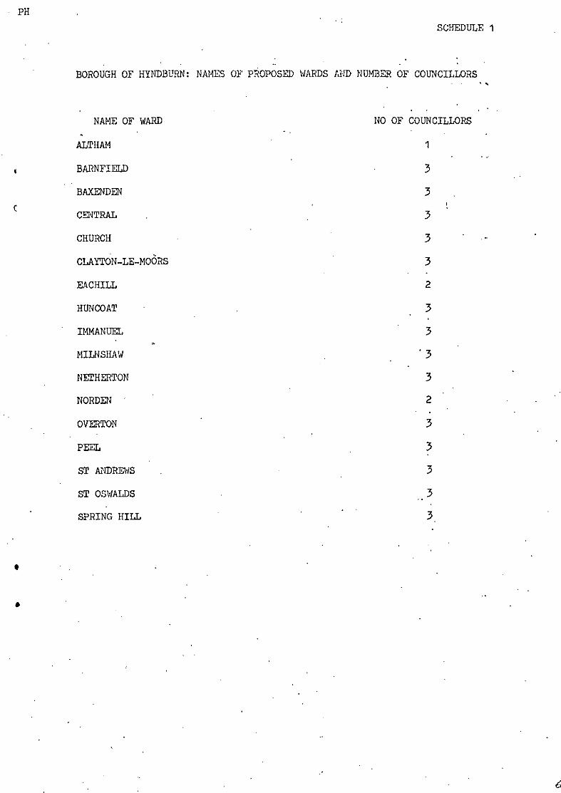
9. Details of these final proposals are set out in Scheduler 1 and 2 to this* - • ' . • • • ' "
report and on the attached map . Schedule 1 gives the names of the wards and
• the number of councillors to be returned by each ward. Schedule 2 shows OUT
proposals for the order of retirement of councillors. ' The boundaries of the
new wards are defined on the map.
PUBLICATION • . ' . . -
10. In accordance with Section 60(5)(b) of the Local Government Act 1972, a
copy of this report and a copy of the map, are being sent to Hyndburn Borough
Council and will be available for public inspection at the Council's main
offices. Copies of this report are also being cent to those who received the
consultation letter and to those who made comments. A detailed description of
the boundaries of the proposed wards as, defined on the map • is set out in
Schedule 3 to this report.
U-S.
Signed
EDMUND COMPTON (CHAIRMAN)
JOHN H RANKIN (DEPUTY CHAIRMAN)
DIANA ALBEJ1ARLE
T C BENFIELD
MICHAEL CHISHOtM
ANDREW WHSATLEY
F B YOUNG
DAVID H SMITH (Secretary)
PH
SCHEDULE 1
BOROUGH OF HYMDBUHN: NAMES OF PROPOSED WARDS AND NUMBER OF COUNCILLORS
NAME OF WARD NO OF COUNCILLORS
ALTHAM 1
BARNFIELD • 3
BAXENDEN 3i
CENTRAL . . 3
CHURCH 3
CLAYTON-LE-MOORS 3
EACHILL 2
HUNCOAT • . 3
IMMANUEL ' 3
MILHSHAW . ' 3
NETHERTON 3
NORDEN ' ' 2
OVERTON ' 3
PEEL . 3
ST ANDREWS . 3
ST OSWALDS 3
SPRING HILL ' 3
SCHEDULE 2
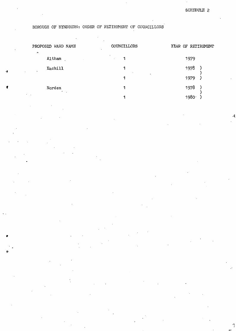
BOROUGH OF HYNDBURN: Ol̂ DER OF RETIREMENT OF COUNCILLORS
PROPOSED WARD NAME
Althajn
Eachill
Norden
COUNCILLORS
1
1
1
1
1
YEAR OF RETIREMENT
1979
1978 )
1979 )
1978 )
1980- )
, ; ' .SCHEDULE J,
BOROUGH OF HYNDBURN: DESCRIPTION OF PROPOSED WARD BOUNDARIES
OVERTON :- - .-
Commencing at a point on the northwestern boundary of the district being
N G:; reference SD 706l6j52'iiiii, thence northwards and following the said '•
district boundary and the northern boundary of the district to V/halley
.Road, thence southwards along the said road to Harwood Lane, thence south-
westwards along the said lane to Park Road, thence southwards along the
said road to Queen Street, thence westwards along the said street to
.Blackburn Road, thence southwestwards along the said road,and Lee Lane to
Wilpshire Road, thence northwestwards, westwards and northwestwards along
the said road to York Road, thence northwards along the said road to a
point opposite N G. reference SD 706l632Wf thence due west to the point
of commencement.
NETHERTON _.. -
Commencing at the point at which the unnamed stream flowing to the east of
Cemetery Hotel to Norden Brook crosses the southeastern boundary of
Overton Ward, - ~" "";• thence northeastwards, and following the said
boundary to the northern boundary of the district, thence eastwards and
following the said district boundary to the western boundary of .41 thaw CP,
thence southwestwards and following the said boundary and westwards and'
following Hyndburn brook to Norden Brook, thence westwards and following
the said brook to the unnamed stream flowing to the ear.t of Cemetary Hotel
to Norden Brook, thence northwestwards and following the said stream to
the point of commencement.
V/ARD
Commencing at the point at which the southeastern boundary of - . „
Netherton ->vW. Ward moots the western boundary of Altham CP, thence
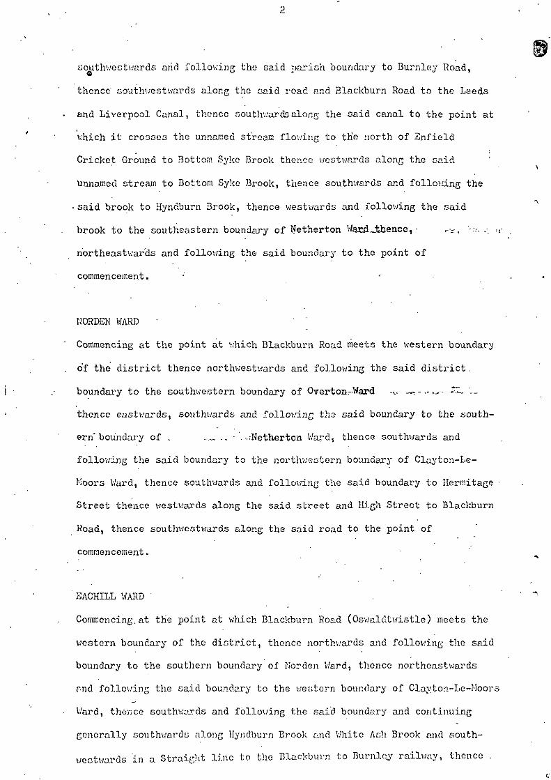
southwestwards arid following the said parish boundary to Burnley Road,
thence couthwestwards along the said road and Blackburn Road to the Leeds
and Liverpool Canal, thence southwards along the said canal to the point at
which it crosses the unnamed stream flowing to th'e north of Snfield
Cricket Ground to Bottom. Sykc Brook thence westwards along the said
Unnamed stream to Bottom Syke Brook, thence southwards and following the
• said brook to Hyndburn Brook, thence westwards and following the said
brook to the southeastern boundary of ffetherton Wand JJaence, - ,.-.., •-:.-..- ,.-
northeastwards and following the said boundary to the point of
commencement.
NORDEN WARD ' ' '
Commencing at the point at which Blackburn Road meets the western boundary
of the district thence northwestwards and following the said district.
boundary to the southwestern boundary of Overton-.-Ward .,.. _~-.-^ ZL. '._
thence eastwards, southwards and following the said boundary to the south-
ern" boundary of , ..-.„ .. .-;Nethertcn Ward, thence southv/ards and
following the said boundary to the northwestern boundary of Clayton-Le-
Koors Ward, thence southwards and following the said boundary to Hermitage •
Street thence westwards along the said street and High Street to Blackburn
Road, thence southwestwards along the said road to the point of
commencement-
SACHILL WARD '
Commencing.at the point at which Blackburn Road (Oswaldtwistle) meets the
western boundary of the district, thence northwards and following the said
boundary to the southern boundary of Norden Ward, thence northeastwards
r-nd following the said boundary to the western boundary of Clayton-Le-Moors
Ward, thence southwards and following the said boundary and continuing
generally southv/ards along Hyndburn Brook and White Ash Brook and south-
westwards in a Straight line to the Blackburn to Burnley railway, thence .
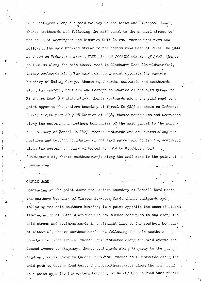
northwestwards along the said railway to the Leeds and Liverpool Canal,M , ' *
thence southwards and following the., said canal to the unnai:ie.d stream..t.q
the south of Accrington and. District Golf Course, thence westwards and
following the said unnamed stream to the access road west of Parcel No
as shown on Ordnance Survey 1:2500 plan SD 72/7328 Sdition. of .1967, thence
southwards along the said access road to Blackburn Road (Oswaldtwistle),
thence westwards along '£he said road to a point opposite the eastern
boundary of Redcap Garage, thence northwards, westwards and.southwards. -
along the eastern, northern and western boundaries of the said garage to
Blackburn Road (Oswaldtwistle), thence westwards along the ̂said road to a
point opposite the eastern boundary of Parcel No 5225 as shown on Ordnance
Survey 1:2500 plan SD 7128 Edition of 195&, thence northwards and westwards
along the eastern and northern boundaries of the said parcel to the north-
ern boundary .of Parcel No Mt23, thence westwards and southwards .along the
northern and western boundaries of the said parcel and continuing southward
along, the. western boundary of Parcel No '*319 to Blackburn Road
(Oswaldtwisle), thence southwestwar.ds along the said road to the point of
commencement.' . . , - . . . • • *
CHURCH WAKD • • ' ' -. , , -
Commencing at the point where the eastern boundary of Eachill \Vard meets
the southern boundary of Clayton-le-Moors Ward, thence eastwards-and-.
following the said southern boundary to a point opposite the unnamed stream
flowing north of Enfield Cricket Ground, thence eastwards to and along, the
said stream and s'outheaotwards in a straight line to the southern boundary
of Althain CP,-thence southeastwards and following the said^southern,
boundary to. First Avenue, thence southv.-estwards along the said avenue and
Cccond Avenue to Kingsv.'ay, thence southwards along Kingsway to the path_ •
leading from Kir-gsv.'ay to Queens Road-West,, thence south-westwards _ along the
said path to Queens Road V/est, thence.-southeastwards along tho said, road
to a point opposite the eastern boundary of No 20} Queens Road Wtir»t thence
southwestwards to and along the said boundary and westwards along the rear
boundary of the .said property to the northwestern boundaries of the
properties on the west side of Gloucester Avenue, thence southv/estv;ards
along the said boundaries to the southern boundary of Mo 100 Gloucester
Avenue, thence southeastward."* along the said boundary to Gloucester Avenue,
thence northeastwards along the said avenue to Lancaster Avenue, thence
.eastwards along the said venue to a point opposite the western boundary of
Milnshaw Park, thence southwards to and along the said boundary to the
northern boundary of Parcel Ho 3̂ 93 as shown on Ordnance Survey 1:2500
plan SD 7528 Sdition of 195&, thence westwards and southwards along the
northern and western boundaries of the said parcel to Kyndburn Road, thence
westwards.along, the said road to Park Road, thence southwards along the
said road to appoint opposite the northern boundary of No 79 Park Road,
thence westwards to and along the said boundary -and the northern boundaries
of No's 98 and.87 Monk Street and No 86 Princess Street to Princess Street,
thence southwards along the said street and Porter Street and continuing
•southwards in a straight line to the Blackburn to Burnley railway, thence
westwards and northwestwards along the -said railway to the eastern boundary
of JSachill Ward, thence northeastwards and following the said boundary to
the point of commencement.
HILKSIIAW WA3D ' .
Commencing at the point at which -the southern boundary of Church Ward
meets the eastern boundary of the said ward, thence northwards and
following the said eastern boundary to the southern boundary of Altham CP
thence' southeast\vards and following the said southern boundary and north-
eastwards along the southeastern boundary of the said parish to Bolton
Avenue, thence southcastv-ards along the said avenue to the Blackburn to
Burnley railway, thence southwestwards along the said railway to Whalley
Road, thence southeastwards along the said road to Castle Street, thence
southwestwards along the said street to ̂ ilnwhaw Lane, thenco northwestwards
.
J -' '-.; ;! I_ ' *'••: -' ••'-''- -
crossing the said lane to King Street, theuce southwestwurds along the saii ... ,
street to Hyndb'urn Road, thence westwards along -the said road to the point
of commencement.
P1S3L WARD ' ' ' • - • : - • - .
Commencing at the point wher.e Plantation Street meets Abbey Street thence
• northwestwards along Abbey Street and Whal-ley Roau to the southeastern
boundary of Milnshav Ward, thence northwestwards and following the"sai'd'
boundary to Perry House Lane, thonce southcastv/ards along the said lane to
Burnley"Road thence northeastwards along the said road to Alice Street, '
thence southe'astwards along the said street and Surrey Street to ITodder" "
Street/ thence" southwestwards along the said street to 'the access road'
northeast of No 3S.Hodder Street, thence southeastwards along the'said"
access"road to the access road to the rear of the properties on"the "south-
aide of Hodder Street, thence southwestwards along the said'access road t*o
the road to the rear of NOB 20 and 18 Clarendon Street, thence southeast-
wards' along the said road to the road to the rear of No "132 to 1^7
Plantation Street, tlience northeastwards and southeastward^ along "the"said
road to Plantation Street, thence southv;estwardc along the said street" to
* ? . . . - - • . . , . .the point of commencement. . : ' • • " "
HimCOAT WA2D . . '* • ' "
Commencing at the point at which Plantation Street meets the eastern
boundary of Peel Ward, thence northwestwards and following the "said
boundary' to the southeastern boundary of Milnshaw Word, thence "nortHeasf- .
wards and following the said boundary to the southeastern boundary of
Alt haw CP, thence northeastwards and following the said boundary to the''"%
Eastern boundary of the district, tK • ::c Routheastwarda and "following"the
said district boundary to the southern"boundary "of Parcel 'No 91S6 aa shown
on Ordnance Survey 1:2500 plan SD'r/8/7928 Revision of 1960, ""thcMi'co "south-
westwards along the -said boundary and the southern -boundary of Parcel
No' 800-3 to Kings Highway, thence westwards and northwestwards along Kings
Highway 'to the southern boundary of Parcel No l6j5? as shown on Ordnance
Survey 1:2500 plan SD 78/7929 Revision of 1960, thence southwestwards along
the said boundary and continuing south-westwards along the southeastern
boundary of Parcel No 1719 and northwestwards along the southwestern
boundary of the said parcel and continuing northwestwards along the south-
western boundary of Parcel No 0027 to a point opposite .the southern
boundary of Parcel No 0021, thence southwestwurds to and along the said
southern boundary to the southeastern boundary of Parcel No 8620 as shown
on Ordnance Survey 1:2500 plan SD 76/7729 Edition of 1961, thence south-
v;estwestwards along the said boundary to the path running northwestward
through Parcel He's 86201 792n and jSOO thence northwestwards along the
said path to a point opposite the southeastern boundary of Parcel No J800
thence southwestvards to and along the said boundary and the southeastern
•boundary of Parcel Mo-2979 as shown on Ordnance Survey 1:2500 plan
SD 76/7728 Edition of 1969 to the path leading to Plantation Road, thence
southeastwards-and southwcstvsrds along the said path to Plantation Road,
thence southwestwards and westwards along the said road and continuing
westwards along Plantation Street to the point of commencement.
ST OSWALD'S WARD .
Commencing at the point where the western boundary of the district meets
the southern boundary of Eachill Ward, thence ooutheastwards and following
the said southern boundary to the southern boundary of Church Ward, thence
southeastward^ along the snid boundary to Blackburn Road (Oswaldtwistle),
thence southwe.stwards along the said road to Thwaites Road, thence south-
wards along the said road to Stanhill Lane, thence northwestwards along the
said Lane and Stanhill Street "to the eastern boundary of Parcel No 08'i-3 as
shown on Ordnance Survey 1:2500 plan SD 732? Edition of 19!?8»' thence south-
westwards and following the said boundary and the eastern boundary of Parcel
No 093-1- to the eastern boundary of Parcel I'o 163'- thence southwards along
• the said boundary to Brookc.id.c Lone, thence westwards along ,the said lanei " '
to.the path from Brookside Lane to Duckworth Hill La;ic, passing, .to the west
. "of the property known as Higher Duckworth Ilj.ll thenco*southwards -along tho
said path to Duckworth Hill Lane, thence eastwards along the. said lone to'C •
White Croft Road, thence southwards along the said road to Red.Shell Lane
$ • thence 'southwards and westwards along the said lane to Elton Road, thence
southcastwards .along the said road to the southern boundary of the district;,
thence southwestwards and following the southern and western boundaries of
the district to the point of commencement. . - .-_
ST ANDREW 1-S WARD . - _ , - . . • . - . . ,
Commencing, at a point on the southern boundary of Church-Word-opposite .the
•stream to the oast of the reservoir, -thence southward to and along the said
strear.! to-the prolongation southeastward^ of the northern boundary of ..-
St Mary's-RC.Mixed and.Infants Primary School, thence northwestwards along
the said prolongation to the street to the cast of the said school,, thence
southwards along the said street to Moscow Kill Street, thence southeast,-
wards -along the said street to a point opposite the northeastern boundary* * ; ! ? ' > • * ,
of Clifton Hill, thence southcastwards to and along the said boundary to.
Coal Pit Lane, thence southeastv/ards and southwards along the said lane to
Fairfield Street, thence westwards along the said street to a point - -'e " • .
opposite the stream flowing to the east of St Mary's RC Primary, School,
& • thence'southwards to and along the said stream to tho prolongation cast-
v.-ards of the northern boundary of No 27 Laburnum Drive, thence wer.twardc-
along the said prolongation and northern boundary and the northern boundary
of No 2^Laburnum Drive to the southern boundary of the playing^fields_
thence, westwards and northwestwardo along, the southern and westorn . • •* ••
boundaries of the- said playing fields to the access path, southeast, of
No 31- Hawthorn Avenue, thence Kouthvestward? along the said aceecu path toi
' • Hawthorn Avenue, thence northwestwards-along the said avenue to
Dene Bank Road, thence southwestv.-ords along thr* said road to Malvern Avenue,
thence northwestwards along the said avenue to Park Lane, thence. southwest-
ward along the said lane to Fielding Lane, thence northwestwards along the
said lane to Keys Lane, thence scuthwcstwards along the said' lane to Stone
Bridge Lane, thence northwestwards alonj.; the .said lane to Union Road, thence
southv.'estwards along the said road to Erooksido Lane, thence couthwestwards
•and northwestwards along the said lane to the eastern boundary of
St Oswald's Ward, thence northwards and following the said boundary to the
southern boundary of Church Ward, thence south-eastwards and following "the
boundary to the point of commencement.
SPRINGHILL WARD • . '
Commencing at the point at which the southeastern boundary of Parcel
No 0001 as shown on Ordnance Survey 1:2500 plan SD 7V7525 Revision of I9601
meets the southwestern boundary of the said parcel, thence northwestwards
along the said southwestern boundary and the southwestern boundaries of
Parcel No's 7618 and 622'+ as shown on Ordnance Survey 1:2300 plan
SD 7*i-/?526 Revision of i960 to the- northeastern boundary of Parcel No 4922
and continuing northwestwards along the said boundary to the northeastern«
corner of Parcel No 4225 » thence northwards in "a straight line to the
southern boundary of Parcel No Vf34 thence eastwards and following the
southern and eastern boundaries of the said parcel and continuing north-
westwards along the northeastern boundary of Parcel No 4237 to the southern
boundary of Parcel No 42-i-l , thence eastwards and following the said
boundary to the southeastern boundary of Parcel No 505'* j thence northeast-
wards and following the said boundary to the eastern boundary of Parcel
No 5̂ 57? thence northwards and following the 'said boundary to the eastern
boundary of Parcel Mo 5363, thonce northwards and westwards along the
eastern and northern boundaries of the said parcel to the western boundary
of Parcel No V*75» thence northwestward:-; and following the said boundary
to the southern boundary of Parcel No 'fOo'i, thonce westwards,, 'northwards
and northwestwards along the southern western and northern boundaries ofi
the said parcel and in prolongation of the said northern boundary to the
path running to the east of Parcel No 37̂ 9> thence northwestwards and
northeastwards along the said path to the southeastern corner of Parcel
IIo 2200, thence northwestwards along the eastern boundary of the said
parcel to a point opposite the issues of the unnamed stream opposite the
.rear boundary of No 18 Cartnel Avenue, thence due west to the said stream
and northwestwards and following the said stream to the eastern boundary of
.St Andrew's Ward, thence northwestwards and following the said boundary to
the southern boundary of Church Ward, thence eastwards along the said
boundary to a point opposite Lonsdale Street, thence southwards to and
along the said street to the access path to the north and east of the
properties on the eastside of Lonsdalc Street, thence southeastward and
southward along the said access path to Charter Street, thence northeast-
wards along the said street to the access path to the rear of the properties
on the northeastern side of Exchange Street, thence coutheastv;ards along
the said access path to Fairfield Street, thence northeastwards along the
said street to Stevenson Street East, thence northeastwards along the said
street to Chester Street, thence southeastward^ along the said street to
Willows Lane, thence southeastwards along the said lane to Ormerod'Street,
thence northeastwards along the said street and in prolongation thereof.to
the former Accrington to Stubbins railway, thence southeastwards along.the
said railway to V/oodnook Water, thence southwestwards and following the
said water to the footpath -from Shoe Hill Viaduct to the unnamed road south
of Victoria Cottage, thence generally southv;estwards and southeastwards
along the said footpath, passing east of Icconluu-st Cottages to the said
unnamed road, thence southwestwards along the said road to the road east of
Parcel No 0001 as shown on OS 1:2500 plan SD ?6/7?26 Revision of 196*1
thence southwards along the said road to a point opposite the southeastern
boundary of the said parcel, thence southwc-stv.'ards to and along the said
boundary to the point of commencement.
10
CZMTRAL V/ARD
Commencing at the point at v/hich the southern boundary of Milnshaw V/ard
meets Xing'Street, thence couthwestwards along the said street to Sdgar
Street,1 thence southwards along the said street to Blackburn Road, thence
southeastwards along the said road'to Eaf.;le -Street, thence southwestwards•)
and southwards along the said street to the prolongation northeastwards ox
the northern boundary of Springhill V/ard, thence southwcstuards along the t|
saici prolongation and continuing southwestwardo and follov/ing the northern
boundary' of the said ward to the southern boundary of Church V/ard, thence '
eastwards and following the said boundary to the southern boundary of
Milnshaw V/ard, thence eastwards ajid following the said boundary to the
point of commencement.
BA3KF1SLD V/ARD
Commencing at'the point at which the prolongation southwestwards of the°.
northern boundary of Parcel No 10-*9 as shown on Ordnance Survey 1:2500
plan SD 76/7727 Edition of 1961 meets the eastern boundary of Springhill
V/ard, thence northwards arid follov/ing the said eastern ward boundary to
the eastern boundary of Central V/ard, thence northeastwards and following
the said boundary to the southern boundary of Kilnshav; V/ard, thence north-
eastwards and following the said boundary to the western boundary of Peel
Ward, thence southeastwards and eastwards along the western and southernv*
boundaries of the said ward to the southern boundary of Huncoat Ward,
thence eastwards and. following the said boundary to the eastern boundary A
of the district, thence coutheastwards and following the said boundary to
the point at v/hich it meets '.'ariixlen Brook, thence southwestv:artls and
following the said brook to the road ivxssing through the works on the east
vside of llanchester Hoad, thr.-nce nortlv/:c:jl:w;tt-0." and westwards along the
said road to Shop Lone, thence noi'thwestv.wds alor.g the said lane to
Christ Church Street, thence southwestwards along the sedd street to .
Rough Lee Road, thence southwards and southwestwards along the said .road to
Royds Street, thence northwestwards-along the said street to a point
opposite the- footpath from Royds Street to Belfield Road, thence south—'
westwards and northwestwards along the said footpath to'the, rear boundary
of No 111 Belfield Road, thence .southwestwards along the said boundary and
"*" ** ' I* f
• the rear boundaries of No's 113 to 169 Belfield Road, thence westwards-*»
along the southern boundary of No 169 Belfield Poad and continuing west-
v/ardward to the northern boundary of Parcel No 10̂ 9 as shown on Ordnance
Survey 1:2500 plan SD 76/772? Edition of 1961, thence westwards and
following the said boundary and in/prolongation thereof to the.point -of
•commencement. • • . - • - . . • ;
IKMAKUSL WA2D
Commencing at the point at which the southern boundary of:the District'
nieets-the eastern boundary of St Oswald's Ward, thence northwestwards and
following the said eastern boundary to the southern boundary of
St Andrew's Ward, thence eastwards and following the said.boundary to the
.-.western boundary of Springhill Ward", thence southoastv/ards and following
the said boundary to the southwestern boundary of Accrington Koor, thence *
southeastwards along the said boundary to the northwestern boundary of, ".
Parcel No 38̂ 6 as shown on Ordnance Survey 1:2500 plan SD 76/7725 Revision
of 1960, thence northeastwards along the said boundary and in prolongation
thereof to the road front Accrington Moor to Roimdhill Road, thence south-
eastwards along the said road to the southern boundary of the district,
thence southv;estwards and following the said district boundary to the-.
point of comRiencet.ient. • ' . . . . .
1,1
BAX2KDSH WARD
Commencing at the point at .which the southern boundary of the district
meets the northeastern boundary of Imisujiucl Ward, thor.ce northwestwards
along the said northeastern boundary to the southeastern boundary of
Springhill Ward, thence northeastwards and following the said boundary to
the eastern boundary of the said ward, thence northwestwards and. following
the said boundary to the southern boundary of Barnfield Ward, thence north-
eastwards and following the said boundary to the eastern boundary of the
district, thence southwards and following the eastern and southern
boundaries of the district to the point of commencement.
ALT1IAK WARD
The parish of AlthaM and that area bounded by a line commencing at the
point where the northern boundary of.Church Ward meets the southeastern
boundary of Clayton-Lc-Moors Ward, thence northwards and following the" /
said southeastern boundary tc the western boundary of Altham CP thencei
southeastwards and Bouthwestwardo alone the said boundary to the northern
boundary of Church V/arcl, thence- westwards and following the said boundary
to the point of