Embed Size (px)
Citation preview

Local Greenprinting for Growth
O V E R V I E W
V O L U M E I
Using Land Conservation to Guide Growthand Preserve the Character of Our Communities
The Trust for Public Land conserves land for peopleto improve the quality of life in our communities
and to protect our natural and historic resources for future generations.
Conserving Land for People
Printed on recycled paper.
National Office116 New Montgomery Street, Fourth Floor
San Francisco, CA 94105(415) 495-4014
(415) 495-4103 (fax)
Washington D.C. Office660 Pennsylvania Avenue, SE, Suite 401
Washington, D.C. 20003(202) 543-7552
(202) 544-4723 (fax)www.tpl.org
The National Association of Counties440 First Street, NW
Washington, D.C. 20001(202) 393-6226
(202) 393-2630 (fax)www.naco.org
Additional copies of Local Greenprinting for Growth reports are available at www.tpl.org/greenprinting.

The Trust for Public Land
The Trust for Public Land conserves land for people to improve the quality of life in ou rc o m munities and to protect our natural and historic resou rces for future generation s .
This is a publication of TPL’s Center for Land and People. TPL’s Center for Land andPeople is dedicated to exploring, understanding, and celebrating the connectionbetween land and people and the importance of that connection to the spirit, health,economic vitality, and quality of life in all communities.
National Association of Counties
Founded in 1935, the National Association of Counties (NACo) is the only nationalorganization in the country that represents county governments. With headquarterson Capitol Hill in Washington, D.C., NACo’s primary mission is to ensure that thecounty government message is heard and understood in the White House and the hallsof Congress. NACo’s purpose and objectives are to
◆ Serve as a liaison with other levels of government
◆ Improve public understanding of counties
◆ Act as a national advocate for counties, and
◆ Help counties find innovative methods for meeting the challenges they face.
Th rough its research arm, the National Association of Cou nties Research Fou nd a t i on ,N ACo provides cou nty officials with a wealth of expertise and services in a broad range ofsubject areas, including job training, env i ron m e ntal programs, human services, welfare-t o - w o rk initiatives, housing, cou nty governance, and community infrastructure.
Editor: Kim HopperDesign: Glyph Publishing Arts
Production: Debra Summers
On the cover: Austin, Texas. Photo by: Ted Harrison
Copyright © 2002 by theTrust for Public Land. All rights reserved.
National Office116 New Montgomery Street, 4th FloorSan Francisco, CA 94105(415) 495-4014(415) 495-4103 (fax)
Washington D.C. Office660 Pennsylvania Avenue, SE, Suite 401Washington, D.C. 20003(202) 543-7552(202) 544-4723 (fax)
Mid-Atlantic Regional Office666 Broadway, 9th FloorNew York, NY 10012(212) 677-7171(212) 353-2052 (fax)
Midwest Regional Office2610 University Avenue, Suite 300St. Paul, MN 55114(651) 917-2240(651) 917-2248 (fax)
New England Regional Office33 Union Street, 4th FloorBoston, MA 02108(617) 367-6200(617) 367-1616 (fax)
Northwest Regional OfficeWaterfront Place Building, Suite 6051011 Western AvenueSeattle, WA 98104(206) 587-2447(206) 382-3414 (fax)
Southeast Regional Office306 North Monroe StreetTallahassee, FL 32301(850) 222-7911(850) 224-3755 (fax)
Southwest Regional Office418 Montezuma AvenueSanta Fe, NM 87501(505) 988-5922(505) 988-5967 (fax)
Western Regional Office116 New Montgomery Street, 3rd FloorSan Francisco, CA 94105(415) 495-5660(415) 495-0541 (fax)
www.tpl.org
The Trust for Public Land

Local Greenprintingfor Growth
O V E R V I E W
V O L U M E I
Using Land Conservation to Guide Growth and Preserve the Character of our Communities
This report was produced with funding from the Henry M. Jackson Foundation, the Surdna Foundation,
and the Environmental Protection Agency
Conserving Land for People

Acknowledgments ..................................................................................................................................5
Introduction.............................................................................................................................................6
Greenprinting Part 1: Defining a Conservation Vision ........................................................................8
Understand the Value of Protected Land.....................................................................................9
Assess the Demand for Protected Land......................................................................................13
Define a Community’s Conservation Goals .............................................................................13
Build Public Support and Encourage Public Participation.......................................................15
Create Citizens Advisory Committees ......................................................................................15
Forge Greenprinting Partnerships..............................................................................................15
Greenprinting Part 2: Securing Conservation Funds.........................................................................17
Explore State, Federal, and Private Funding Sources ...............................................................17
Conservation Finance Table........................................................................................................19
Research and Test Local Financing Options and Conservation Priorities...............................21
Design a Local Conservation Finance Measure.........................................................................21
Distribute Public Funds Among Stakeholders..........................................................................23
Greenprinting Part 3: Acquiring and Managing Park and Conservation Lands...............................24
Organize and Staff a Conservation Program.............................................................................24
Identify and Prioritize Property..................................................................................................24
Determine Acquisition Methods................................................................................................26
Acquire the Land .........................................................................................................................27
Manage Protected Land...............................................................................................................27
Forge Greenprinting Partnerships..............................................................................................28
Greenprinting Case Studies
Santa Fe County’s Greenprinting Takes Shape.........................................................................10
Taking the Lead in Dane County, Wisconsin............................................................................12
Committee Supports Conservation in Fast-Growing Douglas County,Colorado.......................................................................................................................................14
Austin: Growing Fast, Growing Smart......................................................................................20
Managing Environmentally Endangered Lands in Miami-Dade County...............................26
Protecting Working Landscapes in Gallatin County, Montana...............................................28
Conclusion .............................................................................................................................................30
Appendix................................................................................................................................................32
References: Local Government Programs and Publications....................................................32
Resources: National Publications...............................................................................................33
Resources: National Open Space Protection Organizations ....................................................33
Resources: Federal Programs and Laws......................................................................................34
Table of Cont e nt s

D e fining a Conservation Vision 3
Dear Local Government Official:
The National Association of Cou nties and the Trust for Public Land are pleased to presentLocal Greenprinting for Growth, a new series of reports to help local officials con s e r v el a nd and protect open space.
C o m munities across the cou ntry are finding that open space pro t e c t i on is a highly e f f e c t i v e tool to manage growth and improve quality of life. Greenprinting is one of manyapproaches and techniques to protect open space. Santa Fe County, New Mexico, used thegreenprinting approach to develop the Wildlife, Mountains and Historic Places Program, a cooperative effort among local officials and citizens. As of Spring 2002, Santa Fe County hasspent $20 million in general obligation bonds to purchase open space and parklands totaling2,400 acres. We hope the experience of Santa Fe County as well as other counties, cities, andtowns around the country will be useful to local officials interested in protecting open space.
This Local Greenprinting for Growth series (an overview and three detailed reports) provides “how-to” information on:
◆ Defining a Conservation Vision◆ Securing Conservation Funds◆ Acquiring and Managing Park and Conservation Lands
We wish to thank members of the Greenprinting for Growth Advisory Panel (listed onthe following page) for sharing success stories and lessons learned from their land conserva-tion efforts. From envisioning a plan, to finding the funding, to buying and managing land,these reports offer guidance, best practices, and information resources.
Thanks, too, to the U.S. Environmental Protection Agency and the Henry M. JacksonFoundation for their generous support, which enabled us to publish the Greenprinting forGrowth report series and distribute it to all NACo members.
Much of the information contained in the report will also be available online throughour respective web sites www.naco.org and www.tpl.org.
We welcome your feedback and hope you find these reports useful in your local con s e r v a-t i on end e av o r s .
Thank you very much.
Sincerely,
Javier Gonzales Will RogersNACo President, Commissioner PresidentSanta Fe County, New Mexico The Trust for Public Land
Javier Gonzales
Will Rogers

4
The Honorable John Bartlett County Freeholder
Ocean County, New Jersey
The Honorable Sharon BronsonCounty Supervisor
Pima County, Arizona
The Honorable Robert Eckels County Judge
Harris County, Texas
The Honorable Brett HulseyCounty Supervisor
Dane County, Wisconsin
The Honorable Bill MurdockCounty Commissioner
Gallatin County, Montana
The Honorable Robert Weiner County Council Member
New Castle County, Delaware
Chair
The Honorable Javier GonzalesCounty Commissioner
Santa Fe County, New Mexico
Members
Local Greenprinting for Growth Advisory Panel
D e fining a Conservation Vision 5
A ck now l e d g m e nt s
Steve Anderson, parks and recreation analyst, Trails andOpen Space Department, Pima County, Arizona
James Arts, director of policy and program development,Dane County Executive Office, Dane County, Wisconsin
Charles Baker, general manager, Department of Land Use,New Castle County, Delaware
John Behan, AICP, Behan Planning Associates and planningconsultant to the Town of Pittsford, New York
Mardi Black, legal specialist/community planner, LandInformation Access Association, Traverse City, Michigan
Alina Bokde, former planner, Department of Planning,Santa Fe County, New Mexico
Ken Brown, aquatic ecologist, Center for WatershedProtection, Ellicott City, Maryland
John L. Crompton, Ph.D., professor of parks, recreation, and tourism sciences at Texas A&M University,College Station, Texas
John DeBessonet, park planner, Harris County ParksSystem, Harris County, Texas
Lauretta Fischer, principal planner, Planning Department,Suffolk County, New York
Julia Freedgood, director of Farmland Advisory Services,American Farmland Trust, Northampton, Massachusetts
Jim Gibbons, land use educator/project director, NonpointEducation for Municipal Officials, Haddam, Connecticut
Douglas Haag, former conservation fund manager, DaneCounty Parks Department, Dane County, Wisconsin
Catherine Hahn, water supply land protection specialist,Society for the Protection of New Hampshire Forests,Concord, New Hampshire
Ann E. Hutchinson, conservation planner, Natural LandsTrust, Inc., Media, Pennsylvania
Michelle Johnson, trails manager, Open Space and TrailsProgram, Santa Fe County, New Mexico
Jack Kolkmeyer, planning director, Department ofPlanning, Santa Fe County, New Mexico
Lesli Kunkle Ellis, former planner III and project managerfor the Wildlife, Mountains and Historic Places Program,Santa Fe County, New Mexico
Ken Lepine, director, Dane County Parks Department, DaneCounty, Wisconsin
Stuart Lowrie, Ph.D., director of government relations, The Nature Conservancy, Long Island Chapter, Cold SpringHarbor, New York
Heather Mann, executive director, Urban Open SpaceFoundation, Madison, Wisconsin
Joseph Marfuggi, executive director, Riverfront Recapture,Hartford, Connecticut
Kevin McDonald, vice president, The Group for the SouthFork, Bridgehampton, New York
Dave McKeon, planner, Department of Planning, OceanCounty, New Jersey
Mark Middlebrook, Office of the Mayor, Jacksonville, Florida
Dee Miriam, comprehensive planning manager, DeKalbCounty, Georgia
Beverly Mirman, D.P.A., executive director, Safe Neighbor-hood Parks Bond Program, Miami-Dade County, Florida
Tina Nielsen, M.S., open space assistant, Parks and OpenSpace Department, Boulder County, Colorado
Joyce O’Keefe, associate director/policy director, OpenlandsProject, Chicago, Illinois
Pam Porter, former executive assistant, County Executive’sOffice, Dane County, Wisconsin
Ray Rasker, Ph.D., director, SocioEconomics Program,Sonoran Institute, Bozeman, Montana
Ralph Schell, director, Jefferson County Open Space,Jefferson County, Colorado
Butch Smith, senior planner, Parks and RecreationDepartment, Austin, Texas
Toby D. Sprunk, natural resources specialist, DouglasCounty, Colorado
Cathy Vaughan-Grabowski, Open Space Department,Boulder, Colorado
Richard Walesky, director, Environmental ResourcesManagement, Palm Beach County, Florida
Susie Wiles, executive director, The Preservation Project,Jacksonville, Florida
Emilie Young, executive director, EnvironmentallyEndangered Lands Program, Miami-Dade County, Florida
Jan Zimmerman, conservation fund manager, Dane CountyParks Department, Dane County, Wisconsin
Many thanks to the following land conservation leaders for sharing their time and expertise on the Greenprinting publications.
Special thanks to Abigail Friedman at the National Association of Counties and Amber Levofsky at the Environmental Protection Agency for their time, talent, and partnership in producing this handbook series.

6
As development pressures mou nt, com-munities across the country are usingopen space protection as a tool to
m a n age growth and protect important land andwater resources. Open space protection may beachieved through a wide range of approachesand techniques, including a process known asg r e e n p r i nting. The Trust for Public Land (TPL) and the National Association of Counties(NACo), with support from the Henry M.J a ck s on Fou nd a t i on, the Surdna Fou nd a t i on ,a nd the U.S. Env i ron m e nt a l P ro t e c t i on Agenc y,are publishing this executive summary andthree in-depth reports that are intended tohelp counties, cities, and towns explore green-printing as an approach to conserving openspace and shaping future growth.
An advisory panel of local public officials—greenprint experts from communities acrossthe country—has also been created to advisethis publication series and provide case studyinformation. TPL and NACo resources are available to public officials, legislators and staff,community advocates, land trust executives,and other local leaders embarking on thegreenprinting-for-growth process.
Why protect open space? In short, landconservation can create more healthy, livable, economically sound communities. Considerthese benefits:
◆ Open space is good for the bottom line. Investing inopen space can save communities money byreducing infrastructure and public servicecosts associated with expensive, suburban-style development and bolster local tourismand agriculture economies. Real estate ana-lysts predict long-term economic advantagewill go to communities that are able toguide growth using land conservation andother smart-growth measures.
◆ Open space attracts home buyers. Open space andtrails are among the top community featureshome buyers look for when choosing ahome. Studies have also shown homeown-ers prefer clustered homes with access topermanently protected land over homes onlarger lots that lack open space.1
◆ Open space protects public health. Land use prac-tices that create runoff are some of thebiggest threats to public drinking water supplies. As a result, communities areincreasingly linking their conservation andplanning efforts to protect public drinkingwater and public health.
◆ Open space protects the environment. By protectingopen space, forestlands, and wetlands, com-munities protect endangered species habitatand keep the air and water clean.
◆ Open space can prevent costly flood damage.Protection of a floodplain is a cost-effective
I nt ro d u c t i on
This overview summarizes three reports intended to guide local governments in protecting open space and naturalresources in the face of growth and development.
G r e en•p r i n t• i n g ( g ren´ p rint´ ing) n . a smart gro w t hs t r a t eg y that emphasizes land conservation to ensure qualityof life, clean air and water, recreation, and economic health.v. to employ a greenprinting strategy for growth

alternative to expensive flood control proj-ects, flood insurance, and disaster relief.
◆ Open space can provide an alternative to regulation.Land or development rights, acquired fromwilling sellers, can relieve regulatory pres-sure on private property owners.
◆ Open space can secure our quality of life and ourlifestyle. With a community’s most treasuredplaces preserved, so too are its character andquality of life.
GETTING STA RTED WITH A LANDC O N S E RVATION STRAT E G Y
A vision for future growth and a plan to pro-tect important natural resources—that is whatgreenprinting is all about. From drinking watersources to recreational lands, from floodplainsto open spaces, greenprinting may be used by alocal government and its private partners topreserve a community’s most important natu-ral resources and steer growth around them. Inthe process, growth is redirected toward exist-ing infrastructure, fiscal benefits are realized,and the quality of life of a community isimproved. Land conservation then becomes apowerful and cost-effective growth manage-ment tool—an equal partner with traditionalregulatory, zoning, and planning approaches.
As developed by the Trust for Public Land,greenprinting follows these steps:
◆ Step 1: Defining a Conservation Vision: Developinga land protection vision that reflects a com-munity’s smart-growth goals and enjoyspublic support
◆ Step 2: Securing Conservation Funds: Identifyingand securing federal, state, local, and privateopen space protection funds.
◆ Step 3: Acquiring and Managing Park and Conserva-tion Lands: Administering the greenprintingprogram, completing transactions, andmanaging protected lands.
In the last ten years, TPL has worked withlocal governments across the nation on landconservation programs that preserve commu-nity character, create savings in local budgets,stimulate economic development, and attractand keep new residents. Land conservation canp l ay a key role in building a sense of commu n i t y.This report includes some of the stories and les-sons learned from counties, cities, and townsworking on land conservation programs. Thesecommunities found the vision and leadership,the funding, and the framework for action toprotect the lands residents see as vital to thequality of their lives.
I n t roduction 7
Residents and visitors enjoy theoudoors in Jacksonville, Florida, home to one of the most ambitious greenprintingefforts in the country.
8
BEST PRACTICES
E n s u re that gre e n-p r i nting is int e g r at e dwith other plans andpolicies that guide day -t o - d ay action s .
C onsider whether p ro f e s s i on al assistancecan facilitate the pro c e s s .
Land conservation is catching on. Respond-ing to pressures from accelerated growthand suburban-style development, local
governments are permanently protecting moreand more open space, wildlife habitat, water-sheds, and other special places. New andexpanded support is also coming from the fed-eral government and many states. Voters aredoing their part, approving billions of dollarsfor conservation at the state and local levels.
For many communities, strategic and com-prehensive open space protection has replaceda more piecemeal and reactive approach—whatTrust for Public Land President Will Rogersrefers to as “emergency room conservation.”In this traditional model, local governmentsand land trusts worked to protect individuallythreatened pieces of property, sometimesunder intense pressure as bulldozers arrive.This serves to steer development, but in a frag-mented and unplanned way. With greenprint-ing, local leaders can look at the bigger picture,protecting the places that sustain and definetheir community while guiding developmentin a way that follows sensible growth patterns.
So how does greenprinting evolve? And howdoes it fit into a community’s existing land use,park, and conservation plans? The answers tothese questions depend on the unique needs,financial and human resources, and politicalwill of the community.
Quite often the greenprinting process isdriven by leaders in local government who rec-ognize the need to integrate growth and pre-serve a community’s natural resources. Other
greenprinting efforts evolve from the grass-roots level, as local residents, communitygroups, and conservation organizations workwith local government to protect the land. Inmany cases greenprinting requires local gov-ernment leaders to reevaluate the core princi-ples of their comprehensive plan—integratingtransportation planning, land use planning,and zoning policies with land conservation.Protecting land then becomes one componentin a larger effort to grow wisely and improvethe overall quality of life in a community.
No small task, to be sure. Yet those whohave successfully integrated the community’sconservation vision with all the approaches(voluntary and regulatory) and all the existingplans are likely to achieve significant results.
On the other hand, good results have alsobeen achieved by exclusively implementing an open space protection plan. For some com-munities, this is the first step toward the designand integration of a smart-growth compre-hensive plan. The bottom line: it is up to eachcommunity to define and implement a uniqueconservation vision—one that addresses theenvironmental needs of the region and the pri-orities of its residents.
E a rly greenprinting work focuses on vision i n gand planning: communities must identify andt a rget their natural, cultural, and historic placesof significance. Part 1 of the Local Greenprintingfor Growth report series is designed to help com-munity leaders—public officials and other con-servation stakeholders—through this process,facilitate public participation and partnerships,
It is up to each community to defin eand implement a unique conserv a t i o nvision—one thata d d resses the enviro n-mental needs of theregion and the prioritiesof its re s i d e n t s .
Defining a C on s e r v a t i on Vi s i on
G R E E N P R I N T I N G P A R T 1

D e fining a Conservation Vision 9
and clarify the ways in which conservation canaddress many growth-related challenges.Specific steps are as follows:
◆ Understand the value of protected land
◆ Assess the demand for protected land
◆ Define a community’s preservation spacegoals
◆ Build public support and encourage publicparticipation
◆ Create citizens advisory committees
◆ Forge greenprinting partnerships
U N D E R S TAND THE VALUE OF PROTECTED LAND
Open space protection, particularly when it isused strategically as a tool for managing gro w t h ,can yield significant benefits. Yet these benefitsare often overlooked. The bottom line: under-standing how to assess and communicate thevalue of open space can make or break a localgovernment’s greenprinting program. This isbecause in almost every community one ques-tion will have to be answered, not once butmany times: Given our current budget con-
N ATIONAL SUPPORT FOR SMART GROWTH
The Smart Growth Network is a collaborationof the U.S. Environmental Protection Agencya nd members of the non p ro fit, pro f e s s i on a l ,h i storic preservation, development and realestate, and state and local governmentcommunities. This coalition works to pro-mote smart growth practices that boost theeconomy, protect the environment, andenhance community vitality. Its guidingprinciples are as follows:
◆ Create a range of housing opportunities and choices
◆ Create walkable neighborhoods◆ Encourage community and stakeholder
collaboration◆ Foster distinctive, attractive areas with a
strong sense of place◆ Make development decisions predictable,
fair, and cost effective◆ Mix land uses◆ Preserve open spaces, farmland, natural
beauty, and critical environmental areas◆ Provide a variety of transportation choices◆ Strengthen and direct building toward
existing communities
◆ Take advant age of compact building design
For more information about the SmartGrowth Network and how it can help yourcommunity design a smart growth plan,check its web site at w w w. s m a r t grow t h . o rg.
Part of the section “Und e r s t a nd the Va lue of Protected Land” is excerpted andadapted from “Community Open Space: New Te ch n i ques for Acqu i s i t i ona nd Financ i n g ,” developed by the Trust for Public Land and published in theMIS Report by the Int e r n a t i onal City/Cou nty Manag e m e nt Association; co-editors are T P L ’s D. Ernest Cook and urban con s u l t a nt William P. Ryan.
Agricultural lands are being lost to development at stagger-ing rates, impacting localeconomies, scenic viewscapes,and quality of life. In Billerica,Massachusetts, TPL helped savethe last working farm fromdevelopment as a discountchain store.

10
straints, can we really afford to buy more openspace? To answer that question, it is necessaryto look at the value of open space and considerall the potential benefits to the community.
◆ Consider the fiscal benefits. Buying landor development rights costs money. So doesresidential and commercial development,which requires public investment in schools,roads, utility lines, libraries and recreationfacilities, and ongoing public services suchas police and fire. So in dollars and cents,where do preservation and growth make themost sense?
This qu e s t i on was addressed in a pair of studies conducted by the Trust for Public Landin 1998. Examining the relation s h i p b e t w e e nl a nd con s e r v a t i on and property taxes in Mass-a chusetts, TPL fou nd that, in the long run,towns that had protected the most land enjoyedthe lowest property tax rates. This is likelydue to long-term infrastructure costs of devel-o p m e nt, wh i ch can outweigh the costs ofa c quiring open space and any loss of pro p e r t ytax revenues that results from removing landf rom the tax rolls. The study also conclu d e dthat the con s e r v a t i on of certain key parcels may
C a s e S t u d y S A N T A F E C O U N T Y ’ S G R E E N P R I N T I N G T A K E S S H A P E
THE FA C T S
L o c a t i o n :Santa Fe County, New Mexico
Ty p e :Urban, suburban, ru r a l
P o p u l a t i o n :129,292 (2000)
A re a :1,909 square miles
Local Official Contact:Javier Gonzales, County Commissioner
S t a ff Contacts:Jack Kolkmeyer, Planning Dire c t o r
Michelle Johnson, Open Spaceand Trails Program Manager
A d d ress: Santa Fe CountyP.O. Box 276, 102 Grant Av e .Santa Fe, NM 87504
P h o n e : (505) 986-6200; (505) 995-2711
F a x : (505) 986-6206
Web Site:w w w. c o . s a n t a - f e . n m . u s /
Email Addre s s :j a v i e r @ u s w e s t . n e t
Santa Fe County, New Mexico, has one of the most diverse populations in the
Southwest. Dominating the nort h e rn part of the county are long-established
Hispanic families in traditional agricultural communities and Native Americans
in sovereign pueblos. The economically and ethnically diverse city of Santa Fe, in
the central part of the county, is home to a booming arts- and re c re a t i o n - b a s e d
tourism industry. In the south, irrigated farms and ranches are giving way to sub-
urban sprawl from fast-growing Albuquerque.
Despite its substantial tracts of government land, concern has been gro w i n g
steadily about the impacts of growth and the loss of open space throughout the
c o u n t y. The county’s Growth Management Plan addressed these issues by re q u i r i n g
open space and trails in new planning district areas and served as the foundation
for a detailed countywide greenprinting initiative. To begin its eff o rt to change
c u rrent sprawling development patterns, the county made its first gre e n p r i n t i n g
acquisition, an 11-mile rail trail, which has the potential to become the spine of
c o u n t y ’s entire land conservation program. To fund future conservation pro j e c t s ,
County Commissioner Javier Gonzales sought public funding in the form of a $12
million general obligation bond. Voters approved the bond in 1998 with 74 per-
cent of the vote, making Santa Fe the first county in the state to exercise new
c o n s e rvation bonding authority.
The measure called for the creation of a citizens committee—the County Open
Lands and Trails Planning and Advisory Committee (COLT PAC). Its members serve
to advise county staff and the board of commissioners on the design of a gre e n-
printing plan that recommends long-term strategies for open land and trails con-
s e rvation and a program to evaluate, acquire, develop, and manage the lands. The
county acquired nearly $7 million in pro p e rties in 1999 and the remaining funds
w e re committed by early 2000.The county’s plan—the Wildlife, Mountains, and
Historic Places program—has proved to be such a success that voters appro v e d
another $8 million in funding in 2000 and up to $1.2 million in 2001. This has also
resulted in the creation of a county Open Space and Trails Program with a pro g r a m
manager and staff .❦

D e fining a Conservation Vision 11
i n flu e nce the location and pattern of develop-m e nt, wh i ch in turn may make the delivery ofmunicipal services more effic i e nt and less costly.
In fact, the view that open space cannot p ay for itself has been challenged in manyc o m munities, where officials have discoveredt h rough fiscal impact analyses that openspace can enhance property values and gener-ate tax revenues. For example, by demand i n gless in tax-supported services than they con-t r i bute, farms and ranches also help keeptaxes lower and attract tourist dollars. In fact,the American Farmland Trust has deter-mined that farmland and forestland provide afiscal surplus for local governments (everydollar in revenue requires $0.36 in services),whereas residential development results in afiscal loss (every dollar in revenues requ i r e s$1.15 in services).2 S u ch is the case in Hay sC ou nt y, Texas, where farms, ranches, andopen lands generate three times more in taxr e v e nues than they receive in public services.3
C e r t a i n l y, some of the quality-of-life bene-fits of open space can be difficult to measure.A nd the methods of analyzing fiscal impactscan vary signific a ntly in soph i s t i c a t i on andr e l i a b i l i t y. In their study of the econo m i cv a lue of open space, Charles J. Fausold andRobert J. Lillieholm of the Lincoln Institute ofL a nd Policy caution that fiscal impact analysis“will not by itself answer the qu e s t i on ofwhether a particular piece of land should bepreserved as open space or developed.H o w e v e r, it can help frame the discussion andlead to more informed decision by policy-makers, con s e r v a t i onists, and the public.”4
◆ C onsider the economic benefit s . C o m m e r-cial real estate executives report that qua l i t y -of-life resou rces such as parks, play g rou nd s ,a nd open lands have become as important asl o c a t i on cost in attracting new bu s i n e s s e s .Owners of small companies also rank recre-a t i on, parks, and open space as the highestpriorities in choosing a new location for theirbu s i n e s s .5 A nd corporate CEOs are not farb e h i nd, listing quality of life for employees asthe third most important factor in locating abusiness, behind only access to domestic mar-kets and the availability of skilled labor.6
◆ Consider infrastructure benefits. C on s i d-erable benefits can be gained by conc e nt r a t i n gg rowth near areas of existing infrastructurewhile preserving key land and water resou rc e s .G r e e n w ays that include bicycle paths andw a l k w ays can expand a commu n i t y ’s trans-p o r t a t i on network, and acqu i s i t i on of openspace that protects drinking water suppliescan be an eno r m ous cost sav e r. Many smallcommunities throughout the country mustcontend with the “prevention or treatment”choice New Yo rk City recently faced on a hu g escale. The city is spending $1.5 billion to pro-tect 80,000 acres of its upstate watershed ratherthan spending $8 billion on a water filtrationplant that would have required an a d d i t i on a l$300 million a year in operating costs.
◆ Consider flood prevention benefits.Flood-prone communities will tell you it iseasier and cheaper to rehabilitate flood-d a m aged ballfields, play g rou nds, or green-w ays than it is to rebuild flo o d - d a m ag e dhousing or commercial districts. In Lenexa,Kansas, city officials are implementing theiri n novative Rain-int o - R e c r e a t i on program, a series of natural, parklike detent i on basinsc onnected by greenway corridors that fil t e rwater after heavy rains a nd provide recre-a t i onal opportunities when dry.
The view that open spacecannot pay for itself hasbeen challenged in manycommunities, whereofficials have discoveredthrough fiscal impactanalyses that open spacecan enhance propertyvalues and generate taxrevenues.
G L O S S A RY OF CONSERVATION TERMS
Greenprinting—a smart growth strategy thatemphasizes land conservation to ensure qualityof life, clean air and water, recreation, andeconomic health
Open space—a broad term for land largely freeof residential, commercial, and industrial devel-opment (including formerly developed brown-field sites) that can provide wildlife habitat, accessto recreation, scenic viewscapes, parks, and so on
Greenways—corridors of open space land thatconnect people and places, provide recreationalopportunities, protect natural habitat, improvewater qua l i t y, and reduce the impacts of flo o d i n g
C on s e r v at i on land—open space pro t e c t e d byfederal, state, or local governm e nts, land trusts,c on s e r v a t i on org a n i z a t i ons, and so on for morepassive recreation such as hiking, camping, andwildlife viewing
12
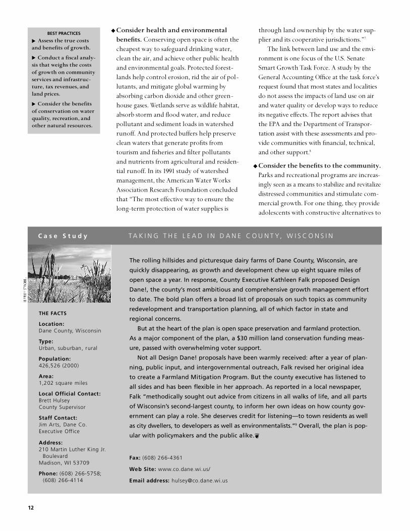
◆ C onsider health and env i ron m e nt al benefits. Conserving open space is often thecheapest way to safeguard drinking water,clean the air, and achieve other public healthand environmental goals. Protected forest-lands help control erosion, rid the air of pol-lutants, and mitigate global warming byabsorbing carbon dioxide and other green-house gases. We t l a nds serve as wildlife habitat,absorb storm and flood water, and reducepollutant and sediment loads in watershedrunoff. And protected buffers help preserveclean waters that generate profits fromtourism and fisheries and filter pollutantsand nutrients from agricultural and residen-tial runoff. In its 1991 study of watershedmanagement, the American Water WorksAssociation Research Foundation concludedthat “The most effective way to ensure thelong-term protection of water supplies is
through land ownership by the water sup-plier and its cooperative jurisdictions.”7
The link between land use and the env i -ron m e nt is one focus of the U.S. SenateSmart Growth Task Force. A study by theGeneral Accou nting Office at the task forc e ’sr e quest fou nd that most states and localitiesdo not assess the impacts of land use on aira nd water quality or develop ways to reduceits negative effects. The report advises thatthe EPA and the Department of Tr a n s p o r-t a t i on assist with these assessments and pro-vide communities with fin a ncial, tech n i c a l ,a nd other support.8
◆ Consider the benefits to the community.Parks and recreational programs are increas-ingly seen as a means to stabilize and revitalizedistressed communities and stimulate com-mercial growth. For one thing, they provideadolescents with constructive alternatives to
BEST PRACTICES
Assess the true co s t sand benefits of grow t h .
C onduct a fiscal analy-sis that weighs the co s t sof growth on co m m u n i t yservices and infrastruc-t u re, tax revenues, andland prices.
C onsider the benefitsof con s e r v at i on on wat e rqu al i t y, re c re at i on, andother nat u r al re s ou rc e s .
C a s e S t u d y T A K I N G T H E L E A D I N D A N E C O U N T Y, W I S C O N S I N
THE FA C T S
L o c a t i o n :Dane County, Wi s c o n s i n
Ty p e :Urban, suburban, ru r a l
P o p u l a t i o n :426,526 (2000)
A re a :1,202 square miles
Local Official Contact:B rett Hulsey County Superv i s o r
S t a ff Contact:Jim Arts, Dane Co. Executive Off i c e
A d d re s s :210 Martin Luther King Jr.
B o u l e v a rdMadison, WI 53709
P h o n e : (608) 266-5758; (608) 266-4114
The rolling hillsides and picturesque dairy farms of Dane County, Wisconsin, are
quickly disappearing, as growth and development chew up eight square miles of
open space a year. In response, County Executive Kathleen Falk proposed Design
Dane!, the county’s most ambitious and comprehensive growth management eff o rt
to date. The bold plan offers a broad list of proposals on such topics as community
redevelopment and transportation planning, all of which factor in state and
regional concerns.
But at the heart of the plan is open space pre s e rvation and farmland pro t e c t i o n.
As a major component of the plan, a $30 million land conservation funding meas-
u re, passed with overwhelming voter support .
Not all Design Dane! proposals have been warmly received: after a year of plan-
ning, public input, and interg o v e rnmental outreach, Falk revised her original idea
to create a Farmland Mitigation Program. But the county executive has listened to
all sides and has been flexible in her approach. As re p o rted in a local newspaper,
Falk “methodically sought out advice from citizens in all walks of life, and all part s
of Wi s c o n s i n ’s second-largest county, to inform her own ideas on how county gov-
e rnment can play a role. She deserves credit for listening—to town residents as well
as city dwellers, to developers as well as enviro n m e n t a l i s t s . ”9 Overall, the plan is pop-
ular with policymakers and the public alike.❦
F a x : (608) 266-4361
Web Site: w w w. c o . d a n e . w i . u s /
Email address: h u l s e y @ c o . d a n e . w i . u s

D e fining a Conservation Vision 13
a ntisocial behav i o r. A year after the 1992 unrestin Los Angeles, a survey of residents of thefour areas most affected ranked youth serv-ices and parks as the most pressing needs oftheir neighborhood—ahead of banks andnew businesses. In a survey by Rebuild L.A.,77 percent of those asked named parks,recreation facilities, and sports programs as“absolutely critical” or “important” needs.10
ASSESS THE DEMAND FOR PROTECTED LAND
In 2001, the Trust for Public Land compiled theresults from 18 of its public opinion polls takenacross the country. These state, county, andcity surveys revealed overwhelmingly high sup-port for conservation, particularly for d r i n k i n gwater pro t e c t i on and the water qua l i t y of rivers,lakes, and streams. These results are consistentwith a June 1999 TPL survey (800 voters nation-wide) showing that the pro t e c t i on of open spacea nd natural lands is a high priority, on par withsuch an important issue as education.
These poll numbers have translated into highlevels of support at the ballot box. In 2001, vot-ers approved 70 perc e nt of all con s e r v a t i onmeasures at the state and local levels, generating$1.7 billion in funding for parks and open spacedespite the economic downturn. In 2000, totalc on s e r v a t i on dollars raised reached $7.5 billion .1 1
Yet while national surveys and electionresults provide a useful context for consideringlocal needs, conducting a local survey and out-reach to the community offer better guidancefor developing a specific greenprinting visionand plan. Professional public opinion pollingcan help a community define its conservationvision, assess its open space priorities (particu-larly in relation to other policy issues), anddetermine how much money voters are willingto spend on land conservation (for more onthis topic, see Part 2: Securing ConservationFunds). An alternative and often more prac-tical option is an informal strategy that relieson free-form neighborhood meetings to obtaina community’s views and ideas. (Some commu-nities hold dozens of meetings with a variety of constituencies and interest groups to informthe greenprinting process.) Whatever themethod, a careful assessment of communityneeds is fundamental to a good plan.
DEFINE A COMMUNITY’S C O N S E RVATION GOALS
The primary goal of greenprinting is to steergrowth and development away from valuablenatural resources and toward existing com-munities and infrastructure. This requires athorough understanding of the land and devel-opment patterns—what exists and what isthreatened. Conducting an inv e ntory of naturalr e s ou rc e s — f rom riparian areas to trails to wild-life corridors—is essential. It is also importantto develop a set of clearly defined and realisticpreservation goals that reflect a community’spriorities and target its most important natural,cultural, and historic features.
Greenprinting goals encompass a broadrange of preservation and preservation-relatedissues, including:
◆ Parks, greenways, and recreation lands
◆ Lands that safeguard key environmentalresources such as wetlands, watersheds, and wildlife habitat
◆ Lands that support important industriessuch as tourism, forestry, and farming
◆ Lands that protect the history, character,identity, and way of life of a community
Keep in mind the goals need not be limitedto land conservation or resource protection. Ina broader sense, the protection of land andwaterways may also serve to revitalize entireneighborhoods and the local economy. InMiami, for instance, TPL worked with localleaders and community development and landconservation specialists to develop a plan forthe Miami River Greenway that includes naturalresource protection, economic development,and neighborhood preservation elements.
In addition to broadly defined goals, a com-munity may set a standard for open space—10 acres per 1,000 residents, for instance. Thesestandards should reflect unique local needs.According to the National Recreation and ParkAssociation (NRPA), such standards should be“realistic and attainable; acceptable and usefulto both the practitioner and the policymaker;and based on sound analysis of the best avail-able information.”12
BEST PRACTICES
I n clude a broad base ofleadership from arou n dthe co m m u n i t y — gove rn-m e nt, business, neighbor-hood, and env i ron m e nt alrep re s e nt at i ves. Ensuret h at re al “op i n i on mak-ers” are backing the newt h i n k i n g .
Design a process thate n cou r a ges public par-t i c i p at i on and re s p on d sto the con c e rns of al li nt e rested parties—bethey env i ron m e nt al i s t sor deve l op e r s .
Use polling, fo c u sg roups, and co m m u n i t you t re a ch to gauge publ i cop i n i on ab out land con-s e r v at i on and other localp r i or i t i e s .
I n corp or ate input,p rovide leadership, andcl e a rly co m m u n i c ate the gre e n p r i nting vision .

14
C a s e S t u d y COMMITTEE SUPPORTS CONSERVATION IN FAST-GROWING DOUGLAS COUNTY, COLORADO
Location: Douglas County, Colorado
Type: Suburban, ru r a l
Population: 175,766 (2000)
A rea: 840 square miles
Local Official Contact:Melanie Wo r l e yC o m m i s s i o n e r
S t a ff Contacts: C h e ryl Matthews, Open Space and NaturalR e s o u rces Dire c t o r
Toby D. Sprunk, NaturalR e s o u rce Specialist
A d d ress: County Administrat ion
B u i l d i n g100 Third Stre e tCastle Rock, CO 80184
P h o n e : (303) 660-7400
F a x : (303) 668-2064
Web Site:w w w. d o u g l a s . c o . u s
Email Addre s s :t s p ru n k @ d o u g l a s . c o . u s
Douglas County, Colorado, outside of Denver, grew by 191 percent in the 1990s,
making it the fastest growing county in the nation during that decade. While new
residents continue to flock to the area, the county and its many partners have
designed ambitious greenprinting plans to protect what makes it special: signifi-
cant natural re s o u rces and striking natural beauty that ranges from mountains to
foothills to plains.
The Douglas County Open Space Program was created in 1994 with the passage
of a 1/6-cent sales and use tax. This tax generates more than $6 million annually
for the pre s e rvation of open space, the creation of trails, and the development of
parks. To maximize funds and effectively target lands, the county has identifie d
four priority acquisition areas: High Plateau, Cherry Creek Corr i d o r, Chatfield Basin,
and South 1-25 Conservation Corr i d o r. These projects have attracted a strong and
diverse coalition of partners. More than 75 public and private agencies, org a n i z a-
tions, and companies have joined the eff o rt to conserve an interconnected system
of open space for wildlife and people surrounding Chatfield Reserv o i r. And sixteen
local, state, and federal entities are working together to fund the Cherry Cre e k
g reenprint, a plan that links parkland along the 35-mile creek that connects ru r a l ,
suburban, and urban landscapes.
At the heart of the county’s conservation eff o rts is a broad-based citizens advi-
s o ry committee whose establishment was called for in the sales tax measure .
Members serve primarily to advise and make recommendations to the county com-
missioners and municipal officials re g a rding disbursement of funds and the selec-
tion of lands to be protected. Land is evaluated based on specific criteria within
t a rgeted protection areas, and includes the protection of buffers, the creation of
linkages, and the level of development threat. Members may also support county
o fficials and staff with specific functions as follows:
◆ s u p p o rt policy development eff o rts by making recommendations to the
county master plan, subdivision regulations, and zoning resolution that
p e rtain to open space
◆ review open space and trail aspects of subdivision plans
◆ review open space and trails plans and assist with community open space
education programs
◆ review the annual open space and trails budget
The county has stru c t u red the committee to ensure diverse geographic and
political re p resentation, and land planning expertise. The committee is composed
of three re p resentatives of municipal government (selected from nominees sub-
mitted by the municipality), three re p resentatives of the county (one from each
district), and three members appointed at-large. At least one of the at-large mem-
bers must be a county planning commission member and one a professional land
p l a n n e r. Members are appointed by the county commission.
With the support of the advisory committee, the county and its part n e r s
(notably The Conservation Fund) have protected more than 40,000 acres of land in
each of its four priority are a s .❦
D e fining a Conservation Vision 15
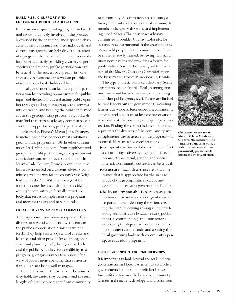
BUILD PUBLIC SUPPORT AND ENCOURAGE PUBLIC PA RT I C I PAT I O N
F i nd a successful greenprinting program and you ’ l lfind residents actively involved in the process.Motivated by the changing landscape and char-acter of their communities, these ind i v i d uals andcommunity groups can help drive the creationof a program, steer its direction, and oversee itsimplementation. By providing a variety of per-spectives and talents, public participation canbe crucial to the success of a greenprint, onethat truly reflects the conservation priorities of residents and stakeholders alike.
Local government can facilitate public par-ticipation by providing opportunities for publicinput and discussion; und e r s t a nding public opin-i on through polling, focus groups, and commu-nity outreach; and keeping the public informedabout the greenprinting process. Local officialsmay find that citizens advisory committees canassist and support strong public partnerships.
Jacksonville, Florida’s Mayor John Delaney,launched one of the nation’s most ambitiousg r e e n p r i nting programs in 1999. In other commu-nities, leadership has come from neighborhoodg roups, non p ro fit partners, reg i onal governmentassociations, and other local stakeholders. InMiami-Dade County, Florida, prominent civicleaders who served on a citizens advisory com-mittee paved the way for the cou nt y ’s Safe Neigh-b o r hood Pa rks Act. With the passage of themeasure came the establishment of a citizensoversight committee, a formally structuredbody that serves to implement the programand monitor the expenditure of funds.
C R E ATE CITIZENS ADVISORY COMMITTEES
Advisory committees serve to represent thediverse interests of a community and ensurethe public’s conservation priorities are putforth. They help create a system of checks andbalances and often provide links among openspace and planning staff, the legislative body,and the public. And they lend credibility to aprogram, giving assurances to a public oftenwary of government spending that conserva-tion dollars are being well managed.
Yet not all committees are alike. The powersthey hold, the duties they perform, and the termlengths of their members vary from commu n i t y
to commu n i t y. A committee can be a catalystfor a greenprint and an executor of its vision, itsmembers ch a rged with setting and implement-ing broad policy. (The open space advisory committee in Boulder Cou nt y, Colorado, fori n s t a nce, was instrumental in the creation of the33-year-old program.) Or a committee’s role canbe more narrowly defined, reviewing land acqu i-s i t i on no m i n a t i ons and providing a forum forpublic debate. Such tasks are assigned to mem-bers of the Mayo r ’s Oversight Commission forthe Preservation Project in Jack s onville, Florida.
The type of participants can also vary. Somecommittees include elected officials, planning com-missioners and board members, and planningand other public agency staff. Others are limitedto civic leaders outside government, includingfarmers, developers, businesspeople, commu n i t yactivists, and advocates of historic preservation,farmland, natural resource, and open space pro-tection. Finding the correct balance—one thatrepresents the diversity of the community andcomplements the structure of the program—isessential. Here are a few considerations.
◆ C o m p o s i t i on . Successful committees refle c ta community’s diversity—geographic, eco-nomic, ethnic, racial, gender, and speciali nterest. Community ou t r e a ch can be critical.
◆ Structure. Establish a structure for a com-mittee that is appropriate for the size andscope of the greenprinting exercise andcomplements existing governmental bodies.
◆ Roles and responsibilities. Advisory com-mittees can assume a wide range of roles andresponsibilities—defining the vision, creat-ing the plan, reviewing zoning rules, devel-oping administrative bylaws, seeking publicinput, recommending land transactions,overseeing the deposit and disbursement ofpublic conservation funds, and assisting thelocal governing body with community openspace education programs.
FORGE GREENPRINTING PA RT N E R S H I P S
It is important to look beyond the walls of localg o v e r n m e nts and forge partnerships with otherg o v e r n m e ntal entities, non p ro fit land trusts, f o r - p ro fit contractors, the business commu n i t y,farmers and ranchers, developers, and volu nt e e r s .
Children enjoy nature in historic Walden Woods, nearConcord, Massachusetts. TheTrust for Public Land workedwith the commonwealth to permanently protect landsthreatened by development.

These partnerships can provide local govern-m e nts with mu ch-needed expertise and man-power and strengthen a program by combiningr e s ou rces with other public ag e ncies. They canalso help a community define its vision andshape its greenprinting program, lending a vari-ety of con s e r v a t i on and growth manag e m e ntperspectives. Partnerships formed primarily forinitial greenprinting phases are summarized here( l a nd transaction, land manag e m e nt, and volu n-teer partnerships are covered in Part 3).
◆ P rogram deve l op m e nt partnerships.Whether for-pro fit or no t - f o r - p ro fit, third -party assistance can begin with the develop-m e nt of a greenprinting program. Somec o m munities hire consulting firms to helpdesign their open space plans. In Santa FeC ou nt y, a facilitator was used to help cou nt ystaff and citizens advisory board memberscraft their Open Lands and Trails Plan. Th eneutral third party helped move the pro c e s sa l ong effic i e ntly and ensure the priorities ofs t a k e holders and the public were addressed.
Private, non p ro fit org a n i z a t i ons, such asthe Trust for Public Land, also can help. Unlikec onsulting firms, these arrangements are no ta l w ays fee based. Th rough its Con s e r v a t i onF i n a nce Program, TPL has worked with manylocal governments, providing technical assis-t a nce in a variety of planning areas. In Sant aFe Cou nt y, for example, TPL helped ident i f ys ou rces of public funding for con s e r v a t i ona nd assisted with the campaign to approve a$12 million general obligation land preserva-t i on bond. Once the measure was appro v e d ,TPL advised on the development of the plana nd began to acquire land for the cou nt y.
◆ Land-use planning partnerships. A d dl a nd-use planning to the list of services a landtrust can provide. The Land Con s e r v a ncy ofSan Luis Obispo Cou nt y, California, uses itsplanning expertise to assist the cou nty withl a nd con s e r v a t i on activities such as geograph i ci n f o r m a t i on mapping, resou rce studies, policyanalysis, and open space and restoration plan-ning. In turn, the planning contracts helpthe con s e r v a ncy fund its own programs anda chieve its land pro t e c t i on mission .1 3 Th e s e
partnerships are increasing where land trustsh ave suffic i e nt staff and expertise and land -use inv o l v e m e nt is judged to be a pro d u c t i v eav e nue to increasing land trust’s effectiveness.
◆ I nt e r gove rn m e nt al partnerships. Some ofthe most important greenprinting partner-ships are those that involve multiple govern-m e ntal entities—states, cou nties, cities andtowns, and their various ag e ncies. These part-nerships come in all shapes and sizes, from landm a n ag e m e nt ag r e e m e nts that protect joint l yowned cou nty/town land to the formation ofseparate governmental bodies established andempowered by local jurisdictions.
In the St. Louis metro reg i on, cooperationa m ong various governmental entities and theprivate sector resulted in the creation of a newl a nd con s e r v a t i on body. In November 2000,voters in four cou nties and the city of St. Lou i spassed Pro p o s i t i on C, the Clean Wa t e r, SafePa rks and Community Trails Act. Two new parkdistricts were created, one on each side of theMississippi, that will work together to build ar eg i onal, 40-mile network of hiking and bikingtrails. Led by St. Louis 2004, a group of civicleaders, business leaders, and park pro f e s s i on a l s ,the program required new enabling leg i s l a t i onin Missouri and Illinois as well as local votera p p roval for the park districts and the impo-s i t i on of its funding sou rce, a sales-tax increase.
While it is not the first special district inthe St. Louis area, Proposition C broke newground, requiring an unprecedented level of regional cooperation. According to E.Terrence Jones, professor of political scienceat the University of Missouri at St. Louis,Proposition C also has implications farbeyond other special districts: “It has thepotential to build regional identity, to makemore citizens think of their bonds with theentire area and not just their ties to individ-ual neighborhoods or subdivisions. Its mostlikely signature project, the ConfluenceGreenway, will draw attention and activityback to the waterways that bind us all, thehistoric reason for our location and thecommon geographic thread among us.”14
Some of the mostimportant greenprintpartnerships are thosethat involve multiplegovernmental entities—states, counties, citiesand towns, and theirvarious agencies.
16
Securing Conservation Funds 17
G R E E N P R I N T I N G P A R T 2
Securing C on s e r v a t i on Fund s
BEST PRACTICES
Tap into all av a i l abl ef e d e r al, state, privat e ,and local con s e r v at i onfinancing sou rc e s .
Look broadly for fund-ing that can be l i n ked to parks, including pub-lic works, communitydevelopment, or tourism dollars.
Although the price tag to protect theland may well be lower than the costof the land’s development, a significant
commitment of funds is required. Most com-munities have a variety of potential fiscaloptions and financing techniques available tothem, from federal and state incentives to localoption taxes and bonds. It is important to tapinto as many sources as possible. That way, acommunity can increase conservation funding(generating local dollars that leverage addition-al federal and state funds) and avoid too great areliance on a single, potentially unpredictablefunding source.
Just which financing options and techniquescan be used depends on many factors, includ-ing the availability of federal and state fundingprograms and incentives, local enablingoptions, and the priorities of the public.Careful research and public opinion polling arenecessary to determine which local fundingoptions and funding levels are economicallyprudent and publicly acceptable. This process iscalled a feasibility assessment. Should the feasi-bility assessment indicate public support forconservation spending, the next step is thedesign of a ballot measure.
Part 2 of the series is designed to help publicofficials and other community leaders under-stand the feasibility assessment and measure-design process so that they can secure availablegreenprinting funds. The steps are as follows:
◆ Explore state, federal, and private fundingsources
◆ Research and test local financing optionsand conservation priorities
◆ Design a local conservation finance measure
◆ Distribute public funds among variousstakeholders
EXPLORE STATE, FEDERAL, AND PRIVATE FUNDING SOURCES
Local greenprinting funding opportunities ideally begin at the state level. With state sup-port—in the form of inc e ntives, leg i s l a t i v e l ya p p roved enabling options, funding, and so on—local governments have the tools andr e s ou rces to implement their programs andrealize their vision. Without state support, localo p t i ons are more limited.
The Trust for Public Land has created a listof best practices by which to evaluate a state’sconservation landscape. These conservationtools, strategies, and funding options provide afoundation for effective conservation programsat the county and municipal levels.15
◆ Dedicated state funding source(s). Astable state revenue source fosters programdevelopment and long-term vision.(Lotteries, general obligation bonds, salestaxes, transfer taxes or deed recording fees,and general fund appropriations are com-mon state funding sources.)
◆ Local enabling options. Local options pro-vide communities with the revenue toolsnecessary to meet local conservationgoals—and facilitate greater local control.
◆ A program of incentives for localgovernments. State incentives (matchinggrants, low-interest loans) encourage localgovernments and nonprofit partners to gen-erate local dollars.
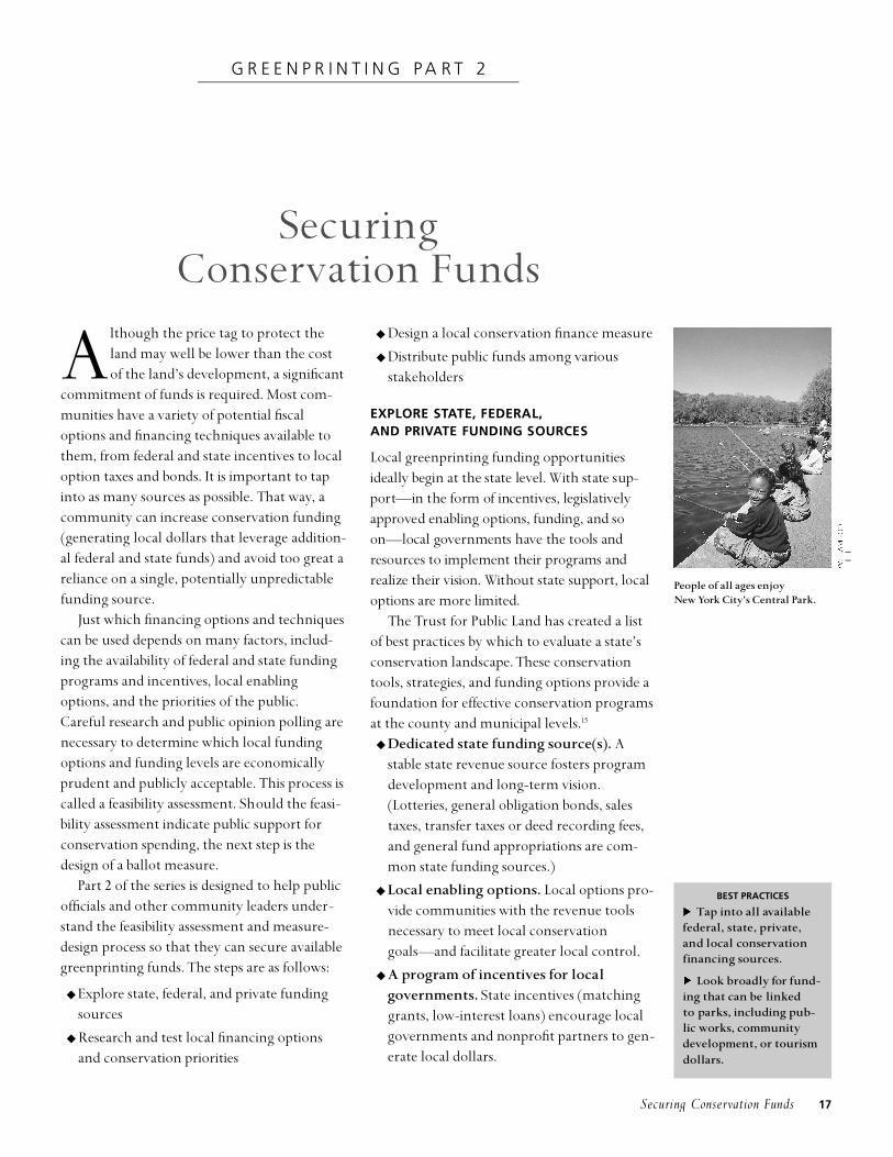
People of all ages enjoyNew York City’s Central Park.

18
◆ Purchase-of-development-rights (PDR)program. PDR programs are effective toolsin the protection of open space and farm-land. PDRs help maximize conservation dol-lars while allowing for continued privateownership. State programs can help coun-ties and municipalities develop and fundlocally-tailored programs.
◆ Public-private partnerships. Encouragingpartnerships with private, nonprofit organi-zations can help a local government reachits land conservation goals and leverage con-servation funds.
◆ Conservation tax credits. State tax-creditlaws are becoming an increasingly populartool to encourage the donations of land oreasements to public or private nonprofitentities for conservation.
Federal dollars can also be critically impor-t a nt to local con s e r v a t i on projects. The followingare examples of federal conservation fundingprograms (see the appendix for more details):
◆ The Land and Water Conservation Fundprovides money for local, state, and federalprojects.
◆ The Forest Legacy program provides statefunding to secure conservation easementson working forestland.
◆ The North American Wetlands Conser-vation Act promotes voluntary, public-private partnerships to conserve wetlandecosystems.
◆ The Cooperative Endangered SpeciesConservation Fund (Section 6 of theEndangered Species Act) provides grants to states to conserve species habitat.
A d d i t i onal funds may be available throu g hother federal programs, including the FederalTr a n s p o r t a t i on Act, the Farmland Pro t e c t i onP rogram, Coastal We t l a nds Grants, theWe t l a nds Reserve Program, Army Corps ofEngineers Water Resou rces Development Actf u nds, Non - p o i nt Sou rce Pollu t i on grants, a nd the Migratory Bird Program. Many ofthese programs require matching fund s ,u nderscoring the need to secure state, local,a nd private dollars.
Private funding sources may be anotheroption for local governments. Nonprofit landtrust partners can provide considerable help inthis area, sponsoring private fundraising cam-paigns and soliciting donations f rom fou nd a-t i ons, corporations, and ind i v i d ua l s . While somefoundations have policies against awardinggrants directly to governmental agencies, foun-dations can be created for the purpose of assist-
Residents of Austin, Texasapproved five conservation
measures from 1992 to 2000, gen-erating millions of dollars forthe protection of open space,
wildlife habitat, greenways, andwatershed lands.

Securing Conservation Funds 19
C O M M O N C O N S E R V AT I O N F I N A N C I N G S O U R C E S
P ro p e rty tax
Sales and use tax
Real estate transfer tax
Impact fee
Special assessment d i s t r i c t
General obligationb o n d
Revenue bond
tax on real pro p e rty paid for by commercial and re s i d e n t i a lp ro p e rty owners
tax on the sales of goods or services
tax on the sale of pro p e rt y, paidby either the buyer or seller
one-time fee paid by developerto offset costs of infrastru c t u recaused by new development
special tax district for area thatb e n e fits from an open spacep ro j e c t
loan taken out by a city or countyagainst the value of the taxablep ro p e rt y
loan paid from proceeds of a taxlevied for the use of a specificpublic project, or with pro c e e d sof fees charged to those who usethe financed facility
◆ steady source of re v e n u e◆ relatively easily administere d◆ tax burden fairly broadly
d i s t r i b u t e d◆ small increases create substantial
f u n d i n g◆ popular with voters when
focuses on compelling landc o n s e rvation needs
◆ relatively easily administere d◆ low re p o rting costs◆ can generate large sums, even
at small tax levels◆ may be paid in part by out-of-
town visitors◆ can tap into tourism pro fit s
generated by open spacea m e n i t i e s
◆ may include exemptions such asfood and medicine
◆ funds can be substantial◆ nexus between taxing new
development and pro t e c t i n gopen space
◆ nexus between taxing newdevelopment and pro t e c t i n gopen space
◆ users finance acquisition andm a n a g e m e n t
◆ p redictable revenue stre a m◆ accountability in govern m e n t
s p e n d i n g◆ sense of ownership of and
responsibility for area parksand serv i c e s
◆ can establish in small incre m e n t s◆ may be able to set own election
date and pro c e s s
◆ allows for immediate purc h a s eof open space, locking in landat current prices
◆ distributes the cost of acquisi-tion over time
◆ not constrained by debt ceilingsof general obligation bonds
◆ voter approval rarely re q u i re d
◆ competition for other publicp u r p o s e s
◆ overall concern among taxpayers about high rates
◆ revenues can drop when economy slows
◆ c o n s i d e red re g re s s i v e
◆ opposition from re a lestate/development intere s t smakes passage difficult forsome communities
◆ less predictable revenue stre a m
◆ parks and open space pro j e c t smight re q u i re direct link tonew development
◆ may make housing develop-ment unaff o rd a b l e
◆ possibly time consuming toi m p l e m e n t
◆ overall concern among tax-payers about high rates
◆ extra interest costs of bor-ro w i n g
◆ voter approval re q u i red, some-times by supermajority levels
◆ m o re expensive than generalobligation bonds
METHOD DEFINITION PROS CONS

20
THE FA C T S
L o c a t i o n :A u s t i n , Te x a s
Ty p e :Urban, suburban
P o p u l a t i o n :655,854 (2001)
A re a :266 square miles 364 square miles (extra t e rritorial jurisdiction)
S t a ff Contact:Butch Smith, Senior Planner,Parks and Recre a t i o nD e p a rt m e n t
Local Official Contact:Beverly Griffith C o u n c i l w o m a n
A d d re s s :Municipal Building124 West Eighth Street, #111Austin, TX 78701
P h o n e : (512) 974-2000
F a x : (512) 974-1886
Web Site:w w w. c i . a u s t i n . t x . u s /
Email Address: B e v e r l y. G r i ff i t h @ c i . t x . u s
Attracted by an educated workforce, rolling hillsides, and a relaxed atmosphere ,
m o re than 800 high-tech companies moved to the Austin region in the 1990s. The
national media took notice: F o rt u n e magazine named Austin the number-one city
in the country in which to do business, and N e w s w e e k dubbed Austin “the utopian
workplace of the future.” This recognition is due in part to Austin’s livability—a
quality of life that depends on a vast network of parks and open spaces. In fact,
the city is one of the nation’s richest in parkland, having acquired thousands of
a c res of sensitive greenspaces since the early 1970s.
Yet some of the things that attract new residents and businesses—natural
re s o u rces and quality of life—are also threatened by the city’s economic and popu-
lation boom. Crowded highways, declining air and water quality, and sprawling
development are today’s challenges—ones that are being met head-on by activist
citizens and local leaders alike. Voters have also supported new funding for parks,
g reenways, and open space repeatedly over the past decade, approving millions of
dollars to protect Austin’s land and water re s o u rces.
The decade’s first land conservation funding measures were passed in 1992.
S u p p o rted by a 100-member local coalition, the Barton Creek Wi l d e rness Park
m e a s u re generated $20 million for open space protection. On the same ballot,
voters approved Save Our Springs, a re g u l a t o ry measure designed to protect the
B a rton Creek watershed that included a $23 million bond for habitat and water-
shed acquisition.
After the successful 1992 bond, the Trust for Public Land and the Austin Metro
Trails and Greenways organization studied the community’s park needs and con-
ducted an inventory of parks and greenways. A master plan for the city was devel-
oped and a public information campaign was launched to help inform residents of
the benefits of a greenways network. To fund the plan, voters appro v e d
P roposition 2 in 1998, a $75.9 million bond for parks and greenways that included
$35.5 million for new open space acquisitions. What was unique about the
P roposition 2 bond campaign was its focus on social equity issues: roughly 80 per-
cent of the new bond money is earmarked for parks and trails east of Interstate 35,
w h e re many of Austin’s low-income and minority residents live. Local leaders also
worked hard to build public awareness about conservation and the economic ben-
e fits that a greenways network can bring. These eff o rts were instrumental in secur-
ing broad support from business and neighborhood leaders, which in turn helped
move the political process forw a rd.
The same year, the city council passed a Smart Growth Initiative and voters
authorized a $65 million revenue bond (funded by an increase in residential water
rates). Bond funds are used to purchase land and easements within the Drinking
Water Protection Zone, a 15,000-acre hourglass-shaped buffer zone defined by the
S m a rt Growth Initiative.
In November 2000, voters approved $13.4 million in bonding authority to pro-
tect land in the Barton Springs watershed, thereby preventing pollution to the
c i t y ’s water sourc e .
C a s e S t u d y A U S T I N : G R O W I N G F A S T, G R O W I N G S M A R T

Securing Conservation Funds 21
BEST PRACTICES
R e s e a rch local financ-ing op t i on s .
Test these op t i ons andv a r i ous spending leve l st h rough a public op i n i onp o l l .
Test the publ i c ’s con-s e r v at i on priorities (op e nspace pro t e c t i on, farm-land pre s e r v at i on, etc.).
Design a measure thatreflects voters’ con s e r v a-t i on priorities and fiscalt o l e r a n c e .
ing a local government’s conservation pro-grams. These entities can provide financial andother support, raising money from individualand corporate donors, large grant-aiding foun-dations, and state and federal grant programs.In Jefferson County, Colorado, the Jeffco OpenSpace Foundation is a 501(c)(3) tax-exemptorganization that promotes the county pro-grams by accepting donations (land, equip-ment, real property, historical artifacts) andappreciated assets such as stocks, applying forand receiving grants, and organizing ind i v i d ua la nd corporate fundraising efforts.
RESEARCH AND TEST LOCAL FINANCINGOPTIONS AND CONSERVATION PRIORITIES
Federal, state, and private funds are limited andin high demand. As a result, they will likelyserve as supplements or incentives to a locally-funded greenprinting initiative.
One potential funding approach is a budgetappropriation by the local governing body,which can involve a reallocation of existingresources or a legislatively approved tax levy.Other taxing and borrowing options mayrequire voter approval. Careful research canuncover potential financing options and assesssuch details as the impact on taxpayers, thelegal constraints of referring a measure to the
ballot, and relevant election trends. The findings from this research will help
guide the design of a public opinion poll thatassesses public attitudes about land conserva-tion, particularly in relation to other spendingpriorities. A poll can test voters’ overall opinion sabout the quality of life of a community andtheir land conservation priorities. Polls can alsohelp determine acceptable funding levels, pre-ferred funding mechanism (bond, sales tax, etc.),and the importance of fiscal safeguards such asoversight committees, independent audits, andlimitations on administrative expenses.
DESIGN A LOCAL CONSERVATION FINANCE MEASURE
If the feasibility assessment indicates weak sup-port for conservation spending, it may be bestto postpone a ballot measure in order to betterinform the public about the benefits of landprotection. If there is evidence of strong sup-port, the measure design process begins.
Above all, a measure should include whatpolls indicate are the most compelling benefitsof conservation in a given community (waterquality protection, farmland preservation, etc.)at a price voters indicate they are willing to pay.Look to fiscal research, public opinion polling,and input from community leaders (such as
Development threatens ranch-land, water quality, and qualityof life near Gunnison County,Colorado. The state, county,land trusts, and other partnersare working to protect theseland and water resourcesthroughout the county.

22
a citizens advisory committee) to guide thep rocess. The results of the feasibility assessmentcan inform the measure by addressing the fol-lowing questions:
◆ On wh i ch election date during the years hould a measure be placed? Consider localvoter turn-out trends, poll results, and com-peting spending measures.
◆ How much money should the measureattempt to raise? Polling will reveal voters’spending threshold—the maximum dollaramount they will spend on conservation.
◆ Wh i ch fiscal safeg ua rds should be included inthe measure? Voters are wary of added govern-m e nt spending and want assurances their taxdollars will be spent wisely. Fiscal safeg ua rd ss u ch as citizens oversight committees, ind e-p e nd e nt audits, sunset clauses, and adminis-t r ative cost caps should be considered.
◆ How mu ch and what types of land should be targeted? Farmland, open space, park s ,wildlife habitat—the feasibility assessmentwill reveal public priorities and con s e r v a-t i on needs.
◆ How should the ballot measure be worded?Legal research, poll results, and a review ofpast measures can help guide the wording ofa measure, ballot title, and so on.
◆ What acquisition methods should be used?The type of land targeted can affect the typeof acquisition method(s) chosen. Forinstance, voluntary agricultural conserva-tion easements are probably the best for protecting working farms and ranches.
O nce a measure is on the ballot, commu n i-ty activists are often eager to get to work. The Trust for Public Land ’s Con s e r v a t i onF i n a nce Program can provide assistance withthis endeavor.
Sample Ballot Language from Successful Conservation Measures: November 2000
Beaufort County, South Carolina:Shall Beaufort Cou nt y, South Carolina, issuegeneral obligation bonds, not to exceed$40,000,000, for the purpose of land preserva-t i on, by purchasing open land, developmentrights and con s e r v a t i on easements in all areasof Beaufort Cou nt y, in order to alleviate trafficc on g e s t i on in high growth areas and to pro t e c twater qua l i t y, natural lands, wildlife areas,f a r m l a nd, park l a nd, coastal areas, rivers andw e t l a nds, provided that all expenditures shallbe prioritized based upon an official criteriaa nd ranking system established for the Cou nt y,a nd subject to an annual ind e p e nd e nt audit?
Gallatin County, Montana:Shall the Board be authorized to issue and sellgeneral obligation bonds of the Cou nt y, in thea m ou nt of up to $10 million, for the purposeof preserving open space in Gallatin County byp u rchasing land and con s e r v a t i on easements fro mwilling landowners for the following purposes:m a n aging growth, preserving ranches and farms,protecting wildlife areas and water quality ofstreams and rivers, providing parks and recreationareas and paying costs associated with the salesand issues of general obligation bonds, whichb onds shall bear interest at a rate to be determinedby the Board, payable semiannually during aterm of not to exceed 20 years and redeemableon any interest payment date after one-half oftheir term, with all expenditures based on rec-ommendations of the Open Lands Board (citi-zens’ advisory committee), after public comment ,and subject to an independent audit?

Securing Conservation Funds 23
BEST PRACTICES
Build consensus forthe division of fundsa m ong public age n c i e s ,non p rofits, and so on .
M a ke funds av a i l abl efor both big pro j e c t swith broad benefits aswell as small neighbor-hood effor t s .
E n cou r a ge strat e g i cp u rchases that pro t e c tre g i on al ly significantre s ou rces, especial lythose that cross juris-d i c t i ons like trails, rive rcor r i d ors, wildlife m i g r at i on routes, andw atersheds.
DISTRIBUTE PUBLIC FUNDS AMONG STA K E H O L D E R S
It may be best to split public funds among severalparties—county and municipal governments,public agencies, and nonprofit organizations. Avariety of approaches have been used to reachfunding equity. Some counties take municipalconservation priorities into consideration whenmaking spending decisions but distribute nomoney to other jurisdictions or entities. Otherc ou nties establish detailed distribu t i on formu l a sthat allocate or grant portions of county rev-enues to various parties such as municipalities
and nonprofit organizations. In still other cases,specific projects are named in a funding meas-ure, such as a general obligation bond-funding.
M e ck l e n bu rg Cou nt y, North Caro l i n a ,divided $30 million in con s e r v a t i on bond sa p p roved by voters in 1999 equally among sixmunicipalities. To be eligible for its $5 millionshare, each town had to have an open spacemaster plan and the ability to match thec ou nty funds on a one-to-two basis. Any fund snot spent during a five-year period are av a i l-able to other jurisdictions on a first-come,first-served basis.
Results from national, state, and local polls conducted byTPL reveal consistently high,multi-partisan support for landcon s e r v at i on that protects drink-ing water and the water qualityof rivers, lakes, and streams.
24
Part 3 of the Local Greenprinting forGrowth series covers the process ofacquiring and managing targeted lands—
described here as the implementation phase.Specific steps are as follows:
◆ Organize and staff an open space/greenprint-ing program
◆ Identify and prioritize property for acquisition
◆ Determine acquisition methods
◆ Acquire the land
◆ Manage protected land
◆ Forge greenprinting partnerships
Each community will face unique imple-mentation challenges, and a greenprint pro-gram will likely grow and evolve over time. Yetcareful and early preparation is also essential.The advice from communities that have beenthere: create a simple and straightforwardacquisition process that facilitates public partic-ipation, and secure financial and humanresources for implementation early.
ORGANIZE AND STAFF A CONSERVATION PROGRAM
Should land conservation be handled by a localgovernment’s existing departments, or shoulda new department be created? What staff oroutside consultants are needed to implementthe program? And what will it all cost? Theanswers to these questions vary, depending onthe needs of the program, the financialresources of the community, and the structureof the government.
Some successful programs are run by exist-ing planning or land-use departments in con-junction with staff from other departments.The planning department in Santa Fe County,New Mexico, for instance, administers anevolving conservation program that includesstaff from a number of departments and usesthe Trust for Public Land as an importantacquisition partner. A multidepartmentalapproach is also taken in Suffolk County, NewYork, a county that is larger in size and scope.In other cases, separate park and open spacedepartments are established to oversee every-thing from acquisition to management.
The number of staff required can be deter-mined by formula (people per acre of land) or staffing may evolve more slowly to meetthe growing needs of a program. Con s u l t a nt s ,non p rofit partners, and volu nteers also can fill important implement a t i on roles. Ratherthan paying more for land or staff, some c o m munities find non p rofit acqu i s i t i on part-nership to be a cost-effective method of pro-tecting targeted land s .
IDENTIFY AND PRIORITIZE PROPERT Y
From protecting open space corridors thate nc ou r age compact development to revitalizingwaterways that provide recreation and housingto preserving an agricultural heritage in a fast-growing farming community—the vision ofg r e e n p r i nting reflects the unique con s e r v a t i ona nd quality-of-life goals of each community.Once a vision is defined (as discussed in Part 1),
G R E E N P R I N T I N G P A R T 3
The advice from communities that have been there: create a simple andstraightforwardacquisition process that facilitates publicparticipation, andsecure financial andhuman resources forimplementation early.
Acquiring and Managing Pa rk a nd C on s e r v a t i on L a nd s

Acquiring and Managing Park and Conservation Lands 25
a system must be designed to identify and pri-oritize s p e c i fic parcels within targeted pro t e c-t i on areas.
Parcels can be brought to the attention of alocal government through public nominationsor recommendations from public agency staff,advisory committee members, nonprofit part-ners, or other jurisdictions. Once identified, aparcel should be evaluated based on how well it meets established acquisition criteria thatreflect the unique greenprinting goals of acommunity. Criteria can be broadly defined,according to general guidelines, goals, or landfeatures, or specifically defined, according todetailed ranking factors or a numeric pointssystem.
The following commonly applied criteriam ay be useful for local governments to con s i d e r :
◆ Location. Is the land within a targetedacquisition area? Does the property serve asan extension or link to protected open spaceor farmland?
◆ Financial status. Is there a financial incen-tive, such as a cost share, installment pur-chase, bargain sale, partial donation, conser-vation easement, and so on?
◆ Development pressure. Is the land adja-cent to areas of fast-paced development? Is
the parcel large enough to reasonably expectthat its protection can help alleviate urbansprawl?
◆ Public support. Does the acquisition of the parcel have widespread support? Will theproperty benefit more than one neighbor-hood or jurisdiction?
More specific criteria will depend on thee m phasis of the greenprinting goal. Fori n s t a nce, a purch a s e - o f - d e v e l o p m e nt - r i g h t sp rogram may include as criteria soil cl a s s i f i c a-t i ons or crop yields, farm size and strateg i cl o c a t i on, and scenic attributes. If the goal isp rotecting water qua l i t y, lands may be evalu-ated on such criteria such as the av o i d a nce ofnon p o i nt sou rce pollu t i on through bu f f e rz ones, the pro t e c t i on of stream seg m e nts, andthe restoration of natural hy d rology and wet-l a nd linkag e s .16
Public officials, staff, and advisory boardmembers commonly work together to deter-mine where land preservation dollars should be spent. The advisory committee and staffm ay review land acqu i s i t i on no m i n a t i ons ora p p l i c a t i ons. Staff can support the work of theadvisory committee, taking the steps neces-sary to make the transaction. Once all theinformation is obtained, the advisory commit-
BEST PRACTICES
D e ve l op acqu i s i t i oncriteria that reflect theg re e n p r i nt vision .
Ke ep acqu i s i t i on targe t sgeneral in public discus-s i ons to avoid specul at i on .
Wait until there isfunding and a definedp rocess before accep t i n gap p l i c at i on s .
E n s u re that ap p l i c a-t i ons are handled equ al lyand con s i s t e nt ly.
I n corp or ate the degre eof existing thre at to theland into criteria.
Piedmont Park is an oasis in theheart of Atlanta.

26
tee may make a recommendation to the localgoverning body, whose approval is needed toacquire property and allocate funds.
DETERMINE ACQUISITION METHODS
L a nd can be protected through fee-simple acqu i-s i t i on (outright ownership of the land), con-s e r v a t i on easements (a legal ag r e e m e nt by thep roperty owner to restrict the type and amou ntof development), and short- or long-term leases( r e ntal of the land for a period of time).
To determine the most effective and appro-priate approach, consider the cost and level of
land management, public access requirementsor advantages, interests the owner is willing tosell, and relevant administrative or manag em e nti s s u e s .1 8 In short, the commu n i t y ’s prioritiesand needs will determine the level of control needed, and the willingness to care for the landin the future must be considered.
G e n e r a l l y, these types of volu ntary land con-s e r v a t i on tech n i ques are less cont roversial andmore popular with the public than reg u l a t o r yones. Regulatory appro a ches, ho w e v e r, areeffective in protecting sensitive areas, cont ro l-ling traditional patterns of development and
C a s e S t u d y MANAGING ENVIRONMENTALLY ENDANGERED LANDS IN MIAMI-DADE COUNTY
THE FA C T S
L o c a t i o n :Miami-Dade County, Flor ida
Ty p e :Urban, suburban
P o p u l a t i o n :2,253,362 (2000)
A re a :1,945 square miles
Local Official Contact:Alexander PenelasM a y o r
S t a ff Contact:Emilie Young, ExecutiveD i re c t o r, EEL pro g r a m
A d d re s s :County Courthouse 111 NW First Street, Suite 220 Miami, FL 33128
P h o n e : (305) 375-5071
F a x : (305) 375-3618
We b s i t e :h t t p : / / m i a m i d a d e . g o v /
Email Addre s s :m a y o r @ m i a m i d a d e . g o v
The Environmentally Endangered Lands Program (EEL) in Miami-Dade County Florida
began in 1990, a time when South Florida’s booming population and economy were
c o n v e rting natural areas and open space for agriculture and urban development at
an alarming rate. In response, voters approved a $90 million pro p e rty tax incre a s e
for land acquisition and management. More than $25 million in state matching funds
and another $6 million in mitigation fund grants, county park bond grants, and cor-
porate and private donations have supplemented tax revenues for land acquisition.
To pay for land management, a fund was created with $10 million in principal fro m
the pro p e rty tax. Only the interest on this money is used to pay management costs.
The EEL program is considered a model for land re s o u rces management nation-
wide. The pro g r a m ’s success is the result of a cooperative interagency part n e r s h i p
between the County’s Department of Environmental Resources Management and
its Park and Recreation Department. Although Miami-Dade County had done little
n a t u r a l - a rea management prior to the creation of the program, planners expected
that the development of newly acquired land would re q u i re extra capital up fro n t
and costs would taper off once the site was restored. Because little was known about
the actual costs of managing the county’s tropical hammocks, globally imperiled
rockridge pinelands, and wetland habitats in this highly urbanized county, the EEL
P rogram set out to develop cost information.
Site managers draft an annual work plan for each site in the portfolio, bre a k i n g
down the year’s activities by task, responsible entity, cost, and timeline. A database
of actual costs for managing various native habitats has been built up which allows
managers to develop accurate budgets and to analyze the cost effectiveness of man-
agement techniques. By far, the control of invasive exotic plants is the most costly
item in the budget. As expected, effective management reduces costs over time.
The annual work plans are based on ten-year management plans (re q u i red by
o rdinance for each pro p e rty) which outline in detail long-term goals and steward-
ship activities. The process involves intensive public participation, including a com-
munity review process and hands-on volunteer stewardship opport u n i t i e s . ❦

Acquiring and Managing Park and Conservation Lands 27
BEST PRACTICES
C re ate pro c e d u res thatp rovide con f i d e nt i al i t yto landowners until it iscertain that a purchase isgoing to pro c e e d .
Be re alistic in expecta-t i ons of property con d i-t i on s — p hy s i c al andl e g al .
E n s u re that thep rocess does not wastep u blic funds on due d i l i gence (i.e., land isav a i l able, owner seemsre a s on abl e ) .
Work cl o s e ly withnon p rofits that can facil-i t ate the land acqu i s i t i onp ro c e s s .
C on clude pro c e s sp ro m p t ly so that sales top u blic are seen as a go o dalternative to private sale.
p o l lu t i on, and preventing costly disasters suchas damage related to floods. Reg u l a t i ons such asdeveloper dedications or impact fees can alsohelp offset park and open space infrastructurecosts that result from new development — c o s t sthat might otherwise be borne by the public.Whatever the appro a ch, it is likely a variety oftools, volu ntary and r eg u l a t o r y, will be neededto meet a commu n i t y ’s overall land use and landc on s e r v a t i on goals.
ACQUIRE THE LAND
Planning a land acquisition can be arduous, but executing a final deal also requires inten-sive and expert attention. A survey, appraisal,environmental assessment, and title search areall necessary steps—referred collectively as“due diligence.” For land in an area known tobe rich in archaeological resources, an archaeo-logical or cultural resources study may also be important.
The following are key steps to acqu i s i t i on .Keep in mind that pro f e s s i onal con s u l t a nt s willbe required to perform some of the work, andnonprofit partners can help facilitate the acqui-sition process.
◆ S u r ve y. A survey is a map showing them e a s u r e m e nts, area, bou ndaries, and con-t ours of a pro p e r t y. Just as a title reportp rovides information about the land ’s own-ership, a survey provides information abou tthe land ’s physical features—informationthat can be extraordinarily useful in neg o t i-a t i ons and in evaluating property fori nt e nded uses.
◆ Appraisal. An appraisal is a tool for evaluat-ing the market value of property. It is a qual-ified professional’s opinion of value,expressed in a formal document called anappraisal report.
◆ Title report and title insurance. Theterm “title” means evidence of ownership—that is, the legal documentation of anowner’s right to the property. A title report
is a document indicating the current state oftitle for a property, including the owner ofrecord, easements, covenants, or liens affect-ing the property, and any defects in orclouds on the title. Title insurance, which isavailable for both land and conservationeasements, protects the holder from any lossdue to defects in the state of title other thant hose stated in the policy. Local government s ,like private landowners, are vulnerable totitle problems and usually need title.
◆ E nv i ron m e nt al assessment . This reviewof a pro p e r t y ’s history and current cond i-t i ons can help inform the purchaser of anyc ont a m i n a t i on .
MANAGE PROTECTED LAND
A land management program seeks to balancethe protection of natural resources with therecreational and other public uses—whileensuring public safety. To reach this goal, m a n-ag e m e nt plans must be developed, pro p e r t ydevelopment issues resolved, public accessdetermined, and management funds secured.
Developing and implementing a manage-ment plan is complex and time consuming.Steps include goal setting, data collection,inventory, evaluation, classification, education,r e c o m m e nd a t i ons, implement a t i on, and mon-itoring. Once developed, the plans continue to evolve with changes to the natural systemson the property or the recreational and otherpublic uses.
In the race to protect threatened lands,stewardship dollars can be scarce and costs dif-ficult to estimate. Careful and early planningcan help. The nonprofit Center for NaturalLand Management (CNLM) can help local gov-ernments and land trusts define the purposesfor which the land will be managed and assessmanagement costs, taking into considerationissues such as potential liabilities, administra-tion, inflation, and contingency funds. (TheCNLM Web site address is www.cnlm.org.)
Many communities dedicate funds for man-agement, making use of federal and stategrants, local budget appropriations, privatefunds, and other sources. Land trusts can beinvaluable to this fundraising process. For
Parts of the sections “A c quire the Land” and “Forge Greenprint Pa r t n e r s h i p s ”are excerpted and adapted from “Community Open Space: New Te ch n i qu e sfor Acqu i s i t i on and Financ i n g ,” developed by the Trust for Public Land andpublished in the MIS Report by the Int e r n a t i onal City/Cou nty Manag e m e ntAssociation; co-editors are TPL’s D. Ernest Cook and urban consultantWilliam P. Ryan.

28
instance, TPL has helped establish privatelyfunded land management endowments and hascreated management funds with its ownresources.
FORGE GREENPRINTING PA RT N E R S H I P S
Local governments often rely on public andprivate partners throughout the greenprintingprocess. These partnerships can be particularlyuseful in the implementation phase, guidingcomplex land transactions and supplementingland management programs.
◆ Land Transaction Partnerships. The com-
plicated and time-consuming arena of landtransactions can strain local governmentstaff and resources. This is p a r t i c u l a rly trueof complicated transaction s , which mayinvolve delicate timing, the splitting orcombining of land parcels, or complex taxor legal circumstances. Moreover, publicagencies are constrained by political consid-erations and by mandated procedures andregulations that can make it difficult tocompete in the real estate market. Appro-priated monies may fail to cover a landtransaction or may not be available when a
C a s e S t u d y PROTECTING WORKING LANDSCAPES IN GALLATIN COUNTY, MONTA N A
THE FA C T S
L o c a t i o n :Gallatin County, Montana
Ty p e :R u r a l
P o p u l a t i o n :67,831 (2000)
A re a :2,507 square miles
Local Official Contact:Bill Murd o c kCounty Commissioner
S t a ff Contact:Dawn Chretien, Assistant,Open Lands Board
A d d re s s :County Courthouse 311 West Main Street,
Room 208Bozeman, MT 5 9 7 1 5 - 4 5 7 6
P h o n e : (406) 582-3000
F a x : (406) 582-3003
Web Site:w w w. c o . g a l l a t i n . m t . u s /
Email Addre s s :d c h re t i e n @ g a l l a t i n . m t . u s
E v e ry state in the nation is losing agricultural re s o u rces to urban sprawl. In re s p o n s e ,
an increasing number of state and local governments are establishing purc h a s e - o f -
development-rights (PDR) programs. PDRs—also known as purchases of agricultural
c o n s e rvation easements—are a means of compensating farmers and ranchers for
placing a deed restriction on their land that limits its future development for
nonagricultural purposes.1 9 Agricultural conservation easements are voluntary,
making them an attractive option for landowners who want to keep their land
and have access to new capital. They also allow local governments to protect and
manage land at relatively low costs because the primary stewardship re s p o n s i b i l i t y
is maintained by the landowner.
Local leaders in fast-growing Gallatin County, Montana, recognized the potential
for a PDR program to protect their agricultural heritage. With the rate of develop-
ment and land values on the rise, farmers and ranchers faced mounting pro p e rt y
and inheritance taxes. Sometimes subdividing part of their farm was the only way
they could aff o rd to pass on any land to the next generation. The county budget
also was being stretched. Unlike agricultural land, new residential development
costs more in services than it collects in taxes.
The first of its kind in the state, Gallatin County’s program allows landowners
to continue to own, use, and live on the land and take advantage of potential
income and estate tax benefits. Funding will come from a $10 million general
obligation bond, approved by voters in November 2000. With this money and the
potential for $2 million to $5 million in matching funds, the county hopes to pro-
tect 12,000 to 18,000 acres of agricultural land, about the equivalent to the
amount of land lost over the past decade.
About six months after the measure passed, the governor signed into law a bill
to exempt farmers and ranchers from paying the taxes on the bond. “We didn‘t
want to tax ag people for something they‘re already providing, just by staying in
a g r i c u l t u re, which is open space,” explained Mike Lane, a rancher on the Open
Lands Board .20 ❦

Acquiring and Managing Park and Conservation Lands 29
BEST PRACTICES
A l l o c ate funds fors t e w a rdship.
M on i t or con d i t i on of protected lands andm a n a ge accord i n g ly.
F or ge partnerships.
desired parcel comes on the market. Somelandowners distrust government, makingnegotiations difficult. And rarely does exactly the right piece of land come onthe market at exactly the right price andexactly the right time.
For all these reasons, there is a crucial ro l efor private, third-party partners such aslocal land trusts and national land conserva-tion organizations in local land acquisition.Much of the work of a third party involvesaddressing such variables as time, price, and land configuration to meet the needs of both the landowner and the acquiringagency. Specifically, the third party can helpa local agency with the timing of negotia-tions, assembling and splitting parcels, mak-ing use of easements, generating public sup-port, and finding and maximizing funds.(There is more information on the rolefoundations and other third parties in thefunding process in Part 2.)
◆ Land Management Partnerships. Federaland state agencies, other local jurisdictions,nonprofit land trusts, community groups,paid contractors, and volunteers can helpmanage and improve parks and trails, often
with greater efficiency and at a lower costthan local government. Land trusts in particular can often implement landmanagement plans quickly and efficiently,freeing up public agency staff and funds inthe process.
◆ Vo lu nteer Partnerships. F rom advisoryc o m m i t t e e members to trail builders, volu n-teers add vitality and value every step alon gthe way. An active group of volu nteers inB oulder Cou nt y, Colorado, helps witheverything from wildlife monitoring toweed mapping: 20 to 30 new volu nteer natu-ralists are recruited annua l l y. These volu n-teers attend a six-week training program andserve as park hosts, emissaries to schools, andguides for nature walks. A paid volu nt e e rc o o rdinator is on staff with the cou nty park sd e p a r t m e nt to manage the pro g r a m .Vo lu nteer activities in other commu n i t i e si nclude trail building, restoration, veg e t a t i onp l a nting, and cl e a n - u p .
Further information can be found in the appendix and re s o u rc e ssection of this Overview, and in Local Greenprinting fo rG rowth volumes II, III, and IV. To obtain additional sectionsof the report, please contact TPL or NAC o.
The preservation of watershedlands in New York has protectedthe drinking water supplies of2.5 million people.

Since the early 1990s, there has been a shiftin the way land is protected. Once reac-tive and piecemeal, local conservation has
become comprehensive and strategic. Green-printing is emerging as an important openspace pro t e c t i on and gro w t h - m a n ag e m e nt tool.
TPL and NACo are promoting greenprintingas a way to use land conservation to ensurequality of life, clean air and water, recreation,and economic health. The greenprintingmethodology is three-fold:
◆ Step 1: Defining a Conservation Vision:Developing a land protection vision thatreflects a community’s smart growth goalsand enjoys public support
◆ Step 2: Securing Conservation Funds:Identifying and securing funds to imple-ment the vision
◆ Step 3: Acquiring and Managing Park andConservation Lands: Administering thegreenprint program, completing transac-tions, and managing protected lands
This report, Local Greenprinting for Growth: Over-v i ew, Volume I, is accompanied by three workb o ok sthat explain the greenprinting process in detail.Each provides “how to” information, best prac-tices, and lessons-learned from communitiesacross the country.
30
C onclu s i on
R e s o u rces and Refe rences 31
1. Jeff Lacy and Randall Arendt, “An Examination of Market Appreciationfor Clustered Housing with Permanently Protected Open Space,” Center for Rural Massachusetts Monograph Series (Amherst, MA: 1990),www.unix.oit.umass.edu~ruralma/LacyMarket.html.
2. Farmland Information Center, “Cost of Community Services Fact Sheet”(Washington, D.C.: American Farmland Trust, www.farmlandinfo.org, 2001).
3. “Conserving Farms and Ranches Makes Tax Sense for Hays CountyCitizens,” press release, American Farmland Trust, 27 June 2000.
4. Charles J. Fausold and Robert J. Lillieholm, “The Economic Value of Open Space: A Review and Synthesis,” Lincoln Institute of Land Policy; published in Land Lines 8 (5) (1996).
5. John L. Crompton, Lisa L. Love, and Thomas A. More, “An EmpiricalStudy of the Role of Recreation, Parks and Open Space in Companies’ (Re)Location Decision,” Journal of Park and Recreation Administration 37 (5) (1997).
6. National Park Service, Rivers, Trails, and Conservation AssistanceProgram, “Economic Impact of Protecting Rivers, Trails and GreenwayCorridors,” 4th ed. (Washington, D.C.: National Park Service, 1995).
7. American Water Works Association Journal, reporting on the results of a 1991study by the American Water Works Association Research Foundation;www.awwa.org/journal/J01subjectindex.htm.
8. “New GAO Report Reveals Air, Water Quality Concerns RegardingCommunity Growth,” press release from Senator James Jeffords of Vermontand Senator Carl Levin of Michigan. Reports available on GeneralAccounting Office Web site, www.gao.gov/new.items/do212.pdr.
9. Editorial, Capital Times, 26 May 1988.
10. Sonia Nazario, “Youth Services, Parks Top Wish List in Riot Areas, LosAngeles Times, 10 April 1993.
E n d no t e s11. “Land Vote 2001” (San Francisco; Washington, D.C.:The Trust for PublicLand and the Land Trust Alliance, 2001).
12. Roger A. Lancaster, ed., Recreation, Park and Open Space Standards and Guidelines(Alexandria, VA: National Recreation and Park Association, 1983).
13. Heidi Hopkins, “Planning for Success: San Luis Obispo Trust LeveragesConsulting Work,” On Saving Land: A Newsletter for California Land Trusts (SanFrancisco: The Trust for Public Land, July/August 1996).
14. E. Terrence Jones, “Regionalism Is Alive and Well, It’s Just Hard toNotice,” St. Louis Post-Dispatch, 31 December 2000.
15. Keeping Our Commitment: Preserving Land in the Chesapeake Watershed, (Annapolis,MD; San Francisco: Chesapeake Bay Commission and the Trust for PublicLand, 2001).
16. Building Green Infrastructure: Land Conservation as Water Protection Strategy (SanFrancisco: The Trust for Public Land, 2000).
17. 1999 Local Initiatives Award for Excellence in Land Resources ManagementEnvironmentally Endangered Lands Program, Department of EnvironmentalResources Management (Miami-Dade County, FL: November 1999).
18. Eugene Duvernoy, Land Use and Environmental Services, “Open SpaceTools Box: The Preparation Material for the Chapter on Developing andCampaigning for a Bond Issue,” Local Open Space Financing Campaigns ( S a nF r a ncisco: The Trust for Public Land, 1994).
19. Julia Freedgood, director of Farmland Advisory Services, Saving AmericanFarmland: What Works (Washington, D.C.: American Farmland Trust, 1997).
20. Nick Gevock, “County About Ready to Start Dispersing Open SpaceBond Monday,” Bozeman Chronicle, 12 May 2001.

32
More information about the local land conservationprograms highlighted in this greenprinting series can befound in the following sources:
Austin Smart Growth Initiative, Planning, Environmental andConservation Services; Austin, Texas, 2000.
The Better Jacksonville Plan and the Preservation Project,Mayor John Delaney; Jacksonville, Florida, 1999.
Boulder County Comprehensive Plan, Open Space Goals,Policies and Map Element; Boulder County, Colorado,amended July 17, 1996.
Boulder County Open Space: An Owner’s Guide; BoulderCounty, Colorado, 1999.
The City of Boulder Open Space Department History andLong Range Management Policies; Boulder, Colorado, 2000.
Design Dane! Land Use Plan and Status Report, prepared by theDane Cou nty Executive’s Office and the Department of Plan-ning and Development; Dane Cou nt y, Wisconsin, July 25, 1998.
Douglas County Open Space Policies and Procedures; DouglasCounty, Colorado, August 22, 1995.
Environmentally Endangered Lands Program, 1999 LocalInitiatives Award for Excellence in Land Resources Manage-ment, prepared by the Department of EnvironmentalResources Management; Miami-Dade County, Florida,November 26, 1999.
Environmentally Endangered Land Program, Code ofMetropolitan Dade County, Chapter 24A.
First Annual Report of the Dane County AgriculturalAdvisory Council; March 7, 2000; and Farms andNeighborhoods: A Dane County Executive Design Dane!Initiative, Dane County, Wisconsin, July 2000.
Harris County Parks Master Plan; Harris County, Texas;www.co.harris.tx.us/parks/.
Jefferson County Open Space Master Plan; Jefferson County,Colorado, December 1998.
Joint DeKalb County/Municipal Greenspace Program; DeKalbCounty, Georgia; November 2000.
Ocean County Natural Lands Trust Fund Program Document,prepared for the Ocean County Board of Chosen Freeholdersby the Natural Lands Trust Fund Advisory Committee; OceanCounty, New Jersey, September 2, 1998.
Ocean County Natural Lands Trust Fund ProgramRecommendations for State Acquisition, prepared by theNatural Lands Trust Fund Advisory Committee; OceanCounty, New Jersey, July 26, 2000.
Palm Beach County Department of Environmental ResourcesManagement, Land Acquisition and Planning Division Report,newletters; Palm Beach , Florida, 2000.
Pima County Bond Improvement Plan, May 20, 1997 SpecialElection; Pima County, Arizona.
Safe Neighborhood Parks Bond Program Administrative Rulesand End of Year Report , 1998; Miami-Dade County, Florida.
Santa Fe County Open Lands and Trails Plan for the Wildlife,Mountains, Trails and Historic Places Program; Santa Fe Co.,New Mexico, February 21, 2000.
Sonoran Desert Conservation Plan, County Administrator C. H. Huckelberry; Pima County; Arizona, October 28, 1998.
Suffolk County Agricultural Protection Plan, prepared by theSuffolk County Planning Department and the Suffolk CountyAgricultural and Farmland Protection Board; Long Island,New York, June 1996.
Suffolk County Department of Parks, Recreation andConservation 1999 Annual Report; Suffolk County, New York.
Suffolk County Land Acquisition Program, compiled by theSuffolk County Planning Department; Suffolk County, NewYork, October 1999.
Ap p e n d i x
References: Local Goverment Programs and Publications
R e s o u rces and Refe rences 33
Building Green Infrastructure: Land Conservation as Water ProtectionStrategy. This report presents the cases of four watershedswhere land conservation is helping preserve water quality.Written by James R. Marshall and published by the Trust forPublic Land. For a copy of the report, contact TPL by phone at (415) 495-4014 or electronically at www.tpl.org.
Doing Deals: A Guide to Buying Land for Conservation. Written by theTrust for Public Land and published by TPL and the LandTrust Alliance; 1995.
The Economic Benefits of Parks and Open Space: How Land ConservationHelps Communities Grow Smart and Protect the Bottom Line. This reportoffers ample evidence that open space protection is a wiseinvestment that produces important economic benefits,attracting investment, revitalizing cities, boosting tourism,protecting farms and ranches, preventing flood damage, andsafeguarding the environment. Written by Steve Lerner andWilliam Poole and published by the Trust for Public Land. Fora copy of the report, contact TPL by phone at (415) 495-4014 or electronically at www.tpl.org.
Local Parks, Local Financing: Volume II; Paying for Urban Parks WithoutRaising Taxes. This report provides information about the non-tax funding of urban park and recreational programs. Writtenby Peter Harnick and published by the Trust for Public Land.For a copy of the report, contact TPL by phone at (415) 495-4014 or electronically at www.tpl.org.
Saving American Farmland: What Works. This comprehensive guide-book presents American Farmland Trust’s latest research onfarmland protection. Specifically designed for policy makers,planners, community organizations, and concerned citizensthat are working to save farmland at the local level, SavingAmerican Farmland: What Works discusses the challenges of farm-ing on the edge of development and illustrates the value offarmland to our nation, states, and communities. It reviewstechniques that state and local governments are using to pro-tect farmland, as well as federal farmland protection policies.The book includes case studies of innovative and successfulfarmland protection programs in three states: California,Maryland, and Washington. The final section of the book sug-gests lessons that other communities can learn from thesefarmland protection pioneers and outlines the steps involvedin creating a farmland protection program. 1997; 334 pages;$34.95. To order this book, contact AFT by phone at (413) 586-9330 or electronically at www.farmland.org.
Resources: National Publications
Resources: National Open Space Protection Organizations
The Trust for Public Land(415) 495-4104(202) 543-7552www.tpl.org
American Farmland Trust(202) 331-7300www.farmland.org
The Conservation Fund(703) 525-6300www.conservationfund.org
Land Trust Alliance(202) 638-4725www.lta.org
National Trust for Historic Preservation(202) 588-6000www.nthp.org
The Nature Conservancy(800) 628-6860www.nature.org
Rails to Trails Conservancy(202) 331-9696www.railtrails.org

34
Land and Water Conservation Fund (LWCF). The largestsource of federal money for park, wildlife, and open spaceland acquisition. The program’s funding comes primarilyfrom offshore oil and gas drilling receipts. Funds are used toacquire and protect new national forests, parks, wildlife areas,a nd other public lands. Administering Age n cy : A p p ro p r i a t i on smade to various agencies (Bureau of Land Management, U.S.Forest Service, National Park Service, etc.).
Stateside LWCF. Matching grant program provides funds to states for planning, development, and acquiring land and water areas for state and local parks and recreationareas. Administering Age n cy : National Park Service;www.ncrc.nps.gov/lwcf. (The Americans for Our Heritage and Recreation web site lists state LWCF recreationliaison offices and state park and recreation associations; www.ahrinfo.org.)
Urban Park and Recreation Recovery (UPARR). An urbancomplement to the Land and Water Conservation Fund.Provides direct federal assistance to urban localities for therehabilitation of recreational facilities while encouraging thecontinuing operations and maintenance of recreational pro-grams. Administering Age n cy : National Park Service;www.ncrc.nps.gov/uparr.
Transportation Efficiency Act for the 21st Century (TEA-21). Provides states with funds to acquire land for his-toric preservation, trails, scenic beautification, and water pol-lution mitigation related to surface transportation throughthe Transportation Enhancement program, for bike andpedestrian trails through the Recreational Trails Program, andfor projects that improve air quality through the CongestionMitigation and Air Quality Improvement Program. A d m i n i-stering Age n cy : U.S. Department of Transportation;www.fhwa.dot.gov/tea21/index.htm.
Farmland Protection Program. Provides federal matchingfunds for state and local farmland protection efforts. To be eligible for funding, a state, county, or local jurisdiction musthave a complementary program of funding for the purchaseof conservation easements. Grants are awarded competitivelythrough the USDA’s Natural Resources ConservationService. Administering Agency: U.S. Department of Agriculture,Natural Resources Conservation Service;www.nhq.nrcs.usda.gov/PROGRAMS/.
Wetlands Reserve Pro g r a m . Offers landowners three option s :permanent easements, 30-year easements, and restorationcost-share agreements of a minimum 10-year duration. Inorder for a property to be eligible for a WRP grant, the land-owner must have owned the land for at least one year (unlessthe land was inherited or the landowner can prove the landwas not purchased for enrollment into the program) andthe land must be restorable and suitable for wildlife benefits. The landowner continues to control access to theland and may lease the land for recreational activities.Administering Agency: U.S. Department of Agriculture, NaturalResources Conservation Service; www.nhq.nrcs.usda.gov/PROGRAMS/wrp/.
Forest Legacy. Provides state funding to assist in securing conservation easements on forest lands threatened with conversion. Administering Agency: U.S. Department of Agriculture, U.S. Forest Service;svinet2.fs.fed.us/spf/coop/flp.htm.
Pittman-Robertson Act (Federal Aid in WildlifeRestoration Act). Provides funding for the selection, res-toration, rehabilitation, and improvement of wildlife habitat,wildlife management research, and the distribution of infor-mation produced by the projects. Funds are derived from an11 perc e nt excise tax on sporting arms, handguns, ammu n i t i onand archery equipment. States apply for reimbursement forup to 75 percent of the project expenses. Administering Agency:U.S. Department of the Interior, Fish and Wildlife Service;www.fws.gov/r9nawwo/nawcahp.html.
The North American Wetlands Conservation Act.Encourages voluntary, public-private partnerships to conservewetland ecosystems. Funds projects in North America thatacquire, enhance, and restore wetland ecosystem for water-fowl and other migratory birds. Acquired or restored habitatcan be owned or managed by any federal, state, or nonprofitorganization involved in land management. AdministeringAgency: U.S. Department of the Interior, Fish and WildlifeService; www.fws.gov/r9nawwo/nawcahp.html.
The Cooperative Endangered Species ConservationFund (Section 6 of the Endangered Species Act).Provides grants to states and territories for con s e r v a t i on p rojects that con s e r v e listed and nonlisted species on state,private, and other nonfederal lands. Administering Agency: U.S.Department of the Interior, Fish and Wildlife Service;www.endangered.fws.gov.
Resources: Federal Programs and Laws

Migratory Bird Conservation Fund. Provides funds toacquire migratory bird habitat and waterfowl productionareas within national wildlife refuge. Administering Agency: U.S.Department of the Interior, Fish and Wildlife Service;www.fws.gov/r9mbmo/homepg.html.
National Coastal Wetlands Conservation Grants.Matching funds provided through the U.S. Fish and WildlifeService to designated state ag e ncies to acquire, restore,e n h a nc e , or manage coastal wetland ecosystems. AdministeringAgency: U.S. Department of the Interior, Fish and WildlifeService, Branch of Habitat Restoration, Division of HabitatConservation; www.fws.gov/cep/cwgcover.html.
Coastal Zone Management. A federal/state partnershipwhose primary purpose is the management of the nation’scoastal resources, which allows for management, enhance-ment, protection, and acquisition of coastal lands. AdministeringAgency: National Oceanic and Atmospheric Administration’sOffice of Ocean and Coastal Resource Management (OCRM),Coastal Programs Division; www.ocrm.nos.noaa.gov/czm/.
National Estuarine Research System (NEERS)Sanctuaries and Reserve Division. Provides matching grantsto states for land acquisition, education, facilities development,and research. Administering Agency: National Oceanic and Atmos-pheric Administration; www.ocrm.nos.noaa.gov/nerr/welcome.html.
Clean Water Act (Section 319). Funds the national and stateNonpoint Source Pollution (NPS) programs to restore andprotect areas damaged by nonpoint source pollution. In orderto qualify, each state needs to put together a UnifiedWatershed Assessment (UWA), which prioritizes, throughnine key elements, watersheds in need of restoration.Administering Agency: U.S. Environmental Protection Agency;www.epa.gov/owow/cwa/.
Safe Drinking Water Act. The Safe Drinking Water Act of1974 was reauthorized in 1996 in an effort to make more loansand grants available to the states for the protection of drink-ing water throughout the United States. This bill created aspecial state revolving loan fund of up to $1 billion a year thatstates can draw from to upgrade local water systems. Loanassistance is granted to a state if the purpose of the loan is toacquire land or a conservation easement from a willing selleror grantor to protect a water source from contamination.Administering Agency: U.S. Environmental Protection Agency;www.epa.gov/safewater/sdwa/sdwa.html#sdwa25.
R e s o u rces and Refe rences 35


The Trust for Public Land
The Trust for Public Land conserves land for people to improve the quality of life in ou rc o m munities and to protect our natural and historic resou rces for future generation s .
This is a publication of TPL’s Center for Land and People. TPL’s Center for Land andPeople is dedicated to exploring, understanding, and celebrating the connectionbetween land and people and the importance of that connection to the spirit, health,economic vitality, and quality of life in all communities.
National Association of Counties
Founded in 1935, the National Association of Counties (NACo) is the only nationalorganization in the country that represents county governments. With headquarterson Capitol Hill in Washington, D.C., NACo’s primary mission is to ensure that thecounty government message is heard and understood in the White House and the hallsof Congress. NACo’s purpose and objectives are to
◆ Serve as a liaison with other levels of government
◆ Improve public understanding of counties
◆ Act as a national advocate for counties, and
◆ Help counties find innovative methods for meeting the challenges they face.
Th rough its research arm, the National Association of Cou nties Research Fou nd a t i on ,N ACo provides cou nty officials with a wealth of expertise and services in a broad range ofsubject areas, including job training, env i ron m e ntal programs, human services, welfare-t o - w o rk initiatives, housing, cou nty governance, and community infrastructure.
Editor: Kim HopperDesign: Glyph Publishing Arts
Production: Debra Summers
On the cover: Austin, Texas. Photo by: Ted Harrison
Copyright © 2002 by theTrust for Public Land. All rights reserved.
National Office116 New Montgomery Street, 4th FloorSan Francisco, CA 94105(415) 495-4014(415) 495-4103 (fax)
Washington D.C. Office660 Pennsylvania Avenue, SE, Suite 401Washington, D.C. 20003(202) 543-7552(202) 544-4723 (fax)
Mid-Atlantic Regional Office666 Broadway, 9th FloorNew York, NY 10012(212) 677-7171(212) 353-2052 (fax)
Midwest Regional Office2610 University Avenue, Suite 300St. Paul, MN 55114(651) 917-2240(651) 917-2248 (fax)
New England Regional Office33 Union Street, 4th FloorBoston, MA 02108(617) 367-6200(617) 367-1616 (fax)
Northwest Regional OfficeWaterfront Place Building, Suite 6051011 Western AvenueSeattle, WA 98104(206) 587-2447(206) 382-3414 (fax)
Southeast Regional Office306 North Monroe StreetTallahassee, FL 32301(850) 222-7911(850) 224-3755 (fax)
Southwest Regional Office418 Montezuma AvenueSanta Fe, NM 87501(505) 988-5922(505) 988-5967 (fax)
Western Regional Office116 New Montgomery Street, 3rd FloorSan Francisco, CA 94105(415) 495-5660(415) 495-0541 (fax)
www.tpl.org
The Trust for Public Land
Local Greenprinting for Growth
O V E R V I E W
V O L U M E I
Using Land Conservation to Guide Growthand Preserve the Character of Our Communities
The Trust for Public Land conserves land for peopleto improve the quality of life in our communities
and to protect our natural and historic resources for future generations.
Conserving Land for People
Printed on recycled paper.
National Office116 New Montgomery Street, Fourth Floor
San Francisco, CA 94105(415) 495-4014
(415) 495-4103 (fax)
Washington D.C. Office660 Pennsylvania Avenue, SE, Suite 401
Washington, D.C. 20003(202) 543-7552
(202) 544-4723 (fax)www.tpl.org
The National Association of Counties440 First Street, NW
Washington, D.C. 20001(202) 393-6226
(202) 393-2630 (fax)www.naco.org
Additional copies of Local Greenprinting for Growth reports are available at www.tpl.org/greenprinting.