Embed Size (px)
Citation preview
Location Analysis Sharpens Carriers’ Competitive EdgeA M A P I N F O W H I T E P A P E R
www.mapinfo.com/comms
TELECOMMUNICATIONS COMPANIES TODAY FACE EVEN MORE CHALLENGES THAN THE MYRIAD OF SERVICES THEY INTRODUCED OVER
THE PAST DECADE. BURDENED WITH DEBT FROM OVERBUILT NETWORKS AND SLOWER ACCEPTANCE OF ADVANCES SUCH AS WEB
CONFERENCING AND UNIFIED COMMUNICATIONS, CLECS, LECS AND WIRELESS CARRIERS ARE STRUGGLING TO RECOVER FROM THE
COLLAPSE OF THE INTERNET BOOM IN 2001. WHAT ONCE WAS A FERTILE MARKETPLACE IS NOW CLUTTERED WITH COMPETITORS
AND INCREASINGLY DIFFICULT TO PENETRATE.
The cost and complexity of winning new customers ismatched only by the rigors of retaining them. Carriers in this age of churn are also hard-pressed to serve thesecustomers. They must accurately define their serviceareas, pinpoint their coverage within their domains and effectively qualify customers for service. They alsomust provision and activate customers for service and deliver hassle-free administration of calling plans.In addition, carriers must conform to FCC mandates governing Enhanced 911 (E-911) and Local NumberPortability (LNP).
To help meet these challenges, service providers needthe actionable insight that only location intelligence can provide. Using geography-based analyses tools, carriers can quickly visualize everything from their service areas and central offices to their customer concentrations. They can bolster their networks, forge lasting customer relationships and comply with FCC mandates. This paper explains how MapInfodata solutions, acting as enlightening catalysts, enablecarriers to lower their costs, raise their productivity and sharpen their competitive advantage.
C o v e r a g e a n d C u s t o m e r s
To succeed in today’s market, carriers must alwaysknow the answers to two fundamental questions:“Where is our coverage?” and “Can we serve this specific customer?”
Coverage, the actual area a carrier serves, is basedupon the location of specific equipment required to deliver service and can change monthly, weekly, even daily. Carriers must be able to track coveragechanges in near real-time to effectively determine theirmarketplace and marketing strategies. Carriers who use an accurate depiction of their coverage to definetheir ability to provide service to customers enjoy aclear competitive advantage.
Coverage pre-qualification functionality found in location intelligence solutions can resolve changing coverage problems by enabling service providers toshare network coverage information internally and withcustomers. Within an application, a user can input anaddress and juxtapose it with the current coverageareas. The system can then determine whether or notthe address is in the coverage zone and take immediateaction, such as logging a trouble ticket or passing therequest to sales for swift, appropriate action.
A typical pre-qualification functionality can be found in a customer service department, which handles callsfrom new subscriptions to service and billing troubles.In addition, sales associates can use the application to show prospective customers the level of service avail-able in the prospects particular area. The applicationcan even be used on a provider’s Web site so customerscan look up coverage information and make purchasedecisions based on current coverage information.
D o Y o u H a v e T h i s
C u s t o m e r C o v e r e d ?
The ultimate question of “Can we serve this customer?”can be best answered by determining the locations ofyour customer and coverage area. Does the customer’sphysical location fall within your service area? Moreover,are there additional services you offer in this area thatyou can market to this customer?
Given today’s crowded marketplace and capricious customers, the carrier that provides the service customers want at their location for the right price, right now, will win the business. But how? How can youensure you provide the services your customers want at their locations? The answer again resides in using anintelligent geography-based solution.
Geography allows service providers to “map out” theactual areas they serve. Determining a list of stateswhere a carrier operates may suffice, or you may needto map the locations you serve within a one or two-mileradius of a fiber route. Whatever detail used to definethe area, its visual representation is the ultimate sourcefor answers. When you can compare your service areawith the site of a specific customer, the next step iseasy: have the customer tell you his/her location and, if appropriate, use that information to make thestrongest possible pitch to win the business.
By coupling the physical location of your customer with the physical area in which you provide service, thequestion of “Can service be provided to this customer?”is a one-step, definitive query. The customer is either in or out of your coverage.
D e f i n i n g S e r v i c e A r e a s :
H o w M a p I n f o C a n H e l p
Carriers can utilize many location-based sources toidentify their service areas. Below are three of the most commonly used boundaries that enable carriers to accomplish this all-important objective and a briefdescription of how MapInfo data solutions optimizetheir use:
Engineering department maps: The engineers who built the service areas developed these maps. Contenttypically includes engineering service points for wirelinecarriers and RF propagation boundaries wireless carriersuse to determine their service areas. MapInfo’s mappingengine enables engineering departments to build thesemaps directly or to import existing maps from a varietyof GIS or CAD programs such as ESRI, AutoDesk, etc.
Industry-specific boundaries: Using maps of areacodes, wire centers, rate centers, etc., carriers canobtain a more complete picture of their service areas.MapInfo software offers boundaries designed and main-tained exclusively for the telecommunications industry.
Government-based boundaries: Mapping state, county,and zip code data enables carriers to view customersusing residential criteria and quickly determine the stateand local governments they need to work with to obtainpermits and adjudicate other issues. MapInfo deliverseasy access to an assortment of government-basedboundaries, many of which are provided with the initialpurchase of MapInfo software.
A p p l i c a t i o n s
Location intelligence solutions can bolster virtuallyevery area of a wireline or wireless carrier’s business.They can transform demographics data into actionableinformation to target a specific customer segment for a new offering or calling plan. They allow carriers toquickly visualize their networks to isolate the likelysource of a network trouble or map their customer baseto strategically staff their customer service call centers.Geography-based solutions even let carriers provisionservices more cost-effectively and adhere to a coterie of FCC regulations.
The following three examples illustrate some of the critical ways carriers are using location-based systems.They explain how MapInfo data solutions used in combination with a MapInfo mapping engine delivereach application.
E-911Wireline and wireless carriers must do more than connect every E-911 caller to the proper Public SafetyAnswering Point (PSAP) facility that receives the call.The FCC also requires them to communicate the preciselocation of every call to the PSAP so the dispatcher can rapidly direct the closest police or emergencyresponse team to assist the caller. CLECs, in particular,must obtain PSAP certification proving they can satisfythese needs.
To achieve this objective, CLECs can overlay PSAP datafrom MapInfo’s PSAP Pro®, a database of nationwidePSAPs, and customer location data using MapInfo’sMapMarker ® in MapInfo’s mapping software to quicklyassign a PSAP to every customer in their service area.The carrier then programs each E-911 call to go to theproper PSAP along with the caller’s name, address andphone number.
T H E U LT I M AT E Q U E S T I O N O F “ C A N W E S E R V E T H I S C U S T O M E R ? ”
C A N B E B E S T A N S W E R E D B Y D E T E R M I N I N G T H E L O C AT I O N S
O F Y O U R C U S T O M E R A N D C O V E R A G E A R E A .
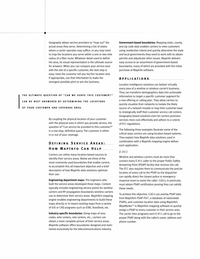
Wireless carriers can use PSAP Pro to locate base stations that will be affected by the Wireless Phase IIFCC Mandate. The new mandate requires them to routeE-911 calls to the nearest PSAP and provide precisecaller X/Y coordinates—i.e. location information. To meet this objective, wireless carriers are implantingGPS units in handsets or triangulating cell towers to pinpoint the caller’s X/Y coordinates to determinewhose service area the caller is in. Using these coordi-nates, PSAP Pro can automatically identify the city andcounty from which the E-911 call was made, enabling the carrier to instantly route the call to nearest PSAP,where the dispatcher can direct the emergencyresponse team to within 150-300 yards of the caller.
M A P I N F O D A T A P R O D U C T S U T I L I Z E D
I N E - 9 1 1 A P P L I C A T I O N
PRODUCT USE
PSAP Pro® Graphically depicts which PSAPs fall intoplanned coverage areas
RateCenterInfo® Identifies areas in which service is planned
MapMarker ® Graphically depicts the location of customer addresses
Local Number Portability (LNP) An offshoot of the Telecommunications Act of 1996that established fair and open competition in the localcommunications marketplace, LNP is an FCC mandatethat guarantees consumers the right to retain theirexisting phone numbers when changing carriers. Forproviders, LNP poses a new set of customer relationshipchallenges, all of which they must overcome to compete.First, carriers must track the location of a caller and the“from and to” activity associated with “porting in” and“porting out” LNP customers. To accurately provision,activate and bill customers, carriers also must maintaina history file on each customer. Because the customer’sNPA/NXX—i.e. the area code/three digit prefix—no longer defines the customer’s location, carriers must rely on geographic references, such as customers’physical addresses, to effectively serve them.
Order entry processes must use physical addressesinstead of NPA/NXXs for service validations and associate these addresses with appropriate geographicboundaries. Likewise, service-provisioning processesmust conjoin the customer’s physical address with the appropriate serving area. In addition, operations,maintenance and customer care departments must correlate such activities as customer/field dispatch,facility to customer demand forecasting and 911
www.mapinfo.com/comms
PSAP Pro® allows for
accurate E911 planning
by mapping out the
geographic service
areas of primary PSAPs,
ensuring that carriers
meet FCC mandates
for emergency service
responses.
PSAP validations with physical addresses and othergeographic references.
To help carriers realize these technically complex objec-tives, MapInfo offers a cost-effective, globally manage-able solution for LNP that provides full geographicportability. Using location-based intelligence, MapInfo’sintegrated data sets let carriers reconnect their legacysystems’ geography-based NPA/NXX boundaries withcustomers’ actual physical addresses. The preferredprocess used by most carriers is to break all linkages of NPA/NXX codes to geographic boundaries. Carriescan then replace NPA/NXX codes with a geocodedaddress as the key building block for customer boundarydata and link geocoded locations to appropriate geographic boundaries such as wire centers, exchange,rate centers and PSAPs.
Using a combination of MapInfo data sets, carriers can port in and port out customers in full compliancewith LNP using geocoding, spatial queries and spatialdata as follows:
• Geocoding current and new service addresses and storing them in a spatial-enabled data repository.
• Creating, obtaining and relating all pertinent geographic boundaries, including wire center,exchange, PSAPs, LATAs, rate centers, etc., using spatial associations and storing them in a spatial-enabled data repository.
• Writing spatial queries to track and record LNPtransactions.
M A P I N F O P R O D U C T S U T I L I Z E D I N L N P A P P L I C A T I O N
PRODUCT USE
ExchangeInfo Identifies the location of Central Offices;PlusTM graphically depicts wire center serving
area; identifies customers by existingincumbent serving switch
RateCenterInfoTM Identifies and ensures porting is within the rate center serving the customer
MapMarker ® Graphically depicts the location of Plus customer addresses
PSAP Pro® Identifies and ensures proper PSAP E-911routing of customer emergency calls
DSL Pre-QualificationProvisioning customers for DSL service is a significantdrain on providers’ resources, due primarily to excessivetruck rolls. A truck roll is technician time and/or remotesite order dispatch that goes into every DSL install.Truck rolls traditionally are expensive, laborious exercis-es that detract from carriers’ profitability and delay newsubscribers awaiting service.
On average, 2.7 truck rolls at $300 per roll are neededto complete a single DSL install. These include: onetruck roll for Central Office (CO)-to subscriber phone line testing and qualification; one truck roll for DSL
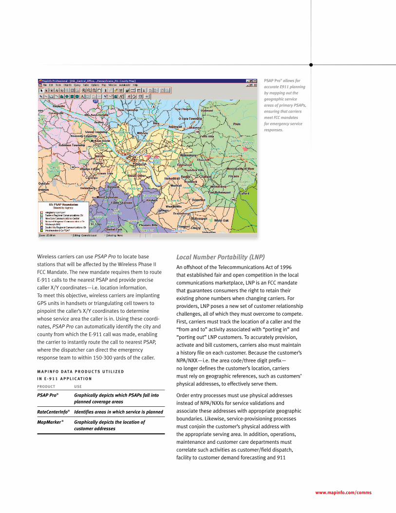
This DSL prequali-
fication analysis uses
MapInfo’s ExchangeInfo
Plus® and MapMarker®
Plus to help carriers
quickly calculate the
distance from an
identified address to
the CO so they can
rapidly determine
their ability to provide
DSL service to any
specified location.
www.mapinfo.com/comms
subscriber site configuration and service verification;and 1/2 to 1 truck roll for DSL subscriber site finalphone testing, call quality verification and work-orderclose-outs. Should problems arise, such as configura-tion errors, even more truck rolls are needed.
Currently, the average customer wait-time for DSLservice is from two weeks to several months. With all of these cost factors and time figured in, the total costto the carrier per line, pre-qualified, provisioned andinstalled, can be well over $1,000. Given that DSLrevenues range from only $40-$60 per month, the ROI on carriers’ initial investment is no less than 16 months. Add churn into the equation, and the break-even point is no less than two years. Bottom line:DSL service providers are losing many thousands of dollars each year.
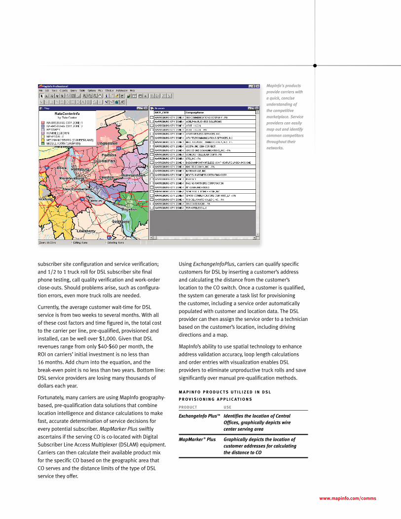
Fortunately, many carriers are using MapInfo geography-based, pre-qualification data solutions that combinelocation intelligence and distance calculations to makefast, accurate determination of service decisions forevery potential subscriber. MapMarker Plus swiftlyascertains if the serving CO is co-located with DigitalSubscriber Line Access Multiplexer (DSLAM) equipment.Carriers can then calculate their available product mixfor the specific CO based on the geographic area thatCO serves and the distance limits of the type of DSLservice they offer.
Using ExchangeInfoPlus, carriers can qualify specificcustomers for DSL by inserting a customer’s addressand calculating the distance from the customer’s location to the CO switch. Once a customer is qualified,the system can generate a task list for provisioning the customer, including a service order automaticallypopulated with customer and location data. The DSLprovider can then assign the service order to a technicianbased on the customer’s location, including drivingdirections and a map.
MapInfo’s ability to use spatial technology to enhanceaddress validation accuracy, loop length calculationsand order entries with visualization enables DSLproviders to eliminate unproductive truck rolls and savesignificantly over manual pre-qualification methods.
M A P I N F O P R O D U C T S U T I L I Z E D I N D S L
P R O V I S I O N I N G A P P L I C A T I O N S
PRODUCT USE
ExchangeInfo PlusTM Identifies the location of Central Offices, graphically depicts wire center serving area
MapMarker ® Plus Graphically depicts the location ofcustomer addresses for calculating the distance to CO
MapInfo’s products
provide carriers with
a quick, concise
understanding of
the competitive
marketplace. Service
providers can easily
map out and identify
common competitors
throughout their
networks.
T h e P r o d u c t s
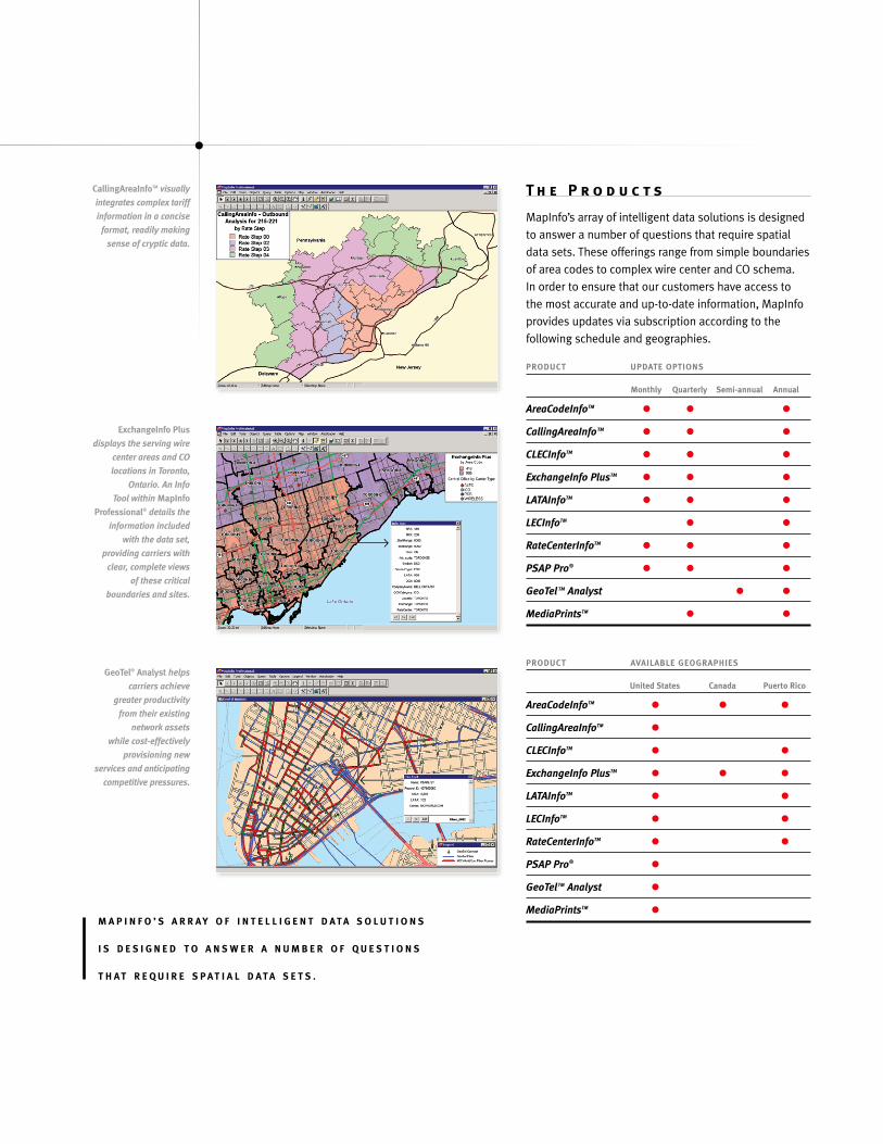
MapInfo’s array of intelligent data solutions is designedto answer a number of questions that require spatialdata sets. These offerings range from simple boundariesof area codes to complex wire center and CO schema. In order to ensure that our customers have access to the most accurate and up-to-date information, MapInfoprovides updates via subscription according to the following schedule and geographies.
PRODUCT UPDATE OPTIONS
Monthly Quarterly Semi-annual Annual
AreaCodeInfoTM • • •CallingAreaInfoTM • • •CLECInfoTM • • •ExchangeInfo PlusTM • • •LATAInfoTM • • •LECInfoTM • •RateCenterInfoTM • • •PSAP Pro® • • •GeoTel TM Analyst • •MediaPrintsTM • •
PRODUCT AVAILABLE GEOGRAPHIES
United States Canada Puerto Rico
AreaCodeInfoTM • • •CallingAreaInfoTM •CLECInfoTM • •ExchangeInfo PlusTM • • •LATAInfoTM • •LECInfoTM • •RateCenterInfoTM • •PSAP Pro® •GeoTelTM Analyst •MediaPrintsTM •
CallingAreaInfoTM visually
integrates complex tariff
information in a concise
format, readily making
sense of cryptic data.
ExchangeInfo Plus
displays the serving wire
center areas and CO
locations in Toronto,
Ontario. An Info
Tool within MapInfo
Professional® details the
information included
with the data set,
providing carriers with
clear, complete views
of these critical
boundaries and sites.
GeoTel® Analyst helps
carriers achieve
greater productivity
from their existing
network assets
while cost-effectively
provisioning new
services and anticipating
competitive pressures.
M A P I N F O ’ S A R R AY O F I N T E L L I G E N T D ATA S O L U T I O N S
I S D E S I G N E D T O A N S W E R A N U M B E R O F Q U E S T I O N S
T H AT R E Q U I R E S PAT I A L D ATA S E T S .
The following product descriptions explain how specificMapInfo data solutions can improve carriers’ operations,cost management and competitiveness.
CallingAreaInfoTM
CallingAreaInfo (CAI) is an integrated software and database product that allows carriers to calculate andmap local calling areas, i.e. the NPA/NXX combinationswithin a specific calling plan, as well as the correspon-ding rate structures and associated geography for 92percent of the NPA/NXXs in the United States as of thiswriting. CAI generates detailed tables and maps of local calling plans available to business and residentialcustomers. It is the only telecommunications softwarethat lets users 1) visualize the local calling plan for callsthat originate from or terminate into an Area Code andexchange; 2) identify and map specific exchanges intheir calling plans. When a calling plan divides a regioninto zones, CAI separately maps each zone.
CAI delivers significant value to Local Exchange Carriers(LEC), which typically offer more than one calling planfor each NPA/NXX combination they serve. The MapInfodata set also can help carriers plan a rollout of dial-upservices by determining the geographic footprint of thenetwork and listing phone numbers that can dial intothe network without incurring toll charges.
Wireless carriers use CAI to assign telephone numbersto new subscribers. By analyzing the each subscriber’slocal calling area via CAI, carriers can easily provide subscribers with a phone number that will give themlocal access to and from their home and work phones.
ExchangeInfo PlusTM
ExchangeInfo Plus is a core database containing COlocations and wire center boundaries. ExchangeInfoPlus delivers a detailed list of every NPA/NXX and relevant information about each, such as Local AccessTransport Area (LATA), operating company number(OCN), carrier name, CLLI® code, rate center andexchange assignments.
ExchangeInfo Plus provides the geographic coverage for areas served by LECs only and CO locations for allfacilities—LEC, CLEC and wireless switches. CO locationsare positioned geographically by either a street addressor a vertical/horizontal (V/H) coordinate.
Carriers today use ExchangeInfo Plus in several pre-qualification applications, including DSL and LNP.For DSL, the MapInfo database lets carriers quickly calculate customers’ distances from the CO and use
wire center boundaries to identify customers that falloutside the CO’s service area. Telecommunications companies performing LNP pre-qualification use thedatabase’s wire center boundaries to determine whichCO services the customer and to ascertain if portingagreements are in place with that particular CO. The MapInfo system works so fast that both of thesepre-qualification processes can be completed with thecustomer on the phone.
RateCenterInfoTM
RateCenterInfo is a database of US rate center bound-aries. Rate centers are locations or points assigned V/H coordinates between which airline mileage isdefined for charging of local or toll calls. RateCenterInfodepicts the service area of each rate center by definingall of the NPA/NXXs assigned to it and displaying their boundaries. The MapInfo data solution providesgeographic coverage for both landline (LEC and CLEC)and wireless NPA/NXXs.
Carriers use RateCenterInfo extensively to streamlinethe LNP pre-qualification process. As of this writing, LNP is permitted only within a geographic rate centerboundary, so accurate analysis of a customer’s addressis required to ensure that his/her new address resideswithin the same rate center. This same requirement willhold true for the upcoming Wireless Number Portability(WNP) mandate, meaning that a customer’s wirelessnumber must be assigned to the same rate center ashis/her their landline number to achieve portability.
RateCenterInfo also provides accurate competitiveanalysis of carriers providing service within particularmarkets down to the rate center level. This level ofanalysis makes it simple for carriers to determine the companies they need to negotiate portability agreements with, and, just as importantly, defines the competitive landscape they will encounter in a given market.
GeoTelTM AnalystGeoTel Analyst lets carriers quickly analyze fiber infrastructures throughout the US. The GeoTel data set features metropolitan fiber routes, fiber-lit buildings,colocation facilities, long-haul backbone links, Internetexchanges, undersea fiber cable landings and more.Using GeoTel data, carriers can easily visualize theirentire networks and other providers’ assets, enablingthem to assess current areas of market penetration aswell as competitive threats and strategize their growth.
www.mapinfo.com/comms
Carriers also use GeoTel for access analysis and urbanplanning and development. They also apply the data solution for critical “last mile” analyses, quicklycalculating the distance required to provide high-speedservices to customers and using this information todecide whether to extend their existing infrastructureor lease bandwidth from another carrier.
In addition to minimizing carriers’ customer acquisitioncosts, GeoTel helps providers more effectively andquickly plan new networks, optimize the use of theircurrent infrastructure and offer the most profitable high-speed phone, video and data services to their customers.
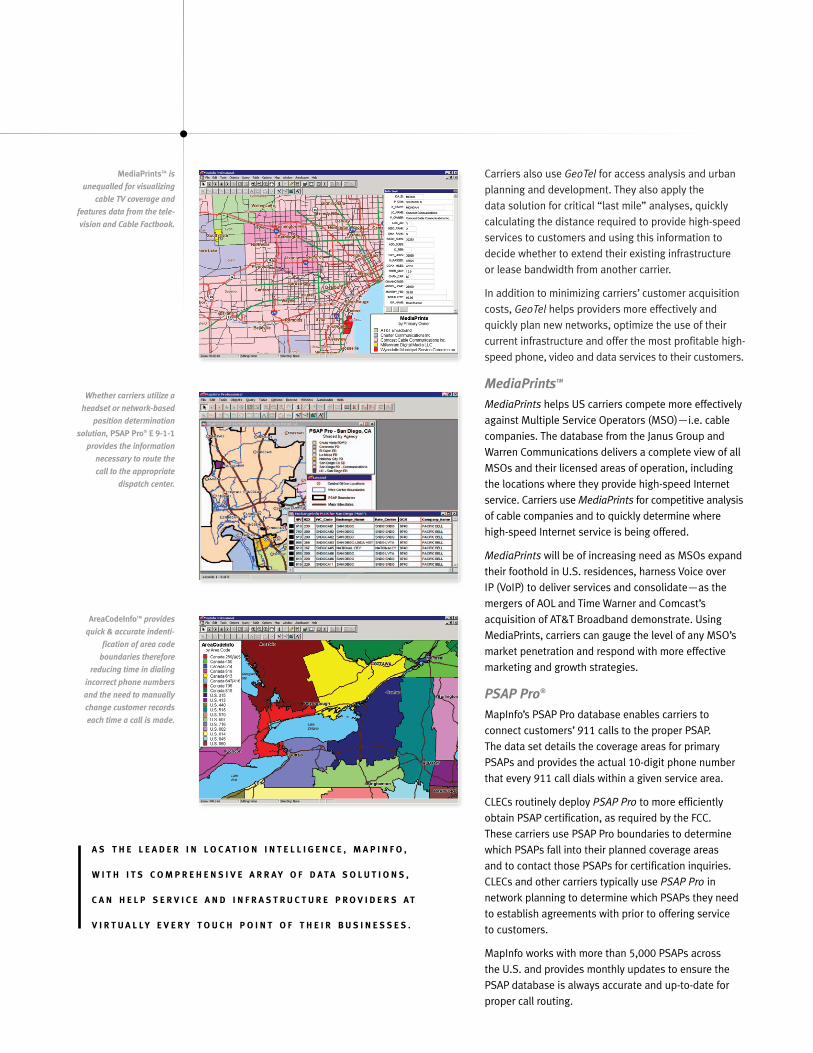
MediaPrintsTM
MediaPrints helps US carriers compete more effectivelyagainst Multiple Service Operators (MSO)—i.e. cablecompanies. The database from the Janus Group andWarren Communications delivers a complete view of allMSOs and their licensed areas of operation, includingthe locations where they provide high-speed Internetservice. Carriers use MediaPrints for competitive analysisof cable companies and to quickly determine wherehigh-speed Internet service is being offered.
MediaPrints will be of increasing need as MSOs expandtheir foothold in U.S. residences, harness Voice over IP (VoIP) to deliver services and consolidate—as themergers of AOL and Time Warner and Comcast’s acquisition of AT&T Broadband demonstrate. UsingMediaPrints, carriers can gauge the level of any MSO’smarket penetration and respond with more effectivemarketing and growth strategies.
PSAP Pro®
MapInfo’s PSAP Pro database enables carriers to connect customers’ 911 calls to the proper PSAP. The data set details the coverage areas for primaryPSAPs and provides the actual 10-digit phone numberthat every 911 call dials within a given service area.
CLECs routinely deploy PSAP Pro to more efficientlyobtain PSAP certification, as required by the FCC. These carriers use PSAP Pro boundaries to determinewhich PSAPs fall into their planned coverage areas and to contact those PSAPs for certification inquiries.CLECs and other carriers typically use PSAP Pro in network planning to determine which PSAPs they needto establish agreements with prior to offering service to customers.
MapInfo works with more than 5,000 PSAPs across the U.S. and provides monthly updates to ensure thePSAP database is always accurate and up-to-date forproper call routing.
MediaPrintsTM is
unequalled for visualizing
cable TV coverage and
features data from the tele-
vision and Cable Factbook.
Whether carriers utilize a
headset or network-based
position determination
solution, PSAP Pro® E 9-1-1
provides the information
necessary to route the
call to the appropriate
dispatch center.
AreaCodeInfoTM provides
quick & accurate indenti-
fication of area code
boundaries therefore
reducing time in dialing
incorrect phone numbers
and the need to manually
change customer records
each time a call is made.
A S T H E L E A D E R I N L O C AT I O N I N T E L L I G E N C E , M A P I N F O ,
W I T H I T S C O M P R E H E N S I V E A R R AY O F D ATA S O L U T I O N S ,
C A N H E L P S E R V I C E A N D I N F R A S T R U C T U R E P R O V I D E R S AT
V I R T U A L LY E V E R Y T O U C H P O I N T O F T H E I R B U S I N E S S E S .
AreaCodeInfoTM
AreaCodeInfo is a database of area codes in the U.S.and Canada. The product provides quick and accurateidentification of area code boundaries. Using theMapInfo data set, carriers can overlay a set of new area codes onto their service areas to quickly updatetheir customer records to reflect these changes.AreaCodeInfo reduces time lost dialing incorrect phonenumbers and the need to manually change customerrecords each time a call is made.
LATAInfoTM
LATAInfo is a database of Local Access Transport Areas(LATA) in the U.S. LATAs define the geographic areas inwhich a call originating within the LATA and terminatingoutside the LATA must be handled via a long distancecarrier. Calls originating and terminating within thesame LATA are handled by a local carrier. With LATAInfo,carriers can plot their customers and ensure that callsare being routed and billed correctly by analyzing callsthat cross LATA boundaries.
CLECInfoTM
CLECInfo is a database of competitive Local ExchangeCarriers. By combining the rate centers to which a CLEC is assigned, carriers can identify the footprint of competitive services. Carriers use CLECInfo to deter-mine the footprint coverage for CLECs within the U.S.,study competitive threats within a given market and tounderstand where additional services are available.Companies outside the telecommunications industryuse CLECInfo to identify common CLECs present at thelocations of their infrastructure, allowing them to reducecosts by negotiating communication contracts.
LECInfoTM
LECInfo is a database of Local Exchange Carriers withinthe U.S. The database combines all of the wire centersin the state where a LEC operates to show the footprintof the parent company. Carriers use LECInfo when theyneed to understand service areas of LECs, but do notneed the level of detail provided within MapInfo’sExchangeInfo Plus, which has definitions of each wirecenter within the footprint.
C o n c l u s i o n
The notion of “where” has become a critical factor in carriers’ decision making as they strive to compete,save, serve and grow in today’s increasingly tight, regulated marketplace.
As a result, geographic and spatial information is now a “must have” for carriers of every kind.
As the leader in location intelligence, MapInfo, with itscomprehensive array of data solutions, can help serviceand infrastructure providers at virtually every touchpoint of their businesses. From service provisioning and billing to network planning and market analyses,MapInfo has a data set that can enhance every processaffecting carriers’ services, networks and customers.
Buttressed by time-tested software and consulting services, the data solutions described in this paperreflect a total solutions approach and specializedtelecommunications focus that has made MapInfo theindustry’s premier location intelligence provider formany years. MapInfo solutions are scalable, flexible,open systems that can integrate spatial capabilities into existing legacy systems. They are easily deployedon common platforms using Sun Java or MicrosoftWindows. They also are easily customized to fit carriers’unique needs and provide speed-to-market that enableservice providers to benefit rapidly from their use.
Like enlightening catalysts, MapInfo’s data solutionsgive carriers the insight they need to take confident,decisive actions—to make smart choices in difficulttimes and, in so doing, to emerge triumphantly andleave their competitors behind.
www.mapinfo.com/comms
G L O S S A R Y + A C R O N Y M D E F I N I T I O N S
C A L L I N G P L A N
A calling plans defines the features provided by a
telephone company in conjunction with local dial tone
service. Examples of calling plans are Measured Rate
charges for every completed call and Flat Rate charges,
which are monthly plans where customers are given
unlimited access to a designated number of other
NPA/NXXs.
C E N T R A L O F F I C E ( C O )
CO is the physical structure where the telephone
company terminates subscriber lines (copper). The CO
is the source of local dial tones. The CO is usually a
Class 5 switch that is basically a mainframe computer
with many, many network ports—i.e. phone lines.
C O M P E T I T I V E L O C A L E X C H A N G E C A R R I E R ( C L E C )
CLECs compete with the LEC. They can build their own
COs or simply resell LEC service, which is purchased at
a wholesale rate and then resold to a customer at a
price usually lower than the customer would pay directly
to the LEC.
C O M M O N L A N G U A G E L O C A T I O N I D E N T I F I E R “
( C L L I ® )
CLLI is an 11 digit alphanumeric code that identifies
a central office. Example: NYCMNY18DS0—The first four
characters identify the place name (NYCM is New York
City Manhattan); the next two characters identify the
state (NY is New York). The remaining three characters
identify the specific switch (18DS0 is the AT&T 5E Digital
Serving Office on West 18th Street.
D I G I T A L S U B S C R I B E R L I N E ( D S L )
Digital Subscriber Line provides higher transmission
rates than dial-up access over POTS lines. Available
in a variety of flavors such as: ADSL, G-Lite, HDSL, IDSL,
RADSL, SDSL, and VDSL. Transmission rates are depend-
ent on the distance from CO, usually measured in feet.
E X C H A N G E
An Exchange is a geographic area that consists of one
or more Central Offices and their associated facilities
(fiber, copper, etc). Exchanges are sometimes referred to
as the NXX of a phone number.
E X C H A N G E A R E A
An Exchange Area is the geographic area in which
telephone services and prices are the same, based on
geography and regulation, not equipment. This is an
important point when looking at ExchangeInfo—which
actually maps out wire centers, not exchange areas as
the name might imply
I N C U M B E N T L O C A L E X C H A N G E C A R R I E R ( I L E C S )
See LEC
I N T E R X C H A N G E C A R R I E R ( I X C )
IXCs are long-haul long distance carriers.
L O C A L A C C E S S A N D T R A N S P O R T A R E A ( L A T A )
LATA is the defining geography in which all calls
made across their borders must be carried by a
long-distance carrier.
L O C A L E X C H A N G E C H A R A C T E R ( L E C )
The LEC is the local phone company, which can either
be a Bell Operating Company (BOC) or an independent.
Also referred to as ILECs.
L O C A L N U M B E R P O R T A B I L I T Y ( L N P )
LNP is the right of a telephone customer in the US to
retain his/her local phone number when switching to
another local telephone service provider. LNP may result
in users’ retaining a single phone number regardless
of their physical location.
www.mapinfo.com/comms
N P A
NPA is the Area Code, i. e. the first three digits of an
11-digit telephone number.
N X X
NXX is the prefix, exchange and the second three digits
of an 11-digit telephone number.
O P E R A T I N G C O M P A N Y N U M B E R ( O C N )
OCN is the code used to identify a telephone company.
P O I N T O F P R E S E N C E ( P O P )
The IXC equivalent of a CO, the POP is the long distance
carrier’s office in the local LATA, prior to connecting to
the local phone company’s CO and the customer’s phone.
P L A I N O L D T E L E P H O N E S E R V I C E ( P O T S )
POTS is the basic telephone service line provided by a
CO to a residence or business
P U B L I C S A F E T Y A N S W E R I N G P O I N T ( P S A P )
A PSAP is a facility that receives 911 call. PSAPs are
segmented as primary, secondary, etc. based on the
caller’s location. The primary PSAP is the first contact a
911 caller will make. In some cases, the primary PSAP
will dispatch help, but in most cases the caller will be
conferenced or transferred to a secondary PSAP from
which help will be dispatched. Secondary PSAPs might
be a fire station or a municipal police department
P U B L I C S W I T C H E D T E L E P H O N E N E T W O R K ( P S T N )
PSTN is the worldwide voice telephone network
accessible to all those with telephones. It is commonly
displayed in drawings as a cloud.
R A T E C E N T E R
A rate center is a geographic point location with
assigned V/H coordinates between which airline miles
are defined for the charging of local or toll lines.
R A T E S T E P
Rate Step is a defined geographic division of an exchange
area used as the primary basis for figuring toll rates.
R E G I O N A L B E L L O P E R A T I N G C O M P A N Y ( R B O C )
An RBOC is one of 7 carriers formed as a result of the
breakup of AT&T in 1983.
T A N D E M
Tandem is a type of CO that establishes trunk-to-trunk
connections; it serves to connect CO’s when interoffice
trunks are not available.
T A R I F F
Tariffs are documents filed by a regulated telephone
company with a PUC or the FCC. It details the services,
equipment and pricing offered by the company.
V E R T I C A L / H O R I Z O N T A L ( V H ) C O O R D I N A T E S
V/H coordinates are based on a complex algorithm that
projects the curvature of the earth onto a flat plane.
These coordinates are used to determine airline mileage
for telecommunications distances between two points.
W I R E C E N T E R
Wire Center is the area of an exchange served by a single
wire center or central office. It can also be referred to
as Wire Center Serving Area. See Central Office (C0) for
more information.
W I R E L E S S N U M B E R P O R T A B I L I T Y ( W N P )
See LNP

MapInfo, the MapInfo meridian logo, MapInfo Professional, AreaCodeInfo, CallingAreaInfo, CLECInfo, ExchangeInfo Plus, LATAInfo, LECInfo, MapMarker, MapMarker Plus, PSAP Pro and RateCenterInfo are registered trademarks or trademarks of MapInfo Corporation and/or its affiliates. ExchangeInfo Plus and CallingAreaInfo products include data from GDT which is copyright 2001, Geographic Data Technology, Inc.MediaPrints is a trademark of The JanusGroup, Inc. GeoTel is a trademark of GeoTel Communications, Inc. All other product and service names mentioned herein are trademarks of their respective owners. 85042 4/03
CORPORATE/AMERICAS
HEADQUARTERS
One Global View
Troy, New York
12180-8399 USA
518.285.6000 TEL
800.327.8627
518.285.6060 FAX
[email protected] E-MAIL
EUROPEAN/UNITED KINGDOM
OFFICE
44.1753.848200 TEL
44.1753.621140 FAX
[email protected] E-MAIL
ASIA-PACIFIC/AUSTRALIAN
OFFICE
61.2.9437.6255 TEL
61.2.9439.1773 FAX
[email protected] E-MAIL
CANADIAN
OFFICE
416.594.5200 TEL
800.268.3282
416.594.5201 FAX
[email protected] E-MAIL