Embed Size (px)
Citation preview
2 PERVASIVE computing Published by the IEEE CS n 1536-1268/10/$26.00 © 2010 IEEE
L o c a t i o n - B a s e d s e r v i c e s
B y helping travelers move from single-occupancy vehicles to pub-lic transit systems, communities can reduce traffic congestion as well as its environmental impact.
Here, we describe our efforts to increase the sat-isfaction of current public transit users and help motivate more people to ride.
OneBusAway (http://onebusaway.org), a suite of transit traveler information tools we developed at the University of Washington, provides real-time arrival information, a trip planner, a schedule and route browser, and a transit-friendly destination finder for Seattle-area bus riders.1 In this article, we concentrate on the tools it provides for real-time arrival in-
formation, which is available through a variety of interfaces for mobile devices. Such in-formation is valuable for both new and frequent riders be-cause it tells those waiting at
the bus stop whether the bus is still coming or if they just missed it. In addition, frequent riders can better time when they leave for the bus stop to minimize time spent waiting. Wait time for transit, particularly of an uncertain duration, is burdensome2 and can pose a safety issue at night in some areas.3,4
OneBusAway has successfully provided real-time arrival information to Seattle-area tran-sit users since mid 2008, currently with more than 10,000 visits a day so far, despite it not yet being an official service of the local transit
agency. However, even though an activity such as using public transit is inherently location sensitive, until late 2009, none of the OneBus-Away tools were location aware. For phone, SMS, and mobile Web interfaces, users could access information by using a unique numeri-cal identifier posted at each bus stop or by navi-gating through a list of stops for a particular transit route. For the full Web interface, users could see stop and route information displayed on a map but still had to search for stops by stop number, route, or address.
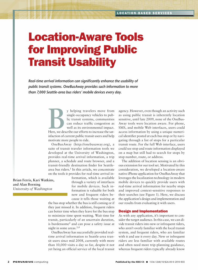
The addition of location sensing is an obvi-ous extension for our tool set. Motivated by this consideration, we developed a location-aware native iPhone application for OneBusAway that leverages the localization technology in modern mobile devices to quickly provide users with real-time arrival information for nearby stops and improved context-sensitive responses to their searches (see Figure 1). Here, we discuss the application’s design and implementation and our results from evaluating it with users.
design and implementationAs with any application, it’s important to con-sider the target audience. In this case, we can di-vide transit riders into new or infrequent riders, who aren’t overly familiar with the local transit system, and frequent riders, who are familiar with it and use it every day. New or infrequent riders are less familiar with available routes and often need more trip-planning guidance, whereas frequent riders typically already know
Real-time arrival information can significantly enhance the usability of public transit systems. OneBusAway provides such information to more than 7,000 Seattle-area bus riders’ mobile devices every day.
Brian Ferris, Kari Watkins, and Alan BorningUniversity of Washington
Location-aware tools for improving Public transit Usability
January–March 2010 PERVASIVE computing 3
which sequence of stops and routes is the fastest to reach their destination, so they just want to know when the next bus is coming. The application presented in this article is targeted pri-marily at this second group of frequent transit users.
We implemented our application on an iPhone so that we could exploit its localization framework and built-in multitouch map support. Our appli-cation communicates with a OneBus-Away back-end server over the phone’s network connection to request infor-mation about stops in a given area, information about particular routes, and, ultimately, real-time arrival infor-mation for specific stops. It’s organized primarily around a tab bar at the bot-tom of the screen that provides entry
points for a map screen, a bookmark screen, a recent-stops screen, and a search screen.
The map screen lets users view avail-able transit stops overlaid on a Google Maps interface, with the ability to zoom and pan the map via multitouch interactions similar to the primary Google Maps iPhone application. The cross-hairs button automatically cen-ters the map on the user’s location and displays nearby stops; the region-se-lection button automatically displays stops in the current map view, such that a user might navigate to another area of the map away from the current location and see available stops in that view. An-other option would have been to auto-matically refresh the set of visible stops as the user navigates through the map.
However, we found that the network latency involved with frequently updat-ing the set of visible stops, especially on older phones with slower EDGE net-work connections, impeded usability. We might revisit this design later with a more opportunistic update policy.
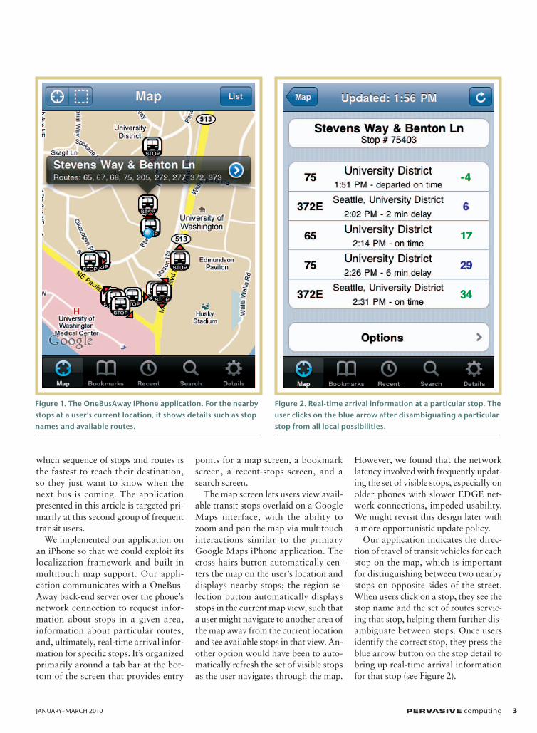
Our application indicates the direc-tion of travel of transit vehicles for each stop on the map, which is important for distinguishing between two nearby stops on opposite sides of the street. When users click on a stop, they see the stop name and the set of routes servic-ing that stop, helping them further dis-ambiguate between stops. Once users identify the correct stop, they press the blue arrow button on the stop detail to bring up real-time arrival information for that stop (see Figure 2).
Figure 1. The OneBusAway iPhone application. For the nearby stops at a user’s current location, it shows details such as stop names and available routes.
Figure 2. Real-time arrival information at a particular stop. The user clicks on the blue arrow after disambiguating a particular stop from all local possibilities.
4 PERVASIVE computing www.computer.org/pervasive
Location-Based services
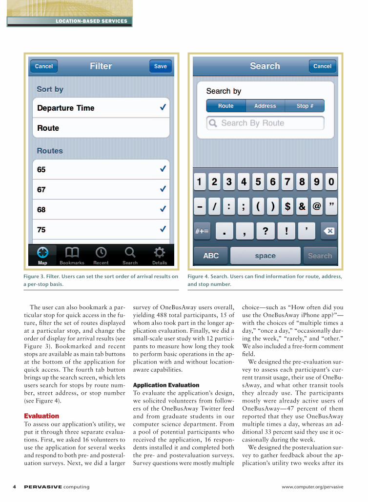
The user can also bookmark a par-ticular stop for quick access in the fu-ture, filter the set of routes displayed at a particular stop, and change the order of display for arrival results (see Figure 3). Bookmarked and recent stops are available as main tab buttons at the bottom of the application for quick access. The fourth tab button brings up the search screen, which lets users search for stops by route num-ber, street address, or stop number (see Figure 4).
evaluationTo assess our application’s utility, we put it through three separate evalua-tions. First, we asked 16 volunteers to use the application for several weeks and respond to both pre- and posteval-uation surveys. Next, we did a larger
survey of OneBusAway users overall, yielding 488 total participants, 15 of whom also took part in the longer ap-plication evaluation. Finally, we did a small-scale user study with 12 partici-pants to measure how long they took to perform basic operations in the ap-plication with and without location-aware capabilities.
application evaluationTo evaluate the application’s design, we solicited volunteers from follow-ers of the OneBusAway Twitter feed and from graduate students in our computer science department. From a pool of potential participants who received the application, 16 respon-dents installed it and completed both the pre- and postevaluation surveys. Survey questions were mostly multiple
choice—such as “How often did you use the OneBusAway iPhone app?”—with the choices of “multiple times a day,” “once a day,” “occasionally dur-ing the week,” “rarely,” and “other.” We also included a free-form comment field.
We designed the pre-evaluation sur-vey to assess each participant’s cur-rent transit usage, their use of OneBu-sAway, and what other transit tools they already use. The participants mostly were already active users of OneBusAway—47 percent of them reported that they use OneBusAway multiple times a day, whereas an ad-ditional 33 percent said they use it oc-casionally during the week.
We designed the postevaluation sur-vey to gather feedback about the ap-plication’s utility two weeks after its
Figure 3. Filter. Users can set the sort order of arrival results on a per-stop basis.
Figure 4. Search. Users can find information for route, address, and stop number.
January–March 2010 PERVASIVE computing 5
deployment. The response was mostly positive—87 percent of the respon-dents rated the application’s utility as “very useful,” with 69 percent of the respondents using the application
multiple times a day. The survey re-sults also included data about which search mechanisms participants used most frequently in the application; Table 1 shows that participants book-
marked the stops they used most fre-quently, although finding nearby stops via GPS wasn’t far behind. We used these results to refactor our design, prioritizing the user interface for the
D isplays that provide real-time arrival information for
buses, subways, light rail, and other transit vehicles are
available in many cities worldwide, at places such as rail sta-
tions, transit centers, and major bus stops. however, providing
and maintaining such displays at, for example, every single bus
stop in a region is prohibitively expensive. With the increased
availability of powerful mobile devices and the public availabil-
ity of transit schedule data in machine-readable formats, many
tools have been developed to make this information available
on mobile devices.
Stuart Maclean, Daniel Daily, and their colleagues at the
university of Washington developed developed a series of inno-
vative transit tools, including one of the first online bus-track-
ing systems, BusView.1 More recently, Google Transit, which
started as a Google Labs project in December 2005 (http://
maps.google. com/help/maps/transit/partners/faq.html), is
now directly integrated into the Google Maps product on many
mobile phones and provides transit trip-planning for more than
405 cities around the world (www.google.com/intl/en/landing/
transit/#mdy). Interfaces to Google Transit exist on a variety of
mobile devices, employing location sensors such as GPS and
Wi-Fi localization on the device to determine a starting location
for trip planning.
Besides being useful to transit riders around the world,
Google Transit is also significant for establishing a de facto
standard for exchanging transit schedule data: the Google
Transit Feed Specification (GTFS; http://code.google.com/tran-
sit/spec/transit_feed_specification.html). The upshot is that
many of the transit agencies participating in the Google Transit
program have also released their transit scheduling data in the
GTFS format for third-party developers to work with. Develop-
ment ecosystems have grown out of this data’s public availabil-
ity, with many “transit hackers” working on innovative uses of
transit data. The Portland TriMet third-party applications page,
for example, lists more than 20 applications that use Portland’s
transit data, many targeted at providing transit data on mobile
devices and many of which use these devices’ localization ca-
pabilities to return location-relevant results (http://trimet.org/
apps/index.htm). Similar ecosystems exist in San Francisco and
the surrounding Bay area, chicago, and other major cities.
One mobile application that employs GTFS transit data is the
Travel assistance Device (TaD) developed at the university of
South Florida.2 TaD uses a mobile device’s GPS to detect a bus
rider’s location and prompt that person when his or her stop
is near. The user manually enters routes and desired stops into
the system for later detection. The application is specifically for
riders with cognitive impairments to increase their usability of
public transit.
another mobile application to improve public transit’s usabil-
ity can be found in previous research at the university of Wash-
ington. The Opportunity Knocks system3 provides a mobile ap-
plication to give cognitive assistance to transit riders. Like TaD,
Opportunity Knocks uses GPS data to model a user’s location,
but unlike TaD, it automatically detects the user’s current mode
of transportation from GPS traces and learns the important
places he or she typically travels to, such as home and work-
place, without manual labeling. On the basis of these learned
models, the application can automatically predict where a user
is headed given only a small amount of tracking data and can
detect when the user does something unexpected, such as for-
getting to get off the bus at the regular stop.
a third such example is the Mobility agents system,4 also
intended for users with cognitive impairments. It provides
prompts to a traveler on a handheld device and simultaneously
communicates to a caregiver the traveler’s location and trip
status.
REfEREnCES
1. S. Maclean and D. Dailey, “Wireless Internet access to real-Time Transit Information,” Transportation Research Record: J. Transportation Research Board, vol. 1791, no. 1, 2002, pp. 92–98.
2. S. Barbeau et al., “Travel assistant Device,” uS Patent app. 11/464,079, 11 aug. 2006.
3. D. Patterson et al., “Opportunity Knocks: a System to Provide cogni-tive assistance with Transportation Services,” Proc. Int’l Conf. Ubiqui-tous Computing (ubicomp), //publisher?//, 2004, //pages cited or URL?//.
4. a. repenning and a. Ioannidou, “Mobility agents: Guiding and Tracking Public Transportation users,” Proc. Working Conf. Advanced Visual Interfaces, acM Press, 2006, pp. 127–134.
related Work in real-time transit information systems
6 PERVASIVE computing www.computer.org/pervasive
Location-Based services
most popular search methods.Overall, the participants’ comments
were positive:
I LOVE the finding stops by my current location feature—killer feature that will destroy all others.
It’s breathtaking how much easier it is to pick out a nearby bus stop using ‘my current location,’ compared to choosing an intersection out of a list of stops, or typing it in directly. It’s a difference of kind, not degree, especially when I’m outside my usual neighborhoods. I showed it to someone whose jaw actually dropped.
Users also commented on the overall
flexibility the application allowed:
The OneBusAway app makes me feel more comfortable with spontaneously changing trip plans or going to different stops.
These comments were borne out in our survey results, which showed that 93 percent of the respondents were likely to walk to a different bus stop on the basis of information from the applica-tion. We touch on these results further in the next section.
Additional user comments provided valuable feedback on some of the ap-plication’s interface elements, which we incorporated into subsequent iterations of the design. For example, the original application required two button presses to refresh arrival information at a stop.
Several users requested a more direct refresh mechanism, which led to re-shuffling the user interface to support a direct refresh button as well as a more aggressive automatic-refresh policy.
comparing Location awarenessWe also compared the relative satis-faction of users of our location-aware tool with that of the users of existing OneBusAway tools. In particular, we asked OneBusAway users to describe how the tool had changed their overall perception of public transit, including their feelings related to satisfaction, utility, perceived wait time, frequency of travel, and safety. We advertised the survey on the OneBusAway Web site, the OneBusAway Twitter feed, and several Seattle-area blogs and received 488 responses.
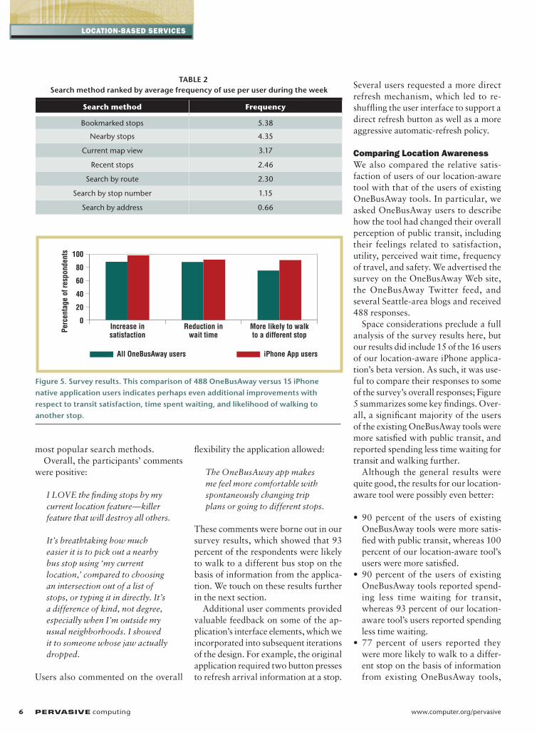
Space considerations preclude a full analysis of the survey results here, but our results did include 15 of the 16 users of our location-aware iPhone applica-tion’s beta version. As such, it was use-ful to compare their responses to some of the survey’s overall responses; Figure 5 summarizes some key findings. Over-all, a significant majority of the users of the existing OneBusAway tools were more satisfied with public transit, and reported spending less time waiting for transit and walking further.
Although the general results were quite good, the results for our location-aware tool were possibly even better:
• 90 percent of the users of existing OneBusAway tools were more satis-fied with public transit, whereas 100 percent of our location-aware tool’s users were more satisfied.
• 90 percent of the users of existing OneBusAway tools reported spend-ing less time waiting for transit, whereas 93 percent of our location-aware tool’s users reported spending less time waiting.
• 77 percent of users reported they were more likely to walk to a differ-ent stop on the basis of information from existing OneBusAway tools,
TABLE 2 Search method ranked by average frequency of use per user during the week
Search method frequency
Bookmarked stops 5.38
nearby stops 4.35
current map view 3.17
recent stops 2.46
Search by route 2.30
Search by stop number 1.15
Search by address 0.66
100
80
60
40
20
0Increase insatisfaction
All OneBusAway users iPhone App users
Reduction inwait time
More likely to walkto a different stop
Perc
enta
ge o
f res
pond
ents
Figure 5. Survey results. This comparison of 488 OneBusAway versus 15 iPhone native application users indicates perhaps even additional improvements with respect to transit satisfaction, time spent waiting, and likelihood of walking to another stop.
January–March 2010 PERVASIVE computing 7
whereas 93 percent of our location-aware tool’s users reported they were more likely to walk to a different stop.
These findings suggest that a location-aware version of OneBusAway might even improve on these results, but we don’t yet have a large enough sample size for statistical significance. The po-tential increase in the number of users who walk to a different stop using the location-aware application is interest-ing, especially in light of the applica-tion’s location-aware capabilities and the potential health benefits of more walking. We hope to gather data for a significantly larger number of riders by doing a followup survey after our location-aware tool is released and in general use.
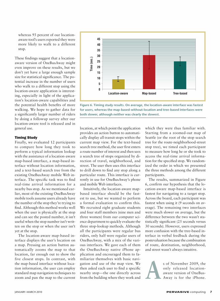
timing studyFinally, we evaluated 12 participants to compare how long they took to perform a typical information lookup with the assistance of a location-aware map-based interface, a map-based in-terface without location information, and a text-based search tree from the existing OneBusAway mobile Web in-terface. The specific task was to find real-time arrival information for a nearby bus stop. As we mentioned ear-lier, most of the existing OneBusAway mobile tools assume users already have the number of the stop they’re trying to find. Although this method works well when the user is physically at the stop and can see the posted number, it isn’t useful when the stop number isn’t writ-ten on the stop or when the user isn’t yet at the stop.
The location-aware map-based in-terface displays the user’s location on a map. Pressing an action button au-tomatically zooms the map to that location, far enough out to show the five closest stops. In contrast, with the map-based interface without loca-tion information, the user can employ standard map navigation techniques to zoom and pan the map to the current
location, at which point the application provides an action button to automati-cally display all transit stops within the current map view. For the text-based search tree method, the user first enters a route number of interest and then sees a search tree of stops organized by di-rection of travel, neighborhood, and street. The user then uses this interface to drill down to find any stop along a particular route. This interface is cur-rently in use for OneBusAway’s phone and mobile Web interfaces.
Intuitively, the location-aware map-based interface should be the fast-est to use, but we wanted to perform a formal evaluation to confirm this. We recruited eight graduate students and four staff members (nine men and three women) from our computer sci-ence department to quickly evaluate the three stop-lookup methods. Although all the participants were regular bus riders, only half were regular users of OneBus Away, with a mix of the vari-ous interfaces. We gave each of them the OneBus Away native iPhone ap-plication and encouraged them to fa-miliarize themselves with basic navi-gation and use of the map view. We then asked each user to find a specific nearby stop—the one directly across from the building where they work and
which they were thus familiar with. Starting from a zoomed-out map of Seattle (or the root of the stop search tree for the route-neighborhood-street stop tree), we timed each participant to measure how long he or she took to access the real-time arrival informa-tion for the specified stop. We random-ized the order in which we presented the three methods among the different participants.
The results, summarized in Figure 6, confirm our hypothesis that the lo-cation-aware map-based interface is fastest for navigating to a target stop. Across the board, each participant was fastest when using it (9 seconds on av-erage). The remaining two interfaces were much slower on average, but the difference between the two wasn’t sta-tistically significant (25 seconds versus 30 seconds). However, users expressed more confusion with the tree-based in-terface in verbal feedback during the postevaluation because the combination of route, destination, neighborhood, and street wasn’t always intuitive.
A s of November 2009, the only released location-aware version of OneBus-Away is for the iPhone.
45
40
35
30
25
20
15
10
5
0Location-aware Map-based Tree-based
Tim
e (s
ec.)
Figure 6. Timing study results. On average, the location-aware interface was fastest for users, whereas the map-based-without-location and tree-based interfaces were both slower, although neither was clearly the slowest.
8 PERVASIVE computing www.computer.org/pervasive
Location-Based services
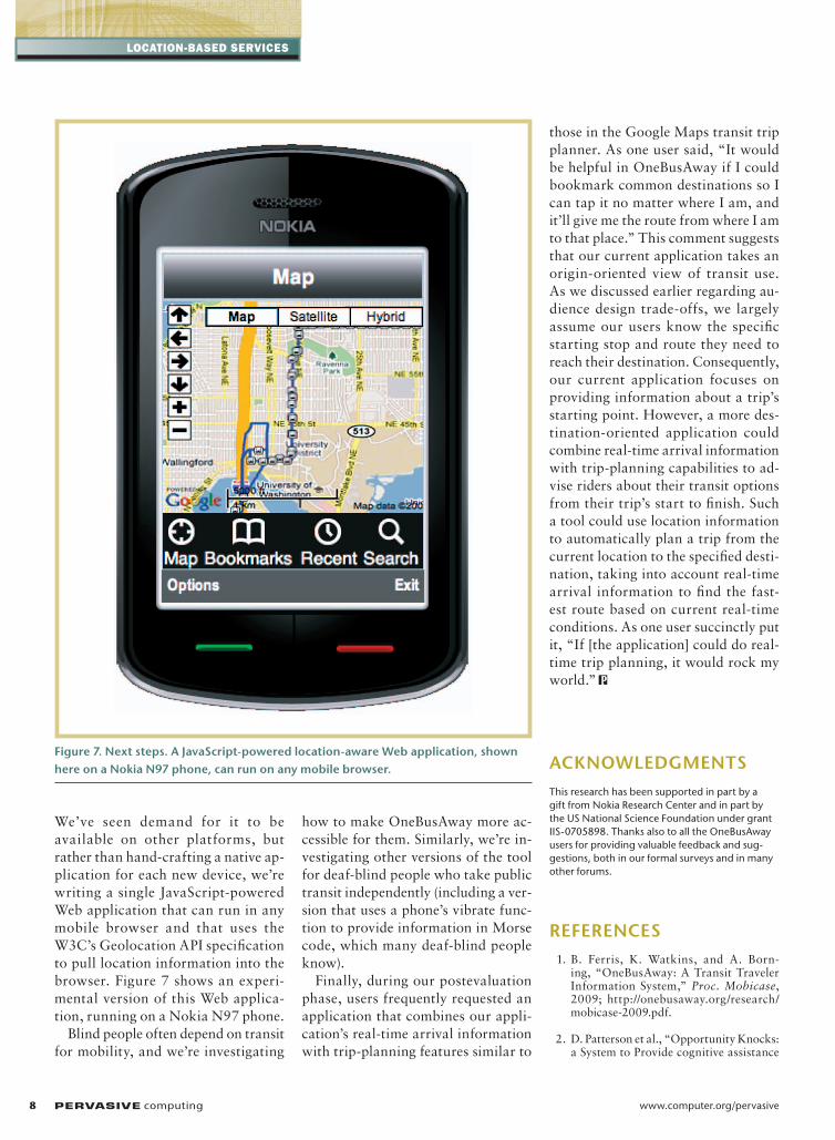
We’ve seen demand for it to be available on other platforms, but rather than hand-crafting a native ap-plication for each new device, we’re writing a single JavaScript-powered Web application that can run in any mobile browser and that uses the W3C’s Geolocation API specification to pull location information into the browser. Figure 7 shows an experi-mental version of this Web applica-tion, running on a Nokia N97 phone.
Blind people often depend on transit for mobility, and we’re investigating
how to make OneBusAway more ac-cessible for them. Similarly, we’re in-vestigating other versions of the tool for deaf-blind people who take public transit independently (including a ver-sion that uses a phone’s vibrate func-tion to provide information in Morse code, which many deaf-blind people know).
Finally, during our postevaluation phase, users frequently requested an application that combines our appli-cation’s real-time arrival information with trip-planning features similar to
those in the Google Maps transit trip planner. As one user said, “It would be helpful in OneBusAway if I could bookmark common destinations so I can tap it no matter where I am, and it’ll give me the route from where I am to that place.” This comment suggests that our current application takes an origin-oriented view of transit use. As we discussed earlier regarding au-dience design trade-offs, we largely assume our users know the specific starting stop and route they need to reach their destination. Consequently, our current application focuses on providing information about a trip’s starting point. However, a more des-tination-oriented application could combine real-time arrival information with trip-planning capabilities to ad-vise riders about their transit options from their trip’s start to finish. Such a tool could use location information to automatically plan a trip from the current location to the specified desti-nation, taking into account real-time arrival information to find the fast-est route based on current real-time conditions. As one user succinctly put it, “If [the application] could do real-time trip planning, it would rock my world.”
AcknOwLEdgmEnTSThis research has been supported in part by a gift from nokia research center and in part by the uS national Science Foundation under grant IIS-0705898. Thanks also to all the OneBusaway users for providing valuable feedback and sug-gestions, both in our formal surveys and in many other forums.
REFEREncES 1. B. Ferris, K. Watkins, and A. Born-
ing, “OneBusAway: A Transit Traveler Information System,” Proc. Mobicase, 2009; http://onebusaway.org/research/ mobicase-2009.pdf.
2. D. Patterson et al., “Opportunity Knocks: a System to Provide cognitive assistance
Figure 7. next steps. A JavaScript-powered location-aware web application, shown here on a nokia n97 phone, can run on any mobile browser.
January–March 2010 PERVASIVE computing 9
with Transportation Services,” Ubicomp 2004, LNCS 3205, Springer-Verlag, pp. 433–450.
3. R. Elmore-Yalch, “King County Metro 2006 Metro Rider/Non-Rider Survey,” Apr. 2007; http://metro.kingcounty.gov/am/reports/2006/2006-RNRFinal.pdf.
4. B. Taylor et al., “Thinking outside the Bus: Understanding User Perceptions of Waiting and Transferring in Order to Increase Transit Use,” California PATH Research Report UCB-ITS-PRR-2009-8, Univ. California, Berkeley, 2009; http://www.path.berkeley.edu/PATH/ Publications/PDF/PRR/2009/PRR-2009-08.pdf.
the AUThORS
Brian ferris is a PhD student in the Department of computer Science and Engineering at the university of Washington. his research interests lie at the intersection of artificial intelligence and human-computer interaction, specifically in their application to problems of broader social impact such as public-transit systems and helping those with cognitive impairments. Fer-ris is the OneBusaway system’s lead developer. contact him at [email protected].
Kari Watkins is a PhD student in the Department of civil and Environmental Engineering at the university of Washington. her research centers on under-standing and affecting mode choice to develop a more sustainable transpor-tation system. Watkins assists in the continued development of OneBusaway as a resource for research in transit applications and interaction with the transit industry. contact her at [email protected].
Alan Borning is a faculty member in the Department of computer Science and Engineering at the university of Washington, an adjunct professor in its Information School, and a member of its Interdisciplinary PhD Program in urban Design and Planning. his research interests concern modeling and simulation, human-computer interaction, and designing for human values. Borning has also done research in object-oriented programming languages and constraint-based languages and systems. contact him at [email protected] cS articles and columns
are also available for free at http://computingnow.computer.org.


![[Digital strategic planner];[who are you, planner]](https://img.pdfslide.net/doc/110x75/587222131a28ab3b7a8b4707/digital-strategic-plannerwho-are-you-planner.jpg)