Embed Size (px)
Citation preview
Report EUR 27411 EN
Hans Bloem, Ray Boguslawski, Maria Teresa Borzacchiello, Piergiorgio Cipriano, Albana Kona, Giacomo Martirano, Isabella Maschio, Francesco Pignatelli
European Union Location
Framework (EULF) Project
Feasibility Study
2015
Location data for buildings related energy efficiency policies

European Commission
Joint Research Centre
Institute for Environment and Sustainability / Institute for Energy and Transport
Contact information
Francesco Pignatelli
Address: Joint Research Centre, via Enrico Fermi, TP. 262, 2749 21023 Ispra (VA)
E-mail: [email protected]
Tel.: +39 0332 78 6319
JRC Science Hub
https://ec.europa.eu/jrc
Legal Notice
This publication is a Technical Report by the Joint Research Centre, the European Commission’s in-house science service.
It aims to provide evidence-based scientific support to the European policy-making process. The scientific output
expressed does not imply a policy position of the European Commission. Neither the European Commission nor any person
acting on behalf of the Commission is responsible for the use which might be made of this publication.
All images © European Union 2015
JRC96946
EUR 27411 EN
ISBN 978-92-79-50572-0 (PDF)
ISBN 978-92-79-50573-7 (print)
ISSN 1018-5593 (print)
ISSN 1831-9424 (online)
doi:10.2788/668832
Luxembourg: Publications Office of the European Union, 2015
© European Union, 2015
Reproduction is authorised provided the source is acknowledged.
Abstract
Based on the priority currently given by the European Union to the energy efficiency topic through its Energy Union
Package, this feasibility study has focused on the role of location data in support of energy efficiency policies,
taking into account the requirements of INSPIRE, EPBD and EED Directives, as well as the CoM initiative. The EU
Member States are already due to implement such Directives according to different roadmaps, but there are
benefits to be gained from a coherent and consistent approach. Moreover, data is not always available in consistent
form and with good quality. The monitoring and reporting requirements set by the CoM need real data and models,
that can be used and that should work consistently across different administrative levels. The analysis reported in
this document support these statement, showing that there is lack of data quality and reliability. These aspects
might hinder the effective application of the energy efficiency policies at the municipal, district and national level. Geospatial technologies in general and accurate location data in particular can support this field, because they can
significantly support efficient processes related to data collection, elaboration and communication to be executed in
all the phases of energy efficiency policies life cycle; and effective decision-making. INSPIRE has a role to play as it
can provide common data models and common data access rules adopted by all EU MS and a roadmap to provide
interoperable datasets of high relevance with energy efficiency. The study has identified areas of development and
analysis that can be useful to fill the recognised “data gap”, and proposed an initial pilot activity as a start-up
project to investigate concretely these ideas with a limited number of pilot cities.
European Union Location Framework – Location data for
buildings related energy efficiency policies: Feasibility Study
Page 3 of 42
CONTENTS
ABBREVIATIONS ................................................................................................... 5 EXECUTIVE SUMMARY ........................................................................................... 6
1 Introduction ............................................................................................... 9
2 European energy efficiency policies ............................................................. 12
3 Energy and location: state of the art ............................................................ 15 3.1 Projects and initiatives related to “Energy and Location” ............................. 15 3.2 On-line survey on “Energy and Location” .................................................. 17
4 A methodology to support energy efficiency implementation and monitoring .... 20 4.1 Building level: Energy Performance of Buildings ......................................... 21 4.2 District level: Energy Efficiency Directive .................................................. 22 4.3 Urban level: Covenant of Mayors ............................................................. 23 4.4 National level: Energy Efficiency Directive ................................................. 25 4.5 Conceptual Architecture to Support the Methodology .................................. 26
5 The role of INSPIRE in Energy efficiency and Location .................................... 26 5.1 INSPIRE candidate data themes ............................................................... 27
5.1.1 Buildings ........................................................................................ 28 5.1.2 Addresses and Cadastral parcels ....................................................... 28 5.1.3 Utility and governmental services ...................................................... 29 5.1.4 Production and industrial facilities ..................................................... 29 5.1.5 Energy Resources ............................................................................ 30 5.1.6 Atmospheric conditions and Meteorological geographical features .......... 30 5.1.7 Land cover ..................................................................................... 30 5.1.8 Statistical Units and Population Distribution ........................................ 31
5.2 Initial mapping exercise .......................................................................... 31
6 Energy pilot outline ................................................................................... 33 6.1 Aims .................................................................................................... 33 6.2 Approach .............................................................................................. 34 6.3 Examples of Use Cases ........................................................................... 35
7 Conclusions .............................................................................................. 37
Links to relevant bibliography ............................................................................ 38
European Union Location Framework – Location data for
buildings related energy efficiency policies: Feasibility Study
Page 4 of 42
FIGURES
Figure 1: The methodology addresses the different scales in the application of energy
efficiency policies .......................................................................................... 20
Figure 2: Atlas of Energy Performance of Buildings- Ferrara ..................................... 22
Figure 3: Top-down and bottom-up approaches in assessing energy performance of
buildings ..................................................................................................... 22
Figure 4: District Level: Energy Efficiency Indicators ................................................ 23
Figure 5: Urban Level: Covenant of Mayors signatories in Italy as of mid May 2014 (the
colour intensity is related to the amount of yearly energy consumption per capita
[MWh/cap]) ................................................................................................. 24
Figure 6: National Level: Energy Efficiency Indicators (colour intensity is related to the
amount of yearly energy consumption per capita [MWh/cap]) ............................ 25
Figure 7: Conceptual architecture to support the methodology .................................. 26
Figure 8: INSPIRE Feature Type BuildingAndBuildingUnitInfo .................................... 32
Figure 9: Possible pilot implementation steps .......................................................... 34
TABLES
Table 1: Key features of main energy efficiency policies relevant to the study ............. 14
Table 2: Relevant projects and initiatives dealing with energy and location. ................ 15
Table 3: Criteria characterizing the scenarios .......................................................... 35
European Union Location Framework – Location data for
buildings related energy efficiency policies: Feasibility Study
Page 5 of 42
ABBREVIATIONS
Acronym Description
BEI Baseline Emission Inventory
CEN Comité Européen de Normalisation
CO2 Carbon Dioxide
CoM Covenant of Mayors
EP Energy Performance
EPBD Energy Performance of Buildings Directive
EED Energy Efficiency Directive
EU European Union
EULF European Union Location Framework
FTE Full Time Equivalent
GML Geography Markup Language
IES Institute of Environment and Sustainability
IET Institute for Energy and Transportation
INSPIRE Infrastructure for Spatial Inforation in Europe
IR Implementing Rule
ISA Interoperability Solutions for Public Administrations
ISO International Organisation for Standardisation
JRC Joint Research Centre
LA Local Authority
MS Member State
NACE Nomenclature Statistique des Activités Economiques
dans la Communauté Européenne
NEAP National Energy Efficiency Action Plan
OGC Open Geospatial Consortium
SEAP Sustainable Energy Action Plan
SME Small Medium Enterprise
TG Technical Guidelines
TWG Thematic Working Group
UML Unified Modelling Language
UN United Nations
WFS Web Feature Service
WMO World Meteorological Organisation
WMS Web Map Service
XMI XML Metadata Interchange
XML eXtensible Markup Language
XSL Extensible Stylesheet Language

European Union Location Framework – Location data for
buildings related energy efficiency policies: Feasibility Study
Page 6 of 42
EXECUTIVE SUMMARY
Energy efficiency constitutes one of the five dimensions of the European Commission's
Energy Union Package 1 , designed to enhance energy security, sustainability and
competitiveness.
European energy policy is reflected in several Directives; the present document focuses
on two main Directives concerning the efficient use of energy in buildings (Directive
2010/31/EU Energy Performance of Buildings - EPBD) and national energy systems
(Directive 2012/27/EU Energy Efficiency Directive - EED).
A further important energy policy initiative considered here is the Covenant of Mayors
(CoM)2, a major European movement involving local and regional authorities (more than
6400 signatories as of June 2015). Through this initiative, municipalities in Europe (and
outside) voluntarily agree to reduce their CO2 emissions by at least 20% by 2020.
Municipalities have to submit a Sustainable Energy Action Plan (SEAP) identifying the
measures planned in order to reach the target.
To implement and monitor energy efficiency policies effectively, local authorities and
Member States are required to report on baseline scenarios (e.g. the Baseline Emissions
Inventories in the Covenant of Mayors initiative) and on progress made at regular
intervals (Annual Reports for the Energy Efficiency Directive and the Energy Performance
of Buildings Directive and Monitoring Emissions Inventories every two years for the
CoM).
Basic reporting tools are available to local authorities and Member States. However, for
the time being, they allow the users to input aggregated and approximated values (for
example, local authorities may rely on national data when local data are not available)
for planning and monitoring progress towards targets.
A common framework for monitoring of energy efficiency policies, with harmonised data
from building to district and ending at national level could improve the interoperability of
the different directives / initiatives. Within such a framework, geo-referencing all the
relevant building data accurately and consistently will significantly improve data quality
and reliability, enable effective scenario modelling to fill gaps in data, and support the
overall policy process.
Furthermore, from a potential market perspective, web-based tools providing access to
the energy performance of geo-referenced buildings could improve territorial knowledge,
and support, for example, the activities of energy service companies and companies
involved in construction / renovation of buildings.
The European Union Location Framework (EULF) 3 project aims to improve the way such
‘location information’ is used in many different policy areas and in e-government
services generally. It does this through a series of recommendations, guidance and
actions to promote and deploy best practice. The EULF draws significantly on the legal
and technical framework provided by the INSPIRE Directive 4 , which started out
1 EC COM(2015) 80. “Communication from the Commission to the European Parliament and the
Council: Energy Union Package.” COM(2015) 80, European Commission, 2015. 2 (http://www.covenantofmayors.eu/index_en.html)
3 More details about the EULF project are provided in the following section
4 http://inspire.ec.europa.eu/
European Union Location Framework – Location data for
buildings related energy efficiency policies: Feasibility Study
Page 7 of 42
supporting European environmental policy. INSPIRE is due to be fully operational by
2020, when Member States have to complete actions to publish interoperable data of
interest for energy efficiency5.
In this context, this feasibility study has been initiated within the EULF project, joining
efforts from the JRC units H06 (Digital Earth and Reference Data) and F07 (Renewables
and Energy Efficiency). It is aimed at verifying how location data can support energy
efficiency policies. In particular its specific goal is to evaluate how the framework set by
the INSPIRE Directive for the harmonised collection and exchange of location data can
serve the needs of policy instruments addressing energy performance of buildings,
energy planning in urban areas, and the national energy efficiency plans of Member
States.
The study has involved the following activities:
desk research to identify relevant international “energy and location” projects and
initiatives;
a survey to collect information from different organisations on their actual and
potential use of location data relevant to energy policies;
development of a methodological approach based on location data to support not
only the EPBD and other energy efficiency policies (EED and sustainable energy
action plans for CoM signatories), but also the whole energy efficiency policy life-
cycle (e.g. local planning and the implementation of measures for the efficient
renovation of buildings);
an initial mapping exercise between the EPBD and CoM data requirements and
the corresponding data models of the INSPIRE candidate data themes;
definition of an “energy” pilot project to assess how these different requirements
can be satisfied with ICT solutions.
The main conclusions from the feasibility study are as follows:
the different energy efficiency policies involve a diverse range of data
requirements to assemble the necessary monitoring against targets at the
different administrative levels;
there is a need for a more harmonised approach to ease the burden for public
authorities and support the needs of policy makers. Such an approach needs to
bridge the “data gap” identified in this study;
it is possible to apply a generalised methodology to support different energy
efficiency policies using location data as an integrating factor and combining both
real and extrapolated data to indicate progress in meeting efficiency targets and
help in planning relevant actions;
geospatial technologies in general and accurate location data in particular can
play an important role in the energy efficiency field, significantly increasing:
o the efficiency of data collection, elaboration and communication processes
in all phases of the life cycle of energy efficiency policies;
o the effectiveness of decisions taken by different stakeholders (policy-
makers, technicians, citizens);
INSPIRE can play an important role through:
5 More details about INSPIRE data themes of interest for energy efficiency are provided in section
5

European Union Location Framework – Location data for
buildings related energy efficiency policies: Feasibility Study
Page 8 of 42
o the provision of common data models and common data access rules
adopted by all EU Member States;
o a roadmap to provide interoperable datasets of high relevance with energy
efficiency.
Various studies have produced technical solutions covering aspects of the overall
energy efficiency requirements but none is sufficiently holistic to address the
broad needs in a harmonised way and the solutions do not always take advantage
of the benefits of location data. Nevertheless, components of these solutions
could be considered in such a harmonised approach.
The methodology and approach require a more detailed assessment in the form
of a “proof on concept” pilot, to resolve some of the more detailed questions and
provide a demonstrator that can be used in promoting a reusable approach for
public authorities and Member States.
A workshop is needed with key stakeholders to review the assessment and
proposed approach and determine interest in participation in the proposed pilot
and potential involvement in the future. Invited parties would include the
European Commission, Member States policy makers, the Covenant of Mayors,
other relevant initiatives, and the energy, ICT and geospatial industries.
European Union Location Framework – Location data for
buildings related energy efficiency policies: Feasibility Study
Page 9 of 42
1 INTRODUCTION
Energy is among the priorities defined in the Commission’s New Start for Europe
strategy6 and energy efficiency plays a significant role in several European Directives
and initiatives7 moving toward the Energy and Climate targets for 2020. Among the
initiatives, it is worth mentioning the Covenant of Mayors, signed voluntarily by more
than 6000 European Mayors 8 , who commit to reductions in CO2 emissions in their
municipalities of at least 20% by 2020. Buildings are responsible for approximately 40%
of the primary energy consumption in Europe and there is a vital need to improve
energy efficiency through policies and innovative solutions.
Reliable data, at national and at local level, are necessary in all the phases of the policy
life cycle, from planning to implementation and monitoring. Obtaining this data for
effective monitoring of progress against targets is a key challenge. In particular, the
data requirements set by the energy efficiency policy instruments explicitly require data
accuracy at local level.
Valuable support to satisfying these data needs can be provided by the INSPIRE
Directive (2007/2/EC)9: INSPIRE is the reference directive for spatial data, establishing
an infrastructure for spatial information in Europe to support Community environmental
policies, and policies or activities which may have an impact on the environment, such as
energy policies. The INSPIRE Directive is well-timed as it is due to be operational by
2020, when MS have to report about data which are of interest for energy efficiency10.
Based on this background, the "Location data for energy efficiency policies" feasibility
study aims to verify the potential for an effective application of spatial data to support
the monitoring requirements of the different EU energy efficiency policies and initiatives,
which include data from different sources and at different scales (building, district and
national).
To achieve this aim, three objectives have been set:
to investigate how INSPIRE can contribute to harmonise and combine several
data requirements coming from different energy policy instruments, in order to
simplify the reporting and monitoring commitments of Member States and local
authorities;
to investigate how INSPIRE can facilitate and integrate the collection, elaboration,
access to and sharing of meaningful data required from different sources to serve
the many needs of the energy efficiency policy making process, at all stages,
including planning and implementation, at local level;
to outline a methodological approach and a set of tools based on location data,
which will initially support the monitoring needs related to energy efficiency
policies at local level and then the whole policy life-cycle.
6 http://ec.europa.eu/priorities/energy-union/index_en.htm 7 More details about are provided in the section 2
8 6,453 Signatories (June 26th 2015) 9 http://inspire.ec.europa.eu/
10 More details about INSPIRE data themes of interest for energy efficiency are provided in section
5
European Union Location Framework – Location data for
buildings related energy efficiency policies: Feasibility Study
Page 10 of 42
The feasibility study has been commissioned by the European Union Location Framework
(EULF) project11, which is led by the European Commission Joint Research Centre and is
part of the Interoperability Solutions for Public Administrations (ISA) Programme12, run
by DG Informatics (DIGIT). The EULF is a framework of recommendations, guidance and
actions to improve the way location information is used in all public services across
Europe, targeting benefits for businesses, citizens and government in key areas of EU
activity, such as Transport and Energy policy, and the Digital Single Market. The EULF
builds on the spatial data infrastructure for Europe being implemented by INSPIRE.
The project has carried out a ‘state-of-play’ survey on location-enabling e-government
and used this in preparing an EULF Strategic Vision, with focus areas on 'policy and
strategy alignment', 'e-government integration', 'standardisation and interoperability',
'return on investment' and 'effective governance and partnerships'. An initial EULF
Blueprint ‘package’ has been developed, with recommendations and actions in the
different focus areas and detailed guidance on key topics such as ‘Public Procurement of
Geospatial Technologies’ and ‘Architecture and Standards for SDI and e-Government’
This feasibility study addresses key aspects of the EULF, including alignment of policies,
efficiency in meeting policy requirements, interoperable standards-based solutions, re-
use of best practices, and better integration of public sector and private sector activities.
The report is structured into seven main sections.
1. Introduction
The context, scope and objectives of the feasibility study.
2. European Energy Efficiency Policies
An overview of the main European energy efficiency policies.
3. Energy and Location: State of the Art
An overview of existing European projects and initiatives dealing with both energy
and location, and presents the results of a survey on the actual and foreseen use
of location data related to energy policies.
4. A Methodology to Support Energy Efficiency Implementation and Monitoring
A description of the proposed methodology for the use of location data to support
the different energy efficiency policy reporting requirements.
5. The Role of INSPIRE
Taking into account the data requirements of energy efficiency policies outlined in
the proposed methodology, this section includes:
a) an analysis to identify the candidate INSPIRE data themes that will be
used to support the energy related data requirements;
b) a summary of the initial mapping of the data required by the Energy
Performance of Buildings Directive (EPBD), the Energy Efficiency
Directive (EED) and the Covenant of Mayors (CoM) and the
11 Information about the EULF, including links to publications and key events, can be found at
http://ec.europa.eu/isa/actions/02-interoperability-architecture/2-13action_en.htm 12 Information about ISA is available at http://ec.europa.eu/isa/ and at
http://ec.europa.eu/isa/library/isa-work-programme/index_en.htm
European Union Location Framework – Location data for
buildings related energy efficiency policies: Feasibility Study
Page 11 of 42
corresponding elements present in the data models of the INSPIRE
candidate data themes.
6. Energy Pilot Outline
An outline of a possible Energy pilot, based on the needs and gaps recognised in
the previous analyses, including examples of use cases that could be supported.
7. Conclusions
In this section the main conclusions of this feasibility study are reported.
The report is completed by an Annex documents containing the following:
- Annex I: “Detailed data requirements”, containing the outcomes of the initial
mapping exercise between the INSPIRE Building data model and the EPDB and
CoM data requirements;
- Annex II: “Projects and initiatives dealing with energy and location”, containing a
description of the fourteen projects and initiatives dealing with “energy and
location” inventoried during the study;
- Annex III: “Results of the online survey”, containing the results of the online
stakeholder survey on the actual and foreseen use of location data related to
energy policies;
- Annex IV: “Data and methodologies for energy performance of buildings”,
containing a description of a methodology to assess energy performance of
buildings.
European Union Location Framework – Location data for
buildings related energy efficiency policies: Feasibility Study
Page 12 of 42
2 EUROPEAN ENERGY EFFICIENCY POLICIES
Both the Energy Roadmap 205013 adopted by the European Commission in 2010 and the
2030 policy framework for climate and energy14 proposed by the European Commission
in 2014 reinforce a political commitment to very high energy savings, with the aim to
achieve a more competitive, secure and sustainable European energy system. Increased
energy efficiency is vital to achieve the challenging goals set for the future, and
particularly the target of at least 27% reduction in the final energy consumption in 2030,
compared to expected energy consumption for 2030. In addition, energy efficiency
constitutes one of the five dimensions of the European Commission's Energy Union
Package15, designed to enhance energy security, sustainability and competitiveness.
European energy policy is reflected in several directives; the current study focuses on
two main directives concerning the efficient use of energy in the building sector
(Directive 2010/31/EU Energy Performance of Buildings) and in the national energy
systems (Directive 2012/27/EU Energy Efficiency Directive). A further important
initiative considered in the study is the Covenant of Mayors,16,
a mainstream European
movement involving local and regional authorities, voluntarily committing to increase
energy efficiency and use of renewable energy sources in their territories. The Covenant
signatories aim to meet or exceed the European Union 20% CO2 reduction objective by
2020 February 2015. Over 6000 local authorities to date have signed the Covenant, a
total of c. 160m inhabitants in the EU-28, and c. 186m million inhabitants in the whole
initiative.
Buildings are responsible for approximately 40% of the primary energy consumption in
Europe and there is a vital need to improve energy efficiency through policies and
innovative solutions. Therefore, the data requirements set by the Energy Performance
of Buildings Directive (EPBD) explicitly call for data accuracy at building level and,
where necessary, in terms of building units.
It is noteworthy that under the EPBD timetable, new standards for certification and
inspection have to be in place by 2015, and by 2018 new buildings have to be nearly
zero-energy. The new building-related standards have to take into account the INSPIRE
Directive (to be implemented by 2020 by Member States), and to involve national
institutions (e.g. cadastre) as well as construction and utility organisations.
The Energy Efficiency Directive (EED) explicitly requires Member States to ensure
that obligated parties (energy distributers and/or retail energy sales companies) provide
on request:
aggregated statistical information on their final customers;
current information on final customers' consumption, including, where applicable,
load profiles, costumer segmentation and geographical location of customers,
while preserving the integrity and confidentiality of private and commercially
sensitive information in compliance with applicable Union law.
13 http://ec.europa.eu/clima/policies/roadmap/index_en.htm 14
http://ec.europa.eu/clima/policies/2030/index_en.htm 15
http://ec.europa.eu/priorities/energy-union/index_en.htm 16 http://www.covenantofmayors.eu/index_en.html

European Union Location Framework – Location data for
buildings related energy efficiency policies: Feasibility Study
Page 13 of 42
Finally, reliable and accurate data are of high importance for the Sustainable Energy
Action Plans of Covenant of Mayors signatories.
Effective implementation and monitoring of energy efficiency policies requires that
Member States and local authorities report about baseline scenarios (e.g. the Baseline
Emissions Inventories in the Covenant of Mayors initiative) and on progress made at
regular intervals (Annual Reports for the Energy Efficiency Directive and the Energy
Performance of Buildings Directive and Monitoring Emissions Inventories every two years
for the CoM). Basic reporting tools are available to local authorities and Member States.
However, for the time being they allow the users to rely on aggregated and
approximated values (for example, local authorities may rely on national data when local
data are not available) for planning and monitoring progress toward the targets.
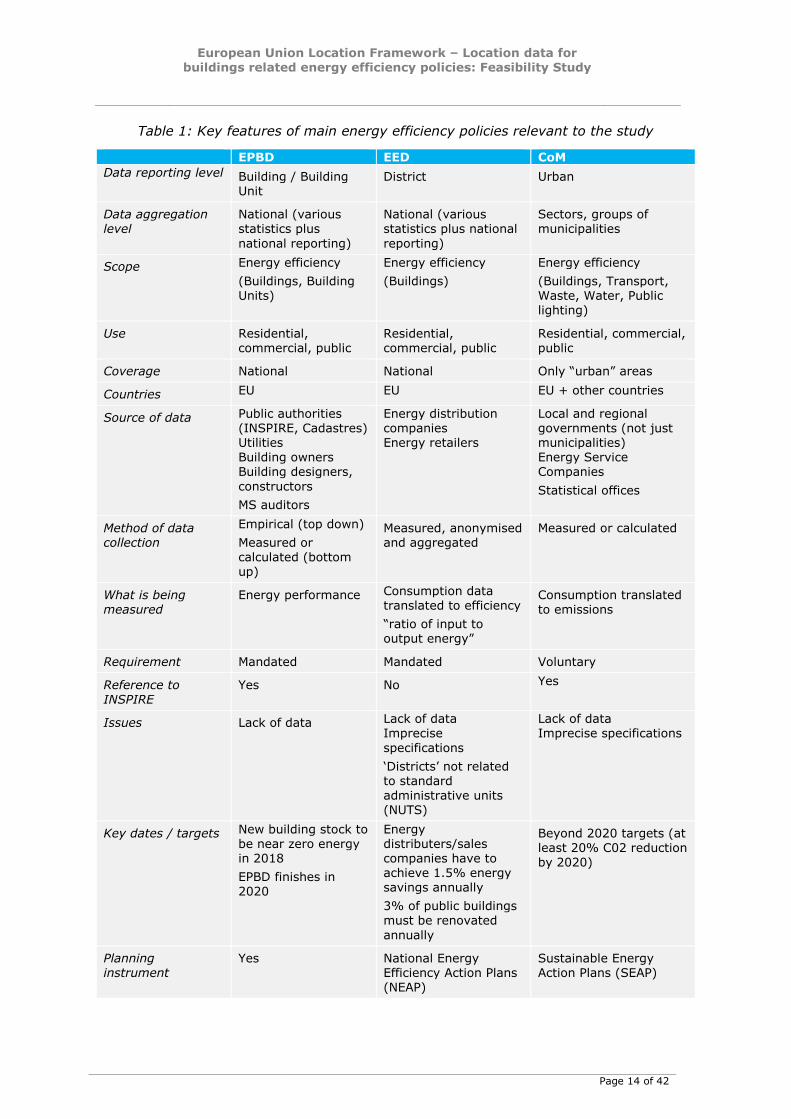
Table 1 describes and compares key features of EPBD, EED and CoM, with relevance to
the scope of the study.
European Union Location Framework – Location data for
buildings related energy efficiency policies: Feasibility Study
Page 14 of 42
Table 1: Key features of main energy efficiency policies relevant to the study
EPBD EED CoM
Data reporting level Building / Building Unit
District Urban
Data aggregation level
National (various statistics plus
national reporting)
National (various statistics plus national
reporting)
Sectors, groups of municipalities
Scope Energy efficiency
(Buildings, Building Units)
Energy efficiency
(Buildings)
Energy efficiency
(Buildings, Transport, Waste, Water, Public
lighting)
Use Residential, commercial, public
Residential, commercial, public
Residential, commercial, public
Coverage National National Only “urban” areas
Countries EU EU EU + other countries
Source of data Public authorities (INSPIRE, Cadastres) Utilities Building owners Building designers,
constructors
MS auditors
Energy distribution companies Energy retailers
Local and regional governments (not just municipalities) Energy Service Companies
Statistical offices
Method of data collection
Empirical (top down)
Measured or calculated (bottom up)
Measured, anonymised and aggregated
Measured or calculated
What is being measured
Energy performance Consumption data translated to efficiency
“ratio of input to output energy”
Consumption translated to emissions
Requirement Mandated Mandated Voluntary
Reference to INSPIRE
Yes No Yes
Issues Lack of data Lack of data Imprecise
specifications
‘Districts’ not related to standard administrative units (NUTS)
Lack of data Imprecise specifications
Key dates / targets New building stock to be near zero energy in 2018
EPBD finishes in 2020
Energy distributers/sales companies have to achieve 1.5% energy savings annually
3% of public buildings must be renovated
annually
Beyond 2020 targets (at least 20% C02 reduction by 2020)
Planning instrument
Yes National Energy Efficiency Action Plans (NEAP)
Sustainable Energy Action Plans (SEAP)
European Union Location Framework – Location data for
buildings related energy efficiency policies: Feasibility Study
Page 15 of 42
3 ENERGY AND LOCATION: STATE OF THE ART
This section gives an overview of existing projects and initiatives in Europe related to
energy efficiency and the use of location data and summarises the results of a survey
undertaken by this study on the actual and foreseen use of location data related to
energy efficiency policies, addressing organisations making use of location data in the
energy context.
3.1 Projects and initiatives related to “Energy and Location”
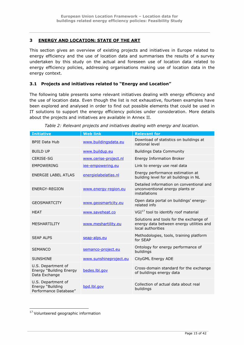
The following table presents some relevant initiatives dealing with energy efficiency and
the use of location data. Even though the list is not exhaustive, fourteen examples have
been explored and analysed in order to find out possible elements that could be used in
IT solutions to support the energy efficiency policies under consideration. More details
about the projects and initiatives are available in Annex II.
Table 2: Relevant projects and initiatives dealing with energy and location.
Initiative Web link Relevant for
BPIE Data Hub www.buildingsdata.eu Download of statistics on buildings at national level
BUILD UP www.buildup.eu Buildings Data Community
CERISE-SG www.cerise-project.nl Energy Information Broker
EMPOWERING iee-empowering.eu Link to energy use real data
ENERGIE LABEL ATLAS energielabelatlas.nl Energy performance estimation at building level for all buildings in NL
ENERGY-REGION www.energy-region.eu Detailed information on conventional and unconventional energy plants or installations
GEOSMARTCITY www.geosmartcity.eu Open data portal on buildings’ energy-related info
HEAT www.saveheat.co VGI17 tool to identify roof material
MESHARTILITY www.meshartility.eu
Solutions and tools for the exchange of
energy data between energy utilities and local authorities
SEAP ALPS seap-alps.eu Methodologies, tools, training platform for SEAP
SEMANCO semanco-project.eu Ontology for energy performance of buildings
SUNSHINE www.sunshineproject.eu CityGML Energy ADE
U.S. Department of
Energy “Building Energy Data Exchange
bedes.lbl.gov Cross-domain standard for the exchange of buildings energy data
U.S. Department of
Energy “Building Performance Database”
bpd.lbl.gov Collection of actual data about real buildings
17
Volunteered geographic information

European Union Location Framework – Location data for
buildings related energy efficiency policies: Feasibility Study
Page 16 of 42
The initiatives listed above are relevant for this study due to their objectives related to
the geographical dimension of energy efficiency. Some of them are focused on data
collection, mainly at national level (key statistical data related to policies) based on
building stock inventories and energy performance certificates. Among those working on
data collection, only two (SEAP ALPS and MESHARTILITY) are strictly related to the
Covenant of Mayors, even if they are not considering spatial information.
Sometimes, data and tools are also made available through community portals like
BUILDUP where interesting references to best practices are described, as well as
examples of (open) datasets about energy certificates and properties of actual buildings
(Ireland), or data about the capacity of installations and generated energy, their
technological characteristics, equipment, purpose of utilisation, etc.
A limited number of initiatives make an explicit reference to INSPIRE or other geo-
standards, and only one (GEOSMARTCITY) is also focusing on the opportunity for
opening “energy-related” harmonised spatial data.
Similarly, few initiatives are defining ontologies, conceptual standards, use cases,
activity descriptions and, in particular, terms and attributes for describing spatial
features (regions, cities, neighbourhoods and buildings), energy consumption, CO2
emission indicators, as well as climate and socio-economic factors that influence energy
consumption.
The spatial dimension is considered in tools for 3D modelling and visualisation, and by
initiatives providing simple maps to visualise data about energy consumption from smart
meters.
The increasing interest in smart metering and smart grid data has been found in some
examples (CERISE-SG and EMPOWERING), with information about energy consumption
taken from utilities’ readers and/or bills, and used to inform consumers and help them
reduce their energy consumption.
Only the US Department of Energy Building Performance Database is devoted to the
collection of actual data from existing buildings. Detailed information about buildings are
collected through various channels, and used to perform benchmarking and analysis at
supra and sub-urban scales.
A detailed and robust analysis of similar initiatives would be beneficial in order to
assemble a structured best practice catalogue: what is provided in this study is an initial
list of initiatives, but a more detailed and structured catalogue would be valuable as a
follow on activity.
In general, all the fourteen projects and initiatives highlight the need for energy-related
data exchange, either considering the energy need (performance) of buildings or actual
energy consumption. However, the factors below need to be considered in solutions to
support the policies covered in this study:
information about buildings and energy-related data are usually presented for
statistical analysis and benchmarking at national or regional level;
in all the initiatives, data are not derived from actual (real) buildings registers,
nor do they have a direct geographical dimension;
European Union Location Framework – Location data for
buildings related energy efficiency policies: Feasibility Study
Page 17 of 42
apart from one initiative, the need for collecting harmonised data from distributed
(national) data infrastructures is not considered;
even if data requirements from local authorities are considered by some projects,
evident references to the use of spatial data are missing, and usually the access
to more detailed data is restricted or hampered;
spatial data are often seen as ancillary, mainly for visualisation purposes;
methodologies are usually not provided for effective use of harmonised spatial
data in use cases related to urban energy planning;
projects dealing with the estimation of energy performance in urban areas do not
clearly describe the characteristics of buildings and building units considered in
the calculation;
even if some projects consider the location of users/customers in providing
neighbourhood analysis, this is only done by using addresses (users in the same
building); furthermore neither daily climatic conditions or the physical
characteristics of buildings are considered in relation to energy consumption;
a holistic approach is generally missing: pilot projects are only taking into account
“buildings” per-se, while other energy-related data themes are not considered;
only one initiative is focused on INSPIRE-harmonised spatial datasets and there is
no initiative proposing a mapping of the data requirements between the energy
directives and the INSPIRE Directive.
3.2 On-line survey on “Energy and Location”
In November 2014 an online survey was launched by the EC-JRC on “Energy and
Location”18. The key objective of this survey was to collect information on the actual and
foreseen use of location data related to energy policies. The questionnaire was set up to
gather not only descriptive information on the current situation but also to collect
information on projects and initiatives dealing with both “energy” and “location”. The
survey consisted of the following parts:
General information about respondents
Actual and potential use of geodata, barriers in accessing data
Awareness of different European Directives related to the Energy policies and
spatial information
Energy and location
The questionnaire re-used the methodology already adopted in the smeSpire project19.
The web platform was EUSurvey20, funded by the ISA programme.
The survey mainly targeted experts involved in energy and GeoICT activities: the
attendees of the international workshop “Benchmarking Energy Sustainability of Cities”21
18 Available at http://ec.europa.eu/eusurvey/runner/EULF_EnergyAndLocation 19 The smeSpire project (www.smespire.eu) built up a community of more than 600
organisations, mainly private SMEs, working on Geo-ICT 20 https://ec.europa.eu/eusurvey/home/welcome
21 http://iet.jrc.ec.europa.eu/energyefficiency/workshop/benchmarking-energy-sustainability-
cities
European Union Location Framework – Location data for
buildings related energy efficiency policies: Feasibility Study
Page 18 of 42
organised by the JRC-IET were directly involved in the survey, together with Geo-ICT
experts invited through the smeSpire community.
The link of the survey was also disseminated through web channels (e.g. ISA 22 ,
INSPIRE23, smeSpire24 web sites, fora, social networks, ...) as well as via mailing lists.
As of February 2015, the number of submitted questionnaires was 72; detailed statistics
of the survey are available in Annex II. Below is a brief analysis of the responses.
More than two-thirds of the respondents are from Italy (38%): this share is in line with
the high involvement of Italian stakeholders in the Covenant of Mayors, with more than
half of all signatories represented by Italian municipalities.
An interesting finding is the balance of public bodies (44%) and private companies
(38%, mainly SMEs) participating in the survey, with the remaining 18% represented by
NGOs and other organisations.
60% of respondents are from small organisations (less than 50 FTE25 employees) and
40% from larger organisations (more than 250 FTEs).
Respondents work mainly at local/regional (39%) or national level (28%), but more than
one-fifth (22%) of them are already involved in activities at European level or outside EU
(10%).
Only 11% of the respondents are from the "Electricity, gas, steam and air conditioning
supply" sector (NACE classification): 17% are from "ICT", and another 15% from
"Professional, scientific and technical activities".
The large majority of respondents (81%) are already working with geographic data, with
buildings (65%), energy resources (56%), land use (44%) and utility/governmental
services (40%) being the most important data themes.
It is noteworthy that about 42% of the respondents are "producers" of geodata, with
many of these producers also involved in the modelling (53%) and/or in the
processing/analysis of data (60%).
Notwithstanding the high ratio of geodata users, only a few of them are familiar with
geodata standards (50% are aware of OGC WMS), and standards for access and
exchange of geodata in interoperable encoding are relatively unknown (WFS 35%, GML
29%).
Half of respondents (49%) are aware of the INSPIRE Directive, with very few
respondents (16%) very or extremely familiar with the Regulations and Technical
Guidelines.
The main barrier encountered in getting geodata (or preventing the innovative use) is
the lack of open and reusable data (69%).
The large majority of respondents (89%) are currently involved in some activities related
to energy.
22
http://ec.europa.eu/isa/news/2014/isa-survey-on-energy-and-location_en.htm
23 http://inspire.ec.europa.eu/index.cfm/newsid/11681
24 http://www.smespire.eu/eulf-survey-on-energy-and-location/
25 Full Time Equivalent
European Union Location Framework – Location data for
buildings related energy efficiency policies: Feasibility Study
Page 19 of 42
Among these respondents, half are directly involved in activities related to the Energy
Performance of Buildings Directive (Directive 2010/31), the Energy Efficiency Directive
(Directive 2012/27) or the Energy from Renewable Sources Directive (Directive
2009/28).
Interestingly, 59% of them are involved in the Covenant of Mayors initiative.
Respondents are mainly involved in activities dealing directly with public buildings (67%)
and residential buildings (54%), with energy savings measures (58%) as principal
objectives.
Principal barriers when working in the energy field are the 'lack of detailed data about
local energy consumption' (e.g. buildings, transport, public lighting, ...), 'lack of energy
geodata' (e.g. data about energy with spatial dimension) and 'lack of information on
energy performance of buildings'. This is maybe the reason why 56% of respondents are
not familiar with “energy density maps”.
Finally even though the final number of responses was not as high as expected, this is
compensated by the skills of respondents involved and the quality of the submitted
replies.
Furthermore, it is worth noting that the importance of linking geospatial and energy has
been also considered in two other similar surveys launched in 2014:
“Open Geospatial Data for Energy Access”, by the World Bank Group and the
European Space Agency26
“Energy Maps”, by the smeSpire, Sunshine and GeoSmartCity projects27, which
with more than 110 respondents in 45 days highlighted the importance of
“mapping energy” to help urban planning and energy regulations, to improve
information and training and facilitate the coordination of local policies.
26
http://goo.gl/forms/OY1bE5vFE6 27
http://193.205.215.100/GT/limesurvey/index.php?sid=89353&lang=en
Respondents considered that energy geodata could be very useful in real time
monitoring of energy consumption and emissions at city level (60%) and for
improving sustainable energy planning (69%), and that "energy geodata" could
facilitate the monitoring of the Energy Performance of Buildings Directive (72%)
and of the Energy Efficiency Directive (75%).
European Union Location Framework – Location data for
buildings related energy efficiency policies: Feasibility Study
Page 20 of 42
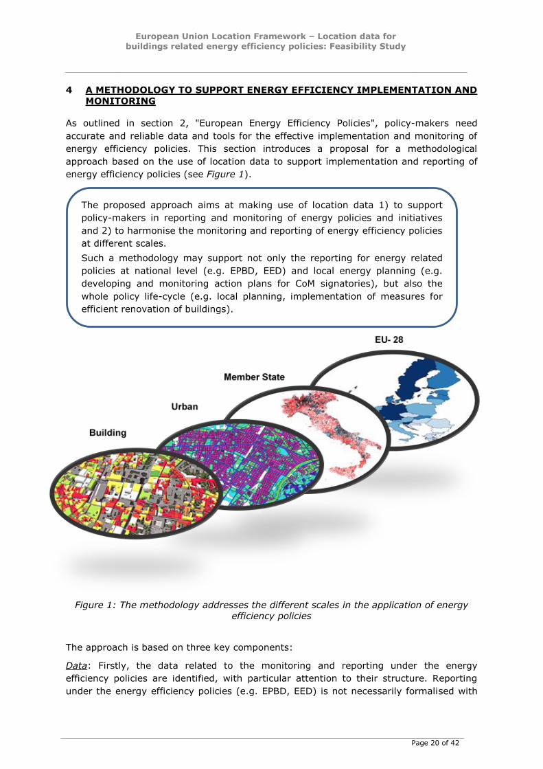
4 A METHODOLOGY TO SUPPORT ENERGY EFFICIENCY IMPLEMENTATION AND
MONITORING
As outlined in section 2, "European Energy Efficiency Policies", policy-makers need
accurate and reliable data and tools for the effective implementation and monitoring of
energy efficiency policies. This section introduces a proposal for a methodological
approach based on the use of location data to support implementation and reporting of
energy efficiency policies (see Figure 1).
Figure 1: The methodology addresses the different scales in the application of energy efficiency policies
The approach is based on three key components:
Data: Firstly, the data related to the monitoring and reporting under the energy
efficiency policies are identified, with particular attention to their structure. Reporting
under the energy efficiency policies (e.g. EPBD, EED) is not necessarily formalised with
The proposed approach aims at making use of location data 1) to support
policy-makers in reporting and monitoring of energy policies and initiatives
and 2) to harmonise the monitoring and reporting of energy efficiency policies
at different scales.
Such a methodology may support not only the reporting for energy related
policies at national level (e.g. EPBD, EED) and local energy planning (e.g.
developing and monitoring action plans for CoM signatories), but also the
whole policy life-cycle (e.g. local planning, implementation of measures for
efficient renovation of buildings).
European Union Location Framework – Location data for
buildings related energy efficiency policies: Feasibility Study
Page 21 of 42
specific data models, and plain text may be sufficient to fulfil the reporting obligations.
Moreover a top-down approach is typically adopted by public authorities, with no
attempt to ensure consistency with data at local level.
Methodologies: Based on the data available at local level and compliant with the INSPIRE
Directive, methodologies will be developed to devise the parameters needed for
monitoring of the energy policies:
The first step will be the calculation of energy performance at building level, when
no energy label or energy performance certificate are available, and in line with
the calculation methods provided in the EPBD;
From the building level, the methodology will describe the scaling up at urban
level and it will enable assessments to be made of energy needs in groups of
buildings, districts and cities. For example, this would allow monitoring of the
building related measures described in their Sustainable Energy Action Plans by
the signatories of the CoM;
A further scale-up step will take the assessments of the energy savings at urban
level and aggregates them, in order to assess their contribution to the national
targets set up under the EED.
Tools: A set of tools is needed for the practical implementation of the methodologies and
ultimately to support a better, evidence-based, policy-making process. This will include
data models, geodatabases, visualisation instruments, data exchange protocols, data
sharing mechanisms, web services, a cookbook for implementers, training materials,
demonstrators, etc.
Some inputs for the development of applicable methodologies are given in the following
paragraphs. A pilot implementation will be needed to define the detailed methodologies,
based on an assessment of data from different sources.
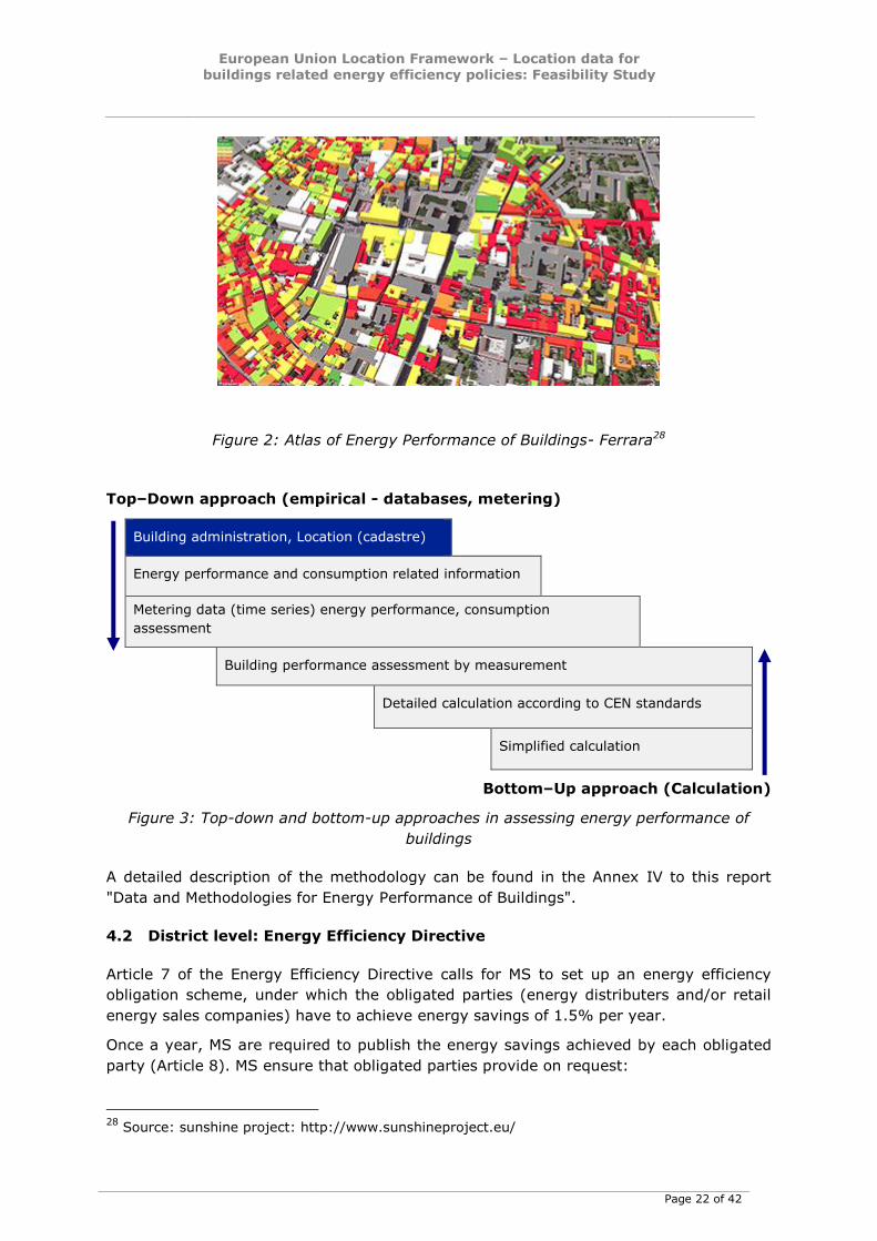
4.1 Building level: Energy Performance of Buildings
There is a need to provide local authorities with reliable energy performance data at
building level to build and update a robust inventory of local energy performance of
buildings data not only based on statistical indicators, and to generate policy support
tools such as energy density maps (see Figure 2) or dashboards of indicators.
The methodology should follow the common general framework set out in Annex I of the
EPBD and refer to the EPBD related CEN overarching standard EN 15603. The proposed
approach will involve a simplified estimation of energy performance at building level,
when no energy label or energy performance certificate are available, in line with the
calculation methods provided in the EPBD.
It is anticipated that the assessment of the energy performance of buildings will draw on
data and calculations from different sources. Figure 3 below shows a top-down and
bottom-up approach for making the assessments. The top-down approach starts from
administrative building data coming from the cadastre and other sources, whilst the
bottom-up approach starts from the calculation method based on CEN standards.
European Union Location Framework – Location data for
buildings related energy efficiency policies: Feasibility Study
Page 22 of 42
Figure 2: Atlas of Energy Performance of Buildings- Ferrara28
Top–Down approach (empirical - databases, metering)
Building administration, Location (cadastre)
Energy performance and consumption related information
Metering data (time series) energy performance, consumption
assessment
Building performance assessment by measurement
Detailed calculation according to CEN standards
Simplified calculation
Bottom–Up approach (Calculation)
Figure 3: Top-down and bottom-up approaches in assessing energy performance of
buildings
A detailed description of the methodology can be found in the Annex IV to this report
"Data and Methodologies for Energy Performance of Buildings".
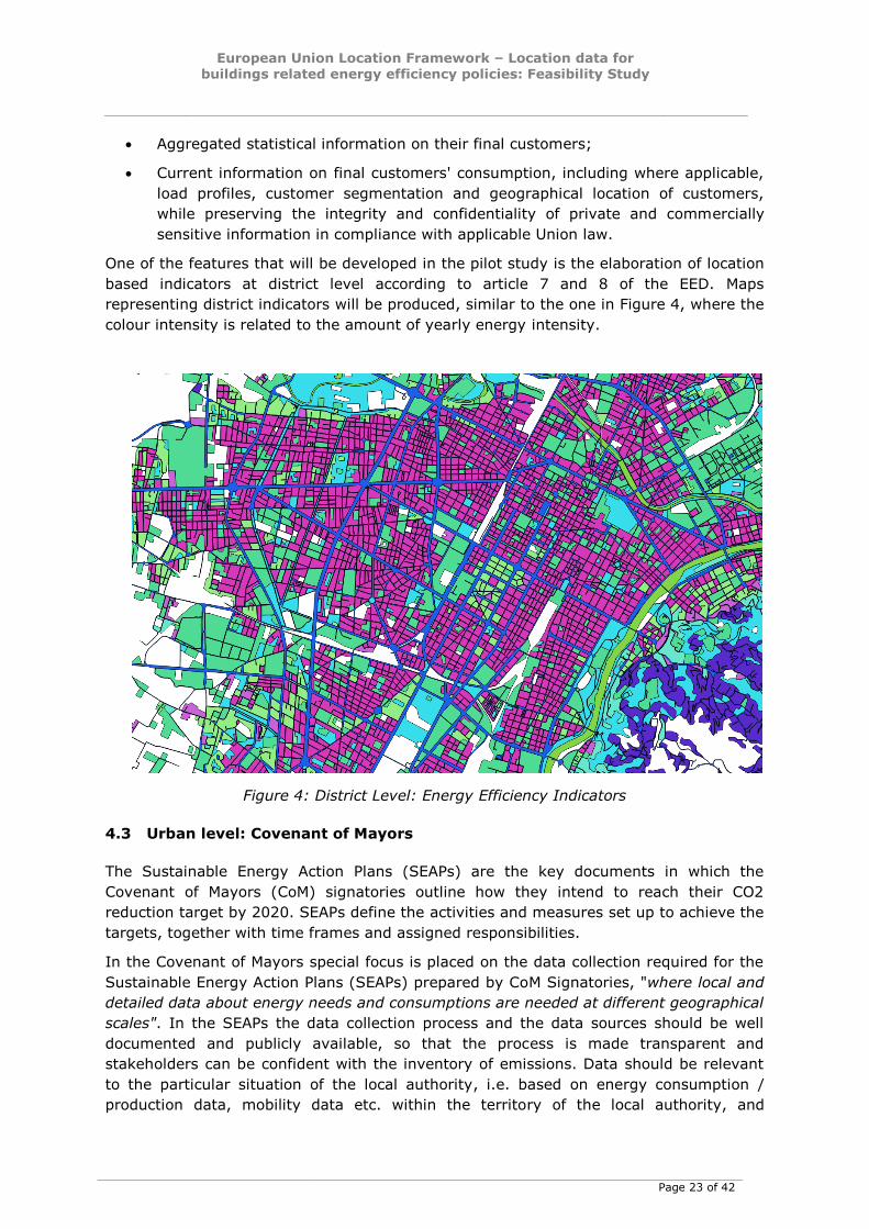
4.2 District level: Energy Efficiency Directive
Article 7 of the Energy Efficiency Directive calls for MS to set up an energy efficiency
obligation scheme, under which the obligated parties (energy distributers and/or retail
energy sales companies) have to achieve energy savings of 1.5% per year.
Once a year, MS are required to publish the energy savings achieved by each obligated
party (Article 8). MS ensure that obligated parties provide on request:
28
Source: sunshine project: http://www.sunshineproject.eu/
European Union Location Framework – Location data for
buildings related energy efficiency policies: Feasibility Study
Page 23 of 42
Aggregated statistical information on their final customers;
Current information on final customers' consumption, including where applicable,
load profiles, customer segmentation and geographical location of customers,
while preserving the integrity and confidentiality of private and commercially
sensitive information in compliance with applicable Union law.
One of the features that will be developed in the pilot study is the elaboration of location
based indicators at district level according to article 7 and 8 of the EED. Maps
representing district indicators will be produced, similar to the one in Figure 4, where the
colour intensity is related to the amount of yearly energy intensity.
Figure 4: District Level: Energy Efficiency Indicators
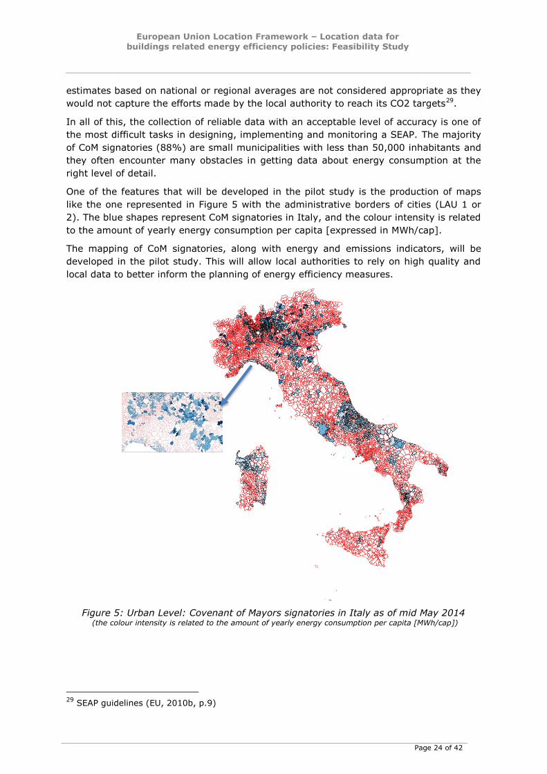
4.3 Urban level: Covenant of Mayors
The Sustainable Energy Action Plans (SEAPs) are the key documents in which the
Covenant of Mayors (CoM) signatories outline how they intend to reach their CO2
reduction target by 2020. SEAPs define the activities and measures set up to achieve the
targets, together with time frames and assigned responsibilities.
In the Covenant of Mayors special focus is placed on the data collection required for the
Sustainable Energy Action Plans (SEAPs) prepared by CoM Signatories, "where local and
detailed data about energy needs and consumptions are needed at different geographical
scales". In the SEAPs the data collection process and the data sources should be well
documented and publicly available, so that the process is made transparent and
stakeholders can be confident with the inventory of emissions. Data should be relevant
to the particular situation of the local authority, i.e. based on energy consumption /
production data, mobility data etc. within the territory of the local authority, and
European Union Location Framework – Location data for
buildings related energy efficiency policies: Feasibility Study
Page 24 of 42
estimates based on national or regional averages are not considered appropriate as they
would not capture the efforts made by the local authority to reach its CO2 targets29.
In all of this, the collection of reliable data with an acceptable level of accuracy is one of
the most difficult tasks in designing, implementing and monitoring a SEAP. The majority
of CoM signatories (88%) are small municipalities with less than 50,000 inhabitants and
they often encounter many obstacles in getting data about energy consumption at the
right level of detail.
One of the features that will be developed in the pilot study is the production of maps
like the one represented in Figure 5 with the administrative borders of cities (LAU 1 or
2). The blue shapes represent CoM signatories in Italy, and the colour intensity is related
to the amount of yearly energy consumption per capita [expressed in MWh/cap].
The mapping of CoM signatories, along with energy and emissions indicators, will be
developed in the pilot study. This will allow local authorities to rely on high quality and
local data to better inform the planning of energy efficiency measures.
Figure 5: Urban Level: Covenant of Mayors signatories in Italy as of mid May 2014 (the colour intensity is related to the amount of yearly energy consumption per capita [MWh/cap])
29
SEAP guidelines (EU, 2010b, p.9)
European Union Location Framework – Location data for
buildings related energy efficiency policies: Feasibility Study
Page 25 of 42
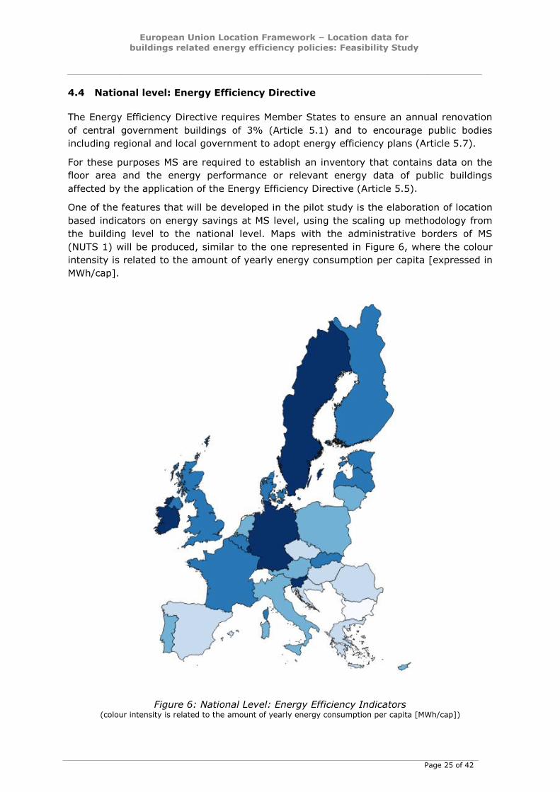
4.4 National level: Energy Efficiency Directive
The Energy Efficiency Directive requires Member States to ensure an annual renovation
of central government buildings of 3% (Article 5.1) and to encourage public bodies
including regional and local government to adopt energy efficiency plans (Article 5.7).
For these purposes MS are required to establish an inventory that contains data on the
floor area and the energy performance or relevant energy data of public buildings
affected by the application of the Energy Efficiency Directive (Article 5.5).
One of the features that will be developed in the pilot study is the elaboration of location
based indicators on energy savings at MS level, using the scaling up methodology from
the building level to the national level. Maps with the administrative borders of MS
(NUTS 1) will be produced, similar to the one represented in Figure 6, where the colour
intensity is related to the amount of yearly energy consumption per capita [expressed in
MWh/cap].
Figure 6: National Level: Energy Efficiency Indicators (colour intensity is related to the amount of yearly energy consumption per capita [MWh/cap])
European Union Location Framework – Location data for
buildings related energy efficiency policies: Feasibility Study
Page 26 of 42
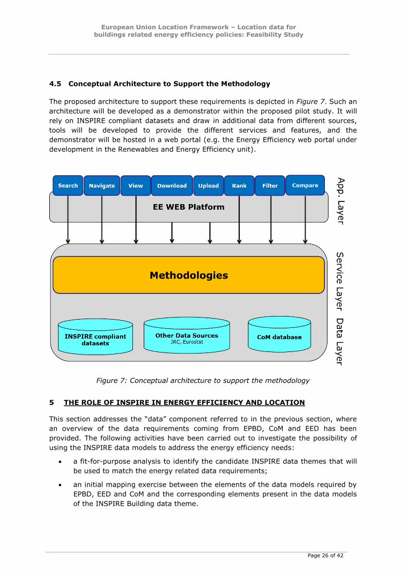
4.5 Conceptual Architecture to Support the Methodology
The proposed architecture to support these requirements is depicted in Figure 7. Such an
architecture will be developed as a demonstrator within the proposed pilot study. It will
rely on INSPIRE compliant datasets and draw in additional data from different sources,
tools will be developed to provide the different services and features, and the
demonstrator will be hosted in a web portal (e.g. the Energy Efficiency web portal under
development in the Renewables and Energy Efficiency unit).
Figure 7: Conceptual architecture to support the methodology
5 THE ROLE OF INSPIRE IN ENERGY EFFICIENCY AND LOCATION
This section addresses the “data” component referred to in the previous section, where
an overview of the data requirements coming from EPBD, CoM and EED has been
provided. The following activities have been carried out to investigate the possibility of
using the INSPIRE data models to address the energy efficiency needs:
a fit-for-purpose analysis to identify the candidate INSPIRE data themes that will
be used to match the energy related data requirements;
an initial mapping exercise between the elements of the data models required by
EPBD, EED and CoM and the corresponding elements present in the data models
of the INSPIRE Building data theme.
European Union Location Framework – Location data for
buildings related energy efficiency policies: Feasibility Study
Page 27 of 42
5.1 INSPIRE candidate data themes
The INSPIRE Directive “establishes an infrastructure for spatial information in Europe to
support Community environmental policies, and policies or activities which may have an
impact on the environment”. INSPIRE defines binding Implementing Rules (Commission
Regulations) and non-binding Technical Guidelines for the interchange of spatial data
through interoperable data models and services. Among the 34 spatial data themes
addressed by the Directive30, the following are directly or indirectly related to “Energy
Efficiency and Location”:
Buildings
Addresses
Cadastral parcels
Utility and governmental services
Production and industrial facilities
Energy resources
Atmospheric conditions
Land Cover
Statistical Units
Population Distribution
The Regulations (Implementing Rules) do not require any specific encoding or formats,
but define the minimum core to be considered for each INSPIRE data theme. At the
same time, INSPIRE strongly encourages the implementation of the data models through
Technical Guidelines defining “how” data should be structured and encoded, by using
well-known and vendor-neutral standards. INSPIRE Data Specifications are described in
various ways: Technical Guidelines are comprehensive documents (one for each of the
34 data themes) with formal descriptions of data requirements, based on UML diagrams
(mainly class diagrams). Data models are also available on the INSPIRE web site31 as
UML interchange format (XMI), GML Application Schemas and XML/XLS Mapping Tables.
Mapping tables provide a comprehensive yet simple tool to represent INSPIRE data
requirements for the aforementioned themes related to “energy”. The detailed lists of
classes, attributes, and constraints for the Building data model are available in Annex I.
These are based on mapping tables available on the INSPIRE web site32. Below is a
description of the candidate data themes and the main aspects of their data models, in
relation to the data requirements described in section 4.
30
http://inspire.ec.europa.eu/index.cfm/pageid/2/list/7 31
http://inspire.ec.europa.eu/index.cfm/pageid/2/list/datamodels
As stated in the web site above, this distribution combines the data models contained in the amendment to the Implementing Rules and the extended data models contained in the data specification Technical Guidelines (but not in the IRs). Please note that the extended data models not included in the IRs should be considered as draft and therefore be used with caution.
32 http://inspire.ec.europa.eu/data-model/approved/r4618/mapping/

European Union Location Framework – Location data for
buildings related energy efficiency policies: Feasibility Study
Page 28 of 42
5.1.1 Buildings
The “Buildings” theme includes the following application schemas (INSPIRE Technical
Guidelines “Buildings” 3.0. pp.29,30):
BuildingsBase, describing the concepts that are common to all other Buildings
application schemas; it contains mainly the core normative semantics of theme
Buildings
Buildings2D, describing the 2D geometric representation of the spatial object
types defined in Buildings Base application schema, namely buildings and building
parts; it inherits from the common semantics of Buildings base
Buildings3D, describing the 3D geometric representation of the spatial object
types defined in Buildings Base application schema, namely buildings and building
parts; it inherits from the common semantics of Buildings base
BuildingsExtendedBase, describing the additional semantics that should be
used to extend normative profiles, whatever the chosen geometric representation
(2D or 3D) is.
BuildingsExtended2D, describing the 2D geometric representation of the
additional spatial object types (namely installations, other constructions, building
units); it inherits both from the common semantics of <Buildings ExtendedBase>
and of the 2D geometric representation of buildings and building parts.
BuildingsExtended3D, describing both the 3D geometric representation of the
additional spatial object types (namely installations, other constructions, building
units) and the additional concepts that should be used to provide more detailed
information about buildings and associated objects, when represented by 3D data
(walls, roofs, openings, room, textures, …); it inherits both from the common
semantics of <Buildings ExtendedBase> and of the 3D geometric representation
of buildings and building parts.
The tables included in Annex I contain the list of detailed properties defined in the
BuildingsExtended2D mapping tables.
The types of objects that are of main interest for the scope of the first mapping exercise
are Buildings, Building Parts and Installations.
5.1.2 Addresses and Cadastral parcels
In the “Buildings” theme, the objects representing “buildings” and “buildings units”
include associations to other feature types defined in two other INSPIRE data themes:
Addresses and Cadastral Parcels. Most buildings can be identified (geocoded) by one or
more addresses (adapted from the INSPIRE Registry33). An address is an identification of
the fixed location of a property. The full address is a hierarchy consisting of components
such as geographic names, with an increasing level of detail, e.g. town, then street
name, then house number or name. It may also include a post code or other postal
descriptors. The address may include a path of access but this depends on the function
of the address (INSPIRE TWG-AD, 2014, p.15).
In the INSPIRE context, cadastral parcels should be forming a partition of national
territory (INSPIRE TWG-CP, 2014, p.13). A cadastral parcel should be considered as a
33
http://inspire.ec.europa.eu/theme/bu/
European Union Location Framework – Location data for
buildings related energy efficiency policies: Feasibility Study
Page 29 of 42
single area of Earth surface (land and/or water) with property rights and unique
ownership34 defined by national law (adapted from UN ECE 2004 and WG-CPI, 2006).
Both addresses and cadastral parcels are often used to reference data about energy
consumption and/or energy performance.
5.1.3 Utility and governmental services
According to the INSPIRE Directive, the Utility and Governmental Services theme
“Includes utility facilities such as sewage, waste management, energy supply and water
supply, administrative and social governmental services such as public administrations,
civil protection sites, schools and hospitals” (INSPIRE TWG-US, 2013, p.13). This theme
has been divided into three sub-themes, one of which deals with “Utility networks”.
Utility services and networks include the physical constructions for transport of defined
utility products (namely pipelines for transport of oil, gas, chemicals, water, sewage and
thermal products), transmission lines and cables (included those for transmission of
electricity, phone and cable-TV signals) and other network elements for encasing pipes
and cases (e.g. ducts, poles and towers). All kinds of transmission utility systems have
nodes (e.g. pump stations), and they are linked to facilities for production and treatment
of different kinds of utility products. These major production and treatment sites are
described in the “Production and industrial facilities” theme.
Six important types of utility networks are distinguished, namely Electricity Network, Oil,
Gas & Chemicals Network, Sewer Network, Telecommunications Network, Thermal
Network and Water Network. They have been designed to describe data in a structured
model with only the most basic characteristics, but adhering to the node-arc-node
concept (taken from the “Network” concept in the INSPIRE Generic Conceptual Model),
respectively for the six types of utility networks (electricity, oil-gas-chemicals, water,
sewer, thermal and telecommunications).
Three types of utility networks are relevant to this study, namely, Thermal networks,
Electricity networks, and Oil, gas, chemicals networks.
5.1.4 Production and industrial facilities
According to the description of the data theme available on the INSPIRE website35, "…
the "Production and Industrial Facilities" theme comprises information about industrial
facilities and activities of production (focusing on extraction, transformation or storage of
resources, including energy production) and the main related environmental issues. In
the relevant Data Specification (INSPIRE TWG-PF, 2013), a more detailed description
says that: “… The overall set of activities considered within the Production and Industrial
Facilities theme spans from extraction of resources, to their transformation in products
or by-products, and their storage. … Transformation of resources should be seen both as
transformation of one resource or product into another, or as transformation into
energy, thus including power generation plants within the scope of this theme …”.
The elements of the ProductionAndIndustrialFacilitiesExt.xsd application schema will
have to be analysed to match the data requirements coming from tables B.2, B.3 and
34
By unique ownership is meant that the ownership is held by one or several joint owners for the
whole parcel. 35
http://inspire.ec.europa.eu/index.cfm/pageid/2/list/7
European Union Location Framework – Location data for
buildings related energy efficiency policies: Feasibility Study
Page 30 of 42
B.4 of the SEAP for Local renewable electricity plants, Local electricity production plants
and Local heat/cold production plants.
5.1.5 Energy Resources
In the INSPIRE context, “Energy resources” are features defining an inferred or
observable spatial extent of a resource that can be, or has been, used as a source of
energy (INSPIRE, TWG-ER, 2013, p.13). The data specification for Energy Resources
provides the mechanism to exchange and compare energy resources related information
defined within a spatial context.
Energy resources are commonly divided into two main types: Primary and Secondary
energy. Primary energy is either extracted or captured directly from natural resources
(such as coal, crude oil, wind or solar radiation) whereas Secondary energy (Energy
Carriers) is the result of a conversion of primary or secondary energy types. Electricity is
one of the most common secondary energy types, being transformed from various
primary energy sources such as coal, oil, natural gas, and wind. Although within the
INSPIRE context only Primary Energy Resources are considered, links to secondary
energy are allowed for through the connection via statistics.
A more detailed analysis of EnergyStatistics application schema is recommended and a
cross-check will have to be done between the relevant elements of the Data Specification
on Energy Resources and the relevant elements of the Data Specification on Production
and Industrial Facilities, in order to ensure consistency and reduce multiplicities where
cross-theme interrelationships exist36.
5.1.6 Atmospheric conditions and Meteorological geographical features
The INSPIRE "Atmospheric Conditions” and "Meteorological Features” themes are
covered together in one Data Specification. These themes provide basic concepts and
data models for environmental protection related activities requiring information on
atmospheric conditions like weather, climate and air quality. The two themes are defined
as follows:
Atmospheric conditions: physical conditions in the atmosphere. Includes
spatial data based on measurements, on models or on a combination thereof and
includes measurements locations;
Meteorological geographical features: weather conditions and their
measurements: precipitation, temperature, evapotranspiration, wind speed and
direction.
A detailed fit-for-purpose analysis will identify the elements of the relevant application
schemas needed to match the climatic zones data requirements present in the energy
efficiency policies.
5.1.7 Land cover
The application schemas of the Land Cover data theme are candidate target data models
to harmonise several input datasets to be used in the energy pilot workflows. In
36
Page 7 of INSPIRE Data Specification on Energy Resources
http://inspire.ec.europa.eu/documents/Data_Specifications/INSPIRE_DataSpecification_ER_v3
.0.pdf

European Union Location Framework – Location data for
buildings related energy efficiency policies: Feasibility Study
Page 31 of 42
particular, the flexibility of the LandCoverNomenclature data type available in both
Raster and Vector application schemas of the Land Cover data specification can facilitate
the harmonisation of several thematic layers, such as Urban Atlas and other datasets
based on urban areas related classification schemes.
5.1.8 Statistical Units and Population Distribution
The combined use of the data models of these two themes will facilitate harmonisation of
datasets consisting of indicators. The Population Distribution theme deals with datasets
of statistical information describing how some phenomena regarding human population
are spread within some part of the 2D space. The theme has no direct spatial features,
and only contains attributes supporting the description of population phenomena related
to statistical units. Population data is linked to spatial objects (statistical units) through
their common identifier, e.g. NUTS codes.
In addition, regarding the genericity of its range of applications, the Executive Summary
of the Data Specification on Population Distribution states that: “There are many
different kinds of statistical data about human population: about people, dwellings,
people at their work place, etc. This document does not intend to provide specifications
for all these. Common characteristics have been extracted and represented into a
generic data model. Using the data model described in this specification, all statistical
data regularly organized in tables or data cubes can be provided in the INSPIRE
framework.”
5.2 Initial mapping exercise
An initial mapping exercise has been carried out between the building related elements
of the data models required by EPBD and CoM and the corresponding elements present
in the INSPIRE data specification on Buildings. Details of the mapping are provided in
Annex I.
The main outcome of this mapping exercise is that the building-related data models
required by EPBD and CoM are semantically richer than the data models under INSPIRE.
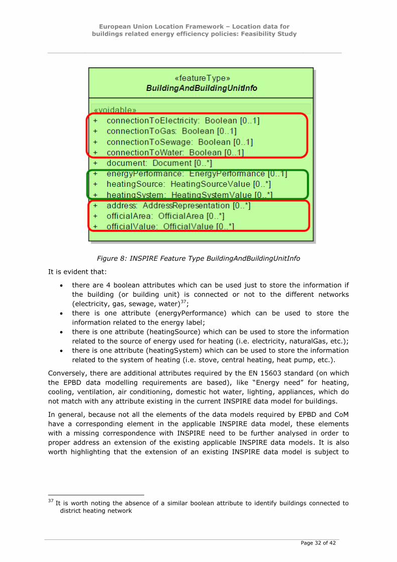
For instance, Figure 8 shows the UML representation of the element of the INSPIRE
Buildings Base Extended data model (Feature Type BuildingAndBuildingUnitInfo) which
deals with energy related aspects.
European Union Location Framework – Location data for
buildings related energy efficiency policies: Feasibility Study
Page 32 of 42
Figure 8: INSPIRE Feature Type BuildingAndBuildingUnitInfo
It is evident that:
there are 4 boolean attributes which can be used just to store the information if
the building (or building unit) is connected or not to the different networks
(electricity, gas, sewage, water)37;
there is one attribute (energyPerformance) which can be used to store the
information related to the energy label;
there is one attribute (heatingSource) which can be used to store the information
related to the source of energy used for heating (i.e. electricity, naturalGas, etc.);
there is one attribute (heatingSystem) which can be used to store the information
related to the system of heating (i.e. stove, central heating, heat pump, etc.).
Conversely, there are additional attributes required by the EN 15603 standard (on which
the EPBD data modelling requirements are based), like “Energy need” for heating,
cooling, ventilation, air conditioning, domestic hot water, lighting, appliances, which do
not match with any attribute existing in the current INSPIRE data model for buildings.
In general, because not all the elements of the data models required by EPBD and CoM
have a corresponding element in the applicable INSPIRE data model, these elements
with a missing correspondence with INSPIRE need to be further analysed in order to
proper address an extension of the existing applicable INSPIRE data models. It is also
worth highlighting that the extension of an existing INSPIRE data model is subject to
37
It is worth noting the absence of a similar boolean attribute to identify buildings connected to
district heating network
European Union Location Framework – Location data for
buildings related energy efficiency policies: Feasibility Study
Page 33 of 42
precise rules and conditions, set to ensure that it does not break the interoperability of
harmonised data and services38.
6 ENERGY PILOT OUTLINE
Based on the outcomes of this feasibility study, this section provides an outline for a
possible EULF pilot on energy efficiency. As mentioned in the introduction, the main aim
of the feasibility study is to verify that geolocation can increase the quality and the
reliability of the data available to local and national policy-makers and help the
alignment between the data requirements addressed by different energy related policies.
The sections below describe first the objectives of the pilot, then details about the
possible approach to be followed and finally propose examples of possible use cases the
pilot should support.
6.1 Aims
The aims of the EULF Pilot Project on "Location data for energy efficiency policies"
include the following:
a) To support local authorities (e.g. Covenant of Mayors signatories) to enhance the
energy efficiency policy-making process (from planning to implementation and
monitoring), improving the quality of data they use (particularly time series local
data).
b) To develop a methodology and to provide local authorities with tools to build and
update a robust inventory of reliable local energy performance of buildings data
(not only based on statistical indicators), to generate energy density maps, a
dashboard of indicators and changes over time of energy performance.
c) To provide local authorities with tools to share data of better quality related to
energy consumption, which can be used by citizens and businesses, including
energy saving companies.
d) To put in place harmonised data flows to support energy related initiatives at local
level (e.g. the CoM) and to align them with the national energy efficiency
planning obligations (set by the Energy Efficiency Directive or the Renewable
Energy Directive).
e) To provide more effective scientific and technical support to European energy
efficiency policy-making process, particularly in relation to the collection and use
of high quality and reliable data for reporting and monitoring.
f) To provide a real example of how INSPIRE can better serve data collection,
collation and sharing among different stakeholders. This may include developing a
formal definition of an extension of the INSPIRE data specification on Buildings
and other data themes related to energy efficiency.
g) To provide a best practice case study for the EULF and contribute to implement
and test its guidelines where appropriate.
38
INSPIRE Generic Conceptual Model -
http://inspire.ec.europa.eu/documents/Data_Specifications/D2.5_v3.4.pdf

European Union Location Framework – Location data for
buildings related energy efficiency policies: Feasibility Study
Page 34 of 42
The pilot should involve a representative set of cities, all of which are CoM signatories
and are already involved in SEAP monitoring activities. In particular, efforts should be
spent to identify candidate cities for which the data needed (as identified in the present
feasibility study) are available and possibly already conformant to the requirements of
the INSPIRE Directive.
In terms of time frame and geographical scale, the involvement of 2-3 cities in the short
term (Phase 1), expanding to 5-6 in the medium term (Phase 2), belonging to different
countries is envisaged. An international workshop could be beneficial both for the
selection of interested cities and for the dissemination of the ideas originated with this
feasibility study to a wider audience.
6.2 Approach
A possible approach to design and deploy the pilot could be based on the steps
schematized in the following Figure 9.
Figure 9: Possible pilot implementation steps
The process to select the partner-cities will have to start in parallel to step 1 and they
will have to be deeply involved in steps from 1 to 4 and in step 6.
A physical workshop will have to be organized with the partner-cities as soon as
possible.
Steps 3 and 4 will have to focus on:
output to be produced
functionalities of the demonstrator
assessment methodologies to be applied to produce the desired output
data flows to be managed by the demonstrator
data sources to be used into the data flows
data harmonization steps to be carried out
Step 6 should include cost-benefit analysis, better if by means of quantitative indicators.
With reference to the proposed approach, different scenarios can be envisaged for the
pilot design and deployment, each of them characterized by different costs and benefits.
The main criteria characterizing the scenarios are listed below and in the following Table
3 an estimation of the related costs and benefits are provided:
the number of cities to be involved;
the heterogeneity of the source datasets, similar in scope;
the level of complexity of the web-based tools to be used by the demonstrator.
Having more cities involved in the pilot would give the possibility to obtain feedback
from a bigger sample, having as a drawback the need to invest more resources for
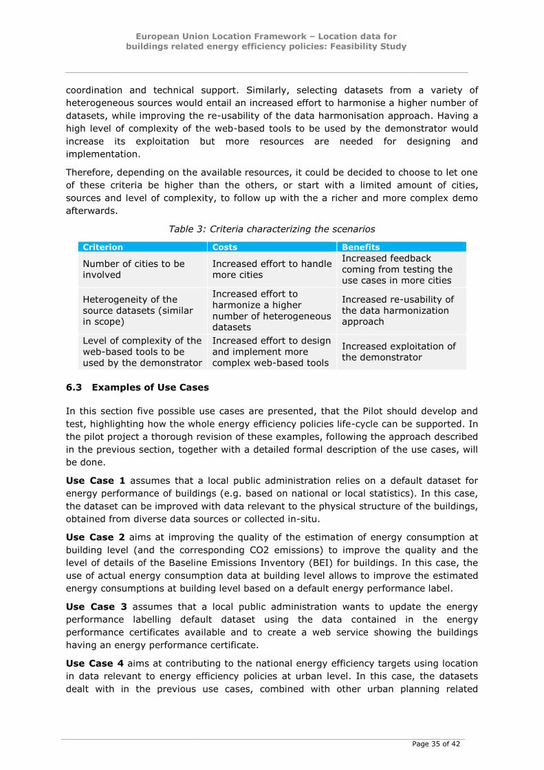
European Union Location Framework – Location data for
buildings related energy efficiency policies: Feasibility Study
Page 35 of 42
coordination and technical support. Similarly, selecting datasets from a variety of
heterogeneous sources would entail an increased effort to harmonise a higher number of
datasets, while improving the re-usability of the data harmonisation approach. Having a
high level of complexity of the web-based tools to be used by the demonstrator would
increase its exploitation but more resources are needed for designing and
implementation.
Therefore, depending on the available resources, it could be decided to choose to let one
of these criteria be higher than the others, or start with a limited amount of cities,
sources and level of complexity, to follow up with the a richer and more complex demo
afterwards.
Table 3: Criteria characterizing the scenarios
Criterion Costs Benefits
Number of cities to be involved
Increased effort to handle more cities
Increased feedback
coming from testing the use cases in more cities
Heterogeneity of the
source datasets (similar in scope)
Increased effort to
harmonize a higher
number of heterogeneous datasets
Increased re-usability of
the data harmonization approach
Level of complexity of the
web-based tools to be
used by the demonstrator
Increased effort to design
and implement more
complex web-based tools
Increased exploitation of the demonstrator
6.3 Examples of Use Cases
In this section five possible use cases are presented, that the Pilot should develop and
test, highlighting how the whole energy efficiency policies life-cycle can be supported. In
the pilot project a thorough revision of these examples, following the approach described
in the previous section, together with a detailed formal description of the use cases, will
be done.
Use Case 1 assumes that a local public administration relies on a default dataset for
energy performance of buildings (e.g. based on national or local statistics). In this case,
the dataset can be improved with data relevant to the physical structure of the buildings,
obtained from diverse data sources or collected in-situ.
Use Case 2 aims at improving the quality of the estimation of energy consumption at
building level (and the corresponding CO2 emissions) to improve the quality and the
level of details of the Baseline Emissions Inventory (BEI) for buildings. In this case, the
use of actual energy consumption data at building level allows to improve the estimated
energy consumptions at building level based on a default energy performance label.
Use Case 3 assumes that a local public administration wants to update the energy
performance labelling default dataset using the data contained in the energy
performance certificates available and to create a web service showing the buildings
having an energy performance certificate.
Use Case 4 aims at contributing to the national energy efficiency targets using location
in data relevant to energy efficiency policies at urban level. In this case, the datasets
dealt with in the previous use cases, combined with other urban planning related

European Union Location Framework – Location data for
buildings related energy efficiency policies: Feasibility Study
Page 36 of 42
datasets, can facilitate to set priorities and financial incentives for the refurbishment of a
target buildings stock at urban level as a contribution to national renovation targets.
Use Case 5 aims at supporting the CoM signatories to prepare and monitor the Emission
Inventory, as the main pillars of their Sustainable Energy Action Plans. In this case, in
addition to the datasets dealt with in the previous use cases, also data related to the
energy production will have to be considered.
European Union Location Framework – Location data for
buildings related energy efficiency policies: Feasibility Study
Page 37 of 42
7 CONCLUSIONS
Based on the priority currently given by the European Union to the energy efficiency
topic through its Energy Union Package, this feasibility study has focused on the role of
location data in support of energy efficiency policies, taking into account the
requirements of INSPIRE, EPBD and EED Directives, as well as of the CoM initiative.
The EU Member States are already due to implement such Directives according to
different roadmaps, but there are benefits to be gained from a coherent and consistent
approach. Moreover, data is not always available in consistent form and with good
quality. The monitoring and reporting requirements set by the CoM need real data and
models, that can be used and that should work consistently across different
administrative levels. On the other hand, the more than 6000 signatories to the CoM
should be supported by few reusable solutions, instead of being left to set up thousands
of ad-hoc planning, monitoring and reporting tools.
The analysis reported in this document support these statement, showing that there is
lack of data quality and reliability, especially at the building level, that it is costly to
collect such data and that the energy consumption data at the building level are
generally not available because they are commercially sensitive. These aspects might
hinder the effective implementation of the energy efficiency policies at the municipal,
district and national level.
In fact, it is generally agreed that, for a better implementation and monitoring of energy
efficiency policies, precise and reliable data as well as robust and evidence-based tools
would be strategic. For example, the development of tools for assessing the energy
performance of buildings at urban scale would strongly support the implementation of
the Energy Performance of Buildings Directive.
A methodological approach for the use of location data for the monitoring of energy
efficiency policies has been provided, clarifying the role of three key components (data,
assessment methodology, tools) and their interrelationships and showing how they can
support the whole life cycle of the energy efficiency policies. It has been highlighted the
need to develop a robust assessment methodology to scale-up energy efficiency data
from building level to district, city and national level, and to develop a set of tools
supporting the implementation of the methodologies.
Geospatial technologies in general and accurate location data in particular can support
this field, because they can significantly support efficient processes related to data
collection, elaboration and communication to be executed in all the phases of energy
efficiency policies life cycle and effective decision-making. The INSPIRE Directive has a
role to play for its relevance in data and services harmonisation and coordination of
thematic expertise at the European level. It can provide common data models and
common data access rules adopted by all EU MS and a roadmap to provide interoperable
datasets of high relevance with energy efficiency.
The study has identified areas of development and analysis that can be useful to fill the
recognised “data gap”, and proposed an initial pilot activity as a start-up project to
investigate concretely these ideas with a limited number of pilot cities. Next steps would
include an international workshop to call for interested cities, and to understand their
level of maturity in the implementation of energy efficiency policy, to assign them to
different use cases and choose the most appropriate scenario to meet their needs.
European Union Location Framework – Location data for
buildings related energy efficiency policies: Feasibility Study
Page 38 of 42
LINKS TO RELEVANT BIBLIOGRAPHY
Agenzia delle Entrate (AdE). (2011). Gli immobili in Italia. Retrieved March 3rd, 2015,
from
http://wwwt.agenziaentrate.gov.it/mt/comunicazione/Gli%20immobili%20in%20Italia%
202011/Gli%20immobili%20in%20Italia%202011%20-%20capitolo%201.pdf
Bloem H. (2013). “The future for standardisation in the building sector; Assessment of
high energy performance buildings” in Workshop on High Performance Buildings - Design
and Evaluation Methodologies. Retrieved March 3rd, 2015, from
http://iet.jrc.ec.europa.eu/energyefficiency/sites/energyefficiency/files/events/High-
Performance-Buildings-June-
2013/Papers/session3/36_pap_bloem_futurestandardisationegrbld.pdf
Building Performance Institute Europe (BPIE). (2011). Europe’s Buildings under the
Microscope. Retrieved March 3rd, 2015, from
http://www.bpie.eu/uploads/lib/document/attachment/21/LR_EU_B_under_microscope_
study.pdf
Coalition for Energy Savings. (2014). Annex A: Timeline of the Energy Efficiency
Directive obligations. Retrieved March 3rd, 2015, from
http://eedguidebook.energycoalition.eu/annexes.html#B
Comitato Termotecnico Italiano (CTI). (2014). Attuazione della certificazione energetica
degli edifici in Italia. Retrieved March 3rd, 2015, from
http://www.cti2000.eu/app/download/8284443385/Sintesi+rapporto+CE+2014.pdf?t=1
419258442
Energy Information Administration (EIA). (2013). International Energy Outlook.
Retrieved July 26th, 2014, from http://www.eia.gov/forecasts/ieo/excel/ieotab_1.xls
European Commission (EC). (2007). Directive 2007/2/EC of the European Parliament
and of the Council of 14 March 2007 establishing an Infrastructure for Spatial
Information in the European Community (INSPIRE). Retrieved March 3rd, 2015, from
http://eur-
lex.europa.eu/LexUriServ/LexUriServ.do?uri=OJ:L:2007:108:0001:0014:EN:PDF
European Commission (EC). (2010). Mandate to CEN, CENELEC and ETSI for the
elaboration and adoption of standards for a methodology calculating the integrated
energy performance of buildings and promoting the energy efficiency of buildings, in
accordance with the terms set in the recast of the Directive on the energy performance
of buildings (2010/31/EU). Retrieved March 3rd, 2015, from
ftp://ftp.cencenelec.eu/CENELEC/EuropeanMandates/M_480.pdf
European Commission (EC). (2013a). European Union Location Framework Strategic
Vision. Retrieved March 3rd, 2015, from http://ec.europa.eu/isa/actions/documents/isa-
2.13_eulf-strategic-vision-lite-v0-3_final_en.pdf
European Commission (EC). (2013b). The Covenant of Mayors in Figures. 5-Year
Assessment. Retrieved March 3rd, 2015, from
http://www.covenantofmayors.eu/IMG/pdf/com_in_figures_jrc.pdf
European Union Location Framework – Location data for
buildings related energy efficiency policies: Feasibility Study
Page 39 of 42
European Commission (EC). (2015). Establishment of a European Union Location
Framework (EULF). Retrieved March 3rd, 2015, from http://ec.europa.eu/isa/actions/02-
interoperability-architecture/2-13action_en.htm
European Union (EU). (2006). Directive 2006/32/EC of the European Parliament and of
the Council of 5 April 2006 on energy end-use efficiency and energy services and
repealing Council Directive 93/76/EEC. Retrieved March 3rd, 2015, from http://eur-
lex.europa.eu/legal-content/EN/TXT/PDF/?uri=CELEX:32006L0032&from=EN
European Union (EU). (2010a). Directive 2010/31/EU of the European Parliament and of
the Council of 19 May 2010 on the energy performance of buildings (recast). Retrieved
March 3rd, 2015, from http://eur-
lex.europa.eu/LexUriServ/LexUriServ.do?uri=OJ:L:2010:153:0013:0035:EN:PDF
European Union (EU). (2010b). How to develop a Sustainable Energy Action Plan.
Retrieved March 3rd, 2015, from
http://www.eumayors.eu/IMG/pdf/seap_guidelines_en.pdf
European Union (EU). (2012). Directive 2012/27/EU of the European Parliament and of
the Council of 25 October 2012 on energy efficiency, amending Directives 2009/125/EC
and 2010/30/EU and repealing Directives 2004/8/EC and 2006/32/EC. Retrieved July
26th, 2015, from http://eur-lex.europa.eu/legal-
content/EN/TXT/PDF/?uri=CELEX:32012L0027&from=EN
European Union (EU). (2014). Energy Performance of Buildings. Retrieved July 26th,
2015, from
http://europa.eu/legislation_summaries/internal_market/single_market_for_goods/const
ruction/en0021_en.htm
INSPIRE Thematic Working Group Addresses (TWG-AD). (2014). D2.8.I.5 Data
Specification on Addresses – Technical Guidelines. Retrieved March 3rd, 2015, from
http://inspire.ec.europa.eu/documents/Data_Specifications/INSPIRE_DataSpecification_
AD_v3.1.pdf
INSPIRE Thematic Working Group Atmospheric Conditions and Meteorological
Geographical Features (TWG-AC-MF). (2013). D2.8.III.13-14Data Specification on
Atmospheric Conditions and Meteorological Geographical Features – Technical
Guidelines. Retrieved March 3rd, 2015, from
http://inspire.ec.europa.eu/documents/Data_Specifications/INSPIRE_DataSpecification_
AC-MF_v3.0.pdf
INSPIRE Thematic Working Group Buildings (TWG-BU). (2013). D2.8.III.2 INSPIRE Data
Specification on Buildings – Technical Guidelines. Retrieved March 3rd, 2015, from
http://inspire.ec.europa.eu/documents/Data_Specifications/INSPIRE_DataSpecification_
BU_v3.0.pdf
INSPIRE Thematic Working Group Cadastral Parcels (TWG-CP). (2014). D2.8.I.6Data
Specification on Cadastral Parcels – Technical Guidelines. Retrieved March 3rd, 2015,
from
http://inspire.ec.europa.eu/documents/Data_Specifications/INSPIRE_DataSpecification_
CP_v3.1.pdf
INSPIRE Thematic Working Group Energy Resources (TWG-ER). (2013). D2.8.III.20 Data
Specification on Energy Resources – Technical Guidelines. Retrieved March 3rd, 2015,
from

European Union Location Framework – Location data for buildings related energy efficiency policies: Feasibility Study
Page 40 of 42
http://inspire.ec.europa.eu/documents/Data_Specifications/INSPIRE_DataSpecification_
ER_v3.0.pdf
INSPIRE Thematic Working Group Production and Industrial Facilities (TWG-PF). (2013).
D2.8.III.8 Data Specification on Production and Industrial Facilities – Technical
Guidelines. Retrieved March 3rd, 2015, from
http://inspire.ec.europa.eu/documents/Data_Specifications/INSPIRE_DataSpecification_
PF_v3.0.pdf
INSPIRE Thematic Working Group Utilities and Governmental Services (TWG-US).
(2013). D2.8.III.6 Data Specification on Utility and Government Services – Technical
Guidelines. Retrieved March 3rd, 2015, from
http://inspire.ec.europa.eu/documents/Data_Specifications/INSPIRE_DataSpecification_
US_v3.0.pdf
Junker J.C. (2014). My Priorities. Retrieved March 3rd, 2015, from
http://juncker.epp.eu/my-priorities
European Union Location Framework – Location data for buildings related energy efficiency policies: Feasibility Study
Page 41 of 42
Europe Direct is a service to help you find answers to your questions about the European Union
Freephone number (*): 00 800 6 7 8 9 10 11
(*) Certain mobile telephone operators do not allow access to 00 800 numbers or these calls may be billed.
A great deal of additional information on the European Union is available on the Internet.
It can be accessed through the Europa server http://europa.eu.
How to obtain EU publications
Our publications are available from EU Bookshop (http://bookshop.europa.eu),
where you can place an order with the sales agent of your choice.
The Publications Office has a worldwide network of sales agents.
You can obtain their contact details by sending a fax to (352) 29 29-42758.
European Commission
EUR 27411 EN – Joint Research Centre – Institute for Environment and Sustainability/ Institute for Energy and Transport
Title: Location data for buildings related energy efficiency policies
Authors: Hans Bloem, Ray Boguslawski, Maria Teresa Borzacchiello, Piergiorgio Cipriano, Albana Kona, Giacomo Martirano,
Isabella Maschio, , Francesco Pignatelli
Luxembourg: Publications Office of the European Union
2015 – 42 pp. – 21.0 x 29.7 cm
EUR – Scientific and Technical Research series – ISSN 1018-5593 (print), ISSN 1831-9424 (online)
ISBN 978-92-79-50572-0 (PDF)
ISBN 978-92-79-50573-7 (print)
doi:10.2788/668832
Page 42 of 42
ISBN 978-92-79-50572-0
doi:10.2788/668832
JRC Mission
As the Commission’s in-house science service, the Joint Research Centre’s mission is to provide EU policies with independent, evidence-based scientific and technical support throughout the whole policy cycle.
Working in close cooperation with policy Directorates-General, the JRC addresses key societal challenges while stimulating innovation through developing new methods, tools and standards, and sharing its know-how with the Member States, the scientific community and international partners.
Serving society Stimulating innovation Supporting legislation
LB
-NA
-27
41
1-E
N-N