Embed Size (px)
Citation preview
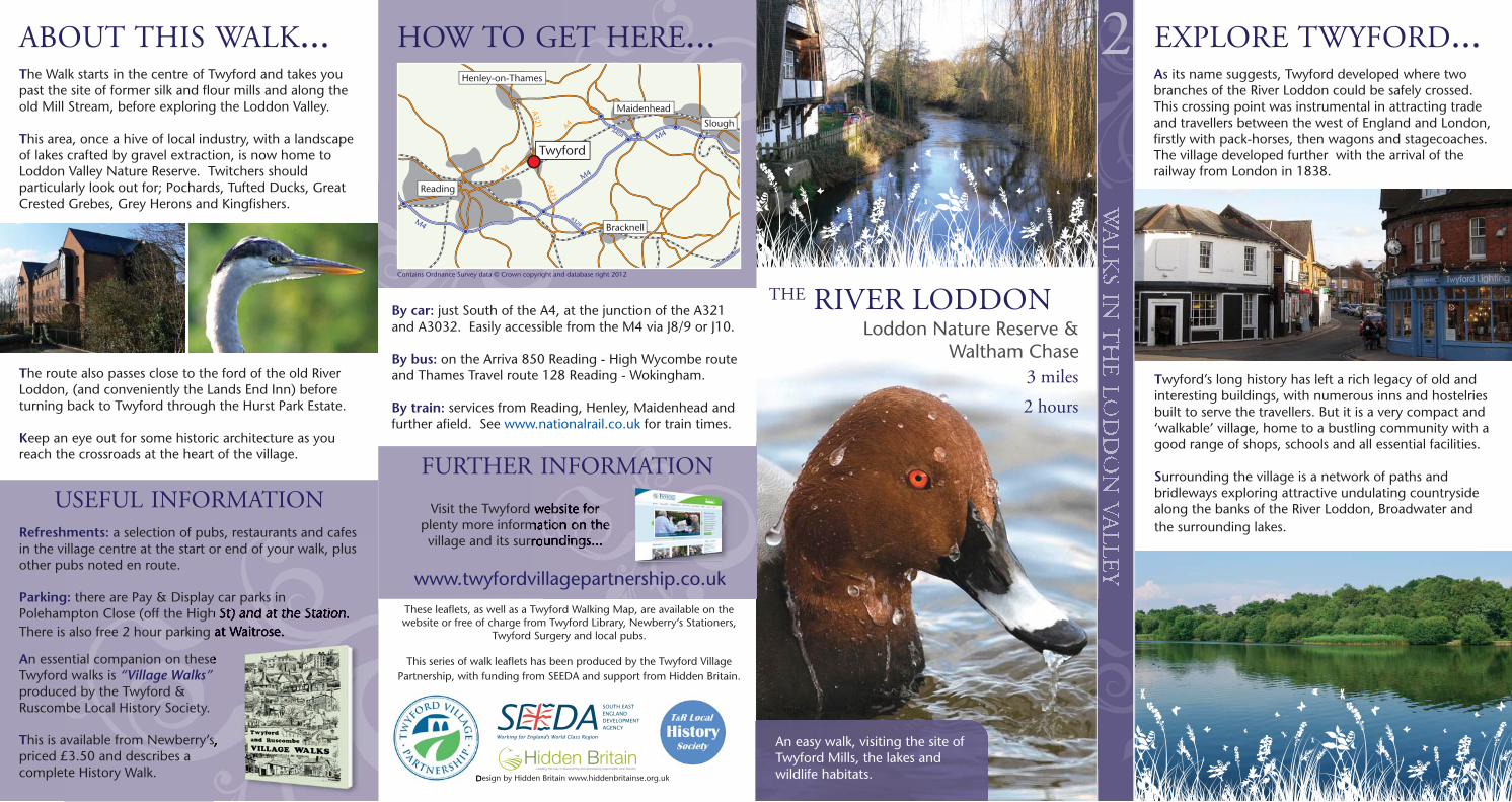
By car: just South of the A4, at the junction of the A321and A3032. Easily accessible from the M4 via J8/9 or J10.
By bus: on the Arriva 850 Reading - High Wycombe routeand Thames Travel route 128 Reading - Wokingham.
By train: services from Reading, Henley, Maidenhead andfurther afield. See www.nationalrail.co.uk for train times.
Visit the Twyford website forplenty more information on thevillage and its surroundings...
Design by Hidden Britain www.hiddenbritainse.org.uk
THE RIVER LODDON
EXPLORE TWYFORD...
Refreshments: a selection of pubs, restaurants and cafesin the village centre at the start or end of your walk, plusother pubs noted en route.
Parking: there are Pay & Display car parks inPolehampton Close (off the High St) and at the Station.There is also free 2 hour parking at Waitrose.
3 miles2 hours
2
An essential companion on theseTwyford walks is “Village Walks”produced by the Twyford &Ruscombe Local History Society.
This is available from Newberry’s,priced £3.50 and describes acomplete History Walk.
M4
M4
M4
A404
A329
Reading
Bracknell
Slough
Maidenhead
Henley-on-Thames
Twyford
A4
A4
A321
A321
FURTHER INFORMATION
HOW TO GET HERE...ABOUT THIS WALK...The Walk starts in the centre of Twyford and takes youpast the site of former silk and flour mills and along theold Mill Stream, before exploring the Loddon Valley.
This area, once a hive of local industry, with a landscapeof lakes crafted by gravel extraction, is now home toLoddon Valley Nature Reserve. Twitchers shouldparticularly look out for; Pochards, Tufted Ducks, GreatCrested Grebes, Grey Herons and Kingfishers.
The route also passes close to the ford of the old RiverLoddon, (and conveniently the Lands End Inn) beforeturning back to Twyford through the Hurst Park Estate.
Keep an eye out for some historic architecture as youreach the crossroads at the heart of the village.
USEFUL INFORMATION
Contains Ordnance Survey data © Crown copyright and database right 2012
Loddon Nature Reserve &Waltham Chase
An easy walk, visiting the site ofTwyford Mills, the lakes andwildlife habitats.
As its name suggests, Twyford developed where twobranches of the River Loddon could be safely crossed.This crossing point was instrumental in attracting tradeand travellers between the west of England and London,firstly with pack-horses, then wagons and stagecoaches.The village developed further with the arrival of therailway from London in 1838.
Twyford’s long history has left a rich legacy of old andinteresting buildings, with numerous inns and hostelriesbuilt to serve the travellers. But it is a very compact and‘walkable’ village, home to a bustling community with agood range of shops, schools and all essential facilities.
Surrounding the village is a network of paths andbridleways exploring attractive undulating countrysidealong the banks of the River Loddon, Broadwater andthe surrounding lakes.
These leaflets, as well as a Twyford Walking Map, are available on thewebsite or free of charge from Twyford Library, Newberry’s Stationers,
Twyford Surgery and local pubs.
This series of walk leaflets has been produced by the Twyford Village Partnership, with funding from SEEDA and support from Hidden Britain.
www.twyfordvillagepartnership.co.uk
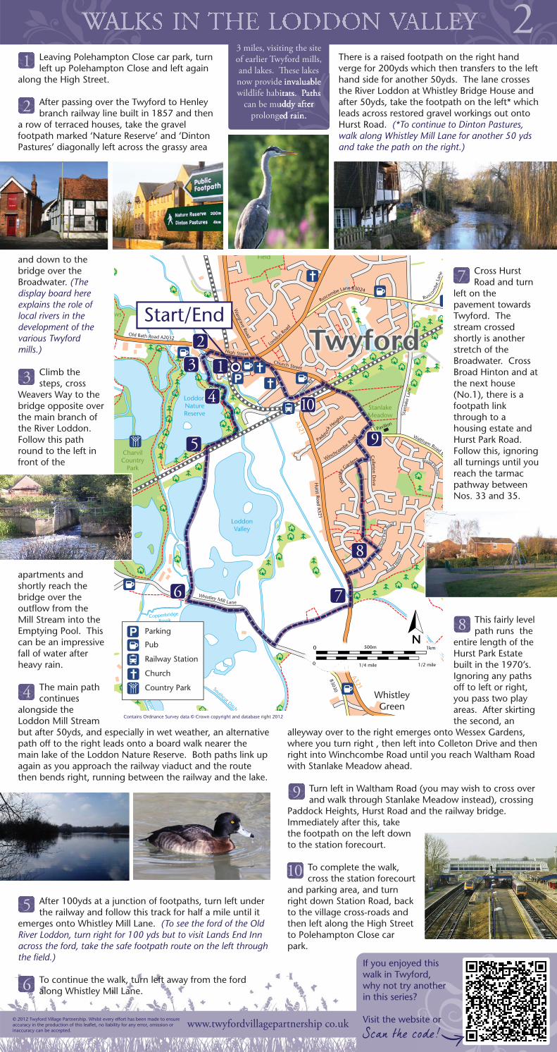
Leaving Polehampton Close car park, turnleft up Polehampton Close and left again
along the High Street.
After passing over the Twyford to Henleybranch railway line built in 1857 and then
a row of terraced houses, take the gravelfootpath marked ‘Nature Reserve’ and ‘DintonPastures’ diagonally left across the grassy area
and down to thebridge over theBroadwater. (Thedisplay board hereexplains the role oflocal rivers in thedevelopment of thevarious Twyfordmills.)
Climb thesteps, cross
Weavers Way to thebridge opposite overthe main branch ofthe River Loddon.Follow this pathround to the left infront of the
apartments andshortly reach thebridge over theoutflow from theMill Stream into theEmptying Pool. Thiscan be an impressivefall of water afterheavy rain.
The main pathcontinues
alongside theLoddon Mill Streambut after 50yds, and especially in wet weather, an alternativepath off to the right leads onto a board walk nearer themain lake of the Loddon Nature Reserve. Both paths link upagain as you approach the railway viaduct and the routethen bends right, running between the railway and the lake.
After 100yds at a junction of footpaths, turn left underthe railway and follow this track for half a mile until it
emerges onto Whistley Mill Lane. (To see the ford of the OldRiver Loddon, turn right for 100 yds but to visit Lands End Innacross the ford, take the safe footpath route on the left throughthe field.)
To continue the walk, turn left away from the fordalong Whistley Mill Lane.
There is a raised footpath on the right handverge for 200yds which then transfers to the lefthand side for another 50yds. The lane crossesthe River Loddon at Whistley Bridge House andafter 50yds, take the footpath on the left* whichleads across restored gravel workings out ontoHurst Road. (*To continue to Dinton Pastures,walk along Whistley Mill Lane for another 50 ydsand take the path on the right.)
Cross HurstRoad and turn
left on thepavement towardsTwyford. Thestream crossedshortly is anotherstretch of theBroadwater. CrossBroad Hinton and atthe next house(No.1), there is afootpath linkthrough to ahousing estate andHurst Park Road.Follow this, ignoringall turnings until youreach the tarmacpathway betweenNos. 33 and 35.
This fairly levelpath runs the
entire length of theHurst Park Estatebuilt in the 1970’s.Ignoring any pathsoff to left or right,you pass two playareas. After skirtingthe second, an
alleyway over to the right emerges onto Wessex Gardens,where you turn right , then left into Colleton Drive and thenright into Winchcombe Road until you reach Waltham Roadwith Stanlake Meadow ahead.
Turn left in Waltham Road (you may wish to cross overand walk through Stanlake Meadow instead), crossing
Paddock Heights, Hurst Road and the railway bridge.Immediately after this, takethe footpath on the left downto the station forecourt.
To complete the walk,cross the station forecourt
and parking area, and turnright down Station Road, backto the village cross-roads andthen left along the High Streetto Polehampton Close carpark.
© 2012 Twyford Village Partnership. Whilst every effort has been made to ensureaccuracy in the production of this leaflet, no liability for any error, omission orinaccuracy can be accepted.
21
If you enjoyed thiswalk in Twyford,why not try anotherin this series?
Visit the website or
2
3 miles, visiting the siteof earlier Twyford mills,and lakes. These lakesnow provide invaluablewildlife habitats. Paths
can be muddy afterprolonged rain.
3
4
5
7
9
10
WhistleyGreen
CharvilCountry
Park
ws
StanlakeMeadow
Field
Pavilion
Old River
Southcot Ditch
Old
Riv
er
Copperbridge
Brook
LoddonNatureReserve
LoddonValley
A321
A321
B3030
MMMMMMMMMMM
Start/End
Waltham Road B3
Stan
lake
Lan
e
Rusc
ombe
Lan
e
Broad Hin
ton
Broad Hinton
Hurst Road
A321
Ruscombe Lane B3024
Old Bath Road A2032
High Street
Whistley Mill Lane
Wargrave Road
London
Road
Church Street
Padd oc
k Heig
hts
Winchcombe R
oad
Wes
sex G
arden
s
Colleton D
rive
Hur
st P
ark
Road
Stat
ion R
d
N0 500m 1km
1/4 mile 1/2 mile 0
Parking
Pub
Railway Station
Church
Country Park
12
3
4
5
6 7
8
9
10
8
Scan the code!
Contains Ordnance Survey data © Crown copyright and database right 2012
6
www.twyfordvillagepartnership co.uk