Embed Size (px)
Citation preview
LOGAN WATER ALLIANCE
ONLINE WATER QUALITY MONITORING SITES: DETAILED PLANNING
TASK NUMBER: 90-12-38
FEBRUARY 2014
Online Water Quality Monitoring Priority 1 and 2 Sites – Detailed Planning Document Number: 7600-000-P-REP-PL-8204
90-12-38 Date issued: 28/02/2014 Page 2 of 55 Rev: 1
Approval Register
Date
Project Manager Submitted
Planning & Project Management Team Review
Program Review
Controlled Document – Change Register
Revision Section
Changed Change Description Initial Date
A All Draft Report SH 28/01/2014
B All Draft Report format SS 04/02/2014
C All Incorporate review comments SH 20/02/2014
1 All Format Final Report SS 24/02/2014
Online Water Quality Monitoring Priority 1 and 2 Sites – Detailed Planning Document Number: 7600-000-P-REP-PL-8204
90-12-38 Date issued: 28/02/2014 Page 3 of 55 Rev: 1
TABLE OF CONTENTS
EXECUTIVE SUMMARY ................................................................................................................................. 8
1. INTRODUCTION ............................................................................................................................... 11
1.1 Objectives ...................................................................................................................................... 11
1.2 Scope ............................................................................................................................................. 11
1.3 Business Drivers ............................................................................................................................ 12
1.4 Stakeholder engagement ............................................................................................................... 12
2. PLANNING CONTEXT ...................................................................................................................... 13
2.1 Existing Situation ........................................................................................................................... 13
2.2 Previous Studies ............................................................................................................................ 14
2.3 Selection of Water Quality Monitoring sites ................................................................................... 16
3. METHODOLOGY .............................................................................................................................. 18
3.1 Risk Assessment for disposal of instrumentation water ................................................................ 19
4. ASSUMPTIONS ................................................................................................................................ 20
4.1 Water Quality Monitoring Parameters ........................................................................................... 20
4.2 Location of Water Quality Cabinets ............................................................................................... 21
4.3 Water Quality Instrumentation ....................................................................................................... 21
4.4 RTU Site Audits ............................................................................................................................. 21
4.5 First Principle Cost Estimate .......................................................................................................... 22
5. DETAILED PLANNING ..................................................................................................................... 23
5.1 WQI 03 - Spring Mountain Reservoir ............................................................................................. 23
5.1.1 Site Description .......................................................................................................................... 23
5.1.2 Risks and Opportunities ............................................................................................................. 24
5.1.3 Cost Estimate............................................................................................................................. 25
5.2 WQI 04 - Woodhill Reservoir ......................................................................................................... 26
5.2.1 Site Description .......................................................................................................................... 26
5.2.2 Risks and Opportunities ............................................................................................................. 27
5.2.3 Cost Estimate............................................................................................................................. 28
5.3 WQI 05 - Jimboomba Reticulation ................................................................................................. 29
5.3.1 Site Description .......................................................................................................................... 29
5.3.2 Risks and Opportunities ............................................................................................................. 30
5.3.3 Cost Estimate............................................................................................................................. 30
5.4 WQI 06 - Flagstone Reticulation .................................................................................................... 31
5.4.1 Site Description .......................................................................................................................... 31
5.4.2 Risks and Opportunities ............................................................................................................. 31
Online Water Quality Monitoring Priority 1 and 2 Sites – Detailed Planning Document Number: 7600-000-P-REP-PL-8204
90-12-38 Date issued: 28/02/2014 Page 4 of 55 Rev: 1
5.4.3 Cost Estimate............................................................................................................................. 32
5.5 WQI 07 - Mundoolun Pump Station ............................................................................................... 33
5.5.1 Site Description .......................................................................................................................... 33
5.5.2 Risks and Opportunities ............................................................................................................. 34
5.5.3 Cost Estimate............................................................................................................................. 34
5.6 WQI 08 - Bethania Reticulation ..................................................................................................... 35
5.6.1 Site Description .......................................................................................................................... 35
5.6.2 Risks and Opportunities ............................................................................................................. 35
5.6.3 Cost Estimate............................................................................................................................. 36
5.7 WQI 09 - Springwood High Level Water Supply zone ................................................................... 37
5.7.1 Site Description .......................................................................................................................... 37
5.7.2 Risks and Opportunities ............................................................................................................. 37
5.7.3 Cost Estimate............................................................................................................................. 38
5.8 WQI 10 - Logan Village Reticulation .............................................................................................. 39
5.8.1 Site Description .......................................................................................................................... 39
5.8.2 Risks and Opportunities ............................................................................................................. 40
5.8.3 Cost Estimate............................................................................................................................. 41
5.9 WQI 11 - Windaroo Reticulation .................................................................................................... 42
5.9.1 Site Description .......................................................................................................................... 42
5.9.2 Risks and Opportunities ............................................................................................................. 42
5.9.3 Cost Estimate............................................................................................................................. 43
5.10 WQI 12 - Springwood Low Level Reservoir ................................................................................... 44
5.10.1 Site Description ...................................................................................................................... 44
5.10.2 Risks and Opportunities ......................................................................................................... 45
5.10.3 Cost Estimate......................................................................................................................... 46
6. CONCLUSION ................................................................................................................................... 47
6.1 Capital Works Program Implication ............................................................................................... 48
7. RECOMMENDATIONS ..................................................................................................................... 49
8. REFERENCES .................................................................................................................................. 50
FIGURES
Figure 2-1: Current Sites Remotely Monitored by LCC ................................................................................. 13
Figure 2-2: Proposed Sites to be Remotely Monitored by LCC ...................................................................... 15
Figure 3-1: Methodology ................................................................................................................................ 18
Figure 5-1: Proposed WQI 03 monitoring point at Spring Mountain Reservoir ............................................. 23
Figure 5-2: Future dosing arrangement ......................................................................................................... 24
Figure 5-3: WQI 04 at Woodhill Reservoir ..................................................................................................... 26
Online Water Quality Monitoring Priority 1 and 2 Sites – Detailed Planning Document Number: 7600-000-P-REP-PL-8204
90-12-38 Date issued: 28/02/2014 Page 5 of 55 Rev: 1
Figure 5-4: WQI 05 sample point at Jimboomba ........................................................................................... 29
Figure 5-5: WQI 06 cabinet location at Flagstone 1 (SPS 78) Pump Station ................................................ 31
Figure 5-6: WQI 07 Cabinet Location, Mundoolun Pump Station ................................................................. 33
Figure 5-7: PRV/WQI 08 Cabinet location at Bethania ................................................................................. 35
Figure 5-8: WQI 09 cabinet location at Parfrey Road, Rochedale ................................................................ 37
Figure 5-9: WQI 10 sample point at Logan Village 1 Pump Station .............................................................. 39
Figure 5-10: WQI 11 cabinet location at Belivah ........................................................................................... 42
Figure 5-11: WQI 12 cabinet location at Springwood Low Level Reservoir ................................................... 44
TABLES
Table E-1: Capital Works Cost Summary ........................................................................................................ 9
Table 1-1: Key stakeholders .......................................................................................................................... 12
Table 2-1: Proposed Water Quality Monitoring Sites .................................................................................... 15
Table 2-2: Assessment of site criticality ....................................................................................................... 17
Table 5-1: WQI 03 Environmental Assessment ............................................................................................ 24
Table 5-2: Capital Cost estimate for WQI 03 ................................................................................................. 25
Table 5-3: Capital Cost estimate for WQI 04 ................................................................................................. 28
Table 5-4: WQI 05 Environmental Assessment ............................................................................................ 30
Table 5-5: Capital Cost estimate for WQI 05 ................................................................................................. 30
Table 5-6: WQI 06 Environmental Assessment ............................................................................................ 32
Table 5-7: Capital Cost estimate for WQI 06 ................................................................................................. 32
Table 5-8: Capital Cost estimate for WQI 07 ................................................................................................. 34
Table 5-9: WQI 08 Environmental Assessment ............................................................................................ 36
Table 5-10: Capital Cost estimate for WQI 08 ............................................................................................... 36
Table 5-11: WQI 09 Environmental Assessment .......................................................................................... 37
Table 5-12: Capital Cost estimate for WQI 09 ............................................................................................... 38
Table 5-13: WQI 10 Environmental Assessment .......................................................................................... 40
Table 5-14: Capital Cost estimate for WQI 10 ............................................................................................... 41
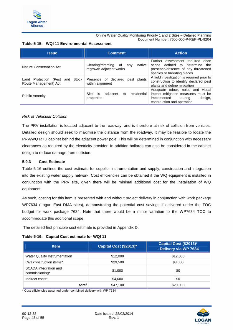
Table 5-15: WQI 11 Environmental Assessment .......................................................................................... 43
Table 5-16: Capital Cost estimate for WQI 11 ............................................................................................... 43
Table 5-17: WQI 11 Environmental Assessment .......................................................................................... 45
Table 5-18: Capital Cost estimate for WQI 12 ............................................................................................... 46
Table 6-1: Proposed sites for alternative release of instrumentation water .................................................. 47
Table 6-2: Capital Works Cost Summary ...................................................................................................... 48

Online Water Quality Monitoring Priority 1 and 2 Sites – Detailed Planning Document Number: 7600-000-P-REP-PL-8204
90-12-38 Date issued: 28/02/2014 Page 6 of 55 Rev: 1
APPENDICES
Appendix A Risk Assessment
Appendix B Preliminary Design Drawings
Appendix C Environmental Assessment
Appendix D Cost Estimate
Appendix E POAR Meeting Minutes
Online Water Quality Monitoring Priority 1 and 2 Sites – Detailed Planning Document Number: 7600-000-P-REP-PL-8204
90-12-38 Date issued: 28/02/2014 Page 7 of 55 Rev: 1
ABBREVIATIONS
ARMP Approved Risk Management Plan
CCP Critical Control Point
DBYD Dial Before You Dig
DN Nominal Diameter
DMA District Metered Area
HACCP Hazard Analysis and Critical Control Points
HV High Voltage
IDM Infrastructure Demand Model
I/O Input/Output
LCC Logan City Council
LV Low Voltage
LWA Logan Water Alliance
POAR Planning, Opportunity And Risk
PS Pump Station
QCP Quality Control Point
RTU Remote Telemetry Unit
SCADA Supervisory Control and Data Acquisition
SRWP Southern Regional Water Pipeline
WQ Water Quality
WTP Water Treatment Plant
WSZ Water Supply Zone
Online Water Quality Monitoring Priority 1 and 2 Sites – Detailed Planning Document Number: 7600-000-P-REP-PL-8204
90-12-38 Date issued: 28/02/2014 Page 8 of 55 Rev: 1
EXECUTIVE SUMMARY
The Online Water Quality Monitoring Strategy (LWA, 2013) identified 12 sites where real-time water quality
monitoring could further enhance Logan City Council’s ability to monitor network water quality. Detailed
planning for ten of these sites has been addressed as part of this current detailed planning study, while two
sites are already being delivered by LWA as part of Work Package WP7635 - Travis Road Reservoir outlet
main.
There are 11 existing online water quality instruments within Logan North and Logan East; however, there is
only one instrument installed within the Logan South network. LCC currently relies upon manual sample
collection and laboratory testing to identify issues with water quality within Logan South, which typically takes
up to one week to identify and respond to any issues. This process limits Council’s ability to respond in a
timely manner to potentially critical events in the water supply network.
The Online Water Quality Management Strategy (LWA Task 90-11-48) identified beneficial locations for
sampling within the LCC water supply area to improve the real time collection of water quality data, and also
reviewed parameters for monitoring. The parameters to be monitored at the proposed sites include:
pH
Temperature
Free Chlorine
Total Chlorine
Nitrate (3 sites).
A review of instrumentation suppliers was undertaken in this current study to determine equipment
availability and cost based on formal quotes from suppliers and has refined instrumentation costs and
specific equipment requirements for the proposed monitoring sites. Detailed planning has been undertaken
for each site by examining constraints and opportunities to determine the preferred location of the water
quality (WQ) cabinet. An environmental, town planning, cultural heritage assessment and a first principles
cost estimate were also undertaken for the sites.
Concept layout plans showing cabinet and conduit locations have been prepared for each of the sites based
on a detailed assessment of the known risks and constraints.
The key findings of this study are:
In general there was minimal constraint for the installation of the water quality monitoring cabinets at
each of the proposed sites. There were no environmental or town planning approval issues which
would prevent installation of the WQ cabinets at any of the sites. Audits of existing remote telemetry
units (RTU) should be undertaken to confirm spare I/O capacity in the RTU.
Online Water Quality Monitoring Priority 1 and 2 Sites – Detailed Planning Document Number: 7600-000-P-REP-PL-8204
90-12-38 Date issued: 28/02/2014 Page 9 of 55 Rev: 1
A key constraint pertains to the release of the instrumentation water generated, where this water
cannot be disposed of to a sewer asset. Release of water for irrigation was preferred where no
sewer disposal exists, and a site specific risk assessment will be undertaken for sites where release
to a stormwater asset is proposed.
There is the potential to realise cost savings in the delivery of two of the proposed sites (WQI 08 and
WQI 11) by combining the delivery of the WQ cabinets in conjunction with works to be undertaken as
part of the Logan East DMA work package, WP 7634.
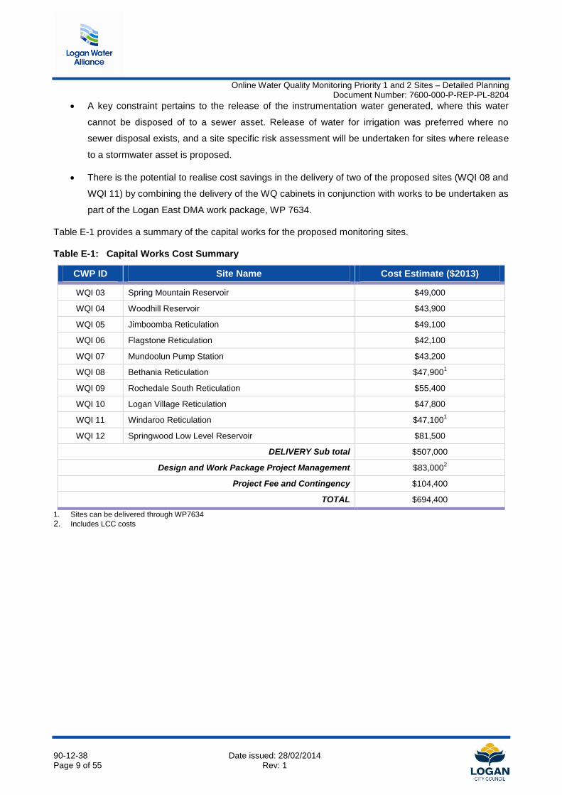
Table E-1 provides a summary of the capital works for the proposed monitoring sites.
Table E-1: Capital Works Cost Summary
CWP ID Site Name Cost Estimate ($2013)
WQI 03 Spring Mountain Reservoir $49,000
WQI 04 Woodhill Reservoir $43,900
WQI 05 Jimboomba Reticulation $49,100
WQI 06 Flagstone Reticulation $42,100
WQI 07 Mundoolun Pump Station $43,200
WQI 08 Bethania Reticulation $47,9001
WQI 09 Rochedale South Reticulation $55,400
WQI 10 Logan Village Reticulation $47,800
WQI 11 Windaroo Reticulation $47,1001
WQI 12 Springwood Low Level Reservoir $81,500
DELIVERY Sub total $507,000
Design and Work Package Project Management $83,0002
Project Fee and Contingency $104,400
TOTAL $694,400
1. Sites can be delivered through WP7634
2. Includes LCC costs
Online Water Quality Monitoring Priority 1 and 2 Sites – Detailed Planning Document Number: 7600-000-P-REP-PL-8204
90-12-38 Date issued: 28/02/2014 Page 10 of 55 Rev: 1
Based on the outcomes of this study LWA recommends:
1. LCC proceed with detailed design and delivery of the following sites:
WQI 03 – Spring Mountain
WQI 05 – Jimboomba Reticulation
WQI 06 – Flagstone Reticulation
WQI 07 – Mundoolun Reticulation
WQI 09 – Rochedale Reticulation
WQI 10 – Logan Village Reticulation
WQI 12 – Springwood Low Level Reservoir
2. WQI 08 and WQI 11 are delivered through the Logan East DMA work package WP7634 to realise the
potential delivery savings
3. The delivery of WQI 04 is investigated in conjunction with installation of a new chlorine booster station
at the site to realise potential delivery savings
4. The Project Brief for “Logan South Disinfection Project (W003)” is updated to reflect the current
capital cost estimates
Online Water Quality Monitoring Priority 1 and 2 Sites – Detailed Planning Document Number: 7600-000-P-REP-PL-8204
90-12-38 Date issued: 28/02/2014 Page 11 of 55 Rev: 1
1. INTRODUCTION
Water utilities must not only respond to regulatory requirements, but also satisfy consumer demand for
drinking water of a consistently high quality. A water quality strategy that includes remote monitoring of the
network can provide water utilities with the ability to proactively manage the risks associated with the supply
of potable water and meet both of these business needs.
Since 2010, Logan City Council (LCC) has invested significantly in active management projects targeting
improvements in water quality. One aspect which has been identified is the significant gap in the availability
of real-time water quality data at critical points within the network. Currently, LCC relies on manual sample
collection and laboratory testing which typically takes up to a week to identify issues. This method does not
achieve appropriate response times to potentially critical events in the water network which may adversely
impact customer health, and limits the ability of operations staff to make real time adjustments to the
network.
Remote water quality monitoring can address some of these issues and provide additional benefits,
including:
early warning of changes in source water quality by monitoring specific or surrogate parameters
enhanced ability to meet increasingly strict regulatory requirements
reducing chemical dosing costs by optimizing and continuously monitoring and regulating the chemical
dosing and operational performance of the network
maintaining customer confidence by transparent reporting on the water quality within the network
1.1 Objectives
The objective of this current Task is to undertake a detailed planning investigation for the installation of
online water quality monitoring instrumentation at ten sites within the Logan water supply network.
1.2 Scope
The scope of this Task is as follows:
Undertake site visits to identify constraints/opportunities for proposed monitoring sites
Review existing infrastructure, operational feasibility (such as power and radio telemetry), site
constraints, approvals, environment, community and constructability issues
Undertake a first principles cost estimate
Online Water Quality Monitoring Priority 1 and 2 Sites – Detailed Planning Document Number: 7600-000-P-REP-PL-8204
90-12-38 Date issued: 28/02/2014 Page 12 of 55 Rev: 1
1.3 Business Drivers
The main Business Drivers for this study are:
improving the Levels of Service by improving the identification and response times to water quality
issues in the network (Improvement)
informing discussions with Seqwater regarding bulk water quality and treatment optimisation
(Improvement)
to assist with achieving compliance with regulatory requirements outlined in Australian Drinking Water
Guidelines (Compliance)
1.4 Stakeholder engagement
The stakeholder engagement process for this study includes:
A start-up meeting with all stakeholders held on 13th September 2013
A Planning, Opportunity and Risk (POAR) workshop held on 2nd
December 2013
An 80% completion Task presentation with all stakeholders held on 22nd
January 2013
Program review of the draft deliverables
Informal and ongoing consultation with various stakeholders, as required
Table 1-1 lists the key stakeholders for this project and their respective areas of interest.
Table 1-1: Key stakeholders
Section Stakeholder Areas of Interest
Infrastructure Planning
Sandy Stewart Impacts on capital works program
Interaction with other planning tasks Tracey Leslie
Water Product Quality
Chris Pipe-Martin Understanding potential impacts on customers
Understanding potential water quality improvement activities Natasha Georgius
Operations Branch Darshan Udayaratna Impacts on the operation of the disinfection assets
Understanding potential water quality improvement activities
Capital Program Development
Maria Thomsen Impacts on the capital works program
Online Water Quality Monitoring Priority 1 and 2 Sites – Detailed Planning Document Number: 7600-000-P-REP-PL-8204
90-12-38 Date issued: 28/02/2014 Page 13 of 55 Rev: 1
2. PLANNING CONTEXT
Since 2010, LCC has invested significantly in active management projects targeting improvements in water
quality. This strategy has identified a significant gap in the availability of real-time water quality data at critical
points within the network. In addition, the time-consuming nature of manual sample collection and laboratory
testing does not facilitate an appropriate response time to potentially critical events in the water network that
may adversely impact customer health, and limits the ability of operations staff to make real time adjustments
to the network.
2.1 Existing Situation
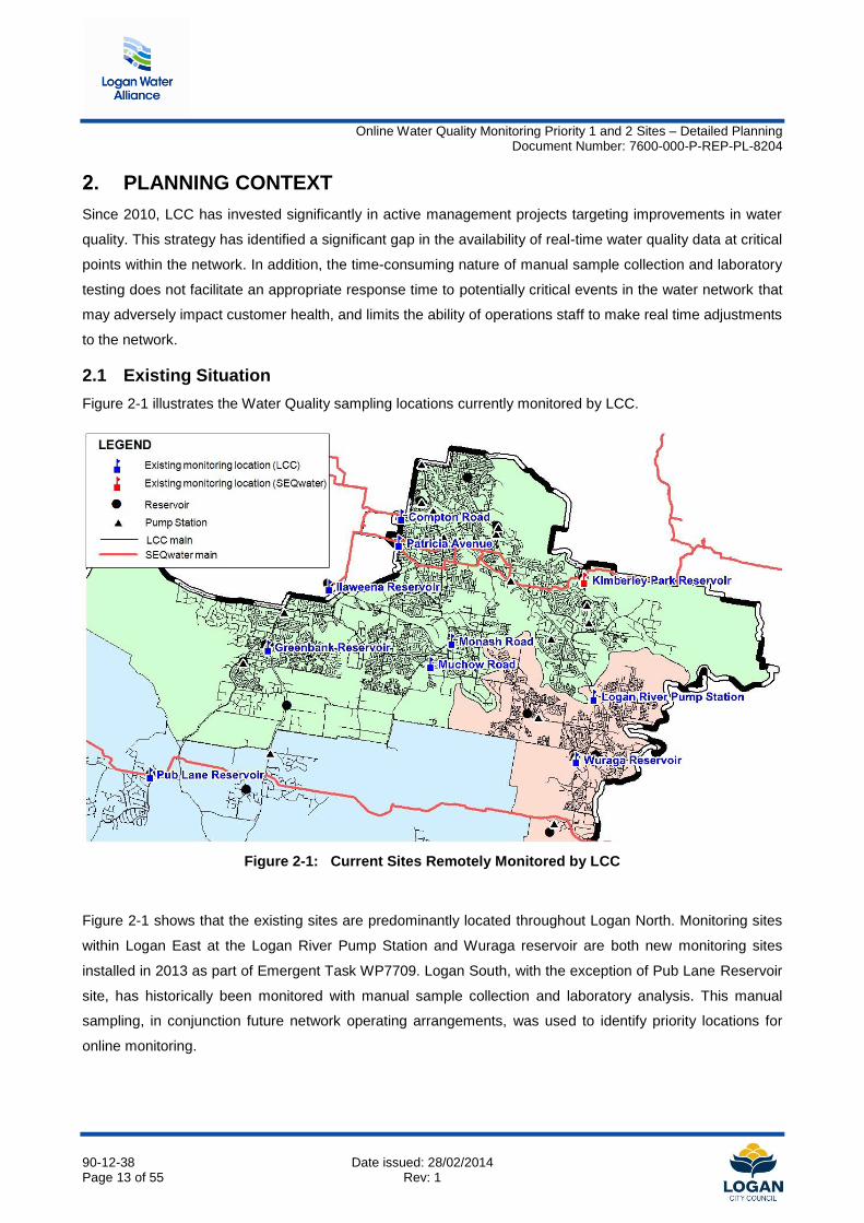
Figure 2-1 illustrates the Water Quality sampling locations currently monitored by LCC.
Figure 2-1: Current Sites Remotely Monitored by LCC
Figure 2-1 shows that the existing sites are predominantly located throughout Logan North. Monitoring sites
within Logan East at the Logan River Pump Station and Wuraga reservoir are both new monitoring sites
installed in 2013 as part of Emergent Task WP7709. Logan South, with the exception of Pub Lane Reservoir
site, has historically been monitored with manual sample collection and laboratory analysis. This manual
sampling, in conjunction future network operating arrangements, was used to identify priority locations for
online monitoring.
Online Water Quality Monitoring Priority 1 and 2 Sites – Detailed Planning Document Number: 7600-000-P-REP-PL-8204
90-12-38 Date issued: 28/02/2014 Page 14 of 55 Rev: 1
2.2 Previous Studies
The Logan Water Alliance (LWA) recently completed an Online Water Quality Monitoring Strategy (LWA,
2013). This report identified the need for:
Two (2) monitoring sites to control the process loop of an existing disinfectant dosing facility located
at:
o WQI03 - Spring Mountain reservoir
o WQI04 - Woodhill reservoir
Eight (8) monitoring sites to monitor areas with historical water quality issues located at:
o WQI05 - St Jude Circuit, Jimboomba
o WQI06 - Homestead Drive, Flagstone
o WQI07 - Mundoolun pump station
o WQI08 - Black Diamond Crescent, Bethania
o WQI09 - Parfrey Road, Rochedale South
o WQI010 - Logan Village
o WQI011 - Bannockburn Road, Windaroo
o WQI012 - Springwood low level reservoir.
Two further monitoring points (WQI 01 and WQI 02) were identified in the Online Water Quality Monitoring
Strategy at Travis Road Reservoir. The design of these two sampling locations was included with planned
works at the reservoir associated with construction of a new outlet main. This monitoring equipment is
currently being delivered by LWA under work package (WP) 7635 and is not included in the scope of the
current study.
Online Water Quality Monitoring Priority 1 and 2 Sites – Detailed Planning Document Number: 7600-000-P-REP-PL-8204
90-12-38 Date issued: 28/02/2014 Page 15 of 55 Rev: 1
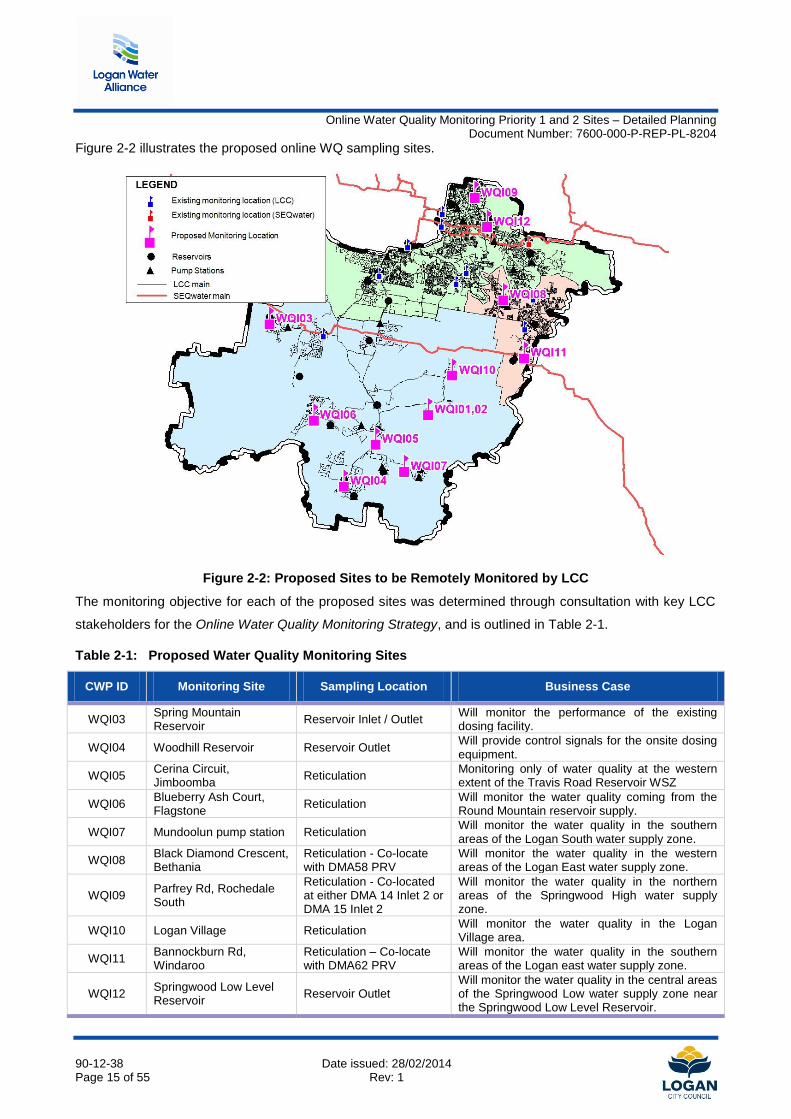
Figure 2-2 illustrates the proposed online WQ sampling sites.
Figure 2-2: Proposed Sites to be Remotely Monitored by LCC
The monitoring objective for each of the proposed sites was determined through consultation with key LCC
stakeholders for the Online Water Quality Monitoring Strategy, and is outlined in Table 2-1.
Table 2-1: Proposed Water Quality Monitoring Sites
CWP ID Monitoring Site Sampling Location Business Case
WQI03 Spring Mountain Reservoir
Reservoir Inlet / Outlet Will monitor the performance of the existing dosing facility.
WQI04 Woodhill Reservoir Reservoir Outlet Will provide control signals for the onsite dosing equipment.
WQI05 Cerina Circuit, Jimboomba
Reticulation Monitoring only of water quality at the western extent of the Travis Road Reservoir WSZ
WQI06 Blueberry Ash Court, Flagstone
Reticulation Will monitor the water quality coming from the Round Mountain reservoir supply.
WQI07 Mundoolun pump station Reticulation Will monitor the water quality in the southern areas of the Logan South water supply zone.
WQI08 Black Diamond Crescent, Bethania
Reticulation - Co-locate with DMA58 PRV
Will monitor the water quality in the western areas of the Logan East water supply zone.
WQI09 Parfrey Rd, Rochedale South
Reticulation - Co-located at either DMA 14 Inlet 2 or DMA 15 Inlet 2
Will monitor the water quality in the northern areas of the Springwood High water supply zone.
WQI10 Logan Village Reticulation Will monitor the water quality in the Logan Village area.
WQI11 Bannockburn Rd, Windaroo
Reticulation – Co-locate with DMA62 PRV
Will monitor the water quality in the southern areas of the Logan east water supply zone.
WQI12 Springwood Low Level Reservoir
Reservoir Outlet Will monitor the water quality in the central areas of the Springwood Low water supply zone near the Springwood Low Level Reservoir.
Online Water Quality Monitoring Priority 1 and 2 Sites – Detailed Planning Document Number: 7600-000-P-REP-PL-8204
90-12-38 Date issued: 28/02/2014 Page 16 of 55 Rev: 1
The Online Water Quality Monitoring Strategy identified that the capital expenditure for these sites is
estimated at $500,000. These costs have been developed using the results of market surveys and
construction costs from recently-undertaken projects of a similar nature.
The LCC Capital Works Program includes $600,000 allocated for the proposed monitoring sites under CWP
item W0003.
2.3 Selection of Water Quality Monitoring sites
Water Quality throughout a water supply zone can vary depending on a number of factors, including
seasonal demand changes, flow reversals, storage size and distance from the supply source. To be able to
capture the changes in water quality that can occur within a zone, sampling locations can include the
following general locations:
within a reservoir
inlet and outlets of reservoirs
within the reticulation or at network extremities
within a trunk main or at a pump station
upstream and downstream of chemical dosing locations
points in the zone with a historical record of water quality incidents
The selection of a site for online monitoring was based on a combination of historical grab sample data,
consultation with operations staff, existing site infrastructure, cost and using hydraulic modelling to assist in
the decision making process where necessary.
Sites were classified either as a Critical Control Point (CCP) or Quality Control Point (QCP) in accordance
with Hazard Analysis and Critical Control Point (HACCP) categorisation of each selected site.
A CCP is a point where control can be applied that prevents, eliminates or reduces exceedances of a critical
water quality parameter incident in a timely manner; whereas a QCP is a site where only limited or no real-
time action can take place to reduce or prevent a water quality issue from occurring.
Online Water Quality Monitoring Priority 1 and 2 Sites – Detailed Planning Document Number: 7600-000-P-REP-PL-8204
90-12-38 Date issued: 28/02/2014 Page 17 of 55 Rev: 1
Table 2-2 outlines the HACCP classification of criticality for the monitoring sites.
Table 2-2: Assessment of site criticality
CWP ID Site Name CCP/QCP
WQI 03 Spring Mountain Reservoir QCP*
WQI 04 Woodhill Reservoir QCP*
WQI 05 Jimboomba Reticulation QCP
WQI 06 Flagstone Reticulation QCP
WQI 07 Mundoolun Pump Station QCP
WQI 08 Bethania Reticulation QCP
WQI 09 Rochedale South Reticulation QCP
WQI 10 Logan Village Reticulation QCP
WQI 11 Windaroo Reticulation QCP
WQI 12 Springwood Low Level Reservoir QCP
Note: WQI 03 and WQI 04 will be considered a CCP where dosing equipment is installed in future
Online Water Quality Monitoring Priority 1 and 2 Sites – Detailed Planning Document Number: 7600-000-P-REP-PL-8204
90-12-38 Date issued: 28/02/2014 Page 18 of 55 Rev: 1
3. METHODOLOGY
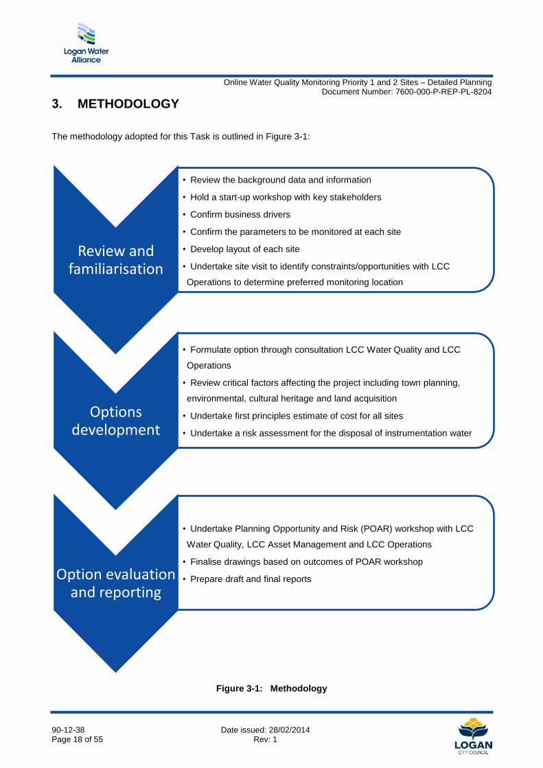
The methodology adopted for this Task is outlined in Figure 3-1:
Figure 3-1: Methodology
Review and familiarisation
• Review the background data and information
• Hold a start-up workshop with key stakeholders
• Confirm business drivers
• Confirm the parameters to be monitored at each site
• Develop layout of each site
• Undertake site visit to identify constraints/opportunities with LCC
Operations to determine preferred monitoring location
Options development
• Formulate option through consultation LCC Water Quality and LCC
Operations
• Review critical factors affecting the project including town planning,
environmental, cultural heritage and land acquisition
• Undertake first principles estimate of cost for all sites
• Undertake a risk assessment for the disposal of instrumentation water
Option evaluation and reporting
• Undertake Planning Opportunity and Risk (POAR) workshop with LCC
Water Quality, LCC Asset Management and LCC Operations
• Finalise drawings based on outcomes of POAR workshop
• Prepare draft and final reports
Online Water Quality Monitoring Priority 1 and 2 Sites – Detailed Planning Document Number: 7600-000-P-REP-PL-8204
90-12-38 Date issued: 28/02/2014 Page 19 of 55 Rev: 1
3.1 Risk Assessment for disposal of instrumentation water
Potable water release to the stormwater network was highlighted as a restricted activity and is regulated by
the Environmental Protection Act 1994 (EP Act, the Act).
Section 319 of the EP Act, subsection (1) prescribes that:
'A person must not carry out any activity that causes, or is likely to cause, environmental harm unless the
person takes all reasonable and practicable measures to prevent or minimise the harm (the general
environmental duty).'
Subsection (2) outlines the measures which must be regarded as part of a persons' general environmental
duty. This includes consideration of the following:
a) the nature of the harm or potential harm
b) the sensitivity of the receiving environment
c) the current state of technical knowledge for the activity
d) the likelihood of successful application of the different measures that might be taken
e) the financial implications of the different measures as they would relate to the type of activity
A preliminary risk assessment was undertaken for the release of potable water at sites where release to
sewer was not possible. The risk assessment for the release of potable water to the stormwater network as
part of this current study considers:
the likelihood and impact to the receiving environment/s
the alternative measures that can be taken to avoid release to stormwater
the cost of these alternatives
The risk assessment is provided in Appendix A.
Online Water Quality Monitoring Priority 1 and 2 Sites – Detailed Planning Document Number: 7600-000-P-REP-PL-8204
90-12-38 Date issued: 28/02/2014 Page 20 of 55 Rev: 1
4. ASSUMPTIONS
This chapter outlines the various assumptions used in this study, such as the monitoring parameters, basis
for site location, site requirements and assumptions used for developing first principles cost estimates.
4.1 Water Quality Monitoring Parameters
The water quality instrumentation required for each of the priority sites was outlined in the Online Water
Quality Management Strategy. At the start up meeting for this current Task, an additional requirement to
monitor free chlorine and total chlorine at all sites was added in anticipation of the conversion of water
supplies to chlorinated supply for all of South East Queensland (currently under consideration by Seqwater
(Bulk water supply authority)). The allocation of space within the new water quality monitoring cabinets (at a
minimum) will ensure the easy integration of future instrumentation for monitoring free chlorine residual.
Additionally, this will ensure online monitoring is available to control operational and disinfection
management activities, ie breakpoint chlorination.
The adopted parameters to be measured at each site are as follows:
pH
Temperature
Free Chlorine
Total Chlorine
In addition to these four parameters, Nitrate measurement was identified as an indicator for monitoring for
nitrification episodes in the distribution network. Nitrification in chloraminated water systems can lead to
depleted disinfectant levels and consequently increased biological contamination, as a result of improved
conditions for biofilm growth within water mains. Nitrate measurement was added to two sites within Logan
North and one site in Logan South, namely:
Springwood Low Level reservoir outlet (WQI 12)
within Springwood High level water supply zone (WSZ) (WQI 09)
within Travis Road (Jimboomba) WSZ (WQI 06)
These sites will provide monitoring of nitrification levels in the bulk water supply entering the network from
Kuraby reservoir and at a point in the supply zone.
Online Water Quality Monitoring Priority 1 and 2 Sites – Detailed Planning Document Number: 7600-000-P-REP-PL-8204
90-12-38 Date issued: 28/02/2014 Page 21 of 55 Rev: 1
4.2 Location of Water Quality Cabinets
The location of the proposed water quality sampling cabinets was determined by assessing locations:
near existing LCC Remote Terminal Unit (RTU) sites for ease of connection to Telemetry and mains
power supply
near existing wastewater assets for ease of discharge of instrumentation water
in part of the network that is able to meet the location objectives outlined in the Online Water Quality
Management Strategy.
4.3 Water Quality Instrumentation
The selection criteria for water quality instrumentation were based upon minimising operator maintenance
and chemical reagent requirements. It was agreed among the POAR workshop attendees that where
possible, monitoring equipment not requiring reagents be preferentially adopted, as this will minimise
ongoing costs, and reduce disposal requirement and OHS handling concerns that may otherwise be
associated with reagent handling and use.
The key criteria considered for selecting the preferred equipment supplier was based on:
Cost
Ability of supplier to provide instrumentation required to monitor the designated parameters
Equipment required and resulting layout of instrumentation within cabinet
Sensor/Equipment life
Maintenance and calibration requirements
Amount of water generated requiring release.
Other criteria included the availability of a turnkey supplied cabinet that would enable installation by Logan
City Council Operations staff. A supplier shortlist was developed to meet these needs.
4.4 RTU Site Audits
Audit of the proposed sites was identified at the POAR workshop to be undertaken during detailed design, in
order to determine availability of spare I/O for connection of the WQ instrumentation to existing RTUs and
ensure that incorporation of the proposed instrumentation can be achieved at the existing site.

Online Water Quality Monitoring Priority 1 and 2 Sites – Detailed Planning Document Number: 7600-000-P-REP-PL-8204
90-12-38 Date issued: 28/02/2014 Page 22 of 55 Rev: 1
4.5 First Principle Cost Estimate
The following assumptions were used to develop the cost estimates for the proposed monitoring sites.
Project Management costs were developed based on the following:
o Project Duration - 5 Weeks (for the construction works and installation of eight sites)
o Project Manager, Project Engineer - 2 hour/day
o Site Supervision - 4 hours/day
Instrumentation costs were developed based on formal quote requests from instrumentation
suppliers. The instrumentation costs reflected the specific instrumentation requirements for each site
Commissioning costs have been estimated based on costs provided for similar projects
Online Water Quality Monitoring Priority 1 and 2 Sites – Detailed Planning Document Number: 7600-000-P-REP-PL-8204
90-12-38 Date issued: 28/02/2014 Page 23 of 55 Rev: 1
5. DETAILED PLANNING
The following section outlines specific requirements for the individual monitoring sites. A description of each
site is provided outlining specific site constraints, risks and opportunities. A cost estimate has also been
compiled for each site based on first principle cost estimates for the civil component of works, supplier
quotes, installation and commissioning of the proposed monitoring cabinets.
5.1 WQI 03 - Spring Mountain Reservoir
5.1.1 Site Description
This location was selected as a Quality Control Point at the extremity of the network and will monitor any
decline of disinfection residual within Spring Mountain reservoir. Approximately 26% of existing monthly
sample readings indicate inadequate disinfection levels (below 0.2 mg/L) as reported in laboratory sampling
data from the site (LWA, 2012). This site will be considered a Critical Control Point (CCP) should a new
chlorine booster station be installed; however, the decision to implement a booster station will be informed by
the proposed online monitoring at Spring Mountain.
The proposed monitoring point is on the combined inlet-outlet main to the reservoir. There is an existing
tapping on the main which was previously used as a rechlorination point - this tapping can be reused,
minimising the installation requirements for the sampling line. The WQ cabinet can be located adjacent to a
disused dosing building, and a conduit can be installed to provide connection to the RTU for the site, which is
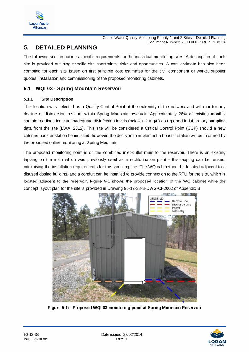
located adjacent to the reservoir. Figure 5-1 shows the proposed location of the WQ cabinet while the
concept layout plan for the site is provided in Drawing 90-12-38-S-DWG-CI-2002 of Appendix B.
Figure 5-1: Proposed WQI 03 monitoring point at Spring Mountain Reservoir
Online Water Quality Monitoring Priority 1 and 2 Sites – Detailed Planning Document Number: 7600-000-P-REP-PL-8204
90-12-38 Date issued: 28/02/2014 Page 24 of 55 Rev: 1
5.1.2 Risks and Opportunities
Environmental/Approval constraints
A review of environmental factors has highlighted some risks for this site, as summarised in Table 5-1, while
the complete Environmental Risk Assessment in provided in Appendix C. As the site for the proposed WQ
cabinet is on already cleared land, there is no risk of disturbance to native vegetation.
Table 5-1: WQI 03 Environmental Assessment
Issue Comment Action
Presence of Fire Ants Site is mapped within a high risk fire ant area
Movement of restricted items in compliance with approved risk management plan (ARMP)
Bush fire Site mapped as a Medium Risk bushfire hazard area
Management required during construction
Discharge of Instrumentation Water
There is no nearby wastewater infrastructure to allow disposal of the instrumentation water. It was agreed in
discussion with LCC representatives that the preferred means of discharging the instrumentation water is via
irrigation. Section 3.1 outlines the risk assessment process undertaken for sites where no opportunity exists
to discharge the instrumentation water to a wastewater asset.
Integration with Dosing control
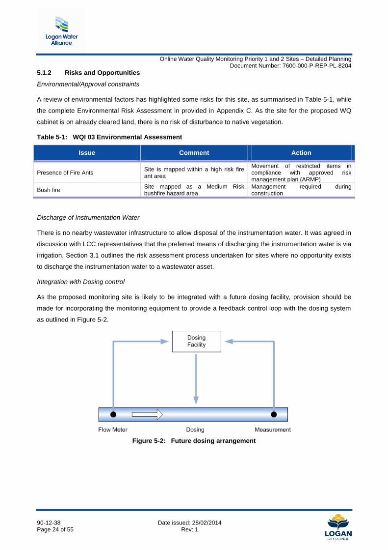
As the proposed monitoring site is likely to be integrated with a future dosing facility, provision should be
made for incorporating the monitoring equipment to provide a feedback control loop with the dosing system
as outlined in Figure 5-2.
Figure 5-2: Future dosing arrangement
Online Water Quality Monitoring Priority 1 and 2 Sites – Detailed Planning Document Number: 7600-000-P-REP-PL-8204
90-12-38 Date issued: 28/02/2014 Page 25 of 55 Rev: 1
5.1.3 Cost Estimate
Table 5-2 outlines the cost estimate for instrumentation supply, construction and integration into the existing
SCADA system by a sub-contractor. The detailed first principle cost estimate is provided in Appendix D. A
provisional sum has been designated for the installation of a sprinkler/sub-surface irrigation system should
stormwater release via soak away be deemed environmentally unacceptable. This will be subject to a risk
assessment undertaken during detailed design in conjunction with LCC prior to construction.
Table 5-2: Capital Cost estimate for WQI 03
Item Capital Cost ($2013)
Water Quality Instrumentation $12,000
Civil construction items $25,400
SCADA integration and commissioning $1,000
Sprinkler System for irrigation of discharge water (provisional sum) $6,000
Indirect costs* $4,600
Total $49,000
*Includes Design and Environmental Group project management and defects liability allowance
Online Water Quality Monitoring Priority 1 and 2 Sites – Detailed Planning Document Number: 7600-000-P-REP-PL-8204
90-12-38 Date issued: 28/02/2014 Page 26 of 55 Rev: 1
5.2 WQI 04 - Woodhill Reservoir
5.2.1 Site Description
This location was selected as a quality control point at the network extremity, where low disinfection levels
have previously been observed. Approximately 30% of analysed lab samples were observed to have
disinfection levels less than 0.2 mg/L (LWA, 2012). This site will be considered a Critical Control Point upon
completion of a new chlorine booster station, which is currently being installed. The proposed monitoring
equipment must be capable of integrating with future dosing equipment to provide feedback control for future
dosing.
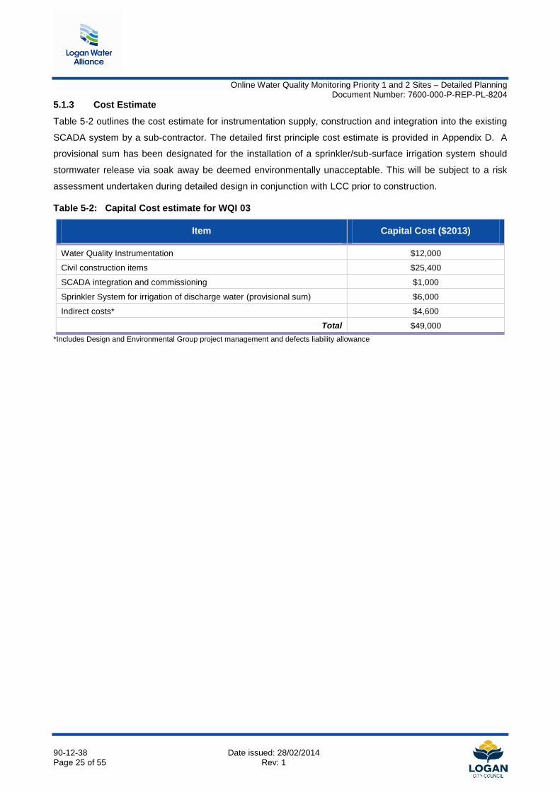
This location will monitor chlorine residual on the outlet of Woodhill reservoir. The instrumentation cabinet
can be installed in the new pump station building. During the site investigations, the new pump set was not
installed, later being commissioned on the 17th January 20141. A new tapping is proposed at the existing
sampling location, and discharge is proposed to connect to the stormwater outlet from the reservoir site. This
will be subject to a risk assessment undertaken during detailed design in conjunction with LCC prior to
construction. Should a risk assessment determine the proposed stormwater disposal is untenable, a
subsurface irrigation system will be installed to water the grassed area at the reservoir site.
Figure 5-3 shows the existing pump station building, while the concept layout plan for the site is provided in
Drawing 90-12-38-S-DWG-CI-2004 of Appendix B. As noted, further field verification is required to determine
the WQ cabinet location within the pump station building.
Figure 5-3: WQI 04 at Woodhill Reservoir
1 Advice provided by LCC Water Operations
Online Water Quality Monitoring Priority 1 and 2 Sites – Detailed Planning Document Number: 7600-000-P-REP-PL-8204
90-12-38 Date issued: 28/02/2014 Page 27 of 55 Rev: 1
5.2.2 Risks and Opportunities
Environmental/Approval constraints
As the water quality monitoring cabinet is proposed within the existing pump station building there is no risk
of disturbance to native vegetation or public amenity with the proposed installation.
Discharge of Instrumentation Water
There is no nearby wastewater infrastructure to allow disposal of the instrumentation water. It was agreed
that the preferred means of discharging the instrumentation water is via the existing stormwater drain for the
reservoir site, which flow toward a stormwater drain in a nearby property. The alternative means of discharge
is subsurface or sprinkler system irrigation. Section 3.1 outlines the risk assessment process undertaken for
sites where no opportunity exists to discharge the instrumentation water to a wastewater asset.
Integration with Dosing control
As the proposed monitoring site will be integrated with a future dosing facility, provision should be made for
incorporating the monitoring equipment to provide a feedback control loop with the dosing system as outlined
in Figure 5-2. Equipment selection should specify these requirements between monitoring and future dosing
equipment.
Installation with future dosing unit
There is potential to realise cost savings by incorporating the installation of an online water quality monitoring
cabinet within the future chlorine booster station to be installed at the site.
Online Water Quality Monitoring Priority 1 and 2 Sites – Detailed Planning Document Number: 7600-000-P-REP-PL-8204
90-12-38 Date issued: 28/02/2014 Page 28 of 55 Rev: 1
5.2.3 Cost Estimate
Table 5-3 outlines the cost estimate for instrumentation supply, construction and integration into the existing
SCADA system by a sub-contractor. The detailed first principle cost estimate is provided in Appendix D. A
provisional sum has been designated for the installation of a sprinkler/sub-surface irrigation system should
stormwater release via soak away be deemed environmentally unacceptable. This will be subject to a risk
assessment undertaken during detailed design in conjunction with LCC prior to construction.
Table 5-3: Capital Cost estimate for WQI 04
Item Capital Cost ($2013)
Water Quality Instrumentation $12,000
Civil construction items $20,300
SCADA integration and commissioning $1,000
Sprinkler System for irrigation of discharge water $6,000
Indirect costs* $4,600
Total $43,900
*Includes Design and Environmental Group project management and defects liability allowance
Online Water Quality Monitoring Priority 1 and 2 Sites – Detailed Planning Document Number: 7600-000-P-REP-PL-8204
90-12-38 Date issued: 28/02/2014 Page 29 of 55 Rev: 1
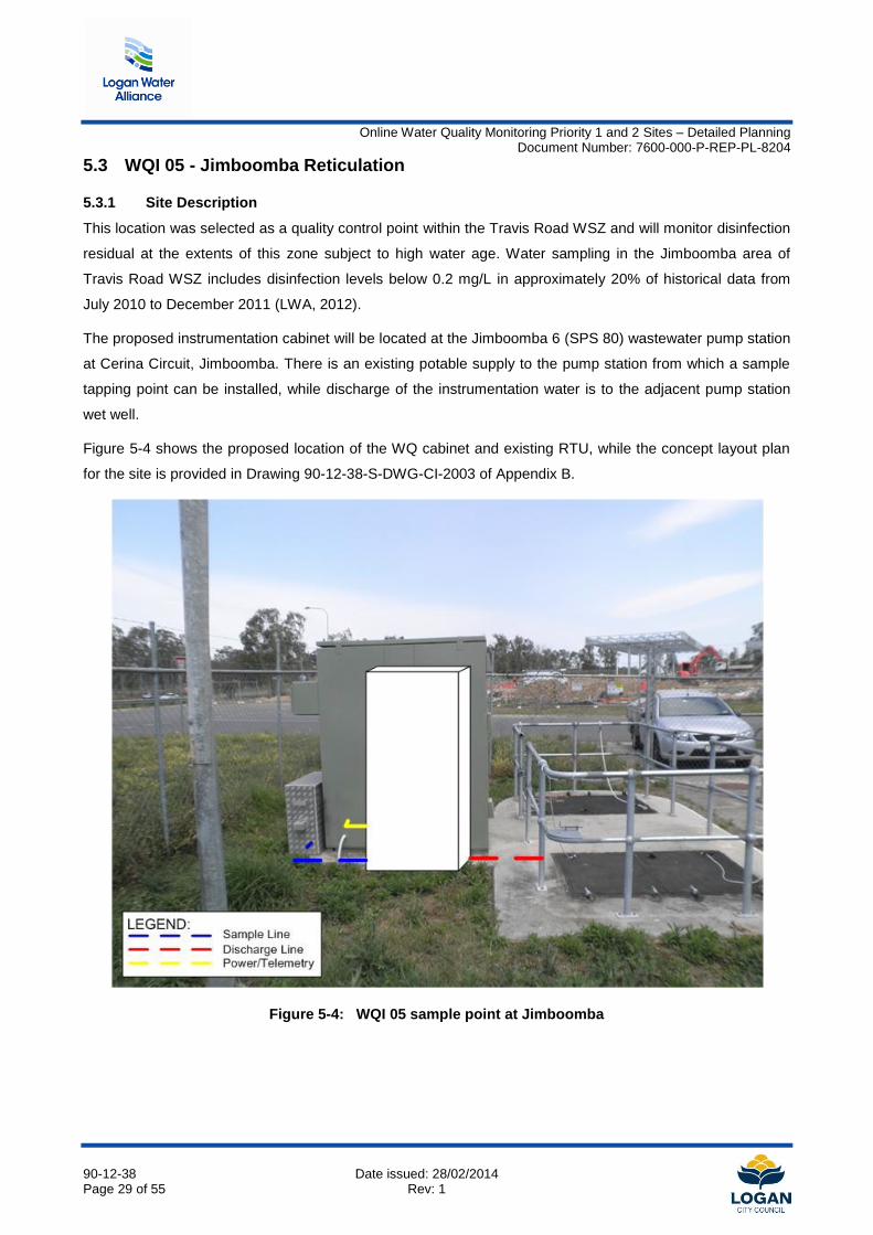
5.3 WQI 05 - Jimboomba Reticulation
5.3.1 Site Description
This location was selected as a quality control point within the Travis Road WSZ and will monitor disinfection
residual at the extents of this zone subject to high water age. Water sampling in the Jimboomba area of
Travis Road WSZ includes disinfection levels below 0.2 mg/L in approximately 20% of historical data from
July 2010 to December 2011 (LWA, 2012).
The proposed instrumentation cabinet will be located at the Jimboomba 6 (SPS 80) wastewater pump station
at Cerina Circuit, Jimboomba. There is an existing potable supply to the pump station from which a sample
tapping point can be installed, while discharge of the instrumentation water is to the adjacent pump station
wet well.
Figure 5-4 shows the proposed location of the WQ cabinet and existing RTU, while the concept layout plan
for the site is provided in Drawing 90-12-38-S-DWG-CI-2003 of Appendix B.
Figure 5-4: WQI 05 sample point at Jimboomba
Online Water Quality Monitoring Priority 1 and 2 Sites – Detailed Planning Document Number: 7600-000-P-REP-PL-8204
90-12-38 Date issued: 28/02/2014 Page 30 of 55 Rev: 1
5.3.2 Risks and Opportunities
A review of environmental factors has highlighted some risks for this site, as summarised in Table 5-4, while
the complete Environmental Risk Assessment is provided in Appendix C. As the site for the proposed WQ
cabinet is on already cleared land within the pump station area, there is no risk of disturbance to native
vegetation.
Table 5-4: WQI 05 Environmental Assessment
Issue Comment Action
Presence of Fire Ants Site is mapped within a high risk fire ant area
Movement of restricted items in compliance with approved risk management plan (ARMP)
Public Amenity Site is adjacent to residential properties
Adequate odour, noise and visual impact mitigation measures must be implemented during design, construction and operation.
Land Protection (Pest and Stock Route Management) Act
Presence of declared pest plants within alignment
A field investigation is required prior to construction to identify declared pest plants and define mitigation
Potable water supply
The potable water sampling point may be sourced from the backflow prevention device pipework installed
adjacent to the RTU at the pump station, rather than from the potable water main in front of the pump station,
which will minimise pipework requirements for connection. This connection should be confirmed in
conjunction with Logan City Council Water Operations representatives.
5.3.3 Cost Estimate
Table 5-5 outlines the cost estimate for instrumentation supply, construction and integration into the network.
The detailed first principle cost estimate is provided in Appendix D.
Table 5-5: Capital Cost estimate for WQI 05
Item Capital Cost ($2013)
Water Quality Instrumentation $19,000
Civil construction items $24,500
SCADA integration and commissioning $1,000
Indirect costs* $4,600
Total $49,100
*Includes Design and Environmental Group project management and defects liability allowance
Online Water Quality Monitoring Priority 1 and 2 Sites – Detailed Planning Document Number: 7600-000-P-REP-PL-8204
90-12-38 Date issued: 28/02/2014 Page 31 of 55 Rev: 1
5.4 WQI 06 - Flagstone Reticulation
5.4.1 Site Description
This location was selected as a quality control point for monitoring the outgoing water quality from Round
Mountain reservoir within Flagstone. The water age through Round Mountain reservoir from the proposed
New Beith Road SRWP offtake will likely increase in the early years of supply to lower Logan South,
compared to the existing supply arrangement. Funds were allocated under Capital Works item W0003 -
Logan South Disinfection Project for a future dosing station at Round Mountain reservoir which will utilise
readings from the proposed water quality instrumentation in Flagstone for trim dosing purposes.
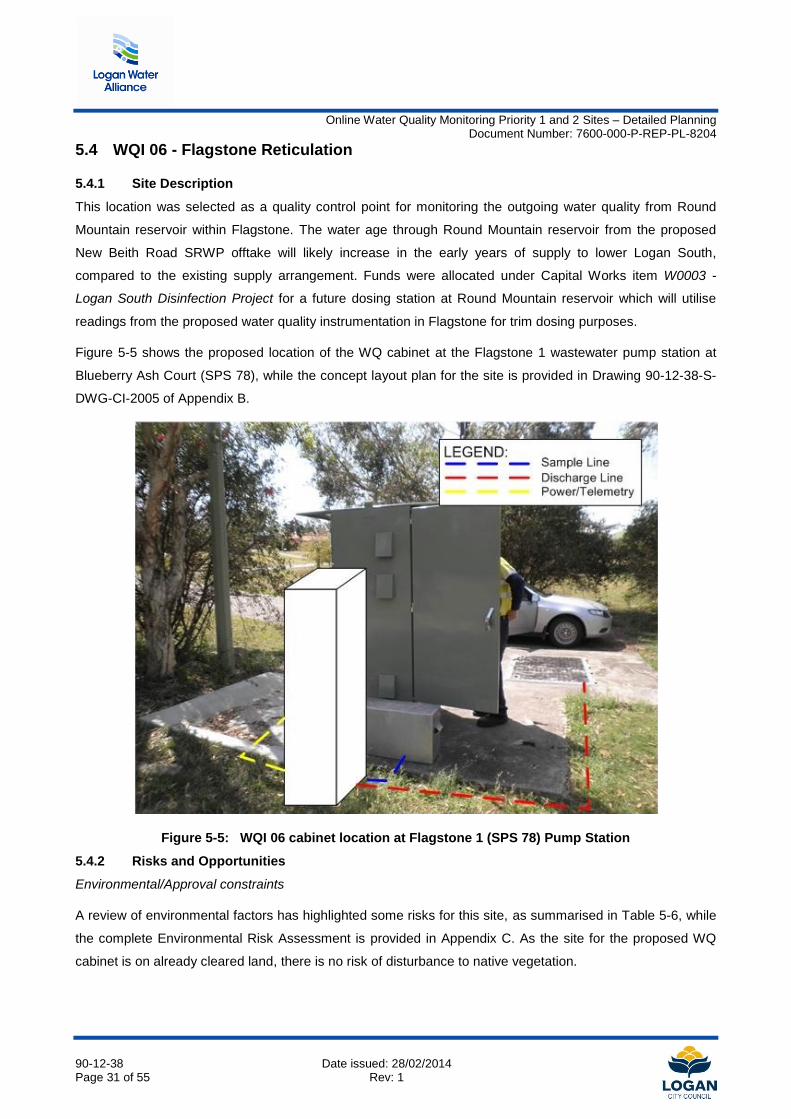
Figure 5-5 shows the proposed location of the WQ cabinet at the Flagstone 1 wastewater pump station at
Blueberry Ash Court (SPS 78), while the concept layout plan for the site is provided in Drawing 90-12-38-S-
DWG-CI-2005 of Appendix B.
Figure 5-5: WQI 06 cabinet location at Flagstone 1 (SPS 78) Pump Station
5.4.2 Risks and Opportunities
Environmental/Approval constraints
A review of environmental factors has highlighted some risks for this site, as summarised in Table 5-6, while
the complete Environmental Risk Assessment is provided in Appendix C. As the site for the proposed WQ
cabinet is on already cleared land, there is no risk of disturbance to native vegetation.
Online Water Quality Monitoring Priority 1 and 2 Sites – Detailed Planning Document Number: 7600-000-P-REP-PL-8204
90-12-38 Date issued: 28/02/2014 Page 32 of 55 Rev: 1
Table 5-6: WQI 06 Environmental Assessment
Issue Comment Action
Presence of Fire Ants Site is mapped within a high risk fire ant area
Movement of restricted items in compliance with approved risk management plan (ARMP)
Nature Conservation Act Clearing/trimming of any native regrowth adjacent works
Further assessment required once scope defined to determine the presence/absence of any threatened species or breeding places
Land Protection (Pest and Stock Route Management) Act
Presence of declared pest plants within alignment
A field investigation is required prior to construction to identify declared pest plants and define mitigation
Public Amenity Site is adjacent to residential properties
Adequate odour, noise and visual impact mitigation measures must be implemented during design, construction and operation.
Potable Water Supply
The potable water sampling point may be sourced from the backflow prevention device pipework installed
adjacent to the RTU at the pump station, rather than from the potable water main which runs in front of the
pump station, which will minimise pipework requirements for connection. This connection should be
confirmed in conjunction with Logan City Council Water Operations representatives.
Switchboard Capacity
An audit of the existing RTU should be undertaken during detailed design to confirm RTU capacity or
determine whether expansion of I/O capacity for the RTU is required.
5.4.3 Cost Estimate
Table 5-7 outlines the cost estimate for instrumentation supply, construction and integration into the existing
water supply network. The detailed first principle cost estimate is provided in Appendix D.
Table 5-7: Capital Cost estimate for WQI 06
Item Capital Cost ($2013)
Water Quality Instrumentation $12,000
Civil construction items $24,500
SCADA integration and commissioning $1,000
Indirect costs* $4,600
Total $42,100
*Includes Design and Environmental Group project management and defects liability allowance
Online Water Quality Monitoring Priority 1 and 2 Sites – Detailed Planning Document Number: 7600-000-P-REP-PL-8204
90-12-38 Date issued: 28/02/2014 Page 33 of 55 Rev: 1
5.5 WQI 07 - Mundoolun Pump Station
5.5.1 Site Description
This location was selected as a quality control point within the Razorback/Mundoolun WSZ. Supply to the
zone is from the South Maclean clear water tanks. Historical sample data in the July 2010 to December 2011
sample period indicates that approximately 60% of samples contained inadequate disinfection levels (LWA,
2012).
The water quality instrumentation can be installed within the Mundoolun water pump station building, utilising
a spare tapping point on the common suction main. There is sufficient space available to mount an
instrumentation cabinet on the wall adjacent to the pump set and utilise underfloor conduits back to the
switchboard and RTU for connection of power and telemetry.
Discharge of water from the instrumentation cabinet is proposed by irrigation. The land adjacent to the pump
station is currently under an infrastructure agreement between LCC and a developer - this may provide for
discharge of the instrumentation water to an adjacent public recreation space. This arrangement should be
facilitated with Logan City Council Development Assessment Services. A decision will also be required in
determining asset maintenance responsibilities within Council.
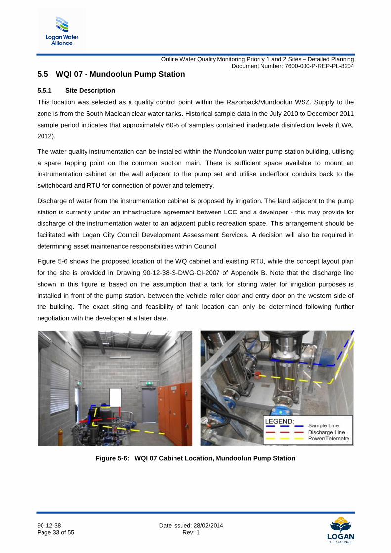
Figure 5-6 shows the proposed location of the WQ cabinet and existing RTU, while the concept layout plan
for the site is provided in Drawing 90-12-38-S-DWG-CI-2007 of Appendix B. Note that the discharge line
shown in this figure is based on the assumption that a tank for storing water for irrigation purposes is
installed in front of the pump station, between the vehicle roller door and entry door on the western side of
the building. The exact siting and feasibility of tank location can only be determined following further
negotiation with the developer at a later date.
Figure 5-6: WQI 07 Cabinet Location, Mundoolun Pump Station
Online Water Quality Monitoring Priority 1 and 2 Sites – Detailed Planning Document Number: 7600-000-P-REP-PL-8204
90-12-38 Date issued: 28/02/2014 Page 34 of 55 Rev: 1
5.5.2 Risks and Opportunities
A review of environmental factors has highlighted that the site is located within a high risk fire ant area, with
the appropriate measures for notification of Biosecurity Queensland to be undertaken in conjunction with the
subcontractors' Approved Risk Management Plan (ARMP). The complete Environmental Risk Assessment in
provided in Appendix C.
Discharge of Instrumentation Water
There is no nearby wastewater infrastructure to allow disposal of the instrumentation water. The only location
available for discharging this instrumentation water is the adjacent developer held land. There may be
opportunity for further negotiation with the developer to allow for discharge to the adjacent land for
irrigation/watering purposes. Should no arrangement be forthcoming, investigation must be made into the
release to a sub-surface soak away pit, as there is no planted vegetation at the site which can be irrigated.
This will be subject to a risk assessment undertaken during detailed design in conjunction with LCC prior to
construction.
Connection of sampling point with suction pipework
It was assumed that the water sampling point can be connected to a blanked off tapping on the common
suction main of the pump sets. Detailed design should confirm that no excess positive/negative pressures
are imparted on the sensor equipment, which are limited to 0.5 bar (50 kPa). Pressure head is typically
broken within the flow assembly which houses the sensor; however, the proposed arrangement should be
confirmed with the equipment manufacturer at detailed design.
5.5.3 Cost Estimate
Table 5-8 outlines the cost estimate for instrumentation supply, construction and integration into the existing
water supply network. The detailed first principle cost estimate is provided in Appendix D.
Table 5-8: Capital Cost estimate for WQI 07
Item Capital Cost ($2013)
Water Quality Instrumentation $12,000
Civil construction items $19,600
SCADA integration and commissioning $1,000
Sprinkler System for irrigation of discharge water $6,000
Indirect costs* $4,600
Total $43,200
*Includes Design and Environmental Group project management and defects liability allowance
Online Water Quality Monitoring Priority 1 and 2 Sites – Detailed Planning Document Number: 7600-000-P-REP-PL-8204
90-12-38 Date issued: 28/02/2014 Page 35 of 55 Rev: 1
5.6 WQI 08 - Bethania Reticulation
5.6.1 Site Description
This location was selected as a quality control point at the extent of the Logan East WSZ. This location will
monitor chlorine residual downstream of Woodhill reservoir. This site will be established in conjunction with a
proposed District Metered Area (DMA 58), which is part of LWA Work Package 7634 - Logan East Water
Supply DMA Management and Fire Flow Augmentations. This work package is currently in detail design with
construction scheduled to commence in January 2014.
The water quality instrumentation is proposed to be installed in a combined control cabinet with the PRV
instrumentation. The cabinet location will be confirmed as part of the design for work package 7634. A
sample line is proposed from within the PRV pit, and there is an adjacent sewer manhole for discharging the
instrumentation water. Mains power supply will be sourced from a street pole in Black Diamond Crescent.
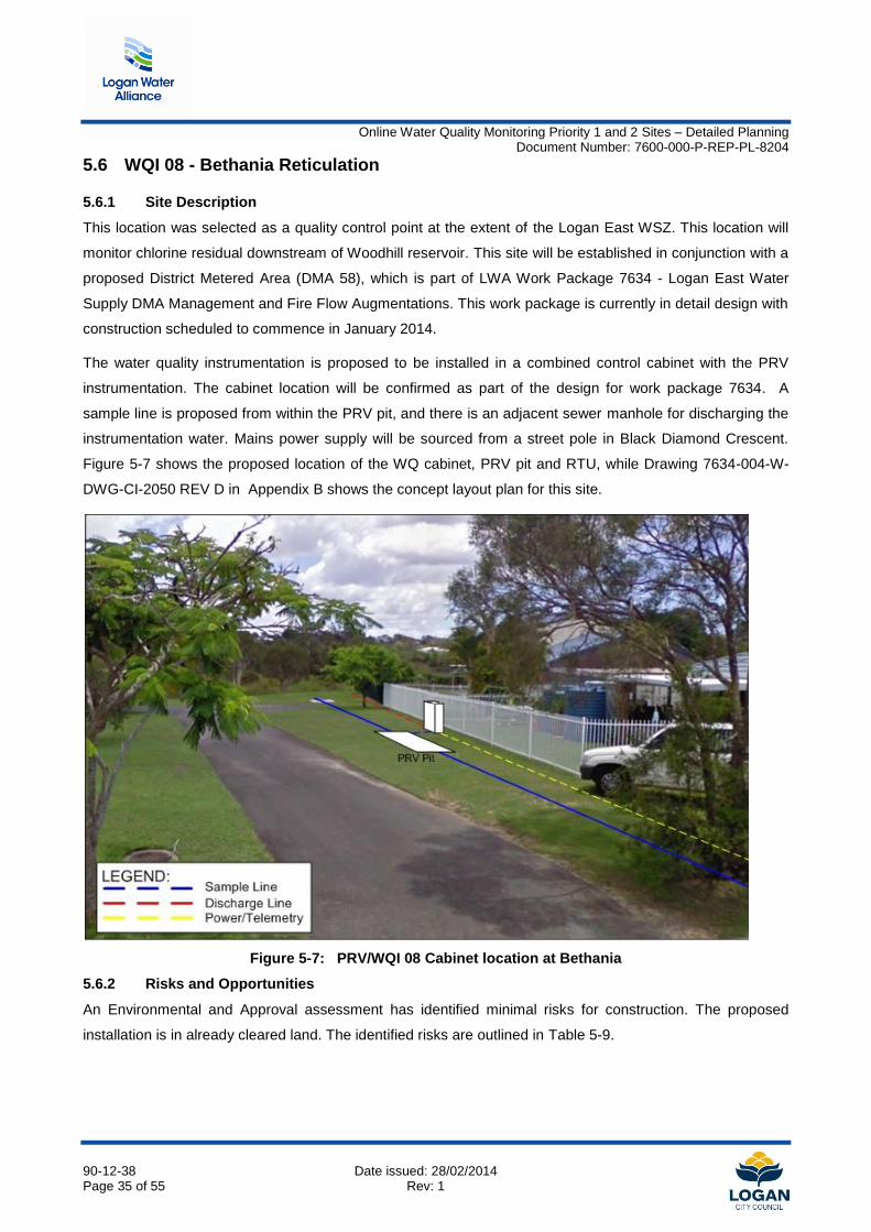
Figure 5-7 shows the proposed location of the WQ cabinet, PRV pit and RTU, while Drawing 7634-004-W-
DWG-CI-2050 REV D in Appendix B shows the concept layout plan for this site.
Figure 5-7: PRV/WQI 08 Cabinet location at Bethania
5.6.2 Risks and Opportunities
An Environmental and Approval assessment has identified minimal risks for construction. The proposed
installation is in already cleared land. The identified risks are outlined in Table 5-9.
Online Water Quality Monitoring Priority 1 and 2 Sites – Detailed Planning Document Number: 7600-000-P-REP-PL-8204
90-12-38 Date issued: 28/02/2014 Page 36 of 55 Rev: 1
Table 5-9: WQI 08 Environmental Assessment
Issue Comment Action
Presence of Groundwater The site is at low elevation (10m AHD) and is located near Logan River
Groundwater is to be captured and tested prior to disposal
Presence of Fire Ants Site is mapped within a low risk fire ant area
Movement of restricted items in compliance with approved risk management plan (ARMP)
Public Amenity Site is adjacent to residential properties
Adequate odour, noise and visual impact mitigation measures must be implemented during design, construction and operation.
PRV pit and Cabinet location
Detailed design should ensure that the PRV pit location is such that conduit lengths can be minimised where
possible. In addition, the adjacent property contains a pool and the cabinet should be located in a position
such that the cabinet cannot be used to gain access to the fenced pool area. Discussions should also be
progressed with the property owner regarding the final location of the cabinet.
5.6.3 Cost Estimate
Table 5-10 outlines the cost estimate for supplier instrumentation and supply, construction and integration
into the existing water supply network. Cost efficiencies can be obtained if the WQ equipment is installed in
conjunction with the PRV site, given there will be minimal additional cost for the installation of WQ equipment
(the only additional scope item being the discharge line for instrumentation water).
As such, costing for this item is presented with and without project delivery in conjunction with work package
WP7634 (Logan East DMA sites), demonstrating the potential cost savings if delivered under the TOC
budget for work package 7634. Note that there would be a minor variation to the WP7634 TOC to
accommodate this additional scope.
The detailed first principle cost estimate is provided in Appendix D.
Table 5-10: Capital Cost estimate for WQI 08
Item Capital Cost ($2013) Capital Cost ($2013)*
- WP7634 delivery
Water Quality Instrumentation $12,000 $12,000
Civil construction cost (additional scope to WP7634) $30,300 $8,000
SCADA integration and commissioning* $1,000 $0
Indirect costs* $4,600 $0
Total $47,900
$20,000
* Cost efficiencies assumed under combined delivery with WP 7634
Online Water Quality Monitoring Priority 1 and 2 Sites – Detailed Planning Document Number: 7600-000-P-REP-PL-8204
90-12-38 Date issued: 28/02/2014 Page 37 of 55 Rev: 1
5.7 WQI 09 - Springwood High Level Water Supply Zone
5.7.1 Site Description
This location was selected as a quality control point within the Springwood High Level Water Supply Zone to
monitor the decay in disinfection residual between this location and water supplied from Springwood Low
Level Reservoir. This location will monitor disinfection residual as well as Nitrate, which will serve as an
indicator for nitrification occurring in the network.
The proposed cabinet location is alongside the existing PRV installation at Parfrey Road, Rochedale
(opposite Gills Close). A sample point tapping is proposed on the DN250 supply main to the PRV zones
(DMA14 and DMA15), while power and telemetry can be supplied from the PRV cabinets. A stormwater gully
inlet pit is available to discharge the instrumentation water; however, if this arrangement is untenable the
discharge line can be directed across the road into the nearest sewer manhole (at front of 23 Parfrey Road).
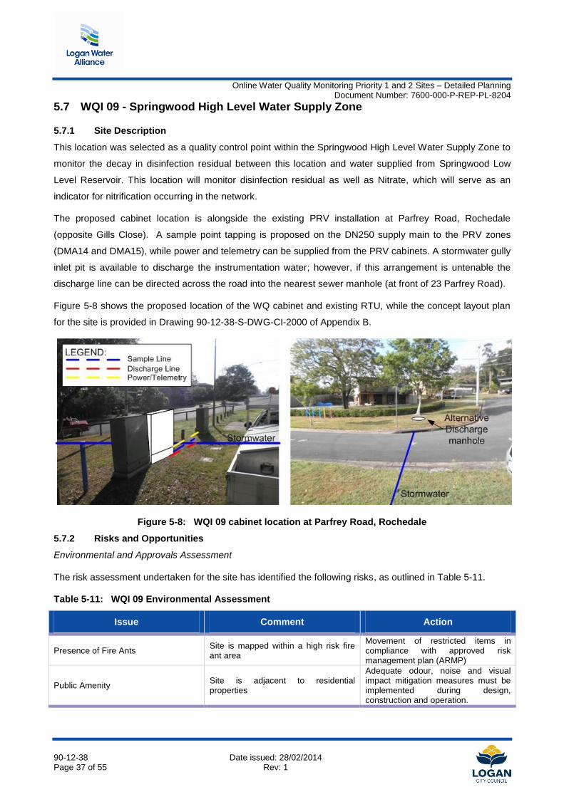
Figure 5-8 shows the proposed location of the WQ cabinet and existing RTU, while the concept layout plan
for the site is provided in Drawing 90-12-38-S-DWG-CI-2000 of Appendix B.
Figure 5-8: WQI 09 cabinet location at Parfrey Road, Rochedale
5.7.2 Risks and Opportunities
Environmental and Approvals Assessment
The risk assessment undertaken for the site has identified the following risks, as outlined in Table 5-11.
Table 5-11: WQI 09 Environmental Assessment
Issue Comment Action
Presence of Fire Ants Site is mapped within a high risk fire ant area
Movement of restricted items in compliance with approved risk management plan (ARMP)
Public Amenity Site is adjacent to residential properties
Adequate odour, noise and visual impact mitigation measures must be implemented during design, construction and operation.
Online Water Quality Monitoring Priority 1 and 2 Sites – Detailed Planning Document Number: 7600-000-P-REP-PL-8204
90-12-38 Date issued: 28/02/2014 Page 38 of 55 Rev: 1
Discharge of Instrumentation Water
There is no adjacent sewerage infrastructure to allow disposal of the instrumentation water. It was agreed in
discussion with LCC representatives that the preferred means of discharging the instrumentation water is to
the stormwater drain, which will minimise site installation costs resulting from traffic management and road
crossings. If this is not tenable, the discharge line can be directed to the sewer manhole at the front of the
opposite property at 23 Parfrey Road.
5.7.3 Cost Estimate
Table 5-12 outlines the summary cost estimate for instrumentation supply, construction and integration into
the existing water supply network. The detailed first principle cost estimate is provided in Appendix D.
Table 5-12: Capital Cost estimate for WQI 09
Item Capital Cost ($2013)
Water Quality Instrumentation $19,000
Civil construction items $30,800
SCADA integration and commissioning $1,000
Indirect costs* $4,600
Total $55,400
*Includes Design and Environmental Group project management and defects liability allowance
Online Water Quality Monitoring Priority 1 and 2 Sites – Detailed Planning Document Number: 7600-000-P-REP-PL-8204
90-12-38 Date issued: 28/02/2014 Page 39 of 55 Rev: 1
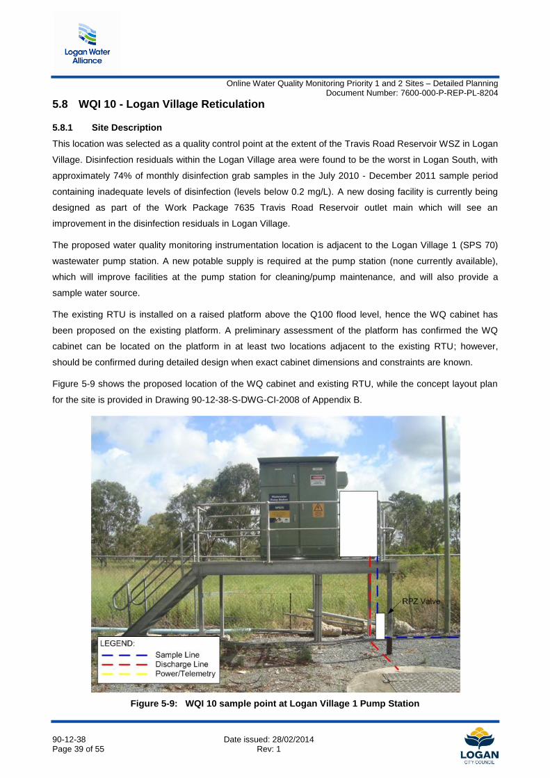
5.8 WQI 10 - Logan Village Reticulation
5.8.1 Site Description
This location was selected as a quality control point at the extent of the Travis Road Reservoir WSZ in Logan
Village. Disinfection residuals within the Logan Village area were found to be the worst in Logan South, with
approximately 74% of monthly disinfection grab samples in the July 2010 - December 2011 sample period
containing inadequate levels of disinfection (levels below 0.2 mg/L). A new dosing facility is currently being
designed as part of the Work Package 7635 Travis Road Reservoir outlet main which will see an
improvement in the disinfection residuals in Logan Village.
The proposed water quality monitoring instrumentation location is adjacent to the Logan Village 1 (SPS 70)
wastewater pump station. A new potable supply is required at the pump station (none currently available),
which will improve facilities at the pump station for cleaning/pump maintenance, and will also provide a
sample water source.
The existing RTU is installed on a raised platform above the Q100 flood level, hence the WQ cabinet has
been proposed on the existing platform. A preliminary assessment of the platform has confirmed the WQ
cabinet can be located on the platform in at least two locations adjacent to the existing RTU; however,
should be confirmed during detailed design when exact cabinet dimensions and constraints are known.
Figure 5-9 shows the proposed location of the WQ cabinet and existing RTU, while the concept layout plan
for the site is provided in Drawing 90-12-38-S-DWG-CI-2008 of Appendix B.
Figure 5-9: WQI 10 sample point at Logan Village 1 Pump Station
Online Water Quality Monitoring Priority 1 and 2 Sites – Detailed Planning Document Number: 7600-000-P-REP-PL-8204
90-12-38 Date issued: 28/02/2014 Page 40 of 55 Rev: 1
5.8.2 Risks and Opportunities
The environmental risk assessment undertaken for the site has identified the following risks, as outlined in
Table 5-13.
Table 5-13: WQI 10 Environmental Assessment
Issue Comment Action
Presence of Fire Ants Site is mapped within a low risk fire ant area
Movement of restricted items in compliance with approved risk management plan (ARMP)
Public Amenity Site is adjacent to residential properties
Adequate odour, noise and visual impact mitigation measures must be implemented during design, construction and operation.
Installation of Cabinet on existing raised RTU platform
A preliminary assessment of the raised platform suggests that sufficient space is available for the installation
of the WQ cabinet. Provision has been made in the cost estimate for the modification (if necessary) of the
raised platform should there be insufficient space; alternatively, the WQ cabinet could be located adjacent to
the existing platform on a new cabinet stand if the cabinet cannot be co-located on the existing platform.
Online Water Quality Monitoring Priority 1 and 2 Sites – Detailed Planning Document Number: 7600-000-P-REP-PL-8204
90-12-38 Date issued: 28/02/2014 Page 41 of 55 Rev: 1
5.8.3 Cost Estimate
Table 5-14 outlines the summary cost estimate for instrumentation supply, construction and integration into
the existing water supply network. The detailed first principle cost estimate is provided in Appendix D.
Table 5-14: Capital Cost estimate for WQI 10
Item Capital Cost ($2013)
Water Quality Instrumentation $12,000
Civil construction items $30,200
SCADA integration and commissioning $1,000
Indirect costs* $4,600
Total $47,800
*Includes Design and Environmental Group project management and defects liability allowance
Online Water Quality Monitoring Priority 1 and 2 Sites – Detailed Planning Document Number: 7600-000-P-REP-PL-8204
90-12-38 Date issued: 28/02/2014 Page 42 of 55 Rev: 1
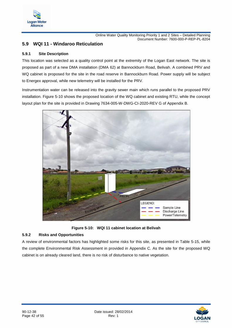
5.9 WQI 11 - Windaroo Reticulation
5.9.1 Site Description
This location was selected as a quality control point at the extremity of the Logan East network. The site is
proposed as part of a new DMA installation (DMA 62) at Bannockburn Road, Belivah. A combined PRV and
WQ cabinet is proposed for the site in the road reserve in Bannockburn Road. Power supply will be subject
to Energex approval, while new telemetry will be installed for the PRV.
Instrumentation water can be released into the gravity sewer main which runs parallel to the proposed PRV
installation. Figure 5-10 shows the proposed location of the WQ cabinet and existing RTU, while the concept
layout plan for the site is provided in Drawing 7634-005-W-DWG-CI-2020-REV G of Appendix B.
Figure 5-10: WQI 11 cabinet location at Belivah
5.9.2 Risks and Opportunities
A review of environmental factors has highlighted some risks for this site, as presented in Table 5-15, while
the complete Environmental Risk Assessment in provided in Appendix C. As the site for the proposed WQ
cabinet is on already cleared land, there is no risk of disturbance to native vegetation.
Online Water Quality Monitoring Priority 1 and 2 Sites – Detailed Planning Document Number: 7600-000-P-REP-PL-8204
90-12-38 Date issued: 28/02/2014 Page 43 of 55 Rev: 1
Table 5-15: WQI 11 Environmental Assessment
Issue Comment Action
Nature Conservation Act Clearing/trimming of any native regrowth adjacent works
Further assessment required once scope defined to determine the presence/absence of any threatened species or breeding places
Land Protection (Pest and Stock Route Management) Act
Presence of declared pest plants within alignment
A field investigation is required prior to construction to identify declared pest plants and define mitigation
Public Amenity Site is adjacent to residential properties
Adequate odour, noise and visual impact mitigation measures must be implemented during design, construction and operation.
Risk of Vehicular Collision
The PRV installation is located adjacent to the roadway, and is therefore at risk of collision from vehicles.
Detailed design should seek to maximise the distance from the roadway. It may be feasible to locate the
PRV/WQ RTU cabinet behind the adjacent power pole. This will be determined in conjunction with necessary
clearances as required by the electricity provider. In addition bollards can also be considered in the cabinet
design to reduce damage from collision.
5.9.3 Cost Estimate
Table 5-16 outlines the cost estimate for supplier instrumentation and supply, construction and integration
into the existing water supply network. Cost efficiencies can be obtained if the WQ equipment is installed in
conjunction with the PRV site, given there will be minimal additional cost for the installation of WQ
equipment.
As such, costing for this item is presented with and without project delivery in conjunction with work package
WP7634 (Logan East DMA sites), demonstrating the potential cost savings if delivered under the TOC
budget for work package 7634. Note that there would be a minor variation to the WP7634 TOC to
accommodate this additional scope.
The detailed first principle cost estimate is provided in Appendix D.
Table 5-16: Capital Cost estimate for WQI 11
Item Capital Cost ($2013)* Capital Cost ($2013)*
- Delivery via WP 7634
Water Quality Instrumentation $12,000 $12,000
Civil construction items* $29,500 $8,000
SCADA integration and
commissioning* $1,000 $0
Indirect costs* $4,600 $0
Total $47,100 $20,000
* Cost efficiencies assumed under combined delivery with WP 7634
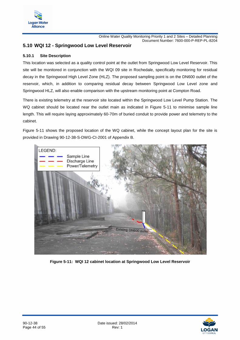
Online Water Quality Monitoring Priority 1 and 2 Sites – Detailed Planning Document Number: 7600-000-P-REP-PL-8204
90-12-38 Date issued: 28/02/2014 Page 44 of 55 Rev: 1
5.10 WQI 12 - Springwood Low Level Reservoir
5.10.1 Site Description
This location was selected as a quality control point at the outlet from Springwood Low Level Reservoir. This
site will be monitored in conjunction with the WQI 09 site in Rochedale, specifically monitoring for residual
decay in the Springwood High Level Zone (HLZ). The proposed sampling point is on the DN600 outlet of the
reservoir, which, in addition to comparing residual decay between Springwood Low Level zone and
Springwood HLZ, will also enable comparison with the upstream monitoring point at Compton Road.
There is existing telemetry at the reservoir site located within the Springwood Low Level Pump Station. The
WQ cabinet should be located near the outlet main as indicated in Figure 5-11 to minimise sample line
length. This will require laying approximately 60-70m of buried conduit to provide power and telemetry to the
cabinet.
Figure 5-11 shows the proposed location of the WQ cabinet, while the concept layout plan for the site is
provided in Drawing 90-12-38-S-DWG-CI-2001 of Appendix B.
Figure 5-11: WQI 12 cabinet location at Springwood Low Level Reservoir
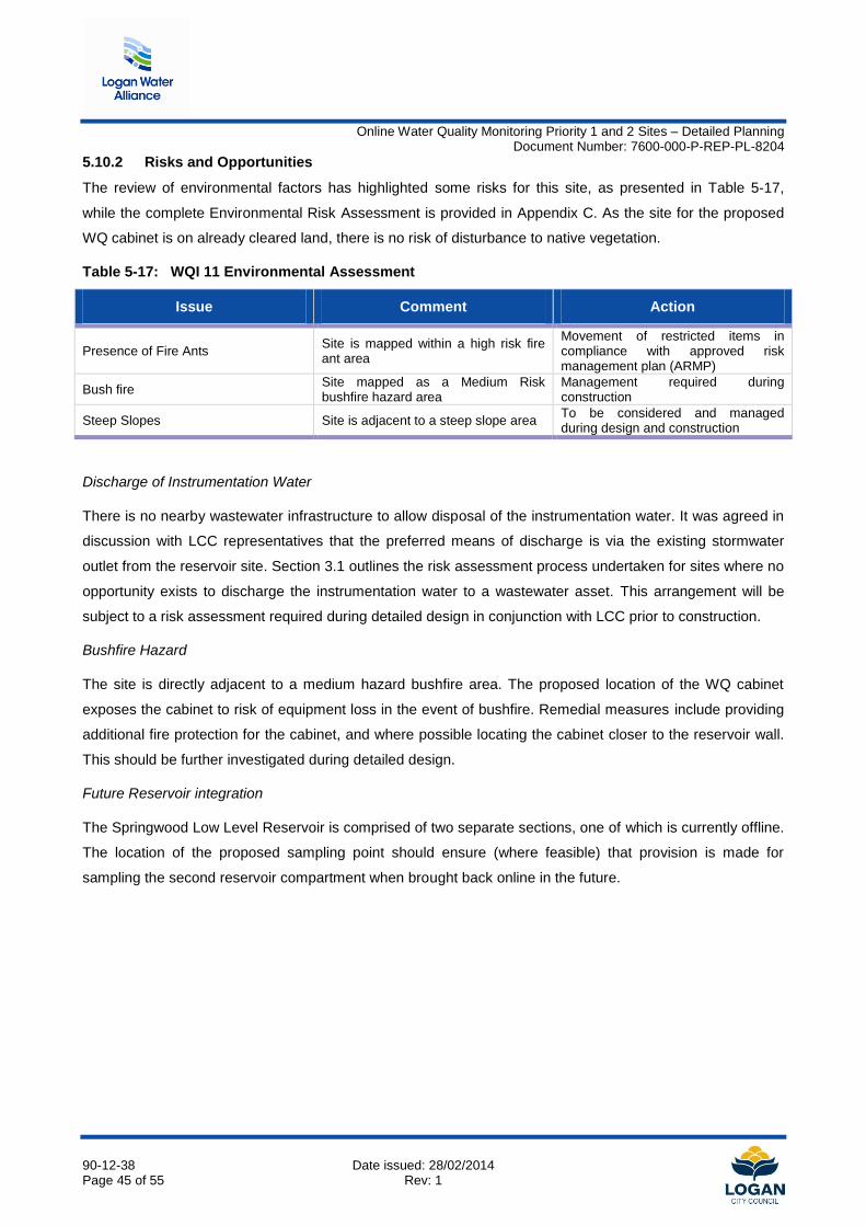
Online Water Quality Monitoring Priority 1 and 2 Sites – Detailed Planning Document Number: 7600-000-P-REP-PL-8204
90-12-38 Date issued: 28/02/2014 Page 45 of 55 Rev: 1
5.10.2 Risks and Opportunities
The review of environmental factors has highlighted some risks for this site, as presented in Table 5-17,
while the complete Environmental Risk Assessment is provided in Appendix C. As the site for the proposed
WQ cabinet is on already cleared land, there is no risk of disturbance to native vegetation.
Table 5-17: WQI 11 Environmental Assessment
Issue Comment Action
Presence of Fire Ants Site is mapped within a high risk fire ant area
Movement of restricted items in compliance with approved risk management plan (ARMP)
Bush fire Site mapped as a Medium Risk bushfire hazard area
Management required during construction
Steep Slopes Site is adjacent to a steep slope area To be considered and managed during design and construction
Discharge of Instrumentation Water
There is no nearby wastewater infrastructure to allow disposal of the instrumentation water. It was agreed in
discussion with LCC representatives that the preferred means of discharge is via the existing stormwater
outlet from the reservoir site. Section 3.1 outlines the risk assessment process undertaken for sites where no
opportunity exists to discharge the instrumentation water to a wastewater asset. This arrangement will be
subject to a risk assessment required during detailed design in conjunction with LCC prior to construction.
Bushfire Hazard
The site is directly adjacent to a medium hazard bushfire area. The proposed location of the WQ cabinet
exposes the cabinet to risk of equipment loss in the event of bushfire. Remedial measures include providing
additional fire protection for the cabinet, and where possible locating the cabinet closer to the reservoir wall.
This should be further investigated during detailed design.
Future Reservoir integration
The Springwood Low Level Reservoir is comprised of two separate sections, one of which is currently offline.
The location of the proposed sampling point should ensure (where feasible) that provision is made for
sampling the second reservoir compartment when brought back online in the future.

Online Water Quality Monitoring Priority 1 and 2 Sites – Detailed Planning Document Number: 7600-000-P-REP-PL-8204
90-12-38 Date issued: 28/02/2014 Page 46 of 55 Rev: 1
5.10.3 Cost Estimate
Table 5-18 outlines the cost estimate for instrumentation supply, construction and integration into the existing
water supply network. First principle cost estimates for this site are higher compared to other sites as a result
of the length of trenching required for installation of power/telemetry conduits.
The detailed first principle cost estimate is provided in Appendix D.
Table 5-18: Capital Cost estimate for WQI 12
Item Capital Cost ($2013)
Water Quality Instrumentation $19,000
Civil construction items $56,900
SCADA integration and commissioning $1,000
Indirect costs* $4,600
Total $81,500
*Includes Design & Environmental Group project management and defects liability allowance
Online Water Quality Monitoring Priority 1 and 2 Sites – Detailed Planning Document Number: 7600-000-P-REP-PL-8204
90-12-38 Date issued: 28/02/2014 Page 47 of 55 Rev: 1
6. CONCLUSION
This detailed planning study outlines the site specific requirements for the installation of ten additional water
quality sites throughout the Logan District. The requirements are based on a preliminary site assessment for
the proposed cabinet locations, and an assessment of the environmental, cultural heritage and approvals
requirements for each of the sites. An estimated cost to install the monitoring equipment at each site has
been developed from first principle cost estimates.
The proposed monitoring sites will serve to improve the real time management of the water supply network,
further enabling a proactive response to issues related to changes in water quality, rather than relying on
manual sampling and laboratory testing. The real-time monitoring will also enhance LCC's ability to respond
rapidly to events which may adversely affect customer health.
This detailed planning study has determined that:
There are minimal constraints for the installation of the water quality monitoring cabinets at each of
the proposed sites. There are no environmental ‘show stoppers’ or town planning approval issues
which would prevent installation of the WQ cabinets at any of the sites.
Audits of existing RTUs should be undertaken to confirm spare I/O capacity in each existing RTU
The release of the instrumentation water cannot be disposed of to a sewer asset at all proposed
sites. Release of water for irrigation was preferred where no sewer disposal exists, and a site
specific risk assessment will need to be undertaken during detailed design for sites where release to
a stormwater asset is proposed. Where the residual risk of disposal to stormwater is considered low
with no risk to the receiving environment as a result of chlorine residual, and the cost of alternative
release is prohibitive, it is recommended that disposal to the stormwater assets should proceed as
outlined in Table 6-1.
Table 6-1: Proposed sites for alternative release of instrumentation water
ID Site Name Proposed Release Mechanism
WQI 03 Spring Mountain Reservoir Irrigation
WQI 04 Woodhill Reservoir Irrigation
WQI 07 Mundoolun Water Pump Station Irrigation
WQI 09 DMA 14/15 PRV site Stormwater drain
WQI 12 Springwood Low Level Reservoir Stormwater drain
There is the potential to realise cost savings in the delivery of two of the proposed sites (WQI 08 and
WQI 11) by combining the delivery of the WQ cabinets in conjunction with works to be undertaken as
part of the Logan East DMA work package, WP 7634.
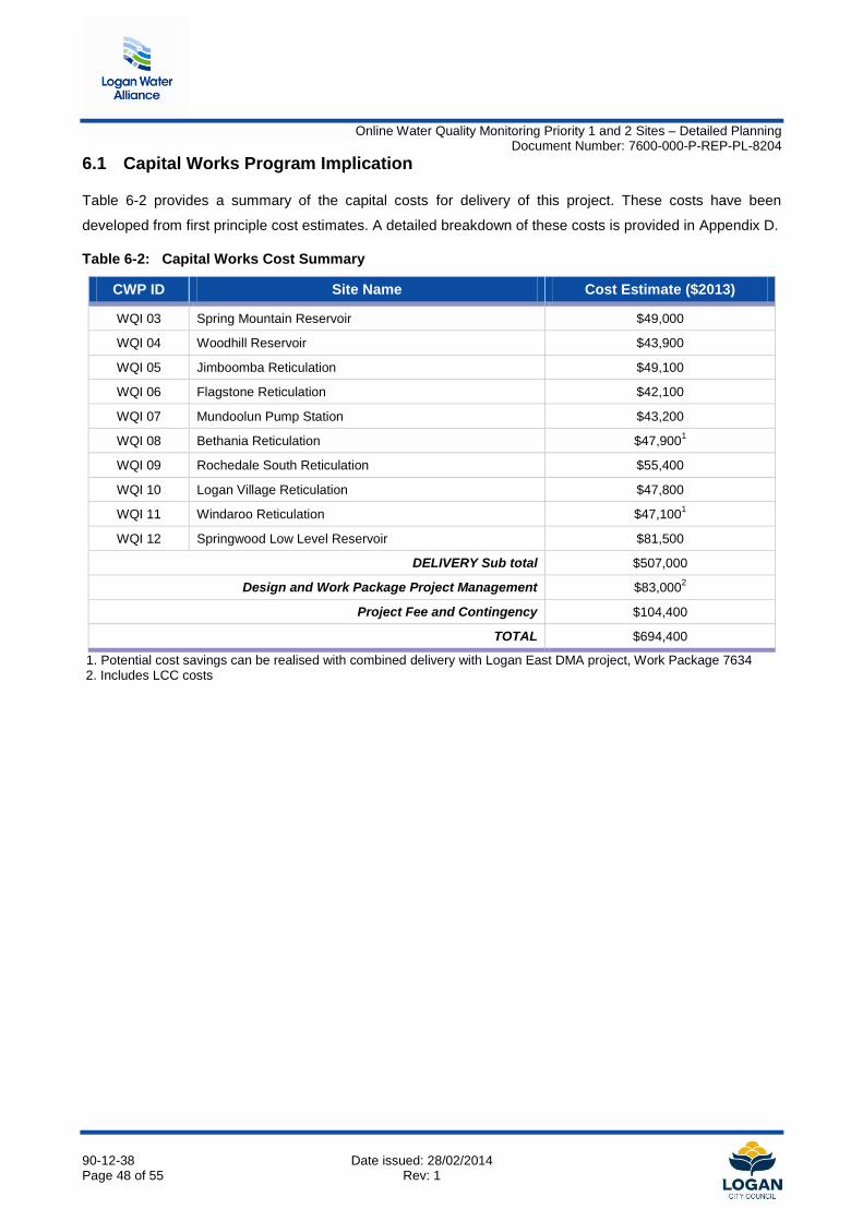
Online Water Quality Monitoring Priority 1 and 2 Sites – Detailed Planning Document Number: 7600-000-P-REP-PL-8204
90-12-38 Date issued: 28/02/2014 Page 48 of 55 Rev: 1
6.1 Capital Works Program Implication
Table 6-2 provides a summary of the capital costs for delivery of this project. These costs have been
developed from first principle cost estimates. A detailed breakdown of these costs is provided in Appendix D.
Table 6-2: Capital Works Cost Summary
CWP ID Site Name Cost Estimate ($2013)
WQI 03 Spring Mountain Reservoir $49,000
WQI 04 Woodhill Reservoir $43,900
WQI 05 Jimboomba Reticulation $49,100
WQI 06 Flagstone Reticulation $42,100
WQI 07 Mundoolun Pump Station $43,200
WQI 08 Bethania Reticulation $47,9001
WQI 09 Rochedale South Reticulation $55,400
WQI 10 Logan Village Reticulation $47,800
WQI 11 Windaroo Reticulation $47,1001
WQI 12 Springwood Low Level Reservoir $81,500
DELIVERY Sub total $507,000
Design and Work Package Project Management $83,0002
Project Fee and Contingency $104,400
TOTAL $694,400
1. Potential cost savings can be realised with combined delivery with Logan East DMA project, Work Package 7634 2. Includes LCC costs
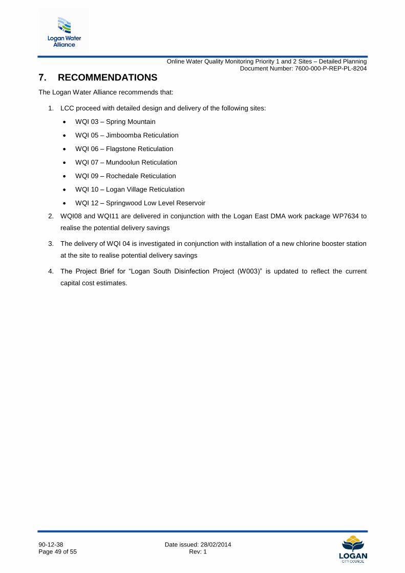
Online Water Quality Monitoring Priority 1 and 2 Sites – Detailed Planning Document Number: 7600-000-P-REP-PL-8204
90-12-38 Date issued: 28/02/2014 Page 49 of 55 Rev: 1
7. RECOMMENDATIONS
The Logan Water Alliance recommends that:
1. LCC proceed with detailed design and delivery of the following sites:
WQI 03 – Spring Mountain
WQI 05 – Jimboomba Reticulation
WQI 06 – Flagstone Reticulation
WQI 07 – Mundoolun Reticulation
WQI 09 – Rochedale Reticulation
WQI 10 – Logan Village Reticulation
WQI 12 – Springwood Low Level Reservoir
2. WQI08 and WQI11 are delivered in conjunction with the Logan East DMA work package WP7634 to
realise the potential delivery savings
3. The delivery of WQI 04 is investigated in conjunction with installation of a new chlorine booster station
at the site to realise potential delivery savings
4. The Project Brief for “Logan South Disinfection Project (W003)” is updated to reflect the current
capital cost estimates.
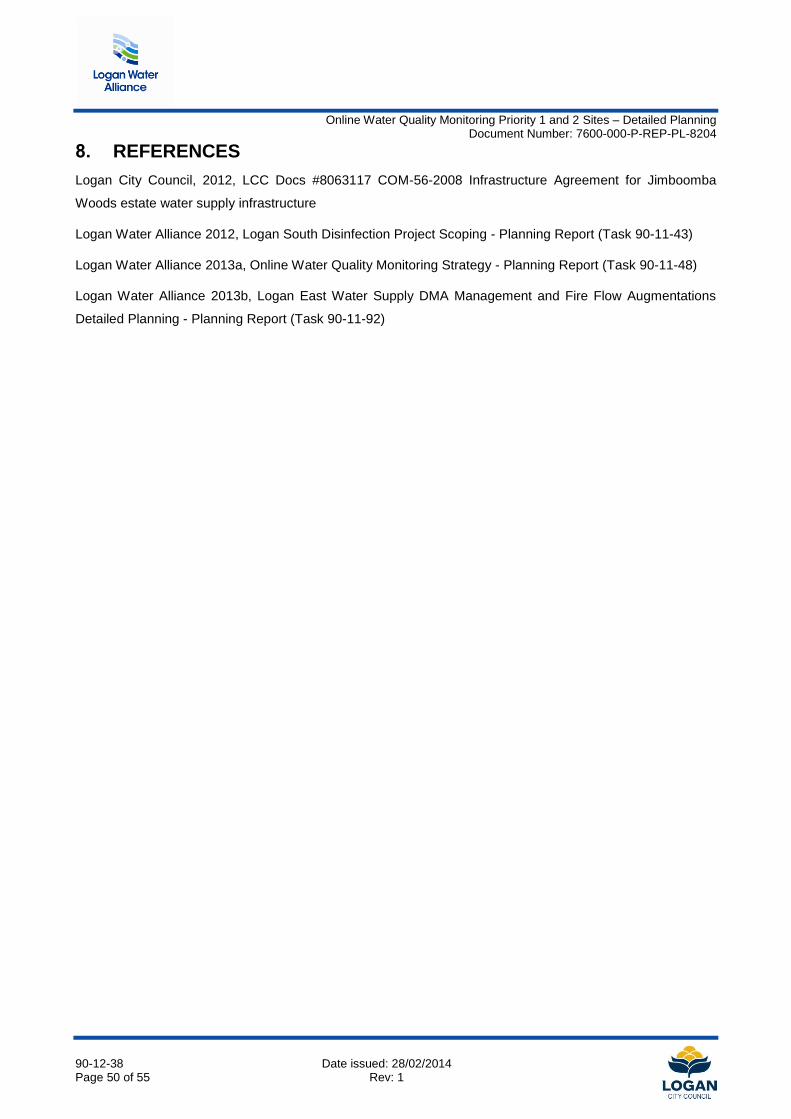
Online Water Quality Monitoring Priority 1 and 2 Sites – Detailed Planning Document Number: 7600-000-P-REP-PL-8204
90-12-38 Date issued: 28/02/2014 Page 50 of 55 Rev: 1
8. REFERENCES
Logan City Council, 2012, LCC Docs #8063117 COM-56-2008 Infrastructure Agreement for Jimboomba
Woods estate water supply infrastructure
Logan Water Alliance 2012, Logan South Disinfection Project Scoping - Planning Report (Task 90-11-43)
Logan Water Alliance 2013a, Online Water Quality Monitoring Strategy - Planning Report (Task 90-11-48)
Logan Water Alliance 2013b, Logan East Water Supply DMA Management and Fire Flow Augmentations
Detailed Planning - Planning Report (Task 90-11-92)

Online Water Quality Monitoring Priority 1 and 2 Sites – Detailed Planning Document Number: 7600-000-P-REP-PL-8204
90-12-38 Date issued: 28/02/2014 Page 51 of 55 Rev: 1
Appendix A Risk Assessment
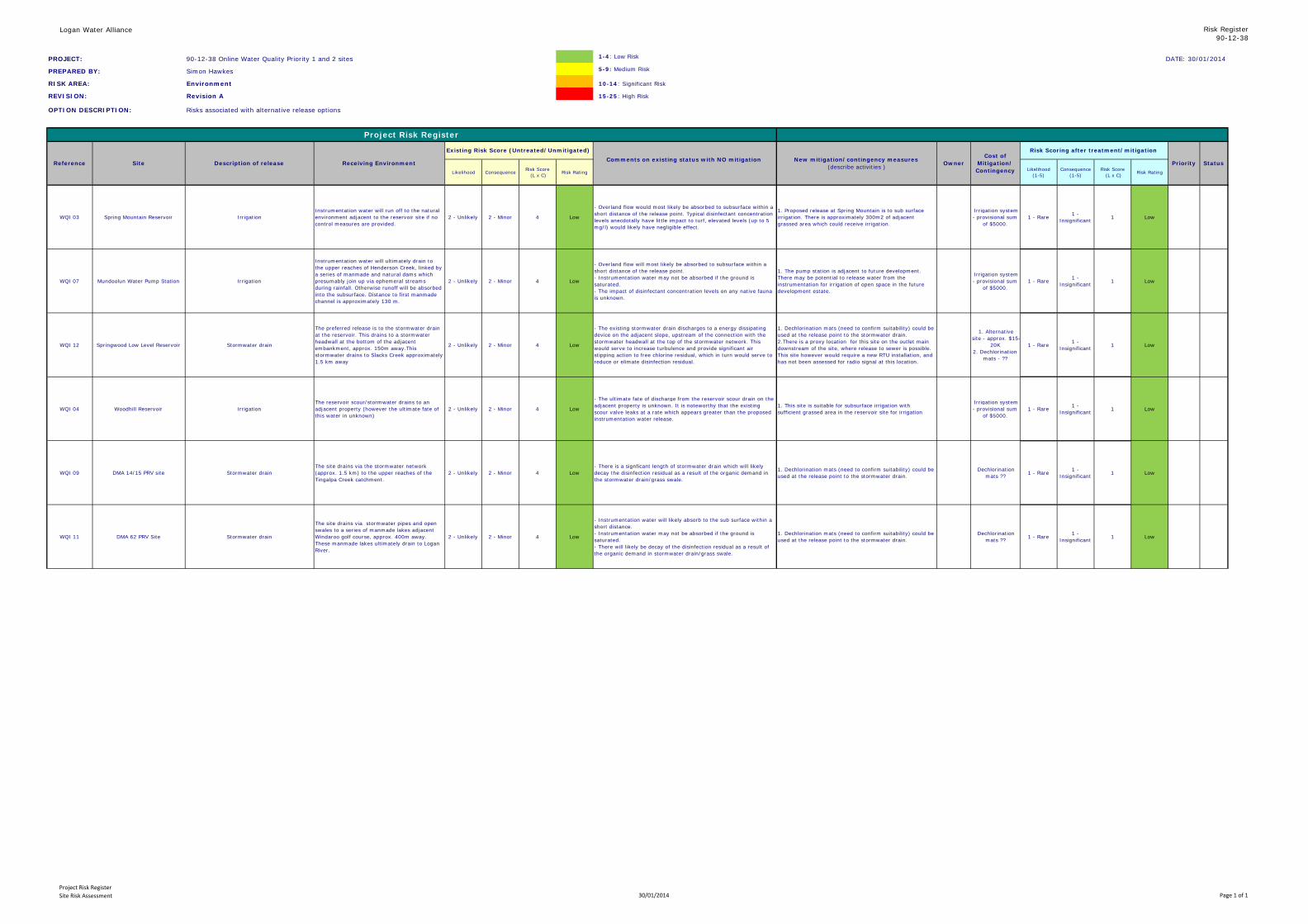
Logan Water Alliance Risk Register90-12-38
PROJECT: 90-12-38 Online Water Quality Priority 1 and 2 sites 1-4: Low Risk DATE: 30/01/2014
PREPARED BY: Simon Hawkes 5-9: Medium Risk
RISK AREA: Environment 10-14: Significant Risk
REVISION: Revision A 15-25: High Risk
OPTION DESCRIPTION: Risks associated with alternative release options
Likelihood Consequence Risk Score (L x C) Risk Rating Likelihood
(1-5)Consequence
(1-5)Risk Score
(L x C) Risk Rating
WQI 03 Spring Mountain Reservoir IrrigationInstrumentation water will run off to the natural environment adjacent to the reservoir site if no control measures are provided.
2 - Unlikely 2 - Minor 4 Low
- Overland flow would most likely be absorbed to subsurface within a short distance of the release point. Typical disinfectant concentration levels anecdotally have little impact to turf, elevated levels (up to 5 mg/l) would likely have negligible effect.
1. Proposed release at Spring Mountain is to sub surface irrigation. There is approximately 300m2 of adjacent grassed area which could receive irrigation.
Irrigation system - provisional sum
of $5000. 1 - Rare 1 -
Insignificant 1 Low
WQI 07 Mundoolun Water Pump Station Irrigation
Instrumentation water will ultimately drain to the upper reaches of Henderson Creek, linked by a series of manmade and natural dams which presumably join up via ephemeral streams during rainfall. Otherwise runoff will be absorbed into the subsurface. Distance to first manmade channel is approximately 130 m.
2 - Unlikely 2 - Minor 4 Low
- Overland flow will most likely be absorbed to subsurface within a short distance of the release point. - Instrumentation water may not be absorbed if the ground is saturated.- The impact of disinfectant concentration levels on any native fauna is unknown.
1. The pump station is adjacent to future development. There may be potential to release water from the instrumentation for irrigation of open space in the future development estate.
Irrigation system - provisional sum
of $5000. 1 - Rare 1 -
Insignificant 1 Low
WQI 12 Springwood Low Level Reservoir Stormwater drain
The preferred release is to the stormwater drain at the reservoir. This drains to a stormwater headwall at the bottom of the adjacent embankment, approx. 150m away.This stormwater drains to Slacks Creek approximately 1.5 km away
2 - Unlikely 2 - Minor 4 Low
- The existing stormwater drain discharges to a energy dissipating device on the adjacent slope, upstream of the connection with the stormwater headwall at the top of the stormwater network. This would serve to increase turbulence and provide significant air stipping action to free chlorine residual, which in turn would serve to reduce or elimate disinfection residual.
1. Dechlorination mats (need to confirm suitability) could be used at the release point to the stormwater drain.2.There is a proxy location for this site on the outlet main downstream of the site, where release to sewer is possible. This site however would require a new RTU installation, and has not been assessed for radio signal at this location.
1. Alternative site - approx. $15-
20K 2. Dechlorination
mats - ??
1 - Rare 1 - Insignificant 1 Low
WQI 04 Woodhill Reservoir IrrigationThe reservoir scour/stormwater drains to an adjacent property (however the ultimate fate of this water in unknown)
2 - Unlikely 2 - Minor 4 Low
- The ultimate fate of discharge from the reservoir scour drain on the adjacent property is unknown. It is noteworthy that the existing scour valve leaks at a rate which appears greater than the proposed instrumentation water release.
1. This site is suitable for subsurface irrigation with sufficient grassed area in the reservoir site for irrigation
Irrigation system - provisional sum
of $5000. 1 - Rare 1 -
Insignificant 1 Low
WQI 09 DMA 14/15 PRV site Stormwater drainThe site drains via the stormwater network (approx. 1.5 km) to the upper reaches of the Tingalpa Creek catchment.
2 - Unlikely 2 - Minor 4 Low- There is a signficant length of stormwater drain which will likely decay the disinfection residual as a result of the organic demand in the stormwater drain/grass swale.
1. Dechlorination mats (need to confirm suitability) could be used at the release point to the stormwater drain.
Dechlorination mats ?? 1 - Rare 1 -
Insignificant 1 Low
WQI 11 DMA 62 PRV Site Stormwater drain
The site drains via stormwater pipes and open swales to a series of manmade lakes adjacent Windaroo golf course, approx. 400m away. These manmade lakes ultimately drain to Logan River.
2 - Unlikely 2 - Minor 4 Low
- Instrumentation water will likely absorb to the sub surface within a short distance.- Instrumentation water may not be absorbed if the ground is saturated.- There will likely be decay of the disinfection residual as a result of the organic demand in stormwater drain/grass swale.
1. Dechlorination mats (need to confirm suitability) could be used at the release point to the stormwater drain.
Dechlorination mats ?? 1 - Rare 1 -
Insignificant 1 Low
Status
Project Risk Register
Reference Site Description of release Receiving Environment
Existing Risk Score (Untreated/Unmitigated)Comments on existing status with NO mitigation New mitigation/contingency measures
(describe activities ) OwnerCost of
Mitigation/ Contingency
Risk Scoring after treatment/mitigation
Priority
Project Risk RegisterSite Risk Assessment 30/01/2014 Page 1 of 1

Online Water Quality Monitoring Priority 1 and 2 Sites – Detailed Planning Document Number: 7600-000-P-REP-PL-8204
90-12-38 Date issued: 28/02/2014 Page 52 of 55 Rev: 1
Appendix B Preliminary Design Drawings
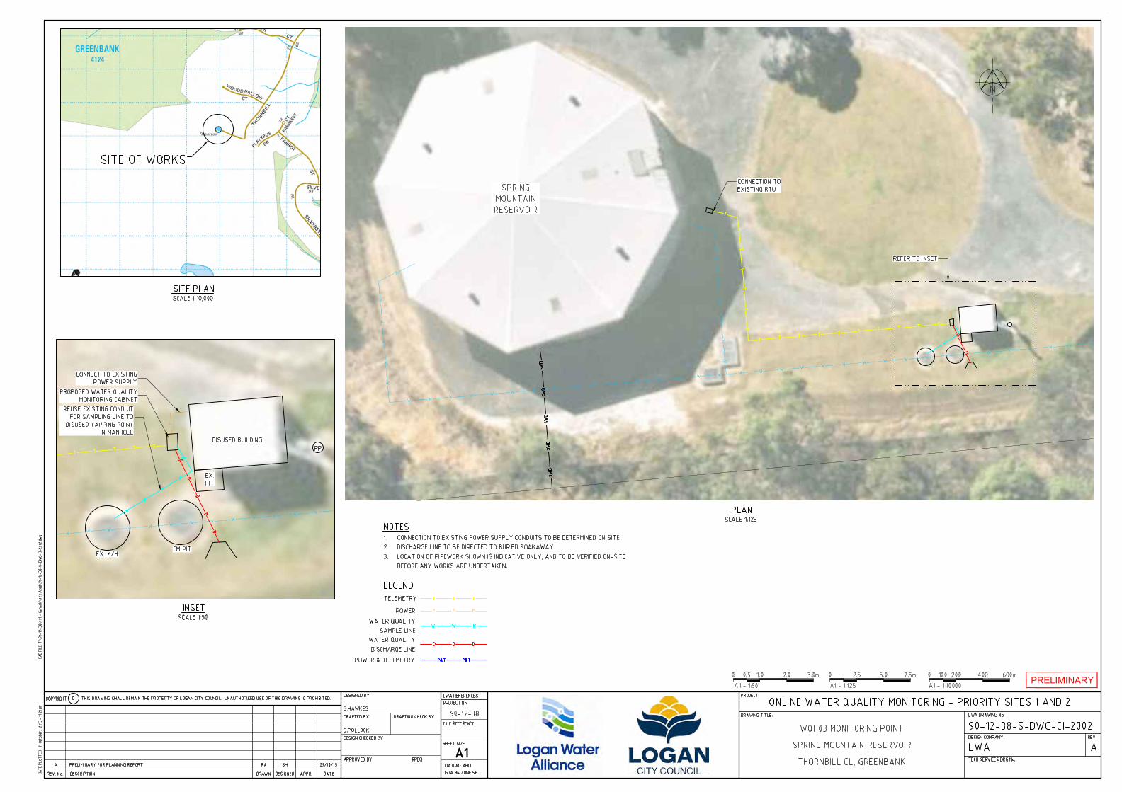
PRELIMINARY
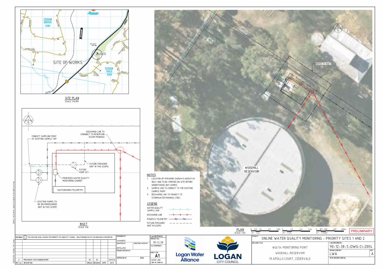
PRELIMINARY
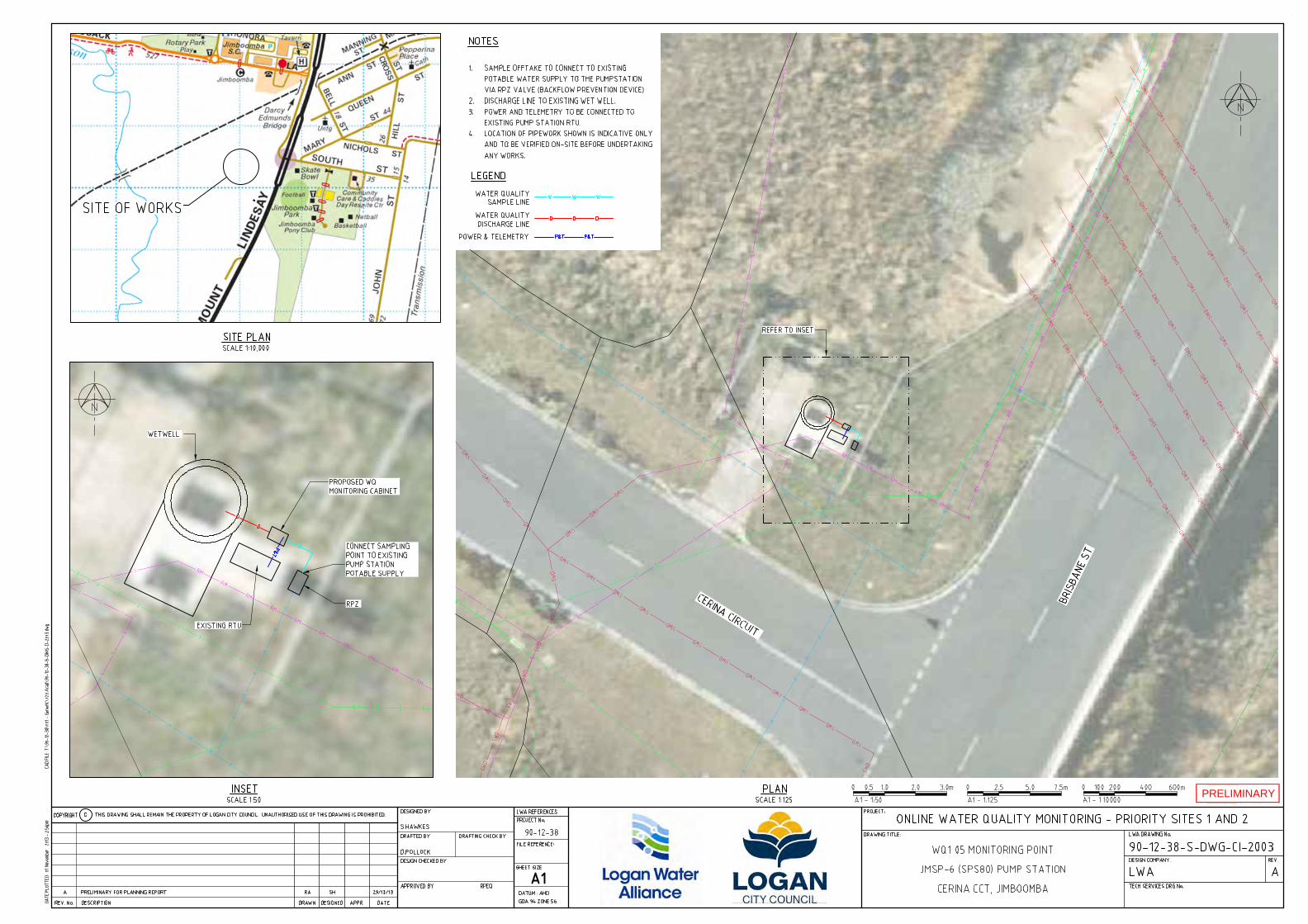
PRELIMINARY
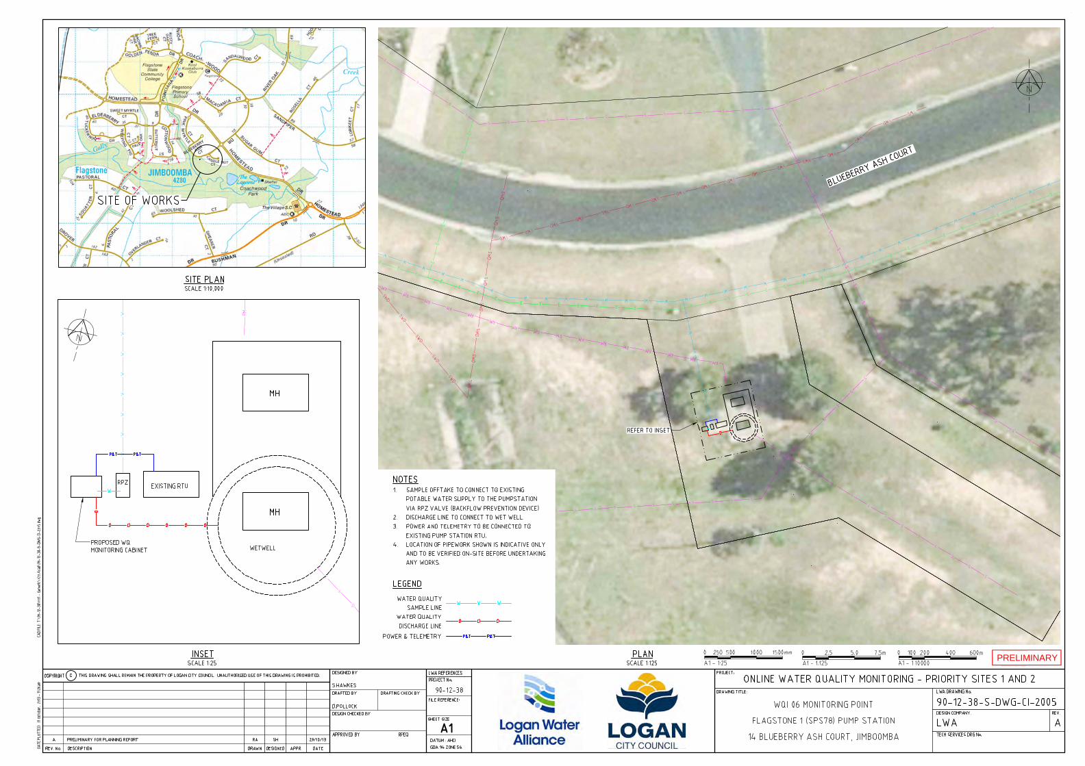
PRELIMINARY
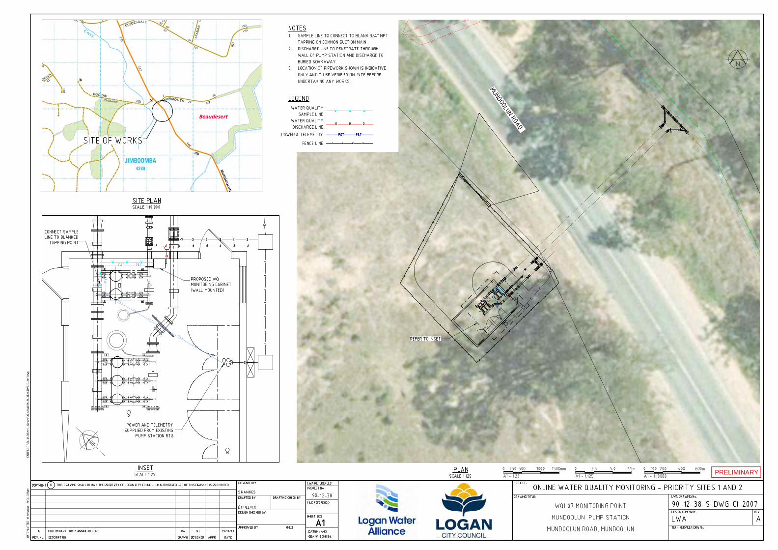
PRELIMINARY
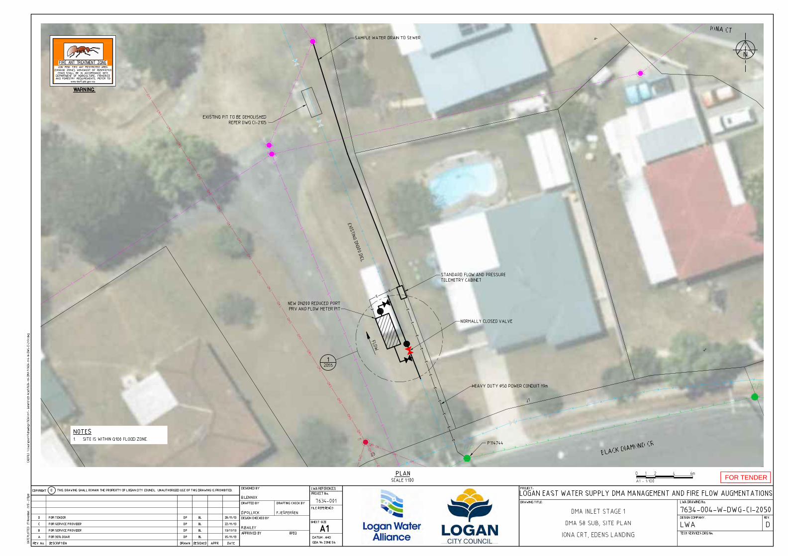
FOR TENDER
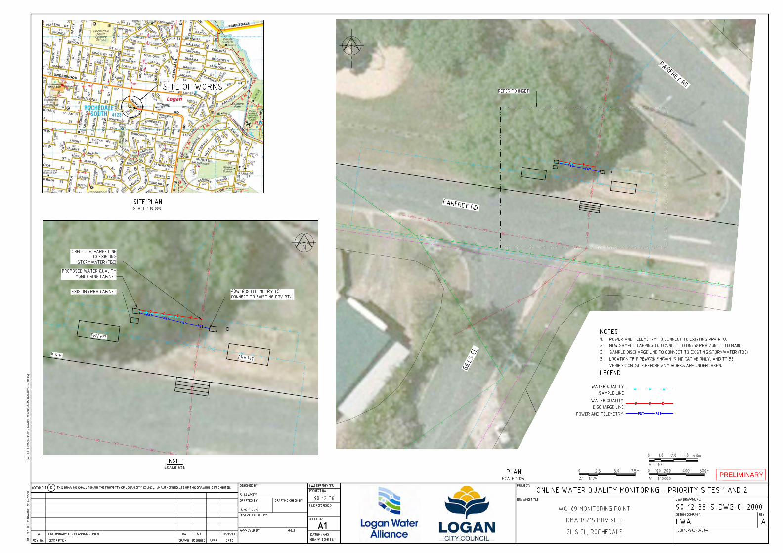
PRELIMINARY
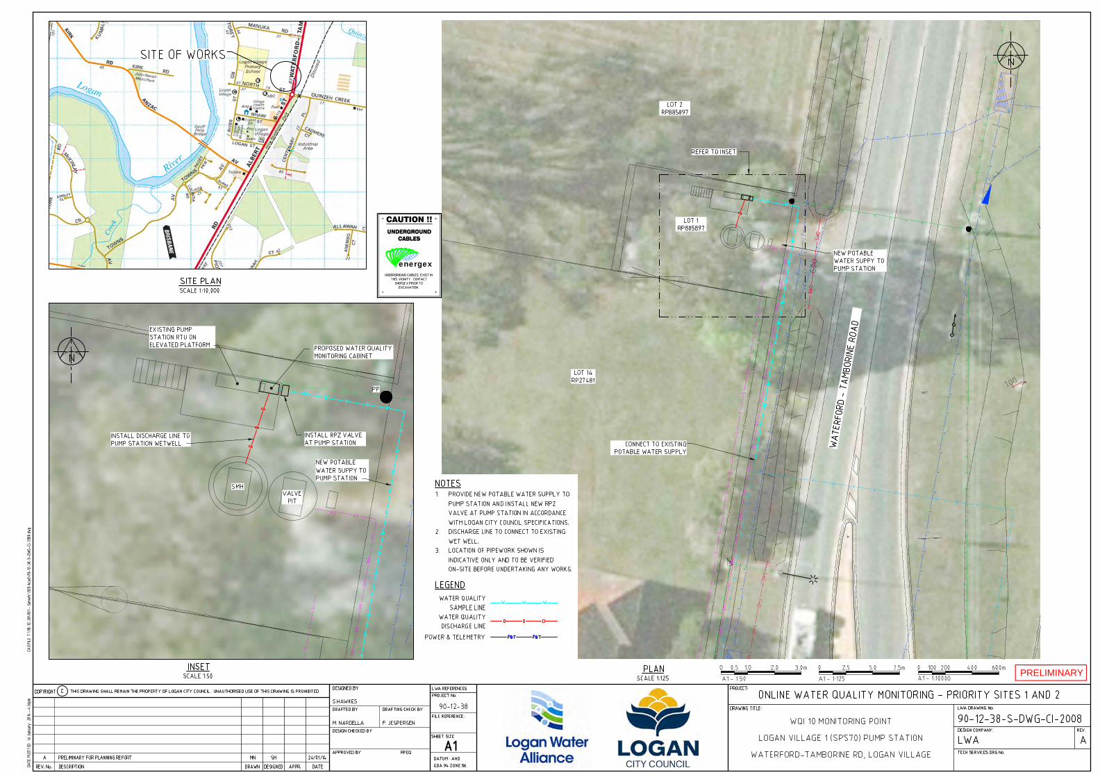
PRELIMINARY
energex
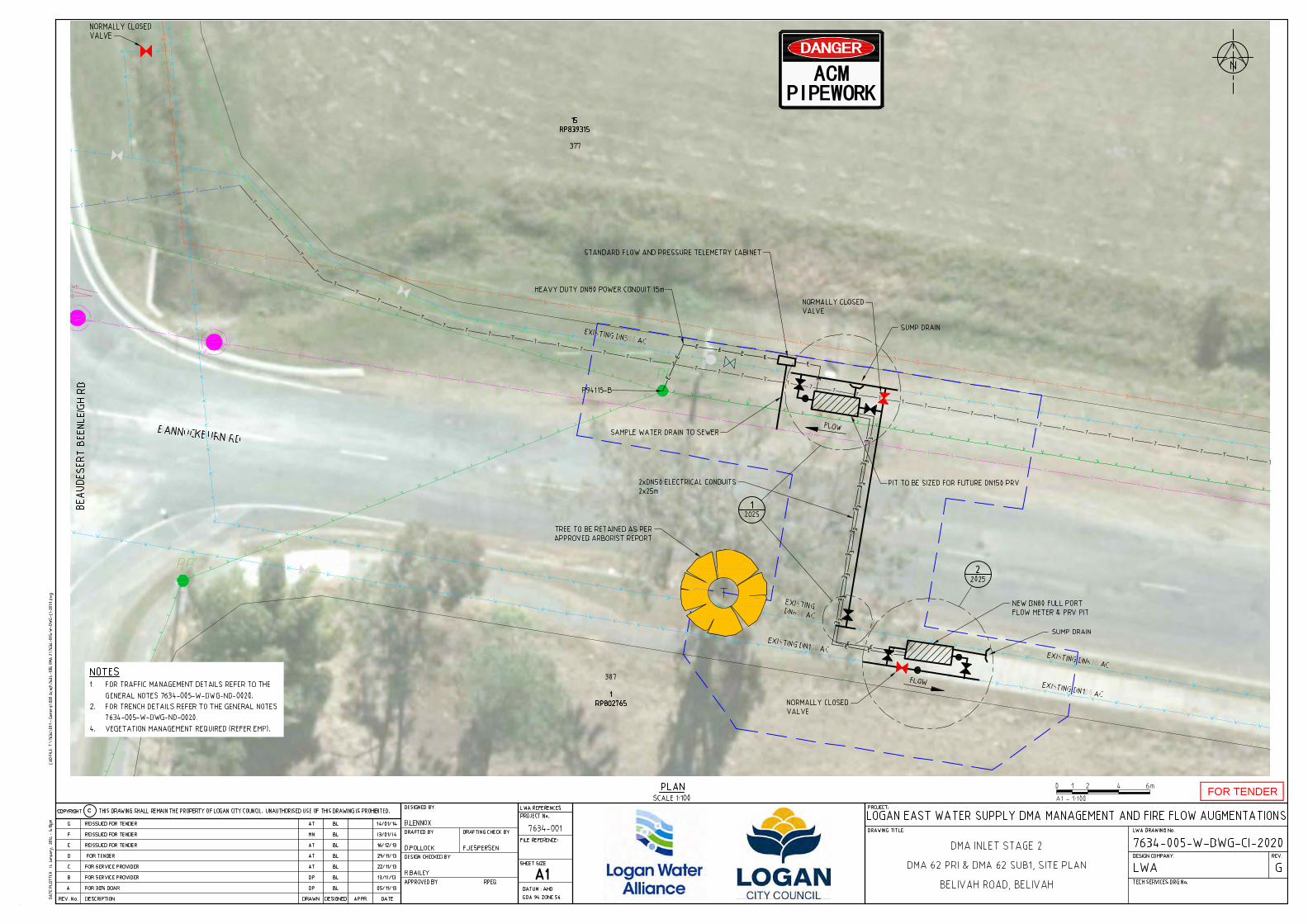
FOR TENDER
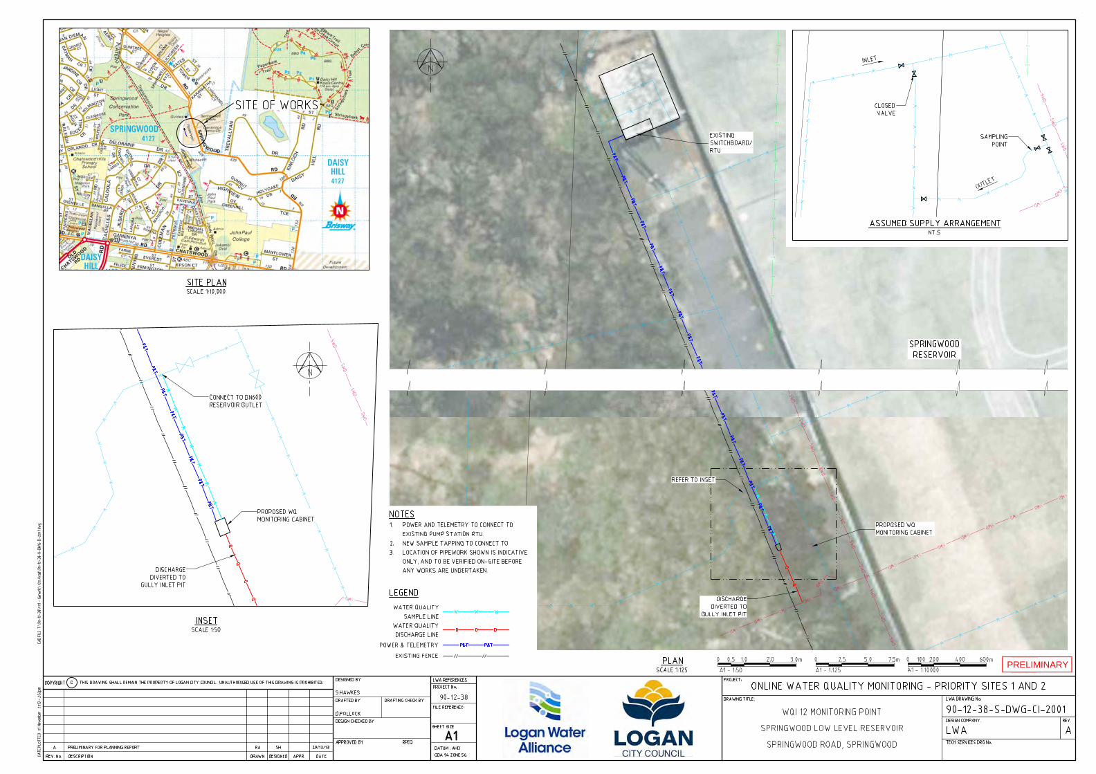
PRELIMINARY

Online Water Quality Monitoring Priority 1 and 2 Sites – Detailed Planning Document Number: 7600-000-P-REP-PL-8204
90-12-38 Date issued: 28/02/2014 Page 53 of 55 Rev: 1
Appendix C Environmental Assessment
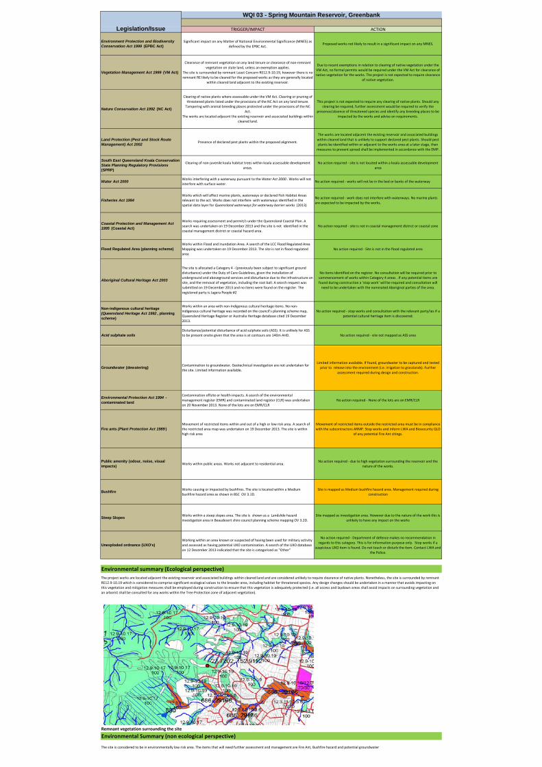
TRIGGER/IMPACT ACTION
Environment Protection and Biodiversity Conservation Act 1999 (EPBC Act)
Significant impact on any Matter of National Environmental Significance (MNES) as defined by the EPBC Act.
Proposed works not likely to result in a significant impact on any MNES.
Vegetation Management Act 1999 (VM Act)
Clearance of remnant vegetation on any land tenure or clearance of non‐remnant vegetation on state land, unless an exemption applies.
The site is surrounded by remnant Least Concern RE12.9‐10.19, however there is no remnant RE likely to be cleared for the proposed works as they are generally located
within cleared land adjacent to the existing reservoir.
Due to recent exemptions in relation to clearing of native vegetation under the VM Act, no formal permits would be required under the VM Act for clearance of native vegetation for the works. The project is not expected to require clearance
of native vegetation.
Nature Conservation Act 1992 (NC Act)
Clearing of native plants where assessable under the VM Act. Clearing or pruning of threatened plants listed under the provisions of the NC Act on any land tenure. Tampering with animal breeding places protected under the provisions of the NC
Act.The works are located adjacent the existing reservoir and associated buildings within
cleared land.
This project is not expected to require any clearing of native plants. Should any clearing be required, further assessment would be required to verify the
presence/absence of threatened species and identify any breeding places to be impacted by the works and advise on requirements.
Land Protection (Pest and Stock Route Management) Act 2002
Presence of declared pest plants within the proposed alignment.
The works are located adjacent the existing reservoir and associated buildings within cleared land that is unlikely to support declared pest plants. Should pest plants be identified within or adjacent to the works area at a later stage, then measures to prevent spread shall be implemented in accordance with the EMP.
South East Queensland Koala Conservation State Planning Regulatory Provisions (SPRP)
Clearing of non‐juvenile koala habitat trees within koala assessable development areas.
No action required ‐ site is not located within a koala assessable development area
Water Act 2000Works interfering with a waterway pursuant to the Water Act 2000 . Works will not interfere with surface water.
No action required ‐ works will not be in the bed or banks of the waterway
Fisheries Act 1994Works which will affect marine plants, waterways or declared Fish Habitat Areas relevant to the act. Works does not interfere with waterways identified in the spatial data layer for Queensland waterways for waterway barrier works (2013)
No action required ‐ work does not interfere with waterways. No marine plants are expected to be impacted by the works.
Coastal Protection and Management Act 1995 (Coastal Act)
Works requiring assessment and permit/s under the Queensland Coastal Plan. A search was undertaken on 19 December 2013 and the site is not identified in the coastal management district or coastal hazard area.
No action required ‐ site is not in coastal management district or coastal zone
Flood Regulated Area (planning scheme)Works within Flood and Inundation Area. A search of the LCC Flood Regulated Area Mapping was undertaken on 19 December 2013. The site is not in flood regulated area
No action required ‐ Site is not in the flood regulated area
Aboriginal Cultural Heritage Act 2003
The site is allocated a Category 4 ‐ (previously been subject to significant ground disturbance) under the Duty of Care Guidelines, given the installation of underground and aboveground services and disturbance due to the infrastructure on site, and the removal of vegetation, including the root ball. A search request was submitted on 19 December 2013 and no items were found on the register. The registered party is Jagera People #2
No items identified on the register. No consultation will be required prior to commencement of works within Category 4 areas . If any potential items are found during construction a 'stop work' will be required and consultation will need to be undertaken with the nominated Aboriginal parties of the area.
Non-indigenous cultural heritage (Queensland Heritage Act 1992 , planning scheme)
Works within an area with non‐Indigenous cultural heritage items. No non‐indigenous cultural heritage was recorded on the council's planning scheme map, Queensland Heritage Register or Australia Heritage database cited 19 December 2013.
No action required ‐ stop works and consultation with the relevant party/ies if a potential cultural heritage item is discovered.
Acid sulphate soilsDisturbance/potential disturbance of acid sulphate soils (ASS). It is unlikely for ASS to be present onsite given that the area is at contours are 140m AHD. No action required ‐ site not mapped as ASS area
WQI 03 - Spring Mountain Reservoir, Greenbank
Legislation/Issue
Groundwater (dewatering)Contamination to groundwater. Geotechnical investigation are not undertaken for the site. Limited information available.
Limited information available. If found, groundwater to be captured and tested prior to release into the environment (i.e. irrigation to grasslands). Further
assessment required during design and construction.
Environmental Protection Act 1994 - contaminated land
Contamination offsite or health impacts. A search of the environmental management register (EMR) and contaminated land register (CLR) was undertaken on 20 November 2013. None of the lots are on EMR/CLR
No action required ‐ None of the lots are on EMR/CLR
Fire ants (Plant Protection Act 1989 )Movement of restricted items within and out of a high or low risk area. A search of the restricted area map was undertaken on 19 December 2013. The site is within high risk area
Movement of restricted items outside the restricted area must be in compliance with the subcontractors ARMP. Stop works and inform LWA and Biosecurity QLD
of any potential Fire Ant citings.
Public amenity (odour, noise, visual impacts)
Works within public areas. Works not adjacent to residential area.No action required ‐ due to high vegetation surrounding the reservoir and the
nature of the works.
BushfireWorks causing or impacted by bushfires. The site is located within a Medium bushfire hazard area as shown in BSC OV 3.1D.
Site is mapped as Medium bushfire hazard area. Management required during construction
Steep SlopesWorks within a steep slopes area. The site is shown as a Landslide hazard investigation area in Beaudesert shire council planning scheme mapping OV 3.2D.
Site mapped as investigation area. However due to the nature of the work this is unlikely to have any impact on the works
Unexploded ordnance (UXO's)Working within an area known or suspected of having been used for military activity and assessed as having potential UXO contamination. A search of the UXO database on 12 December 2013 indicated that the site is categorised as "Other"
No action required ‐ Department of defence makes no recommendation in regards to this category. This is for information purpose only. Stop works if a
suspicious UXO item is found. Do not touch or disturb the item. Contact LWA and the Police.
The project works are located adjacent the existing reservoir and associated buildings within cleared land and are considered unlikely to require clearance of native plants. Nonetheless, the site is surrounded by remnant RE12.9‐10.19 which is considered to comprise significant ecological values to the broader area, including habitat for threatened species. Any design changes should be undertaken in a manner that avoids impacting on this vegetation and mitigation measures shall be employed during construction to ensure that this vegetation is adequately protected (i.e. all access and laydown areas shall avoid impacts on surrounding vegetation and an arborist shall be consulted for any works within the Tree Protection zone of adjacent vegetation).
Environmental summary (Ecological perspective)
Remnant vegetation surrounding the site
The site is considered to be in environmentally low risk area. The items that will need further assessment and management are Fire Ant, Bushfire hazard and potential groundwater
Environmental Summary (non ecological perspective)
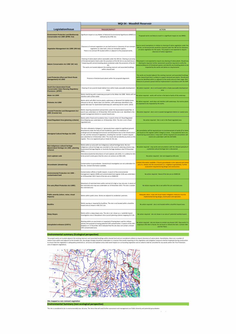
TRIGGER/IMPACT ACTION
Environment Protection and Biodiversity Conservation Act 1999 (EPBC Act)
Significant impact on any Matter of National Environmental Significance (MNES) as defined by the EPBC Act.
Proposed works not likely to result in a significant impact on any MNES.
Vegetation Management Act 1999 (VM Act)Clearance of remnant vegetation on any land tenure or clearance of non‐remnant
vegetation on state land, unless an exemption applies.There is no remnant RE located within or adjacent to the proposed works.
Due to recent exemptions in relation to clearing of native vegetation under the VM Act, no formal permits would be required under the VM Act for clearance of native vegetation for the works. The project is not expected to require
clearance of native vegetation.
Nature Conservation Act 1992 (NC Act)
Clearing of native plants where assessable under the VM Act. Clearing or pruning of threatened plants listed under the provisions of the NC Act on any land tenure. Tampering with animal breeding places protected under the provisions of the NC
Act.The works are located adjacent the existing reservoir and associated buildings
within cleared land.
This project is not expected to require any clearing of native plants. Should any clearing be required, further assessment would be required to verify the
presence/absence of threatened species and identify any breeding places to be impacted by the works and advise on requirements.
Land Protection (Pest and Stock Route Management) Act 2002
Presence of declared pest plants within the proposed alignment.
The works are located adjacent the existing reservoir and associated buildings within cleared land that is unlikely to support declared pest plants. Should pest plants be identified within or adjacent to the works area at a later stage, then measures to prevent spread shall be implemented in accordance with the EMP.
South East Queensland Koala Conservation State Planning Regulatory Provisions (SPRP)
Clearing of non‐juvenile koala habitat trees within koala assessable development areas.
No action required ‐ site is not located within a koala assessable development area
Water Act 2000Works interfering with a waterway pursuant to the Water Act 2000 . Works will not interfere with surface water.
No action required ‐ works will not be in the bed or banks of the waterway
Fisheries Act 1994Works which will affect marine plants, waterways or declared Fish Habitat Areas relevant to the act. Works does not interfere with waterways identified in the spatial data layer for Queensland waterways for waterway barrier works (2013)
No action required ‐ work does not interfere with waterways. No marine plants are expected to be impacted by the works.
Coastal Protection and Management Act 1995 (Coastal Act)
Works requiring assessment and permit/s under the Queensland Coastal Plan. A search was undertaken on 19 December 2013 and the site is not identified in the coastal management district or coastal hazard area.
No action required ‐ site is not in coastal management district or coastal zone
Flood Regulated Area (planning scheme)Works within Flood and Inundation Area. A search of the LCC Flood Regulated Area Mapping was undertaken on 19 December 2013. The site is not in flood regulated area
No action required ‐ Site is not in the flood regulated area
Aboriginal Cultural Heritage Act 2003
The site is allocated a Category 4 ‐ (previously been subject to significant ground disturbance) under the Duty of Care Guidelines, given the installation of underground and aboveground services and disturbance due to the infrastructure on site, and the removal of vegetation, including the root ball. A search request was submitted on 19 December 2013. The results did not identify any items on the register. This is no registered party or body for this site.
No consultation will be required prior to commencement of works (if no items are found on the register) within Category 4 areas . If any potential items are found during construction a 'stop work' will be required and consultation will
need to be undertaken with the DATSIMA
Non-indigenous cultural heritage (Queensland Heritage Act 1992 , planning scheme)
Works within an area with non‐Indigenous cultural heritage items. No non‐indigenous cultural heritage was recorded on the council's planning scheme map, Queensland Heritage Register or Australia Heritage database cited 19 December 2013
No action required ‐ stop works and consultation with the relevant party/ies if a potential cultural heritage item is discovered.
Legislation/Issue
WQI 04 - Woodhill Reservoir
)2013.
Acid sulphate soilsDisturbance/potential disturbance of acid sulphate soils (ASS). It is unlikely for ASS to be present onsite given that the area is at contours are 90m AHD. No action required ‐ site not mapped as ASS area
Groundwater (dewatering)Contamination to groundwater. Geotechnical investigation are not undertaken for the site. Limited information available.
Limited information available. If found, groundwater to be captured and tested prior to release into the environment (i.e. irrigation to grasslands). Further
assessment required during design and construction.
Environmental Protection Act 1994 - contaminated land
Contamination offsite or health impacts. A search of the environmental management register (EMR) and contaminated land register (CLR) was undertaken on 20 November 2013. None of the lots are on EMR/CLR
No action required ‐ None of the lots are on EMR/CLR
Fire ants (Plant Protection Act 1989 )Movement of restricted items within and out of a high or low risk area. A search of the restricted area map was undertaken on 19 December 2013. The site is outside the restricted area
No Action required. Site is not within fire ant restricted area
Public amenity (odour, noise, visual impacts)
Works within public areas. Works are adjacent to residential premises. Adequate odour, noise and visual impact mitigation measures must be
implemented during design, construction and operation.
BushfireWorks causing or impacted by bushfires. The site is not located within a bushfire hazard area as shown in BSC OV 3.1A.
No action required ‐ site is not located within a bushfire hazard area.
Steep SlopesWorks within a steep slopes area. The site is not shown as a Landslide hazard investigation area in Beaudesert shire council planning scheme mapping OV 3.2A.
No action required ‐ site not shown in an area of potential landslip hazard .
Unexploded ordnance (UXO's)
Working within an area known or suspected of having been used for military activity and assessed as having potential UXO contamination. A search of the UXO database on 12 December 2013 indicated that the site does not contain a known UXO contaminated area.
No action required ‐ site not shown to contain any known UXO. Stop works if a suspicious UXO item is found. Do not touch or disturb the item. Contact LWA
and the Police.
Site mapped as non‐remnant vegetation
Environmental summary (Ecological perspective)
The project works are located adjacent the existing reservoir and associated buildings within cleared land and are considered unlikely to require clearance of native plants. Nonetheless, there are a number of mature trees within and adjacent to the broader site. Any design changes should be undertaken in a manner that avoids impacting on this vegetation and mitigation measures shall be employed during construction to ensure that this vegetation is adequately protected (i.e. all access and laydown areas shall avoid impacts on surrounding vegetation and an arborist shall be consulted for any works within the Tree Protection zone of adjacent vegetation).
pp g
Environmental Summary (non ecological perspective)
The site is considered to be in environmentally low risk area. The items that will need further assessment and management are Public Amenity and potential groundwater
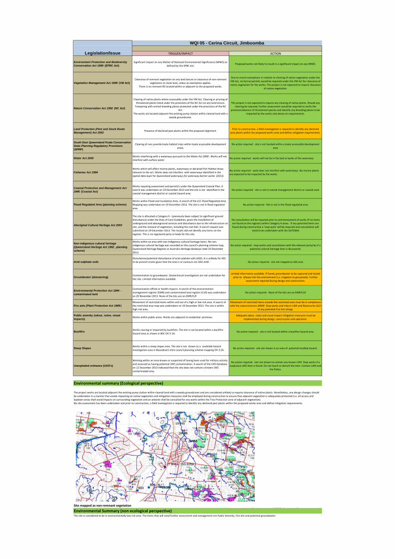
TRIGGER/IMPACT ACTION
Environment Protection and Biodiversity Conservation Act 1999 (EPBC Act)
Significant impact on any Matter of National Environmental Significance (MNES) as defined by the EPBC Act.
Proposed works not likely to result in a significant impact on any MNES.
Vegetation Management Act 1999 (VM Act)Clearance of remnant vegetation on any land tenure or clearance of non‐remnant
vegetation on state land, unless an exemption applies.There is no remnant RE located within or adjacent to the proposed works.
Due to recent exemptions in relation to clearing of native vegetation under the VM Act, no formal permits would be required under the VM Act for clearance of native vegetation for the works. The project is not expected to require clearance
of native vegetation.
Nature Conservation Act 1992 (NC Act)
Clearing of native plants where assessable under the VM Act. Clearing or pruning of threatened plants listed under the provisions of the NC Act on any land tenure. Tampering with animal breeding places protected under the provisions of the NC
Act.The works are located adjacent the existing pump station within cleared land with a
weedy groundcover.
This project is not expected to require any clearing of native plants. Should any clearing be required, further assessment would be required to verify the
presence/absence of threatened species and identify any breeding places to be impacted by the works and advise on requirements.
Land Protection (Pest and Stock Route Management) Act 2002
Presence of declared pest plants within the proposed alignment.Prior to construction, a field investigation is required to identify any declared
pest plants within the proposed works area and define mitigation requirements.
South East Queensland Koala Conservation State Planning Regulatory Provisions (SPRP)
Clearing of non‐juvenile koala habitat trees within koala assessable development areas.
No action required ‐ site is not located within a koala assessable development area
Water Act 2000Works interfering with a waterway pursuant to the Water Act 2000 . Works will not interfere with surface water.
No action required ‐ works will not be in the bed or banks of the waterway
Fisheries Act 1994Works which will affect marine plants, waterways or declared Fish Habitat Areas relevant to the act. Works does not interfere with waterways identified in the spatial data layer for Queensland waterways for waterway barrier works (2013)
No action required ‐ work does not interfere with waterways. No marine plants are expected to be impacted by the works.
Coastal Protection and Management Act 1995 (Coastal Act)
Works requiring assessment and permit/s under the Queensland Coastal Plan. A search was undertaken on 19 December 2013 and the site is not identified in the coastal management district or coastal hazard area.
No action required ‐ site is not in coastal management district or coastal zone
Flood Regulated Area (planning scheme)Works within Flood and Inundation Area. A search of the LCC Flood Regulated Area Mapping was undertaken on 19 December 2013. The site is not in flood regulated area
No action required ‐ Site is not in the flood regulated area
Aboriginal Cultural Heritage Act 2003
The site is allocated a Category 4 ‐ (previously been subject to significant ground disturbance) under the Duty of Care Guidelines, given the installation of underground and aboveground services and disturbance due to the infrastructure on site, and the removal of vegetation, including the root ball. A search request was submitted on 19 December 2013. The results did not identify any items on the register. This is no registered party or body for this site.
No consultation will be required prior to commencement of works (if no items are found on the register) within Category 4 areas . If any potential items are found during construction a 'stop work' will be required and consultation will
need to be undertaken with the DATSIMA
Non-indigenous cultural heritage (Queensland Heritage Act 1992 , planning scheme)
Works within an area with non‐Indigenous cultural heritage items. No non‐indigenous cultural heritage was recorded on the council's planning scheme map, Queensland Heritage Register or Australia Heritage database cited 19 December 2013
No action required ‐ stop works and consultation with the relevant party/ies if a potential cultural heritage item is discovered.
Legislation/Issue
WQI 05 - Cerina Circuit, Jimboomba
2013.
Acid sulphate soilsDisturbance/potential disturbance of acid sulphate soils (ASS). It is unlikely for ASS to be present onsite given that the area is at contours are 30m AHD. No action required ‐ site not mapped as ASS area
Groundwater (dewatering)Contamination to groundwater. Geotechnical investigation are not undertaken for the site. Limited information available.
Limited information available. If found, groundwater to be captured and tested prior to release into the environment (i.e. irrigation to grasslands). Further
assessment required during design and construction.
Environmental Protection Act 1994 - contaminated land
Contamination offsite or health impacts. A search of the environmental management register (EMR) and contaminated land register (CLR) was undertaken on 20 November 2013. None of the lots are on EMR/CLR
No action required ‐ None of the lots are on EMR/CLR
Fire ants (Plant Protection Act 1989 )Movement of restricted items within and out of a high or low risk area. A search of the restricted area map was undertaken on 19 December 2013. The site is within high risk area
Movement of restricted items outside the restricted area must be in compliance with the subcontractors ARMP. Stop works and inform LWA and Biosecurity QLD
of any potential Fire Ant citings.
Public amenity (odour, noise, visual impacts)
Works within public areas. Works are adjacent to residential premises. Adequate odour, noise and visual impact mitigation measures must be
implemented during design, construction and operation.
BushfireWorks causing or impacted by bushfires. The site is not located within a bushfire hazard area as shown in BSC OV 3.1A.
No action required ‐ site is not located within a bushfire hazard area.
Steep SlopesWorks within a steep slopes area. The site is not shown as a Landslide hazard investigation area in Beaudesert shire council planning scheme mapping OV 3.2A.
No action required ‐ site not shown in an area of potential landslip hazard .
Unexploded ordnance (UXO's)
Working within an area known or suspected of having been used for military activity and assessed as having potential UXO contamination. A search of the UXO database on 12 December 2013 indicated that the site does not contain a known UXO contaminated area.
No action required ‐ site not shown to contain any known UXO. Stop works if a suspicious UXO item is found. Do not touch or disturb the item. Contact LWA and
the Police.
Site mapped as non remnant vegetation
Environmental summary (Ecological perspective)
The project works are located adjacent the existing pump station within cleared land with a weedy groundcover and are considered unlikely to require clearance of native plants. Nonetheless, any design changes should be undertaken in a manner that avoids impacting on native vegetation and mitigation measures shall be employed during construction to ensure that adjacent vegetation is adequately protected (i.e. all access and laydown areas shall avoid impacts on surrounding vegetation and an arborist shall be consulted for any works within the Tree Protection zone of adjacent vegetation).No site assessment has been undertaken and prior to construction, a field investigation is required to identify any declared pest plants within the proposed works area and define mitigation requirements.
Site mapped as non‐remnant vegetation
Environmental Summary (non ecological perspective)The site is considered to be in environmentally low risk area. The items that will need further assessment and management are Public Amenity, Fire Ant and potential groundwater
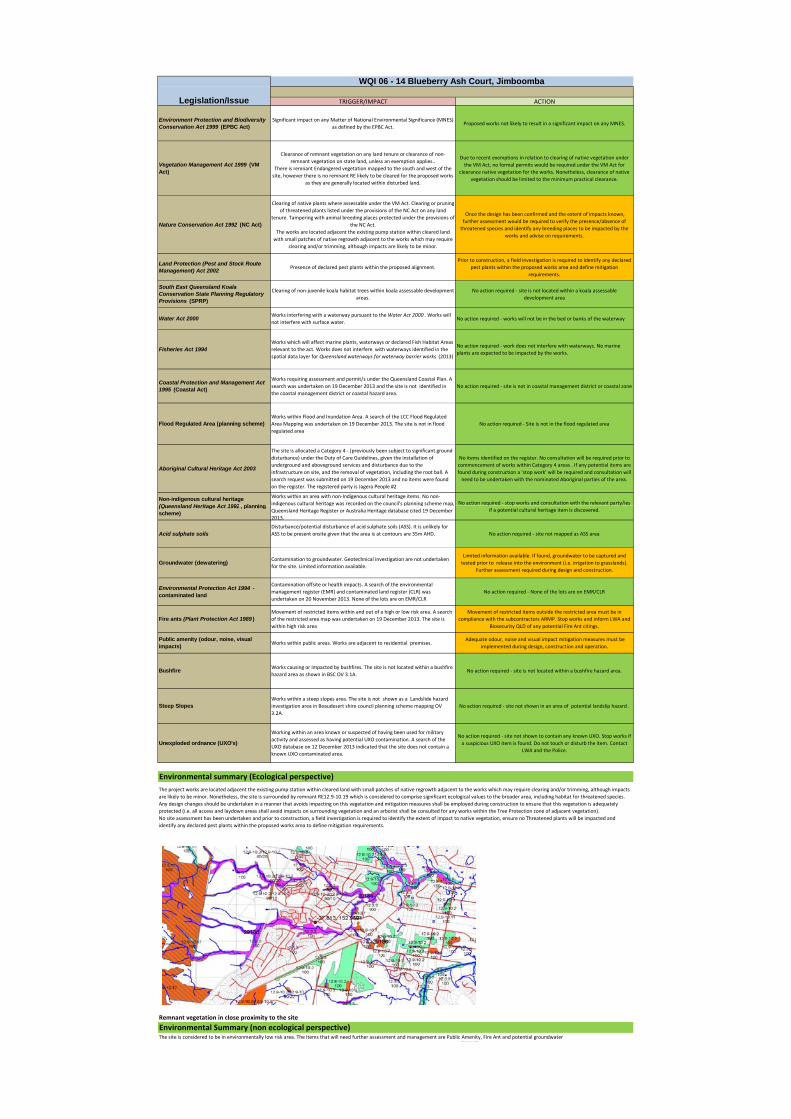
TRIGGER/IMPACT ACTION
Environment Protection and Biodiversity Conservation Act 1999 (EPBC Act)
Significant impact on any Matter of National Environmental Significance (MNES) as defined by the EPBC Act.
Proposed works not likely to result in a significant impact on any MNES.
Vegetation Management Act 1999 (VM Act)
Clearance of remnant vegetation on any land tenure or clearance of non‐remnant vegetation on state land, unless an exemption applies..
There is remnant Endangered vegetation mapped to the south and west of the site, however there is no remnant RE likely to be cleared for the proposed works
as they are generally located within disturbed land.
Due to recent exemptions in relation to clearing of native vegetation under the VM Act, no formal permits would be required under the VM Act for
clearance native vegetation for the works. Nonetheless, clearance of native vegetation should be limited to the minimum practical clearance.
Nature Conservation Act 1992 (NC Act)
Clearing of native plants where assessable under the VM Act. Clearing or pruning of threatened plants listed under the provisions of the NC Act on any land
tenure. Tampering with animal breeding places protected under the provisions of the NC Act.
The works are located adjacent the existing pump station within cleared land with small patches of native regrowth adjacent to the works which may require
clearing and/or trimming, although impacts are likely to be minor.
Once the design has been confirmed and the extent of impacts known, further assessment would be required to verify the presence/absence of threatened species and identify any breeding places to be impacted by the
works and advise on requirements.
Land Protection (Pest and Stock Route Management) Act 2002
Presence of declared pest plants within the proposed alignment.Prior to construction, a field investigation is required to identify any declared
pest plants within the proposed works area and define mitigation requirements.
South East Queensland Koala Conservation State Planning Regulatory Provisions (SPRP)
Clearing of non‐juvenile koala habitat trees within koala assessable development areas.
No action required ‐ site is not located within a koala assessable development area
Water Act 2000Works interfering with a waterway pursuant to the Water Act 2000 . Works will not interfere with surface water.
No action required ‐ works will not be in the bed or banks of the waterway
Fisheries Act 1994Works which will affect marine plants, waterways or declared Fish Habitat Areas relevant to the act. Works does not interfere with waterways identified in the spatial data layer for Queensland waterways for waterway barrier works (2013)
No action required ‐ work does not interfere with waterways. No marine plants are expected to be impacted by the works.
Coastal Protection and Management Act 1995 (Coastal Act)
Works requiring assessment and permit/s under the Queensland Coastal Plan. A search was undertaken on 19 December 2013 and the site is not identified in the coastal management district or coastal hazard area.
No action required ‐ site is not in coastal management district or coastal zone
Flood Regulated Area (planning scheme)Works within Flood and Inundation Area. A search of the LCC Flood Regulated Area Mapping was undertaken on 19 December 2013. The site is not in flood regulated area
No action required ‐ Site is not in the flood regulated area
Aboriginal Cultural Heritage Act 2003
The site is allocated a Category 4 ‐ (previously been subject to significant ground disturbance) under the Duty of Care Guidelines, given the installation of underground and aboveground services and disturbance due to the infrastructure on site, and the removal of vegetation, including the root ball. A search request was submitted on 19 December 2013 and no items were found on the register. The registered party is Jagera People #2
No items identified on the register. No consultation will be required prior to commencement of works within Category 4 areas . If any potential items are found during construction a 'stop work' will be required and consultation will need to be undertaken with the nominated Aboriginal parties of the area.
Non-indigenous cultural heritage (Queensland Heritage Act 1992 planning
Works within an area with non‐Indigenous cultural heritage items. No non‐indigenous cultural heritage was recorded on the council's planning scheme map, No action required ‐ stop works and consultation with the relevant party/ies
Legislation/Issue
WQI 06 - 14 Blueberry Ash Court, Jimboomba
(Queensland Heritage Act 1992 , planning scheme)
g g p g p,Queensland Heritage Register or Australia Heritage database cited 19 December 2013.
q p p yif a potential cultural heritage item is discovered.
Acid sulphate soilsDisturbance/potential disturbance of acid sulphate soils (ASS). It is unlikely for ASS to be present onsite given that the area is at contours are 35m AHD. No action required ‐ site not mapped as ASS area
Groundwater (dewatering)Contamination to groundwater. Geotechnical investigation are not undertaken for the site. Limited information available.
Limited information available. If found, groundwater to be captured and tested prior to release into the environment (i.e. irrigation to grasslands).
Further assessment required during design and construction.
Environmental Protection Act 1994 - contaminated land
Contamination offsite or health impacts. A search of the environmental management register (EMR) and contaminated land register (CLR) was undertaken on 20 November 2013. None of the lots are on EMR/CLR
No action required ‐ None of the lots are on EMR/CLR
Fire ants (Plant Protection Act 1989 )Movement of restricted items within and out of a high or low risk area. A search of the restricted area map was undertaken on 19 December 2013. The site is within high risk area
Movement of restricted items outside the restricted area must be in compliance with the subcontractors ARMP. Stop works and inform LWA and
Biosecurity QLD of any potential Fire Ant citings.
Public amenity (odour, noise, visual impacts)
Works within public areas. Works are adjacent to residential premises. Adequate odour, noise and visual impact mitigation measures must be
implemented during design, construction and operation.
BushfireWorks causing or impacted by bushfires. The site is not located within a bushfire hazard area as shown in BSC OV 3.1A.
No action required ‐ site is not located within a bushfire hazard area.
Steep SlopesWorks within a steep slopes area. The site is not shown as a Landslide hazard investigation area in Beaudesert shire council planning scheme mapping OV 3.2A.
No action required ‐ site not shown in an area of potential landslip hazard .
Unexploded ordnance (UXO's)
Working within an area known or suspected of having been used for military activity and assessed as having potential UXO contamination. A search of the UXO database on 12 December 2013 indicated that the site does not contain a known UXO contaminated area.
No action required ‐ site not shown to contain any known UXO. Stop works if a suspicious UXO item is found. Do not touch or disturb the item. Contact
LWA and the Police.
Environmental summary (Ecological perspective)
The project works are located adjacent the existing pump station within cleared land with small patches of native regrowth adjacent to the works which may require clearing and/or trimming, although impacts are likely to be minor. Nonetheless, the site is surrounded by remnant RE12.9‐10.19 which is considered to comprise significant ecological values to the broader area, including habitat for threatened species. Any design changes should be undertaken in a manner that avoids impacting on this vegetation and mitigation measures shall be employed during construction to ensure that this vegetation is adequately protected (i.e. all access and laydown areas shall avoid impacts on surrounding vegetation and an arborist shall be consulted for any works within the Tree Protection zone of adjacent vegetation).No site assessment has been undertaken and prior to construction, a field investigation is required to identify the extent of impact to native vegetation, ensure no Threatened plants will be impacted and identify any declared pest plants within the proposed works area to define mitigation requirements.
Remnant vegetation in close proximity to the site
Environmental Summary (non ecological perspective)The site is considered to be in environmentally low risk area. The items that will need further assessment and management are Public Amenity, Fire Ant and potential groundwater
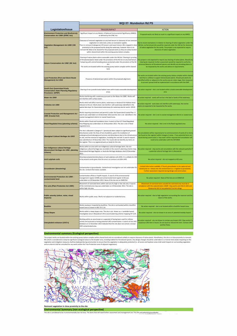
TRIGGER/IMPACT ACTION
Environment Protection and Biodiversity Conservation Act 1999 (EPBC Act)
Significant impact on any Matter of National Environmental Significance (MNES) as defined by the EPBC Act.
Proposed works not likely to result in a significant impact on any MNES.
Vegetation Management Act 1999 (VM Act)
Clearance of remnant vegetation on any land tenure or clearance of non‐remnant vegetation on state land, unless an exemption applies.
There is remnant Endangered, Of Concern and Least Concern REs mapped in close proximity to the proposed works along the waterway, however there is no
remnant RE likely to be cleared for the proposed works as they are solely located within cleared land within the existing pump station complex.
Due to recent exemptions in relation to clearing of native vegetation under the VM Act, no formal permits would be required under the VM Act for clearance of native vegetation for the works. The project is not expected to require
clearance of native vegetation.
Nature Conservation Act 1992 (NC Act)
Clearing of native plants where assessable under the VM Act. Clearing or pruning of threatened plants listed under the provisions of the NC Act on any land tenure. Tampering with animal breeding places protected under the provisions of the NC
Act.The works are located within the existing pump station complex within cleared
land.
This project is not expected to require any clearing of native plants. Should any clearing be required, further assessment would be required to verify the
presence/absence of threatened species and identify any breeding places to be impacted by the works and advise on requirements.
Land Protection (Pest and Stock Route Management) Act 2002
Presence of declared pest plants within the proposed alignment.
The works are located within the existing pump station complex within cleared land that is unlikely to support declared pest plants. Should pest plants be
identified within or adjacent to the works area at a later stage, then measures to prevent spread shall be implemented in accordance with the EMP.
South East Queensland Koala Conservation State Planning Regulatory Provisions (SPRP)
Clearing of non‐juvenile koala habitat trees within koala assessable development areas.
No action required ‐ site is not located within a koala assessable development area
Water Act 2000Works interfering with a waterway pursuant to the Water Act 2000 . Works will not interfere with surface water.
No action required ‐ works will not be in the bed or banks of the waterway
Fisheries Act 1994Works which will affect marine plants, waterways or declared Fish Habitat Areas relevant to the act. Works does not interfere with waterways identified in the spatial data layer for Queensland waterways for waterway barrier works (2013)
No action required ‐ work does not interfere with waterways. No marine plants are expected to be impacted by the works.
Coastal Protection and Management Act 1995 (Coastal Act)
Works requiring assessment and permit/s under the Queensland Coastal Plan. A search was undertaken on 19 December 2013 and the site is not identified in the coastal management district or coastal hazard area.
No action required ‐ site is not in coastal management district or coastal zone
Flood Regulated Area (planning scheme)Works within Flood and Inundation Area. A search of the LCC Flood Regulated Area Mapping was undertaken on 19 December 2013. The site is not in flood regulated area
No action required ‐ Site is not in the flood regulated area
Aboriginal Cultural Heritage Act 2003
The site is allocated a Category 4 ‐ (previously been subject to significant ground disturbance) under the Duty of Care Guidelines, given the installation of underground and aboveground services and disturbance due to the infrastructure on site, and the removal of vegetation, including the root ball. A search request was submitted on 19 December 2013. The results did not identify any items on the register. This is no registered party or body for this site.
No consultation will be required prior to commencement of works (if no items are found on the register) within Category 4 areas . If any potential items are found during construction a 'stop work' will be required and consultation will
need to be undertaken with the DATSIMA
Non-indigenous cultural heritage (Queensland Heritage Act 1992 , planning
h )
Works within an area with non‐Indigenous cultural heritage items. No non‐indigenous cultural heritage was recorded on the council's planning scheme map, Queensland Heritage Register or Australia Heritage database cited 19 December
No action required ‐ stop works and consultation with the relevant party/ies if a potential cultural heritage item is discovered.
Legislation/Issue
WQI 07- Mundoolun Rd PS
scheme)Queensland Heritage Register or Australia Heritage database cited 19 December 2013.
a potential cultural heritage item is discovered.
Acid sulphate soilsDisturbance/potential disturbance of acid sulphate soils (ASS). It is unlikely for ASS to be present onsite given that the area is at contours are 60m AHD. No action required ‐ site not mapped as ASS area
Groundwater (dewatering)Contamination to groundwater. Geotechnical investigation are not undertaken for the site. Limited information available.
Limited information available. If found, groundwater to be captured and tested prior to release into the environment (i.e. irrigation to grasslands).
Further assessment required during design and construction.
Environmental Protection Act 1994 - contaminated land
Contamination offsite or health impacts. A search of the environmental management register (EMR) and contaminated land register (CLR) was undertaken on 20 November 2013. None of the lots are on EMR/CLR
No action required ‐ None of the lots are on EMR/CLR
Fire ants (Plant Protection Act 1989 )Movement of restricted items within and out of a high or low risk area. A search of the restricted area map was undertaken on 19 December 2013. The site is within high risk area
Movement of restricted items outside the restricted area must be in compliance with the subcontractors ARMP. Stop works and inform LWA and
Biosecurity QLD of any potential Fire Ant citings.
Public amenity (odour, noise, visual impacts)
Works within public areas. Works not adjacent to residential area.No action required ‐ due to high vegetation surrounding the reservoir and the
nature of the works.
BushfireWorks causing or impacted by bushfires. The site is not located within a bushfire hazard area as shown in BSC OV 3.1A.
No action required ‐ site is not located within a bushfire hazard area.
Steep SlopesWorks within a steep slopes area. The site is not shown as a Landslide hazard investigation area in Beaudesert shire council planning scheme mapping OV 3.2A.
No action required ‐ site not shown in an area of potential landslip hazard .
Unexploded ordnance (UXO's)
Working within an area known or suspected of having been used for military activity and assessed as having potential UXO contamination. A search of the UXO database on 12 December 2013 indicated that the site does not contain a known UXO contaminated area.
No action required ‐ site not shown to contain any known UXO. Stop works if a suspicious UXO item is found. Do not touch or disturb the item. Contact LWA
and the Police.
Environmental summary (Ecological perspective)
The project works are located within the existing pump station complex within cleared land and are considered unlikely to require clearance of native plants. Nonetheless, the site is in close proximity to remnant REs which is considered to comprise significant ecological values to the broader area, including habitat for threatened species. Any design changes should be undertaken in a manner that avoids impacting on this vegetation and mitigation measures shall be employed during construction to ensure that this vegetation is adequately protected (i.e. all access and laydown areas shall avoid impacts on surrounding vegetation and an arborist shall be consulted for any works within the Tree Protection zone of adjacent vegetation).
Remnant vegetation in close proximity to the site
Environmental Summary (non ecological perspective)The site is considered to be in environmentally low risk area. The items that will need further assessment and management are Fire Ant and potential groundwater
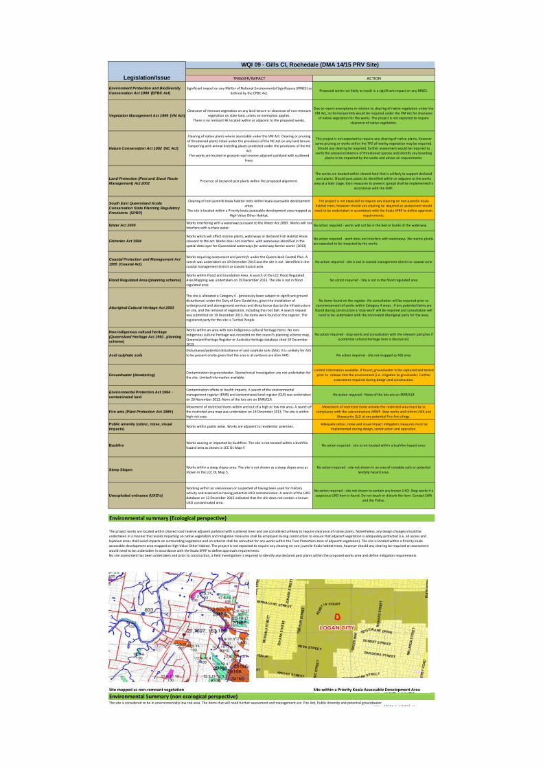
TRIGGER/IMPACT ACTION
Environment Protection and Biodiversity Conservation Act 1999 (EPBC Act)
Significant impact on any Matter of National Environmental Significance (MNES) as defined by the EPBC Act.
Proposed works not likely to result in a significant impact on any MNES.
Vegetation Management Act 1999 (VM Act)Clearance of remnant vegetation on any land tenure or clearance of non‐remnant
vegetation on state land, unless an exemption applies.There is no remnant RE located within or adjacent to the proposed works.
Due to recent exemptions in relation to clearing of native vegetation under the VM Act, no formal permits would be required under the VM Act for clearance of native vegetation for the works. The project is not expected to require
clearance of native vegetation.
Nature Conservation Act 1992 (NC Act)
Clearing of native plants where assessable under the VM Act. Clearing or pruning of threatened plants listed under the provisions of the NC Act on any land tenure. Tampering with animal breeding places protected under the provisions of the NC
Act.The works are located in grassed road reserve adjacent parkland with scattered
trees.
This project is not expected to require any clearing of native plants, however some pruning or works within the TPZ of nearby vegetation may be required. Should any clearing be required, further assessment would be required to
verify the presence/absence of threatened species and identify any breeding places to be impacted by the works and advise on requirements.
Land Protection (Pest and Stock Route Management) Act 2002
Presence of declared pest plants within the proposed alignment.
The works are located within cleared land that is unlikely to support declared pest plants. Should pest plants be identified within or adjacent to the works
area at a later stage, then measures to prevent spread shall be implemented in accordance with the EMP.
South East Queensland Koala Conservation State Planning Regulatory Provisions (SPRP)
Clearing of non‐juvenile koala habitat trees within koala assessable development areas.
The site is located within a Priority koala assessable development area mapped as High Value Other Habitat.
The project is not expected to require any clearing on non‐juvenile Koala habitat trees, however should any clearing be required an assessment would need to be undertaken in accordance with the Koala SPRP to define approvals
requirements.
Water Act 2000Works interfering with a waterway pursuant to the Water Act 2000 . Works will not interfere with surface water.
No action required ‐ works will not be in the bed or banks of the waterway
Fisheries Act 1994Works which will affect marine plants, waterways or declared Fish Habitat Areas relevant to the act. Works does not interfere with waterways identified in the spatial data layer for Queensland waterways for waterway barrier works (2013)
No action required ‐ work does not interfere with waterways. No marine plants are expected to be impacted by the works.
Coastal Protection and Management Act 1995 (Coastal Act)
Works requiring assessment and permit/s under the Queensland Coastal Plan. A search was undertaken on 19 December 2013 and the site is not identified in the coastal management district or coastal hazard area.
No action required ‐ site is not in coastal management district or coastal zone
Flood Regulated Area (planning scheme)Works within Flood and Inundation Area. A search of the LCC Flood Regulated Area Mapping was undertaken on 19 December 2013. The site is not in flood regulated area
No action required ‐ Site is not in the flood regulated area
Aboriginal Cultural Heritage Act 2003
The site is allocated a Category 4 ‐ (previously been subject to significant ground disturbance) under the Duty of Care Guidelines, given the installation of underground and aboveground services and disturbance due to the infrastructure on site, and the removal of vegetation, including the root ball. A search request was submitted on 19 December 2013. No items were found on the register. The registered party for the site is Turrbal People
No items found on the register. No consultation will be required prior to commencement of works within Category 4 areas . If any potential items are found during construction a 'stop work' will be required and consultation will need to be undertaken with the nominated Aboriginal party for the area.
Non-indigenous cultural heritage (Queensland Heritage Act 1992 , planning scheme)
Works within an area with non‐Indigenous cultural heritage items. No non‐indigenous cultural heritage was recorded on the council's planning scheme map, Queensland Heritage Register or Australia Heritage database cited 19 December 2013.
No action required ‐ stop works and consultation with the relevant party/ies if a potential cultural heritage item is discovered.
Legislation/Issue
WQI 09 - Gills Cl, Rochedale (DMA 14/15 PRV Site)
Acid sulphate soilsDisturbance/potential disturbance of acid sulphate soils (ASS). It is unlikely for ASS to be present onsite given that the area is at contours are 65m AHD. No action required ‐ site not mapped as ASS area
Groundwater (dewatering)Contamination to groundwater. Geotechnical investigation are not undertaken for the site. Limited information available.
Limited information available. If found, groundwater to be captured and tested prior to release into the environment (i.e. irrigation to grasslands). Further
assessment required during design and construction.
Environmental Protection Act 1994 - contaminated land
Contamination offsite or health impacts. A search of the environmental management register (EMR) and contaminated land register (CLR) was undertaken on 20 November 2013. None of the lots are on EMR/CLR
No action required ‐ None of the lots are on EMR/CLR
Fire ants (Plant Protection Act 1989 )Movement of restricted items within and out of a high or low risk area. A search of the restricted area map was undertaken on 19 December 2013. The site is within high risk area
Movement of restricted items outside the restricted area must be in compliance with the subcontractors ARMP. Stop works and inform LWA and
Biosecurity QLD of any potential Fire Ant citings.
Public amenity (odour, noise, visual impacts)
Works within public areas. Works are adjacent to residential premises. Adequate odour, noise and visual impact mitigation measures must be
implemented during design, construction and operation.
BushfireWorks causing or impacted by bushfires. The site is not located within a bushfire hazard area as shown in LCC OL Map 4
No action required ‐ site is not located within a bushfire hazard area.
Steep SlopesWorks within a steep slopes area. The site is not shown as a steep slopes area as shown in the LCC OL Map 5.
No action required ‐ site not shown in an area of unstable soils or potential landslip hazard area.
Unexploded ordnance (UXO's)
Working within an area known or suspected of having been used for military activity and assessed as having potential UXO contamination. A search of the UXO database on 12 December 2013 indicated that the site does not contain a known UXO contaminated area.
No action required ‐ site not shown to contain any known UXO. Stop works if a suspicious UXO item is found. Do not touch or disturb the item. Contact LWA
and the Police.
Site mapped as non‐remnant vegetation Site within a Priority Koala Assessable Development Area
Environmental summary (Ecological perspective)
The project works are located within cleared road reserve adjacent parkland with scattered trees and are considered unlikely to require clearance of native plants. Nonetheless, any design changes should be undertaken in a manner that avoids impacting on native vegetation and mitigation measures shall be employed during construction to ensure that adjacent vegetation is adequately protected (i.e. all access and laydown areas shall avoid impacts on surrounding vegetation and an arborist shall be consulted for any works within the Tree Protection zone of adjacent vegetation). The site is located within a Priority koala assessable development area mapped as High Value Other Habitat. The project is not expected to require any clearing on non‐juvenile Koala habitat trees, however should any clearing be required an assessment would need to be undertaken in accordance with the Koala SPRP to define approvals requirements.No site assessment has been undertaken and prior to construction, a field investigation is required to identify any declared pest plants within the proposed works area and define mitigation requirements.
l ( l l )The site is considered to be in environmentally low risk area. The items that will need further assessment and management are Fire Ant, Public Amenity and potential groundwaterEnvironmental Summary (non ecological perspective)
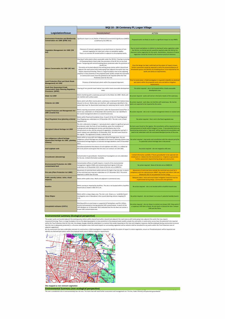
TRIGGER/IMPACT ACTION
Environment Protection and Biodiversity Conservation Act 1999 (EPBC Act)
Significant impact on any Matter of National Environmental Significance (MNES) as defined by the EPBC Act.
Proposed works not likely to result in a significant impact on any MNES.
Vegetation Management Act 1999 (VM Act)
Clearance of remnant vegetation on any land tenure or clearance of non‐remnant vegetation on state land, unless an exemption applies.
There is no remnant RE located within or adjacent to the proposed works.
Due to recent exemptions in relation to clearing of native vegetation under the VM Act, no formal permits would be required under the VM Act for
clearance native vegetation for the works. Nonetheless, clearance of native vegetation should be limited to the minimum practical clearance.
Nature Conservation Act 1992 (NC Act)
Clearing of native plants where assessable under the VM Act. Clearing or pruning of threatened plants listed under the provisions of the NC Act on any land
tenure. Tampering with animal breeding places protected under the provisions of the NC Act.
The works are located adjacent the existing pump station within cleared land adjacent the road reserve with landscaping trees adjacent the works that may require clearance/trimming. There is a large Eucalyptus tree on the adjoining
property in close proximity to the proposed water quality sample line and works or construction access have the potential to be required within the Tree
Protection Zone for this tree.
Once the design has been confirmed and the extent of impacts known, further assessment would be required to verify the presence/absence of threatened species and identify any breeding places to be impacted by the
works and advise on requirements.
Land Protection (Pest and Stock Route Management) Act 2002
Presence of declared pest plants within the proposed alignment.Prior to construction, a field investigation is required to identify any declared
pest plants within the proposed works area and define mitigation requirements.
South East Queensland Koala Conservation State Planning Regulatory Provisions (SPRP)
Clearing of non‐juvenile koala habitat trees within koala assessable development areas.
No action required ‐ site is not located within a koala assessable development area
Water Act 2000Works interfering with a waterway pursuant to the Water Act 2000 . Works will not interfere with surface water.
No action required ‐ works will not be in the bed or banks of the waterway
Fisheries Act 1994Works which will affect marine plants, waterways or declared Fish Habitat Areas relevant to the act. Works does not interfere with waterways identified in the spatial data layer for Queensland waterways for waterway barrier works (2013)
No action required ‐ work does not interfere with waterways. No marine plants are expected to be impacted by the works.
Coastal Protection and Management Act 1995 (Coastal Act)
Works requiring assessment and permit/s under the Queensland Coastal Plan. A search was undertaken on 19 December 2013 and the site is not identified in the coastal management district or coastal hazard area.
No action required ‐ site is not in coastal management district or coastal zone
Flood Regulated Area (planning scheme)Works within Flood and Inundation Area. A search of the LCC Flood Regulated Area Mapping was undertaken on 19 December 2013. The site is not in flood regulated area
No action required ‐ Site is not in the flood regulated area
Aboriginal Cultural Heritage Act 2003
The site is allocated a Category 4 ‐ (previously been subject to significant ground disturbance) under the Duty of Care Guidelines, given the installation of underground and aboveground services and disturbance due to the infrastructure on site, and the removal of vegetation, including the root ball. A search request was submitted on 19 December 2013. No items were found on the register. The registered CH body is Jabree Pty ltd
No items were found on the register. No consultation will be required prior to commencement of works within Category 4 areas . If any potential items are found during construction a 'stop work' will be required and consultation will need to be undertaken with the nominated Aboriginal parties of the area.
Non-indigenous cultural heritage (Queensland Heritage Act 1992 , planning scheme)
Works within an area with non‐Indigenous cultural heritage items. No non‐indigenous cultural heritage was recorded on the council's planning scheme map, Queensland Heritage Register or Australia Heritage database cited 19 December 2013.
No action required ‐ stop works and consultation with the relevant party/ies if a potential cultural heritage item is discovered.
Legislation/Issue
WQI 10 - 38 Centenary Pl, Logan Village
Acid sulphate soilsDisturbance/potential disturbance of acid sulphate soils (ASS). It is unlikely for ASS to be present onsite given that the area is at contours are 20m AHD. No action required ‐ site not mapped as ASS area
Groundwater (dewatering)Contamination to groundwater. Geotechnical investigation are not undertaken for the site. Limited information available.
Limited information available. If found, groundwater to be captured and tested prior to release into the environment (i.e. irrigation to grasslands).
Further assessment required during design and construction.
Environmental Protection Act 1994 - contaminated land
Contamination offsite or health impacts. A search of the environmental management register (EMR) and contaminated land register (CLR) was undertaken on 20 November 2013. None of the lots are on EMR/CLR
No action required ‐ None of the lots are on EMR/CLR
Fire ants (Plant Protection Act 1989 )Movement of restricted items within and out of a high or low risk area. A search of the restricted area map was undertaken on 19 December 2013. The entire alignment is within low risk area
Movement of restricted items outside the restricted area must be in compliance with the subcontractors ARMP. Stop works and inform LWA and
Biosecurity QLD of any potential Fire Ant citings.
Public amenity (odour, noise, visual impacts)
Works within public areas. Works are adjacent in commercial area. Adequate odour, noise and visual impact mitigation measures must be
implemented during design, construction and operation.
BushfireWorks causing or impacted by bushfires. The site is not located within a bushfire hazard area as shown in BSC OV 3.1A.
No action required ‐ site is not located within a bushfire hazard area.
Steep SlopesWorks within a steep slopes area. The site is not shown as a Landslide hazard investigation area in Beaudesert shire council planning scheme mapping OV 3.2A.
No action required ‐ site not shown in an area of potential landslip hazard .
Unexploded ordnance (UXO's)
Working within an area known or suspected of having been used for military activity and assessed as having potential UXO contamination. A search of the UXO database on 12 December 2013 indicated that the site does not contain a known UXO contaminated area.
No action required ‐ site not shown to contain any known UXO. Stop works if a suspicious UXO item is found. Do not touch or disturb the item. Contact
LWA and the Police.
Site mapped as non‐remnant vegetation
Environmental Summary (non ecological perspective)
Environmental summary (Ecological perspective)The project works are located adjacent the existing pump station within cleared land within cleared land adjacent the road reserve with landscaping trees adjacent the works that may require clearance/trimming. There is a large Eucalyptus tree on the adjoining property in close proximity to the proposed water quality sample line and works or construction access have the potential to be required within the Tree Protection Zone for this tree. Any design changes should be undertaken in a manner that avoids impacting on this tree and mitigation measures shall be employed during construction to ensure that this tree is adequately protected (i.e. all access and laydown areas shall avoid impacts on surrounding vegetation and an arborist shall be consulted for any works within the Tree Protection zone of adjacent vegetation).No site assessment has been undertaken and prior to construction, a field investigation is required to identify the extent of impact to native vegetation, ensure no Threatened plants will be impacted and identify any declared pest plants within the proposed works area to define mitigation requirements.
Environmental Summary (non ecological perspective)The site is considered to be in environmentally low risk area. The items that will need further assessment and management are Fire Ant, Public Amenity and potential groundwater
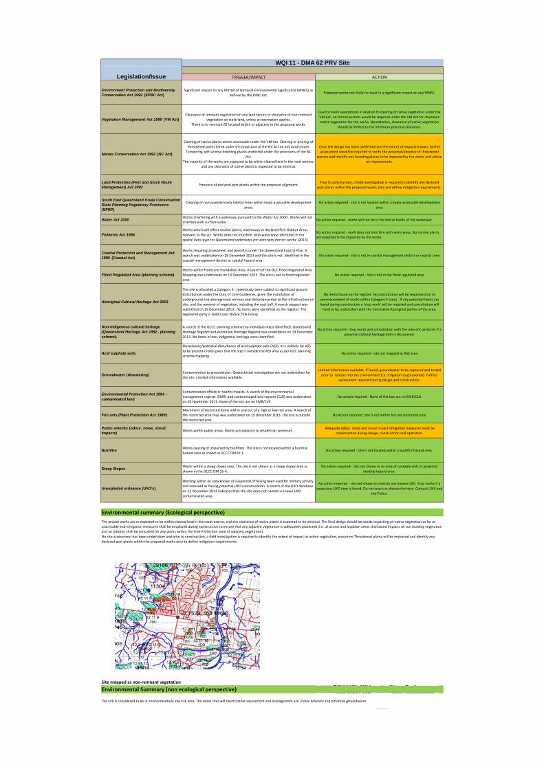
TRIGGER/IMPACT ACTION
Environment Protection and Biodiversity Conservation Act 1999 (EPBC Act)
Significant impact on any Matter of National Environmental Significance (MNES) as defined by the EPBC Act.
Proposed works not likely to result in a significant impact on any MNES.
Vegetation Management Act 1999 (VM Act)Clearance of remnant vegetation on any land tenure or clearance of non‐remnant
vegetation on state land, unless an exemption applies.There is no remnant RE located within or adjacent to the proposed works.
Due to recent exemptions in relation to clearing of native vegetation under the VM Act, no formal permits would be required under the VM Act for clearance native vegetation for the works. Nonetheless, clearance of native vegetation
should be limited to the minimum practical clearance.
Nature Conservation Act 1992 (NC Act)
Clearing of native plants where assessable under the VM Act. Clearing or pruning of threatened plants listed under the provisions of the NC Act on any land tenure. Tampering with animal breeding places protected under the provisions of the NC
Act.The majority of the works are expected to be within cleared land in the road reserve,
and any clearance of native plants is expected to be minimal.
Once the design has been confirmed and the extent of impacts known, further assessment would be required to verify the presence/absence of threatened
species and identify any breeding places to be impacted by the works and advise on requirements.
Land Protection (Pest and Stock Route Management) Act 2002
Presence of declared pest plants within the proposed alignment.Prior to construction, a field investigation is required to identify any declared
pest plants within the proposed works area and define mitigation requirements.
South East Queensland Koala Conservation State Planning Regulatory Provisions (SPRP)
Clearing of non‐juvenile koala habitat trees within koala assessable development areas.
No action required ‐ site is not located within a koala assessable development area
Water Act 2000Works interfering with a waterway pursuant to the Water Act 2000 . Works will not interfere with surface water.
No action required ‐ works will not be in the bed or banks of the waterway
Fisheries Act 1994Works which will affect marine plants, waterways or declared Fish Habitat Areas relevant to the act. Works does not interfere with waterways identified in the spatial data layer for Queensland waterways for waterway barrier works (2013)
No action required ‐ work does not interfere with waterways. No marine plants are expected to be impacted by the works.
Coastal Protection and Management Act 1995 (Coastal Act)
Works requiring assessment and permit/s under the Queensland Coastal Plan. A search was undertaken on 19 December 2013 and the site is not identified in the coastal management district or coastal hazard area.
No action required ‐ site is not in coastal management district or coastal zone
Flood Regulated Area (planning scheme)Works within Flood and Inundation Area. A search of the GCC Flood Regulated Area Mapping was undertaken on 19 December 2013. The site is not in flood regulated area
No action required ‐ Site is not in the flood regulated area
Aboriginal Cultural Heritage Act 2003
The site is allocated a Category 4 ‐ (previously been subject to significant ground disturbance) under the Duty of Care Guidelines, given the installation of underground and aboveground services and disturbance due to the infrastructure on site, and the removal of vegetation, including the root ball. A search request was submitted on 19 December 2013 . No items were identified on the register. The registered party is Gold Coast Native Title Group
No items found on the register. No consultation will be required prior to commencement of works within Category 4 areas . If any potential items are found during construction a 'stop work' will be required and consultation will need to be undertaken with the nominated Aboriginal parties of the area.
Non-indigenous cultural heritage (Queensland Heritage Act 1992 , planning scheme)
A search of the GCCC planning scheme (no individual maps identified), Queensland Heritage Register and Australian Heritage Register was undertaken on 19 December 2013. No items of non‐Indigenous heritage were identified.
No action required ‐ stop works and consultation with the relevant party/ies if a potential cultural heritage item is discovered.
Disturbance/potential disturbance of acid sulphate soils (ASS). It is unlikely for ASS
Legislation/Issue
WQI 11 - DMA 62 PRV Site
Acid sulphate soils
/p p ( ) yto be present onsite given that the site is outside the ASS area as per GCC planning scheme mapping
No action required ‐ site not mapped as ASS area
Groundwater (dewatering)Contamination to groundwater. Geotechnical investigation are not undertaken for the site. Limited information available.
Limited information available. If found, groundwater to be captured and tested prior to release into the environment (i.e. irrigation to grasslands). Further
assessment required during design and construction.
Environmental Protection Act 1994 - contaminated land
Contamination offsite or health impacts. A search of the environmental management register (EMR) and contaminated land register (CLR) was undertaken on 20 November 2013. None of the lots are on EMR/CLR
No action required ‐ None of the lots are on EMR/CLR
Fire ants (Plant Protection Act 1989 )Movement of restricted items within and out of a high or low risk area. A search of the restricted area map was undertaken on 19 December 2013. The site is outside the restricted area
No Action required. Site is not within fire ant restricted area
Public amenity (odour, noise, visual impacts)
Works within public areas. Works are adjacent to residential premises. Adequate odour, noise and visual impact mitigation measures must be
implemented during design, construction and operation.
BushfireWorks causing or impacted by bushfires. The site is not located within a bushfire hazard area as shown in GCCC OM10‐1.
No action required ‐ site is not located within a bushfire hazard area.
Steep SlopesWorks within a steep slopes area. The site is not shown as a steep slopes area as shown in the GCCC OM 16‐4.
No action required ‐ site not shown in an area of unstable soils or potential landslip hazard area.
Unexploded ordnance (UXO's)
Working within an area known or suspected of having been used for military activity and assessed as having potential UXO contamination. A search of the UXO database on 12 December 2013 indicated that the site does not contain a known UXO contaminated area.
No action required ‐ site not shown to contain any known UXO. Stop works if a suspicious UXO item is found. Do not touch or disturb the item. Contact LWA and
the Police.
Site mapped as non‐remnant vegetation
Environmental Summary (non ecological perspective)
Environmental summary (Ecological perspective)
The project works are re expected to be within cleared land in the road reserve, and any clearance of native plants is expected to be minimal. The final design should be avoids impacting on native vegetation as far as practicable and mitigation measures shall be employed during construction to ensure that any adjacent vegetation is adequately protected (i.e. all access and laydown areas shall avoid impacts on surrounding vegetation and an arborist shall be consulted for any works within the Tree Protection zone of adjacent vegetation).No site assessment has been undertaken and prior to construction, a field investigation is required to identify the extent of impact to native vegetation, ensure no Threatened plants will be impacted and identify any declared pest plants within the proposed works area to define mitigation requirements.
The site is considered to be in environmentally low risk area. The items that will need further assessment and management are Public Amenity and potential groundwater
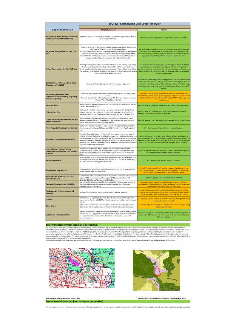
TRIGGER/IMPACT ACTION
Environment Protection and Biodiversity Conservation Act 1999 (EPBC Act)
Significant impact on any Matter of National Environmental Significance (MNES) as defined by the EPBC Act.
Proposed works not likely to result in a significant impact on any MNES.
Vegetation Management Act 1999 (VM Act)
Clearance of remnant vegetation on any land tenure or clearance of non‐remnant vegetation on state land, unless an exemption applies.
The site is surrounded by remnant Least Concern vegetation, however the proposed works are located within the paved fenced area of the existing reservoir and no
remnant RE 12.9‐10.17 will be impacted by the works. The remnant RE consists of a Eucalypt woodland that is limited to the other side of the fenceline.
Due to recent exemptions in relation to clearing of native vegetation under the VM Act, no formal permits would be required under the VM Act for
clearance native vegetation for the works. Nonetheless, clearance of native vegetation should be limited to the minimum practical clearance.
Nature Conservation Act 1992 (NC Act)
Clearing of native plants where assessable under the VM Act. Clearing or pruning of threatened plants listed under the provisions of the NC Act on any land tenure.
Tampering with animal breeding places protected under the provisions of the NC Act.The works are located within the existing reservoir site in cleared paved land, and no
clearance of native plants is expected.
This project is not expected to require any clearing of native plants. Should any clearing or trimming of the adjoining vegetation be required, further
assessment would be required to verify the presence/absence of threatened species and identify any breeding places to be impacted by the works and
advise on requirements.
Land Protection (Pest and Stock Route Management) Act 2002
Presence of declared pest plants within the proposed alignment.
The works are located adjacent the existing reservoir and associated buildings within cleared land that is unlikely to support declared pest plants. Should
pest plants be identified within or adjacent to the works area at a later stage, then measures to prevent spread shall be implemented in accordance with
the EMP.
South East Queensland Koala Conservation State Planning Regulatory Provisions (SPRP)
Clearing of non‐juvenile koala habitat trees within koala assessable development areas.
The site is located within a Priority koala assessable development area mapped as Medium Value Rehabilitation Habitat.
The project is not expected to require any clearing on non‐juvenile Koala habitat trees, however should any clearing be required an assessment would need to be undertaken in accordance with the Koala SPRP to define approvals
requirements.
Water Act 2000Works interfering with a waterway pursuant to the Water Act 2000 . Works will not interfere with surface water.
No action required ‐ works will not be in the bed or banks of the waterway
Fisheries Act 1994Works which will affect marine plants, waterways or declared Fish Habitat Areas relevant to the act. Works does not interfere with waterways identified in the spatial data layer for Queensland waterways for waterway barrier works (2013)
No action required ‐ work does not interfere with waterways. No marine plants are expected to be impacted by the works.
Coastal Protection and Management Act 1995 (Coastal Act)
Works requiring assessment and permit/s under the Queensland Coastal Plan. A search was undertaken on 19 December 2013 and the site is not identified in the coastal management district or coastal hazard area.
No action required ‐ site is not in coastal management district or coastal zone
Flood Regulated Area (planning scheme)Works within Flood and Inundation Area. A search of the LCC Flood Regulated Area Mapping was undertaken on 19 December 2013. The site is not in flood regulated area
No action required ‐ Site is not in the flood regulated area
Aboriginal Cultural Heritage Act 2003
The site is allocated a Category 4 ‐ (previously been subject to significant ground disturbance) under the Duty of Care Guidelines, given the installation of underground and aboveground services and disturbance due to the infrastructure on site, and the removal of vegetation, including the root ball. A search request was submitted on 19 December 2013. No items were registered on the register. The registered parties are Jagera People #2 and Turrbal People
No items found on the register. No consultation will be required prior to commencement of works within Category 4 areas . If any potential items are found during construction a 'stop work' will be required and consultation will need to be undertaken with the nominated Aboriginal parties of the area.
Non-indigenous cultural heritage (Q l d H it A t 1992 l i
Works within an area with non‐Indigenous cultural heritage items. No non‐indigenous cultural heritage was recorded on the council's planning scheme map No action required ‐ stop works and consultation with the relevant party/ies
Legislation/Issue
WQI 12 - Springwood Low Level Reservoir
(Queensland Heritage Act 1992 , planning scheme)
indigenous cultural heritage was recorded on the council s planning scheme map, Queensland Heritage Register or Australia Heritage database cited 19 December 2013.
No action required stop works and consultation with the relevant party/iesif a potential cultural heritage item is discovered.
Acid sulphate soils
Disturbance/potential disturbance of acid sulphate soils (ASS). It is unlikely for ASS to be present onsite given that the area is not mapped as an ASS area as shown in LCC OL Map 3. Contours are mapped as 100m AHD.
No action required ‐ site not mapped as ASS area
Groundwater (dewatering)Contamination to groundwater. Geotechnical investigation are not undertaken for the site. Limited information available.
Limited information available. If found, groundwater to be captured and tested prior to release into the environment (i.e. irrigation to grasslands).
Further assessment required during design and construction.
Environmental Protection Act 1994 - contaminated land
Contamination offsite or health impacts. A search of the environmental management register (EMR) and contaminated land register (CLR) was undertaken on 20 November 2013. None of the lots are on EMR/CLR
No action required ‐ None of the lots are on EMR/CLR
Fire ants (Plant Protection Act 1989 )Movement of restricted items within and out of a high or low risk area. A search of the restricted area map was undertaken on 19 December 2013. The entire alignment is within low risk area
Movement of restricted items outside the restricted area must be in compliance with the subcontractors ARMP. Stop works and inform LWA and
Biosecurity QLD of any potential Fire Ant citings.
Public amenity (odour, noise, visual impacts)
Works within public areas. Works are adjacent to residential premises. Adequate odour, noise and visual impact mitigation measures must be implemented during design, construction and operation. However, due to nature of the work noise is the only likely impact and will be minimal
BushfireWorks causing or impacted by bushfires. The site is not located within a bushfire hazard area as shown in LCC OL Map 4, but is adjacent to a medium bushfire hazard district.
Site is directly adjacent to Medium bushfire hazard area. Management during construction may be required.
Steep SlopesWorks within a steep slopes area. The site is not shown as a steep slopes area as shown in the LCC OL Map 5. However, the site is directly adjacent to steep slope
Site is on the edge of steep slope area. To be considered and managed during design and construction
Unexploded ordnance (UXO's)
Working within an area known or suspected of having been used for military activity and assessed as having potential UXO contamination. A search of the UXO database on 12 December 2013 indicated that the site does not contain a known UXO contaminated area.
No action required ‐ site not shown to contain any known UXO. Stop works if a suspicious UXO item is found. Do not touch or disturb the item. Contact
LWA and the Police.
Site mapped as non‐remnant vegetation Site within a Priority Koala Assessable Development Area
Environmental Summary (non ecological perspective)
Environmental summary (Ecological perspective)The project works are located adjacent the existing reservoir within a paved fenced area and no clearance of native vegetation is expected to be required for the works. Nonetheless, the site is surrounded by remnant RE 12.9‐10.17 which is considered to comprise significant ecological values to the broader area, including habitat for threatened species. Any design changes should be undertaken in a manner that avoids impacting on this vegetation and mitigation measures shall be employed during construction to ensure that this vegetation is adequately protected (i.e. all access and laydown areas shall avoid impacts on surrounding vegetation and an arborist shall be consulted for any works within the Tree Protection zone of adjacent vegetation). The site is located within a Priority koala assessable development area mapped as Medium Value Rehabilitation Habitat. The project is not expected to require any clearing on non‐juvenile Koala habitat trees, however should any clearing be required an assessment would need to be undertaken in accordance with the Koala SPRP to define approvals requirements.No site assessment has been undertaken and prior to construction, a field investigation is required to identify any potential impacts to adjoining vegetation and define mitigation requirements.
Environmental Summary (non ecological perspective)
The site is considered to be in environmentally low risk area. The items that will need further assessment and management are Fire Ant, Public Amenity, bushfire hazard, steep slope area and potential groundwater
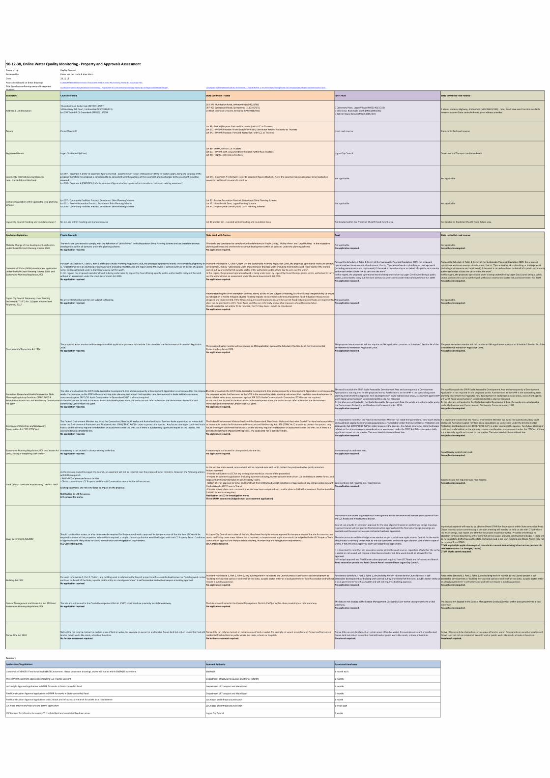
Prepared by: Hayley Gardner
Reviewed by: Pieter van der Linde & Alex Moro
Date: 28.11.13
Assessment based on these drawings: G:\7600\000\300\303 Environment\11 Projects\PDP‐90‐12‐38 Online WQ monitoring Priority 1&2 sites\Design Plans
Title Searches confirming owners & easement location:
\\Lwafapsvr01\admin\7600\000\300\303 Environment\11 Projects\PDP‐90‐12‐38 Online WQ monitoring Priority 1&2 sites\Approvals\Title Searches.pdf \\Lwafapsvr01\admin\7600\000\300\303 Environment\11 Projects\PDP‐90‐12‐38 Online WQ monitoring Priority 1&2 sites\Approvals\Indicative easement locations.docx
Site Details Council Freehold State Land with Trustee Local Road State controlled road reserve
Address & Lot description
19 Apollo Court, Cedar Vale (RP229316/997)14 Blueberry Ash Court, Jimboomba (SP107993/921)Lot 970 Thornbill Cl, Greenbank (RP819215/970)
353‐379 Mundoolun Road, Jimboomba (WD3218/89)387‐403 Springwood Road, Springwood (SL10166/171)23 Black Diamond Crescent, Bethania (RP849310/941)
0 Centenary Place, Logan Village (MISC14617/222)0 Gills Close, Rochedale South (MISC20061/31)0 Belivah Road, Belivah (MISC54685/407)
0 Mount Lindesay Highway, Jimboomba (MISC32619/131) ‐ note; don't have exact location available however assume State controlled road given address provided
Tenure Council Freehold
Lot 89 ‐ DNRM (Purpose: Park and Recreation) with LCC as TrusteesLot 171 ‐ DNRM (Purpose: Water Supply) with SEQ Distributor Retailer Authority as TrusteesLot 941 ‐ DNRM (Purpose: Park and Recreation) with LCC as Trustees
Local road reserve State controlled road reserve
Registered Owner Logan City Council (all lots)
Lot 89‐ DNRM, with LCC as TrusteesLot 171 ‐ DNRM, with SEQ Distributor Retailer Authority as TrusteesLot 941‐ DNRM, with LCC as Trustees
Logan City Council Department of Transport and Main Roads
Easements, Interests & Encumbrancesnote: relevant items listed only
Lot 997 ‐ Easement A (refer to easement figure attached ‐ easement is in favour of Beaudesert Shire for water supply, being the purpose of the proposal therefore the proposal is considered to be consistent with the purpose of the easement and no changes to the easement would be required.)Lot 970 ‐ Easement A (ENERGEX) (refer to easement figure attached ‐ proposal not considered to impact existing easement)
Lot 941 ‐ Easement A (ENERGEX) (refer to easement figure attached. Note: the easement does not appear to be located on property – will need to survey to confirm)
Not applicable Not applicable
Domain designation within applicable local planning scheme
Lot 997 ‐ Community Facilities Precinct, Beaudesert Shire Planning SchemeLot 921 ‐ Passive Recreation Precinct, Beaudesert Shire Planning SchemeLot 970 ‐ Community Facilities Precinct, Beaudesert Shire Planning Scheme
Lot 89 ‐ Passive Recreation Precinct, Beaudesert Shire Planning SchemeLot 171 ‐ Residential Zone, Logan Planning SchemeLot 941 ‐ Open Space Domain, Gold Coast Planning Scheme
Not applicable Not applicable
Logan City Council Flooding and Inundation Map 2 No lots are within Flooding and Inundation Area Lot 89 and Lot 941 ‐ Located within Flooding and Inundation Area Not located within the Predicted 1% AEP Flood Extent area. Not located in Predicted 1% AEP Flood Extent area.
Applicable legislation Private Freehold State Land with Trustee Road State controlled road reserve
Material Change of Use development application under the Gold Coast Planning Scheme 2003
The works are considered to comply with the definition of 'Utility Minor' in the Beaudesert Shire Planning Scheme and are therefore exempt development within all domains under the planning scheme. No application required.
The works are considered to comply with the definitions of 'Public Utility', 'Utility Minor' and 'Local Utilities' in the respective planning schemes and are therefore exempt development within all domains under the planning scheme. No application required.
Not applicable. No application required.
Not applicable. No application required.
Operational Works (OPW) development application under the Gold Coast Planning Scheme 2003, and Sustainable Planning Regulation 2009
Pursuant to Schedule 4, Table 4, Item 1 of the Sustainable Planning Regulation 2009, the proposed operational works are exempt development, thais, “Operational work or plumbing or drainage work (including maintenance and repair work) if the work is carried out by or on behalf of a public sector entity authorised under a State law to carry out the work”. In this regard, the proposed operational work is being undertaken by Logan City Council being a public sector, authorised to carry out the work without an assessment under the Local Government Act 2009.No application required.
Pursuant to Schedule 4, Table 4, Item 1 of the Sustainable Planning Regulation 2009, the proposed operational works are exempt development, that is, “Operational work or plumbing or drainage work (including maintenance and repair work) if the work is carried out by or on behalf of a public sector entity authorised under a State law to carry out the work”. In this regard, the proposed operational work is being undertaken by Logan City Council being a public sector, authorised to carry out the work without an assessment under the Local Government Act 2009.No application required.
Pursuant to Schedule 4, Table 4, Item 1 of the Sustainable Planning Regulation 2009, the proposed operational works are exempt development, that is, “Operational work or plumbing or drainage work (including maintenance and repair work) if the work is carried out by or on behalf of a public sector entity authorised under a State law to carry out the work”. In this regard, the proposed operational work is being undertaken by Logan City Council being a public sector, authorised to carry out the work without an assessment under the Local Government Act 2009.
No application required.
Logan City Council Temporary Local Planning
Instrument (“TLPI”) No. 1 (Logan Interim Flood
Response) 2012
No private freehold properties are subject to flooding.No application required.
Notwithstanding the OPW exemption outlined above, as two lot are subject to flooding, it is the Alliance’s responsibility to ensure our obligation is met to mitigate adverse flooding impacts to external sites by ensuring correct flood mitigation measures are designed and implemented. If the Alliance requires confirmation to ensure the correct flood mitigation methods are implemented, plans can be provided to LCC’s Flood Team and they can informally advise what measures should be undertaken.Should substantial cut and/or fill be required, the TLPI key items should be considered.No application required.
Not applicable. No application required.
Not applicable. No application required.
Environmental Protection Act 1994
The proposed water monitor will not require an ERA application pursuant to Schedule 2 Section 64 of the Environmental Protection Regulation 2008.No application required.
The proposed water monitor will not require an ERA application pursuant to Schedule 2 Section 64 of the Environmental Protection Regulation 2008.No application required.
The proposed water monitor will not require an ERA application pursuant to Schedule 2 Section 64 of the Environmental Protection Regulation 2008.No application required.
The proposed water monitor will not require an ERA application pursuant to Schedule 2 Section 64 of the Environmental Protection Regulation 2008.No application required.
South East Queensland Koala Conservation State
Planning Regulatory Provisions (SPRP) 2010 &
Environment Protection and Biodiversity Conservation Act 1999
The sites are all outside the SPRP Koala Assessable Development Area and consequently a Development Application is not required for the proposed works. Furthermore, as the SPRP is the overarching state planning instrument that regulates new development in koala habitat value areas, assessment against SPP 2/10 Koala Conservation in Queensland 2010 is also not required. As the sites are not located in the Koala Assessable Development Area, the works are not referrable under the Environment Protection and Biodiversity Conservation Act 1999.No application required.
The lots are outside the SPRP Koala Assessable Development Area and consequently a Development Application is not required for the proposed works. Furthermore, as the SPRP is the overarching state planning instrument that regulates new development in koala habitat value areas, assessment against SPP 2/10 Koala Conservation in Queensland 2010 is also not required. As the site is not located in the Koala Assessable Development Area, the works are not referrable under the Environment Protection and Biodiversity Conservation Act 1999.No application required.
The road is outside the SPRP Koala Assessable Development Area and consequently a Development Application is not required for the proposed works. Furthermore, as the SPRP is the overarching state planning instrument that regulates new development in koala habitat value areas, assessment against SPP 2/10 Koala Conservation in Queensland 2010 is also not required. As the sites are not located in the Koala Assessable Development Area, the works are not referrable under the Environment Protection and Biodiversity Conservation Act 1999.No application required.
The road is outside the SPRP Koala Assessable Development Area and consequently a Development Application is not required for the proposed works. Furthermore, as the SPRP is the overarching state planning instrument that regulates new development in koala habitat value areas, assessment against SPP 2/10 Koala Conservation in Queensland 2010 is also not required. As the sites are not located in the Koala Assessable Development Area, the works are not referrable under the Environment Protection and Biodiversity Conservation Act 1999.No application required.
Environment Protection and Biodiversity
Conservation Act 1999 (EPBC Act)
The Federal Environment Minister has listed the Queensland, New South Wales and Australian Capital Territory koala populations as 'vulnerable' under the Environmental Protection and Biodiversity Act 1999 (“EPBC Act”) in order to protect the species. Any future clearing of confirmed koala habitat on the site may require consideration or assessment under the EPBC Act if there is a potentially significant impact on the species. The associated risk is considered low.No application required.
The Federal Environment Minister has listed the Queensland, New South Wales and Australian Capital Territory koala populations as 'vulnerable' under the Environmental Protection and Biodiversity Act 1999 (“EPBC Act”) in order to protect the species. Any future clearing of confirmed koala habitat on the site may require consideration or assessment under the EPBC Act if there is a potentially significant impact on the species. The associated risk is considered low.No application required.
It is important to note that the Federal Environment Minister has listed the Queensland, New South Wales and Australian Capital Territory koala populations as 'vulnerable' under the Environmental Protection and Biodiversity Act 1999 (“EPBC Act”) in order to protect the species. Any future clearing of confirmed koala habitat on the site may require consideration or assessment under the EPBC Act if there is a potentially significant impact on the species. The associated risk is considered low.No application required.
It is important to note that the Federal Environment Minister has listed the Queensland, New South Wales and Australian Capital Territory koala populations as 'vulnerable' under the Environmental Protection and Biodiversity Act 1999 (“EPBC Act”) in order to protect the species. Any future clearing of confirmed koala habitat on the site may require consideration or assessment under the EPBC Act if there is a potentially significant impact on the species. The associated risk is considered low.No application required.
Easements are not required over road reserve.No application required.
Local Government Act 2009
Should construction access, or a lay down area be required for the proposed works, approval for temporary use of the site from LCC would be required as owner of the properties. Where this is required, a simple consent application would be lodged with the LCC Property Team. Conditions of approval would likely relate to safety, maintenance and revegetation requirements.LCC Consent required.
As Logan City Council are trustee of the lots, they have the rights to issue approval for temporary use of the site for construction access and/or lay down areas. Where this is required, a simple consent application would be lodged with the LCC Property Team. Conditions of approval are likely to relate to safety, maintenance and revegetation requirements LCC Consent required.
Any construction works or geotechnical investigations within the reserve will require prior approval from the LCC Roads and Infrastructure Branch.
Council can provide ‘in principle’ approval for the pipe alignment based on preliminary design drawings. However Council will not provide final construction approval until the final set of design drawings are available and the construction sub‐contractor has been appointed.
The sub‐contractor will then lodge an excavation and/or road closure application to Council for the works. This process is normally undertaken by the sub‐contractor and would typically form part of their scope of works. If not, the LWA Approvals team can lodge these applications.
It is important to note that any excavation works within the road reserve, regardless of whether the surfaceis sealed or not sealed, will require a Road Excavation Permit. One week should be allowed for this approval. In Principal approval and Final Construction approval required from LCC Roads and Infrastructure Branch.Road excavation permit and Road Closure Permit required from Logan City Council.
In principal approval will need to be obtained from DTMR for the proposal within State‐controlled Road. Closer to construction commencing, a pre‐start meeting will need to be held on site with DTMR where the IFC drawings, SQE report and EMP for the project must be provided. Provided DTMR have no objection to these documents, a Works Permit will be issued, allowing construction to begin. If there will be no impacts to traffic flow on the state controlled road, a pre start meeting and Works Permit may not be required from DTMR. DTMR In principle application required (also obtain consent from existing infrastructure providers in
road reserve area ‐ i.e. Energex, Telstra)
DTMR Works permit required.
Building Act 1975
Pursuant to Schedule 3, Part 2, Table 1, any building work in relation to the Council project is self assessable development as "building work carried out by or on behalf of the State, a public sector entity or a local government” is self assessable and will not require a building approval.No application required.
Pursuant to Schedule 3, Part 2, Table 1, any building work in relation to the Council project is self assessable development as "building work carried out by or on behalf of the State, a public sector entity or a local government” is self assessable and will not require a building approval.No application required.
Pursuant to Schedule 3, Part 2, Table 1, any building work in relation to the Council project is self assessable development as "building work carried out by or on behalf of the State, a public sector entity or a local government” is self assessable and will not require a building approval.No application required.
Pursuant to Schedule 3, Part 2, Table 1, any building work in relation to the Council project is self assessable development as "building work carried out by or on behalf of the State, a public sector entity or a local government” is self assessable and will not require a building approval.No application required.
Coastal Management and Protection Act 1995 and
Sustainable Planning Regulation 2009
The lots are not located in the Coastal Management District (CMD) or within close proximity to a tidal waterway. No application required.
The lots are not located in the Coastal Management District (CMD) or within close proximity to a tidal waterway. No application required.
The lots are not located in the Coastal Management District (CMD) or within close proximity to a tidal waterway. No application required.
The lots are not located in the Coastal Management District (CMD) or within close proximity to a tidal waterway. No application required.
Native Title Act 1993
Native title can only be claimed on certain areas of land or water, for example on vacant or unallocated Crown land but not on residential freehold land or public works like roads, schools or hospitals. No further assessment required.
Native title can only be claimed on certain areas of land or water, for example on vacant or unallocated Crown land but not on residential freehold land or public works like roads, schools or hospitals. No further assessment required.
Native title can only be claimed on certain areas of land or water, for example on vacant or unallocated Crown land but not on residential freehold land or public works like roads, schools or hospitals. No referral required.
Native title can only be claimed on certain areas of land or water, for example on vacant or unallocated Crown land but not on residential freehold land or public works like roads, schools or hospitals. No referral required.
Summary
Relevant Authority Associated timeframe
ENERGEX 1 month each
Department of Natural Resources and Mines (DNRM) 2 months
Department of Transport and Main Roads 2 months
Department of Transport and Main Roads 2 months
LCC Roads and Infrastructure Branch 1 month
LCC Roads and Infrastructure Branch 1 week each
Logan City Council 3 weeks
LCC Road excavation/Road closure permit application
LCC Consent for infrastructure over LCC Freehold land and associated lay down areas
No waterway located near road. No application required.
In Principle Approval application to DTMR for works in State‐controlled Road
Final Construction Approval application to DTMR for works in State‐controlled Road
Final Construction Approval application to LCC Roads and Infrastructure Branch for works local road reserve
Three DNRM easement application including LCC Trustee Consent
Applications/Negotiations
Sustainable Planning Regulation 2009 and Water Act
2000 (Taking or interfering with water)
A waterway is not located in close proximity to the lots. No application required.
Land Title Act 1994 and Acquisition of Land Act 1967
As the sites are owned by Logan City Council, an easement will not be required over the proposed water monitors. However, the following actions will still be required:‐ Notify LCC of proposed access to sites‐ Obtain consent from LCC Property and Parks & Conservation teams for the infrastructure.
Existing easements are not considered to impact on the proposal.
Notification to LCC for access.
LCC consent for works.
90‐12‐38, Online Water Quality Monitoring ‐ Property and Approvals Assessment
Liaison with ENERGEX if works within ENERGEX easement. Based on current drawings, works will not be within ENERGEX easement.
A waterway is not located in close proximity to the lots. No application required.
As the lots are state owned, an easement will be required over each lot to protect the proposed water quality monitors. Actions required:‐ Provide notification to LCC for any investigation works (as trustee of the properties)‐ Prepare an easement application (including easement drawing, trustee consent letters from LCC and relevant DNRM forms) and lodge with DNRM (Undertaken by LCC Property Team).‐ Obtain offer of approval to 'Enter and Construct' from DNRM and accept conditions of approval and pay compensation amount (Undertaken by LCC Property Team).‐ Prepare survey plans once construction works have been completed and provide plans to DNRM for easement finalisation (allow $10,000 for each survey plan). Notification to LCC for investigation works
Three DNRM easements (lodged under one easement application)
Easements are not required over road reserve.No application required.
No waterway located near road. No application required.
Online Water Quality Monitoring Priority 1 and 2 Sites – Detailed Planning Document Number: 7600-000-P-REP-PL-8204
90-12-38 Date issued: 28/02/2014 Page 54 of 55 Rev: 1
Appendix D Cost Estimate
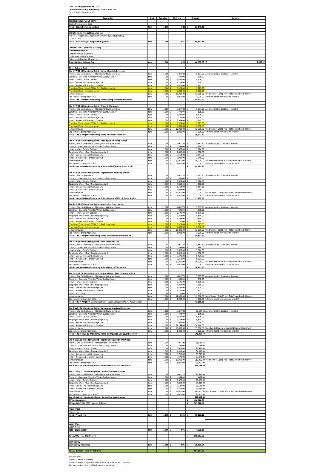
LWA ‐ Planning Estimate 90‐12‐38
Online Water Quality Monitoring ‐ Priority Sites 1 & 2
(First Principle Estimate ‐ RC)
Description Unit Quantity Unit rate Amount Remarks
DESIGN DEVELOPMENT COSTS
Design Development Cost Total ‐ Design Development Cost item 1.000 0.05 23,046.40$
Work Package ‐ Project Management
Project Management ,Supervision,Community and EstimatingQ‐Leave Levy Total ‐ Work Package ‐ Project Management item 1.000 0.12 55,311.36$
DELIVERY COST ‐ (Indirect & Direct)
Indirect Delivery Cost
Design Group ManagementEnvironmental ManagementDefects Liability Cost AllowanceTotal ‐ Indirect Delivery Cost item 1.000 0.10 46,092.80$ 4,609.28$
Direct Delivery Cost
Site 1 ‐ WQ1 03 Monitoring Point ‐ Spring Mountain Reservoir
Prelims, Site Establishment , Management & Supervision item 1.000 $5,687.50 5,687.50$ Assumed project duration = 5 weeksConstruct ‐ Concrete Plinth for Water Quality Cabinet item 1.000 898.00$ 898.00$ Install ‐ Water Quality Cabinet item 1.000 5,676.00$ 5,676.00$ Install ‐ Sample line and Discharge Line item 1.000 3,718.00$ 3,718.00$ Install ‐ Power and Telemetry Conduit item 1.000 9,471.00$ 9,471.00$ Provisional Sum ‐ Install 3000L Poly Tank(inground) item 1.000 3,923.00$ 3,923.00$ Provisional Sum ‐ Irrigation system item 1.000 2,000.00$ 2,000.00$ Instrumentation item 1.000 12,000.00$ 12,000.00$ Basic Cabinet Cost (Free + Total) based on E+H quoteSite commissioning into SCADA item 1.000 1,000.00$ 1,000.00$ Estimate based on discussion with RB. Total ‐ Site 1 ‐ WQ1 03 Monitoring Point ‐ Spring Mountain Reservoir 44,373.50$
Site 2 ‐ WQ1 04 Monitoring Point ‐ Wood Hill Reservoir
Prelims, Site Establishment , Management & Supervision item 1.000 $5,687.50 5,687.50$ Assumed project duration = 5 weeksConstruct ‐ Concrete Plinth for Water Quality Cabinet item 1.000 898.00$ 898.00$ Install ‐ Water Quality Cabinet item 1.000 5,676.00$ 5,676.00$ Install ‐ Sample line and Discharge Line item 1.000 4,114.00$ 4,114.00$ Install ‐ Power and Telemetry Conduit item 1.000 3,949.00$ 3,949.00$ Provisional Sum ‐ Install 3000L Poly Tank(inground) item 1.000 3,923.00$ 3,923.00$ Provisional Sum ‐ Irrigation system item 1.000 2,000.00$ 2,000.00$ Instrumentation item 1.000 12,000.00$ 12,000.00$ Basic Cabinet Cost (Free + Total) based on E+H quoteSite commissioning into SCADA item 1.000 1,000.00$ 1,000.00$ Estimate based on discussion with RB. Total ‐ Site 2 ‐ WQ1 04 Monitoring Point ‐ Wood Hill Reservoir 39,247.50$
Site 3 ‐ WQ1 05 Monitoring Point ‐ JMSP‐6(SPS 80) Pump Station
Prelims, Site Establishment , Management & Supervision item 1.000 $5,687.50 5,687.50$ Assumed project duration = 5 weeksConstruct ‐ Concrete Plinth for Water Quality Cabinet item 1.000 898.00$ 898.00$ Install ‐ Water Quality Cabinet item 1.000 5,676.00$ 5,676.00$ Tapping to Water Main (if no tapping exists) item 1.000 4,818.00$ 4,818.00$ Install ‐ Sample line and Discharge Line item 1.000 3,454.00$ 3,454.00$ Install ‐ Power and Telemetry Conduit item 1.000 3,949.00$ 3,949.00$ Instrumentation item 1.000 19,000.00$ 19,000.00$ Based on E+H quote including Nitrate measurementSite commissioning into SCADA item 1.000 1,000.00$ 1,000.00$ Estimate based on discussion with RB. Total ‐ Site 3 ‐ WQ1 05 Monitoring Point ‐ JMSP‐6(SPS 80) Pump Station 44,482.50$
Site 4 ‐ WQ1 06 Monitoring Point ‐ Flagstone(SPS 78) Pump Station
Prelims, Site Establishment , item 1.000 $5,687.50 5,687.50$ Assumed project duration = 5 weeksConstruct ‐ Concrete Plinth for Water Quality Cabinet item 1.000 898.00$ 898.00$ Install ‐ Water Quality Cabinet item 1.000 5,676.00$ 5,676.00$ Tapping to Water Main (if no tapping exists) item 1.000 4,818.00$ 4,818.00$ Install ‐ Sample line and Discharge Line item 1.000 3,454.00$ 3,454.00$ Install ‐ Power and Telemetry Conduit item 1.000 3,949.00$ 3,949.00$ Instrumentation item 1.000 12,000.00$ 12,000.00$ Basic Cabinet Cost (Free + Total) based on E+H quoteSite commissioning into SCADA item 1.000 1,000.00$ 1,000.00$ Estimate based on discussion with RB. Total ‐ Site 4 ‐ WQ1 06 Monitoring Point ‐ Flagstone(SPS 78) Pump Station 37,482.50$
Site 5 ‐ WQ1 07 Monitoring Point ‐ Mundoolun Pump Station
Prelims, Site Establishment , Management & Supervision item 1.000 $5,687.50 5,687.50$ Assumed project duration = 5 weeksConstruct ‐ Concrete Plinth for Water Quality Cabinet item 1.000 898.00$ 898.00$ Install ‐ Water Quality Cabinet item 1.000 5,676.00$ 5,676.00$ Tapping to Water Main (if no tapping exists) item 1.000 4,818.00$ 4,818.00$ Install ‐ Sample line and Discharge Line item 1.000 1,859.00$ 1,859.00$ Install ‐ Power and Telemetry Conduit item 1.000 770.00$ 770.00$ Provisional Sum ‐ Install 3000L Poly Tank (inground) item 1.000 3,923.00$ 3,923.00$ Provisional Sum ‐ Irrigation system item 1.000 2,000.00$ 2,000.00$ Instrumentation item 1.000 12,000.00$ 12,000.00$ Basic Cabinet Cost (Free + Total) based on E+H quoteSite commissioning into SCADA item 1.000 1,000.00$ 1,000.00$ Estimate based on discussion with RB. Total ‐ Site 5 ‐ WQ1 07 Monitoring Point ‐ Mundoolun Pump Station 38,631.50$
Site 6 ‐ WQ1 09 Monitoring Point ‐ DMA 14/15 PRV Site
Prelims, Site Establishment , Management & Supervision item 1.000 $5,687.50 5,687.50$ Assumed project duration = 5 weeksConstruct ‐ Concrete Plinth for Water Quality Cabinet item 1.000 898.00$ 898.00$ Install ‐ Water Quality Cabinet item 1.000 5,676.00$ 5,676.00$ Tapping to Water Main (if no tapping exists) item 1.000 4,818.00$ 4,818.00$ Install ‐ Sample line and Discharge Line item 1.000 5,471.00$ 5,471.00$ Install ‐ Power and Telemetry Conduit item 1.000 8,261.00$ 8,261.00$ Instrumentation item 1.000 19,000.00$ 19,000.00$ Based on E+H quote including Nitrate measurementSite commissioning into SCADA item 1.000 1,000.00$ 1,000.00$ Estimate based on discussion with RB. Total ‐ Site 6 ‐ WQ1 09 Monitoring Point ‐ DMA 14/15 PRV Site 50,811.50$
Site 7 ‐ WQ1 10 Monitoring Point ‐ Logan Village 2 (SPS 71) Pump Station
Prelims, Site Establishment , Management & Supervision item 1.000 $5,687.50 5,687.50$ Assumed project duration = 5 weeksConstruct ‐ Concrete Plinth for Water Quality Cabinet item 1.000 898.00$ 898.00$ Install ‐ Water Quality Cabinet item 1.000 5,676.00$ 5,676.00$ Tapping to Water Main (if no tapping exists) item 1.000 4,818.00$ 4,818.00$ Install ‐ Sample line and Discharge Line item 1.000 8,624.00$ 8,624.00$ Install ‐ Power and Telemetry Conduit item 1.000 3,812.00$ 3,812.00$ Install ‐ RPZ Valve item 1.000 700.00$ 700.00$ Instrumentation item 1.000 12,000.00$ 12,000.00$ Basic Cabinet Cost (Free + Total) based on E+H quoteSite commissioning into SCADA item 1.000 1,000.00$ 1,000.00$ Estimate based on discussion with RB. Total ‐ Site 7 ‐ WQ1 10 Monitoring Point ‐ Logan Village 2 (SPS 71) Pump Station 43,215.50$
Site 8‐ WQ1 12 Monitoring Point ‐ Springwood Low Level Reservoir
Prelims, Site Establishment , Management & Supervision item 1.000 $5,687.50 $5,687.50 Assumed project duration = 5 weeksConstruct ‐ Concrete Plinth for Water Quality Cabinet item 1.000 898.00$ 898.00$ Install ‐ Water Quality Cabinet item 1.000 5,676.00$ 5,676.00$ Tapping to Water Main (if no tapping exists) item 1.000 4,818.00$ 4,818.00$ Install ‐ Sample line and Discharge Line item 1.000 5,676.00$ 5,676.00$ Install ‐ Power and Telemetry Conduit item 1.000 34,144.00$ 34,144.00$ Instrumentation item 1.000 19,000.00$ 19,000.00$ Based on E+H quote including Nitrate measurementSite commissioning into SCADA item 1.000 1,000.00$ 1,000.00$ Estimate based on discussion with RB. Total ‐ Site 8‐ WQ1 12 Monitoring Point ‐ Springwood Low Level Reservoir $76,899.50
Site 9‐ WQ1 08 Monitoring Point ‐ Bethania Reticulation (DMA site)
Prelims, Site Establishment , Management & Supervision item 1.000 $5,687.50 $5,687.50Construct ‐ Concrete Plinth for Water Quality Cabinet item 1.000 898.00$ $898.00Install ‐ Water Quality Cabinet item 1.000 5,676.00$ $5,676.00Tapping to Water Main (if no tapping exists) item 1.000 4,818.00$ $4,818.00Install ‐ Sample line and Discharge Line item 1.000 3,718.00$ $3,718.00Install ‐ Power and Telemetry Conduit item 1.000 9,471.00$ $9,471.00Instrumentation item 1.000 12,000.00$ $12,000.00 Basic Cabinet Cost (Free + Total) based on E+H quoteSite commissioning into SCADA item 1.000 1,000.00$ $1,000.00Site 9‐ WQ1 08 Monitoring Point ‐ Bethania Reticulation (DMA site) $43,268.50
Site 10‐ WQ1 11 Monitoring Point ‐ Bannockburn reticulation
Prelims, Site Establishment , Management & Supervision item 1.000 $5,687.50 $5,687.50Construct ‐ Concrete Plinth for Water Quality Cabinet item 1.000 898.00$ $898.00Install ‐ Water Quality Cabinet item 1.000 5,676.00$ $5,676.00Tapping to Water Main (if no tapping exists) item 1.000 4,818.00$ $4,818.00Install ‐ Sample line and Discharge Line item 1.000 8,624.00$ $8,624.00Install ‐ Power and Telemetry Conduit item 1.000 3,812.00$ $3,812.00Instrumentation item 1.000 12,000.00$ $12,000.00 Basic Cabinet Cost (Free + Total) based on E+H quoteSite commissioning into SCADA item 1.000 1,000.00$ $1,000.00Site 10‐ WQ1 11 Monitoring Point ‐ Bannockburn reticulation $42,515.50
TOTAL ‐ Direct Cost 460,928.00$
TOTAL ‐ DELIVERY COST (Indirect & Direct) 507,020.80$
PROJECT FEE
Project Fee Total ‐ Project Fee item 1.000 0.135$ 79,026.11$
Logan Water
Logan WaterTotal ‐ Logan Water item 1.000 0.01$ 4,609.28$
TOTAL TOC ‐ (A+B+C+D+E+F) 669,013.95$
Contingency
Contingency Allowance item 1.000 0.05$ 25,351.04$
TOTAL BUDGET ‐ (A+B+C+D+E+F+G) 694,364.99$
Assumptions:Project Duration = 5 weeksProject Manager/Project Engineer = 2hours/day for project durationSite Supervision = 4 hours/day for project duration
Online Water Quality Monitoring Priority 1 and 2 Sites – Detailed Planning Document Number: 7600-000-P-REP-PL-8204
90-12-38 Date issued: 28/02/2014 Page 55 of 55 Rev: 1
Appendix E POAR Meeting Minutes
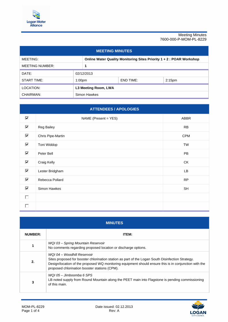
Meeting Minutes
7600-000-P-MOM-PL-8229
MOM-PL-8229 Date issued: 02.12.2013 Page 1 of 4 Rev: A
MEETING MINUTES
MEETING: Online Water Quality Monitoring Sites Priority 1 + 2 : POAR Workshop
MEETING NUMBER: 1
DATE: 02/12/2013
START TIME: 1:00pm END TIME: 2:15pm
LOCATION: L3 Meeting Room, LWA
CHAIRMAN: Simon Hawkes
ATTENDEES / APOLOGIES
NAME (Present = YES) ABBR
Reg Bailey RB
Chris Pipe-Martin CPM
Toni Widdop TW
Peter Bell PB
Craig Kelly CK
Lester Bridgham LB
Rebecca Pollard RP
Simon Hawkes SH
MINUTES
NUMBER: ITEM:
1 WQI 03 – Spring Mountain Reservoir No comments regarding proposed location or discharge options.
2.
WQI 04 – Woodhill Reservoir Sites proposed for booster chlorination station as part of the Logan South Disinfection Strategy. Design/location of the proposed WQ monitoring equipment should ensure this is in conjunction with the proposed chlorination booster stations (CPM).
3
WQI 05 – Jimboomba 6 SPS LB noted supply from Round Mountain along the PEET main into Flagstone is pending commissioning of this main.
Meeting Minutes
7600-000-P-MOM-PL-8229
MOM-PL-8229 Date issued: 02.12.2013 Page 2 of 4 Rev: A
Action: CPM to confirm whether both WQI 05 and WQI 06 are required for WQ monitoring, given the proximity of these two sites.
4
WQI 06 – Flagstone 2 SPS No comments regarding proposed location or discharge options. Action: As noted in item 3.
5
WQI 07 – Mundoolun Road WPS Site is proposed for booster chlorination station as part of the Logan South Disinfection Strategy. Design/location of the proposed WQ monitoring equipment should ensure this is in conjunction with the proposed chlorination booster stations (CPM).
6 WQI 08 – DMA 58, Bethania No comments regarding proposed location or discharge options.
7 WQI 09 – DMA 14/15, Rochedale No comments regarding proposed location or discharge options.
8.
WQI 10 – Logan Village 2 SPS RP queried whether there was an alternative location for the monitoring point which may be in a location with poorer water turnover. The current location (adjacent to the LV2 SPS) has good turnover due to the industrial demand in the area. Action: SH to investigate alternative location
9.
WQI 11 – DMA 62, Belivah
LB queried whether this site is a duplicate of the existing monitoring location in the area. The map below shows the general location of the existing monitoring point, LB to confirm exact location.
It appears that the existing monitoring location will provide representative sample of water quality in the network. The existing site should be visited to confirm whether Total Chlorine monitoring can be included in future in the existing cabinet.
Action: CPM to confirm that the existing monitoring location is maintained, and the proposed WQI 11 site be dropped from the list. Provision for future upgrade of this site to monitor Total Chlorine can be considered.
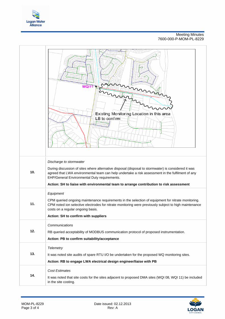
Meeting Minutes
7600-000-P-MOM-PL-8229
MOM-PL-8229 Date issued: 02.12.2013 Page 3 of 4 Rev: A
10.
Discharge to stormwater
During discussion of sites where alternative disposal (disposal to stormwater) is considered it was agreed that LWA environmental team can help undertake a risk assessment in the fulfilment of any EHP/General Environmental Duty requirements.
Action: SH to liaise with environmental team to arrange contribution to risk assessment
11.
Equipment
CPM queried ongoing maintenance requirements in the selection of equipment for nitrate monitoring. CPM noted ion selective electrodes for nitrate monitoring were previously subject to high maintenance costs on a regular ongoing basis.
Action: SH to confirm with suppliers
12.
Communications
RB queried acceptability of MODBUS communication protocol of proposed instrumentation.
Action: PB to confirm suitability/acceptance
13.
Telemetry
It was noted site audits of spare RTU I/O be undertaken for the proposed WQ monitoring sites.
Action: RB to engage LWA electrical design engineer/liaise with PB
14. Cost Estimates
It was noted that site costs for the sites adjacent to proposed DMA sites (WQI 08, WQI 11) be included in the site costing.
Meeting Minutes
7600-000-P-MOM-PL-8229
MOM-PL-8229 Date issued: 02.12.2013 Page 4 of 4 Rev: A
Action: SH to include these site costs (noting inclusion/exclusion of WQI 11 site to be confirmed)
15.
Equipment suppliers
It was agreed by stakeholders that E+H be engaged to supply instrumentation given: - E+H instrumentation preferred by Operations - E+H instrumentation offered at lowest cost - E+H can provide instrumentation to monitor all of the desired parameters Action: LWA design engineer to liaise with E+H to develop instrumentation layout within cabinet
16.