Embed Size (px)
Citation preview

LONG-TERM SOIL AND VEGETATION RECOVERY IN FIVE SEMIARID MONTANA GHOST
TOWNS
By: Paul A. Knapp
1991 Knapp, P.A. Long-term soil and vegetation recovery in five semiarid Montana ghost towns. The
Professional Geographer 43:486-499.
Made available courtesy of Taylor and Francis: http://www.tandf.co.uk/journals/
***Reprinted with permission. No further reproduction is authorized without written permission from
Taylor and Francis. This version of the document is not the version of record. Figures and/or pictures
may be missing from this format of the document.***
Abstract:
Five semiarid Montana ghost towns abandoned for more than 45 years were studied to understand better the
nature of soil and vegetation recovery following severe human impacts. Discriminant analysis was used to
interpret and classify variation among land-use intensity groups. Recovery at the five towns was strongly linked
to the degree of the initial soil disturbance, vegetation type, and precipitation. Recovery of the vegetation to
ambient conditions was far from complete in all but one town.
Key Words: vegetation recovery, soil recovery, semiarid Montana, discriminant analysis.
Article:
Use of public lands in the American West has steadily increased in recent decades (Francis and Ganzel 1984),
prompting mangers of public lands to encourage studies of the long-term effects of human-induced disturbances
on soil and vegetation recovery (National Research Council 1984). Numerous studies have shown that human
use of western public lands, such as camping (Cole 1983, 1987), off-road vehicles (Lathrop 1983; Webb 1983;
Prose and Metzger 1985), and trampling (Weaver and Dale 1978; Cole 1988) can have severe impact on soils
and vegetation. Little information exists, however, about the nature of recovery over periods greater than 40
years in the public lands of the arid and semiarid American West (e.g., McLean and Tisdale 1972; Anderson
and Holte 1981; French and Mitchell 1983).
Environments that ale damaged by human activities may follow one of four recovery scenarios after disturbance
(Cairns 1980). One recovery scenario is that the disturbed environment remains in a damaged state and shows
little sign of recovery. Damage to the environment in this instance may be so great (e.g., the loss of topsoil or
the introduction of aggressive exotics) that it may be irreversible. A second recovery scenario is that the
damaged environment resembles the predisturbance environment, but has some new, beneficial characteristics,
such as greater species diversity or exotics that have greater forage value than native species. A third recovery
scenario is that a damaged ecosystem is enhanced through management techniques to a new, but not
predisturbance, condition. A fourth scenario is that an ecosystem fully recovers and returns to its original
condition.
A few studies have examined long-term revegetation patterns following disturbance in arid public lands, but
few have estimated long-term vegetation recovery times. Most have been conducted in the Mojave Desert
where annual precipitation totals are less than 25 cm. Recovery times in that region (estimated from total short-
lived and long-lived perennial cover) were between 30 and 135 years (Webb and Wilshire 1980; Carpenter et al.
1986; Webb et al. 1988). Recovery of solely long-lived species may take several centuries (Vasek et al. 1975) if
it occurs at all (Webb and Wilshire 1980). Variation in the rate of recovery of Mojave Desert vegetation appears
to depend primarily on the intensity of soil disturbance (Vasek et al. 1975; Webb and Wilshire 1980). High-
intensity disturbances that remove topsoil reduce reserves of essential nitrogen, phosphorus, and organic carbon
(Charley and Cowling 1968). Other disturbances may accidentally introduce exotic species that can outcompete
native species for available resources (Young et al. 1987). Vegetation disturbed by farming in southern Alberta
had not returned to climax conditions 60 years after abandonment (Dormaar and Smoliak 1985). Over-grazed
ranges in southern British Columbia had, however, recovered to excellent condition within 20 to 40 years
following the exclusion of grazing (McLean and Tisdale 1972).
No studies have examined the effects of long-term soil compaction on revegetation in semiarid public lands.
Estimates of complete soil recovery from vehicular compaction and human trampling at five southwestern
Montana ghost towns, based on bulk density and macroporosity, averaged 105 years and ranged from 50 to 227
years (Knapp 1989). Disturbances that compact the soil may accelerate water erosion, diminish infiltration
rates, and place additional moisture stress on plants (Hinckley et al. 1983).
Ghost towns abandoned for more than 45 years offer an opportunity to examine the long-term consequences of
concentrated human use on ambient soil and vegetation. Understanding the consequences of new species
introduction, change in species richness or dominance, and soil compaction provides insight into the fate of the
soil and vegetation in public lands that have recently experienced heavy human pressure. This study was
designed to determine how different disturbance intensities affect recovery patterns in semiarid environments;
how soil recovery relates to vegetation recovery; and which variables best characterize the degree of recovery.
Discriminant analysis was used to evaluate the combined effects of soil and vegetation recovery and to reveal
patterns not readily apparent from examining either the soil or vegetation data alone.
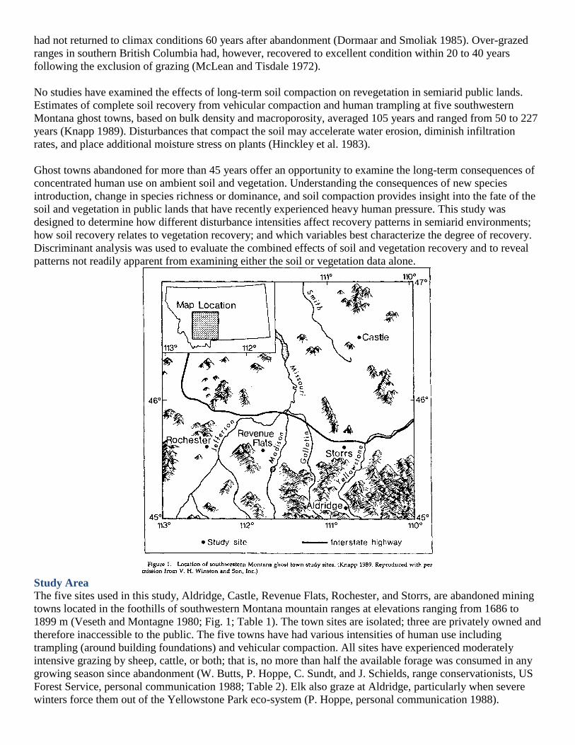
Study Area
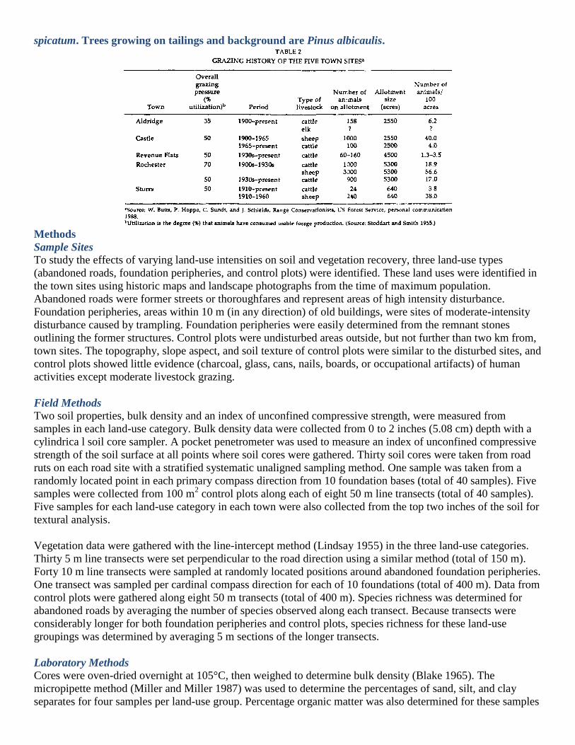
The five sites used in this study, Aldridge, Castle, Revenue Flats, Rochester, and Storrs, are abandoned mining
towns located in the foothills of southwestern Montana mountain ranges at elevations ranging from 1686 to
1899 m (Veseth and Montagne 1980; Fig. 1; Table 1). The town sites are isolated; three are privately owned and
therefore inaccessible to the public. The five towns have had various intensities of human use including
trampling (around building foundations) and vehicular compaction. All sites have experienced moderately
intensive grazing by sheep, cattle, or both; that is, no more than half the available forage was consumed in any
growing season since abandonment (W. Butts, P. Hoppe, C. Sundt, and J. Schields, range conservationists, US
Forest Service, personal communication 1988; Table 2). Elk also graze at Aldridge, particularly when severe
winters force them out of the Yellowstone Park eco-system (P. Hoppe, personal communication 1988).

Aldridge was founded in 1896 with the discovery of rich coal deposits, which were burned to form coke for use
in copper smelting. Its population peaked at 800 in 1901, but rapidly declined in 1910 when the Montana Coal
and Coke Company, which owned and operated the mines, closed because of litigation. The last resident left in
1933 (Whithorn and Whithorn 1965; Cheney 1984).
Castle, named after the castle-shaped peaks rising above the town, was founded in 1887 with the discovery of
lead ore. It reached its greatest population, 2000, in 1891. The town was short-lived, however, because it lacked
a railroad to make ore transportation economical. Castle's population rapidly declined after operations closed in
1893, and the last resident left in 1937 (Miller 1974; Cheney 1984).
Gold deposits were discovered at Revenue Flats in the middle 1880s (Fig. 2). The population grew to a
maximum of 75 in the late 1890s, then fluctuated until abandonment in the 1940s when the need for soldiers in
World War Il depleted the town of its workers (J. Willis, former resident, personal communication 1987).
Rochester, established in the 1860s with the discovery of a rich gold vein, supported a population of more than
5000 by the late 1880s. The town ultimately declined when the principal mine, continually flooded by
groundwater, could no longer be worked. The last residents of Rochester left in 1937 (Wolle 1963; Miller
1974).
The coal town of Storrs was created in 1902 to supply coke to the Anaconda copper smelters. The mines were
worked until 1910, at which time the town of 250- 350 residents was quickly shut down. The houses were
moved to Bozeman and other nearby coal mining operations (Whithorn and Whithorn 1948).
The current natural vegetation of the study sites comprises four different grassland and shrubland habitat types:
Purshia tridentata (Pursh) DC. and Agropyron spicatum Pursh at Aldridge (Putr/Agsp); Artemisia tridentata
Nutt. and Festuca idahoensis Elmer. (Geranium viscosissimum F. & M. phase) at Castle and Storrs (Artr/Feid);
Artemisia tridentata and Festuca idahoensis at Revenue Flats; and Stipa comata Trin. & Rupr. and Bouteloua
gracilis (H.B.K.) Stued. at Rochester (Stco/Bogr) (Mueggler and Stewart 1980; Table 1). The Artr/Feid habitat
type is characterized by considerably more forb cover than either the Putr/Agsp or the Stco/Bogr habitat types.
The dominant bunchgrasses are Festuca idahoensis and Agropyron spicatum. The dominant sodgrasses are
Bouteloua gracilis and the exotic Poa pratensis L., which withstand grazing and trampling well (Yaeger et al.
1976). Bouteloua gracilis is found only at Rochester, and Poa pratensis is most common at Castle and Storrs.
The dominant shrubs are Artemisia tridentata, Artemisia frigida Nutt., Chrysothamnus nauseosus (Pall.)
Britton., and Purshia tridentata. Artemisia tridentata is common at all sites.
Mean precipitation estimates (derived from nearby weather stations; James 1964) ranged from 31 cm yr-1
at the
town of Rochester to 50 cm yr-1
at the towns of Castle and Storrs. Growing season length ranged from 90 to 125
days (Ross et al. 1973). The soils are either sandy loams or clay loams, and have originated from ei-ther granitic
or volcanic parent material (Table 1).
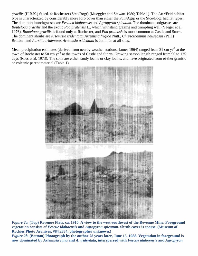
Figure 2a. (Top) Revenue Flats, ca. 1910. A view to the west-southwest of the Revenue Mine. Foreground
vegetation consists of Fescue idahoensis and Agropyron spicatum. Shrub cover is sparse. (Museum of
Rockies Photo Archives, #84.2834, photographer unknown.)
Figure 2b. (Bottom) Photograph by the author 78 years later, June 15, 1988. Vegetation in foreground is
now dominated by Artemisia cana and A. tridentata, interspersed with Fescue idahoensis and Agropyron
spicatum. Trees growing on tailings and background are Pinus albicaulis.
Methods
Sample Sites
To study the effects of varying land-use intensities on soil and vegetation recovery, three land-use types
(abandoned roads, foundation peripheries, and control plots) were identified. These land uses were identified in
the town sites using historic maps and landscape photographs from the time of maximum population.
Abandoned roads were former streets or thoroughfares and represent areas of high intensity disturbance.
Foundation peripheries, areas within 10 m (in any direction) of old buildings, were sites of moderate-intensity
disturbance caused by trampling. Foundation peripheries were easily determined from the remnant stones
outlining the former structures. Control plots were undisturbed areas outside, but not further than two km from,
town sites. The topography, slope aspect, and soil texture of control plots were similar to the disturbed sites, and
control plots showed little evidence (charcoal, glass, cans, nails, boards, or occupational artifacts) of human
activities except moderate livestock grazing.
Field Methods
Two soil properties, bulk density and an index of unconfined compressive strength, were measured from
samples in each land-use category. Bulk density data were collected from 0 to 2 inches (5.08 cm) depth with a
cylindrica l soil core sampler. A pocket penetrometer was used to measure an index of unconfined compressive
strength of the soil surface at all points where soil cores were gathered. Thirty soil cores were taken from road
ruts on each road site with a stratified systematic unaligned sampling method. One sample was taken from a
randomly located point in each primary compass direction from 10 foundation bases (total of 40 samples). Five
samples were collected from 100 m2 control plots along each of eight 50 m line transects (total of 40 samples).
Five samples for each land-use category in each town were also collected from the top two inches of the soil for
textural analysis.
Vegetation data were gathered with the line-intercept method (Lindsay 1955) in the three land-use categories.
Thirty 5 m line transects were set perpendicular to the road direction using a similar method (total of 150 m).
Forty 10 m line transects were sampled at randomly located positions around abandoned foundation peripheries.
One transect was sampled per cardinal compass direction for each of 10 foundations (total of 400 m). Data from
control plots were gathered along eight 50 m transects (total of 400 m). Species richness was determined for
abandoned roads by averaging the number of species observed along each transect. Because transects were
considerably longer for both foundation peripheries and control plots, species richness for these land-use
groupings was determined by averaging 5 m sections of the longer transects.
Laboratory Methods
Cores were oven-dried overnight at 105°C, then weighed to determine bulk density (Blake 1965). The
micropipette method (Miller and Miller 1987) was used to determine the percentages of sand, silt, and clay
separates for four samples per land-use group. Percentage organic matter was also determined for these samples

with a Leco Carbon Determinator CR12 and subsequent conversion of carbon content to organic matter
percentages (Thompson and Troeh 1973).
Statistical Methods
Canonical discriminant analysis was used to derive linear combinations of soil and vegetation variables
(canonical variates) that summarize variation among the three categories of prior land use (Klecka 1980; SAS
Institute 1985). The variables chosen for analysis were percentage of total vegetation cover, introduced grass
cover, native grass cover, species richness, unconfined soil strength, and bulk density. Multicollinearity was
avoided by omitting any variable judged redundant with others already in the model, using a threshold of simple
r = 0.8 as the selection criterion. Discriminant function analysis then used the canonical variates to predict land-
use group membership of the observations. These predictions were compared to empirical groupings to specify
the percentage of observations correctly classified.
Discriminant analysis rests on two major assumptions. The discriminating variables should be multivariate-
normally distributed, and the group covariance matrices should be equal (Klecka 1980). No land-use group was
represented by normal distributions for all variables. In addition, the da ta in this study do not have equal group
covariances, indicating that multivariate representations of the three land-use categories differ significantly in
either shape or size of their dispersion (Williams 1983). However, when the sample size is as large (390
observations) and canonical correlation values are as high (0.84) as in this study, discriminant analysis is a
robust technique (Klecka 1983). Violations of the assumptions do not invalidate statistical conclusions if the
method is used to suggest hypotheses to be tested later, or to describe patterns in the data (Klecka 1980;
Williams 1983).
Results
Derivation of Discriminant Function
Total vegetation cover ranged from 35% to 110% (overlap of shrubs and grasses made it possible to exceed
100% cover), and native grass cover ranged from less than 1% to 70% (Table 3). Introduced grass cover ranged
from 0% to 59%, and species richness values ranged from 2.8 to 9.8 species/5 m (Table 3). Bulk density ranged
between 0.94 to 1.51 g/cm3 and unconfined soil strength values 1.38 to 4.29 kg/ cm
2. Values were typically
greater at disturbed sites than at undisturbed sites for all the variables, except total vegetation and native grass
cover.
Only the first canonical discriminant function provided sufficient discriminatory power. Standardized canonical
coefficients, which give the relative importance of a variable, indicated that unconfined soil strength (1.18) and
bulk density (0.90) contributed the most to the function scores. Species richness (0.48) and cover of introduced
grasses (0.32) contributed to group separation less than the first two variables, and native grass cover (-0.14)
and total cover (-0.15) made the smallest contributions (Table 4). Structure coefficients for the function, which

indicate how closely a variable and function are related, showed a similar pattern, being highest for unconfined
soil strength (0.88) and moderate for bulk density (0.58) and species richness (0.41). Structure co-efficient
values were low for introduced grass cover (0.17), total cover (-0.08), and native grass cover (— 0.20) (Table
4). These coefficients suggest that the function is essentially a measure of soil compaction; sites with high
discriminant scores tended to have more severely compacted soils than sites with low scores. Sites with high
discriminant scores also showed a weak tendency to support more species, a greater cover of introduced grasses,
and a lower cover of native grasses, although considerably less discriminatory power was provided to the
function by these variables.
The discriminant function effectively separated land-use categories. The squared canonical correlation indicated
that 0.71 of the variance in the scores was related to the group differences. The relative percentage indicated
that 0.98 of the variance in the function related to variance in the discriminators. For the function, the Wilk's
Lambda value was 0.28 and the F-statistic was 57.6 (P < 0.01), indicating that for the data in this study a good
deal of discriminating information was derived, and that the remaining information about group differences to
be gathered from a second discriminant function was statistically spurious and therefore unnecessary.
Land-use Category Classification
The discriminant function was used to predict the land-use group membership of observations, which was
compared with actual group memberships to test the accuracy for known cases. Prediction of land-use
membership provides an additional measure of group differences that further aids interpretation. Three hundred
twenty-eight of the 390 observations (84.1%) were correctly classified into their respective land-use groups
(Table 5). Although 90% of the sites in the two disturbed classifications were correctly predicted, less than 30%
of the control plots were. All of the misclassified control plots were placed into foundation peripheries. The two
groups overlap considerably and are poorly discriminated by the variables used in this study.
The statistic tau helps assess the degree of discrimination between groups by comparing random results with
correct classifications. The tau value based on the discriminating variables indicated that 74.6% fewer errors
were made than would have occurred by random classification.
Most (83%) of the misclassified observations between foundations and controls occurred at Aldridge, Revenue
Flats, and Rochester (Table 5). At these sites the variables did not differ enough to discriminate effectively
between prior land use. Nearly complete recovery has occurred for these foundation peripheries at these town
sites.
Discussion
Recovery Pathways at Town Sites
Two soil indices, bulk density and unconfined soil strength, essentially discriminated between land-use
categories even 45 to 77 years after abandonment. Vegetation indices that provided additional discriminatory
power were limited principally to species richness and the total cover of introduced grasses. Further
combinations of vegetation variables provided less discrimination among land-use categories.
The variation in effective discrimination of land-use categories among towns reflected differences in the extent
of recovery. Towns with a greater percentage of correct classifications could be interpreted as further from
complete recovery. Greater discrimination among land-use categories was also associated with the wetter towns
(Castle, Storrs, and Aldridge) than the drier towns (Rochester and Revenue Flats). This relationship may be a
function of greater soil compaction at the wetter sites. Within arid and semi-arid regions, soil recovery can be
influenced by how wet a site is, because areas with higher annual precipitation typically have more soil organic
matter than drier areas (Millar et al. 1958; Table 1). Removal of organic matter through disturbance leads to
greater relative soil compaction increases over drier sites because the organic matter is replaced by higher
density, lower porosity, mineral particles (Knapp 1989).
Recovery time for soils and vegetation depends on the definition of recovery used. A minimum time is
estimated if recovery is defined to be reached when vegetation cover approximates that on undisturbed sites,
and soil characteristics would not mechanically or chemically (via lack of nutrients) impede plant growth. A
maximum time is estimated if full recovery is defined to be reached when soil and vegetation have returned to
predisturbance conditions. Full recovery may not be realistic, though, in arid and semi-arid environments
because plants that first colonize following disturbance may control soil moisture conditions to the exclusion of
naturally occurring long-lived perennials (Webb and Wilshire 1980), or the rate of vegetation change is so slow
that climatic and geomorphic variability may exceed recovery rates (Webb et al. 1987). In addition, bulk
densities of compacted soils may never return to their undisturbed condition (Heinonen 1977).
Comparisons of the disturbed land-use group vegetation assemblages at these five town sites to their respective
control plots suggested that two recovery scenarios had occurred (Cairns 1980). Rochester had experienced
nearly complete recovery. The Rochester foundation peripheries had the same environmental characteristics as
the surrounding control plots with no significant differences between any of the vegetation or soil variables
(Table 3). Also, the Rochester abandoned road vegetation seemed to be very similar to the control plot. Only
along the abandoned road did total cover remain significantly less (Table 3).
Comparison of soil bulk density values between disturbed and undisturbed sites at Rochester suggests that the
soils of the abandoned road have not yet recovered, and may require nearly a century for complete amelioration
(Knapp 1989). This difference in recovery times between soil compaction and vegetation suggests that
moderate soil compaction may not limit vegetation recovery. Overall, vegetation recovery in Rochester is nearly
complete 50 years after disturbance. This state of nearly complete recovery is likely a result of the dominance of
Bouteloua gracilis in the native grass cover at Rochester (Table 3). This sodgrass is highly resilient to
disturbances like grazing or trampling (Yaeger et al. 1976) and was probably not greatly affected by the town
site occupation.
A second vegetation recovery scenario (Cairns 1980) occurred at the remaining four towns. At these sites,
disturbed vegetation only partially recovered to conditions similar to the surrounding undisturbed environment.
The remaining difference, such as improved forage, may be considered beneficial. For example, significantly
more introduced grass (e.g., Poa pratensis) cover was observed at the disturbed land-use groups in Aldridge,
Castle, and Storrs, than at their respective control plots (Table 3). Al though introduced grasses have become
successfully established to the exclusion of native grasses, the introduced grasses are beneficial in that they are
highly palatable to cattle, resistant to drought, and regenerate rapidly (Yaeger et al. 1976; Plummer 1977).
Despite these advantages, the recovery process in towns other than Rochester was incomplete and fostered
deleterious changes. Many plant species existed only in the disturbed sites or in the control plots. The ecological
importance of these species to the fauna (and vice versa) varies considerably. For example, a valuable plant for
elk forage, Purshia tridentata, occurred in the Aldridge control plot, but almost nowhere in the Aldridge
disturbed areas. Instead, large stands of generally less-palatable Artemisia tridentata (Mozingo 1987) grew
there. Cynoglossum officinale L., a poisonous biennial species that effectively outcompetes most grasses for
available resources, was predominant at the disturbed land-use areas in Aldridge, Castle, and Storrs. Vegetation
recovery in these four towns was far from complete, as indicated by vegetative composition, and will likely

remain incomplete due to the competitive dominance of species (e.g., Artemisia tridentata, Cynoglossum
officinale, and Poa pratensis) that thrive in disturbed areas.
Intra-Town Site Variation
Initial land use has a strong influence on the general recovery process and can be linked to the severity of soil
compaction. The lack of discrimination between control plots and foundation peripheries at Aldridge, Revenue
Flats, and Rochester in the discriminant analysis illustrates this point (Table 5). The analysis indicated no
significant differences among these land-use categories. Not surprisingly, these were the towns where estimated
soil recovery periods were shortest, requiring approximately 50 to 60 years (Knapp 1989). Conversely,
discrimination between foundation peripheries and control plots at Castle and Storrs was considerably higher
and could be attributed to the longer soil recovery periods estimated for these sites. Similarly, the discriminant
model also effectively separated abandoned roads from control plots at all towns.
A less obvious relationship exists between soil compaction and vegetative recovery. Critical limits of bulk
density that mechanically impede plant growth range from approximately 1.40 to 1.60 g/cm3 or higher,
depending on soil structure, with coarse-grained soils having higher limiting bulk densities than fine-grained
soils (Donahue et al. 1976). By reducing infiltration rates, soil compaction can further diminish plant growth in
regions where soil moisture is the significant limiting factor (Lathrop and Rowlands 1983; Webb 1983).
Species, however, are individualistic in their response to compaction and so are not equally affected by
compacted soil. In the Mojave Desert, soil compaction was the major limiting factor to revegetation when bulk
density was in the range 1.58 to 1.71 g/cm3 (Webb and Wilshire 1980), but not in the range 1.50 to 1.65 g /cm
3
(Webb et al. 1988). None of the bulk densities in this study exceeds the critical thresholds for sandy loam soils,
the highest value being 7,51 g/cm3, Therefore, soil compaction should not physically impede root growth of the
plants, but may affect plants in other ways such as decreased infiltration.
Vegetative recovery responses did not show as strong a relationship with initial land use and appear to be
somewhat unpredictable. Differences between abandoned roads and foundation peripheries were less marked in
terms of the four vegetation variables used in the discriminant model than in terms of soil variables (Table 3).
Inconsistencies in vegetation recovery responses can be attributed to spatial variation in the thoroughness of the
mechanical removal of vegetation. Plants at the study areas were destroyed (or damaged) by grazing, trampling,
vehicular movement, and foundation construction. Plant response to these activities not only reflects the
intensity and size of the disturbance, but its ubiquity as well. Vehicular movement is particularly destructive to
the vegetation, but less intense disturbances, such as trampling, elicit the same destructive response if repeated
enough. Ten to 50 years of occupancy in these towns was sufficient time to make plant damage severe and
widespread. The majority of vegetation destruction and soil compaction likely occurred initially and then
leveled off after several months of occupation as in the Mojave Desert (Webb 1983) and southeastern Montana
(Leininger and Payne 1980).
Variable recovery responses among town sites can also be attributed to seed dispersal. Plants that survive
disturbances to large areas contribute substantially to revegetation through seed germination and vegetative
sprouting, whereas immigration of seeds and the local seed bank have only a moderate influence on
revegetation (Connell and Slatyer 1977). When disturbance removes all plants from large areas, seed
colonization then becomes the primary influence on vegetation recovery.
Conclusion
Long-term soil and vegetation recovery from human land use is a highly complex process in semiarid regions of
the American West. A combination of factors, including initial intensity of disturbance, climate, and the
introduction of exotic species, strongly influences the nature of recovery. At four of the five study sites in
southwestern Montana, recovery of either the soil or vegetation was far from complete. Only at the driest site
did vegetation characteristics approximate the control plots. Rapid recovery at this site was a function of the
resistance to disturbance of the native grass cover.
Results from this study strongly suggest that the impact of human land use on semiarid environments may often
lead to long-term changes of the soils and vegetation, and the processes of soil and vegetation recovery take far
longer than the 45 to 77 years of abandonment represented in this study. These results also suggest that the
relationship between soil recovery and vegetation recovery is not always strong.
Use of public lands in the American West will undoubtedly increase in the next several decades and impacts on
the land-scape will accompany this growth. Future studies of this type will need to address whether the results
of this study in south-western Montana hold true for other semiarid areas, and what condition of preservation
may be acceptable for the commonweal. One question that requires further research is whether the
establishment of exotic species will continue to preclude the reestablishment of native species, preventing full
recovery. A second question is far more complex. At what point, in terms of size and location, do disturbances
affect the stability of an ecosystem? If ecosystems are no more stable than a house of cards, what is the
threshold that will cause this house to collapse (Wilson 1989)? Stewards of western public lands are faced with
difficult management decisions, partly, because of a paucity of data concerning the long-term consequences of
human disturbances. Results from studies that address these questions will give the manager a better
understanding of what the future holds.
Literature Cited
Anderson, J. E., and K. E. Holte. 1981. Vegetation development over 25 years without grazing on sagebrush-
dominated rangeland in southeastern Idaho. journal of Range Management 34:25-29.
Blake, G. R. 1965. Bulk density. In Methods of Soil Analysis Part I. Physical and Mineralogical Properties, ed.
C. A. Black, 374-90. Madison, WI: American Society of Agronomy.
Cairns, J. Jr. 1980. Concluding statement. In The Recovery Process in Damaged Ecosystems, ed. J. Cairns, Jr.,
163-64. Ann Arbor, MI: Ann Arbor Science Publishers Inc.
Carpenter, D. E., M. G. Barbour, and C. J. Bahre. 1986. Old field succession in Mojave Desert scrub. Madroilo
33:111-22.
Charley, J. L., and S. W. Cowling. 1968. Changes in soil nutrient status resulting from overgrazing and their
consequences in plant communities of semi-arid areas. Proceedings, Ecological Society of Australia 3:28-38.
Cheney, R. C. 1984. Names on the Face of Montana. Missoula, MT: Mountain Press Publishing Company.
Cole, D. N. 1983. Campsite impact on three western wilderness areas. Environmental Management 7:275-88.
Cole, D. N. 1987. Recreational impacts on back-country campsites in Grand Canyon Nation-al Park, Arizona,
USA. Environmental Management 10:651-59.
Cole, D. N. 1988. Disturbance and Recovery of Trampled Montane Grasslands and Forests in Montana. Forest
Service, Research Paper INT-389. Ogden, UT: US Department of Agriculture.
Connell, J. H., and R. O. Slatyer. 1977. Mechanisms of succession in natural communities and their role in
community stability and organization. American Naturalist 111:1119- 44.
Donahue, R. L., R. H. Follett, and R. W. Tulloc. 1976. Our Soils and their Management. Danville, IL: Interstate
Publishers.
Dormaar, J. F., and S. Smoliak. 1985. Recovery of vegetative cover and soil organic matter during revegetation
of abandoned farmland in a semiarid climate. Journal of Range Management 38:487-91.
Francis, J. G., and R. Ganzel. 1984. Introduction. In Western Public Lands: The Management of Natural
Resources in a Time of Declining Federalism, ed. J. G. Francis and R. Ganzel, 1-22. Totowa, NJ: Roman and
Allenhead Press. French, N. R., and J. E. Mitchell. 1983. Long-Term Vegetation Changes in Permanent
Quadrats at the Idaho National Engineering Laboratory Site. Forest, Wildlife and Range Experiment Station
Bulletin 36. Moscow, ID: University of Idaho.
Heinonen, R. 1977. Towards normal bulk density. Soil Science Society of America Journal 41: 1214-15.
Hinckley, B. S., R. M. Iverson, and B. Hallet. 1983. Accelerated water erosion in ORV-Use Areas. In
Environmental Effects of Off-Road Vehicles, ed. R. H. Webb and H. G. Wilshire, 81-96. New York: Springer-
Verlag.
James, J. W. 1964. The effect of wind on precipitation catch on a small hill. Journal of Geo-physical Research
69:2521-24.
Klecka, W. R. 1980. Discriminant Analysis. Quantitative Applications in the Social Sciences, No. 07-109.
Beverly Hills: Sage Publications. Knapp, P. A. 1989. Natural recovery of compacted soils in semiarid Montana.
Physical Geography 10:165-75.
Lathrop, E. W. 1983. The effect of vehicle use on desert vegetation. In Environmental Effects of Off-Road
Vehicles, ed. R. H. Webb and H. G. Wilshire, 153-66. New York: Springer-Verlag.
Lathrop, E. W., and P. G. Rowlands. 1983. Plant ecology in deserts: Ari overview. In Environ-mental Effects of
Off-Road Vehicles, ed. R. H. Webb and H. G. Wilshire, 113-52. New York: Springer-Verlag.
Leininger, W. C., and G. F. Payne. 1980. The Effects of Off-road Vehicle Travel on Rangeland in Southeastern
Montana. Montana Agricultural Experiment Station Research Report 153. Bozeman, MT: Montana State
University.
Lindsay, A. A. 1955. Testing the line strip method. Ecology 36:485-94.
McLean, A., and E. W. Tisdale. 1972. Recovery rate of depleted range sites under protection from grazing.
Journal of Range Management 25:178-84.
Millar, C. E., L. M. Turk, and H. D Foth. 1958. Fundamentals of Soil Science. New York, NY: John Wiley and
Sons.
Miller, D. C. 1974. Ghost Towns of Montana. Boulder, CO: Pruett Publishing Company.
Miller, W. P., and D. M. Miller. 1987. A micro-pipette method for soil mechanical analysis. Communications in
Soil Science Plant Analysis 18: 1-15.
Montagne, C., L. C. Munn., G. A. Nielsen, I. W. Rogers, and H. E. Hunter. 1982. Soils of Montana. Montana
Agricultural Experiment Station Bulletin 744. Bozeman, MT: Montana State University.
Mozingo, H. 1987. Shrubs of the Great Basin. Reno, NV: University of Nevada Press.
Mueggler, W. F , and W. L. Stewart. 1980. Grass-land and Shrubland Habitat Types of Western Montana.
USDA Forest Service General Technical Report INT-66. Ogden, UT: US Department of Agriculture.
National Climatic Data Center. 1986. Magnetic Tape TD9640. Asheville, NC.
National Research Council, National Academy of Sciences. 1984. Introduction in Developing Strategies for
Rangeland Management, ed. B. Delworth Gardner, xix-xxi. Boulder, CO: Westview Press.
Plummer, A. P. 1977. Revegetation of disturbed intermountain sites. In Reclamation and Use of Disturbed Land
in the Southwest, ed. J. L. Thomas, 302-39. Tucson: University of Arizona Press.
Prose, D. V., an d S. K. Metzger. 1985. Recovery of Soils and Vegetation in World War II Military Base
Camps, Mojave Desert. Open File Report #85-234. Menlo Park, CA: US Geological Survey.
Ross, R. L., E. P. Murray, and J. G. Haigh. 1973. Soil and Vegetation Inventory of Near Pristine Sites,
Montana. Bozeman, MT: US Department of Agriculture-Soil Conservation Service.
SAS Institute Inc. 1985. SAS User's Guide: Statistics. Version 5 Edition. Cary, NC: SAS Institute Inc.
Stoddart, L. A., and A. D. Smith. 1955. Range Management. New York, NY: McGraw Hill.
Thompson, L. M., and F. R. Troeh. 1973. Soils and Soil Fertility. 3rd ed. New York: McGraw-Hill.
Vasek, F. C., H. B. Johnson, and D. G. Brum. 1975. Effects of power transmission lines on vegetation of the
Mojave Desert. Madrotio 23: . 114-30.
Veseth, R., and C. Montagne. 1980. Geologic Parent Materials of Montana Soils. Bulletin 721, Bozeman, MT:
US Department of Agriculture-Soil Conservation Service and Montana Agriculture Experiment Station.
Weaver, T., and D. Dale. 1978. Trampling effects of hikers, motorcycles and horses in meadows and forests.
Journal of Applied Ecology 15:451-57.
Webb, R. H. 1983. Compaction of desert soils by off-road vehicles. In Environmental Effects of Off-Road
Vehicles, ed. R. H. Webb and H. G. Wilshire, 51-80. New York: Springer-Verlag.
Webb, R. H., J. W. Steiger, and E. B. Newman. 1988. The Response of Vegetation to Disturbance
in Death Valley National Monument, California. US Geological Survey Bulletin 1793, Washington: US
Government Printing Office.
Webb, R. H., J. W. Steiger, and R. M. Turner. 1987. Dynamics of Mojave desert shrub assemblages in the
Panamint Mountains, California. Ecology 68:478-90.
Webb, R. H., and H. G. Wilshire. 1980. Recovery of soils and vegetation in a Mojave Desert Ghost Town,
Nevada, U.S.A. Journal of Arid Environments 3:291-303.
Whithorn, W., and D. Whithorn. 1948. Photo History of Livingston-Bozeman Coal Country.
Pray, MT: Whithorn and Whithorn. Whithorn, W., and D. Whithorn. 1965. A Photo History of Aldridge.
Minneapolis, MN: Acme Printing and Stationery.
Williams, B. K. 1983. Some observations on the use of discriminant analysis. Ecology 64:1283- 91.
Wolle, M. S. 1963. Montana Pay Dirt. Athens, OH: Sage/Swallow.
Wilson, E. O. 1989. Threats to biodiversity. Scientific American 261:108-16.
Yaeger, R. R., W. C. Leininger, and D. E. Ryerson. 1976. Common Montana Range Plants. Bozeman, MT:
.Montana State University.
Young, J. A., R. A. Evans, R. E. Eckert, and B. L. Kay. 1987. Cheatgrass. Rangelands 9:266- 70.