Embed Size (px)
Citation preview
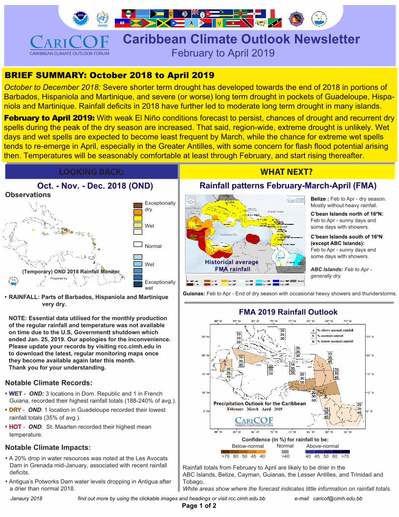
Below-normalConfidence (in %) for rainfall to be:
Normal Above-normal
Rainfall totals from February to April are likely to be drier in theABC Islands, Belize, Cayman, Guianas, the Lesser Antilles, and Trinidad and Tobago. White areas show where the forecast indicates little information on rainfall totals.
Page 1 of 2
LOOKING BACK: WHAT NEXT?
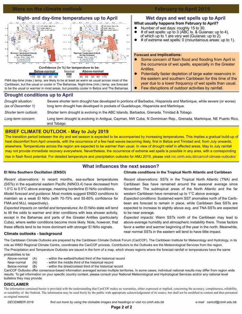
40 45 50 60 >70>70 60 50 45 40 >40
Janaury 2018 find out more by using the clickable images and headings or visit rcc.cimh.edu.bb e-mail [email protected]
Caribbean Climate Outlook NewsletterFebruary to April 2019
Observations
RAINFALL: Parts of Barbados, Hispaniola and Martinique very dry.
NOTE: Essential data utilised for the monthly productionof the regular rainfall and temperature was not available on time due to the U.S, Governmentt shutdown whichended Jan. 25, 2019. Our apologies for the inconvenience.Please update your records by visiting rcc.cimh.edu in to download the latest, regular monitoring maps oncethey become available again later this month.Thank you for your understanding.
Notable Climate Records:
Oct. - Nov. - Dec. 2018 (OND)
BRIEF SUMMARY: October 2018 to April 2019October to December 2018: Severe shorter term drought has developed towards the end of 2018 in portions of Barbados, Hispaniola and Martinique, and severe (or worse) long term drought in pockets of Guadeloupe, Hispa-niola and Martinique. Rainfall deficits in 2018 have further led to moderate long term drought in many islands. February to April 2019: With weak El Niño conditions forecast to persist, chances of drought and recurrent dryspells during the peak of the dry season are increased. That said, region-wide, extreme drought is unlikely. Wet days and wet spells are expected to become least frequent by March, while the chance for extreme wet spellstends to re-emerge in April, especially in the Greater Antilles, with some concern for flash flood potential arisingthen. Temperatures will be seasonably comfortable at least through February, and start rising thereafter.
FMA 2019 Rainfall Outlook
(Temporary) OND 2018 Rainfall MonitorPrepared by
Exceptionallydry
Wet
Normal
Wet
Exceptionallywet
Rainfall patterns February-March-April (FMA)
Historical average FMA rainfall
Belize : Feb to Apr - dry season. Mostly without heavy rainfall.C’bean Islands north of 16ºN: Feb to Apr - sunny days and some days with showers.
C’bean Islands south of 16ºN(except ABC Islands): Feb to Apr - sunny days and some days with showers.
Guianas: Feb to Apr - End of dry season with occasional heavy showers and thunderstorms.
ABC Islands: Feb to Apr -generally dry.
WET - OND: 3 locations in Dom. Republic and 1 in French Guiana, recorded their highest rainfall totals (188-240% of avg.). DRY - OND: 1 location in Guadeloupe recorded their lowest
rainfall totals (35% of avg.). HOT - OND: St. Maarten recorded their highest mean
temperature.
Notable Climate Impacts: A 20% drop in water resources was noted at the Les Avocats
Dam in Grenada mid-January, associated with recent rainfall deficits. Antigua’s Potworks Dam water levels dropping in Antigua after
a drier than normal 2018.
DECEMBER 2018 find out more by using the clickable images and headings or visit rcc.cimh.edu.bb e-mail [email protected]
Below-normal Above-normal
Page 2 of 2
El Niño Southern Oscillation (ENSO)
Recent observations: In recent months, sea-surface temperatures (SSTs) in the equatorial eastern Pacific (NINO3.4) have decreased from 1.0°C to 0.5°C above average, meaning borderline El Niño conditions.Model forecast and guidance: Most models suggest ENSO conditions to maintain as a weak El Niño (with 70-75% and 55-60% confidence for FMA and MJJ, respectively). Expected impacts on rainfall and temperatures: An El Niño state will tend to tilt the odds to warmer and drier conditions with less shower activity, except in the Bahamas and parts of the Greater Antilles (particularly Cuba), where wetter conditions become more likely. Note, however, that these effects tend to be more dominant with stronger El Niño signals.
Climate conditions in the Tropical North Atlantic and Caribbean
Recent observations: SSTs in the Tropical North Atlantic (TNA) and Caribbean Sea have remained around the seasonal average since November. The subtropical areas of the North Atlantic and the far western Caribbean have remained up to 1°C above average.Expected conditions: Sustained warm SST anomalies north of the Carib-bean are forecast to remain in place, while Caribbean Sea SSTs are expected to increase to slightly above avg. and TNA SSTs are expected to be near average. Expected impacts: Warm SSTs north of the Caribbean may lead to above-average humidity and atmospheric instability there. Those factors favor a wetter and warmer beginning of the year in the north. Meanwhile, near normal SSTs in the eastern will tend to have little impact.
More on the climate outlook February to April 2019
Forecast and Implications: Some concern of flash flood and flooding from April in the occurrence of wet spells, especially in the Greater Antilles. Potentially faster depletion of large water reservoirs in the eastern and southern Caribbean for this time of the year due to a lower frequency of wet spells than usual. Few disruptions of outdoor activities by rainfall.
Drought conditions up to April Drought situation: Severe shorter term drought has developed in portions of Barbados, Hispaniola and Martinique, while severe (or worse)(as of December 1) long term drought has developed in pockets of Guadeloupe, Hispaniola and Martinique.
Shorter term outlook: Shorter term drought is evolving in the ABC Islands, Barbados, Grenada, Trinidad & Tobago.
Long term concern: Long term drought is evolving in Antigua, Cayman, NW Cuba, N Dominican Rep., Grenada, Martinique, NE Puerto Rico, and and Tobago.
Wet days and wet spells up to April
BRIEF CLIMATE OUTLOOK - May to July 2019The transition period between the dry and wet season is expected to be accompanied by increasing temperatures. This implies a gradual build-up ofheat discomfort from April onwards, with the occurrence of a few heat waves becoming likely, first in Belize and Trinidad and, from July onwards, elsewhere. Temperatures across the region are expected to be warmer than usual. In view of drought relief in affected areas, May to July rainfall may not provide immediate recovery everywhere. Nevertheless, the occurrence of extreme wet spells is possible in any area, with a corresponding rise in flash flood potential. For detailed temperature and precipitation outlooks for AMJ 2019, please visit rcc.cimh.edu.bb/caricof-climate-outlooks/
Night- and day-time temperatures up to April
FMA day-time (max.) temp. are likely to be at least as warm as usual across most of theCaribbean, but the usual or cooler in The Bahamas. Night-time (min.) temp. are forecast to be the usual or warmer in most areas, but possibly cooler in Belize and The Bahamas.
What influences the next season?
Confidence (in %) for temperature to be:Normal
40 45 50 60 >70>70 60 50 45 40 >40
Climate outlooks - backgroundThe Caribbean Climate Outlooks are prepared by the Caribbean Climate Outlook Forum (CariCOF). The Caribbean Institute for Meteorology and Hydrology, in its role as WMO Regional Climate Centre, coordinates the CariCOF process. Contributors to the Outlooks are the Meteorological Services from the region.The Precipitation and Temperature Outlooks are issued in the form of a map, which shows regions where the forecast rainfall or temperatures have the same probabilities to be: Above-normal (A) - within the wettest/hottest third of the historical record Near-normal (N) - within the middle third of the historical record Below-normal (B) - within the driest/coldest third of the historical recordCariCOF Outlooks offer consensus-based information averaged across multiple territories. In some cases, individual national results may differ from region wide results. To get information on your specific country context, please consult your National Meteorological and Hydrological Services and/or any national level bulletins they may provide.
DISCLAIMERThe information contained herein is provided with the understanding that CariCOF makes no warranties, either expressed or implied, concerning the accuracy, completeness, reliability, or suitability of the Outlook. The information may be used freely by the public with appropriate acknowledgement of its source, but shall not be modified in content and then presented as original material.
What usually happens from February to April? Number of wet days: roughly 15 to 30. # of wet spells: up to 3 (ABC Is. & Guianas: up to 4), of which up to 1 are very wet (Guianas: up to 2). # of extreme wet spells: 0 (mountainous areas: up to 1).


![Looking back and looking forward[1]](https://img.pdfslide.net/doc/110x75/5559ad0dd8b42aa4288b511b/looking-back-and-looking-forward1.jpg)