Embed Size (px)
Citation preview
GeoConservationUK UpdateGCUK held a necessarily much delayed22nd AGM, starting at 10 am, on Saturday
27th March 2021. Of course, this had to be a virtual(Zoom!) meeting. The business matters included approv-ing the Minutes of the previous AGM (held on 19th Octo-ber, 2019) and Reports were given by the Chair, and on
Spring 2021 issue
page. 1
behalf of the Honorary Treasurer, and Newsletter Editor,together with some from member groups, etc.
The election of members to the Executive Committeewas also held. Lesley Dunlop was re-elected Chair andlikewise Dr Ian Stimpson as Honorary Secretary. GarryDawson and Tom Hose were re-elected to, and AlanHoliday remains on, the Executive Committee. Ken Ad-dison (for Geoconservation Cymru) and Mike Browne(for the Scottish Diversity Forum) were re-confirmed asEx officio Partner-Members of the Executive Committee.However, with the passing of Alan Cutler, GCUK is stillwithout a Honorary Treasurer; a volunteer for this, notreally onerous, role is actively being sought and if any-one wishes to self-nominate themselves...!
During the meeting's comments from the floor and AoBdiscussion session the extra workload borne - due toCovid matters and the lack of a Honorary Treasurer - bythe Honorary Secretary, Ian Stimpson was acknowl-edged. It was also noted that GCUK has some limitedfunds it would like to use, perhaps as match-funding, tohelp kick-start geoconservation projects - especially asthe lockdown eases. Of some related interest, theproposal to UNESCO for a 'Geodiversity Day' was re-ported; consequently, member groups should perhapsbegin to consider what they might do for this welcomeglobal event taking place on 6th October, 2022.
Tom Tom Tom Tom HoseHoseHoseHose
-------------------------------------------------------------------
International Geodiversity Day
Following the support of colleagues from around theworld, the proposal for an 'International GeodiversityDay' is now officially on the agenda for the nextUNESCO Executive Board Meeting. UNESCO MemberStates supporting the proposal include: Brazil, Colom-bia, Croatia, Italy, Oman, Poland, Portugal, the RussianFederation, the United Kingdom, Uruguay, Viet Nam,and Zimbabwe. The proposal can be at examined at:
https://unesdoc.unesco.org/ark:/48223/pf0000375688
The proposal will now go forward to a vote at the 211th
session of the Executive Board, which will take placebetween 7th - 21st April. All being well, the final decisionwill then be made at the 41st session of the UNESCOGeneral Conference in November 2021; the f irst'International Geodiversity Day' would the 6th October2022.
Over the coming weeks we will be in touch with morenews on the upcoming vote, and also a number ofonline events we will be holding to highlight the Interna-tional Geodiversity Day project. In the meantime, dorefer to the dedicated website (at: geodiversityday.org) formore information. MurrayMurrayMurrayMurray GrayGrayGrayGray
Looking to the future... and hoping that...Welcome to first 2021 issue of the three planned forthis year of the GCUK newsletter. Let's hope itheralds a better year to get outdoors and do some ofthat practical geoconservation work we all enjoy -field surveys, scrub and mud clearance... Similarly,we can hope it will soon be possible to showcasesuch important work to the public, through site visitsand events. In so doing, we can demonstrate thecommunity-asset value of the sites we manage andperhaps encourage town and parish councils in par-ticular to financially support our work.
Of course, the necessary site-monitoring work andhistorical background research (after, of course, thelibraries and archives fully re-open) will still need tobe done. Then there is the preparation of revisedand new on-site interpretation and geotrails, the up-dating (please!!!) of group web-sites and...
We might even find some much-needed time to lookat how we might better engage with the new life-blood of geoconservaton, such as earth science un-dergraduates and those newly employed in earthscience-related activities (not always obviously geo-logical!). Here we not only need to continue to buildand maintain the bridges with our local universitiesand nature conservation groups but also to look atcontacting those firms and organisations working inand around our sites; admittedly this isn't easy whenlocal decision-making isn't a feature of many largecompanies/organisations and health and safety andinsurance matters are to the fore.
Meanwhile, I must say a BIG "thank you" to thecontributors to this newsletter and follow it up withthe usual plea to groups to send me their news andto include me in their newsletter mailing list. Per-haps, also think about forwarding GEONEWS, andyour group's newsletter, to possible new membersand partner companies and organisations. Do letyour friends and even family see this newsletter;they might even forgive you for those absencesdoing work that makes a real difference. Tom Tom Tom Tom HoseHoseHoseHose

page. 2
Interesting experience with on-line field trip for London South
Bank University studentsFor several years I have been helping with a
Dorset field trip for London South Bank University
(LSBU) civil engineering students looking at coastal man-
agement issues. Owing to Covid-19 this year the March
field trip was not possible. The lecturers at LSBU organ-
ised a local film company, Pageant Productions, to film
four local geologists explaining the geology and coastal
management at five locations. The locations were
Lulworth Cove, Lyme Regis, Portland, Weymouth Bay
and West Bay.
After a reconnaissance at each of the locations with Gary
Jarman from Pageant Productions we then had filming
sessions in late February. This was very professionally
done, and Gary was excellent learning about the geology
as we went along. The weather wasn't brilliant but at
least it wasn't raining! Not only was there filming on the
ground but also use of a drone which provided some
excellent aerial cover and not normally available to the
students on a standard field trip. I covered part of Wey-
mouth Bay and West Bay.
The Weymouth Bay filming was at Redcliff, Bowleaze
Cove, Furzy Cliff, Overcombe and Preston Beach Road.
This provides very good examples of coastal manage-
ment, hold the line and no active intervention. Redcliff (see
below) has excellent examples of rotational slip due to the
combination of Corallian limestone over clay and sand-
stone. The section has been particularly active since
2016. The use of a drone produced (see right column, top)
some superb sections in the final version of the film. As
the cliff-top land has little value nothing is being done to
stop the mass-movement, so it is a good example of no
active intervention.
In Bowleaze Cove the Riviera Hotel was at risk of
damage but in 1980 coastal protection measures were
put in place with a gabion wall supporting the cliff as well
as drainage and grading of slope to reduce the risk of
landslips. Forty years on the gabions are still there but
looking their age. However, they have done a good job
for around £60,000! So here we have a good example of
'holding the line' in coastal management terms. In the
final film version, Gary included archive pictures to show
how things have changed over the years and not just
giving a 2021 view.
Furzy Cliff (see below), with Oxford Clay capped by Cor-allian sandstone is another example of no active inter-vention with rotational slip and clay flows. However,
page. 3
owing to beach replenishment further west on PrestonBeach Road, shingle has moved eastward and nowhelps to protect the base of the cliff from marine ero-sion. Overcombe and Preston Beach Road are goodexamples of 'holding the line' and where fairly dramaticimprovements have occurred helped by coastal protec-tion schemes supported by the Environment Agencyand the local council. I also covered the West Baysection with further excellent examples of coastal man-agement contrasting East Cliff with work carried out in2004 and 2019 protecting West Bay from flooding.
After the filming, Gary did an excellent editing job sothe students had four 3-hour sessions viewing the filmsand then having the opportunity to ask questions andmake comments. It also allowed me to introduce morearchive material to show how successful recent
schemes have been. AlanAlanAlanAlan HolidayHolidayHolidayHoliday (Chair, DIGS)
-------------------------------------------------------------------------
Warwickshire
GeoConservation Group
As have many member groups, the WGCG has had torun its lecture programme as an on-line 'Zoom' offering;the 17th February offering, 'Geological Time and theAnthropocene', was presented by Ian Fairchild in twoparts.
The initial PowerPoint presentation (see below) examinedthe way in which geologists establish stratigraphicgolden spikes that represent particular instants in geo-
logical history, using examples throughout the record.The particular issues from the idea of an AnthropoceneEpoch were then examined. A key idea of this is thatthe Earth System is now operating outside its rangewithin the Holocene Epoch, representing the time sincethe last Ice Age.
The second part (see next column, top) of the evening was inthe form of a scripted dialogue between the speakerand participating members; it was titled 'Introducing theAnthropocene'.
Future presentations include topics such as:
on 21st April:- ‘Henry Clifton Sorby– Sheffield’s Greatest Scientist’ byNoel Worley;
and on 19th May:- 'Iapetus NoMore – the continental collisionthat shaped Scotland' by AngusMiller.
Meanwhile, anyone interested infuller information on the Group'srecent and near-past activities canread and download its latestnewsletter (see right) at:
https://www.wgcg.co.uk/wp-
content/uploads/2021/02/WGCG_Spring_2021_Newsletter_3.pdfTAHTAHTAHTAH
-------------------------------------------------------------------------
Adieu to the Pliocene Forest
The owners of Rockhall Wood SSSI (on which the
Pliocene Forest (see below) is growing) at Sutton have
informed me that they require a lease on the site, at a
peppercorn rent, to secure the position of themselves and
of GeoSuffolk using the site. I have had amicable conver-
sations with the owner but, as GeoSuffolk's work on sites
is all voluntary, sadly we can go no further and have
withdrawn from this site.
I would like to thank all of the individuals, families and
organisations (national and international) who have con-
tributed to this climate-change interpretation project, and
Barry Hall who developed and cared for the Pliocene
Forest. There is more on the project on the web-page at
Pliocene Forest (geosuffolk.co.uk). Bob Bob Bob Bob MarkhamMarkhamMarkhamMarkham

Past Zoom Events & a Walk
Due to Covid Lockdown Number Three
Hull Geological Society (HGS) arranged
an early spring programme of roughly
fortnightly Zoom Talks (lasting about 35 minutes and
normally starting at 7.30pm) through to the end of April:
Thursday, 21st January:- evening Zoom lecture by Pro-
fessor Patrick Boylan (School of Arts and Social Sciences,
City, University of London), "New light on the Neander-
thals: music, rope-making and now an apparent geneticlink to Coronavirus".
Wednesday 27th January:- Zoom Talk, by John Connor,
“The Geomorphology of the San Andreas Fault”.
Thursday 4th February:- morning walk 'Geology in Hull'
led by Mike Horne – this event was fully booked!
Thursday 11th February:- Zoom talk, by Mike Horne,
“Geology under Hull”.
Wednesday 24th February:- Zoom seminar chaired by
Mike Horne, "Fossilisation".
Thursday 11th March:- Zoom lecture, by David Hill, "The
geology of southern Sweden".
Thursday 25th March:- Members' Evening on Zoom -
includes Helen Kitson on "Keyingham Gravel Pit" &
Mike Horne on "South Ferriby Foreshore".
Thursday 8th April:- Zoom lecture, by Mike Horne, "TheYorkshire Type Erratics collection"
Mike Mike Mike Mike HorneHorneHorneHorne (HGS Secretary)
-------------------------------------------------------------------------
Current Projects, Focused
on the CityThe city of Cambridge is the focus for three of our
current projects, all of which are aimed at encouraging
people to look at the links that cities have with their local
landscape and geology. The first
is the recent publication of the
latest in our Fen Edge Trail
walks (fenedgetrail.org), this one
starting at the famous Sedgwick
Museum of Earth Sciences (see
right) in the city centre and finish-
ing in the attractive riverside vil-
lage of Fen Ditton a few miles
away.
The route is titled ‘from revolutionary science to river-
side meadows’ and is a fascinating mixture of history,
culture, science and geology. It
takes in the exotic building stones
of monuments and historic build-
ings (including Crick and Watson’s
favourite pub!), fossil-rich floors
(and even an ammonite - see left - on
display in one) of the shopping ar-
cades and reclaimed waterside
land whilst also passing sites
where significant Quaternary research has revealed the
complex geological history of the river valley. The sec-
ond is the write up of the city’s geology for the upcoming
book ‘A Natural History of Cambridge’ (NatHistCam.org.uk) by
Cambridge Natural History Society (cnhs.org.uk). Both of
these highlight the city’s location in the Cam Valley
where the river enters the fenland basin. An important
river crossing point on the southern edge of the Fens, it
developed on the drier Pleistocene River Terraces un-
derlain by the Cretaceous Gault clay and Chalk. The
fossil-rich bed of the Cambridge Greensand lies be-
tween them and many of the fossils from it can be seen
in the Sedgwick Museum, alongside internationally im-
portant displays on the region’s Jurassic fossils.
For those not expecting to see some decent geology not
far from the city centre, a visit to Cherry Hinton East pit
is a pleasant surprise. Here, a large, now-disused Chalk
pit (see below) is a Local Geological Site. Excavated for the
Totternhoe Stone (a hard band extensively used as a
building stone) at its base, the cliffs now provide excel-
lent exposures of the Zig Zag Chalk and the Holywell
Nodular Chalk, together with the Melbourn Rock bed
and the Plenus Marls. The site is owned and managed
by The Bedfordshire, Cambridgeshire & Northampton-
shire Wildlife Trust as it is also a biological SSSI known
for its chalk flora. One of the area’s important chalk
springs issues from the Totternhoe Stone just across
the road, forming a pool known as the Giant’s Grave.
page. 4

Cambridge is well known for
its famous buildings such as
King’s College Chapel (see
left), particularly the view of it
across ‘The Backs’ and the
River Cam. Much study has
been done of the building
stones used in the city and
we are delighted that an arti-
cle on mapping Cambridge
building stone has recently
been published by Nigel Woodcock and Euan Furness;
details can be found at:www.esc.cam.ac.uk/news/mapping-cambridge-building-stone
This is very timely as our third project is to look at local
building stone, particularly in Cambridge, to identify
buildings that should be put forward as Local Geological
Sites. That should keep us busy for a while! ChrisChrisChrisChris
..........................................................................
Mapping and listing of ‘Candidate
Local Geological Sites’
As we have so few LGS (/RIGS) in Cam-
bridgeshire, we have decided to follow the
example set in Norfolk to map and list a relatively large
number of ‘candidate’ sites. This is in addition to con-
tinuing to put forward proposals for the full designation
of some priority sites. We hope that an initial ‘trial’ list of
ten or so sites will be put forward for listing later this
year. We are currently looking at examples of the geo-
conservation of Quaternary sites designated elsewhere
in the country because we would like to learn from
others’ experience as we start to consider the potentially
high number of both Pleistocene and Holocene sites in
the county. Any relevant advice, which can be emailed
to [email protected], from other groups would be most
welcome. ChrisChrisChrisChris
-------------------------------------------------------------------
A North Norfolk Coast Virtual Field Trip
We've all got much used to on-line meetings over thepast year and have, just possibly, appreciated the com-muting time saved. I wonder, though, if we would all feelthe same about, avoiding travel time and reducing ourcarbon footprint by not actually visiting geosites in per-son? Well, such opportunities do exist and, indeed,potentially are a valuable way of giving access to, andengaging with, individuals and groups not normallydrawn to such a basic geology experience - and withoutthe cold and the rain! Some years ago I was a day-participant in an Open University project aimed at devel-oping fieldwork experiences for students unable to per-
page. 5
sonally safely visitgeosites due tovarious physicalimpairments.
Quite recently, avirtual field trip wascompiled (see left and
below right for a couple
of screen-captures) as part of the 'Palaeolithic Artefact Dis-coveries from Sandscaping' (PADS) project, funded byNorth Norfolk District Council and based at Queen MaryUniversity of London(2020-21). It was cre-ated with GoogleEarth Projects; theYorkshire GeologicalSociety has produceda handy guide to thistool at: https://static1.squarespace.com/static/5ebc647c0446723b32229119/t/5f401339
8564127a9d657c7d/1598034761802/YGSVirtualFieldTripUserGuide.pdf
Meanwhile, details of the project can be found at:
https://www.pabproject.org/research-projects/happisburgh/#sandscaping
Many of the research findings referred to within thePADS virtual field trip are the result of over 20 years ofresearch at Happisburgh by a large team of research-ers, and their contributions are to be gratefully acknowl-edged. The virtual field trip can be found at:https://www.pabproject.org/research-projects/happisburgh/north-norfolk-coast-
virtual-field-trip/
and is best cited as: Harris CRE, Bynoe R, Lewis SG andPathways to Ancient Britain (2021). A Virtual Field Trip to theNorth Norfolk Coast. [Online]It's an informative and interesting experience using the
vitual field guide. However, perhaps rather perversely, I
really missed the screech of gulls and the salty air smell,
if not the driving rain of east coast work in the field! THTHTHTH
-------------------------------------------------------------------
Publishing your work in...Perusal of geoconservation and geotourism
journal papers indicates that work in the UK is
grossly under-represented. This is possibly
because in Europe and elsewhere there is
much more actively promoted academic engagement in
the associated research. 'Geoconservation Research'
(website at: http://gcr.khuisf.ac.ir/) is an international, open-
access peer-reviewed journal. Because its accepted
manuscripts aren't subject to any page and article
processing charges why not submit accounts of your
work, in an appropriate academic style (and advice on
this is available via GCUK) to the journal? TAHTAHTAHTAH
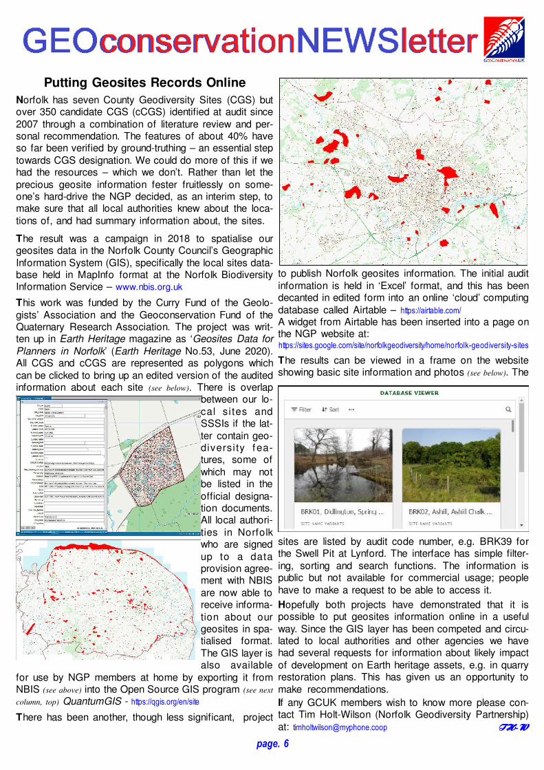
Putting Geosites Records Online
Norfolk has seven County Geodiversity Sites (CGS) butover 350 candidate CGS (cCGS) identified at audit since2007 through a combination of literature review and per-sonal recommendation. The features of about 40% haveso far been verified by ground-truthing – an essential steptowards CGS designation. We could do more of this if wehad the resources – which we don’t. Rather than let theprecious geosite information fester fruitlessly on some-one’s hard-drive the NGP decided, as an interim step, tomake sure that all local authorities knew about the loca-tions of, and had summary information about, the sites.
The result was a campaign in 2018 to spatialise ourgeosites data in the Norfolk County Council’s GeographicInformation System (GIS), specifically the local sites data-base held in MapInfo format at the Norfolk BiodiversityInformation Service – www.nbis.org.uk
This work was funded by the Curry Fund of the Geolo-gists’ Association and the Geoconservation Fund of theQuaternary Research Association. The project was writ-ten up in Earth Heritage magazine as ‘Geosites Data forPlanners in Norfolk’ (Earth Heritage No.53, June 2020).All CGS and cCGS are represented as polygons whichcan be clicked to bring up an edited version of the auditedinformation about each site (see below). There is overlap
between our lo-cal si tes andSSSIs if the lat-ter contain geo-diversi ty fea-tures, some ofwhich may notbe listed in theofficial designa-tion documents.All local authori-ties in Norfolkwho are signedup to a dataprovision agree-ment with NBISare now able toreceive informa-tion about ourgeosites in spa-tialised format.The GIS layer isalso available
for use by NGP members at home by exporting it fromNBIS (see above) into the Open Source GIS program (see next
column, top) QuantumGIS - https://qgis.org/en/site
There has been another, though less significant, project
to publish Norfolk geosites information. The initial auditinformation is held in ‘Excel’ format, and this has beendecanted in edited form into an online ‘cloud’ computingdatabase called Airtable – https://airtable.com/
A widget from Airtable has been inserted into a page onthe NGP website at:https://sites.google.com/site/norfolkgeodiversity/home/norfolk-geodiversity-sites
The results can be viewed in a frame on the websiteshowing basic site information and photos (see below). The
sites are listed by audit code number, e.g. BRK39 forthe Swell Pit at Lynford. The interface has simple filter-ing, sorting and search functions. The information ispublic but not available for commercial usage; peoplehave to make a request to be able to access it.
Hopefully both projects have demonstrated that it ispossible to put geosites information online in a usefulway. Since the GIS layer has been competed and circu-lated to local authorities and other agencies we havehad several requests for information about likely impactof development on Earth heritage assets, e.g. in quarryrestoration plans. This has given us an opportunity tomake recommendations.
If any GCUK members wish to know more please con-tact Tim Holt-Wilson (Norfolk Geodiversity Partnership)at: [email protected] TH-WTH-WTH-WTH-W
page. 6
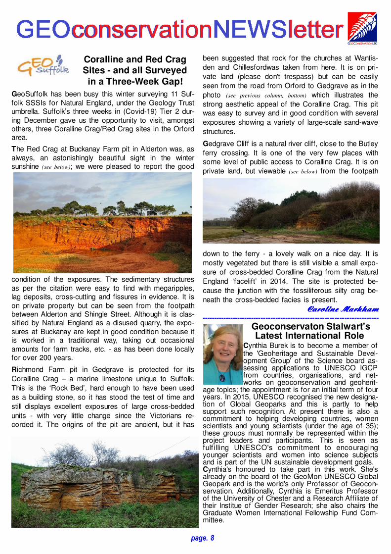
College Lakes: Exposing theQuaternary
College Lake, near Marsworth in Buck-inghamshire, is one of the most importantsites managed by the Berkshire, Buck-inghamshire, and Oxfordshire Wildlife
Trust (BBOWT). The 65-hectare nature reserve is situ-ated in a former chalk quarry in Pitstone, in the AylesburyVale district of Buckinghamshire. Importantly, the site hasa SSSI designation for its Quaternary geology. Therehave been a series of significant fossil finds at the site.However, it is the sedimentary evidence from CollegeLake and Marsworth area which has helped constrain aseries of warm and cold periods from the Middle andLate Pleistocene MIS 7-5.
MIS (for the non-Quaternary specialists!) is short forMarine Isotope Stage (or oxygen isotope stages, OIS),each of which represents alternating warm and coolperiods in the Earth's relatively recent palaeoclimate his-tory. They are calculated from oxygen isotope levels, thatreflect changes in temperature, obtained from deep-seacore samples. More than 100 stages, covering the last 6million years, have been recognised so far. Stage 7represents a time around 200,000-243,000 years agowhilst Stage 5 represents a time period of 80,000-130,000 years ago. MIS 7 represents a warm period, theAveley Interglacial. MIS 5, is split into sub-stages, inwhich 5 a and c are warm stages and b and d are coldstages.
Two major channels of different ages have been identi-fied and investigated. The older one, dating from approxi-mately 220,000 years ago, has produced evidence of awarmer interglacial rich in mammalian fauna. This wasfollowed by a cold period when permafrost conditionsprevailed. The sediments at College Lake were subjectedto intensive freeze thaw cycles which created the involu-tion features that we want to expose. These features areformed where frost heave, soft sediment deformation andcryoturbation occur. The upper channel, now absent dueto quarrying activities, represented warmer conditionsfrom c.120,000 years ago
The BBOWT, in partnership with local geologists, theGeologists’ Association (GA), members of the Quater-nary Research Association (QRA), and Natural Englandhave worked collaboratively in seeking to promote thegeological heritage and thefascinating geological storyat College Lake.
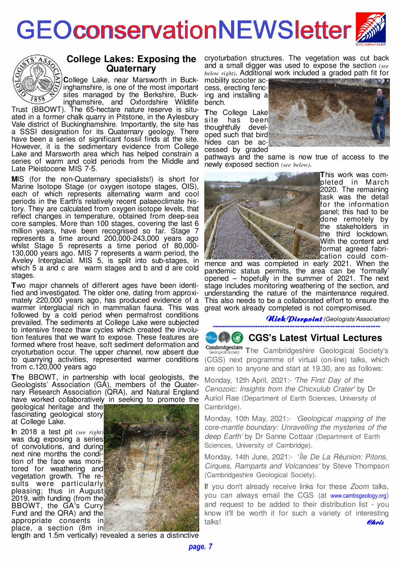
In 2018 a test pit (see right)
was dug exposing a seriesof convolutions, and duringnext nine months the condi-tion of the face was moni-tored for weathering andvegetation growth. The re-sults were particularlypleasing; thus in August2019, with funding (from theBBOWT, the GA's CurryFund and the QRA) and theappropriate consents inplace, a section (8m inlength and 1.5m vertically) revealed a series a distinctive
cryoturbation structures. The vegetation was cut backand a small digger was used to expose the section (see
below right). Additional work included a graded path fit formobility scooter ac-cess, erecting fenc-ing and installing abench.
The College Lakesite has beenthoughtfully devel-oped such that birdhides can be ac-cessed by gradedpathways and the same is now true of access to thenewly exposed section (see below).
This work was com-pleted in March2020. The remainingtask was the detailfor the informationpanel; this had to bedone remotely bythe stakeholders inthe third lockdown.With the content andformat agreed fabri-cation could com-
mence and was completed in early 2021. When thepandemic status permits, the area can be ‘formally’opened – hopefully in the summer of 2021. The nextstage includes monitoring weathering of the section, andunderstanding the nature of the maintenance required.This also needs to be a collaborated effort to ensure thegreat work already completed is not compromised.
Nick Nick Nick Nick PierpointPierpointPierpointPierpoint (Geologists’ Association)--------------------------------------------------------------------
CGS's Latest Virtual Lectures
The Cambridgeshire Geological Society's(CGS) next programme of virtual (on-line) talks, whichare open to anyone and start at 19.30, are as follows:
Monday, 12th April, 2021:- ‘The First Day of theCenozoic: Insights from the Chicxulub Crater' by DrAuriol Rae (Department of Earth Sciences, University of
Cambridge).
Monday, 10th May, 2021:- ‘Geological mapping of thecore-mantle boundary: Unravelling the mysteries of thedeep Earth‘ by Dr Sanne Cottaar (Department of Earth
Sciences, University of Cambridge).
Monday, 14th June, 2021:- 'Île De La Réunion: Pitons,Cirques, Ramparts and Volcanoes‘ by Steve Thompson(Cambridgeshire Geological Society).
If you don't already receive links for these Zoom talks,you can always email the CGS (at www.cambsgeology.org)and request to be added to their distribution list - youknow it'll be worth it for such a variety of interestingtalks! ChrisChrisChrisChris
page. 7
Coralline and Red CragSites - and all Surveyed
in a Three-Week Gap!
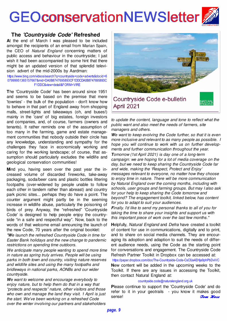
GeoSuffolk has been busy this winter surveying 11 Suf-folk SSSIs for Natural England, under the Geology Trustumbrella. Suffolk’s three weeks in (Covid-19) Tier 2 dur-ing December gave us the opportunity to visit, amongstothers, three Coralline Crag/Red Crag sites in the Orfordarea.
The Red Crag at Buckanay Farm pit in Alderton was, asalways, an astonishingly beautiful sight in the wintersunshine (see below); we were pleased to report the good
condition of the exposures. The sedimentary structuresas per the citation were easy to find with megaripples,lag deposits, cross-cutting and fissures in evidence. It ison private property but can be seen from the footpathbetween Alderton and Shingle Street. Although it is clas-sified by Natural England as a disused quarry, the expo-sures at Buckanay are kept in good condition because itis worked in a traditional way, taking out occasionalamounts for farm tracks, etc. - as has been done locallyfor over 200 years.
Richmond Farm pit in Gedgrave is protected for its
Coralline Crag – a marine limestone unique to Suffolk.
This is the ‘Rock Bed’, hard enough to have been used
as a building stone, so it has stood the test of time and
still displays excellent exposures of large cross-bedded
units - with very little change since the Victorians re-corded it. The origins of the pit are ancient, but it has
been suggested that rock for the churches at Wantis-
den and Chillesfordwas taken from here. It is on pri-
vate land (please don't trespass) but can be easily
seen from the road from Orford to Gedgrave as in the
photo (see previous column, bottom) which illustrates the
strong aesthetic appeal of the Coralline Crag. This pitwas easy to survey and in good condition with several
exposures showing a variety of large-scale sand-wave
structures.
Gedgrave Cliff is a natural river cliff, close to the Butley
ferry crossing. It is one of the very few places withsome level of public access to Coralline Crag. It is on
private land, but viewable (see below) from the footpath
down to the ferry - a lovely walk on a nice day. It is
mostly vegetated but there is still visible a small expo-
sure of cross-bedded Coralline Crag from the Natural
England ‘facelift’ in 2014. The site is protected be-
cause the junction with the fossiliferous silty crag be-
neath the cross-bedded facies is present.
CarolineCarolineCarolineCaroline MarkhamMarkhamMarkhamMarkham-------------------------------------------------------------------------
Geoconservaton Stalwart'sLatest International Role
Cynthia Burek is to become a member ofthe 'Geoheritage and Sustainable Devel-opment Group' of the Science board as-sessing applications to UNESCO IGCPfrom countries, organisations, and net-works on geoconservation and geoherit-
age topics; the appointment is for an initial term of fouryears. In 2015, UNESCO recognised the new designa-tion of Global Geoparks and this is partly to helpsupport such recognition. At present there is also acommitment to helping developing countries, womenscientists and young scientists (under the age of 35);these groups must normally be represented within theproject leaders and participants. This is seen asfulf illing UNESCO's commitment to encouragingyounger scientists and women into science subjectsand is part of the UN sustainable development goals.Cynthia's honoured to take part in this work. She'salready on the board of the GeoMon UNESCO GlobalGeopark and is the world's only Professor of Geocon-servation. Additionally, Cynthia is Emeritus Professorof the University of Chester and a Research Affiliate oftheir Institue of Gender Research; she also chairs theGraduate Women International Fellowship Fund Com-mittee.
page. 8
The 'Countryside Code' RefreshedAt the end of March I was pleased to be includedamongst the recipients of an email from Marian Spain,
the CEO of Natural England concerning matters ofpublic access and behaviour in the countryside; I justwish it had been accompanied by some hint that theremight be an updated version of that splendid televi-sion advert of the mid-2000s by Aardman:https://www.bing.com/videos/search?q=countryside+code+adverts&docid=607999951365157667&mid=DA0B8747695893CF1DDCDA0B8747695893C
F1DDC&view=detail&FORM=VIRE
The 'Countryside Code' has been around since 1951and seems to be based on the premise that mere'townies' - the bulk of the population - don't know howto behave in that part of England away from shoppingmalls, street-lights and takeaways (oh, and buses!)mainly in the 'care' of big estates, foreign investorsand companies, and, of course, farmers (owners andtenants). It rather reminds one of the assumption oftoo many in the farming, game and estate manage-ment communities that nobody outside their circle hasany knowledge, understanding and sympathy for thechallenges they face in economically working andcaring for the working landscape; of course, that as-sumption should particularly excludes the wildlife andgeological conservation communities!
Mind you, having seen over the past year the in-creased volume of discarded fireworks, take-awaypackaging, soda/beer cans and plastic bottles litteringfootpaths (over-widened by people unable to followeach other in tandem rather than abreast) and countrypark picnic sites... perhaps they do have a point. Thecounter argument might partly be in the seemingincrease in wildlife abuse, particularly the poisoning ofbirds of prey. Anyway, the “refreshed” 'CountrysideCode' is designed to help people enjoy the country-side “in a safe and respectful way”. Now, back to thewords of that welcome email announcing the launch ofthe new Code, 70 years after the original booklet:
"We launch the refreshed Countryside Code in time forEaster Bank holidays and the new change to pandemicrestrictions on spending time outdoors.We anticipate many people wanting to spend more timein nature as spring truly arrives. People will be usingparks in both town and country, visiting nature reservesand wildlife sites and using the many footpaths andbridleways in national parks, AONBs and our widercountryside.We want to welcome and encourage everybody toenjoy nature, but to help them do that in a way that“protects and respects” nature, other visitors and thosewho own and manage the land they visit. 1 April is justthe start. We’ve been working on a refreshed Codeover the winter involving our partners and stakeholders
to update the content, language and tone to reflect what thepublic want and also meet the needs of farmers, sitemanagers and others. We want to keep evolving the Code further, so that it is evenmore inclusive and relevant to as many people as possible. Ihope you will continue to work with us on further develop-ments and further communication throughout the year.Tomorrow (1st April 2021) is day one of a long-termcampaign: we are hoping for a lot of media coverage on theday, but we need to keep sharing the Countryside Code farand wide, making the ‘Respect, Protect and Enjoy’messages relevant to everyone, no matter how they chooseto enjoy time in nature. There will be more communicationby Natural England over the coming months, including withschools, user groups and farming groups. But may I also askfor your help to keep sharing the Code tomorrow andbeyond? The engagement toolkit, linked below, has contentfor you to adapt to suit your audiences.Finally. I’d like to send my personal thanks to all of you fortaking the time to share your insights and support us withthis important piece of work over the last few months."
Helpfully, Natural England and Defra have created a toolkitof content for use in communications, digitally and to print,and to share on social media channels. They are encour-aging its adoption and adaption to suit the needs of differ-ent audience needs, using the Code as the starting pointfor conversations and engagement. The Countryside CodeRefresh Partner Toolkit in Dropbox can be accessed at:https://paper.dropbox.com/doc/The-Countryside-Code-CsCfJa4EHja9phPbDviVC
New content will be added in the upcoming weeks to theToolkit. If there are any issues in accessing the Toolkit,then contact Natural England at:
Please continue to support the 'Countryside Code' and dorefer to it in your geotrails - you know it makes goodsense! Tom Tom Tom Tom HoseHoseHoseHose
page. 9

museums, etc. and when we do talks for other organisa-tions.
GeoEssex also has been busy compiling reports, forDistrict Planning Authorities, that give details of the localgeology and list all of the geological sites in their areas;a citation is produced for each geosite that has beendesignated as a “Local Geological Site (LGS)” to paral-lel the designation given to wildlife sites. Unsurprisingly,follow-up to ensure that these geosites are incorporatedinto Local Plans has been found to be necessary asgeology is not on everyone’s radar yet – we must all domuch more to wave the flag as geology does not havethe same statutory profile as either archaeology or wild-life. We do find, however, that once you engage peoplein discovering deep time, they are fascinated.
RosRosRosRos Mercer Mercer Mercer Mercer (Secretary ERMS & GeoEssex)-------------------------------------------------------------------------
Zoom Events & Field TripsDue to the Covid lockdown, the Hull Geo-logical Society (HGS) has arranged alate-spring programme of roughly fort-nightly online talks (lasting about 35 min-
utes & normally starting at 7.30pm), through to May.Non-members are welcome to attend but they mustbook with the HGS Secretary who'll send them the log-in code. People are asked not to share or record talks.
Friday, 16th April 2021:- Virtual Club Night on FaceBook - the topic is "Sedimentary Structures". Pleasepost your pictures in the album entitled “club night 16th
April - Sedimentary Structures” which you can find by
clicking on “media” and then “albums”. You are alsowelcome to “like” and comment on other members’pictures.
Friday, 16th April:- Bisat Research Group field meeting– booking required; further details will be sent when you
book. For more information please telephone GrahamKings on 01482 659 133 or e-mail bisat at: hullgeolsoc.co.uk
Wednesday, 21st April:- Zoom seminar (tbc) by JohnConnor & Mike Horne, "The Cobble Churches ofHolderness".Thursday, 29th April:- South Ferriby Foreshore researchfieldwork meeting (we hope to record and log some ofthe sections) led by Mary Howard & Mike Horne –booking required; further details will be sent to youwhen you book.
Wednesday, 12th May:- evening Zoom lecture meeting -John Connor, "The Use of Geophysics for MarineArchaeology". Note: we cannot offer lifts to field meetings due to the Covid Pandemic
and ask members not to offer lifts – we have to closely follow Govern-
ment guidelines for our liability insurance to be valid. This may change
after 17th May. There will continue to be a restriction on the number of
members attending field meetings, so please book early.
Mike Mike Mike Mike HorneHorneHorneHorne (HGS Secretary)
Essex Geology News
The Essex Rock & Mineral Society tookdelivery of the third in their Essex Geologyseries of posters, 'Essex Rocks', almost ayear ago; this unfortunately coinciding with
the beginning of pandemic's first lock-down, hamperingits promotion. However, geology does not go out of datethat quickly! So we hope to get them out and availablethis summer.
The first in the series was 'Pebbles in Essex and Beyond'(see below left), which sold well once people were tuned intolooking at what pebbles are made of rather than justregarding them as ‘stones’. The pebbles are pictured anddescribed and their origin and journey from their sourceis related on the reverse of the poster.
The 'Fossils in Essex and Beyond' poster (see above right) ismore self-explanatory, but fossils are less easy to comeby, especially in Essex, unless you go to the coast –Walton-on-the-Naze in particular – and there is a sectionto help with the identification of the multitude of molluscsfrom the Red Crag.
The 'Essex Rocks' poster (see
left) has a large 3-D columni llustrating the rocks youwould encounter when (and if)you dig down 300m into thecounty. On its reverse are pic-tures of the rocks and scenesto show the environment ofthe times.
All these posters are availableat the very modest price of £2each from the Essex Rock &Mineral Society; there is anorder form on the web-site at:
www.erms.org
We hope to make them available through visitor centres,
page. 10
Writing for the Wildlife TrustCornwall Geoconservation Group (CGG) hasbeen part of Cornwall Wildlife Trust (CWT)since its formation 30 years ago. CWT hasover 17,000 members. They get a colourfulmagazine four times a year and CGG tries to
feed a little geology into each issue – sometimes we geta whole page or more! Usually it’s around 250 words anda picture. The article below was put together by JohnMacadam and Mark Vickers and is an early draft of whatthe members will be able to read next month.
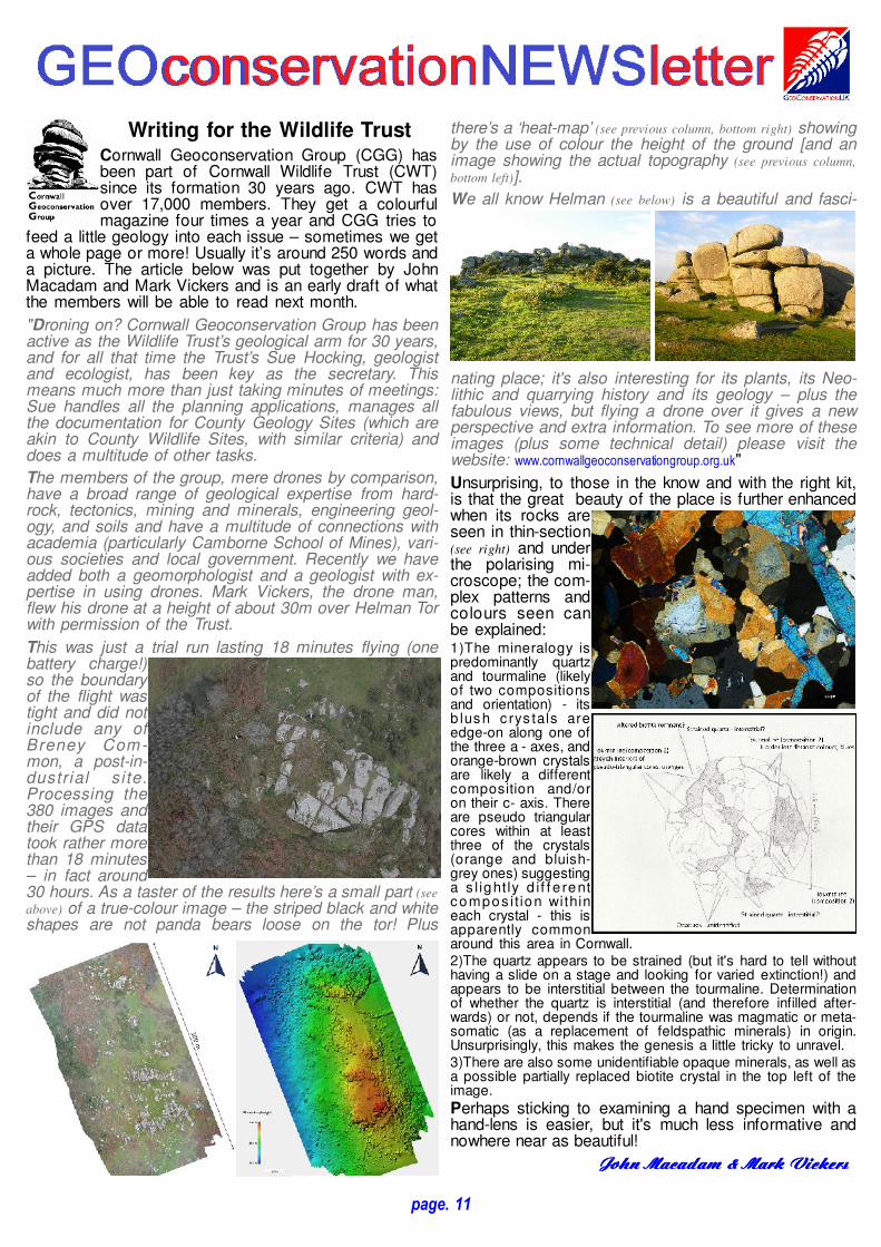
"Droning on? Cornwall Geoconservation Group has beenactive as the Wildlife Trust’s geological arm for 30 years,and for all that time the Trust’s Sue Hocking, geologistand ecologist, has been key as the secretary. Thismeans much more than just taking minutes of meetings:Sue handles all the planning applications, manages allthe documentation for County Geology Sites (which areakin to County Wildlife Sites, with similar criteria) anddoes a multitude of other tasks. The members of the group, mere drones by comparison,have a broad range of geological expertise from hard-rock, tectonics, mining and minerals, engineering geol-ogy, and soils and have a multitude of connections withacademia (particularly Camborne School of Mines), vari-ous societies and local government. Recently we haveadded both a geomorphologist and a geologist with ex-pertise in using drones. Mark Vickers, the drone man,flew his drone at a height of about 30m over Helman Torwith permission of the Trust. This was just a trial run lasting 18 minutes flying (onebattery charge!)so the boundaryof the flight wastight and did notinclude any ofBreney Com-mon, a post-in-dustrial si te.Processing the380 images andtheir GPS datatook rather morethan 18 minutes– in fact around30 hours. As a taster of the results here’s a small part (see
above) of a true-colour image – the striped black and whiteshapes are not panda bears loose on the tor! Plus
page. 11
there’s a ‘heat-map’ (see previous column, bottom right) showingby the use of colour the height of the ground [and animage showing the actual topography (see previous column,
bottom left)].We all know Helman (see below) is a beautiful and fasci-
nating place; it's also interesting for its plants, its Neo-lithic and quarrying history and its geology – plus thefabulous views, but flying a drone over it gives a newperspective and extra information. To see more of theseimages (plus some technical detail) please visit thewebsite: www.cornwallgeoconservationgroup.org.uk"
Unsurprising, to those in the know and with the right kit,is that the great beauty of the place is further enhancedwhen its rocks areseen in thin-section(see right) and underthe polarising mi-croscope; the com-plex patterns andcolours seen canbe explained: 1)The mineralogy ispredominantly quartzand tourmaline (likelyof two compositionsand orientation) - itsb lush c rys tals areedge-on along one ofthe three a - axes, andorange-brown crystalsare likely a differentcomposition and/oron their c- axis. Thereare pseudo triangularcores within at leastthree of the crystals(orange and bluish-grey ones) suggestinga s l ightly d i f f e rentcompos it ion withineach crystal - this isapparently commonaround this area in Cornwall.2)The quartz appears to be strained (but it's hard to tell withouthaving a slide on a stage and looking for varied extinction!) andappears to be interstitial between the tourmaline. Determinationof whether the quartz is interstitial (and therefore infilled after-wards) or not, depends if the tourmaline was magmatic or meta-somatic (as a replacement of feldspathic minerals) in origin.Unsurprisingly, this makes the genesis a little tricky to unravel.3)There are also some unidentifiable opaque minerals, as well asa possible partially replaced biotite crystal in the top left of theimage.
Perhaps sticking to examining a hand specimen with ahand-lens is easier, but it's much less informative andnowhere near as beautiful!
John John John John Macadam Macadam Macadam Macadam & & & & Mark Mark Mark Mark VickersVickersVickersVickers
illustrates some of Smith's diaries for the years 1789and then (excepting 1808) 1802-1822.
'The Table of Contents' shows the volume's split into the'Forward' and 'Introduction and four sections': 'Bordersand the North', 'Wales and Central England', 'East An-glia and the South-East', and 'The West'. Each openswith four sheets of the 1815 map and includes an essayon aspects of Smith's great work. The whole is roundedoff by an index and a bibliography.
Following the the two-page 'Forward', which establishesSmith's achievements in their necessarily subterraneanand historical contexts, is a useful time-line of his lifeand work. The 'Introduction' provides an overview ofSmith's formative years and contextualises his workwithin earlier, contemporary and subsequent conceptsabout the nature and natural processes of the earth.The illustrations of his notebooks on Newhaven's CastleHill cliff strata are particularly informative about a much
less well known,even neglected,early example ofhis work and ap-proach; likewise,the early cross-sec-tions' illustrations -comparing this withthe later preparedand published ones
(see above) is most illuminating.
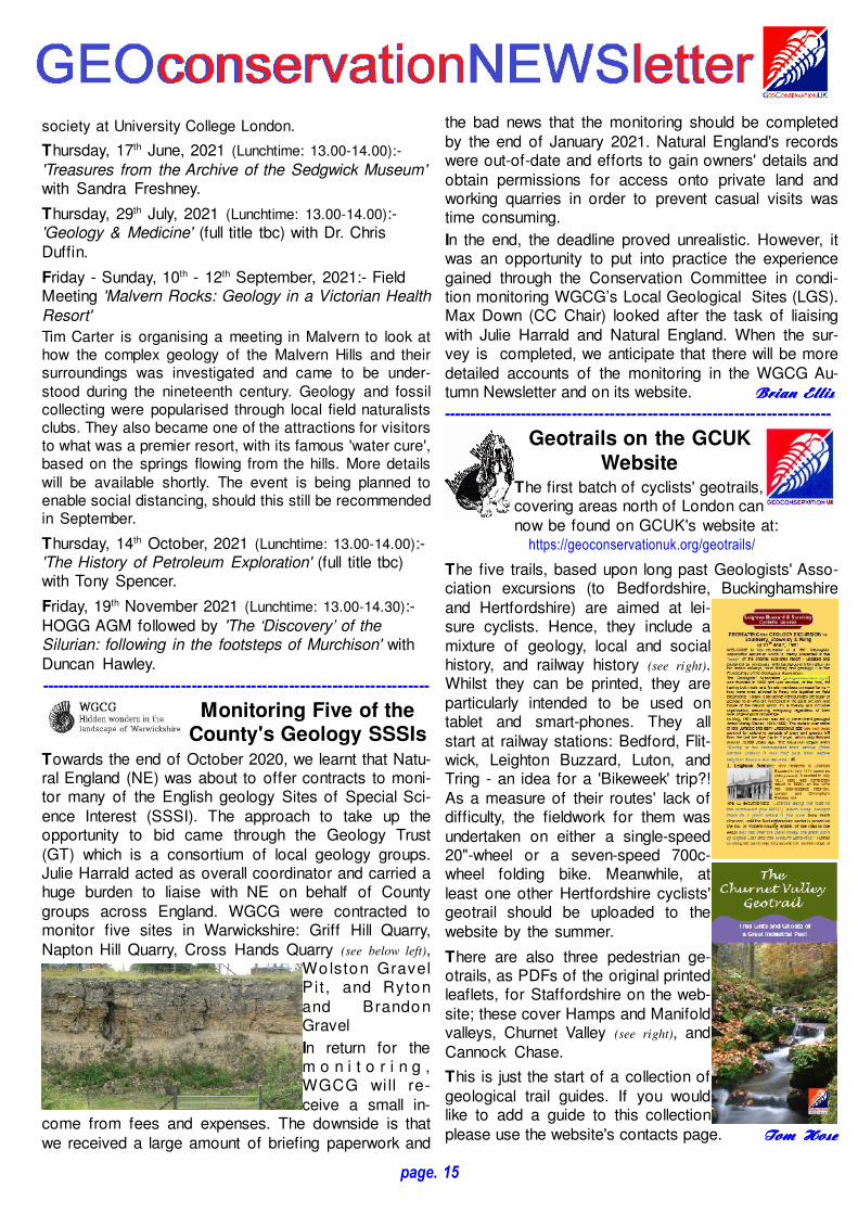
'Borders and the North' opens with the sombre-colouredpallete (unlike that of the west country in the openingmap spread - see below) of that region's sheets in full-sizereproductions. It's interesting to see how Smith recog-nized and roughly delineated the complex geology ofthe Lake District - something hard to appreciate whilstgazing at a wall-mounted and glazed original copy in theGeological Society's foyer! On the other coast, The
page. 12
This isn't just any book, it's 'STRATA:William Smith’s Geological Maps'!
by
Peter Wigley, Douglas Palmer, John Henry, Tom Sharpe, Jill
Darrell, Diana Clements, John Mather, Dave Williams
(with a Foreword by Robert Macfarlane)
Publication Date: 22nd October, 2020Publisher: Thames & Hudson
Price: £50.00
Released just in time for some lucky geologists' Christ-mas lists this sumptuous hard-bound volume quitequickly went out print. So, it's pleasing to report it'salready back in print and as well produced as theoriginal - just a pity, but perhaps another sad reflectionon the economics of the UK's modern manufacturing,it's both printed and bound in China. Actually, thatbinding is a little tight, sometimes making it difficult tofully open and admire the two-page spreads that aresuch an excellent feature of the volume. Its 256 (36.5 x26.5 cm) art-quality paper pages are profusely illus-trated in full colour.
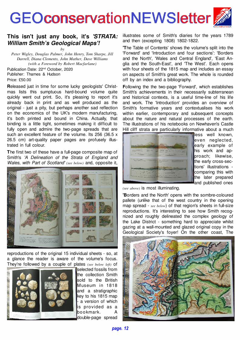
The first two of these have a full-page composite map ofSmith's 'A Delineation of the Strata of England andWales, with Part of Scotland' (see below) and, opposite it,
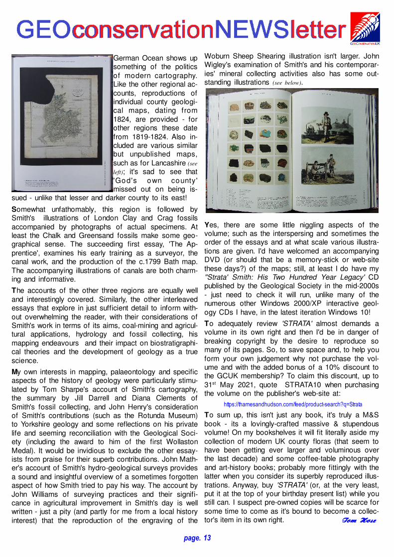
reproductions of the original 15 individual sheets - so, ata glance the reader is aware of the volume's focus.They're followed by a couple of plates (see below left) of
selected fossils fromthe collection Smithsold to the BritishMuseum in 1818and a stratigraphickey to his 1815 map- a version of whichis provided as abookmark. Adouble-page spread
German Ocean shows upsomething of the politicsof modern cartography.Like the other regional ac-counts, reproductions ofindividual county geologi-cal maps, dating from1824, are provided - forother regions these datefrom 1819-1824. Also in-cluded are various similarbut unpublished maps,such as for Lancashire (see
left); it's sad to see that'God's own county'missed out on being is-
sued - unlike that lesser and darker county to its east!
Somewhat unfathomably, this region is followed bySmith's illustrations of London Clay and Crag fossilsaccompanied by photographs of actual specimens. Atleast the Chalk and Greensand fossils make some geo-graphical sense. The succeeding first essay, 'The Ap-prentice', examines his early training as a surveyor, thecanal work, and the production of the c.1799 Bath map.The accompanying illustrations of canals are both charm-ing and informative.
The accounts of the other three regions are equally welland interestingly covered. Similarly, the other interleavedessays that explore in just sufficient detail to inform with-out overwhelming the reader, with their considerations ofSmith's work in terms of its aims, coal-mining and agricul-tural applications, hydrology and fossil collecting, hismapping endeavours and their impact on biostratigraphi-cal theories and the development of geology as a truescience.
My own interests in mapping, palaeontology and specificaspects of the history of geology were particularly stimu-lated by Tom Sharpe's account of Smith's cartography,the summary by Jill Darrell and Diana Clements ofSmith's fossil collecting, and John Henry's considerationof Smith's contributions (such as the Rotunda Museum)to Yorkshire geology and some reflections on his privatelife and seeming reconciliation with the Geological Soci-ety (including the award to him of the first WollastonMedal). It would be invidious to exclude the other essay-ists from praise for their superb contributions. John Math-er's account of Smith's hydro-geological surveys providesa sound and insightful overview of a sometimes forgottenaspect of how Smith tried to pay his way. The account byJohn Williams of surveying practices and their signifi-cance in agricultural improvement in Smith's day is wellwritten - just a pity (and partly for me from a local historyinterest) that the reproduction of the engraving of the
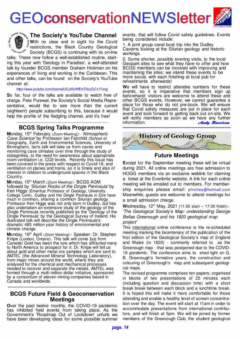
Woburn Sheep Shearing illustration isn't larger. JohnWigley's examination of Smith's and his contemporar-ies' mineral collecting activities also has some out-standing illustrations (see below).
Yes, there are some little niggling aspects of thevolume; such as the interspersing and sometimes theorder of the essays and at what scale various illustra-tions are given. I'd have welcomed an accompanyingDVD (or should that be a memory-stick or web-sitethese days?) of the maps; still, at least I do have my''Strata' Smith: His Two Hundred Year Legacy' CDpublished by the Geological Society in the mid-2000s- just need to check it will run, unlike many of thenumerous other Windows 2000/XP interactive geol-ogy CDs I have, in the latest iteration Windows 10!
To adequately review 'STRATA' almost demands avolume in its own right and then I'd be in danger ofbreaking copyright by the desire to reproduce somany of its pages. So, to save space and, to help youform your own judgement why not purchase the vol-ume and with the added bonus of a 10% discount tothe GCUK membership? To claim this discount, up to31st May 2021, quote STRATA10 when purchasingthe volume on the publisher's web-site at:
https://thamesandhudson.com/feed/product-search?q=Strata
To sum up, this isn't just any book, it's truly a M&Sbook - its a lovingly-crafted massive & stupendousvolume! On my bookshelves it will fit literally aside mycollection of modern UK county floras (that seem tohave been getting ever larger and voluminous overthe last decade) and some coffee-table photographyand art-history books; probably more fittingly with thelatter when you consider its superbly reproduced illus-trations. Anyway, buy 'STRATA' (or, at the very least,put it at the top of your birthday present list) while youstill can. I suspect pre-owned copies will be scarce forsome time to come as it's bound to become a collec-tor's item in its own right. Tom Tom Tom Tom HoseHoseHoseHose
page. 13
The Society's YouTube ChannelWith no clear end in sight for the Covidrestrictions, the Black Country GeologicalSociety (BCGS) is continuing with its on-line
talks. These now follow a well-established routine, start-ing this year with 'Geology in Paradise', a well-attendedtalk by founder BCGS member Graham Hickman on hisexperiences of living and working in the Caribbean. Thisand other talks, can be found on the Society's YouTubechannel at:
https://www.youtube.com/channel/UCu65xWfEmTXiczZs7x1Fasg
So far, four of the talks are available to watch free ofcharge. Pete Purewal, the Society's Social Media Repre-sentative, would like to see more than the current(eighteen!) people subscribing to this, because it wouldhelp the profile of the fledgling channel, and it's free!
..........................................................................
BCGS Spring Talks Programme Monday, 15th February (Zoom Meeting):- 'AtmosphericCave Science' by Professor Ian Fairchild (School ofGeography, Earth and Environmental Sciences, University ofBirmingham). Ian's talk will take us from caves andmonitoring cave climates over time through the study ofstalagmites, to the need for awareness about appropriateroom ventilation i.e. CO2 levels. Recently this issue hasbeen covered in the press with respect to Covid-19, andventilation on planes and trains, so it is timely and also ofinterest in relation to underground spaces in the BlackCountry.
Monday, 15th March (Zoom Meeting):- BCGS AGMfollowed by 'Silurian Rocks of the Dingle Peninsula' byKen Higgs (Emeritus Professor of Geology, UniversityCollege Cork). Dudley and the Dingle Peninsula in Eire havemuch in common, sharing a common Silurian geology.Professor Ken Higgs was not only born in Dudley, but hasalso undertaken an extensive study of the geology of theDingle Peninsula recently published as the 'Geology of theDingle Peninsula' by the Geological Survey of Ireland. Hisillustrated talk will describe the Dingle Peninsula'sdramatic 485 million year history of environmental andclimate change.
Monday, 19th April (Zoom Meeting):- Speaker: Dr. StephenKnipe (London, Ontario). This talk will come live fromCanada! Gold has been the lure which has attracted manyto North America to prospect for it. Dr. Knipe will tell usabout gold and other metal ore samples which are sent toAMTEL (the Advanced Mineral Technology Laboratory),from major mines around the world, where they areanalysed for the chemical and mechanical processesneeded to recover and separate the metals. AMTEL wasformed through a multi-million dollar initiative, sponsoredby a consortium of eleven mining companies based inCanada and worldwide.........................................................................................
BCGS Future Field & GeoconservationMeetings
Over the past twelve months, the COVID-19 pandemichas inhibited field events from taking place. As theGovernment's 'Roadmap Out of Lockdown' unfurls wehave been developing ideas for some possible summer
events, that will follow Covid safety guidelines. Eventsbeing considered include:1. A joint group canal boat trip into the DudleyCaverns looking at the Silurian geology and historicworkings.
2. Some shorter, possibly evening visits, to the localGeopark sites to see what they have to offer and howBCGS members can be involved with improving andmaintaining the sites; we intend these events to bemore social, with each finishing at local pub forrefreshments afterwards!
We will have to restrict attendee numbers for theseevents, so it is imperative that members sign upbeforehand; visitors are welcome to attend these andother BCGS events. However, we cannot guarantee aplace for those who do not pre-book. We will ensurethat Covid safety measures are put in place for eachevent and look forward to getting back out on-site. Wewill notify members as soon as we have any furtherinformation. AndyAndyAndyAndy HarrisonHarrisonHarrisonHarrison-------------------------------------------------------------------------
Future Meetings
Except for the September meeting these will be virtualduring 2021. All online meetings are free admission toHOGG members via an exclusive weblink for claiminga ticket at the Evenbrite website. A link for each onlinemeeting will be emailed out to members. For member-ship enquiries please email: [email protected]
Meanwhile, guests are welcome to attend meetings fora small admission charge.
Wednesday, 12th May, 2021 (11.00 start – 17.00 finish):-
'The Geological Society’s Map: understanding GeorgeBellas Greenough and his 1820 geological mapproject'This international online conference is the re-scheduledmeeting marking the bicentenary of the publication of thefirst edition of the Geological Society’s map of Englandand Wales (in 1820) - commonly referred to as the
Greenough map - that was postponed due to the COVID-19 pandemic. The conference aims to shed light on G.B. Greenough’s formative years, the construction andcolouring of Greenough’s map and subsequent geologi-cal maps.
The revised programme comprises ten papers; organisedin blocks of two presentations of 25 minutes each(including question and discussion time) with a shortbreak break between each block and a lunchtime break.It is hoped this will make it more comfortable for those
attending and enable a healthy level of screen concentra-tion over the day. The event will start at 11am in order toaccommodate presentations from international contribu-tors, and will finish at 5pm. We will be joined by formermembers of the Greenough Club, the student geological
page. 14
society at University College London.
Thursday, 17th June, 2021 (Lunchtime: 13.00-14.00):-
'Treasures from the Archive of the Sedgwick Museum'with Sandra Freshney.
Thursday, 29th July, 2021 (Lunchtime: 13.00-14.00):-'Geology & Medicine' (full title tbc) with Dr. ChrisDuffin.
Friday - Sunday, 10th - 12th September, 2021:- FieldMeeting 'Malvern Rocks: Geology in a Victorian HealthResort'Tim Carter is organising a meeting in Malvern to look athow the complex geology of the Malvern Hills and theirsurroundings was investigated and came to be under-
stood during the nineteenth century. Geology and fossilcollecting were popularised through local field naturalistsclubs. They also became one of the attractions for visitorsto what was a premier resort, with its famous 'water cure',based on the springs flowing from the hills. More details
will be available shortly. The event is being planned toenable social distancing, should this still be recommendedin September.
Thursday, 14th October, 2021 (Lunchtime: 13.00-14.00):-'The History of Petroleum Exploration' (full title tbc)with Tony Spencer.
Friday, 19th November 2021 (Lunchtime: 13.00-14.30):-HOGG AGM followed by 'The ‘Discovery’ of theSilurian: following in the footsteps of Murchison' withDuncan Hawley.
-------------------------------------------------------------------------
Monitoring Five of theCounty's Geology SSSIs
Towards the end of October 2020, we learnt that Natu-ral England (NE) was about to offer contracts to moni-tor many of the English geology Sites of Special Sci-ence Interest (SSSI). The approach to take up theopportunity to bid came through the Geology Trust(GT) which is a consortium of local geology groups.Julie Harrald acted as overall coordinator and carried ahuge burden to liaise with NE on behalf of Countygroups across England. WGCG were contracted tomonitor five sites in Warwickshire: Griff Hill Quarry,Napton Hill Quarry, Cross Hands Quarry (see below left),
Wo lston GravelPit, and Rytonand BrandonGravel
In return for them o n i t o r i n g ,WGCG will re-ceive a small in-
come from fees and expenses. The downside is thatwe received a large amount of briefing paperwork and
page. 15
the bad news that the monitoring should be completedby the end of January 2021. Natural England's recordswere out-of-date and efforts to gain owners' details andobtain permissions for access onto private land andworking quarries in order to prevent casual visits wastime consuming.
In the end, the deadline proved unrealistic. However, itwas an opportunity to put into practice the experiencegained through the Conservation Committee in condi-tion monitoring WGCG’s Local Geological Sites (LGS).Max Down (CC Chair) looked after the task of liaisingwith Julie Harrald and Natural England. When the sur-vey is completed, we anticipate that there will be moredetailed accounts of the monitoring in the WGCG Au-tumn Newsletter and on its website. BrianBrianBrianBrian EllisEllisEllisEllis
-------------------------------------------------------------------------
Geotrails on the GCUK
WebsiteThe first batch of cyclists' geotrails,covering areas north of London cannow be found on GCUK's website at:
https://geoconservationuk.org/geotrails/
The five trails, based upon long past Geologists' Asso-ciation excursions (to Bedfordshire, Buckinghamshireand Hertfordshire) are aimed at lei-sure cyclists. Hence, they include amixture of geology, local and socialhistory, and railway history (see right).Whilst they can be printed, they areparticularly intended to be used ontablet and smart-phones. They allstart at railway stations: Bedford, Flit-wick, Leighton Buzzard, Luton, andTring - an idea for a 'Bikeweek' trip?!As a measure of their routes' lack ofdifficulty, the fieldwork for them wasundertaken on either a single-speed20"-wheel or a seven-speed 700c-wheel folding bike. Meanwhile, atleast one other Hertfordshire cyclists'geotrail should be uploaded to thewebsite by the summer.
There are also three pedestrian ge-otrails, as PDFs of the original printedleaflets, for Staffordshire on the web-site; these cover Hamps and Manifoldvalleys, Churnet Valley (see right), andCannock Chase.
This is just the start of a collection ofgeological trail guides. If you wouldlike to add a guide to this collectionplease use the website's contacts page. Tom Tom Tom Tom HoseHoseHoseHose
page. 16
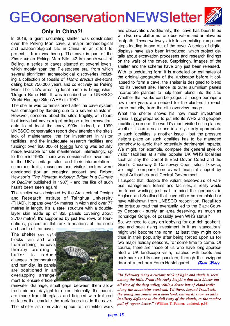
Only in China?!
In 2018, a giant undulating shelter was constructedover the Peking Man cave, a major archaeologicaland palaeontological site in China, in an effort toprotect it from weathering. The cave is part of theZhoukoudian Peking Man Site, 42 km south-west ofBeijing, a series of caves situated at several levels,which mostly span the Pleistocene era, from whichseveral significant archaeological discoveries includ-ing a collection of fossils of Homo erectus skeletonsdating back 750,000 years and collectively as PekingMan. The site's arresting local name is Longgushan,'Dragon Bone Hill’. It was inscribed as a UNESCOWorld Heritage Site (WHS) in 1987.
The shelter was commissioned after the cave systemwas damaged by flooding due to a severe rainstorm.However, concerns about the site's fragility, with fearsthat individual caves might collapse after excavation,date to at least the early-1990s. Indeed, a 1999UNESCO conservation report drew attention the site'slack of maintenance, the for investment in visitorfacilities, and the inadequate research facilities andfunding; over $50,000 of foreign funding was actuallymade available for site maintenance. Interestingly, upto the mid-1990s there was considerable investmentin the UK's heritage sites and their interpretation -numerous trails, museums and visitor centres weredeveloped (for an engaging account see RobertHewison's 'The Heritage Industry: Britain in a Climateof Decline' published in 1987) - and the like of suchhasn't been seen again!
The shelter was designed by the Architectural Designand Research Institute of Tsinghua University(THAD). It spans over 54 metres in width and over 77metres in length. It's a steel structure with a double-layer skin made up of 825 panels covering about3,700 metre2. It's supported by just two rows of foun-dations, placed on flat rock formations at the northand south of the cave.
The shelter (see right)
blocks rain and windfrom entering the cave,thereby creating abuf fer to reducechanges in temperatureand humidity. Its panelsare positioned in anoverlapping arrange-ment to ensure efficientrainwater drainage; small gaps between them allowfresh air and daylight to enter. Internally, the panelsare made from fibreglass and finished with texturedsurfaces that emulate the rock faces inside the cave.
The shelter also provides space for scientific work
and observation. Additionally, the cave has been fittedwith two new platforms for observation and an elevatedfootpath. These walkways link to an existing ramp andsteps leading in and out of the cave. A series of digitaldisplays have also been introduced, which project de-tails about excavation processes and research findingson the walls of the caves. Surprisingly, images of theshelter and the scheme have only just been released.
With its undulating form it is modelled on estimates ofthe original geography of the landscape before it col-lapsed to form a cave, the shelter is designed to blendinto its verdant site. Hence its outer aluminium panelsincorporate planters to help them blend into the site.Whether that works can be judged, although perhaps afew more years are needed for the planters to reachsome maturity, from the site overview image.
What the shelter shows his how much investmentChina is now prepared to put into its WHS and geoparklocalities, some of the world's most visited such places;whether it's on a scale and in a style truly appropriateto such localities is another issue - but the pressurevisitors place on such localities has to be managedsomehow to avoid their potentially detrimental impacts.We might, for example, compare the general style ofvisitor facilities at similar popular UK WHS localitiessuch as say the Dorset & East Devon Coast and theGiant's Causeway & Causeway Coast sites; likewise,we might compare their overall financial support byLocal Authorities and Central Government.
I suspect that, despite the valiant endeavours of vari-ous management teams and facilities, it really wouldbe found wanting; just call to mind the geoparks inEngland and Scotland that have either contemplated orhave withdrawn from UNESCO recognition. Recall toothe tortuous road that eventually led to the Black Coun-try Geopark - surely, an area deserving, as much asIronbridge Gorge, of possibly even WHS status?
So, we need to carry on lobbying for our rich geoherit-age and seek rising investment in it as 'staycations'might well become the norm; at least they might con-tinue in their popularity after being forced upon us fortwo major holiday seasons, for some time to come. Ofcourse, there are those of us who have long appreci-ated a UK landscape vista, reached with boots andback-pack or bike and panniers, through the unzippeddoor of a tent or a Youth Hostel garret! Tom Tom Tom Tom HoseHoseHoseHose
-------------------------------------------------------------------------
"In February many a curious trick of light and shade is seen
among the hills. From this rocky height a dun mist blocks out
all view of the deep valley, while a dense bar of cloud trails
along the mountains overhead. Yet there, beyond Troutbeck,
the young sun smiles on a moorland, setting its snow wreaths
in silvery defiance to the dull ivory of the clouds, to the sombre
pall of vapour below.” (William T. Palmer, undated, p.36)
page. 17
Bikeweek
Whilst its theme this year is 'healthand wellbeing', and cycling remainsa great way to keep fit and active, it'salso a great way to explore the UK'sgeoheritage - just think of all thosecyclists' geotrails. So, why not appre-ciate this century-old plus form ofsustainable transport, get 'on yerbike' that week, and visit those LGS/RIGS sites near to home? We'd loveto see those photos of you doing justthat in the next issue of GEONEWS!
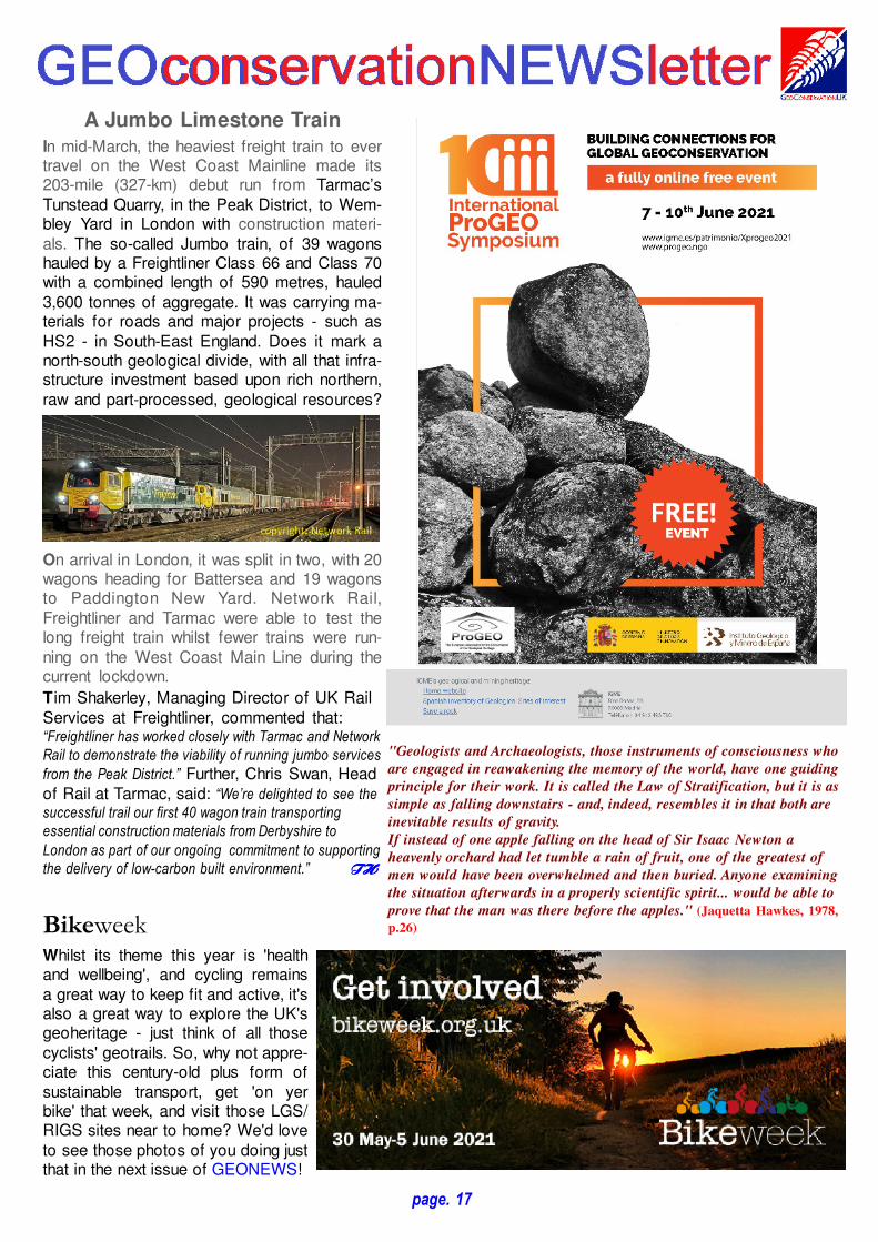
A Jumbo Limestone Train
In mid-March, the heaviest freight train to evertravel on the West Coast Mainline made its203-mile (327-km) debut run from Tarmac’sTunstead Quarry, in the Peak District, to Wem-bley Yard in London with construction materi-als. The so-called Jumbo train, of 39 wagonshauled by a Freightliner Class 66 and Class 70with a combined length of 590 metres, hauled3,600 tonnes of aggregate. It was carrying ma-terials for roads and major projects - such asHS2 - in South-East England. Does it mark anorth-south geological divide, with all that infra-structure investment based upon rich northern,raw and part-processed, geological resources?
On arrival in London, it was split in two, with 20wagons heading for Battersea and 19 wagonsto Paddington New Yard. Network Rail,Freightliner and Tarmac were able to test thelong freight train whilst fewer trains were run-ning on the West Coast Main Line during thecurrent lockdown.
T im Shakerley, Managing Director of UK RailServices at Freightliner, commented that:“Freightliner has worked closely with Tarmac and Network
Rail to demonstrate the viability of running jumbo services
from the Peak District.” Further, Chris Swan, Headof Rail at Tarmac, said: “We’re delighted to see the
successful trail our first 40 wagon train transporting
essential construction materials from Derbyshire to
London as part of our ongoing commitment to supporting
the delivery of low-carbon built environment.” THTHTHTH
"Geologists and Archaeologists, those instruments of consciousness who
are engaged in reawakening the memory of the world, have one guiding
principle for their work. It is called the Law of Stratification, but it is as
simple as falling downstairs - and, indeed, resembles it in that both are
inevitable results of gravity.
If instead of one apple falling on the head of Sir Isaac Newton a
heavenly orchard had let tumble a rain of fruit, one of the greatest of
men would have been overwhelmed and then buried. Anyone examining
the situation afterwards in a properly scientific spirit... would be able to
prove that the man was there before the apples." (Jaquetta Hawkes, 1978,
p.26)

This newsletter is publishedby GeoConservationUK
and is sponsored by
Rockhounds Welcome!
Editor: Dr. Thomas A. Hoseto whom correspondenceshould be addressed at:[email protected]
injuring a cyclist who was pushing a cycle on a zebra crossing. In his
judgment Lord Waller said: “the fact that the injured party had a
bicycle in her hand did not mean that she was no longer a
pedestrian” .
2. The Department for Transport: In a letter written in 1994, the DfT
confirmed “... that a cyclist pushing a bicycle on a pedestrian
facility is regarded as a pedestrian”. A footpath is, arguably, a
pedestrian facility in the same way as a zebra crossing or footway, and
there is no obvious reason to differentiate between pedestrian facilities
that form part of a vehicular highway, and those which do not.
However, 'Ramblers’'/'Open Spaces Society' in 'Rights ofWay - a Guide to Law and Practice' state: “It is submitted that a
bicycle is not a ‘natural accompaniment’ of a user of a footpath, and to
push (or carry) one along a footpath is therefore to commit a trespass
against the landowner"; but this is based upon the case ofRegina v Mathias decided in 1861 - before the bicyclewas invented. As a keen walker and leisure cyclist, Iunderstandably feel somewhat conflicted on the matter!
Now the relevance of all of this to geoconservationfieldwork is that the new Policing Bill could potentiallycriminalise any perceived such bicycle or other country-side trespass; as the 'CPRE' notes, it: "...includes new
trespass and protest offences, which risk putting a ‘do not enter’
sign across the country and further limiting access to the green
spaces that enrich all of our lives."
Meanwhile, if you find an obstructed RoW you can takesome simple stepsto help rectify the is-sue - summarised,at least for bridle-ways, in the flow-chart (see left) by theBritish Horse Soci-ety. Please reportRoW access issuesto the relevant LocalAuthority and ParishCouncil. Otherwise,we'll all lose thatcountryside, particu-larly for f ieldwork,access we reallyshould be able totake for granted.
Tom Tom Tom Tom HoseHoseHoseHose
Copy for the next GEONEWS issue, for July 2021, must be with
the Editor by 16th July, 2021 at the very latest!
Rights of Way & Geoconservation Work
Rights of Way (RoW) in England and Wales are the mainroutes by which anyone undertaking geological fieldworkgains legal access to the countryside. However, theycannot be taken for granted. I and colleagues havefound during the pandemic lockdowns, even when wewere restricted to our home territories, that surprisinglymany are difficult to find or follow, are physically ob-structed, and now even temporarily closed - to seemingly
prevent infections(apparently of humansand livestock) in farms- until the pandemic isover (see left). In some,but not all, such lattercases alternativeroutes have been pro-
vided; this should not mean that the original routes aren'trestored when the pandemic restrictions are removed;though after a year's vegetationgrowth (see right) this could be achallenge - one most likely to fallon volunteers rather than betaken up by the landowners andtheir tenants who are legally re-sponsible for maintaining RoW.Anyway, on my recent walks andrides I've found it most useful tocarry a pair of folding secateurs!Of course, there are restrictions legally in place on someRoW, but these, for instance, do not - seemingly unlessthe landowner actually asserts this (see below) - includepreventing cyclists walking withor carrying their bicycles on foot-paths, provided it is safe. As Ifrequently use a single-speedsmall-wheel folding bicycle forfieldwork, on geotrails in particu-lar, I've found that there is noreal case law on the matter!However, 'Cycling UK' notes(https://www.cyclinguk.org/sites/default/files/document/migrated/info/public-
footpaths5ebrf.pdf):1. Bicycling [that is riding!] without permission on a footpath normally
constitutes an act of civil trespass...
2. As the status of many countryside paths is simply due to quirks of
history, some footpaths are indistinguishable from bridleways, whilst
others may actually be more suitable for cycling.
3. Cyclists (and horseriders) have access to only 22% of the RoW
network in England and Wales...
4. The 1968 Countryside Act permits people to bicycle on bridleways as
long as they give way to equestrians and pedestrians.
Further, 'Cycling UK' believes that it's not illegal to pusha cycle on a footpath because of the following points:1. Crank v Brooks 1980: In this case, a motorist was prosecuted for
page. 18