Embed Size (px)
Citation preview

Lord Howe Island Maritime Archaeological Survey
3-16 February 2002
A Joint NSW Heritage Office and Marine Park Authority Project
NSW Heritage Office Maritime Heritage Program SYDNEY June 2002
Report prepared by David Nutley and Tim Smith
Lord Howe Island Maritime Archaeological Survey
Report Prepared June 2002 copy NSW Heritage Office Sydney NSW AUSTRALIA The material contained within may be quoted with appropriate attribution Disclaimer Any representation statement opinion or advice expressed or implied in this publication is made in good faith but on the basis that the State of New South Wales its agents and employees are not liable (whether by reason of negligence lack of care or otherwise) to any person for any damage or loss whatsoever which has occurred or may occur in relation to that person taking or not taking (as the case may be) action in respect of any representation statement or advice referred to above This report includes lsquoProject Island Heritage The Maritime Archaeology of Lord Howe Island - A Proposal drafted by Tim Smith in May 2001 Front cover Norfolk Island Pine channel markers for Erscotts Passage ndash bearing approximately
2440 True (Photograph by David Nutley)
Lord Howe Island Maritime Archaeological Survey
Lord Howe Island Maritime Archaeological Survey
TABLE OF CONTENTS
1 EXECUTIVE SUMMARY 1 1 AIMS 2 11 Target 1 - First Fleet Anchor HMS Supply 2 12 Target 2 - Whaling Heritage 2 13 Target 3 - Lagoon Losses 2 14 Target 4 - General Maritime Heritage of the island 2
2 METHODOLOGY 3 21 Background research 3 22 Target site selection 3 23 Equipment selection and deployment 4 24 Composition of the team 5 25 Constraints 5
3 THE PHYSICAL SETTING 7 31 World Heritage Property 7 32 Born on exploration settlement and trade 7 33 Lord Howe Island Marine Park 7 34 Shipwrecks Heritage 8 35 Island Tourism 8
4 LEGISLATIVE CONTROLS 9 41 Heritage Act 1977 10 42 Commonwealth Historic Shipwrecks Act 1976 10 43 Marine Parks Act 1998 10
5 THE SITES ndash THEIR HISTORY 12 51 First Fleet Anchor 12
511 Historical Background 12 512 Key time line for HMS Supply 13 513 A penal settlement in need 14 514 Lord Howe Island ndash Supplyrsquos crew wade ashore 15 515 Panic and alarm An anchor cast adrift 15 516 Anchored in time 16 517 The Norfolk run 18
52 Target 2 Whaling Heritage 18 521 The Whaling Wrecks of New South Wales 18
53 Target 3 Lagoon Losses 20 531 Vessel Summaries 21 532 Other Colonial Shipwrecks of Lord Howe Island 23
54 Target 4 - General Maritime Heritage of the island 25
6 CURRENT FIELDWORK RESULTS 25 61 Target 1 - First Fleet Anchor HMS Supply 25
611 Location 25 612 Environmental context 25 613 Discussion of survey results 26
62 Target 2 ndash Whaling Heritage 27 621 Location 27 622 Environmental context 28 623 Discussion of survey results 29
63 Target 2 ndash Lagoon Losses 30 631 Location 30 632 Environmental context 34
Lord Howe Island Maritime Archaeological Survey
633 Discussion of survey results 34 64 Target 4 - general maritime heritage of the island 37
641 Discussion of survey results 37
7 ASSESSMENT OF SIGNIFICANCE 41 71 Introduction 41 72 Target 1 ndash First Fleet anchor 41 73 Target 2 ndash Whaling heritage 41 74 Target 3 ndash Lagoon losses 41
741 Ovalau 41 742 Favorite 43 743 Jacques del Mar 43 744 La Meurthe 44
8 MANAGEMENT RECOMMENDATIONS 44 81 Target 1 ndash First Fleet anchor 44 82 Target 2 ndash Whaling Heritage 45
821 CONSERVATION 45 822 DISPLAY AND PUBLIC ACCESS 45 823 PROMOTION 45
83 Target 3 ndash Lagoon losses 45 831 Ovalau 45 832 Favorite 46 833 Jacques del Mar 46 834 La Meurthe 47
9 BIBLIOGRAPHY 48 APPENDIX A - LORD HOWE ISLAND SHIPWRECK INFORMATION SHEET 51
TABLE OF FIGURES Figure 1 Lord Howe Island Marine Park vessel Coris ___________________________________ 6 Figure 2 Mt Lidgbirdndash named by the captain of HMS Supply_____________________________ 8 Figure 3 Lord Howe Island surrounded by the marine park ______________________________ 9 Figure 4 A sketch of Lord Howe Islandrsquos western side _________________________________ 12 Figure 6 The first published chart of Lord Howe Island ________________________________ 15 Figure 7 The barque King Oscar __________________________________________________ 19 Figure 9 Photograph of the Ovalau _______________________________________________ 21 Figure 10 Jacques del Mar on reef ________________________________________________ 22 Figure 11 Photograph of the timber fishing vessel Favorite ashore _______________________ 23 Figure 12 Chart of magnetometer runs and anomaly clusters ___________________________ 26 Figure 13 Details of magnetic anomaly clusters off Erscottrsquos Passage and South West Passage 27 Figure 14 Georges Bay probably named after the wreck of the whaler George______________ 28 Figure 15 Wolfe Rock - struck by the whaler Wolf in 1837 ______________________________ 29 Figure 16 Jacques del Mar on south side of North Passage_____________________________ 30 Figure 17 Main portion of Favorite wreck site at high tide_______________________________ 31 Figure 18 Measured drawing of the partially exposed hull section on North Beach ___________ 32 Figure 19 Tim Smith undertaking the measured sketch ________________________________ 33 Figure 20 View of lagoon with North Passage _______________________________________ 33 Figure 21 Sketch of the upended Ovalau boiler ______________________________________ 35 Figure 22 Recording details of the boiler at the Ovalau site _____________________________ 35 Figure 23 Two of three portholes recovered from the Ovalau wreck site ___________________ 36 Figure 24 Erscotts Passage channel marker pines____________________________________ 38 Figure 25 Hull timbers from island launch in paddock__________________________________ 40
Lord Howe Island Maritime Archaeological Survey
THE SURVEY TEAM David Nutley Senior Maritime Archaeologist Heritage Office - Project Director
and Dive Supervisor Tim Smith Maritime Archaeologist Heritage Office - Principle Researcher
diver and transportation logistics Geoff Kelly Manager Lord Howe Island Marine Park ndash Coxswain liaison and
logistical support Julie Smith Ranger Lord Howe Island Administration Seconded by Marine
Park as a diver Darrin Nobbs Lord Howe Island resident - Coxswain Brian Busteed Proprietor Howea Divers ndash Coxswain Richard Smith ABC Television - Documentary filmmaker and diver
Figure 1 Lord Howe Island Marine Park vessel Coris The main survey platform used during the 2002 expedition (photograph by Tim Smith)
Lord Howe Island Maritime Archaeological Survey
ACKNOWLEDGEMENTS The survey could not have proceeded with a great deal of logistical support valuable advice contacts historical information and boat-handling skills provided by a number of people The Heritage Office and Marine Park Authority would like to acknowledge the following people and organisations for their generous assistance Brian Busteed Proprietor Howea Divers For getting the survey off the ground
with his vision of locating the HMS Supply anchor as well as provision of his boat handling expertise dive boat and other diving equipment assistance with local contacts and general enthusiastic support ndash and especially for his ability to stay calm in any circumstance
Geoff Kelly Manager Lord Howe Island Marine Park Geoffrsquos provision of Marine Park facilities and work boat and his own special skills and knowledge were invaluable
Julie Smith Ranger Lord Howe Island Administration - seconded by Lord Howe Island Marine Park to provide diver support Juliersquos diving skills professionalism positive outlook and willingness to engage in underwater cultural heritage research were greatly appreciated
Darrin Nobbs Coxswain lsquoDarsquosrsquo humour exceptional boat handling skills and fearless approach to life made working in 2-3m swells not only possible but also bearable
Richard Smith ABC Documentary filmmaker Richardrsquos video work provides a valuable record of the survey It is a shame that on this occasion weather induced limitations on the search for the Supply anchor did not favour documentary work Hopefully there will be another opportunity
Margaret (Pixie) and Ed Rourke Proprietors Pinetrees Resort Pixie and Edrsquos provided great
hospitality at Pinetrees Their contribution of aerial photographs of the Jacques del Mar was a great addition to the record of the islandrsquos maritime history in this report
Jim Whistler Editor of the Lord Howe Island newsletter lsquoSignalrsquo Jimrsquos wealth of historical information about Lord Howe Island and inclusion of details about the survey in lsquoSignalrsquo was greatly appreciated
Clive Wilson Lord Howe Island Maritime Thanks Clive for providing advice on the survey work and for first hand information on a number of Lord Howe Island shipwreck events
Neil Gladwin Coordinator PADI Asia Pacific Project Aware Foundation Thanks to Neil and to PADIrsquos Project Aware for much appreciated financial support for this survey
Francis Prentice and Jan Smith Australian National Maritime Museum Library The indefatigable
Francis and Jan provided their usual level of exceptional assistance with historic records held by the museumrsquos library
Peter Phillipps Post Office Manager Lord Howe Island and ardent researcher of Lord Howe Island aviation history Peter provided generous and bountiful level of information about the flying boat service to Lord Howe Island and aviation incidents
Lord Howe Island Maritime Archaeological Survey
UK Hydrographic For providing archival information on a number of ships Office Gabrielle Fabri Curators Historic Photographs and Ships Plans NMM
Greenwich For information on available ships plans for Supply and Ovalau
Jeremy Green Curator Western Australian Maritime Museum For the supply of magnetometer equipment for the project
Myra Stanbury Curator Western Australian Maritime Museum For information on anchor sizes related to the Supply
Kieran Hosty Curator Australian National Maritime Museum For information on anchor and cable sizes and use of a magnetometer and underwater video
Helen Muldoon Executive Officer NSW Marine Park Authority For providing an efficient line of communication between Marine Parks Authority and the NSW Heritage Office
John Riley Marine engineering specialist for discussions on Ovalaursquos engines and comparative examples
Inara Walden Curator Museum of Sydney For access to research notes related to the museumrsquos model of HMS Supply
Donald Payten Proprietor of Beachcomber Guesthouse For information on family associations with the Ovalau
Jim Smelt Dr Senior Research Scientist Maritime Operations Division Department of Defence for assistance with interpreting the magnetometer data acquired during the survey
Peter Hill Dr Senior Scientist Geosciences Australia for information on topographical mapping of the undersea area of Lord Howe Island
Figure 2 Mt Lidgbirdndash named by the captain of HMS Supply Lt Henry Lidgbird Ball who
discovered the island in 1788 (Photograph by David Nutley)
Lord Howe Island Maritime Archaeological Survey
1
1 Executive Summary Lord Howe Island with its surrounding marine park is a special place The natural assets of this area are recognised internationally for their uniqueness in terms of geographical location and almost pristine condition The islandrsquos rich maritime associations with mainland Australia are less well established and the associated physical reminders of past human interaction are under utilised as a learning resource The Lord Howe Island Maritime Archaeological Survey was undertaken to contribute to the development of appropriate management and interpretation of Lord Howe Island maritime heritage It was conducted as a joint project between the NSW Heritage Office and the NSW Marine Park Authority The survey identified a range of significant underwater cultural features that have a special association with the islandrsquos historical past Through this survey a scientific assessment of the shipwrecks and associated items protected by a range of State and Federal legislation has been commenced for the first time The survey has identified the value of this archaeological resource demonstrated its importance in association with the established world heritage attributes of Lord Howe Island and provided recommendations for its ongoing management and interpretation The work of this survey is still preliminary in nature There is considerable scope for additional direct and remote sensing surveys in the marine park and for drawing upon the wealth of information that resides within the oral history tradition of island residents The existence of land based maritime heritage was only touched upon within the current survey Limited investigation however revealed the continuing survival of shipwreck relics in various forms including a number of houses built from recycled timbers of ships wrecked at or near the island Linked to the natural heritage values of the island the land and marine based cultural heritage provides great potential for further promotion and understanding of this unique place and its colourful history
Lord Howe Island Maritime Archaeological Survey
2
1 AIMS The Lord Howe Island Maritime Archaeological Survey set out to investigate key cultural heritage sites located in waters bordering Lord Howe Island This work was undertaken to enable informed management decisions by the Marine Park Authority and the Heritage Office and to assist in the promotion of the cultural heritage values of the Marine Park The investigation focused on 4 key areas 11 Target 1 - First Fleet Anchor HMS Supply The principal target was an historic anchor believed lost in 1788 from the First Fleet tender HMS Supply on the western side of the island 12 Target 2 - Whaling Heritage Two early whaling shipwrecks have occurred at the island The George lost in 1830 and Wolf in 1837 form part of a unique group of whaling vessels lost in New South Walesrsquo waters Both vessels were lost on the south-eastern side of the island Archival information eliminated the Wolf as a practical target as it is believe to have sunk in anything from 1km to 4km of water 13 Target 3 - Lagoon Losses Five shipwrecks have been lost at the entrance to the islands lagoon They comprise SM Stetson (1877) Ovalau (1903) La Meurthe (1907) Jacques del Mar (1954) and Favorite (1965) The Ovalau Jacques del Mar and Favorite were investigated accurate positions obtained and preliminary archaeological assessments completed Weather conditions prevented any investigation of the La Meurthe and limited investigation of the Jacques del Mar 14 Target 4 - General Maritime Heritage of the island Information was sought from oral history sources on the island in relation to photographs stories relics and other maritime heritage including the aviation heritage associated with flying boats scuttled in the marine park
Lord Howe Island Maritime Archaeological Survey
3
2 Methodology 21 Background research The maritime history of Lord Howe Island is generally sourced from a few general histories that document early island life They include Nichollrsquos 1939 work Lord Howe Island 1788-1938 Rabonersquos Lord Howe Island ndash Itrsquos Discovery and Early Associations of 1972 and Nevillersquos colourful account of David Blackburnrsquos life Blackburnrsquos Isle of 1975 These sources provide a useful background to the islandrsquos discovery settlement and maritime traditions however some are limited by a lack of referencing The islander histories are important especially in relation to local recollections of shipping accidents and the impact that these events had on the inhabitants There have been many publications dealing with the early transactions and correspondence between key personnel associated with the settlement of the colony These provide convenient access to the records the originals of which can be found in major collections such at the Mitchell Library of New South Wales During the research phase of the project the Heritage Office sourced copies of the original materials where possible to enable accuracy in referencing Unfortunately the record of HMS Supplyrsquos second voyage to Lord Howe Island (partially published in Nicholl 1939) could not be located due to incomplete referencing A search of Australian and United Kingdom archives has failed to locate the original document to verify the published transcript Further attempts will be made to locate this important reference In relation to the subsequent historic shipwreck events the Heritage Office has conducted in depth research and obtained significant information from original vessel registers (eg Lloyds Register British Register of Ships) contemporary newspapers and through building plans where these survive (eg Ovalau) While original photographs of vessels wrecked at Lord Howe Island are few copies of known examples have been obtained Because of the early age of some wreck events (eg George 1830) few extant original documents exist through which to tell the story This lack of contemporary accounting has had a significant effect on the ability to determine the actual place of the wreck event and details of the circumstances For George it is unknown whether the vessel grounded on the shoal known as Georges Rock or was totally wrecked there or whether the vessel finally sank at or near the bay known today as Georges Bay Similarly this bay may have earned its name because the survivors alone made it ashore there or that wreckage accumulated at that spot Based on such scanty information shipwreck searches must therefore cover extensive areas of seabed and loss possibilities 22 Target site selection The target sites were selected on balance of likelihood of accessibility and historic potential The whaler Wolf while historically significant appears almost certainly to be located in extremely deep water of the SE of the island ndash in anything from 1-4km of water This site was eliminated from the search options due the very low probability of it being found However Wolfe Rock was photographed to provide a record of a place name that marks the shipwreck event
Lord Howe Island Maritime Archaeological Survey
4
Another whaler whaler the George was included since two shore-based and therefore accessible landforms have earned their names from the wreck event It was concluded that there was potential for the ship to have sunk close to shore and to therefore have iron remains that could be found through use of a magnetometer The George however was lost on the eastern side of the island and both Georges Bay and George Rock are exposed to southerly and easterly winds As island boats can only access the eastern side of the island when the conditions permit passage out of the lagoon survey work for this site was extremely weather dependent The location of the lagoon wrecks is well known and parts of the Favorite and the Jacques del Mar are clearly visible above the reef These two wrecks are mid 20th century ships whose primary significance is their recreational diving value when sea conditions preclude access to other areas No archaeological survey has been conducted of these sites and they were included in this survey to achieve this objective and to provide some record of their current condition The 1907 wreck of the La Meurthe lies on the western side of the lagoon reef just south of North Passage The wreck was also selected as a target in the current survey as it is both historic and there is no archaeological data currently available The 1903 wreck of the Ovalau was included as information on its position appeared to have been lost in recent times It is also an historic shipwreck that has an important part in island oral history The anchor from HMS Supply was included on the basis that it is potentially evidence of the first human visitation to the island and would therefore be of considerable historic significance Background research also suggested that its location could be confined to a reasonable search area on the western side of the island Lord Howe Island has had an intrinsic connection with the sea since its initial discovery in 1788 It was therefore an assumption of this survey that records and physical evidence of this connection would survive in homes public spaces and in the memories of residents of the island For this reason a range of people were contacted during the course of the survey and a photographic record was made of specific items of maritime heritage This preliminary survey was unable to complete a comprehensive coverage of general maritime heritage on Lord Howe Island but sought only to highlight the potential for further research in this area 23 Equipment selection and deployment Magnetometer All targeted sites were of a nature that would reasonably be expected to have retained a significant iron component that could be located through remote sensing survey using a magnetometer Two magnetometers were therefore used as the primary survey tool ndash one was brought as a back-up in case of equipment failure The magnetometer lsquofishrsquo was deployed behind a diesel powered work boat at a distance of 15-20 metres The fish was weighted with 9lb of lead and towed at a speed of
Lord Howe Island Maritime Archaeological Survey
5
between 5 and 6 knots The depth of the water column ranged from 30m to ~8m It is estimated that the fish was towed at an average depth below surface of 2-3m It was not possible to deploy the fish closer to the bottom as there was no way of determining its exact depth and the risk of snagging it on reef would have been too great Global Positioning System (GPS) GPS positions were obtained for all survey targets using a hand held GPS unit Averaging was not practical in most cases and the accuracy is therefore considered to be plusmn 8m Echo Sounder All workboats utilised in this survey were fitted with echo sounders to established depth of the water column Data storage All location depth and track data was stored on MapSource software Cameras A Kodak Digital camera (DC290) and a 35mm camera were used to record still photographs The survey work was also recorded using television quality video equipment 24 Composition of the team The team was selected to provide a full range of skills required for the survey work and to ensure that diving could be undertaken in accordance with dive standard AS2299 The team consisted of A total of 5 divers comprised of 2 qualified Dive Supervisors (level 2) 3 qualified divers Specific dive operations were conducted with a team of 3 divers and 1 boat handler The dive team consisted of 1 Dive Supervisor 1 Stand-by Diver 1 Diver Dives were conducted with one diver tethered to the surface and the associated diver also tethered to this diver 25 Constraints bull Geography The volcanic nature of Lord Howe Island is associated with a strong natural magnetic signature through much of the rock formations within the survey area While the magnetometer worked well for large objects like the remains of the iron steamer Ovalau
Lord Howe Island Maritime Archaeological Survey
6
the natural magnetism complicated the use of the magnetometer for searches of relatively small objects like anchors
bull Equipment The absence of a means for determining the exact depth of the magnetometer lsquofishrsquo limited the effectiveness of the equipment in the strong natural magnetic signature of rock formations A sidescan sonar would have been of added assistance in determining depth of the magnetometer lsquofishrsquo but was not available to the survey team Future surveys should consider the deployment of underwater scooters and hand held metal detectors to provide adequate coverage and to overcome the natural magnetism of the volcanic rock It is also understood that the RAN is currently working on a device that will incorporate an ROV (remote operated vehicle) which would incorporate video and metal detectingmagnetometer capability This would enable remote sensing surveys to be conducted close to the seabed and would enable the filtering out of background magnetic lsquonoisersquo This equipment is not expected to be available for 2-3 years
bull Weather February was chosen as being the most likely time to provide suitable working weather conditions However unseasonably bad weather severely constrained the extent of the magnetometer survey work The accompanying seas of 2-3 metres also hampered the ability to steer narrow survey lanes Diver based survey work was also limited to 3 diving days on the western side of the island and 2 diving days in limited areas on the east side of the island Although the Ovalau was found on the first day of survey work when an initial single inspection was conducted it was only possible to commence diver based survey work on the morning of the day before leaving The need to begin demobilisation and to allow 24 hours between the last dive and flying out of Lord Howe Island only enabled one dive at this time The wreckage is quite scattered and a great deal more survey is necessary to adequately record this site The ideal way to conduct survey work within the Marine Park would be to have the flexibility to respond to favourable weather patterns when they arrive rather than choosing a pre-determined field season For this to be possible the equipment for the survey would need to be available at short notice and would need to be flown to the island rather than relying on transport by ship
sect Research The constraints related to the paucity of historical reference material related to many of the shipwreck events at Lord Howe Island was mentioned above Lack of detailed contemporary histories has meant that it is sometimes difficult today to identify the actual wreck event location circumstances surrounding the loss or contemporary salvage and recovery activities (where these occurred) This means that dedicated searches for the remains of some of the local shipwreck sites will be difficult In many cases large wide area searches will be required to identify submerged shipwreck materials or to eliminate areas from future searches These difficulties are exacerbated by the local marine environment (eg magnetic geology exposed and wild shoreline dangerous reefs and channels deep water areas) and coastal conditions (access heavily weather dependent) factors not overly conducive to site retention in a recognised form or which invite offshore survey
Lord Howe Island Maritime Archaeological Survey
7
3 The Physical Setting 31 World Heritage Property Lord Howe Island is a unique place in world terms Its rugged beauty and diverse marine ecosystems have ensured international recognition The Lord Howe Island World Heritage Property added to the World Heritage List in 1982 covers an area of 146300 hectares Formally nominated for inclusion in 1981 the island was identified as having significant natural values These included a varied range of endemic species significant migratory seabird colonies diverse coral and algal reef systems outstanding geological features and exceptional natural beauty (Cairns 19988) Successfully listed on the merits of these attributes the nomination did not draw on the islandrsquos cultural heritage significance The Lord Howe Island Maritime Archaeological Survey seeks to identify and assess one component of that heritage the islandrsquos rich underwater cultural assets 32 Born on exploration settlement and trade It is significant that Lord Howe Island was discovered by ship Located by Lieutenant Ball in 1788 whilst in command of the First Fleet tender HMS Supply subsequent contact was necessitated by sea Dangerous reefs and the ever-present hazards of ocean travel meant that a number of visiting ships became wrecked at the island or in surrounding waters Vessel losses reduced with the development of air travel first by flying boats then commercial jet aircraft Today shipwrecks form part of the nations underwater cultural heritage resource Awaiting discovery and inspection the sites may retain detailed evidence of vessel construction fit out trade and cargo and what life was like aboard ship from the earliest days of the colony Shipwrecks and associated remains exist as fragile archaeological sites They form a significant component of the Lord Howe Island property and are a direct link to the earliest days of the islandrsquos history settlement and development They are protected by the Commonwealth Historic Shipwrecks Act 1976 and the NSW Heritage Act 1977 (see below) 33 Lord Howe Island Marine Park The shipwrecks and associated sites exist in the underwater environment They lie in waters now managed by a combination of State and Federal Marine Parks The State Marine Park includes 48000 hectares and was declared under the Marine Parks Act 1997 on 26 February 1999 The Park extends from the mean high water mark out to three nautical miles around Lord Howe Island and Balls Pyramid Of
Lord Howe Island Maritime Archaeological Survey
8
international significance the marine environment includes the worlds southernmost coral reef The adjoining Commonwealth Marine Park totaling approximately 300514 hectares extends from this boundary out to the Territorial Seas 12-mile limit This Park was declared under the National Parks and Wildlife Conservation Act 1975 on 21 June 2000 The New South Wales Marine Park Authority and Environment Australia (Commonwealth Department of the Environment and Heritage) manage the two parks and are undertaking the development of a Zoning Plan and Operational Plan for the State Park and a Management Plan for the Commonwealth Marine Park 34 Shipwrecks Heritage Shipwrecks hold a particular fascination for the public They are often associated with loss of life and property or tragic events that affected many peoplersquos lives Shipwrecks once located form a focus of detailed study Firstly they act as markers to earlier historic events allowing divers and others the opportunity to return to the exact scene of an incident By carefully recording and interpreting these fragile sites direct access can be made to a past era Information can be obtained on a range of themes such as ship technology transport trade and industry Special insights can be made into life on board through the goods and possessions they carried Often this information has not survived in contemporary historic records Communities benefit from learning about local maritime history This history can be interpreted through a range of activities including publications dive tourism land-based shipwreck walking trails and signage and school study programs The information can be disseminated through a variety of media such as plaques video CDrsquos books research articles etc 35 Island Tourism The tourism sector is a major beneficiary of Historic Shipwreck identification Figures for example from Victoria show that some eight million visitors annually (in 1998) targeted the Statersquos Great Ocean Road A significant proportion is thought to also visit the associated ldquoGreat Ocean Road Historic Shipwreck Trailrdquo Considerable funds are therefore injected into the tourism and hospitality industries At Lord Howe Island some three to four hundred tourists may be present simultaneously during the summer period (Davey 1986) Today the principal means of access to the island is by light aircraft while accommodation includes a number of licensed guest houses and self-contained apartment complexes (Lord Howe Island Board August 1995)
Lord Howe Island Maritime Archaeological Survey
9
Local tourism operators currently target relaxation activities including walking bird watching diving and swimming There is a limited heritage tourism focus The opportunity to develop interpretation activities based on the islandrsquos cultural aspects was identified in the Lord Howe Island Permanent Park Reserve Plan of Management (1986 45 48 66) It is noted that only three land-based heritage sites were identified with the Planrsquos major focus being the preservation of the islandrsquos environmentalnatural attributes (72ff) Promotion of the islandrsquos unique underwater cultural sites and interpretation of land-based features is an area for opportunity Discovery of key sites would contribute to a greater understanding of the important place the island played in early colonial times Appropriate interpretation of these sites and incorporation into the islandrsquos visitor activities would help to promote their conservation and long-term management Promotion of the islandrsquos cultural heritage sites would augment the significant achievements made in managing its unique natural assets
Figure 3 Lord Howe Island surrounded by the marine park with rich natural attractions and a strong maritime history (Photograph by David Nutley)
4 LEGISLATIVE CONTROLS Cultural heritage in the Lord Howe Island Marine Park is covered by two key pieces of legislation bull The NSW State Heritage Act 1977 that covers relics in internal State waters and out
to the 3-mile limit
Lord Howe Island Maritime Archaeological Survey
10
bull The Commonwealth Historic Shipwrecks Act 1976 that covers shipwrecks within the
limit of Australian Territorial Waters and up to the low water coastal mark (but not State waters such as rivers harbours and enclosed bays)
41 Heritage Act 1977 The NSW Heritage Act 1977 is state legislation administered by the NSW Heritage Office The relics provisions of the Heritage Act extend out to the three nautical mile State limit The Heritage Act 1977 governs management of submerged cultural materials (eg relics anchors historic aircraft) in the State waters of Lord Howe Island Marine Park that are over fifty years of age and related to the settlement of NSW Under section 170 of the Act all State Government instrumentalities (ie government agencies) need to keep a register of heritage assets within land that they control These may include shipwrecks and other archaeological sites within their jurisdiction 42 Commonwealth Historic Shipwrecks Act 1976 The Historic Shipwrecks Act 1976 applies to Australian Territorial waters extending from the low water mark along the NSW coast to the outer edge of the continental shelf It does not cover the Statersquos internal waterways such as lakes rivers and harbours bull The Director of the NSW Heritage Office is the delegated authority for administration
of the Act in NSW Under section 4 all shipwrecks 75 years of age and older are declared historic and accorded permanent protection Other shipwrecks may be declared historic and granted this protection on an individual basis according to their particular merits
Shipwrecks lying within the coastal zone ie below the low water mark but in waters also covered by the State Heritage Act are administered under the Commonwealth Act 43 Marine Parks Act 1998 The Marine Parks Act 1997 governs activities in marine parks to ensure the protection conservation and sustainable use of natural systems One of the principal mechanisms of management established under the Act is the designation of zones where particular classes of activity are prohibited or regulated The Marine Parks Regulation 1999 prohibits certain activities generally within marine parks except with the consent of the Marine Park Authority These activities include placement and removal of moorings introduction of exotic animals or pests organised research activities commercial activities and organised sporting educational and recreational activities
Lord Howe Island Maritime Archaeological Survey
11
The Marine Parks Act 1997 also requires that the concurrence of the relevant Ministers is obtained before consent is granted to any development (as defined by Part 4 of the Environmental Planning and Assessment Act 1979) within a marine park
The Act provides for the closure of areas of marine parks prohibiting the carrying out of any specified activity
Lord Howe Island Maritime Archaeological Survey
12
5 THE SITES ndash THEIR HISTORY 51 First Fleet Anchor The Lord Howe Island Maritime Archaeological Survey sought to locate an historic anchor believed lost in 1788 from the First Fleet armed tender HMS Supply 1 The story of the Supply and the lost anchor also provides a background to the discovery of Lord Howe Island and the subsequent history and maritime character that developed in this isolated area
Figure 4 A sketch of Lord Howe Islandrsquos western side published in the
Illustrated Sydney News 15 May 1880
511 Historical Background
Following the British Governmentrsquos 1786 decision to establish a remote penal settlement in Australia preparations began for the first convict transportation
1 Little is known about the origin of HMS Supply Some suggest the vessel was built in America during 1759 and commissioned by the British Admiralty in 1786 (lthttphomevicnetnetaugt) The National Maritime Museum UK holds plans for a Supply built 1759 in the British Admiralty Collection Scale 148 Access 4606 Box 59 identified as the First Fleet vessel Those plans indicate that the vessel was the smallest of the First Fleet vessels at only 70 feet in length (2140 metres) and of 168 tons Constructed fully of timber the Supply was described as a brig and one of the vessels used to carry stores between the government naval dockyards At this time it was described as a ldquoTransport of 175 tons and in good conditionrdquo (see PRO Navy Board Records ADM 1062213) Supply was described as being a ldquovery firm strong little vessel very flat-floored roomyrdquo that carried eight guns with a deep waist (Hunter 17932) The vessel was specially fitted out for the voyage to Botany Bay with several alterations including the fitting of armament (see PRO 1062214 Navy Board Records Deptford Yard Letterbooks Series 1 1794-1788 ADM 1063321 ADM 1062213) After completion of duties Supply was decommissioned in 1792 (see PRO 1062214 Navy Board Records to the Admiralty letter of 14 April 1792 signed Philip Stephens) and reputedly renamed Thomas amp Nancy carrying coal on the Thames until around 1806 (Egan 1999 267)
Lord Howe Island Maritime Archaeological Survey
13
On 13 May 1797 a fleet of eleven vessels embarked for Botany Bay The flagship HMS Sirius was a 6th Rate naval frigate in company with HMS Supply an armed former Navy vessel of approximately 170 tons that served as its tender
512 Key time line for HMS Supply 1787 13 May The First Fleet sailed from Spithead London UK 25 May Governor Phillip switches command to Supply (Flannery 1996 35) 1788 18 January Supply arrives at Botany Bay 19 January first transports arrived 20 January Rest of Fleet arrives at Botany Bay by 10am (Tench 37) 13 February Supply sailed for Norfolk Island (15th according to Egan 1999 32) 17 February Supply discovered Lord Howe Island but continued on to Norfolk Island 29 February Supply landed Kingrsquos party at Norfolk Island (Egan 1999 46) 13 March Supply landed at Lord Howe Island on return Boat crew ashore collected many turtles (~18) 20 March Supply arrived Sydney Cove from Norfolk Island (Tench 62) 6 May Supply again went to Lord Howe Island for turtle 14 May Supply landed at Lord Howe Island Lost anchor when gale rose up 25 May Arrives back at Sydney Cove with no turtle (Egan 1999 61 HRA 146) 20 July Supply sailed for Norfolk Island (Tench 82 92) 26 August Supply returned to Port Jackson 2 October Sirius sailed for Cape of Good Hope for emergency supplies 31 December Two oared boats commanded by Lieutenant Ball of Supply and Lieutenant George
Johnston of the Marines captured the first Aboriginal named Arabanoo from Manly Cove (Tench 95)
1789 17 February Supply sailed for Lord Howe Island with Arabanoo (Tench 100) 24 March Supply returned from Lord Howe Island and Norfolk Island with 3 turtles (Tench 102) 2 May Sirius returned from Cape of Good Hope 11 November Supply ordered to Norfolk and Lord Howe Island for more turtle 6 male and 8 female
convicts for Norfolk Island (Fletcher 1975) 21 December Supply returned via Norfolk Island (Neville) with three turtles ((Fletcher 1975 73) 1790 7 January Supply to Norfolk Island with 22 male convicts two female and one child (Neville
1975 54ff) Stopped at Lord Howe en route Gunner conducted survey and water source search No turtle found (Fletcher 1975 77)
12 February Supply returned to Port Jackson after being forced to wait for winds in Botany Bay (Fletcher 1975 77)
6 March Sirius and Supply sailed to Norfolk Island with Marines and ~200 convicts 19 March Sirius wrecked at Norfolk Island 24 March Supply departed Norfolk Island with Philip Gidley King aboard (Egan 1999 160) 5 April Supply returned from Lord Howe Island with the bad news (HRA382) 18 April Supply sailed for Batavia (Indonesia) for supplies Could not stop in at Norfolk Island
due to winds (HRA 382) 19 October Supply returned to Port Jackson Many crew died at Batavia 17 December Waaksamheyd arrived from Batavia with supplies 1791 22 January Supply sailed for Norfolk Island 27 February Supply returned from Norfolk Island with Sirius crew 11 March Robinson Reid carpenter of Supply detailed a report that indicated Supply would
need a total repair with a year (Egan 1999 230) 22 March Supply sailed to Norfolk Island with troops (Egan 1999 231) 30 May Supply returned from Norfolk Island (Egan 1999 245) 26 November Supply sailed for England after repairs with a kangaroo aboard as a gift for the King
(Egan 1999 267 269 Tench 210) 1792 20 April Supply passes the Lizard entrance to English Channel
Lord Howe Island Maritime Archaeological Survey
14
513 A penal settlement in need
The temporary colony isolated in the southern hemisphere and removed from ready supply lines faced disaster if it could not master its surroundings and become at least partly self sufficient This desire soon drove the fledgling colonial authority to seek new lands to aid the survival of the penal establishment The previously sighted Norfolk Island became an immediate target following Captain Cookrsquos discovery aboard Resolution in 1774 Cook indicated that the island held promise for cultivation with apparent rich lands
While en-route Lieutenant Ball made the important observation of another landmass the uncharted Lord Howe Island group on 17 February The vessel got to within thirteen (nautical) miles of the island (24 kilometres) initially mistaking it for two Ball named the largest portion in honour of Admiral of the Fleet Lord Richard Howe and the smaller Lidgbird Island
By noon the next day Supply came to within four miles of shore (75 kilometres) and Ball soon realised his error (Nicholls16) Supply carried on to Norfolk and successfully
Figure 5 HMS Supply painting by George Raper entitled ldquoHis Majestyrsquos Brig Supply 1790 off Lord Howe Island Disc Feb 1788rdquo Ink and water colour After Smith Bernard amp Wheeler Alwyne ed 1988 The art of the First Fleet and other early Australian drawings Yale University Press London Plate 92 page 92
Preparations for locating Norfolk Island were made just three weeks after the colonyrsquos foundation The mission ultimately led to the discovery of Lord Howe Island and the loss of Supplyrsquos anchor there
Governor Arthur Phillip ordered HMS Supply to re-locate Norfolk Island under its master Lieutenant Lidgbird Ball He was instructed to land Phillip Gidley King and a settlement party
King as Commandant of the island was charged with establishing the settlement to examine the territory and to attempt cultivation of various crops These included the islands natural flax together with European supplies of cotton corn grains and livestock The Supply departed the safe haven of Port Jackson Sydney for Norfolk Island on 13 February 1788 (Neville 197538)
Lord Howe Island Maritime Archaeological Survey
15
landed his compliment of officers convict settlers supplies and livestock between 3 - 9 March (Neville 197538)
514 Lord Howe Island ndash Supplyrsquos crew wade ashore
On the return journey Supply put into Lord Howe Island at 2 pm on 13 March 1788
The water depth was reported to be thirteen fathoms or 24 metres A boat was sent ashore making the first historic landing probably through the southern lagoon Here the crew collected numerous turtles for delivery back to the starving settlement (Nicholls 17)
Figure 6 The first published chart of Lord Howe Island
Engraving by Thomas Medland and based on the early charting of the island by Lieutenant Ball aboard Supply Published on 31 July 1789 by J Stockdale in The Voyage of Governor Arthur Phillip to Botany Bay Manuscript version of this chart and view from which this engraving was made is held by the Hydrographic Department Turton UK
515 Panic and alarm An anchor cast adrift
After the crews successful return to Sydney Ball was charged to return to the new island and collect more turtles In the words of Governor Phillip he was to check the scurvy with which most people are affected nearly two hundred rendered incapable of doing any work (HRA136)
Supply sailed out of Port Jackson again on 6 May 1788 after having its hull caulked (HRA136)
At 10 am on 14 May 1788 Supply reached Lord Howe Island for the second time three and a half months after arrival at Botany Bay Moored on the western side in fifteen
Lord Howe Island Maritime Archaeological Survey
16
fathoms of water (275 metres) Lieutenant Ball ordered out the small jolly boat2 in search of turtle
However by 4 pm rain and a strong gale swept the vessel forcing the crew to cut the cable and make sail (Nicholls 193918) In danger of being blown ashore Supply managed to wear out into deeper water Amid the drama and to their surprise the crew noticed another vessel in the vicinity
This vessel was found to be the convict transport Charlotte Charlotte was one of the initial group of First Fleet transports that had departed the settlement for the return voyage to England Having deposited their human cargo and supplies they were now ready for re-assignment
Although warned to stay away from Lord Howe Island on their way home their commanders had heard about the islandrsquos discovery and hoped to obtain trading items or useful cargo Soon the transports Scarborough and Lady Penhryn were on the scene (Nicholls 193924)
Suddenly the uninhabited island had four square-riggers anchored off its southern end
516 Anchored in time Due to his fastidious Royal Navy training the master of Supply left sufficient notes of the incident to allow a successful search to be mounted (as reprinted in Nicholls 1939) Ball reported the water depth at which Supply was anchored that day - 15 fathoms (equivalent of 90 feet or 2750 metres) He also noted that the vessel was moored adjacent to Mt Lidgbird (elevation 777 metres) on its western side with bearings to the following major landmarks (Nicholls 1939 18) Point King SSE 34 E Point Phillip NW 34 N body of island N by E 12 E These clues confirm that the vessel was moored at the south-western end of the island probably in the vicinity of the Man of War Passage or South Passage as it is also known today The name itself suggests the favoured mooring ground for these early Royal Navy visitors An initial survey aim involved re-locating Ballrsquos general plot position by comparing his descriptions to contemporary and modern island charts Anchored here adjacent to the fringing reef it was a convenient point to launch oared boats through natural passages into the adjacent lagoon Ball had previously noted that there were several ldquosmall openings for boatsrdquo to the lagoon in this general area (Ball in Supply Tender Remarks Book 9 April 1787-1792 RN Hydrographic Department Miscellaneous Papers Vol 69 Ba1 pp615ff) The area also provided a safe depth to moor a vessel allowing sufficient sea-room to escape should a gale or heavy sea set in from the south or south west Indeed this is precisely what happened to Supply in 1788 David Blackburn commander of the transport Golden Grove was aboard Supply during the initial discovery of Lord Howe Island He described the landing on 13 March 1788 2 Supply was fitted out with three small open boats referred to as lsquocuttersrsquo These were of 21 19 and 16 feet in length respectively (see PRO Navy Board Records ADM 1063321)
Lord Howe Island Maritime Archaeological Survey
17
Supply anchored in the large bay on (the) south west side and at 4 in the afternoon displayed the English colours on shore and took formal possession of the island in the name of his Brittanic Majesty (Neville 197543) Ever keen to map and claim new territories cartographers presumably aboard Supply on subsequent voyages chartered the coast of Lord Howe Island marking its major features (Neville 1975 figure xiv) This first island map was published on 31 July 1789 and clearly indicated the preferred mooring ground (as denoted by the bearing point to major landmarks) The map provides another clue to where Supplyrsquos anchor might lie The anchors were made of wrought iron that could be forged to shape and hammer-welded to complete the form The long shank is basically round in section with a gradual tapering towards the ring end At this end the hole or eye is square in section The arms of the anchor are attached at the crown with a typical angle of about 60 degrees to the shank The flukes or palms are welded to the upper surface of the arms (see Curryer 1999 Stanbury 1994 72) Initial research suggested the likely compliment of anchors carried by Supply to Australian waters Contemporary naval treatises3 provide information on the preferred number and size of anchors carried by naval vessels Brigs of Supplyrsquos tonnage would normally have five (5) anchors the three main or ldquobowerrdquo anchors being of 12-cwt (cubit weight) size (Steel 1794) A 12-cwt anchor would be approximately 11 feet (or 335 metres) in length Later research revealed a letter detailing the fitting out of Supply (PRO Navy Board Records ADM 1063321) and confirmed the presence of the following anchors 4 anchors of 12 cubit weight (bowers) 1 anchor of 5 cubit weight (stream) 1 anchor of 2 cubit weight (kedge) It appears that Supply carried an additional bower anchor to the general complement carried ndash probably to cover any losses during its assignment to the southern oceans where re-supply was impossible It can be expected that Supplyrsquos anchor lost at Lord Howe Island will be a 12 cwt example measuring 335 in overall length The anchors were fitted with rope hemp cables the bowers with cables 11 inches in thickness and the stream of 6 inches (see PRO Navy Board Records ADM 1063321)
3 David Steelrsquos 1794 publication The Elements and Practice of Rigging and Seamanship established standard requirements for the fit-out of Royal Navy vessels His treatise indicated that a gun brig up to 200 tons (approximating HMS Supplyrsquos tonnage) would have three bower anchors This is complemented by a later work also dealing with Royal Navy vessels published in 1809 Burneyrsquos Marine Dictionary (published 1815 in Curryer 1999)) again suggests three ldquobowerrdquo anchors for gun brigs of 187 tons It provided that they should be of the slightly larger 14-cwt size at 11 feet 8 inches (360 metres) According to research by Kieran Hosty at the Australian National Maritime Museum Laveryrsquos Arming and Fitting of English Shiprsquos of War 1600-1815 suggested a main anchor size of 10-11 cwt for Supplyrsquos type (perscom 7 Feb 2002)
Lord Howe Island Maritime Archaeological Survey
18
517 The Norfolk run
The loss of Supplyrsquos anchor featured no more in official records and was presumably written off as a loss It is unknown whether the vessel made do with its remaining compliment of anchors or obtained another from one of the departing vessels
Norfolk Island continued to be the principal objective of Supplyrsquos sea travels because of its potential for cultivation and settlement Another visitor arrived on 2 October 1788 the storeship Golden Grove with thirty-two additional convicts
HMS Sirius had meanwhile departed for Cape Town South Africa in September 1788 in search of emergency supplies
Supply made many calls to Norfolk Island from this period including a trip on 17 February 1789 with the first Aboriginal Arabanoo captured at Sydney On this trip it again stopped at Lord Howe Island but collected only three turtles (Tench 100)
Another major expedition departed Sydney on 7 March 1790 when both Sirius and Supply departed for Norfolk Island Aboard were some four hundred people including approximately 100 convicts The aim of the voyage was to reduce the numbers then at Sydney still suffering with severe food shortages
On 18 March 1790 while unloading stores the Sirius was driven ashore at Sydney Bay and totally wrecked Supply only barely managed to escape destruction due to Lieutenant Balls watchful eye (HRA380ff)
This was a serious blow to the colony and left Supply as the sole link with the outside world
Supply again left for Norfolk Island on 22 February under command of David Blackburn Lieutenant Ball being unwell This trip involved the recovery of Captain Hunter together with the officers and crew of the wrecked Sirius almost a year after their loss (Neville 197557)
52 Target 2 Whaling Heritage Two early whaling shipwrecks form the secondary survey target The George lost in 1830 and Wolf in 1837 form part of a unique group of whaling vessels lost in New South Walesrsquo waters
521 The Whaling Wrecks of New South Wales In Australia the study of whaling-related wreck sites is under explored due to a limited number of sites being discovered A number of studies have identified the potential number of vessels lost whilst engaged in whaling activities These studies have revealed that relatively few whaling vessels were lost in Australian waters (for example only six in Victoria) Five fatal events have been identified involving vessels engaged in whaling in New South Wales The losses range from 1806-1857 although none have so far been located The majority of whalerrsquos wrecked in Australian waters were not actually whaling at the time
Lord Howe Island Maritime Archaeological Survey
19
The discovery and recording of a few extant shipwreck sites if preserved in suitable environments could significantly add to the general body of information on whaling activities in the Pacific and southern oceans Shipwrecks still hold the trump card of being a veritable time capsule documenting detailed aspects of whaling operations at one moment of time No dedicated searches have been conducted to locate any of NSWs whaling wreck sites Documentation of the whaling wreck resource is constrained by the location of most sites in widely separated areas far distant from the mainland Britannia (1783-1806) Wrecked at either Elizabeth
reef or Middleton Reef George (1810 -1830) Wrecked at Lord Howe
Island Deveron (1830 -1833) Possibly wrecked in vicinity
of Solitary Islands Wolf (1814 -1837) Wrecked at Lord Howe
Island Packet (1849 -1857) Wrecked at Elizabeth
Reef Figure 7 The barque King Oscar being run down by a
whale off the east Australian coast in 1872 Illustrated Sydney News 20 February 1872
The two vessels lost at Lord Howe Island offer the best opportunity for scientific study Of particular interest is the British built Tasmanian operated brig George lost somewhere in the inshore area near Georges Rock or perhaps Georges Bay Located on the uninhabited and rarely dived southeastern end of the island the potential for the detection of the site and for the retention of archaeological remains is considered medium-high The other vessel of great interest is the ex-Royal Navy gun brig Wolf built in 1814 at the Woolwich Naval Dockyard Later converted to a three-masted barque this 264-foot whaler was lost off Lord Howe Island while carrying 1700 barrels of sperm oil Most of the crew was sick from their eighteen months at sea The fully loaded vessel is thought to have struck in the vicinity of Wolfe Rock while contemporary reports suggest it sank in deep waters ten miles off the island This would make discovery of the actual wreck site very difficult Unconfirmed reports by divers suggest that some wreck-related materials have been found at Wolfe Rock perhaps associated with the grounding event
Lord Howe Island Maritime Archaeological Survey
20
The George and other NSW whaling wreck sites might provide valuable insights into the operation of whaling vessels generally in Australian waters Many research opportunities exist The Packet for example lost at Elizabeth Reef was known to have had a crew comprising Spanish Portuguese Malay New Zealanders Tahitians and many Islanders - indeed it was the most heterogeneous crew the Sydney Morning Herald had ever seen (Sydney Morning Herald 11 March 1857) It is hoped that following discovery careful wreck site studies might contribute much to these areas of research 53 Target 3 Lagoon Losses Five shipwrecks are known to have been lost at the entrance to the islands lagoon They comprise SM Stetson 1877 Ovalau 1903 La Mearthe (1907) Jaques del Mar (1954) and Favorite (1965) At the time of the current inspection it was known that the latter three had been located and positively identified These were considered the focus of initial recording including the gaining of accurate positions and preliminary archaeological assessments Searches for the remains of Ovalau and S M Stetson were anticipated with Ovalau mentioned in a local island history as having been previously located Wrecked in shallow waters near to the lagoon entrance the located sites have been heavily reduced by the action of waves and storms and the underlying reef platforms Many of the sites have been salvaged by recreational SCUBA divers The current fieldwork aimed to visit each of these sites and to complete initial assessments of their condition and spread The five shipwreck sites cover the period 1877 ndash 1965 and confirm that sea travel to Lord Howe Island remained dangerous until modern times Site histories have been augmented by important recollections of Harbour Master Clive Wilson and Jim Whistler The vessels have a significant association with the island in terms of their role as passenger and cargo carriers The sites form part of the established reef systems fringing the lagoon entrance and are a popular target for visiting divers and snorkelerrsquos alike
Figure 8 Photo thought to be of Jaques del Mar lost at the north passage in 1954 (Photograph
supplied by Dean Claflin)
Lord Howe Island Maritime Archaeological Survey
21
531 Vessel Summaries Ovalau 1903 The island trading steamer Ovalau was a steel screw vessel built by the
famous Denny Brothers at Dumbarton in 1891 Originally owned by the Union Steam Ship Company of NZ Ltd (USS Co) the impressive vessel was schooner rigged with two masts and 70-metres (230 feet) in length At the time of loss Ovalau was owned by the Burns Philp amp Company having just been purchased four months earlier The steamer was propelled by a four bladed cast iron propeller and a powerful twin-crank quadruple expansion engine (four cylinders) and had a tonnage of 1229 tons gross (Wilkinson 1981 24ff)
The steamer caught fire and sank on a passage between Norfolk Island and Lord Howe on 20 October 1903 Under command of Captain Todd the fire broke out in the cargo of copra The vessel made it to Lord Howe Island where the passengers then crew abandoned ship with the aid of the Islanderrsquos whaleboats Several explosions devastated the Ovalau that sank in sight of those ashore near the North Passage
Figure 9 Photograph of the Ovalau from the I Farquhar Collection
Reprinted in Wilkinson BA amp Willson RK 1981 The Main Line Fleet of Burns Philp Sydney P24
One of the interesting stories associated with the loss was a cargo of parrots and Cockatoos being transshipped by the crew When the fire took hold they let the birds go through portholes and watched them fly ashore The environmental implications of this action have not been assessed Residents spotted a Cockatoo high up near Mt Gower during the current survey operations The shiprsquos name derives from the Fijian island Ovalau with its capital Levuka The name lives on within the Payten family on Lord Howe Island Donald Payten owner of Beachcomber Guesthouse has given his son the name Ovalau as his middle name This follows what is becoming a family tradition In memory of the ship and its loss the name was originally given to Donald Paytenrsquos father Harry Ovalau Payten
Lord Howe Island Maritime Archaeological Survey
22
Figure 10 Jacques del Mar on reef in 1954
(Photograph supplied by Margaret ldquoPixierdquo Rourke) Jacques del Mar 1954 A French-registered steel screw steamer wrecked at the Islands
North Passage in 1954 Originally called Marion Sleigh the vessel witnessed several name changes had a tonnage of 506 gross and was 4428 metres in length Built at Bremerhaven Germany in 1906 Jacques del Mar was at one time registered to Sydney as 6 of 1930 with Official Number 139627
Favorite 1965 One of the Islands recent shipwrecks the Favorite ran aground on the
north side of North Passage in 1965 Few details have been located for the vessel its origin or ownership The Favorite is believed to have been an American tuna boat lost whilst on a fishing voyage (Signal 22 September 1965) Local resident Mr Jim Whistler assisted the crew ashore by rowboat and vividly recalled the grounding event (perscom February 2002) The vessel broke up and now lies scattered across the reef at North Passage A section of timber hull at North Beach is reputedly from the wreck
Lord Howe Island Maritime Archaeological Survey
23
Figure 11 Photograph of the timber fishing vessel Favorite ashore on the north side of the North Passage in 1965 The vessel finally broke up across the reef
Reprinted in Loney Jack Australian Shipwrecks Update 1622-1990 Vol5
La Meurthe 1907 Abandoned at sea in gale whilst under the tow of St Louis the ex-French warship now an unmanned ghost ship drove ashore near the lagoon at Lord Howe Island in 1907 Much to the amazement of local residents the vessel was inspected after grounding on the fringing reef and found to be crew-less but with some possessions still aboard The boarding party found a message written in chalk on the cabin wall announcing that that the ship had been abandoned by the tug St Louis A quantity of chain from an anchor was found over the side indicating that the tow had been cut Another message in chalk recalled the death of one of the crew and his burial at sea The impact drove away the rudder and rudder post damaged the keel and let water into the hull Worsening weather apparently led to the vessel breaking up A timber sailing ship of 1597 tons gross La Meurthe was built at France in 1882
SM Stetson 1877 The collier barque SM Stetson left Newcastle with 1150 tons of coal
on 10 March 1877 bound for San Francisco After springing a leak at sea Captain Curtis beached vessel at the entrance to the North Passage on 25 March Three of the crew manned a small boat and after a gruelling seven-day voyage made Sydney A timber barque of 707 tons gross SM Stetson had been built at Port Maddison in the USA during 1874 The vessel was registered at San Francisco with Official Number 115351
532 Other Colonial Shipwrecks of Lord Howe Island
Eight other vessels were lost during visits to the island while working there or when travelling past Of these the Pacific Chieftain is well known locally and the Makambo fully salvaged Details of the following shipwreck events are known from surviving historic records assessed by the NSW Heritage Office or from oral recollections
Sylph 1873 The Sylph foundered at sea after departing Lord Howe Island for Sydney on 20 April 1873 All eight crew and passengers were drowned with a cargo of onions A timber ketch of 17 tons gross and length of 1310 metres built in 1849 by Henry Fisk
Lord Howe Island Maritime Archaeological Survey
24
at Brisbane Water NSW Lord Howe Island residents William Field Thompson and Henry Wainright owned the Sylph Registered in Sydney at 1 of 1850 with Official Number 32395 Sylphrsquos Hole in the lagoon recalls the favoured mooring location for the vessel
Zeno 1895 Abandoned in sight of Lord Howe on its western side during a voyage from Newcastle to Wellington New Zealand with coal Sinking on 6 September 1895 ten crew made the safety of the island the Zeno was built in 1876 by John Henry A timber brigantine of 407 tons gross and 3892 metres in length at Johns River Nova Scotia Canada The vessel was registered at Auckland at folio 26 of 1891 with Official Number 74343
Maelgwyn 1907 The Maelgwyn was abandoned approximately twenty miles north west of Lord Howe Island in 1907 Departing Pisco Peru on 17 November 1906 the vessel became disabled in a gale after ballast shifted All 20 crew reached Lord Howe Island in the shiprsquos boats Of 1276 tons gross and 6706 metres in length the iron barque was built in 1884 by Doxford amp Sons at Sunderland in Scotland The barque was registered in London with Official Number 89625
Laura 1911 The Laura was lost at sea after departing the Peruvian port of Callao on 18 April for Newcastle to load coal One of Lauras lifeboats eventually washed up north of Cronulla Beach Sydney with the wheel box at Lord Howe Island Laura was a barque formerly known as Claudova
Whangaroa 1911 The Wangaroa was abandoned at sea about 20 June 1911 after becoming unseaworthy The vessel departed Mokau in New Zealand for Sydney with a cargo of hardwood The crew spent four days clinging to vessel before making Lord Howe Island They abandoned the wreck north of the Admiralty Group and wreckage was later sighted ashore A three-masted timber topsail schooner of 143 tons and 3648 metres in length Whangaroa was the port of that name in 1893 Registered at Sydney as 46 of 1899 it had an Official Number of 94270
Makambo 1918 Makambo Rock north of Malabar Hill was named after the grounding of the Makambo there in 1918 On a voyage from the island to Sydney the well-known Burns Philp line owned the vessel Makambo was a steel screw steamer built in 1907 at Glasgow with a length of 64 metres (210-feet) and tonnage of 1159 gross The Brownrsquos Company tugboat Champion was dispatched from Sydney to render assistance The tug towed Makambo to Neds Beach where it was patched with the aid of a salvage diver and refloated (Sydney Morning Herald 25 June 1918) Contemporary newspapers reported the death of Miss Readon a passenger when a boat capsized during the evacuation of passengers and crew from the vessel (Sydney Morning Herald 20 June 1918)
The grounding event is associated with an environmental disaster when rats from the hold made it ashore and decimated several bird species (Hill 1992 42) Anchors and chain were thrown overboard at the time of the initial incident The Wilsonrsquos were asked to pick them up with the anchor and chain eventually recovered amidst high drama (Clive Wilson pers com)
Mystery Star 1936 The Mystery Star was lost after departing Lord Howe Island for New South Wales in October 1936 Crewed by actors Brian Abbot and Leslie Simpson the vessel was never found despite searches by RAN destroyer Waterhen and RAAF aircraft including Seagull amphibians and a Gannet monoplane The Mystery Star was a timber motor skiff of 488 metres in length
Lord Howe Island Maritime Archaeological Survey
25
Pacific Chieftain 1967 The vessel Pacific Chieftain wrecked on North Rock in the Admiralty Group immediately north of the island in 1967 Owned by Clive Wilson the 33 ft fishing boat was lost while fishing at Flat Rock near North Rock with 11 people aboard The passengers and crew escaped unscathed
54 Target 4 - General Maritime Heritage of the island Lord Howe Island has had an intrinsic connection with the sea since its initial discovery in 1788 It was therefore an assumption of this survey that records and physical evidence of this connection would survive in homes public spaces and in the memories of residents of the island 6 CURRENT FIELDWORK RESULTS 61 Target 1 - First Fleet Anchor HMS Supply
611 Location The anchor was not located during this survey and lies lsquohiddenrsquo in its unique underwater setting A small item difficult to detect with existing remote surveying technologies (approximately one ton and 355 meters in length) the anchor awaits further dedicated searches
612 Environmental context The survey was conducted in the southwest side of the lagoon with particular attention being paid to covering South Passage (also known as South West Passage or lsquoMan-of-War Passagersquo) and Erscotts Passage However due to the likely presence of other shiprsquos anchors and cultural materials lying offshore from the lagoon a much wider area of seafloor was chosen for investigation The area west of Blackburn Island for example was a designated mooring ground used extensively during the nineteenth century It is thought that early visitors to the island such as the whalers also moored in the general area The survey included areas in and around the reported 15-fathom depth (90 feet or 27 metres) adjacent to the main southern entrances where Supply was believed moored on 14 May 1788 The seabed consisted of sand patches running between longitudinal reef structures The reef is probably built upon harder volcanic rock with the sand accumulated in areas where softer rock has eroded The reef itself is relatively flat and covered with a layer of soft and hard corals Visibility was up to 50 metres
Lord Howe Island Maritime Archaeological Survey
26
Figure 12 Chart of magnetometer runs and anomaly clusters
613 Discussion of survey results A range of magnetic anomalies were identified but most of the clusters tended to suggest lineal patterns - perhaps a reflection of the magnetite in volcanic dykes traversing the seabed in the survey area These tended to run in approximate lines out from the masses of Mt Lidgbird and Mt Gower There were a couple of more isolated anomalies detected within this general pattern but time and weather conditions did not allow these to be lsquoground truthedrsquo by diving operations The record of the survey however provides a basis for future survey work Local divers are also planning to undertake periodic dives on some of the anomalies when they have an opportunity Because the anchor is an isolated small target within a wide survey area further dedicated searches will be required It can be expected that the anchor lies well exposed if sitting on reef areas although it may be substantially buried if located within one of the sand gullies Evidence from other Admiralty Pattern Long Shanked anchor discoveries in Australian waters suggests that one of the flukes should be partially
Lord Howe Island Maritime Archaeological Survey
27
visible although the timber stock might be completely lost due to marine organism attack
Figure 13 Details of magnetic anomaly clusters off Erscottrsquos Passage and South West Passage
62 Target 2 ndash Whaling Heritage
621 Location George 1830 This site was not located
Wolf 1837
No search was conducted for this shipwreck as it is believed to have foundered in deep water off the volcanic plateau that forms Lord Howe Island
Dive conducted in this area
Dive conducted in this area
Lord Howe Island Maritime Archaeological Survey
28
622 Environmental context George 1830 Georges Bay is open to easterly and southeasterly winds In addition southerly winds drive heavy seas along the coast and into this bay The underlying flat reef falls away just short of the shore and when the sea is up the swells break heavily on the narrow beach trapped at the base of a steep cliff It is in fact a most inhospitable place to escape from a shipwreck event and would presumably only have been the site of a landing if the survivors had no other choice This would tend to favour a scenario where the ship sank in or near the bay and the shiprsquos boats were unable to pull around the headland into the more favourable bays and beaches further north
Figure 14 Georges Bay probably named after the wreck of the whaler George - 1830
(Photograph by David Nutley)
Wolf 1837 Wolfe Rock is a small outcrop that sits just at or below the surface at high tide At low tide and when there is any swell around the seas break in a mass of foam However on a still day it would pose a considerable threat to shipping
Lord Howe Island Maritime Archaeological Survey
29
Figure 15 Wolfe Rock - struck by the whaler Wolf in 1837 (Photograph by David Nutley)
623 Discussion of survey results George 1830 A magnetometer survey was commenced near the entrance to Georges Bay (presumably named after the ship) but was discontinued when high levels of natural magnetic rock was found to lie in abundance throughout the bay With the expected fragmentary nature of any surviving wreck related material it was considered unlikely that the magnetometer could differentiate culturally occurring iron remains from that of the background magnetic readings A single dive on SCUBA was conducted at 27 metres opposite the opening to Georges Bay in an attempt to understand the nature of the bottom topography The area proved similar to that adjacent to Mt Lidgbird and the Supply anchor search area comprising raised lineal reefs interposed with sandy gullies The very close inshore area of the beach was not inspected due to extreme surge and wave activity No survey was possible in the vicinity of shoal area near Georges Rock near the very southern end of the island due to unfavourable sea conditions Georges Rock is believed to be the location where the George struck the island The lsquorockrsquo actually comprises an extensive shallow reef system not an isolated exposed feature (Brian Busteed 2001 perscom) It is not clear whether Georges Bay was named to mark where the ship came ashore or where the shiprsquos boat came ashore after the ship foundered Wolf 1837 No search was conducted for the whaler Wolfe as it is believed to have foundered in deep water off the volcanic plateau that forms Lord Howe Island A photographic record
Lord Howe Island Maritime Archaeological Survey
30
was made of Wolfe Rock identified as the place where the vessel struck Today Wolfe Rock is spelt with an lsquoersquo not the original spelling of the vessel Wolf Wolfe Rock is reported by island residents to have later been used as a bombing target by the RAAF (Peter Phillipps pers com Feb 2002) 63 Target 2 ndash Lagoon Losses
631 Location GPS positions were obtained for the following shipwrecks on 14 February 2002 (WGS 84 coordinates)
Figure 16 Jacques del Mar on south side of North Passage
(Photograph by Tim Smith)
Jacques del Mar ndash This wreck occurred on the southern side of the North Passage with portions of the wreck exposed on the reef top at low tide This section is lies very close to the track vessels take through passage and is therefore a familiar feature to residents and tourists alike It comprises fragmentary hull and deck plating access ladders and bollards The main portion of the wreck however lies west of this in deeper water on the ocean side of the fringing reef The scattered iron remains are reported to lie in a hole within the reef system but are notoriously difficult to dive because of wave and current activity and their location close to the navigation channel (Brian Busteed perscom 2002) Weather conditions precluded an inspection of the deep-water remains during the current survey The following exposed sections of wreckage were positioned bull main portion Latitude 31deg 31454rsquo S Longitude 159deg 02936rsquo E
Lord Howe Island Maritime Archaeological Survey
31
bull Adjacent scatter Latitude 31deg 31480rsquo S Longitude 159deg 02902rsquo E An iron boom from the vessel was salvaged after the wreck event and now lies in the front grounds of the Lord Howe Island Museum The vessel was subject to ongoing salvage at the time of loss and it is expected that other relics survive around the Island The fragmentary nature of the wreck site today is testimony to ferocious storms that sweep the island and the battering of the fringing reef areas that protect the lagoon Favorite ndash The remains of this vessel are also widely scattered - partially exposed on reef on the north side of North Passage and also over into the lagoon area off North Beach They comprise the main engine mass scattered refrigeration piping and four large steel boxes comprising refrigeration tanks for frozen goods and smaller tanks possibly used for water storage A significant discovery by island residents was a timber hull section located ashore on the adjacent North Beach This section lies inshore of the other remains and was considered likely to have carried over the reef from the main wreck location
Figure 17 Main portion of Favorite wreck site at high tide
(Photograph by Tim Smith) The timber remains were inspected on 5 February 2002 photographed videoed and drawn It appears from the condition of the timber section (415 x 250 metres) and its near re-burial within the survey period that the hull section is generally covered by sand Located at the mouth of a small creek that breaches the dunes heavy runoff would lead to periodic scouring The timber section comprises (at least) fifteen strakes of external planking (lines of planks) and underlying hull frames The planking is secured to the frames by iron fastenings the outer surfaces bogged up with a fiberglass-type material to waterproof them There is clear evidence of burning in some sections particularly frame ends suggesting that the hull partially burnt out
Lord Howe Island Maritime Archaeological Survey
32
Figure 18 Measured drawing of the partially exposed hull section on North Beach based on site sketch (Tim Smith) and photomosaic (David Nutley)
Drawn by Tim Smith Most planks measured 12- 13 centimeters in width the largest being 19 centimeters Portions of internal lsquoceilingrsquo timbers were evident attached to the inside surfaces of the frames Visually the section of hull timber appears similar to the planking lines of Favorite as seen in Figure 10 A timber sample was extracted from the external planking which when analysed was found to be Pseudotsuga menziesii or ldquoDouglas Firrdquo Commonly known as Oregon the timber is well-known in American shipbuilding and would support the Favorite being constructed in the Americas While three timber frames were visible fastening lines indicate the presence of nine frames attached to the hull section The frame scantlings were 165 centimeters square The main elements are located at (taken on 14 February 2002 WGS 84) bull Engine block - Latitude 31deg 31360rsquo S Longitude 159deg 02702rsquo E bull Refrigeration tubing - Latitude 31deg 31338rsquo S Longitude 159deg 02727rsquo E bull Main refrigerated box - Latitude 31deg 31315rsquo S Longitude 159deg 02742rsquo E bull Refrigerated box (submerged) - Latitude 31deg 31289rsquo S Longitude 159deg 02820rsquo E bull Refrigerated box - Latitude 31deg 31272rsquo S Longitude 159deg 02798rsquo E bull Refrigerated box - Latitude 31deg 31294rsquo S Longitude 159deg 02788rsquo E bull Hull remains on beach - Latitude 31deg 31073rsquo S Longitude 159deg 02575rsquo E
Lord Howe Island Maritime Archaeological Survey
33
Figure 19 Tim Smith undertaking the measured sketch (Photograph by David Nutley)
Figure 20 View of lagoon with North Passage (and Jacques del Mar aground) in centre of image (Photograph provided by Margaret ldquoPixierdquo Rourke)
Lord Howe Island Maritime Archaeological Survey
34
632 Environmental context The lagoon is located on the western side of the island and provides reasonable protection for shallow draft vessels The shipwrecks on this side of the island are all located near the North Passage an artificial passage created to allow access of ships to the wharf towards the northern end of the lagoon
633 Discussion of survey results Weather conditions did not permit survey of the Le Meurthe and severely limited work on the Jacques del Mar Time and weather precluded any search for the S M Stetson Jacques del Mar Mr Jim Whistler confirmed that the iron boom lying in the grounds of the museum came from the Jacques del Mar He recalled that at the time vessels only every 2-3 months and large vessels did not come into the lagoon but anchored off it for unloading He advised that the Jacques del Mar anchored outside the reef when a storm came up and the captain did not have time to pull the anchor up Because of this the vessel couldnrsquot get underway and it washed onto the reef The vessel was carrying a general cargo for the island and fuel The wreck was bought by Mr Kirby Margaret Rourkersquos (Pixiersquos) father from Pinetrees Jim Whistler was managing Pinetrees at the time Mr Kirby obtained salvage rights to the wreck from the insurers and Jim was put in charge of the work He recovered doors booms etc ndash lsquoanything that could moversquo He said it was a terrible job and the salvage placed a large financial strain on Mr Kirby as not much money was returned on the salvage rights outlay Ovalau The remains of the Ovalau were re-located on the afternoon of 4 February 2002 following advice from local resident John Green He reported that the wreck lay west of the North Passage on a line straight out through the channel Mr Green confirmed that the wreck had previously been inspected by an Island-based group of divers including himself and Michael Thompson Glass-bottom boat operators had also occasionally observed it on extremely clear water day The diving activity took place in the 1980rsquos and included the removal of some items from the site including three portholes now on public display at the Islandrsquos Museum Divers stopped accessing the site when a convenient tree used to line up the site was removed on Malabar Hill Magnetic anomalies were quickly detected on the initial run out from North Passage Subsequent parallel and right-angled runs with the magnetometer defined the spread of wreckage over about 300 metres An initial dive was conducted in the middle of the recorded anomalies in an area where the echo sounder picked out raised material on the edge of otherwise flat reef The dive confirmed the presence of scattered material including bollards a single scotch boiler large lengths of propeller shaft a possible winch miscellaneous sections of hull plating and a mound of collapsed components of the vertical inverted quadruple expansion steam engine A second dive on Friday 15 February when sea conditions had subsided considerably enabled some measured survey and photographic recording to be undertaken
Lord Howe Island Maritime Archaeological Survey
35
Recreational divers who were diving in the area at this time also reported that portions of the wreck were spread over a wide area in a water between 18 and 30 metres
Figure 21 Sketch of the upended Ovalau boiler showing the probable arrangement of features on the boiler face (uppermost) Details are obscured by marine growth (Drawing by Tim Smith)
Figure 22 Recording details of the boiler at the Ovalau site Lord Howe Island Ranger Julie Smith assisting Heritage Office Archaeologist Tim Smith (Photograph by David Nutley)
Lord Howe Island Maritime Archaeological Survey
36
The boiler stands on one end with three fireboxes uppermost and is intact with little evidence of damage Its orientation suggests that very strong swells sweep the site and may account from the scattered and highly fragmentary nature of the wreck A standard Scotch-type the boiler has a diameter of 440 metres (14 12 feet) and a length of 320 metres (ie stands off the seabed 320 m) The boiler lies 740 metres east of the engine in a water depth of 18 metres and was the only main boiler carried by the Ovalau It was originally situated forward of the engine and immediately aft of the shiprsquos bridge The boiler was located at bull Latitude 31deg 31717rsquo S Longitude 159deg 02328rsquo E (WGS 84 4 February 2002) The wreckrsquos location upon undulating reef would also contribute to the vessel breaking down rapidly due to abrasion and inability to bury within sediment The collapsed state of the engine and the rest of the site is marked This reflects its position on flat reef exposed to swell activity from the south and west It may also suggest that the explosions within the hull considerably weakened the overall structure and assisted with the initial breakup of the wreck
Figure 23 Two of three portholes recovered from the Ovalau wreck site by recreational divers and now on display at the Lord Howe Island Museum (Photographs by Julie Smith)
Report of a diver visiting the site (probably) in the 1930rsquos indicates possible salvage activity (see Nicholas 193944) Salvage of shipwreck sites at this time (ie using hard hat equipment) commonly involved the use of explosives to access key metal components This activity might have contributed to the fragmentary nature of the engine remains It is worth noting the potential for older Island residents to retain recollections of this activity The engine lies canted over on one side with the cylinder heads facing the up-ended boiler The four cylinders (two high pressure and two low pressure) can be made out within a mass of confused underlying structure (approximately 340 meters in length) Canted down a small slope of reef the cylinders retain their overall alignment although much of the supporting engine structure is hard to discern due to its cover of marine
Lord Howe Island Maritime Archaeological Survey
37
growth and iron concretion products It is currently unknown how much of the engine has been disturbed or elements removed The fragmentary nature of the structure and collapse of the upper portion incorporating the cylinders is indicative of the engine having been dynamited Marine engine specialist John Riley who noted the absence of the condenser confirms this (perscom 15 May 2002) The engine condenser was commonly salvaged due to its high percentage of copper components Also visible within the engine mass are remains of the upright lsquolegsrsquo that supported the structure The National Maritime Museum at Greenwich (UK) holds several original plans for the Ovalau including drawing 377 Engines (see attached) These plans indicate that Ovalaursquos quadruple expansion (4 cylinder) direct acting inverted steam engine stood an impressive 22 feet high (670 metres) The quadruple engine was the end development of compound marine engines and is represented on only a handful of NSW shipwrecks Ovalau (1903) Iron Chieftain (1941) and Iron Knight (1943) Ovalaursquos is the only located and accessible quadruple engine on a NSW historic shipwreck site
Favorite Dynamic sea conditions have scattered the remains of this vessel over a wide area of the lagoon off North Beach As a result there is little coherence to the site but the components that are visible are large solid and accessible Those parts within the lagoon itself are accessible by snorkeling or kayak The engine block on top of the reef can be reached by foot at low tide and the timber hull section in the creek at North Beach can also be accessed by foot though it seems to be buried by under sand a good deal of the time 64 Target 4 - general maritime heritage of the island
641 Discussion of survey results A detailed survey of general maritime heritage on the island was not possible within the scope of the current survey However maritime related sites with potential for further study include bull Erscotts Passage ndash Norfolk Island Pine markers Prominent on the shoreline near Lovers Bay stand two magnificent Norfolk Island Pines The Pines listed as of heritage significance to the Island were planted in c1873 as navigational markers (Tanner 1985 76) Similar to obelisks or flagstaffs ashore the two pines when in alignment serve to mark a safe route through the main southern passage into the lagoon ndash Erscotts Passage Historic charts of Lord Howe Island indicate that timber flagstaffs were also established in the region during the nineteenth century but is unclear whether these served a similar purpose or were used to inform shiprsquos masters of safe conditions to enter the lagoon The pines stand on a part of the lagoon shore that would have been a likely landing ground for the Officers and crew of HMS Supply on their first official landing in 1788 Located adjacent to both South and Erscotts Passage the shoreline consists of several sandy indents that would have provided convenient access from Supply presumably moored offshore from here
Lord Howe Island Maritime Archaeological Survey
38
Figure 24 Erscotts Passage channel marker pines (Photograph by David Nutley)
bull Houses made from recycled shipwreck timbers Several residential houses on Lord Howe Island have been identified as being of special heritage significance This relates to their early age of construction retention of original fabric or associations with significant early islander families Several houses are thought to have incorporated timbers washed ashore either from an historic shipwreck event or cargo lost overboard (see Rabone 1972 23) These houses require further detailed study to identify the presence of ships timbers (possibly through evidence of fastening types including treenails and spikes) the wood species involved and their possible association with the shipwreck heritage of the island The Nathan Thompson House on Neds Beach Road is an example The building is reputed to date from the 1850s and is a simple timber cottage set on a base of local stone known as calcancinite The board and batten walls are made from the local Island trees Scaleybark and Blackbutt whilst some of the interior walls and joinery are of Red Cedar cut from logs collected by Thompson after being allegedly washed ashore on the island The original interior walls are tongue and grooved and beaded by hand and interior timbers retain adze marks (Heritage Office Database ndash HOD entry) bull Photographs and records in private collections and the Lord Howe Island Museum Mr Jim Whistler editor of the Islandrsquos newsletter Signal noted the presence within the Lord Howe Island Museum collection of original photographs and negatives by island photographer Mr Dick Morris This extensive collection of photographs was compiled during 7-8 years following Mr Morrisrsquo arrival c1931-2 He photographed various scenes and events and sold the prints to visiting tourists often at Nedrsquos Beach
Lord Howe Island Maritime Archaeological Survey
39
The collection includes several images related to the maritime history of the island and key shipwreck events The collection is now available to researchers at the recently opened Museum and will be examined to identify relevant images bull Aircraft remains The history of the Island is inexorably linked to the period of the flying boat service The image of these graceful craft landing on the island lagoon is a familiar one and the services close ties to the aircraft base at Rose Bay Sydney Tourists to the island regularly view historic movietone and other films related to this fascinating period in island tourism through the weekly screenings at the Town Hall Islander Post-Master Peter Phillipps is an authority on historic aircraft associations with Lord Howe Island and has compiled a book detailing that history (Phillipps 2002) Flying boat charters began successfully on 9 December 1947 and finally concluded in September 1974 aboard Beachcomber The use of flying boats resulted in some notable incidents that have left a permanent record within the environment These include fragmentary remains of RAAF Catalina A24-381 of Number 11 Squadron Rathmines NSW The aircraft clipped North Peak on Malabar Hill at night on 28 September 1948 after detecting a serious fuel leak The Catalina exploded in flames crashing near the Old Settlement with only two survivors being rescued by local residents from a crew of nine The impact site is linked by an interpretative walking trail from near Neds Beach and fragments of the wreckage are retained within the fields and slope Another incident involved Trans Oceanic Airways (TOA) Catalina VH-EAX that was driven ashore in a gale on 23 June 1949 The remains from this aircraft were partly salvaged One wing was transported to Neds Beach and used as fill to stabilise erosion under the present-day shelter near to the main beach access What happened to the remainder of the airframe is unknown (Phillipps 2002 per com) The other significant reminder of this important era is the wreck of the ANSETT Airways Short Sandringham flying boat Pacific Chieftain (VH-BRE) that was also driven ashore within the lagoon on 3 July 1963 and severely damaged the following day (Phillipps 2002 in press and 1999) Beyond repair the aircraft was partially salvaged for usable parts towed to sea holed with hand axes and sunk off the North Passage The archaeological remains of this aircraft have not been searched for or detected It is considered that they would be located in deep water Several eyewitnesses to the scuttling are still resident on the island and transit photographs available that could assist the approximate sinking site to be relocated A position for the target area was recorded with the now obsolete Sat Nav navigational system when island resident Mr Roy lsquoSnowrsquo Wilson was interred near the site in March 1987 aboard his vessel Lulawai (Signal Newsletter Vol 3 No73) The funeral was a significant event in the islandrsquos history The remains of this aircraft are important as a physical record of the period of flying boat travel and early island tourism The remains are protected by the relics provisions of the NSW Heritage Act 1977
Lord Howe Island Maritime Archaeological Survey
40
Should they be located through accident or dedicated underwater remote sensing surveys the Heritage Council of New South Wales would need to be contacted immediately Appropriate management recommendations could then be developed to ensure the survival of the fragile remains and appropriate interpretation strategies developed bull Lower hull of a small timber launch in paddock Mr Peter Phillipps invited the survey team to inspect the remains of a small timber boat lying within a stand of trees on the Thompson property The existence of the fragmentary lower (upturned) hull of a timber vessel was a surprise and suggests that similar remains might be located at other parts of the island Information on the type of vessel its date or range of use was unknown Of standard clinker construction the thinly planked hull measured approximately three meters in length and has evidence of copper-lines drainage (pump) holes in the lower hull There was no surviving evidence of the bow or stern Several stringers (or internal framing members) were also evident The timber was in a considerable state of deterioration lying in a wet exposed environment It appears the vessel was used locally and had the appearance of an early open whaleboat or similar rowed vessel It is uncertain whether it was ever fitted with a powered engine
Figure 25 Hull timbers from island launch in paddock (Photograph by David Nutley)
Lord Howe Island Maritime Archaeological Survey
41
7 ASSESSMENT OF SIGNIFICANCE 71 Introduction Significance has been assessed in accordance with the nature and degree of significance of the sitersquos primary attributes These include attributes related to historical social archaeological scientific and interpretative significance 72 Target 1 ndash First Fleet anchor Although the anchor was not located its significance as evidence of the first known human contact with the island and its association with the establishment of Sydney and with HMS Supply would make this a relic of considerable historic importance If found an assessment of significance would include consideration of to the following points 1 Supply was the first vessel of the First Fleet to reach Botany Bay on 19 January 1788
The remainder of the fleet arrived two days later on 21 January (Neville 197542) 2 Supply carried the colonyrsquos key personnel ashore including Governor Arthur Phillip
Lieutenant Philip King and William Dawes
These key personnel had specifically transferred to the smaller faster Supply in order to race ahead of the fleet They left the flagship HMS Sirius on 25 November 1787 after departing the Cape of Good Hope (Neville 197542)
3 Supply was the first vessel to enter Port Jackson a day ahead of the rest of the fleet after the
famous relocation from Botany Bay 4 Supply discovered Lord Howe Island in March 1788 when sent to re-locate Norfolk Island 5 Supply served as the principle method of communication for the Port Jackson settlement and
the Norfolk Island penal colony following the loss of HMS Sirius in 1790 6 Supply saved the colony from starvation when it sailed to Batavia (Indonesia) for emergency
supplies on 18 April 1790 Supply arrived back from Batavia on 19 October 1790 after a voyage of over six months Many of the crew having died in that port from disease
7 HMS Supply the first to enter Botany Bay was also the last vessel of the famous First Fleet to
return home departing Sydney on 27 December 1791 (Neville 197598) 73 Target 2 ndash Whaling heritage Neither the Wolf nor the George were located However Georges Rock Georges Bay and Wolfe Rock have interpretive significance due to their association with this important part of Lord Howe Islandrsquos historic background 74 Target 3 ndash Lagoon losses
741 Ovalau
Lord Howe Island Maritime Archaeological Survey
42
7411 ATTRIBUTES OF SIGNIFICANCE Historical (Concerned with range of context)
The Ovalau is synonymous with the history of Burns Philp operations in the South Seas and with the islandrsquos long and continuing dependence on the sea for many transportation needs
Social (Concerned with community regard or esteem)
The ship continues to have a strong place in oral history on the island The place of the ship in that history is marked by the use of its name within the Payten family
Located in easy access of the lagoon and island-based diver charter businesses the Ovalau is the largest accessible shipwreck available for heritage tourism activities
Technical (Concerned with technical or creative achievement)
Because of its disturbed state the site retains medium technological significance
The engine is the only located example of the quadruple expansion type on a
shipwreck in NSW It is a rare example of a type not widely evidenced on vessels operating in the Statersquos waters during the late nineteenth-early twentieth century
Archaeological (Concerned with research potential through investigation of material remains)
The sitersquos quadruple expansion steam engine is important for archaeological documentation of advances in marine steam technology
Interpretative (Concerned with public education values)
The site is very accessible to divers and has potential to be incorporated into a Lord Howe Island Marine Park interpretative program
7412 Statement of Significance
The Ovalau is synonymous with the history of Burns Philp operations in the South Seas and with the islandrsquos long and continuing dependence on the sea for cargo transport The ship continues to have a strong place in oral history on the island The place of the vessel in that history is marked by the continuing use of its name within the Payten family
The quadruple expansion marine engine is a rare example of its type in
Australia and provides an archaeological record of advances in marine steam technology
The accessibility of the site provides potential for incorporation into a Lord Howe
Island Marine Park interpretative program and recreational diving experiences
Lord Howe Island Maritime Archaeological Survey
43
742 Favorite Historical (Concerned with range of context)
Little information is currently available on the history of this vessel and its historic attributes cannot be fully assessed
Social (Concerned with community regard or esteem)
The remains of the ship are a visible reminder to the community and visitors to the island of the ever-present dangers faced by shipping even into modern times
Interpretative (Concerned with public education values)
The site is very accessible and has potential to be incorporated into a Lord Howe Island Marine Park interpretative program
7421 Statement of Significance The remains of the Favorite are a visible reminder to the community and visitors
to the island of the ever-present dangers faced by shipping even into modern times The site is very accessible and has potential to be incorporated into a Lord Howe Island Marine Park interpretative program (The significance of this site should be reassessed in the event that additional historical information is located)
743 Jacques del Mar Historical (Concerned with range of context)
Little information is currently available on the history of this vessel and its historic attributes cannot be fully assessed
Social (Concerned with community regard or esteem)
The remains of the ship are a visible reminder to the community and visitors to the island of the ever-present dangers faced by shipping even into modern times
Interpretative (Concerned with public education values)
The site is very accessible and has potential to be incorporated into a Lord Howe Island Marine Park interpretative program
7431 Statement of Significance The remains of the Jacques del Mar are a visible reminder to the community and visitors to the island of the ever present dangers faced by shipping even into modern times The site is very accessible and has potential to be incorporated into a Lord Howe Island Marine Park interpretative program (The significance of
Lord Howe Island Maritime Archaeological Survey
44
this site should be reassessed in the event that additional historical information is located)
744 La Meurthe Further research into the history of the Le Meurthe and a survey of the wreck site will be needed before an assessment of the significance of this site can be completed Social (Concerned with community regard or esteem)
The remains of the vessel are sometimes visited by recreational SCUBA divers who enjoy the sitersquos major elements in a usually demanding environment
The site is important in lending its name to the popular surf break in the vicinity
of the wreck The unofficial ldquoLa Meurthe Breakrdquo attribution is evidence of the process whereby
a local community associates a major shipwreck event with a local landform or feature (usually a reef headland rock or bay associated with a shipwreck event) It is the only known example in NSW of a surf break being associated with an historic shipwreck event
8 MANAGEMENT RECOMMENDATIONS 81 Target 1 ndash First Fleet anchor
The anchor was not located during this survey However the following is provided as a basic guide in the event that it is found in the future This relic once located would be of national heritage significance It is associated with the earliest European exploration of Lord Howe Island by the Royal Navy following the establishment of the penal colony at Port Jackson The anchor would serve as a permanent marker of the actual scene of Supplyrsquos second landing at Lord Howe Island and its near loss on the fringing reef Upon discovery several options for the anchorrsquos preservation could be considered These include leaving the anchor in its unique underwater setting and incorporating it into existing island dive tourism programs The anchorrsquos location and images of the anchor could be relayed to land-based visitors through suitable onshore interpretation This approach would be consistent with the UNESCO Convention on the Protection of the Underwater Cultural Heritage that promotes retention and conservation in-situ as the preferred option unless there are strong research or preservation issues that suggest otherwise Recovery is the other option with public display of the anchor at Lord Howe Island This would require appropriate archaeological assessments conservation advice and facilities secure funding and excavation approval under the NSW Heritage Act 1977
Lord Howe Island Maritime Archaeological Survey
45
Both options would facilitate wide public interaction with this important historic relic and advance the islandrsquos unique heritage assets Media interest in the discovery would be high One of two naval vessels employed with the original convict fleet HMS Supply was the first vessel to land at Botany Bay in 1788 and the first to enter Sydney Harbour The historic wreck of HMS Sirius at Norfolk Island (1790) is the only other tangible link to the vessels of the First Fleet 82 Target 2 ndash Whaling Heritage
821 CONSERVATION Until the wreck sites are located there will be no current conservation issues for either the George or the Wolf
822 DISPLAY AND PUBLIC ACCESS Georges Rock is actually a shoal with very limited access due to its exposed and relatively remote location on the island At Georges Bay there is limited walking access and in calm weather boat access Given the exposed nature of the beach and the relatively low level of visitation it is not recommended that signage be established at Georges Bay
823 PROMOTION Georges Bay and Wolfe Rock are included in a number of existing information brochures as well as the NSW Heritage Office website Maritime Heritage Online (httpmaritimeheritagenswgovau) It would be appropriate for additional opportunities to be sought that link the names of these geographical features to the 1830 loss of the whaler George and the 1837 loss of the Wolf 83 Target 3 ndash Lagoon losses
831 Ovalau
8311 CONSERVATION As of the time of the current survey this is a stable site with no visible evidence of active corrosion The main potential threat to this stability is the use of anchors associated with dive boats Features such as the intact single boiler and the remains of the steam engine are particularly vulnerable to disturbance and a renewed phase of active corrosion if the current marine growth and concretion is dislodged by contact with anchors or anchor chains The installation of a permanent mooring by the Marine Park Authority or by the Authority in conjunction dive charter operators on the island would be an effective means of eliminating this threat and minimising the impact of diver visitation
8312 DISPLAY AND PUBLIC ACCESS The Ovalau provides the major underwater cultural heritage attraction within the Lord Howe Island Marine Park It has considerable potential for adding variety to the experience of visiting divers The main features lie at a depth of about 19 metres that suit
Lord Howe Island Maritime Archaeological Survey
46
divers of limited levels of experience Parts of the wreck in 30 metres of water are suitable for more experienced divers and provide an opportunity to start the dive at a deeper depth and to conclude the dive at a shallower depth thus providing a lsquoprofilersquo for the dive that conforms with approved safety routines
8313 PROMOTION The Ovalau has potential for promotion through photographically illustrated articles in diving magazines tourism brochures and web-sites The wreck site is not in a location that lends itself to shore based signage Underwater signage would be possible but would be made more difficult by the scattered nature of the site the strong surge that is periodically experienced in this area and the flat reef on which much of the wreckage sites
832 Favorite
8321 CONSERVATION There is no requirement for active conservation work to be undertaken on the site of the Favorite However as with all shipwreck sites avoidance of destabilisation and renewed active corrosion requires divers and reef walkers to be advised to avoid damaging the surface of the remains
8322 DISPLAY AND PUBLIC ACCESS The Favorite provides an underwater and above water cultural heritage attraction within the Lord Howe Island Marine Park It has potential for adding variety to the experience of visiting divers particularly inexperienced divers or when sea conditions prevent diving outside of the lagoon
8323 PROMOTION The Favorite has potential for promotion through photographically illustrated articles in diving magazines tourism brochures and websites The scattered nature of the site does not lend itself to shore based or underwater signage
833 Jacques del Mar
8331 CONSERVATION There is no requirement for active conservation work to be undertaken on the site of the Jacques del Mar However as with all shipwreck sites avoidance of destabilisation and renewed active corrosion requires divers to be advised to avoid damaging the surface of the remains
8332 DISPLAY AND PUBLIC ACCESS The Jacques del Mar provides an underwater and above water cultural heritage attraction within the Lord Howe Island Marine Park Itrsquos underwater component on the western side of the reef has potential for adding variety to the experience of divers when sea conditions are suitable for diving outside of the lagoon
Lord Howe Island Maritime Archaeological Survey
47
8333 PROMOTION The Jacques del Mar has potential for promotion through photographically illustrated articles in diving magazines tourism brochures and web-sites The scattered nature of the site does not lend itself to shore based or underwater signage
834 La Meurthe
8341 CONSERVATION No survey was undertaken of this site due to weather conditions and the following recommendation is based on the nature of the location of the wreck These recommendations will need to be reassessed in light of any future archaeological survey It is not expected that there will be a requirement for active conservation work to be undertaken on the site of the La Meurthe However as with all shipwreck sites avoidance of destabilisation and renewed active corrosion requires divers to be advised to avoid damaging the surface of the remains
8342 DISPLAY AND PUBLIC ACCESS The La Meurthe provides an underwater cultural heritage attraction within the Lord Howe Island Marine Park It has potential for adding variety to the experience of divers when sea conditions are suitable for diving outside of the lagoon
8343 PROMOTION The La Meurthe has potential for promotion through photographically illustrated articles in diving magazines tourism brochures and web-sites The scattered nature of the site does not lend itself to shore based or underwater signage
Lord Howe Island Maritime Archaeological Survey
48
9 BIBLIOGRAPHY
Anon 2000 Lord Howe Island Group World Heritage Property Strategic Plan for Management 2000-2005 Lord Howe Island Board Prepared by Manidis Roberts Consultants Surrey Hills
Bauer Commander Bruce 1986 ed The Sextant Handbook Adjustment Repair Use and History International Marine Publishing Maine USA
Cairnes Lorraine Ed 1998 Lord Howe Island Group World Heritage Property Strategic Issues Study A Report Commissioned by the Lord Howe Island Board Fathom Consulting Sydney
Calligan Dennis 1994 Cooks cannon and anchor The recovery and conservation of relics from HMB Endeavour Commonwealth of Australia
Cotsell George 1856Treatise Shipsrsquo Anchors London
Curryer Betty 1999 Anchors An Illustrated History London
Davey A 1986 Plan of Management Lord Howe Island Permanent Park Preserve New South Wales National Parks and Wildlife Service Sydney
Egan Jack 1999 Buried Alive Sydney 1788-1792 Eyewitness Accounts of the Making of a Nation Allen amp Unwin Sydney
Evans V amp Nutley D 1991 ldquoHooked on anchorsrdquo in Bulletin of the Australian Institute For Maritime Archaeology 15(2)pp41-44
Flannery Tim Ed 1998 Watkin Tench 1788 The Text Publishing Company Melbourne
Fletcher Brian (editor) 1975 An Account of the English Colony in New South Wale by David Collins (Originally published 1798) Reed Books Sydney
Fox M Allan 1998 An Interpretive Strategy for Lord Howe Island Group World Heritage Property Lord Howe Island Board
Henderson Graeme 1993 The wreck of the Sirius in Australian Geographic No29 Jan-Mar 1993 100-117
Heritage Office 2000 Shipwreck Information Sheet Lord Howe Island Heritage Office Sydney
Heritage Office 2000 Introduction to Maritime Archaeology brochure Heritage Office Sydney
Heritage Office 1996 Shipwreck Atlas of New South Wales edition 3 Heritage Office Sydney
Hill Chris 1992 Lord Howe Island South Pacific paradise on our door step in Australian Geographic No28 Oct-Dec 1992 32-53
Historic Records of New South Wales 1892 Volume 1 Part 2 - Phillip 1783-1792 Charles Potter Government Printer Sydney
Hunter John 1793 An Historical Journal of the Transactions at Port Jackson and Norfolk Island with the Discoveries which have been made in New South Wales and in the Southern Ocean Since the Publication of Phillips Voyages London John Stockdale Piccadilly Reproduced by the Libraries Board of South Australia Adelaide 1968
Lord Howe Island Maritime Archaeological Survey
49
Jenkins Jayne 2000 Balls Pyramid Lord Howe Island Scuba Diver Magazine MarchApril 2000 pp40-43
Johnson Paul-Alan 1992 In the beginning From the First Fleet to Macquarie The Globe ndash Unfolding Australia Special Issue 37 1992 pp38-44
Lord Howe Island World Heritage Area brochure Lord Howe Island Board (no date)
Mander-Jones Phyllis 1972 Manuscripts in the British Isles Relating to Australia New Zealand and the Pacific University of Hawaii Honolulu and Australian National University
Marine Park Authority 2000 Help us plan Lord Howe Island Marine Park brochure Produced by the Marine Park Authority and Environment Australia
Neville Derek 1975 Blackburns Isle Terence Dalton Limited Suffolk
Nicholls Max 1939 Lord Howe Island 1788-1938 George M Dash publishers Sydney
OBrien Ekarestini 1998 Australian Joint Copying Project Handbook Part 8 Miscellaneous Series National Library of Australia Canberra
Phillips Margaret 1993 Australian Joint Copying Project Handbook Part 7 Public Records Office Admiralty Records National Library of Australia Canberra
Phillipps Peter 2002 (in press) The Flying Boat Days The Early Aviation History of Lord Howe Island Seaview Press South Australia
Phillipps Peter 1999 The worldrsquos last flying boat service in Australian Aviation Nov 1999 pp64-66
Pickard John 1992 Genealogy of Maps from Lord Howe Island The Globe ndash Unfolding Australia Special Issue 37 1992 pp80-4
Rabone Harold 1972 Lord Howe Island Its Discovery and Early Associations 1788-1888 Sydney
Smith Bernard amp Wheeler Alwyne ed 1988 The art of the First Fleet and other early Australian drawings Yale University Press London
Smith Tim 2001 Project Island Heritage The Lord Howe Island Maritime Archaeological Survey ndash Proposal NSW Heritage Office Interdepartmental Report May 2001
Smith Tim and Weir Chloe 1999 Where are the whalers The whaling wreck site potential of New South Wales Bulletin of the Australian Institute for Maritime Archaeology Vol 23 pp 40-45
Smith Tim 2000 Admiralty Old Pattern Long Shanked Anchor North Head Conservation Management Plan NSW Heritage Office Sydney (internal report)
Stanbury Myra 1994 HMS Sirius 1790 AN illustrated catalogue of artefacts recovered from the wreck site at Norfolk Island Australian Institute for Maritime Archaeology Special Publication No7 Perth
Steel David 1794 The elements and practice of rigging and seamanship Vol1 London
Lord Howe Island Maritime Archaeological Survey
50
Steel David 1794 Description and use of anchors extract from The elements and practice of rigging and seamanship Vol1 1794 London published in Nautical Research Journal vol13 pp124ff
Wilkinson BA amp Willson RK 1981 The Main Line Fleet of Burns Philp Sydney HMS Supply Key reference materials Armstrong A 1794-99 Log Books Masters Logs Supply 1794-1769 Microfilm copy
held by Mitchell LibraryState Library of New South Wales (ADM 514023 AJCP 1618 piece 3468)
Ball Lieut HL 1791-2 Journal of the Proceedings of HM Supply 27 Nov 1791-20 April
1792 Microfilm copy held by Mitchell LibraryState Library of New South Wales (PRO 412)
Blackburn D Remarks Etc on Coast and Harbours Master of His Majestyrsquos Armed
Tender Supply 1792 Hydrographic Department Miscellaneous Papers vol69 Ba1 pp615ff Microfilm copy held by Mitchell LibraryState Library of New South Wales (M2319)
Blackburn D Correspondence 1785-1796 Microfilm copy held by Mitchell LibraryState
Library of New South Wales (AJCP M97) Blackburn D Ships Musters - Supply Microfilm copy held by Mitchell LibraryState
Library of New South Wales (ADM 3610981) Various Navy Board Records To the Admiralty 1787-1788 Microfilm copy held by
Mitchell LibraryState Library of New South Wales (ADM 106 221322143321) Various Admiralty Captains Logs Transports Charlotte Fishburn Borrowdale
Alexander 1786-1789 Microfilm copy held by Mitchell LibraryState Library of New South Wales (ADM 514375)
51
10 Appendix A - Lord Howe Island Shipwreck Information Sheet
Shipwrecks ndash Lord Howe Island The NSW coast and waterways are littered with thousands of shipwrecks Their timbers iron plating anchors and cargoes have become fragile records of a heroic maritime history They are the last remnants of a time when industry commerce and families were directly or indirectly reliant on transport by sea
River boats trains and road transport linked the inland regions of the State with the ships that plied our coastal and international shipping lanes Freight and passenger vessels came in various shapes and sizes their form influenced by their ocean going habits or the shallow river bars of small coastal ports Technology and cargoes also shaped the construction of the ships while commercial and political decisions determined when and where ships rail or road were the dominant transport network
The ships that form our maritime heritage were built locally and at ports around the world - from the small riverside slipways on the NSW coast to the mighty shipyards in England Scotland Canada and the USA
Commercial and public interests did not always result in good record keeping for these vessels the people who served on them the passengers who entrusted their welfare to them or the cargoes that they carried Often they were too mundane just workhorses that kept the economy together Many ships passed on with no surviving image to record their appearance The day to day experiences of the passengers and crew were rarely written down The remains on the seabed often contain the only surviving clues
Generally ships are not totally destroyed when they are wrecked Parts are preserved covered in sand mud and marine growth A flat expanse of sand can cover a large part of the story of the ship and the people who were associated with it The only visible clue may be the fluke of an anchor If this or other visible evidence of the ship is taken away the site may be lost forever or inadvertently damaged by modern day anchors dredging or other human activities
We as a community can help to preserve the information held within shipwreck sites By becoming aware of their location and place in history we can relive the joys and fears of the people they carried We can also feel something of the trepidation and anguish of those who waited upon their arrival
This information sheet lists 15 of the ships that have been lost on or near Lord Howe Island If you wish to obtain more information or if you wish to share information from other sources please contact
Maritime Archaeology Unit NSW Heritage Office Locked Bag 5020 Parramatta NSW 2124 Phone 02-9635 6155 Fax 02-9891 4688 Email heritageofficeheritagenswgovau Shipwreck Database Msritime Heritage Online httpmaritimeheritagenswgovau or httpaimaiinetnetau See also the Shipwreck Atlas of New South Wales available from the NSW Heritage Office
This sheet is available free from httpwwwheritagenswgovau and may be reproduced with appropriate attribution
Location
Legislation All shipwrecks over 75 years of age are automatically classified as historic shipwrecks and protected under the Historic Shipwrecks Act 1976 Relics off the NSW coast likely to be associated with historic ships are also protected under this Act
Relics in NSW lakes and rivers over 50 years of age are protected under the relics provisions of the NSW Heritage Act 1977
The Heritage Office should be notified as soon as possible if a shipwreck or other underwater relic is located or disturbed
Severe penalties apply for non-compliance with the legislation
Sailors clinging to their disintegrating ship battling overwhelming seas clutching at floating debris gasping for momentary breaths in foaming surf - these are the
52
Shipwrecks of Lord Howe Island Favorite - One of the Islandrsquos more recent shipwrecks the Favorite ran aground at the North Passage in 1965 Few details have been located for the vessel its origin or ownership
George - the earliest shipwreck at Lord Howe Island the 186 ton whaler George either ran aground or sank off the southern end in December 1830 A 2377 metre two-masted whaler operating out of Tasmania built at Plymouth UK in 1810 registered Hobart as 6 of 1830
Jacques del Mar - French-registered 506 ton 4428 metre steel screw steamer wrecked at the Islandrsquos North Passage in 1954 Built as the Marion Sleigh at Bremerhaven Germany in 1906 and one time registered to Sydney as 6 of 1930 with Official Number 139627
La Meurthe - abandoned at sea in gale whilst under the tow of St Louis The unmanned ldquoghost shiprdquo drove ashore near the lagoon at Lord Howe Island in 1907 much to the amazement of local residents A timber sailing ship of 1597 tons gross built at France in 1882
Laura ndash lost at sea after departing the Peruvian port of Callao on 18 April for Newcastle to load coal One of Laurarsquos lifeboats eventually washed up north of Cronulla Beach Sydney and the wheel box at Lord Howe Island A barque formerly known as Claudova
Maelgwyn ndash abandoned approximately twenty miles northwest Lord Howe Island in 1907 Departing Pisco Peru on 17 November 1906 the 1276 ton vessel became disabled in a gale after ballast shifted All 20 crew reached Lord Howe Island in the boats A 6706 metre iron barque built at Sunderland Scotland in 1884 and registered at London Official Number 89625
Mystery Star ndash intended as part of a film on Lord Howe Island the 488 metre timber motor skiff was lost after departing the island for New South Wales in October 1936 Crewed by actors Brian Abbot and Leslie Simpson the vessel was never found despite searches by RAN destroyer Waterhen and RAAF aircraft including Seagull amphibians and a Gannet monoplane
Ovalau ndash cargo of copra caught fire about 100 miles from Lord Howe Island in Oct 1903 but contained until reaching that place Passengers and crew disembarked before the ship exploded burnt and finally sank off North Passage A 1229 ton 70-metre steamer built in Scotland in 1891 registered at Sydney as 331903 Official Number 141471 Cargo of Cockatoos and parrots let loose on the island Wreckage lies in 19-30m of water - located
Pacific Chieftain ndash a 10 metre wooden fishing vessel wrecked in November 1968 at Flat Rock near North Rock Admiralty Islands All 11 passengers and crew escaped on a lifeboat
SM Stetson ndash the 707 ton collier barque SM Stetson left Newcastle with 1150 tons of coal on 10 March 1877 bound for San Francisco Sprang a leak and beached at entrance to North Passage on 25 March Three crew manned a small boat and after a gruelling 7 day voyage made Sydney Built in the USA in 1874 Registered San Francisco Official Number 115351
Sylph -The 13 metre 17 ton ketch Sylph foundered at sea after departing Lord Howe Island for Sydney on 20 April 1873 All 8 crew and passengers drowned Built at Brisbane Water in 1849 NSW Owned by Lord Howe Island residents Field Thompson and Wainright some of whom were lost with the vessel Registered in Sydney at 1 of 1850 with Official Number 32395
Viking ndash A wooden double-ender island boat lost between Sydney and Lord Howe Island in November 1936 with the loss of 6 lives
Whangaroa - Became unseaworthy and abandoned about 20 June 1911 after departing New Zealand for Sydney with cargo of hardwood Crew arrived at Lord Howe Island after four days clinging to vessel Wreckage later sighted ashore A 3648 metre topsail schooner of 143 tons built at Whangaroa in 1893 Registered Sydney as 46 of 1899 with Official Number 94270
Wolf - the 265 ton whaling barque Wolf wrecked near Lord Howe Island in 1837 At sea for 18 months with 1700 barrels of sperm whale oil aboard Exhausted crew went ashore for water and food Wolf blew against near-shore reefs and holed later sinking within ten miles of shore Originally built as a gun-brig at the Royal Navy Woolwich Dockyard in 1814
Zeno - abandoned off Lord Howe Island on a voyage from Newcastle to Wellington New Zealand with coal Foundered on 6 September 1895 with 10 crew making the safety of the island A 407 ton 3892 metre brigantine built at Johnrsquos River Nova Scotia Canada in 1876 Registered Auckland at folio 26 of 1891 Official Number 74343
ISBN 1 876415 42 8 HO 0015 Crown copyright 2000

Lord Howe Island Maritime Archaeological Survey
Lord Howe Island Maritime Archaeological Survey
TABLE OF CONTENTS
1 EXECUTIVE SUMMARY 1 1 AIMS 2 11 Target 1 - First Fleet Anchor HMS Supply 2 12 Target 2 - Whaling Heritage 2 13 Target 3 - Lagoon Losses 2 14 Target 4 - General Maritime Heritage of the island 2
2 METHODOLOGY 3 21 Background research 3 22 Target site selection 3 23 Equipment selection and deployment 4 24 Composition of the team 5 25 Constraints 5
3 THE PHYSICAL SETTING 7 31 World Heritage Property 7 32 Born on exploration settlement and trade 7 33 Lord Howe Island Marine Park 7 34 Shipwrecks Heritage 8 35 Island Tourism 8
4 LEGISLATIVE CONTROLS 9 41 Heritage Act 1977 10 42 Commonwealth Historic Shipwrecks Act 1976 10 43 Marine Parks Act 1998 10
5 THE SITES ndash THEIR HISTORY 12 51 First Fleet Anchor 12
511 Historical Background 12 512 Key time line for HMS Supply 13 513 A penal settlement in need 14 514 Lord Howe Island ndash Supplyrsquos crew wade ashore 15 515 Panic and alarm An anchor cast adrift 15 516 Anchored in time 16 517 The Norfolk run 18
52 Target 2 Whaling Heritage 18 521 The Whaling Wrecks of New South Wales 18
53 Target 3 Lagoon Losses 20 531 Vessel Summaries 21 532 Other Colonial Shipwrecks of Lord Howe Island 23
54 Target 4 - General Maritime Heritage of the island 25
6 CURRENT FIELDWORK RESULTS 25 61 Target 1 - First Fleet Anchor HMS Supply 25
611 Location 25 612 Environmental context 25 613 Discussion of survey results 26
62 Target 2 ndash Whaling Heritage 27 621 Location 27 622 Environmental context 28 623 Discussion of survey results 29
63 Target 2 ndash Lagoon Losses 30 631 Location 30 632 Environmental context 34
Lord Howe Island Maritime Archaeological Survey
633 Discussion of survey results 34 64 Target 4 - general maritime heritage of the island 37
641 Discussion of survey results 37
7 ASSESSMENT OF SIGNIFICANCE 41 71 Introduction 41 72 Target 1 ndash First Fleet anchor 41 73 Target 2 ndash Whaling heritage 41 74 Target 3 ndash Lagoon losses 41
741 Ovalau 41 742 Favorite 43 743 Jacques del Mar 43 744 La Meurthe 44
8 MANAGEMENT RECOMMENDATIONS 44 81 Target 1 ndash First Fleet anchor 44 82 Target 2 ndash Whaling Heritage 45
821 CONSERVATION 45 822 DISPLAY AND PUBLIC ACCESS 45 823 PROMOTION 45
83 Target 3 ndash Lagoon losses 45 831 Ovalau 45 832 Favorite 46 833 Jacques del Mar 46 834 La Meurthe 47
9 BIBLIOGRAPHY 48 APPENDIX A - LORD HOWE ISLAND SHIPWRECK INFORMATION SHEET 51
TABLE OF FIGURES Figure 1 Lord Howe Island Marine Park vessel Coris ___________________________________ 6 Figure 2 Mt Lidgbirdndash named by the captain of HMS Supply_____________________________ 8 Figure 3 Lord Howe Island surrounded by the marine park ______________________________ 9 Figure 4 A sketch of Lord Howe Islandrsquos western side _________________________________ 12 Figure 6 The first published chart of Lord Howe Island ________________________________ 15 Figure 7 The barque King Oscar __________________________________________________ 19 Figure 9 Photograph of the Ovalau _______________________________________________ 21 Figure 10 Jacques del Mar on reef ________________________________________________ 22 Figure 11 Photograph of the timber fishing vessel Favorite ashore _______________________ 23 Figure 12 Chart of magnetometer runs and anomaly clusters ___________________________ 26 Figure 13 Details of magnetic anomaly clusters off Erscottrsquos Passage and South West Passage 27 Figure 14 Georges Bay probably named after the wreck of the whaler George______________ 28 Figure 15 Wolfe Rock - struck by the whaler Wolf in 1837 ______________________________ 29 Figure 16 Jacques del Mar on south side of North Passage_____________________________ 30 Figure 17 Main portion of Favorite wreck site at high tide_______________________________ 31 Figure 18 Measured drawing of the partially exposed hull section on North Beach ___________ 32 Figure 19 Tim Smith undertaking the measured sketch ________________________________ 33 Figure 20 View of lagoon with North Passage _______________________________________ 33 Figure 21 Sketch of the upended Ovalau boiler ______________________________________ 35 Figure 22 Recording details of the boiler at the Ovalau site _____________________________ 35 Figure 23 Two of three portholes recovered from the Ovalau wreck site ___________________ 36 Figure 24 Erscotts Passage channel marker pines____________________________________ 38 Figure 25 Hull timbers from island launch in paddock__________________________________ 40
Lord Howe Island Maritime Archaeological Survey
THE SURVEY TEAM David Nutley Senior Maritime Archaeologist Heritage Office - Project Director
and Dive Supervisor Tim Smith Maritime Archaeologist Heritage Office - Principle Researcher
diver and transportation logistics Geoff Kelly Manager Lord Howe Island Marine Park ndash Coxswain liaison and
logistical support Julie Smith Ranger Lord Howe Island Administration Seconded by Marine
Park as a diver Darrin Nobbs Lord Howe Island resident - Coxswain Brian Busteed Proprietor Howea Divers ndash Coxswain Richard Smith ABC Television - Documentary filmmaker and diver
Figure 1 Lord Howe Island Marine Park vessel Coris The main survey platform used during the 2002 expedition (photograph by Tim Smith)
Lord Howe Island Maritime Archaeological Survey
ACKNOWLEDGEMENTS The survey could not have proceeded with a great deal of logistical support valuable advice contacts historical information and boat-handling skills provided by a number of people The Heritage Office and Marine Park Authority would like to acknowledge the following people and organisations for their generous assistance Brian Busteed Proprietor Howea Divers For getting the survey off the ground
with his vision of locating the HMS Supply anchor as well as provision of his boat handling expertise dive boat and other diving equipment assistance with local contacts and general enthusiastic support ndash and especially for his ability to stay calm in any circumstance
Geoff Kelly Manager Lord Howe Island Marine Park Geoffrsquos provision of Marine Park facilities and work boat and his own special skills and knowledge were invaluable
Julie Smith Ranger Lord Howe Island Administration - seconded by Lord Howe Island Marine Park to provide diver support Juliersquos diving skills professionalism positive outlook and willingness to engage in underwater cultural heritage research were greatly appreciated
Darrin Nobbs Coxswain lsquoDarsquosrsquo humour exceptional boat handling skills and fearless approach to life made working in 2-3m swells not only possible but also bearable
Richard Smith ABC Documentary filmmaker Richardrsquos video work provides a valuable record of the survey It is a shame that on this occasion weather induced limitations on the search for the Supply anchor did not favour documentary work Hopefully there will be another opportunity
Margaret (Pixie) and Ed Rourke Proprietors Pinetrees Resort Pixie and Edrsquos provided great
hospitality at Pinetrees Their contribution of aerial photographs of the Jacques del Mar was a great addition to the record of the islandrsquos maritime history in this report
Jim Whistler Editor of the Lord Howe Island newsletter lsquoSignalrsquo Jimrsquos wealth of historical information about Lord Howe Island and inclusion of details about the survey in lsquoSignalrsquo was greatly appreciated
Clive Wilson Lord Howe Island Maritime Thanks Clive for providing advice on the survey work and for first hand information on a number of Lord Howe Island shipwreck events
Neil Gladwin Coordinator PADI Asia Pacific Project Aware Foundation Thanks to Neil and to PADIrsquos Project Aware for much appreciated financial support for this survey
Francis Prentice and Jan Smith Australian National Maritime Museum Library The indefatigable
Francis and Jan provided their usual level of exceptional assistance with historic records held by the museumrsquos library
Peter Phillipps Post Office Manager Lord Howe Island and ardent researcher of Lord Howe Island aviation history Peter provided generous and bountiful level of information about the flying boat service to Lord Howe Island and aviation incidents
Lord Howe Island Maritime Archaeological Survey
UK Hydrographic For providing archival information on a number of ships Office Gabrielle Fabri Curators Historic Photographs and Ships Plans NMM
Greenwich For information on available ships plans for Supply and Ovalau
Jeremy Green Curator Western Australian Maritime Museum For the supply of magnetometer equipment for the project
Myra Stanbury Curator Western Australian Maritime Museum For information on anchor sizes related to the Supply
Kieran Hosty Curator Australian National Maritime Museum For information on anchor and cable sizes and use of a magnetometer and underwater video
Helen Muldoon Executive Officer NSW Marine Park Authority For providing an efficient line of communication between Marine Parks Authority and the NSW Heritage Office
John Riley Marine engineering specialist for discussions on Ovalaursquos engines and comparative examples
Inara Walden Curator Museum of Sydney For access to research notes related to the museumrsquos model of HMS Supply
Donald Payten Proprietor of Beachcomber Guesthouse For information on family associations with the Ovalau
Jim Smelt Dr Senior Research Scientist Maritime Operations Division Department of Defence for assistance with interpreting the magnetometer data acquired during the survey
Peter Hill Dr Senior Scientist Geosciences Australia for information on topographical mapping of the undersea area of Lord Howe Island
Figure 2 Mt Lidgbirdndash named by the captain of HMS Supply Lt Henry Lidgbird Ball who
discovered the island in 1788 (Photograph by David Nutley)
Lord Howe Island Maritime Archaeological Survey
1
1 Executive Summary Lord Howe Island with its surrounding marine park is a special place The natural assets of this area are recognised internationally for their uniqueness in terms of geographical location and almost pristine condition The islandrsquos rich maritime associations with mainland Australia are less well established and the associated physical reminders of past human interaction are under utilised as a learning resource The Lord Howe Island Maritime Archaeological Survey was undertaken to contribute to the development of appropriate management and interpretation of Lord Howe Island maritime heritage It was conducted as a joint project between the NSW Heritage Office and the NSW Marine Park Authority The survey identified a range of significant underwater cultural features that have a special association with the islandrsquos historical past Through this survey a scientific assessment of the shipwrecks and associated items protected by a range of State and Federal legislation has been commenced for the first time The survey has identified the value of this archaeological resource demonstrated its importance in association with the established world heritage attributes of Lord Howe Island and provided recommendations for its ongoing management and interpretation The work of this survey is still preliminary in nature There is considerable scope for additional direct and remote sensing surveys in the marine park and for drawing upon the wealth of information that resides within the oral history tradition of island residents The existence of land based maritime heritage was only touched upon within the current survey Limited investigation however revealed the continuing survival of shipwreck relics in various forms including a number of houses built from recycled timbers of ships wrecked at or near the island Linked to the natural heritage values of the island the land and marine based cultural heritage provides great potential for further promotion and understanding of this unique place and its colourful history
Lord Howe Island Maritime Archaeological Survey
2
1 AIMS The Lord Howe Island Maritime Archaeological Survey set out to investigate key cultural heritage sites located in waters bordering Lord Howe Island This work was undertaken to enable informed management decisions by the Marine Park Authority and the Heritage Office and to assist in the promotion of the cultural heritage values of the Marine Park The investigation focused on 4 key areas 11 Target 1 - First Fleet Anchor HMS Supply The principal target was an historic anchor believed lost in 1788 from the First Fleet tender HMS Supply on the western side of the island 12 Target 2 - Whaling Heritage Two early whaling shipwrecks have occurred at the island The George lost in 1830 and Wolf in 1837 form part of a unique group of whaling vessels lost in New South Walesrsquo waters Both vessels were lost on the south-eastern side of the island Archival information eliminated the Wolf as a practical target as it is believe to have sunk in anything from 1km to 4km of water 13 Target 3 - Lagoon Losses Five shipwrecks have been lost at the entrance to the islands lagoon They comprise SM Stetson (1877) Ovalau (1903) La Meurthe (1907) Jacques del Mar (1954) and Favorite (1965) The Ovalau Jacques del Mar and Favorite were investigated accurate positions obtained and preliminary archaeological assessments completed Weather conditions prevented any investigation of the La Meurthe and limited investigation of the Jacques del Mar 14 Target 4 - General Maritime Heritage of the island Information was sought from oral history sources on the island in relation to photographs stories relics and other maritime heritage including the aviation heritage associated with flying boats scuttled in the marine park
Lord Howe Island Maritime Archaeological Survey
3
2 Methodology 21 Background research The maritime history of Lord Howe Island is generally sourced from a few general histories that document early island life They include Nichollrsquos 1939 work Lord Howe Island 1788-1938 Rabonersquos Lord Howe Island ndash Itrsquos Discovery and Early Associations of 1972 and Nevillersquos colourful account of David Blackburnrsquos life Blackburnrsquos Isle of 1975 These sources provide a useful background to the islandrsquos discovery settlement and maritime traditions however some are limited by a lack of referencing The islander histories are important especially in relation to local recollections of shipping accidents and the impact that these events had on the inhabitants There have been many publications dealing with the early transactions and correspondence between key personnel associated with the settlement of the colony These provide convenient access to the records the originals of which can be found in major collections such at the Mitchell Library of New South Wales During the research phase of the project the Heritage Office sourced copies of the original materials where possible to enable accuracy in referencing Unfortunately the record of HMS Supplyrsquos second voyage to Lord Howe Island (partially published in Nicholl 1939) could not be located due to incomplete referencing A search of Australian and United Kingdom archives has failed to locate the original document to verify the published transcript Further attempts will be made to locate this important reference In relation to the subsequent historic shipwreck events the Heritage Office has conducted in depth research and obtained significant information from original vessel registers (eg Lloyds Register British Register of Ships) contemporary newspapers and through building plans where these survive (eg Ovalau) While original photographs of vessels wrecked at Lord Howe Island are few copies of known examples have been obtained Because of the early age of some wreck events (eg George 1830) few extant original documents exist through which to tell the story This lack of contemporary accounting has had a significant effect on the ability to determine the actual place of the wreck event and details of the circumstances For George it is unknown whether the vessel grounded on the shoal known as Georges Rock or was totally wrecked there or whether the vessel finally sank at or near the bay known today as Georges Bay Similarly this bay may have earned its name because the survivors alone made it ashore there or that wreckage accumulated at that spot Based on such scanty information shipwreck searches must therefore cover extensive areas of seabed and loss possibilities 22 Target site selection The target sites were selected on balance of likelihood of accessibility and historic potential The whaler Wolf while historically significant appears almost certainly to be located in extremely deep water of the SE of the island ndash in anything from 1-4km of water This site was eliminated from the search options due the very low probability of it being found However Wolfe Rock was photographed to provide a record of a place name that marks the shipwreck event
Lord Howe Island Maritime Archaeological Survey
4
Another whaler whaler the George was included since two shore-based and therefore accessible landforms have earned their names from the wreck event It was concluded that there was potential for the ship to have sunk close to shore and to therefore have iron remains that could be found through use of a magnetometer The George however was lost on the eastern side of the island and both Georges Bay and George Rock are exposed to southerly and easterly winds As island boats can only access the eastern side of the island when the conditions permit passage out of the lagoon survey work for this site was extremely weather dependent The location of the lagoon wrecks is well known and parts of the Favorite and the Jacques del Mar are clearly visible above the reef These two wrecks are mid 20th century ships whose primary significance is their recreational diving value when sea conditions preclude access to other areas No archaeological survey has been conducted of these sites and they were included in this survey to achieve this objective and to provide some record of their current condition The 1907 wreck of the La Meurthe lies on the western side of the lagoon reef just south of North Passage The wreck was also selected as a target in the current survey as it is both historic and there is no archaeological data currently available The 1903 wreck of the Ovalau was included as information on its position appeared to have been lost in recent times It is also an historic shipwreck that has an important part in island oral history The anchor from HMS Supply was included on the basis that it is potentially evidence of the first human visitation to the island and would therefore be of considerable historic significance Background research also suggested that its location could be confined to a reasonable search area on the western side of the island Lord Howe Island has had an intrinsic connection with the sea since its initial discovery in 1788 It was therefore an assumption of this survey that records and physical evidence of this connection would survive in homes public spaces and in the memories of residents of the island For this reason a range of people were contacted during the course of the survey and a photographic record was made of specific items of maritime heritage This preliminary survey was unable to complete a comprehensive coverage of general maritime heritage on Lord Howe Island but sought only to highlight the potential for further research in this area 23 Equipment selection and deployment Magnetometer All targeted sites were of a nature that would reasonably be expected to have retained a significant iron component that could be located through remote sensing survey using a magnetometer Two magnetometers were therefore used as the primary survey tool ndash one was brought as a back-up in case of equipment failure The magnetometer lsquofishrsquo was deployed behind a diesel powered work boat at a distance of 15-20 metres The fish was weighted with 9lb of lead and towed at a speed of
Lord Howe Island Maritime Archaeological Survey
5
between 5 and 6 knots The depth of the water column ranged from 30m to ~8m It is estimated that the fish was towed at an average depth below surface of 2-3m It was not possible to deploy the fish closer to the bottom as there was no way of determining its exact depth and the risk of snagging it on reef would have been too great Global Positioning System (GPS) GPS positions were obtained for all survey targets using a hand held GPS unit Averaging was not practical in most cases and the accuracy is therefore considered to be plusmn 8m Echo Sounder All workboats utilised in this survey were fitted with echo sounders to established depth of the water column Data storage All location depth and track data was stored on MapSource software Cameras A Kodak Digital camera (DC290) and a 35mm camera were used to record still photographs The survey work was also recorded using television quality video equipment 24 Composition of the team The team was selected to provide a full range of skills required for the survey work and to ensure that diving could be undertaken in accordance with dive standard AS2299 The team consisted of A total of 5 divers comprised of 2 qualified Dive Supervisors (level 2) 3 qualified divers Specific dive operations were conducted with a team of 3 divers and 1 boat handler The dive team consisted of 1 Dive Supervisor 1 Stand-by Diver 1 Diver Dives were conducted with one diver tethered to the surface and the associated diver also tethered to this diver 25 Constraints bull Geography The volcanic nature of Lord Howe Island is associated with a strong natural magnetic signature through much of the rock formations within the survey area While the magnetometer worked well for large objects like the remains of the iron steamer Ovalau
Lord Howe Island Maritime Archaeological Survey
6
the natural magnetism complicated the use of the magnetometer for searches of relatively small objects like anchors
bull Equipment The absence of a means for determining the exact depth of the magnetometer lsquofishrsquo limited the effectiveness of the equipment in the strong natural magnetic signature of rock formations A sidescan sonar would have been of added assistance in determining depth of the magnetometer lsquofishrsquo but was not available to the survey team Future surveys should consider the deployment of underwater scooters and hand held metal detectors to provide adequate coverage and to overcome the natural magnetism of the volcanic rock It is also understood that the RAN is currently working on a device that will incorporate an ROV (remote operated vehicle) which would incorporate video and metal detectingmagnetometer capability This would enable remote sensing surveys to be conducted close to the seabed and would enable the filtering out of background magnetic lsquonoisersquo This equipment is not expected to be available for 2-3 years
bull Weather February was chosen as being the most likely time to provide suitable working weather conditions However unseasonably bad weather severely constrained the extent of the magnetometer survey work The accompanying seas of 2-3 metres also hampered the ability to steer narrow survey lanes Diver based survey work was also limited to 3 diving days on the western side of the island and 2 diving days in limited areas on the east side of the island Although the Ovalau was found on the first day of survey work when an initial single inspection was conducted it was only possible to commence diver based survey work on the morning of the day before leaving The need to begin demobilisation and to allow 24 hours between the last dive and flying out of Lord Howe Island only enabled one dive at this time The wreckage is quite scattered and a great deal more survey is necessary to adequately record this site The ideal way to conduct survey work within the Marine Park would be to have the flexibility to respond to favourable weather patterns when they arrive rather than choosing a pre-determined field season For this to be possible the equipment for the survey would need to be available at short notice and would need to be flown to the island rather than relying on transport by ship
sect Research The constraints related to the paucity of historical reference material related to many of the shipwreck events at Lord Howe Island was mentioned above Lack of detailed contemporary histories has meant that it is sometimes difficult today to identify the actual wreck event location circumstances surrounding the loss or contemporary salvage and recovery activities (where these occurred) This means that dedicated searches for the remains of some of the local shipwreck sites will be difficult In many cases large wide area searches will be required to identify submerged shipwreck materials or to eliminate areas from future searches These difficulties are exacerbated by the local marine environment (eg magnetic geology exposed and wild shoreline dangerous reefs and channels deep water areas) and coastal conditions (access heavily weather dependent) factors not overly conducive to site retention in a recognised form or which invite offshore survey
Lord Howe Island Maritime Archaeological Survey
7
3 The Physical Setting 31 World Heritage Property Lord Howe Island is a unique place in world terms Its rugged beauty and diverse marine ecosystems have ensured international recognition The Lord Howe Island World Heritage Property added to the World Heritage List in 1982 covers an area of 146300 hectares Formally nominated for inclusion in 1981 the island was identified as having significant natural values These included a varied range of endemic species significant migratory seabird colonies diverse coral and algal reef systems outstanding geological features and exceptional natural beauty (Cairns 19988) Successfully listed on the merits of these attributes the nomination did not draw on the islandrsquos cultural heritage significance The Lord Howe Island Maritime Archaeological Survey seeks to identify and assess one component of that heritage the islandrsquos rich underwater cultural assets 32 Born on exploration settlement and trade It is significant that Lord Howe Island was discovered by ship Located by Lieutenant Ball in 1788 whilst in command of the First Fleet tender HMS Supply subsequent contact was necessitated by sea Dangerous reefs and the ever-present hazards of ocean travel meant that a number of visiting ships became wrecked at the island or in surrounding waters Vessel losses reduced with the development of air travel first by flying boats then commercial jet aircraft Today shipwrecks form part of the nations underwater cultural heritage resource Awaiting discovery and inspection the sites may retain detailed evidence of vessel construction fit out trade and cargo and what life was like aboard ship from the earliest days of the colony Shipwrecks and associated remains exist as fragile archaeological sites They form a significant component of the Lord Howe Island property and are a direct link to the earliest days of the islandrsquos history settlement and development They are protected by the Commonwealth Historic Shipwrecks Act 1976 and the NSW Heritage Act 1977 (see below) 33 Lord Howe Island Marine Park The shipwrecks and associated sites exist in the underwater environment They lie in waters now managed by a combination of State and Federal Marine Parks The State Marine Park includes 48000 hectares and was declared under the Marine Parks Act 1997 on 26 February 1999 The Park extends from the mean high water mark out to three nautical miles around Lord Howe Island and Balls Pyramid Of
Lord Howe Island Maritime Archaeological Survey
8
international significance the marine environment includes the worlds southernmost coral reef The adjoining Commonwealth Marine Park totaling approximately 300514 hectares extends from this boundary out to the Territorial Seas 12-mile limit This Park was declared under the National Parks and Wildlife Conservation Act 1975 on 21 June 2000 The New South Wales Marine Park Authority and Environment Australia (Commonwealth Department of the Environment and Heritage) manage the two parks and are undertaking the development of a Zoning Plan and Operational Plan for the State Park and a Management Plan for the Commonwealth Marine Park 34 Shipwrecks Heritage Shipwrecks hold a particular fascination for the public They are often associated with loss of life and property or tragic events that affected many peoplersquos lives Shipwrecks once located form a focus of detailed study Firstly they act as markers to earlier historic events allowing divers and others the opportunity to return to the exact scene of an incident By carefully recording and interpreting these fragile sites direct access can be made to a past era Information can be obtained on a range of themes such as ship technology transport trade and industry Special insights can be made into life on board through the goods and possessions they carried Often this information has not survived in contemporary historic records Communities benefit from learning about local maritime history This history can be interpreted through a range of activities including publications dive tourism land-based shipwreck walking trails and signage and school study programs The information can be disseminated through a variety of media such as plaques video CDrsquos books research articles etc 35 Island Tourism The tourism sector is a major beneficiary of Historic Shipwreck identification Figures for example from Victoria show that some eight million visitors annually (in 1998) targeted the Statersquos Great Ocean Road A significant proportion is thought to also visit the associated ldquoGreat Ocean Road Historic Shipwreck Trailrdquo Considerable funds are therefore injected into the tourism and hospitality industries At Lord Howe Island some three to four hundred tourists may be present simultaneously during the summer period (Davey 1986) Today the principal means of access to the island is by light aircraft while accommodation includes a number of licensed guest houses and self-contained apartment complexes (Lord Howe Island Board August 1995)
Lord Howe Island Maritime Archaeological Survey
9
Local tourism operators currently target relaxation activities including walking bird watching diving and swimming There is a limited heritage tourism focus The opportunity to develop interpretation activities based on the islandrsquos cultural aspects was identified in the Lord Howe Island Permanent Park Reserve Plan of Management (1986 45 48 66) It is noted that only three land-based heritage sites were identified with the Planrsquos major focus being the preservation of the islandrsquos environmentalnatural attributes (72ff) Promotion of the islandrsquos unique underwater cultural sites and interpretation of land-based features is an area for opportunity Discovery of key sites would contribute to a greater understanding of the important place the island played in early colonial times Appropriate interpretation of these sites and incorporation into the islandrsquos visitor activities would help to promote their conservation and long-term management Promotion of the islandrsquos cultural heritage sites would augment the significant achievements made in managing its unique natural assets
Figure 3 Lord Howe Island surrounded by the marine park with rich natural attractions and a strong maritime history (Photograph by David Nutley)
4 LEGISLATIVE CONTROLS Cultural heritage in the Lord Howe Island Marine Park is covered by two key pieces of legislation bull The NSW State Heritage Act 1977 that covers relics in internal State waters and out
to the 3-mile limit
Lord Howe Island Maritime Archaeological Survey
10
bull The Commonwealth Historic Shipwrecks Act 1976 that covers shipwrecks within the
limit of Australian Territorial Waters and up to the low water coastal mark (but not State waters such as rivers harbours and enclosed bays)
41 Heritage Act 1977 The NSW Heritage Act 1977 is state legislation administered by the NSW Heritage Office The relics provisions of the Heritage Act extend out to the three nautical mile State limit The Heritage Act 1977 governs management of submerged cultural materials (eg relics anchors historic aircraft) in the State waters of Lord Howe Island Marine Park that are over fifty years of age and related to the settlement of NSW Under section 170 of the Act all State Government instrumentalities (ie government agencies) need to keep a register of heritage assets within land that they control These may include shipwrecks and other archaeological sites within their jurisdiction 42 Commonwealth Historic Shipwrecks Act 1976 The Historic Shipwrecks Act 1976 applies to Australian Territorial waters extending from the low water mark along the NSW coast to the outer edge of the continental shelf It does not cover the Statersquos internal waterways such as lakes rivers and harbours bull The Director of the NSW Heritage Office is the delegated authority for administration
of the Act in NSW Under section 4 all shipwrecks 75 years of age and older are declared historic and accorded permanent protection Other shipwrecks may be declared historic and granted this protection on an individual basis according to their particular merits
Shipwrecks lying within the coastal zone ie below the low water mark but in waters also covered by the State Heritage Act are administered under the Commonwealth Act 43 Marine Parks Act 1998 The Marine Parks Act 1997 governs activities in marine parks to ensure the protection conservation and sustainable use of natural systems One of the principal mechanisms of management established under the Act is the designation of zones where particular classes of activity are prohibited or regulated The Marine Parks Regulation 1999 prohibits certain activities generally within marine parks except with the consent of the Marine Park Authority These activities include placement and removal of moorings introduction of exotic animals or pests organised research activities commercial activities and organised sporting educational and recreational activities
Lord Howe Island Maritime Archaeological Survey
11
The Marine Parks Act 1997 also requires that the concurrence of the relevant Ministers is obtained before consent is granted to any development (as defined by Part 4 of the Environmental Planning and Assessment Act 1979) within a marine park
The Act provides for the closure of areas of marine parks prohibiting the carrying out of any specified activity
Lord Howe Island Maritime Archaeological Survey
12
5 THE SITES ndash THEIR HISTORY 51 First Fleet Anchor The Lord Howe Island Maritime Archaeological Survey sought to locate an historic anchor believed lost in 1788 from the First Fleet armed tender HMS Supply 1 The story of the Supply and the lost anchor also provides a background to the discovery of Lord Howe Island and the subsequent history and maritime character that developed in this isolated area
Figure 4 A sketch of Lord Howe Islandrsquos western side published in the
Illustrated Sydney News 15 May 1880
511 Historical Background
Following the British Governmentrsquos 1786 decision to establish a remote penal settlement in Australia preparations began for the first convict transportation
1 Little is known about the origin of HMS Supply Some suggest the vessel was built in America during 1759 and commissioned by the British Admiralty in 1786 (lthttphomevicnetnetaugt) The National Maritime Museum UK holds plans for a Supply built 1759 in the British Admiralty Collection Scale 148 Access 4606 Box 59 identified as the First Fleet vessel Those plans indicate that the vessel was the smallest of the First Fleet vessels at only 70 feet in length (2140 metres) and of 168 tons Constructed fully of timber the Supply was described as a brig and one of the vessels used to carry stores between the government naval dockyards At this time it was described as a ldquoTransport of 175 tons and in good conditionrdquo (see PRO Navy Board Records ADM 1062213) Supply was described as being a ldquovery firm strong little vessel very flat-floored roomyrdquo that carried eight guns with a deep waist (Hunter 17932) The vessel was specially fitted out for the voyage to Botany Bay with several alterations including the fitting of armament (see PRO 1062214 Navy Board Records Deptford Yard Letterbooks Series 1 1794-1788 ADM 1063321 ADM 1062213) After completion of duties Supply was decommissioned in 1792 (see PRO 1062214 Navy Board Records to the Admiralty letter of 14 April 1792 signed Philip Stephens) and reputedly renamed Thomas amp Nancy carrying coal on the Thames until around 1806 (Egan 1999 267)
Lord Howe Island Maritime Archaeological Survey
13
On 13 May 1797 a fleet of eleven vessels embarked for Botany Bay The flagship HMS Sirius was a 6th Rate naval frigate in company with HMS Supply an armed former Navy vessel of approximately 170 tons that served as its tender
512 Key time line for HMS Supply 1787 13 May The First Fleet sailed from Spithead London UK 25 May Governor Phillip switches command to Supply (Flannery 1996 35) 1788 18 January Supply arrives at Botany Bay 19 January first transports arrived 20 January Rest of Fleet arrives at Botany Bay by 10am (Tench 37) 13 February Supply sailed for Norfolk Island (15th according to Egan 1999 32) 17 February Supply discovered Lord Howe Island but continued on to Norfolk Island 29 February Supply landed Kingrsquos party at Norfolk Island (Egan 1999 46) 13 March Supply landed at Lord Howe Island on return Boat crew ashore collected many turtles (~18) 20 March Supply arrived Sydney Cove from Norfolk Island (Tench 62) 6 May Supply again went to Lord Howe Island for turtle 14 May Supply landed at Lord Howe Island Lost anchor when gale rose up 25 May Arrives back at Sydney Cove with no turtle (Egan 1999 61 HRA 146) 20 July Supply sailed for Norfolk Island (Tench 82 92) 26 August Supply returned to Port Jackson 2 October Sirius sailed for Cape of Good Hope for emergency supplies 31 December Two oared boats commanded by Lieutenant Ball of Supply and Lieutenant George
Johnston of the Marines captured the first Aboriginal named Arabanoo from Manly Cove (Tench 95)
1789 17 February Supply sailed for Lord Howe Island with Arabanoo (Tench 100) 24 March Supply returned from Lord Howe Island and Norfolk Island with 3 turtles (Tench 102) 2 May Sirius returned from Cape of Good Hope 11 November Supply ordered to Norfolk and Lord Howe Island for more turtle 6 male and 8 female
convicts for Norfolk Island (Fletcher 1975) 21 December Supply returned via Norfolk Island (Neville) with three turtles ((Fletcher 1975 73) 1790 7 January Supply to Norfolk Island with 22 male convicts two female and one child (Neville
1975 54ff) Stopped at Lord Howe en route Gunner conducted survey and water source search No turtle found (Fletcher 1975 77)
12 February Supply returned to Port Jackson after being forced to wait for winds in Botany Bay (Fletcher 1975 77)
6 March Sirius and Supply sailed to Norfolk Island with Marines and ~200 convicts 19 March Sirius wrecked at Norfolk Island 24 March Supply departed Norfolk Island with Philip Gidley King aboard (Egan 1999 160) 5 April Supply returned from Lord Howe Island with the bad news (HRA382) 18 April Supply sailed for Batavia (Indonesia) for supplies Could not stop in at Norfolk Island
due to winds (HRA 382) 19 October Supply returned to Port Jackson Many crew died at Batavia 17 December Waaksamheyd arrived from Batavia with supplies 1791 22 January Supply sailed for Norfolk Island 27 February Supply returned from Norfolk Island with Sirius crew 11 March Robinson Reid carpenter of Supply detailed a report that indicated Supply would
need a total repair with a year (Egan 1999 230) 22 March Supply sailed to Norfolk Island with troops (Egan 1999 231) 30 May Supply returned from Norfolk Island (Egan 1999 245) 26 November Supply sailed for England after repairs with a kangaroo aboard as a gift for the King
(Egan 1999 267 269 Tench 210) 1792 20 April Supply passes the Lizard entrance to English Channel
Lord Howe Island Maritime Archaeological Survey
14
513 A penal settlement in need
The temporary colony isolated in the southern hemisphere and removed from ready supply lines faced disaster if it could not master its surroundings and become at least partly self sufficient This desire soon drove the fledgling colonial authority to seek new lands to aid the survival of the penal establishment The previously sighted Norfolk Island became an immediate target following Captain Cookrsquos discovery aboard Resolution in 1774 Cook indicated that the island held promise for cultivation with apparent rich lands
While en-route Lieutenant Ball made the important observation of another landmass the uncharted Lord Howe Island group on 17 February The vessel got to within thirteen (nautical) miles of the island (24 kilometres) initially mistaking it for two Ball named the largest portion in honour of Admiral of the Fleet Lord Richard Howe and the smaller Lidgbird Island
By noon the next day Supply came to within four miles of shore (75 kilometres) and Ball soon realised his error (Nicholls16) Supply carried on to Norfolk and successfully
Figure 5 HMS Supply painting by George Raper entitled ldquoHis Majestyrsquos Brig Supply 1790 off Lord Howe Island Disc Feb 1788rdquo Ink and water colour After Smith Bernard amp Wheeler Alwyne ed 1988 The art of the First Fleet and other early Australian drawings Yale University Press London Plate 92 page 92
Preparations for locating Norfolk Island were made just three weeks after the colonyrsquos foundation The mission ultimately led to the discovery of Lord Howe Island and the loss of Supplyrsquos anchor there
Governor Arthur Phillip ordered HMS Supply to re-locate Norfolk Island under its master Lieutenant Lidgbird Ball He was instructed to land Phillip Gidley King and a settlement party
King as Commandant of the island was charged with establishing the settlement to examine the territory and to attempt cultivation of various crops These included the islands natural flax together with European supplies of cotton corn grains and livestock The Supply departed the safe haven of Port Jackson Sydney for Norfolk Island on 13 February 1788 (Neville 197538)
Lord Howe Island Maritime Archaeological Survey
15
landed his compliment of officers convict settlers supplies and livestock between 3 - 9 March (Neville 197538)
514 Lord Howe Island ndash Supplyrsquos crew wade ashore
On the return journey Supply put into Lord Howe Island at 2 pm on 13 March 1788
The water depth was reported to be thirteen fathoms or 24 metres A boat was sent ashore making the first historic landing probably through the southern lagoon Here the crew collected numerous turtles for delivery back to the starving settlement (Nicholls 17)
Figure 6 The first published chart of Lord Howe Island
Engraving by Thomas Medland and based on the early charting of the island by Lieutenant Ball aboard Supply Published on 31 July 1789 by J Stockdale in The Voyage of Governor Arthur Phillip to Botany Bay Manuscript version of this chart and view from which this engraving was made is held by the Hydrographic Department Turton UK
515 Panic and alarm An anchor cast adrift
After the crews successful return to Sydney Ball was charged to return to the new island and collect more turtles In the words of Governor Phillip he was to check the scurvy with which most people are affected nearly two hundred rendered incapable of doing any work (HRA136)
Supply sailed out of Port Jackson again on 6 May 1788 after having its hull caulked (HRA136)
At 10 am on 14 May 1788 Supply reached Lord Howe Island for the second time three and a half months after arrival at Botany Bay Moored on the western side in fifteen
Lord Howe Island Maritime Archaeological Survey
16
fathoms of water (275 metres) Lieutenant Ball ordered out the small jolly boat2 in search of turtle
However by 4 pm rain and a strong gale swept the vessel forcing the crew to cut the cable and make sail (Nicholls 193918) In danger of being blown ashore Supply managed to wear out into deeper water Amid the drama and to their surprise the crew noticed another vessel in the vicinity
This vessel was found to be the convict transport Charlotte Charlotte was one of the initial group of First Fleet transports that had departed the settlement for the return voyage to England Having deposited their human cargo and supplies they were now ready for re-assignment
Although warned to stay away from Lord Howe Island on their way home their commanders had heard about the islandrsquos discovery and hoped to obtain trading items or useful cargo Soon the transports Scarborough and Lady Penhryn were on the scene (Nicholls 193924)
Suddenly the uninhabited island had four square-riggers anchored off its southern end
516 Anchored in time Due to his fastidious Royal Navy training the master of Supply left sufficient notes of the incident to allow a successful search to be mounted (as reprinted in Nicholls 1939) Ball reported the water depth at which Supply was anchored that day - 15 fathoms (equivalent of 90 feet or 2750 metres) He also noted that the vessel was moored adjacent to Mt Lidgbird (elevation 777 metres) on its western side with bearings to the following major landmarks (Nicholls 1939 18) Point King SSE 34 E Point Phillip NW 34 N body of island N by E 12 E These clues confirm that the vessel was moored at the south-western end of the island probably in the vicinity of the Man of War Passage or South Passage as it is also known today The name itself suggests the favoured mooring ground for these early Royal Navy visitors An initial survey aim involved re-locating Ballrsquos general plot position by comparing his descriptions to contemporary and modern island charts Anchored here adjacent to the fringing reef it was a convenient point to launch oared boats through natural passages into the adjacent lagoon Ball had previously noted that there were several ldquosmall openings for boatsrdquo to the lagoon in this general area (Ball in Supply Tender Remarks Book 9 April 1787-1792 RN Hydrographic Department Miscellaneous Papers Vol 69 Ba1 pp615ff) The area also provided a safe depth to moor a vessel allowing sufficient sea-room to escape should a gale or heavy sea set in from the south or south west Indeed this is precisely what happened to Supply in 1788 David Blackburn commander of the transport Golden Grove was aboard Supply during the initial discovery of Lord Howe Island He described the landing on 13 March 1788 2 Supply was fitted out with three small open boats referred to as lsquocuttersrsquo These were of 21 19 and 16 feet in length respectively (see PRO Navy Board Records ADM 1063321)
Lord Howe Island Maritime Archaeological Survey
17
Supply anchored in the large bay on (the) south west side and at 4 in the afternoon displayed the English colours on shore and took formal possession of the island in the name of his Brittanic Majesty (Neville 197543) Ever keen to map and claim new territories cartographers presumably aboard Supply on subsequent voyages chartered the coast of Lord Howe Island marking its major features (Neville 1975 figure xiv) This first island map was published on 31 July 1789 and clearly indicated the preferred mooring ground (as denoted by the bearing point to major landmarks) The map provides another clue to where Supplyrsquos anchor might lie The anchors were made of wrought iron that could be forged to shape and hammer-welded to complete the form The long shank is basically round in section with a gradual tapering towards the ring end At this end the hole or eye is square in section The arms of the anchor are attached at the crown with a typical angle of about 60 degrees to the shank The flukes or palms are welded to the upper surface of the arms (see Curryer 1999 Stanbury 1994 72) Initial research suggested the likely compliment of anchors carried by Supply to Australian waters Contemporary naval treatises3 provide information on the preferred number and size of anchors carried by naval vessels Brigs of Supplyrsquos tonnage would normally have five (5) anchors the three main or ldquobowerrdquo anchors being of 12-cwt (cubit weight) size (Steel 1794) A 12-cwt anchor would be approximately 11 feet (or 335 metres) in length Later research revealed a letter detailing the fitting out of Supply (PRO Navy Board Records ADM 1063321) and confirmed the presence of the following anchors 4 anchors of 12 cubit weight (bowers) 1 anchor of 5 cubit weight (stream) 1 anchor of 2 cubit weight (kedge) It appears that Supply carried an additional bower anchor to the general complement carried ndash probably to cover any losses during its assignment to the southern oceans where re-supply was impossible It can be expected that Supplyrsquos anchor lost at Lord Howe Island will be a 12 cwt example measuring 335 in overall length The anchors were fitted with rope hemp cables the bowers with cables 11 inches in thickness and the stream of 6 inches (see PRO Navy Board Records ADM 1063321)
3 David Steelrsquos 1794 publication The Elements and Practice of Rigging and Seamanship established standard requirements for the fit-out of Royal Navy vessels His treatise indicated that a gun brig up to 200 tons (approximating HMS Supplyrsquos tonnage) would have three bower anchors This is complemented by a later work also dealing with Royal Navy vessels published in 1809 Burneyrsquos Marine Dictionary (published 1815 in Curryer 1999)) again suggests three ldquobowerrdquo anchors for gun brigs of 187 tons It provided that they should be of the slightly larger 14-cwt size at 11 feet 8 inches (360 metres) According to research by Kieran Hosty at the Australian National Maritime Museum Laveryrsquos Arming and Fitting of English Shiprsquos of War 1600-1815 suggested a main anchor size of 10-11 cwt for Supplyrsquos type (perscom 7 Feb 2002)
Lord Howe Island Maritime Archaeological Survey
18
517 The Norfolk run
The loss of Supplyrsquos anchor featured no more in official records and was presumably written off as a loss It is unknown whether the vessel made do with its remaining compliment of anchors or obtained another from one of the departing vessels
Norfolk Island continued to be the principal objective of Supplyrsquos sea travels because of its potential for cultivation and settlement Another visitor arrived on 2 October 1788 the storeship Golden Grove with thirty-two additional convicts
HMS Sirius had meanwhile departed for Cape Town South Africa in September 1788 in search of emergency supplies
Supply made many calls to Norfolk Island from this period including a trip on 17 February 1789 with the first Aboriginal Arabanoo captured at Sydney On this trip it again stopped at Lord Howe Island but collected only three turtles (Tench 100)
Another major expedition departed Sydney on 7 March 1790 when both Sirius and Supply departed for Norfolk Island Aboard were some four hundred people including approximately 100 convicts The aim of the voyage was to reduce the numbers then at Sydney still suffering with severe food shortages
On 18 March 1790 while unloading stores the Sirius was driven ashore at Sydney Bay and totally wrecked Supply only barely managed to escape destruction due to Lieutenant Balls watchful eye (HRA380ff)
This was a serious blow to the colony and left Supply as the sole link with the outside world
Supply again left for Norfolk Island on 22 February under command of David Blackburn Lieutenant Ball being unwell This trip involved the recovery of Captain Hunter together with the officers and crew of the wrecked Sirius almost a year after their loss (Neville 197557)
52 Target 2 Whaling Heritage Two early whaling shipwrecks form the secondary survey target The George lost in 1830 and Wolf in 1837 form part of a unique group of whaling vessels lost in New South Walesrsquo waters
521 The Whaling Wrecks of New South Wales In Australia the study of whaling-related wreck sites is under explored due to a limited number of sites being discovered A number of studies have identified the potential number of vessels lost whilst engaged in whaling activities These studies have revealed that relatively few whaling vessels were lost in Australian waters (for example only six in Victoria) Five fatal events have been identified involving vessels engaged in whaling in New South Wales The losses range from 1806-1857 although none have so far been located The majority of whalerrsquos wrecked in Australian waters were not actually whaling at the time
Lord Howe Island Maritime Archaeological Survey
19
The discovery and recording of a few extant shipwreck sites if preserved in suitable environments could significantly add to the general body of information on whaling activities in the Pacific and southern oceans Shipwrecks still hold the trump card of being a veritable time capsule documenting detailed aspects of whaling operations at one moment of time No dedicated searches have been conducted to locate any of NSWs whaling wreck sites Documentation of the whaling wreck resource is constrained by the location of most sites in widely separated areas far distant from the mainland Britannia (1783-1806) Wrecked at either Elizabeth
reef or Middleton Reef George (1810 -1830) Wrecked at Lord Howe
Island Deveron (1830 -1833) Possibly wrecked in vicinity
of Solitary Islands Wolf (1814 -1837) Wrecked at Lord Howe
Island Packet (1849 -1857) Wrecked at Elizabeth
Reef Figure 7 The barque King Oscar being run down by a
whale off the east Australian coast in 1872 Illustrated Sydney News 20 February 1872
The two vessels lost at Lord Howe Island offer the best opportunity for scientific study Of particular interest is the British built Tasmanian operated brig George lost somewhere in the inshore area near Georges Rock or perhaps Georges Bay Located on the uninhabited and rarely dived southeastern end of the island the potential for the detection of the site and for the retention of archaeological remains is considered medium-high The other vessel of great interest is the ex-Royal Navy gun brig Wolf built in 1814 at the Woolwich Naval Dockyard Later converted to a three-masted barque this 264-foot whaler was lost off Lord Howe Island while carrying 1700 barrels of sperm oil Most of the crew was sick from their eighteen months at sea The fully loaded vessel is thought to have struck in the vicinity of Wolfe Rock while contemporary reports suggest it sank in deep waters ten miles off the island This would make discovery of the actual wreck site very difficult Unconfirmed reports by divers suggest that some wreck-related materials have been found at Wolfe Rock perhaps associated with the grounding event
Lord Howe Island Maritime Archaeological Survey
20
The George and other NSW whaling wreck sites might provide valuable insights into the operation of whaling vessels generally in Australian waters Many research opportunities exist The Packet for example lost at Elizabeth Reef was known to have had a crew comprising Spanish Portuguese Malay New Zealanders Tahitians and many Islanders - indeed it was the most heterogeneous crew the Sydney Morning Herald had ever seen (Sydney Morning Herald 11 March 1857) It is hoped that following discovery careful wreck site studies might contribute much to these areas of research 53 Target 3 Lagoon Losses Five shipwrecks are known to have been lost at the entrance to the islands lagoon They comprise SM Stetson 1877 Ovalau 1903 La Mearthe (1907) Jaques del Mar (1954) and Favorite (1965) At the time of the current inspection it was known that the latter three had been located and positively identified These were considered the focus of initial recording including the gaining of accurate positions and preliminary archaeological assessments Searches for the remains of Ovalau and S M Stetson were anticipated with Ovalau mentioned in a local island history as having been previously located Wrecked in shallow waters near to the lagoon entrance the located sites have been heavily reduced by the action of waves and storms and the underlying reef platforms Many of the sites have been salvaged by recreational SCUBA divers The current fieldwork aimed to visit each of these sites and to complete initial assessments of their condition and spread The five shipwreck sites cover the period 1877 ndash 1965 and confirm that sea travel to Lord Howe Island remained dangerous until modern times Site histories have been augmented by important recollections of Harbour Master Clive Wilson and Jim Whistler The vessels have a significant association with the island in terms of their role as passenger and cargo carriers The sites form part of the established reef systems fringing the lagoon entrance and are a popular target for visiting divers and snorkelerrsquos alike
Figure 8 Photo thought to be of Jaques del Mar lost at the north passage in 1954 (Photograph
supplied by Dean Claflin)
Lord Howe Island Maritime Archaeological Survey
21
531 Vessel Summaries Ovalau 1903 The island trading steamer Ovalau was a steel screw vessel built by the
famous Denny Brothers at Dumbarton in 1891 Originally owned by the Union Steam Ship Company of NZ Ltd (USS Co) the impressive vessel was schooner rigged with two masts and 70-metres (230 feet) in length At the time of loss Ovalau was owned by the Burns Philp amp Company having just been purchased four months earlier The steamer was propelled by a four bladed cast iron propeller and a powerful twin-crank quadruple expansion engine (four cylinders) and had a tonnage of 1229 tons gross (Wilkinson 1981 24ff)
The steamer caught fire and sank on a passage between Norfolk Island and Lord Howe on 20 October 1903 Under command of Captain Todd the fire broke out in the cargo of copra The vessel made it to Lord Howe Island where the passengers then crew abandoned ship with the aid of the Islanderrsquos whaleboats Several explosions devastated the Ovalau that sank in sight of those ashore near the North Passage
Figure 9 Photograph of the Ovalau from the I Farquhar Collection
Reprinted in Wilkinson BA amp Willson RK 1981 The Main Line Fleet of Burns Philp Sydney P24
One of the interesting stories associated with the loss was a cargo of parrots and Cockatoos being transshipped by the crew When the fire took hold they let the birds go through portholes and watched them fly ashore The environmental implications of this action have not been assessed Residents spotted a Cockatoo high up near Mt Gower during the current survey operations The shiprsquos name derives from the Fijian island Ovalau with its capital Levuka The name lives on within the Payten family on Lord Howe Island Donald Payten owner of Beachcomber Guesthouse has given his son the name Ovalau as his middle name This follows what is becoming a family tradition In memory of the ship and its loss the name was originally given to Donald Paytenrsquos father Harry Ovalau Payten
Lord Howe Island Maritime Archaeological Survey
22
Figure 10 Jacques del Mar on reef in 1954
(Photograph supplied by Margaret ldquoPixierdquo Rourke) Jacques del Mar 1954 A French-registered steel screw steamer wrecked at the Islands
North Passage in 1954 Originally called Marion Sleigh the vessel witnessed several name changes had a tonnage of 506 gross and was 4428 metres in length Built at Bremerhaven Germany in 1906 Jacques del Mar was at one time registered to Sydney as 6 of 1930 with Official Number 139627
Favorite 1965 One of the Islands recent shipwrecks the Favorite ran aground on the
north side of North Passage in 1965 Few details have been located for the vessel its origin or ownership The Favorite is believed to have been an American tuna boat lost whilst on a fishing voyage (Signal 22 September 1965) Local resident Mr Jim Whistler assisted the crew ashore by rowboat and vividly recalled the grounding event (perscom February 2002) The vessel broke up and now lies scattered across the reef at North Passage A section of timber hull at North Beach is reputedly from the wreck
Lord Howe Island Maritime Archaeological Survey
23
Figure 11 Photograph of the timber fishing vessel Favorite ashore on the north side of the North Passage in 1965 The vessel finally broke up across the reef
Reprinted in Loney Jack Australian Shipwrecks Update 1622-1990 Vol5
La Meurthe 1907 Abandoned at sea in gale whilst under the tow of St Louis the ex-French warship now an unmanned ghost ship drove ashore near the lagoon at Lord Howe Island in 1907 Much to the amazement of local residents the vessel was inspected after grounding on the fringing reef and found to be crew-less but with some possessions still aboard The boarding party found a message written in chalk on the cabin wall announcing that that the ship had been abandoned by the tug St Louis A quantity of chain from an anchor was found over the side indicating that the tow had been cut Another message in chalk recalled the death of one of the crew and his burial at sea The impact drove away the rudder and rudder post damaged the keel and let water into the hull Worsening weather apparently led to the vessel breaking up A timber sailing ship of 1597 tons gross La Meurthe was built at France in 1882
SM Stetson 1877 The collier barque SM Stetson left Newcastle with 1150 tons of coal
on 10 March 1877 bound for San Francisco After springing a leak at sea Captain Curtis beached vessel at the entrance to the North Passage on 25 March Three of the crew manned a small boat and after a gruelling seven-day voyage made Sydney A timber barque of 707 tons gross SM Stetson had been built at Port Maddison in the USA during 1874 The vessel was registered at San Francisco with Official Number 115351
532 Other Colonial Shipwrecks of Lord Howe Island
Eight other vessels were lost during visits to the island while working there or when travelling past Of these the Pacific Chieftain is well known locally and the Makambo fully salvaged Details of the following shipwreck events are known from surviving historic records assessed by the NSW Heritage Office or from oral recollections
Sylph 1873 The Sylph foundered at sea after departing Lord Howe Island for Sydney on 20 April 1873 All eight crew and passengers were drowned with a cargo of onions A timber ketch of 17 tons gross and length of 1310 metres built in 1849 by Henry Fisk
Lord Howe Island Maritime Archaeological Survey
24
at Brisbane Water NSW Lord Howe Island residents William Field Thompson and Henry Wainright owned the Sylph Registered in Sydney at 1 of 1850 with Official Number 32395 Sylphrsquos Hole in the lagoon recalls the favoured mooring location for the vessel
Zeno 1895 Abandoned in sight of Lord Howe on its western side during a voyage from Newcastle to Wellington New Zealand with coal Sinking on 6 September 1895 ten crew made the safety of the island the Zeno was built in 1876 by John Henry A timber brigantine of 407 tons gross and 3892 metres in length at Johns River Nova Scotia Canada The vessel was registered at Auckland at folio 26 of 1891 with Official Number 74343
Maelgwyn 1907 The Maelgwyn was abandoned approximately twenty miles north west of Lord Howe Island in 1907 Departing Pisco Peru on 17 November 1906 the vessel became disabled in a gale after ballast shifted All 20 crew reached Lord Howe Island in the shiprsquos boats Of 1276 tons gross and 6706 metres in length the iron barque was built in 1884 by Doxford amp Sons at Sunderland in Scotland The barque was registered in London with Official Number 89625
Laura 1911 The Laura was lost at sea after departing the Peruvian port of Callao on 18 April for Newcastle to load coal One of Lauras lifeboats eventually washed up north of Cronulla Beach Sydney with the wheel box at Lord Howe Island Laura was a barque formerly known as Claudova
Whangaroa 1911 The Wangaroa was abandoned at sea about 20 June 1911 after becoming unseaworthy The vessel departed Mokau in New Zealand for Sydney with a cargo of hardwood The crew spent four days clinging to vessel before making Lord Howe Island They abandoned the wreck north of the Admiralty Group and wreckage was later sighted ashore A three-masted timber topsail schooner of 143 tons and 3648 metres in length Whangaroa was the port of that name in 1893 Registered at Sydney as 46 of 1899 it had an Official Number of 94270
Makambo 1918 Makambo Rock north of Malabar Hill was named after the grounding of the Makambo there in 1918 On a voyage from the island to Sydney the well-known Burns Philp line owned the vessel Makambo was a steel screw steamer built in 1907 at Glasgow with a length of 64 metres (210-feet) and tonnage of 1159 gross The Brownrsquos Company tugboat Champion was dispatched from Sydney to render assistance The tug towed Makambo to Neds Beach where it was patched with the aid of a salvage diver and refloated (Sydney Morning Herald 25 June 1918) Contemporary newspapers reported the death of Miss Readon a passenger when a boat capsized during the evacuation of passengers and crew from the vessel (Sydney Morning Herald 20 June 1918)
The grounding event is associated with an environmental disaster when rats from the hold made it ashore and decimated several bird species (Hill 1992 42) Anchors and chain were thrown overboard at the time of the initial incident The Wilsonrsquos were asked to pick them up with the anchor and chain eventually recovered amidst high drama (Clive Wilson pers com)
Mystery Star 1936 The Mystery Star was lost after departing Lord Howe Island for New South Wales in October 1936 Crewed by actors Brian Abbot and Leslie Simpson the vessel was never found despite searches by RAN destroyer Waterhen and RAAF aircraft including Seagull amphibians and a Gannet monoplane The Mystery Star was a timber motor skiff of 488 metres in length
Lord Howe Island Maritime Archaeological Survey
25
Pacific Chieftain 1967 The vessel Pacific Chieftain wrecked on North Rock in the Admiralty Group immediately north of the island in 1967 Owned by Clive Wilson the 33 ft fishing boat was lost while fishing at Flat Rock near North Rock with 11 people aboard The passengers and crew escaped unscathed
54 Target 4 - General Maritime Heritage of the island Lord Howe Island has had an intrinsic connection with the sea since its initial discovery in 1788 It was therefore an assumption of this survey that records and physical evidence of this connection would survive in homes public spaces and in the memories of residents of the island 6 CURRENT FIELDWORK RESULTS 61 Target 1 - First Fleet Anchor HMS Supply
611 Location The anchor was not located during this survey and lies lsquohiddenrsquo in its unique underwater setting A small item difficult to detect with existing remote surveying technologies (approximately one ton and 355 meters in length) the anchor awaits further dedicated searches
612 Environmental context The survey was conducted in the southwest side of the lagoon with particular attention being paid to covering South Passage (also known as South West Passage or lsquoMan-of-War Passagersquo) and Erscotts Passage However due to the likely presence of other shiprsquos anchors and cultural materials lying offshore from the lagoon a much wider area of seafloor was chosen for investigation The area west of Blackburn Island for example was a designated mooring ground used extensively during the nineteenth century It is thought that early visitors to the island such as the whalers also moored in the general area The survey included areas in and around the reported 15-fathom depth (90 feet or 27 metres) adjacent to the main southern entrances where Supply was believed moored on 14 May 1788 The seabed consisted of sand patches running between longitudinal reef structures The reef is probably built upon harder volcanic rock with the sand accumulated in areas where softer rock has eroded The reef itself is relatively flat and covered with a layer of soft and hard corals Visibility was up to 50 metres
Lord Howe Island Maritime Archaeological Survey
26
Figure 12 Chart of magnetometer runs and anomaly clusters
613 Discussion of survey results A range of magnetic anomalies were identified but most of the clusters tended to suggest lineal patterns - perhaps a reflection of the magnetite in volcanic dykes traversing the seabed in the survey area These tended to run in approximate lines out from the masses of Mt Lidgbird and Mt Gower There were a couple of more isolated anomalies detected within this general pattern but time and weather conditions did not allow these to be lsquoground truthedrsquo by diving operations The record of the survey however provides a basis for future survey work Local divers are also planning to undertake periodic dives on some of the anomalies when they have an opportunity Because the anchor is an isolated small target within a wide survey area further dedicated searches will be required It can be expected that the anchor lies well exposed if sitting on reef areas although it may be substantially buried if located within one of the sand gullies Evidence from other Admiralty Pattern Long Shanked anchor discoveries in Australian waters suggests that one of the flukes should be partially
Lord Howe Island Maritime Archaeological Survey
27
visible although the timber stock might be completely lost due to marine organism attack
Figure 13 Details of magnetic anomaly clusters off Erscottrsquos Passage and South West Passage
62 Target 2 ndash Whaling Heritage
621 Location George 1830 This site was not located
Wolf 1837
No search was conducted for this shipwreck as it is believed to have foundered in deep water off the volcanic plateau that forms Lord Howe Island
Dive conducted in this area
Dive conducted in this area
Lord Howe Island Maritime Archaeological Survey
28
622 Environmental context George 1830 Georges Bay is open to easterly and southeasterly winds In addition southerly winds drive heavy seas along the coast and into this bay The underlying flat reef falls away just short of the shore and when the sea is up the swells break heavily on the narrow beach trapped at the base of a steep cliff It is in fact a most inhospitable place to escape from a shipwreck event and would presumably only have been the site of a landing if the survivors had no other choice This would tend to favour a scenario where the ship sank in or near the bay and the shiprsquos boats were unable to pull around the headland into the more favourable bays and beaches further north
Figure 14 Georges Bay probably named after the wreck of the whaler George - 1830
(Photograph by David Nutley)
Wolf 1837 Wolfe Rock is a small outcrop that sits just at or below the surface at high tide At low tide and when there is any swell around the seas break in a mass of foam However on a still day it would pose a considerable threat to shipping
Lord Howe Island Maritime Archaeological Survey
29
Figure 15 Wolfe Rock - struck by the whaler Wolf in 1837 (Photograph by David Nutley)
623 Discussion of survey results George 1830 A magnetometer survey was commenced near the entrance to Georges Bay (presumably named after the ship) but was discontinued when high levels of natural magnetic rock was found to lie in abundance throughout the bay With the expected fragmentary nature of any surviving wreck related material it was considered unlikely that the magnetometer could differentiate culturally occurring iron remains from that of the background magnetic readings A single dive on SCUBA was conducted at 27 metres opposite the opening to Georges Bay in an attempt to understand the nature of the bottom topography The area proved similar to that adjacent to Mt Lidgbird and the Supply anchor search area comprising raised lineal reefs interposed with sandy gullies The very close inshore area of the beach was not inspected due to extreme surge and wave activity No survey was possible in the vicinity of shoal area near Georges Rock near the very southern end of the island due to unfavourable sea conditions Georges Rock is believed to be the location where the George struck the island The lsquorockrsquo actually comprises an extensive shallow reef system not an isolated exposed feature (Brian Busteed 2001 perscom) It is not clear whether Georges Bay was named to mark where the ship came ashore or where the shiprsquos boat came ashore after the ship foundered Wolf 1837 No search was conducted for the whaler Wolfe as it is believed to have foundered in deep water off the volcanic plateau that forms Lord Howe Island A photographic record
Lord Howe Island Maritime Archaeological Survey
30
was made of Wolfe Rock identified as the place where the vessel struck Today Wolfe Rock is spelt with an lsquoersquo not the original spelling of the vessel Wolf Wolfe Rock is reported by island residents to have later been used as a bombing target by the RAAF (Peter Phillipps pers com Feb 2002) 63 Target 2 ndash Lagoon Losses
631 Location GPS positions were obtained for the following shipwrecks on 14 February 2002 (WGS 84 coordinates)
Figure 16 Jacques del Mar on south side of North Passage
(Photograph by Tim Smith)
Jacques del Mar ndash This wreck occurred on the southern side of the North Passage with portions of the wreck exposed on the reef top at low tide This section is lies very close to the track vessels take through passage and is therefore a familiar feature to residents and tourists alike It comprises fragmentary hull and deck plating access ladders and bollards The main portion of the wreck however lies west of this in deeper water on the ocean side of the fringing reef The scattered iron remains are reported to lie in a hole within the reef system but are notoriously difficult to dive because of wave and current activity and their location close to the navigation channel (Brian Busteed perscom 2002) Weather conditions precluded an inspection of the deep-water remains during the current survey The following exposed sections of wreckage were positioned bull main portion Latitude 31deg 31454rsquo S Longitude 159deg 02936rsquo E
Lord Howe Island Maritime Archaeological Survey
31
bull Adjacent scatter Latitude 31deg 31480rsquo S Longitude 159deg 02902rsquo E An iron boom from the vessel was salvaged after the wreck event and now lies in the front grounds of the Lord Howe Island Museum The vessel was subject to ongoing salvage at the time of loss and it is expected that other relics survive around the Island The fragmentary nature of the wreck site today is testimony to ferocious storms that sweep the island and the battering of the fringing reef areas that protect the lagoon Favorite ndash The remains of this vessel are also widely scattered - partially exposed on reef on the north side of North Passage and also over into the lagoon area off North Beach They comprise the main engine mass scattered refrigeration piping and four large steel boxes comprising refrigeration tanks for frozen goods and smaller tanks possibly used for water storage A significant discovery by island residents was a timber hull section located ashore on the adjacent North Beach This section lies inshore of the other remains and was considered likely to have carried over the reef from the main wreck location
Figure 17 Main portion of Favorite wreck site at high tide
(Photograph by Tim Smith) The timber remains were inspected on 5 February 2002 photographed videoed and drawn It appears from the condition of the timber section (415 x 250 metres) and its near re-burial within the survey period that the hull section is generally covered by sand Located at the mouth of a small creek that breaches the dunes heavy runoff would lead to periodic scouring The timber section comprises (at least) fifteen strakes of external planking (lines of planks) and underlying hull frames The planking is secured to the frames by iron fastenings the outer surfaces bogged up with a fiberglass-type material to waterproof them There is clear evidence of burning in some sections particularly frame ends suggesting that the hull partially burnt out
Lord Howe Island Maritime Archaeological Survey
32
Figure 18 Measured drawing of the partially exposed hull section on North Beach based on site sketch (Tim Smith) and photomosaic (David Nutley)
Drawn by Tim Smith Most planks measured 12- 13 centimeters in width the largest being 19 centimeters Portions of internal lsquoceilingrsquo timbers were evident attached to the inside surfaces of the frames Visually the section of hull timber appears similar to the planking lines of Favorite as seen in Figure 10 A timber sample was extracted from the external planking which when analysed was found to be Pseudotsuga menziesii or ldquoDouglas Firrdquo Commonly known as Oregon the timber is well-known in American shipbuilding and would support the Favorite being constructed in the Americas While three timber frames were visible fastening lines indicate the presence of nine frames attached to the hull section The frame scantlings were 165 centimeters square The main elements are located at (taken on 14 February 2002 WGS 84) bull Engine block - Latitude 31deg 31360rsquo S Longitude 159deg 02702rsquo E bull Refrigeration tubing - Latitude 31deg 31338rsquo S Longitude 159deg 02727rsquo E bull Main refrigerated box - Latitude 31deg 31315rsquo S Longitude 159deg 02742rsquo E bull Refrigerated box (submerged) - Latitude 31deg 31289rsquo S Longitude 159deg 02820rsquo E bull Refrigerated box - Latitude 31deg 31272rsquo S Longitude 159deg 02798rsquo E bull Refrigerated box - Latitude 31deg 31294rsquo S Longitude 159deg 02788rsquo E bull Hull remains on beach - Latitude 31deg 31073rsquo S Longitude 159deg 02575rsquo E
Lord Howe Island Maritime Archaeological Survey
33
Figure 19 Tim Smith undertaking the measured sketch (Photograph by David Nutley)
Figure 20 View of lagoon with North Passage (and Jacques del Mar aground) in centre of image (Photograph provided by Margaret ldquoPixierdquo Rourke)
Lord Howe Island Maritime Archaeological Survey
34
632 Environmental context The lagoon is located on the western side of the island and provides reasonable protection for shallow draft vessels The shipwrecks on this side of the island are all located near the North Passage an artificial passage created to allow access of ships to the wharf towards the northern end of the lagoon
633 Discussion of survey results Weather conditions did not permit survey of the Le Meurthe and severely limited work on the Jacques del Mar Time and weather precluded any search for the S M Stetson Jacques del Mar Mr Jim Whistler confirmed that the iron boom lying in the grounds of the museum came from the Jacques del Mar He recalled that at the time vessels only every 2-3 months and large vessels did not come into the lagoon but anchored off it for unloading He advised that the Jacques del Mar anchored outside the reef when a storm came up and the captain did not have time to pull the anchor up Because of this the vessel couldnrsquot get underway and it washed onto the reef The vessel was carrying a general cargo for the island and fuel The wreck was bought by Mr Kirby Margaret Rourkersquos (Pixiersquos) father from Pinetrees Jim Whistler was managing Pinetrees at the time Mr Kirby obtained salvage rights to the wreck from the insurers and Jim was put in charge of the work He recovered doors booms etc ndash lsquoanything that could moversquo He said it was a terrible job and the salvage placed a large financial strain on Mr Kirby as not much money was returned on the salvage rights outlay Ovalau The remains of the Ovalau were re-located on the afternoon of 4 February 2002 following advice from local resident John Green He reported that the wreck lay west of the North Passage on a line straight out through the channel Mr Green confirmed that the wreck had previously been inspected by an Island-based group of divers including himself and Michael Thompson Glass-bottom boat operators had also occasionally observed it on extremely clear water day The diving activity took place in the 1980rsquos and included the removal of some items from the site including three portholes now on public display at the Islandrsquos Museum Divers stopped accessing the site when a convenient tree used to line up the site was removed on Malabar Hill Magnetic anomalies were quickly detected on the initial run out from North Passage Subsequent parallel and right-angled runs with the magnetometer defined the spread of wreckage over about 300 metres An initial dive was conducted in the middle of the recorded anomalies in an area where the echo sounder picked out raised material on the edge of otherwise flat reef The dive confirmed the presence of scattered material including bollards a single scotch boiler large lengths of propeller shaft a possible winch miscellaneous sections of hull plating and a mound of collapsed components of the vertical inverted quadruple expansion steam engine A second dive on Friday 15 February when sea conditions had subsided considerably enabled some measured survey and photographic recording to be undertaken
Lord Howe Island Maritime Archaeological Survey
35
Recreational divers who were diving in the area at this time also reported that portions of the wreck were spread over a wide area in a water between 18 and 30 metres
Figure 21 Sketch of the upended Ovalau boiler showing the probable arrangement of features on the boiler face (uppermost) Details are obscured by marine growth (Drawing by Tim Smith)
Figure 22 Recording details of the boiler at the Ovalau site Lord Howe Island Ranger Julie Smith assisting Heritage Office Archaeologist Tim Smith (Photograph by David Nutley)
Lord Howe Island Maritime Archaeological Survey
36
The boiler stands on one end with three fireboxes uppermost and is intact with little evidence of damage Its orientation suggests that very strong swells sweep the site and may account from the scattered and highly fragmentary nature of the wreck A standard Scotch-type the boiler has a diameter of 440 metres (14 12 feet) and a length of 320 metres (ie stands off the seabed 320 m) The boiler lies 740 metres east of the engine in a water depth of 18 metres and was the only main boiler carried by the Ovalau It was originally situated forward of the engine and immediately aft of the shiprsquos bridge The boiler was located at bull Latitude 31deg 31717rsquo S Longitude 159deg 02328rsquo E (WGS 84 4 February 2002) The wreckrsquos location upon undulating reef would also contribute to the vessel breaking down rapidly due to abrasion and inability to bury within sediment The collapsed state of the engine and the rest of the site is marked This reflects its position on flat reef exposed to swell activity from the south and west It may also suggest that the explosions within the hull considerably weakened the overall structure and assisted with the initial breakup of the wreck
Figure 23 Two of three portholes recovered from the Ovalau wreck site by recreational divers and now on display at the Lord Howe Island Museum (Photographs by Julie Smith)
Report of a diver visiting the site (probably) in the 1930rsquos indicates possible salvage activity (see Nicholas 193944) Salvage of shipwreck sites at this time (ie using hard hat equipment) commonly involved the use of explosives to access key metal components This activity might have contributed to the fragmentary nature of the engine remains It is worth noting the potential for older Island residents to retain recollections of this activity The engine lies canted over on one side with the cylinder heads facing the up-ended boiler The four cylinders (two high pressure and two low pressure) can be made out within a mass of confused underlying structure (approximately 340 meters in length) Canted down a small slope of reef the cylinders retain their overall alignment although much of the supporting engine structure is hard to discern due to its cover of marine
Lord Howe Island Maritime Archaeological Survey
37
growth and iron concretion products It is currently unknown how much of the engine has been disturbed or elements removed The fragmentary nature of the structure and collapse of the upper portion incorporating the cylinders is indicative of the engine having been dynamited Marine engine specialist John Riley who noted the absence of the condenser confirms this (perscom 15 May 2002) The engine condenser was commonly salvaged due to its high percentage of copper components Also visible within the engine mass are remains of the upright lsquolegsrsquo that supported the structure The National Maritime Museum at Greenwich (UK) holds several original plans for the Ovalau including drawing 377 Engines (see attached) These plans indicate that Ovalaursquos quadruple expansion (4 cylinder) direct acting inverted steam engine stood an impressive 22 feet high (670 metres) The quadruple engine was the end development of compound marine engines and is represented on only a handful of NSW shipwrecks Ovalau (1903) Iron Chieftain (1941) and Iron Knight (1943) Ovalaursquos is the only located and accessible quadruple engine on a NSW historic shipwreck site
Favorite Dynamic sea conditions have scattered the remains of this vessel over a wide area of the lagoon off North Beach As a result there is little coherence to the site but the components that are visible are large solid and accessible Those parts within the lagoon itself are accessible by snorkeling or kayak The engine block on top of the reef can be reached by foot at low tide and the timber hull section in the creek at North Beach can also be accessed by foot though it seems to be buried by under sand a good deal of the time 64 Target 4 - general maritime heritage of the island
641 Discussion of survey results A detailed survey of general maritime heritage on the island was not possible within the scope of the current survey However maritime related sites with potential for further study include bull Erscotts Passage ndash Norfolk Island Pine markers Prominent on the shoreline near Lovers Bay stand two magnificent Norfolk Island Pines The Pines listed as of heritage significance to the Island were planted in c1873 as navigational markers (Tanner 1985 76) Similar to obelisks or flagstaffs ashore the two pines when in alignment serve to mark a safe route through the main southern passage into the lagoon ndash Erscotts Passage Historic charts of Lord Howe Island indicate that timber flagstaffs were also established in the region during the nineteenth century but is unclear whether these served a similar purpose or were used to inform shiprsquos masters of safe conditions to enter the lagoon The pines stand on a part of the lagoon shore that would have been a likely landing ground for the Officers and crew of HMS Supply on their first official landing in 1788 Located adjacent to both South and Erscotts Passage the shoreline consists of several sandy indents that would have provided convenient access from Supply presumably moored offshore from here
Lord Howe Island Maritime Archaeological Survey
38
Figure 24 Erscotts Passage channel marker pines (Photograph by David Nutley)
bull Houses made from recycled shipwreck timbers Several residential houses on Lord Howe Island have been identified as being of special heritage significance This relates to their early age of construction retention of original fabric or associations with significant early islander families Several houses are thought to have incorporated timbers washed ashore either from an historic shipwreck event or cargo lost overboard (see Rabone 1972 23) These houses require further detailed study to identify the presence of ships timbers (possibly through evidence of fastening types including treenails and spikes) the wood species involved and their possible association with the shipwreck heritage of the island The Nathan Thompson House on Neds Beach Road is an example The building is reputed to date from the 1850s and is a simple timber cottage set on a base of local stone known as calcancinite The board and batten walls are made from the local Island trees Scaleybark and Blackbutt whilst some of the interior walls and joinery are of Red Cedar cut from logs collected by Thompson after being allegedly washed ashore on the island The original interior walls are tongue and grooved and beaded by hand and interior timbers retain adze marks (Heritage Office Database ndash HOD entry) bull Photographs and records in private collections and the Lord Howe Island Museum Mr Jim Whistler editor of the Islandrsquos newsletter Signal noted the presence within the Lord Howe Island Museum collection of original photographs and negatives by island photographer Mr Dick Morris This extensive collection of photographs was compiled during 7-8 years following Mr Morrisrsquo arrival c1931-2 He photographed various scenes and events and sold the prints to visiting tourists often at Nedrsquos Beach
Lord Howe Island Maritime Archaeological Survey
39
The collection includes several images related to the maritime history of the island and key shipwreck events The collection is now available to researchers at the recently opened Museum and will be examined to identify relevant images bull Aircraft remains The history of the Island is inexorably linked to the period of the flying boat service The image of these graceful craft landing on the island lagoon is a familiar one and the services close ties to the aircraft base at Rose Bay Sydney Tourists to the island regularly view historic movietone and other films related to this fascinating period in island tourism through the weekly screenings at the Town Hall Islander Post-Master Peter Phillipps is an authority on historic aircraft associations with Lord Howe Island and has compiled a book detailing that history (Phillipps 2002) Flying boat charters began successfully on 9 December 1947 and finally concluded in September 1974 aboard Beachcomber The use of flying boats resulted in some notable incidents that have left a permanent record within the environment These include fragmentary remains of RAAF Catalina A24-381 of Number 11 Squadron Rathmines NSW The aircraft clipped North Peak on Malabar Hill at night on 28 September 1948 after detecting a serious fuel leak The Catalina exploded in flames crashing near the Old Settlement with only two survivors being rescued by local residents from a crew of nine The impact site is linked by an interpretative walking trail from near Neds Beach and fragments of the wreckage are retained within the fields and slope Another incident involved Trans Oceanic Airways (TOA) Catalina VH-EAX that was driven ashore in a gale on 23 June 1949 The remains from this aircraft were partly salvaged One wing was transported to Neds Beach and used as fill to stabilise erosion under the present-day shelter near to the main beach access What happened to the remainder of the airframe is unknown (Phillipps 2002 per com) The other significant reminder of this important era is the wreck of the ANSETT Airways Short Sandringham flying boat Pacific Chieftain (VH-BRE) that was also driven ashore within the lagoon on 3 July 1963 and severely damaged the following day (Phillipps 2002 in press and 1999) Beyond repair the aircraft was partially salvaged for usable parts towed to sea holed with hand axes and sunk off the North Passage The archaeological remains of this aircraft have not been searched for or detected It is considered that they would be located in deep water Several eyewitnesses to the scuttling are still resident on the island and transit photographs available that could assist the approximate sinking site to be relocated A position for the target area was recorded with the now obsolete Sat Nav navigational system when island resident Mr Roy lsquoSnowrsquo Wilson was interred near the site in March 1987 aboard his vessel Lulawai (Signal Newsletter Vol 3 No73) The funeral was a significant event in the islandrsquos history The remains of this aircraft are important as a physical record of the period of flying boat travel and early island tourism The remains are protected by the relics provisions of the NSW Heritage Act 1977
Lord Howe Island Maritime Archaeological Survey
40
Should they be located through accident or dedicated underwater remote sensing surveys the Heritage Council of New South Wales would need to be contacted immediately Appropriate management recommendations could then be developed to ensure the survival of the fragile remains and appropriate interpretation strategies developed bull Lower hull of a small timber launch in paddock Mr Peter Phillipps invited the survey team to inspect the remains of a small timber boat lying within a stand of trees on the Thompson property The existence of the fragmentary lower (upturned) hull of a timber vessel was a surprise and suggests that similar remains might be located at other parts of the island Information on the type of vessel its date or range of use was unknown Of standard clinker construction the thinly planked hull measured approximately three meters in length and has evidence of copper-lines drainage (pump) holes in the lower hull There was no surviving evidence of the bow or stern Several stringers (or internal framing members) were also evident The timber was in a considerable state of deterioration lying in a wet exposed environment It appears the vessel was used locally and had the appearance of an early open whaleboat or similar rowed vessel It is uncertain whether it was ever fitted with a powered engine
Figure 25 Hull timbers from island launch in paddock (Photograph by David Nutley)
Lord Howe Island Maritime Archaeological Survey
41
7 ASSESSMENT OF SIGNIFICANCE 71 Introduction Significance has been assessed in accordance with the nature and degree of significance of the sitersquos primary attributes These include attributes related to historical social archaeological scientific and interpretative significance 72 Target 1 ndash First Fleet anchor Although the anchor was not located its significance as evidence of the first known human contact with the island and its association with the establishment of Sydney and with HMS Supply would make this a relic of considerable historic importance If found an assessment of significance would include consideration of to the following points 1 Supply was the first vessel of the First Fleet to reach Botany Bay on 19 January 1788
The remainder of the fleet arrived two days later on 21 January (Neville 197542) 2 Supply carried the colonyrsquos key personnel ashore including Governor Arthur Phillip
Lieutenant Philip King and William Dawes
These key personnel had specifically transferred to the smaller faster Supply in order to race ahead of the fleet They left the flagship HMS Sirius on 25 November 1787 after departing the Cape of Good Hope (Neville 197542)
3 Supply was the first vessel to enter Port Jackson a day ahead of the rest of the fleet after the
famous relocation from Botany Bay 4 Supply discovered Lord Howe Island in March 1788 when sent to re-locate Norfolk Island 5 Supply served as the principle method of communication for the Port Jackson settlement and
the Norfolk Island penal colony following the loss of HMS Sirius in 1790 6 Supply saved the colony from starvation when it sailed to Batavia (Indonesia) for emergency
supplies on 18 April 1790 Supply arrived back from Batavia on 19 October 1790 after a voyage of over six months Many of the crew having died in that port from disease
7 HMS Supply the first to enter Botany Bay was also the last vessel of the famous First Fleet to
return home departing Sydney on 27 December 1791 (Neville 197598) 73 Target 2 ndash Whaling heritage Neither the Wolf nor the George were located However Georges Rock Georges Bay and Wolfe Rock have interpretive significance due to their association with this important part of Lord Howe Islandrsquos historic background 74 Target 3 ndash Lagoon losses
741 Ovalau
Lord Howe Island Maritime Archaeological Survey
42
7411 ATTRIBUTES OF SIGNIFICANCE Historical (Concerned with range of context)
The Ovalau is synonymous with the history of Burns Philp operations in the South Seas and with the islandrsquos long and continuing dependence on the sea for many transportation needs
Social (Concerned with community regard or esteem)
The ship continues to have a strong place in oral history on the island The place of the ship in that history is marked by the use of its name within the Payten family
Located in easy access of the lagoon and island-based diver charter businesses the Ovalau is the largest accessible shipwreck available for heritage tourism activities
Technical (Concerned with technical or creative achievement)
Because of its disturbed state the site retains medium technological significance
The engine is the only located example of the quadruple expansion type on a
shipwreck in NSW It is a rare example of a type not widely evidenced on vessels operating in the Statersquos waters during the late nineteenth-early twentieth century
Archaeological (Concerned with research potential through investigation of material remains)
The sitersquos quadruple expansion steam engine is important for archaeological documentation of advances in marine steam technology
Interpretative (Concerned with public education values)
The site is very accessible to divers and has potential to be incorporated into a Lord Howe Island Marine Park interpretative program
7412 Statement of Significance
The Ovalau is synonymous with the history of Burns Philp operations in the South Seas and with the islandrsquos long and continuing dependence on the sea for cargo transport The ship continues to have a strong place in oral history on the island The place of the vessel in that history is marked by the continuing use of its name within the Payten family
The quadruple expansion marine engine is a rare example of its type in
Australia and provides an archaeological record of advances in marine steam technology
The accessibility of the site provides potential for incorporation into a Lord Howe
Island Marine Park interpretative program and recreational diving experiences
Lord Howe Island Maritime Archaeological Survey
43
742 Favorite Historical (Concerned with range of context)
Little information is currently available on the history of this vessel and its historic attributes cannot be fully assessed
Social (Concerned with community regard or esteem)
The remains of the ship are a visible reminder to the community and visitors to the island of the ever-present dangers faced by shipping even into modern times
Interpretative (Concerned with public education values)
The site is very accessible and has potential to be incorporated into a Lord Howe Island Marine Park interpretative program
7421 Statement of Significance The remains of the Favorite are a visible reminder to the community and visitors
to the island of the ever-present dangers faced by shipping even into modern times The site is very accessible and has potential to be incorporated into a Lord Howe Island Marine Park interpretative program (The significance of this site should be reassessed in the event that additional historical information is located)
743 Jacques del Mar Historical (Concerned with range of context)
Little information is currently available on the history of this vessel and its historic attributes cannot be fully assessed
Social (Concerned with community regard or esteem)
The remains of the ship are a visible reminder to the community and visitors to the island of the ever-present dangers faced by shipping even into modern times
Interpretative (Concerned with public education values)
The site is very accessible and has potential to be incorporated into a Lord Howe Island Marine Park interpretative program
7431 Statement of Significance The remains of the Jacques del Mar are a visible reminder to the community and visitors to the island of the ever present dangers faced by shipping even into modern times The site is very accessible and has potential to be incorporated into a Lord Howe Island Marine Park interpretative program (The significance of
Lord Howe Island Maritime Archaeological Survey
44
this site should be reassessed in the event that additional historical information is located)
744 La Meurthe Further research into the history of the Le Meurthe and a survey of the wreck site will be needed before an assessment of the significance of this site can be completed Social (Concerned with community regard or esteem)
The remains of the vessel are sometimes visited by recreational SCUBA divers who enjoy the sitersquos major elements in a usually demanding environment
The site is important in lending its name to the popular surf break in the vicinity
of the wreck The unofficial ldquoLa Meurthe Breakrdquo attribution is evidence of the process whereby
a local community associates a major shipwreck event with a local landform or feature (usually a reef headland rock or bay associated with a shipwreck event) It is the only known example in NSW of a surf break being associated with an historic shipwreck event
8 MANAGEMENT RECOMMENDATIONS 81 Target 1 ndash First Fleet anchor
The anchor was not located during this survey However the following is provided as a basic guide in the event that it is found in the future This relic once located would be of national heritage significance It is associated with the earliest European exploration of Lord Howe Island by the Royal Navy following the establishment of the penal colony at Port Jackson The anchor would serve as a permanent marker of the actual scene of Supplyrsquos second landing at Lord Howe Island and its near loss on the fringing reef Upon discovery several options for the anchorrsquos preservation could be considered These include leaving the anchor in its unique underwater setting and incorporating it into existing island dive tourism programs The anchorrsquos location and images of the anchor could be relayed to land-based visitors through suitable onshore interpretation This approach would be consistent with the UNESCO Convention on the Protection of the Underwater Cultural Heritage that promotes retention and conservation in-situ as the preferred option unless there are strong research or preservation issues that suggest otherwise Recovery is the other option with public display of the anchor at Lord Howe Island This would require appropriate archaeological assessments conservation advice and facilities secure funding and excavation approval under the NSW Heritage Act 1977
Lord Howe Island Maritime Archaeological Survey
45
Both options would facilitate wide public interaction with this important historic relic and advance the islandrsquos unique heritage assets Media interest in the discovery would be high One of two naval vessels employed with the original convict fleet HMS Supply was the first vessel to land at Botany Bay in 1788 and the first to enter Sydney Harbour The historic wreck of HMS Sirius at Norfolk Island (1790) is the only other tangible link to the vessels of the First Fleet 82 Target 2 ndash Whaling Heritage
821 CONSERVATION Until the wreck sites are located there will be no current conservation issues for either the George or the Wolf
822 DISPLAY AND PUBLIC ACCESS Georges Rock is actually a shoal with very limited access due to its exposed and relatively remote location on the island At Georges Bay there is limited walking access and in calm weather boat access Given the exposed nature of the beach and the relatively low level of visitation it is not recommended that signage be established at Georges Bay
823 PROMOTION Georges Bay and Wolfe Rock are included in a number of existing information brochures as well as the NSW Heritage Office website Maritime Heritage Online (httpmaritimeheritagenswgovau) It would be appropriate for additional opportunities to be sought that link the names of these geographical features to the 1830 loss of the whaler George and the 1837 loss of the Wolf 83 Target 3 ndash Lagoon losses
831 Ovalau
8311 CONSERVATION As of the time of the current survey this is a stable site with no visible evidence of active corrosion The main potential threat to this stability is the use of anchors associated with dive boats Features such as the intact single boiler and the remains of the steam engine are particularly vulnerable to disturbance and a renewed phase of active corrosion if the current marine growth and concretion is dislodged by contact with anchors or anchor chains The installation of a permanent mooring by the Marine Park Authority or by the Authority in conjunction dive charter operators on the island would be an effective means of eliminating this threat and minimising the impact of diver visitation
8312 DISPLAY AND PUBLIC ACCESS The Ovalau provides the major underwater cultural heritage attraction within the Lord Howe Island Marine Park It has considerable potential for adding variety to the experience of visiting divers The main features lie at a depth of about 19 metres that suit
Lord Howe Island Maritime Archaeological Survey
46
divers of limited levels of experience Parts of the wreck in 30 metres of water are suitable for more experienced divers and provide an opportunity to start the dive at a deeper depth and to conclude the dive at a shallower depth thus providing a lsquoprofilersquo for the dive that conforms with approved safety routines
8313 PROMOTION The Ovalau has potential for promotion through photographically illustrated articles in diving magazines tourism brochures and web-sites The wreck site is not in a location that lends itself to shore based signage Underwater signage would be possible but would be made more difficult by the scattered nature of the site the strong surge that is periodically experienced in this area and the flat reef on which much of the wreckage sites
832 Favorite
8321 CONSERVATION There is no requirement for active conservation work to be undertaken on the site of the Favorite However as with all shipwreck sites avoidance of destabilisation and renewed active corrosion requires divers and reef walkers to be advised to avoid damaging the surface of the remains
8322 DISPLAY AND PUBLIC ACCESS The Favorite provides an underwater and above water cultural heritage attraction within the Lord Howe Island Marine Park It has potential for adding variety to the experience of visiting divers particularly inexperienced divers or when sea conditions prevent diving outside of the lagoon
8323 PROMOTION The Favorite has potential for promotion through photographically illustrated articles in diving magazines tourism brochures and websites The scattered nature of the site does not lend itself to shore based or underwater signage
833 Jacques del Mar
8331 CONSERVATION There is no requirement for active conservation work to be undertaken on the site of the Jacques del Mar However as with all shipwreck sites avoidance of destabilisation and renewed active corrosion requires divers to be advised to avoid damaging the surface of the remains
8332 DISPLAY AND PUBLIC ACCESS The Jacques del Mar provides an underwater and above water cultural heritage attraction within the Lord Howe Island Marine Park Itrsquos underwater component on the western side of the reef has potential for adding variety to the experience of divers when sea conditions are suitable for diving outside of the lagoon
Lord Howe Island Maritime Archaeological Survey
47
8333 PROMOTION The Jacques del Mar has potential for promotion through photographically illustrated articles in diving magazines tourism brochures and web-sites The scattered nature of the site does not lend itself to shore based or underwater signage
834 La Meurthe
8341 CONSERVATION No survey was undertaken of this site due to weather conditions and the following recommendation is based on the nature of the location of the wreck These recommendations will need to be reassessed in light of any future archaeological survey It is not expected that there will be a requirement for active conservation work to be undertaken on the site of the La Meurthe However as with all shipwreck sites avoidance of destabilisation and renewed active corrosion requires divers to be advised to avoid damaging the surface of the remains
8342 DISPLAY AND PUBLIC ACCESS The La Meurthe provides an underwater cultural heritage attraction within the Lord Howe Island Marine Park It has potential for adding variety to the experience of divers when sea conditions are suitable for diving outside of the lagoon
8343 PROMOTION The La Meurthe has potential for promotion through photographically illustrated articles in diving magazines tourism brochures and web-sites The scattered nature of the site does not lend itself to shore based or underwater signage
Lord Howe Island Maritime Archaeological Survey
48
9 BIBLIOGRAPHY
Anon 2000 Lord Howe Island Group World Heritage Property Strategic Plan for Management 2000-2005 Lord Howe Island Board Prepared by Manidis Roberts Consultants Surrey Hills
Bauer Commander Bruce 1986 ed The Sextant Handbook Adjustment Repair Use and History International Marine Publishing Maine USA
Cairnes Lorraine Ed 1998 Lord Howe Island Group World Heritage Property Strategic Issues Study A Report Commissioned by the Lord Howe Island Board Fathom Consulting Sydney
Calligan Dennis 1994 Cooks cannon and anchor The recovery and conservation of relics from HMB Endeavour Commonwealth of Australia
Cotsell George 1856Treatise Shipsrsquo Anchors London
Curryer Betty 1999 Anchors An Illustrated History London
Davey A 1986 Plan of Management Lord Howe Island Permanent Park Preserve New South Wales National Parks and Wildlife Service Sydney
Egan Jack 1999 Buried Alive Sydney 1788-1792 Eyewitness Accounts of the Making of a Nation Allen amp Unwin Sydney
Evans V amp Nutley D 1991 ldquoHooked on anchorsrdquo in Bulletin of the Australian Institute For Maritime Archaeology 15(2)pp41-44
Flannery Tim Ed 1998 Watkin Tench 1788 The Text Publishing Company Melbourne
Fletcher Brian (editor) 1975 An Account of the English Colony in New South Wale by David Collins (Originally published 1798) Reed Books Sydney
Fox M Allan 1998 An Interpretive Strategy for Lord Howe Island Group World Heritage Property Lord Howe Island Board
Henderson Graeme 1993 The wreck of the Sirius in Australian Geographic No29 Jan-Mar 1993 100-117
Heritage Office 2000 Shipwreck Information Sheet Lord Howe Island Heritage Office Sydney
Heritage Office 2000 Introduction to Maritime Archaeology brochure Heritage Office Sydney
Heritage Office 1996 Shipwreck Atlas of New South Wales edition 3 Heritage Office Sydney
Hill Chris 1992 Lord Howe Island South Pacific paradise on our door step in Australian Geographic No28 Oct-Dec 1992 32-53
Historic Records of New South Wales 1892 Volume 1 Part 2 - Phillip 1783-1792 Charles Potter Government Printer Sydney
Hunter John 1793 An Historical Journal of the Transactions at Port Jackson and Norfolk Island with the Discoveries which have been made in New South Wales and in the Southern Ocean Since the Publication of Phillips Voyages London John Stockdale Piccadilly Reproduced by the Libraries Board of South Australia Adelaide 1968
Lord Howe Island Maritime Archaeological Survey
49
Jenkins Jayne 2000 Balls Pyramid Lord Howe Island Scuba Diver Magazine MarchApril 2000 pp40-43
Johnson Paul-Alan 1992 In the beginning From the First Fleet to Macquarie The Globe ndash Unfolding Australia Special Issue 37 1992 pp38-44
Lord Howe Island World Heritage Area brochure Lord Howe Island Board (no date)
Mander-Jones Phyllis 1972 Manuscripts in the British Isles Relating to Australia New Zealand and the Pacific University of Hawaii Honolulu and Australian National University
Marine Park Authority 2000 Help us plan Lord Howe Island Marine Park brochure Produced by the Marine Park Authority and Environment Australia
Neville Derek 1975 Blackburns Isle Terence Dalton Limited Suffolk
Nicholls Max 1939 Lord Howe Island 1788-1938 George M Dash publishers Sydney
OBrien Ekarestini 1998 Australian Joint Copying Project Handbook Part 8 Miscellaneous Series National Library of Australia Canberra
Phillips Margaret 1993 Australian Joint Copying Project Handbook Part 7 Public Records Office Admiralty Records National Library of Australia Canberra
Phillipps Peter 2002 (in press) The Flying Boat Days The Early Aviation History of Lord Howe Island Seaview Press South Australia
Phillipps Peter 1999 The worldrsquos last flying boat service in Australian Aviation Nov 1999 pp64-66
Pickard John 1992 Genealogy of Maps from Lord Howe Island The Globe ndash Unfolding Australia Special Issue 37 1992 pp80-4
Rabone Harold 1972 Lord Howe Island Its Discovery and Early Associations 1788-1888 Sydney
Smith Bernard amp Wheeler Alwyne ed 1988 The art of the First Fleet and other early Australian drawings Yale University Press London
Smith Tim 2001 Project Island Heritage The Lord Howe Island Maritime Archaeological Survey ndash Proposal NSW Heritage Office Interdepartmental Report May 2001
Smith Tim and Weir Chloe 1999 Where are the whalers The whaling wreck site potential of New South Wales Bulletin of the Australian Institute for Maritime Archaeology Vol 23 pp 40-45
Smith Tim 2000 Admiralty Old Pattern Long Shanked Anchor North Head Conservation Management Plan NSW Heritage Office Sydney (internal report)
Stanbury Myra 1994 HMS Sirius 1790 AN illustrated catalogue of artefacts recovered from the wreck site at Norfolk Island Australian Institute for Maritime Archaeology Special Publication No7 Perth
Steel David 1794 The elements and practice of rigging and seamanship Vol1 London
Lord Howe Island Maritime Archaeological Survey
50
Steel David 1794 Description and use of anchors extract from The elements and practice of rigging and seamanship Vol1 1794 London published in Nautical Research Journal vol13 pp124ff
Wilkinson BA amp Willson RK 1981 The Main Line Fleet of Burns Philp Sydney HMS Supply Key reference materials Armstrong A 1794-99 Log Books Masters Logs Supply 1794-1769 Microfilm copy
held by Mitchell LibraryState Library of New South Wales (ADM 514023 AJCP 1618 piece 3468)
Ball Lieut HL 1791-2 Journal of the Proceedings of HM Supply 27 Nov 1791-20 April
1792 Microfilm copy held by Mitchell LibraryState Library of New South Wales (PRO 412)
Blackburn D Remarks Etc on Coast and Harbours Master of His Majestyrsquos Armed
Tender Supply 1792 Hydrographic Department Miscellaneous Papers vol69 Ba1 pp615ff Microfilm copy held by Mitchell LibraryState Library of New South Wales (M2319)
Blackburn D Correspondence 1785-1796 Microfilm copy held by Mitchell LibraryState
Library of New South Wales (AJCP M97) Blackburn D Ships Musters - Supply Microfilm copy held by Mitchell LibraryState
Library of New South Wales (ADM 3610981) Various Navy Board Records To the Admiralty 1787-1788 Microfilm copy held by
Mitchell LibraryState Library of New South Wales (ADM 106 221322143321) Various Admiralty Captains Logs Transports Charlotte Fishburn Borrowdale
Alexander 1786-1789 Microfilm copy held by Mitchell LibraryState Library of New South Wales (ADM 514375)
51
10 Appendix A - Lord Howe Island Shipwreck Information Sheet
Shipwrecks ndash Lord Howe Island The NSW coast and waterways are littered with thousands of shipwrecks Their timbers iron plating anchors and cargoes have become fragile records of a heroic maritime history They are the last remnants of a time when industry commerce and families were directly or indirectly reliant on transport by sea
River boats trains and road transport linked the inland regions of the State with the ships that plied our coastal and international shipping lanes Freight and passenger vessels came in various shapes and sizes their form influenced by their ocean going habits or the shallow river bars of small coastal ports Technology and cargoes also shaped the construction of the ships while commercial and political decisions determined when and where ships rail or road were the dominant transport network
The ships that form our maritime heritage were built locally and at ports around the world - from the small riverside slipways on the NSW coast to the mighty shipyards in England Scotland Canada and the USA
Commercial and public interests did not always result in good record keeping for these vessels the people who served on them the passengers who entrusted their welfare to them or the cargoes that they carried Often they were too mundane just workhorses that kept the economy together Many ships passed on with no surviving image to record their appearance The day to day experiences of the passengers and crew were rarely written down The remains on the seabed often contain the only surviving clues
Generally ships are not totally destroyed when they are wrecked Parts are preserved covered in sand mud and marine growth A flat expanse of sand can cover a large part of the story of the ship and the people who were associated with it The only visible clue may be the fluke of an anchor If this or other visible evidence of the ship is taken away the site may be lost forever or inadvertently damaged by modern day anchors dredging or other human activities
We as a community can help to preserve the information held within shipwreck sites By becoming aware of their location and place in history we can relive the joys and fears of the people they carried We can also feel something of the trepidation and anguish of those who waited upon their arrival
This information sheet lists 15 of the ships that have been lost on or near Lord Howe Island If you wish to obtain more information or if you wish to share information from other sources please contact
Maritime Archaeology Unit NSW Heritage Office Locked Bag 5020 Parramatta NSW 2124 Phone 02-9635 6155 Fax 02-9891 4688 Email heritageofficeheritagenswgovau Shipwreck Database Msritime Heritage Online httpmaritimeheritagenswgovau or httpaimaiinetnetau See also the Shipwreck Atlas of New South Wales available from the NSW Heritage Office
This sheet is available free from httpwwwheritagenswgovau and may be reproduced with appropriate attribution
Location
Legislation All shipwrecks over 75 years of age are automatically classified as historic shipwrecks and protected under the Historic Shipwrecks Act 1976 Relics off the NSW coast likely to be associated with historic ships are also protected under this Act
Relics in NSW lakes and rivers over 50 years of age are protected under the relics provisions of the NSW Heritage Act 1977
The Heritage Office should be notified as soon as possible if a shipwreck or other underwater relic is located or disturbed
Severe penalties apply for non-compliance with the legislation
Sailors clinging to their disintegrating ship battling overwhelming seas clutching at floating debris gasping for momentary breaths in foaming surf - these are the
52
Shipwrecks of Lord Howe Island Favorite - One of the Islandrsquos more recent shipwrecks the Favorite ran aground at the North Passage in 1965 Few details have been located for the vessel its origin or ownership
George - the earliest shipwreck at Lord Howe Island the 186 ton whaler George either ran aground or sank off the southern end in December 1830 A 2377 metre two-masted whaler operating out of Tasmania built at Plymouth UK in 1810 registered Hobart as 6 of 1830
Jacques del Mar - French-registered 506 ton 4428 metre steel screw steamer wrecked at the Islandrsquos North Passage in 1954 Built as the Marion Sleigh at Bremerhaven Germany in 1906 and one time registered to Sydney as 6 of 1930 with Official Number 139627
La Meurthe - abandoned at sea in gale whilst under the tow of St Louis The unmanned ldquoghost shiprdquo drove ashore near the lagoon at Lord Howe Island in 1907 much to the amazement of local residents A timber sailing ship of 1597 tons gross built at France in 1882
Laura ndash lost at sea after departing the Peruvian port of Callao on 18 April for Newcastle to load coal One of Laurarsquos lifeboats eventually washed up north of Cronulla Beach Sydney and the wheel box at Lord Howe Island A barque formerly known as Claudova
Maelgwyn ndash abandoned approximately twenty miles northwest Lord Howe Island in 1907 Departing Pisco Peru on 17 November 1906 the 1276 ton vessel became disabled in a gale after ballast shifted All 20 crew reached Lord Howe Island in the boats A 6706 metre iron barque built at Sunderland Scotland in 1884 and registered at London Official Number 89625
Mystery Star ndash intended as part of a film on Lord Howe Island the 488 metre timber motor skiff was lost after departing the island for New South Wales in October 1936 Crewed by actors Brian Abbot and Leslie Simpson the vessel was never found despite searches by RAN destroyer Waterhen and RAAF aircraft including Seagull amphibians and a Gannet monoplane
Ovalau ndash cargo of copra caught fire about 100 miles from Lord Howe Island in Oct 1903 but contained until reaching that place Passengers and crew disembarked before the ship exploded burnt and finally sank off North Passage A 1229 ton 70-metre steamer built in Scotland in 1891 registered at Sydney as 331903 Official Number 141471 Cargo of Cockatoos and parrots let loose on the island Wreckage lies in 19-30m of water - located
Pacific Chieftain ndash a 10 metre wooden fishing vessel wrecked in November 1968 at Flat Rock near North Rock Admiralty Islands All 11 passengers and crew escaped on a lifeboat
SM Stetson ndash the 707 ton collier barque SM Stetson left Newcastle with 1150 tons of coal on 10 March 1877 bound for San Francisco Sprang a leak and beached at entrance to North Passage on 25 March Three crew manned a small boat and after a gruelling 7 day voyage made Sydney Built in the USA in 1874 Registered San Francisco Official Number 115351
Sylph -The 13 metre 17 ton ketch Sylph foundered at sea after departing Lord Howe Island for Sydney on 20 April 1873 All 8 crew and passengers drowned Built at Brisbane Water in 1849 NSW Owned by Lord Howe Island residents Field Thompson and Wainright some of whom were lost with the vessel Registered in Sydney at 1 of 1850 with Official Number 32395
Viking ndash A wooden double-ender island boat lost between Sydney and Lord Howe Island in November 1936 with the loss of 6 lives
Whangaroa - Became unseaworthy and abandoned about 20 June 1911 after departing New Zealand for Sydney with cargo of hardwood Crew arrived at Lord Howe Island after four days clinging to vessel Wreckage later sighted ashore A 3648 metre topsail schooner of 143 tons built at Whangaroa in 1893 Registered Sydney as 46 of 1899 with Official Number 94270
Wolf - the 265 ton whaling barque Wolf wrecked near Lord Howe Island in 1837 At sea for 18 months with 1700 barrels of sperm whale oil aboard Exhausted crew went ashore for water and food Wolf blew against near-shore reefs and holed later sinking within ten miles of shore Originally built as a gun-brig at the Royal Navy Woolwich Dockyard in 1814
Zeno - abandoned off Lord Howe Island on a voyage from Newcastle to Wellington New Zealand with coal Foundered on 6 September 1895 with 10 crew making the safety of the island A 407 ton 3892 metre brigantine built at Johnrsquos River Nova Scotia Canada in 1876 Registered Auckland at folio 26 of 1891 Official Number 74343
ISBN 1 876415 42 8 HO 0015 Crown copyright 2000

Lord Howe Island Maritime Archaeological Survey
7
3 The Physical Setting 31 World Heritage Property Lord Howe Island is a unique place in world terms Its rugged beauty and diverse marine ecosystems have ensured international recognition The Lord Howe Island World Heritage Property added to the World Heritage List in 1982 covers an area of 146300 hectares Formally nominated for inclusion in 1981 the island was identified as having significant natural values These included a varied range of endemic species significant migratory seabird colonies diverse coral and algal reef systems outstanding geological features and exceptional natural beauty (Cairns 19988) Successfully listed on the merits of these attributes the nomination did not draw on the islandrsquos cultural heritage significance The Lord Howe Island Maritime Archaeological Survey seeks to identify and assess one component of that heritage the islandrsquos rich underwater cultural assets 32 Born on exploration settlement and trade It is significant that Lord Howe Island was discovered by ship Located by Lieutenant Ball in 1788 whilst in command of the First Fleet tender HMS Supply subsequent contact was necessitated by sea Dangerous reefs and the ever-present hazards of ocean travel meant that a number of visiting ships became wrecked at the island or in surrounding waters Vessel losses reduced with the development of air travel first by flying boats then commercial jet aircraft Today shipwrecks form part of the nations underwater cultural heritage resource Awaiting discovery and inspection the sites may retain detailed evidence of vessel construction fit out trade and cargo and what life was like aboard ship from the earliest days of the colony Shipwrecks and associated remains exist as fragile archaeological sites They form a significant component of the Lord Howe Island property and are a direct link to the earliest days of the islandrsquos history settlement and development They are protected by the Commonwealth Historic Shipwrecks Act 1976 and the NSW Heritage Act 1977 (see below) 33 Lord Howe Island Marine Park The shipwrecks and associated sites exist in the underwater environment They lie in waters now managed by a combination of State and Federal Marine Parks The State Marine Park includes 48000 hectares and was declared under the Marine Parks Act 1997 on 26 February 1999 The Park extends from the mean high water mark out to three nautical miles around Lord Howe Island and Balls Pyramid Of
Lord Howe Island Maritime Archaeological Survey
8
international significance the marine environment includes the worlds southernmost coral reef The adjoining Commonwealth Marine Park totaling approximately 300514 hectares extends from this boundary out to the Territorial Seas 12-mile limit This Park was declared under the National Parks and Wildlife Conservation Act 1975 on 21 June 2000 The New South Wales Marine Park Authority and Environment Australia (Commonwealth Department of the Environment and Heritage) manage the two parks and are undertaking the development of a Zoning Plan and Operational Plan for the State Park and a Management Plan for the Commonwealth Marine Park 34 Shipwrecks Heritage Shipwrecks hold a particular fascination for the public They are often associated with loss of life and property or tragic events that affected many peoplersquos lives Shipwrecks once located form a focus of detailed study Firstly they act as markers to earlier historic events allowing divers and others the opportunity to return to the exact scene of an incident By carefully recording and interpreting these fragile sites direct access can be made to a past era Information can be obtained on a range of themes such as ship technology transport trade and industry Special insights can be made into life on board through the goods and possessions they carried Often this information has not survived in contemporary historic records Communities benefit from learning about local maritime history This history can be interpreted through a range of activities including publications dive tourism land-based shipwreck walking trails and signage and school study programs The information can be disseminated through a variety of media such as plaques video CDrsquos books research articles etc 35 Island Tourism The tourism sector is a major beneficiary of Historic Shipwreck identification Figures for example from Victoria show that some eight million visitors annually (in 1998) targeted the Statersquos Great Ocean Road A significant proportion is thought to also visit the associated ldquoGreat Ocean Road Historic Shipwreck Trailrdquo Considerable funds are therefore injected into the tourism and hospitality industries At Lord Howe Island some three to four hundred tourists may be present simultaneously during the summer period (Davey 1986) Today the principal means of access to the island is by light aircraft while accommodation includes a number of licensed guest houses and self-contained apartment complexes (Lord Howe Island Board August 1995)
Lord Howe Island Maritime Archaeological Survey
9
Local tourism operators currently target relaxation activities including walking bird watching diving and swimming There is a limited heritage tourism focus The opportunity to develop interpretation activities based on the islandrsquos cultural aspects was identified in the Lord Howe Island Permanent Park Reserve Plan of Management (1986 45 48 66) It is noted that only three land-based heritage sites were identified with the Planrsquos major focus being the preservation of the islandrsquos environmentalnatural attributes (72ff) Promotion of the islandrsquos unique underwater cultural sites and interpretation of land-based features is an area for opportunity Discovery of key sites would contribute to a greater understanding of the important place the island played in early colonial times Appropriate interpretation of these sites and incorporation into the islandrsquos visitor activities would help to promote their conservation and long-term management Promotion of the islandrsquos cultural heritage sites would augment the significant achievements made in managing its unique natural assets
Figure 3 Lord Howe Island surrounded by the marine park with rich natural attractions and a strong maritime history (Photograph by David Nutley)
4 LEGISLATIVE CONTROLS Cultural heritage in the Lord Howe Island Marine Park is covered by two key pieces of legislation bull The NSW State Heritage Act 1977 that covers relics in internal State waters and out
to the 3-mile limit
Lord Howe Island Maritime Archaeological Survey
10
bull The Commonwealth Historic Shipwrecks Act 1976 that covers shipwrecks within the
limit of Australian Territorial Waters and up to the low water coastal mark (but not State waters such as rivers harbours and enclosed bays)
41 Heritage Act 1977 The NSW Heritage Act 1977 is state legislation administered by the NSW Heritage Office The relics provisions of the Heritage Act extend out to the three nautical mile State limit The Heritage Act 1977 governs management of submerged cultural materials (eg relics anchors historic aircraft) in the State waters of Lord Howe Island Marine Park that are over fifty years of age and related to the settlement of NSW Under section 170 of the Act all State Government instrumentalities (ie government agencies) need to keep a register of heritage assets within land that they control These may include shipwrecks and other archaeological sites within their jurisdiction 42 Commonwealth Historic Shipwrecks Act 1976 The Historic Shipwrecks Act 1976 applies to Australian Territorial waters extending from the low water mark along the NSW coast to the outer edge of the continental shelf It does not cover the Statersquos internal waterways such as lakes rivers and harbours bull The Director of the NSW Heritage Office is the delegated authority for administration
of the Act in NSW Under section 4 all shipwrecks 75 years of age and older are declared historic and accorded permanent protection Other shipwrecks may be declared historic and granted this protection on an individual basis according to their particular merits
Shipwrecks lying within the coastal zone ie below the low water mark but in waters also covered by the State Heritage Act are administered under the Commonwealth Act 43 Marine Parks Act 1998 The Marine Parks Act 1997 governs activities in marine parks to ensure the protection conservation and sustainable use of natural systems One of the principal mechanisms of management established under the Act is the designation of zones where particular classes of activity are prohibited or regulated The Marine Parks Regulation 1999 prohibits certain activities generally within marine parks except with the consent of the Marine Park Authority These activities include placement and removal of moorings introduction of exotic animals or pests organised research activities commercial activities and organised sporting educational and recreational activities
Lord Howe Island Maritime Archaeological Survey
11
The Marine Parks Act 1997 also requires that the concurrence of the relevant Ministers is obtained before consent is granted to any development (as defined by Part 4 of the Environmental Planning and Assessment Act 1979) within a marine park
The Act provides for the closure of areas of marine parks prohibiting the carrying out of any specified activity
Lord Howe Island Maritime Archaeological Survey
12
5 THE SITES ndash THEIR HISTORY 51 First Fleet Anchor The Lord Howe Island Maritime Archaeological Survey sought to locate an historic anchor believed lost in 1788 from the First Fleet armed tender HMS Supply 1 The story of the Supply and the lost anchor also provides a background to the discovery of Lord Howe Island and the subsequent history and maritime character that developed in this isolated area
Figure 4 A sketch of Lord Howe Islandrsquos western side published in the
Illustrated Sydney News 15 May 1880
511 Historical Background
Following the British Governmentrsquos 1786 decision to establish a remote penal settlement in Australia preparations began for the first convict transportation
1 Little is known about the origin of HMS Supply Some suggest the vessel was built in America during 1759 and commissioned by the British Admiralty in 1786 (lthttphomevicnetnetaugt) The National Maritime Museum UK holds plans for a Supply built 1759 in the British Admiralty Collection Scale 148 Access 4606 Box 59 identified as the First Fleet vessel Those plans indicate that the vessel was the smallest of the First Fleet vessels at only 70 feet in length (2140 metres) and of 168 tons Constructed fully of timber the Supply was described as a brig and one of the vessels used to carry stores between the government naval dockyards At this time it was described as a ldquoTransport of 175 tons and in good conditionrdquo (see PRO Navy Board Records ADM 1062213) Supply was described as being a ldquovery firm strong little vessel very flat-floored roomyrdquo that carried eight guns with a deep waist (Hunter 17932) The vessel was specially fitted out for the voyage to Botany Bay with several alterations including the fitting of armament (see PRO 1062214 Navy Board Records Deptford Yard Letterbooks Series 1 1794-1788 ADM 1063321 ADM 1062213) After completion of duties Supply was decommissioned in 1792 (see PRO 1062214 Navy Board Records to the Admiralty letter of 14 April 1792 signed Philip Stephens) and reputedly renamed Thomas amp Nancy carrying coal on the Thames until around 1806 (Egan 1999 267)
Lord Howe Island Maritime Archaeological Survey
13
On 13 May 1797 a fleet of eleven vessels embarked for Botany Bay The flagship HMS Sirius was a 6th Rate naval frigate in company with HMS Supply an armed former Navy vessel of approximately 170 tons that served as its tender
512 Key time line for HMS Supply 1787 13 May The First Fleet sailed from Spithead London UK 25 May Governor Phillip switches command to Supply (Flannery 1996 35) 1788 18 January Supply arrives at Botany Bay 19 January first transports arrived 20 January Rest of Fleet arrives at Botany Bay by 10am (Tench 37) 13 February Supply sailed for Norfolk Island (15th according to Egan 1999 32) 17 February Supply discovered Lord Howe Island but continued on to Norfolk Island 29 February Supply landed Kingrsquos party at Norfolk Island (Egan 1999 46) 13 March Supply landed at Lord Howe Island on return Boat crew ashore collected many turtles (~18) 20 March Supply arrived Sydney Cove from Norfolk Island (Tench 62) 6 May Supply again went to Lord Howe Island for turtle 14 May Supply landed at Lord Howe Island Lost anchor when gale rose up 25 May Arrives back at Sydney Cove with no turtle (Egan 1999 61 HRA 146) 20 July Supply sailed for Norfolk Island (Tench 82 92) 26 August Supply returned to Port Jackson 2 October Sirius sailed for Cape of Good Hope for emergency supplies 31 December Two oared boats commanded by Lieutenant Ball of Supply and Lieutenant George
Johnston of the Marines captured the first Aboriginal named Arabanoo from Manly Cove (Tench 95)
1789 17 February Supply sailed for Lord Howe Island with Arabanoo (Tench 100) 24 March Supply returned from Lord Howe Island and Norfolk Island with 3 turtles (Tench 102) 2 May Sirius returned from Cape of Good Hope 11 November Supply ordered to Norfolk and Lord Howe Island for more turtle 6 male and 8 female
convicts for Norfolk Island (Fletcher 1975) 21 December Supply returned via Norfolk Island (Neville) with three turtles ((Fletcher 1975 73) 1790 7 January Supply to Norfolk Island with 22 male convicts two female and one child (Neville
1975 54ff) Stopped at Lord Howe en route Gunner conducted survey and water source search No turtle found (Fletcher 1975 77)
12 February Supply returned to Port Jackson after being forced to wait for winds in Botany Bay (Fletcher 1975 77)
6 March Sirius and Supply sailed to Norfolk Island with Marines and ~200 convicts 19 March Sirius wrecked at Norfolk Island 24 March Supply departed Norfolk Island with Philip Gidley King aboard (Egan 1999 160) 5 April Supply returned from Lord Howe Island with the bad news (HRA382) 18 April Supply sailed for Batavia (Indonesia) for supplies Could not stop in at Norfolk Island
due to winds (HRA 382) 19 October Supply returned to Port Jackson Many crew died at Batavia 17 December Waaksamheyd arrived from Batavia with supplies 1791 22 January Supply sailed for Norfolk Island 27 February Supply returned from Norfolk Island with Sirius crew 11 March Robinson Reid carpenter of Supply detailed a report that indicated Supply would
need a total repair with a year (Egan 1999 230) 22 March Supply sailed to Norfolk Island with troops (Egan 1999 231) 30 May Supply returned from Norfolk Island (Egan 1999 245) 26 November Supply sailed for England after repairs with a kangaroo aboard as a gift for the King
(Egan 1999 267 269 Tench 210) 1792 20 April Supply passes the Lizard entrance to English Channel
Lord Howe Island Maritime Archaeological Survey
14
513 A penal settlement in need
The temporary colony isolated in the southern hemisphere and removed from ready supply lines faced disaster if it could not master its surroundings and become at least partly self sufficient This desire soon drove the fledgling colonial authority to seek new lands to aid the survival of the penal establishment The previously sighted Norfolk Island became an immediate target following Captain Cookrsquos discovery aboard Resolution in 1774 Cook indicated that the island held promise for cultivation with apparent rich lands
While en-route Lieutenant Ball made the important observation of another landmass the uncharted Lord Howe Island group on 17 February The vessel got to within thirteen (nautical) miles of the island (24 kilometres) initially mistaking it for two Ball named the largest portion in honour of Admiral of the Fleet Lord Richard Howe and the smaller Lidgbird Island
By noon the next day Supply came to within four miles of shore (75 kilometres) and Ball soon realised his error (Nicholls16) Supply carried on to Norfolk and successfully
Figure 5 HMS Supply painting by George Raper entitled ldquoHis Majestyrsquos Brig Supply 1790 off Lord Howe Island Disc Feb 1788rdquo Ink and water colour After Smith Bernard amp Wheeler Alwyne ed 1988 The art of the First Fleet and other early Australian drawings Yale University Press London Plate 92 page 92
Preparations for locating Norfolk Island were made just three weeks after the colonyrsquos foundation The mission ultimately led to the discovery of Lord Howe Island and the loss of Supplyrsquos anchor there
Governor Arthur Phillip ordered HMS Supply to re-locate Norfolk Island under its master Lieutenant Lidgbird Ball He was instructed to land Phillip Gidley King and a settlement party
King as Commandant of the island was charged with establishing the settlement to examine the territory and to attempt cultivation of various crops These included the islands natural flax together with European supplies of cotton corn grains and livestock The Supply departed the safe haven of Port Jackson Sydney for Norfolk Island on 13 February 1788 (Neville 197538)
Lord Howe Island Maritime Archaeological Survey
15
landed his compliment of officers convict settlers supplies and livestock between 3 - 9 March (Neville 197538)
514 Lord Howe Island ndash Supplyrsquos crew wade ashore
On the return journey Supply put into Lord Howe Island at 2 pm on 13 March 1788
The water depth was reported to be thirteen fathoms or 24 metres A boat was sent ashore making the first historic landing probably through the southern lagoon Here the crew collected numerous turtles for delivery back to the starving settlement (Nicholls 17)
Figure 6 The first published chart of Lord Howe Island
Engraving by Thomas Medland and based on the early charting of the island by Lieutenant Ball aboard Supply Published on 31 July 1789 by J Stockdale in The Voyage of Governor Arthur Phillip to Botany Bay Manuscript version of this chart and view from which this engraving was made is held by the Hydrographic Department Turton UK
515 Panic and alarm An anchor cast adrift
After the crews successful return to Sydney Ball was charged to return to the new island and collect more turtles In the words of Governor Phillip he was to check the scurvy with which most people are affected nearly two hundred rendered incapable of doing any work (HRA136)
Supply sailed out of Port Jackson again on 6 May 1788 after having its hull caulked (HRA136)
At 10 am on 14 May 1788 Supply reached Lord Howe Island for the second time three and a half months after arrival at Botany Bay Moored on the western side in fifteen
Lord Howe Island Maritime Archaeological Survey
16
fathoms of water (275 metres) Lieutenant Ball ordered out the small jolly boat2 in search of turtle
However by 4 pm rain and a strong gale swept the vessel forcing the crew to cut the cable and make sail (Nicholls 193918) In danger of being blown ashore Supply managed to wear out into deeper water Amid the drama and to their surprise the crew noticed another vessel in the vicinity
This vessel was found to be the convict transport Charlotte Charlotte was one of the initial group of First Fleet transports that had departed the settlement for the return voyage to England Having deposited their human cargo and supplies they were now ready for re-assignment
Although warned to stay away from Lord Howe Island on their way home their commanders had heard about the islandrsquos discovery and hoped to obtain trading items or useful cargo Soon the transports Scarborough and Lady Penhryn were on the scene (Nicholls 193924)
Suddenly the uninhabited island had four square-riggers anchored off its southern end
516 Anchored in time Due to his fastidious Royal Navy training the master of Supply left sufficient notes of the incident to allow a successful search to be mounted (as reprinted in Nicholls 1939) Ball reported the water depth at which Supply was anchored that day - 15 fathoms (equivalent of 90 feet or 2750 metres) He also noted that the vessel was moored adjacent to Mt Lidgbird (elevation 777 metres) on its western side with bearings to the following major landmarks (Nicholls 1939 18) Point King SSE 34 E Point Phillip NW 34 N body of island N by E 12 E These clues confirm that the vessel was moored at the south-western end of the island probably in the vicinity of the Man of War Passage or South Passage as it is also known today The name itself suggests the favoured mooring ground for these early Royal Navy visitors An initial survey aim involved re-locating Ballrsquos general plot position by comparing his descriptions to contemporary and modern island charts Anchored here adjacent to the fringing reef it was a convenient point to launch oared boats through natural passages into the adjacent lagoon Ball had previously noted that there were several ldquosmall openings for boatsrdquo to the lagoon in this general area (Ball in Supply Tender Remarks Book 9 April 1787-1792 RN Hydrographic Department Miscellaneous Papers Vol 69 Ba1 pp615ff) The area also provided a safe depth to moor a vessel allowing sufficient sea-room to escape should a gale or heavy sea set in from the south or south west Indeed this is precisely what happened to Supply in 1788 David Blackburn commander of the transport Golden Grove was aboard Supply during the initial discovery of Lord Howe Island He described the landing on 13 March 1788 2 Supply was fitted out with three small open boats referred to as lsquocuttersrsquo These were of 21 19 and 16 feet in length respectively (see PRO Navy Board Records ADM 1063321)
Lord Howe Island Maritime Archaeological Survey
17
Supply anchored in the large bay on (the) south west side and at 4 in the afternoon displayed the English colours on shore and took formal possession of the island in the name of his Brittanic Majesty (Neville 197543) Ever keen to map and claim new territories cartographers presumably aboard Supply on subsequent voyages chartered the coast of Lord Howe Island marking its major features (Neville 1975 figure xiv) This first island map was published on 31 July 1789 and clearly indicated the preferred mooring ground (as denoted by the bearing point to major landmarks) The map provides another clue to where Supplyrsquos anchor might lie The anchors were made of wrought iron that could be forged to shape and hammer-welded to complete the form The long shank is basically round in section with a gradual tapering towards the ring end At this end the hole or eye is square in section The arms of the anchor are attached at the crown with a typical angle of about 60 degrees to the shank The flukes or palms are welded to the upper surface of the arms (see Curryer 1999 Stanbury 1994 72) Initial research suggested the likely compliment of anchors carried by Supply to Australian waters Contemporary naval treatises3 provide information on the preferred number and size of anchors carried by naval vessels Brigs of Supplyrsquos tonnage would normally have five (5) anchors the three main or ldquobowerrdquo anchors being of 12-cwt (cubit weight) size (Steel 1794) A 12-cwt anchor would be approximately 11 feet (or 335 metres) in length Later research revealed a letter detailing the fitting out of Supply (PRO Navy Board Records ADM 1063321) and confirmed the presence of the following anchors 4 anchors of 12 cubit weight (bowers) 1 anchor of 5 cubit weight (stream) 1 anchor of 2 cubit weight (kedge) It appears that Supply carried an additional bower anchor to the general complement carried ndash probably to cover any losses during its assignment to the southern oceans where re-supply was impossible It can be expected that Supplyrsquos anchor lost at Lord Howe Island will be a 12 cwt example measuring 335 in overall length The anchors were fitted with rope hemp cables the bowers with cables 11 inches in thickness and the stream of 6 inches (see PRO Navy Board Records ADM 1063321)
3 David Steelrsquos 1794 publication The Elements and Practice of Rigging and Seamanship established standard requirements for the fit-out of Royal Navy vessels His treatise indicated that a gun brig up to 200 tons (approximating HMS Supplyrsquos tonnage) would have three bower anchors This is complemented by a later work also dealing with Royal Navy vessels published in 1809 Burneyrsquos Marine Dictionary (published 1815 in Curryer 1999)) again suggests three ldquobowerrdquo anchors for gun brigs of 187 tons It provided that they should be of the slightly larger 14-cwt size at 11 feet 8 inches (360 metres) According to research by Kieran Hosty at the Australian National Maritime Museum Laveryrsquos Arming and Fitting of English Shiprsquos of War 1600-1815 suggested a main anchor size of 10-11 cwt for Supplyrsquos type (perscom 7 Feb 2002)
Lord Howe Island Maritime Archaeological Survey
18
517 The Norfolk run
The loss of Supplyrsquos anchor featured no more in official records and was presumably written off as a loss It is unknown whether the vessel made do with its remaining compliment of anchors or obtained another from one of the departing vessels
Norfolk Island continued to be the principal objective of Supplyrsquos sea travels because of its potential for cultivation and settlement Another visitor arrived on 2 October 1788 the storeship Golden Grove with thirty-two additional convicts
HMS Sirius had meanwhile departed for Cape Town South Africa in September 1788 in search of emergency supplies
Supply made many calls to Norfolk Island from this period including a trip on 17 February 1789 with the first Aboriginal Arabanoo captured at Sydney On this trip it again stopped at Lord Howe Island but collected only three turtles (Tench 100)
Another major expedition departed Sydney on 7 March 1790 when both Sirius and Supply departed for Norfolk Island Aboard were some four hundred people including approximately 100 convicts The aim of the voyage was to reduce the numbers then at Sydney still suffering with severe food shortages
On 18 March 1790 while unloading stores the Sirius was driven ashore at Sydney Bay and totally wrecked Supply only barely managed to escape destruction due to Lieutenant Balls watchful eye (HRA380ff)
This was a serious blow to the colony and left Supply as the sole link with the outside world
Supply again left for Norfolk Island on 22 February under command of David Blackburn Lieutenant Ball being unwell This trip involved the recovery of Captain Hunter together with the officers and crew of the wrecked Sirius almost a year after their loss (Neville 197557)
52 Target 2 Whaling Heritage Two early whaling shipwrecks form the secondary survey target The George lost in 1830 and Wolf in 1837 form part of a unique group of whaling vessels lost in New South Walesrsquo waters
521 The Whaling Wrecks of New South Wales In Australia the study of whaling-related wreck sites is under explored due to a limited number of sites being discovered A number of studies have identified the potential number of vessels lost whilst engaged in whaling activities These studies have revealed that relatively few whaling vessels were lost in Australian waters (for example only six in Victoria) Five fatal events have been identified involving vessels engaged in whaling in New South Wales The losses range from 1806-1857 although none have so far been located The majority of whalerrsquos wrecked in Australian waters were not actually whaling at the time
Lord Howe Island Maritime Archaeological Survey
19
The discovery and recording of a few extant shipwreck sites if preserved in suitable environments could significantly add to the general body of information on whaling activities in the Pacific and southern oceans Shipwrecks still hold the trump card of being a veritable time capsule documenting detailed aspects of whaling operations at one moment of time No dedicated searches have been conducted to locate any of NSWs whaling wreck sites Documentation of the whaling wreck resource is constrained by the location of most sites in widely separated areas far distant from the mainland Britannia (1783-1806) Wrecked at either Elizabeth
reef or Middleton Reef George (1810 -1830) Wrecked at Lord Howe
Island Deveron (1830 -1833) Possibly wrecked in vicinity
of Solitary Islands Wolf (1814 -1837) Wrecked at Lord Howe
Island Packet (1849 -1857) Wrecked at Elizabeth
Reef Figure 7 The barque King Oscar being run down by a
whale off the east Australian coast in 1872 Illustrated Sydney News 20 February 1872
The two vessels lost at Lord Howe Island offer the best opportunity for scientific study Of particular interest is the British built Tasmanian operated brig George lost somewhere in the inshore area near Georges Rock or perhaps Georges Bay Located on the uninhabited and rarely dived southeastern end of the island the potential for the detection of the site and for the retention of archaeological remains is considered medium-high The other vessel of great interest is the ex-Royal Navy gun brig Wolf built in 1814 at the Woolwich Naval Dockyard Later converted to a three-masted barque this 264-foot whaler was lost off Lord Howe Island while carrying 1700 barrels of sperm oil Most of the crew was sick from their eighteen months at sea The fully loaded vessel is thought to have struck in the vicinity of Wolfe Rock while contemporary reports suggest it sank in deep waters ten miles off the island This would make discovery of the actual wreck site very difficult Unconfirmed reports by divers suggest that some wreck-related materials have been found at Wolfe Rock perhaps associated with the grounding event
Lord Howe Island Maritime Archaeological Survey
20
The George and other NSW whaling wreck sites might provide valuable insights into the operation of whaling vessels generally in Australian waters Many research opportunities exist The Packet for example lost at Elizabeth Reef was known to have had a crew comprising Spanish Portuguese Malay New Zealanders Tahitians and many Islanders - indeed it was the most heterogeneous crew the Sydney Morning Herald had ever seen (Sydney Morning Herald 11 March 1857) It is hoped that following discovery careful wreck site studies might contribute much to these areas of research 53 Target 3 Lagoon Losses Five shipwrecks are known to have been lost at the entrance to the islands lagoon They comprise SM Stetson 1877 Ovalau 1903 La Mearthe (1907) Jaques del Mar (1954) and Favorite (1965) At the time of the current inspection it was known that the latter three had been located and positively identified These were considered the focus of initial recording including the gaining of accurate positions and preliminary archaeological assessments Searches for the remains of Ovalau and S M Stetson were anticipated with Ovalau mentioned in a local island history as having been previously located Wrecked in shallow waters near to the lagoon entrance the located sites have been heavily reduced by the action of waves and storms and the underlying reef platforms Many of the sites have been salvaged by recreational SCUBA divers The current fieldwork aimed to visit each of these sites and to complete initial assessments of their condition and spread The five shipwreck sites cover the period 1877 ndash 1965 and confirm that sea travel to Lord Howe Island remained dangerous until modern times Site histories have been augmented by important recollections of Harbour Master Clive Wilson and Jim Whistler The vessels have a significant association with the island in terms of their role as passenger and cargo carriers The sites form part of the established reef systems fringing the lagoon entrance and are a popular target for visiting divers and snorkelerrsquos alike
Figure 8 Photo thought to be of Jaques del Mar lost at the north passage in 1954 (Photograph
supplied by Dean Claflin)
Lord Howe Island Maritime Archaeological Survey
21
531 Vessel Summaries Ovalau 1903 The island trading steamer Ovalau was a steel screw vessel built by the
famous Denny Brothers at Dumbarton in 1891 Originally owned by the Union Steam Ship Company of NZ Ltd (USS Co) the impressive vessel was schooner rigged with two masts and 70-metres (230 feet) in length At the time of loss Ovalau was owned by the Burns Philp amp Company having just been purchased four months earlier The steamer was propelled by a four bladed cast iron propeller and a powerful twin-crank quadruple expansion engine (four cylinders) and had a tonnage of 1229 tons gross (Wilkinson 1981 24ff)
The steamer caught fire and sank on a passage between Norfolk Island and Lord Howe on 20 October 1903 Under command of Captain Todd the fire broke out in the cargo of copra The vessel made it to Lord Howe Island where the passengers then crew abandoned ship with the aid of the Islanderrsquos whaleboats Several explosions devastated the Ovalau that sank in sight of those ashore near the North Passage
Figure 9 Photograph of the Ovalau from the I Farquhar Collection
Reprinted in Wilkinson BA amp Willson RK 1981 The Main Line Fleet of Burns Philp Sydney P24
One of the interesting stories associated with the loss was a cargo of parrots and Cockatoos being transshipped by the crew When the fire took hold they let the birds go through portholes and watched them fly ashore The environmental implications of this action have not been assessed Residents spotted a Cockatoo high up near Mt Gower during the current survey operations The shiprsquos name derives from the Fijian island Ovalau with its capital Levuka The name lives on within the Payten family on Lord Howe Island Donald Payten owner of Beachcomber Guesthouse has given his son the name Ovalau as his middle name This follows what is becoming a family tradition In memory of the ship and its loss the name was originally given to Donald Paytenrsquos father Harry Ovalau Payten
Lord Howe Island Maritime Archaeological Survey
22
Figure 10 Jacques del Mar on reef in 1954
(Photograph supplied by Margaret ldquoPixierdquo Rourke) Jacques del Mar 1954 A French-registered steel screw steamer wrecked at the Islands
North Passage in 1954 Originally called Marion Sleigh the vessel witnessed several name changes had a tonnage of 506 gross and was 4428 metres in length Built at Bremerhaven Germany in 1906 Jacques del Mar was at one time registered to Sydney as 6 of 1930 with Official Number 139627
Favorite 1965 One of the Islands recent shipwrecks the Favorite ran aground on the
north side of North Passage in 1965 Few details have been located for the vessel its origin or ownership The Favorite is believed to have been an American tuna boat lost whilst on a fishing voyage (Signal 22 September 1965) Local resident Mr Jim Whistler assisted the crew ashore by rowboat and vividly recalled the grounding event (perscom February 2002) The vessel broke up and now lies scattered across the reef at North Passage A section of timber hull at North Beach is reputedly from the wreck
Lord Howe Island Maritime Archaeological Survey
23
Figure 11 Photograph of the timber fishing vessel Favorite ashore on the north side of the North Passage in 1965 The vessel finally broke up across the reef
Reprinted in Loney Jack Australian Shipwrecks Update 1622-1990 Vol5
La Meurthe 1907 Abandoned at sea in gale whilst under the tow of St Louis the ex-French warship now an unmanned ghost ship drove ashore near the lagoon at Lord Howe Island in 1907 Much to the amazement of local residents the vessel was inspected after grounding on the fringing reef and found to be crew-less but with some possessions still aboard The boarding party found a message written in chalk on the cabin wall announcing that that the ship had been abandoned by the tug St Louis A quantity of chain from an anchor was found over the side indicating that the tow had been cut Another message in chalk recalled the death of one of the crew and his burial at sea The impact drove away the rudder and rudder post damaged the keel and let water into the hull Worsening weather apparently led to the vessel breaking up A timber sailing ship of 1597 tons gross La Meurthe was built at France in 1882
SM Stetson 1877 The collier barque SM Stetson left Newcastle with 1150 tons of coal
on 10 March 1877 bound for San Francisco After springing a leak at sea Captain Curtis beached vessel at the entrance to the North Passage on 25 March Three of the crew manned a small boat and after a gruelling seven-day voyage made Sydney A timber barque of 707 tons gross SM Stetson had been built at Port Maddison in the USA during 1874 The vessel was registered at San Francisco with Official Number 115351
532 Other Colonial Shipwrecks of Lord Howe Island
Eight other vessels were lost during visits to the island while working there or when travelling past Of these the Pacific Chieftain is well known locally and the Makambo fully salvaged Details of the following shipwreck events are known from surviving historic records assessed by the NSW Heritage Office or from oral recollections
Sylph 1873 The Sylph foundered at sea after departing Lord Howe Island for Sydney on 20 April 1873 All eight crew and passengers were drowned with a cargo of onions A timber ketch of 17 tons gross and length of 1310 metres built in 1849 by Henry Fisk
Lord Howe Island Maritime Archaeological Survey
24
at Brisbane Water NSW Lord Howe Island residents William Field Thompson and Henry Wainright owned the Sylph Registered in Sydney at 1 of 1850 with Official Number 32395 Sylphrsquos Hole in the lagoon recalls the favoured mooring location for the vessel
Zeno 1895 Abandoned in sight of Lord Howe on its western side during a voyage from Newcastle to Wellington New Zealand with coal Sinking on 6 September 1895 ten crew made the safety of the island the Zeno was built in 1876 by John Henry A timber brigantine of 407 tons gross and 3892 metres in length at Johns River Nova Scotia Canada The vessel was registered at Auckland at folio 26 of 1891 with Official Number 74343
Maelgwyn 1907 The Maelgwyn was abandoned approximately twenty miles north west of Lord Howe Island in 1907 Departing Pisco Peru on 17 November 1906 the vessel became disabled in a gale after ballast shifted All 20 crew reached Lord Howe Island in the shiprsquos boats Of 1276 tons gross and 6706 metres in length the iron barque was built in 1884 by Doxford amp Sons at Sunderland in Scotland The barque was registered in London with Official Number 89625
Laura 1911 The Laura was lost at sea after departing the Peruvian port of Callao on 18 April for Newcastle to load coal One of Lauras lifeboats eventually washed up north of Cronulla Beach Sydney with the wheel box at Lord Howe Island Laura was a barque formerly known as Claudova
Whangaroa 1911 The Wangaroa was abandoned at sea about 20 June 1911 after becoming unseaworthy The vessel departed Mokau in New Zealand for Sydney with a cargo of hardwood The crew spent four days clinging to vessel before making Lord Howe Island They abandoned the wreck north of the Admiralty Group and wreckage was later sighted ashore A three-masted timber topsail schooner of 143 tons and 3648 metres in length Whangaroa was the port of that name in 1893 Registered at Sydney as 46 of 1899 it had an Official Number of 94270
Makambo 1918 Makambo Rock north of Malabar Hill was named after the grounding of the Makambo there in 1918 On a voyage from the island to Sydney the well-known Burns Philp line owned the vessel Makambo was a steel screw steamer built in 1907 at Glasgow with a length of 64 metres (210-feet) and tonnage of 1159 gross The Brownrsquos Company tugboat Champion was dispatched from Sydney to render assistance The tug towed Makambo to Neds Beach where it was patched with the aid of a salvage diver and refloated (Sydney Morning Herald 25 June 1918) Contemporary newspapers reported the death of Miss Readon a passenger when a boat capsized during the evacuation of passengers and crew from the vessel (Sydney Morning Herald 20 June 1918)
The grounding event is associated with an environmental disaster when rats from the hold made it ashore and decimated several bird species (Hill 1992 42) Anchors and chain were thrown overboard at the time of the initial incident The Wilsonrsquos were asked to pick them up with the anchor and chain eventually recovered amidst high drama (Clive Wilson pers com)
Mystery Star 1936 The Mystery Star was lost after departing Lord Howe Island for New South Wales in October 1936 Crewed by actors Brian Abbot and Leslie Simpson the vessel was never found despite searches by RAN destroyer Waterhen and RAAF aircraft including Seagull amphibians and a Gannet monoplane The Mystery Star was a timber motor skiff of 488 metres in length
Lord Howe Island Maritime Archaeological Survey
25
Pacific Chieftain 1967 The vessel Pacific Chieftain wrecked on North Rock in the Admiralty Group immediately north of the island in 1967 Owned by Clive Wilson the 33 ft fishing boat was lost while fishing at Flat Rock near North Rock with 11 people aboard The passengers and crew escaped unscathed
54 Target 4 - General Maritime Heritage of the island Lord Howe Island has had an intrinsic connection with the sea since its initial discovery in 1788 It was therefore an assumption of this survey that records and physical evidence of this connection would survive in homes public spaces and in the memories of residents of the island 6 CURRENT FIELDWORK RESULTS 61 Target 1 - First Fleet Anchor HMS Supply
611 Location The anchor was not located during this survey and lies lsquohiddenrsquo in its unique underwater setting A small item difficult to detect with existing remote surveying technologies (approximately one ton and 355 meters in length) the anchor awaits further dedicated searches
612 Environmental context The survey was conducted in the southwest side of the lagoon with particular attention being paid to covering South Passage (also known as South West Passage or lsquoMan-of-War Passagersquo) and Erscotts Passage However due to the likely presence of other shiprsquos anchors and cultural materials lying offshore from the lagoon a much wider area of seafloor was chosen for investigation The area west of Blackburn Island for example was a designated mooring ground used extensively during the nineteenth century It is thought that early visitors to the island such as the whalers also moored in the general area The survey included areas in and around the reported 15-fathom depth (90 feet or 27 metres) adjacent to the main southern entrances where Supply was believed moored on 14 May 1788 The seabed consisted of sand patches running between longitudinal reef structures The reef is probably built upon harder volcanic rock with the sand accumulated in areas where softer rock has eroded The reef itself is relatively flat and covered with a layer of soft and hard corals Visibility was up to 50 metres
Lord Howe Island Maritime Archaeological Survey
26
Figure 12 Chart of magnetometer runs and anomaly clusters
613 Discussion of survey results A range of magnetic anomalies were identified but most of the clusters tended to suggest lineal patterns - perhaps a reflection of the magnetite in volcanic dykes traversing the seabed in the survey area These tended to run in approximate lines out from the masses of Mt Lidgbird and Mt Gower There were a couple of more isolated anomalies detected within this general pattern but time and weather conditions did not allow these to be lsquoground truthedrsquo by diving operations The record of the survey however provides a basis for future survey work Local divers are also planning to undertake periodic dives on some of the anomalies when they have an opportunity Because the anchor is an isolated small target within a wide survey area further dedicated searches will be required It can be expected that the anchor lies well exposed if sitting on reef areas although it may be substantially buried if located within one of the sand gullies Evidence from other Admiralty Pattern Long Shanked anchor discoveries in Australian waters suggests that one of the flukes should be partially
Lord Howe Island Maritime Archaeological Survey
27
visible although the timber stock might be completely lost due to marine organism attack
Figure 13 Details of magnetic anomaly clusters off Erscottrsquos Passage and South West Passage
62 Target 2 ndash Whaling Heritage
621 Location George 1830 This site was not located
Wolf 1837
No search was conducted for this shipwreck as it is believed to have foundered in deep water off the volcanic plateau that forms Lord Howe Island
Dive conducted in this area
Dive conducted in this area
Lord Howe Island Maritime Archaeological Survey
28
622 Environmental context George 1830 Georges Bay is open to easterly and southeasterly winds In addition southerly winds drive heavy seas along the coast and into this bay The underlying flat reef falls away just short of the shore and when the sea is up the swells break heavily on the narrow beach trapped at the base of a steep cliff It is in fact a most inhospitable place to escape from a shipwreck event and would presumably only have been the site of a landing if the survivors had no other choice This would tend to favour a scenario where the ship sank in or near the bay and the shiprsquos boats were unable to pull around the headland into the more favourable bays and beaches further north
Figure 14 Georges Bay probably named after the wreck of the whaler George - 1830
(Photograph by David Nutley)
Wolf 1837 Wolfe Rock is a small outcrop that sits just at or below the surface at high tide At low tide and when there is any swell around the seas break in a mass of foam However on a still day it would pose a considerable threat to shipping
Lord Howe Island Maritime Archaeological Survey
29
Figure 15 Wolfe Rock - struck by the whaler Wolf in 1837 (Photograph by David Nutley)
623 Discussion of survey results George 1830 A magnetometer survey was commenced near the entrance to Georges Bay (presumably named after the ship) but was discontinued when high levels of natural magnetic rock was found to lie in abundance throughout the bay With the expected fragmentary nature of any surviving wreck related material it was considered unlikely that the magnetometer could differentiate culturally occurring iron remains from that of the background magnetic readings A single dive on SCUBA was conducted at 27 metres opposite the opening to Georges Bay in an attempt to understand the nature of the bottom topography The area proved similar to that adjacent to Mt Lidgbird and the Supply anchor search area comprising raised lineal reefs interposed with sandy gullies The very close inshore area of the beach was not inspected due to extreme surge and wave activity No survey was possible in the vicinity of shoal area near Georges Rock near the very southern end of the island due to unfavourable sea conditions Georges Rock is believed to be the location where the George struck the island The lsquorockrsquo actually comprises an extensive shallow reef system not an isolated exposed feature (Brian Busteed 2001 perscom) It is not clear whether Georges Bay was named to mark where the ship came ashore or where the shiprsquos boat came ashore after the ship foundered Wolf 1837 No search was conducted for the whaler Wolfe as it is believed to have foundered in deep water off the volcanic plateau that forms Lord Howe Island A photographic record
Lord Howe Island Maritime Archaeological Survey
30
was made of Wolfe Rock identified as the place where the vessel struck Today Wolfe Rock is spelt with an lsquoersquo not the original spelling of the vessel Wolf Wolfe Rock is reported by island residents to have later been used as a bombing target by the RAAF (Peter Phillipps pers com Feb 2002) 63 Target 2 ndash Lagoon Losses
631 Location GPS positions were obtained for the following shipwrecks on 14 February 2002 (WGS 84 coordinates)
Figure 16 Jacques del Mar on south side of North Passage
(Photograph by Tim Smith)
Jacques del Mar ndash This wreck occurred on the southern side of the North Passage with portions of the wreck exposed on the reef top at low tide This section is lies very close to the track vessels take through passage and is therefore a familiar feature to residents and tourists alike It comprises fragmentary hull and deck plating access ladders and bollards The main portion of the wreck however lies west of this in deeper water on the ocean side of the fringing reef The scattered iron remains are reported to lie in a hole within the reef system but are notoriously difficult to dive because of wave and current activity and their location close to the navigation channel (Brian Busteed perscom 2002) Weather conditions precluded an inspection of the deep-water remains during the current survey The following exposed sections of wreckage were positioned bull main portion Latitude 31deg 31454rsquo S Longitude 159deg 02936rsquo E
Lord Howe Island Maritime Archaeological Survey
31
bull Adjacent scatter Latitude 31deg 31480rsquo S Longitude 159deg 02902rsquo E An iron boom from the vessel was salvaged after the wreck event and now lies in the front grounds of the Lord Howe Island Museum The vessel was subject to ongoing salvage at the time of loss and it is expected that other relics survive around the Island The fragmentary nature of the wreck site today is testimony to ferocious storms that sweep the island and the battering of the fringing reef areas that protect the lagoon Favorite ndash The remains of this vessel are also widely scattered - partially exposed on reef on the north side of North Passage and also over into the lagoon area off North Beach They comprise the main engine mass scattered refrigeration piping and four large steel boxes comprising refrigeration tanks for frozen goods and smaller tanks possibly used for water storage A significant discovery by island residents was a timber hull section located ashore on the adjacent North Beach This section lies inshore of the other remains and was considered likely to have carried over the reef from the main wreck location
Figure 17 Main portion of Favorite wreck site at high tide
(Photograph by Tim Smith) The timber remains were inspected on 5 February 2002 photographed videoed and drawn It appears from the condition of the timber section (415 x 250 metres) and its near re-burial within the survey period that the hull section is generally covered by sand Located at the mouth of a small creek that breaches the dunes heavy runoff would lead to periodic scouring The timber section comprises (at least) fifteen strakes of external planking (lines of planks) and underlying hull frames The planking is secured to the frames by iron fastenings the outer surfaces bogged up with a fiberglass-type material to waterproof them There is clear evidence of burning in some sections particularly frame ends suggesting that the hull partially burnt out
Lord Howe Island Maritime Archaeological Survey
32
Figure 18 Measured drawing of the partially exposed hull section on North Beach based on site sketch (Tim Smith) and photomosaic (David Nutley)
Drawn by Tim Smith Most planks measured 12- 13 centimeters in width the largest being 19 centimeters Portions of internal lsquoceilingrsquo timbers were evident attached to the inside surfaces of the frames Visually the section of hull timber appears similar to the planking lines of Favorite as seen in Figure 10 A timber sample was extracted from the external planking which when analysed was found to be Pseudotsuga menziesii or ldquoDouglas Firrdquo Commonly known as Oregon the timber is well-known in American shipbuilding and would support the Favorite being constructed in the Americas While three timber frames were visible fastening lines indicate the presence of nine frames attached to the hull section The frame scantlings were 165 centimeters square The main elements are located at (taken on 14 February 2002 WGS 84) bull Engine block - Latitude 31deg 31360rsquo S Longitude 159deg 02702rsquo E bull Refrigeration tubing - Latitude 31deg 31338rsquo S Longitude 159deg 02727rsquo E bull Main refrigerated box - Latitude 31deg 31315rsquo S Longitude 159deg 02742rsquo E bull Refrigerated box (submerged) - Latitude 31deg 31289rsquo S Longitude 159deg 02820rsquo E bull Refrigerated box - Latitude 31deg 31272rsquo S Longitude 159deg 02798rsquo E bull Refrigerated box - Latitude 31deg 31294rsquo S Longitude 159deg 02788rsquo E bull Hull remains on beach - Latitude 31deg 31073rsquo S Longitude 159deg 02575rsquo E
Lord Howe Island Maritime Archaeological Survey
33
Figure 19 Tim Smith undertaking the measured sketch (Photograph by David Nutley)
Figure 20 View of lagoon with North Passage (and Jacques del Mar aground) in centre of image (Photograph provided by Margaret ldquoPixierdquo Rourke)
Lord Howe Island Maritime Archaeological Survey
34
632 Environmental context The lagoon is located on the western side of the island and provides reasonable protection for shallow draft vessels The shipwrecks on this side of the island are all located near the North Passage an artificial passage created to allow access of ships to the wharf towards the northern end of the lagoon
633 Discussion of survey results Weather conditions did not permit survey of the Le Meurthe and severely limited work on the Jacques del Mar Time and weather precluded any search for the S M Stetson Jacques del Mar Mr Jim Whistler confirmed that the iron boom lying in the grounds of the museum came from the Jacques del Mar He recalled that at the time vessels only every 2-3 months and large vessels did not come into the lagoon but anchored off it for unloading He advised that the Jacques del Mar anchored outside the reef when a storm came up and the captain did not have time to pull the anchor up Because of this the vessel couldnrsquot get underway and it washed onto the reef The vessel was carrying a general cargo for the island and fuel The wreck was bought by Mr Kirby Margaret Rourkersquos (Pixiersquos) father from Pinetrees Jim Whistler was managing Pinetrees at the time Mr Kirby obtained salvage rights to the wreck from the insurers and Jim was put in charge of the work He recovered doors booms etc ndash lsquoanything that could moversquo He said it was a terrible job and the salvage placed a large financial strain on Mr Kirby as not much money was returned on the salvage rights outlay Ovalau The remains of the Ovalau were re-located on the afternoon of 4 February 2002 following advice from local resident John Green He reported that the wreck lay west of the North Passage on a line straight out through the channel Mr Green confirmed that the wreck had previously been inspected by an Island-based group of divers including himself and Michael Thompson Glass-bottom boat operators had also occasionally observed it on extremely clear water day The diving activity took place in the 1980rsquos and included the removal of some items from the site including three portholes now on public display at the Islandrsquos Museum Divers stopped accessing the site when a convenient tree used to line up the site was removed on Malabar Hill Magnetic anomalies were quickly detected on the initial run out from North Passage Subsequent parallel and right-angled runs with the magnetometer defined the spread of wreckage over about 300 metres An initial dive was conducted in the middle of the recorded anomalies in an area where the echo sounder picked out raised material on the edge of otherwise flat reef The dive confirmed the presence of scattered material including bollards a single scotch boiler large lengths of propeller shaft a possible winch miscellaneous sections of hull plating and a mound of collapsed components of the vertical inverted quadruple expansion steam engine A second dive on Friday 15 February when sea conditions had subsided considerably enabled some measured survey and photographic recording to be undertaken
Lord Howe Island Maritime Archaeological Survey
35
Recreational divers who were diving in the area at this time also reported that portions of the wreck were spread over a wide area in a water between 18 and 30 metres
Figure 21 Sketch of the upended Ovalau boiler showing the probable arrangement of features on the boiler face (uppermost) Details are obscured by marine growth (Drawing by Tim Smith)
Figure 22 Recording details of the boiler at the Ovalau site Lord Howe Island Ranger Julie Smith assisting Heritage Office Archaeologist Tim Smith (Photograph by David Nutley)
Lord Howe Island Maritime Archaeological Survey
36
The boiler stands on one end with three fireboxes uppermost and is intact with little evidence of damage Its orientation suggests that very strong swells sweep the site and may account from the scattered and highly fragmentary nature of the wreck A standard Scotch-type the boiler has a diameter of 440 metres (14 12 feet) and a length of 320 metres (ie stands off the seabed 320 m) The boiler lies 740 metres east of the engine in a water depth of 18 metres and was the only main boiler carried by the Ovalau It was originally situated forward of the engine and immediately aft of the shiprsquos bridge The boiler was located at bull Latitude 31deg 31717rsquo S Longitude 159deg 02328rsquo E (WGS 84 4 February 2002) The wreckrsquos location upon undulating reef would also contribute to the vessel breaking down rapidly due to abrasion and inability to bury within sediment The collapsed state of the engine and the rest of the site is marked This reflects its position on flat reef exposed to swell activity from the south and west It may also suggest that the explosions within the hull considerably weakened the overall structure and assisted with the initial breakup of the wreck
Figure 23 Two of three portholes recovered from the Ovalau wreck site by recreational divers and now on display at the Lord Howe Island Museum (Photographs by Julie Smith)
Report of a diver visiting the site (probably) in the 1930rsquos indicates possible salvage activity (see Nicholas 193944) Salvage of shipwreck sites at this time (ie using hard hat equipment) commonly involved the use of explosives to access key metal components This activity might have contributed to the fragmentary nature of the engine remains It is worth noting the potential for older Island residents to retain recollections of this activity The engine lies canted over on one side with the cylinder heads facing the up-ended boiler The four cylinders (two high pressure and two low pressure) can be made out within a mass of confused underlying structure (approximately 340 meters in length) Canted down a small slope of reef the cylinders retain their overall alignment although much of the supporting engine structure is hard to discern due to its cover of marine
Lord Howe Island Maritime Archaeological Survey
37
growth and iron concretion products It is currently unknown how much of the engine has been disturbed or elements removed The fragmentary nature of the structure and collapse of the upper portion incorporating the cylinders is indicative of the engine having been dynamited Marine engine specialist John Riley who noted the absence of the condenser confirms this (perscom 15 May 2002) The engine condenser was commonly salvaged due to its high percentage of copper components Also visible within the engine mass are remains of the upright lsquolegsrsquo that supported the structure The National Maritime Museum at Greenwich (UK) holds several original plans for the Ovalau including drawing 377 Engines (see attached) These plans indicate that Ovalaursquos quadruple expansion (4 cylinder) direct acting inverted steam engine stood an impressive 22 feet high (670 metres) The quadruple engine was the end development of compound marine engines and is represented on only a handful of NSW shipwrecks Ovalau (1903) Iron Chieftain (1941) and Iron Knight (1943) Ovalaursquos is the only located and accessible quadruple engine on a NSW historic shipwreck site
Favorite Dynamic sea conditions have scattered the remains of this vessel over a wide area of the lagoon off North Beach As a result there is little coherence to the site but the components that are visible are large solid and accessible Those parts within the lagoon itself are accessible by snorkeling or kayak The engine block on top of the reef can be reached by foot at low tide and the timber hull section in the creek at North Beach can also be accessed by foot though it seems to be buried by under sand a good deal of the time 64 Target 4 - general maritime heritage of the island
641 Discussion of survey results A detailed survey of general maritime heritage on the island was not possible within the scope of the current survey However maritime related sites with potential for further study include bull Erscotts Passage ndash Norfolk Island Pine markers Prominent on the shoreline near Lovers Bay stand two magnificent Norfolk Island Pines The Pines listed as of heritage significance to the Island were planted in c1873 as navigational markers (Tanner 1985 76) Similar to obelisks or flagstaffs ashore the two pines when in alignment serve to mark a safe route through the main southern passage into the lagoon ndash Erscotts Passage Historic charts of Lord Howe Island indicate that timber flagstaffs were also established in the region during the nineteenth century but is unclear whether these served a similar purpose or were used to inform shiprsquos masters of safe conditions to enter the lagoon The pines stand on a part of the lagoon shore that would have been a likely landing ground for the Officers and crew of HMS Supply on their first official landing in 1788 Located adjacent to both South and Erscotts Passage the shoreline consists of several sandy indents that would have provided convenient access from Supply presumably moored offshore from here
Lord Howe Island Maritime Archaeological Survey
38
Figure 24 Erscotts Passage channel marker pines (Photograph by David Nutley)
bull Houses made from recycled shipwreck timbers Several residential houses on Lord Howe Island have been identified as being of special heritage significance This relates to their early age of construction retention of original fabric or associations with significant early islander families Several houses are thought to have incorporated timbers washed ashore either from an historic shipwreck event or cargo lost overboard (see Rabone 1972 23) These houses require further detailed study to identify the presence of ships timbers (possibly through evidence of fastening types including treenails and spikes) the wood species involved and their possible association with the shipwreck heritage of the island The Nathan Thompson House on Neds Beach Road is an example The building is reputed to date from the 1850s and is a simple timber cottage set on a base of local stone known as calcancinite The board and batten walls are made from the local Island trees Scaleybark and Blackbutt whilst some of the interior walls and joinery are of Red Cedar cut from logs collected by Thompson after being allegedly washed ashore on the island The original interior walls are tongue and grooved and beaded by hand and interior timbers retain adze marks (Heritage Office Database ndash HOD entry) bull Photographs and records in private collections and the Lord Howe Island Museum Mr Jim Whistler editor of the Islandrsquos newsletter Signal noted the presence within the Lord Howe Island Museum collection of original photographs and negatives by island photographer Mr Dick Morris This extensive collection of photographs was compiled during 7-8 years following Mr Morrisrsquo arrival c1931-2 He photographed various scenes and events and sold the prints to visiting tourists often at Nedrsquos Beach
Lord Howe Island Maritime Archaeological Survey
39
The collection includes several images related to the maritime history of the island and key shipwreck events The collection is now available to researchers at the recently opened Museum and will be examined to identify relevant images bull Aircraft remains The history of the Island is inexorably linked to the period of the flying boat service The image of these graceful craft landing on the island lagoon is a familiar one and the services close ties to the aircraft base at Rose Bay Sydney Tourists to the island regularly view historic movietone and other films related to this fascinating period in island tourism through the weekly screenings at the Town Hall Islander Post-Master Peter Phillipps is an authority on historic aircraft associations with Lord Howe Island and has compiled a book detailing that history (Phillipps 2002) Flying boat charters began successfully on 9 December 1947 and finally concluded in September 1974 aboard Beachcomber The use of flying boats resulted in some notable incidents that have left a permanent record within the environment These include fragmentary remains of RAAF Catalina A24-381 of Number 11 Squadron Rathmines NSW The aircraft clipped North Peak on Malabar Hill at night on 28 September 1948 after detecting a serious fuel leak The Catalina exploded in flames crashing near the Old Settlement with only two survivors being rescued by local residents from a crew of nine The impact site is linked by an interpretative walking trail from near Neds Beach and fragments of the wreckage are retained within the fields and slope Another incident involved Trans Oceanic Airways (TOA) Catalina VH-EAX that was driven ashore in a gale on 23 June 1949 The remains from this aircraft were partly salvaged One wing was transported to Neds Beach and used as fill to stabilise erosion under the present-day shelter near to the main beach access What happened to the remainder of the airframe is unknown (Phillipps 2002 per com) The other significant reminder of this important era is the wreck of the ANSETT Airways Short Sandringham flying boat Pacific Chieftain (VH-BRE) that was also driven ashore within the lagoon on 3 July 1963 and severely damaged the following day (Phillipps 2002 in press and 1999) Beyond repair the aircraft was partially salvaged for usable parts towed to sea holed with hand axes and sunk off the North Passage The archaeological remains of this aircraft have not been searched for or detected It is considered that they would be located in deep water Several eyewitnesses to the scuttling are still resident on the island and transit photographs available that could assist the approximate sinking site to be relocated A position for the target area was recorded with the now obsolete Sat Nav navigational system when island resident Mr Roy lsquoSnowrsquo Wilson was interred near the site in March 1987 aboard his vessel Lulawai (Signal Newsletter Vol 3 No73) The funeral was a significant event in the islandrsquos history The remains of this aircraft are important as a physical record of the period of flying boat travel and early island tourism The remains are protected by the relics provisions of the NSW Heritage Act 1977
Lord Howe Island Maritime Archaeological Survey
40
Should they be located through accident or dedicated underwater remote sensing surveys the Heritage Council of New South Wales would need to be contacted immediately Appropriate management recommendations could then be developed to ensure the survival of the fragile remains and appropriate interpretation strategies developed bull Lower hull of a small timber launch in paddock Mr Peter Phillipps invited the survey team to inspect the remains of a small timber boat lying within a stand of trees on the Thompson property The existence of the fragmentary lower (upturned) hull of a timber vessel was a surprise and suggests that similar remains might be located at other parts of the island Information on the type of vessel its date or range of use was unknown Of standard clinker construction the thinly planked hull measured approximately three meters in length and has evidence of copper-lines drainage (pump) holes in the lower hull There was no surviving evidence of the bow or stern Several stringers (or internal framing members) were also evident The timber was in a considerable state of deterioration lying in a wet exposed environment It appears the vessel was used locally and had the appearance of an early open whaleboat or similar rowed vessel It is uncertain whether it was ever fitted with a powered engine
Figure 25 Hull timbers from island launch in paddock (Photograph by David Nutley)
Lord Howe Island Maritime Archaeological Survey
41
7 ASSESSMENT OF SIGNIFICANCE 71 Introduction Significance has been assessed in accordance with the nature and degree of significance of the sitersquos primary attributes These include attributes related to historical social archaeological scientific and interpretative significance 72 Target 1 ndash First Fleet anchor Although the anchor was not located its significance as evidence of the first known human contact with the island and its association with the establishment of Sydney and with HMS Supply would make this a relic of considerable historic importance If found an assessment of significance would include consideration of to the following points 1 Supply was the first vessel of the First Fleet to reach Botany Bay on 19 January 1788
The remainder of the fleet arrived two days later on 21 January (Neville 197542) 2 Supply carried the colonyrsquos key personnel ashore including Governor Arthur Phillip
Lieutenant Philip King and William Dawes
These key personnel had specifically transferred to the smaller faster Supply in order to race ahead of the fleet They left the flagship HMS Sirius on 25 November 1787 after departing the Cape of Good Hope (Neville 197542)
3 Supply was the first vessel to enter Port Jackson a day ahead of the rest of the fleet after the
famous relocation from Botany Bay 4 Supply discovered Lord Howe Island in March 1788 when sent to re-locate Norfolk Island 5 Supply served as the principle method of communication for the Port Jackson settlement and
the Norfolk Island penal colony following the loss of HMS Sirius in 1790 6 Supply saved the colony from starvation when it sailed to Batavia (Indonesia) for emergency
supplies on 18 April 1790 Supply arrived back from Batavia on 19 October 1790 after a voyage of over six months Many of the crew having died in that port from disease
7 HMS Supply the first to enter Botany Bay was also the last vessel of the famous First Fleet to
return home departing Sydney on 27 December 1791 (Neville 197598) 73 Target 2 ndash Whaling heritage Neither the Wolf nor the George were located However Georges Rock Georges Bay and Wolfe Rock have interpretive significance due to their association with this important part of Lord Howe Islandrsquos historic background 74 Target 3 ndash Lagoon losses
741 Ovalau
Lord Howe Island Maritime Archaeological Survey
42
7411 ATTRIBUTES OF SIGNIFICANCE Historical (Concerned with range of context)
The Ovalau is synonymous with the history of Burns Philp operations in the South Seas and with the islandrsquos long and continuing dependence on the sea for many transportation needs
Social (Concerned with community regard or esteem)
The ship continues to have a strong place in oral history on the island The place of the ship in that history is marked by the use of its name within the Payten family
Located in easy access of the lagoon and island-based diver charter businesses the Ovalau is the largest accessible shipwreck available for heritage tourism activities
Technical (Concerned with technical or creative achievement)
Because of its disturbed state the site retains medium technological significance
The engine is the only located example of the quadruple expansion type on a
shipwreck in NSW It is a rare example of a type not widely evidenced on vessels operating in the Statersquos waters during the late nineteenth-early twentieth century
Archaeological (Concerned with research potential through investigation of material remains)
The sitersquos quadruple expansion steam engine is important for archaeological documentation of advances in marine steam technology
Interpretative (Concerned with public education values)
The site is very accessible to divers and has potential to be incorporated into a Lord Howe Island Marine Park interpretative program
7412 Statement of Significance
The Ovalau is synonymous with the history of Burns Philp operations in the South Seas and with the islandrsquos long and continuing dependence on the sea for cargo transport The ship continues to have a strong place in oral history on the island The place of the vessel in that history is marked by the continuing use of its name within the Payten family
The quadruple expansion marine engine is a rare example of its type in
Australia and provides an archaeological record of advances in marine steam technology
The accessibility of the site provides potential for incorporation into a Lord Howe
Island Marine Park interpretative program and recreational diving experiences
Lord Howe Island Maritime Archaeological Survey
43
742 Favorite Historical (Concerned with range of context)
Little information is currently available on the history of this vessel and its historic attributes cannot be fully assessed
Social (Concerned with community regard or esteem)
The remains of the ship are a visible reminder to the community and visitors to the island of the ever-present dangers faced by shipping even into modern times
Interpretative (Concerned with public education values)
The site is very accessible and has potential to be incorporated into a Lord Howe Island Marine Park interpretative program
7421 Statement of Significance The remains of the Favorite are a visible reminder to the community and visitors
to the island of the ever-present dangers faced by shipping even into modern times The site is very accessible and has potential to be incorporated into a Lord Howe Island Marine Park interpretative program (The significance of this site should be reassessed in the event that additional historical information is located)
743 Jacques del Mar Historical (Concerned with range of context)
Little information is currently available on the history of this vessel and its historic attributes cannot be fully assessed
Social (Concerned with community regard or esteem)
The remains of the ship are a visible reminder to the community and visitors to the island of the ever-present dangers faced by shipping even into modern times
Interpretative (Concerned with public education values)
The site is very accessible and has potential to be incorporated into a Lord Howe Island Marine Park interpretative program
7431 Statement of Significance The remains of the Jacques del Mar are a visible reminder to the community and visitors to the island of the ever present dangers faced by shipping even into modern times The site is very accessible and has potential to be incorporated into a Lord Howe Island Marine Park interpretative program (The significance of
Lord Howe Island Maritime Archaeological Survey
44
this site should be reassessed in the event that additional historical information is located)
744 La Meurthe Further research into the history of the Le Meurthe and a survey of the wreck site will be needed before an assessment of the significance of this site can be completed Social (Concerned with community regard or esteem)
The remains of the vessel are sometimes visited by recreational SCUBA divers who enjoy the sitersquos major elements in a usually demanding environment
The site is important in lending its name to the popular surf break in the vicinity
of the wreck The unofficial ldquoLa Meurthe Breakrdquo attribution is evidence of the process whereby
a local community associates a major shipwreck event with a local landform or feature (usually a reef headland rock or bay associated with a shipwreck event) It is the only known example in NSW of a surf break being associated with an historic shipwreck event
8 MANAGEMENT RECOMMENDATIONS 81 Target 1 ndash First Fleet anchor
The anchor was not located during this survey However the following is provided as a basic guide in the event that it is found in the future This relic once located would be of national heritage significance It is associated with the earliest European exploration of Lord Howe Island by the Royal Navy following the establishment of the penal colony at Port Jackson The anchor would serve as a permanent marker of the actual scene of Supplyrsquos second landing at Lord Howe Island and its near loss on the fringing reef Upon discovery several options for the anchorrsquos preservation could be considered These include leaving the anchor in its unique underwater setting and incorporating it into existing island dive tourism programs The anchorrsquos location and images of the anchor could be relayed to land-based visitors through suitable onshore interpretation This approach would be consistent with the UNESCO Convention on the Protection of the Underwater Cultural Heritage that promotes retention and conservation in-situ as the preferred option unless there are strong research or preservation issues that suggest otherwise Recovery is the other option with public display of the anchor at Lord Howe Island This would require appropriate archaeological assessments conservation advice and facilities secure funding and excavation approval under the NSW Heritage Act 1977
Lord Howe Island Maritime Archaeological Survey
45
Both options would facilitate wide public interaction with this important historic relic and advance the islandrsquos unique heritage assets Media interest in the discovery would be high One of two naval vessels employed with the original convict fleet HMS Supply was the first vessel to land at Botany Bay in 1788 and the first to enter Sydney Harbour The historic wreck of HMS Sirius at Norfolk Island (1790) is the only other tangible link to the vessels of the First Fleet 82 Target 2 ndash Whaling Heritage
821 CONSERVATION Until the wreck sites are located there will be no current conservation issues for either the George or the Wolf
822 DISPLAY AND PUBLIC ACCESS Georges Rock is actually a shoal with very limited access due to its exposed and relatively remote location on the island At Georges Bay there is limited walking access and in calm weather boat access Given the exposed nature of the beach and the relatively low level of visitation it is not recommended that signage be established at Georges Bay
823 PROMOTION Georges Bay and Wolfe Rock are included in a number of existing information brochures as well as the NSW Heritage Office website Maritime Heritage Online (httpmaritimeheritagenswgovau) It would be appropriate for additional opportunities to be sought that link the names of these geographical features to the 1830 loss of the whaler George and the 1837 loss of the Wolf 83 Target 3 ndash Lagoon losses
831 Ovalau
8311 CONSERVATION As of the time of the current survey this is a stable site with no visible evidence of active corrosion The main potential threat to this stability is the use of anchors associated with dive boats Features such as the intact single boiler and the remains of the steam engine are particularly vulnerable to disturbance and a renewed phase of active corrosion if the current marine growth and concretion is dislodged by contact with anchors or anchor chains The installation of a permanent mooring by the Marine Park Authority or by the Authority in conjunction dive charter operators on the island would be an effective means of eliminating this threat and minimising the impact of diver visitation
8312 DISPLAY AND PUBLIC ACCESS The Ovalau provides the major underwater cultural heritage attraction within the Lord Howe Island Marine Park It has considerable potential for adding variety to the experience of visiting divers The main features lie at a depth of about 19 metres that suit
Lord Howe Island Maritime Archaeological Survey
46
divers of limited levels of experience Parts of the wreck in 30 metres of water are suitable for more experienced divers and provide an opportunity to start the dive at a deeper depth and to conclude the dive at a shallower depth thus providing a lsquoprofilersquo for the dive that conforms with approved safety routines
8313 PROMOTION The Ovalau has potential for promotion through photographically illustrated articles in diving magazines tourism brochures and web-sites The wreck site is not in a location that lends itself to shore based signage Underwater signage would be possible but would be made more difficult by the scattered nature of the site the strong surge that is periodically experienced in this area and the flat reef on which much of the wreckage sites
832 Favorite
8321 CONSERVATION There is no requirement for active conservation work to be undertaken on the site of the Favorite However as with all shipwreck sites avoidance of destabilisation and renewed active corrosion requires divers and reef walkers to be advised to avoid damaging the surface of the remains
8322 DISPLAY AND PUBLIC ACCESS The Favorite provides an underwater and above water cultural heritage attraction within the Lord Howe Island Marine Park It has potential for adding variety to the experience of visiting divers particularly inexperienced divers or when sea conditions prevent diving outside of the lagoon
8323 PROMOTION The Favorite has potential for promotion through photographically illustrated articles in diving magazines tourism brochures and websites The scattered nature of the site does not lend itself to shore based or underwater signage
833 Jacques del Mar
8331 CONSERVATION There is no requirement for active conservation work to be undertaken on the site of the Jacques del Mar However as with all shipwreck sites avoidance of destabilisation and renewed active corrosion requires divers to be advised to avoid damaging the surface of the remains
8332 DISPLAY AND PUBLIC ACCESS The Jacques del Mar provides an underwater and above water cultural heritage attraction within the Lord Howe Island Marine Park Itrsquos underwater component on the western side of the reef has potential for adding variety to the experience of divers when sea conditions are suitable for diving outside of the lagoon
Lord Howe Island Maritime Archaeological Survey
47
8333 PROMOTION The Jacques del Mar has potential for promotion through photographically illustrated articles in diving magazines tourism brochures and web-sites The scattered nature of the site does not lend itself to shore based or underwater signage
834 La Meurthe
8341 CONSERVATION No survey was undertaken of this site due to weather conditions and the following recommendation is based on the nature of the location of the wreck These recommendations will need to be reassessed in light of any future archaeological survey It is not expected that there will be a requirement for active conservation work to be undertaken on the site of the La Meurthe However as with all shipwreck sites avoidance of destabilisation and renewed active corrosion requires divers to be advised to avoid damaging the surface of the remains
8342 DISPLAY AND PUBLIC ACCESS The La Meurthe provides an underwater cultural heritage attraction within the Lord Howe Island Marine Park It has potential for adding variety to the experience of divers when sea conditions are suitable for diving outside of the lagoon
8343 PROMOTION The La Meurthe has potential for promotion through photographically illustrated articles in diving magazines tourism brochures and web-sites The scattered nature of the site does not lend itself to shore based or underwater signage
Lord Howe Island Maritime Archaeological Survey
48
9 BIBLIOGRAPHY
Anon 2000 Lord Howe Island Group World Heritage Property Strategic Plan for Management 2000-2005 Lord Howe Island Board Prepared by Manidis Roberts Consultants Surrey Hills
Bauer Commander Bruce 1986 ed The Sextant Handbook Adjustment Repair Use and History International Marine Publishing Maine USA
Cairnes Lorraine Ed 1998 Lord Howe Island Group World Heritage Property Strategic Issues Study A Report Commissioned by the Lord Howe Island Board Fathom Consulting Sydney
Calligan Dennis 1994 Cooks cannon and anchor The recovery and conservation of relics from HMB Endeavour Commonwealth of Australia
Cotsell George 1856Treatise Shipsrsquo Anchors London
Curryer Betty 1999 Anchors An Illustrated History London
Davey A 1986 Plan of Management Lord Howe Island Permanent Park Preserve New South Wales National Parks and Wildlife Service Sydney
Egan Jack 1999 Buried Alive Sydney 1788-1792 Eyewitness Accounts of the Making of a Nation Allen amp Unwin Sydney
Evans V amp Nutley D 1991 ldquoHooked on anchorsrdquo in Bulletin of the Australian Institute For Maritime Archaeology 15(2)pp41-44
Flannery Tim Ed 1998 Watkin Tench 1788 The Text Publishing Company Melbourne
Fletcher Brian (editor) 1975 An Account of the English Colony in New South Wale by David Collins (Originally published 1798) Reed Books Sydney
Fox M Allan 1998 An Interpretive Strategy for Lord Howe Island Group World Heritage Property Lord Howe Island Board
Henderson Graeme 1993 The wreck of the Sirius in Australian Geographic No29 Jan-Mar 1993 100-117
Heritage Office 2000 Shipwreck Information Sheet Lord Howe Island Heritage Office Sydney
Heritage Office 2000 Introduction to Maritime Archaeology brochure Heritage Office Sydney
Heritage Office 1996 Shipwreck Atlas of New South Wales edition 3 Heritage Office Sydney
Hill Chris 1992 Lord Howe Island South Pacific paradise on our door step in Australian Geographic No28 Oct-Dec 1992 32-53
Historic Records of New South Wales 1892 Volume 1 Part 2 - Phillip 1783-1792 Charles Potter Government Printer Sydney
Hunter John 1793 An Historical Journal of the Transactions at Port Jackson and Norfolk Island with the Discoveries which have been made in New South Wales and in the Southern Ocean Since the Publication of Phillips Voyages London John Stockdale Piccadilly Reproduced by the Libraries Board of South Australia Adelaide 1968
Lord Howe Island Maritime Archaeological Survey
49
Jenkins Jayne 2000 Balls Pyramid Lord Howe Island Scuba Diver Magazine MarchApril 2000 pp40-43
Johnson Paul-Alan 1992 In the beginning From the First Fleet to Macquarie The Globe ndash Unfolding Australia Special Issue 37 1992 pp38-44
Lord Howe Island World Heritage Area brochure Lord Howe Island Board (no date)
Mander-Jones Phyllis 1972 Manuscripts in the British Isles Relating to Australia New Zealand and the Pacific University of Hawaii Honolulu and Australian National University
Marine Park Authority 2000 Help us plan Lord Howe Island Marine Park brochure Produced by the Marine Park Authority and Environment Australia
Neville Derek 1975 Blackburns Isle Terence Dalton Limited Suffolk
Nicholls Max 1939 Lord Howe Island 1788-1938 George M Dash publishers Sydney
OBrien Ekarestini 1998 Australian Joint Copying Project Handbook Part 8 Miscellaneous Series National Library of Australia Canberra
Phillips Margaret 1993 Australian Joint Copying Project Handbook Part 7 Public Records Office Admiralty Records National Library of Australia Canberra
Phillipps Peter 2002 (in press) The Flying Boat Days The Early Aviation History of Lord Howe Island Seaview Press South Australia
Phillipps Peter 1999 The worldrsquos last flying boat service in Australian Aviation Nov 1999 pp64-66
Pickard John 1992 Genealogy of Maps from Lord Howe Island The Globe ndash Unfolding Australia Special Issue 37 1992 pp80-4
Rabone Harold 1972 Lord Howe Island Its Discovery and Early Associations 1788-1888 Sydney
Smith Bernard amp Wheeler Alwyne ed 1988 The art of the First Fleet and other early Australian drawings Yale University Press London
Smith Tim 2001 Project Island Heritage The Lord Howe Island Maritime Archaeological Survey ndash Proposal NSW Heritage Office Interdepartmental Report May 2001
Smith Tim and Weir Chloe 1999 Where are the whalers The whaling wreck site potential of New South Wales Bulletin of the Australian Institute for Maritime Archaeology Vol 23 pp 40-45
Smith Tim 2000 Admiralty Old Pattern Long Shanked Anchor North Head Conservation Management Plan NSW Heritage Office Sydney (internal report)
Stanbury Myra 1994 HMS Sirius 1790 AN illustrated catalogue of artefacts recovered from the wreck site at Norfolk Island Australian Institute for Maritime Archaeology Special Publication No7 Perth
Steel David 1794 The elements and practice of rigging and seamanship Vol1 London
Lord Howe Island Maritime Archaeological Survey
50
Steel David 1794 Description and use of anchors extract from The elements and practice of rigging and seamanship Vol1 1794 London published in Nautical Research Journal vol13 pp124ff
Wilkinson BA amp Willson RK 1981 The Main Line Fleet of Burns Philp Sydney HMS Supply Key reference materials Armstrong A 1794-99 Log Books Masters Logs Supply 1794-1769 Microfilm copy
held by Mitchell LibraryState Library of New South Wales (ADM 514023 AJCP 1618 piece 3468)
Ball Lieut HL 1791-2 Journal of the Proceedings of HM Supply 27 Nov 1791-20 April
1792 Microfilm copy held by Mitchell LibraryState Library of New South Wales (PRO 412)
Blackburn D Remarks Etc on Coast and Harbours Master of His Majestyrsquos Armed
Tender Supply 1792 Hydrographic Department Miscellaneous Papers vol69 Ba1 pp615ff Microfilm copy held by Mitchell LibraryState Library of New South Wales (M2319)
Blackburn D Correspondence 1785-1796 Microfilm copy held by Mitchell LibraryState
Library of New South Wales (AJCP M97) Blackburn D Ships Musters - Supply Microfilm copy held by Mitchell LibraryState
Library of New South Wales (ADM 3610981) Various Navy Board Records To the Admiralty 1787-1788 Microfilm copy held by
Mitchell LibraryState Library of New South Wales (ADM 106 221322143321) Various Admiralty Captains Logs Transports Charlotte Fishburn Borrowdale
Alexander 1786-1789 Microfilm copy held by Mitchell LibraryState Library of New South Wales (ADM 514375)
51
10 Appendix A - Lord Howe Island Shipwreck Information Sheet
Shipwrecks ndash Lord Howe Island The NSW coast and waterways are littered with thousands of shipwrecks Their timbers iron plating anchors and cargoes have become fragile records of a heroic maritime history They are the last remnants of a time when industry commerce and families were directly or indirectly reliant on transport by sea
River boats trains and road transport linked the inland regions of the State with the ships that plied our coastal and international shipping lanes Freight and passenger vessels came in various shapes and sizes their form influenced by their ocean going habits or the shallow river bars of small coastal ports Technology and cargoes also shaped the construction of the ships while commercial and political decisions determined when and where ships rail or road were the dominant transport network
The ships that form our maritime heritage were built locally and at ports around the world - from the small riverside slipways on the NSW coast to the mighty shipyards in England Scotland Canada and the USA
Commercial and public interests did not always result in good record keeping for these vessels the people who served on them the passengers who entrusted their welfare to them or the cargoes that they carried Often they were too mundane just workhorses that kept the economy together Many ships passed on with no surviving image to record their appearance The day to day experiences of the passengers and crew were rarely written down The remains on the seabed often contain the only surviving clues
Generally ships are not totally destroyed when they are wrecked Parts are preserved covered in sand mud and marine growth A flat expanse of sand can cover a large part of the story of the ship and the people who were associated with it The only visible clue may be the fluke of an anchor If this or other visible evidence of the ship is taken away the site may be lost forever or inadvertently damaged by modern day anchors dredging or other human activities
We as a community can help to preserve the information held within shipwreck sites By becoming aware of their location and place in history we can relive the joys and fears of the people they carried We can also feel something of the trepidation and anguish of those who waited upon their arrival
This information sheet lists 15 of the ships that have been lost on or near Lord Howe Island If you wish to obtain more information or if you wish to share information from other sources please contact
Maritime Archaeology Unit NSW Heritage Office Locked Bag 5020 Parramatta NSW 2124 Phone 02-9635 6155 Fax 02-9891 4688 Email heritageofficeheritagenswgovau Shipwreck Database Msritime Heritage Online httpmaritimeheritagenswgovau or httpaimaiinetnetau See also the Shipwreck Atlas of New South Wales available from the NSW Heritage Office
This sheet is available free from httpwwwheritagenswgovau and may be reproduced with appropriate attribution
Location
Legislation All shipwrecks over 75 years of age are automatically classified as historic shipwrecks and protected under the Historic Shipwrecks Act 1976 Relics off the NSW coast likely to be associated with historic ships are also protected under this Act
Relics in NSW lakes and rivers over 50 years of age are protected under the relics provisions of the NSW Heritage Act 1977
The Heritage Office should be notified as soon as possible if a shipwreck or other underwater relic is located or disturbed
Severe penalties apply for non-compliance with the legislation
Sailors clinging to their disintegrating ship battling overwhelming seas clutching at floating debris gasping for momentary breaths in foaming surf - these are the
52
Shipwrecks of Lord Howe Island Favorite - One of the Islandrsquos more recent shipwrecks the Favorite ran aground at the North Passage in 1965 Few details have been located for the vessel its origin or ownership
George - the earliest shipwreck at Lord Howe Island the 186 ton whaler George either ran aground or sank off the southern end in December 1830 A 2377 metre two-masted whaler operating out of Tasmania built at Plymouth UK in 1810 registered Hobart as 6 of 1830
Jacques del Mar - French-registered 506 ton 4428 metre steel screw steamer wrecked at the Islandrsquos North Passage in 1954 Built as the Marion Sleigh at Bremerhaven Germany in 1906 and one time registered to Sydney as 6 of 1930 with Official Number 139627
La Meurthe - abandoned at sea in gale whilst under the tow of St Louis The unmanned ldquoghost shiprdquo drove ashore near the lagoon at Lord Howe Island in 1907 much to the amazement of local residents A timber sailing ship of 1597 tons gross built at France in 1882
Laura ndash lost at sea after departing the Peruvian port of Callao on 18 April for Newcastle to load coal One of Laurarsquos lifeboats eventually washed up north of Cronulla Beach Sydney and the wheel box at Lord Howe Island A barque formerly known as Claudova
Maelgwyn ndash abandoned approximately twenty miles northwest Lord Howe Island in 1907 Departing Pisco Peru on 17 November 1906 the 1276 ton vessel became disabled in a gale after ballast shifted All 20 crew reached Lord Howe Island in the boats A 6706 metre iron barque built at Sunderland Scotland in 1884 and registered at London Official Number 89625
Mystery Star ndash intended as part of a film on Lord Howe Island the 488 metre timber motor skiff was lost after departing the island for New South Wales in October 1936 Crewed by actors Brian Abbot and Leslie Simpson the vessel was never found despite searches by RAN destroyer Waterhen and RAAF aircraft including Seagull amphibians and a Gannet monoplane
Ovalau ndash cargo of copra caught fire about 100 miles from Lord Howe Island in Oct 1903 but contained until reaching that place Passengers and crew disembarked before the ship exploded burnt and finally sank off North Passage A 1229 ton 70-metre steamer built in Scotland in 1891 registered at Sydney as 331903 Official Number 141471 Cargo of Cockatoos and parrots let loose on the island Wreckage lies in 19-30m of water - located
Pacific Chieftain ndash a 10 metre wooden fishing vessel wrecked in November 1968 at Flat Rock near North Rock Admiralty Islands All 11 passengers and crew escaped on a lifeboat
SM Stetson ndash the 707 ton collier barque SM Stetson left Newcastle with 1150 tons of coal on 10 March 1877 bound for San Francisco Sprang a leak and beached at entrance to North Passage on 25 March Three crew manned a small boat and after a gruelling 7 day voyage made Sydney Built in the USA in 1874 Registered San Francisco Official Number 115351
Sylph -The 13 metre 17 ton ketch Sylph foundered at sea after departing Lord Howe Island for Sydney on 20 April 1873 All 8 crew and passengers drowned Built at Brisbane Water in 1849 NSW Owned by Lord Howe Island residents Field Thompson and Wainright some of whom were lost with the vessel Registered in Sydney at 1 of 1850 with Official Number 32395
Viking ndash A wooden double-ender island boat lost between Sydney and Lord Howe Island in November 1936 with the loss of 6 lives
Whangaroa - Became unseaworthy and abandoned about 20 June 1911 after departing New Zealand for Sydney with cargo of hardwood Crew arrived at Lord Howe Island after four days clinging to vessel Wreckage later sighted ashore A 3648 metre topsail schooner of 143 tons built at Whangaroa in 1893 Registered Sydney as 46 of 1899 with Official Number 94270
Wolf - the 265 ton whaling barque Wolf wrecked near Lord Howe Island in 1837 At sea for 18 months with 1700 barrels of sperm whale oil aboard Exhausted crew went ashore for water and food Wolf blew against near-shore reefs and holed later sinking within ten miles of shore Originally built as a gun-brig at the Royal Navy Woolwich Dockyard in 1814
Zeno - abandoned off Lord Howe Island on a voyage from Newcastle to Wellington New Zealand with coal Foundered on 6 September 1895 with 10 crew making the safety of the island A 407 ton 3892 metre brigantine built at Johnrsquos River Nova Scotia Canada in 1876 Registered Auckland at folio 26 of 1891 Official Number 74343
ISBN 1 876415 42 8 HO 0015 Crown copyright 2000
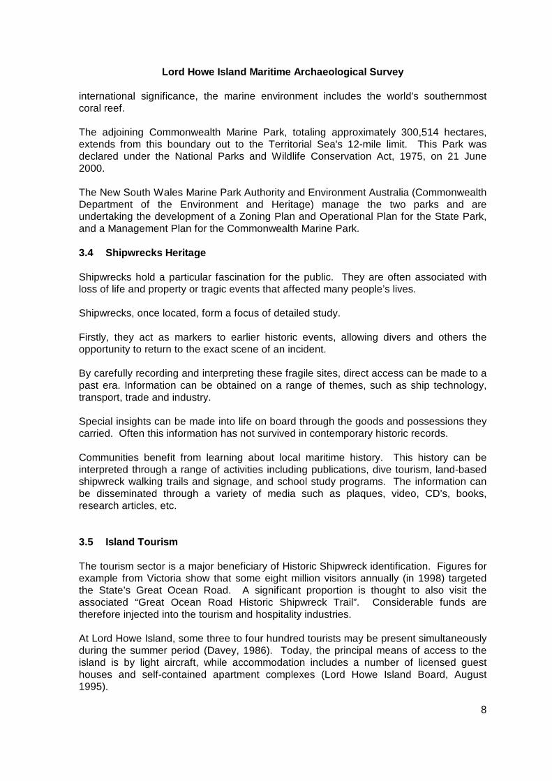
Lord Howe Island Maritime Archaeological Survey
25
Pacific Chieftain 1967 The vessel Pacific Chieftain wrecked on North Rock in the Admiralty Group immediately north of the island in 1967 Owned by Clive Wilson the 33 ft fishing boat was lost while fishing at Flat Rock near North Rock with 11 people aboard The passengers and crew escaped unscathed
54 Target 4 - General Maritime Heritage of the island Lord Howe Island has had an intrinsic connection with the sea since its initial discovery in 1788 It was therefore an assumption of this survey that records and physical evidence of this connection would survive in homes public spaces and in the memories of residents of the island 6 CURRENT FIELDWORK RESULTS 61 Target 1 - First Fleet Anchor HMS Supply
611 Location The anchor was not located during this survey and lies lsquohiddenrsquo in its unique underwater setting A small item difficult to detect with existing remote surveying technologies (approximately one ton and 355 meters in length) the anchor awaits further dedicated searches
612 Environmental context The survey was conducted in the southwest side of the lagoon with particular attention being paid to covering South Passage (also known as South West Passage or lsquoMan-of-War Passagersquo) and Erscotts Passage However due to the likely presence of other shiprsquos anchors and cultural materials lying offshore from the lagoon a much wider area of seafloor was chosen for investigation The area west of Blackburn Island for example was a designated mooring ground used extensively during the nineteenth century It is thought that early visitors to the island such as the whalers also moored in the general area The survey included areas in and around the reported 15-fathom depth (90 feet or 27 metres) adjacent to the main southern entrances where Supply was believed moored on 14 May 1788 The seabed consisted of sand patches running between longitudinal reef structures The reef is probably built upon harder volcanic rock with the sand accumulated in areas where softer rock has eroded The reef itself is relatively flat and covered with a layer of soft and hard corals Visibility was up to 50 metres
Lord Howe Island Maritime Archaeological Survey
26
Figure 12 Chart of magnetometer runs and anomaly clusters
613 Discussion of survey results A range of magnetic anomalies were identified but most of the clusters tended to suggest lineal patterns - perhaps a reflection of the magnetite in volcanic dykes traversing the seabed in the survey area These tended to run in approximate lines out from the masses of Mt Lidgbird and Mt Gower There were a couple of more isolated anomalies detected within this general pattern but time and weather conditions did not allow these to be lsquoground truthedrsquo by diving operations The record of the survey however provides a basis for future survey work Local divers are also planning to undertake periodic dives on some of the anomalies when they have an opportunity Because the anchor is an isolated small target within a wide survey area further dedicated searches will be required It can be expected that the anchor lies well exposed if sitting on reef areas although it may be substantially buried if located within one of the sand gullies Evidence from other Admiralty Pattern Long Shanked anchor discoveries in Australian waters suggests that one of the flukes should be partially
Lord Howe Island Maritime Archaeological Survey
27
visible although the timber stock might be completely lost due to marine organism attack
Figure 13 Details of magnetic anomaly clusters off Erscottrsquos Passage and South West Passage
62 Target 2 ndash Whaling Heritage
621 Location George 1830 This site was not located
Wolf 1837
No search was conducted for this shipwreck as it is believed to have foundered in deep water off the volcanic plateau that forms Lord Howe Island
Dive conducted in this area
Dive conducted in this area
Lord Howe Island Maritime Archaeological Survey
28
622 Environmental context George 1830 Georges Bay is open to easterly and southeasterly winds In addition southerly winds drive heavy seas along the coast and into this bay The underlying flat reef falls away just short of the shore and when the sea is up the swells break heavily on the narrow beach trapped at the base of a steep cliff It is in fact a most inhospitable place to escape from a shipwreck event and would presumably only have been the site of a landing if the survivors had no other choice This would tend to favour a scenario where the ship sank in or near the bay and the shiprsquos boats were unable to pull around the headland into the more favourable bays and beaches further north
Figure 14 Georges Bay probably named after the wreck of the whaler George - 1830
(Photograph by David Nutley)
Wolf 1837 Wolfe Rock is a small outcrop that sits just at or below the surface at high tide At low tide and when there is any swell around the seas break in a mass of foam However on a still day it would pose a considerable threat to shipping
Lord Howe Island Maritime Archaeological Survey
29
Figure 15 Wolfe Rock - struck by the whaler Wolf in 1837 (Photograph by David Nutley)
623 Discussion of survey results George 1830 A magnetometer survey was commenced near the entrance to Georges Bay (presumably named after the ship) but was discontinued when high levels of natural magnetic rock was found to lie in abundance throughout the bay With the expected fragmentary nature of any surviving wreck related material it was considered unlikely that the magnetometer could differentiate culturally occurring iron remains from that of the background magnetic readings A single dive on SCUBA was conducted at 27 metres opposite the opening to Georges Bay in an attempt to understand the nature of the bottom topography The area proved similar to that adjacent to Mt Lidgbird and the Supply anchor search area comprising raised lineal reefs interposed with sandy gullies The very close inshore area of the beach was not inspected due to extreme surge and wave activity No survey was possible in the vicinity of shoal area near Georges Rock near the very southern end of the island due to unfavourable sea conditions Georges Rock is believed to be the location where the George struck the island The lsquorockrsquo actually comprises an extensive shallow reef system not an isolated exposed feature (Brian Busteed 2001 perscom) It is not clear whether Georges Bay was named to mark where the ship came ashore or where the shiprsquos boat came ashore after the ship foundered Wolf 1837 No search was conducted for the whaler Wolfe as it is believed to have foundered in deep water off the volcanic plateau that forms Lord Howe Island A photographic record
Lord Howe Island Maritime Archaeological Survey
30
was made of Wolfe Rock identified as the place where the vessel struck Today Wolfe Rock is spelt with an lsquoersquo not the original spelling of the vessel Wolf Wolfe Rock is reported by island residents to have later been used as a bombing target by the RAAF (Peter Phillipps pers com Feb 2002) 63 Target 2 ndash Lagoon Losses
631 Location GPS positions were obtained for the following shipwrecks on 14 February 2002 (WGS 84 coordinates)
Figure 16 Jacques del Mar on south side of North Passage
(Photograph by Tim Smith)
Jacques del Mar ndash This wreck occurred on the southern side of the North Passage with portions of the wreck exposed on the reef top at low tide This section is lies very close to the track vessels take through passage and is therefore a familiar feature to residents and tourists alike It comprises fragmentary hull and deck plating access ladders and bollards The main portion of the wreck however lies west of this in deeper water on the ocean side of the fringing reef The scattered iron remains are reported to lie in a hole within the reef system but are notoriously difficult to dive because of wave and current activity and their location close to the navigation channel (Brian Busteed perscom 2002) Weather conditions precluded an inspection of the deep-water remains during the current survey The following exposed sections of wreckage were positioned bull main portion Latitude 31deg 31454rsquo S Longitude 159deg 02936rsquo E
Lord Howe Island Maritime Archaeological Survey
31
bull Adjacent scatter Latitude 31deg 31480rsquo S Longitude 159deg 02902rsquo E An iron boom from the vessel was salvaged after the wreck event and now lies in the front grounds of the Lord Howe Island Museum The vessel was subject to ongoing salvage at the time of loss and it is expected that other relics survive around the Island The fragmentary nature of the wreck site today is testimony to ferocious storms that sweep the island and the battering of the fringing reef areas that protect the lagoon Favorite ndash The remains of this vessel are also widely scattered - partially exposed on reef on the north side of North Passage and also over into the lagoon area off North Beach They comprise the main engine mass scattered refrigeration piping and four large steel boxes comprising refrigeration tanks for frozen goods and smaller tanks possibly used for water storage A significant discovery by island residents was a timber hull section located ashore on the adjacent North Beach This section lies inshore of the other remains and was considered likely to have carried over the reef from the main wreck location
Figure 17 Main portion of Favorite wreck site at high tide
(Photograph by Tim Smith) The timber remains were inspected on 5 February 2002 photographed videoed and drawn It appears from the condition of the timber section (415 x 250 metres) and its near re-burial within the survey period that the hull section is generally covered by sand Located at the mouth of a small creek that breaches the dunes heavy runoff would lead to periodic scouring The timber section comprises (at least) fifteen strakes of external planking (lines of planks) and underlying hull frames The planking is secured to the frames by iron fastenings the outer surfaces bogged up with a fiberglass-type material to waterproof them There is clear evidence of burning in some sections particularly frame ends suggesting that the hull partially burnt out
Lord Howe Island Maritime Archaeological Survey
32
Figure 18 Measured drawing of the partially exposed hull section on North Beach based on site sketch (Tim Smith) and photomosaic (David Nutley)
Drawn by Tim Smith Most planks measured 12- 13 centimeters in width the largest being 19 centimeters Portions of internal lsquoceilingrsquo timbers were evident attached to the inside surfaces of the frames Visually the section of hull timber appears similar to the planking lines of Favorite as seen in Figure 10 A timber sample was extracted from the external planking which when analysed was found to be Pseudotsuga menziesii or ldquoDouglas Firrdquo Commonly known as Oregon the timber is well-known in American shipbuilding and would support the Favorite being constructed in the Americas While three timber frames were visible fastening lines indicate the presence of nine frames attached to the hull section The frame scantlings were 165 centimeters square The main elements are located at (taken on 14 February 2002 WGS 84) bull Engine block - Latitude 31deg 31360rsquo S Longitude 159deg 02702rsquo E bull Refrigeration tubing - Latitude 31deg 31338rsquo S Longitude 159deg 02727rsquo E bull Main refrigerated box - Latitude 31deg 31315rsquo S Longitude 159deg 02742rsquo E bull Refrigerated box (submerged) - Latitude 31deg 31289rsquo S Longitude 159deg 02820rsquo E bull Refrigerated box - Latitude 31deg 31272rsquo S Longitude 159deg 02798rsquo E bull Refrigerated box - Latitude 31deg 31294rsquo S Longitude 159deg 02788rsquo E bull Hull remains on beach - Latitude 31deg 31073rsquo S Longitude 159deg 02575rsquo E
Lord Howe Island Maritime Archaeological Survey
33
Figure 19 Tim Smith undertaking the measured sketch (Photograph by David Nutley)
Figure 20 View of lagoon with North Passage (and Jacques del Mar aground) in centre of image (Photograph provided by Margaret ldquoPixierdquo Rourke)
Lord Howe Island Maritime Archaeological Survey
34
632 Environmental context The lagoon is located on the western side of the island and provides reasonable protection for shallow draft vessels The shipwrecks on this side of the island are all located near the North Passage an artificial passage created to allow access of ships to the wharf towards the northern end of the lagoon
633 Discussion of survey results Weather conditions did not permit survey of the Le Meurthe and severely limited work on the Jacques del Mar Time and weather precluded any search for the S M Stetson Jacques del Mar Mr Jim Whistler confirmed that the iron boom lying in the grounds of the museum came from the Jacques del Mar He recalled that at the time vessels only every 2-3 months and large vessels did not come into the lagoon but anchored off it for unloading He advised that the Jacques del Mar anchored outside the reef when a storm came up and the captain did not have time to pull the anchor up Because of this the vessel couldnrsquot get underway and it washed onto the reef The vessel was carrying a general cargo for the island and fuel The wreck was bought by Mr Kirby Margaret Rourkersquos (Pixiersquos) father from Pinetrees Jim Whistler was managing Pinetrees at the time Mr Kirby obtained salvage rights to the wreck from the insurers and Jim was put in charge of the work He recovered doors booms etc ndash lsquoanything that could moversquo He said it was a terrible job and the salvage placed a large financial strain on Mr Kirby as not much money was returned on the salvage rights outlay Ovalau The remains of the Ovalau were re-located on the afternoon of 4 February 2002 following advice from local resident John Green He reported that the wreck lay west of the North Passage on a line straight out through the channel Mr Green confirmed that the wreck had previously been inspected by an Island-based group of divers including himself and Michael Thompson Glass-bottom boat operators had also occasionally observed it on extremely clear water day The diving activity took place in the 1980rsquos and included the removal of some items from the site including three portholes now on public display at the Islandrsquos Museum Divers stopped accessing the site when a convenient tree used to line up the site was removed on Malabar Hill Magnetic anomalies were quickly detected on the initial run out from North Passage Subsequent parallel and right-angled runs with the magnetometer defined the spread of wreckage over about 300 metres An initial dive was conducted in the middle of the recorded anomalies in an area where the echo sounder picked out raised material on the edge of otherwise flat reef The dive confirmed the presence of scattered material including bollards a single scotch boiler large lengths of propeller shaft a possible winch miscellaneous sections of hull plating and a mound of collapsed components of the vertical inverted quadruple expansion steam engine A second dive on Friday 15 February when sea conditions had subsided considerably enabled some measured survey and photographic recording to be undertaken
Lord Howe Island Maritime Archaeological Survey
35
Recreational divers who were diving in the area at this time also reported that portions of the wreck were spread over a wide area in a water between 18 and 30 metres
Figure 21 Sketch of the upended Ovalau boiler showing the probable arrangement of features on the boiler face (uppermost) Details are obscured by marine growth (Drawing by Tim Smith)
Figure 22 Recording details of the boiler at the Ovalau site Lord Howe Island Ranger Julie Smith assisting Heritage Office Archaeologist Tim Smith (Photograph by David Nutley)
Lord Howe Island Maritime Archaeological Survey
36
The boiler stands on one end with three fireboxes uppermost and is intact with little evidence of damage Its orientation suggests that very strong swells sweep the site and may account from the scattered and highly fragmentary nature of the wreck A standard Scotch-type the boiler has a diameter of 440 metres (14 12 feet) and a length of 320 metres (ie stands off the seabed 320 m) The boiler lies 740 metres east of the engine in a water depth of 18 metres and was the only main boiler carried by the Ovalau It was originally situated forward of the engine and immediately aft of the shiprsquos bridge The boiler was located at bull Latitude 31deg 31717rsquo S Longitude 159deg 02328rsquo E (WGS 84 4 February 2002) The wreckrsquos location upon undulating reef would also contribute to the vessel breaking down rapidly due to abrasion and inability to bury within sediment The collapsed state of the engine and the rest of the site is marked This reflects its position on flat reef exposed to swell activity from the south and west It may also suggest that the explosions within the hull considerably weakened the overall structure and assisted with the initial breakup of the wreck
Figure 23 Two of three portholes recovered from the Ovalau wreck site by recreational divers and now on display at the Lord Howe Island Museum (Photographs by Julie Smith)
Report of a diver visiting the site (probably) in the 1930rsquos indicates possible salvage activity (see Nicholas 193944) Salvage of shipwreck sites at this time (ie using hard hat equipment) commonly involved the use of explosives to access key metal components This activity might have contributed to the fragmentary nature of the engine remains It is worth noting the potential for older Island residents to retain recollections of this activity The engine lies canted over on one side with the cylinder heads facing the up-ended boiler The four cylinders (two high pressure and two low pressure) can be made out within a mass of confused underlying structure (approximately 340 meters in length) Canted down a small slope of reef the cylinders retain their overall alignment although much of the supporting engine structure is hard to discern due to its cover of marine
Lord Howe Island Maritime Archaeological Survey
37
growth and iron concretion products It is currently unknown how much of the engine has been disturbed or elements removed The fragmentary nature of the structure and collapse of the upper portion incorporating the cylinders is indicative of the engine having been dynamited Marine engine specialist John Riley who noted the absence of the condenser confirms this (perscom 15 May 2002) The engine condenser was commonly salvaged due to its high percentage of copper components Also visible within the engine mass are remains of the upright lsquolegsrsquo that supported the structure The National Maritime Museum at Greenwich (UK) holds several original plans for the Ovalau including drawing 377 Engines (see attached) These plans indicate that Ovalaursquos quadruple expansion (4 cylinder) direct acting inverted steam engine stood an impressive 22 feet high (670 metres) The quadruple engine was the end development of compound marine engines and is represented on only a handful of NSW shipwrecks Ovalau (1903) Iron Chieftain (1941) and Iron Knight (1943) Ovalaursquos is the only located and accessible quadruple engine on a NSW historic shipwreck site
Favorite Dynamic sea conditions have scattered the remains of this vessel over a wide area of the lagoon off North Beach As a result there is little coherence to the site but the components that are visible are large solid and accessible Those parts within the lagoon itself are accessible by snorkeling or kayak The engine block on top of the reef can be reached by foot at low tide and the timber hull section in the creek at North Beach can also be accessed by foot though it seems to be buried by under sand a good deal of the time 64 Target 4 - general maritime heritage of the island
641 Discussion of survey results A detailed survey of general maritime heritage on the island was not possible within the scope of the current survey However maritime related sites with potential for further study include bull Erscotts Passage ndash Norfolk Island Pine markers Prominent on the shoreline near Lovers Bay stand two magnificent Norfolk Island Pines The Pines listed as of heritage significance to the Island were planted in c1873 as navigational markers (Tanner 1985 76) Similar to obelisks or flagstaffs ashore the two pines when in alignment serve to mark a safe route through the main southern passage into the lagoon ndash Erscotts Passage Historic charts of Lord Howe Island indicate that timber flagstaffs were also established in the region during the nineteenth century but is unclear whether these served a similar purpose or were used to inform shiprsquos masters of safe conditions to enter the lagoon The pines stand on a part of the lagoon shore that would have been a likely landing ground for the Officers and crew of HMS Supply on their first official landing in 1788 Located adjacent to both South and Erscotts Passage the shoreline consists of several sandy indents that would have provided convenient access from Supply presumably moored offshore from here
Lord Howe Island Maritime Archaeological Survey
38
Figure 24 Erscotts Passage channel marker pines (Photograph by David Nutley)
bull Houses made from recycled shipwreck timbers Several residential houses on Lord Howe Island have been identified as being of special heritage significance This relates to their early age of construction retention of original fabric or associations with significant early islander families Several houses are thought to have incorporated timbers washed ashore either from an historic shipwreck event or cargo lost overboard (see Rabone 1972 23) These houses require further detailed study to identify the presence of ships timbers (possibly through evidence of fastening types including treenails and spikes) the wood species involved and their possible association with the shipwreck heritage of the island The Nathan Thompson House on Neds Beach Road is an example The building is reputed to date from the 1850s and is a simple timber cottage set on a base of local stone known as calcancinite The board and batten walls are made from the local Island trees Scaleybark and Blackbutt whilst some of the interior walls and joinery are of Red Cedar cut from logs collected by Thompson after being allegedly washed ashore on the island The original interior walls are tongue and grooved and beaded by hand and interior timbers retain adze marks (Heritage Office Database ndash HOD entry) bull Photographs and records in private collections and the Lord Howe Island Museum Mr Jim Whistler editor of the Islandrsquos newsletter Signal noted the presence within the Lord Howe Island Museum collection of original photographs and negatives by island photographer Mr Dick Morris This extensive collection of photographs was compiled during 7-8 years following Mr Morrisrsquo arrival c1931-2 He photographed various scenes and events and sold the prints to visiting tourists often at Nedrsquos Beach
Lord Howe Island Maritime Archaeological Survey
39
The collection includes several images related to the maritime history of the island and key shipwreck events The collection is now available to researchers at the recently opened Museum and will be examined to identify relevant images bull Aircraft remains The history of the Island is inexorably linked to the period of the flying boat service The image of these graceful craft landing on the island lagoon is a familiar one and the services close ties to the aircraft base at Rose Bay Sydney Tourists to the island regularly view historic movietone and other films related to this fascinating period in island tourism through the weekly screenings at the Town Hall Islander Post-Master Peter Phillipps is an authority on historic aircraft associations with Lord Howe Island and has compiled a book detailing that history (Phillipps 2002) Flying boat charters began successfully on 9 December 1947 and finally concluded in September 1974 aboard Beachcomber The use of flying boats resulted in some notable incidents that have left a permanent record within the environment These include fragmentary remains of RAAF Catalina A24-381 of Number 11 Squadron Rathmines NSW The aircraft clipped North Peak on Malabar Hill at night on 28 September 1948 after detecting a serious fuel leak The Catalina exploded in flames crashing near the Old Settlement with only two survivors being rescued by local residents from a crew of nine The impact site is linked by an interpretative walking trail from near Neds Beach and fragments of the wreckage are retained within the fields and slope Another incident involved Trans Oceanic Airways (TOA) Catalina VH-EAX that was driven ashore in a gale on 23 June 1949 The remains from this aircraft were partly salvaged One wing was transported to Neds Beach and used as fill to stabilise erosion under the present-day shelter near to the main beach access What happened to the remainder of the airframe is unknown (Phillipps 2002 per com) The other significant reminder of this important era is the wreck of the ANSETT Airways Short Sandringham flying boat Pacific Chieftain (VH-BRE) that was also driven ashore within the lagoon on 3 July 1963 and severely damaged the following day (Phillipps 2002 in press and 1999) Beyond repair the aircraft was partially salvaged for usable parts towed to sea holed with hand axes and sunk off the North Passage The archaeological remains of this aircraft have not been searched for or detected It is considered that they would be located in deep water Several eyewitnesses to the scuttling are still resident on the island and transit photographs available that could assist the approximate sinking site to be relocated A position for the target area was recorded with the now obsolete Sat Nav navigational system when island resident Mr Roy lsquoSnowrsquo Wilson was interred near the site in March 1987 aboard his vessel Lulawai (Signal Newsletter Vol 3 No73) The funeral was a significant event in the islandrsquos history The remains of this aircraft are important as a physical record of the period of flying boat travel and early island tourism The remains are protected by the relics provisions of the NSW Heritage Act 1977
Lord Howe Island Maritime Archaeological Survey
40
Should they be located through accident or dedicated underwater remote sensing surveys the Heritage Council of New South Wales would need to be contacted immediately Appropriate management recommendations could then be developed to ensure the survival of the fragile remains and appropriate interpretation strategies developed bull Lower hull of a small timber launch in paddock Mr Peter Phillipps invited the survey team to inspect the remains of a small timber boat lying within a stand of trees on the Thompson property The existence of the fragmentary lower (upturned) hull of a timber vessel was a surprise and suggests that similar remains might be located at other parts of the island Information on the type of vessel its date or range of use was unknown Of standard clinker construction the thinly planked hull measured approximately three meters in length and has evidence of copper-lines drainage (pump) holes in the lower hull There was no surviving evidence of the bow or stern Several stringers (or internal framing members) were also evident The timber was in a considerable state of deterioration lying in a wet exposed environment It appears the vessel was used locally and had the appearance of an early open whaleboat or similar rowed vessel It is uncertain whether it was ever fitted with a powered engine
Figure 25 Hull timbers from island launch in paddock (Photograph by David Nutley)
Lord Howe Island Maritime Archaeological Survey
41
7 ASSESSMENT OF SIGNIFICANCE 71 Introduction Significance has been assessed in accordance with the nature and degree of significance of the sitersquos primary attributes These include attributes related to historical social archaeological scientific and interpretative significance 72 Target 1 ndash First Fleet anchor Although the anchor was not located its significance as evidence of the first known human contact with the island and its association with the establishment of Sydney and with HMS Supply would make this a relic of considerable historic importance If found an assessment of significance would include consideration of to the following points 1 Supply was the first vessel of the First Fleet to reach Botany Bay on 19 January 1788
The remainder of the fleet arrived two days later on 21 January (Neville 197542) 2 Supply carried the colonyrsquos key personnel ashore including Governor Arthur Phillip
Lieutenant Philip King and William Dawes
These key personnel had specifically transferred to the smaller faster Supply in order to race ahead of the fleet They left the flagship HMS Sirius on 25 November 1787 after departing the Cape of Good Hope (Neville 197542)
3 Supply was the first vessel to enter Port Jackson a day ahead of the rest of the fleet after the
famous relocation from Botany Bay 4 Supply discovered Lord Howe Island in March 1788 when sent to re-locate Norfolk Island 5 Supply served as the principle method of communication for the Port Jackson settlement and
the Norfolk Island penal colony following the loss of HMS Sirius in 1790 6 Supply saved the colony from starvation when it sailed to Batavia (Indonesia) for emergency
supplies on 18 April 1790 Supply arrived back from Batavia on 19 October 1790 after a voyage of over six months Many of the crew having died in that port from disease
7 HMS Supply the first to enter Botany Bay was also the last vessel of the famous First Fleet to
return home departing Sydney on 27 December 1791 (Neville 197598) 73 Target 2 ndash Whaling heritage Neither the Wolf nor the George were located However Georges Rock Georges Bay and Wolfe Rock have interpretive significance due to their association with this important part of Lord Howe Islandrsquos historic background 74 Target 3 ndash Lagoon losses
741 Ovalau
Lord Howe Island Maritime Archaeological Survey
42
7411 ATTRIBUTES OF SIGNIFICANCE Historical (Concerned with range of context)
The Ovalau is synonymous with the history of Burns Philp operations in the South Seas and with the islandrsquos long and continuing dependence on the sea for many transportation needs
Social (Concerned with community regard or esteem)
The ship continues to have a strong place in oral history on the island The place of the ship in that history is marked by the use of its name within the Payten family
Located in easy access of the lagoon and island-based diver charter businesses the Ovalau is the largest accessible shipwreck available for heritage tourism activities
Technical (Concerned with technical or creative achievement)
Because of its disturbed state the site retains medium technological significance
The engine is the only located example of the quadruple expansion type on a
shipwreck in NSW It is a rare example of a type not widely evidenced on vessels operating in the Statersquos waters during the late nineteenth-early twentieth century
Archaeological (Concerned with research potential through investigation of material remains)
The sitersquos quadruple expansion steam engine is important for archaeological documentation of advances in marine steam technology
Interpretative (Concerned with public education values)
The site is very accessible to divers and has potential to be incorporated into a Lord Howe Island Marine Park interpretative program
7412 Statement of Significance
The Ovalau is synonymous with the history of Burns Philp operations in the South Seas and with the islandrsquos long and continuing dependence on the sea for cargo transport The ship continues to have a strong place in oral history on the island The place of the vessel in that history is marked by the continuing use of its name within the Payten family
The quadruple expansion marine engine is a rare example of its type in
Australia and provides an archaeological record of advances in marine steam technology
The accessibility of the site provides potential for incorporation into a Lord Howe
Island Marine Park interpretative program and recreational diving experiences
Lord Howe Island Maritime Archaeological Survey
43
742 Favorite Historical (Concerned with range of context)
Little information is currently available on the history of this vessel and its historic attributes cannot be fully assessed
Social (Concerned with community regard or esteem)
The remains of the ship are a visible reminder to the community and visitors to the island of the ever-present dangers faced by shipping even into modern times
Interpretative (Concerned with public education values)
The site is very accessible and has potential to be incorporated into a Lord Howe Island Marine Park interpretative program
7421 Statement of Significance The remains of the Favorite are a visible reminder to the community and visitors
to the island of the ever-present dangers faced by shipping even into modern times The site is very accessible and has potential to be incorporated into a Lord Howe Island Marine Park interpretative program (The significance of this site should be reassessed in the event that additional historical information is located)
743 Jacques del Mar Historical (Concerned with range of context)
Little information is currently available on the history of this vessel and its historic attributes cannot be fully assessed
Social (Concerned with community regard or esteem)
The remains of the ship are a visible reminder to the community and visitors to the island of the ever-present dangers faced by shipping even into modern times
Interpretative (Concerned with public education values)
The site is very accessible and has potential to be incorporated into a Lord Howe Island Marine Park interpretative program
7431 Statement of Significance The remains of the Jacques del Mar are a visible reminder to the community and visitors to the island of the ever present dangers faced by shipping even into modern times The site is very accessible and has potential to be incorporated into a Lord Howe Island Marine Park interpretative program (The significance of
Lord Howe Island Maritime Archaeological Survey
44
this site should be reassessed in the event that additional historical information is located)
744 La Meurthe Further research into the history of the Le Meurthe and a survey of the wreck site will be needed before an assessment of the significance of this site can be completed Social (Concerned with community regard or esteem)
The remains of the vessel are sometimes visited by recreational SCUBA divers who enjoy the sitersquos major elements in a usually demanding environment
The site is important in lending its name to the popular surf break in the vicinity
of the wreck The unofficial ldquoLa Meurthe Breakrdquo attribution is evidence of the process whereby
a local community associates a major shipwreck event with a local landform or feature (usually a reef headland rock or bay associated with a shipwreck event) It is the only known example in NSW of a surf break being associated with an historic shipwreck event
8 MANAGEMENT RECOMMENDATIONS 81 Target 1 ndash First Fleet anchor
The anchor was not located during this survey However the following is provided as a basic guide in the event that it is found in the future This relic once located would be of national heritage significance It is associated with the earliest European exploration of Lord Howe Island by the Royal Navy following the establishment of the penal colony at Port Jackson The anchor would serve as a permanent marker of the actual scene of Supplyrsquos second landing at Lord Howe Island and its near loss on the fringing reef Upon discovery several options for the anchorrsquos preservation could be considered These include leaving the anchor in its unique underwater setting and incorporating it into existing island dive tourism programs The anchorrsquos location and images of the anchor could be relayed to land-based visitors through suitable onshore interpretation This approach would be consistent with the UNESCO Convention on the Protection of the Underwater Cultural Heritage that promotes retention and conservation in-situ as the preferred option unless there are strong research or preservation issues that suggest otherwise Recovery is the other option with public display of the anchor at Lord Howe Island This would require appropriate archaeological assessments conservation advice and facilities secure funding and excavation approval under the NSW Heritage Act 1977
Lord Howe Island Maritime Archaeological Survey
45
Both options would facilitate wide public interaction with this important historic relic and advance the islandrsquos unique heritage assets Media interest in the discovery would be high One of two naval vessels employed with the original convict fleet HMS Supply was the first vessel to land at Botany Bay in 1788 and the first to enter Sydney Harbour The historic wreck of HMS Sirius at Norfolk Island (1790) is the only other tangible link to the vessels of the First Fleet 82 Target 2 ndash Whaling Heritage
821 CONSERVATION Until the wreck sites are located there will be no current conservation issues for either the George or the Wolf
822 DISPLAY AND PUBLIC ACCESS Georges Rock is actually a shoal with very limited access due to its exposed and relatively remote location on the island At Georges Bay there is limited walking access and in calm weather boat access Given the exposed nature of the beach and the relatively low level of visitation it is not recommended that signage be established at Georges Bay
823 PROMOTION Georges Bay and Wolfe Rock are included in a number of existing information brochures as well as the NSW Heritage Office website Maritime Heritage Online (httpmaritimeheritagenswgovau) It would be appropriate for additional opportunities to be sought that link the names of these geographical features to the 1830 loss of the whaler George and the 1837 loss of the Wolf 83 Target 3 ndash Lagoon losses
831 Ovalau
8311 CONSERVATION As of the time of the current survey this is a stable site with no visible evidence of active corrosion The main potential threat to this stability is the use of anchors associated with dive boats Features such as the intact single boiler and the remains of the steam engine are particularly vulnerable to disturbance and a renewed phase of active corrosion if the current marine growth and concretion is dislodged by contact with anchors or anchor chains The installation of a permanent mooring by the Marine Park Authority or by the Authority in conjunction dive charter operators on the island would be an effective means of eliminating this threat and minimising the impact of diver visitation
8312 DISPLAY AND PUBLIC ACCESS The Ovalau provides the major underwater cultural heritage attraction within the Lord Howe Island Marine Park It has considerable potential for adding variety to the experience of visiting divers The main features lie at a depth of about 19 metres that suit
Lord Howe Island Maritime Archaeological Survey
46
divers of limited levels of experience Parts of the wreck in 30 metres of water are suitable for more experienced divers and provide an opportunity to start the dive at a deeper depth and to conclude the dive at a shallower depth thus providing a lsquoprofilersquo for the dive that conforms with approved safety routines
8313 PROMOTION The Ovalau has potential for promotion through photographically illustrated articles in diving magazines tourism brochures and web-sites The wreck site is not in a location that lends itself to shore based signage Underwater signage would be possible but would be made more difficult by the scattered nature of the site the strong surge that is periodically experienced in this area and the flat reef on which much of the wreckage sites
832 Favorite
8321 CONSERVATION There is no requirement for active conservation work to be undertaken on the site of the Favorite However as with all shipwreck sites avoidance of destabilisation and renewed active corrosion requires divers and reef walkers to be advised to avoid damaging the surface of the remains
8322 DISPLAY AND PUBLIC ACCESS The Favorite provides an underwater and above water cultural heritage attraction within the Lord Howe Island Marine Park It has potential for adding variety to the experience of visiting divers particularly inexperienced divers or when sea conditions prevent diving outside of the lagoon
8323 PROMOTION The Favorite has potential for promotion through photographically illustrated articles in diving magazines tourism brochures and websites The scattered nature of the site does not lend itself to shore based or underwater signage
833 Jacques del Mar
8331 CONSERVATION There is no requirement for active conservation work to be undertaken on the site of the Jacques del Mar However as with all shipwreck sites avoidance of destabilisation and renewed active corrosion requires divers to be advised to avoid damaging the surface of the remains
8332 DISPLAY AND PUBLIC ACCESS The Jacques del Mar provides an underwater and above water cultural heritage attraction within the Lord Howe Island Marine Park Itrsquos underwater component on the western side of the reef has potential for adding variety to the experience of divers when sea conditions are suitable for diving outside of the lagoon
Lord Howe Island Maritime Archaeological Survey
47
8333 PROMOTION The Jacques del Mar has potential for promotion through photographically illustrated articles in diving magazines tourism brochures and web-sites The scattered nature of the site does not lend itself to shore based or underwater signage
834 La Meurthe
8341 CONSERVATION No survey was undertaken of this site due to weather conditions and the following recommendation is based on the nature of the location of the wreck These recommendations will need to be reassessed in light of any future archaeological survey It is not expected that there will be a requirement for active conservation work to be undertaken on the site of the La Meurthe However as with all shipwreck sites avoidance of destabilisation and renewed active corrosion requires divers to be advised to avoid damaging the surface of the remains
8342 DISPLAY AND PUBLIC ACCESS The La Meurthe provides an underwater cultural heritage attraction within the Lord Howe Island Marine Park It has potential for adding variety to the experience of divers when sea conditions are suitable for diving outside of the lagoon
8343 PROMOTION The La Meurthe has potential for promotion through photographically illustrated articles in diving magazines tourism brochures and web-sites The scattered nature of the site does not lend itself to shore based or underwater signage
Lord Howe Island Maritime Archaeological Survey
48
9 BIBLIOGRAPHY
Anon 2000 Lord Howe Island Group World Heritage Property Strategic Plan for Management 2000-2005 Lord Howe Island Board Prepared by Manidis Roberts Consultants Surrey Hills
Bauer Commander Bruce 1986 ed The Sextant Handbook Adjustment Repair Use and History International Marine Publishing Maine USA
Cairnes Lorraine Ed 1998 Lord Howe Island Group World Heritage Property Strategic Issues Study A Report Commissioned by the Lord Howe Island Board Fathom Consulting Sydney
Calligan Dennis 1994 Cooks cannon and anchor The recovery and conservation of relics from HMB Endeavour Commonwealth of Australia
Cotsell George 1856Treatise Shipsrsquo Anchors London
Curryer Betty 1999 Anchors An Illustrated History London
Davey A 1986 Plan of Management Lord Howe Island Permanent Park Preserve New South Wales National Parks and Wildlife Service Sydney
Egan Jack 1999 Buried Alive Sydney 1788-1792 Eyewitness Accounts of the Making of a Nation Allen amp Unwin Sydney
Evans V amp Nutley D 1991 ldquoHooked on anchorsrdquo in Bulletin of the Australian Institute For Maritime Archaeology 15(2)pp41-44
Flannery Tim Ed 1998 Watkin Tench 1788 The Text Publishing Company Melbourne
Fletcher Brian (editor) 1975 An Account of the English Colony in New South Wale by David Collins (Originally published 1798) Reed Books Sydney
Fox M Allan 1998 An Interpretive Strategy for Lord Howe Island Group World Heritage Property Lord Howe Island Board
Henderson Graeme 1993 The wreck of the Sirius in Australian Geographic No29 Jan-Mar 1993 100-117
Heritage Office 2000 Shipwreck Information Sheet Lord Howe Island Heritage Office Sydney
Heritage Office 2000 Introduction to Maritime Archaeology brochure Heritage Office Sydney
Heritage Office 1996 Shipwreck Atlas of New South Wales edition 3 Heritage Office Sydney
Hill Chris 1992 Lord Howe Island South Pacific paradise on our door step in Australian Geographic No28 Oct-Dec 1992 32-53
Historic Records of New South Wales 1892 Volume 1 Part 2 - Phillip 1783-1792 Charles Potter Government Printer Sydney
Hunter John 1793 An Historical Journal of the Transactions at Port Jackson and Norfolk Island with the Discoveries which have been made in New South Wales and in the Southern Ocean Since the Publication of Phillips Voyages London John Stockdale Piccadilly Reproduced by the Libraries Board of South Australia Adelaide 1968
Lord Howe Island Maritime Archaeological Survey
49
Jenkins Jayne 2000 Balls Pyramid Lord Howe Island Scuba Diver Magazine MarchApril 2000 pp40-43
Johnson Paul-Alan 1992 In the beginning From the First Fleet to Macquarie The Globe ndash Unfolding Australia Special Issue 37 1992 pp38-44
Lord Howe Island World Heritage Area brochure Lord Howe Island Board (no date)
Mander-Jones Phyllis 1972 Manuscripts in the British Isles Relating to Australia New Zealand and the Pacific University of Hawaii Honolulu and Australian National University
Marine Park Authority 2000 Help us plan Lord Howe Island Marine Park brochure Produced by the Marine Park Authority and Environment Australia
Neville Derek 1975 Blackburns Isle Terence Dalton Limited Suffolk
Nicholls Max 1939 Lord Howe Island 1788-1938 George M Dash publishers Sydney
OBrien Ekarestini 1998 Australian Joint Copying Project Handbook Part 8 Miscellaneous Series National Library of Australia Canberra
Phillips Margaret 1993 Australian Joint Copying Project Handbook Part 7 Public Records Office Admiralty Records National Library of Australia Canberra
Phillipps Peter 2002 (in press) The Flying Boat Days The Early Aviation History of Lord Howe Island Seaview Press South Australia
Phillipps Peter 1999 The worldrsquos last flying boat service in Australian Aviation Nov 1999 pp64-66
Pickard John 1992 Genealogy of Maps from Lord Howe Island The Globe ndash Unfolding Australia Special Issue 37 1992 pp80-4
Rabone Harold 1972 Lord Howe Island Its Discovery and Early Associations 1788-1888 Sydney
Smith Bernard amp Wheeler Alwyne ed 1988 The art of the First Fleet and other early Australian drawings Yale University Press London
Smith Tim 2001 Project Island Heritage The Lord Howe Island Maritime Archaeological Survey ndash Proposal NSW Heritage Office Interdepartmental Report May 2001
Smith Tim and Weir Chloe 1999 Where are the whalers The whaling wreck site potential of New South Wales Bulletin of the Australian Institute for Maritime Archaeology Vol 23 pp 40-45
Smith Tim 2000 Admiralty Old Pattern Long Shanked Anchor North Head Conservation Management Plan NSW Heritage Office Sydney (internal report)
Stanbury Myra 1994 HMS Sirius 1790 AN illustrated catalogue of artefacts recovered from the wreck site at Norfolk Island Australian Institute for Maritime Archaeology Special Publication No7 Perth
Steel David 1794 The elements and practice of rigging and seamanship Vol1 London
Lord Howe Island Maritime Archaeological Survey
50
Steel David 1794 Description and use of anchors extract from The elements and practice of rigging and seamanship Vol1 1794 London published in Nautical Research Journal vol13 pp124ff
Wilkinson BA amp Willson RK 1981 The Main Line Fleet of Burns Philp Sydney HMS Supply Key reference materials Armstrong A 1794-99 Log Books Masters Logs Supply 1794-1769 Microfilm copy
held by Mitchell LibraryState Library of New South Wales (ADM 514023 AJCP 1618 piece 3468)
Ball Lieut HL 1791-2 Journal of the Proceedings of HM Supply 27 Nov 1791-20 April
1792 Microfilm copy held by Mitchell LibraryState Library of New South Wales (PRO 412)
Blackburn D Remarks Etc on Coast and Harbours Master of His Majestyrsquos Armed
Tender Supply 1792 Hydrographic Department Miscellaneous Papers vol69 Ba1 pp615ff Microfilm copy held by Mitchell LibraryState Library of New South Wales (M2319)
Blackburn D Correspondence 1785-1796 Microfilm copy held by Mitchell LibraryState
Library of New South Wales (AJCP M97) Blackburn D Ships Musters - Supply Microfilm copy held by Mitchell LibraryState
Library of New South Wales (ADM 3610981) Various Navy Board Records To the Admiralty 1787-1788 Microfilm copy held by
Mitchell LibraryState Library of New South Wales (ADM 106 221322143321) Various Admiralty Captains Logs Transports Charlotte Fishburn Borrowdale
Alexander 1786-1789 Microfilm copy held by Mitchell LibraryState Library of New South Wales (ADM 514375)
51
10 Appendix A - Lord Howe Island Shipwreck Information Sheet
Shipwrecks ndash Lord Howe Island The NSW coast and waterways are littered with thousands of shipwrecks Their timbers iron plating anchors and cargoes have become fragile records of a heroic maritime history They are the last remnants of a time when industry commerce and families were directly or indirectly reliant on transport by sea
River boats trains and road transport linked the inland regions of the State with the ships that plied our coastal and international shipping lanes Freight and passenger vessels came in various shapes and sizes their form influenced by their ocean going habits or the shallow river bars of small coastal ports Technology and cargoes also shaped the construction of the ships while commercial and political decisions determined when and where ships rail or road were the dominant transport network
The ships that form our maritime heritage were built locally and at ports around the world - from the small riverside slipways on the NSW coast to the mighty shipyards in England Scotland Canada and the USA
Commercial and public interests did not always result in good record keeping for these vessels the people who served on them the passengers who entrusted their welfare to them or the cargoes that they carried Often they were too mundane just workhorses that kept the economy together Many ships passed on with no surviving image to record their appearance The day to day experiences of the passengers and crew were rarely written down The remains on the seabed often contain the only surviving clues
Generally ships are not totally destroyed when they are wrecked Parts are preserved covered in sand mud and marine growth A flat expanse of sand can cover a large part of the story of the ship and the people who were associated with it The only visible clue may be the fluke of an anchor If this or other visible evidence of the ship is taken away the site may be lost forever or inadvertently damaged by modern day anchors dredging or other human activities
We as a community can help to preserve the information held within shipwreck sites By becoming aware of their location and place in history we can relive the joys and fears of the people they carried We can also feel something of the trepidation and anguish of those who waited upon their arrival
This information sheet lists 15 of the ships that have been lost on or near Lord Howe Island If you wish to obtain more information or if you wish to share information from other sources please contact
Maritime Archaeology Unit NSW Heritage Office Locked Bag 5020 Parramatta NSW 2124 Phone 02-9635 6155 Fax 02-9891 4688 Email heritageofficeheritagenswgovau Shipwreck Database Msritime Heritage Online httpmaritimeheritagenswgovau or httpaimaiinetnetau See also the Shipwreck Atlas of New South Wales available from the NSW Heritage Office
This sheet is available free from httpwwwheritagenswgovau and may be reproduced with appropriate attribution
Location
Legislation All shipwrecks over 75 years of age are automatically classified as historic shipwrecks and protected under the Historic Shipwrecks Act 1976 Relics off the NSW coast likely to be associated with historic ships are also protected under this Act
Relics in NSW lakes and rivers over 50 years of age are protected under the relics provisions of the NSW Heritage Act 1977
The Heritage Office should be notified as soon as possible if a shipwreck or other underwater relic is located or disturbed
Severe penalties apply for non-compliance with the legislation
Sailors clinging to their disintegrating ship battling overwhelming seas clutching at floating debris gasping for momentary breaths in foaming surf - these are the
52
Shipwrecks of Lord Howe Island Favorite - One of the Islandrsquos more recent shipwrecks the Favorite ran aground at the North Passage in 1965 Few details have been located for the vessel its origin or ownership
George - the earliest shipwreck at Lord Howe Island the 186 ton whaler George either ran aground or sank off the southern end in December 1830 A 2377 metre two-masted whaler operating out of Tasmania built at Plymouth UK in 1810 registered Hobart as 6 of 1830
Jacques del Mar - French-registered 506 ton 4428 metre steel screw steamer wrecked at the Islandrsquos North Passage in 1954 Built as the Marion Sleigh at Bremerhaven Germany in 1906 and one time registered to Sydney as 6 of 1930 with Official Number 139627
La Meurthe - abandoned at sea in gale whilst under the tow of St Louis The unmanned ldquoghost shiprdquo drove ashore near the lagoon at Lord Howe Island in 1907 much to the amazement of local residents A timber sailing ship of 1597 tons gross built at France in 1882
Laura ndash lost at sea after departing the Peruvian port of Callao on 18 April for Newcastle to load coal One of Laurarsquos lifeboats eventually washed up north of Cronulla Beach Sydney and the wheel box at Lord Howe Island A barque formerly known as Claudova
Maelgwyn ndash abandoned approximately twenty miles northwest Lord Howe Island in 1907 Departing Pisco Peru on 17 November 1906 the 1276 ton vessel became disabled in a gale after ballast shifted All 20 crew reached Lord Howe Island in the boats A 6706 metre iron barque built at Sunderland Scotland in 1884 and registered at London Official Number 89625
Mystery Star ndash intended as part of a film on Lord Howe Island the 488 metre timber motor skiff was lost after departing the island for New South Wales in October 1936 Crewed by actors Brian Abbot and Leslie Simpson the vessel was never found despite searches by RAN destroyer Waterhen and RAAF aircraft including Seagull amphibians and a Gannet monoplane
Ovalau ndash cargo of copra caught fire about 100 miles from Lord Howe Island in Oct 1903 but contained until reaching that place Passengers and crew disembarked before the ship exploded burnt and finally sank off North Passage A 1229 ton 70-metre steamer built in Scotland in 1891 registered at Sydney as 331903 Official Number 141471 Cargo of Cockatoos and parrots let loose on the island Wreckage lies in 19-30m of water - located
Pacific Chieftain ndash a 10 metre wooden fishing vessel wrecked in November 1968 at Flat Rock near North Rock Admiralty Islands All 11 passengers and crew escaped on a lifeboat
SM Stetson ndash the 707 ton collier barque SM Stetson left Newcastle with 1150 tons of coal on 10 March 1877 bound for San Francisco Sprang a leak and beached at entrance to North Passage on 25 March Three crew manned a small boat and after a gruelling 7 day voyage made Sydney Built in the USA in 1874 Registered San Francisco Official Number 115351
Sylph -The 13 metre 17 ton ketch Sylph foundered at sea after departing Lord Howe Island for Sydney on 20 April 1873 All 8 crew and passengers drowned Built at Brisbane Water in 1849 NSW Owned by Lord Howe Island residents Field Thompson and Wainright some of whom were lost with the vessel Registered in Sydney at 1 of 1850 with Official Number 32395
Viking ndash A wooden double-ender island boat lost between Sydney and Lord Howe Island in November 1936 with the loss of 6 lives
Whangaroa - Became unseaworthy and abandoned about 20 June 1911 after departing New Zealand for Sydney with cargo of hardwood Crew arrived at Lord Howe Island after four days clinging to vessel Wreckage later sighted ashore A 3648 metre topsail schooner of 143 tons built at Whangaroa in 1893 Registered Sydney as 46 of 1899 with Official Number 94270
Wolf - the 265 ton whaling barque Wolf wrecked near Lord Howe Island in 1837 At sea for 18 months with 1700 barrels of sperm whale oil aboard Exhausted crew went ashore for water and food Wolf blew against near-shore reefs and holed later sinking within ten miles of shore Originally built as a gun-brig at the Royal Navy Woolwich Dockyard in 1814
Zeno - abandoned off Lord Howe Island on a voyage from Newcastle to Wellington New Zealand with coal Foundered on 6 September 1895 with 10 crew making the safety of the island A 407 ton 3892 metre brigantine built at Johnrsquos River Nova Scotia Canada in 1876 Registered Auckland at folio 26 of 1891 Official Number 74343
ISBN 1 876415 42 8 HO 0015 Crown copyright 2000
Lord Howe Island Maritime Archaeological Survey
26
Figure 12 Chart of magnetometer runs and anomaly clusters
613 Discussion of survey results A range of magnetic anomalies were identified but most of the clusters tended to suggest lineal patterns - perhaps a reflection of the magnetite in volcanic dykes traversing the seabed in the survey area These tended to run in approximate lines out from the masses of Mt Lidgbird and Mt Gower There were a couple of more isolated anomalies detected within this general pattern but time and weather conditions did not allow these to be lsquoground truthedrsquo by diving operations The record of the survey however provides a basis for future survey work Local divers are also planning to undertake periodic dives on some of the anomalies when they have an opportunity Because the anchor is an isolated small target within a wide survey area further dedicated searches will be required It can be expected that the anchor lies well exposed if sitting on reef areas although it may be substantially buried if located within one of the sand gullies Evidence from other Admiralty Pattern Long Shanked anchor discoveries in Australian waters suggests that one of the flukes should be partially
Lord Howe Island Maritime Archaeological Survey
27
visible although the timber stock might be completely lost due to marine organism attack
Figure 13 Details of magnetic anomaly clusters off Erscottrsquos Passage and South West Passage
62 Target 2 ndash Whaling Heritage
621 Location George 1830 This site was not located
Wolf 1837
No search was conducted for this shipwreck as it is believed to have foundered in deep water off the volcanic plateau that forms Lord Howe Island
Dive conducted in this area
Dive conducted in this area
Lord Howe Island Maritime Archaeological Survey
28
622 Environmental context George 1830 Georges Bay is open to easterly and southeasterly winds In addition southerly winds drive heavy seas along the coast and into this bay The underlying flat reef falls away just short of the shore and when the sea is up the swells break heavily on the narrow beach trapped at the base of a steep cliff It is in fact a most inhospitable place to escape from a shipwreck event and would presumably only have been the site of a landing if the survivors had no other choice This would tend to favour a scenario where the ship sank in or near the bay and the shiprsquos boats were unable to pull around the headland into the more favourable bays and beaches further north
Figure 14 Georges Bay probably named after the wreck of the whaler George - 1830
(Photograph by David Nutley)
Wolf 1837 Wolfe Rock is a small outcrop that sits just at or below the surface at high tide At low tide and when there is any swell around the seas break in a mass of foam However on a still day it would pose a considerable threat to shipping
Lord Howe Island Maritime Archaeological Survey
29
Figure 15 Wolfe Rock - struck by the whaler Wolf in 1837 (Photograph by David Nutley)
623 Discussion of survey results George 1830 A magnetometer survey was commenced near the entrance to Georges Bay (presumably named after the ship) but was discontinued when high levels of natural magnetic rock was found to lie in abundance throughout the bay With the expected fragmentary nature of any surviving wreck related material it was considered unlikely that the magnetometer could differentiate culturally occurring iron remains from that of the background magnetic readings A single dive on SCUBA was conducted at 27 metres opposite the opening to Georges Bay in an attempt to understand the nature of the bottom topography The area proved similar to that adjacent to Mt Lidgbird and the Supply anchor search area comprising raised lineal reefs interposed with sandy gullies The very close inshore area of the beach was not inspected due to extreme surge and wave activity No survey was possible in the vicinity of shoal area near Georges Rock near the very southern end of the island due to unfavourable sea conditions Georges Rock is believed to be the location where the George struck the island The lsquorockrsquo actually comprises an extensive shallow reef system not an isolated exposed feature (Brian Busteed 2001 perscom) It is not clear whether Georges Bay was named to mark where the ship came ashore or where the shiprsquos boat came ashore after the ship foundered Wolf 1837 No search was conducted for the whaler Wolfe as it is believed to have foundered in deep water off the volcanic plateau that forms Lord Howe Island A photographic record
Lord Howe Island Maritime Archaeological Survey
30
was made of Wolfe Rock identified as the place where the vessel struck Today Wolfe Rock is spelt with an lsquoersquo not the original spelling of the vessel Wolf Wolfe Rock is reported by island residents to have later been used as a bombing target by the RAAF (Peter Phillipps pers com Feb 2002) 63 Target 2 ndash Lagoon Losses
631 Location GPS positions were obtained for the following shipwrecks on 14 February 2002 (WGS 84 coordinates)
Figure 16 Jacques del Mar on south side of North Passage
(Photograph by Tim Smith)
Jacques del Mar ndash This wreck occurred on the southern side of the North Passage with portions of the wreck exposed on the reef top at low tide This section is lies very close to the track vessels take through passage and is therefore a familiar feature to residents and tourists alike It comprises fragmentary hull and deck plating access ladders and bollards The main portion of the wreck however lies west of this in deeper water on the ocean side of the fringing reef The scattered iron remains are reported to lie in a hole within the reef system but are notoriously difficult to dive because of wave and current activity and their location close to the navigation channel (Brian Busteed perscom 2002) Weather conditions precluded an inspection of the deep-water remains during the current survey The following exposed sections of wreckage were positioned bull main portion Latitude 31deg 31454rsquo S Longitude 159deg 02936rsquo E
Lord Howe Island Maritime Archaeological Survey
31
bull Adjacent scatter Latitude 31deg 31480rsquo S Longitude 159deg 02902rsquo E An iron boom from the vessel was salvaged after the wreck event and now lies in the front grounds of the Lord Howe Island Museum The vessel was subject to ongoing salvage at the time of loss and it is expected that other relics survive around the Island The fragmentary nature of the wreck site today is testimony to ferocious storms that sweep the island and the battering of the fringing reef areas that protect the lagoon Favorite ndash The remains of this vessel are also widely scattered - partially exposed on reef on the north side of North Passage and also over into the lagoon area off North Beach They comprise the main engine mass scattered refrigeration piping and four large steel boxes comprising refrigeration tanks for frozen goods and smaller tanks possibly used for water storage A significant discovery by island residents was a timber hull section located ashore on the adjacent North Beach This section lies inshore of the other remains and was considered likely to have carried over the reef from the main wreck location
Figure 17 Main portion of Favorite wreck site at high tide
(Photograph by Tim Smith) The timber remains were inspected on 5 February 2002 photographed videoed and drawn It appears from the condition of the timber section (415 x 250 metres) and its near re-burial within the survey period that the hull section is generally covered by sand Located at the mouth of a small creek that breaches the dunes heavy runoff would lead to periodic scouring The timber section comprises (at least) fifteen strakes of external planking (lines of planks) and underlying hull frames The planking is secured to the frames by iron fastenings the outer surfaces bogged up with a fiberglass-type material to waterproof them There is clear evidence of burning in some sections particularly frame ends suggesting that the hull partially burnt out
Lord Howe Island Maritime Archaeological Survey
32
Figure 18 Measured drawing of the partially exposed hull section on North Beach based on site sketch (Tim Smith) and photomosaic (David Nutley)
Drawn by Tim Smith Most planks measured 12- 13 centimeters in width the largest being 19 centimeters Portions of internal lsquoceilingrsquo timbers were evident attached to the inside surfaces of the frames Visually the section of hull timber appears similar to the planking lines of Favorite as seen in Figure 10 A timber sample was extracted from the external planking which when analysed was found to be Pseudotsuga menziesii or ldquoDouglas Firrdquo Commonly known as Oregon the timber is well-known in American shipbuilding and would support the Favorite being constructed in the Americas While three timber frames were visible fastening lines indicate the presence of nine frames attached to the hull section The frame scantlings were 165 centimeters square The main elements are located at (taken on 14 February 2002 WGS 84) bull Engine block - Latitude 31deg 31360rsquo S Longitude 159deg 02702rsquo E bull Refrigeration tubing - Latitude 31deg 31338rsquo S Longitude 159deg 02727rsquo E bull Main refrigerated box - Latitude 31deg 31315rsquo S Longitude 159deg 02742rsquo E bull Refrigerated box (submerged) - Latitude 31deg 31289rsquo S Longitude 159deg 02820rsquo E bull Refrigerated box - Latitude 31deg 31272rsquo S Longitude 159deg 02798rsquo E bull Refrigerated box - Latitude 31deg 31294rsquo S Longitude 159deg 02788rsquo E bull Hull remains on beach - Latitude 31deg 31073rsquo S Longitude 159deg 02575rsquo E
Lord Howe Island Maritime Archaeological Survey
33
Figure 19 Tim Smith undertaking the measured sketch (Photograph by David Nutley)
Figure 20 View of lagoon with North Passage (and Jacques del Mar aground) in centre of image (Photograph provided by Margaret ldquoPixierdquo Rourke)
Lord Howe Island Maritime Archaeological Survey
34
632 Environmental context The lagoon is located on the western side of the island and provides reasonable protection for shallow draft vessels The shipwrecks on this side of the island are all located near the North Passage an artificial passage created to allow access of ships to the wharf towards the northern end of the lagoon
633 Discussion of survey results Weather conditions did not permit survey of the Le Meurthe and severely limited work on the Jacques del Mar Time and weather precluded any search for the S M Stetson Jacques del Mar Mr Jim Whistler confirmed that the iron boom lying in the grounds of the museum came from the Jacques del Mar He recalled that at the time vessels only every 2-3 months and large vessels did not come into the lagoon but anchored off it for unloading He advised that the Jacques del Mar anchored outside the reef when a storm came up and the captain did not have time to pull the anchor up Because of this the vessel couldnrsquot get underway and it washed onto the reef The vessel was carrying a general cargo for the island and fuel The wreck was bought by Mr Kirby Margaret Rourkersquos (Pixiersquos) father from Pinetrees Jim Whistler was managing Pinetrees at the time Mr Kirby obtained salvage rights to the wreck from the insurers and Jim was put in charge of the work He recovered doors booms etc ndash lsquoanything that could moversquo He said it was a terrible job and the salvage placed a large financial strain on Mr Kirby as not much money was returned on the salvage rights outlay Ovalau The remains of the Ovalau were re-located on the afternoon of 4 February 2002 following advice from local resident John Green He reported that the wreck lay west of the North Passage on a line straight out through the channel Mr Green confirmed that the wreck had previously been inspected by an Island-based group of divers including himself and Michael Thompson Glass-bottom boat operators had also occasionally observed it on extremely clear water day The diving activity took place in the 1980rsquos and included the removal of some items from the site including three portholes now on public display at the Islandrsquos Museum Divers stopped accessing the site when a convenient tree used to line up the site was removed on Malabar Hill Magnetic anomalies were quickly detected on the initial run out from North Passage Subsequent parallel and right-angled runs with the magnetometer defined the spread of wreckage over about 300 metres An initial dive was conducted in the middle of the recorded anomalies in an area where the echo sounder picked out raised material on the edge of otherwise flat reef The dive confirmed the presence of scattered material including bollards a single scotch boiler large lengths of propeller shaft a possible winch miscellaneous sections of hull plating and a mound of collapsed components of the vertical inverted quadruple expansion steam engine A second dive on Friday 15 February when sea conditions had subsided considerably enabled some measured survey and photographic recording to be undertaken
Lord Howe Island Maritime Archaeological Survey
35
Recreational divers who were diving in the area at this time also reported that portions of the wreck were spread over a wide area in a water between 18 and 30 metres
Figure 21 Sketch of the upended Ovalau boiler showing the probable arrangement of features on the boiler face (uppermost) Details are obscured by marine growth (Drawing by Tim Smith)
Figure 22 Recording details of the boiler at the Ovalau site Lord Howe Island Ranger Julie Smith assisting Heritage Office Archaeologist Tim Smith (Photograph by David Nutley)
Lord Howe Island Maritime Archaeological Survey
36
The boiler stands on one end with three fireboxes uppermost and is intact with little evidence of damage Its orientation suggests that very strong swells sweep the site and may account from the scattered and highly fragmentary nature of the wreck A standard Scotch-type the boiler has a diameter of 440 metres (14 12 feet) and a length of 320 metres (ie stands off the seabed 320 m) The boiler lies 740 metres east of the engine in a water depth of 18 metres and was the only main boiler carried by the Ovalau It was originally situated forward of the engine and immediately aft of the shiprsquos bridge The boiler was located at bull Latitude 31deg 31717rsquo S Longitude 159deg 02328rsquo E (WGS 84 4 February 2002) The wreckrsquos location upon undulating reef would also contribute to the vessel breaking down rapidly due to abrasion and inability to bury within sediment The collapsed state of the engine and the rest of the site is marked This reflects its position on flat reef exposed to swell activity from the south and west It may also suggest that the explosions within the hull considerably weakened the overall structure and assisted with the initial breakup of the wreck
Figure 23 Two of three portholes recovered from the Ovalau wreck site by recreational divers and now on display at the Lord Howe Island Museum (Photographs by Julie Smith)
Report of a diver visiting the site (probably) in the 1930rsquos indicates possible salvage activity (see Nicholas 193944) Salvage of shipwreck sites at this time (ie using hard hat equipment) commonly involved the use of explosives to access key metal components This activity might have contributed to the fragmentary nature of the engine remains It is worth noting the potential for older Island residents to retain recollections of this activity The engine lies canted over on one side with the cylinder heads facing the up-ended boiler The four cylinders (two high pressure and two low pressure) can be made out within a mass of confused underlying structure (approximately 340 meters in length) Canted down a small slope of reef the cylinders retain their overall alignment although much of the supporting engine structure is hard to discern due to its cover of marine
Lord Howe Island Maritime Archaeological Survey
37
growth and iron concretion products It is currently unknown how much of the engine has been disturbed or elements removed The fragmentary nature of the structure and collapse of the upper portion incorporating the cylinders is indicative of the engine having been dynamited Marine engine specialist John Riley who noted the absence of the condenser confirms this (perscom 15 May 2002) The engine condenser was commonly salvaged due to its high percentage of copper components Also visible within the engine mass are remains of the upright lsquolegsrsquo that supported the structure The National Maritime Museum at Greenwich (UK) holds several original plans for the Ovalau including drawing 377 Engines (see attached) These plans indicate that Ovalaursquos quadruple expansion (4 cylinder) direct acting inverted steam engine stood an impressive 22 feet high (670 metres) The quadruple engine was the end development of compound marine engines and is represented on only a handful of NSW shipwrecks Ovalau (1903) Iron Chieftain (1941) and Iron Knight (1943) Ovalaursquos is the only located and accessible quadruple engine on a NSW historic shipwreck site
Favorite Dynamic sea conditions have scattered the remains of this vessel over a wide area of the lagoon off North Beach As a result there is little coherence to the site but the components that are visible are large solid and accessible Those parts within the lagoon itself are accessible by snorkeling or kayak The engine block on top of the reef can be reached by foot at low tide and the timber hull section in the creek at North Beach can also be accessed by foot though it seems to be buried by under sand a good deal of the time 64 Target 4 - general maritime heritage of the island
641 Discussion of survey results A detailed survey of general maritime heritage on the island was not possible within the scope of the current survey However maritime related sites with potential for further study include bull Erscotts Passage ndash Norfolk Island Pine markers Prominent on the shoreline near Lovers Bay stand two magnificent Norfolk Island Pines The Pines listed as of heritage significance to the Island were planted in c1873 as navigational markers (Tanner 1985 76) Similar to obelisks or flagstaffs ashore the two pines when in alignment serve to mark a safe route through the main southern passage into the lagoon ndash Erscotts Passage Historic charts of Lord Howe Island indicate that timber flagstaffs were also established in the region during the nineteenth century but is unclear whether these served a similar purpose or were used to inform shiprsquos masters of safe conditions to enter the lagoon The pines stand on a part of the lagoon shore that would have been a likely landing ground for the Officers and crew of HMS Supply on their first official landing in 1788 Located adjacent to both South and Erscotts Passage the shoreline consists of several sandy indents that would have provided convenient access from Supply presumably moored offshore from here
Lord Howe Island Maritime Archaeological Survey
38
Figure 24 Erscotts Passage channel marker pines (Photograph by David Nutley)
bull Houses made from recycled shipwreck timbers Several residential houses on Lord Howe Island have been identified as being of special heritage significance This relates to their early age of construction retention of original fabric or associations with significant early islander families Several houses are thought to have incorporated timbers washed ashore either from an historic shipwreck event or cargo lost overboard (see Rabone 1972 23) These houses require further detailed study to identify the presence of ships timbers (possibly through evidence of fastening types including treenails and spikes) the wood species involved and their possible association with the shipwreck heritage of the island The Nathan Thompson House on Neds Beach Road is an example The building is reputed to date from the 1850s and is a simple timber cottage set on a base of local stone known as calcancinite The board and batten walls are made from the local Island trees Scaleybark and Blackbutt whilst some of the interior walls and joinery are of Red Cedar cut from logs collected by Thompson after being allegedly washed ashore on the island The original interior walls are tongue and grooved and beaded by hand and interior timbers retain adze marks (Heritage Office Database ndash HOD entry) bull Photographs and records in private collections and the Lord Howe Island Museum Mr Jim Whistler editor of the Islandrsquos newsletter Signal noted the presence within the Lord Howe Island Museum collection of original photographs and negatives by island photographer Mr Dick Morris This extensive collection of photographs was compiled during 7-8 years following Mr Morrisrsquo arrival c1931-2 He photographed various scenes and events and sold the prints to visiting tourists often at Nedrsquos Beach
Lord Howe Island Maritime Archaeological Survey
39
The collection includes several images related to the maritime history of the island and key shipwreck events The collection is now available to researchers at the recently opened Museum and will be examined to identify relevant images bull Aircraft remains The history of the Island is inexorably linked to the period of the flying boat service The image of these graceful craft landing on the island lagoon is a familiar one and the services close ties to the aircraft base at Rose Bay Sydney Tourists to the island regularly view historic movietone and other films related to this fascinating period in island tourism through the weekly screenings at the Town Hall Islander Post-Master Peter Phillipps is an authority on historic aircraft associations with Lord Howe Island and has compiled a book detailing that history (Phillipps 2002) Flying boat charters began successfully on 9 December 1947 and finally concluded in September 1974 aboard Beachcomber The use of flying boats resulted in some notable incidents that have left a permanent record within the environment These include fragmentary remains of RAAF Catalina A24-381 of Number 11 Squadron Rathmines NSW The aircraft clipped North Peak on Malabar Hill at night on 28 September 1948 after detecting a serious fuel leak The Catalina exploded in flames crashing near the Old Settlement with only two survivors being rescued by local residents from a crew of nine The impact site is linked by an interpretative walking trail from near Neds Beach and fragments of the wreckage are retained within the fields and slope Another incident involved Trans Oceanic Airways (TOA) Catalina VH-EAX that was driven ashore in a gale on 23 June 1949 The remains from this aircraft were partly salvaged One wing was transported to Neds Beach and used as fill to stabilise erosion under the present-day shelter near to the main beach access What happened to the remainder of the airframe is unknown (Phillipps 2002 per com) The other significant reminder of this important era is the wreck of the ANSETT Airways Short Sandringham flying boat Pacific Chieftain (VH-BRE) that was also driven ashore within the lagoon on 3 July 1963 and severely damaged the following day (Phillipps 2002 in press and 1999) Beyond repair the aircraft was partially salvaged for usable parts towed to sea holed with hand axes and sunk off the North Passage The archaeological remains of this aircraft have not been searched for or detected It is considered that they would be located in deep water Several eyewitnesses to the scuttling are still resident on the island and transit photographs available that could assist the approximate sinking site to be relocated A position for the target area was recorded with the now obsolete Sat Nav navigational system when island resident Mr Roy lsquoSnowrsquo Wilson was interred near the site in March 1987 aboard his vessel Lulawai (Signal Newsletter Vol 3 No73) The funeral was a significant event in the islandrsquos history The remains of this aircraft are important as a physical record of the period of flying boat travel and early island tourism The remains are protected by the relics provisions of the NSW Heritage Act 1977
Lord Howe Island Maritime Archaeological Survey
40
Should they be located through accident or dedicated underwater remote sensing surveys the Heritage Council of New South Wales would need to be contacted immediately Appropriate management recommendations could then be developed to ensure the survival of the fragile remains and appropriate interpretation strategies developed bull Lower hull of a small timber launch in paddock Mr Peter Phillipps invited the survey team to inspect the remains of a small timber boat lying within a stand of trees on the Thompson property The existence of the fragmentary lower (upturned) hull of a timber vessel was a surprise and suggests that similar remains might be located at other parts of the island Information on the type of vessel its date or range of use was unknown Of standard clinker construction the thinly planked hull measured approximately three meters in length and has evidence of copper-lines drainage (pump) holes in the lower hull There was no surviving evidence of the bow or stern Several stringers (or internal framing members) were also evident The timber was in a considerable state of deterioration lying in a wet exposed environment It appears the vessel was used locally and had the appearance of an early open whaleboat or similar rowed vessel It is uncertain whether it was ever fitted with a powered engine
Figure 25 Hull timbers from island launch in paddock (Photograph by David Nutley)
Lord Howe Island Maritime Archaeological Survey
41
7 ASSESSMENT OF SIGNIFICANCE 71 Introduction Significance has been assessed in accordance with the nature and degree of significance of the sitersquos primary attributes These include attributes related to historical social archaeological scientific and interpretative significance 72 Target 1 ndash First Fleet anchor Although the anchor was not located its significance as evidence of the first known human contact with the island and its association with the establishment of Sydney and with HMS Supply would make this a relic of considerable historic importance If found an assessment of significance would include consideration of to the following points 1 Supply was the first vessel of the First Fleet to reach Botany Bay on 19 January 1788
The remainder of the fleet arrived two days later on 21 January (Neville 197542) 2 Supply carried the colonyrsquos key personnel ashore including Governor Arthur Phillip
Lieutenant Philip King and William Dawes
These key personnel had specifically transferred to the smaller faster Supply in order to race ahead of the fleet They left the flagship HMS Sirius on 25 November 1787 after departing the Cape of Good Hope (Neville 197542)
3 Supply was the first vessel to enter Port Jackson a day ahead of the rest of the fleet after the
famous relocation from Botany Bay 4 Supply discovered Lord Howe Island in March 1788 when sent to re-locate Norfolk Island 5 Supply served as the principle method of communication for the Port Jackson settlement and
the Norfolk Island penal colony following the loss of HMS Sirius in 1790 6 Supply saved the colony from starvation when it sailed to Batavia (Indonesia) for emergency
supplies on 18 April 1790 Supply arrived back from Batavia on 19 October 1790 after a voyage of over six months Many of the crew having died in that port from disease
7 HMS Supply the first to enter Botany Bay was also the last vessel of the famous First Fleet to
return home departing Sydney on 27 December 1791 (Neville 197598) 73 Target 2 ndash Whaling heritage Neither the Wolf nor the George were located However Georges Rock Georges Bay and Wolfe Rock have interpretive significance due to their association with this important part of Lord Howe Islandrsquos historic background 74 Target 3 ndash Lagoon losses
741 Ovalau
Lord Howe Island Maritime Archaeological Survey
42
7411 ATTRIBUTES OF SIGNIFICANCE Historical (Concerned with range of context)
The Ovalau is synonymous with the history of Burns Philp operations in the South Seas and with the islandrsquos long and continuing dependence on the sea for many transportation needs
Social (Concerned with community regard or esteem)
The ship continues to have a strong place in oral history on the island The place of the ship in that history is marked by the use of its name within the Payten family
Located in easy access of the lagoon and island-based diver charter businesses the Ovalau is the largest accessible shipwreck available for heritage tourism activities
Technical (Concerned with technical or creative achievement)
Because of its disturbed state the site retains medium technological significance
The engine is the only located example of the quadruple expansion type on a
shipwreck in NSW It is a rare example of a type not widely evidenced on vessels operating in the Statersquos waters during the late nineteenth-early twentieth century
Archaeological (Concerned with research potential through investigation of material remains)
The sitersquos quadruple expansion steam engine is important for archaeological documentation of advances in marine steam technology
Interpretative (Concerned with public education values)
The site is very accessible to divers and has potential to be incorporated into a Lord Howe Island Marine Park interpretative program
7412 Statement of Significance
The Ovalau is synonymous with the history of Burns Philp operations in the South Seas and with the islandrsquos long and continuing dependence on the sea for cargo transport The ship continues to have a strong place in oral history on the island The place of the vessel in that history is marked by the continuing use of its name within the Payten family
The quadruple expansion marine engine is a rare example of its type in
Australia and provides an archaeological record of advances in marine steam technology
The accessibility of the site provides potential for incorporation into a Lord Howe
Island Marine Park interpretative program and recreational diving experiences
Lord Howe Island Maritime Archaeological Survey
43
742 Favorite Historical (Concerned with range of context)
Little information is currently available on the history of this vessel and its historic attributes cannot be fully assessed
Social (Concerned with community regard or esteem)
The remains of the ship are a visible reminder to the community and visitors to the island of the ever-present dangers faced by shipping even into modern times
Interpretative (Concerned with public education values)
The site is very accessible and has potential to be incorporated into a Lord Howe Island Marine Park interpretative program
7421 Statement of Significance The remains of the Favorite are a visible reminder to the community and visitors
to the island of the ever-present dangers faced by shipping even into modern times The site is very accessible and has potential to be incorporated into a Lord Howe Island Marine Park interpretative program (The significance of this site should be reassessed in the event that additional historical information is located)
743 Jacques del Mar Historical (Concerned with range of context)
Little information is currently available on the history of this vessel and its historic attributes cannot be fully assessed
Social (Concerned with community regard or esteem)
The remains of the ship are a visible reminder to the community and visitors to the island of the ever-present dangers faced by shipping even into modern times
Interpretative (Concerned with public education values)
The site is very accessible and has potential to be incorporated into a Lord Howe Island Marine Park interpretative program
7431 Statement of Significance The remains of the Jacques del Mar are a visible reminder to the community and visitors to the island of the ever present dangers faced by shipping even into modern times The site is very accessible and has potential to be incorporated into a Lord Howe Island Marine Park interpretative program (The significance of
Lord Howe Island Maritime Archaeological Survey
44
this site should be reassessed in the event that additional historical information is located)
744 La Meurthe Further research into the history of the Le Meurthe and a survey of the wreck site will be needed before an assessment of the significance of this site can be completed Social (Concerned with community regard or esteem)
The remains of the vessel are sometimes visited by recreational SCUBA divers who enjoy the sitersquos major elements in a usually demanding environment
The site is important in lending its name to the popular surf break in the vicinity
of the wreck The unofficial ldquoLa Meurthe Breakrdquo attribution is evidence of the process whereby
a local community associates a major shipwreck event with a local landform or feature (usually a reef headland rock or bay associated with a shipwreck event) It is the only known example in NSW of a surf break being associated with an historic shipwreck event
8 MANAGEMENT RECOMMENDATIONS 81 Target 1 ndash First Fleet anchor
The anchor was not located during this survey However the following is provided as a basic guide in the event that it is found in the future This relic once located would be of national heritage significance It is associated with the earliest European exploration of Lord Howe Island by the Royal Navy following the establishment of the penal colony at Port Jackson The anchor would serve as a permanent marker of the actual scene of Supplyrsquos second landing at Lord Howe Island and its near loss on the fringing reef Upon discovery several options for the anchorrsquos preservation could be considered These include leaving the anchor in its unique underwater setting and incorporating it into existing island dive tourism programs The anchorrsquos location and images of the anchor could be relayed to land-based visitors through suitable onshore interpretation This approach would be consistent with the UNESCO Convention on the Protection of the Underwater Cultural Heritage that promotes retention and conservation in-situ as the preferred option unless there are strong research or preservation issues that suggest otherwise Recovery is the other option with public display of the anchor at Lord Howe Island This would require appropriate archaeological assessments conservation advice and facilities secure funding and excavation approval under the NSW Heritage Act 1977
Lord Howe Island Maritime Archaeological Survey
45
Both options would facilitate wide public interaction with this important historic relic and advance the islandrsquos unique heritage assets Media interest in the discovery would be high One of two naval vessels employed with the original convict fleet HMS Supply was the first vessel to land at Botany Bay in 1788 and the first to enter Sydney Harbour The historic wreck of HMS Sirius at Norfolk Island (1790) is the only other tangible link to the vessels of the First Fleet 82 Target 2 ndash Whaling Heritage
821 CONSERVATION Until the wreck sites are located there will be no current conservation issues for either the George or the Wolf
822 DISPLAY AND PUBLIC ACCESS Georges Rock is actually a shoal with very limited access due to its exposed and relatively remote location on the island At Georges Bay there is limited walking access and in calm weather boat access Given the exposed nature of the beach and the relatively low level of visitation it is not recommended that signage be established at Georges Bay
823 PROMOTION Georges Bay and Wolfe Rock are included in a number of existing information brochures as well as the NSW Heritage Office website Maritime Heritage Online (httpmaritimeheritagenswgovau) It would be appropriate for additional opportunities to be sought that link the names of these geographical features to the 1830 loss of the whaler George and the 1837 loss of the Wolf 83 Target 3 ndash Lagoon losses
831 Ovalau
8311 CONSERVATION As of the time of the current survey this is a stable site with no visible evidence of active corrosion The main potential threat to this stability is the use of anchors associated with dive boats Features such as the intact single boiler and the remains of the steam engine are particularly vulnerable to disturbance and a renewed phase of active corrosion if the current marine growth and concretion is dislodged by contact with anchors or anchor chains The installation of a permanent mooring by the Marine Park Authority or by the Authority in conjunction dive charter operators on the island would be an effective means of eliminating this threat and minimising the impact of diver visitation
8312 DISPLAY AND PUBLIC ACCESS The Ovalau provides the major underwater cultural heritage attraction within the Lord Howe Island Marine Park It has considerable potential for adding variety to the experience of visiting divers The main features lie at a depth of about 19 metres that suit
Lord Howe Island Maritime Archaeological Survey
46
divers of limited levels of experience Parts of the wreck in 30 metres of water are suitable for more experienced divers and provide an opportunity to start the dive at a deeper depth and to conclude the dive at a shallower depth thus providing a lsquoprofilersquo for the dive that conforms with approved safety routines
8313 PROMOTION The Ovalau has potential for promotion through photographically illustrated articles in diving magazines tourism brochures and web-sites The wreck site is not in a location that lends itself to shore based signage Underwater signage would be possible but would be made more difficult by the scattered nature of the site the strong surge that is periodically experienced in this area and the flat reef on which much of the wreckage sites
832 Favorite
8321 CONSERVATION There is no requirement for active conservation work to be undertaken on the site of the Favorite However as with all shipwreck sites avoidance of destabilisation and renewed active corrosion requires divers and reef walkers to be advised to avoid damaging the surface of the remains
8322 DISPLAY AND PUBLIC ACCESS The Favorite provides an underwater and above water cultural heritage attraction within the Lord Howe Island Marine Park It has potential for adding variety to the experience of visiting divers particularly inexperienced divers or when sea conditions prevent diving outside of the lagoon
8323 PROMOTION The Favorite has potential for promotion through photographically illustrated articles in diving magazines tourism brochures and websites The scattered nature of the site does not lend itself to shore based or underwater signage
833 Jacques del Mar
8331 CONSERVATION There is no requirement for active conservation work to be undertaken on the site of the Jacques del Mar However as with all shipwreck sites avoidance of destabilisation and renewed active corrosion requires divers to be advised to avoid damaging the surface of the remains
8332 DISPLAY AND PUBLIC ACCESS The Jacques del Mar provides an underwater and above water cultural heritage attraction within the Lord Howe Island Marine Park Itrsquos underwater component on the western side of the reef has potential for adding variety to the experience of divers when sea conditions are suitable for diving outside of the lagoon
Lord Howe Island Maritime Archaeological Survey
47
8333 PROMOTION The Jacques del Mar has potential for promotion through photographically illustrated articles in diving magazines tourism brochures and web-sites The scattered nature of the site does not lend itself to shore based or underwater signage
834 La Meurthe
8341 CONSERVATION No survey was undertaken of this site due to weather conditions and the following recommendation is based on the nature of the location of the wreck These recommendations will need to be reassessed in light of any future archaeological survey It is not expected that there will be a requirement for active conservation work to be undertaken on the site of the La Meurthe However as with all shipwreck sites avoidance of destabilisation and renewed active corrosion requires divers to be advised to avoid damaging the surface of the remains
8342 DISPLAY AND PUBLIC ACCESS The La Meurthe provides an underwater cultural heritage attraction within the Lord Howe Island Marine Park It has potential for adding variety to the experience of divers when sea conditions are suitable for diving outside of the lagoon
8343 PROMOTION The La Meurthe has potential for promotion through photographically illustrated articles in diving magazines tourism brochures and web-sites The scattered nature of the site does not lend itself to shore based or underwater signage
Lord Howe Island Maritime Archaeological Survey
48
9 BIBLIOGRAPHY
Anon 2000 Lord Howe Island Group World Heritage Property Strategic Plan for Management 2000-2005 Lord Howe Island Board Prepared by Manidis Roberts Consultants Surrey Hills
Bauer Commander Bruce 1986 ed The Sextant Handbook Adjustment Repair Use and History International Marine Publishing Maine USA
Cairnes Lorraine Ed 1998 Lord Howe Island Group World Heritage Property Strategic Issues Study A Report Commissioned by the Lord Howe Island Board Fathom Consulting Sydney
Calligan Dennis 1994 Cooks cannon and anchor The recovery and conservation of relics from HMB Endeavour Commonwealth of Australia
Cotsell George 1856Treatise Shipsrsquo Anchors London
Curryer Betty 1999 Anchors An Illustrated History London
Davey A 1986 Plan of Management Lord Howe Island Permanent Park Preserve New South Wales National Parks and Wildlife Service Sydney
Egan Jack 1999 Buried Alive Sydney 1788-1792 Eyewitness Accounts of the Making of a Nation Allen amp Unwin Sydney
Evans V amp Nutley D 1991 ldquoHooked on anchorsrdquo in Bulletin of the Australian Institute For Maritime Archaeology 15(2)pp41-44
Flannery Tim Ed 1998 Watkin Tench 1788 The Text Publishing Company Melbourne
Fletcher Brian (editor) 1975 An Account of the English Colony in New South Wale by David Collins (Originally published 1798) Reed Books Sydney
Fox M Allan 1998 An Interpretive Strategy for Lord Howe Island Group World Heritage Property Lord Howe Island Board
Henderson Graeme 1993 The wreck of the Sirius in Australian Geographic No29 Jan-Mar 1993 100-117
Heritage Office 2000 Shipwreck Information Sheet Lord Howe Island Heritage Office Sydney
Heritage Office 2000 Introduction to Maritime Archaeology brochure Heritage Office Sydney
Heritage Office 1996 Shipwreck Atlas of New South Wales edition 3 Heritage Office Sydney
Hill Chris 1992 Lord Howe Island South Pacific paradise on our door step in Australian Geographic No28 Oct-Dec 1992 32-53
Historic Records of New South Wales 1892 Volume 1 Part 2 - Phillip 1783-1792 Charles Potter Government Printer Sydney
Hunter John 1793 An Historical Journal of the Transactions at Port Jackson and Norfolk Island with the Discoveries which have been made in New South Wales and in the Southern Ocean Since the Publication of Phillips Voyages London John Stockdale Piccadilly Reproduced by the Libraries Board of South Australia Adelaide 1968
Lord Howe Island Maritime Archaeological Survey
49
Jenkins Jayne 2000 Balls Pyramid Lord Howe Island Scuba Diver Magazine MarchApril 2000 pp40-43
Johnson Paul-Alan 1992 In the beginning From the First Fleet to Macquarie The Globe ndash Unfolding Australia Special Issue 37 1992 pp38-44
Lord Howe Island World Heritage Area brochure Lord Howe Island Board (no date)
Mander-Jones Phyllis 1972 Manuscripts in the British Isles Relating to Australia New Zealand and the Pacific University of Hawaii Honolulu and Australian National University
Marine Park Authority 2000 Help us plan Lord Howe Island Marine Park brochure Produced by the Marine Park Authority and Environment Australia
Neville Derek 1975 Blackburns Isle Terence Dalton Limited Suffolk
Nicholls Max 1939 Lord Howe Island 1788-1938 George M Dash publishers Sydney
OBrien Ekarestini 1998 Australian Joint Copying Project Handbook Part 8 Miscellaneous Series National Library of Australia Canberra
Phillips Margaret 1993 Australian Joint Copying Project Handbook Part 7 Public Records Office Admiralty Records National Library of Australia Canberra
Phillipps Peter 2002 (in press) The Flying Boat Days The Early Aviation History of Lord Howe Island Seaview Press South Australia
Phillipps Peter 1999 The worldrsquos last flying boat service in Australian Aviation Nov 1999 pp64-66
Pickard John 1992 Genealogy of Maps from Lord Howe Island The Globe ndash Unfolding Australia Special Issue 37 1992 pp80-4
Rabone Harold 1972 Lord Howe Island Its Discovery and Early Associations 1788-1888 Sydney
Smith Bernard amp Wheeler Alwyne ed 1988 The art of the First Fleet and other early Australian drawings Yale University Press London
Smith Tim 2001 Project Island Heritage The Lord Howe Island Maritime Archaeological Survey ndash Proposal NSW Heritage Office Interdepartmental Report May 2001
Smith Tim and Weir Chloe 1999 Where are the whalers The whaling wreck site potential of New South Wales Bulletin of the Australian Institute for Maritime Archaeology Vol 23 pp 40-45
Smith Tim 2000 Admiralty Old Pattern Long Shanked Anchor North Head Conservation Management Plan NSW Heritage Office Sydney (internal report)
Stanbury Myra 1994 HMS Sirius 1790 AN illustrated catalogue of artefacts recovered from the wreck site at Norfolk Island Australian Institute for Maritime Archaeology Special Publication No7 Perth
Steel David 1794 The elements and practice of rigging and seamanship Vol1 London
Lord Howe Island Maritime Archaeological Survey
50
Steel David 1794 Description and use of anchors extract from The elements and practice of rigging and seamanship Vol1 1794 London published in Nautical Research Journal vol13 pp124ff
Wilkinson BA amp Willson RK 1981 The Main Line Fleet of Burns Philp Sydney HMS Supply Key reference materials Armstrong A 1794-99 Log Books Masters Logs Supply 1794-1769 Microfilm copy
held by Mitchell LibraryState Library of New South Wales (ADM 514023 AJCP 1618 piece 3468)
Ball Lieut HL 1791-2 Journal of the Proceedings of HM Supply 27 Nov 1791-20 April
1792 Microfilm copy held by Mitchell LibraryState Library of New South Wales (PRO 412)
Blackburn D Remarks Etc on Coast and Harbours Master of His Majestyrsquos Armed
Tender Supply 1792 Hydrographic Department Miscellaneous Papers vol69 Ba1 pp615ff Microfilm copy held by Mitchell LibraryState Library of New South Wales (M2319)
Blackburn D Correspondence 1785-1796 Microfilm copy held by Mitchell LibraryState
Library of New South Wales (AJCP M97) Blackburn D Ships Musters - Supply Microfilm copy held by Mitchell LibraryState
Library of New South Wales (ADM 3610981) Various Navy Board Records To the Admiralty 1787-1788 Microfilm copy held by
Mitchell LibraryState Library of New South Wales (ADM 106 221322143321) Various Admiralty Captains Logs Transports Charlotte Fishburn Borrowdale
Alexander 1786-1789 Microfilm copy held by Mitchell LibraryState Library of New South Wales (ADM 514375)
51
10 Appendix A - Lord Howe Island Shipwreck Information Sheet
Shipwrecks ndash Lord Howe Island The NSW coast and waterways are littered with thousands of shipwrecks Their timbers iron plating anchors and cargoes have become fragile records of a heroic maritime history They are the last remnants of a time when industry commerce and families were directly or indirectly reliant on transport by sea
River boats trains and road transport linked the inland regions of the State with the ships that plied our coastal and international shipping lanes Freight and passenger vessels came in various shapes and sizes their form influenced by their ocean going habits or the shallow river bars of small coastal ports Technology and cargoes also shaped the construction of the ships while commercial and political decisions determined when and where ships rail or road were the dominant transport network
The ships that form our maritime heritage were built locally and at ports around the world - from the small riverside slipways on the NSW coast to the mighty shipyards in England Scotland Canada and the USA
Commercial and public interests did not always result in good record keeping for these vessels the people who served on them the passengers who entrusted their welfare to them or the cargoes that they carried Often they were too mundane just workhorses that kept the economy together Many ships passed on with no surviving image to record their appearance The day to day experiences of the passengers and crew were rarely written down The remains on the seabed often contain the only surviving clues
Generally ships are not totally destroyed when they are wrecked Parts are preserved covered in sand mud and marine growth A flat expanse of sand can cover a large part of the story of the ship and the people who were associated with it The only visible clue may be the fluke of an anchor If this or other visible evidence of the ship is taken away the site may be lost forever or inadvertently damaged by modern day anchors dredging or other human activities
We as a community can help to preserve the information held within shipwreck sites By becoming aware of their location and place in history we can relive the joys and fears of the people they carried We can also feel something of the trepidation and anguish of those who waited upon their arrival
This information sheet lists 15 of the ships that have been lost on or near Lord Howe Island If you wish to obtain more information or if you wish to share information from other sources please contact
Maritime Archaeology Unit NSW Heritage Office Locked Bag 5020 Parramatta NSW 2124 Phone 02-9635 6155 Fax 02-9891 4688 Email heritageofficeheritagenswgovau Shipwreck Database Msritime Heritage Online httpmaritimeheritagenswgovau or httpaimaiinetnetau See also the Shipwreck Atlas of New South Wales available from the NSW Heritage Office
This sheet is available free from httpwwwheritagenswgovau and may be reproduced with appropriate attribution
Location
Legislation All shipwrecks over 75 years of age are automatically classified as historic shipwrecks and protected under the Historic Shipwrecks Act 1976 Relics off the NSW coast likely to be associated with historic ships are also protected under this Act
Relics in NSW lakes and rivers over 50 years of age are protected under the relics provisions of the NSW Heritage Act 1977
The Heritage Office should be notified as soon as possible if a shipwreck or other underwater relic is located or disturbed
Severe penalties apply for non-compliance with the legislation
Sailors clinging to their disintegrating ship battling overwhelming seas clutching at floating debris gasping for momentary breaths in foaming surf - these are the
52
Shipwrecks of Lord Howe Island Favorite - One of the Islandrsquos more recent shipwrecks the Favorite ran aground at the North Passage in 1965 Few details have been located for the vessel its origin or ownership
George - the earliest shipwreck at Lord Howe Island the 186 ton whaler George either ran aground or sank off the southern end in December 1830 A 2377 metre two-masted whaler operating out of Tasmania built at Plymouth UK in 1810 registered Hobart as 6 of 1830
Jacques del Mar - French-registered 506 ton 4428 metre steel screw steamer wrecked at the Islandrsquos North Passage in 1954 Built as the Marion Sleigh at Bremerhaven Germany in 1906 and one time registered to Sydney as 6 of 1930 with Official Number 139627
La Meurthe - abandoned at sea in gale whilst under the tow of St Louis The unmanned ldquoghost shiprdquo drove ashore near the lagoon at Lord Howe Island in 1907 much to the amazement of local residents A timber sailing ship of 1597 tons gross built at France in 1882
Laura ndash lost at sea after departing the Peruvian port of Callao on 18 April for Newcastle to load coal One of Laurarsquos lifeboats eventually washed up north of Cronulla Beach Sydney and the wheel box at Lord Howe Island A barque formerly known as Claudova
Maelgwyn ndash abandoned approximately twenty miles northwest Lord Howe Island in 1907 Departing Pisco Peru on 17 November 1906 the 1276 ton vessel became disabled in a gale after ballast shifted All 20 crew reached Lord Howe Island in the boats A 6706 metre iron barque built at Sunderland Scotland in 1884 and registered at London Official Number 89625
Mystery Star ndash intended as part of a film on Lord Howe Island the 488 metre timber motor skiff was lost after departing the island for New South Wales in October 1936 Crewed by actors Brian Abbot and Leslie Simpson the vessel was never found despite searches by RAN destroyer Waterhen and RAAF aircraft including Seagull amphibians and a Gannet monoplane
Ovalau ndash cargo of copra caught fire about 100 miles from Lord Howe Island in Oct 1903 but contained until reaching that place Passengers and crew disembarked before the ship exploded burnt and finally sank off North Passage A 1229 ton 70-metre steamer built in Scotland in 1891 registered at Sydney as 331903 Official Number 141471 Cargo of Cockatoos and parrots let loose on the island Wreckage lies in 19-30m of water - located
Pacific Chieftain ndash a 10 metre wooden fishing vessel wrecked in November 1968 at Flat Rock near North Rock Admiralty Islands All 11 passengers and crew escaped on a lifeboat
SM Stetson ndash the 707 ton collier barque SM Stetson left Newcastle with 1150 tons of coal on 10 March 1877 bound for San Francisco Sprang a leak and beached at entrance to North Passage on 25 March Three crew manned a small boat and after a gruelling 7 day voyage made Sydney Built in the USA in 1874 Registered San Francisco Official Number 115351
Sylph -The 13 metre 17 ton ketch Sylph foundered at sea after departing Lord Howe Island for Sydney on 20 April 1873 All 8 crew and passengers drowned Built at Brisbane Water in 1849 NSW Owned by Lord Howe Island residents Field Thompson and Wainright some of whom were lost with the vessel Registered in Sydney at 1 of 1850 with Official Number 32395
Viking ndash A wooden double-ender island boat lost between Sydney and Lord Howe Island in November 1936 with the loss of 6 lives
Whangaroa - Became unseaworthy and abandoned about 20 June 1911 after departing New Zealand for Sydney with cargo of hardwood Crew arrived at Lord Howe Island after four days clinging to vessel Wreckage later sighted ashore A 3648 metre topsail schooner of 143 tons built at Whangaroa in 1893 Registered Sydney as 46 of 1899 with Official Number 94270
Wolf - the 265 ton whaling barque Wolf wrecked near Lord Howe Island in 1837 At sea for 18 months with 1700 barrels of sperm whale oil aboard Exhausted crew went ashore for water and food Wolf blew against near-shore reefs and holed later sinking within ten miles of shore Originally built as a gun-brig at the Royal Navy Woolwich Dockyard in 1814
Zeno - abandoned off Lord Howe Island on a voyage from Newcastle to Wellington New Zealand with coal Foundered on 6 September 1895 with 10 crew making the safety of the island A 407 ton 3892 metre brigantine built at Johnrsquos River Nova Scotia Canada in 1876 Registered Auckland at folio 26 of 1891 Official Number 74343
ISBN 1 876415 42 8 HO 0015 Crown copyright 2000

Lord Howe Island Maritime Archaeological Survey
32
Figure 18 Measured drawing of the partially exposed hull section on North Beach based on site sketch (Tim Smith) and photomosaic (David Nutley)
Drawn by Tim Smith Most planks measured 12- 13 centimeters in width the largest being 19 centimeters Portions of internal lsquoceilingrsquo timbers were evident attached to the inside surfaces of the frames Visually the section of hull timber appears similar to the planking lines of Favorite as seen in Figure 10 A timber sample was extracted from the external planking which when analysed was found to be Pseudotsuga menziesii or ldquoDouglas Firrdquo Commonly known as Oregon the timber is well-known in American shipbuilding and would support the Favorite being constructed in the Americas While three timber frames were visible fastening lines indicate the presence of nine frames attached to the hull section The frame scantlings were 165 centimeters square The main elements are located at (taken on 14 February 2002 WGS 84) bull Engine block - Latitude 31deg 31360rsquo S Longitude 159deg 02702rsquo E bull Refrigeration tubing - Latitude 31deg 31338rsquo S Longitude 159deg 02727rsquo E bull Main refrigerated box - Latitude 31deg 31315rsquo S Longitude 159deg 02742rsquo E bull Refrigerated box (submerged) - Latitude 31deg 31289rsquo S Longitude 159deg 02820rsquo E bull Refrigerated box - Latitude 31deg 31272rsquo S Longitude 159deg 02798rsquo E bull Refrigerated box - Latitude 31deg 31294rsquo S Longitude 159deg 02788rsquo E bull Hull remains on beach - Latitude 31deg 31073rsquo S Longitude 159deg 02575rsquo E
Lord Howe Island Maritime Archaeological Survey
33
Figure 19 Tim Smith undertaking the measured sketch (Photograph by David Nutley)
Figure 20 View of lagoon with North Passage (and Jacques del Mar aground) in centre of image (Photograph provided by Margaret ldquoPixierdquo Rourke)
Lord Howe Island Maritime Archaeological Survey
34
632 Environmental context The lagoon is located on the western side of the island and provides reasonable protection for shallow draft vessels The shipwrecks on this side of the island are all located near the North Passage an artificial passage created to allow access of ships to the wharf towards the northern end of the lagoon
633 Discussion of survey results Weather conditions did not permit survey of the Le Meurthe and severely limited work on the Jacques del Mar Time and weather precluded any search for the S M Stetson Jacques del Mar Mr Jim Whistler confirmed that the iron boom lying in the grounds of the museum came from the Jacques del Mar He recalled that at the time vessels only every 2-3 months and large vessels did not come into the lagoon but anchored off it for unloading He advised that the Jacques del Mar anchored outside the reef when a storm came up and the captain did not have time to pull the anchor up Because of this the vessel couldnrsquot get underway and it washed onto the reef The vessel was carrying a general cargo for the island and fuel The wreck was bought by Mr Kirby Margaret Rourkersquos (Pixiersquos) father from Pinetrees Jim Whistler was managing Pinetrees at the time Mr Kirby obtained salvage rights to the wreck from the insurers and Jim was put in charge of the work He recovered doors booms etc ndash lsquoanything that could moversquo He said it was a terrible job and the salvage placed a large financial strain on Mr Kirby as not much money was returned on the salvage rights outlay Ovalau The remains of the Ovalau were re-located on the afternoon of 4 February 2002 following advice from local resident John Green He reported that the wreck lay west of the North Passage on a line straight out through the channel Mr Green confirmed that the wreck had previously been inspected by an Island-based group of divers including himself and Michael Thompson Glass-bottom boat operators had also occasionally observed it on extremely clear water day The diving activity took place in the 1980rsquos and included the removal of some items from the site including three portholes now on public display at the Islandrsquos Museum Divers stopped accessing the site when a convenient tree used to line up the site was removed on Malabar Hill Magnetic anomalies were quickly detected on the initial run out from North Passage Subsequent parallel and right-angled runs with the magnetometer defined the spread of wreckage over about 300 metres An initial dive was conducted in the middle of the recorded anomalies in an area where the echo sounder picked out raised material on the edge of otherwise flat reef The dive confirmed the presence of scattered material including bollards a single scotch boiler large lengths of propeller shaft a possible winch miscellaneous sections of hull plating and a mound of collapsed components of the vertical inverted quadruple expansion steam engine A second dive on Friday 15 February when sea conditions had subsided considerably enabled some measured survey and photographic recording to be undertaken
Lord Howe Island Maritime Archaeological Survey
35
Recreational divers who were diving in the area at this time also reported that portions of the wreck were spread over a wide area in a water between 18 and 30 metres
Figure 21 Sketch of the upended Ovalau boiler showing the probable arrangement of features on the boiler face (uppermost) Details are obscured by marine growth (Drawing by Tim Smith)
Figure 22 Recording details of the boiler at the Ovalau site Lord Howe Island Ranger Julie Smith assisting Heritage Office Archaeologist Tim Smith (Photograph by David Nutley)
Lord Howe Island Maritime Archaeological Survey
36
The boiler stands on one end with three fireboxes uppermost and is intact with little evidence of damage Its orientation suggests that very strong swells sweep the site and may account from the scattered and highly fragmentary nature of the wreck A standard Scotch-type the boiler has a diameter of 440 metres (14 12 feet) and a length of 320 metres (ie stands off the seabed 320 m) The boiler lies 740 metres east of the engine in a water depth of 18 metres and was the only main boiler carried by the Ovalau It was originally situated forward of the engine and immediately aft of the shiprsquos bridge The boiler was located at bull Latitude 31deg 31717rsquo S Longitude 159deg 02328rsquo E (WGS 84 4 February 2002) The wreckrsquos location upon undulating reef would also contribute to the vessel breaking down rapidly due to abrasion and inability to bury within sediment The collapsed state of the engine and the rest of the site is marked This reflects its position on flat reef exposed to swell activity from the south and west It may also suggest that the explosions within the hull considerably weakened the overall structure and assisted with the initial breakup of the wreck
Figure 23 Two of three portholes recovered from the Ovalau wreck site by recreational divers and now on display at the Lord Howe Island Museum (Photographs by Julie Smith)
Report of a diver visiting the site (probably) in the 1930rsquos indicates possible salvage activity (see Nicholas 193944) Salvage of shipwreck sites at this time (ie using hard hat equipment) commonly involved the use of explosives to access key metal components This activity might have contributed to the fragmentary nature of the engine remains It is worth noting the potential for older Island residents to retain recollections of this activity The engine lies canted over on one side with the cylinder heads facing the up-ended boiler The four cylinders (two high pressure and two low pressure) can be made out within a mass of confused underlying structure (approximately 340 meters in length) Canted down a small slope of reef the cylinders retain their overall alignment although much of the supporting engine structure is hard to discern due to its cover of marine
Lord Howe Island Maritime Archaeological Survey
37
growth and iron concretion products It is currently unknown how much of the engine has been disturbed or elements removed The fragmentary nature of the structure and collapse of the upper portion incorporating the cylinders is indicative of the engine having been dynamited Marine engine specialist John Riley who noted the absence of the condenser confirms this (perscom 15 May 2002) The engine condenser was commonly salvaged due to its high percentage of copper components Also visible within the engine mass are remains of the upright lsquolegsrsquo that supported the structure The National Maritime Museum at Greenwich (UK) holds several original plans for the Ovalau including drawing 377 Engines (see attached) These plans indicate that Ovalaursquos quadruple expansion (4 cylinder) direct acting inverted steam engine stood an impressive 22 feet high (670 metres) The quadruple engine was the end development of compound marine engines and is represented on only a handful of NSW shipwrecks Ovalau (1903) Iron Chieftain (1941) and Iron Knight (1943) Ovalaursquos is the only located and accessible quadruple engine on a NSW historic shipwreck site
Favorite Dynamic sea conditions have scattered the remains of this vessel over a wide area of the lagoon off North Beach As a result there is little coherence to the site but the components that are visible are large solid and accessible Those parts within the lagoon itself are accessible by snorkeling or kayak The engine block on top of the reef can be reached by foot at low tide and the timber hull section in the creek at North Beach can also be accessed by foot though it seems to be buried by under sand a good deal of the time 64 Target 4 - general maritime heritage of the island
641 Discussion of survey results A detailed survey of general maritime heritage on the island was not possible within the scope of the current survey However maritime related sites with potential for further study include bull Erscotts Passage ndash Norfolk Island Pine markers Prominent on the shoreline near Lovers Bay stand two magnificent Norfolk Island Pines The Pines listed as of heritage significance to the Island were planted in c1873 as navigational markers (Tanner 1985 76) Similar to obelisks or flagstaffs ashore the two pines when in alignment serve to mark a safe route through the main southern passage into the lagoon ndash Erscotts Passage Historic charts of Lord Howe Island indicate that timber flagstaffs were also established in the region during the nineteenth century but is unclear whether these served a similar purpose or were used to inform shiprsquos masters of safe conditions to enter the lagoon The pines stand on a part of the lagoon shore that would have been a likely landing ground for the Officers and crew of HMS Supply on their first official landing in 1788 Located adjacent to both South and Erscotts Passage the shoreline consists of several sandy indents that would have provided convenient access from Supply presumably moored offshore from here
Lord Howe Island Maritime Archaeological Survey
38
Figure 24 Erscotts Passage channel marker pines (Photograph by David Nutley)
bull Houses made from recycled shipwreck timbers Several residential houses on Lord Howe Island have been identified as being of special heritage significance This relates to their early age of construction retention of original fabric or associations with significant early islander families Several houses are thought to have incorporated timbers washed ashore either from an historic shipwreck event or cargo lost overboard (see Rabone 1972 23) These houses require further detailed study to identify the presence of ships timbers (possibly through evidence of fastening types including treenails and spikes) the wood species involved and their possible association with the shipwreck heritage of the island The Nathan Thompson House on Neds Beach Road is an example The building is reputed to date from the 1850s and is a simple timber cottage set on a base of local stone known as calcancinite The board and batten walls are made from the local Island trees Scaleybark and Blackbutt whilst some of the interior walls and joinery are of Red Cedar cut from logs collected by Thompson after being allegedly washed ashore on the island The original interior walls are tongue and grooved and beaded by hand and interior timbers retain adze marks (Heritage Office Database ndash HOD entry) bull Photographs and records in private collections and the Lord Howe Island Museum Mr Jim Whistler editor of the Islandrsquos newsletter Signal noted the presence within the Lord Howe Island Museum collection of original photographs and negatives by island photographer Mr Dick Morris This extensive collection of photographs was compiled during 7-8 years following Mr Morrisrsquo arrival c1931-2 He photographed various scenes and events and sold the prints to visiting tourists often at Nedrsquos Beach
Lord Howe Island Maritime Archaeological Survey
39
The collection includes several images related to the maritime history of the island and key shipwreck events The collection is now available to researchers at the recently opened Museum and will be examined to identify relevant images bull Aircraft remains The history of the Island is inexorably linked to the period of the flying boat service The image of these graceful craft landing on the island lagoon is a familiar one and the services close ties to the aircraft base at Rose Bay Sydney Tourists to the island regularly view historic movietone and other films related to this fascinating period in island tourism through the weekly screenings at the Town Hall Islander Post-Master Peter Phillipps is an authority on historic aircraft associations with Lord Howe Island and has compiled a book detailing that history (Phillipps 2002) Flying boat charters began successfully on 9 December 1947 and finally concluded in September 1974 aboard Beachcomber The use of flying boats resulted in some notable incidents that have left a permanent record within the environment These include fragmentary remains of RAAF Catalina A24-381 of Number 11 Squadron Rathmines NSW The aircraft clipped North Peak on Malabar Hill at night on 28 September 1948 after detecting a serious fuel leak The Catalina exploded in flames crashing near the Old Settlement with only two survivors being rescued by local residents from a crew of nine The impact site is linked by an interpretative walking trail from near Neds Beach and fragments of the wreckage are retained within the fields and slope Another incident involved Trans Oceanic Airways (TOA) Catalina VH-EAX that was driven ashore in a gale on 23 June 1949 The remains from this aircraft were partly salvaged One wing was transported to Neds Beach and used as fill to stabilise erosion under the present-day shelter near to the main beach access What happened to the remainder of the airframe is unknown (Phillipps 2002 per com) The other significant reminder of this important era is the wreck of the ANSETT Airways Short Sandringham flying boat Pacific Chieftain (VH-BRE) that was also driven ashore within the lagoon on 3 July 1963 and severely damaged the following day (Phillipps 2002 in press and 1999) Beyond repair the aircraft was partially salvaged for usable parts towed to sea holed with hand axes and sunk off the North Passage The archaeological remains of this aircraft have not been searched for or detected It is considered that they would be located in deep water Several eyewitnesses to the scuttling are still resident on the island and transit photographs available that could assist the approximate sinking site to be relocated A position for the target area was recorded with the now obsolete Sat Nav navigational system when island resident Mr Roy lsquoSnowrsquo Wilson was interred near the site in March 1987 aboard his vessel Lulawai (Signal Newsletter Vol 3 No73) The funeral was a significant event in the islandrsquos history The remains of this aircraft are important as a physical record of the period of flying boat travel and early island tourism The remains are protected by the relics provisions of the NSW Heritage Act 1977
Lord Howe Island Maritime Archaeological Survey
40
Should they be located through accident or dedicated underwater remote sensing surveys the Heritage Council of New South Wales would need to be contacted immediately Appropriate management recommendations could then be developed to ensure the survival of the fragile remains and appropriate interpretation strategies developed bull Lower hull of a small timber launch in paddock Mr Peter Phillipps invited the survey team to inspect the remains of a small timber boat lying within a stand of trees on the Thompson property The existence of the fragmentary lower (upturned) hull of a timber vessel was a surprise and suggests that similar remains might be located at other parts of the island Information on the type of vessel its date or range of use was unknown Of standard clinker construction the thinly planked hull measured approximately three meters in length and has evidence of copper-lines drainage (pump) holes in the lower hull There was no surviving evidence of the bow or stern Several stringers (or internal framing members) were also evident The timber was in a considerable state of deterioration lying in a wet exposed environment It appears the vessel was used locally and had the appearance of an early open whaleboat or similar rowed vessel It is uncertain whether it was ever fitted with a powered engine
Figure 25 Hull timbers from island launch in paddock (Photograph by David Nutley)
Lord Howe Island Maritime Archaeological Survey
41
7 ASSESSMENT OF SIGNIFICANCE 71 Introduction Significance has been assessed in accordance with the nature and degree of significance of the sitersquos primary attributes These include attributes related to historical social archaeological scientific and interpretative significance 72 Target 1 ndash First Fleet anchor Although the anchor was not located its significance as evidence of the first known human contact with the island and its association with the establishment of Sydney and with HMS Supply would make this a relic of considerable historic importance If found an assessment of significance would include consideration of to the following points 1 Supply was the first vessel of the First Fleet to reach Botany Bay on 19 January 1788
The remainder of the fleet arrived two days later on 21 January (Neville 197542) 2 Supply carried the colonyrsquos key personnel ashore including Governor Arthur Phillip
Lieutenant Philip King and William Dawes
These key personnel had specifically transferred to the smaller faster Supply in order to race ahead of the fleet They left the flagship HMS Sirius on 25 November 1787 after departing the Cape of Good Hope (Neville 197542)
3 Supply was the first vessel to enter Port Jackson a day ahead of the rest of the fleet after the
famous relocation from Botany Bay 4 Supply discovered Lord Howe Island in March 1788 when sent to re-locate Norfolk Island 5 Supply served as the principle method of communication for the Port Jackson settlement and
the Norfolk Island penal colony following the loss of HMS Sirius in 1790 6 Supply saved the colony from starvation when it sailed to Batavia (Indonesia) for emergency
supplies on 18 April 1790 Supply arrived back from Batavia on 19 October 1790 after a voyage of over six months Many of the crew having died in that port from disease
7 HMS Supply the first to enter Botany Bay was also the last vessel of the famous First Fleet to
return home departing Sydney on 27 December 1791 (Neville 197598) 73 Target 2 ndash Whaling heritage Neither the Wolf nor the George were located However Georges Rock Georges Bay and Wolfe Rock have interpretive significance due to their association with this important part of Lord Howe Islandrsquos historic background 74 Target 3 ndash Lagoon losses
741 Ovalau
Lord Howe Island Maritime Archaeological Survey
42
7411 ATTRIBUTES OF SIGNIFICANCE Historical (Concerned with range of context)
The Ovalau is synonymous with the history of Burns Philp operations in the South Seas and with the islandrsquos long and continuing dependence on the sea for many transportation needs
Social (Concerned with community regard or esteem)
The ship continues to have a strong place in oral history on the island The place of the ship in that history is marked by the use of its name within the Payten family
Located in easy access of the lagoon and island-based diver charter businesses the Ovalau is the largest accessible shipwreck available for heritage tourism activities
Technical (Concerned with technical or creative achievement)
Because of its disturbed state the site retains medium technological significance
The engine is the only located example of the quadruple expansion type on a
shipwreck in NSW It is a rare example of a type not widely evidenced on vessels operating in the Statersquos waters during the late nineteenth-early twentieth century
Archaeological (Concerned with research potential through investigation of material remains)
The sitersquos quadruple expansion steam engine is important for archaeological documentation of advances in marine steam technology
Interpretative (Concerned with public education values)
The site is very accessible to divers and has potential to be incorporated into a Lord Howe Island Marine Park interpretative program
7412 Statement of Significance
The Ovalau is synonymous with the history of Burns Philp operations in the South Seas and with the islandrsquos long and continuing dependence on the sea for cargo transport The ship continues to have a strong place in oral history on the island The place of the vessel in that history is marked by the continuing use of its name within the Payten family
The quadruple expansion marine engine is a rare example of its type in
Australia and provides an archaeological record of advances in marine steam technology
The accessibility of the site provides potential for incorporation into a Lord Howe
Island Marine Park interpretative program and recreational diving experiences
Lord Howe Island Maritime Archaeological Survey
43
742 Favorite Historical (Concerned with range of context)
Little information is currently available on the history of this vessel and its historic attributes cannot be fully assessed
Social (Concerned with community regard or esteem)
The remains of the ship are a visible reminder to the community and visitors to the island of the ever-present dangers faced by shipping even into modern times
Interpretative (Concerned with public education values)
The site is very accessible and has potential to be incorporated into a Lord Howe Island Marine Park interpretative program
7421 Statement of Significance The remains of the Favorite are a visible reminder to the community and visitors
to the island of the ever-present dangers faced by shipping even into modern times The site is very accessible and has potential to be incorporated into a Lord Howe Island Marine Park interpretative program (The significance of this site should be reassessed in the event that additional historical information is located)
743 Jacques del Mar Historical (Concerned with range of context)
Little information is currently available on the history of this vessel and its historic attributes cannot be fully assessed
Social (Concerned with community regard or esteem)
The remains of the ship are a visible reminder to the community and visitors to the island of the ever-present dangers faced by shipping even into modern times
Interpretative (Concerned with public education values)
The site is very accessible and has potential to be incorporated into a Lord Howe Island Marine Park interpretative program
7431 Statement of Significance The remains of the Jacques del Mar are a visible reminder to the community and visitors to the island of the ever present dangers faced by shipping even into modern times The site is very accessible and has potential to be incorporated into a Lord Howe Island Marine Park interpretative program (The significance of
Lord Howe Island Maritime Archaeological Survey
44
this site should be reassessed in the event that additional historical information is located)
744 La Meurthe Further research into the history of the Le Meurthe and a survey of the wreck site will be needed before an assessment of the significance of this site can be completed Social (Concerned with community regard or esteem)
The remains of the vessel are sometimes visited by recreational SCUBA divers who enjoy the sitersquos major elements in a usually demanding environment
The site is important in lending its name to the popular surf break in the vicinity
of the wreck The unofficial ldquoLa Meurthe Breakrdquo attribution is evidence of the process whereby
a local community associates a major shipwreck event with a local landform or feature (usually a reef headland rock or bay associated with a shipwreck event) It is the only known example in NSW of a surf break being associated with an historic shipwreck event
8 MANAGEMENT RECOMMENDATIONS 81 Target 1 ndash First Fleet anchor
The anchor was not located during this survey However the following is provided as a basic guide in the event that it is found in the future This relic once located would be of national heritage significance It is associated with the earliest European exploration of Lord Howe Island by the Royal Navy following the establishment of the penal colony at Port Jackson The anchor would serve as a permanent marker of the actual scene of Supplyrsquos second landing at Lord Howe Island and its near loss on the fringing reef Upon discovery several options for the anchorrsquos preservation could be considered These include leaving the anchor in its unique underwater setting and incorporating it into existing island dive tourism programs The anchorrsquos location and images of the anchor could be relayed to land-based visitors through suitable onshore interpretation This approach would be consistent with the UNESCO Convention on the Protection of the Underwater Cultural Heritage that promotes retention and conservation in-situ as the preferred option unless there are strong research or preservation issues that suggest otherwise Recovery is the other option with public display of the anchor at Lord Howe Island This would require appropriate archaeological assessments conservation advice and facilities secure funding and excavation approval under the NSW Heritage Act 1977
Lord Howe Island Maritime Archaeological Survey
45
Both options would facilitate wide public interaction with this important historic relic and advance the islandrsquos unique heritage assets Media interest in the discovery would be high One of two naval vessels employed with the original convict fleet HMS Supply was the first vessel to land at Botany Bay in 1788 and the first to enter Sydney Harbour The historic wreck of HMS Sirius at Norfolk Island (1790) is the only other tangible link to the vessels of the First Fleet 82 Target 2 ndash Whaling Heritage
821 CONSERVATION Until the wreck sites are located there will be no current conservation issues for either the George or the Wolf
822 DISPLAY AND PUBLIC ACCESS Georges Rock is actually a shoal with very limited access due to its exposed and relatively remote location on the island At Georges Bay there is limited walking access and in calm weather boat access Given the exposed nature of the beach and the relatively low level of visitation it is not recommended that signage be established at Georges Bay
823 PROMOTION Georges Bay and Wolfe Rock are included in a number of existing information brochures as well as the NSW Heritage Office website Maritime Heritage Online (httpmaritimeheritagenswgovau) It would be appropriate for additional opportunities to be sought that link the names of these geographical features to the 1830 loss of the whaler George and the 1837 loss of the Wolf 83 Target 3 ndash Lagoon losses
831 Ovalau
8311 CONSERVATION As of the time of the current survey this is a stable site with no visible evidence of active corrosion The main potential threat to this stability is the use of anchors associated with dive boats Features such as the intact single boiler and the remains of the steam engine are particularly vulnerable to disturbance and a renewed phase of active corrosion if the current marine growth and concretion is dislodged by contact with anchors or anchor chains The installation of a permanent mooring by the Marine Park Authority or by the Authority in conjunction dive charter operators on the island would be an effective means of eliminating this threat and minimising the impact of diver visitation
8312 DISPLAY AND PUBLIC ACCESS The Ovalau provides the major underwater cultural heritage attraction within the Lord Howe Island Marine Park It has considerable potential for adding variety to the experience of visiting divers The main features lie at a depth of about 19 metres that suit
Lord Howe Island Maritime Archaeological Survey
46
divers of limited levels of experience Parts of the wreck in 30 metres of water are suitable for more experienced divers and provide an opportunity to start the dive at a deeper depth and to conclude the dive at a shallower depth thus providing a lsquoprofilersquo for the dive that conforms with approved safety routines
8313 PROMOTION The Ovalau has potential for promotion through photographically illustrated articles in diving magazines tourism brochures and web-sites The wreck site is not in a location that lends itself to shore based signage Underwater signage would be possible but would be made more difficult by the scattered nature of the site the strong surge that is periodically experienced in this area and the flat reef on which much of the wreckage sites
832 Favorite
8321 CONSERVATION There is no requirement for active conservation work to be undertaken on the site of the Favorite However as with all shipwreck sites avoidance of destabilisation and renewed active corrosion requires divers and reef walkers to be advised to avoid damaging the surface of the remains
8322 DISPLAY AND PUBLIC ACCESS The Favorite provides an underwater and above water cultural heritage attraction within the Lord Howe Island Marine Park It has potential for adding variety to the experience of visiting divers particularly inexperienced divers or when sea conditions prevent diving outside of the lagoon
8323 PROMOTION The Favorite has potential for promotion through photographically illustrated articles in diving magazines tourism brochures and websites The scattered nature of the site does not lend itself to shore based or underwater signage
833 Jacques del Mar
8331 CONSERVATION There is no requirement for active conservation work to be undertaken on the site of the Jacques del Mar However as with all shipwreck sites avoidance of destabilisation and renewed active corrosion requires divers to be advised to avoid damaging the surface of the remains
8332 DISPLAY AND PUBLIC ACCESS The Jacques del Mar provides an underwater and above water cultural heritage attraction within the Lord Howe Island Marine Park Itrsquos underwater component on the western side of the reef has potential for adding variety to the experience of divers when sea conditions are suitable for diving outside of the lagoon
Lord Howe Island Maritime Archaeological Survey
47
8333 PROMOTION The Jacques del Mar has potential for promotion through photographically illustrated articles in diving magazines tourism brochures and web-sites The scattered nature of the site does not lend itself to shore based or underwater signage
834 La Meurthe
8341 CONSERVATION No survey was undertaken of this site due to weather conditions and the following recommendation is based on the nature of the location of the wreck These recommendations will need to be reassessed in light of any future archaeological survey It is not expected that there will be a requirement for active conservation work to be undertaken on the site of the La Meurthe However as with all shipwreck sites avoidance of destabilisation and renewed active corrosion requires divers to be advised to avoid damaging the surface of the remains
8342 DISPLAY AND PUBLIC ACCESS The La Meurthe provides an underwater cultural heritage attraction within the Lord Howe Island Marine Park It has potential for adding variety to the experience of divers when sea conditions are suitable for diving outside of the lagoon
8343 PROMOTION The La Meurthe has potential for promotion through photographically illustrated articles in diving magazines tourism brochures and web-sites The scattered nature of the site does not lend itself to shore based or underwater signage
Lord Howe Island Maritime Archaeological Survey
48
9 BIBLIOGRAPHY
Anon 2000 Lord Howe Island Group World Heritage Property Strategic Plan for Management 2000-2005 Lord Howe Island Board Prepared by Manidis Roberts Consultants Surrey Hills
Bauer Commander Bruce 1986 ed The Sextant Handbook Adjustment Repair Use and History International Marine Publishing Maine USA
Cairnes Lorraine Ed 1998 Lord Howe Island Group World Heritage Property Strategic Issues Study A Report Commissioned by the Lord Howe Island Board Fathom Consulting Sydney
Calligan Dennis 1994 Cooks cannon and anchor The recovery and conservation of relics from HMB Endeavour Commonwealth of Australia
Cotsell George 1856Treatise Shipsrsquo Anchors London
Curryer Betty 1999 Anchors An Illustrated History London
Davey A 1986 Plan of Management Lord Howe Island Permanent Park Preserve New South Wales National Parks and Wildlife Service Sydney
Egan Jack 1999 Buried Alive Sydney 1788-1792 Eyewitness Accounts of the Making of a Nation Allen amp Unwin Sydney
Evans V amp Nutley D 1991 ldquoHooked on anchorsrdquo in Bulletin of the Australian Institute For Maritime Archaeology 15(2)pp41-44
Flannery Tim Ed 1998 Watkin Tench 1788 The Text Publishing Company Melbourne
Fletcher Brian (editor) 1975 An Account of the English Colony in New South Wale by David Collins (Originally published 1798) Reed Books Sydney
Fox M Allan 1998 An Interpretive Strategy for Lord Howe Island Group World Heritage Property Lord Howe Island Board
Henderson Graeme 1993 The wreck of the Sirius in Australian Geographic No29 Jan-Mar 1993 100-117
Heritage Office 2000 Shipwreck Information Sheet Lord Howe Island Heritage Office Sydney
Heritage Office 2000 Introduction to Maritime Archaeology brochure Heritage Office Sydney
Heritage Office 1996 Shipwreck Atlas of New South Wales edition 3 Heritage Office Sydney
Hill Chris 1992 Lord Howe Island South Pacific paradise on our door step in Australian Geographic No28 Oct-Dec 1992 32-53
Historic Records of New South Wales 1892 Volume 1 Part 2 - Phillip 1783-1792 Charles Potter Government Printer Sydney
Hunter John 1793 An Historical Journal of the Transactions at Port Jackson and Norfolk Island with the Discoveries which have been made in New South Wales and in the Southern Ocean Since the Publication of Phillips Voyages London John Stockdale Piccadilly Reproduced by the Libraries Board of South Australia Adelaide 1968
Lord Howe Island Maritime Archaeological Survey
49
Jenkins Jayne 2000 Balls Pyramid Lord Howe Island Scuba Diver Magazine MarchApril 2000 pp40-43
Johnson Paul-Alan 1992 In the beginning From the First Fleet to Macquarie The Globe ndash Unfolding Australia Special Issue 37 1992 pp38-44
Lord Howe Island World Heritage Area brochure Lord Howe Island Board (no date)
Mander-Jones Phyllis 1972 Manuscripts in the British Isles Relating to Australia New Zealand and the Pacific University of Hawaii Honolulu and Australian National University
Marine Park Authority 2000 Help us plan Lord Howe Island Marine Park brochure Produced by the Marine Park Authority and Environment Australia
Neville Derek 1975 Blackburns Isle Terence Dalton Limited Suffolk
Nicholls Max 1939 Lord Howe Island 1788-1938 George M Dash publishers Sydney
OBrien Ekarestini 1998 Australian Joint Copying Project Handbook Part 8 Miscellaneous Series National Library of Australia Canberra
Phillips Margaret 1993 Australian Joint Copying Project Handbook Part 7 Public Records Office Admiralty Records National Library of Australia Canberra
Phillipps Peter 2002 (in press) The Flying Boat Days The Early Aviation History of Lord Howe Island Seaview Press South Australia
Phillipps Peter 1999 The worldrsquos last flying boat service in Australian Aviation Nov 1999 pp64-66
Pickard John 1992 Genealogy of Maps from Lord Howe Island The Globe ndash Unfolding Australia Special Issue 37 1992 pp80-4
Rabone Harold 1972 Lord Howe Island Its Discovery and Early Associations 1788-1888 Sydney
Smith Bernard amp Wheeler Alwyne ed 1988 The art of the First Fleet and other early Australian drawings Yale University Press London
Smith Tim 2001 Project Island Heritage The Lord Howe Island Maritime Archaeological Survey ndash Proposal NSW Heritage Office Interdepartmental Report May 2001
Smith Tim and Weir Chloe 1999 Where are the whalers The whaling wreck site potential of New South Wales Bulletin of the Australian Institute for Maritime Archaeology Vol 23 pp 40-45
Smith Tim 2000 Admiralty Old Pattern Long Shanked Anchor North Head Conservation Management Plan NSW Heritage Office Sydney (internal report)
Stanbury Myra 1994 HMS Sirius 1790 AN illustrated catalogue of artefacts recovered from the wreck site at Norfolk Island Australian Institute for Maritime Archaeology Special Publication No7 Perth
Steel David 1794 The elements and practice of rigging and seamanship Vol1 London
Lord Howe Island Maritime Archaeological Survey
50
Steel David 1794 Description and use of anchors extract from The elements and practice of rigging and seamanship Vol1 1794 London published in Nautical Research Journal vol13 pp124ff
Wilkinson BA amp Willson RK 1981 The Main Line Fleet of Burns Philp Sydney HMS Supply Key reference materials Armstrong A 1794-99 Log Books Masters Logs Supply 1794-1769 Microfilm copy
held by Mitchell LibraryState Library of New South Wales (ADM 514023 AJCP 1618 piece 3468)
Ball Lieut HL 1791-2 Journal of the Proceedings of HM Supply 27 Nov 1791-20 April
1792 Microfilm copy held by Mitchell LibraryState Library of New South Wales (PRO 412)
Blackburn D Remarks Etc on Coast and Harbours Master of His Majestyrsquos Armed
Tender Supply 1792 Hydrographic Department Miscellaneous Papers vol69 Ba1 pp615ff Microfilm copy held by Mitchell LibraryState Library of New South Wales (M2319)
Blackburn D Correspondence 1785-1796 Microfilm copy held by Mitchell LibraryState
Library of New South Wales (AJCP M97) Blackburn D Ships Musters - Supply Microfilm copy held by Mitchell LibraryState
Library of New South Wales (ADM 3610981) Various Navy Board Records To the Admiralty 1787-1788 Microfilm copy held by
Mitchell LibraryState Library of New South Wales (ADM 106 221322143321) Various Admiralty Captains Logs Transports Charlotte Fishburn Borrowdale
Alexander 1786-1789 Microfilm copy held by Mitchell LibraryState Library of New South Wales (ADM 514375)
51
10 Appendix A - Lord Howe Island Shipwreck Information Sheet
Shipwrecks ndash Lord Howe Island The NSW coast and waterways are littered with thousands of shipwrecks Their timbers iron plating anchors and cargoes have become fragile records of a heroic maritime history They are the last remnants of a time when industry commerce and families were directly or indirectly reliant on transport by sea
River boats trains and road transport linked the inland regions of the State with the ships that plied our coastal and international shipping lanes Freight and passenger vessels came in various shapes and sizes their form influenced by their ocean going habits or the shallow river bars of small coastal ports Technology and cargoes also shaped the construction of the ships while commercial and political decisions determined when and where ships rail or road were the dominant transport network
The ships that form our maritime heritage were built locally and at ports around the world - from the small riverside slipways on the NSW coast to the mighty shipyards in England Scotland Canada and the USA
Commercial and public interests did not always result in good record keeping for these vessels the people who served on them the passengers who entrusted their welfare to them or the cargoes that they carried Often they were too mundane just workhorses that kept the economy together Many ships passed on with no surviving image to record their appearance The day to day experiences of the passengers and crew were rarely written down The remains on the seabed often contain the only surviving clues
Generally ships are not totally destroyed when they are wrecked Parts are preserved covered in sand mud and marine growth A flat expanse of sand can cover a large part of the story of the ship and the people who were associated with it The only visible clue may be the fluke of an anchor If this or other visible evidence of the ship is taken away the site may be lost forever or inadvertently damaged by modern day anchors dredging or other human activities
We as a community can help to preserve the information held within shipwreck sites By becoming aware of their location and place in history we can relive the joys and fears of the people they carried We can also feel something of the trepidation and anguish of those who waited upon their arrival
This information sheet lists 15 of the ships that have been lost on or near Lord Howe Island If you wish to obtain more information or if you wish to share information from other sources please contact
Maritime Archaeology Unit NSW Heritage Office Locked Bag 5020 Parramatta NSW 2124 Phone 02-9635 6155 Fax 02-9891 4688 Email heritageofficeheritagenswgovau Shipwreck Database Msritime Heritage Online httpmaritimeheritagenswgovau or httpaimaiinetnetau See also the Shipwreck Atlas of New South Wales available from the NSW Heritage Office
This sheet is available free from httpwwwheritagenswgovau and may be reproduced with appropriate attribution
Location
Legislation All shipwrecks over 75 years of age are automatically classified as historic shipwrecks and protected under the Historic Shipwrecks Act 1976 Relics off the NSW coast likely to be associated with historic ships are also protected under this Act
Relics in NSW lakes and rivers over 50 years of age are protected under the relics provisions of the NSW Heritage Act 1977
The Heritage Office should be notified as soon as possible if a shipwreck or other underwater relic is located or disturbed
Severe penalties apply for non-compliance with the legislation
Sailors clinging to their disintegrating ship battling overwhelming seas clutching at floating debris gasping for momentary breaths in foaming surf - these are the
52
Shipwrecks of Lord Howe Island Favorite - One of the Islandrsquos more recent shipwrecks the Favorite ran aground at the North Passage in 1965 Few details have been located for the vessel its origin or ownership
George - the earliest shipwreck at Lord Howe Island the 186 ton whaler George either ran aground or sank off the southern end in December 1830 A 2377 metre two-masted whaler operating out of Tasmania built at Plymouth UK in 1810 registered Hobart as 6 of 1830
Jacques del Mar - French-registered 506 ton 4428 metre steel screw steamer wrecked at the Islandrsquos North Passage in 1954 Built as the Marion Sleigh at Bremerhaven Germany in 1906 and one time registered to Sydney as 6 of 1930 with Official Number 139627
La Meurthe - abandoned at sea in gale whilst under the tow of St Louis The unmanned ldquoghost shiprdquo drove ashore near the lagoon at Lord Howe Island in 1907 much to the amazement of local residents A timber sailing ship of 1597 tons gross built at France in 1882
Laura ndash lost at sea after departing the Peruvian port of Callao on 18 April for Newcastle to load coal One of Laurarsquos lifeboats eventually washed up north of Cronulla Beach Sydney and the wheel box at Lord Howe Island A barque formerly known as Claudova
Maelgwyn ndash abandoned approximately twenty miles northwest Lord Howe Island in 1907 Departing Pisco Peru on 17 November 1906 the 1276 ton vessel became disabled in a gale after ballast shifted All 20 crew reached Lord Howe Island in the boats A 6706 metre iron barque built at Sunderland Scotland in 1884 and registered at London Official Number 89625
Mystery Star ndash intended as part of a film on Lord Howe Island the 488 metre timber motor skiff was lost after departing the island for New South Wales in October 1936 Crewed by actors Brian Abbot and Leslie Simpson the vessel was never found despite searches by RAN destroyer Waterhen and RAAF aircraft including Seagull amphibians and a Gannet monoplane
Ovalau ndash cargo of copra caught fire about 100 miles from Lord Howe Island in Oct 1903 but contained until reaching that place Passengers and crew disembarked before the ship exploded burnt and finally sank off North Passage A 1229 ton 70-metre steamer built in Scotland in 1891 registered at Sydney as 331903 Official Number 141471 Cargo of Cockatoos and parrots let loose on the island Wreckage lies in 19-30m of water - located
Pacific Chieftain ndash a 10 metre wooden fishing vessel wrecked in November 1968 at Flat Rock near North Rock Admiralty Islands All 11 passengers and crew escaped on a lifeboat
SM Stetson ndash the 707 ton collier barque SM Stetson left Newcastle with 1150 tons of coal on 10 March 1877 bound for San Francisco Sprang a leak and beached at entrance to North Passage on 25 March Three crew manned a small boat and after a gruelling 7 day voyage made Sydney Built in the USA in 1874 Registered San Francisco Official Number 115351
Sylph -The 13 metre 17 ton ketch Sylph foundered at sea after departing Lord Howe Island for Sydney on 20 April 1873 All 8 crew and passengers drowned Built at Brisbane Water in 1849 NSW Owned by Lord Howe Island residents Field Thompson and Wainright some of whom were lost with the vessel Registered in Sydney at 1 of 1850 with Official Number 32395
Viking ndash A wooden double-ender island boat lost between Sydney and Lord Howe Island in November 1936 with the loss of 6 lives
Whangaroa - Became unseaworthy and abandoned about 20 June 1911 after departing New Zealand for Sydney with cargo of hardwood Crew arrived at Lord Howe Island after four days clinging to vessel Wreckage later sighted ashore A 3648 metre topsail schooner of 143 tons built at Whangaroa in 1893 Registered Sydney as 46 of 1899 with Official Number 94270
Wolf - the 265 ton whaling barque Wolf wrecked near Lord Howe Island in 1837 At sea for 18 months with 1700 barrels of sperm whale oil aboard Exhausted crew went ashore for water and food Wolf blew against near-shore reefs and holed later sinking within ten miles of shore Originally built as a gun-brig at the Royal Navy Woolwich Dockyard in 1814
Zeno - abandoned off Lord Howe Island on a voyage from Newcastle to Wellington New Zealand with coal Foundered on 6 September 1895 with 10 crew making the safety of the island A 407 ton 3892 metre brigantine built at Johnrsquos River Nova Scotia Canada in 1876 Registered Auckland at folio 26 of 1891 Official Number 74343
ISBN 1 876415 42 8 HO 0015 Crown copyright 2000
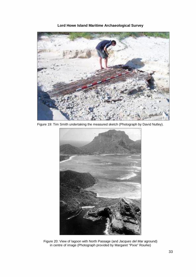
Lord Howe Island Maritime Archaeological Survey
50
Steel David 1794 Description and use of anchors extract from The elements and practice of rigging and seamanship Vol1 1794 London published in Nautical Research Journal vol13 pp124ff
Wilkinson BA amp Willson RK 1981 The Main Line Fleet of Burns Philp Sydney HMS Supply Key reference materials Armstrong A 1794-99 Log Books Masters Logs Supply 1794-1769 Microfilm copy
held by Mitchell LibraryState Library of New South Wales (ADM 514023 AJCP 1618 piece 3468)
Ball Lieut HL 1791-2 Journal of the Proceedings of HM Supply 27 Nov 1791-20 April
1792 Microfilm copy held by Mitchell LibraryState Library of New South Wales (PRO 412)
Blackburn D Remarks Etc on Coast and Harbours Master of His Majestyrsquos Armed
Tender Supply 1792 Hydrographic Department Miscellaneous Papers vol69 Ba1 pp615ff Microfilm copy held by Mitchell LibraryState Library of New South Wales (M2319)
Blackburn D Correspondence 1785-1796 Microfilm copy held by Mitchell LibraryState
Library of New South Wales (AJCP M97) Blackburn D Ships Musters - Supply Microfilm copy held by Mitchell LibraryState
Library of New South Wales (ADM 3610981) Various Navy Board Records To the Admiralty 1787-1788 Microfilm copy held by
Mitchell LibraryState Library of New South Wales (ADM 106 221322143321) Various Admiralty Captains Logs Transports Charlotte Fishburn Borrowdale
Alexander 1786-1789 Microfilm copy held by Mitchell LibraryState Library of New South Wales (ADM 514375)
51
10 Appendix A - Lord Howe Island Shipwreck Information Sheet
Shipwrecks ndash Lord Howe Island The NSW coast and waterways are littered with thousands of shipwrecks Their timbers iron plating anchors and cargoes have become fragile records of a heroic maritime history They are the last remnants of a time when industry commerce and families were directly or indirectly reliant on transport by sea
River boats trains and road transport linked the inland regions of the State with the ships that plied our coastal and international shipping lanes Freight and passenger vessels came in various shapes and sizes their form influenced by their ocean going habits or the shallow river bars of small coastal ports Technology and cargoes also shaped the construction of the ships while commercial and political decisions determined when and where ships rail or road were the dominant transport network
The ships that form our maritime heritage were built locally and at ports around the world - from the small riverside slipways on the NSW coast to the mighty shipyards in England Scotland Canada and the USA
Commercial and public interests did not always result in good record keeping for these vessels the people who served on them the passengers who entrusted their welfare to them or the cargoes that they carried Often they were too mundane just workhorses that kept the economy together Many ships passed on with no surviving image to record their appearance The day to day experiences of the passengers and crew were rarely written down The remains on the seabed often contain the only surviving clues
Generally ships are not totally destroyed when they are wrecked Parts are preserved covered in sand mud and marine growth A flat expanse of sand can cover a large part of the story of the ship and the people who were associated with it The only visible clue may be the fluke of an anchor If this or other visible evidence of the ship is taken away the site may be lost forever or inadvertently damaged by modern day anchors dredging or other human activities
We as a community can help to preserve the information held within shipwreck sites By becoming aware of their location and place in history we can relive the joys and fears of the people they carried We can also feel something of the trepidation and anguish of those who waited upon their arrival
This information sheet lists 15 of the ships that have been lost on or near Lord Howe Island If you wish to obtain more information or if you wish to share information from other sources please contact
Maritime Archaeology Unit NSW Heritage Office Locked Bag 5020 Parramatta NSW 2124 Phone 02-9635 6155 Fax 02-9891 4688 Email heritageofficeheritagenswgovau Shipwreck Database Msritime Heritage Online httpmaritimeheritagenswgovau or httpaimaiinetnetau See also the Shipwreck Atlas of New South Wales available from the NSW Heritage Office
This sheet is available free from httpwwwheritagenswgovau and may be reproduced with appropriate attribution
Location
Legislation All shipwrecks over 75 years of age are automatically classified as historic shipwrecks and protected under the Historic Shipwrecks Act 1976 Relics off the NSW coast likely to be associated with historic ships are also protected under this Act
Relics in NSW lakes and rivers over 50 years of age are protected under the relics provisions of the NSW Heritage Act 1977
The Heritage Office should be notified as soon as possible if a shipwreck or other underwater relic is located or disturbed
Severe penalties apply for non-compliance with the legislation
Sailors clinging to their disintegrating ship battling overwhelming seas clutching at floating debris gasping for momentary breaths in foaming surf - these are the
52
Shipwrecks of Lord Howe Island Favorite - One of the Islandrsquos more recent shipwrecks the Favorite ran aground at the North Passage in 1965 Few details have been located for the vessel its origin or ownership
George - the earliest shipwreck at Lord Howe Island the 186 ton whaler George either ran aground or sank off the southern end in December 1830 A 2377 metre two-masted whaler operating out of Tasmania built at Plymouth UK in 1810 registered Hobart as 6 of 1830
Jacques del Mar - French-registered 506 ton 4428 metre steel screw steamer wrecked at the Islandrsquos North Passage in 1954 Built as the Marion Sleigh at Bremerhaven Germany in 1906 and one time registered to Sydney as 6 of 1930 with Official Number 139627
La Meurthe - abandoned at sea in gale whilst under the tow of St Louis The unmanned ldquoghost shiprdquo drove ashore near the lagoon at Lord Howe Island in 1907 much to the amazement of local residents A timber sailing ship of 1597 tons gross built at France in 1882
Laura ndash lost at sea after departing the Peruvian port of Callao on 18 April for Newcastle to load coal One of Laurarsquos lifeboats eventually washed up north of Cronulla Beach Sydney and the wheel box at Lord Howe Island A barque formerly known as Claudova
Maelgwyn ndash abandoned approximately twenty miles northwest Lord Howe Island in 1907 Departing Pisco Peru on 17 November 1906 the 1276 ton vessel became disabled in a gale after ballast shifted All 20 crew reached Lord Howe Island in the boats A 6706 metre iron barque built at Sunderland Scotland in 1884 and registered at London Official Number 89625
Mystery Star ndash intended as part of a film on Lord Howe Island the 488 metre timber motor skiff was lost after departing the island for New South Wales in October 1936 Crewed by actors Brian Abbot and Leslie Simpson the vessel was never found despite searches by RAN destroyer Waterhen and RAAF aircraft including Seagull amphibians and a Gannet monoplane
Ovalau ndash cargo of copra caught fire about 100 miles from Lord Howe Island in Oct 1903 but contained until reaching that place Passengers and crew disembarked before the ship exploded burnt and finally sank off North Passage A 1229 ton 70-metre steamer built in Scotland in 1891 registered at Sydney as 331903 Official Number 141471 Cargo of Cockatoos and parrots let loose on the island Wreckage lies in 19-30m of water - located
Pacific Chieftain ndash a 10 metre wooden fishing vessel wrecked in November 1968 at Flat Rock near North Rock Admiralty Islands All 11 passengers and crew escaped on a lifeboat
SM Stetson ndash the 707 ton collier barque SM Stetson left Newcastle with 1150 tons of coal on 10 March 1877 bound for San Francisco Sprang a leak and beached at entrance to North Passage on 25 March Three crew manned a small boat and after a gruelling 7 day voyage made Sydney Built in the USA in 1874 Registered San Francisco Official Number 115351
Sylph -The 13 metre 17 ton ketch Sylph foundered at sea after departing Lord Howe Island for Sydney on 20 April 1873 All 8 crew and passengers drowned Built at Brisbane Water in 1849 NSW Owned by Lord Howe Island residents Field Thompson and Wainright some of whom were lost with the vessel Registered in Sydney at 1 of 1850 with Official Number 32395
Viking ndash A wooden double-ender island boat lost between Sydney and Lord Howe Island in November 1936 with the loss of 6 lives
Whangaroa - Became unseaworthy and abandoned about 20 June 1911 after departing New Zealand for Sydney with cargo of hardwood Crew arrived at Lord Howe Island after four days clinging to vessel Wreckage later sighted ashore A 3648 metre topsail schooner of 143 tons built at Whangaroa in 1893 Registered Sydney as 46 of 1899 with Official Number 94270
Wolf - the 265 ton whaling barque Wolf wrecked near Lord Howe Island in 1837 At sea for 18 months with 1700 barrels of sperm whale oil aboard Exhausted crew went ashore for water and food Wolf blew against near-shore reefs and holed later sinking within ten miles of shore Originally built as a gun-brig at the Royal Navy Woolwich Dockyard in 1814
Zeno - abandoned off Lord Howe Island on a voyage from Newcastle to Wellington New Zealand with coal Foundered on 6 September 1895 with 10 crew making the safety of the island A 407 ton 3892 metre brigantine built at Johnrsquos River Nova Scotia Canada in 1876 Registered Auckland at folio 26 of 1891 Official Number 74343
ISBN 1 876415 42 8 HO 0015 Crown copyright 2000
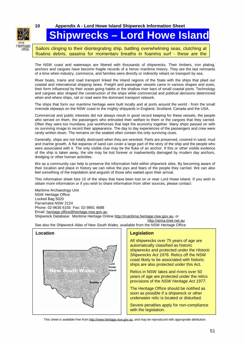