Embed Size (px)
Citation preview
IDENTIFICATION STUDYFOR
CULTCRAL RESOURCES WITHIN PROPOSED METRO RAILSUBW:'\, Y STATION LOCATIONS IN
METROPOLIT-\t\ LOS ANGELES. CALIFORNIA
Prepared For:
Southern California Rapid Transit DistrictMetro Rail Transit Project
425 South Main StreetLos Angeles, California 90013
Prepared J3.,v:
WESTEC Services, Inc.32]] Fifth Avenue
San Diego, California 92103Project No. 30289/3511 J000
Funding for this project is provided by grants to theSouthern California Rapid Transit District from theUnited States Department of Transportation, theState of California and the Los Angeles CountyTransportation Commission.
May 1985
Sectio7
1.0
2.0
3.0
3.1
3.1.1
3.1.1.1
3.1.1.2
3.1.1.3
3.1.2
3.1.2.1
3.1.2.2
3.1.2.3
3.1.3
3.1.3.1
3.1.3.2
3.1.3.3
3.1.4
3.1.4.1
3.1.4.2
3.2
3.3
Title
Il\TRODCCTIO:\,
:'I1fTHODS
RESULTS
Los Angeles Union Passenger Terminal
Prehistoric Resources
Midden Deposits
Human Burials/Remains
Isolated Artifacts/F eatures
Contact Period Resources
Midden Deposits
Human Burials/R emains
lsob ted Artifacts/F ea tures
Historic Resources: Anglo American
Sisters of Charity Orphanage
Griffith Lumber Yard and Commercial Buildings
Keller Ranch/Hotel de France
Historic Resources: Chinese Period
Artifact Deposit
Isolated Artifacts
Civic Center
Fifth and HilI
1
2
3
3
3
8
8
9
9
9
10
10
]0
]4
]4
14
14
17
17
22
4.0
4.1
4.2
4.3
5.0
5.1
5.1.1
5.1.2
5.2
5.3
'T'itle
RESOl"HCE SlGNIFlCA',C:": A SUMMARY
Los Angeles l nion Passenger Terminal
Civic CeL"
MANAGEMENT (RECOMMENDATIONS
Los Angeles "Union Passenger Terminal
Test Trenchin~
Monitoring of Soldier Piles and Bulkheads
CiviC' Center
Fifth and Hill Streets
RESEARCH CITED
29
29
32
32
32
34
37
38
38
39
LIST OF FIGl'RES
Number Title Page
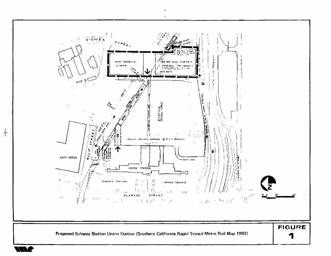
1 Proposed SUbway Station Union Station (SouthernCalifornia Rapid Transit Metro Rail Map 1983) 4
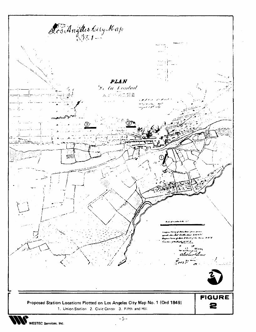
2 Proposed Station Locations Plotted on Los Angeles CityMap No.1 (Ord 1849) 5
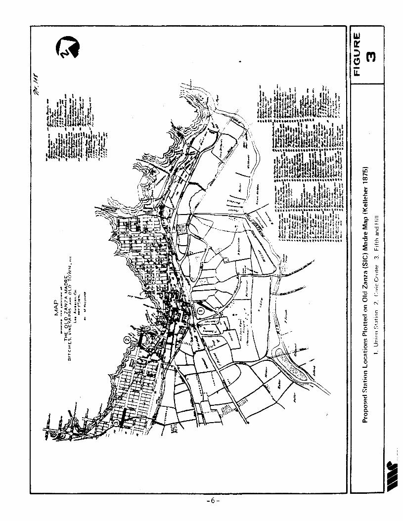
3 Proposed Station Locations Plotted on Old Zanza (Sic)Madre Map (Kelleher 1875) 6
4 Location of Proposed Union Station Subway Station.Plotted on Map of First Gas Plant (Lecouveur 1872) 11
5 Proposed SUbway Station at Union Station Plotted on 1888Sanborn Fire Map 12
6 Proposed SUbway Station at Union Station Plotted on 1894Sanborn Fire Map 13
7 Proposed Station Located at Union Station as Plotted onBaist's Real Estate Map of Los Angeles (1912) 15
ii
8
9
10
11
13
14
1;;
16
17
18
19
20
21
Number
1
LIST or FlGl'f\ES (Continuer'
Title
Proposed Subway Station at Union Station Plotted on 1937Sanborn Fire \1ap
Proposed SUbway Station - Civil Center (SouthernCalifornia Rapid Transit Metro Rail Project Map 1983)
Proposed Civic Center Station Plotted on Baist's RealEstate Map of Los Angeles (1912)
Hill and Second Streets from City Hall Tower, about 1895
Hill and Temple Streets Before Hill Street Tunnel, aboutNovember 1908
Hill Street Tunnel Plans and Profile (1904)
Hill Street Tunnel Looking North From First Street, 1918
Hill Street Demolition - Grading Plans (1954)
Proposed SUbway Station Fifth and Hill Streets (SouthernCalifornia Rapid Transit District Metro Rail Map (1983»
Proposed Station Located at Fifth and Hill Streets asPlotted on Baist's Real Estate Map of Los Angeles (1912)
~
Fifth and Hill Street Station, Los Angeles Grading Map(Lecouveur 1870)
Storm Sewer Plan and Profile, Fifth and Hill Streets (1904)
Proposed Test Trench Areas at Union Station West
Proposed Test Trench Area near Ramirez Street at UnionStation East
LIST OF TABLES
Title
Levels of Potential Significance for Possible CulturalResources at Three Station Sites
iii
IG
18
19
20
21
23
24
tV'~ I
28
30
36
31
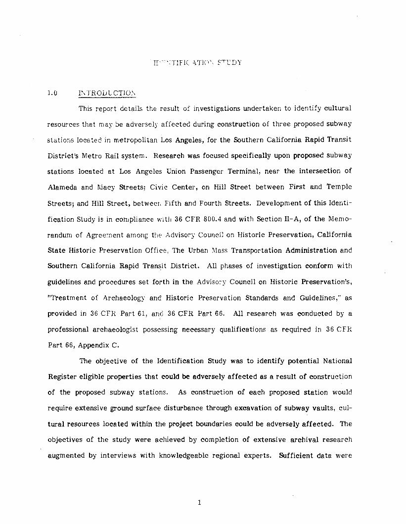
1.0 e~lROLJlCTIOl\
This report details the result of investigations undertaken to identify cultural
resources that may be adversely affected during construction of three proposed subway
stations located in metropolitan Los Angeles, for the Southern California Rapid Transit
District's Metro Rail system. Research was focused specifically upon proposed subway
stations located at Los Angeles Union Passenger Terminal, near the intersection of
Alameda and Macy Streets; Civic Center, on Hill Street between First and Temple
Streets; and Hill Street, between Fifth and Fourth Streets. Development of this Identi
fication Study is in compliance with 36 CPR 800.4 and with Section II-A, of the Memo
randum of Agreement among the Advisory Council on Historic Preservation, California
State Historic Preservation Office, The Urban Mass Transportation Administration and
Southern California Rapid Transit District. All phases of investigation conform with
guidelines and procedures set forth in the Adviso:--y Council on Historic Preservation's,
"Treatment of Archaeology and Historic Preservation Standards and Guidelines," as
provided in 36 CFR Part 61, and 36 CFR Part 66. All research was conducted by a
professional archaeologist possessing necessary qualifications as required in 36 CPR
Part 66, Appendix C.
The objective of the Identification Study was to identify potential National
Register eligible properties that could be adversely affected as a result of construction
of the proposed subway stations. As construction of each proposed station would
require extensive ground surface disturbance through excavation of subway vaults, cul
tural resources located within the project boundaries could be adversely affected. The
objectives of the study were achieved by completion of extensive archival research
augmented by interviews with knowledgeable regional experts. Sufficient data were
1
COT pi kr:.: to dete! c potentiEtl fr< ellcounte:ing cultu:~d resources at Los Angeles
Uniofl Passenger Terminlil ane 6.t Eel' Street near thE' intersection of Hill and FiftL
Streets. Because no in-fielc subsurface excavations were completed during this study,
the specific nature or integrity of these potential resources is at present unclear.
2.0 1\lETHODS
The Initial Study completed for the Environmental Impact Statement for the
Metro Rail Project included archival research, interviews with knowledgeable research
ers, and an in-field archaeological survey (WESTEC 1983). The result of these investi
gations revealed a potential for encountering cultural resources at several proposed
subway stations.
Included among these were the Los Angeles Union Passenger Terminal, Civic
Center, and Fifth and Hill Street locations. As a means of clarifying this potential for
the presence of cultural resources, research undertaken for the current Identification
Study was intensified and focused specifically upon these three proposed station loca
tions. The principal tasks completed included extensive archival research augmented by
interviews with individuals knowledgeable about archaeological resources within the
immediate study areas. All pertinent historical documents were compiled from three
principal repositories in Los Angeles. Historic maps, street profiles and plans were
collected from the Bureau of Engineering, Los Angeles City Hall; Sanborn Maps from
the Geography Map Library, California State University, Northridge; and photographs
from the Los Angeles Public Library. Individuals contacted included:
Dr. Charles Rozaire, Los Angeles County Museum of Natural History
Mr. Robert Wlodarski, California Department of Transportation
Ms. Lois Webb, California Department of Transportation
Ms. Jeanne Poole, El.Pueblo de Los Angeles Historic Park
Dr. Jay Frierman, El Pueblo de Los Angeles Historic Park
2
..
Advice was also sC .. ::"ht fro, C'aLhrna State Historic Prese~vation Office representc,-, 6
ti\'es. I'll). Hans hreutzberg- anc ~\}s. Lucinda Woodward.
The dati~ co~:pjlc:: during this stud~, provides a clear understanding of the
potential for the presence of cultural resources that may be encountered during con-
struction of each proposed subway statio:L These potentials are discussed in detail in
the following results section.
3.0 RESULTS
Sufficient historic data has been compiled to address the probability of cul-
tural resources that may be present and encountered during construction of three pro-
posed subway stations located at Los Angeles Union Passenger Terminal, Civic Center,
and Fifth and Hill Streets.
3.1 Los Angeles Union Passenger Terminal
Los Angeles Union Passenger Terminal (LA UPT) is included on the National
Register of Historic Places principally by virtue of architectural uniqueness. The sub-
way station proposed for Union Station will not affect the LAUPT architecture because..
the subway station will be situated north of and behind the terminal building. As
presently designed, the station extends southeast from the present Rapid Transit Dis-
trict's bus-turn at Macy Street, and crosses the existing track yard (Figure 1). Early
maps of Los Angeles show the immediate project area as consisting primarily of agri-
cultural fields until the 1900s (Figures 2 and 3), although some areas were used for
com mercial and institutional buildings as discussed below.
3.1.1 Prehistori c Resources
Los Angeles Union Passenger Terminal was built upon land that' fell within
the active Los Angeles River flood plain, and was subjected to periodic and severe
3
,. 0 1M 'to"-<P
~
(
\
_0/
II"\ ., ""( \
\
., ) /', .'
f'\ I I
!r'jJi'
~l
\\:', \
" f'
/!
(
! r,
, (
4 po f A. ~1I.r"PJ(~
'-;V"r::ACF r~tr:l(t"H'
o,!)~:z "~;j~ ...><0:W...
) ~,\ (L
~TI:!.FET
!~I'JI
I
I ( ) /
F"~" '~I(. f'Jtr.r.M.f. .. ,4HOllNlr
ALAMFDA
0'
i
P,IJ., TF"MI~lAI
,.....'~-.'
//'Y/r I/~,IJ "_ _ilJ.-;1-' _'
Sl~ 4' :~"• .s.f'.,, ElEl-r ' . ......
------_...~~~:~~~~J"--- ~ - i r ._~~ .. - r·~~ ,~.·tr 1-
,;f/j' I' i)l~n,o "'.AIL SU" "'ArE ,I 1 ~
" ".'OF • )' PAP!<INf, (\IV> ~'AC.' ) II " ff
l ~".." J;4.', ~'::::'~,.::'":".~~:;.:''''''-' ,~, ~I •• , ~ Jo/kl'AIUfU••" "
:-::z===-==':::z<{=", ~ 1' ?
, ,'- \~ ;
/"IGN"S
( ,
G,'·I" 1/\ ),,i'tJ
c:::::J \\~ ;1,
i;~~;~?'
I~~/~~ IvJ,I He',I ( I'~
I {""", ~., I If,._ / ,r ~u~FAr_F r,.,,,nN6 r"
'!) I ,I r,i I III,I " ,.}" [ )
I II I
'I,' /r
I.t'I
... Proposed Subway Station Union Station (Southern California Rapid Transit Metro Rail Man 1983)FIGURE
~
..
-":"" . -- ...... ...;, ,
' ....-. .,.' .'" ,,- ~/
/>
,,
,-- .... ',ft
I(I,, tI I, I, .PUN
(rl ! III/INri,"
J
/'. r
':"~~:j-:!
ri"/ I
;
,,I:- --"'
j,--,r
'. .,"\
U
<E_~;-/
2FIGURE
-5-
Proposed Station L .ocatlons Plotted1, Un' on Los A
....~ 'on Station 2 C. . ngeles City Map N.. "" Cent" 3 F. o. 1 lOrd 1849)WEST . ,fth ,nd Hill
EC Services. Inc.
-Ion,...CO......
CI)or.~0;;~
0. .-C'C =:~ CCI).. '""C ~
C'C ....~ u..
U C"'i(i) ...
Q:
C'C ~N <:l: UC'C '-'N ;;
"C
0 c--:l:C c
"C cCI)
:: '"'c c::0: -v.
:5c:c.;; -C'CUC
...Jl:C.;;C'C...
c.r."Ca:v.Cc..0..
CL.
I---------_76_------.J ----.--I,.

floodin; ii, the past (Huey. RO'TJE,ni anc' \\'ebb 1980; Weitze 1980). To prevent possi!)lc
damacre to thr' Dasseno-e!" terminal b\ floods. as much as 2C feet of fill soil has be'?"o ~ c: ...'
brough i in tc build up the property to\';ard~ the east and as little as 4 feet on the west
underneath the public parking lot. It is possible that cultural resources were buried
intact below this fill soil and preserved. Evidence in support of this theory is provided
by the discovery of Indian artifacts during construction of Union Station, which
Johnston (1962:121) considered to be associated with the Gabrielino village of Yangna.
Unfortunately, the precise location within the Union Station property where these arti
facts were recovered is not provided by Johnston.
More conclusively, excavations completed across Alameda from Union Sta
tion, adjacent to the Hollywood Freeway on-ramp at site LAn-7, revealed an intact
cultural deposit aproximately 2 meters in depth below approximately 1 meter of fill soil
(Wlodarski, Romani and Webb 1985). This deposit contained artifacts assignable to each
cultural period recorded for Los Angeles, including prehistoric Indian artifacts (Frier
man 1985), and is approximately on a parallel contour (based on recent soil boring logs)
with a point immediately below the fill level near the bus turn around. In light of these
discoveries in the immediate vicinity of the project area, the potential for encountering
cultural materials below the fill soil at Union Station is considered high.
Prehistoric resources within the affected area at Union Station may be
encountered below the original fill level at what was once the historic ground surface.
The exact depth of fill varies across the facility; it may be as shallow as 3-4 feet in
front of the Union Station block and as deep as 20 feet in the tracks area. Because
documentation of the exact location of previous archaeological finds is ambiguous, it is
difficult to pinpoint an area of higher or lower sensitivity. Resources that may have
existed in the track area to the rear of Union Station may be relatively undisturbed by
historic activities and the placement of up to 20 feet of fill but may have suffered
7
se\'",~',: dis~)lH.·erne::. rs"~ flooding and netwal soil mo\"eme,t. Conversely. prehis
toric resources ths.t ~;,sy txjst under thE: rrJ'J:'E: shallow 3-4 feet of fill ir; the front may
have been disturbed by historic land usc;.
The type of prehistoric artifacts and cultural debris that could be found
subsurface may range freT intact midden deposits to isolated artifact finds and may
contain human burials/remains.
3.1.1.1 Midden Deposits
Generally, a midden deposit is defined as a soil deposit containing cultural
debris, greasy soils l faunal remains, ash/charcoal, seeds and other evidence of a broad
range of rather intensive human use. An intact midden deposit possessing a wide range
of artifacts might qualify for the National Register and would potentially pose the
greatest constraint to construction in terms of delay time and temporary avoidance.
3.1.1.2 Human Burials/Remains
Although no human burials or remains have been reported for the imme
diate Union Station area, there is some potential for their presence within a midden
deposit. Human remains may vary from in-place formal inhumations to cremations or
scattered bones.
3.1.1.3 Isolated Artifacts/Features
Isolated prehistoric features such as hearths, shell deposits, or other con
centratiol)s of artifacts may be encountered during monitoring of trenching or excava
tion. Without reference to a larger site, these are likely to have local significance
rather than State or National Register status, and while important as sources of raw
data, they do not pose major construction constraints, nor require timely concurrence
procedures.
8
3.1.2.1
3.1.2.2
..
:,.1. 2 Contac~ Pe!'ioc ResoL; or':
Contact period resou:'ccs are those middens~ artifacts or cultural deb!is that
'were produced by nati\'~ people~ after Sp9.nish intrusion in 1769, but before wide-scale
acculturation circa 1840. Exarnples might include glass arrowpoints, metal spears or
ceramic vessels with handles. These resources could include human burials or remains.
The potential for significant contact period resources is greater near the intersection of
Alameda and Commercial Streets in the general area of the reported historic rancheria.
!\Jidden Deposits
The type of contact period artifacts and cultural debris that could be
found subsurface may range from intact midden deposits to isolated artifact finds.
Generally, a contact period midden deposit is defined as a soil deposit produced after
1769 A.D. and containing cultural debris of both traditional Native American and Euro
pean-influence, greasy soils, faunal remains, ash/charcoal, seeds and other evidence of
a broad range of rather intensive human use. An intact midden deposit possessing a
wide range of artifacts might qualify for the National Register and would potentially
pose the greatest constraint to construction in terms of delay time and temporary
avoidance.
Human Burials/Remains
In general~ there is probably less potential for human burials within a
contact rancheria because of acculturated burial patterns which included burial in
Christian cemeteries or removal of the deceased to outlying areas because of health
risks. This may be an important consideration because construction is less likely to be
delayed as a result of the lesser potential for burials and because burials determined to
be less than 100 years of age do not, under State law, require Native American consul
tation.
9
3.l.2.? l"o18te:~ A:otifqc>t<: fFestu"es
lsol&.tec contact perio~ features such as hearths, shell depositoS, or oth".:;;
concentrations of ear'ly historic Native American artifacts may be encountered, durin;
monitoring of trenching or excavation. Without reference to a larger site, these are
likely to have local significance rather than State or National Register status, and while
important as sources of raw data, they do not pose major construction constraints, nor
require timely concurrence procedures.
Contact period resources encountered during excavation will be imme
diately evaluated by the Monitoring Archaeologist. Resources may be determined as
important or significant if they can clearly demonstrate culture changes and processes
as a result of non-native influences; if they reflect a unique period or cultural horizon
that has been previously undocumented for the area; or if the quantity and range of
artifacts and cultural debris are such that the data base will lend itself to analysis anc
can provide insights into known research problems and questions.
3.1.3 Historic Resources: Anglo Period
3.1.3.1 Sisters of Charity Orphanage
In 1856, the property on the southeast corner of Alameda and l\lacy
Streets, containing approximately 10 acres, was sold by B.D. Wilson to the Catholic
Church. Here, the Sisters of Charity School and Orphanage was established. The school
and orphanage included a three-story school building which once stood at the corner of
Alameda and l\1acy Streets, a two-story residence with a parlor, a two-story combina
tion playroom, dining room, and kitchen with attached wash house, a single-story hay
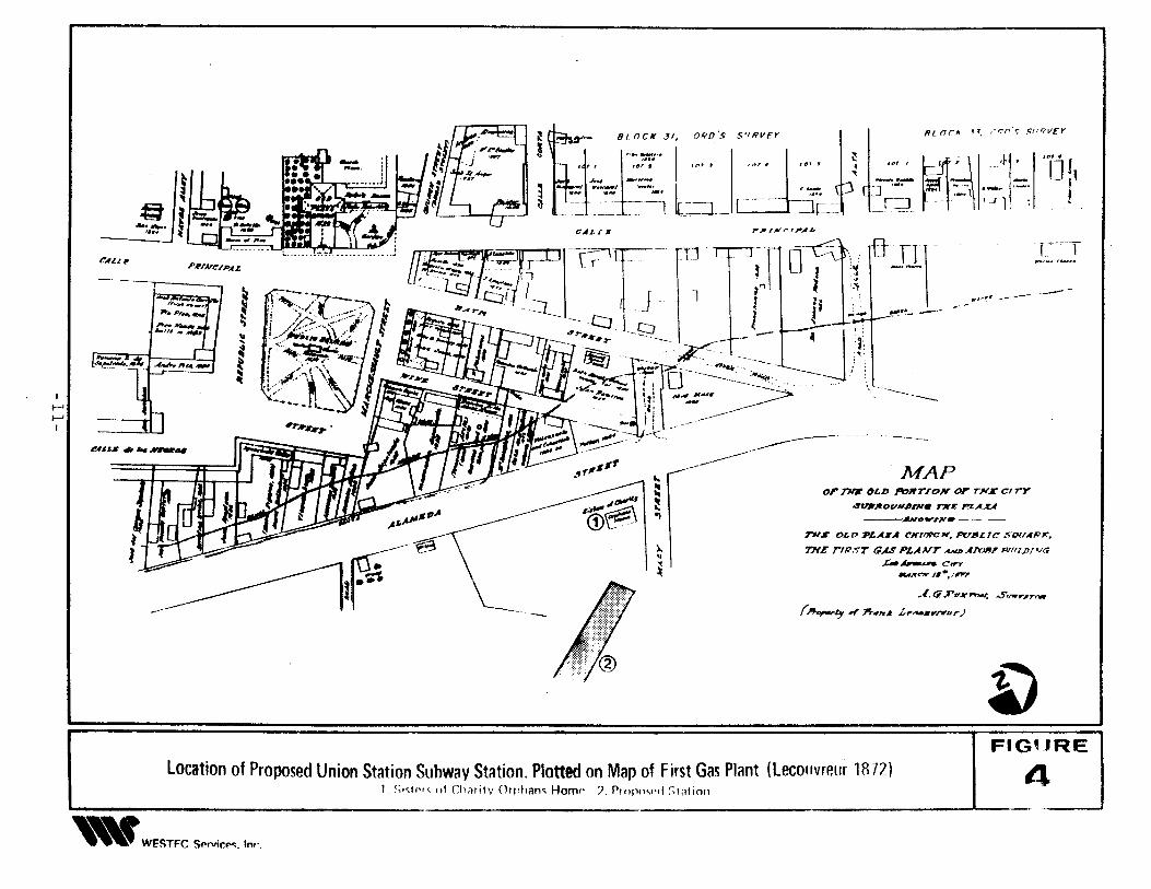
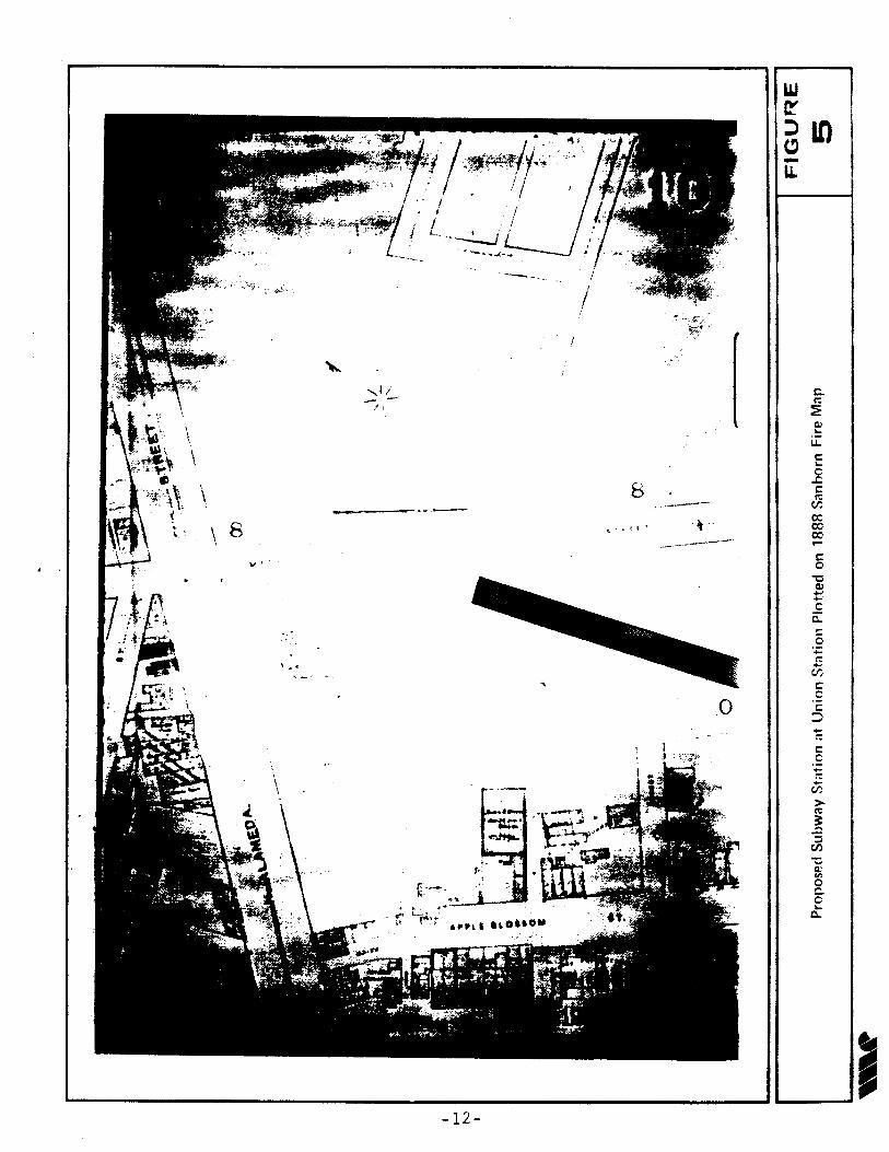
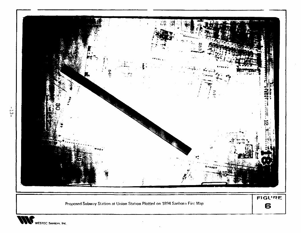
building, an arbor, a poultry yard, well and pump, and various out-buildings (Figures 4
through 6). After operating in this location for 35 years, the orphanage was moved to
Boyle Heights in 1891 (Spitter 1951). If they still exist subsurface, architectural and
archaeological remains of the Sisters of Charity Orphanage are unlikely to meet
10
.l. t7.T-'v.. 1'tVoI; ..5'.",,..,,..-.(~Jy..r :n#n~ ,/,,..-.,,.Nhr)
TNI' OLD PLAZA C'Kr'1V'CH. PULILIC SlXIAP~.
THE rlp,<;T (;AS PLAJVT ANlI.ANJlfT PlIIlJ>/VG
.u.~c.......,,~~ /1·, ,,,,,
'Tj f~I
!
r.~···T
.... ,.~, ------ ------
Hi 0('1( l'. /lr;o(l't; SIIRVEY
r~'~; ,J.
1St ~., ........ 1-..
. . . 1J 1,
MAP
Jl\~'~--'"
----~ J. !]~:
)~l
.' :
---ANoW"rJ!t'_ -- ._-
OF nm D£D /'IOJlrrOK OT TNI' ClrY
4U1rJeoVNlJrN. TN#: 1"'Z.A..Lf
~
:,!
~,rNr'".A~
l
.1
).,
"~
"=~.,
CALrJ<
8/ nCIf 31, ORO'S S'/RVEY f~..'. -::::'. I ~," II'" 1(1" ,,,,. u:" .. ~ 1(1"
J.~ _H__ _ ...., "--1 '-'" " , .-- ..~ ,.. ~ a::::. -JJ.~B=I l::::J .. d..Jr:: -g~
~
!
"--.l~eh~
l~
CAUl"
I~
~
I
Location of Proposed Union Station Suhway Station. Plotted on Map of First Gas Plant ILecouvrelir lRlf)1 ~;l~t!'l'; of Ch;JrilV Orl'ham Hom!' 7. Prnpfw'l/ ;,1;Jtion
F'G~JRe
4
".WESTfC Sf>rv;CI":. lor'
r;c:o
c:o
"'Ca>..,-c
0::c:o0;c
EU?c:cc:
::>
r;..,U?>~
..0::l
U?
~
c:...ic:
J5c:c00oc...
.0
".------'
-------,---'-
8
-- ..... J,. .. _
0,-
.....
\ 8
\
\.\
....
'-------:u-12~- --===:J~----JJ
.J~;~~It':I,....fr".;:1'1';:t;1\.
<:R _., ~_~: .....~ .. ;:
. ~ t.-J~~..J1T::!.t;~I~ 1.... . 1"..·:..·.·.. .. Jt;, I.. . It
;, . '. t....,. ..' '.. "''~ ;. ....
,,
..... ........• "It ?,
''1
, ......""
"•.. roc' ~--......,.,.,.
• "It, .. ,.»t." .. '\'"""ri- ,.,' 1&,.. ~"..r ,. ·r.....,.
>;"wr.. 4 ..... 'r-( >r "..- ...........
'~/ '..~ ..-,.
1 ~
• .A
,.. ..'~ f:,.
{I'i:.:
~tv
"',
". 4, Itt ,
....'.i' .~.. ',. ,'-. ,I'. ..~'. . .' ., -~; ~
~.; ....it. .' ~~
..
i'.
·1:i •
·t.t ...... of',
'P'.~
t.f :
:I'"t
" ~
I........WI
Proposed Subway Stiltion ilt Union Station Plotted on 1894 Silllhorn Fire MilP
,.WESTfC ~Cr.!i. Inc.
_---A-.FI~'RE I
Natior;e' Re;;c:te>r crite!l8, A1:', ,J1;I, ~ossible. it appears i!T}~robable that such rx'oper'
ties \\oulc possoss the iLteg:,ity 0: level of resource significance.
3.1.3.2 Griffith Lumber Yard and Commercial Buildings
The Sisters of Charity property was sold to J.M. Griffith, who established
a lumber yard at this location. By 1900 Griffith sold the property to the Southern
Pa~ific Railroad which apparently razed or removed all of the buildings on the property,
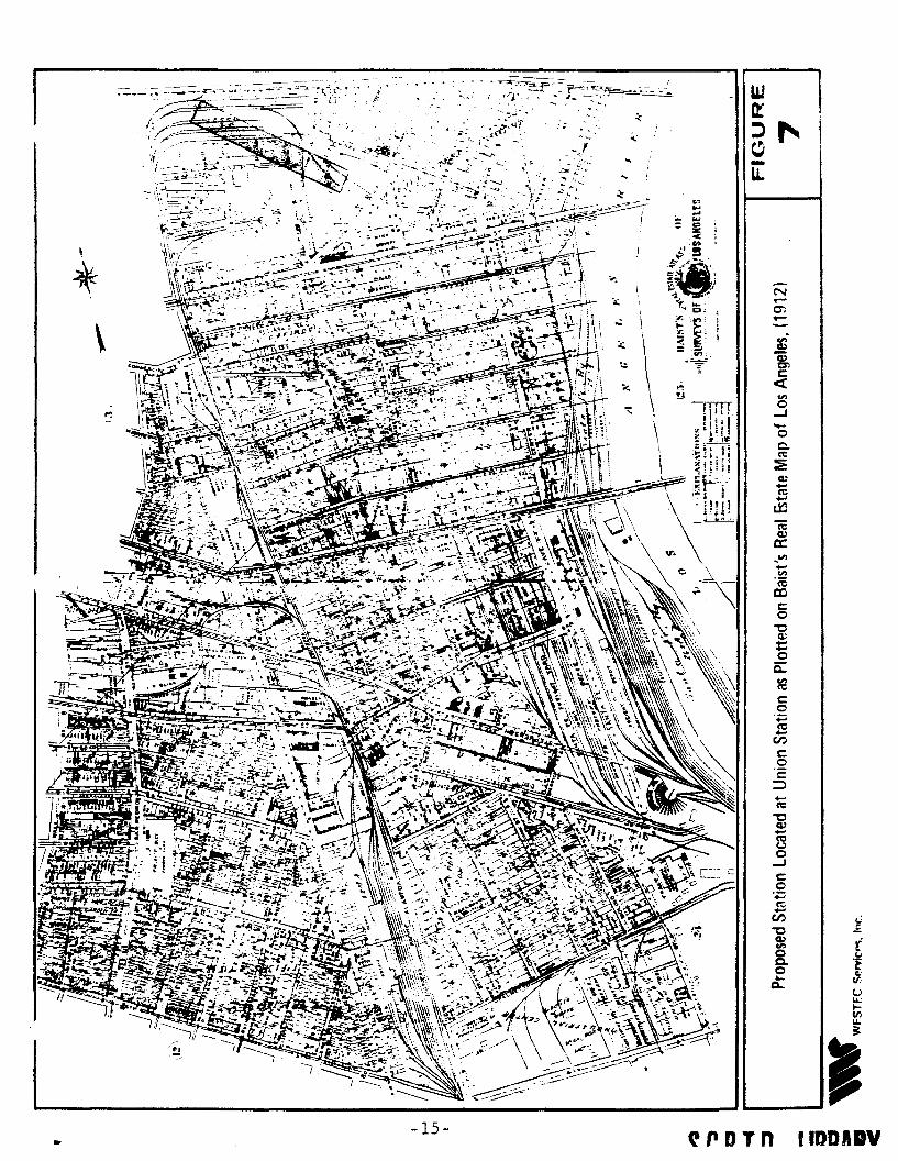
replacing them with spur tracks for the railroad (Figure 7). In 1937, the Los Angeles
Union Passenger Terminal was constructed on the property south of Alameda between
Aliso and Macy Streets (Figure 8).
3.1.3.3 Keller Ranch/Hotel de France
Core borings led to the recovery of American period (circa 1860-1900)
historic trash (bottles~ metal pieces and ceramics) and debris that is probably associated
with the Keller Ranch and Hotel de France. These materials came fro:11 below the
present paved surface of the fee parking lot near Alameda and Aliso Streets (Costello
1980; Padon 1981) and are not likely to e>..ist within the affected project area. How
ever, if they are encountered during project construction, they would have local signifi
cance.
Historic Resources: Chinese Period
Artifact Deposit
We have no evidence of a National Register eligible deposit, architectural
feature or other in-place concentration of Chinese culture within the project area.
Chinese period artifacts and other evidence of their material culture have been found
underneath the fill in the southern portion of the surface parking lot in front of Union
Station and west of Alameda Street at LAn-7 (Frierman 1985). If such resources are
found in the project area, they could potentially be National Register eligible because
3.1.4
3.1.4.1
14
..
\
-15-
N....C'l-
fl'DTn IIDDADV
It--'0\,
rt".---,Aft, ,. /,- ,,". ~
..,.:
,- ,~
<-".
. ";", ..
,~~,
~.I ,,'L.~ " .0Ii, .t_..
- F,' ,t \ \
I I; ,t " \i til
I : \.~ \
.: l!\ ~..~\ \ --"-
...
u.>wc..o
•IF~
"
....:
"
l
t,~.
...u......-~. --'-
. : t";'{ ,;', ,".,' ,to
---
' ~.;> .. ,,:~ ":;}i~\~'. {
FIGURE II Propo,ed Suhw·v SI.,;00 .1 Uoioo S'..;oo Plotted 00 19~7 ';.·'0 horo F; Ie M." ~ B
"'YWf=C;TJ:C C;"rvicp<; In,.
their reco\'ery 2.'](' analysis mRy contribute to our understanding of Chinese economics,
social life! and history in ea~'ly Los Ange12s.
3.1.4.2 Isolated ArUfacts
The recovery of isolated artifacts associated with the Chinese period is
more likely than encountering 8!l intact deposit. Because of the limited resource base
of such isolates, they will most proba:,:~ be of local, rather than state or national
signi fi cance.
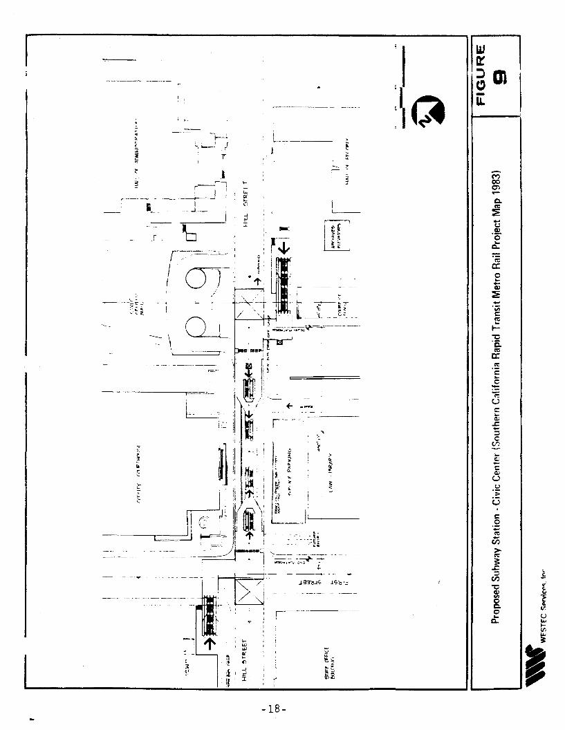
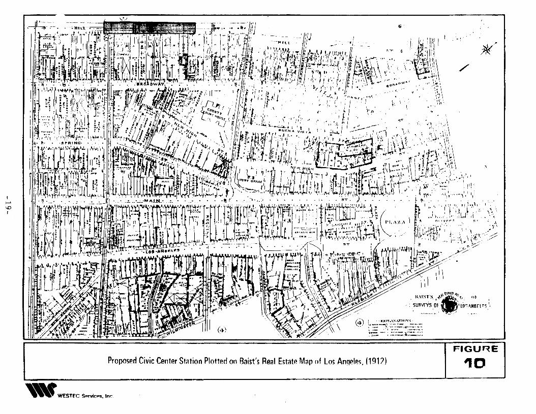
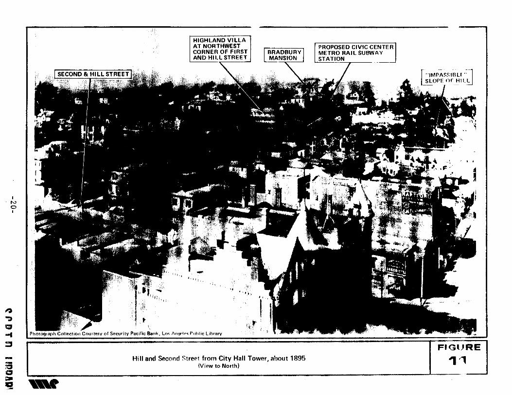
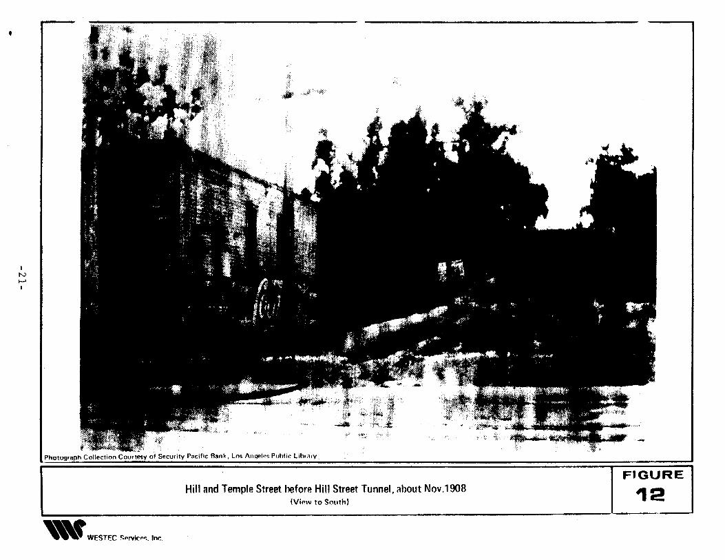
3.2 Civic Center
This proposed subway station is located on Hill Street between First and Tem
ple Streets (Figure 9). In the early 1950s, a small amount of fragmentary human bone
was recovered near Teniple and Hill Streets. This find was recalled by Dr. Charles
Rozaire, who, as a student at UCLA, witnessed the event. No artifacts were found with
the bone. At the time of discovery, a considerable amount of grading was being under
ta.ken for construction of the County of Los Angeles Administration offices and the
Hollywood Freeway. In fact, much of what once was rather a steep hill between First
and Temple Streets, was completely removed during this construction.
This hill is clearly seen on early historic maps and photographs of Los Angeles
(Figures 2, 3 and 10). The 1888 Sanborn Fire Insurance Company Map of the area lists
the southern edge of this hill as "impassable for teams." Figure 11, a photograph taken
about 1895, clearly shows the steep hill over which Hill Street passed. This remarkably
detailed photograph provides a glimpse of a portion of Los Angeles which no longer
exists today. In addition to the hill, the Bradbury mansion is visible, as is the Highland
Villa at the northwest corner of First and Hill Streets. The proposed subway location is
pointed out on the photograph providing a perspective of the proposed project. Fig
ure 12, a photograph taken in 1908, is a view south along Hill Street, from the Temple
and Hill Street intersection which provides another excellent view of the steep hill
which lends its name to Hill Street.
17
...c:.;..-c:~
u.::.::u
McoCl"l....
(,)
.~oet
I~ en I-u...
=
, ' . '1.-~.. ~J~
T
F=----:------=----
:If~-
I ~
~\\\
c:.2.....~
en>~
1, en ': ~ ~ .: ' ~ f
:" : ~ ~,~ : 0 "~ i~ 0 It U
~ ~~~I_li,i,~:ig_~~__!~~~ .B~i ffi~
-18- Iif-~"
I.......
'"I
6'
("1\ t •.•:xI \:'\".\Tln~S,=-_') '1'_"._-'; ' R' ..__ .
I~ 1:= "'l "::':.:- l"~~:::::.::~::.0_ - - __ , ,~J••_ _ ......s _ .
Proposed Civic Center Station Plotted on Baist's Real Estate Map of los Anqeles, (1912)
'" WESTfC S..rvICM. Inr..
~
./
,
FIGURE
10
Hill and Second Strept from City Hall Tower, about 1895(View to Northl
INoI
~
~
a-t:J
--;aa=-~
HIGHLAND VILLAAT NORTHWESTCORNER OF FIRSTAND HILL STREET-,
-,,< lj l , ,
"
Photograph Collection Courte~y of Security Pacific Bank, Lm !\IlfWII'< Puhllc library
~
BRADBURYMANSION
PROPOSED CIVIC CENTERMETRO RAIL SUBWAYSTATION
-"7»---
••
FIGlJRE
1"
,
,N......I
Photograph Collection Courtesy of Security Pacific Bank. Los Anll"!"~ Puh! ic Libm,y
Hill and Temple Street before Hill Street Tunnel, ilbout Nov.1908(Vir.w to South)
"" WESTfC ~"rvIc"<:. Inc.
FIGURE
12
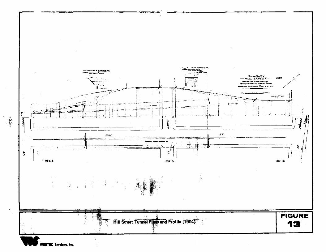
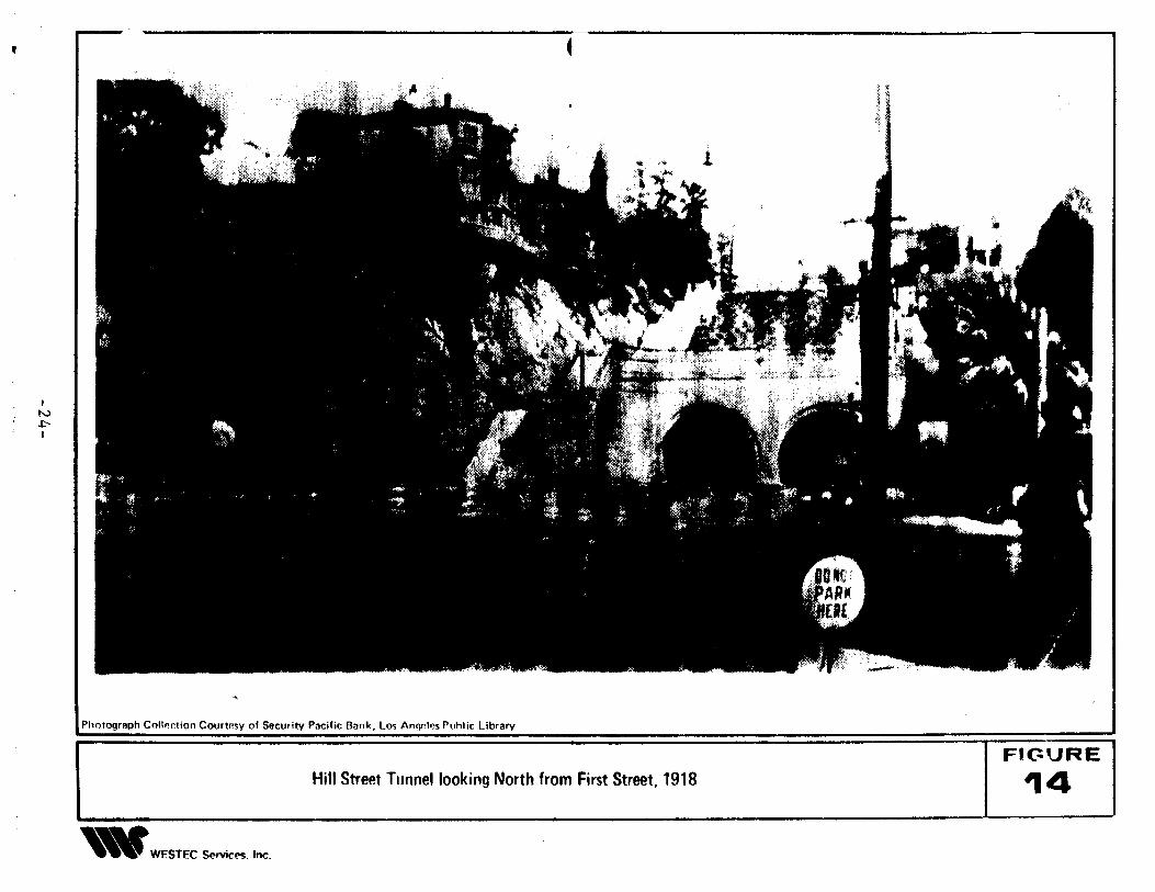
In 190 ..1, plf~rl;;: were a' ~)tc::: t':, CO(1st!'uct 2 tunnel through this !til: with
ei;"rances at Fil'st ane Temple StrBets (Fit:ure 13). Construction was completed in 1909,
with t\\O tunnels lying parallel to each other extending beneath the hill between First
and Temple Streets (Figure 14). The western half of the Hill Street Tunnel was used for
the Los Angeles Pacific Electric trolley, while the eastern half served as a vehicle
thoroughfare. Stairs were built along the western side of the tunnel, which allowed
pedestrians access to residences and businesses situated atop the hill. These are clearly
seen in Figure 14. The Hill Street Tunnel was to exist a little over 50 years.
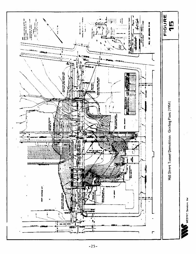
In 1956, the Hill Street Tunnel was demolished in concert with the construr>
tion of the Hollvwood Freewav. Demolition olans (Filrure 15) clearly show that exten
sive IITading was undertaken. and as much as 40 feet of the original hill through which
the tunnel extended was removed. It is possible these activities were those that pro
duced the human bone, and it appears very unlikely, considering the magnitude of grad
ing on Hill Street between First and Temple Streets, that any cultural resources would
remain. This sentiment was shared by Dr. Rozaire, the individual who originally col
lected the human bone from the area at the time of construction.
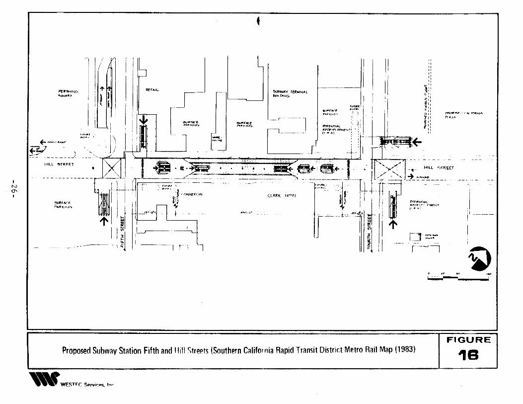
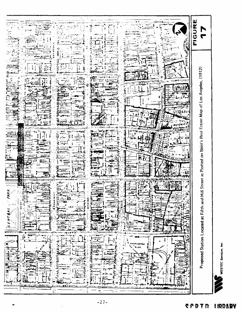
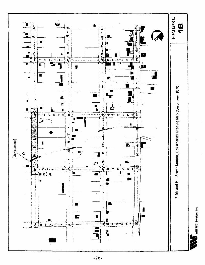
3.3 Fifth and Hill Streets
This proposed subway station is located on Hill Street between Fourth and
Fifth Streets in downtown Los Angeles (Figures 16 and 17). Early maps of Los Angeles
show that the Zanja Madre, or principal water canal, originated north of the plaza,
extended south along Alameda, then turned west, eventually crossing Hill Street just
north of Fifth Street (Figures 3 and 18). While no recent maps, street profiles, or plans
actually show the Zanja within the immediate project boundaries, there is a possibility a
remnant may still exist. Portions of the Zanja Madre have been discovered intact at
El Pueblo de Los Angeles State Historic Park and are suggested to be potentially
eligible for National Register status (Costello and Wilcoxon n.d.). A section of a later,
22
.,. i
~ '1' I
Hnn_H77A/".w"-H/L£ SrRCCr- VOIO/'/#
Fi/t!'f'wNJf ni-K<k -" 71wP,pU.1r.
~,.7luvr,'_~"I'OankJ
_Jl1'•..-.......I1I'/~~l'()N;~".
; !,..
. ~.,At6 ....,__ ,..u,._ ......'::.~;'~,710,~~
.' "'--,/ ".
n--.-w..",,_• .,,n.,_ ,._~.c..M_.,~Ao"""I.
--~ .......
~F-:=l i ~)j~~'iJ. ..~~-~- -_.
~ l .. u_ d llL -------- ~=."c'''''':-;'~''-''''''''.c''''''.'''"''..;;::...-':~-~~~~.~c::.: •. =:::::::::=;;;;....=::...-:-.~;-. '0t~~- - "~,
~ F' ==:.!=~_.__._--umm_..__--_:_m_____··_··n··~f-f,- ....-4~--~--';"--------~, I .~
I .•.." ."" """
~INWI
'It,e;"":'. ~~~,
~ ::~:T;
',..:;"'"'i,;:~"
"'~~~
Hill street TU......1f8nliProfile (1904F'f'
FIGURE
13
,
IN~I
~
Photograph ColIl!ction Courtesy of Security Pacific Bank, Los Anql!les Puhlic library
Hill Street Tunnel looking North from First Street, 1918
,.WESTEC ~rvic('!;. Inc.
FIC:URE
14
c::o:-e"0EQ)
oa:;c::c::~
r-
L
x
\
,II
,.... _- .........
.,... ..,.
\
----------------..-t-_
-25-
•
~
,ii-----
CLARK ~01f.l
L
A"VJ'.o"
---_.... -- -_._-- -------
~/ "'I
"I'"I'
I____jJ I II ::l' I' IlET.'L J LJ SOrwAY TfI1M''''AL I' ~::PEI!~'N(') I fllJlDN& Ii"':'-"A"f ~ I Il,:~ ,""", 'I"~ [--- o, ...",,,:t ,.~.~ I II ~"_,, ,. .... ''''''''''''.1 ,. nl'
" ....QK""....~ :; : • ! ~ II f'lAl/\
: __r----- '.,:, i I ':,
'I' i ~~:~~. ~~~ l mrmr'AL~' ~.: II +~_. h,,,,,., ' ! .. - r-- ,----- rr~~;~U.,...,rN': if' .' -
~ ~...our ~..' .' '\ I ! I 1 H<>'"", ; : I _'~t._"; ,-Q . , j I I
~;~--------) --~--,.rX111 ·=M. ~ ../ r [>(1'.-- --• . '.- .' .. '. . . .• '.. . -- ..' ....... . ~lILL r,TR,E£T"'" ...", .. x I '@l. iI~.'~.:~_~=.~:::~ @it... I· .' I />< :;._
-.. ~ -.~~ ~_ ~._._- --
r
111 ~ ~=:l- .11 ~ ,L. u.u: -I IJ I ;111 [~j=~.--- ..-----.--- -)ij I --1 rl l '~I I~rl
IN0J
O' .O'~' 1M'! --- -_. !
FIGUREProposed SUbW;lV Station Fifth and Hill Strepts (Southern Califolllia Rapid Transit District Metro Rail Map (1983) I 1 B
,.WE~Trc S4>rvi~fMl. Irw
~...nl
"C~nl
~...JCo
'';;CC...
(/)
"CQ)."oC.o..
Q..
It:c.:
ex:
'"o-'-o0.It:
:Ec.:...It:v.
L.W
N...O'l...
---, ·1'. "----- ,.' -----... - -' ----; '.; ---------7 --- -,.I." _
-27-...~rDTn IIDDIIY
•
•
•
:I:"t:c:~
~....~u..
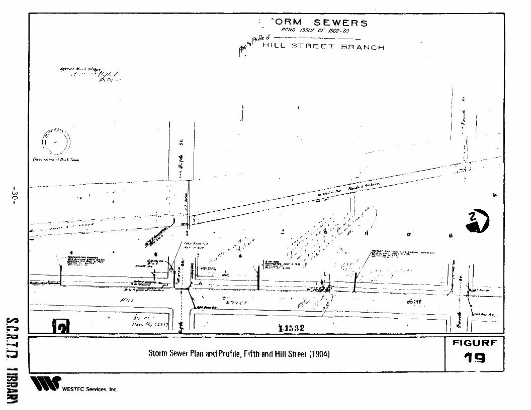
American irTigatio'1 systeri: wa.s exposed recently by Caltr:ms Archaeologists at L L\,:- ';"
on the wes~ side of Alameda Street across fro:T. Union S" ation (Romani 1985). Thic
featurE.: consists of a single, brick-lined pipe, approximately 24 inches in interior diame
ter. While portions of the original Zanja ~ladre were brick lined in EI Pueblo de Los
Angeles State Park area, the maps clearly show an open irrigation style ditch in the
Fifth and Hill Street study area.
As Figure 19 shows, a sewer and storm drain was placed below Hill Street in
1904, with a connection between a 24 inch vitrified pipe to a 31 inch diameter, single,
brick-lined sewer pipe, beneath the intersection of Fifth and Hill Streets. This sewer
system parallels Hill Street and should not be confused with the Zanja Madre which runs
perpendicular to Hill Street, just north of Fifth Street. This sewer system is not con
sidered to represent a significant historic feature. Its presence and location are
provided here to ensure no confusion will arise should the feature be exposed during
construction of the proposed station.
4.0 RESOURCE SIGNIFICANCE: A SUMMARY
As shown on Table 1 and discussed below, the cultural resources that may exist
subsurface at proposed station locations could possess varying degrees of significance.
4.1 Los Angeles Union Passenger Terminal
Of the potential buried resources, artifacts and middens associated with the
prehistoric/historic village of Yangna and those from the Rancheria de Poblanos possess
the most potential for National Register eligbility under Criterion D, as resources that
"have yielded or may be likely to yield, information of importance in prehistory or
history."
While other resources such as scattered debris from the various historic settle
.ments (inclUding Anglo-Ameri-can and Chinese) may have state or local significance,
they appear unlikely to qualify for National Register elibigility under existing criteria.
29
·ORMSEWERSflr'YNO /SSUr or 1,902- aJ
r:~f"'I''';1 LL s~,,~,cT BR ANCH
A/l""''''''' Md'Th "~/r~- «....j// "'.', l~'//'~". ~.,,:~-.,...,-
.;'f,
I
j .~
i....,
lot
,--
'"-»10'
~
Ii';I
FIGURE
19
Ii
JL 1/.! ~ :;. 'r ·cf I
~II~-"~;''', I,
.J-,':::~ )
Ii
--
'I...
~
,;
-- -----~_. ';;;:,~:----'.- 5/'..J.',1...:.,.-.--:'!'t(>t ~-'
----~".1 ----r--- ~....- I-- '~ II' t----------='~ ,~\ ~ ,.
..- ,,' " .". " . i.·
·<';~"'f' ~";Yj._,',' .L I', t • ,A'
...- .,'f' t, J(~ ".~'./'" ,1
,": ~ " ,I; .. , ~._.O>,',", "': --""" '-'~',,~~,{b'_fl 't"., /e.c\-'::J."''C.'I'''~,I' ~' ',' .,' ,I I ", - '., :'!~"":~f.1:' ,,~ , ,\ r, '1.1' I' ". """ ".' ... " .., . , . '.1'," • "L " I '" _.. t. {e..:n.eN<""" I 1.( • I. "
~ 'l'" ~t,;,~"~;'.".. l ..~.... : ..... , '.''~ 1, ""'._,I",;-~ ""c -~-==~]J.k=:-_=-~<6 ,,; _
-..h ~... '- ~', • .- ~=. .... '. - ,I '. r , '._. 1 \r~._"'J.(/ l- I --_. I r . ,~.~~ -/"L L' T oS _.''-;''1 ==-~ '----- =_,--'--1 r- _._~-..
i1532
r..........,./f... I<A?'. J,If"1.~ ,. _ .....
~
~
..:
."
tt\
Storm Sewer Plan and Profile. Fifth and Hill Street (1904)
J" ,../ ' 111«u.. lVv :tIl7 I
~"L
,j'".
/,;4.7.I;.7;f,
(.t. '\d ..' l)\\,J,
r .., ..~, e"
---_._._- -----....
(7v"" Vi""" (II /J,ttk ,s,.....
,. -:"~~/''~1~ n_'_'_':,.; : --~-7'~ I-,~ . fAr'
• ~ • I
- =-..~r.::::!!F~'- ~!-..",:~nWJ
m'::.:':''::77n~1' ,.' ..,. --.... ~ :
~, ~,
1-- j:- ~ ---~--------- ~~~-'> :--I_ .._'-r;:;; f _
"'--b--"---..--- _. .....,._.,.~.
fWof
~~:::c:I~C,
-I ''''WESTFC ~~, Inc,:a:-~
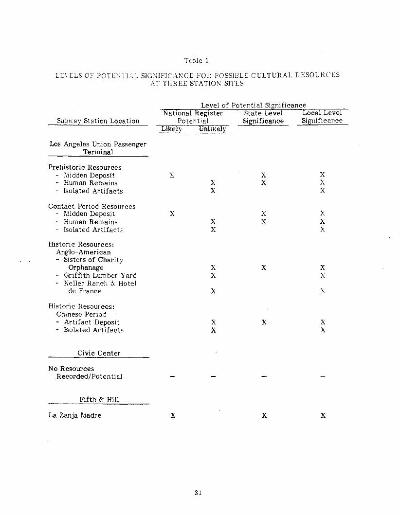
Table 1
LE\ILS OF POTE\ TL!,L SIGNIFICAJ\,CE Fon POSSIBU= CULTURAL RESOURCE~
AT ThREE STATION SITES
Level of Potential SignificanceNational Register State Level Local Level
Subwav Station Location Potential Significance Significance"
Likel\' unlikely.Los Angeles Union Passenger
Terminal
Prehistoric Resources- Midden Deposit X X X- Human Remains X X X- Isolated Artifacts X X
Contact Period Resources- lViidden Deposit X X X- Human Remains X X X- Isolated Artifacts X X
Historic Resources:Anglo-American- Sisters of Charity
Orphanage X X X- Griffith Lumber Yard X X- Keller Ranch &: Hotel
de France X X
Historic Resources:Chinese Period- Artifact Deposit X X X- Isolated Artifacts X X
Civic Center
No ResourcesRecorded/Potenti al
Fifth &: Hill
La Zanja Madre X X X
31
The p!'elimina;y assess':- er,: is based on previo5 reco;nmendatio:.' ~::
resources in the immediate area (H&tneway 1980), on the possibility for a sufficie;1tly
undisturbec deposit that can be researcheG and on recent interpretation of eligibility
determination requirements.
4.2 Civic Center
The absence of cultural resources at this highly disturbed station site
precludes the potential for the presence of cultural resources.
4.3 Fifth and Hill
If portions of La Zanja Madre, Los Angeles' first water system, exist in the
area of potential affect at Fifth and Hill Streets, they may qUalify for National Regis
ter eligibility as suggested by previous researchers (Hatheway 1980; Costello and Wil
coxon n.d.). Eligibility IT,sy be met through application of Criterion C for resources
that "embody the distinctive characteristics of a type, period, or method of construc
tion ..." or under Criterion D for yielding important information.
5.0 MANAGEMENT RECOMMENDATIONS
5.1 Los Angeles Union Passenger Terminal
Indian artifacts were recovered from the Union Station property during con
struction of the facility. Johnston (1962) considered these to be associated with the
Gabrielino village of Yangna. Others, notably Huey, Romani, and Webb (1980), believe
these prehistoric artifacts were associated with the post-contact, segregated Indian
settlement of Rancheria de Poblanos. Regardless of the affiliation, the presence of an
intact deposit of Native American artifacts would be considered significant. If a pre
historic deposit is found and determined to be the village of Yangna, the elusive original
settlement of downtown Los Angeles will finally have been located. This would provide
an excellent opportunity to study prehistoric lifeways in Los Angeles, an area that has
32
not been acJec'J,:tely invcstigs.tec archaeolosicall:.:. due tc the early -:estructiofJ 0" f
research data base as a result of rapid urbanization in metropolitan Los Angeles.
The discovery of deposits linked to the Rancheria de Poblanos would be con
sidered as significant as those from Yangna. Study of a post-contact site, such as this
one, would provide an excellent, and rare opportunity to test models of acculturation.
The Native American population of early Los Angeles, while often considered socially
inferior by their Anglo neighbors, played an important role in the early development of
the City of Los Angeles and an understanding of their mode of survival within the
unfavorable social and cultural climate of early Los Angeles must certainly be con-
sidered an important line of inquiry.
Union Station is constructed upon fill soil, as much as 20 feet in depth
reported for the rear and as little as 4 feet in the front. Prior to construction of the
train station~ the area was not severely modified. Historic maps show the area to have
been used principally for agricultural purposes until sometime around 1900, when the
Southern Pacific Railroad placed a spur track in the area. The Sisters of Charity School
and Orphanage occupied the corner of Alameda and Macy Streets from 1856 until 1891,,
being briefly replaced by a lumberyard until the spur tracks were constructed. To the
south, in the center of the present Union Station property, lay Appaplaza Street. a
section of old Chinatown. As currently proposed, the subway station would not directl:,
affect these areas that contained historical structures prior to construction of Union
Station. Nevertheless, it is possible that historic refuse deposits associated with these
settlements may be encountered during station construction. The study of refuse
deposits linked to particular ethnic groups, during specific temporal periods, would be
important, and thus such deposits may be significant at varying levels of state and local
interpretation.
33
Based on currently avai1ab~e information, there is no firm evidence that any
cultural resource is present below the surface of Union Station within the proposed
subway station location. As a method of improving the data base and to ensure that no
major unknown structw'es or resources are encountered during construction at Union
Station, it is recommended that a serjes of trenches be excavated within the proposed
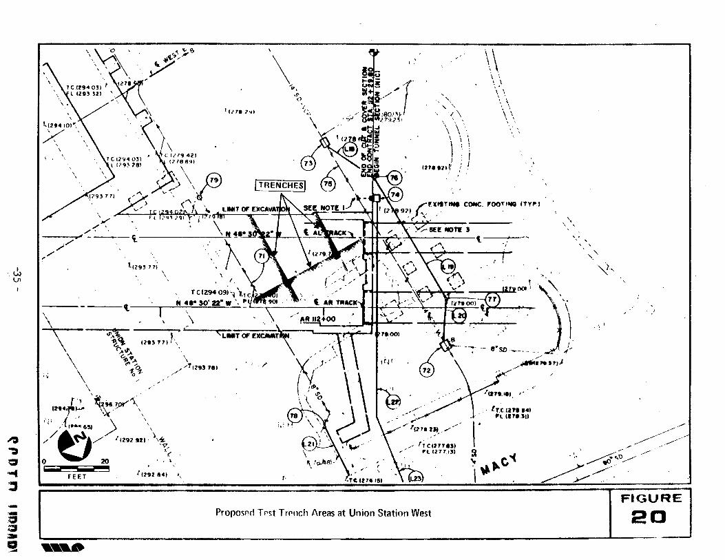
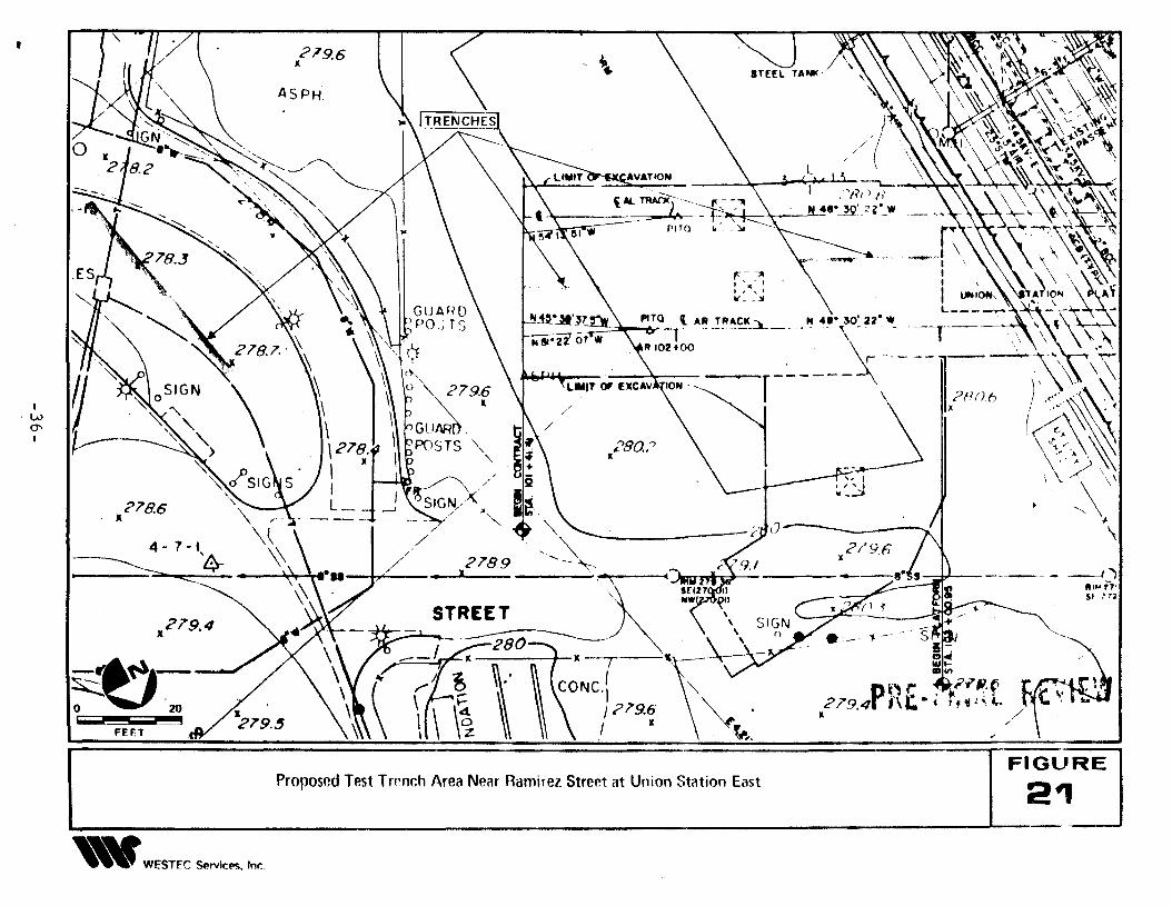
project area as shown in Figures 20 through 2l.
Although it may not be possible to excavate at each of the following trench
locations because of property ownership conflicts, public safety or ingress/egress prob
lems, excavation of some or all of the trenches can be a valuable measure. The
trenches will provide a far clearer understanding of the depth and nature of the fill, a
more realistic possibility of the presence/absence of large structures and definition of
the original landform . A work week may be required for the trenching.
All test trenching should be monitored by a qualified archaeologist. The
archaeologist should examine the trench periodically during excavation to ensure that
damage to possible subsurface cultural resources is minimized. The archaeologist
should keep a written and photographic log of the trenching activities. The log should
contain: information about the presence or absence of cultural debris; the nature of the
soil; any variances in soil strata; and comments on the information supplied by the
trenching.
If significant debris are encountered during the test trenching, they should
be minimally documented and avoided since the object of the testing program is to
assess for presence/absence and for potential significance. Data recovery or other
intensive investigation should be completed during a later phase of stUdy, not at the
preliminary testing level.
34
,---
FIGURE
20
", '
,,'~,
\.
\. \
\
\. "
\.
, \, )
,.----....
, " . ....~ .-----'/ ~..;------- ~~ y/~/ .
,,'
/---...-, .....
"
, !
[r,C,ln•••,
1'1I.'""
e·SD~_ .. _~)," .
~I"."J
"
\\\ \'. \..\ \\ ''. ,. \
\ \\ ', ,, ., ',
\.~I,...c'4
"
"" ""
1\
'\ '\\.\ . \
) \ \, : I
In. 'll~ ! I,
frcen1."~l. 1211'"
I
Ie. < • ~,•.OO)
"
,.
\1>,
.1'<)
/
I 1118 2~1
PrOllOSflfl Tpst TrPllch Areas at Union Station West
,,
,\
,,'1 1295.711,
12"'11~
1(29284)
rcl29409i:'" ~....,..111[ ! ':-'/ ".j "':001 ~t
N 4'- 50' 22- W\ ~C~: '\)~ 't A~ TRACK liH'OO)=t2 'I \ I -'(r- t ..
• ,\ ," /~RIIZ+OO ' ~,;,.I _. , ,.-
"'~a.~..l'... "'...G-~ "...<"''0
10'1-
\\.
FEET
\\,,
'\\\
" \\,
. , '
12'LfJ.,. ~~tll,~'\\.... ., ~ ,',' ) \" I·..e 6SJ \//t:)/ ll292 .tl \,~-y,O
<20 . , l
, i ~ \
\~%\'"~'';,.TCIP94 O~I: Inl'
l 12lH '2) \".\. /' '.\
)<';'\ > '<)\, . TC 12<j4 031 ']CII''' 421
lI7<j~2BI 11188'l'\ \\ '~\\\fJ('> 79, ,,' \
.(793111. ,'\ " \'" I. (~ (" . 74
, ~ IlU p21' 1\ '~ /",UltTlW CONe, P:OOTl"G ITY,.)'y . f L (7'" 7<Jl ~/II7' 92)·1'"'.., .' '
./ " "\ '( ... " .
---~./. ./",.., ..J_~_~ '~N~~ ,r-$f:[NOTlJ t.
",.., "
,. t I2 ", 11~ ,
",.
l1\J1
--.~a;a
~
~.,c:J.....~
•
IW0\,
278.6It
----279.4
It
FEET
"~WESTFC ~rvicl"S, Inr..
279.6l
ASPH
Proposed Test Trrnch Area Near Ramirez Street at Union Station East
/~- --4"")ItI.. '7'S' ,',.
P ~'"..279.4 nt-.II
"FIGURE
21
F,: p:de:'r'ec' 10c2ti .~". for tes:t trenclies~ aIle t' '~ one most likely to provide
useable- inforlTJatic,:'"l, i5 nes'"' T.S. Point :t\13332G.31!E21G5~J6.58 adjacent to the cross
ove~' box (Figure 20). Excavation could occur within thE; existing parking area near the
existing baggage handling building. Trenches should be at least 6 feet in length and
excava:(;d with a narrow bucket (18 to 24 inches in width) backhoe to a depth sufficient
to penetrate the fill level. If feasible, three trenches should be excavated in this area.
Two trenches, approximately 20 and 30 feet in length, could be excavated in a general
north/south direction and a trench approximately 35 feet could be excavated in an
east/west trending direction (Figure 20). In the case of the west cross-over box area,
the trench may reveal native soH as shallow as 3 feet.
Should the preferred trench area be unavailable, a second area should be
considered for testing. The alternative area is behind (east of) the existing track yard
near a loading platform or in a public easement bounded by Ramirez Street, Vignes
Street and the freeway ramps. Two trenches on either side of the loading platform
could be excavated to an extent of 25 feet on the west and 15 feet on the east. A third
trench in an easement east of Vignes Street could be excavated to a length of 40 feet in
a north/south trending direction. Trenching at this location may better define the
historic floodplain surface and partially resolve the issue of buried prehistoric/historic
resources in the area. Excavation to a depth of as much as 10 feet will be necessary to
penetrate the fill soils.
Monitored trenching at either location will serve as a valuable planning tool
and can provide far more detail for this identification study and for future treatment
plans.
5.1.2 Monitoring of Soldier Piles and Bulkheads
In addition to the monitored trenching program, a qualified archaeologist
will monitor excavation of soldier piles along the edge of the proposed excavation. The
37
pilec;: wil1 be O' 6-8 foot cel~teps and will provide a sample of soils across a broac' e:'es,-
l\Jor.itoring of bulkheac C'.Jts will provide further information on fill depths and the
presence/absence of culturb.l debl'is. \"'"hen combined with the monitored trenching, the
soldier pile and bulkhead monitoring should provide a much more complete picture of
the subsurface components in the area of the cross-over box and proposed subway sta-
tion.
5.2 Civic Center
As evidenced by the recovery of human remains from the vicinity of Temple
and Hill Streets, a cultural deposit may have at one time existed within the proposed
subway study area. However, extensive grading for construction of the Los Angeles
County Administrative offices and Hollywood Freeway has likely destroyed any cultural
deposit that may have existed there. Because of the low probability of encountering
cultural resources at this proposed subway station, archaeological monitoring as recom-
mended in the Project FElS (WESTEC 1983), is no longer considered necessary, as the
construction of the Civic Center Subway Station will have no adverse effect upon cul-
tural resources.
5.3 Fifth and Hill Streets
Research has suggested that a portion of the Zanja Madre, the first water
system established for Los Angeles, and a potential National Register property, crossed
Hill Street just north of Fifth Street within the proposed subway location. A segment
of this early water system is presently preserved at El Pueblo de Los Angeles State
Historic Park, and integrated into the Parks interpretive history program. Should
another portion of this Zanja be located within the proposed subway, every effort should
be made to remove it and provide for curation of the materials so that they may
provide a link to the earliest historic period of settlement for the City of Los Angeles.
38
..
RESEARCH CITED
Costello, Juh& G.
1980 Los Angeles Downtown People :'Ilover Program Archaeological ResourceSurvey Phase 2. A report prepared for the Community RedevelopmentAgency, Los Angeles, California.
Costello, Julia G. and Larry Wilcoxon
n.d. An archaeological assessment of cultural resources in urban LosAngeles. City of Los Angeles, Department of Public Works.
Frierman, Jay D.
1985 Personal Com munication
Hatheway, Roger
1980 Historic Preservation Overlay Zone for El Pueblo de Los Angeles StateHistoric Park.
Huey, Gene, John Romani, and Lois Webb
1980 Archaeological Survey Report for the El Monte Extension in the City ofLos Angeles, Los Angeles, Califronia. Route 70-LA-101-0.0/0.5 07202417801.
Johnston, Bernice E.
1962 California's Gabrielino Indians. Frederick Webb Hodge AnniversaryPublication Fund Volume 8. Los AngeJes: Southwest Museum.
Padon, Beth
1980 Historical Archaeological Status Report for the Expanded Monitoring atthe Los Angeles Union Passenger Terminal for the El Monte BuswayExtension, Route 07-LA-I0 50.0/50.1, Route 07-101 0.0/0.3 07218417801.
Romani, John
1985 Personnal Communication
Rozaire, Charles
1985 Personal Communication
Spitter, Henry W.
1951 Education in Los Angeles 1880-190, Historical Society of Southern California Quarterly, Vol. 33 No. 2:101-118.
39
1
\
1980 Aliso Street Historical Report for the Ell\1onte Busway Extension in theCity of Los Angeles. CALTRANS, District 07, Los Angeles
WESTEC Services, Inc.
1983 Technical Report - Archaeological Resources. In Final EnvironmentalImpact Statement Los Angeles, Rail Rapid Transit Project. SouthernCalifornia Rapid Transit District, Los Angeles, California.
Wlodarski, Robert, John Romani and Lois Webb
1985 Personal Corn munication
40
~ r. II Tn IIRRAIV