Embed Size (px)
Citation preview

Loss-Estimation Modeling of Earthquake Scenarios for Each County in Nevada
Using HAZUS-MH
Nevada Bureau of Mines and Geology Open-File Report 06-1
University of Nevada, Reno
There are huge risks.
We can take action to reduce the risks.

There are huge risks.
We can take action to reduce the risks.

Earthquakes have occurred throughout Nevada.

There is a good chance that you will experience a major earthquake. There are at least 30 faults that could cause damage in the Reno-Carson City urban corridor.

The probability of at least one magnitude 6 or greater event in the next fifty years is between 34 and 98%. The probability of at least one magnitude 7 or greater event in the next fifty years is between 4 and 50%. Hazards include intense ground shaking, ruptures of the ground, liquefaction, landslides, and ancillary problems, such as fires and hazardous waste spills.

We used FEMA’s loss-estimation model, HAZUS-MH, to estimate the effects of potential earthquakes near each of the
county seats in Nevada.
This model is used in emergency-response and recovery exercises and will be used to help rapidly
estimate the scope of damage and losses immediately after an earthquake (information that helps with a
Presidential Declaration of Disaster).

FEMA used this model in 2000 to estimate annualized loss from earthquakes:
$55 million per year for the State, including $28 million per year for the Las Vegas area, and
$18 million per year for the Reno area.
But major earthquakes in Nevada don’t occur annually. They happen on any given fault every few thousand to tens of thousands of years. If an earthquake occurs soon near an urban area, the
consequences can be devastating.
Because Nevada has so many active faults, the hazards are high, and the risks are huge.

The risks are huge.
For a magnitude 6.9 earthquake on the Mount Rose fault, HAZUS estimated, for the Washoe-Carson-Storey-Douglas region:
up to $7.6 billion in economic loss (~2.9 billion in Washoe County alone)
major damage to approximately 12,000 buildings
800 to 3,000 people needing public shelter
80 to 300 fatalities.

Mount Rose fault zone
Genoa fault

The risks are huge.
For a magnitude 7.1 earthquake on the Genoa fault, HAZUS estimated, for the Washoe-Carson-Storey-Douglas region:
up to $2.5 billion in economic loss (~$471 million in Douglas County alone)
major damage to approximately 12,000 buildings
800 to 3,000 people needing public shelter
80 to 300 fatalities.

Genoa fault
up to 5 meters of vertical displacement when it last moved, ~ 550 years ago
well exposed in gravel quarry south of Genoa
one of the most active faults in Nevada

Genoa fault
up to 5 meters of vertical displacement when it last moved, ~ 550 years ago
well exposed in gravel quarry south of Genoa
one of the most active faults in Nevada

The risks are huge.
For a magnitude 6.5 earthquake on a fault near Virginia City, HAZUS estimated, for the Washoe-Carson-Storey-Douglas region:
up to $2.5 billion in economic loss (~$8.5 million in Storey County)
major damage to approximately 3,500 buildings
200 to 800 people needing public shelter
20 to 90 fatalities.

Mount Rose fault zone
Genoa fault
Comstock fault zone
Carson City fault zone

The risks are huge.
For a magnitude 6.5 earthquake on the Carson City fault, HAZUS estimated, for the Washoe-Carson-Storey-Douglas region:
up to $2.2 billion in economic loss(~$665 million in Carson City alone)
major damage to approximately 3,900 buildings
170 to 700 people needing public shelter
30 to 110 fatalities.

Reno
Sparks
MogulVerdi
GoldenValley Sun
Valley
PantherValley
HiddenValley
SpringValley
VirginiaFoothills
PleasantValley
GalenaForestEstates
NewWashoe
City
Franktown
Glenbrook
VirginiaCity
Virginia CityHighlands
Lockwood
Wadsworth
InclineVillage
Dayton
CarsonCity
PinionHills
NewEmpire
Stewart
IndianHills
JohnsonLane area
JacksValley
GenoaZephyrCove
Minden
Gardnerville
Centerville
50
50
80
80
395
431
341
207
206
28
50
395
IX
VIII
VII
VI
V
< V
Modified MercalliIntensity
Mound House
Surface faultingfrom scenarioearthquake
Reno Sparks
Dayton
Carson City
Incline Village
Virginia City
Modified Mercalli Intensity Map from NBMG’s 1996 “Planning Scenario for a Major Earthquake in Western Nevada” – A magnitude 7.1 earthquake on the Mt. Rose fault could cause widespread damage in the area of Intensity IX (“General panic. Cracked ground conspicuous. Damage considerable in specially designed structures, great in substantial masonry buildings with some collapse in large part.”)


We don’t know exactly how often these specific earthquakes occur, but we do
have reasonable estimates of earthquake rates for each region.

The earthquake hazards in Nevada are comparable to those in seismically active areas of California.

Probability of an earthquake of magnitude 6.5 or greater occurring within 50 km in 50 years (from USGS probabilistic seismic hazard analysis)
~50% chance for Reno and Carson City, magnitude 6.5
Probability

USGS maps of active faults – compiled from data of the state geological surveys, including the Nevada Bureau of Mines and Geology and the California Geological Survey

Active faults on the Reno 1 x 2-degree sheet
Reno
Fallon
Carson City

Probability of an earthquake of magnitude 6.5 or greater occurring within 50 km in 50 years (from USGS probabilistic seismic hazard analysis)
20-25% chance for Fallon, magnitude 6.5
Lovelock
Fallon: $85 million loss in Churchill County from magnitude 6.5

Active faults on the Lovelock 1 x 2-degree sheet
Lovelock

Probability of an earthquake of magnitude 7.0 or greater occurring within 50 km in 50 years (from USGS probabilistic seismic hazard analysis)
1-2% chance for Lovelock, magnitude 7.0
Lovelock: $61 million loss in Pershing County from a magnitude 7.3

Probability of an earthquake of magnitude 6.5 or greater occurring within 50 km in 50 years (from USGS probabilistic seismic hazard analysis)
~10% chance for Lovelock, magnitude 6.5
Lovelock

Active faults on the Winnemucca 1 x 2-degree sheet
Winnemucca

Active faults on the McDermitt 1 x 2-degree sheet
Winnemucca
Active faults on the Vya 1 x 2-degree sheet
Winnemucca
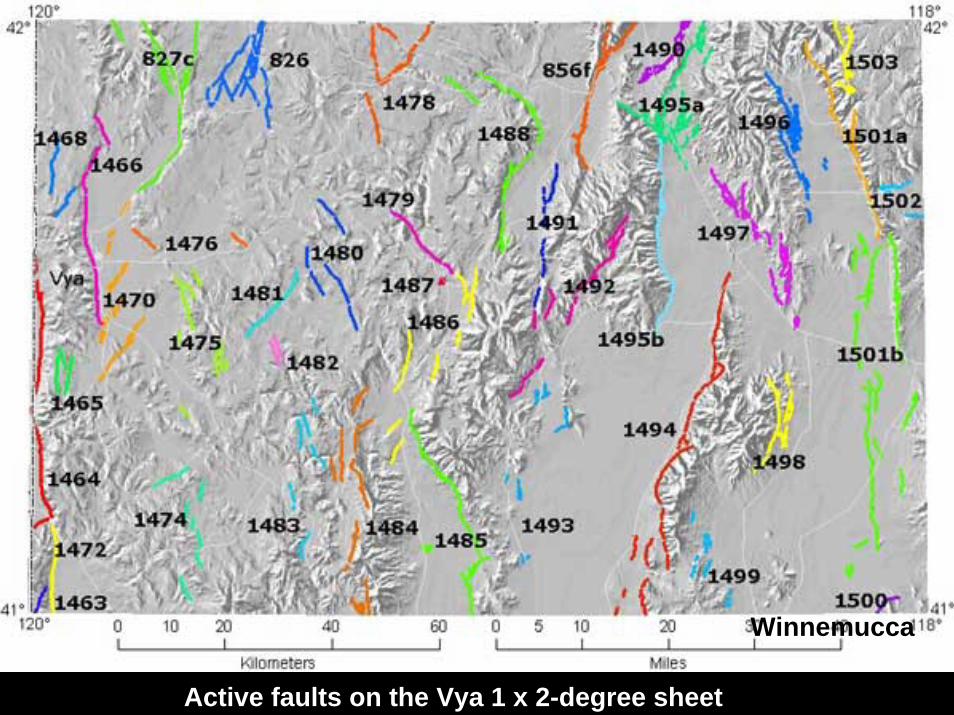
Probability of an earthquake of magnitude 6.5 or greater occurring within 50 km in 50 years (from USGS probabilistic seismic hazard analysis)
5-10% chance for Winnemucca, magnitude 6.5
Winnemucca: $56 million loss in Humboldt County from magnitude 6.5

Active faults on the Wells 1 x 2-degree sheet
Wells

Active faults on the Elko 1 x 2-degree sheet
Elko
West Wendover

Active fault on the west side of the Ruby Mountains, on the haul road to the Rat pit at the Bald Mountain mine

Paleozicbedrock
Quaternary gravels
Active fault on the west side of the Ruby Mountains, on the haul road to the Rat pit at the Bald Mountain mine

Probability of an earthquake of magnitude 6.5 or greater occurring within 50 km in 50 years (from USGS probabilistic seismic hazard analysis)
6-8% chance for Elko, magnitude 6.5
Elko: $224 million loss in Elko County from magnitude 6.5

Active faults on the Winnemucca 1 x 2-degree sheet
Battle Mountain

Probability of an earthquake of magnitude 7.0 or greater occurring within 50 km in 50 years (from USGS probabilistic seismic hazard analysis)
~1.5% chance for Battle Mountain, magnitude 7.0
Battle Mountain: $74 million loss in Lander County from magnitude 7.5

Active faults on the Millitt 1 x 2-degree sheet
Austin

Austin
Probability of an earthquake of magnitude 6.5 or greater occurring within 50 km in 50 years (from USGS probabilistic seismic hazard analysis)
10-15% chance for Austin, magnitude 6.5

Active faults on the Ely 1 x 2-degree sheet
Eureka
Ely

Probability of an earthquake of magnitude 7.0 or greater occurring within 50 km in 50 years (from USGS probabilistic seismic hazard analysis)
<0.5% chance for Eureka, magnitude 7.0
Eureka: $4.1 million loss in Eureka County from magnitude 7.2

Probability of an earthquake of magnitude 6.5 or greater occurring within 50 km in 50 years (from USGS probabilistic seismic hazard analysis)
1.5-2% chance for Ely, magnitude 6.5
Ely: $79 million loss in White Pine County from magnitude 6.8

Active faults on the Lund 1 x 2-degree sheet

Active faults on the Caliente 1 x 2-degree sheet

Probability of an earthquake of magnitude 6.5 or greater occurring within 50 km in 50 years (from USGS probabilistic seismic hazard analysis)
2-3% chance for Pioche, magnitude 6.5
Pioche: $5.6 million loss in Lincoln County from magnitude 6.5

Active faults on the Walker Lake 1 x 2-degree sheet
Hawthorne
Yerington

Probability of an earthquake of magnitude 7.0 or greater occurring within 50 km in 50 years (from USGS probabilistic seismic hazard analysis)
12% chance for Yerington, magnitude 7.0
Yerington: $88 million loss in Lyon County from magnitude 6.9

Probability of an earthquake of magnitude 7.0 or greater occurring within 50 km in 50 years (from USGS probabilistic seismic hazard analysis)
10-12% chance for Hawthorne, magnitude 7.0
Hawthorne: $78 million loss in Mineral County from magnitude 7.5
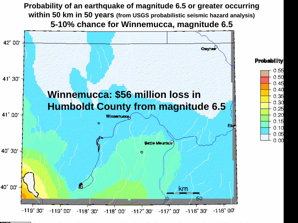
Probability of an earthquake of magnitude 6.0 or greater occurring within 50 km in 50 years (from USGS probabilistic seismic hazard analysis)
>60% chance for Reno, Carson City, Yerington, & Hawthorne
Hawthorne

Active faults on the Tonopah 1 x 2-degree sheet
Tonopah

Probability of an earthquake of magnitude 7.0 or greater occurring within 50 km in 50 years (from USGS probabilistic seismic hazard analysis)
<1% chance for Tonopah, magnitude 7.0
Tonopah: $440 thousand loss in Nye County from magnitude 7.0

Probability of an earthquake of magnitude 6.5 or greater occurring within 50 km in 50 years (from USGS probabilistic seismic hazard analysis)
5-10% chance for Tonopah, magnitude 6.5

Active faults on the Goldfield 1 x 2-degree sheet
Goldfield

Probability of an earthquake of magnitude 6.5 or greater occurring within 50 km in 50 years (from USGS probabilistic seismic hazard analysis)
5-10% chance for Goldfield, magnitude 6.5
Goldfield: $280 thousand loss in Esmeralda County from magnitude 6.7

Faults on the Kingman 1 x 2-degree sheet
Laughlin

There are active faults nearly everywhere in Nevada,
Red = fault ruptures during historical earthquakes (last 150 years)Orange = Late Pleistocene faults (<130,000 years old)Yellow = other Quaternary faults (<1.8 million years old)
but not everywhere.


Faults on the Death Valley 1 x 2-degree sheet
Beatty
Pahrump

Faults on the Las Vegas 1 x 2-degree sheet
Pahrump
Mesquite
Moapa
Las Vegas

Quaternary fault exposed at construction site in Las Vegas Valley

Quaternary fault exposed at construction site in Las Vegas Valley
Unit 4
Unit 4
Unit 5
Unit 5
Unit 1 does not appear to be cut by the fault
Unit 2 = wedge of sediment deposited against the fault
Unit 3

Measured earthquakes in the Las Vegas area
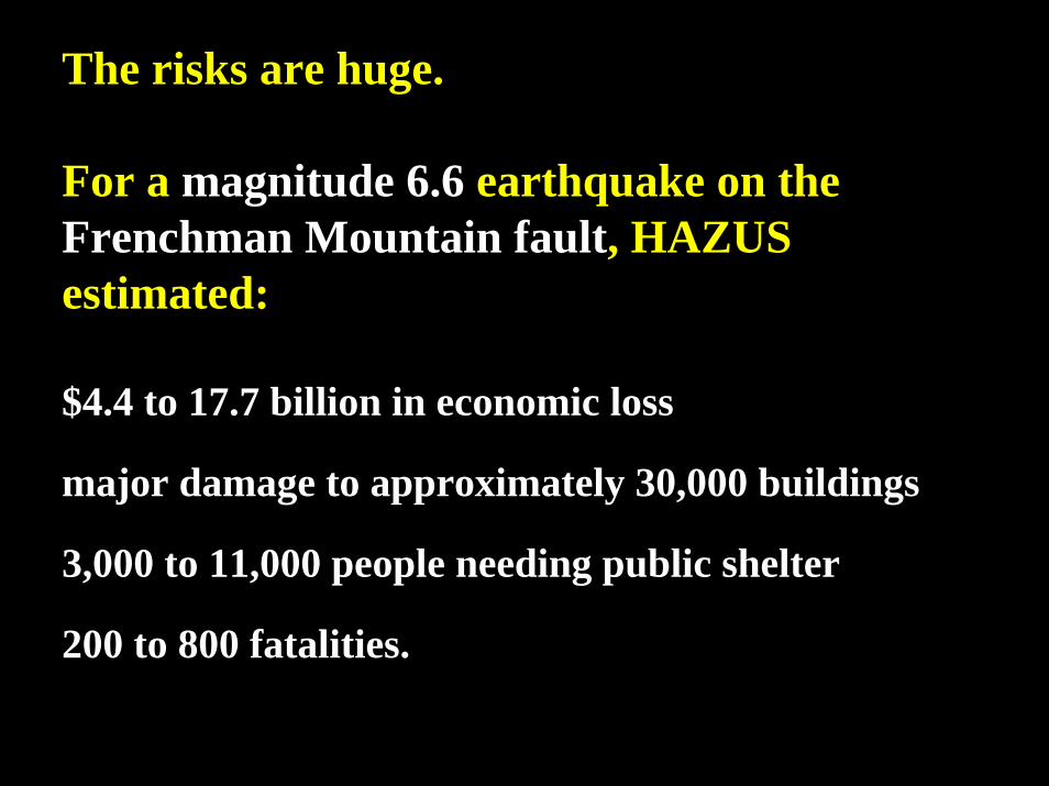
The risks are huge.
For a magnitude 6.6 earthquake on the Frenchman Mountain fault, HAZUS estimated:
$4.4 to 17.7 billion in economic loss
major damage to approximately 30,000 buildings
3,000 to 11,000 people needing public shelter
200 to 800 fatalities.

For a magnitude 5.9 daytime earthquake on the Frenchman Mountain fault, HAZUS estimated, for all of Clark County:
$2.2 to 8.9 billion in economic loss, of which $1.2 to 4.7 billion would be in building damage,$0.3 to 1.3 billion would be in damage to building contents, and$0.7 to 2.9 billion in business interruption losses related to the building stock;
major damage to 4,000 to 17,000 buildings(655 completely destroyed),
3,000 to 12,000 people needing public shelter,300 to 1,200 people needing hospital care (but only 768 of 2,341 beds
would be available in the county during the first day, up to 910 at Day 3 and 1,730 at Day 30); and
80 to 300 fatalities.(Casualty numbers are expected to be less for either a night-time or commute-time earthquake.)
(from NBMG-NDEM-FEMA-sponsored earthquake exercise for the City of Las Vegas, 2003)

Probability of an earthquake of magnitude 6.0 or greater occurring within 50 km in 50 years (from USGS probabilistic seismic hazard analysis)
10-20% chance for Las Vegas area, magnitude 6
Probability

Data from NTS shots showed that sites in Las Vegas Valley shake more than sites on bedrock (because of loose soils and/or amplification of seismic waves due to the geometry of the basin).

The main points:
1. The earthquake risks are huge in Nevada.
2. We can do something about it.
a. Be prepared to respond.
b. Mitigate structural risks, largely through building codes and avoiding faults and areas of liquefaction.
c. Mitigate nonstructural risks.

Nonstructural damage often can be easily prevented.

Earthquake-secure bookshelves in the office of the State Geologist

Secured computers at the Clark County Building Department


Information about Nevada earthquakes and what you can do:Nevada Bureau of Mines and Geology
www.nbmg.unr.edu
Nevada Seismological Laboratorywww.seismo.unr.edu

Loss-Estimation Modeling of Earthquake Scenarios for Each County in Nevada
Using HAZUS-MH
Nevada Bureau of Mines and Geology Open-File Report 06-1
University of Nevada, Reno
There are huge risks.
We can take action to reduce the risks.

Be prepared for fires (Loma Prieta = World Series Earthquake, 1989).

Loma Prieta = World Series Earthquake, 1989

San Francisco, 1906


San Francisco, 1906, after the earthquake and fire

Expect damage to the infrastructure (I-5, Northridge Earthquake, 1994).

Expect damage to highways (Oakland, 1989 World Series Earthquake).

Retrofitting can sometimes help (Oakland, 1989).

Expect disruptions to utilities (electricity, water, sewage, telephones, etc., Northridge, 1994).

Expect disruptions to communications (radio tower, Bay area, 1989).

Expect damage in areas with poor soil or rock conditions (Loma Prieta, 1989).

Expect liquefaction (Loma Prieta, 1989).

Loma Prieta Earthquake, Marina district, San Francisco, 1989

Expect lateral spreading (Loma Prieta, 1989).

Expect damage to unreinforced masonry buildings (Northridge, 1994).
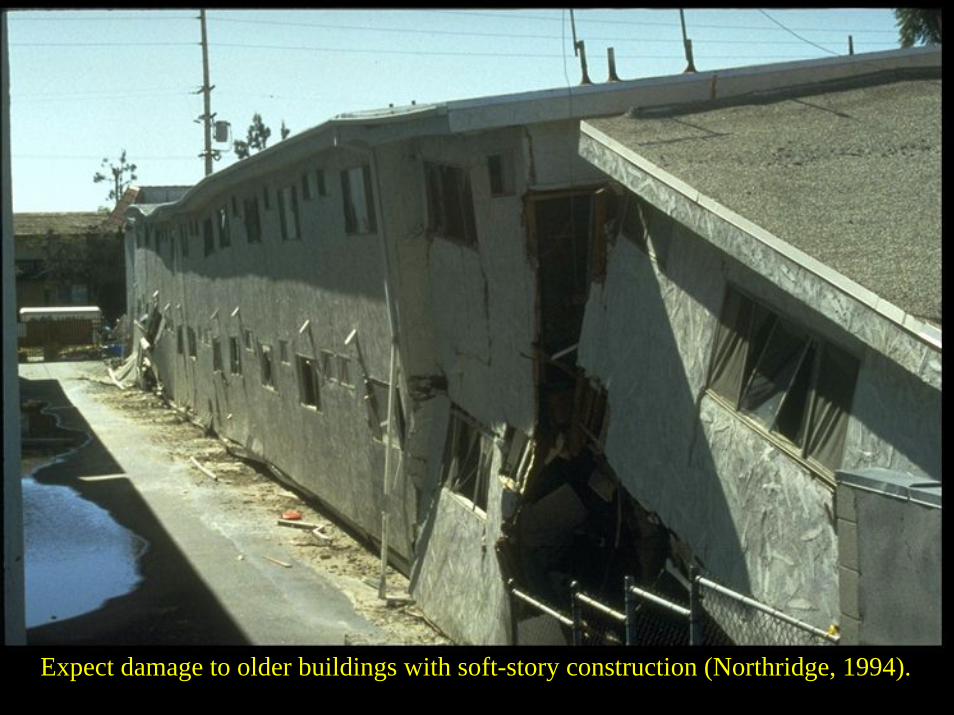
Expect damage to older buildings with soft-story construction (Northridge, 1994).

Hope that construction practices were up to code (6-story bldg, Izmit, Turkey, 1999).

Expect problems with unusual construction (Cal State Northridge parking structure, 1994).

Hope people keep a sense of humor (but expect looting).

Expect large numbers of people needing food, clothing, and shelter (Loma Prieta, 1989).

Be aware of potential loss of normal communications by telephones and cell phones.
from NBMG’s 1996 “Planning Scenario for a Major Earthquake in Western Nevada” – A magnitude 7.1 earthquake on the Mt. Rose fault near Reno could cause loss of telephone and cell communications.
Reno
Sparks
MogulVerdi
GoldenValley
LemmonValley
SunValley
Silver Knolls
Stead
SpanishSpringsCold
SpringsValley
PantherValley
HiddenValley
SpringValley
VirginiaFoothills
PleasantValley
GalenaForestEstates
NewWashoe
City
Franktown
Glenbrook
VirginiaCity
Virginia CityHighlands
Lockwood
Wadsworth
InclineVillage
Dayton
CarsonCity
PinionHills
NewEmpire
Stewart
Mound House
IndianHills
JohnsonLane area
JacksValley
GenoaZephyrCove
Minden
Gardnerville
Centerville
Dresslerville
Smith
50
50
80
80
395
431
28
341
445
207
206
50
395
395
Reno
80
AREA OF DETAIL
Plate 6Hypothetical Effect onComm nications in the
Zone A
Zone C
Zone B
Zone A
Zone B
Zone C
0 5 MILES
0 10 KILOMETERS
Radio and television stations
Telephone offices and switchingcenters
Central telephone offices
Surface faulting from scenarioearthquake
Refer to table 33.

Be aware that potential shelters may be damaged.
from NBMG’s 1996 “Planning Scenario for a Major Earthquake in Western Nevada”
SpringValley
VirginiaFoothills
VirginiaCity
NewWashoe
City
PleasantValley
Virginia CityHighlands
GalenaForestEstates
Franktown
SilverCity
395
431
429
341
50
Holcomb Ln.
0 4 MILES
0 5 KILOMETERS
IX
VIII
VII
VI
V
< V
ModifiedMercalliIntensity
Elementary school
Middle school
High school
Administrative office
Surface faulting fromscenario earthquake
CarsonCity
JacksValley
Stewart
PinionHills
395
50
50
Arrowhead Dr.
New Empire
0 1 MILE
0 1 KILOMETER
IX
VIII
VII
VI
V
< V
ModifiedMercalliIntensity
Law enforcement agencies
Local government
Fire stations
Hospitals
National Guard facilities
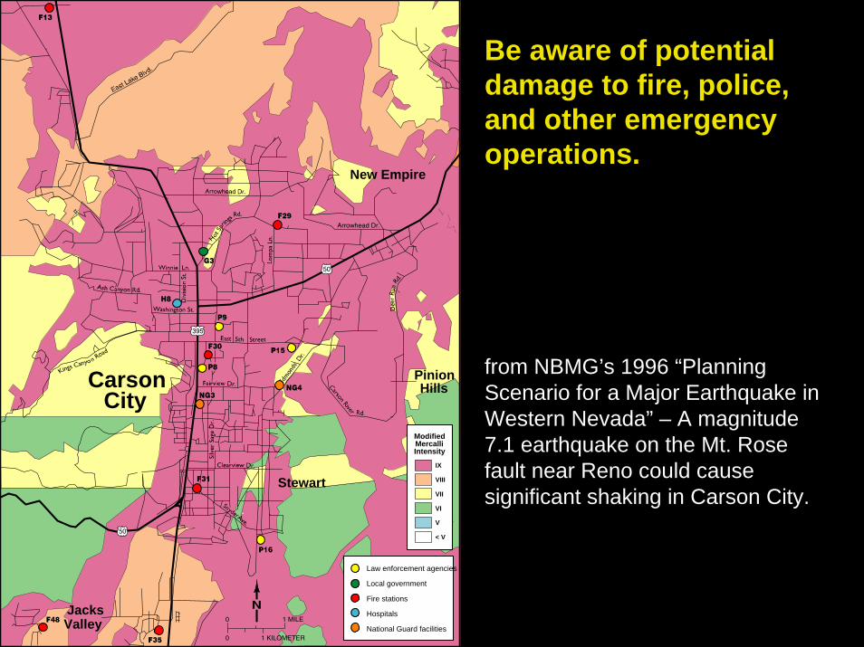
Be aware of potential damage to fire, police, and other emergency operations.
from NBMG’s 1996 “Planning Scenario for a Major Earthquake in Western Nevada” – A magnitude 7.1 earthquake on the Mt. Rose fault near Reno could cause significant shaking in Carson City.

Loss-Estimation Modeling of Earthquake Scenarios for Each County in Nevada
Using HAZUS-MH
Nevada Bureau of Mines and Geology Open-File Report 06-1
University of Nevada, Reno
There are huge risks.
We can take action to reduce the risks.