Embed Size (px)
Citation preview
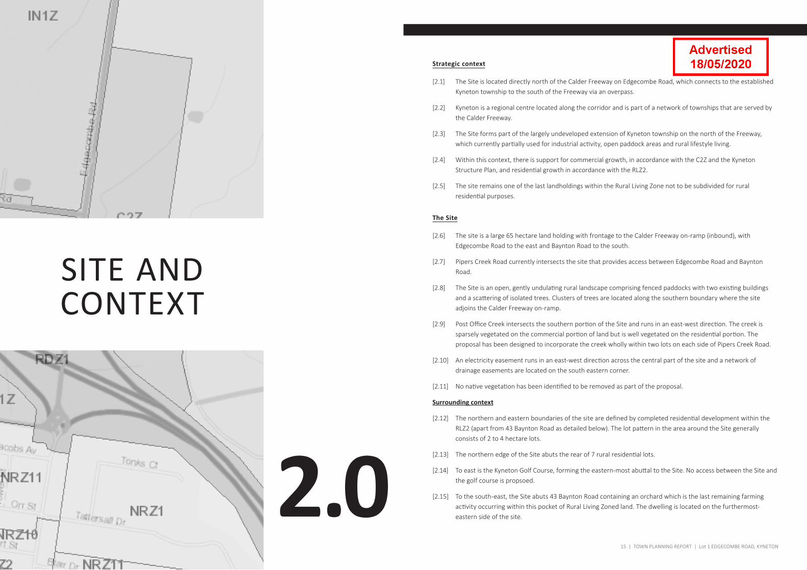
[1.1]
Lot 1 Edgecombe RoadKyneton
Planning Report for the subdivision of land (43 lots, 1 common property and reserve land)
December 2019
PE.2 ATTACHMENT 2
Table of Content
1.0 INTRODUCTION� 6
2.0 SITE�AND�CONTEXT� 14
3.0 THE�PROPOSAL� 19
4.0 PLANNING�CONTEXT� 26
5.0 PLANNING�PROVISIONS� 33
6.0 CONCLUSION� 42
7.0 APPENDIX�A� 44
List of Project Team and Discipline
Discipline Project Team
Traffic Impact Assessment GTA consultants
Cultural Heritage Management Plan Ecology and Heritage Partners
Engineering Service Strategy Select Architects
Subdivision Layout Select Architects
Quality Control Sign-off
Prepared by Reviewed by Approved by
Jane Witham Kyle O'Brien Rob Milner
5 | TOWN PLANNING REPORT | Lot 1 EDGECOMBE ROAD, KYNETONLot 1 EDGECOMBE ROAD, KYNETON | TOWN PLANNING REPORT | 4
1.0
INTRODUCTION
7 | TOWN PLANNING REPORT | Lot 1 EDGECOMBE ROAD, KYNETON
Introduction
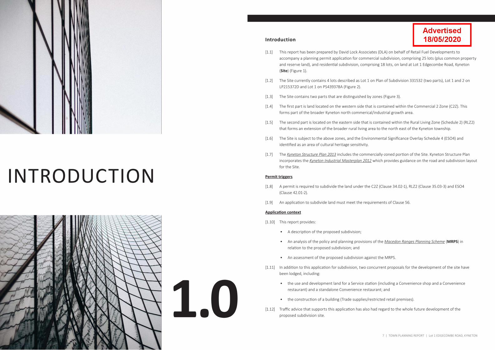
[1.1] This report has been prepared by David Lock Associates (DLA) on behalf of Retail Fuel Developments to accompany a planning permit application for commercial subdivision, comprising 25 lots (plus common property and reserve land), and residential subdivision, comprising 18 lots, on land at Lot 1 Edgecombe Road, Kyneton (Site) (Figure 1).
[1.2] The Site currently contains 4 lots described as Lot 1 on Plan of Subdivision 331532 (two parts), Lot 1 and 2 on LP215372D and Lot 1 on PS439378A (Figure 2).
[1.3] The Site contains two parts that are distinguished by zones (Figure 3).
[1.4] The first part is land located on the western side that is contained within the Commercial 2 Zone (C2Z). This forms part of the broader Kyneton north commerical/industrial growth area.
[1.5] The second part is located on the eastern side that is contained within the Rural Living Zone (Schedule 2) (RLZ2) that forms an extension of the broader rural living area to the north east of the Kyneton township.
[1.6] The Site is subject to the above zones, and the Environmental Significance Overlay Schedule 4 (ESO4) and identified as an area of cultural heritage sensitivity.
[1.7] The Kyneton Structure Plan 2013 includes the commercially-zoned portion of the Site. Kyneton Structure Plan incorporates the Kyneton Industrial Masterplan 2012 which provides guidance on the road and subdivision layout for the Site.
Permit triggers
[1.8] A permit is required to subdivide the land under the C2Z (Clause 34.02-1), RLZ2 (Clause 35.03-3) and ESO4 (Clause 42.01-2).
[1.9] An application to subdivide land must meet the requirements of Clause 56.
Application context
[1.10] This report provides:
• A description of the proposed subdivision;
• An analysis of the policy and planning provisions of the Macedon Ranges Planning Scheme (MRPS) in relation to the proposed subdivision; and
• An assessment of the proposed subdivision against the MRPS.
[1.11] In addition to this application for subdivision, two concurrent proposals for the development of the site have been lodged, including:
• the use and development land for a Service station (including a Convenience shop and a Convenience restaurant) and a standalone Convenience restaurant; and
• the construction of a building (Trade supplies/restricted retail premises).
[1.12] Traffic advice that supports this application has also had regard to the whole future development of the proposed subdivision site.
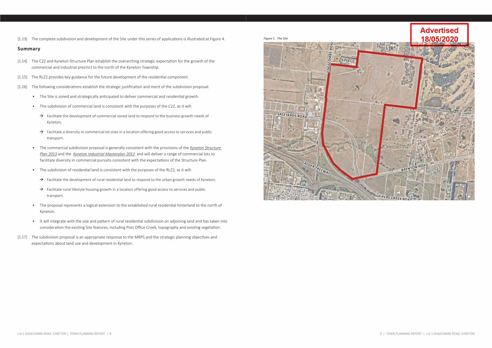
Figure 1. The Site
9 | TOWN PLANNING REPORT | Lot 1 EDGECOMBE ROAD, KYNETONLot 1 EDGECOMBE ROAD, KYNETON | TOWN PLANNING REPORT | 8
[1.13] The complete subdivision and development of the Site under this series of applications is illustrated at Figure 4.
Summary
[1.14] The C2Z and Kyneton Structure Plan establish the overarching strategic expectation for the growth of the commercial and industrial precinct to the north of the Kyneton Township.
[1.15] The RLZ2 provides key guidance for the future development of the residential component.
[1.16] The following considerations establish the strategic justification and merit of the subdivision proposal:
• The Site is zoned and strategically anticipated to deliver commercial and residential growth.
• The subdivision of commercial land is consistent with the purposes of the C2Z, as it will:
à Facilitate the development of commercial zoned land to respond to the business growth needs of Kyneton;
à Facilitate a diversity in commercial lot sizes in a location offering good access to services and public transport.
• The commercial subdivision proposal is generally consistent with the provisions of the Kyneton Structure Plan 2013 and the Kyneton Industrial Masterplan 2012 and will deliver a range of commercial lots to facilitate diversity in commercial pursuits consistent with the expectations of the Structure Plan.
• The subdivision of residential land is consistent with the purposes of the RLZ2, as it will:
à Facilitate the development of rural residential land to respond to the urban growth needs of Kyneton;
à Facilitate rural lifestyle housing growth in a location offering good access to services and public transport.
• The proposal represents a logical extension to the established rural residential hinterland to the north of Kyneton.
• It will integrate with the size and pattern of rural residential subdivision on adjoining land and has taken into consideration the existing Site features, including Post Office Creek, topography and existing vegetation.
[1.17] The subdivision proposal is an appropriate response to the MRPS and the strategic planning objectives and expectations about land use and development in Kyneton.
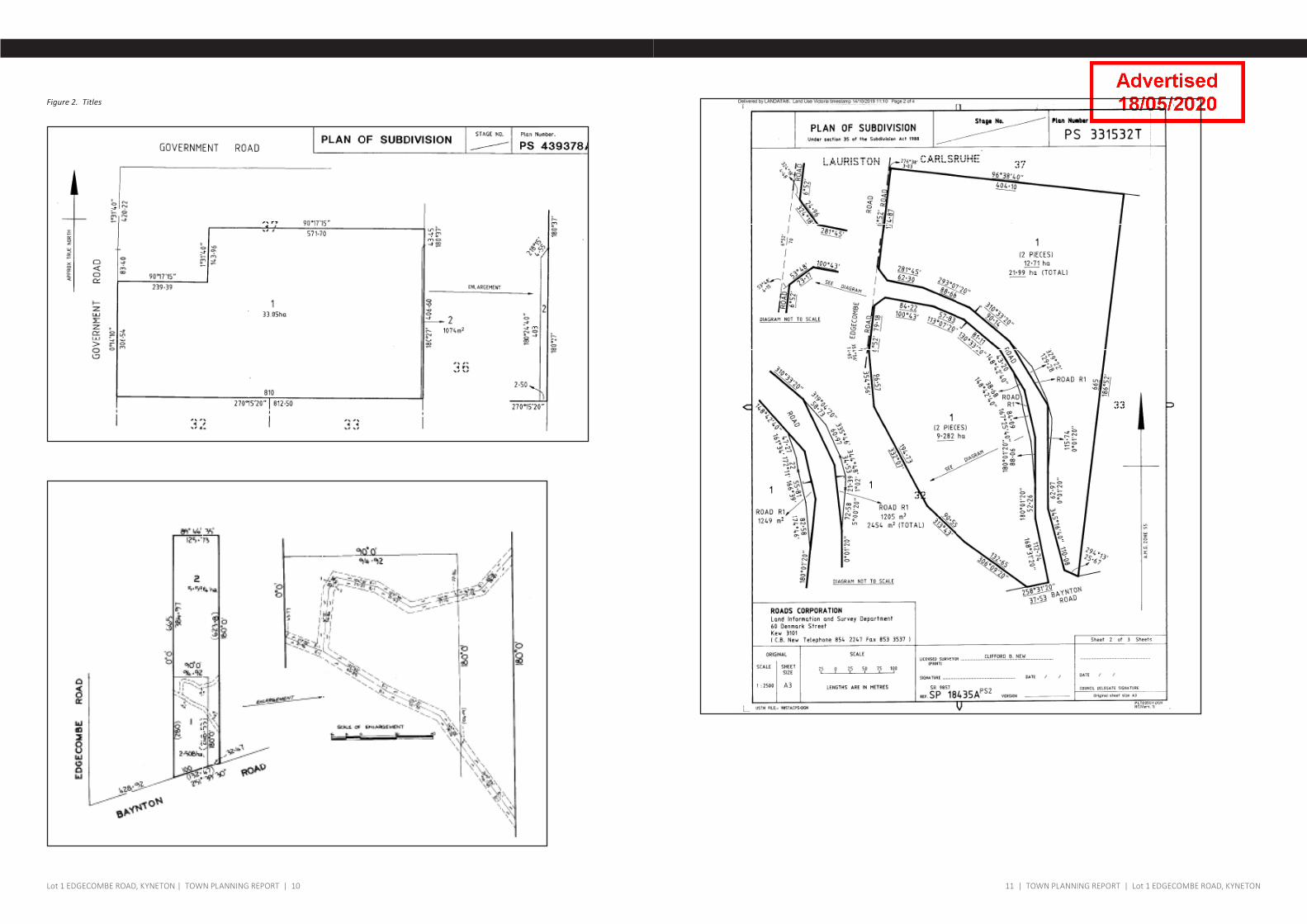
Figure 2. Titles
11 | TOWN PLANNING REPORT | Lot 1 EDGECOMBE ROAD, KYNETONLot 1 EDGECOMBE ROAD, KYNETON | TOWN PLANNING REPORT | 10
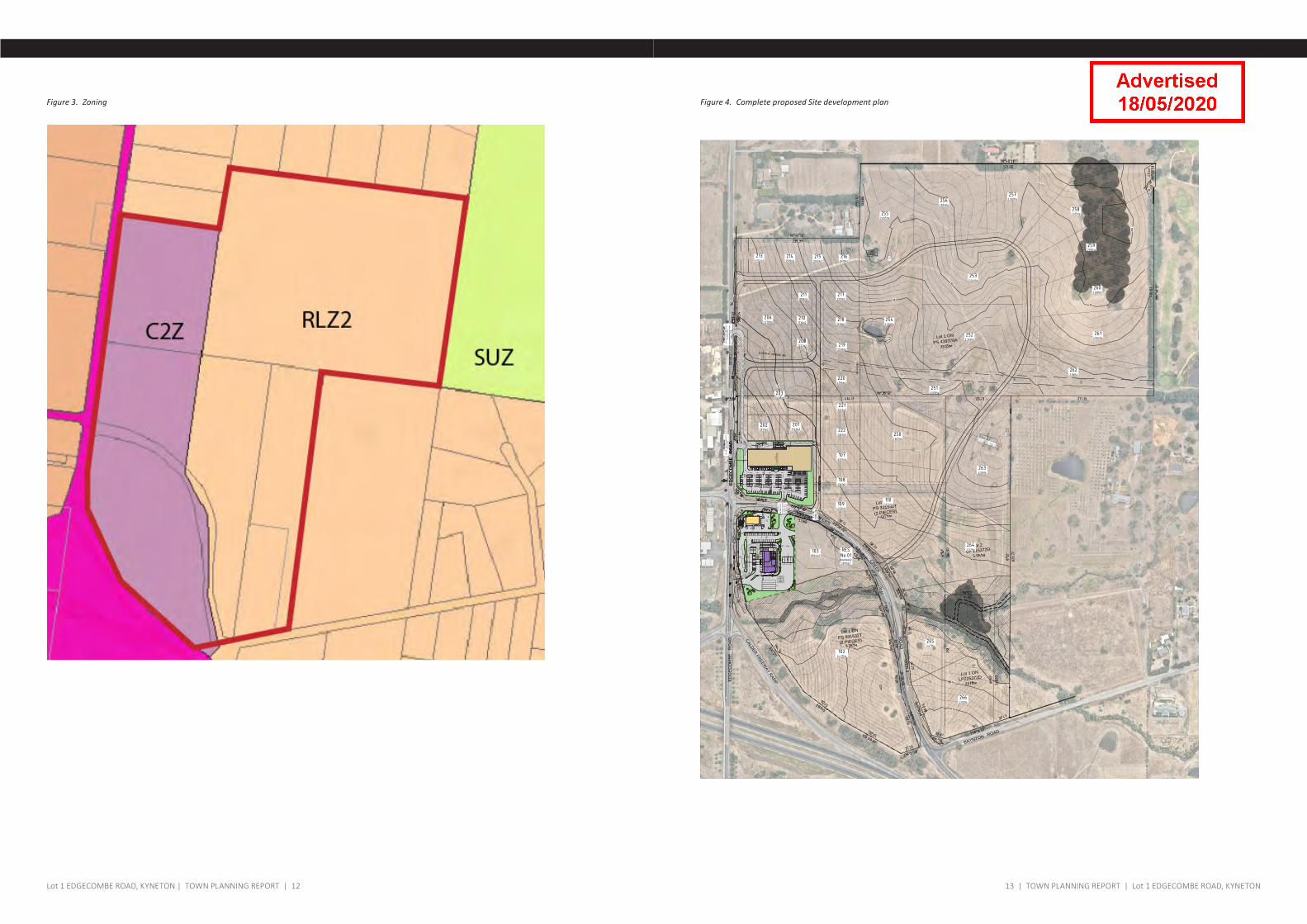
Figure 4. Complete proposed Site development planFigure 3. Zoning
Shed
Sheds WeatherboardHouse
T.B.MPM 70
Dam
Dam
ED
GE
CO
MB
E
RO
AD
POSTOFFICE
CREEK
POST
OFFICE
CREEK
BAYNTON ROAD
CALDER FREEWAY RAM
P
OldPost
&Wire
Fence
OldPost
&Wire
Fence
OldPost,WireandStar
PicketFence
OldPost,WireandStar
PicketFence
OldPost,WireandStar
PicketFence
OldPost,WireandStar
PicketFence
Old
Post & Wire
Fenc
e
Old
Post &
Wire
Fenc
eO
ldPo
st &W
ireFe
nce
Old
Post & Wire
Fenc
e Old
Post
,W
ire & Star
Pick
etFe
nce
Old
Post & Wire
Fenc
e
Old
Post &
Wire
Fenc
e
Old
Post
,W
ire & Star
Pick
etFe
nce
Old
Post
,W
ire & Star
Pick
etFe
nce
OldPost,
Wire&Star
Picket
Fence
Old
Con
cret
ePo
st & Wire
Fenc
e
OldConcretePost&WireFence
OldConcretePost&WireFence
Old
Con
cret
ePo
st & Wire
Fenc
e
Old
Con
cret
ePo
st & Wire
Fenc
e
Old
Concrete
Post&Wire
Fence
OldConcretePost&WireFence
Old
Con
cret
ePo
st & Wire
Fenc
e
Lot 1 ON
PS 439378A
Lot 2LP 215372D
Lot 1 ONLP215372D
Lot 1 ON
PS 331532T
(2 PIECES)
Old
Concrete
Post&Wire
Fence
Groupof
LargeGumtrees
Lot 1 ON
PS 331532T
(2 PIECES)
Shed
OldPost,WireandStar
PicketFence
OldPost,WireandStar
PicketFence
OldPost,WireandStar
PicketFence
Old
Post
,W
irean
dSt
arPi
cket
Fenc
e Old
Post
,W
irean
dSt
arPi
cket
Fenc
e
Old
Post
,W
irean
dSt
arPi
cket
Fenc
e
Old
Post
,W
irean
dSt
arPi
cket
Fenc
e
Old
Post
,W
irean
dSt
arPi
cket
Fenc
e
Old
Post,W
ireandStarPicketFence
OldPost,Wireand
StarPicketFence
OldPost,Wire
andStarPicketFence
OldPost,WireandStar
PicketFence
524
526
524
522
520
518516
516
514
514
512
512
510
510
508
508
508
510
512
510
508
506
506
RO
AD
PIPERS
CREEK
Bridge
Bridge
ED
GE
CO
MB
E
RO
AD
1041.256Ha
1038394m2
1052593m2
CPCOMMON
PROPERTY2397m2
1061.645Ha
2022977m2
2013143m2
20310468m2
1094232m2
1083361m2
1073357m2
2223362m2
2213227m2
2204796m2
2193578m2
2061.378Ha
2101710m2
2111883m2
2183328m2
2173391m2
2134925m2
2143599m2
2153592m2
2163599m2
2552.005Ha
2561.993Ha
2572.002Ha
2582.015Ha
2591.995Ha
2602.018Ha
2612.002Ha
2622.06Ha
2522.392Ha
2542.236Ha
2512.009Ha
2502.002Ha
1102.032Ha
2632.00Ha
2642.57Ha
1026.417Ha
2532.046Ha
2092222m2
RESNo.01DRAINAGE2879m2
2632.00Ha
2642.57Ha
2653.47Ha
2662.00Ha
SITE
BO
UN
DA
RY
53.48m
6°52'
SITE BOU
ND
ARY
82.40m
354°56'
23.17m
53°48'
SITE BOUNDARY 84.22m 100°43'
PROPOSED SITE BOUNDARY98.91m
SITE BOUNDARY57.83m
113°07'20"
SITE BOUNDARY
80.52m
130°33'20"
43.20m
148°42'40"
47.27m341°34'
PROPOSED RD
WAITINGBAY
NO EN
TRY
NO ENTRY
KE
EP
CLE
AR
KE
EP
CLE
AR
WAITINGBAY
13.58m
354°56'
26.15m
6°52'
PR
OP
OS
ED
SITE
BO
UN
DA
RY
134.97m
ED
GE
CO
MB
E
RO
AD
Old
Post & Wire
Fenc
e
Old
Con
cret
ePo
st & Wire
Fenc
e
OldPost,WireandStar
PicketFence
OldPost,WireandStar
PicketFence
P
aS
PiFe
Old
Post
,W
irean
dSt
arPi
cket
Fenc
e
512
510
508
P
1061.645Ha
2022977m2
2013143m2
20310468m2
202222m2
17.60 m2
26.27 m2
9.24 m2
17.60 m2
EOD
EOD
B
B
B
B
B
B
B
B
BBQGA
SC
AG
E
BB B
2050
7700
2050
3200
MAIN ENTRY
DISPLAY SPACE
17.60 m2
4,780 m2
26.27 m2
9.24 m2
17.60 m2
27.44 m2 24.95 m2 34.65 m2
EOD
EOD
B
B
B
B
B
B
B
B
KEEPCLEAR
KEEPCLEAR
BALEPRESS
KEEPCLEAR
BALEPRESS
GASCAGE
BBQGA
SC
AG
E
BB B
BIN STORAGE
2050
7700
2050
3200
2850
21150
8500
6915
8173HEIGHT TO UNDERSIDE TO BE 5050mm
DOUBLE SLIDING GATE 4400
6.6M DOUBLE SWING GATE6.6M DOUBLE SWING GATESIZE OF SPRINKLER TANK TBC
MAIN ENTRY
DISPLAY SPACE
DISPLAY SPACEDISPLAY
SPACEDISPLAY SPACE
TTS CANOPY
SPRINKLERTANK
PUMPHOUSE
FUTURE EXPANSION LAND = 981.19 m2
DOUBLE SLIDING GATE 4400
HYSTER
HYSTER
H2.5TX
H2.5TX
TRA
DE
SU
PP
LIES
STO
RE
/R
ES
TRIC
TED
RE
TAIL
GOODSINWARDS
GI CANOPY
PROPOSED GI LEFTENTRY
PROPOSEDGI ENTRY
100°43'
24.96m
324°18'
SITE BOUNDARY57.83m
113°07'20"
TROLLEY BAYNB168
TROLLEY BAYNB168
7462
13226
5500
7200
11000
7200
12500
00
7200
11000
7200
12500
7200
11000
7200
11000
7200
5500
8500
7200
7,200
PR
OP
OS
ED
CU
STO
ME
R E
NTR
Y/E
XIT LE
FT ON
LY.
PR
OP
OS
ED
GI LE
FT EX
IT ON
LY
P I P E R S C R E E K R O A D
E D
G E
C O
M B
E R
O A
D
OU
T
EXISTING POWERLINE
SITE
AR
EA
16,453m²
(1.64 ha)
IN
6510
72007200
PR
OP
OS
ED
CU
STO
ME
RE
NTR
Y/E
XIT A
LLW
AY
S.
PR
OP
OS
ED
CU
STO
ME
R E
NTR
Y LE
FT &R
IGH
T IN O
NLY
PR
OP
OS
ED
TRU
CK
EN
TRY
PR
OP
OS
ED
CU
STO
ME
R E
NTR
Y LE
FT IN,
PR
OP
OS
ED
CU
STO
ME
RE
NTR
Y &
EX
IT.LE
FT & R
IGH
TIN
& O
UT
S E
R V
I C E
R O
A D
EN
TRY
& E
XIT.
LEFT &
RIG
HT
IN &
OU
T
BRISBANE + MELBO
URNE
PR
OJE
CT
CLIE
NT
DR
AW
ING
TITLE
AM
EN
DM
EN
T DE
TAILS
NO
RTH
RE
VIS
ION
No.
SH
EE
T
of
SC
ALE
@ A
1
CH
EC
KE
D
DA
TE
DR
AW
N
PR
OJE
CT N
o.
DA
TEB
YR
EV
PR
OJE
CT A
DD
RE
SSD
RA
WIN
G N
o.
ISS
UE
BU
ILDE
R / C
ON
TRA
CTO
R TO
VE
RIFY
ALL D
IME
NS
ION
S O
N S
ITE P
RIO
RT
O P
RO
DU
CIN
G S
HO
P D
RA
WIN
GS
, OR
DE
RIN
G M
AT
ER
IALS
OR
CO
MM
EN
CIN
G W
OR
K O
N S
ITE. U
SE
FIGU
RE
D D
IME
NS
ION
S O
NLY
, DO
NO
T S
CA
LE
DR
AW
ING
S &
INF
OR
M trg
OF
AN
Y C
ON
FL
ICT
OR
DIS
CR
EP
AN
CY
BE
TW
EE
N S
ITE
CO
ND
ITIO
NS
AN
D D
OC
UM
EN
TS
.D
RA
WIN
GS
SH
ALL B
E R
EA
D IN
CO
NJU
NC
TIO
N W
ITH
RE
LEV
AN
TC
ON
SU
LTAN
TS D
RA
WIN
GS
, RE
GU
LATO
RY
CO
DE
S A
ND
STA
ND
AR
DS
.©
- CO
PY
RIG
HT trg
CO
PY
RIG
HT
OF
DE
SIG
NS
SH
OW
N H
ER
EIN
IS R
ET
AIN
ED
BY
TH
ISO
FFICE
, WR
ITTEN
AU
THO
RITY
IS R
EQ
UIR
ED
FOR
AN
Y R
EP
RO
DU
CTIO
N.
Level 3, Suite 37, 799 S
pringvale Road,
Mulgrave, V
ictoria 3170 Australia
T: +61 3 9542 9300 F: +61 3 9542 9310
ww
w.trg-aus.com
The Retail G
roup Pty Ltd A
BN
85 050 134 686
RB
P N
o. DP
-AD
1689
2018
PR
OP
OS
ED
MIX
ED
US
ED
EV
ELO
PM
EN
T
LOT 1 E
DG
EC
OM
BE
RO
AD
KY
NE
TON
VIC
3444
TITLE P
AG
E &
SITE
LOC
ALITY
PLA
N
OC
T. '191:2500
JSA
B
PR
ELIM
INA
RY
18104TP01
P5
0109
RE
TAIL FU
EL D
EV
ELO
PM
EN
TS
P1
PR
ELIM
INA
RY
ISS
UE
JS07-10-19
P2
PR
ELIM
INA
RY
ISS
UE
JS08-10-19
P3
PR
ELIM
INA
RY
ISS
UE
JS18-10-19
P4
PR
ELIM
INA
RY
ISS
UE
JS18-12-19
P5
PR
ELIM
INA
RY
ISS
UE
JS19-12-19
PRELIMINARYNot for construction
1:2500 @ A
1 SIZE
/ 1:5000@ A
3 SIZE
0m75m
25m50m
100m
PR
OP
OS
ED
MIX
ED
US
E D
EV
ELO
PM
EN
TA
T
LOT 1 E
DG
EC
OM
BE
RO
AD
, KY
NE
TON
, VIC
TP01
TITLE P
AG
E A
ND
SITE
LOC
ALITY
PLA
NTP
02P
RO
PO
SE
D S
ITE P
LAN
1TP
02AP
RO
PO
SE
D S
ITE P
LAN
2TP
03P
RO
PO
SE
D P
AR
T SITE
PLA
N 1
TP04
PR
OP
OS
ED
PA
RT S
ITE P
LAN
2TP
05 P
RO
PO
SE
D E
LEV
ATIO
NS
1TP
06P
RO
PO
SE
D E
LEV
ATIO
NS
2TP
07P
RO
PO
SE
D E
LEV
ATIO
NS
3TP
08P
RO
PO
SE
D E
LEV
ATIO
NS
4
AR
CH
ITEC
TUR
AL D
RA
WIN
G LIS
T :
13 | TOWN PLANNING REPORT | Lot 1 EDGECOMBE ROAD, KYNETONLot 1 EDGECOMBE ROAD, KYNETON | TOWN PLANNING REPORT | 12
2.0
SITE�AND�CONTEXT
15 | TOWN PLANNING REPORT | Lot 1 EDGECOMBE ROAD, KYNETON
Strategic context
[2.1] The Site is located directly north of the Calder Freeway on Edgecombe Road, which connects to the established Kyneton township to the south of the Freeway via an overpass.
[2.2] Kyneton is a regional centre located along the corridor and is part of a network of townships that are served by the Calder Freeway.
[2.3] The Site forms part of the largely undeveloped extension of Kyneton township on the north of the Freeway, which currently partially used for industrial activity, open paddock areas and rural lifestyle living.
[2.4] Within this context, there is support for commercial growth, in accordance with the C2Z and the Kyneton Structure Plan, and residential growth in accordance with the RLZ2.
[2.5] The site remains one of the last landholdings within the Rural Living Zone not to be subdivided for rural residential purposes.
The Site
[2.6] The site is a large 65 hectare land holding with frontage to the Calder Freeway on-ramp (inbound), with Edgecombe Road to the east and Baynton Road to the south.
[2.7] Pipers Creek Road currently intersects the site that provides access between Edgecombe Road and Baynton Road.
[2.8] The Site is an open, gently undulating rural landscape comprising fenced paddocks with two existing buildings and a scattering of isolated trees. Clusters of trees are located along the southern boundary where the site adjoins the Calder Freeway on-ramp.
[2.9] Post Office Creek intersects the southern portion of the Site and runs in an east-west direction. The creek is sparsely vegetated on the commercial portion of land but is well vegetated on the residential portion. The proposal has been designed to incorporate the creek wholly within two lots on each side of Pipers Creek Road.
[2.10] An electricity easement runs in an east-west direction across the central part of the site and a network of drainage easements are located on the south eastern corner.
[2.11] No native vegetation has been identified to be removed as part of the proposal.
Surrounding context
[2.12] The northern and eastern boundaries of the site are defined by completed residential development within the RLZ2 (apart from 43 Baynton Road as detailed below). The lot pattern in the area around the Site generally consists of 2 to 4 hectare lots.
[2.13] The northern edge of the Site abuts the rear of 7 rural residential lots.
[2.14] To east is the Kyneton Golf Course, forming the eastern-most abuttal to the Site. No access between the Site and the golf course is propsoed.
[2.15] To the south-east, the Site abuts 43 Baynton Road containing an orchard which is the last remaining farming activity occurring within this pocket of Rural Living Zoned land. The dwelling is located on the furthermost-eastern side of the site.
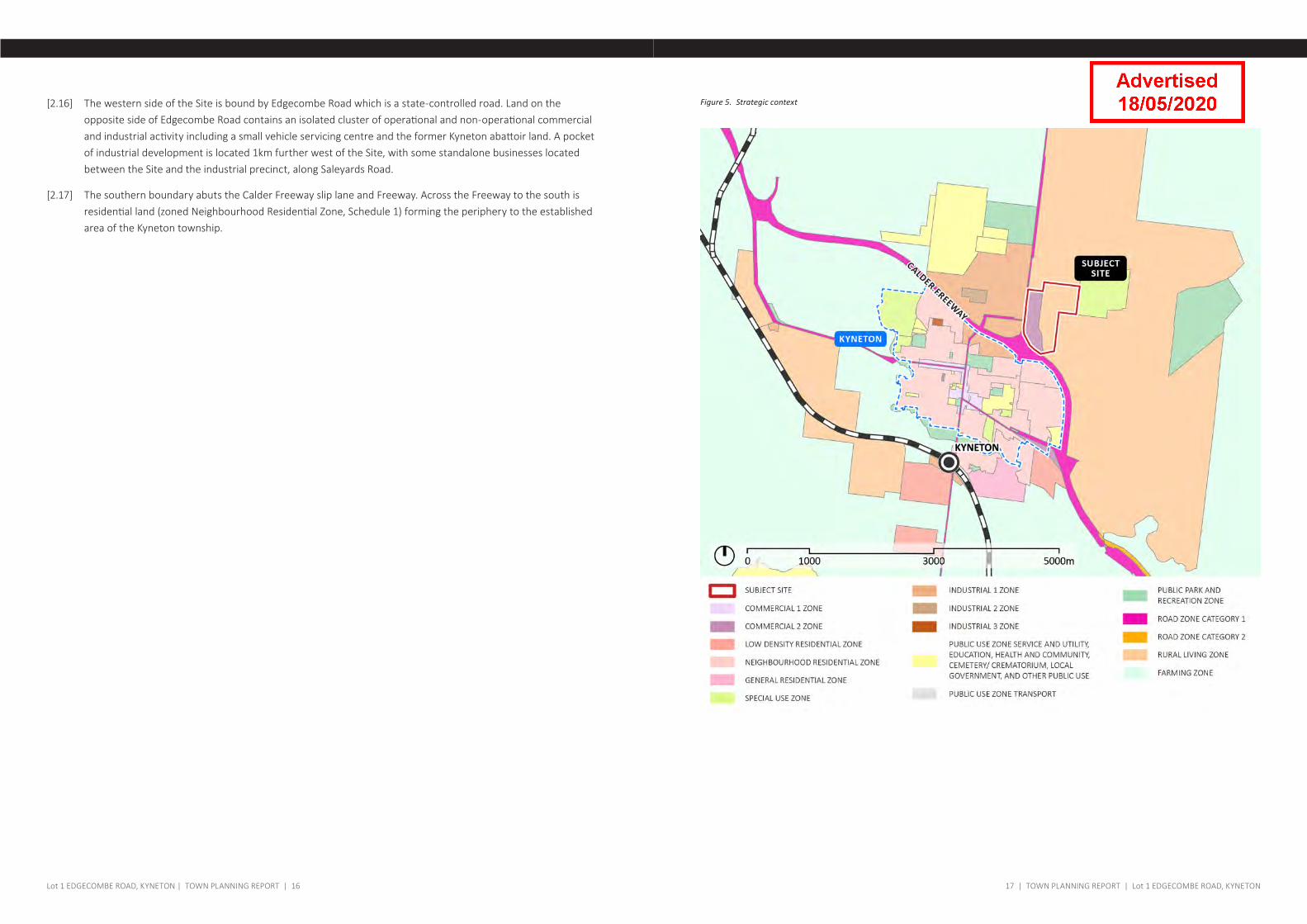
Figure 5. Strategic context
17 | TOWN PLANNING REPORT | Lot 1 EDGECOMBE ROAD, KYNETONLot 1 EDGECOMBE ROAD, KYNETON | TOWN PLANNING REPORT | 16
[2.16] The western side of the Site is bound by Edgecombe Road which is a state-controlled road. Land on the opposite side of Edgecombe Road contains an isolated cluster of operational and non-operational commercial and industrial activity including a small vehicle servicing centre and the former Kyneton abattoir land. A pocket of industrial development is located 1km further west of the Site, with some standalone businesses located between the Site and the industrial precinct, along Saleyards Road.
[2.17] The southern boundary abuts the Calder Freeway slip lane and Freeway. Across the Freeway to the south is residential land (zoned Neighbourhood Residential Zone, Schedule 1) forming the periphery to the established area of the Kyneton township.
This page is intended to be left blank
3.0
THE�PROPOSAL
7 BARANBALI DRIVE, VERMONT SOUTH | TOWN PLANNING REPORT | 18
21 | TOWN PLANNING REPORT | Lot 1 EDGECOMBE ROAD, KYNETONLot 1 EDGECOMBE ROAD, KYNETON | TOWN PLANNING REPORT | 20
Overview
[3.1] The subdivision proposes a combined commercial and rural residential subdivision as follows:
• a commercial development of 25 lots, a common property lot and a drainage reserve;
• a rural residential subdivision of 18 lots;
[3.2] It proposes Easement E-1 for an electricity line traversing the site, Easement E-2 for an electricity line, drainage and sewerage infrastructure. The proposal also includes land set aside as a drainage reserve.
[3.3] No buildings and works are proposed as part of this proposal.
[3.4] The existing dwelling will be retained on the east portion of the land.
[3.5] The proposed subdivision will provide for all commercial and residential lots to front all abutting roads.
Functional road layout
[3.6] The proposal includes a network of roads through the Site that integrate with the surrounding road network and facilitate access through the commercial and rural residential lots.
[3.7] The road layout includes:
• a new service road to Edgecombe Road that will facilitate access to Lot 106 and 206.
• A north-south spine is proposed within the commercial precinct. An additional east-west link provides a second new access to Edgecombe Road approximately halfway along the Site frontage.
• a new ring road linking Edgecombe Road and Pipers Creek Road, to facilitate access to all residential lots.
[3.8] No direct lot access is proposed to/from Edgecombe Road.
[3.9] For commercial roads, as per the Traffic Impact Assessment prepared by GTA, the road widths have been designed to cater for large truck turning movements. The road cross section is in accordance with Council's Engineering Standard.
[3.10] Regarding the residential road, the internal road is open ended to both Edgecombe Road via the internal commercial network and Pipers Creek Road. At the interface between the commercial road and the residential road, a threshold will be created through a wall, changes in landscape treatments and a change of road pavement (for a short length). It is expected to adopt the cross section from the IDM for a sealed pavement within a 22m wide reserve to provide for additional landscape plantings.
[3.11] Where possible dwellings and their access will address the existing road pattern. To reinforce this for these lots, the culvert crossings will be constructed onto Pipers Creek Road. Culvert crossings will be in accordance with the relevant Council and VicRoads standard details. The crossings will be located in safe locations.
[3.12] The long road design permits each dwelling to have two options to exit in the case of emergency.
[3.13] Please refer to the GTA traffic assessment for further information.
Staging
[3.14] Both the residential and commercial subdivision are proposed to include 4 stages each to provide for the
progressive development of the Site.
Commercial
[3.15] Future Lot 104 and Lot 105 are proposed to accommodate a Service Station (including a Convenience shop and a Convenience restaurant) and a standalone Convenience restaurant as part of a separate application.
[3.16] Lot 106 is proposed to accommodate a Trade supplies/restricted retail premises as part of a separate application.
[3.17] Lot 102 is proposed to wholly contain Post Office Creek to the west of Pipers Creek Road.
Residential
[3.18] The land forming part of the residential subdivision contains various isolated trees and a significant tract of bushland at the north eastern corner of the Site. Lots 257, Lot 258, Lot 259 and Lot 260 each contain part of the vegetation to the east to be retained. It is requested that a Land Rehabilitation Plan is undertaken by the way of a condition of approval.
[3.19] The rural residential subdivision has been proposed to include indicative 40 x 40m building envelopes on each proposed lot. The envelopes have been designed at 20m from the front setback, 10m from side boundaries and each separated by a minimum 40m. Proposed Lot 265 and Lot 264 are proposed to be sited away from the edge of the riparian buffer area on either side of Post Office Creek.
[3.20] Lot 265 is proposed to wholly contain Post Office Creek to the east of Pipers Creek Road.
Post Office Creek
[3.21] Council pre-lodgement advice, dated 4 December 2019 requests a Land Rehabilitation Plan that incorporates a long term restoration plan for Post Office Creek, or alternatively, Council may consider obtaining the creek as a Council reserve.
[3.22] The creek has been proposed to be contained in one ownership on either side of Pipers Creek Road (Lot 102 and Lot 265) to ensure it is maintained and managed appropriately.
[3.23] As indicated in correspondence from Council, our client is open to negotiations to dedicate the creek as Council reserve, provided Council is willing to forego the public space contribution applicable to the proposal.
[3.24] It is requested that a Land Rehabilitation Plan is undertaken by the way of a condition of approval.
[3.25] The CHMP prepared as part of the application requires fencing to be erected around the creek buffer area. Any fencing that causes an obstruction to overland flow is discouraged.
Drainage and stormwater management
Commercial
[3.26] Each site within the development will be required to detain discharges to the pre-development rates.
Pipers Creek Road – north
[3.27] Stormwater from roads and commercial sites discharging to the roads would be conveyed through a piped system to a detention basin located by the riparian zone on Pipers Creek Road, at this site the stormwater would be treated by:
23 | TOWN PLANNING REPORT | Lot 1 EDGECOMBE ROAD, KYNETONLot 1 EDGECOMBE ROAD, KYNETON | TOWN PLANNING REPORT | 22
• removing of trash;
• sediments; and
• further detention.
[3.28] Stormwater would then discharge from back into the Pipers Creek Road reserve to discharge into the creek adjacent the culvert crossing.
[3.29] The road cross section would have pavement area to act as an overland flow path to avoid damaging property.
[3.30] The sizes of all pipes and water treatment basins would be determined to contain storm flows in accordance with Council Engineering requirements.
Pipers Creek Road – south
[3.31] The one commercial site on the south side of Pipers Creek Road, would detain its stormwater flow to the pre-development discharge rates and then discharge the stormwater to Pipers Creek Road to a pipe to convey the water to the creek adjacent the culvert crossing.
Rural Living
[3.32] The road cross section is designed for swale drains on either side of the road pavement. The road long section would align to minimise the concentration or change overland flow paths. It is expected culvert crossings would convey water across the road at low points. Each residential site entrance would have a constructed entrance and culvert crossing.
[3.33] Each of the sites will be approximately 2 hectares, each site has a building envelope on the more elevated parts of the site, any concentration of stormwater would be discharged to natural depressions for dispersal into waterways.
Sewerage
Commercial
[3.34] A sewerage manhole is located at the intersection of Edgecombe Road and Pipers Creek Road.
[3.35] It is proposed the sewerage reticulation mains extended to service this area from that manhole. The mains will be designed so where possible those lots which can be connected to the manhole via gravity mains discharging directly to that manhole.
[3.36] It is expected the development on the south side of Pipers Creek Road and some of the lots within the north side of the Pipers Creek Road will be required to be serviced by a main which will be gravitate down toward the Travelers Creek to a pump station.
[3.37] The pump station constructed to the requirements of the local utility provider as an authority asset, will pump back to the manhole at the intersection. For the north side lots this main is expected to be at the rear of the relevant sites adjacent the low density residential development
Rural Living
[3.38] The rural residential lots which back onto the commercial development will be able to discharge into those mains via their own pump and rising main. A covenant would be created to advise owners of the requirements and
ongoing obligations for the pump and discharges.
[3.39] Where discharge directly into the mains is not possible, each site would have a Land Capability Assessment to consider the correct method for the disposal of waste water within the site.
[3.40] A Land Capability Assessment is under preparation and will be provided to support the application in early 2020.
Electricity
[3.41] A series of high voltage mains run along the Edgecombe Road and across the Site. Some of the commercial uses are sufficiently large as to require their own substations, while others will draw low voltage from the low voltage reticulated network to be installed as part of the proposal.
[3.42] It is expected as part of the design process suitable locations for substations will be nominated and underground reticulation to individual lots will be installed as part of the development.
NBN
[3.43] The NBN advises the area is ready for connection via fixed wireless technology. Lots will be connected in accordance with NBN’s requirements.
Landscaping
[3.44] It is understood that the proposed landscaping response is an integral component of the assessment of the application.
[3.45] We anticipate on providing a fully resolved landscape masterplan at a future point when the design and layout has been fully resolved to avoid duplication.

This page is intended to be left blank
4.0
PLANNING�CONTEXT
7 BARANBALI DRIVE, VERMONT SOUTH | TOWN PLANNING REPORT | 24
27 | TOWN PLANNING REPORT | Lot 1 EDGECOMBE ROAD, KYNETONLot 1 EDGECOMBE ROAD, KYNETON | TOWN PLANNING REPORT | 26
Introduction
[4.1] The application seeks approval for a subdivision that is consistent with the relevant Planning Policy Framework (PPF) and strategic expectations for commercial development and rural residential in Kyneton.
Planning Policy Context
Settlement
[4.2] The orderly growth of regional townships is sought within the PPF. The policy expectation is that orderly urban growth will be located in proximity to services and transport corridors and make efficient use of infrastructure.
[4.3] Plan Melbourne identifies Kyneton as a Regional Centre that “has capacity to support more housing and employment generating development, without impacting on the economic and environmental roles that surrounding non-urban areas serve” (Policy 7.1.2).
[4.4] State settlement policy at Clause 11 seeks land to be managed through strategic and statutory plans to provide for the development of sustainable and liveable urban areas in an integrated manner.
[4.5] The Local Planning Policy Framework (LPPF) supports these growth expectations in areas such as Kyneton (Clause 21.04).
[4.6] Kyneton is identified as a "Large district town" in the Strategic Framework Plan at Clause 21.03 and strategically significant centre, which are sought to accommodate future growth (Strategy 1.2, Clause 21.04). It well serviced by the Calder Freeway and railway corridor from Bendigo to Melbourne (Clause 21.03 and Clause 21.04).
[4.7] Kyneton is an important service and retail node for surrounding rural land, and accommodates major industries such as saleyards, abattoirs and administrative services.
[4.8] Within this context, it is important for the Site to develop in a manner than integrates with the broader surrounding context, in addition to integrating commercial and residential uses on the Site.
Economic Development
[4.9] State policy supports regional growth in locations that benefit from existing community infrastructure and services (Clause 11) and support rural economies to grow and diversify (Clause 17.01-1S) and provide a net benefit to the regional community (Clause 17.02-2S).
[4.10] The Planning Scheme identifies__ Kyneton as a significant contributor to economic development.
[4.11] There is policy support for commercial and industrial growth within the Scheme at Clause 21.10-1, which includes the following strategies:
• Strategy 1.1: Maintain Kyneton and Gisborne as the main industrial centres in the Shire.
• Strategy 1.2: Support the development of business clusters.
• Strategy 1.6: Encourage new transport related industries that can maximise benefit from the Calder Freeway and access to Melbourne.
• Strategy 1.13: Protect industrial and commercial zoned land, industries or other activities with significant off
site impacts from encroachment from commercial, residential and other sensitive uses which would adversely affect business viability.
[4.12] Clause 21.10-1 seeks to maintain the amenity of areas interfacing with industrial and commercial uses and the quality of the rural environment, including at township gateways (Strategy 2.5):
• Ensure industrial and commercial development at township gateways and along major roads does not detract from the valued elements of the surrounding landscape.
[4.13] The Structure Plan seeks to support viable business and supports the ongoing growth and diversification of Kyneton. It sets out specific actions, including:
• Encourage industry and trade related land uses on the eastern side of Edgecombe Road north of Calder Freeway in a way that avoids a compromise of the industrial area and or undermine the role of the town centre. Shop/supermarket use is strongly discouraged in this location.
Built Environment and Heritage
[4.14] Built environment policy at Clause 15 seeks development to respond to its context in respect of surrounding character, cultural heritage, natural features and the surrounding landscape.
[4.15] The Site is within Macedon Ranges, which is an Environmentally Sensitive Area of State significance (Clause 13.07-1S). Within this context, the proposed subdivision is to consider the surrounding context and landscape character.
Built Environment - commercial development
[4.16] Clause 22.06 seeks new commercial development to have regard to the preferred visual character context, key road gateways and corridors and have a positive impact on the amenity and the physical environment of the Shire.
[4.17] The Design Guidelines for Industrial & Commercial Developments for the Macedon Ranges, June 2012 (the Design Guidelines), are identified in Clause 22.06 as key to achieving the intent. It is policy under Clause 22.06 to assess proposals against the Design Guidelines.
[4.18] A detailed assessment Part B (Subdivision Guidelines) is provided at Appendix A.
Built environment and Housing - Rural residential
[4.19] Rural residential housing policy at Clause 16 seeks development to take place in locations that contain appropriate infrastructure and services to facilitate the use, and zoned to cater for it (Clause 16.01-5S).
[4.20] It also seeks rural residential development to consider surrounding agricultural uses and existing landscape values.
[4.21] Kyneton Structure Plan references similar expectations and seeks to consolidate residential growth and development to areas that are designated to accommodate residential development, whilst protecting long term growth opportunities and protect valued urban and rural character elements. The Residential Growth and Development map (Figure 6) identifies the Site as a location to retain limited Rural Living Development.
[4.22] Local housing policy contains objectives and strategies specific to rural residential development at Clause 21.09-2 supports sustainable development that prioritises the natural environment and landscape, and provides a
29 | TOWN PLANNING REPORT | Lot 1 EDGECOMBE ROAD, KYNETONLot 1 EDGECOMBE ROAD, KYNETON | TOWN PLANNING REPORT | 28
diversity of lot sizes in areas zoned for Rural Living, and provides appropriate staging, infrastructure and access to local facilities.
[4.23] Strategies to support these objectives include:
• Strategy 1.2: Ensure any rural residential development promotes and reflects the rural character and activities of the area, responds to landscape values and environmental constraints including potential impacts on water quality, adds to the attractiveness of the area and minimises the visual prominence of buildings in the landscape.
• Strategy 1.4: Ensure subdivisions seek to utilise existing good quality roads and minimise the number of additional roads created.
• Strategy 3.1: Require the subdivision and development of rural living zoned land to minimise impacts on the natural environment, including biodiversity, habitat, water catchments and water quality.
• Strategy 3.2: Support appropriately located rural residential development that responds to landscape values and environmental constraints, including Special Water Supply Catchments.
• Strategy 3.3: Avoid subdivision of land that is constrained by slope, drainage, soil types, native vegetation and any other topographic or environmental features.
• Strategy 3.4: Require building envelopes to be located away from remnant bushland, prominent ridgelines, hilltops or other visually exposed areas.
• Strategy 3.7: Locate access roads and development envelopes so that minimal earthworks are required.
• Strategy 3.9: Locate larger lots on ridgelines, hilltops, areas of vegetation, adjacent to waterways and adjacent to the Calder Freeway.
• Strategy 4.1: Require subdivisions to utilise adequately constructed existing roads for access, and to upgrade existing roads where necessary to provide a safe and integrated road and path network.
• Strategy 4.5: Require appropriate supporting infrastructure for new subdivision and development, including sealed roads, road / junction improvements, path networks.
• Strategy 4.5: Require development contributions or works in lieu to the satisfaction of the responsible authority for subdivision of land.
Natural Environment
[4.24] Macedon Ranges is identified as an Environmental sensitive area of State significance under Clause 12.05-1S.
[4.25] State and local policy require the protection of waterways such as Post Office Creek, and the broader protection of water supply catchments. Development is sought to help protect and conserve areas with identified environmental and landscape values and to be sensitively designed and sited to maintain and enhance environmental assets as such (Clause 12.3-1S).
[4.26] With respect to catchment planning and management, Clause 14.02-1S and Clause 21.07-3 (Water) aim to manage catchments to avoid downstream impacts, particularly drinking water supplies, which includes maintaining natural functions of waterways, minimising erosion and reducing polluted surface runoff from
adjacent land uses.
[4.27] Key local strategies within Clause 21.07-3 include:
• Strategy 1.4: Ensure use and development, including dwellings, on land which cannot be serviced by a reticulated sewerage system is designed, sited, managed and maintained to prevent the contamination of water supplies in the catchment.
• Strategy 1.6: Encourage larger lots where there are drainage lines, waterways and steep slopes
• Strategy 1.7: Require on site property works that enhance water quality. These works may include fencing of gullies and waterways and revegetation of gullies and waterways
• Strategy 1.8: Ensure the natural drainage functions are retained in the development of land for residential purposes.
• Strategy 1.10: Require commercial, residential or industrial uses to demonstrate the activity will provide a net benefit to the health of the waterway.
Assessment
[4.28] Kyneton is recognised as a regionally significant location and the proposal appropriately responds to the strategic need for its commercial and residential expansion.
[4.29] The Site is a strategic location for commercial and residential expansion due to its proximity to surrounding services and infrastructure.
[4.30] The proposal will support the commercial and residential growth aspirations sought for Kyneton, in addition to servicing a broader catchment due to its location on the Calder Freeway.
[4.31] The proposed commercial precinct (including a Service station (and integrated uses), Covenience restaurant and Trade supplies development) is a positive response to the Site's strategic policy context in that:
• It provides for the orderly expansion of the Kyneton township and the Kyneton industrial park to the north of the Calder Freeway;
• The proposal provides a strategic economic contribution to Kyneton and the broader region
• The proposal meets strategies in Clause 21.10-1 by providing a cluster of business development and transport related industries on land adjacent to the Calder Freeway
• It is currently undeveloped;
• It is accessible to the broader Kyneton area being located on the northern entrance to the township and benefits from a main road frontage;
• It does not undermine other industrial areas or the retail centre of Kyneton;
• The subdivision is consistent with the Design Guidelines;
• The subdivision has been designed to protect the natural environment, insofar as no vegetation will be removed and Post Office Creek will be protected by its designation in one ownership and surrounding buffer.
This page is intended to be left blank
31 | TOWN PLANNING REPORT | 7 BARANBALI DRIVE, VERMONT SOUTH Lot 1 EDGECOMBE ROAD, KYNETON | TOWN PLANNING REPORT | 30
[4.32] The proposed rural residential subdivision is a positive response to the Site's strategic policy context in that:
• It is designated to be used for rural residential development;
• It provides for the orderly expansion of the Kyneton township and fits within the surrounding rural residential development context to the north-east of Kyneton;
• It is currently undeveloped;
• It is accessible to the broader Kyneton area being located in proximity to Edgecombe Road and the Calder Freeway;
• It contains various environmental features that can be appropriately protected and managed due to the location of the road network, retention of vegetation and containment of Post Office Creek in one ownership.
5.0
PLANNING�PROVISIONS
Overview
[5.1] The Site is subject to the following provisions of the MRPS:
• Commercial 2 Zone;
• Rural Living Zone, Schedule 2;
• Kyneton Structure Plan, including the Kyneton Industrial Masterplan;
• Environmental Significance Overlay, Schedule 4 (ESO4).
Planning Context
Commercial 2 Zone
[5.2] The purpose of the C2Z is to:
• To implement the Municipal Planning Strategy and the Planning Policy Framework.
• To encourage commercial areas for offices, appropriate manufacturing and industries, bulky goods retailing, other retail uses, and associated business and commercial services.
• To ensure that uses do not affect the safety and amenity of adjacent, more sensitive uses.
[5.3] Decision guidelines apply at Clause 34.02-7 in relation to use, subdivision and buildings and works.
Rural Living Zone, Schedule 2
[5.4] The purpose of the RLZ is to:
• To implement the Municipal Planning Strategy and the Planning Policy Framework.
• To provide for residential use in a rural environment.
• To provide for agricultural land uses which do not adversely affect the amenity of surrounding land uses.
• To protect and enhance the natural resources, biodiversity and landscape and heritage values of the area.
• To encourage use and development of land based on comprehensive and sustainable land management practices and infrastructure provision.
[5.5] Clause 35.03-3 states that each lot must be at least the area specified for the land in Schedule 2. Schedule 2 designates a 2 hectare minimum subdivision area (for all land outside Area 1), which the proposal complies.
[5.6] Decision guidelines apply at Clause 35.03-5 in relation to general issues, agricultural issues, environmental issues and design and siting issues.
Kyneton Structure Plan and Kyneton Industrial Masterplan
[5.7] The Structure Plan, designates the broader area on the northern side of the Calder Freeway in two parts; a primary "Industry and Employment Precinct" and "Industry Service Uses" area, with the latter covering the commercial area of the Site.
[5.8] The "Industry Services Uses" area is sought to facilitate industry and trade related land uses without impacting
33 | TOWN PLANNING REPORT | Lot 1 EDGECOMBE ROAD, KYNETON
other industrial areas, or the retail role of the town centre in Kyneton.
[5.9] Kyneton Structure Plan incorporates the Kyneton Industrial Masterplan (refer Figure 7) which provides guidance on the road and subdivision layout for the Site.
[5.10] The proposal incorporates key features of the Masterplan into the design, include:
• A variety of small, medium and large lots, generally regular in shape and ranging from:
à less than 0.2 hectares;
à 0.2 hectares - 0.5 hectares;
à 0.5 hectares - 1 hectares; and
à 1-2 hectares
• A conceptual road network including:
à a north-south spine;
à east-west connector roads that provide a connection to rural living land further east; and
à a service road along Edgecombe Road.
• A waterway/drainage corridor along Post Office Creek
• Direct interface between commercial lots and surrounding residential land.
[5.11] Other key features identified on the plan include existing infrastructure networks, a small encroachment into the 500m Meat Works buffer, rural interface (requiring a 5m vegetation screen) and two access points.
Environmental Significance Overlay, Schedule 4
[5.12] The Site is located wholly within the Environmental Significance Overlay Schedule 4 (Eppalock Proclaimed Catchment). The purpose of the overlay is to ensure the protection and maintenance of water quality and water yield within the Eppalock Water Supply Catchment Area.
[5.13] A permit is required for subdivision within the ESO4 area.
[5.14] The ESO and ESO4 contain relevant decision guidelines which include ensuring proposed development provides a net benefit to the stability and health of the waterway, , the need to maintain and re-vegetate land within 30 metres of a watercourse, and proximity of effluent and irrigation fields to watercourses.
[5.15] It is noted that the creek is subject to a CHMP which provides recommendations for the management of the creek.
Assessment
Commercial subdivision
[5.16] The proposed subdivision of commercial land is consistent with the C2Z.
[5.17] It will enable the development of the land in accordance with the Kyneton Structure Plan and Industrial Masterplan. Specifically:
• The proposed subdivision supports the "Industry Services Uses" area designation and will facilitate industry and trade related land uses without impacting the Kyneton town centre
• The proposal provides for a diversity of lot types on a grid pattern that is well serviced by existing infrastructure.
• Commercial lots are sufficient in size to provide for commercially viable development opportunities in addition to providing 5m planted buffer areas at the interface with surrounding rural residential land.
• No vegetation removal is proposed, including the existing vegetation buffers between the Calder Freeway on-ramp and proposed Lot 102.
Rural residential subdivision
[5.18] The Site is appropriate to accommodate rural residential growth due to its zoning, its location on the northern side of Kyneton township. Specifically:
• The Site will appropriate services to the proposed lots including electricity, reticulated water and road accessibility.
• The subdivision has been proposed to consider the landscape values of the Site, including the slope.
• The proposal has been designed to result in no vegetation removal, and the retention of large established bushland on the north east of the site will be protected through conditions on title.
• The undulating topography of the Site will allow for future dwellings to fit comfortably within the landscape without any significant ridgelines and visual prominent buildings.
• The rural subdivision has been designed to fit around one new 'ring road' that will provide access to majority of the lots that will avoid excessive earthworks. The road has been designed to cater for new plantings to enhance the new streetscape and reinforce the rural landscape character of the area.
• Proposed residential lots are proposed to orientate away from the Commercial 2 Zone land and are large 2ha lots that allow for building envelopes with a sufficient buffer to the commercial land.
• There are four lots (Lot 262, Lot 263, Lot 264 and Lot 267) that contain interface the existing farm land to the east. It is noted that the existing dwelling located on the Site is the closest proximity to the agricultural land. Considering the land is used as an orchard and is located within the RLZ, this is not considered to be a detrimental land use conflict.
Cultural Heritage
[5.19] The Site contains land within an area of Aboriginal Cultural Heritage Sensitivity around Post Office Creek. The Site required a Cultural Heritage Management Plan (CHMP) to be prepared to accompany the application.
[5.20] State policy at Clause 15.03-2S seeks to ensure the protection and conservation of Aboriginal cultural heritage significance, which includes ensuring permit approvals align with the recommendations of the CHMP.
[5.21] To protect land identified as areas of Aboriginal Cultural Heritage, it is proposed that Lot 102 and Lot 265 contain a condition on title to ensure the land is not used for development, in accordance with the CHMP.
[5.22] The CHMP is provided as part of the application package.
35 | TOWN PLANNING REPORT | Lot 1 EDGECOMBE ROAD, KYNETONLot 1 EDGECOMBE ROAD, KYNETON | TOWN PLANNING REPORT | 34
Eppalock proclaimed catchment and Post Office Creek
[5.23] The proposal has been strategically designed to avoid adverse interference with Post Office Creek, its surrounding riparian corridor and the removal of trees.
[5.24] To ensure protection of the creek, the lot configuration provides the creek and associated riparian corridor to be wholly within two lots (Lot 102 and Lot 265).
[5.25] Each proposed lot that contains part of Post Office Creek will contain restrictions within the buffer area to be considered in accordance with the CHMP and referral agency requirements.
Public open space contribution and subdivision
[5.26] Clause 53.01 applies to require a person who proposes to subdivide land to make a mandatory contribution to the Council for public open space in an amount specified.
[5.27] The Schedule to the Clause requires proponents to provide a 5% land and/or cash contributions for all land in the municipality.
[5.28] As previously mentioned, our client is open to negotiations with Council to dedicate Post Office Creek as Council reserve, in lieu of providing the 5% contribution.
37 | TOWN PLANNING REPORT | Lot 1 EDGECOMBE ROAD, KYNETONLot 1 EDGECOMBE ROAD, KYNETON | TOWN PLANNING REPORT | 36
Figure 6. Kyneton Structure Plan
AEC
OM
14 J
une
2013
2
39 | TOWN PLANNING REPORT | Lot 1 EDGECOMBE ROAD, KYNETONLot 1 EDGECOMBE ROAD, KYNETON | TOWN PLANNING REPORT | 38
Figure 7. Kyneton Industrial Masterplan
CE
MET
ER
YW
ATER
TR
EATM
ENT
PLAN
T(C
OLI
BAN
WAT
ER)
Land
scap
e st
rip p
rovi
ded
tosc
reen
exi
stin
g ab
atto
irop
erat
ions
(by
agre
emen
tw
ith la
ndow
ners
)
Roa
d re
serv
e w
idth
and
pave
men
t loc
atio
n su
bjec
t to
conf
irmat
ion
of fi
bre
cabl
es
APP
RO
VED
PLA
NN
ING
PER
MIT
No.
210
0117
APP
RO
VED
PLA
NN
ING
PER
MIT
No.
210
0339
APP
RO
VED
PLAN
NIN
G P
ERM
ITN
o. 2
0502
84
PRO
PO
SED
SUBD
IVIS
ION
Pow
er li
nes
(pot
entia
l for
unde
rgro
undi
ng s
ubje
ct to
auth
ority
app
rova
l)
Pot
entia
l roa
d co
nnec
tion
to fu
ture
rura
l liv
ing
area
Low
er o
rder
road
with
prim
ary
func
tion
to b
e se
rvic
ing
four
eas
t-fac
ing
lots
.Tr
affic
mea
sure
s w
ill b
e re
quire
d to
disc
oura
ge th
is s
ectio
n of
ser
vice
road
bein
g us
ed a
s th
e pr
imar
y th
roug
h ro
ute
to th
e ea
st -
wes
t con
nect
or s
treet
Ext
ensi
on o
f ser
vice
road
alo
ng E
dgec
ombe
Rd
and
rem
oval
of E
-W c
entre
road
with
in B
3Z
LEG
EN
D Stud
y A
rea
Bou
ndar
y
Land
Ow
ners
hip
(whe
re m
ultip
le p
arce
ls in
1ow
ners
hip)
Wat
erw
ays
/ Dra
inag
e
Prop
osed
Dra
inag
e re
serv
e / c
hann
el(s
ize
&lo
catio
n de
pend
ent o
n m
ore
deta
iled
cont
our i
nfor
mat
ion
and
hydr
aulic
ana
lysi
s)
Prop
osed
Ret
ardi
ng B
asin
(siz
e &
loca
tion
depe
nden
t on
hydr
aulic
ana
lysi
s &
det
aile
d de
sign
)
Sens
itive
Use
Buf
fer(
500m
Fro
m M
eat W
orks
)
Exis
ting
ongo
ing
uses
Ope
n S
pace
(siz
e de
pend
ent o
n re
tard
ing
basi
nre
quire
men
ts)
Ope
n S
pace
/ W
ater
way
Inte
rface
-bu
ildin
gs to
pro
vide
for p
assi
ve s
urve
illanc
eof
the
open
spa
ce(re
fer M
aced
on R
ange
s S
hire
(MR
S) D
esig
n G
uide
lines
for I
ndus
trial
Dev
elop
men
t Par
t C, S
ectio
n 7)
Rur
al /
Cem
eter
y In
terfa
ce -
prov
ide
a 5m
vege
tate
d sc
reen
and
/ or
mou
ndin
g to
the
satis
fact
ion
of M
RS
(refe
r MR
S D
esig
n G
uide
lines
for I
ndus
trial
Dev
elop
men
tPa
rt C
, Sec
tion
7 an
d G
uide
line
2.4.
3)
Edge
com
be R
oad
Inte
rface
- bu
ildin
gssh
ould
be
setb
ack
atle
ast 2
0m fr
omEd
geco
mbe
Roa
d pa
vem
ent,
setb
ack
to b
ela
ndsc
aped
to th
e sa
tisfa
ctio
n of
MR
S(re
fer M
RS
Des
ign
Gui
delin
es fo
r Ind
ustri
al D
evel
opm
ent
Part
C, S
ectio
n 7
and
Gui
delin
e 2.
4.1)
Sens
itive
Use
(aba
ttoir)
Inte
rface
- de
sign
and
sitin
g of
new
bui
ldin
gs to
con
side
rpo
tent
ial a
men
ity im
pact
s of
aba
ttoir
Cal
der F
reew
ay In
terfa
ce -
whe
re s
ite a
buts
Cal
der F
reew
ay p
rovi
de la
ndsc
ape
scre
ento
the
satis
fact
ion
of M
RS
(refe
r MR
S D
esig
n G
uide
lines
for I
ndus
trial
Dev
elop
men
tPa
rt C
, Sec
tion
7)
Sale
yard
s R
oad
Inte
rface
- w
here
site
abu
tsSa
leya
rds
Roa
d / M
ollis
on S
treet
bui
lt fo
rmis
to b
e ar
ticlu
late
d an
d us
e of
bla
nk w
alls
min
imis
ed
22m
Roa
d R
eser
ve
17m
Roa
d R
eser
ve (o
ne w
ay)
Pote
ntia
l Tra
ffic
Man
agem
ent D
evic
e(s
ubje
ctto
Vic
Roa
ds a
ppro
val)
Acce
ss P
oint
Fibr
e C
able
- N
extg
en(lo
catio
n to
be
verif
ied)
Pow
er li
nes
(loca
tion
to b
e ve
rifie
d)
IND
UST
RIA
L LA
ND
LO
T BR
EAK
DO
WN
<0.3
ha
14
%
0.3h
a <
0.45
ha
45
%
0.45
ha <
0.7
5ha
23
%
0.75
ha <
1.0
ha
4%
1.0h
a <
2.0h
a
11
%
2.0h
a +
3%
BUS
INE
SS L
AN
D L
OT
BR
EAK
DO
WN
<0.2
ha
66
%
0.2h
a <
0.5h
a
28
%
0.5h
a <
1.0h
a
3%
1.0h
a <
2.0h
a
3%
Ple
ase
Not
e:Lo
t lay
out s
how
n is
indi
cativ
e on
ly a
nd s
ubje
ct to
deta
iled
desi
gn o
f eac
h si
te.
Plea
se n
ote:
Furth
er c
onto
ur in
form
atio
n an
d a
hydr
aulic
ana
lysi
s is
requ
ired
tode
term
ine
the
size
and
loca
tion
of th
e pr
opos
ed d
rain
age
infra
stru
ctur
e. D
rain
age
infra
stru
ctur
e sh
own
on th
is p
lan
is in
dica
tive
only.
Prin
cipa
lM
aced
on R
ange
s S
hire
Cou
ncil
PO
Box
151
Kyn
eton
, Vic
344
4
Urb
an D
esig
n an
d M
anag
emen
t Pty
Ltd
PO
Box
351
Sun
bury
342
9 +
61 3
997
1 63
00 |
Fax:
and
man
agem
ent
Offi
ce 1
, Lev
el 1
, 114
Eva
ns S
treet
, Sun
bury
, VIC
, 324
9 +
61 3
997
1 63
99
Pro
ject
Man
agem
ent |
Lan
d D
evel
opm
ent |
Civ
il E
ngin
eerin
g |
Traf
fic a
nd T
rans
port
Eng
inee
ring
| Urb
an D
esig
n
UrbanDesign
Pho
ne:
D L
ogan
D L
ogan
J La
ncas
hire
J La
ncas
hire
06 J
une
2012
KYN
ETO
N IN
DU
STR
IAL
MA
STE
RPL
ANM
aced
on R
ange
s S
hire
Cou
ncil
Con
cept
Pla
n
REV
ISIO
ND
ESIG
NED
DAT
E
Dra
wn
Des
igne
d
Appr
oved
Che
cked
Shee
t No:
of
APPR
OVE
DD
ate
Scal
e @
A1
© U
rban
Des
ign
and
Man
agem
ent P
ty L
tdA
BN 6
2 52
5 44
3 15
6
Rev
isio
n:
Dra
win
g N
o:12
0606
_MP
_110
60
E
0101
8040
016
01:
4000
DR
AFT
ED
No.B
Add
ition
of e
aste
rn B
usin
ess
Zone
d La
nd, l
ot m
ix re
finem
ents
10/0
2/12
DL
MM
/JL
CA
dditi
on o
f pro
pose
d dr
aina
ge re
serv
es /
chan
nels
22/0
2/12
DL
MM
/JL
DA
dditi
on s
ervi
ce ro
ad a
long
Edg
ecom
be R
d06
/06/
12D
LJL
E
12/0
6/12
DL
JLA
G
Figure 8. Residential Growth and Development (Kyneton Structure Plan)
AECOM
14 June 2013
11
4.5 Residential Growth and Development Principles - Improve and diversify housing. - Consolidate residential growth and development. - Protect long term growth opportunities. - Protect valued urban and rural character elements. Directions - In the short to medium-term (0 - 10 years), contain and intensify residential development within
existing Residentially zoned land within the town boundary. - Encourage housing diversity opportunities respectful of heritage values and existing
neighbourhood character within 500m of the Town Centre and at strategic sites. - Discourage ad-hoc rural living development around the periphery of the township. - Investigate areas south of the railway station for future medium to long-term (10-20 year) future
residential growth having regard to the Structure Plan objectives of consolidation and supply and demand pressures being met. Requires analysis of environmental, agricultural and landscape factors and protection as appropriate, and consideration of lot size and density range, existing industrial and rail uses, servicing, staging and funding matters.
- Subject to consolidation objectives being achieved, consider the potential of other areas for long term growth, subject to supply and demand, provision of appropriate infrastructure and assessment of relative merits.
Actions - Levy development contributions from new Greenfield/infill development to fund infrastructure. - Promote orderly residential infill, including housing diversity opportunities, within areas of
underdeveloped Residential 1 zoned land. - Reflect the objectives of this theme in revisions to the Local Planning Policy Framework, future
Zones and Overlays. - Nominate an area south of the railway line as an ‘Investigation Area’ set aside for future medium to
long term (10-20 year) growth subject to the substantial achievement of consolidation objectives and having regard to the investigation matters described in the relevant Direction above.
- Monitor population growth and dwellings approvals in line with forecasts within the Study Area through a review of land-supply and demand every 5 years.
- Through the Neighbourhood Character Study, identify suitable sites and / or locations for potential housing diversity opportunities where higher density and infill development could occur with minimal off-site amenity and character impacts.
- Facilitate housing diversity opportunities within 500m of the Town Centre and at strategic sites through the recommendations of the Neighbourhood Character Study (AECOM 2012).
- Review future lot size, form and planning provisions for the DPO1 precinct affecting land between Post Office Creek and George Street.
Figure 6 Residential Growth and Development
This page is intended to be left blank
6.0
CONCLUSION
7 BARANBALI DRIVE, VERMONT SOUTH | TOWN PLANNING REPORT | 40
[6.1] Having had consideration for all of the above, we submit that this application demonstrates an appropriate development outcome for the site. In particular, the following areas are of importance:
• The proposal directly responds to the Site's zoning for a commercial development alongside rural residential living.
• The proposal is well integrated, including a well-connected movement network across the commercial and residential components, which links appropriately to Edgecombe Road.
• The commercial precinct has been designed with lots that are suitably designed and sited to cater for local small scale business pursuits that support the broader industrial and commercial precinct to the north of Kyneton
• The commercial precinct benefits from the Calder Freeway accessibility.
• The commercial subdivision is generally consistent with the Kyneton Structure Plan and the Kyneton Industrial Masterplan and the Design Guidelines.
• The rural residential subdivision component has been designed with generous lot sizes that consider the site characteristics and avoid any significant impacts on natural features including Post Office Creek and large tracts of existing vegetation.
• Post Office Creek and the broader Eppalock Water Supply Catchment have been considered as part of the proposal and will not be adversely impacted due to the siting and design proposed.
[6.2] It is therefore submitted that the application is an acceptable outcome that complies with the key relevant elements of the Macedon Ranges Planning Scheme and should be supported.
7.0
APPENDIX�A
43 | TOWN PLANNING REPORT | Lot 1 EDGECOMBE ROAD, KYNETONLot 1 EDGECOMBE ROAD, KYNETON | TOWN PLANNING REPORT | 42
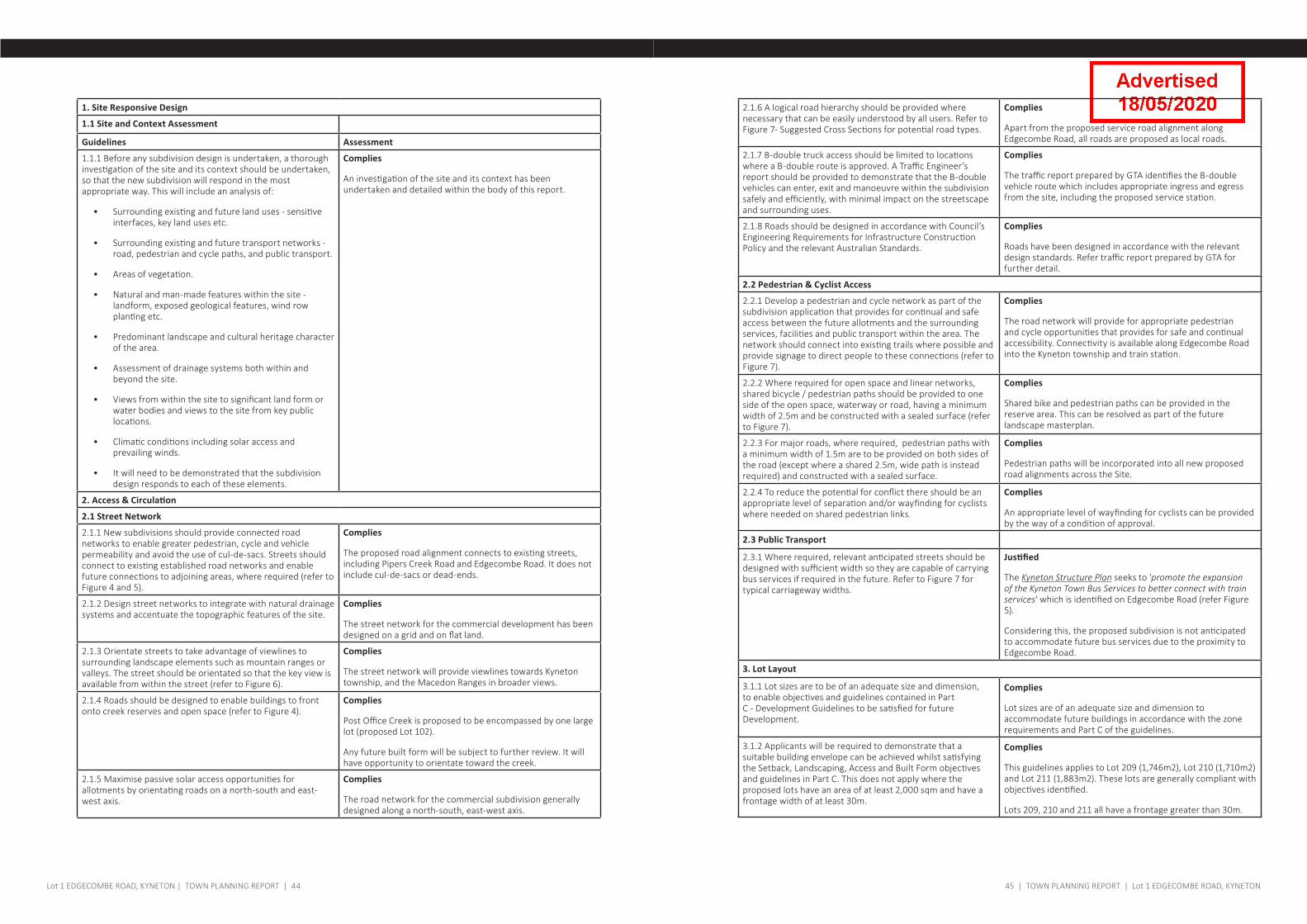
1. Site Responsive Design
1.1 Site and Context Assessment
Guidelines Assessment
1.1.1 Before any subdivision design is undertaken, a thorough investigation of the site and its context should be undertaken, so that the new subdivision will respond in the most appropriate way. This will include an analysis of:
• Surrounding existing and future land uses - sensitive interfaces, key land uses etc.
• Surrounding existing and future transport networks - road, pedestrian and cycle paths, and public transport.
• Areas of vegetation.
• Natural and man-made features within the site - landform, exposed geological features, wind row planting etc.
• Predominant landscape and cultural heritage character of the area.
• Assessment of drainage systems both within and beyond the site.
• Views from within the site to significant land form or water bodies and views to the site from key public locations.
• Climatic conditions including solar access and prevailing winds.
• It will need to be demonstrated that the subdivision design responds to each of these elements.
Complies
An investigation of the site and its context has been undertaken and detailed within the body of this report.
2. Access & Circulation
2.1 Street Network
2.1.1 New subdivisions should provide connected road networks to enable greater pedestrian, cycle and vehicle permeability and avoid the use of cul-de-sacs. Streets should connect to existing established road networks and enable future connections to adjoining areas, where required (refer to Figure 4 and 5).
Complies
The proposed road alignment connects to existing streets, including Pipers Creek Road and Edgecombe Road. It does not include cul-de-sacs or dead-ends.
2.1.2 Design street networks to integrate with natural drainage systems and accentuate the topographic features of the site.
Complies
The street network for the commercial development has been designed on a grid and on flat land.
2.1.3 Orientate streets to take advantage of viewlines to surrounding landscape elements such as mountain ranges or valleys. The street should be orientated so that the key view is available from within the street (refer to Figure 6).
Complies
The street network will provide viewlines towards Kyneton township, and the Macedon Ranges in broader views.
2.1.4 Roads should be designed to enable buildings to front onto creek reserves and open space (refer to Figure 4).
Complies
Post Office Creek is proposed to be encompassed by one large lot (proposed Lot 102).
Any future built form will be subject to further review. It will have opportunity to orientate toward the creek.
2.1.5 Maximise passive solar access opportunities for allotments by orientating roads on a north-south and east-west axis.
Complies
The road network for the commercial subdivision generally designed along a north-south, east-west axis.
2.1.6 A logical road hierarchy should be provided where necessary that can be easily understood by all users. Refer to Figure 7- Suggested Cross Sections for potential road types.
Complies
Apart from the proposed service road alignment along Edgecombe Road, all roads are proposed as local roads.
2.1.7 B-double truck access should be limited to locations where a B-double route is approved. A Traffic Engineer’s report should be provided to demonstrate that the B-double vehicles can enter, exit and manoeuvre within the subdivision safely and efficiently, with minimal impact on the streetscape and surrounding uses.
Complies
The traffic report prepared by GTA identifies the B-double vehicle route which includes appropriate ingress and egress from the site, including the proposed service station.
2.1.8 Roads should be designed in accordance with Council’s Engineering Requirements for Infrastructure Construction Policy and the relevant Australian Standards.
Complies
Roads have been designed in accordance with the relevant design standards. Refer traffic report prepared by GTA for further detail.
2.2 Pedestrian & Cyclist Access
2.2.1 Develop a pedestrian and cycle network as part of the subdivision application that provides for continual and safe access between the future allotments and the surrounding services, facilities and public transport within the area. The network should connect into existing trails where possible and provide signage to direct people to these connections (refer to Figure 7).
Complies
The road network will provide for appropriate pedestrian and cycle opportunities that provides for safe and continual accessibility. Connectivity is available along Edgecombe Road into the Kyneton township and train station.
2.2.2 Where required for open space and linear networks, shared bicycle / pedestrian paths should be provided to one side of the open space, waterway or road, having a minimum width of 2.5m and be constructed with a sealed surface (refer to Figure 7).
Complies
Shared bike and pedestrian paths can be provided in the reserve area. This can be resolved as part of the future landscape masterplan.
2.2.3 For major roads, where required, pedestrian paths with a minimum width of 1.5m are to be provided on both sides of the road (except where a shared 2.5m, wide path is instead required) and constructed with a sealed surface.
Complies
Pedestrian paths will be incorporated into all new proposed road alignments across the Site.
2.2.4 To reduce the potential for conflict there should be an appropriate level of separation and/or wayfinding for cyclists where needed on shared pedestrian links.
Complies
An appropriate level of wayfinding for cyclists can be provided by the way of a condition of approval.
2.3 Public Transport
2.3.1 Where required, relevant anticipated streets should be designed with sufficient width so they are capable of carrying bus services if required in the future. Refer to Figure 7 for typical carriageway widths.
Justified
The Kyneton Structure Plan seeks to 'promote the expansion of the Kyneton Town Bus Services to better connect with train services' which is identified on Edgecombe Road (refer Figure 5).
Considering this, the proposed subdivision is not anticipated to accommodate future bus services due to the proximity to Edgecombe Road.
3. Lot Layout
3.1.1 Lot sizes are to be of an adequate size and dimension, to enable objectives and guidelines contained in Part C - Development Guidelines to be satisfied for future Development.
Complies
Lot sizes are of an adequate size and dimension to accommodate future buildings in accordance with the zone requirements and Part C of the guidelines.
3.1.2 Applicants will be required to demonstrate that a suitable building envelope can be achieved whilst satisfying the Setback, Landscaping, Access and Built Form objectives and guidelines in Part C. This does not apply where the proposed lots have an area of at least 2,000 sqm and have a frontage width of at least 30m.
Complies
This guidelines applies to Lot 209 (1,746m2), Lot 210 (1,710m2) and Lot 211 (1,883m2). These lots are generally compliant with objectives identified.
Lots 209, 210 and 211 all have a frontage greater than 30m.
45 | TOWN PLANNING REPORT | Lot 1 EDGECOMBE ROAD, KYNETONLot 1 EDGECOMBE ROAD, KYNETON | TOWN PLANNING REPORT | 44
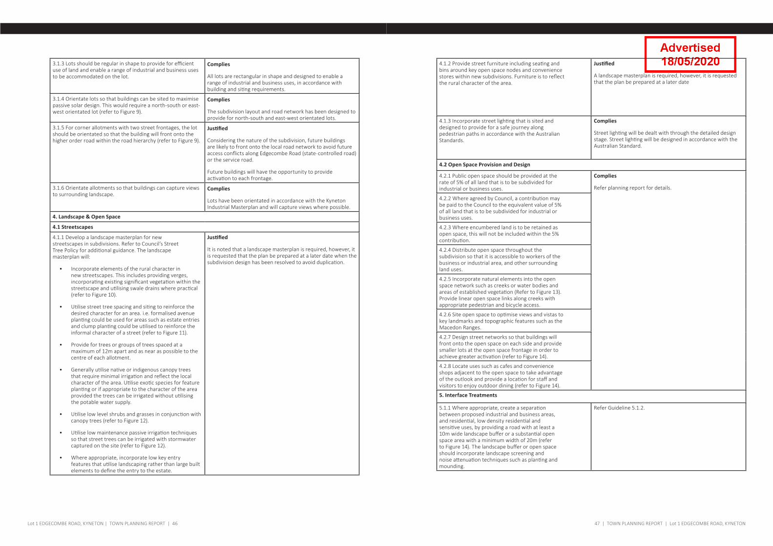
3.1.3 Lots should be regular in shape to provide for efficient use of land and enable a range of industrial and business uses to be accommodated on the lot.
Complies
All lots are rectangular in shape and designed to enable a range of industrial and business uses, in accordance with building and siting requirements.
3.1.4 Orientate lots so that buildings can be sited to maximise passive solar design. This would require a north-south or east-west orientated lot (refer to Figure 9).
Complies
The subdivision layout and road network has been designed to provide for north-south and east-west orientated lots.
3.1.5 For corner allotments with two street frontages, the lot should be orientated so that the building will front onto the higher order road within the road hierarchy (refer to Figure 9).
Justified
Considering the nature of the subdivision, future buildings are likely to front onto the local road network to avoid future access conflicts along Edgecombe Road (state-controlled road) or the service road.
Future buildings will have the opportunity to provide activation to each frontage.
3.1.6 Orientate allotments so that buildings can capture views to surrounding landscape.
Complies
Lots have been orientated in accordance with the Kyneton Industrial Masterplan and will capture views where possible.
4. Landscape & Open Space
4.1 Streetscapes
4.1.1 Develop a landscape masterplan for new streetscapes in subdivisions. Refer to Council’s Street Tree Policy for additional guidance. The landscape masterplan will:
• Incorporate elements of the rural character in new streetscapes. This includes providing verges, incorporating existing significant vegetation within the streetscape and utilising swale drains where practical (refer to Figure 10).
• Utilise street tree spacing and siting to reinforce the desired character for an area. i.e. formalised avenue planting could be used for areas such as estate entries and clump planting could be utilised to reinforce the informal character of a street (refer to Figure 11).
• Provide for trees or groups of trees spaced at a maximum of 12m apart and as near as possible to the centre of each allotment.
• Generally utilise native or indigenous canopy trees that require minimal irrigation and reflect the local character of the area. Utilise exotic species for feature planting or if appropriate to the character of the area provided the trees can be irrigated without utilising the potable water supply.
• Utilise low level shrubs and grasses in conjunction with canopy trees (refer to Figure 12).
• Utilise low maintenance passive irrigation techniques so that street trees can be irrigated with stormwater captured on the site (refer to Figure 12).
• Where appropriate, incorporate low key entry features that utilise landscaping rather than large built elements to define the entry to the estate.
Justified
It is noted that a landscape masterplan is required, however, it is requested that the plan be prepared at a later date when the subdivision design has been resolved to avoid duplication.
4.1.2 Provide street furniture including seating and bins around key open space nodes and convenience stores within new subdivisions. Furniture is to reflect the rural character of the area.
Justified
A landscape masterplan is required, however, it is requested that the plan be prepared at a later date
4.1.3 Incorporate street lighting that is sited and designed to provide for a safe journey along pedestrian paths in accordance with the Australian Standards.
Complies
Street lighting will be dealt with through the detailed design stage. Street lighting will be designed in accordance with the Australian Standard.
4.2 Open Space Provision and Design
4.2.1 Public open space should be provided at the rate of 5% of all land that is to be subdivided for industrial or business uses.
Complies
Refer planning report for details.
4.2.2 Where agreed by Council, a contribution may be paid to the Council to the equivalent value of 5% of all land that is to be subdivided for industrial or business uses.
4.2.3 Where encumbered land is to be retained as open space, this will not be included within the 5% contribution.
4.2.4 Distribute open space throughout the subdivision so that it is accessible to workers of the business or industrial area, and other surrounding land uses.
4.2.5 Incorporate natural elements into the open space network such as creeks or water bodies and areas of established vegetation (Refer to Figure 13). Provide linear open space links along creeks with appropriate pedestrian and bicycle access.
4.2.6 Site open space to optimise views and vistas to key landmarks and topographic features such as the Macedon Ranges.
4.2.7 Design street networks so that buildings will front onto the open space on each side and provide smaller lots at the open space frontage in order to achieve greater activation (refer to Figure 14).
4.2.8 Locate uses such as cafes and convenience shops adjacent to the open space to take advantage of the outlook and provide a location for staff and visitors to enjoy outdoor dining (refer to Figure 14).
5. Interface Treatments
5.1.1 Where appropriate, create a separation between proposed industrial and business areas, and residential, low density residential and sensitive uses, by providing a road with at least a 10m wide landscape buffer or a substantial open space area with a minimum width of 20m (refer to Figure 14). The landscape buffer or open space should incorporate landscape screening and noise attenuation techniques such as planting and mounding.
Refer Guideline 5.1.2.
47 | TOWN PLANNING REPORT | Lot 1 EDGECOMBE ROAD, KYNETONLot 1 EDGECOMBE ROAD, KYNETON | TOWN PLANNING REPORT | 46
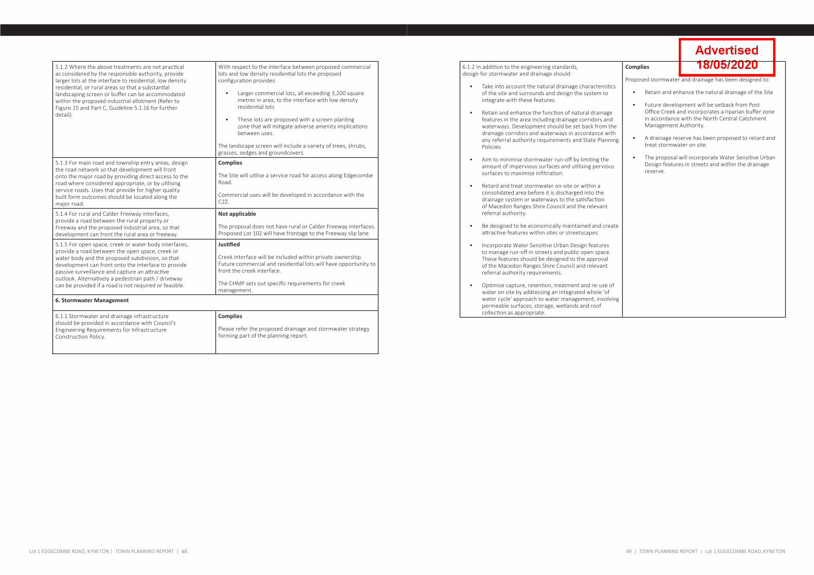
5.1.2 Where the above treatments are not practical as considered by the responsible authority, provide larger lots at the interface to residential, low density residential, or rural areas so that a substantial landscaping screen or buffer can be accommodated within the proposed industrial allotment (Refer to Figure 15 and Part C, Guideline 5.1.16 for further detail).
With respect to the interface between proposed commercial lots and low density residential lots the proposed configuration provides:
• Larger commercial lots, all exceeding 3,200 square metres in area, to the interface with low density residential lots
• These lots are proposed with a screen planting zone that will mitigate adverse amenity implications between uses.
The landscape screen will include a variety of trees, shrubs, grasses, sedges and groundcovers.
5.1.3 For main road and township entry areas, design the road network so that development will front onto the major road by providing direct access to the road where considered appropriate, or by utilising service roads. Uses that provide for higher quality built form outcomes should be located along the major road.
Complies
The Site will utilise a service road for access along Edgecombe Road.
Commercial uses will be developed in accordance with the C2Z.
5.1.4 For rural and Calder Freeway interfaces, provide a road between the rural property or Freeway and the proposed industrial area, so that development can front the rural area or freeway.
Not applicable
The proposal does not have rural or Calder Freeway interfaces. Proposed Lot 102 will have frontage to the Freeway slip lane.
5.1.5 For open space, creek or water body interfaces, provide a road between the open space, creek or water body and the proposed subdivision, so that development can front onto the interface to provide passive surveillance and capture an attractive outlook. Alternatively a pedestrian path / driveway can be provided if a road is not required or feasible.
Justified
Creek interface will be included within private ownership. Future commercial and residential lots will have opportunity to front the creek interface.
The CHMP sets out specific requirements for creek management.
6. Stormwater Management
6.1.1 Stormwater and drainage infrastructure should be provided in accordance with Council’s Engineering Requirements for Infrastructure Construction Policy.
Complies
Please refer the proposed drainage and stormwater strategy forming part of the planning report.
6.1.2 In addition to the engineering standards, design for stormwater and drainage should:
• Take into account the natural drainage characteristics of the site and surrounds and design the system to integrate with these features.
• Retain and enhance the function of natural drainage features in the area including drainage corridors and waterways. Development should be set back from the drainage corridors and waterways in accordance with any referral authority requirements and State Planning Policies.
• Aim to minimise stormwater run-off by limiting the amount of impervious surfaces and utilising pervious surfaces to maximise infiltration.
• Retard and treat stormwater on-site or within a consolidated area before it is discharged into the drainage system or waterways to the satisfaction of Macedon Ranges Shire Council and the relevant referral authority.
• Be designed to be economically maintained and create attractive features within sites or streetscapes.
• Incorporate Water Sensitive Urban Design features to manage run-off in streets and public open space. These features should be designed to the approval of the Macedon Ranges Shire Council and relevant referral authority requirements.
• Optimise capture, retention, treatment and re-use of water on site by addressing an integrated whole 'of water cycle’ approach to water management, involving permeable surfaces, storage, wetlands and roof collection as appropriate.
Complies
Proposed stormwater and drainage has been designed to:
• Retain and enhance the natural drainage of the Site
• Future development will be setback from Post Office Creek and incorporates a riparian buffer zone in accordance with the North Central Catchment Management Authority.
• A drainage reserve has been proposed to retard and treat stormwater on site.
• The proposal will incorporate Water Sensitive Urban Design features in streets and within the drainage reserve.
49 | TOWN PLANNING REPORT | Lot 1 EDGECOMBE ROAD, KYNETONLot 1 EDGECOMBE ROAD, KYNETON | TOWN PLANNING REPORT | 48

Level 2/166 Albert Road South Melbourne 3205VictoriaAustralia
t: +61 3 9682 8568
www.dlaaust.comTwitter: @DLA_Australia Plantastic Blog: dla - plantastic.blogspot.com.au/
Sydney | Melbourne | United Kingdom | Norway | Sweden