Embed Size (px)
Citation preview
LOUISIANA DEPARTMENT OF
WILDLIFE & FISHERIES
OFFICE OF FISHERIES
INLAND FISHERIES SECTION
PART VI -A
WATERBODY MANAGEMENT PLAN SERIES
VERNON LAKE
LAKE HISTORY & MANAGEMENT ISSUES
ii
CHRONOLOGY
January 2010 – Prepared by
Bobby Reed, Biologist Manager, District 5
August 2012—Updated by
Eric Shanks, Biologist Manager, District 5
April 2014—Updated by
Eric Shanks, Biologist Manager, District 5
Remainder of this page left intentionally blank.
iii
TABLE OF CONTENTS
LAKE HISTORY ...................................................................................................................................................... 1
GENERAL INFORMATION ............................................................................................................................... 1 Parish/ location: .................................................................................................................................................. 1 Date Lake formed: ............................................................................................................................................... 1 Impoundment: ...................................................................................................................................................... 1 Ownership: .......................................................................................................................................................... 1 Size (surface acres): ............................................................................................................................................ 1 Water shed: .......................................................................................................................................................... 1 Pool stage: ........................................................................................................................................................... 1 Drawdown (outlet) structure description: ........................................................................................................... 1 Who controls: ...................................................................................................................................................... 2
LAKE AUTHORITY ............................................................................................................................................ 2 ACCESS ................................................................................................................................................................. 3
Boat docks/wharves: ............................................................................................................................................ 3 Piers: ................................................................................................................................................................... 3 State/Federal facilities: ....................................................................................................................................... 3 Reefs: ................................................................................................................................................................... 3
SHORELINE DEVELOPMENT.......................................................................................................................... 3 State/National Parks: .......................................................................................................................................... 3 Shoreline Development by Landowners: ............................................................................................................. 3
PHYSICAL DESCRIPTION ................................................................................................................................ 3 Shoreline length: .................................................................................................................................................. 3 Timber type: ......................................................................................................................................................... 4 Average depth: ..................................................................................................................................................... 4 Maximum depth: .................................................................................................................................................. 4 Natural seasonal water fluctuation: .................................................................................................................... 4
EVENTS / PROBLEMS ........................................................................................................................................ 4 AQUATIC VEGETATION ................................................................................................................................. 5 Type map: ............................................................................................................................................................ 5 Biomass: .............................................................................................................................................................. 5 Treatment history by year available: ................................................................................................................... 5 Biological: ........................................................................................................................................................... 5
HISTORY OF REGULATIONS .......................................................................................................................... 6 Recreational: ....................................................................................................................................................... 6 Commercial: ........................................................................................................................................................ 7
DRAWDOWN HISTORY ..................................................................................................................................... 8 FISH KILLS / DISEASE HISTORY .................................................................................................................. 10
LMBV ................................................................................................................................................................. 10 Fish Kills ........................................................................................................................................................... 10
CONTAMINANTS / POLLUTION ................................................................................................................... 11 Water quality: .................................................................................................................................................... 11 Water level fluctuation: ..................................................................................................................................... 11
BIOLOGICAL ..................................................................................................................................................... 11 Age and Growth ................................................................................................................................................. 16 Genetic Analysis ................................................................................................................................................ 16 Largemouth Bass Feeding Habits ...................................................................................................................... 17 Creel Survey ...................................................................................................................................................... 17 Stocking: ............................................................................................................................................................ 17 Species profile.................................................................................................................................................... 18 Threatened/endangered/exotic species: ............................................................................................................. 21
WATER USE ....................................................................................................................................................... 21 Hunting: ............................................................................................................................................................. 21 Skiing: ................................................................................................................................................................ 21 Scuba Diving: .................................................................................................................................................... 21

iv
Swimming: ......................................................................................................................................................... 21 Fishing & boat riding: ....................................................................................................................................... 21 Irrigation: .......................................................................................................................................................... 21
LITERATURE CITED ........................................................................................................................................... 22
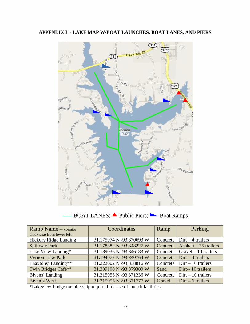
APPENDIX I - LAKE MAP W/BOAT LAUNCHES, BOAT LANES, AND PIERS ....................................... 23
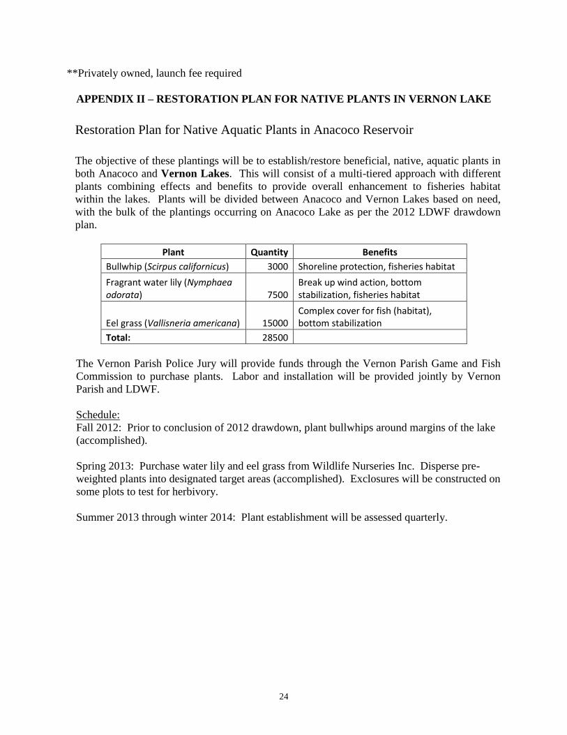
APPENDIX II – RESTORATION PLAN FOR NATIVE PLANTS IN VERNON LAKE ............................... 24
APPENDIX III – VEGETATIVE TYPE MAP ..................................................................................................... 25
LAKE HISTORY
GENERAL INFORMATION
Parish/ location:
Vernon Lake is located 5 miles west of Leesville, in western Vernon Parish, situated in west-
central Louisiana. The dam and spillway are located 5 miles north of LA Hwy 8 in Sections 1
& 2, T2N-R10W.
Date Lake formed:
Vernon Lake was formed in 1963 as a result of Act 277 of the 1948 Legislature which
established the Anacoco Prairie Game and Fish Preserve and setting aside some 5,379 acres
for the construction of recreational waters and lands.
Impoundment:
Vernon Lake was created by the impounding of Anacoco Creek with an earthen dam some
4,911 feet in length with a 16’ crown at elevation 257.0 mean sea level (MSL). The
embankment is constructed of a homogenous earth fill with stone rip-rap shore protection.
Maximum embank height is approximately 43 feet with landside slopes of 3:1 and 30:1.
Tributaries include the east and west forks of Anacoco Creek. Purpose: water supply.
Ownership:
The State of Louisiana owns the water bottom and the LA Department of Wildlife &
Fisheries manages the fish and wildlife resources. The Department of Transportation and
Development have authority and maintenance over the levees and associated structures as per
Act 270 (see below).
Size (surface acres):
4,200 acres (56,700 acre feet storage); maximum capacity: 99,473 acre-feet.
Water shed:
The watershed comprises 112 square miles (71,680 acres) of area. The watershed to
lake/ratio is 17:1. Watershed characteristics: Commercial pineland forest, upland hardwood,
and pasture. Soils are acidic, well drained, infertile sandy loams and clays. Lake waters are
generally soft as alkalinity and total hardness are low (mean = 14 mg/l) and pH is slightly
acidic (mean 6.4). The watershed is an eastern tributary of the Sabine River basin, boundary
waters shared with the State of Texas.
Pool stage:
245.0 MSL at spillway crest; Tailwater elevation 206.0 MSL
Drawdown (outlet) structure description:
Under ideal conditions, the Lake can be drawn down about 4” per day with the gates opened
to maximum height.
Gate size – 6 foot x 6 foot
Number of gates – 2; dual gates placed in line, one in front of the other
Construction – reinforced concrete control structure
Condition – Good – refurbished in 2009
2
Flow rate – draw down 4”/day under ideal conditions
Spillway:
Spillway location – the spillway is located on the eastern end of Vernon dam at the spillway
park.
Spillway crest length – 300’ at 245.0’ MSL
Condition – Good to fair – refurbished joint compound in 2009
Flow rate – present spillway design flood – 29,100 cubic feet per second
Who controls:
Louisiana Department of Transportation and Development is responsible for the maintenance
and operation of 19 reservoir embankments, including Vernon Lake, to maintain their
integrity and to prevent any breach or damage to the existing facilities as per Act 270 of
1984. DOTD is not responsible for lake management. Any request for opening a lake must
be directed to DOTD in writing from the Secretary of the Department of Wildlife and
Fisheries. Verbal request are not to be accepted. The letter from Wildlife and Fisheries is to
indicate the date for gate opening and the rate of drawdown desired for wildlife or lake
management purposes.
LAKE AUTHORITY
Act 858 of the 1981 Legislature abolished some 19 special game and fish commissions
including the Anacoco Prairie Game and Fish Commission which governed Vernon Lake.
Authorities for lakes & structures were transferred to the Louisiana Department of Wildlife
& Fisheries. However, parish government under state law can select/appoint a panel of
interested/concerned citizens to serve on committees in an advisory capacity to the jury. This
process was utilized and the Vernon Parish Game & Fish Commission was created to fill that
role with respect to fish & wildlife issues in the Parish.
Vernon Parish Game and Fish Commission
Vernon Parish Game and Fish Commission
Jason Nolde, Chairman
C/O Vernon Parish Police Jury
P.O. Box 1548
Leesville, LA 71446
Authorization
Eleven members are selected by the Police Jury to serve at the leisure of the Police Jury in an
advisory capacity only; current civilian members include Arno Arpke, Sam Fertitta Jr., Jason
Nolde, Mark Koury, Jody Patterson (Secretary), Randy Bennett, Paul Kayama, Tim
Goodwin, Scotty Goins, and Jury members Mike Kay, and Melvin Haymon.
3
ACCESS
Boat Ramps
There are eight boat ramps available for public use on Vernon Lake. Five are publicly
owned and maintained by parish authorities. Two are privately owned and require launch
fees. One is privately owned and requires annual membership for ramp privileges.
(Appendix I - Lake Map with boat launches and piers).
Boat Lanes/Channels
There are currently more than 12 miles of improved, marked boat lanes on Vernon Lake
(Appendix I).
Boat docks/wharves:
There are currently 4 boat docks associated with public boat ramps (Appendix I); one on the
east side (Spillway Park landing) and three on the west side of the lake (Hickory Ridge and
Bivens landings). There are numerous private docks surrounding the shoreline.
Piers:
There are two public fishing piers located on the east side of Vernon Lake where it is crossed
by US Hwy 171 at the east fork of Anacoco Creek. The north and south spans of the old US
Hwy 171 Bridge were left standing and serve as excellent public fishing piers. In 2009, a
fishing pier was constructed on the shoreline of Spillway Park north of the boat ramp. There
are also numerous private piers and boathouses around the lake.
State/Federal facilities:
There are currently no state or federally owned facilities on Vernon Lake.
Reefs:
There are currently no state-owned/operated artificial reefs on Vernon Lake.
SHORELINE DEVELOPMENT
State/National Parks:
There are currently no state or federally owned parks on Vernon Lake.
Shoreline Development by Landowners:
Approximately 40% of the shoreline is developed with homes and camps.
PHYSICAL DESCRIPTION
Shoreline length:
There are 49 miles of shoreline around Vernon Lake.
4
Timber type:
Forests surrounding Vernon Lake consist primarily of commercial pine plantation and mixed
upland pine/hardwood communities.
Average depth:
23 feet
Maximum depth:
53 feet
Natural seasonal water fluctuation:
0.5 – 2.0 feet
EVENTS / PROBLEMS
The Construction of Vernon Lake:
With the construction of Vernon Lake in 1963, eight miles upstream of Anacoco Lake, the
potential fertility of Anacoco was reduced substantially. When several Lakes are serially
placed on a stream, the downstream Lakes suffer a reduction in biological communities as
nutrients are assimilated in upstream Lakes (Yeager, 1993). While the Vernon Lake
watershed is roughly half that of the Anacoco watershed, water levels within Vernon Lake
are much more stable and productive leading to increased fisheries production.
The Construction of Vernon Lake Spillway Channel Stabilization Wall:
Vernon Lake was drawn down in 1985 to construct a retaining wall along the east side of the
spillway channel to eliminate the bank cave-ins and scouring that was occurring to the berm
area of the park and boat ramp. This modification has functioned as intended since
installation.
Designation of Vernon Lake as a Quality Largemouth Bass Lake:
April 1, 1991 - Largemouth bass slot limit implemented as corrective measure to direct
harvest to an abundant population of small fish (14-17” protected slot, 8 fish creel, 4 fish
over slot allowed). Additionally, the Lake would receive Florida bass stockings on an annual
basis to increase the likelihood an angler could catch a larger bass.
Wallop-Breaux Boat Lane Project:
A Department funded Wallop-Breaux project was awarded to the Vernon Parish Police Jury
for the clearing and marking of 7.5 miles of boat lanes in Vernon Lake during 1995
(Appendix I).
Spillway Degradation 2008-2009:
Concrete joints on the spillway had degraded. The joints had begun to fail and spillway
movement/damage was beginning to occur. To prevent washouts and additional damage, LA
DOTD initiated a drawdown to conduct repairs.
5
Removal of Quality Largemouth Bass Lake Designation
April 20, 2014: The 14 – 17 inch protective slot limit for bass was removed. From this date
forward, statewide harvest regulations for black bass (10 per day creel and no minimum
length limit) are in effect for Vernon Lake.
MANAGEMENT ISSUES
AQUATIC VEGETATION
In the early years of impoundment, Vernon Lake had light to moderate densities of
submersed aquatic vegetation due to water clarity and depth. Coontail (Ceratophyllum
demersum), fanwort (Cabomba caroliniana), Egeria, Potamogeton, and muskgrass (Chara)
infestations were prevalent in the western and northern sections of the lake. The last
drawdown to correct a vegetation infestation occurred in 1980 (Table 2). In 2013, in
conjunction with the Anacoco Lake plant restoration effort, 3,000 eel grass (Vallisneria
americana) rhizomes were planted in coves on the southern end of the lake (Appendix II).
No plantings were made in the middle or upper portions of the lake as beneficial aquatic
vegetation has increased naturally in those areas over the past four years. Monitoring of
these plantings is ongoing through 2014.
Type map:
Vegetation type mapping is conducted on Vernon Lake in late summer/early fall on an
annual basis. The 2013 type map documented no significant vegetation problems on the
lake. Beneficial vegetation such as banana lily (Nymphoides aquatica), coontail
(Ceratophyllum demersum), and variable leaf pondweed (Potamogeton diversifolius) were
observed in greater abundance.
SEE APPENDIX III for recent type map and PART C for historical type map reports.
Biomass:
No vegetation biomass sampling has been conducted.
Treatment history by year available:
Biological: No biological control agents used to date in Vernon Lake.
6
Chemical:
Vernon Lake does not have a history of problematic vegetation. Chemical treatments are
concentrated in shallow coves, often associated with home sites. Primary target species are
primrose and alligator weed (Table1).
Table 1. Vernon Lake herbicide treatment history 2006-2013.
Year Number of Treatments*
Acres Treated
Primary Vegetation Treated
2006 2 5.4 Common Salvinia
2010 1 10 Primrose, Alligator Weed, Knotweed
2011 1 22 Primrose, Water lily, Knotweed
2012 2 62 Primrose, Common Salvinia, Alligator Weed, Water Lily, Knotweed
2013 3 41 Primrose, Water Hyacinth, Alligator Weed
*For reporting purposes, a treatment is defined as one crew working for one day.
Physical: The most recent draw down conducted on Vernon Lake was conducted in 2009 for spillway
and dam maintenance. See Table 2 for full drawdown history.
HISTORY OF REGULATIONS
Recreational:
The following statewide regulations were applied to Vernon Lake at impoundment in 1963.
Black Bass (Largemouth, spotted): 15 daily of any size
Buffalo Fish or their hybrids: No daily limit, no size restriction
Freshwater Drum (Gaspergou): No daily limit, no size restriction
Bowfin (Choupique, Grinnell): No daily limit, no size restriction
Channel Catfish: 11 inch min. total length limit (see Catfish below for possession limit)
Blue Catfish: 12 inch min. total length limit (see Catfish below for limit)
Flathead Catfish: 14 inch min. total length limit (see Catfish below for limit)
Catfish (Blue, Channel and Flathead): the possession limit for catfish caught on a
recreational license shall be 100. The 100 fish may be a single species, or a combination of
blue, channel or flathead catfish. In addition, an angler may possess a maximum of 25
undersize catfish or a single or combination of all 3 species.
Crappie: 50 daily per person
Yellow Bass: 50 daily per person
April 1, 1991 - Largemouth bass slot limit implemented as corrective measure to direct
harvest to an abundant population of small fish (14-17” protected slot, 8 fish creel, 4 fish
over slot allowed)
7
April 20, 2014—Largemouth bass slot limit removed, and statewide 10 fish daily creel with
no length restrictions implemented.
Current Regulations:
Statewide regulations are in effect for all fish species.
Recreational fishing regulations may be viewed at the link:
http://www.wlf.louisiana.gov/fishing/regulations
Commercial:
The use of gill nets, trammel nets, and hoop nets have been prohibited in Vernon Lake (as
per Title 76 below) since 1978. Trotlines and slat traps are not prohibited and may be used to
take legal commercial species within Anacoco Lake, Vernon Lake and Anacoco Creek
between the two Lakes.
The statewide commercial fishing regulations may be viewed at the link below:
http://www.wlf.louisiana.gov/fishing/regulations
TITLE 76
WILDLIFE AND FISHERIES
PART VII. FISH AND OTHER AQUATIC LIFE
Chapter 1. Freshwater Sports and Commercial Fishing
103. Anacoco Lake, Lake Vernon and Anacoco Bayou
A. Whereas, the chairman of the Anacoco-Prairie State Fish and Game
Commission has requested commercial nets be prohibited in Lake Vernon, Anacoco Lake, and
that portion of Anacoco Bayou between the lakes, all in Vernon Parish, and
Whereas, fish population samples taken by the district fisheries biologist
indicate a very low population of commercial fish, and
Whereas, it is evident that there are no viable commercial fisheries due to the
scarcity of these commercial species.
B. Therefore, be it resolved, the Louisiana Wildlife and Fisheries Commission
hereby prohibits the use of fish nets (gill nets, trammel nets, hoop nets, fish seines) in Anacoco
Lake, Lake Vernon and that portion of Anacoco Bayou between the two lakes, Vernon Parish, LA.
AUTHORITY NOTE: Promulgated in accordance with R.S. 56:22.
HISTORICAL NOTE: Promulgated by the Department of Wildlife and Fisheries,
Wildlife and Fisheries Commission, LR 4:57 (February 1978), amended LR 7:356 (July 1981), LR
12:843 (December 1986).
8
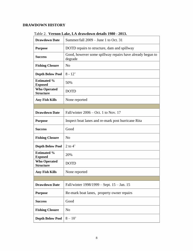
DRAWDOWN HISTORY
Table 2. Vernon Lake, LA drawdown details 1980 - 2013.
Drawdown Date Summer/fall 2009 – June 1 to Oct. 31
Purpose DOTD repairs to structure, dam and spillway
Success Good, however some spillway repairs have already begun to
degrade
Fishing Closure No
Depth Below Pool 8 - 12’
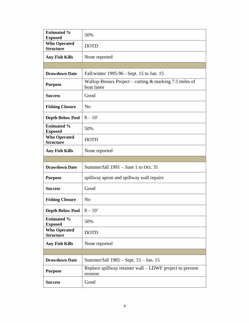
Estimated %
Exposed 50%
Who Operated
Structure DOTD
Any Fish Kills None reported
Drawdown Date Fall/winter 2006 – Oct. 1 to Nov. 17
Purpose Inspect boat lanes and re-mark post hurricane Rita
Success Good
Fishing Closure No
Depth Below Pool 2 to 4’
Estimated %
Exposed 20%
Who Operated
Structure DOTD
Any Fish Kills None reported
Drawdown Date Fall/winter 1998/1999 – Sept. 15 – Jan. 15
Purpose Re-mark boat lanes, property owner repairs
Success Good
Fishing Closure No
Depth Below Pool 8 – 10’
9
Estimated %
Exposed 50%
Who Operated
Structure DOTD
Any Fish Kills None reported
Drawdown Date Fall/winter 1995-96 - Sept. 15 to Jan. 15
Purpose Wallop-Breaux Project – cutting & marking 7.5 miles of
boat lanes
Success Good
Fishing Closure No
Depth Below Pool 8 – 10’
Estimated %
Exposed 50%
Who Operated
Structure DOTD
Any Fish Kills None reported
Drawdown Date Summer/fall 1991 – June 1 to Oct. 31
Purpose spillway apron and spillway wall repairs
Success Good
Fishing Closure No
Depth Below Pool 8 – 10’
Estimated %
Exposed 50%
Who Operated
Structure DOTD
Any Fish Kills None reported
Drawdown Date Summer/fall 1985 – Sept. 15 – Jan. 15
Purpose Replace spillway retainer wall – LDWF project to prevent
erosion
Success Good
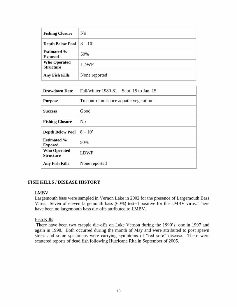
10
Fishing Closure No
Depth Below Pool 8 – 10’
Estimated %
Exposed 50%
Who Operated
Structure LDWF
Any Fish Kills None reported
Drawdown Date Fall/winter 1980-81 – Sept. 15 to Jan. 15
Purpose To control nuisance aquatic vegetation
Success Good
Fishing Closure No
Depth Below Pool 8 – 10’
Estimated %
Exposed 50%
Who Operated
Structure LDWF
Any Fish Kills None reported
FISH KILLS / DISEASE HISTORY
LMBV
Largemouth bass were sampled in Vernon Lake in 2002 for the presence of Largemouth Bass
Virus. Seven of eleven largemouth bass (60%) tested positive for the LMBV virus. There
have been no largemouth bass die-offs attributed to LMBV.
Fish Kills
There have been two crappie die-offs on Lake Vernon during the 1990’s; one in 1997 and
again in 1998. Both occurred during the month of May and were attributed to post spawn
stress and some specimens were carrying symptoms of “red sore” disease. There were
scattered reports of dead fish following Hurricane Rita in September of 2005.
11
CONTAMINANTS / POLLUTION
A fish consumption advisory was issued August 5, 1997 and revised May 29, 2003. The
advisory is available at the following link:
http://new.dhh.louisiana.gov/index.cfm/page/902
The current advisory reads as: Women of childbearing age and children less than seven
years of age should consume no more than ONE MEAL PER MONTH of largemouth bass,
flathead catfish, redear or bluegill sunfish combined from the advisory area. Other adults and
children seven years of age and older should consume no more than FOUR MEALS PER
MONTH of largemouth bass, flathead catfish, redear or bluegill sunfish combined from the
advisory area. Unless the fish species is specifically addressed in the details of the advisory,
please limit consumption of all species in an advisory area to FOUR MEALS PER MONTH.
Water quality:
Vernon Lake has three designated uses as per LDEQ; primary contact recreation
(swimming), secondary contact recreation (boating), and fish and wildlife propagation. The
2012 LDEQ Water Quality Integrated Report indicates the lake is fully supporting primary
and secondary contact recreation; however fish and wildlife propagation is not fully
supported due to mercury contamination in fish (see above).
The complete report can be viewed on LDEQ’s website at:
http://www.deq.louisiana.gov/portal/DIVISIONS/WaterPermits/WaterQualityStandardsAsse
ssment/WaterQualityInventorySection305b/2012IntegratedReport.aspx
Water level fluctuation:
In typical years, the Vernon Lake water level may range from 0.5’ to 2.0’ above spillway
crest height.
BIOLOGICAL
Fish Samples
Gear: In the years 1966 – 1990, biomass (rotenone) surveys were the preferred method of
sampling fish populations in Vernon Lake. The standardized methodologies of
electrofishing, gillnets, seines, lead nets, and creel surveys have been employed to assess
fisheries population attributes from 1990 – 2014 (Table 3).
Rotenone (standing crop estimates) were conducted in: 1967, 1968, 1970, 1974 - 1976, 1982,
1984, 1988, 1990
12
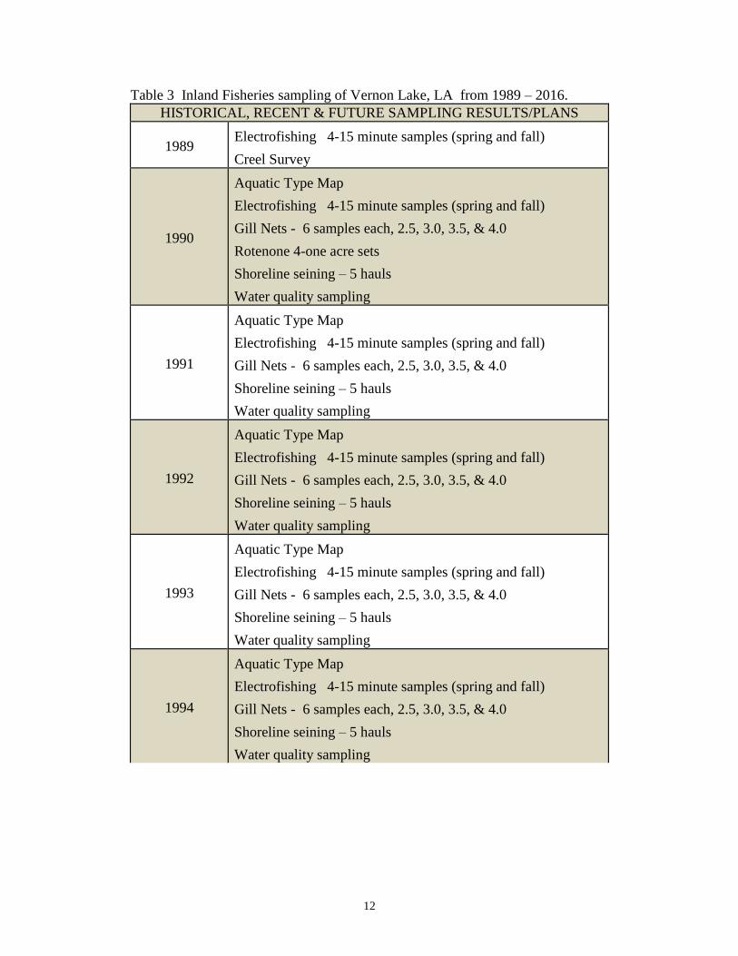
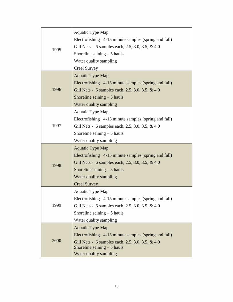
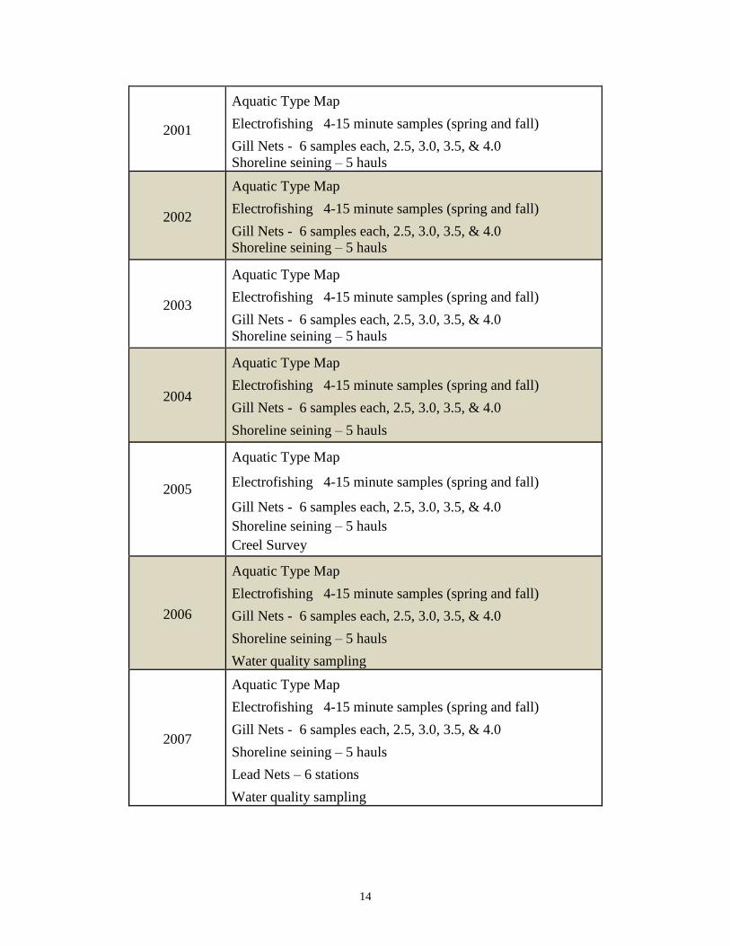
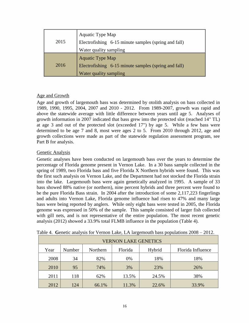
Table 3 Inland Fisheries sampling of Vernon Lake, LA from 1989 – 2016.
HISTORICAL, RECENT & FUTURE SAMPLING RESULTS/PLANS
1989 Electrofishing 4-15 minute samples (spring and fall)
Creel Survey
1990
Aquatic Type Map
Electrofishing 4-15 minute samples (spring and fall)
Gill Nets - 6 samples each, 2.5, 3.0, 3.5, & 4.0
Rotenone 4-one acre sets
Shoreline seining – 5 hauls
Water quality sampling
1991
Aquatic Type Map
Electrofishing 4-15 minute samples (spring and fall)
Gill Nets - 6 samples each, 2.5, 3.0, 3.5, & 4.0
Shoreline seining – 5 hauls
Water quality sampling
1992
Aquatic Type Map
Electrofishing 4-15 minute samples (spring and fall)
Gill Nets - 6 samples each, 2.5, 3.0, 3.5, & 4.0
Shoreline seining – 5 hauls
Water quality sampling
1993
Aquatic Type Map
Electrofishing 4-15 minute samples (spring and fall)
Gill Nets - 6 samples each, 2.5, 3.0, 3.5, & 4.0
Shoreline seining – 5 hauls
Water quality sampling
1994
Aquatic Type Map
Electrofishing 4-15 minute samples (spring and fall)
Gill Nets - 6 samples each, 2.5, 3.0, 3.5, & 4.0
Shoreline seining – 5 hauls
Water quality sampling
13
1995
Aquatic Type Map
Electrofishing 4-15 minute samples (spring and fall)
Gill Nets - 6 samples each, 2.5, 3.0, 3.5, & 4.0
Shoreline seining – 5 hauls
Water quality sampling
Creel Survey
1996
Aquatic Type Map
Electrofishing 4-15 minute samples (spring and fall)
Gill Nets - 6 samples each, 2.5, 3.0, 3.5, & 4.0
Shoreline seining – 5 hauls
Water quality sampling
1997
Aquatic Type Map
Electrofishing 4-15 minute samples (spring and fall)
Gill Nets - 6 samples each, 2.5, 3.0, 3.5, & 4.0
Shoreline seining – 5 hauls
Water quality sampling
1998
Aquatic Type Map
Electrofishing 4-15 minute samples (spring and fall)
Gill Nets - 6 samples each, 2.5, 3.0, 3.5, & 4.0
Shoreline seining – 5 hauls
Water quality sampling
Creel Survey
1999
Aquatic Type Map
Electrofishing 4-15 minute samples (spring and fall)
Gill Nets - 6 samples each, 2.5, 3.0, 3.5, & 4.0
Shoreline seining – 5 hauls
Water quality sampling
2000
Aquatic Type Map
Electrofishing 4-15 minute samples (spring and fall)
Gill Nets - 6 samples each, 2.5, 3.0, 3.5, & 4.0
Shoreline seining – 5 hauls
Water quality sampling
14
2001
Aquatic Type Map
Electrofishing 4-15 minute samples (spring and fall)
Gill Nets - 6 samples each, 2.5, 3.0, 3.5, & 4.0
Shoreline seining – 5 hauls
2002
Aquatic Type Map
Electrofishing 4-15 minute samples (spring and fall)
Gill Nets - 6 samples each, 2.5, 3.0, 3.5, & 4.0
Shoreline seining – 5 hauls
2003
Aquatic Type Map
Electrofishing 4-15 minute samples (spring and fall)
Gill Nets - 6 samples each, 2.5, 3.0, 3.5, & 4.0
Shoreline seining – 5 hauls
2004
Aquatic Type Map
Electrofishing 4-15 minute samples (spring and fall)
Gill Nets - 6 samples each, 2.5, 3.0, 3.5, & 4.0
Shoreline seining – 5 hauls
2005
Aquatic Type Map
Electrofishing 4-15 minute samples (spring and fall)
Gill Nets - 6 samples each, 2.5, 3.0, 3.5, & 4.0
Shoreline seining – 5 hauls
Creel Survey
2006
Aquatic Type Map
Electrofishing 4-15 minute samples (spring and fall)
Gill Nets - 6 samples each, 2.5, 3.0, 3.5, & 4.0
Shoreline seining – 5 hauls
Water quality sampling
2007
Aquatic Type Map
Electrofishing 4-15 minute samples (spring and fall)
Gill Nets - 6 samples each, 2.5, 3.0, 3.5, & 4.0
Shoreline seining – 5 hauls
Lead Nets – 6 stations
Water quality sampling
15
2008
Aquatic Type Map
Electrofishing 4-15 minute samples (spring and fall)
Gill Nets - 6 samples each, 2.5, 3.0, 3.5, & 4.0
Shoreline seining – 5 hauls
Lead Nets – 6 stations
Water quality sampling
2009
Aquatic Type Map
Electrofishing 6-15 minute samples (spring)
Lead Nets – 6 stations
Water quality sampling
2010
Aquatic Type Map
Electrofishing 6-15 minute samples (spring and fall)
Age & Growth: standardized mortality project
Shoreline seining – 5 hauls
Lead Nets – 6 stations
Water quality sampling
Creel Survey
2011
Aquatic Type Map
Electrofishing 6-15 minute samples (spring)
Age & Growth: standardized mortality project
Lead Nets – 6 stations
Water quality sampling
2012
Aquatic Type Map
Electrofishing 6-15 minute samples (spring and fall)
Age & Growth: standardized mortality project
Water quality sampling
2013
Aquatic Type Map
Electrofishing 6-15 minute samples (spring and fall)
Water quality sampling
2014
Aquatic Type Map
Electrofishing 6-15 minute samples (spring and fall)
Water quality sampling
Creel Survey
16
2015
Aquatic Type Map
Electrofishing 6-15 minute samples (spring and fall)
Water quality sampling
2016
Aquatic Type Map
Electrofishing 6-15 minute samples (spring and fall)
Water quality sampling
Age and Growth
Age and growth of largemouth bass was determined by otolith analysis on bass collected in
1989, 1990, 1995, 2004, 2007 and 2010 - 2012. From 1989-2007, growth was rapid and
above the statewide average with little difference between years until age 5. Analyses of
growth information in 2007 indicated that bass grew into the protected slot (reached 14" TL)
at age 3 and out of the protected slot (exceeded 17") by age 5. While a few bass were
determined to be age 7 and 8, most were ages 2 to 5. From 2010 through 2012, age and
growth collections were made as part of the statewide regulation assessment program, see
Part B for analysis.
Genetic Analysis
Genetic analyses have been conducted on largemouth bass over the years to determine the
percentage of Florida genome present in Vernon Lake. In a 30 bass sample collected in the
spring of 1989, two Florida bass and five Florida X Northern hybrids were found. This was
the first such analysis on Vernon Lake, and the Department had not stocked the Florida strain
into the lake. Largemouth bass were again genetically analyzed in 1995. A sample of 33
bass showed 88% native (or northern), nine percent hybrids and three percent were found to
be the pure Florida Bass strain. In 2004 after the introduction of some 2,117,223 fingerlings
and adults into Vernon Lake, Florida genome influence had risen to 47% and many large
bass were being reported by anglers. While only eight bass were tested in 2005, the Florida
genome was expressed in 50% of the sample. This sample consisted of larger fish collected
with gill nets, and is not representative of the entire population. The most recent genetic
analysis (2012) showed a 33.9% total FLMB influence in the population (Table 4).
Table 4. Genetic analysis for Vernon Lake, LA largemouth bass populations 2008 – 2012.
VERNON LAKE GENETICS
Year Number Northern Florida Hybrid Florida Influence
2008 34 82% 0% 18% 18%
2010 95 74% 3% 23% 26%
2011 118 62% 13.5% 24.5% 38%
2012 124 66.1% 11.3% 22.6% 33.9%
17
Largemouth Bass Feeding Habits
Stomach analyses of 92 bass collected in the spring of 1990 indicated that over 52%
contained no food items. Of the 48% that had food contents, half (24%) contained
unidentified fish remains. Stomachs were also found to contain an assortment of small
fishes, insects and arthropods.
Creel Survey Recreational angler surveys were conducted over a 12-month period in 1989, 1995, 1998,
2005, and 2010 to determine angler effort and catch rates. Roving surveys to count anglers
were made at random during each scheduled interview period to allow expansion of data to
estimate total angler attributes. The surveys included boat and shore anglers at major access
points and did not assess camp owners unless they utilized the access points. The 2010 creel
survey estimated a total of 4,118 anglers caught 4,213 largemouth bass, of which 586 (14%)
were harvested and 3,627 (86%) were released. Detailed analyses of recreational angler
surveys are discussed further in Part B.
Water Quality
Water quality parameters (pH, Temperature, dissolved oxygen, conductivity and
transparency) are measured and recorded in conjunction with fisheries samples. All
measured values were indicative of good water quality, with the exception of 2007 and 2008,
where increases in turbidity were observed (27” and 20” respectively).
Stocking:
LDWF Office of Fisheries stocking policy was updated in 2013. LDWF now stocks larger
FLMB fingerlings (>2”) at correspondingly lower rates (20/acre; LDWF Stocking Policy
2013). This change is reflected in the 2013 Vernon Lake stocking (Table 5).
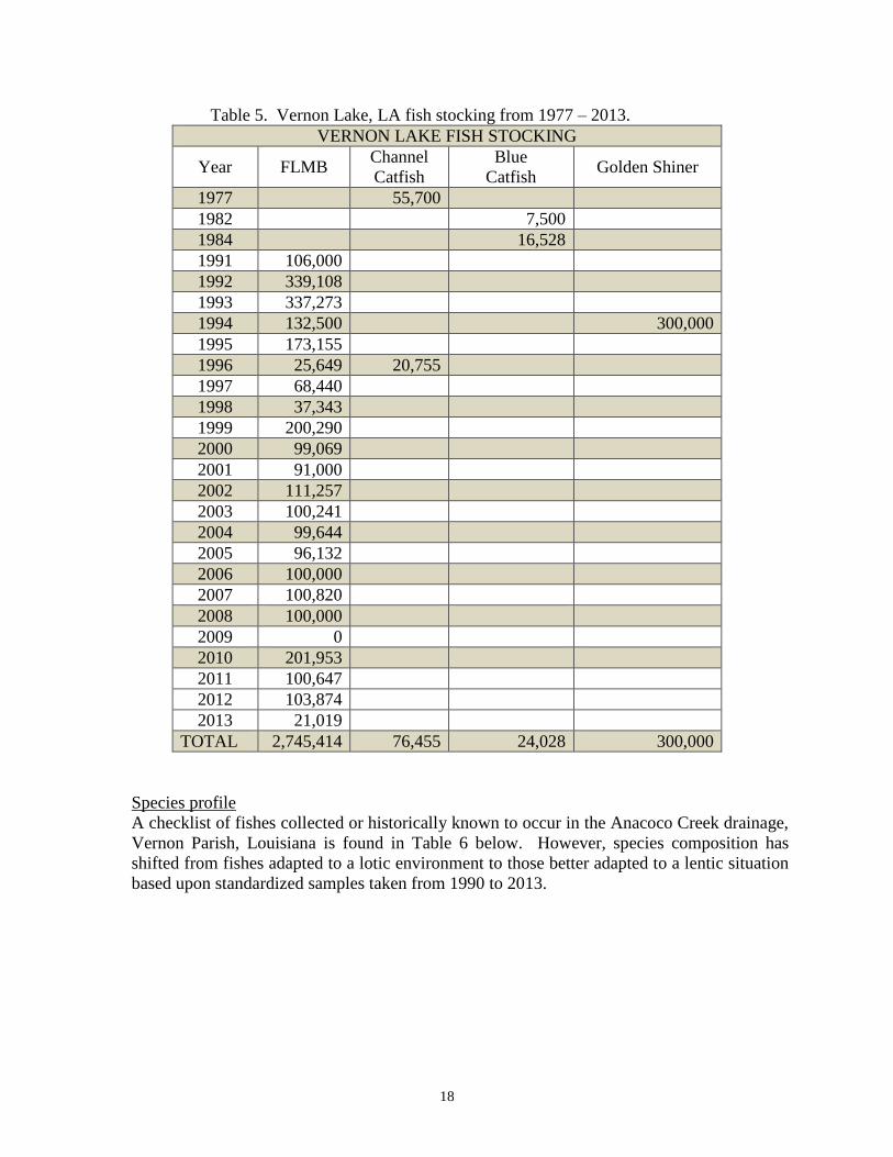
18
Table 5. Vernon Lake, LA fish stocking from 1977 – 2013.
VERNON LAKE FISH STOCKING
Year FLMB Channel
Catfish
Blue
Catfish Golden Shiner
1977 55,700
1982 7,500
1984 16,528
1991 106,000
1992 339,108
1993 337,273
1994 132,500 300,000
1995 173,155
1996 25,649 20,755
1997 68,440
1998 37,343
1999 200,290
2000 99,069
2001 91,000
2002 111,257
2003 100,241
2004 99,644
2005 96,132
2006 100,000
2007 100,820
2008 100,000
2009 0
2010 201,953
2011 100,647
2012 103,874
2013 21,019
TOTAL 2,745,414 76,455 24,028 300,000
Species profile
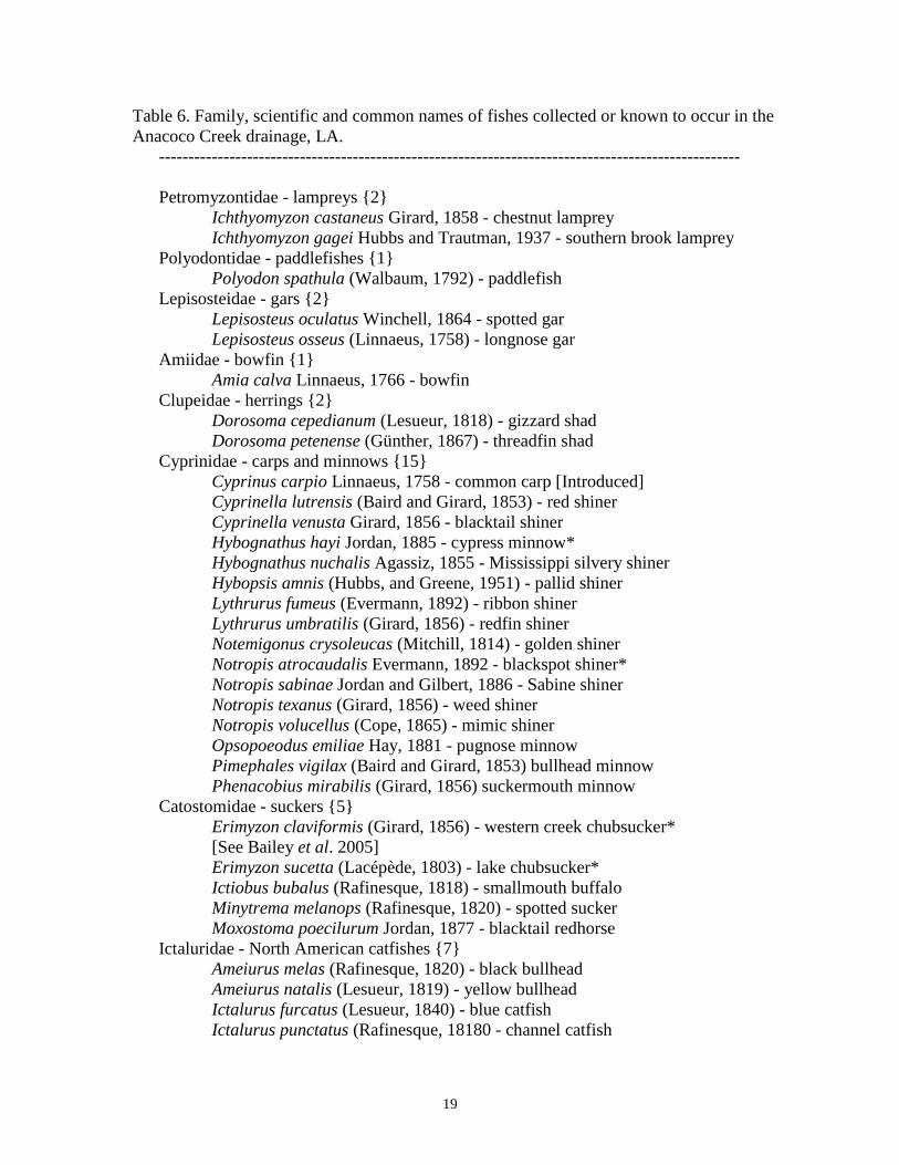
A checklist of fishes collected or historically known to occur in the Anacoco Creek drainage,
Vernon Parish, Louisiana is found in Table 6 below. However, species composition has
shifted from fishes adapted to a lotic environment to those better adapted to a lentic situation
based upon standardized samples taken from 1990 to 2013.
19
Table 6. Family, scientific and common names of fishes collected or known to occur in the
Anacoco Creek drainage, LA.
---------------------------------------------------------------------------------------------------
Petromyzontidae - lampreys {2}
Ichthyomyzon castaneus Girard, 1858 - chestnut lamprey
Ichthyomyzon gagei Hubbs and Trautman, 1937 - southern brook lamprey
Polyodontidae - paddlefishes {1}
Polyodon spathula (Walbaum, 1792) - paddlefish
Lepisosteidae - gars {2}
Lepisosteus oculatus Winchell, 1864 - spotted gar
Lepisosteus osseus (Linnaeus, 1758) - longnose gar
Amiidae - bowfin {1}
Amia calva Linnaeus, 1766 - bowfin
Clupeidae - herrings {2}
Dorosoma cepedianum (Lesueur, 1818) - gizzard shad
Dorosoma petenense (Günther, 1867) - threadfin shad
Cyprinidae - carps and minnows {15}
Cyprinus carpio Linnaeus, 1758 - common carp [Introduced]
Cyprinella lutrensis (Baird and Girard, 1853) - red shiner
Cyprinella venusta Girard, 1856 - blacktail shiner
Hybognathus hayi Jordan, 1885 - cypress minnow*
Hybognathus nuchalis Agassiz, 1855 - Mississippi silvery shiner
Hybopsis amnis (Hubbs, and Greene, 1951) - pallid shiner
Lythrurus fumeus (Evermann, 1892) - ribbon shiner
Lythrurus umbratilis (Girard, 1856) - redfin shiner
Notemigonus crysoleucas (Mitchill, 1814) - golden shiner
Notropis atrocaudalis Evermann, 1892 - blackspot shiner*
Notropis sabinae Jordan and Gilbert, 1886 - Sabine shiner
Notropis texanus (Girard, 1856) - weed shiner
Notropis volucellus (Cope, 1865) - mimic shiner
Opsopoeodus emiliae Hay, 1881 - pugnose minnow
Pimephales vigilax (Baird and Girard, 1853) bullhead minnow
Phenacobius mirabilis (Girard, 1856) suckermouth minnow
Catostomidae - suckers {5}
Erimyzon claviformis (Girard, 1856) - western creek chubsucker*
[See Bailey et al. 2005]
Erimyzon sucetta (Lacépède, 1803) - lake chubsucker*
Ictiobus bubalus (Rafinesque, 1818) - smallmouth buffalo
Minytrema melanops (Rafinesque, 1820) - spotted sucker
Moxostoma poecilurum Jordan, 1877 - blacktail redhorse
Ictaluridae - North American catfishes {7}
Ameiurus melas (Rafinesque, 1820) - black bullhead
Ameiurus natalis (Lesueur, 1819) - yellow bullhead
Ictalurus furcatus (Lesueur, 1840) - blue catfish
Ictalurus punctatus (Rafinesque, 18180 - channel catfish
20
Noturus gyrinus (Mitchill, 1817) - tadpole madtom
Noturus nocturnus Jordan and Gilbert, 1886 - freckled madtom
Pylodictis olivaris (Rafinesque, 1818) - flathead catfish
Esocidae - pikes {1}
Esox americanus Gmelin, 1788 - grass pickerel
Aphredoderidae - pirate perch {1}
Aphredoderus sayanus (Gilliams, 1824) - pirate perch
Atherinopsidae - New World silversides {1}
Labidesthes sicculus (Cope, 1865) - brook silverside
Fundulidae - topminnows {2}
Fundulus notatus (Rafinesque, 1820) - blackstripe topminnow
Fundulus olivaceus (Storer, 1845) - blackspotted topminnow
Poeciliidae - livebearers {3}
Gambusia affinis (Baird and Girard, 1853) - western mosquitofish
Heterandria formosa Agassiz, 1855 - least killifish* [Introduced?]
Poecilia latipinna (Lesueur, 1821) - sailfin molly
Cyprinodontidae - pupfishes {1}
Cyprinodon variegatus Lacépède, 1803 - sheepshead minnow
Moronidae - temperate basses {1}
Morone mississippiensis Jordan and Evermann, 1887 - yellow bass
Centrarchidae - sunfishes {13}
Centrarchus macropterus (Lacépède, 1801) - flier
Lepomis cyanellus Rafinesque, 1819 - green sunfish
Lepomis gulosus (Cuvier, 1829) - warmouth
Lepomis humilis (Girard, 1858) - orangespotted sunfish
Lepomis macrochirus Rafinesque, 1819 - bluegill
Lepomis marginatus (Holbrook, 1855) - dollar sunfish
Lepomis megalotis (Rafinesque, 1820) - longear sunfish
Lepomis microlophus (Gunther, 1859) - redear sunfish
Lepomis miniatus Jordan, 1877 - redspotted sunfish
Lepomis symmetricus Forbes, 1883 - bantam sunfish
Micropterus salmoides (Lacépède, 1802) - largemouth bass
Micropterus punctulatus (Rafinesque, 1819) - spotted bass
Pomoxis annularis Rafinesque, 1818 - white crappie
Pomoxis nigromaculatus (Lesueur, 1829) - black crappie
Percidae - perches {9}
Ammocrypta vivax Hay, 1882 - scaly sand darter
Etheostoma chlorosomum (Hay, 1880) - bluntnose darter
Etheostoma collettei Birdsong and Knapp, 1969 - creole darter
Etheostoma gracile (Girard, 1859) - slough darter
Etheostoma histrio Jordan and Gilbert, 1887 - harlequin darter
Etheostoma proeliare (Hay, 1880) - cypress darter
Percina macrolepida Stevenson, 1971 - bigscale logperch
Percina maculata (Girard, 1859) - blackside darter
Percina sciera (Swain, 1883) - dusky darter
Sciaenidae - drums and croakers {1}
21
Aplodinotus grunniens Rafinesque – Freshwater drum
Elassomatidae - pygmy sunfish {1}
Elassoma zonatum Jordan, 1877 - banded pygmy sunfish
Nomenclature and phylogenetic order follows Nelson, et al. 2004. Common and
Scientific Names of Fishes from the United States, Canada, and Mexico, 6th
Edition.
American Fisheries Society Special Publication 29. 386 pp. Exceptions are noted.
Threatened/endangered/exotic species:
Bald eagles have been known to nest in the vicinity of Vernon Lake.
WATER USE
Hunting:
There are about two dozen duck blinds scattered around Vernon Lake. These are by permit
only through the Vernon Parish Police Jury.
Skiing:
Because of the many stumps in Vernon Lake, very little water skiing occurs on the lake.
Scuba Diving:
Very little diving occurs on Vernon Lake.
Swimming:
There is a public swimming area at the Spillway Park. The area is swim at your own risk
with no life guards on duty.
Fishing & boat riding:
Both are very popular on Vernon Lake.
Irrigation:
There are no agricultural or municipal water withdrawals for the purpose of irrigation.
Several private property owners have personal irrigation systems designed for yard and
garden watering only.

22
Literature Cited
Louisiana Department of Wildlife and Fisheries. 2013. Resource Enhancement Through
Stocking, Office of Fisheries, LDWF, Baton Rouge, LA.
Yeager, B. L. 1993. Dams. Pages 57-113. In C. F. Bryan and D. A. Rutherford, editors.
Impacts on warmwater streams: Guidelines for evaluation. Southern Division, American
Fisheries Society, Little Rock, Arkansas
23
APPENDIX I - LAKE MAP W/BOAT LAUNCHES, BOAT LANES, AND PIERS
----- BOAT LANES; Public Piers; Boat Ramps
Ramp Name – counter
clockwise from lower left Coordinates Ramp Parking
Hickory Ridge Landing 31.175974 N -93.370693 W Concrete Dirt – 4 trailers
Spillway Park 31.178382 N -93.348227 W Concrete Asphalt – 25 trailers
Lake View Landing* 31.189036 N -93.346183 W Concrete Gravel – 10 trailers
Vernon Lake Park 31.194077 N -93.340764 W Concrete Dirt – 4 trailers
Thaxtons’ Landing** 31.222602 N -93.338816 W Concrete Dirt – 10 trailers
Twin Bridges Café** 31.239100 N -93.379300 W Sand Dirt-- 10 trailers
Bivens’ Landing 31.215955 N -93.371236 W Concrete Dirt – 10 trailers
Biven’s West 31.215955 N -93.371777 W Gravel Dirt – 6 trailers
*Lakeview Lodge membership required for use of launch facilities
24
**Privately owned, launch fee required
APPENDIX II – RESTORATION PLAN FOR NATIVE PLANTS IN VERNON LAKE
Restoration Plan for Native Aquatic Plants in Anacoco Reservoir
The objective of these plantings will be to establish/restore beneficial, native, aquatic plants in
both Anacoco and Vernon Lakes. This will consist of a multi-tiered approach with different
plants combining effects and benefits to provide overall enhancement to fisheries habitat
within the lakes. Plants will be divided between Anacoco and Vernon Lakes based on need,
with the bulk of the plantings occurring on Anacoco Lake as per the 2012 LDWF drawdown
plan.
Plant Quantity Benefits
Bullwhip (Scirpus californicus) 3000 Shoreline protection, fisheries habitat
Fragrant water lily (Nymphaea odorata) 7500
Break up wind action, bottom stabilization, fisheries habitat
Eel grass (Vallisneria americana) 15000 Complex cover for fish (habitat), bottom stabilization
Total: 28500
The Vernon Parish Police Jury will provide funds through the Vernon Parish Game and Fish
Commission to purchase plants. Labor and installation will be provided jointly by Vernon
Parish and LDWF.
Schedule:
Fall 2012: Prior to conclusion of 2012 drawdown, plant bullwhips around margins of the lake
(accomplished).
Spring 2013: Purchase water lily and eel grass from Wildlife Nurseries Inc. Disperse pre-
weighted plants into designated target areas (accomplished). Exclosures will be constructed on
some plots to test for herbivory.
Summer 2013 through winter 2014: Plant establishment will be assessed quarterly.
25
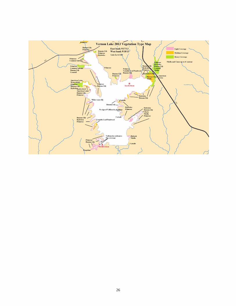
APPENDIX III – VEGETATIVE TYPE MAP
VERNON LAKE
September 2013
Robby Maxwell
Vernon Lake, in Vernon Parish, was surveyed for the presence of aquatic vegetation on
September 17 and 18, 2013. On the first day of the survey, water clarity was 84 cm as measured by
Secchi disk on the northeastern fork of the lake. On the second day of the survey, water clarity was 132
cm as measured by Secchi disk in Empire Cove on the southwestern end of the lake. Both readings were
lower than last year’s Secchi reading of 162 cm. Water levels were 1’ below pool level at 244’ MSL.
Mapped plant densities were designated as “Low,” “Medium,” or “High.” Heaviest infestations
were on the flats in the upper parts of the two northern forks of the lake, and in large northwestern coves.
Coves in the southern half of the lake were generally only sparsely vegetated with aquatics. The most
common species of concern in the lake were primrose (Ludwigia sp.) and American lotus (Nelumbo
lutea), which were highest in the northern flats and northwestern coves. A species of concern that
occurred more sporadically was common salvinia (Salvinia minima) in a cove and canal on the
northwestern fork.
Other emergent species that were noted in varying densities, but are not considered to be of great
concern, included banana lily (Nymphoides aquatic) found on shorelines throughout the lake, Hydrolea
sp. found in shallow areas and shorelines throughout the lake, spatterdock (Nuphar luteum) and white
water lily (Nymphaea odorata) on the central-western shoreline, and bulrush (Schoenoplectus
californicus) and cattails (Typha sp.) were found sporadically throughout the southeastern shore.
Submerged aquatic vegetation was observed throughout the lake up to the 4’ contour. Species
observed include coontail (Ceratophyllum demersum) in the northern flats and a northwestern cove,
variable leaf pondweed (Potamogeton diversifolius) noted in a northern and southwestern cove but likely
found in other locations, and Nitella sp. and Chara sp. found throughout the lake with the highest
densities in the northern flats and shallow coves throughout the lake.
Problem areas generally consist of shallow flats and coves that are filling in. A cove on the
northwestern fork has perennial infestations of primrose (made worse by extremely shallow water) now
has common salvinia in it. The large central-western cove is also extremely shallow, and has a large
stand of American lotus and other emergent plants in it. We will also address these areas as conditions
and water levels allow. At only 1’ below pool, access to these areas is extremely limited.
Overall, the majority of the lake is relatively clear of nuisance vegetation, and we will focus
efforts on the few areas that are an issue.
26