Embed Size (px)
Citation preview

CHAPTER 1
INTRODUCTION
1.1 Relevance of the topic
The Asian monsoon system is an integral component of the earth's climate sys
tem, involving complex interactions of the atmosphere, the hydrosphere and
the biosphere. The majority of the population of the planet reside in the mon
soon regions. India, with a population of nearly a billion people, is located in
the central portion of South Asia and is predominantly within the monsoon
regime. The annual variation of rainfall and temperature has a major influence
on the livelihood and well being of the country. The change in the large scale
atmospheric and oceanic circulations due to the redistribution of monsoon heat
sources and sinks is also affecting weather and climate in regions far away from
the monsoon region. Droughts and floods due to the changes in monsoon af
fect agricultural and industrial production and cause property damages, hu
man suffering and death and spread of diseases thus posing serious threats not
only to the monsoon community but also on the global scale.
1

Chapter 1: Introduction 2
The summer monsoon contributes about 80% to the annual rainwater po
tential of India. Traditionally in India, agricultural practices have been tied to
the annual cycle of the monsoon. Variations in the timing and quantity of rain
fall significantly affect the productivity of crops. A monsoon year with less total
rainfall than normal generally corresponds to low crop yields (Gadgil, 1996). An
intense monsoon can cause considerable distress as a result of severe flooding
and crop destruction. In addition, within the monsoon rainy season there are
great variations of precipitation, the so called intraseasonal variations. The long
periods of excess rainfall are often referred to as active phases of the monsoon
and the dry periods of little rain as break phases. Since ploughing and plant
ing periods are extremely susceptible to the changes in monsoon rains, the in
traseasonal variability has a direct influence on the agricultural sector. Even if
the average seasonal monsoon rains are normal, an ill-timed arrival or cessa
tion of rainfall can cause crop destruction (Webster et al., 1998). With accurate
forecasts, the impact of variability of the monsoon on agricultural practices,
water management, etc., could be optimised. Since the Asian monsoon system
is a dominant manifestation of a strongly interactive ocean-atmosphere-land
system, understanding the mechanism that produce the variability in the mon
soon is very much needed for developing accurate prediction methods. \
1.2 Justification for the study
A strong cross-equatorial Low Level Jetstream (LLD with core around 850 hPa
exists over the Indian Ocean and south Asia during the boreal summer mon
soon season, June to September. LLJ has its origin in the south Indian Ocean,
north of the Mascarene High as an easterly current, it crosses the equator in a
narrow longitudinal belt close to the east African coast as a southerly current
with speeds at times even as high as 100 knots, turns into a westerly current

Chapter 1: Introduction 3
over the Arabian Sea and passes through India and enters the western Pacific
Ocean.
LLJ has strong horizontal shear (vorticity) in the planetary boundary layer
(maximum vorticity at 850 hPa) and is important for generation of convective
rainfall and for the development of rain producing weather systems. The LLJ is
the main conduit for transporting moisture generated over Indian Ocean to the
monsoon area. The intraseasonal oscillation of LLJ controls this moisture dis
tribution. In active monsoon condition a large convective region over the Bay
of Bengal is maintained by the LLJ passes through peninsular India. It is found
that this convection maintains the LLJ. When convection over Bay of Bengal
decreases and it gets established over the equatorial Indian Ocean at the time
of break monsoon, the LLJ bypasses India and is located south of India. It then
transports bulk of the moisture evaporated over the Indian Ocean to the west
Pacific Ocean and the moisture supply to India is cut off. Thus LLJ plays an
important role in monsoon rainfall distribution over the Indian subcontinent.
1.3 Monsoon
The term monsoon appears to have originated from the Arabic word Mausam
which means season. With change of season there is also generally a change
of wind direction; hence the word monsoon also came to be associated with
wind directions. In a true monsoon climate, seasonal wind shifts typically cause
a drastic change in the general precipitation and temperature patterns. Mon
soons have been subject of considerable research work for more than a century.
According to Ramage (1971) the main characteristics of monsoon regions are as
follows

Chapter 1: Introduction 4
• The prevailing wind direction shifts by at least 1200 between January and July.
• The average frequency of the respective prevailing wind directions in January
and July exceeds 40%.
• The mean resultant wind speed in at least one of the months exceeds 3 ms-I.
• Fewer than one cyclone-anticyclone alternation occurs every two years in either
month in a 50 latitude-longitude region. This monsoon region which includes
parts of the African continent, South Asia and North Australia is shown
as shaded area in Figure 1.1.
Figure 1.1: Areas with monsoon circulations according to Ramage criteria (Ramag,,1971)
There are three fundamental driving mechanisms of the planetary-scale
monsoon. These are (i) the differential heating of the land and the ocean and
the resulting pressure gradient (ii) the impact of the rotation of the planet and
(iii) moist processes in the atmosphere. Thus monsoon is a complex, nonlinear
phenomenon involving atmosphere, oceanic, and land-based processes (Web
ster, 1987). Ocean can store energy more efficiently than land and therefore re
tain heat longer than land mass. So over large ocean basins, seasonal changes
Chapter 1: Introduction 5
in tropical circulation are limited to minor latitudinal shifts and small varia
tions in the intensity. However, over land important seasonal temperature and
pressure changes take place that produce seasonal reversal of pressure gradient
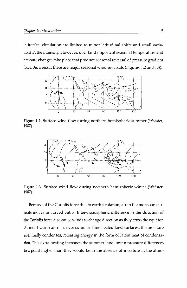
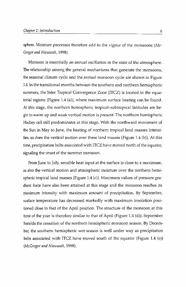
force. As a result there are major seasonal wind reversals (Figures 1.2 and 1.3).
o 30 90 150
Figure 1.2: Surface wind flow during northern hemispheric summer (Webster, 1987)
o 3C 60 90 120 150
Figure 1.3: Surface wind flow during northern hemispheric winter (Webster, 1987)
Because of the Coriolis force due to earth's rotation, air in the monsoon cur
rents moves in curved paths. Inter-hemispheric difference in the direction of
the Coriolis force also cause winds to change direction as they cross the equator.
As moist warm air rises over summer-time heated land surfaces, the moisture
eventually condenses, releasing energy in the form of latent heat of condensa
tion. This extra heating increases the summer land-ocean pressure differences
to a point higher than they would be in the absence of moisture in the atmo-
Chapter 1: Introduction 6
sphere. Moisture processes therefore add to the vigour of the monsoons (Mc
Gregor and Nieuwolt, 1998).
Monsoon is essentially an annual oscillation in the state of the atmosphere.
The relationship among the general mechanisms that generate the monsoons,
the seasonal climate cycle and the annual monsoon cycle are shown in Figure
1.4. In the transitional months between the southern and northern hemispheric
summers, the Inter Tropical Convergence Zone (ITCZ) is located in the equa
torial regions (Figure 1.4 (a)), where maximum surface heating can be found.
At this stage, the northern hemispheric tropical-subtropical latitudes are be
gin to warm up and weak vertical motion is present. The northern hemispheric
Hadley cell still predominates at this stage. With the northward movement of
the Sun in May to June, the heating of northern tropical land masses intensi
fies, as does the vertical motion over these land masses (Figure 1.4 (b)). At this
time, precipitation belts associated with ITCZ have moved north of the equator,
signaling the onset of the summer monsoon.
From June to July, sensible heat input at the surface is close to a maximum,
as also the vertical motion and atmospheric moisture over the northern hemi
spheric tropical land masses (Figure 1.4 (c)). Maximum values of pressure gra
dient force have also been attained at this stage and the monsoon reaches its
maximum intensity with maximum amount of precipitation. By September,
surface temperature has decreased markedly with maximum insolation posi
tioned close to that of the April position. The structure of the monsoon at this
time of the year is therefore similar to that of April (Figure 1.4 (d)). September
heralds the cessation of the northern hemispheric monsoon season. By Decem
ber, the southern hemispheric wet season is well under way as precipitation
belts associated with ITCZ have moved south of the equator (Figure 1.4 (e))
(McGregor and Nieuwolt, 1998).

Chapler 1: Inlroduction
" " km , o
(a) APRIL
); Ocean
1 SOlax
- -- --, L","
(b) MAY/JUNE
&
" -L t'\
D, , o
Ocean
(c) JUNE f JULY Is " ,---,.,-----,,- "'" -rE 15
(0) SEPTEMBER s~,
". km ,
0
" TI"CIJO
20 -
"
- E
r, " km , / l\
0 Ocean 'k .... L,,'"
:] /-
/~ .I -" "'" T('C)
/ 2Or- rffb; ,
/ -'---~ " --- -I
EOU EOU
15 J s"",
" ~~rTl oL~~~~ EOU
km ,
T('C)~] ~------...;;... EOu
(e) DECEMBER
Figure 1.4: The annual monsoon cyde (Websler el al., 1998)
7

Chapter 1: Introduction 8
1.4 Asian Summer Monsoon
During the northern hemispheric summer season, ITCZ migrates to its north
ern most position (300 N) over south Asia establishing the monsoon trough.
There the pressure patterned meridional circulation in summer is further ac
centuated by the presence of Cl huge mountain massif over South Asia, the Hi
malayas, leading to the establishment of the southwest monsoon. The supply
of atmospheric water vapour is crucial in this context. In boreal summer, there
is large evaporation in the south Indian Ocean trade wind area and the cross
equatorial monsoon air-stream carries this water vapour into south Asia, thus
fueling the monsoon rainfall. The parameters of broad scale monsoon system
described by Krishnamurti and Bhalme (1976) are schematically shown in Figure
1.5. Some of the components of the monsoon system are described as below.
~ .. 1'----,---
Figure 1.5: Schematic diagram of the elements of monsoon system (Krishnamu,ti and Bhalme, 1976)

Chapter 1: Introduction 9
Monsoon Trough: During the summer monsoon season, at the surface there
is a trough extending southeastwards from the heat low over Pakistan upto
Gangetic West Bengal. It is called the Monsoon Trough. The heat low over cen
tral parts of Pakistan and neighboring regions is generally linked to the region
of maximum heating which are out of reach of the maritime air mass. The heat
low is shallow extending upto about 1.5 km and above it is a well marked ridge
extending to the upper troposphere, which is part of the subtropical high pres
sure belt. The monsoon trough is regarded as a part of the equatorial trough
of the northern summer in Indian longitudes. The position of this trough line
varies from day-to-day and has a vital bearing on the monsoon rains. No other
semi-permanent feature has such a control on monsoon activity. When mon
soon trough is south of its normal position, we get the active monsoon phase.
When monsoon trough moves to the foot hills of the Himalayas we get the
break monsoon phase (Rao, 1976).
Mascarene High: This is a high pressure area south of the equator near the
Mascarene Islands east of Madagascar. The centre of this anticyclone is located
near 30°5 and 500 E. Variation in the location and strength of the Mascarene
High are important in relation to the summer monsoon circulation and rainfall
over India.
Low Level Cross Equatorial Jet: This is the well known northern summer
Low Level Jet (LL]). LLJ has its origin in the south Indian Ocean north of the
Mascarene High as an easterly current, it crosses the equator in a narrow lon
gitudinal belt close to the east African coast as southerly current with speeds
at times even as high as 100 knots, turns into Arabian Sea as a westerly cur
rent and passes through India to the western Pacific Ocean. The LL] is the main
conduit for transporting moisture generated over the Indian Ocean into the
monsoon area.

Chapter 1: Introduction 10
Tibetan High: This is a large anticyclone known to have its largest ampli
tude near 200 hra during the northern summer months. Between 500 hra and
200 hPa, the high pressure belt is well to the south of Tibet during June and
September and over Tibet during July and August. The combination of the Ti
betan High in the upper troposphere and the Monsoon Trough at sea level is
accompanied by warm hydrostatic tropospheric columns over the northern In
dia and over the foot hills of the mountains. The warm troposphere is another
important feature of broad-scale monsoon system.
Tropical Easterly Jet: A strong easterly flow of air south of the Tibetan High,
a tropical easterly jetstream (TE]), develops in the upper troposphere at around
150 hPa during the monsoon season. This jet has winds of 80-100 knots and has
its axis approximately around lOoN and 1000E. Normally, TEJ is in an acceler
ating stage from south China Sea to south India and decelerates to the west.
Upper divergence associated with TEJ is regarded as favourable for convection
upstream of 700E. Subsidence occurs downstream. The fact that the tropical
easterly jet only occurs in the summer suggests that its development is related
to the seasonal cycle of surface heating and convective heating in the area over
which jet lies.
Monsoon Cloudiness and Rainfall : The Indian longitudes are character
ized by a large seasonal excursion of the maximum cloud zone (MCZ). It is
found that during June-September there are two favourable locations for MCZ
over these longitudes. On a majority of days the MCZ is present north of l5°N
in the monsoon zone. Often a secondary MCZ occurs in the equatorial region
between the equator and lOoN. The monsoon MCZ gets established by north
ward movement of the MCZ occurring over the equatorial Indian Ocean in
April and May. The secondary MCZ appears intermittently, and is character
ized by long spells of persistence only when the monsoon MCZ is absent. The

Chapter 1: Introduction 11
monsoon MCZ cannot remain for more than a month without re-establishment
by the the secondary MCZ (Sikka and Gadgil, 1980). The rainfall shows similar
temporal variation like the cloudiness in MCZ
All these components are connected through the monsoon Hadley circula
tion. Krishnamurti and Bhalme (1976) found that interaction among solar radia
tion, conditional instability of the monsoon atmosphere and the cloudiness in
the monsoon trough region lead to a quasi biweekly oscillation of the compo
nents of the monsoon system.
1.4.1 Onset and Withdrawal of Monsoon
Onset of Asian Summer Monsoon is one of the most dramatic seasonal tran
sition exhibited by the atmosphere. The onset of monsoon refers to the burst of
rains over Kerala on the southern tip of the peninsula and is associated with the
commencement of organised monsoon rainfall over Indian region and the es
tablishment of the monsoon trough. The onset phase of monsoon commences
in late May/early June. The mean date of onset over Kerala is 1 June, with
standard deviation of 8 days. It takes about six weeks from the time of onset
over Kerala for the monsoon rains to cover the entire country (India). Figure
1.6 shows the normal onset dates of southwest monsoon over India.
The nature of the onset of the monsoon and the significant factors in the
energetics have been extensively studied (Krishnamurti et al., 1981; Pearce and
Mohanty, 1984; Ananthakrishnan and Soman, 1988; Joseph et al., 1994). The main
circulation features of the onset can be summarised as follows (i) formation and
northward movement of a cyclonic system (onset vortex) in the southwest Arabian Sea
in many years; (ii) strengthening and deepening of westerlies in the lower troposphere
and organisation and strengthening of easterlies in the upper troposphere over peninsu
lar India; (iii) the subtropical westerly jet over north India tending to weaken and shift

Chapter 1: Introduction 12
JON
20N
10N
70E aOE 90E
Figure 1.6: Mean dates of onset of the summer monsoon over India. Broken lines denote isolines based on inadequate data. (From India Meteorological Department)
northward; (iv) persistent heavy cloudiness over the southeast Arabian Sea (Soman
and Krishnakumar, 1993).
On the synoptic scale, the onset of monsoon over Kerala is associated with
the genesis and movement of either a depression/ cyclone in the Indian seas,
or a low pressure area off the coast of Kerala or mid-tropospheric disturbances
in the east-west trough zone at the tip of the peninsula. The onset involves the
genesis of a well-defined onset vortex (George and Mishra, 1993) in about 50% of
the years. It usually forms on the cyclonic shear side of the low-level jet in the
lower troposphere over eastern Arabian Sea and subsequently its motions are
more westward, usually toward the Arabian coast, where it is known to dissi
pate. It has been noted to first form in the middle troposphere over the eastern

Chapter 1: Introduction 13
Arabian Sea and subsequently cyclogenesis occurs in the lower troposphere
(Krishnamurti,1985).
Krishnamurti and Ramanathan (1982) showed that convective heating has by
far the largest effect in determining the structure and strength of the divergent
wind. They also demonstrate that unless the moisture is present in the initial
profile, no onset occurs in the model. Sikka (1980) suggested that passage of
deep mid-latitude westerlies across the Mozambique channel in late May trig
gers the surge in cross-equatorial flow leading to the onset of the monsoon.
Analysis of Outgoing Longwave Radiation (OLR) data by Joseph et al. (1994)
has shown that around the time of monsoon onset over Kerala (MOK), an ac
tive belt of convection extends from the south China through the Bay of Ben
gal, with suppressed convection in the equatorial trough region of the western
North Pacific. They also point out that the delayed MOK is associated with
El NiilO particularly in its year +1. Of the 22 years between 1870-1989 when
MOK was delayed by 8 days or more, 16 cases were associated with moderate
or strong El NinoOf the 13 strong El Ninos during the same period, 9 were
associated with moderate to large delays in MOK.
While the onset of the monsoon over India is invariably gradual, its with
drawal is relatively rapid. Withdrawal from the northwestern parts of India
normally commences by September 1 (Figure 1.7). Cooling of the the land
masses of northern India and further north and a shift in the activity of the
troughs in the westerly wind belt to a relatively lower-latitude belt result in
the southward shift of the monsoon trough and withdrawal of the monsoon
from northwest India. As these factors vary from year to year, the withdrawal
of the monsoon undergoes interannual variation. In general, the withdrawal of
the monsoon from western Rajastan, Haryana, and Punjab takes place during
the first fortnight of September, and withdrawal from most of the remaining

Chapter 1: Introduction
30N
1 SEPTEMElER
20N
ION
70E
;
15 OCTO~E ~-I--- _______ '"
---1 NOVEMBEn
90E
14
Figure 1.7: Mean dates of withdrawal of the summer monsoon from India. Broken lines denote isolines based on inadequate data. (From India Meteorological Department)
parts of the country occurs during the period mid-September to mid-October
(Mooley and Shukla, 1987).
1.4.2 Annual Cycle
During Asian summer monsoon season, there are two principal rainfall max
ima. The first lies around ISDN and contains two principal sub-maxima: over
the Bay of Bengal and in the eastern Arabian Sea next to Ghat mountain range.
The second and weaker maximum lies close to and south of the equator and ex
tends from 60DE to llODE. The northern precipitation zone matches the location
of the monsoon trough. The southerly maximum coincides with the weaker
surface pressure trough lying just to the south of the equator. During winter the

Chapter 1: Introduction 15
precipitation patterns extend as a broad zone from the western Indian Ocean
to the date line to the south of the equator and is located closer to the equator
than during the summer. The heating gradients in both seasons associated with
precipitation and radiative processes are largest on the planet, dominating the
planet's annual cycle and defining circulation structures on a planetary scale
(Webster et al., 1998).
The major precipitation zone in northern summer is in a tilted position with
its center in the Indian region (between lso N and 200 N) while its position in the
western Pacific remains around SON. This mean displacement of the precipita
tion zone over the Indian region represents a strong asymmetric heat source.
The heating gradients associated with such a heat source drives a regional
Hadley circulation with ascending motion around 20o N, and descending mo
tion from the equator to the southern hemisphere subtropics. The precipitation
maximum and hence the ascending part of the Hadley circulation during the
northern summer over the rest of the globe is closer to the equator and centered
around SON. It was first noted by Schulman (1973) that the regional monsoon
Hadley cell with reverse meridional circulation in the Indian monsoon region
is strong enough to make the zonally averaged Hadley cell appear to be very
week during the northern summer. The importance of the regional Hadley cir
culation in the monsoon rainfall was recognised by Joseph (1978) who showed
that the mean meridional wind at 150 hPa in June, July and August over In
dia was related to the seasonal monsoon precipitation. However, there is also
an" east-west Walker circulation with major ascending motion in the equato
rial western Pacific and Indonesia and subsidence over the equatorial Indian
Ocean. Thus, the Indian monsoon may be viewed as a superposition and in
teraction between a regional Hadley circulation and a planetary-scale Walker
circulation (Goswami, 1994; Goswami et al., 1999).

Chapter 1: Introduction 16
Through out the annual cycle, the Sea Surface Temperature (SST) in the In
dian Ocean undergoes major changes. The SST is the most important charac
teristics of the coupled ocean-atmosphere system and determines, to a large
degree, the manner in which the ocean and the atmosphere interact. The atmo
sphere feels the SST but the future SST depends on the surface thermal structure
and particularly on the heat content of the upper ocean. A warm SST anomaly
without warm heat content will quickly be eliminated by the atmosphere. On
the other hand, warm SST region with warm heat content can be very persistent
to the climate system. The north Indian Ocean SST reaches maximum in spring
and early summer (more substantially in the Arabian Sea). With the arrival of
the monsoon due to mixing and enhanced Ekman transports SST seems to fall
rapidly. Negative feedbacks occur between the atmospheric component of the
monsoon and the ocean.
1.4.3 Interannual Variability
The year to year variation of the Asian monsoon is one of the strongest sig
nals of the earth's climate variability. The mean rainfall over Indian peninsula
Oune-September) is about 852 mm and the standard deviation of the seasonal
mean is about 84 mm (Parthasarathy et al., 1994). A large fraction of interan
nual variability is determined by the slowly varying surface boundary condi
tions such as SST, surface albedo and soil moisture (Charney and Shukla, 1981).
Several workers have shown that there is a significant relationship between
drought in the Indian summer monsoon and El Nino-Southern Oscillation
(ENSO) (Sikka, 1980; Rasmusson and Carpenter, 1983; Shukla and Paolina, 1983).
Webster et al. (1998) point out that nearly all El Nino years are drought years
in India but not all drought years correspond to El Nino years. Although the
relationship is not fully understood, it is clear that the monsoon and ENSO are
related in some fundamental manner.

Chapter 1: Introduction 17
Soman and Slingo (1997) showed that the modulation of the Walker circu
lation (additional ~ubsidence) is the dominant mechanism by which El Nino
weakens the Asian summer monsoon for the years 1983 and 1984. However,
the delayed onset during El Nino may be associated with the complementary
cold SST anomalies in the western Pacific that delay the northward transition
of the Tropical Convective Maximum (TCM). They further suggest that during
cold events it is primarily the warm SST anomalies in the western Pacific that
enhances the TCM and lead to an early onset and stronger monsoon. Although
numerous studies have focused on ENSO links to the Indian monsoon, Lau and
Wu (1999) mentioned that India is not a major center of action in the dominant
coupled precipitation-SST relationships. Arpe et al. (1998) studied the differ
ences between 1987 and 1988 summer monsoons and suggest that, while large
scale dynamics over India are mainly governed by Pacific SST, the variability
of precipitation over India is impacted by a number of other factors including
SST anomalies over the northern Indian Ocean, soil wetness, initial conditions,
and the quasi-biennial oscillation. They show that the two direct effects of El
Nino are to reduce precipitation over India and reduce the surface winds over
the Arabian Sea. They suggest that the latter leads to an increase in SST and
more precipitation over India acting to counteract the direct effect of El Nino .
Another school of thought believe that the monsoon in turn influence ENSO
(Yasunari, 1990). Several recent studies have examined the possibility of mod
ification of the ENSO characteristics by the summer monsoon by simple cou
pled models. Wainer and Webster (1996) argued that the interannual variation
of the summer monsoon may contribute to irregularities of El Nino. Chung
and Nigam (1999) showed that, based on results from an intermediate ocean
atmosphere coupled model, that monsoon forcing may increase the frequency
of occurrence of El Nino. Lau et al. (2000) suggested that boreal spring warm
ing in the north Arabian Sea and subtropical western Pacific may play a role in
Chapter 1: Introduction 18
the development of strong South Asian monsoon. Kumar et al. (1999) showed
that the inverse relationship between ENSO and Indian Summer Monsoon,
that was clearly evident before 1980, weakened considerably in recent decades.
They suggest that this is associated with a southward shift in Walker Circu
lation, and increased Eurasian surface temperature during winter and spring
seasons. Using NCEP /NCAR reanalysis data and Atmospheric General Circu
lation model Goswami and Jayavelu (2001) have shown that the Indian Monsoon,
by itself, does not produce significant surface wind anomalies in the the equato
rial Pacific either during or following the monsoon season and thus the Indian
monsoon by itself is unlikely to influence the ENSO in a significant way.
The interannual variability of monsoon rainfall shows a biennial variability
during certain periods of the data record. This biennial oscillation, referred to as
tropospheric biennial oscillation (TBO) is reported in the rainfall of Indonesia
(Yasunari and Suppiah, 1988) and east Asia (Tian and Yasunari, 1992; Shen and Lau,
1995) as well as in Indian rainfall (Mooley and Parthasarathy, 1984). The rainfall
TBO appears as a part of the coupled ocean-atmosphere system of the monsoon
regions, increasing rainfall in one summer and decreasing in the next.
A strong biennial tendency has also been noted in ENSO cycles for some
time (Lau and Sheu, 1988; Rasmusson et al., 1990). Except for the different time
scales, the evolutionary features of the biennial oscillation in SST, sea level pres
sure, wind and precipitation are very similar to that of ENSO. In the last several
years, there have been increasing evidences showing the presence of the TBO in
the monsoon regions (Yasunari, 1990; Shen and Lau, 1995; Meehl, 1997). Recently
a number of theories have emerged suggesting that the TBO may be related
to the air-sea interaction in the Asian Summer Monsoon region, modified by
coupled ocean-atmosphere processes (Meehl, 1997; Chang and Li, 1999). Recent
studies have also suggested that strong monsoon-ENSO interactions may result

Chapter 1: Introduction 19
in a strong biennial tendency in ENSO cycles in the form of rapid development
of La Niila approximately one year after an El Nino (Lau et al., 2000; Lau and
Wu, 2001). Kim and Lau (2000) investigated the mechanism of the quasi-biennial
tendency in ENSO-monsoon coupled system using an intermediate coupled
model. They found that the strong coupling of ENSO to monsoon wind forcing
over the western Pacific is the key mechanism.
1.4.4 Intraseasonal Variability
Among the many time scales of Asian Monsoon variations, the intraseasonal
variation is most distinctive. Observational evidence shows the existence of
three different quasi-periodic oscillations with periods of 4-6 days, 10-20 days
and 30-60 days (Krishnamurti and Bhalme, 1976). The 4-6 day oscillations are
largely observed in monsoon trough region. The dynamical system associated
with the 4-6 day scale is the monsoon disturbance. A dominant characteristic of
intraseasonal fluctuations during summer in the monsoon region is the active
break cycles of precipitation with periods of 10-20 days or 30-60 days. Active
spells of the summer monsoon region are associated with an intense trough
over India with heavy rainfall over monsoon trough zone. During the break
monsoon condition, the monsoon trough moves northward to the foot of the
Himalayas, resulting in decrease in rainfall over much of India but enhanced
rainfall in the far north and south (Ramanadham et al., 1973). These anomalies
are large scale and extend across the entirety of South Asia.
The active-break cycles are linked to observed northward propagation of
convection from Indian Ocean on to the Asian subcontinent in summer (Kesava
murty et al., 1980; Sikka and Gadgil, 1980). This northward propagation has a time
scale of 30-60 days and has been noted in many studies (Yasunari, 1981; Krish
namurti and Subrahmanyam, 1982; Lau and Chan, 1986; Wang and Rui, 1990; Gadgil
and Asha, 1992). Similar northward propagation is also found over the west Pa-

Chapter 1: Introduction 20
cific during northern summer (Murakami, 1984; Wang and Rui, 1990). Hartman
and Michelsen (1989) analysed daily precipitation from Indian stations during
1901-70 and confirmed the existence of 30-50 day variability over peninsular
parts of the country. Yasunari (1981) suggested that the northward migrating
monsoon cloud bands are maintained by a transient local Hadley cell and also
may be related to the low-frequency Madden Julian Oscillation (MJO) (Madden
and Julian, 1972, 1994). The MJO can be defined as a 30-50 day oscillation in the
large scale circulation cells that move eastward from at least the Indian Ocean
to the central Pacific Ocean. Even though the association of active and break
periods of the monsoon with MJO is not fully understood, there is abundant
evidence of frequency peaks in south Asian rainfall and wind in the same pe
riod bands as the MJO (Julian and Madden, 1981; Wang and Rui, 1990; Madden
and Julian, 1994).
Wang and Rui (1990) classified the intraseasonal movement of convection
anomaly in three categories. They are (i) eastward (ii) independent north
ward and (iii) westward. The eastward propagating convection anomaly ex
hibit three major tracks: (a) equatorial eastward from Africa all the way to
the mid-Pacific, (b) first eastward along the Indian Ocean, then either turning
northeast toward the northwest Pacific or southeast toward southwest Pacific
at the maritime continent, and (c) eastward propagation along the equator with
split center(s) moving northward in the Indian and/ or west Pacific Oceans. In
dependent northward propagation which is not associated with eastward prop
agation is found over two longitude sectors: the Indian monsoon region and
western Pacific monsoon region. The mechanism responsible for meridional
propagation may differ from that for the eastward propagation. However, cli
matologically, the most active period of the MJO (at least in its equatorial man
ifestation) is in the boreal fall and winter (Webster et al., 1998).

Chapter 1: Introduction 21
A number of theories have been proposed to explain the northward move
ment of convection during summer. Lau and Peng (1990) showed that the inter
action of tropical diabatic heating associated with the 30-60 day oscillation and
the summer monsoon mean flow induces the development of westward prop
agating synoptic scale cyclonic vortices over the monsoon region leading to the
active and break phases of the monsoon. They suggest that the rapid develop
ment of these disturbances, and associated weakening of equatorial convection
via changes in the low-level moisture convergences accounts for the observed
northward migration of the monsoon trough. Webster (1983); Srinivasan et al.
(1993) emphasized the important role of land surface heat fluxes in the bound
ary layer that destabilize the atmosphere ahead of the ascending zone, causing
a northward shift of convective activity. Goswami and Shukla (1984) suggested
that the northward propagation is due to a convection-thermal relaxation feed
back where in the convective activity increases static stability while dynamic
and radiative relaxation decreases the moist static stability, bringing the atmo
sphere to a convectively unstable state. Based on results of a modelling study
of summer ISO's, Wang and Xie (1997), described the northward propagation
as a convection front formed by the equatorial Rossby waves emanating from
the equatorial convection. Krishnan et al. (2000) suggest that monsoon breaks
are initiated by rapid northwest propagating Rossby waves emanating from
convectively-stable anomalies over the Bay of Bengal.
Using principal oscillation pattern (POP) technique Annamalai and Slingo
(2001) describes the origin and propagation of 15 day and 40 day mode of in
traseasonal oscillations. The 40 day mode originates and intensifies over the
equatorial Indian Ocean and it has poleward propagation on either side of
the equator, as well as eastward propagation into the equatorial west Pacific.
The Rossby waves emanating from the west Pacific appear to be responsible
for the northwestward propagation of convection. The 15 day mode originates

Chapter 1: Introduction 22
over the equatorial west Pacific, associated with westward propagating Rossby
waves, amplifies over the northwest tropical Pacific and modulates both the
continental and oceanic TCZs over the Indian longitudes. By separating sum
mertime ISOs based on their zonal propagation characteristics in the Indian
Ocean and the western Pacific Ocean, Lawrence and Webster (2002) have shown
that the eastward propagation of convection along the equator is a fundamen
tal feature of the ma}ority of summertime 150s. The eastward propagation ap
pears to be directly related to the northward movement of convection that is
associated with active and break cycles of precipitation across India.
There is some evidence that interannual variations of intraseasonal oscilla
tion activity may influence monsoon strength. Several modelling studies show
that a significant fraction of the interannual variation of the seasonal mean
Indian summer monsoon is governed by internal chaotic dynamics (Goswami
et al., 1998; Harzallah and Sadourny, 1995; Rodwell and Hoskins, 1995). Goswami
and Ajayamohan (2001) have shown that the intraseasonal and interannual vari
ations are governed by a common mode of spatial variability. The spatial pat
tern of standard deviation of intraseasonal variability of low-level vorticity
and spatial pattern of the dominant mode of intraseasonal variability of the
low level winds are similar to that of interannual variability .. In another re
cent study Lawrence and Webster (2001) have shown that intraseasonal activity
Indian monsoon relationship is essentially independent of the ENSO-Indian
monsoon relationship.
1.5 Low Level J etstream
Low Level Jetstream (LLJ) according to a definition sugges.ted by Reiter (1961)
should have marked gradients of wind speed in the horizontal and vertical. There are
several places where strong low-level currents are observed. The LLJs are gen-

Chapter 1: Introduction 23
erally located in the lowest 1 to 2 km of the troposphere. These are strongly
influenced by orography, friction, diurnal cycle of heating and corresponding
variations of pressure gradient and static stability (Asnani, 1993). The following
geographical locations are favourable for the occurrence of these LLJs.
1. Slopes of the mountains parallel to the anti-cyclonic flow around the sub-tropical
anti-cyclones; for example, low-level jet over west central USA, along the Peru
coast in South America and along Namibian coast in South African continent.
2. Narrow mountain gaps, like Marsabit (North Kenya) Jet stream.
3. North-south oriented continental coasts near cross-equatorial flow, e.g., East
African LLJ during Asian summer monsoon.
Bunker (1965) using Aircraft observations of wind in the Arabian Sea during
the International Indian Ocean Expedition (HOE) traced a LLJ with large ver
tical wind shears off Somalia and across the Central parts of Arabian Sea. He
showed that monsoon winds attained a speed of 50 knots in the southwestern
parts of the Arabian Sea at the top of a 1000 meter layer of air cooled by contact
with the up welled water off the Somali-Arabian coasts.
Analysing the wind data of five years collected by the radio
sonde/rawinsonde network of India, Joseph and Raman (1966) established the
existence of a westerly low level jet stream over peninsular India with strong
vertical and horizontal wind shears (Figure 1.8). This jet is seen over peninsu
lar India on many days in the month of July with core at about 1.5 km above
mean sea level and core speeds of the order of 40-60 knots. It showed persis
tence of a few days at one latitude. South to north movement of the jet core
was also reported. Findlater (1969a) found that the Asian summer monsoon LLJ
has its origin in the south Indian Ocean north of the Mascarene High as an
easterly current, it crosses the equator in a narrow longitudinal belt close to
the east African coast as southerly current with speeds at times even as high

Chapter 1: Introduction
ul o 3-0 :J ~ -~
...J \5 <!
2S0 280
?7()2~ 270.!!!2-. _
o L---I----'_..L----'---'---' o 10 20 30 40 50 60
W I NO SP E E D l KNOTS)
21
Figure 1.8: Low Level Jet stream over peninsular India at 00 UTC on 9 July 1961. (a) winds and isolines of wind (magnitude) in knots at 850 hPa level. LLJ axis is marked by a thick line. (b) vertical profile of wind speed at Visakhapatnarn (17.1°N, 83.3°E) on the jet axis. The three digit numbers marked are the directions of wind. (adapted from Joseph and Raman (1966))
as 100 knots, turns into a westerly current over the Arabian Sea and passes
through India. This jet according to their computations accounts nearly for half
the inter-hemispheric transport of air in the lower troposphere. Using monthly
mean winds Findlater (1971) showed that the LLJ splits into two branches over
the Arabian Sea, the northern branch intersecting the west coast of Indian near
17°N, while the southerly branch passes eastward just south of India. Figure
1.9 shows the monthly mean airflow at the 1.0 km level for August.

Chapter 1: Introduction
(
./" / ./"----..
~
--.. --..
-- --.. -- -----
...... 7,~ 'r-I-:;-...c~,<--......... -+-->-....--'>( ;,......::..t....,------r-------t-IO ...
...... ...... -- -10
le-" L-+-~~~~=U~-----+-I~
O· 70· .~
25
Figure 1.9: Wind field at 1 km for August over the Indian Ocean from Findlater (1971). Thick lines marked are the LLJ axes. Isotachs in ms- 1 are shown as broken lines.

Chapter 1: Introduction 26
Krishnamurti et al. (1976) studied the LLJ using a single-level, time
dependent, primitive equation model with bottom topography and a pre
scribed flow on the eastern boundary. They concluded that the broad-scale
low-level jet is forced by the differential heating over India and barotropic in
stability is a possible mechanism for the splitting of the jet. Other one layer
models such as those of Anderson (1976); Hart (1977); Bannon (1979, 1982) have
indicated how a cross equatorial jet can be formed and have described some
of the dynamics involved. Anderson (1976) invoked the effects of lateral friction
along the mountains located at the East African coast and showed that a bal
ance between the {3 effect and lateral friction leads to a reasonable strength of
the East African Low Level Jet and a location at a reasonable distances away
from the mountains. Hart (1977) presented a number of analytical models in
which the stratification of the observed atmosphere was represented by a free
surface under the influence of a reduced gravity. An impermeable western wall
barrier simulated the effects of the East African Highlands, and a realistic zonal
inflow was prescribed at the eastern boundary. This simplified picture of the
observed situation represented the idea that it is the inversion that forces the
incident flow to go around rather than the mountain barrier. One of the models
of Hart (1977) represented the idea of potential vorticity conservation and the
advection of the potential vorticity across the equator resulting in the formation
of a low level jet in the presence of western boundary mountains.
With a fine-mesh (200m) vertical resolution numerical model Krishnamurti
and Wong (1979) studied the planetary boundary layer dynamics of the low
level monsoonal. flow over the Arabian Sea. They concluded that the merid
ional motion of air across the equator from the Southern to the Northern Hemi
sphere toward lower pressure results in an acceleration and an enhancement
of the horizontal advective terms in the balance forces. As an extension of this
study Krishnamurti et al. (1983)-using a three dimensional model that removes

Chapter 1: Introduction 27
the restriction of symmetry-modeled the jet's vertical structure and simulated
more realistically its curvature and the position of its maximum strength over
the Arabian Sea. The quadratic bulk formulation drag coefficient used was de
pendent on orographic height. Away from the equator in both hemispheres,
the modeled momentum balance was found to be mainly geostrophic at the
level of 1 km, with surface friction producing an Ekman balance at 200 m. Near
the equator, the balance was cyclostrophic above with friction again important
near the ground. An important feature of their results was that the confluence
associated with the intertropical convergence zone (ITCZ) over the Arabian Sea
did not appear to be accounted for by geostrophic flow. The imbalance between
Coriolis and pressure gradient forces to the south of the ITCZ tended to accel
erate air parcels northward and so produce the confluence.
Krishnamurti and Ramanathan (1982) showed that the overall development
and strengthening of the low-level zonal flow during onset is highly sensitive
to the large scale field of differential heating. Joseph et al. (1994) suggested that
the intensification of the Low Level ]etstream occurs only after the ITCZ over
the Indian Ocean has moved north of the equator. A time depended primi
tive equation model with specified zonal flow, mountains and diabatic heating
was used to study the LL] by Hoskins and Rodwell (1995); Rodwell and Hoskins
(1995). The east African highlands and a land-sea contrast in surface friction
are shown to be essential for the concentration of the cross equatorial low level
flow into LL]. They found that surface friction and diabatic heating provide
mechanisms for material modification of potential vorticity (PV) of the flow
and both were found important for the maintenance of the LL]. The study iden
tified the strong sensitivity of the LL] to changes in convective heating over
Indian Ocean. When there is a little modification of the PV, the LL] turns anti
cyclonically over the Arabian Sea and the flow tends to avoid India.

Chapter 1: Introduction 28
Arpe et al. (1998) explained the teleconnection between the Somali Jet over
the Arabian Sea and El Num/ La Nina. During El Nino the convection area
over the Indian subcontinent, which is the attractor for the Somali Jet, would
move eastward and consequently subsidising air would replace rising air and
the intensity of the rising air would be reduced. Halpern and Woiceshyn (1999)
defined the onset of the Somali Jet to be the date when National Aeronau
tics and Space Administration (NASA) Scatterometer (NSCAT) surface wind
speeds off Somalia reached 12 ms-2 over a 3° x 3°region in the western Ara
bian Sea for atleast six days. The minimum duration was about three inertial
periods, which is the approximate time for development of Ekman currents.
The zonal component of wind direction must be eastward. Using Special Sen
sor Microwave Imager (SSM/I) wind data Halpern and Woiceshyn (2001) studied
the interannual variations of the Somali Jet in the Arabian Sea during 1988-99
linked with El Nino and La Nina episodes. According to them the average date
of Somali jet onset was two days later in El Nino events in comparison with La
Nina conditions. Monthly mean strength of the Somali Jet 0.4 ms- 1 weaker dur
ing El Nino episodes than during La Nina intervals. They also reported that
the monthly mean intensity of the Somali Jet is above (below) normal, there is
an excess (deficit) of rainfall along the Indian west coast.
1.6 Monsoon Depressions
The monsoon season in summer over Asia is punctuated by intermittent emer
gence and subsequent decay of well-defined, synoptic scale propagating dis
turbances. One of such synoptic scale tropical disturbance is the Monsoon De
pression (MD). These are the important rain producing disturbances of In
dian southwest monsoon. Climc..tology shows that monsoon depressions gen
erally form in the northern portion of the Bay of Bengal and move west
northwestwards (Rao, 1976; Sikka, 1977). The general features of monsoon

Chapter 1: Introduction 29
depressions were studied by several workers (Koteswaram and George, 1958;
Pisharoty and Asnani, 1957; Sikka, 1977; Mak, 1987). The horizontal wavelength
of a depression is typically about 2000 km and generally extend vertically up to
about 10 to 12 km. The radial gradient of surface pressure ranges from 2 to 5 hPa
per 100 km and a surface wind of 8 to 16 ms-I. The disturbance has cold core
in the lower troposphere and warm core above (Sikka, 1977). Maximum rain
fall and cloudiness is found southwest of the depression center (Pisharoty and
Asnani, 1957). Lindzen et al. (1983) ascribed the growth of a Bay of Bengal mon
soon depression to the horizontal shear flow instability mechanism. Douglas
(1992a,b) investigated the structure and dynamics of the monsoon onset vortex
and Bay of Bengal depression by special observing systems of MONEX 1979.
They found many similarities between the structure of the mature onset vortex
and the Bay of Bengal monsoon depression.The observed lower tropospheric
positive vorticity tendency west of both depressions (indicating the direction
of motion) was primarily a result of an excess of cyclonic vorticity generation
by convergence over anticyclonic vorticity advection. Heat-budget calculations
for the rain areas showed an approximate balance between warm advection
and adiabatic cooling at 850 hPa, though diabatic heating was large above this
level. For both depressions the region of maximum rainfall was coincident with
the location of the maximum warm advection in the lower troposphere.
1.7 Heavy Rainfall Events Along West Coast of India
Weather during the monsoon period varies from one area to another and from
one day to another over the same area. These variations are connected with
synoptic patterns in surface and upper air. Formation of off-shore vortices in
the trough in westerlies along the west coast of India and associated heavy
rainfall is an important synoptic system during monsoon (Rao, 1976). Offshore
vortices are mesoscale in character with linear dimensions of the order of 100

Chapter 1: Introduction 30
km or even less and their presence is detected by weak easterly winds at coastal
stations. Notwithstanding their small dimension, they are effective in giving
spells of very heavy rain in their vicinity. The peculiarity of the rainfall asso
ciated with these vortices is that the rainfall over the coast is heavier than that
over hill stations a few kilometers east. Their normal duration is of the order
of 1 to 3 days. The dynamics of these vortices has not been examined in much
detail so far. Existence of these vortices has not been firmly established because
of the lack of mesoscale data. They are suspected to be forming when the mon
soon is normal or strong over the Arabian Sea. Available data show that they
are very small both horizontally and vertically and can be located by coastal
surface winds. For the forecasting of heavy rainfall the approach was mainly
a statistical correlation, lacking the proper understanding of their dynamics
(George, 1956; Mukherjee, 1980).