Embed Size (px)
Citation preview
Lower Duwamish Waterway RM 3.7-3.9 East
(Early Action Area 6)
Source Control Action Plan
March 2009
Publication No. 09-09-082 Printed on recycled paper
This report is available on the Department of Ecology home page on the World Wide Web at http://www.ecy.wa.gov/programs/tcp/sites/lower_duwamish/sites/early_action_area_6/EAA_6.htm

For a printed copy of this report, contact:
Department of Ecology Toxics Cleanup Program
Phone: 360-407-7170
Refer to Publication Number 09-09-082
If you need this publication in an alternate format, please call the Toxics Cleanup Program at 360-407-7170. Persons with hearing loss can call 711 for Washington Relay Service. Persons with a speech disability can call 877-833-6341.
Lower Duwamish Waterway RM 3.7-3.9 East
(Early Action Area 6)
Source Control Action Plan
Produced by
Sarah Good Toxics Cleanup Program
Northwest Regional Office Washington State Department of Ecology
Bellevue, Washington
and
Science Applications International Corporation 18912 North Creek Parkway, Suite 101
Bothell, WA 98011
With Assistance from:
King County City of Seattle
The Boeing Company U. S. Environmental Protection Agency
March 2009
Waterbody No. WA-09-1010
Publication No. 09-09-082

This page intentionally left blank.
Page i
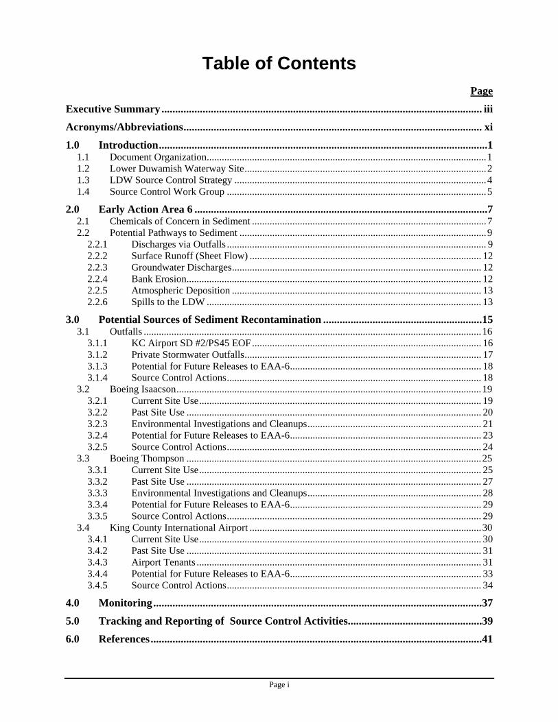
Table of Contents Page
Executive Summary..................................................................................................................... iii
Acronyms/Abbreviations............................................................................................................. xi
1.0 Introduction........................................................................................................................1 1.1 Document Organization...............................................................................................................1 1.2 Lower Duwamish Waterway Site................................................................................................2 1.3 LDW Source Control Strategy ....................................................................................................4 1.4 Source Control Work Group .......................................................................................................5
2.0 Early Action Area 6 ...........................................................................................................7 2.1 Chemicals of Concern in Sediment .............................................................................................7 2.2 Potential Pathways to Sediment ..................................................................................................9
2.2.1 Discharges via Outfalls ....................................................................................................... 9 2.2.2 Surface Runoff (Sheet Flow) ............................................................................................ 12 2.2.3 Groundwater Discharges................................................................................................... 12 2.2.4 Bank Erosion..................................................................................................................... 12 2.2.5 Atmospheric Deposition ................................................................................................... 13 2.2.6 Spills to the LDW ............................................................................................................. 13
3.0 Potential Sources of Sediment Recontamination ..........................................................15 3.1 Outfalls ......................................................................................................................................16
3.1.1 KC Airport SD #2/PS45 EOF........................................................................................... 16 3.1.2 Private Stormwater Outfalls.............................................................................................. 17 3.1.3 Potential for Future Releases to EAA-6............................................................................ 18 3.1.4 Source Control Actions..................................................................................................... 18
3.2 Boeing Isaacson.........................................................................................................................19 3.2.1 Current Site Use................................................................................................................ 19 3.2.2 Past Site Use ..................................................................................................................... 20 3.2.3 Environmental Investigations and Cleanups..................................................................... 21 3.2.4 Potential for Future Releases to EAA-6............................................................................ 23 3.2.5 Source Control Actions..................................................................................................... 24
3.3 Boeing Thompson .....................................................................................................................25 3.3.1 Current Site Use................................................................................................................ 25 3.3.2 Past Site Use ..................................................................................................................... 27 3.3.3 Environmental Investigations and Cleanups..................................................................... 28 3.3.4 Potential for Future Releases to EAA-6............................................................................ 29 3.3.5 Source Control Actions..................................................................................................... 29
3.4 King County International Airport ............................................................................................30 3.4.1 Current Site Use................................................................................................................ 30 3.4.2 Past Site Use ..................................................................................................................... 31 3.4.3 Airport Tenants ................................................................................................................. 31 3.4.4 Potential for Future Releases to EAA-6............................................................................ 33 3.4.5 Source Control Actions..................................................................................................... 34
4.0 Monitoring........................................................................................................................37
5.0 Tracking and Reporting of Source Control Activities.................................................39
6.0 References.........................................................................................................................41
Page ii
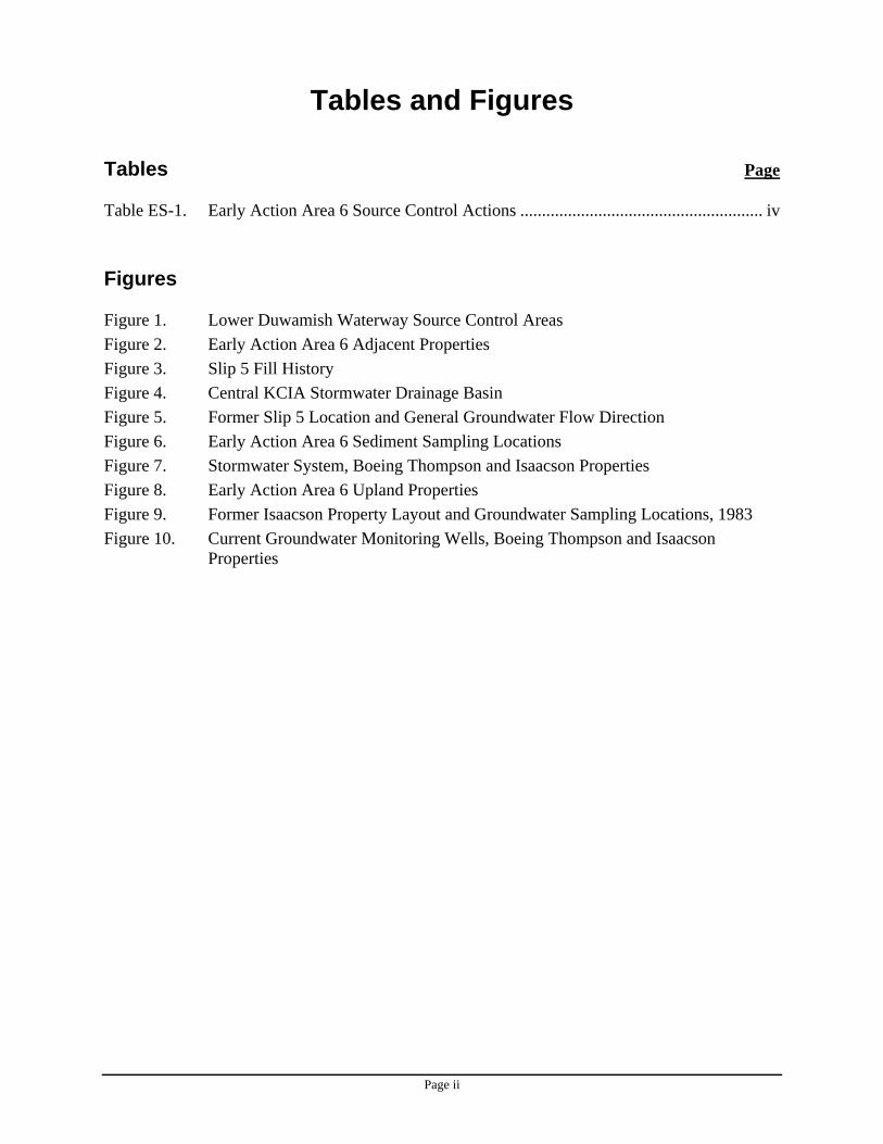
Tables and Figures Tables Page Table ES-1. Early Action Area 6 Source Control Actions ........................................................ iv Figures Figure 1. Lower Duwamish Waterway Source Control Areas Figure 2. Early Action Area 6 Adjacent Properties Figure 3. Slip 5 Fill History Figure 4. Central KCIA Stormwater Drainage Basin Figure 5. Former Slip 5 Location and General Groundwater Flow Direction Figure 6. Early Action Area 6 Sediment Sampling Locations Figure 7. Stormwater System, Boeing Thompson and Isaacson Properties Figure 8. Early Action Area 6 Upland Properties Figure 9. Former Isaacson Property Layout and Groundwater Sampling Locations, 1983 Figure 10. Current Groundwater Monitoring Wells, Boeing Thompson and Isaacson
Properties
Page iii
Executive Summary
The purpose of this Source Control Action Plan (SCAP) is to describe potential sources of contaminants to sediments along the Lower Duwamish Waterway (LDW) River Mile (RM) 3.7 to 3.9 East, and to identify actions necessary to prevent recontamination of sediment after cleanup. This SCAP is based on a thorough review of information pertinent to sediment recontamination, as documented in Lower Duwamish Waterway RM 3.7-3.9 East (Early Action Area 6) Summary of Existing Information and Identification of Data Gaps (SAIC 2008).
The LDW, located in Seattle and Tukwila, Washington, was added to the National Priorities List (Superfund) by the U.S. Environmental Protection Agency (EPA) on September 13, 2001. Chemicals of concern (COCs) found in waterway sediments include polychlorinated biphenyls (PCBs), polycyclic aromatic hydrocarbons (PAHs), mercury and other metals, and phthalates. These COCs may pose threats to people, fish, and wildlife.
In December 2000, EPA and the Washington State Department of Ecology (Ecology) entered into an Administrative Order on Consent with King County, the Port of Seattle, the city of Seattle, and The Boeing Company to perform a Remedial Investigation (RI) and Feasibility Study (FS) of sediment contamination in the waterway. EPA is the lead agency for the LDW RI/FS. Ecology is the lead agency for controlling current sources of pollution to the site, in cooperation with the city of Seattle, King County, the Port of Seattle, the city of Tukwila, and EPA.
Phase 1 of the LDW RI/FS (Windward 2003a) used existing data to identify potential human health and ecological risks, information needs, and high priority areas for cleanup. Seven candidate early action areas were identified (Windward 2003b); Early Action Area 6 (EAA-6) is one of these.
As part of source control efforts in the LDW, Ecology works with other members of the Source Control Work Group (SCWG) to develop SCAPs for areas of sediment contamination that will or may require cleanup. The SCAP for each of these sediment areas describes potential sources of sediment contaminants and the actions needed to control them, and evaluates whether ongoing sources are present that could recontaminate sediments after cleanup. In addition, the SCAPs describe source control actions that are planned or currently underway, and sampling and monitoring activities that will be conducted to identify additional sources.
Sections 1 and 2 of this SCAP provide background information about the LDW site and EAA-6. Arsenic, PAHs, PCBs, phthalates (bis[2-ethylhexyl]phthalate [BEHP], butylbenzyl phthalate [BBP]), benzyl alcohol, and dibenzofuran are considered to be the major COCs in EAA-6 sediments. While this SCAP focuses on these COCs, other chemicals that could result in sediment recontamination will be addressed as sources are identified.
Section 3 describes potential sources of contamination that may affect sediments in EAA-6, including outfalls, spills to the waterway, and releases from adjacent or upland properties; evaluates the significance of these potential sources; and identifies the actions that are planned or underway to control potential contaminant sources. Section 4 discusses monitoring activities that will be conducted to identify additional sources and assess progress. Section 5 describes how source control efforts will be tracked and reported.
Page iv
Table ES-1 lists the source control actions that have been identified for EAA-6. This table includes a brief description of the potential contaminant sources for each property, source control activities to be conducted, parties involved in source control actions for each property or task, and milestone/target dates for completion of the identified action items. The milestones and targets are best case scenarios based on consultation with the identified agencies or facilities. They reflect reasonably achievable schedules, and include the time required for planning, contracting, field work, laboratory analysis, and activities dependent on weather.
A removal action at EAA-6 was not scheduled at the time this SCAP was prepared.
Page v
Table ES-1. Early Action Area 6 Source Control Actions
Potential Sources Action Items Priority Responsible
Party Status Estimated
Completion Date
KC Airport SD #2/PS45 EOF (King County Storm Drain / Seattle Public Utilities [SPU] Emergency Overflow [EOF])
Collect and analyze sediment trap sample to evaluate concentrations of chemicals in the central KCIA drainage basin. Reinstall sediment trap and continue to sample as needed.
High SPU In Progress TBD
If COCs are present in the storm drain line, conduct source tracing to identify potential contaminant sources at KCIA. High King County,
SPU Planned 2009
Collect and analyze a solids sample from near the KC Airport SD #2/PS45 EOF outfall to evaluate whether chemicals are being discharged to EAA-6 via this outfall.
Medium King County, SPU Planned 2009
If COCs are present in the storm drain line downstream of CB-39, collect a solids sample from CB-39 on the Boeing Thompson property Medium Boeing Planned 2009
Potential ongoing source: Stormwater discharges to EAA-6 from the 48-inch KC Airport SD#2/PS45 EOF may represent an ongoing source of COCs to EAA-6. Discharges from two private outfalls at the Boeing Thompson property are addressed below.
Follow up on discharges observed from the KC Airport SD#2/PS45 EOF in 2007 and 2008, to identify sources and/or characteristics of discharges. High Ecology, SPU,
King County In Progress 2009
Boeing Isaacson Property
Negotiate an Agreed Order to conduct a MTCA RI/FS at the Boeing Isaacson/Thompson site. High Ecology,
Boeing Planned 2009
Characterize contaminant concentrations in subsurface soil near the former location of the Slip 5 outfall, to the north of the 48-inch storm drain line, and at other locations on the property as needed.
High Boeing Planned 2009
Conduct additional groundwater sampling as needed to characterize concentrations of arsenic and other COCs, including wet and dry season groundwater samples.
High Boeing Planned 2009
If COCs in soil and groundwater are present at concentrations that pose a risk of sediment recontamination, then develop a plan for controlling these contaminant sources.
High Ecology, Boeing Planned 2009
Potential historical source: High concentrations of arsenic have been identified in soil and groundwater at this property. These are likely associated with past site use, including placement of fill material in former Slip 5, arsenic-based wood treatment, or steel fabrication operations. Little data are available regarding concentrations of other COCs.
Collect bank samples and analyze them for COCs to evaluate potential for sediment recontamination from bank erosion. Medium
Boeing, Ecology, and/or Port of Seattle
(TBD)
Planned 2009
Page vi
Potential Sources Action Items Priority Responsible
Party Status Estimated
Completion DateInvestigate the condition of the 48-inch KC Airport SD#2/PS45 EOF that passes through the Boeing Isaacson property. Medium King County Planned 2009
Clarify the purpose, function, and configuration of the edge drains along the Boeing Isaacson shoreline. Low Boeing, Port of
Seattle In Progress 2009
Collect stormwater solids samples from the catch basins on the Boeing Isaacson property that drain to the Boeing Thompson stormwater system. Medium Boeing Planned 2009
Potential ongoing source: Contaminated soil and groundwater may result in transport of arsenic directly to EAA-6, via the Boeing Thompson storm drain system, or to the KC Airport SD#2/PS45 EOF outfall. Investigate the status and source of the unidentified outfall pipe located
near the Boeing Isaacson/Jorgensen Forge property boundary (Outfall 2063).
Low Boeing Planned 2009
Boeing Thompson Property
Conduct a comprehensive soil and groundwater investigation at this property, including groundwater monitoring at selected wells and evaluation of potential arsenic sources.
High Boeing Planned 2009
If COCs in soil and groundwater are present at concentrations that pose a risk of sediment recontamination, then develop a plan for controlling these contaminant sources.
High Ecology, Boeing Planned 2009
If needed, conduct additional tidal studies to address the tidal efficiency anomaly identified in well I-205 during a tidal study conducted in 2000, and to collect additional information on tidal influences.
Low Boeing Planned 2009
Collect bank soil samples and analyze them for COCs to evaluate the potential for sediment recontamination from bank erosion. Medium
Ecology, Boeing, and/or Port of Seattle
(TBD)
Planned 2009
Potential historical source: High concentrations of arsenic have been detected in groundwater at this property. These may be associated with past site use, including placement of fill material in former Slip 5, installation of arsenic-treated pilings, or other industrial operations at this site.
Review Boeing memorandum regarding findings associated with the two drainage pipes that may be discharging to the 8801 Site, and assess the potential that these discharges may contribute to recontamination of LDW sediments.
Medium Ecology In Progress June 2009
Collect storm drain solids samples from the Boeing Thompson stormwater system to assess concentrations of contaminants. Medium Boeing Planned 2009 Potential ongoing source:
Contaminated soil and groundwater may result in transport of arsenic directly to EAA-6 or to the Boeing Thompson storm drain system.
Conduct a source control inspection to clarify the nature of current activities at this property and to assess the current potential for sediment recontamination.
Low Ecology Planned 2009
Page vii
Potential Sources Action Items Priority Responsible
Party Status Estimated
Completion Date
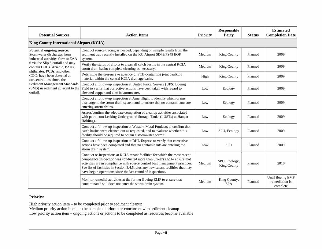
King County International Airport (KCIA)
Conduct source tracing as needed, depending on sample results from the sediment trap recently installed on the KC Airport SD#2/PS45 EOF system.
Medium King County Planned 2009
Verify the status of efforts to clean all catch basins in the central KCIA storm drain basin; complete cleaning as necessary. Medium King County Planned 2009
Determine the presence or absence of PCB-containing joint caulking material within the central KCIA drainage basin. High King County Planned 2009
Conduct a follow-up inspection at United Parcel Service (UPS) Boeing Field to verify that corrective actions have been taken with regard to elevated copper and zinc in stormwater.
Low Ecology Planned 2009
Conduct a follow-up inspection at Ameriflight to identify which drains discharge to the storm drain system and to ensure that no contaminants are entering storm drains.
Low Ecology Planned 2009
Assess/confirm the adequate completion of cleanup activities associated with petroleum Leaking Underground Storage Tanks (LUSTs) at Hangar Holdings.
Low Ecology Planned 2009
Conduct a follow-up inspection at Western Metal Products to confirm that catch basins were cleaned out as requested, and to evaluate whether this facility should be required to obtain a stormwater permit.
Low SPU, Ecology Planned 2009
Conduct a follow-up inspection at DHL Express to verify that corrective actions have been completed and that no contaminants are entering the storm drain system.
Low SPU Planned 2009
Conduct re-inspections at KCIA tenant facilities for which the most recent compliance inspection was conducted more than 3 years ago to ensure that activities are in compliance with source control best management practices. See list of facilities in Section 3.4.5, plus any new tenant facilities that may have begun operations since the last round of inspections.
Medium SPU, Ecology, King County Planned 2010
Potential ongoing source: Stormwater discharges from industrial activities flow to EAA-6 via the Slip 5 outfall and may contain COCs. Arsenic, PAHs, phthalates, PCBs, and other COCs have been detected at concentrations above the Sediment Management Standards (SMS) in sediment adjacent to the outfall.
Monitor remedial activities at the former Boeing EMF to ensure that contaminated soil does not enter the storm drain system. Medium King County,
EPA Planned Until Boeing EMF
remediation is complete
Priority:
High priority action item – to be completed prior to sediment cleanup Medium priority action item – to be completed prior to or concurrent with sediment cleanup Low priority action item – ongoing actions or actions to be completed as resources become available
Page viii
This page intentionally left blank.
Page ix
Acknowledgements
The Department of Ecology would like to thank the members of the interagency LDW Source Control Work Group and others for their contributions and support in developing this SCAP:
Beth Schmoyer, P.E., Senior Engineer, Seattle Public Utilities, City of Seattle
Bob Wright, Urban Waters Inspector, Washington State Department of Ecology, Water Quality Program
Bruce Tiffany, Water Quality Engineer, King County Wastewater Treatment Division
Byung Maeng, Environmental Engineer, Washington State Department of Ecology, Hazardous Waste and Toxics Reduction Program
Greg Stegman, Environmental Specialist, Washington State Department of Ecology, Water Quality Program
Dan Cargill, Source Control Project Manager, Washington State Department of Ecology, Toxics Cleanup Program
John Keeling, Environmental Engineer, Washington State Department of Ecology, Toxics Cleanup Program
Kathryn Lewis, Project Manager, Environmental Remediation, The Boeing Company
Kristine A. Flint, Environmental Scientist & Remedial Project Manager for Sediment Source Control, Region 10, U.S. EPA Environmental Cleanup Office
Lawrence E. McCrone, Managing Scientist, Exponent (on behalf of The Boeing Company)
Maura O’Brien, Hydrogeologist, Washington State Department of Ecology, Toxics Cleanup Program
Mike Jeffers, Urban Waters Inspector, Washington State Department of Ecology, Hazardous Waste and Toxics Reduction Program
Peter Dumaliang, Environmental Scientist III, King County International Airport
Richard Thomas, Source Control Specialist, Washington State Department of Ecology, Toxics Cleanup Program
Ron Timm, Hydrogeologist, Washington State Department of Ecology, Toxics Cleanup Program
Ryan Barth, P.E., Anchor Environmental (on behalf of Jorgensen Forge Corporation)
Page x
This page intentionally left blank.
Page xi
Acronyms/Abbreviations BBP butyl benzyl phthalate BEHP bis(2-ethylhexyl)phthalate bgs below ground surface BMP best management practice CB catch basin CMP corrugated metal pipe COC chemical of concern CSCSL Confirmed and Suspected Contaminated Sites List CSL Cleanup Screening Level CSO combined sewer overflow DMR Discharge Monitoring Report EAA Early Action Area EAA-6 Early Action Area 6 Ecology Washington State Department of Ecology EMF Electronics Manufacturing Facility EOF emergency overflow EPA United States Environmental Protection Agency FS Feasibility Study gpm gallons per minute HPAH high molecular weight polycyclic aromatic hydrocarbons IAAI Industrial Auto Auctions, Inc. KCIA King County International Airport KCIW King County Industrial Waste LDW Lower Duwamish Waterway LDWG Lower Duwamish Waterway Group LPAH low molecular weight polycyclic aromatic hydrocarbons LUST leaking underground storage tank MTCA Washington State Model Toxics Control Act NOAA National Oceanic and Atmospheric Administration NPDES National Pollutant Discharge Elimination System OC organic carbon PAH polycyclic aromatic hydrocarbon PCB polychlorinated biphenyl PSCAA Puget Sound Clean Air Agency RCRA Resource Conservation and Recovery Act RI Remedial Investigation RM river mile ROD Record of Decision SAIC Science Applications International Corporation SCAP Source Control Action Plan SCWG Source Control Work Group SD storm drain SMS Sediment Management Standards SPCC Spill Prevention, Control and Countermeasures SPU Seattle Public Utilities SQS Sediment Quality Standard
Page xii
Acronyms/Abbreviations (Continued) SSCC South Seattle Community College SVOC semivolatile organic compound SWPPP Stormwater Pollution Prevention Plan TOC total organic carbon VOC volatile organic compound UPS United Parcel Service WAC Washington Administrative Code WQ Water Quality WQS Water Quality Standards WWTP wastewater treatment plant
Page 1
1.0 Introduction
This Source Control Action Plan (SCAP) describes potential sources of contamination that may affect sediments in and adjacent to the Early Action Area 6 (EAA-6) Source Control Area.1 The purpose of this plan is to evaluate the significance of these sources and to determine if actions are needed to minimize the potential for recontamination of EAA-6 sediments after cleanup. In addition, this SCAP describes:
• Source control actions/programs that are planned or currently underway, • Sampling and monitoring activities that will be conducted to identify additional sources
and assess progress, and • How these source control efforts will be tracked and reported.
The information in this document was obtained from a variety of sources, including the following documents:
• Lower Duwamish Waterway, RM 3.7-3.9 East, Early Action Area 6 - Summary of Existing Information and Identification of Data Gaps, Science Applications International Corporation (SAIC), May 2008, located on Ecology’s website: http://www.ecy.wa.gov/programs/tcp/sites/lower_duwamish/sites/early_action_area_6/dataGaps/data_gaps_report.htm
• Lower Duwamish Waterway Source Control Strategy, Washington State Department of Ecology, January 2004, located on Ecology’s website: http://www.ecy.wa.gov/pubs/0409043.pdf
1.1 Document Organization
Section 1 of this SCAP describes the Lower Duwamish Waterway (LDW) site, the strategy for source control, and the responsibilities of the public agencies involved in source control for the LDW. Section 2 provides background information on EAA-6, including a description of the chemicals of concern (COCs) for sediments. Section 3 provides an overview of potential sources of contaminants that may affect EAA-6 sediments, including outfalls, spills, properties adjacent to EAA-6, and upland properties. Section 3 also describes actions planned or currently underway to control potential sources of contaminants, while Sections 4 and 5 describe monitoring and tracking/reporting activities, respectively. References are listed in Section 6, and figures are presented at the end of the document.
As new information about the sites and potential sources discussed in this document becomes available and as source control progress is made, Ecology will update the information in this SCAP as needed. Up-to-date information on the status of source control actions is summarized in the LDW Source Control Status Reports (Ecology 2007a, 2008a, 2008c, and as updated).
1 This SCAP incorporates data published through February 28, 2009. Section 5, Tracking and Reporting of Source Control Activities, describes how newer data will be disseminated.
Page 2
1.2 Lower Duwamish Waterway Site
The LDW Site is the downstream portion of the Duwamish River, extending from the southern tip of Harbor Island to just south of Turning Basin 3 (Figure 1). It is a major shipping route for bulk and containerized cargo. Most of the upland areas adjacent to the LDW have been developed for industrial and commercial operations. These include cargo handling and storage, marine construction, boat manufacturing, marina operations, concrete manufacturing, paper and metals fabrication, food processing, and aerospace manufacturing. In addition to industry, the river is used for fishing, recreation, and wildlife habitat. Residential areas near the waterway include the South Park and Georgetown neighborhoods. Beginning in 1913, this portion of the Duwamish River was dredged and straightened to promote navigation and industrial development, resulting in the river’s current form. Shoreline features within the waterway include constructed bulkheads, piers, wharves, buildings extending over the water, and steeply sloped banks armored with riprap or other fill materials (Weston 1999). This development left intertidal habitats dispersed in relatively small patches, with the exception of Kellogg Island, which is the largest contiguous area of intertidal habitat remaining in the Duwamish River (Tanner 1991). Over the past 20 years, public agencies and volunteer organizations have worked to restore intertidal and subtidal habitat to the river. Some of the largest restoration projects are at Herring House Park/Terminal 107, Turning Basin 3, Hamm Creek, and Terminal 105.
The presence of chemical contamination in the LDW has been recognized since the 1970s (Windward 2003a). In 1988, the United States Environmental Protection Agency (EPA) investigated sediments in the LDW as part of the Elliott Bay Action Program. Problem chemicals identified by the EPA study included metals, polycyclic aromatic hydrocarbons (PAHs), polychlorinated biphenyls (PCBs), phthalates, and other organic compounds. In 1999, EPA completed a study of approximately 6 miles of the waterway, from the southern tip of Harbor Island to just south of the turning basin near the Norfolk combined sewer overflow (Weston 1999). This study confirmed the presence of PCBs, PAHs, phthalates, mercury, and other metals. These contaminants may pose threats to people, fish, and wildlife.
In December 2000, EPA and the Washington State Department of Ecology (Ecology) signed an Administrative Order on Consent with King County, the Port of Seattle, the city of Seattle, and The Boeing Company, collectively known as the Lower Duwamish Waterway Group (LDWG). Under the agreement, the LDWG is conducting a Remedial Investigation (RI) and Feasibility Study (FS) of the LDW to assess risks to human health and the environment and to evaluate cleanup alternatives. The RI for the site is being done in two phases. Results of Phase 1 were published in July 2003 (Windward 2003a). The Phase 1 RI used existing data to characterize the nature and extent of chemical distributions in LDW sediments, develop preliminary risk estimates, and identify candidate sites for early cleanup action. The Phase 2 RI is currently underway and is designed to fill critical data gaps identified in Phase 1. Based on the results of the Phase 2 RI, additional areas for cleanup may be identified. During Phase 2, an FS is being conducted that will address cleanup options for contaminated sediments in the LDW.
On September 13, 2001, EPA added the LDW to the National Priorities List. This is EPA’s list of hazardous waste sites that warrant further investigation and cleanup under Superfund. Ecology added the site to the Washington State Hazardous Sites List on February 26, 2002.
Page 3
An interagency Memorandum of Understanding, signed by EPA and Ecology in April 2002 and updated in April 2004, divides responsibilities for the site (EPA and Ecology 2002, EPA and Ecology 2004). EPA is the lead agency for the LDW RI/FS, while Ecology is the lead agency for source control issues.
In June 2003, the Technical Memorandum: Data Analysis and Candidate Site Identification (Windward 2003b) was issued. Seven candidate sites were recommended for early action (Figure 1). The early action areas (EAAs) are:
• Area 1: Duwamish/Diagonal combined sewer overflow (CSO) and storm drain (SD) • Area 2: West side of the waterway, just south of the First Avenue S. Bridge,
approximately 2.2 miles from the south end of Harbor Island • Area 3: Slip 4, approximately 2.8 miles from the south end of Harbor Island • Area 4: South of Slip 4, on the east side of the waterway, just offshore of the Boeing
Plant 2 and Jorgensen Forge properties, approximately 2.9 to 3.7 miles from the south end of Harbor Island
• Area 5: Terminal 117 and adjacent properties, approximately 3.6 miles from the south end of Harbor Island, on the west side of the waterway
• Area 6: East side of the waterway, approximately 3.8 miles from the south end of Harbor Island, in the area of former Slip 5
• Area 7: Norfolk CSO/SD, on the east side of the waterway, approximately 4.9 to 5.5 miles from the south end of Harbor Island
Of the seven recommended EAAs, five either had sponsors to begin investigations or were already under investigation by a member or group of members of the LDWG. These five sites are: Slip 4, Terminal 117, Boeing Plant 2, Duwamish/Diagonal CSO/SD, and Norfolk CSO/SD. EPA is the lead agency for managing cleanup at Terminal 117 and Slip 4. The other three early action cleanup projects were begun before the current LDW RI/FS was initiated. Cleanup at Boeing Plant 2, under EPA Resource Conservation and Recovery Act (RCRA) management, is currently in the planning stage. The Duwamish/Diagonal CSO/SD and Norfolk CSO/SD cleanups are under King County management as part of the Elliott Bay-Duwamish Restoration Program. Cleanup at Duwamish/Diagonal was partially completed in March 2004; a partial sediment cleanup was conducted at Norfolk CSO/SD in 1999. Early action cleanups may involve members of the LDWG or other parties as appropriate. Planning and implementation of early action cleanups is being conducted concurrently with the Phase 2 investigation.
In 2007, Ecology, in consultation with EPA, identified eight additional source control areas based on available sediment data, size of the upland basin draining to the source control area, and general knowledge about facilities operating in the basin. In February 2008, Ecology identified the areas of the LDW not covered by a SCAP or planned SCAP. Using the same criteria as in 2007, eight additional potential source control areas were added to the list (Ecology 2008a). The seven EAAs and 16 additional source control areas are shown in Figure 1.
Page 4
Further information about the LDW can be found at: http://yosemite.epa.gov/r10/cleanup.nsf/sites/lduwamish and http://www.ecy.wa.gov/programs/tcp/sites/lower_duwamish/lower_duwamish_hp.html.
1.3 LDW Source Control Strategy
The LDW Source Control Strategy (Ecology 2004) describes the process for identifying source control issues and implementing effective source controls for the LDW. The plan is to identify and manage sources of potential contamination and recontamination in coordination with sediment cleanups. The goal of the strategy is to minimize the potential for recontamination of sediments to levels exceeding the LDW sediment cleanup goals and the Washington State Sediment Management Standards (SMS).2 Existing administrative and legal authorities will be used to perform inspections and require necessary source control actions.
The strategy is being implemented through the development of a series of detailed, area-specific SCAPs that will be coordinated with sediment cleanups, beginning with the EAAs. Each SCAP will document what is known about the area, the potential sources of recontamination, actions taken to address them, and how to determine when adequate source control is achieved for an area. Because the scope of source control for each site will vary, it will be necessary to adapt each plan to the specific situation at that site. The success of this strategy depends on the coordination and cooperation of all public agencies with responsibility for source control in the LDW area, as well as prompt compliance by the businesses that must make necessary changes to control releases from their properties.
The source control strategy focuses on controlling contamination that affects LDW sediments. It is based on the principles of source control for sediment sites described in EPA’s Principles for Managing Contaminated Sediment Risks at Hazardous Waste Sites; February 12, 2002 (EPA 2002), and Ecology’s SMS. The first principle is to control sources early, starting with identifying all ongoing sources of contaminants to the site. EPA’s Record of Decision (ROD) for the site will require that sources of sediment contamination to the entire site be evaluated, investigated, and controlled as necessary. Dividing source control work into specific SCAPs and prioritizing those plans to coordinate with sediment cleanups will address the guidance and regulations and will be consistent with the selected remedial actions in the EPA ROD.
Source control priorities are divided into four tiers. Tier 1 consists of source control actions associated with EAA sediment cleanups. Tier 2 consists of source control actions associated with cleanup areas identified in Phase 2 of the RI/FS and EPA’s ROD. Tier 3 consists of source control necessary to prevent future sediment contamination from basins that may not drain directly to an identified sediment cleanup area. Tier 4 consists of source control necessary to address any recontamination identified by post-cleanup sediment monitoring (Ecology 2008a). This document is a SCAP for a Tier 1 Source Control Area.
Further information about the LDW Source Control Strategy can be found at: http://www.ecy.wa.gov/biblio/0409052.html and http://www.ecy.wa.gov/programs/tcp/sites/lower_duwamish/lower_duwamish_hp.html.
2 Washington Administrative Code (WAC) 173-204
Page 5
1.4 Source Control Work Group
The primary public agencies responsible for source control for the LDW are Ecology, the city of Seattle, King County, Port of Seattle, city of Tukwila, and EPA. In order to coordinate among these agencies, Ecology formed the Source Control Work Group (SCWG) in January 2002. The purpose of the SCWG is to share information, discuss strategy, actively participate in developing SCAPs, jointly implement source control measures, and share progress reports on source control activities for the LDW area. The monthly SCWG meetings are chaired by Ecology. All final decisions on source control actions and completeness will be made by Ecology, in consultation with EPA, as outlined in the April 2004 Ecology/EPA LDW Memorandum of Understanding (EPA and Ecology 2004).
Other public agencies with relevant source control responsibilities include the Washington State Department of Transportation, Puget Sound Clean Air Agency, and the Seattle/King County Department of Public Health. These agencies are invited to participate in source control with the SCWG as appropriate (Ecology 2004).
Page 6
This page intentionally left blank.
Page 7
2.0 Early Action Area 6
EAA-6 is located along the eastern side of the LDW Superfund Site between 3.7 and 3.9 miles from the southern tip of Harbor Island (Figure 1). Sediments in EAA-6 have accumulated chemical contaminants from several sources, both historical and potentially ongoing. These chemicals may have entered the LDW through direct discharges, spills, bank erosion, groundwater discharges, surface water runoff, atmospheric deposition, or other non-point source discharges.
EAA-6 is located adjacent to a former tidal marsh area that was eliminated when the Duwamish River was straightened and channelized to form the current LDW in the late 1800s and early 1900s. Available information indicates that a meander of the Duwamish River once flowed in a west-to-east direction near the current Boeing Isaacson and Thompson property boundaries before continuing its generally northward flow direction (ERM 2000a). Extensive dredge and fill efforts in the early 1900s placed the LDW channel in its present position west of the Boeing Isaacson and Boeing Thompson properties (Figure 2). A portion of the former river channel formed Slip 5 as shown in Figure 3.
The EAA-6 source control area includes two properties that are located adjacent to EAA-6: Boeing Isaacson and Boeing Thompson (Figure 2). These properties are bounded by Jorgensen Forge Corporation (Jorgensen Forge) to the north, East Marginal Way S. and King County International Airport (KCIA) to the east, and the 8801 Site3, also known as the former PACCAR site or Kenworth Motor Truck Company/Insurance Auto Auctions, Inc. (IAAI), to the south.
The source control area includes the central portion of KCIA. Stormwater from this area drains to EAA-6 through a 48-inch public storm drain outfall (Figure 4). This public storm drain outfall also serves as an emergency overflow (EOF) for Pump Station 45 on the city of Seattle’s sanitary sewer system.
Filling in of portions of Slip 5 occurred between the 1930s and the mid-1960s (Figure 3). By about 1966, Slip 5 was completely filled in as part of site development at Boeing Thompson (Dames & Moore 1983). Reportedly, the fill material consisted of silty sand with significant amounts of slag, fire bricks, and miscellaneous construction materials (ERM 2000a).
Groundwater in the vicinity of EAA-6 is unconfined and generally flows toward the LDW and the former Slip 5 (Figure 5), with water levels ranging from 11 to 12 feet below ground surface (Landau 1988a). According to a tidal study conducted at the Boeing Isaacson property in August 2000, significant tidal effects on groundwater were observed to a distance of approximately 400 feet from the LDW. While tidal effects were observed at points further inland, the tidally-induced deflection of groundwater flow at these locations was less significant (ERM 2000b).
2.1 Chemicals of Concern in Sediment
Several environmental investigations have included the collection of sediment data near EAA-6, including Boeing site characterization studies (Exponent 1998), a National Oceanic and 3 The 8801 Site is currently owned by Merrill Creek Holdings, LLC.
Page 8
Atmospheric Administration (NOAA) sediment characterization of the Duwamish River (NOAA 1998), an EPA Site Inspection (Weston 1999), and the LDW Phase 2 RI (Windward 2005a, 2005b, 2007a, 2007b).
Sediment data for EAA-6 are detailed in Summary of Existing Information and Identification of Data Gaps (SAIC 2008), referred to in this document as the EAA-6 Data Gaps Report. Chemical data were compared to the SMS, which include both the Sediment Quality Standards (SQS) and Cleanup Screening Levels (CSLs) (Chapter 173-204 WAC). Sediments that meet the SQS criteria have a low likelihood of adverse effects on sediment-dwelling biological resources. However, an exceedance of the SQS numerical criteria does not necessarily indicate adverse effects or toxicity, and the degree of SQS exceedance does not correspond to the level of sediment toxicity. The CSL is greater than or equal to the SQS and represents a higher level of risk to benthic organisms than SQS levels. The SQS and CSL values provide a basis for identifying sediments that may pose a risk to some ecological receptors. The SMS for most organic chemicals are based on total organic carbon (OC)-normalized concentrations.
As described in the EAA-6 Data Gaps Report, surveys conducted during 1998 and 1999 included collection of surface sediment samples at 20 locations and subsurface sediment samples at one location within EAA-6. More recently, sediment sampling conducted as part of the Phase 2 RI included 10 surface sediment samples collected during three rounds of surface sediment sampling in 2005/2006 and seven samples collected from two coring locations in 2006. Sediment sampling locations are shown in Figure 6.
COCs were identified based on the results of sediment sampling conducted at EAA-6. Chemicals that exceeded the SQS in at least one surface or subsurface sediment sample offshore of the EAA-6 source control area are considered COCs. The greatest SQS exceedances were observed for arsenic at locations SS114 (surface sediment) and SC50a (subsurface sediment), adjacent to Boeing Isaacson (Figure 6).
The following chemicals are considered to be COCs at EAA-6 with regard to potential sediment recontamination:
Chemical of Concern (COC) Surface Sediment Subsurface Sediment
Metals: Arsenic
PAHs: Acenaphthene
Benzo(a)anthracene
Benzo(a)pyrene
Benzo(b)fluoranthene
Benzo(g,h,i)perylene
Benzo(k)fluoranthene
Benzofluoranthenes (total)
Chrysene
Page 9
Chemical of Concern (COC) Surface Sediment Subsurface Sediment
Dibenzo(a,h)anthracene
Fluoranthene
Fluorene
Indeno(1,2,3-cd)pyrene Phenanthrene Total HPAH
Total LPAH
Phthalates: Bis(2-ethylhexyl)phthalate (BEHP)
Butyl benzyl phthalate (BBP)
Other SVOCs: Benzoic acid
Benzyl alcohol
Dibenzofuran
PCBs: PCBs (total)
Indicates maximum detected chemical concentration in sediment exceeds the SQS only Indicates maximum detected chemical concentration in sediment exceeds both the SQS and CSL
2.2 Potential Pathways to Sediment
Transport pathways that could contribute to the recontamination of EAA-6 sediments following remedial activities include discharges via outfalls, surface runoff (sheet flow) from adjacent properties, bank erosion, groundwater discharges, air deposition, and spills directly to the LDW. These pathways are described below, and are discussed in more specific detail in Section 3.
2.2.1 Discharges via Outfalls
Discharges to the LDW may occur from public or private storm drain systems, CSOs, and EOFs.
Public or Private Storm Drains
The LDW area is served by a combination of separated storm drain and sanitary sewers, and combined sewer systems. Storm drains convey stormwater runoff collected from streets, parking lots, roof drains, and residential, commercial, and industrial properties to the waterway. In the LDW, there are both public and private storm drain systems. Most of the waterfront properties are served by privately owned systems that discharge directly to the waterway. The other upland areas are served by a combination of private and publicly owned systems.
Storm drains entering the LDW carry runoff generated by rain and snow. A wide range of chemicals may become dissolved or suspended in runoff as rainwater flows over the land. Urban

Page 10
areas may accumulate particulates, dust, oil, asphalt, rust, rubber, metals, pesticides, detergents, or other materials as a result of urban activities. These can be flushed into storm drains during wet weather. Storm drains can also convey materials from businesses with permitted discharges (i.e., National Pollutant Discharge Elimination System [NPDES] industrial stormwater permits), vehicle washing, runoff from landscaped areas, erosion of contaminated soil, groundwater infiltration, and materials illegally dumped into the system.
The sanitary sewer system collects municipal and industrial wastewater from throughout the LDW area and conveys it to King County’s West Point Wastewater Treatment Plant (WWTP), where it is treated before being discharged to Puget Sound. The smaller trunk sewer lines, which collect wastewater from individual properties, are owned and operated by the individual municipalities (e.g., cities of Seattle and Tukwila) and local sewer districts. The large interceptor system that collects wastewater from the trunk lines is owned and operated by King County. A King County interceptor extends along the east side of East Marginal Way S.
Four outfalls are present in the EAA-6 area, including one publicly-owned outfall, two private outfalls, and one unidentified outfall (Figure 2). The publicly-owned outfall, referred to in this report as KC Airport SD #2/PS45 EOF, discharges stormwater runoff from 237 acres of the central portion of KCIA (KCIA Drainage Basin 2), including aircraft maintenance and fueling areas. In addition, the outfall serves as an EOF for Pump Station 45 on the city of Seattle’s sanitary sewer system (see discussion of EOFs below). The two private outfalls are owned by Boeing and discharge stormwater from the Boeing Thompson and Isaacson properties. The unidentified outfall is a pipe that was observed protruding from a bulkhead near the Boeing Isaacson property during a 2003 outfall survey of the LDW (Herrera 2004). Any contaminants discharged via these outfalls could directly affect sediments.
CSOs and EOFs
Some areas of the LDW are served by combined sewer systems, which carry both stormwater and municipal/industrial wastewater in a single pipe. These systems were generally constructed before about 1970 because it was less expensive to install a single pipe rather than separate storm and sanitary systems. Under normal rainfall conditions, wastewater and stormwater are conveyed through this combined sewer pipe to a wastewater treatment facility. During large storm events, however, the total volume of wastewater and stormwater can sometimes exceed the conveyance and treatment capacity of the combined sewer system. When this occurs, the combined sewer system is designed to overflow through relief points, called CSOs. The CSOs prevent the combined sewer system from backing up and creating flooding problems.
Untreated municipal/industrial wastewater and stormwater can potentially be discharged through CSOs to the LDW during these storm events. The city of Seattle owns and operates the local sanitary sewer collectors and trunk lines, while King County owns and operates the larger interceptor lines that transport flow from the local systems to the West Point WWTP. The City’s CSO network has its own NPDES permit; the County’s CSOs are administered under the NPDES permit established for the West Point WWTP.
An EOF is a discharge that can occur from either the combined or sanitary sewer systems that is not necessarily related to storm conditions and/or system capacity limitations. EOF discharges

Page 11
typically occur as a result of mechanical issues (e.g., pump station failures) or when transport lines are blocked; pump stations are operated by both the City and County. Pressure relief points are provided in the drainage network to discharge flow to an existing storm drain or CSO pipe under emergency conditions to prevent sewer backups. EOF events are not covered under the City’s or County’s existing CSO wastewater permits.
The outfall for KC Airport SD#2, which discharges storm drainage from 237 acres of the central portion of KCIA, also serves as an EOF for Pump Station 45 on the city of Seattle’s sanitary sewer system. No CSOs discharge to the LDW within EAA-6.
NPDES Permits
Based on a comprehensive survey of outfall or outfall-like structures terminating in the LDW conducted in 2004 by SPU, along with information from the Phase 1 RI and updated information from Ecology, EPA, the city of Seattle, the city of Tukwila, the Port of Seattle, King County, and Boeing, approximately 250 outfalls were identified within the LDW study area (Windward 2007c). Many of these discharges are permitted under the NPDES. There are two types of NPDES permits that are applicable to EAA-6:
Phase I Municipal Stormwater Permit
Stormwater runoff collected in municipal separate storm sewers and discharged to surface waters is required to have a NPDES permit under the federal Clean Water Act. Phase I of the municipal stormwater program went into effect in 1990 and applies to municipalities with populations of more than 100,000, including the city of Seattle and King County.
The original Phase I permit was issued in 1995; it was reissued on January 17, 2007. The permit requires that all permittees characterize stormwater quality at three different locations within their storm drain system. Each location is designed to represent a unique land use (e.g., commercial, industrial, and high or low density residential). Different permittees have been assigned different land use types. Monitoring may be conducted at an outfall or within the drainage basin to isolate the specific type of land use. Complete monitoring requirements are in Special Condition S.8 of the permit, which is available online at: http://www.ecy.wa.gov/programs/wq/stormwater/municipal/phase_I_permit/ph_i-permit.html.
In addition to the expanded monitoring described above, the Phase I permit also contains more traditional requirements such as system maintenance, business inspections, education/outreach, best management practices (BMPs), and the development of municipal stormwater regulations/code.
Before this permit was reissued, and as the Superfund sediment RI process was beginning, the city of Seattle and King County formed a joint program to conduct source control inspections throughout the 20,000 acres of the LDW drainage basin. The City’s source control authorities come from the City Stormwater, Grading, and Drainage Control Code (SMC 22.800), which was established in part to meet the requirements of its NPDES municipal stormwater permit. King County’s source control authorities stem from their authorized pretreatment program and attendant industrial and hazardous waste management programs, as well as from the Phase I NPDES requirements.
Page 12
The joint LDW city-county source control program initiated in 2003 is an aggressive effort to reduce the amount of pollution entering public storm drains and sanitary/combined sewer systems that discharge to the LDW. LDW source control activities generally go beyond what is required under the NPDES program. In particular, the level of source tracing and characterization being conducted through the joint program far exceeds what is required by NPDES.
Within the EAA-6 source control area, the Phase I permit covers stormwater discharges to the KC Airport SD#2/PS45 EOF (Outfall 2062 on Figure 2).
Industrial Stormwater General Permit
This permit covers approximately 103 industries within the natural drainage basin of the LDW. Coverage under the Industrial Stormwater General Permit requires a facility to monitor its stormwater discharge for copper, zinc, oils, and total suspended solids. Within the EAA-6 source control area, the permit covers stormwater discharges from the Boeing Isaacson/Thompson property (SO3-000148, LDW outfalls 2061 and 2077 on Figure 2), United Parcel Service (UPS) Boeing Field (SO3-000434), Ameriflight, Inc. (SO3-002830), and DHL Express (SO3-004602).
2.2.2 Surface Runoff (Sheet Flow)
In areas lacking collection systems, spills or leaks on properties adjacent to the LDW could flow directly over impervious surfaces or through creeks and ditches to the waterway. The Boeing Thompson property and portions of the Boeing Isaacson property are served by a storm water drainage system (Figure 7), which reduces the potential for surface runoff to the LDW. The Boeing Isaacson property is currently vacant, but may undergo future development activity which could result in transport of residual contaminants in soil to the LDW.
2.2.3 Groundwater Discharges
Contaminants in soil resulting from spills and releases to adjacent (and possibly upland) properties may be transported to groundwater and subsequently be released to the LDW. Seeps have been sampled along the LDW shoreline near the northern property boundary of Boeing Isaacson (southern end of the Jorgensen Forge property). Copper was detected in a seep water sample at a concentration of 8.16 ug/L (Seep 20 as listed in Windward 2004), above the marine chronic water quality standard (WQS) of 3.1 ug/L. In addition, arsenic contamination of groundwater has been documented in this area since the early 1980s. Groundwater discharges represent a potential pathway for transport of contaminants to the LDW.
2.2.4 Bank Erosion
The banks of the LDW shoreline are susceptible to erosion by wind and surface water, particularly in areas where banks are steep. Shoreline armoring and the presence of vegetation reduce the potential for bank erosion. Contaminants in soils along the banks of EAA-6 could be released directly to sediments via erosion. A wooden bulkhead is located along the boundary between the Boeing Thompson/Isaacson properties and the waterway; rock and rubble fill

Page 13
material have been placed behind the bulkhead. A portion of the bulkhead is within the commercial waterway.
2.2.5 Atmospheric Deposition
Atmospheric deposition occurs when air pollutants enter the LDW directly or through stormwater. Air pollutants may be generated from point or non-point sources. Point sources include industrial facilities, and air pollutants may be generated from painting, sandblasting, loading/unloading of raw materials, and other activities, or through industrial smokestacks. None of the properties within the EAA-6 source control area are currently regulated as point sources of air emissions.
Non-point sources include dispersed sources such as vehicle emissions, aircraft exhaust, and off-gassing from common materials such as plastics. Air pollutants may be transported over long distances by wind, and can be deposited to land and water surfaces by precipitation or particle deposition. Air traffic at KCIA may result in significant air pollutant emissions; contaminants may be transported through the air and deposited at EAA-6 or in areas that drain to the LDW. While this transport mechanism may be significant, no information is currently available to assess the potential for EAA-6 sediment recontamination associated with air emissions from airport operations.
Ecology is currently evaluating how best to address the atmospheric deposition pathway with regard to LDW source control. Since air pollutant sources are not confined to any single drainage, the atmospheric deposition pathway must be managed in a larger context. Information on recent and ongoing atmospheric deposition studies in the LDW area is summarized in the LDW Source Control Status Report (Ecology 2007a, 2008a, 2008c, and subsequent updates); Ecology will continue to monitor these efforts.
2.2.6 Spills to the LDW
Near-water and over-water activities have the potential to impact adjacent sediments from spills of material containing contaminants of concern. No over-water activities are currently conducted at the Boeing Isaacson or Boeing Thompson property, and spills near the shoreline at the Boeing Thompson property would be contained within the site stormwater system. The Boeing Isaacson property is currently vacant.

Page 14
This page intentionally left blank.
Page 15
3.0 Potential Sources of Sediment Recontamination
Potential sources of sediment recontamination are described in detail in the EAA-6 Data Gaps Report (SAIC 2008). This section summarizes the information on public and private outfalls (Section 3.1), adjacent properties (Sections 3.2 and 3.3), and upland properties (Section 3.4).
Two properties are located adjacent to EAA-6 (Figure 2):
• Boeing Isaacson property • Boeing Thompson property
These properties may contribute contaminants to EAA-6 sediments through stormwater discharge, discharge of contaminated groundwater, bank erosion/leaching, and surface runoff/spills.
As with many properties along the LDW, there is a portion of uplands adjacent to the Boeing Isaacson property that is within the boundaries of the former Commercial Waterway District No. 1, King County. The assets of the Commercial Waterway District were transferred to the Port of Seattle in 1963. Boeing asserts that the Port should be responsible for all investigations on this parcel. A case decided by the Washington State Supreme Court in 1963 appears to limit the authority of the Commercial Waterway District and consequently the Port over this type of land. Ecology will ask the Office of the Attorney General for advice on how best to address such parcels.
Upland properties may also be a source of contaminants to EAA-6 sediments. The central portion of KCIA is located to the east and northeast of Boeing Isaacson and Boeing Thompson and lies within the EAA-6 stormwater drainage basin, as shown in Figure 4. The following KCIA tenants are located within the EAA-6 stormwater drainage basin (Figure 8):
• UPS Boeing Field • Ameriflight, Inc. (Hangar 5) • Hangar Holdings, Inc. (Vulcan, TAG Aviation, Former Shell Oil) • Western Metal Products, Inc. • Galvin Flying Services • Nordstrom, Inc. • DHL Express (ABX Air, Airborne Express) • Airwest Repair Services (Airwest Sales & Service, Bicknell) • BAX Global, Inc. • Clay Lacy Aviation (Gateway USA, Flight Center, Flightcraft Inc. Seattle) • Wings Aloft / Southeast “T” Hangars • Aeroflight National Charter Network (Seattle Air Corp., BFI Holdings) • South Seattle Community College (SSCC) Aviation Department
In addition, the former Boeing Electronics Manufacturing Facility (EMF) is partially located within the area from which stormwater drains to the KC Airport SD #2/PS45 EOF. At the time the EAA-6 Data Gaps Report was prepared, the following additional KCIA tenants were

Page 16
conducting operations in this area: Caliber Inspection, Inc.; GSM, Inc.; Federal Express Perimeter Rd.; Galvin Flying Services sublease to Clay Lacy Aviation; and Federal Drug Enforcement Administration. These businesses and/or agencies are no longer KCIA tenants. KCIA tenant facilities that were identified as potential sources of EAA-6 sediment recontamination in the EAA-6 Data Gaps Report (SAIC 2008) are discussed in Section 3.4.
Potential contaminant transport pathways for upland properties include stormwater discharge to KC Airport SD #2/PS45 EOF, infiltration of contaminated groundwater into the stormwater system, and transport and discharge of COCs in groundwater to the LDW.
3.1 Outfalls
SPU’s 2003 outfall survey identified four pipes associated with the Boeing Isaacson and Thompson properties (Herrera 2004). From north to south, these are:
Outfall Name Diameter/Material Outfall Type (Owner)
2063 – Boeing Isaacson 4-inch steel Unidentified SD
2062 – KC Airport SD #2/PS45 EOF 48-inch CMP Public: SPU EOF/King County SD
2061 – Boeing Thompson (Outfall A)
24-inch steel Permitted private SD (Boeing Thompson)
2077 – Boeing Thompson (Outfall B)
Steel; diameter not listed
Permitted private SD (Boeing Thompson)
The outfall locations are shown in Figure 2, and they are discussed in more detail below.
3.1.1 KC Airport SD #2/PS45 EOF
Stormwater from approximately 237 acres of the central portion of KCIA (KCIA Drainage Basin 2) drains to a lift station, located east of the Boeing Isaacson and Thompson properties on the east side of East Marginal Way S. The lift station pumps stormwater from KCIA Outfall #2 to the KC Airport SD #2/PS45 EOF outfall via a 48-inch corrugated metal pipe (CMP).
The outfall also serves as an EOF for Pump Station 45 on the city of Seattle’s sanitary sewer system. An EOF is a discharge from either the combined or sanitary sewer systems that occurs due to mechanical failure (e.g., pump station failures or pipe blockages), and is not related to storm conditions and/or system capacity limitations. Relief points are provided in the network to discharge flow under emergency conditions to prevent sewer backups. Pump station 45 is equipped with an emergency generator to prevent overflows resulting from power system failures. No information was available regarding the frequency of overflows from Pump Station 45 (if any).
In addition, KC Airport SD #2/PS45 EOF receives runoff from a small area at the northwest corner of the Boeing Thompson property via catch basin (CB) 39. CB39 and a small 6-inch stub connect to the King County storm drain system on the Thompson site just before the terminus of the storm drain at the LDW (Figure 7; Boeing 2001).

Page 17
In the past, KC Airport SD #2/PS45 EOF drained to the head of Slip 5 at the approximate location shown in Figure 9. In approximately 1966, prior to filling of Slip 5, the Boeing Company extended the 48-inch diameter storm sewer along the southern edge of the Isaacson property out to the LDW (Dames & Moore 1983). In 1990, in anticipation of redevelopment of the Isaacson parcel, the King County storm drain line was moved to its current location on the northern side of the property, as shown in Figure 4.
A storm drain solids sample was collected from a manhole located at the lift station on the east side of East Marginal Way S. as part of the Elliott Bay Action Program in the mid-1980s. Arsenic (170 mg/kg), cadmium (23.2 mg/kg), chromium (1,010 mg/kg), and mercury (1.1 mg/kg) were detected at concentrations above the SQS in this sample4 (Tetra Tech 1988).
SPU installed a sediment trap in this storm drain system in a manhole just east of East Marginal Way S in October 2008 (Figure 4); the first sample was scheduled to be collected in February/March 2009, with a second round of samples scheduled for collection from this sediment trap in August/September 2008.
Discharges unrelated to storm events have been observed at the KC Airport SD #2/PS45 EOF outfall on numerous occasions. On June 29, 2006, an unknown discharge of turbid water was reported to be flowing from this outfall (Ecology 2006). No additional information about this discharge was available.
On July 8, 2007, a kayaker reported a discharge of a “sudsy, foul smelling water” from this outfall (King County 2007). EPA subsequently collected a sample of the orange-colored discharge, and analyzed it for total suspended solids, oil and grease, pH, volatile organic compounds (VOCs), PCBs, and metals (arsenic, chromium, copper, and lead). Results were below detection for all of the pollutants and the sample pH was close to neutral (Modjeski 2007). It was postulated that the color of the discharge resulted from a naturally-occurring iron bacterial floc that may bloom in water that collects in the King County Outfall #2 vault.
Discolored and/or turbid water was observed discharging from this outfall on a number of occasions in September 2008 (Cummings 2008). Ecology found no evidence of discolored or highly turbid water in the pump station or outfall line (Wright 2008). Groundwater inflow to the storm drain line may cause the pump station to activate and discharge water even when there is no rainfall.
On September 26, 2008, an approximately 100 gallon per minute (gpm) green discharge was observed flowing from this outfall (Ecology 2008b). Ecology is currently investigating.
3.1.2 Private Stormwater Outfalls
Two private outfalls (Outfalls 2061 and 2077) discharge stormwater from the Boeing Thompson and Boeing Isaacson properties to EAA-6 (Figure 2). These outfalls are referred to on Boeing’s
4 It should be emphasized that the SQS and CSL values do not apply to storm drain solids. It is important to note that any comparison of this kind is most likely conservative given that sediments discharged from storm drains are highly dispersed in the receiving environment and mixed with the natural sedimentation taking place in the system.
Page 18
Thompson Site Stormwater Map as Outfalls A and B, respectively (Figure 7). They are covered under Boeing’s Industrial Stormwater General Permit (No. SO3-000148).
A 4-inch steel pipe was observed protruding from the bulkhead near the northern boundary of the Boeing Isaacson property during the 2003 SPU outfall survey (shown as Outfall 2063 on Figure 2) . This outfall is not shown on Boeing’s stormwater system map and no additional information regarding this pipe was available. .
Action items associated with the private outfalls are discussed in Section 3.3.
3.1.3 Potential for Future Releases to EAA-6
Contaminants in stormwater from the central portion of KCIA may be discharged to the LDW through the KC Airport SD #2/PS45 EOF outfall. A stormwater solids sample collected within this system as part of the Elliott Bay Action Program in 1988 contained arsenic, cadmium, chromium, and mercury above the SQS. Arsenic has been identified as a COC in EAA-6 sediments, with concentrations to 1,100 mg/kg in sediment downstream of the outfall (Figure 6). PAHs were also detected in this sample, however comparison to the SQS is not possible because no total organic carbon (TOC) data were collected to allow normalization of dry weight concentrations. PAHs were also identified as COCs in EAA-6 sediments.
In 2004-2005, SPU collected solids samples from two catch basins within the central KCIA drainage basin (CB40 and RCB56); sample locations are shown in Figure 4. The sample collected from CB40 (on property leased from KCIA by Ameriflight, Inc.) contained elevated concentrations of mercury (0.61 mg/kg) and PCBs (6.6 mg/kg DW). Ameriflight cleaned out the catch basin and the nearby oil/water separator in January 2008. TPH-oil (6,600 mg/kg) was elevated in RCB56, located along Airport Way in the northern portion of the drainage basin.
In addition, discharges have been observed flowing from this outfall on several occasions that appear to be unrelated to storm events, indicating the potential for groundwater inflow or other non-storm related source. According to SPU staff, no discharges from SPU sanitary pump stations have been recorded during any of these observed discharges. Therefore, these appear to be related to discharges from the King County storm drain system, not the SPU sanitary system (Schmoyer 2008).
Facilities located within the central KCIA drainage basin, and the potential for contaminants in stormwater from these facilities to reach the LDW, are discussed in Section 3.4.
3.1.4 Source Control Actions
Stormwater discharges from the KC Airport SD #2/PS45 EOF outfall may represent an ongoing source of COCs to EAA-6. Discharges from private outfalls are addressed in Sections 3.2 and 3.3. To minimize the potential for discharge of COCs from the KC Airport SD #2/PS45 EOF outfall, the following source control actions will be conducted:
• SPU will collect and analyze samples from the sediment trap installed in October 2008 in the KC Airport SD #2 system. The sediment trap will continue to be reinstalled and sampled as needed to monitor contaminant concentrations in this storm drain system.
Page 19
• King County and/or SPU will conduct additional source tracing as needed to identify potential contaminant sources at KCIA, depending on the sediment trap results.
• SPU and/or King County will collect a storm drain solids sample just upstream of the KC Airport SD #2/PS45 EOF outfall.
• If COCs are present at concentrations above the SQS in the storm drain line downstream of CB39 on the Boeing Thompson property, Boeing will collect a solids sample from CB39.
• Ecology and/or King County will follow up on discharges observed from the KC Airport SD #2/PS45 EOF in 2007 and 2008 to identify the sources and/or characteristics of these discharges.
In addition, Ecology, King County, and/or SPU will reinspect upland sites as needed (see Section 3.4), and Ecology’s Water Quality (WQ) Program will continue to review and update NPDES permits.
3.2 Boeing Isaacson
The Boeing Isaacson property is located along the east side of the LDW at approximately RM 3.7 to 3.8, as measured from the southern tip of Harbor Island. The property is rectangular, about 9.8 acres in size, and is situated between the LDW on the west and East Marginal Way S on the east (Figure 2). The property is bordered on the south by the Boeing Thompson property and on the north by the Jorgensen Forge property.
The Boeing Company purchased this property from the Isaacson Steel Company on March 14, 1984. The parcel was originally 12.29 acres in size, however a property boundary adjustment was recorded on November 8, 2001, which moved the southern Isaacson property line north to its current location, reducing the size of this parcel by 2.45 acres to its current 9.84 acres. The topography is relatively flat.
The western Boeing Isaacson property boundary does not extend all the way to the LDW; a strip of land consisting of the shoreline bulkhead and approximately 20 to 30 feet inshore of the bulkhead is identified in King County parcel ownership records as part of the waterway and therefore is under Port of Seattle control (Figure 2). Aerial photos indicate that Boeing and its predecessors occupied this property until about 1990.
3.2.1 Current Site Use
The Boeing Isaacson property is currently vacant. The property is completely paved with asphalt and concrete, and there are no permanent buildings present on the site. The concrete is a remnant of former steel mill operations and consists primarily of slab-on-grade, spread footings, and at least 20 large foundations that supported overhead cranes used during the active steel mill operations (ERM 2000a). A portion of the property is currently used for vehicle/truck parking and storage of containers and other materials.
The property contains seven catch basins that drain to the Boeing Thompson storm drain system, and five storm drain manholes that are connected to KC Airport SD #2/PS45 EOF (Figure 7). In
Page 20
addition, six edge drains are located along the LDW shoreline. The purpose, function, and configuration of the edge drains are unclear. These drains are not connected to the Boeing storm drain system.
A 4-inch steel pipe was observed protruding from the bulkhead near the northern boundary of the Boeing Isaacson property during the 2003 SPU outfall survey. This pipe is not shown on a stormwater system map provided by Boeing (Figure 7). No additional information about this pipe was available.
Three groundwater monitoring wells are located on the Boeing Isaacson property, as shown in Figure 10: I-200 (upgradient), and I-104 and I-203 (downgradient). Two additional downgradient wells are located on the Boeing Thompson property (I-205 and I-206).
3.2.2 Past Site Use
Past site use of the Boeing Isaacson property is summarized below:
Date Site Use
Prior to 1929 Pasture land, homes Present in 1929; begin and end
date unknown Sawmill (Duwamish Lumber Company, Tyee Lumber
Company) Early 1940s Storage of scrap metal associated with Isaacson Iron Works
Plant No. 2 (north of the Boeing Isaacson property) 1945 Wood treatment using arsenic/copper/zinc solutions
(Mineralized-Cell Wood Preserving Company) 1943/1945 to 1967 Zinc galvanizing plant in northeast corner (Isaacson
Corporation) 1950s to early 1980s Structural steel fabrication (Isaacson Steel Company)
1984 to present Storage of parts, tools, and other materials (Boeing)
Historical operations of particular interest with respect to the potential for EAA-6 sediment recontamination are summarized below. Additional information on past site use is provided in the EAA-6 Data Gaps Report (SAIC 2008).
Filling of Slip 5
The fill material placed in Slip 5 reportedly consisted of slag waste and soil; land reclamation along the LDW was primarily composed of imported soil from offsite sources, but may also have included slag, fire brick, and material dredged from the LDW (Dames & Moore 1983). Soil sampling in 1983 identified high concentrations of metals in the fill material in the southern and western margins of the Boeing Isaacson property (prior to the property line adjustment).
Wood Treatment by Mineralized-Cell Wood Preserving Company
According to a 1945 survey of pollution sources in the Duwamish-Green River drainage area, the Mineralized-Cell Wood Preserving Company was located to the south of the Isaacson Iron Works at that time, presumably on the current Boeing Isaacson parcel (Foster 1945). This facility
Page 21
is not apparent in a 1946 aerial photo of the property (SAIC 2008, Appendix B). This company employed a patented process in which a solution of arsenic and sulfate salts of copper and zinc was heated and applied to the base of logs under pressure. A precipitating agent was used to set the chemicals and thus harden the wood. The storage tanks in which the solution was heated were washed twice daily. Any sludge or remaining chemicals were drained onto the ground.
Supply tanks containing fuel oil occasionally overflowed during filling; however the oil seeped into the ground and reportedly did not drain directly into the LDW. According to Foster (1945), no chemicals reached the waterway except those that leached out of the wood when the poles were shipped by water. It is likely that operations at this facility resulted in contamination of soil with arsenic, copper, zinc, and petroleum hydrocarbons.
Isaacson Steel Company Operations
The Isaacson Steel Company purchased the Isaacson Iron Works plant from the U.S. Navy in the 1950s. Between approximately 1946 and 1967, a galvanizing plant was constructed and operated in the northeast corner of the property. The steel fabrication and galvanizing facility was expanded to what is labeled as Building 14-05 in Figure 9 during the 1950s and 1960s (Landau 1988a). Fill material, including slag/fire brick material, was used to extend the site area into Slip 5 by about 20 to 50 feet. Plant expansion and development continued into the 1960s. Additional fill was placed within Slip 5 during this time, and a bulkhead was constructed along the LDW and backfilled to reclaim an additional 50 feet of land between the waterway and the Isaacson Steel property line (Dames & Moore 1983). Land expansion along the LDW used primarily imported soil from offsite sources but may also have included slag, fire brick (which typically contained asbestos), and material dredged from Slip 5 (Dames & Moore 1983). In approximately 1966, Slip 5 was completely filled as part of site development of the Boeing Thompson property.
3.2.3 Environmental Investigations and Cleanups
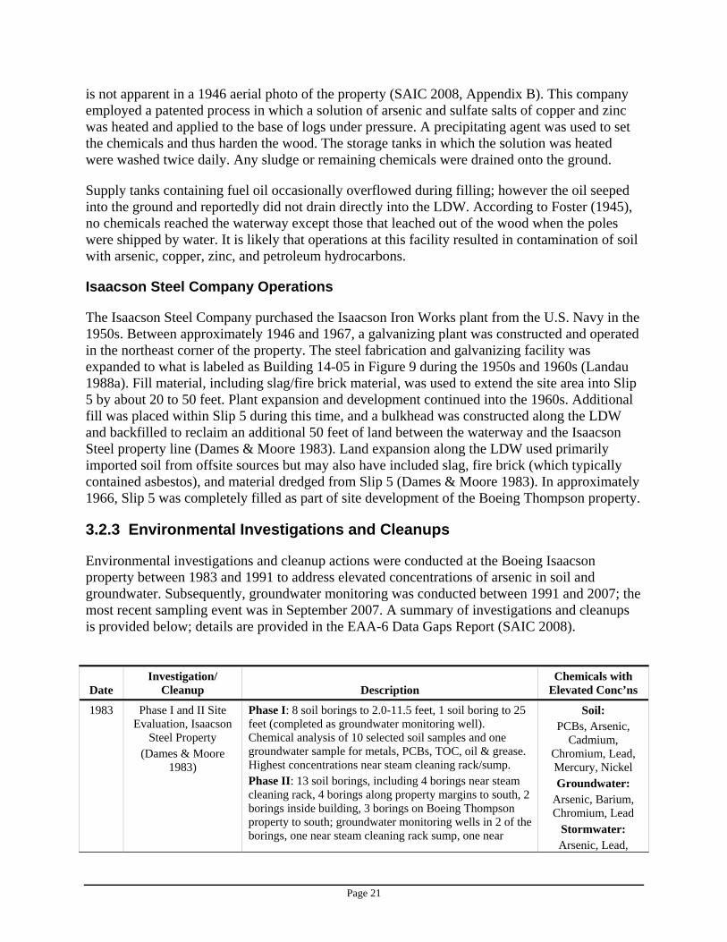
Environmental investigations and cleanup actions were conducted at the Boeing Isaacson property between 1983 and 1991 to address elevated concentrations of arsenic in soil and groundwater. Subsequently, groundwater monitoring was conducted between 1991 and 2007; the most recent sampling event was in September 2007. A summary of investigations and cleanups is provided below; details are provided in the EAA-6 Data Gaps Report (SAIC 2008).
Date Investigation/
Cleanup Description Chemicals with
Elevated Conc’ns
1983 Phase I and II Site Evaluation, Isaacson
Steel Property (Dames & Moore
1983)
Phase I: 8 soil borings to 2.0-11.5 feet, 1 soil boring to 25 feet (completed as groundwater monitoring well). Chemical analysis of 10 selected soil samples and one groundwater sample for metals, PCBs, TOC, oil & grease. Highest concentrations near steam cleaning rack/sump. Phase II: 13 soil borings, including 4 borings near steam cleaning rack, 4 borings along property margins to south, 2 borings inside building, 3 borings on Boeing Thompson property to south; groundwater monitoring wells in 2 of the borings, one near steam cleaning rack sump, one near
Soil: PCBs, Arsenic,
Cadmium, Chromium, Lead, Mercury, Nickel Groundwater:
Arsenic, Barium, Chromium, Lead
Stormwater: Arsenic, Lead,
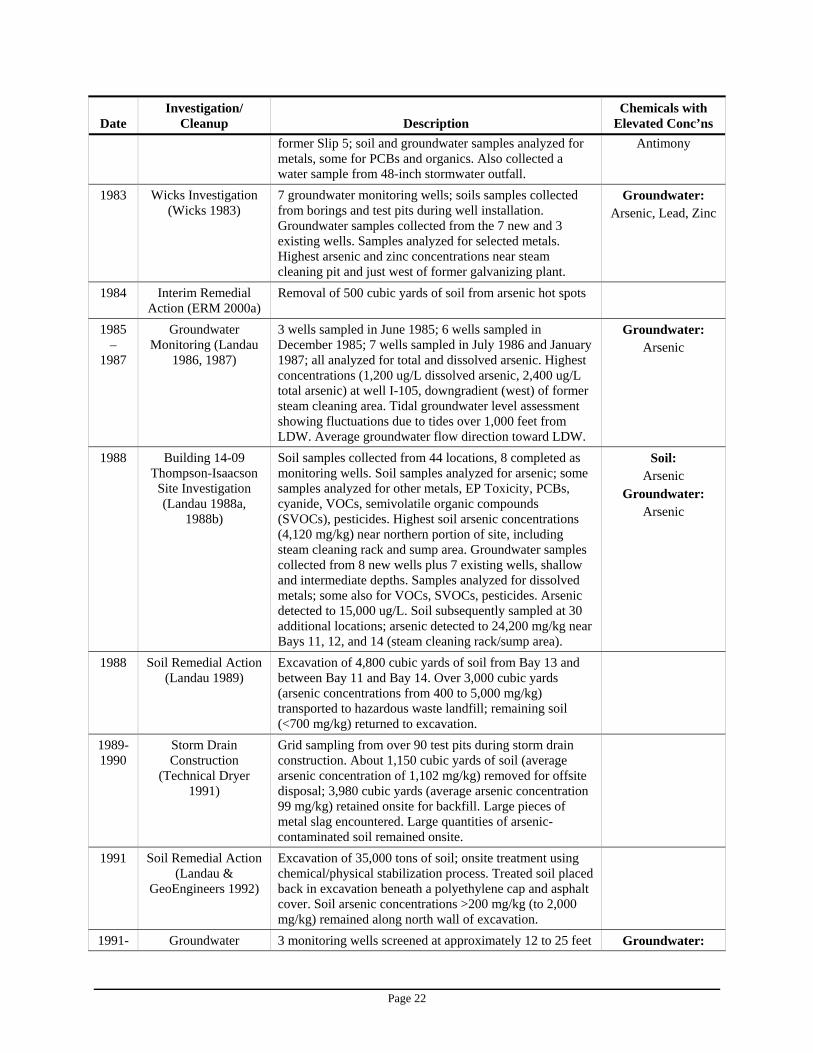
Page 22
Date Investigation/
Cleanup Description Chemicals with
Elevated Conc’ns former Slip 5; soil and groundwater samples analyzed for metals, some for PCBs and organics. Also collected a water sample from 48-inch stormwater outfall.
Antimony
1983 Wicks Investigation (Wicks 1983)
7 groundwater monitoring wells; soils samples collected from borings and test pits during well installation. Groundwater samples collected from the 7 new and 3 existing wells. Samples analyzed for selected metals. Highest arsenic and zinc concentrations near steam cleaning pit and just west of former galvanizing plant.
Groundwater: Arsenic, Lead, Zinc
1984 Interim Remedial Action (ERM 2000a)
Removal of 500 cubic yards of soil from arsenic hot spots
1985 –
1987
Groundwater Monitoring (Landau
1986, 1987)
3 wells sampled in June 1985; 6 wells sampled in December 1985; 7 wells sampled in July 1986 and January 1987; all analyzed for total and dissolved arsenic. Highest concentrations (1,200 ug/L dissolved arsenic, 2,400 ug/L total arsenic) at well I-105, downgradient (west) of former steam cleaning area. Tidal groundwater level assessment showing fluctuations due to tides over 1,000 feet from LDW. Average groundwater flow direction toward LDW.
Groundwater: Arsenic
1988 Building 14-09 Thompson-Isaacson
Site Investigation (Landau 1988a,
1988b)
Soil samples collected from 44 locations, 8 completed as monitoring wells. Soil samples analyzed for arsenic; some samples analyzed for other metals, EP Toxicity, PCBs, cyanide, VOCs, semivolatile organic compounds (SVOCs), pesticides. Highest soil arsenic concentrations (4,120 mg/kg) near northern portion of site, including steam cleaning rack and sump area. Groundwater samples collected from 8 new wells plus 7 existing wells, shallow and intermediate depths. Samples analyzed for dissolved metals; some also for VOCs, SVOCs, pesticides. Arsenic detected to 15,000 ug/L. Soil subsequently sampled at 30 additional locations; arsenic detected to 24,200 mg/kg near Bays 11, 12, and 14 (steam cleaning rack/sump area).
Soil: Arsenic
Groundwater: Arsenic
1988 Soil Remedial Action (Landau 1989)
Excavation of 4,800 cubic yards of soil from Bay 13 and between Bay 11 and Bay 14. Over 3,000 cubic yards (arsenic concentrations from 400 to 5,000 mg/kg) transported to hazardous waste landfill; remaining soil (<700 mg/kg) returned to excavation.
1989-1990
Storm Drain Construction
(Technical Dryer 1991)
Grid sampling from over 90 test pits during storm drain construction. About 1,150 cubic yards of soil (average arsenic concentration of 1,102 mg/kg) removed for offsite disposal; 3,980 cubic yards (average arsenic concentration 99 mg/kg) retained onsite for backfill. Large pieces of metal slag encountered. Large quantities of arsenic-contaminated soil remained onsite.
1991 Soil Remedial Action (Landau &
GeoEngineers 1992)
Excavation of 35,000 tons of soil; onsite treatment using chemical/physical stabilization process. Treated soil placed back in excavation beneath a polyethylene cap and asphalt cover. Soil arsenic concentrations >200 mg/kg (to 2,000 mg/kg) remained along north wall of excavation.
1991- Groundwater 3 monitoring wells screened at approximately 12 to 25 feet Groundwater:
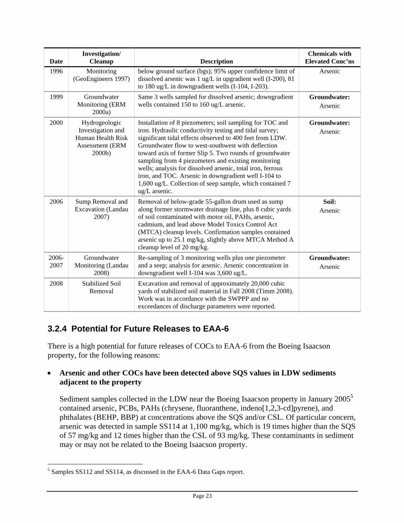
Page 23
Date Investigation/
Cleanup Description Chemicals with
Elevated Conc’ns 1996 Monitoring
(GeoEngineers 1997) below ground surface (bgs); 95% upper confidence limit of dissolved arsenic was 1 ug/L in upgradient well (I-200), 81 to 180 ug/L in downgradient wells (I-104, I-203).
Arsenic
1999 Groundwater Monitoring (ERM
2000a)
Same 3 wells sampled for dissolved arsenic; downgradient wells contained 150 to 160 ug/L arsenic.
Groundwater: Arsenic
2000 Hydrogeologic Investigation and
Human Health Risk Assessment (ERM
2000b)
Installation of 8 piezometers; soil sampling for TOC and iron. Hydraulic conductivity testing and tidal survey; significant tidal effects observed to 400 feet from LDW. Groundwater flow to west-southwest with deflection toward axis of former Slip 5. Two rounds of groundwater sampling from 4 piezometers and existing monitoring wells; analysis for dissolved arsenic, total iron, ferrous iron, and TOC. Arsenic in downgradient well I-104 to 1,600 ug/L. Collection of seep sample, which contained 7 ug/L arsenic.
Groundwater: Arsenic
2006 Sump Removal and Excavation (Landau
2007)
Removal of below-grade 55-gallon drum used as sump along former stormwater drainage line, plus 8 cubic yards of soil contaminated with motor oil, PAHs, arsenic, cadmium, and lead above Model Toxics Control Act (MTCA) cleanup levels. Confirmation samples contained arsenic up to 25.1 mg/kg, slightly above MTCA Method A cleanup level of 20 mg/kg.
Soil: Arsenic
2006-2007
Groundwater Monitoring (Landau
2008)
Re-sampling of 3 monitoring wells plus one piezometer and a seep; analysis for arsenic. Arsenic concentration in downgradient well I-104 was 3,600 ug/L.
Groundwater: Arsenic
2008 Stabilized Soil Removal
Excavation and removal of approximately 20,000 cubic yards of stabilized soil material in Fall 2008 (Timm 2008). Work was in accordance with the SWPPP and no exceedances of discharge parameters were reported.
3.2.4 Potential for Future Releases to EAA-6
There is a high potential for future releases of COCs to EAA-6 from the Boeing Isaacson property, for the following reasons:
• Arsenic and other COCs have been detected above SQS values in LDW sediments adjacent to the property
Sediment samples collected in the LDW near the Boeing Isaacson property in January 20055 contained arsenic, PCBs, PAHs (chrysene, fluoranthene, indeno[1,2,3-cd]pyrene), and phthalates (BEHP, BBP) at concentrations above the SQS and/or CSL. Of particular concern, arsenic was detected in sample SS114 at 1,100 mg/kg, which is 19 times higher than the SQS of 57 mg/kg and 12 times higher than the CSL of 93 mg/kg. These contaminants in sediment may or may not be related to the Boeing Isaacson property.
5 Samples SS112 and SS114, as discussed in the EAA-6 Data Gaps report.
Page 24
• Arsenic contamination of soil and groundwater has been documented
Past activities at the Boeing Isaacson property have resulted in soil and groundwater contamination. Soil remediation was conducted in 1984, 1988, 1989/1990, 1991, 2006, and 2008. Contaminated soil containing arsenic concentrations up to 2,000 mg/kg remains at the site.
Groundwater concentrations at the Boeing Isaacson property exceed groundwater-to-sediment screening levels (SAIC 2008). Groundwater sampling was conducted at the Boeing Isaacson property between 1988 and 2007. Arsenic concentrations in the upgradient well (I-200) ranged from 10 ug/L in 1988 to 0.9 ug/L during the most recent sampling event in September 2007. Arsenic concentrations in downgradient well I-104 ranged from 12 ug/L in 1988 to 3,600 ug/L in September 2007. Arsenic concentrations in downgradient well I-203 ranged from 60 ug/L in 1988 to 1,200 ug/L in 2000; the most recent sampling event in September 2007 found 140 ug/L arsenic in this well.
• Groundwater flows toward the LDW
The groundwater flow direction is generally to the west-southwest, toward the LDW. Therefore, it is likely that arsenic and potentially other COCs in groundwater are moving toward the waterway; the potential for sediment recontamination following sediment cleanup actions is high.
3.2.5 Source Control Actions
Information needed to assess the potential for sediment recontamination associated with current or historical operations at the Boeing Isaacson property was summarized in the EAA-6 Data Gaps Report.
The following source control actions will be conducted to fill the identified data gaps and reduce the potential for recontamination of EAA-6 sediments:
• Ecology will negotiate an Agreed Order with Boeing to conduct a MTCA RI/FS at this site. This will include the following activities:
Boeing will characterize contaminant concentrations in subsurface soil near the former location of the Slip 5 outfall (Figure 9), to the north of the 48-inch storm drain line, and at other locations on the property as needed. Samples will be analyzed for all of the EAA-6 COCs, at a minimum.
Boeing will conduct groundwater sampling at selected wells to characterize concentrations of arsenic and other COCs at the Boeing Isaacson property, including wet and dry season groundwater samples.
If COCs in soil and groundwater are present at concentrations that pose a risk of sediment recontamination, Boeing will develop a plan for controlling these contaminant sources.
• Ecology, Boeing, and/or the Port of Seattle will collect bank soil samples and analyze them for COCs to evaluate the potential for sediment recontamination from bank erosion.
Page 25
• King County will investigate the condition of the 48-inch KC Airport SD #2/PS45 EOF that passes through the Boeing Isaacson property.
• Ecology will obtain information from Boeing and the Port of Seattle to clarify the purpose, function, and configuration of the edge drains along the Boeing Isaacson shoreline
• Boeing will collect storm drain solids samples from the catch basins that drain to the Boeing Thompson stormwater system.
• Boeing will investigate the status and source of the unidentified pipe (Outfall 2063 on Figure 2) located near the Boeing Isaacson/Jorgensen Forge property boundary.
3.3 Boeing Thompson
The Boeing Thompson property is located to the south of Boeing Isaacson, along the east side of the LDW at approximately RM 3.8 to 3.9, as measured from the southern tip of Harbor Island. The property is approximately 19.35 acres in size, and is situated between the LDW on the west, East Marginal Way S. on the east, and the 8801 Site on the south (Figure 2).
The Boeing Company purchased this property from the Parr Seattle Company in January 1957. The property is located in an area of extensive fill placed as part of the rechannelization of the LDW; boreholes drilled at the site encountered up to 1.5 feet of sand and gravel fill beneath the pavement, and silty sand/silty gravel fill with bricks and slag material to a depth of 6.5 to 17.5 feet below the ground surface. The thickest fill layer was observed within the area of the former Slip 5 (ERM 2000b).
The topography is relatively flat, and the property is almost entirely paved (Boeing 2001). Groundwater generally flows to the west toward the LDW, and is affected by a regular pattern of diurnal fluctuations over a portion of the property due to tidal influences. Localized effects of fill heterogeneity have been observed, mostly near the LDW shoreline.
3.3.1 Current Site Use
As of December 31, 2007, industrial/manufacturing operations have been relocated from the Boeing Thompson site to other Boeing facilities, primarily the aircraft final assembly locations in Renton and Everett. Current activities reportedly include storage of surplus vehicles and preparation of the site for reuse or sale.
According to the facility’s 2001 Stormwater Pollution Prevention Plan (SWPPP; Boeing 2001), nine buildings at the site were used for industrial operations and associated utilities/logistics. The majority of the site area is composed of outdoor parking areas, storage areas, and transportation lanes. Past industrial activity consisted of assembly of jet engines for Boeing commercial aircraft. Specific activities included testing, machining, and painting of engine sub-assemblies.
According to the SWPPP (Boeing 2001), the storm drain system at the Boeing Thompson property consists of 81 catch basins, 23 storm drain manholes, and two oil-water separators. The structures drain through two active private outfalls (2061 and 2077, shown as Outfalls A and B on Figure 7) to the LDW. These outfalls are partially or entirely submerged during high tides. As
Page 26
noted earlier, CB39, located on the northwest corner of the Boeing Thompson site, is connected to the 48-inch KC Airport SD #2/PS45 EOF.
The facility operates under an industrial stormwater general permit, No. SO3-000148, which was originally issued on December 22, 1993 and was extended to May 2008. Ecology has proposed to extend the expired general permit until April 30, 2009. A stormwater compliance inspection was conducted by Ecology on April 6, 2007, which indicated that the benchmark level for total zinc had been exceeded for the preceding three quarters, and that a Level 1 response was required (Ecology 2007c).
Potential sources of stormwater pollution include:
• Materials and wastes stored outside in tanks, which includes a 550-gallon aboveground diesel storage tank on the west side of Building 14-02, a 240-gallon aboveground diesel storage tank on the north side of Building 14-13, one 5,000-gallon aboveground storage tank on the west side of Building 14-01 for aqueous degreaser fluids (never used), and one 20,000-gallon underground diesel/heating fuel storage tank on the west side of Building 14-02 that was closed in place. The two small diesel tanks are active: one is used for the emergency generator and the other is associated with the fire suppression system pumps. All tanks (except the underground storage tank that was closed in place) have secondary containment.
• Material stored outside in containers in the Material Storage Sheds near Building 14-03. • Waste previously stored in containers at the Waste Storage Area near Building 14-03; this
material has been moved to a hazardous waste accumulation area located inside building 14-01.
According to the SWPPP (Boeing 2001), the facility employs various BMPs to minimize the potential for releases of contaminants to the environment. Manufacturing occurs inside buildings. Outside material storage areas are covered and provided with spill containment, and are constructed to reduce the influx of windborne precipitation. Storage and maintenance of materials, wastes, and tanks is conducted in accordance with applicable regulations. A hazardous waste management plan and a hazardous materials management plan have been developed and implemented for the facility (Boeing 2001).
Several catch basins that drain the paved shoulder on the west side of East Marginal Way S. flow into the Boeing Thompson storm drain system near the main gate. This flow combines with other property runoff, passes through an oil-water separator, then discharges to the LDW at an outfall on the northern portion of the Boeing Thompson shoreline (Boeing 2001). There are no identified areas where stormwater runs onto the Boeing Thompson property from offsite.
Non-stormwater discharges from the Boeing Thompson property result from fire hydrant flushing, water line flushing, and irrigation drainage (Boeing 2001); these are not associated with industrial discharges.
Merrill Creek Holdings, LLC, the owner of the property located immediately south of Boeing Thompson (the 8801 Site), has identified two drains that discharge to their property from the south wall of the Boeing Thompson property. Boeing reports that one of these pipes is a 12-inch perforated culvert pipe that drains groundwater and releases pressure from behind the concrete
Page 27
wall. This culvert pipe has no tie-ins with the Boeing Thompson storm drain system. The second pipe is identified as a foundation drain which also has no tie-ins with the Boeing Thompson storm drain system. Boeing has prepared a memorandum to document information about these two pipes. The two drainage pipes have a potential to discharge groundwater at the surface onto the 8801 Site (O’Brien 2008).
3.3.2 Past Site Use
Past site use of the Boeing Thompson property is summarized below:
Date Site Use
1917 to 1945 Sawmill, including construction of pilings and a log chute in Slip 5 (Bissell Lumber Company)
1952 Three-tier timbered bulkhead constructed on south side of Slip 5 to retain fill material dredged from the LDW
1955; end date unknown Consolidated Freightways leased a portion of the property 1956 Property vacant; all buildings removed
1957 to 1981 Plaster of Paris mockup and assembly of aircraft engines (Boeing Airplane Company)
1981 Facility expansion to include 757 Fatigue Testing Facility (Boeing Airplane Company)
Early 1990s (to 1993) Support of B-2 bomber program, including painting, copper plating, sealing/bonding, and fuel systems testing (Boeing
Defense and Space Group) 1994 to 2007 Facility refurbished; used for assembly of jet engines for
commercial aircraft (Boeing Commercial Airplane Group)
Historical operations of particular interest with respect to the potential for EAA-6 sediment recontamination are summarized below. Additional information on past site use is provided in the EAA-6 Data Gaps Report (SAIC 2008).
Filling of Slip 5
The fill material placed in Slip 5 reportedly consisted of slag waste and soil; land reclamation along the LDW was primarily composed of imported soil from offsite sources, but may also have included slag, fire brick, and material dredged from the LDW (Dames & Moore 1983). Soil sampling in 1983 identified high concentrations of metals in the fill material in the southern and western margins of the Boeing Isaacson property to the north.
Bissell Lumber Company Operations
In December 1917, Bissell Lumber Company applied to the U.S. Corps of Engineers for permission to dredge, construct a log chute, and install pilings in Slip 5. Construction was completed and the facility operated at this location until 1945. It has been suggested that pilings may have been treated with arsenic, and could therefore be a source of arsenic contamination in the former Slip 5 area.

Page 28
Boeing Operations
A wide variety of products containing hazardous substances were used at this property during Boeing’s 50-year occupancy, including solvents, sealants, paint and adhesives, cleaners, copper sulfate, hydraulic fluids and oils. In addition, a dioxin-containing product present at the property in 1991 was shipped offsite for disposal in 1993. In 1990, the facility generated approximately 1.7 million pounds of hazardous waste. Industrial activities, particularly those conducted before the advent of environmental regulations and reporting requirements, may have resulted in release of contaminants to soil and groundwater. However, few environmental samples have been collected at the Boeing Thompson property.
3.3.3 Environmental Investigations and Cleanups
Few environmental investigations or cleanup actions have been conducted at the Boeing Thompson property. A summary of investigations and cleanups is provided below; details are provided in the EAA-6 Data Gaps Report (SAIC 2008). Current groundwater monitoring well locations are shown in Figure 10.
Date Investigation/
Cleanup Description Chemicals with
Elevated Conc’ns
1992 Investigation of Potential Release
from Oil Collection Tanks
(Boeing 1992)
Oil/water separator overflow may have released hydraulic and/or surface oils to soil and groundwater; 2 soil borings drilled and 1 groundwater monitoring well installed. No results available.
Unknown
1988 to 1996
Groundwater Monitoring
(Landau 1988a, Landau 2008)
Samples collected from monitoring wells I-205 and I-206; analyzed for dissolved arsenic. Concentrations varied, ranging from <1 ug/L to 640 ug/L in I-205 and from 1,430 to 2,000 ug/L in I-206.
Groundwater: Arsenic
1996 Supplemental Soil and
Groundwater Investigation
(GeoEngineers 1996, as cited in
ERM 2000a)
Soil and groundwater sampled near location of monitoring well I-206; 6 strataprobe borings installed to 20 feet bgs; 63 soil samples and 6 groundwater samples analyzed for arsenic. Groundwater flow generally to the west, toward water tank and potentially the property to south (8801 Site). Arsenic detected in soil to 43 mg/kg; dissolved arsenic in groundwater ranged from 66 to 660 ug/L.
Groundwater: Arsenic
1999/2000 Groundwater Monitoring
(ERM 2000a, ERM 2000b)
Samples collected from wells I-205 and I-206 (December 1999, August 2000, October 2000) and piezometer PZ-8 (August and October 2000 only); analyzed for dissolved arsenic. Concentrations ranged from 2 ug/L to 1,600 ug/L.
Groundwater: Arsenic
2006/2007 Groundwater Sampling
(Ecology2007b, Landau 2008b)
2 Boeing Thompson groundwater monitoring wells (I-205 and I-206) sampled in March 2006, August 2006, and September 2007. Samples analyzed for dissolved arsenic; concentrations ranged from 9.8 to 720 ug/L.
Groundwater: Arsenic
Page 29
3.3.4 Potential for Future Releases to EAA-6
The Boeing Thompson property is a potential source of COCs that may contribute to recontamination of EAA-6 sediments, for the following reasons:
• COCs have been detected above SQS values in LDW sediments adjacent to the property
Sediment samples collected in the LDW near the Boeing Thompson property in 1997 and 20056 contained PCBs and phthalates (BEHP, BBP) at concentrations above the SQS and/or CSL. In addition, arsenic, PAHs, PCBs, phthalates, benzyl alcohol, and dibenzofuran have been detected in sediments near the location of a Boeing storm drain outfall (Outfall A as shown in Figure 7) and the location of the KC Airport SD #2/PS45 EOF outfall. These contaminants in sediment may or may not be related to the Boeing Thompson property.
• Arsenic contamination has been documented in groundwater
Groundwater concentrations at the Boeing Thompson property exceed groundwater-to-sediment screening levels (SAIC 2008). Groundwater monitoring has been conducted at the Boeing Thompson property between 1988 and 2007. Wells adjacent to the LDW contained dissolved arsenic up to 2,000 ug/L, with the highest concentrations found in well I-206. The most recent sample from this well (September 2007) contained 720 ug/L dissolved arsenic.
• Groundwater flows toward the LDW
The groundwater flow direction is generally to the west, toward the LDW. Therefore, it is likely that arsenic-contaminated groundwater is moving toward the waterway and the potential for sediment recontamination following sediment cleanup actions is high.
In addition, two outfalls discharge stormwater from Boeing Thompson to the LDW under an Industrial Stormwater General Permit. According to an April 2007 inspection, the permit’s benchmark level for zinc had been exceeded for three quarters. No sampling of storm drain solids has been conducted at this property. Stormwater discharge may therefore also be a potential sediment recontamination pathway.
It is possible that releases of chemicals to soil and groundwater may have occurred as a result of industrial operations at this property. Sampling conducted at Boeing Thompson has focused on arsenic; it is not known whether other contaminants may be present in environmental media at this site and, if so, whether they represent a potential sediment recontamination pathway.
3.3.5 Source Control Actions
Information needed to assess the potential for sediment recontamination associated with current or historical operations at the Boeing Thompson property was summarized in the EAA-6 Data Gaps Report.
6 Samples R26, R27, R31, EST143, EIT060, LDW-SS119, as discussed in the EAA-6 Data Gaps report.
Page 30
The following source control actions will be conducted to fill the identified data gaps and reduce the potential for recontamination of EAA-6 sediments:
• Boeing will conduct a comprehensive soil and groundwater investigation at this property to characterize the concentration of arsenic and other COCs. The groundwater investigation will include groundwater monitoring at selected wells and an evaluation of the potential sources of arsenic in the Boeing Thompson monitoring wells.
• If COCs in soil and groundwater are present at concentrations that pose a risk of sediment recontamination, Boeing will develop a plan to remove, minimize and/or control these contaminant sources.
• If needed, Boeing will conduct additional tidal studies to address the tidal efficiency anomaly identified in well I-205 during a tidal study conducted in 2000 (ERM 2000b), and to collect additional information on tidal influences to assess the potential for sediment recontamination associated with contaminated groundwater at this property.
• Ecology, Boeing, or the Port of Seattle will collect bank soil samples and analyze them for COCs to evaluate the potential for sediment recontamination from bank erosion.
• Ecology will review a memorandum prepared by Boeing to document their findings associated with the two drains that discharge to the 8801 Site, and will assess the potential that these discharges may contribute to recontamination of LDW sediments.
• Boeing will collect solids samples from the Boeing Thompson storm drain system to assess concentrations of contaminants that may be present.
• Ecology will conduct a source control inspection at this facility to clarify the nature of current activities and to assess the potential that current operations may contribute to recontamination of EAA-6 sediments.
3.4 King County International Airport
KCIA is a general aviation airport owned and operated by King County as a public utility. The site covers about 615 acres, of which approximately 237 acres in the central portion of the airport drains to EAA-6 (Figure 4).
There are about 15 miles of pipe in the KCIA storm drain system, and all KCIA stormwater discharges to the LDW. There are two pumping stations, which lift the water and pump it out at two outfalls. The north pump station discharges to Slip 4. The southern pump station drains the central portion of KCIA through the 48-inch pipe that runs under the Boeing Isaacson property and discharges to EAA-6 through the KC Airport SD #2/PS45 EOF outfall. Drainage from the southern portion of KCIA discharges to the LDW at Slip 6.
3.4.1 Current Site Use
The airport currently averages more than 300,000 operations (takeoffs and landings) each year and serves small commercial passenger airlines, cargo carriers, private aircraft owners, helicopters, corporate jets, and military and other aircraft. Potential sources of pollutants include air emissions associated with airport operations, and de-icing activities, which are performed on aircraft to minimize ice buildup on the wings and plane body during cold weather conditions.
Page 31
KCIA has constructed dedicated areas for aircraft de-icing; the runoff from these areas is diverted to the sanitary sewer system and is conveyed to the local municipal treatment facility. All tenants are required to de-ice aircraft in the specified locations to prevent de-icing fluids from entering the airport’s stormwater system.
Much of central KCIA is leased to various airport tenants, as listed in Section 3.0. Tenant locations are shown in Figure 8. Activities of airport tenants include fuel storage and aircraft maintenance, vehicle and equipment maintenance, and repair/storage of vehicles and equipment. Most maintenance and repair work is performed inside hangars. Detailed information on each of the airport tenants is provided in the EAA-6 Data Gaps Report (SAIC 2008).
Since 2002, Boeing has removed concrete joint caulking material containing PCBs up to 79,000 mg/kg from areas of north KCIA (within the EAA-3/Slip 4 drainage basin). A joint caulk sample collected by KCIA in 2005 from within the EAA-4 (Boeing Plant 2) drainage basin (location JC-3) contained a PCB concentration (Aroclor 1260) of 1.69 mg/kg (E&E 2007). No sampling of joint caulking material has been conducted in the central portion of KCIA that drains to EAA-6.
3.4.2 Past Site Use
In the early 1900s, the winding course of the Duwamish River, which ran through much of the airport property, was straightened and filled. Construction of the airport began in 1928. The airport served as the community’s aviation center until December 6, 1941, when the U.S. Army took over the airport for strategic and production reasons. The airport remained under military jurisdiction through the end of World War II.
In the late 1940s, the airport was reopened for passenger and other commercial traffic. Usage evolved to general aviation, serving industrial, business, and recreational purposes after the opening of Sea-Tac International Airport in 1947.
3.4.3 Airport Tenants
Information relevant to EAA-6 sediment recontamination is summarized below. Additional information is provided in the EAA-6 Data Gaps Report.
Current Operations Concerns Potential Source of COCs to EAA-6?
UPS Boeing Field, 7500-7575 Perimeter Rd. S. Air cargo transport; stormwater permit SO3-000434
UPS is working on a Level 2 response to elevated metals concentrations in stormwater discharge
Yes
Ameriflight, Inc. (Hangar 5), 7585 Perimeter Rd. S. Air cargo airline; stormwater permit SO3-002830
Facility was not in compliance with stormwater permit as of March 2007; no follow-up inspection
Yes
Hangar Holdings, Inc. (Vulcan, TAG Aviation, Former Shell Oil), 7675 Perimeter Rd. S. Aircraft hangar; listed on Confirmed and Suspected Contaminated Sites List (CSCSL)
Petroleum contamination associated with aviation fuel leaking underground storage
Yes
Page 32
Current Operations Concerns Potential Source of COCs to EAA-6?
tanks (LUSTs); voluntary cleanup conducted in 2003; contaminated soil remains onsite
Western Metal Products, Inc., 7696 and 7800-7802 Perimeter Rd. S. Metal parts fabrication Catch basins over 60 percent full in March
2006 and various corrective actions required; facility in compliance with stormwater regulations in December 2006; it is not known whether the catch basins were cleaned out.
Unknown
Galvin Flying Services, 7777 Perimeter Rd. S. Service and repair of aircraft None; facility in compliance per
December 2004 SPU stormwater pollution prevention inspection.
No (per 2004 inspection)
Nordstrom, Inc., 7979 Perimeter Rd. S. Cargo and passenger transport None; facility in compliance per October
2004 stormwater pollution prevention inspection.
No (per 2004 inspection)
DHL Express (ABX Air, Airborne Express), 8013-8075 Perimeter Rd. S. Courier services; stormwater permit SO3-004602
Petroleum sheens observed entering catch basins; as of May 2006 inspection, Discharge Monitoring Reports (DMRs) not submitted for previous 4 quarters; no follow-up inspection.
Yes
Airwest Repair Services (Airwest Sales & Services, Bicknell), 8167-8187 Perimeter Rd. S. Aircraft maintenance and storage; property subleased to Puget Sound Aviators (flight school), CJ Systems Aviation Group (maintenance and storage of helicopters), GBA (gyroplane assembly)
None; all facilities in compliance per 2004 stormwater pollution prevention inspections
No (per 2004 inspection)
BAX Global, Inc., 8201 Perimeter Rd. S. Transport of packages and containers None; in compliance per March 2002
stormwater pollution prevention inspection
No (per 2002 inspection)
Clay Lacy Aviation (Flightcraft Inc. Seattle, Gateway USA, Flight Center), 8285-8403 Perimeter Rd. S. Airport services to private jets and fixed base operations
Voluntary cleanup for aviation fuel LUSTs completed in 1996; in compliance per December 2004 stormwater pollution prevention inspection
No (per 2004 inspection)
Wings Aloft/Southeast “T” Hangars, 8453-8525 Perimeter Rd. S. Flight school; maintenance and fueling of aircraft; portions subleased to Reed Aviation (airframe maintenance), Airtech Instrument Company (repair of aviation-related instruments), Cascade Air Frame (helicopter maintenance), Helicopters Northwest (flight training), and Washington Avionics, Inc. (sale
None; in compliance per 2005 stormwater pollution prevention inspections
No (per 2005 inspection)
Page 33
Current Operations Concerns Potential Source of COCs to EAA-6?
and repair of aviation equipment) Aeroflight National Charter Network (Seattle Air Corp., BFI Holdings), 8535-8555 Perimeter Rd. S. Transport of passengers and packages; maintenance, fueling, and storage of aircraft and cargo
LUST cleanup conducted in 1996; in compliance per 2005 stormwater pollution prevention inspection
No (per 2005 inspection)
South Seattle Community College (SSCC) Aviation Department, 8900 East Marginal Way S. Aircraft repair school None; in compliance per November 2004
stormwater pollution prevention inspection
No (per 2004 inspection)
Former Boeing Electronics Manufacturing Facility (EMF), 7355 Airport Way S. Buildings demolished in 1996; currently leased to UPS
Groundwater contamination with chlorinated solvents from electronic circuit board manufacturing conducted during 1960s to 1982; ongoing RCRA corrective action under EPA Administrative Order. Groundwater plume flows toward EAA-4 (Boeing Plant 2 to Jorgensen Forge).
Yes (soil cleanup activities could transport contaminants to storm drain system)
3.4.4 Potential for Future Releases to EAA-6
Insufficient information is available to determine whether central KCIA is a source of COCs that may result in recontamination of EAA-6 sediments. The following factors indicate a potential for transport of contaminants to EAA-6 from KCIA and its tenants:
• KCIA and its tenants engage in activities that generate COCs
Airport operations include de-icing of aircraft, fueling, and maintenance of aircraft and vehicles. Airport tenants engage in various activities, including aircraft maintenance, metal fabrication, fueling, and equipment/vehicle washing. These activities, if not properly managed, could result in the release of COCs to the storm drain system.
• Stormwater collected in central KCIA discharges to EAA-6 via KC Airport SD #2/PS45 EOF
Stormwater collected from 237 acres in central KCIA is conveyed via a pump station to the 48-inch pipe that runs under the Boeing Isaacson property and discharges to EAA-6 through the KC Airport SD #2/PS45 EOF outfall.
Page 34
• COCs have been detected above SQS values in LDW sediments adjacent to the Slip 5 outfall
Sediment samples collected in the LDW near the Slip 5 outfall in 1997 and 20057 contained arsenic, PAHs (acenaphthene, benzo[a]anthracene, benzo[a]pyrene, benzo[b]fluoranthene, benzo[g,h,i]perylene, benzo[k]fluoranthene, chrysene, dibenzo[a,h]anthracene, fluoranthene, fluorene, indeno[1,2,3-cd]pyrene, phenanthrene), phthalates (BEHP, BBP), PCBs, benzoic acid, and dibenzofuran at concentrations above the SQS and/or CSL.
Very little sampling of storm drain solids has been conducted in this area of KCIA. However, storm drain solids collected from a catch basin at the Ameriflight facility in 2004 contained PCBs at 6.6 mg/kg and mercury at 0.61 mg/kg; the source of these contaminants was not determined. Other properties have documented soil and groundwater contamination, such as the former Boeing EMF, which is currently undergoing investigation and cleanup, and Hangar Holdings, where petroleum-contaminated soil was left in place after construction activities in 1996/1997. Contaminants in soil and groundwater could enter the KCIA stormwater system through cracks or gaps in the stormwater piping. In addition, cleanup activities at the Boeing EMF could result in transport of contaminants in soil to the stormwater system if site activities are improperly managed.
Most of the KCIA tenant facilities have not been inspected by SPU or Ecology since 2004. However, KCIA has recently conducted internal source control inspections as required by the Phase I municipal NPDES permit. No information on results of these inspections was available at the time this report was prepared.
Since 2002, Boeing has removed concrete joint caulking material containing up to 79,000 mg/kg PCBs from areas of north KCIA (within the Slip 4 drainage basin). A joint caulk sample collected from KCIA within the EAA-4 (Boeing Plant 2) drainage basin contained an elevated PCB concentration (Aroclor 1260) of 1.69 mg/kg. If exposed concrete is present in this area, PCBs in joint caulking material within the EAA-6 drainage basin could be a source of sediment recontamination. Further investigation of PCB sources in the central portion of KCIA may be needed, depending on sample results from the sediment trap that was recently installed on the KC Airport SD #2/PS45 EOF system.
3.4.5 Source Control Actions
Information needed to assess the potential for sediment recontamination associated with current or historical operations at central KCIA was summarized in the EAA-6 Data Gaps Report.
The following source control actions will be conducted to fill the identified data gaps and reduce the potential for recontamination of EAA-6 sediments:
• King County will conduct additional source tracing, as necessary, depending on the sample results from the sediment trap that was recently installed on the KC Airport SD #2/PS45 EOF system.
7 Samples R22, R23, EST148, DR220, LDW-SS115, LDW-SS119, LDW-SS157, LDW-SS158, and LDW-SC51, as discussed in the EAA-6 Data Gaps report.
Page 35
• King County will verify the status of efforts to clean all catch basins in the central KCIA storm drain basin.
• King County will determine the presence or absence of PCB-containing joint caulking material in the central KCIA storm drain basin.
• Ecology will conduct a follow-up inspection at UPS Boeing Field to verify that corrective actions have been taken with regard to elevated copper and zinc in stormwater.
• Ecology will conduct a follow-up inspection at Ameriflight to identify which drains discharge to the storm drain system and to ensure that no contaminants are entering the storm drains.
• Ecology will assess/confirm the adequate completion of cleanup activities associated with petroleum LUSTs at Hangar Holdings.
• SPU and Ecology will conduct a follow-up inspection at Western Metal Products to confirm that catch basins were cleaned out as requested, and to evaluate whether this facility should be required to obtain a stormwater permit.
• Ecology will conduct a follow-up inspection at DHL Express to verify that corrective actions have been completed and that no contaminants are entering the storm drain system.
• King County, SPU, and/or Ecology will conduct re-inspections at facilities for which the most recent inspection was conducted over 3 years ago to ensure that activities are in compliance with source control best management practices. These facilities include: Galvin Flying Services, Clay Lacy Aviation, MJL Partners, Nordstrom, Airwest Repair Services, Puget Sound Aviators, CJ Systems Aviation Group, GBA, BAX Global, Wings Aloft, Reed Aviation, Airtech Instrument Company, Cascade Air Frame, Helicopters Northwest, Washington Avionics, Inc., Aeroflight National Charter Network, and SSCC Aviation Department, and any new tenants that may have begun operations since the last round of source control inspections.
• King County and EPA will monitor remedial activities at the former Boeing EMF to ensure that contaminated soil does not enter the storm drain system.
Follow-up tenant inspections by SPU and/or Ecology as listed above should be conducted in cooperation with KCIA, thereby allowing Airport staff to understand deficiencies and assist with compliance.

Page 36
This page intentionally left blank.
Page 37
4.0 Monitoring
Monitoring efforts by SPU, Ecology, King County, and the Puget Sound Clean Air Agency (PSCAA) will continue to assist in identifying and tracing ongoing sources of COCs present in LDW sediments or in upland media. This information will be used to focus source control efforts on specific problem areas within the EAA-6 source control area and to track the progress of the source control program. The following types of samples will be collected:
• In-line sediment trap samples from storm drain systems, • Onsite catch basin solids samples, • Soil samples as necessary, and • Wet and dry season groundwater samples from selected wells.
If monitoring data indicate the presence of additional sources that could result in recontamination of EAA-6 sediments, then Ecology will identify source control activities as appropriate.
Because source control is an iterative process, monitoring is necessary to identify trends in concentrations of COCs. Monitoring is anticipated to continue for some years. Any decisions to discontinue monitoring will be made jointly by Ecology and EPA, based on the best available information. At this time, Ecology plans to review the progress and data associated with source control action items for each SCAP at least annually, and to summarize this information in the LDW Source Control Status Reports, which are scheduled for publication twice a year. In addition, Ecology may prepare Technical Memoranda to update the Data Gaps reports and SCAPs, as needed.

Page 38
This page intentionally left blank.
Page 39
5.0 Tracking and Reporting of Source Control Activities
Ecology is the lead for tracking, documenting, and reporting the status of source control to EPA and the public. Each agency involved in source control will document its source control activities and provide regular updates to Ecology. Ecology prepares semiannual LDW Source Control Status Reports that summarize recent activities for each source control area and the overall status of source control in the LDW. Updates to SCAPs and source control recommendations will be recorded as appropriate in Ecology’s LDW Source Control Status Reports, as well as in technical memoranda or decision documents as needed to update Ecology’s or EPA’s records concerning potential contaminant sources.

Page 40
This page intentionally left blank.
Page 41
6.0 References
Boeing (The Boeing Company). 1992. Letter from J.T. Johnstone, Environmental Affairs Manager, Boeing Defense & Space Group, to Mr. Joe Hickey, Washington Department of Ecology, Re: Investigation of Potential Release from Oil Collection Tank. August 18, 1992.
Boeing. 2001. Stormwater Pollution Prevention Plan, The Boeing Company, Thompson Site, Existing Permit SO3000148. April 2001.
Boeing. 2008. Thompson Site Stormwater Map.
Cummings. 2008. Email from BJ Cummings, Duwamish River Cleanup Coalition, to Robert Wright (Ecology), Re: Discolored and turbid discharge. October 1, 2008.
Dames & Moore. 1983. Report of Evaluation of Site Contamination, Isaacson Steel Property, for the Boeing Aerospace Company. October 4, 1983.
E&E (Ecology and Environment). 2007. Lower Duwamish Waterway Early Action Area 4, Final Summary of Existing Information and Identification of Data Gaps Report. June 2007.
Ecology (Washington State Department of Ecology). 2004. Lower Duwamish Waterway Source Control Strategy. Publication No. 04-09-043. Prepared by Washington State Department of Ecology, Northwest Regional Office, Toxics Cleanup Program. January 2004.
Ecology. 2006. Environmental Report Tracking System. ERTS# 556039. Boeing-Isaacson Property, Unknown Discharge of Turbid Water. June 26, 2006.
Ecology. 2007a. Lower Duwamish Waterway Source Control Status Report. 2003 to June 2007. Washington State Department of Ecology. Publication No. 07-04-064. July 2007.
Ecology. 2007b. Letter from Maura S. O’Brien, Site Manager, Toxics Cleanup Program, Northwest Regional Office, Washington Department of Ecology, to Mr. Paul Frankel, Energy and Environmental Affairs, The Boeing Company, Re: Groundwater Sampling Results for Wet and Dry Season at I-205 and -206 at Boeing Isaacson Property, 8625 East Marginal Way, Tukwila, WA 98018. November 8, 2007.
Ecology. 2007c. Stormwater Compliance Inspection Report, Boeing Thompson. April 6, 2007.
Ecology. 2008a. LDW Source Control Status Report. July 2007 to March 2008. Washington State Department of Ecology. Publication No. 08-09-063. May 2008.
Ecology. 2008b. Environmental Report Tracking System, ERTS# 608563. Discharge from outfall south of Jorgensen Forge and near Boeing Plant II. September 26, 2008.
Ecology. 2008c. LDW Source Control Status Report. April 2008 through August 2008. Washington State Department of Ecology. Publication No. 08-09-068. October 2008.
Page 42
EPA (U.S. Environmental Protection Agency). 2002. Principles for Managing Contaminated Sediment Risks at Hazardous Waste Sites. U.S. Environmental Protection Agency, Office of Solid Waste and Emergency Response. OSWER Directive 9285.6-08. February 12, 2002.
EPA and Ecology. 2002. Lower Duwamish Waterway Site Memorandum of Understanding Between the United States Environmental Protection Agency and the Washington State Department of Ecology. April 2002.
EPA and Ecology. 2004. Lower Duwamish Waterway Site Memorandum of Understanding Between the United States Environmental Protection Agency and the Washington State Department of Ecology. April 2004.
ERM (Environmental Resources Management). 2000a. Conceptual Proposal for No Further Action Determination at the Boeing Isaacson Property. Prepared by Environmental Resources Management for The Boeing Company. April 2000.
ERM. 2000b. Request for Groundwater NFA Determination, Hydrogeologic Investigation and Site-Specific Action Level for Arsenic in Groundwater, Boeing Isaacson Site, VCP ID#NW0453. Prepared by Environmental Resources Management for The Boeing Company. November 2000.
Exponent. 1998. Duwamish Waterway Phase I Site Characterization Report. Prepared by Exponent for The Boeing Company. March 1998.
Foster. 1945. Sources of Pollution in the Duwamish-Green River Drainage Area. Prepared by Richard F. Foster, Washington Pollution Control Commission. December 6, 1945.
GeoEngineers. 1996. As cited in ERM 2000a.
GeoEngineers. 1997. Thompson-Isaacson Site Evaluation Groundwater Compliance Monitoring Program. Prepared by GeoEngineers for The Boeing Company. As cited in ERM 2000a.
Herrera. 2004. Summary Report. Lower Duwamish Waterway Outfall Survey. Prepared by Herrera Environmental Consultants, Inc. for Seattle Public Utilities. January 2004.
King County. 2007. King County Water and Land Resources Division, Drainage Investigation Report. Duwamish River – Outfall #2. July 12, 2007.
Landau. 1986. First Annual Report, Ground Water Monitoring Program, Boeing Isaacson Property, 8541 East Marginal Way South, Seattle, Washington. Prepared by Landau Associates, Inc. for The Boeing Company. June 1986.
Landau. 1987. Second Annual Report, Ground Water Monitoring Program, Boeing Isaacson Property, 8541 East Marginal Way South, Seattle, Washington. Prepared by Landau Associates, Inc. for The Boeing Company. May 29, 1987.
Page 43
Landau. 1988a. Data Report: Building 14-09, Thompson-Isaacson Site Investigation. Prepared for The Boeing Company by Landau Associates, Inc. May 4, 1988.
Landau. 1988b. Data Report No. 2: Building 14-09, Thompson-Isaacson Site Investigation. Prepared for The Boeing Company by Landau Associates, Inc. July 8, 1988.
Landau. 1989. Final Report, Thompson-Isaacson Site Soil Excavation Work Plan. Prepared by Landau Associates, Inc. for The Boeing Company. March 21, 1989.
Landau. 1990. Thompson-Isaacson Site Soil Remedial Action Plan. Prepared by Landau Associates, Inc. for The Boeing Company. December 17, 1990.
Landau. 1991. Thompson-Isaacson Site Ground Water Monitoring Program. Prepared by Landau Associates, Inc. for The Boeing Company. March 1, 1991.
Landau & GeoEngineers. 1992. Final Report, Thompson-Isaacson Site, Full-Scale Soil Stabilization Program, Summary Report. Prepared by Landau Associates, Inc. and GeoEngineers for The Boeing Company. Volumes I, II, and III. April 27, 1992.
Landau. 2007. Sump Removal and Soil Excavation, Boeing Isaacson Property, Seattle, Washington. Prepared by Landau Associates for The Boeing Company. February 5, 2007.
Landau. 2008. Cumulative Data Table. Summary of Compounds Detected in Groundwater, Boeing Isaacson-Thompson Site, Seattle, Washington. Draft.
Modjeski, R. 2007. Email from Ronald Modjeski, USEPA, to Elena Olinares, King County Department of Natural Resources & Parks, Re: KC Airport Outfall #2. December 10, 2007.
NOAA (National Oceanic and Atmospheric Administration). 1998. Duwamish Waterway sediment characterization study report. Damage Assessment Center, National Oceanic and Atmospheric Administration, Seattle, WA. As cited in Windward 2003a.
O’Brien, M. 2007. Email from Maura O’Brien, Washington Department of Ecology, to Iris Winstanley, SAIC, Re: Current Status of Boeing Thompson/Isaacson Property. December 13, 2007.
O’Brien, M. 2008. Comments from Maura O’Brien on EAA-6 draft Data Gaps Report. April 2008.
SAIC (Science Applications International Corporation). 2008. Lower Duwamish Waterway, RM 3.7-3.9 East, Early Action Area 6 – Summary of Existing Information and Identification of Data Gaps. Prepared for Washington State Department of Ecology, Toxics Cleanup Program, by Science Applications International Corporation (SAIC). May 2008.
Schmoyer. 2008. Comments on Draft 2 SCAP, page 19.
Page 44
Tanner, C. 1991. Potential Intertidal Habitat Restoration Sites in the Duwamish River Estuary. EPA 910/9-91-050. Prepared for Port of Seattle Engineering Department and U.S. Environmental Protection Agency, Seattle, WA. As cited in Windward 2003a.
Technical Dryer. 1991. Thompson-Isaacson Site Storm Drain Line and Soil Core Sampling. Summary Report. Prepared by Technical Dryer, Inc. for Boeing Environmental Affairs. March 6, 1991.
Tetra Tech. 1988. Elliott Bay Action Program: Evaluation of Potential Contaminant Sources. Prepared for Puget Sound Estuary Program, U.S. Environmental Protection Agency, Region. Tetra Tech, Inc.
Timm. 2008. Email from Ron Timm, Ecology, to Sarah Good, Ecology, Re: 2008 Removal at Isaacson. March 26, 2009.
Weston (Roy F. Weston, Inc.). 1999. Site inspection report: Lower Duwamish River. RM 2.5-11.5. Volume 1 – Report and appendices. Prepared by Roy F. Weston, Inc. for U.S. Environmental Protection Agency Region 10, Seattle, WA.
Wicks, P.H. 1983. Evaluation of Potential Soil and Ground Water Contamination at the Isaacson Corporation Property, Seattle, Washington. Prepared by Patrick H. Wicks, P.E., in association with Sweet, Edwards & Associates, Inc. Submitted to Isaacson Corporation and Graham & Dunn, Attorneys-at-Law. December 21, 1983.
Windward. 2003a. Phase 1 Remedial Investigation Report. Final. Prepared by Windward Environmental LLC for the Lower Duwamish Waterway Group. July 3, 2003.
Windward. 2003b. Task 5: Identification of candidate sites for early action; Technical memorandum: Data analysis and candidate site identification. Final. Prepared by Windward Environmental LLC for the Lower Duwamish Waterway Group. June 12, 2003.
Windward. 2004. Data Report: Survey and Sampling of Lower Duwamish Waterway Seeps. Final. Prepared by Windward Environmental LLC for the Lower Duwamish Waterway Group. November 18, 2004.
Windward. 2005a. Data Report: Round 1 Surface Sediment Sampling for Chemical Analyses and Toxicity Testing. Final. Prepared by Windward Environmental LLC for the Lower Duwamish Waterway Group. October 21, 2005.
Windward. 2005b. Data Report: Round 2 Surface Sediment Sampling for Chemical Analyses and Toxicity Testing. Final. Prepared by Windward Environmental LLC for the Lower Duwamish Waterway Group. December 9, 2005.
Windward. 2007a. Data Report: Subsurface Sediment Sampling for Chemical Analyses. Final. Prepared by Windward Environmental LLC and RETEC for the Lower Duwamish Waterway Group. January 29, 2007.
Page 45
Windward. 2007b. Data Report: Round 3 Surface Sediment Sampling for Chemical Analyses and Toxicity Testing. Final. Prepared by Windward Environmental LLC for the Lower Duwamish Waterway Group. March 12, 2007.
Windward. 2007c. Draft Phase 2 Lower Duwamish Waterway Remedial Investigation Report. Prepared by Windward Environmental, LLC, for the Lower Duwamish Waterway Group. November 6, 2007.
Wright. 2008. Email from Robert Wright (Ecology) to BJ Cummings (Duwamish River Cleanup Coalition), Re: Investigation into turbid discharge from outfall. October 1, 2008.

Page 46
This page intentionally left blank.

Figures

This page intentionally left blank.
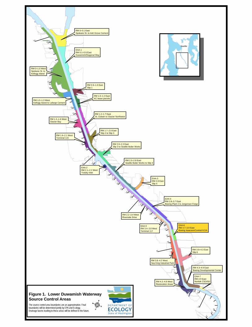
RM 0–1.0 WestSpokane St. to Kellogg Island
RM 2.0–2.3 EastSlip 3 to Seattle Boiler Works
RM 0–0.1 EastSpokane St. to Ash Grove Cement
RM 3.9–4.3 EastSlip 6
RM 2.2–3.4 WestRiverside Drive
EAA-1RM 0.1–0.9 EastDuwamish/Diagonal Way
RM 0.9–1.0 EastSlip 1
RM 4.2–4.8 WestRestoration Areas
EAA-4RM 2.8–3.7 EastBoeing Plant 2 to Jorgensen Forge
RM 1.6–2.1 WestTerminal 115
EAA-5RM 3.4–3.8 WestTerminal 117
RM 1.0–1.3 WestKellogg Island to Lafarge Cement
RM 1.7–2.0 EastSlip 2 to Slip 3
RM 1.2–1.7 EastSt. Gobain to Glacier Northwest
RM 4.3–4.9 EastBoeing Developmental Center
RM 3.8–4.2 WestSea King Industrial Park
RM 1.3–1.6 WestGlacier Bay
RM 2.3–2.8 EastSeattle Boiler Works to Slip 4
EAA-3RM 2.8 EastSlip 4
EAA-2RM 2.1–2.2 WestTrotsky Inlet
RM 1.0–1.2 EastKC lease parcels
EAA-6RM 3.7–3.9 EastBoeing Isaacson/Central KCIA
EAA-7RM 4.9 EastNorfolk CSO/SD
5.0
2.0
4.0
0.0
4.9
4.8
4.7
4. 4
4.3
4.2
3.9
3.8
3.7
3.6
3.5
3.4
3.3
3.2
3.1
2.9
5.6
2.7
2.6
2.5
2.4
2.3
2.8
5.4
1.9
1.8
1.6
1.5
1.3
1.2
1.1
5.5
0.9
0.8
0.7
0.2
0.1
2.1
Seattle
4Figure 1. Lower Duwamish WaterwaySource Control AreasThe source control area boundaries are an approximation. Final boundaries will be determined jointly by EPA and Ecology. Drainage basins leading to these areas will be defined in the future.
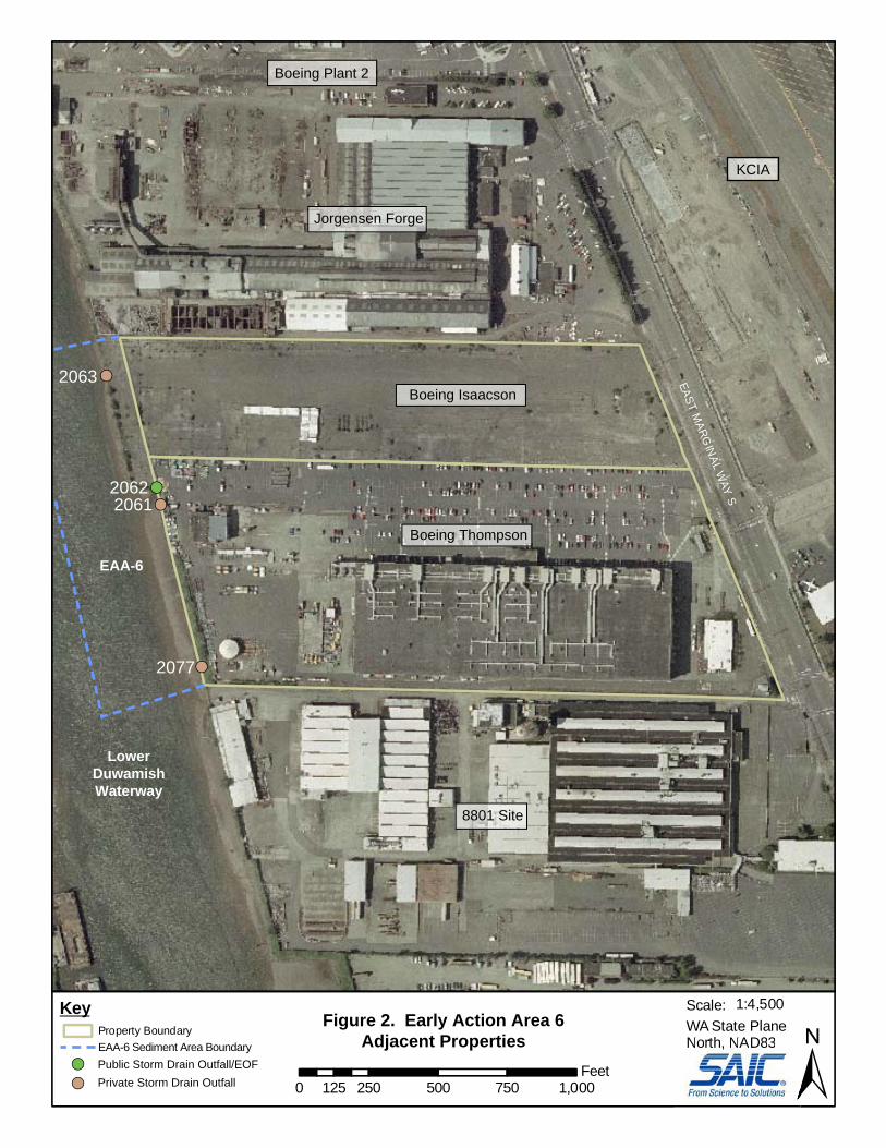
EASTM
ARGIN
ALW
AYS
KCIA
Jorgensen Forge
Boeing Plant 2
8801 Site
Lower
EAA-6
DuwamishWaterway
Boeing Thompson
Boeing Isaacson
0 250 500 750 1,000125Feet ±
1:4,500Scale:WA State PlaneNorth, NAD83
Figure 2. Early Action Area 6Adjacent Properties
Property BoundaryEAA-6 Sediment Area Boundary
Key
Nortrr h, NAD83Public Storm Drain Outfall/EOFPrivate Storm Drain Outfall
2063
20622061
2077
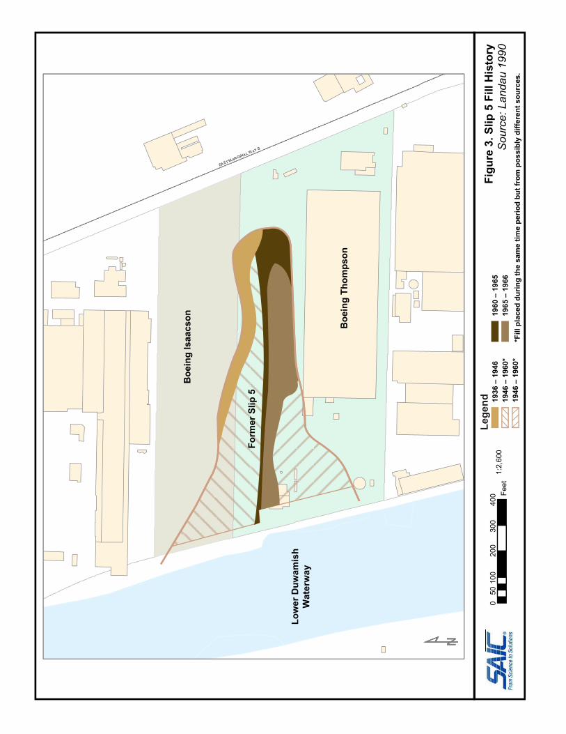
Figu
re3.
Slip
5 F
ill H
isto
ryS
ourc
e: L
anda
u 19
900
5010
020
030
040
0 Feet
1:2,
600
1936
– 1
946
1946
– 1
960*
1946
– 1
960*
1960
– 1
965
1965
– 1
966
*Fill
pla
ced
durin
g th
e sa
me
time
perio
d bu
t fro
m p
ossi
bly
diffe
rent
sou
rces
.
Lege
nd
Boe
ing
Isaa
cson
Boe
ing
Thom
pson
Low
er D
uwam
ish
Wat
erw
ay
Form
er S
lip 5
I5SB
NP
RR
I5N
B
AIR
POR
TW
AYS
PER
IMET
ERR
DS
EAS
TM
AR
GIN
AL
WAY
S
BNR
R
16TH
AVE
S
14TH
AVE
S
MILITARY RD S
NP
RR
NP
RR
Figure 4. Central KCIA Stormwater Drainage Basin0 500 1,000 1,500 2,000250
Feet
...\GIS\projects\LDW\EEA6\EEA6-upland-drainage.mxd M.Goff 10/10/08 WA State Plane NAD 83 - feet
Legend48" KC Airport SD #2/PS45EOF
Sewer lines (City of Seattle Data)Storm drainSanitary sewerCombinedCentral KCIA Stormwater Drainage Basin
1 inch equals 445 feet
Boeing Plant 2
Lower D
uwam
ish Waterw
ay
Jorgensen Forge
Boeing IsaacsonBoeing Thompson
8801 Site
KCIA
CB40
RCB56
SPU Sediment Trap
KC AirportSD #2/PS45EOF
Figu
re5.
For
mer
Slip
5 L
ocat
ion
and
Gen
eral
Gro
undw
ater
Flo
w D
irect
ion
Sou
rce:
ER
M 2
000b
050
100
200
300
400 Fe
et1:
2,60
0Fo
rmer
Slip
5C
urre
nt G
roun
dwat
er F
low
Dire
ctio
n1.
50
Mea
n gr
ound
wat
er e
leva
tion
in
fe
et a
bove
mea
n se
a le
vel
Lege
nd
1.00
1.00
1.50 1.
50
2.00
2.00
Form
er S
lip 5
Low
er D
uwam
ish
Wat
erw
ay
Boe
ing
Isaa
cson
Boe
ing
Thom
pson

0 75 150 225 30037.5Feet
1:1,500Scale:WA State Plane North, NAD83
LowerDuwamishWaterway
KeyAerial Photo: USGS 2002
,Figure 6. Early Action Area 6Sediment Sampling LocationsSubsurface Sample Location
Surface Sample LocationPublic Storm Drain Outfall/EOFPrivate Storm Drain Outfall
Subsurface SamplesSample ID Depth Interval (feet)Chemical SQS Exceedance Factor
Chemical SQS Exceedance Factor
Surface SamplesSample ID
Boeing Thompson
Boeing Isaacson
EIT060PCBs 1.6EIT060PCBs 1.6
SS119SS119PCBs 4.9BBP 1.9
EST143PCBs 2.4EST143PCBs 2.4
EST148PCBs 2.5EST148PCBs 2.5
EST147PCBs 4.4EST147PCBs 4.4
EST162PCBs 4.4PCBs 4.4
R22PAHs (various) 1.4-3.2Arsenic 1.4PCBs 1.1
R26
SS158PCBs 1.7SS158PCBs 1.7
DR220 0-2PCBs 2.9DR220 0-2PCBs 2.9
SC50a 0-1 1-2 2-2.8PCBs 6.7 8.0BEHP 2.3Arsenic 12 4.9 2.8
SC50a 0-1 1-2 2-2.8PCBs 6.7 8.0BEHP 2.3Arsenic 12 4.9 2.8
SC51 0-1 1-1.5 0-2 2-3.8PCBs 7.3 3.4Fluoranthene 1.6Acenaphthene 1.6 3.3Dibenzofuran 1.8BEHP 2.3Benzyl alcohol 3.2
SC51 0-1 1-1.5 0-2 2-3.8PCBs 7.3 3.4Fluoranthene 1.6Acenaphthene 1.6 3.3Dibenzofuran 1.8BEHP 2.3Benzyl alcohol 3.2
SS115SS115PAHs (various) 1.3-1.7
EST161PCBs 1.6EST161PCBs 1.6SS112
Arsenic 8.4BBP 2.5PCBs 2.2Fluoranthene 1.2SS114Arsenic 19PCBs 4.5BEHP 1.7PAHs (various) 1.1-1.3
R30
DR188
EST142
EST141
DR187
EST158EST159EST160
SS338
SS159
SS116SS118
2077
2061
2062
2063
R23PAHs (various) 1.4-5.9PCBs 4.3BBP 2.4BEHP 1.8Dibenzofuran 1.2
SS157BBP 1.3Benzoic Acid 1.2
R26BBP 2.0PCBs 1.2
R27PCBs 1.9BBP 1.2
R31BBP 3.7BEHP 1.3
Figu
re 7
. St
orm
wat
er S
yste
m, B
oein
g Th
omps
onan
d Is
aacs
on P
rope
rtie
sS
ourc
e: B
oein
g 20
08
Boe
ing
Thom
pson
Boe
ing
Isaa
cson
I5SB
I5 NB
AIRPO
RT WAY S
EAST MAR
GINAL W
AY S
BEACON AVE S16
TH
AV
E S
S MYRTLE ST
MILITARY R
D S
SWIFT AVE S
S WEBSTER ST
16T
HAV
S B
R
29TH
AVE
S
0 500 1,000 1,500 2,000250Feet
1:9,400Scale:WA State PlaneNorth, NAD83
Aerial Photo: USGS 2002
Figure 8. Early Action Area 6Upland Properties
King CountyInternational Airport
Former BoeingEMF Site
King County Offices
UPS
Western MetalProducts
Nordstrom
Airwest Repair
WingsAloft
AmeriflightHangar Holdings
Galvin FlyingServices
DHL
BAX Global
Boeing Isaacson
Boeing Thompson
Clay LacyAviation
SSCCAeroflight
ControlTower
Lower D
uwam
ish Waterw
ay
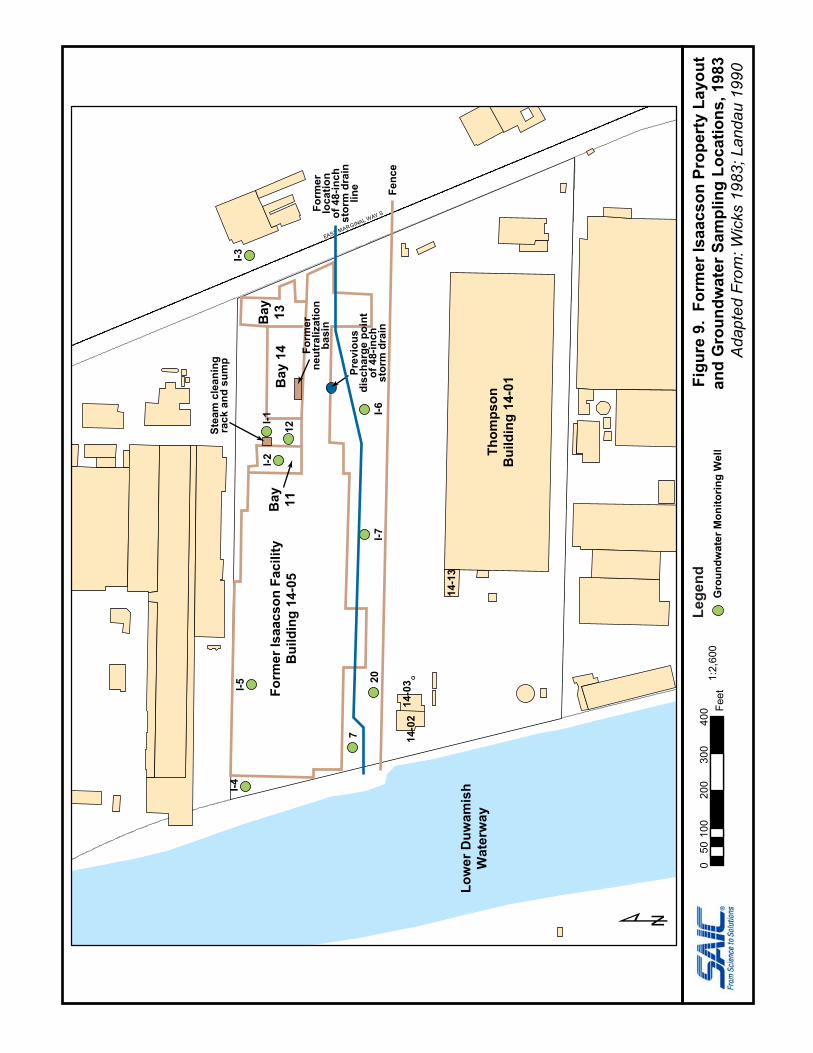
EAST MARGINAL WAY S
¹Fi
gure
9.
Form
er Is
aacs
on P
rope
rty
Layo
utan
d G
roun
dwat
er S
ampl
ing
Loca
tions
, 198
3A
dapt
ed F
rom
: Wic
ks 1
983;
Lan
dau
1990
050
100
200
300
400 Fe
et1:
2,60
0
Form
er Is
aacs
on F
acili
tyB
uild
ing
14-0
5B
ay 11B
ay 1
4B
ay 13
Thom
pson
Bui
ldin
g 14
-01
Low
er D
uwam
ish
Wat
erw
ay
Gro
undw
ater
Mon
itorin
g W
ell
I-7
I-4I-5
I-2I-1
I-3
12
I-6
7
Lege
nd
20
14-0
214
-03
14-1
3
Stea
m c
lean
ing
rack
and
sum
p
Form
erne
utra
lizat
ion
basi
n
Prev
ious
disc
harg
e po
int
of 4
8-in
chst
orm
dra
in
Form
erlo
catio
nof
48-
inch
stor
m d
rain
line Fe
nce
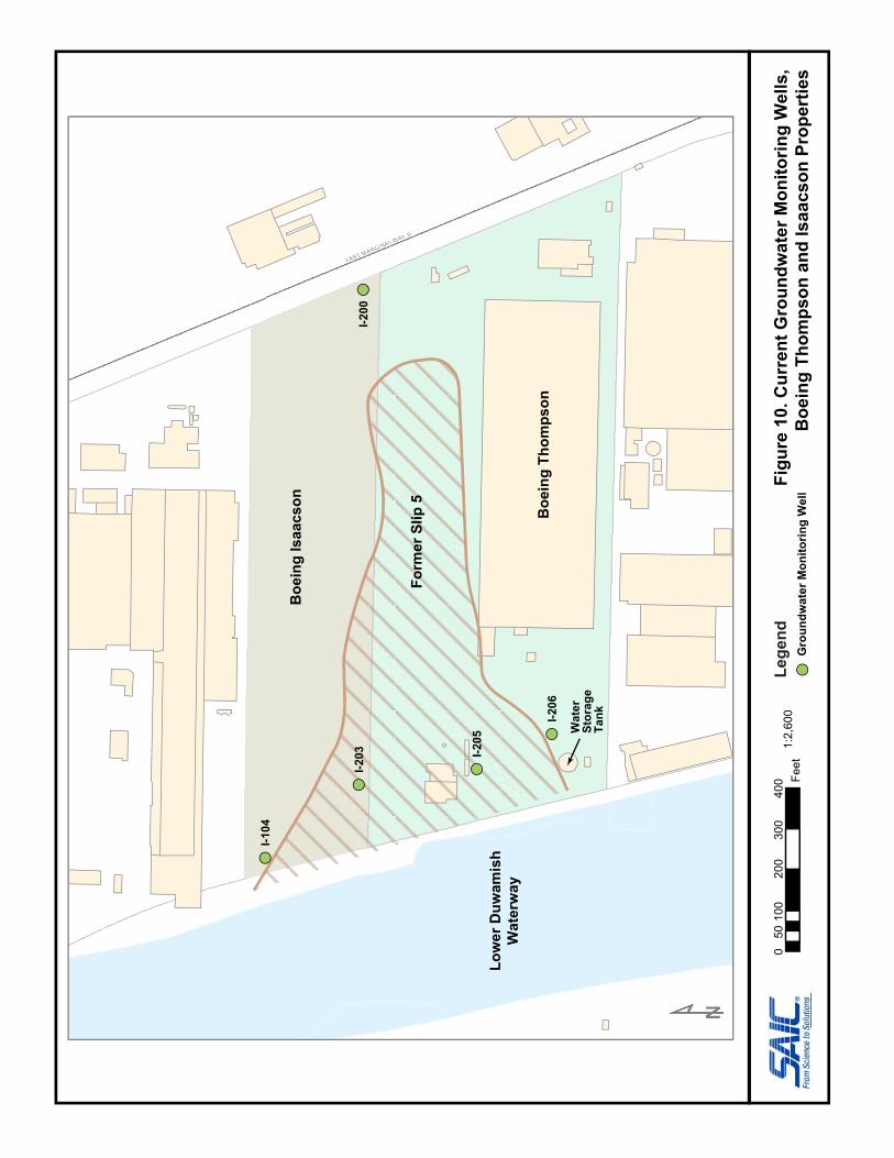
EAEE ST MARGINAL WAYAA S
Figu
re 1
0. C
urre
nt G
roun
dwat
er M
onito
ring
Wel
ls,
Boe
ing
Thom
pson
and
Isaa
cson
Pro
pert
ies
050
100
200
300
400 Fe
et1:
2,60
0
I-104
Form
er S
lip 5
Boe
ing
Isaa
cson
Boe
ing
Thom
pson
Low
er D
uwam
ish
Wat
erw
ay
Gro
undw
ater
Mon
itorin
g W
ell
Lege
nd
I-203 I-2
05
I-206
Wat
erSt
orag
eTa
nk
I-200