Embed Size (px)
Citation preview

Intl Law and Federal Regulations
Voyage Planning and Time
LT Mack Nolen

International Law and Federal Regulations
• AGENDA:• Convention on the Law of the Sea• Legal Divisions of the Oceans and Airspace• Navigation/Overflight of National Waters • Innocent Passage/Transit Passage• Legal Status of Ships and Aircraft
• Environmental Agreement (MARPOL 73/78)

International Law
“International law is defined as that body of rules that nations consider binding in their relations with one another.”
• Sources: International Agreements, Practice of Nations/Common Law
• Enforcement: International Court of Justice (ICJ), International Tribunal for the LOS

U.S. Navy Regulations
• ARTICLE 0705
• “At all times, Commanders shall observe, and require their commands to observe, the principles of international law.”
• “Where necessary to fulfill this responsibility, a departure from other provisions of Navy Regulations is authorized.”

NWP 1-14M
• NWP 1-14M - Commander’s Handbook on the Law of Naval Operations• Part One - Law of Peacetime Naval
Operations• (Law of the Sea)
• Part Two - Law of Naval Warfare• (Law of Armed Conflict)

UN Convention on the Law of the Sea (1972-1982)
• UN Convention on the Law of the Sea• Legal Divisions of the Oceans and
Airspace• Navigation/Overflight of National Waters • Legal Status of Ships and Aircraft
• Note: The United States has not ratified this treaty but is party to it.• The LOS Convention came into force 16
Nov 94

UN Convention on the Law of the Sea (1972-1982)
• “We must join the rest of the world in ratifying, at long last, the Convention on the Law of the Sea. The Convention on the Law of the Sea extends the rule of law to the world’s oceans.” Bill Clinton - 12 Jun 98
Ratified
Signed, but not yet ratified
Did not sign

Definitions
• Baselines: territorial seas and maritime zones are measured from baselines. There are several ways of drawing these baselines:
• Low water line: low water (low tide) line along the coast.
• Straight baselines: used when coastline is deeply indented or a fringe of islands exists along the coast.

BASELINEBASELINE
INDENTED COASTLINE FRINGING ISLANDS
Straight Baselines

Definitions
• Bays and gulfs: a well-defined indentation in the coastline of such proportion that it is more than mere curvature in the coastline.• The water area must be
greater than that of a semicircle drawn with the diameter equal to the length of distance across the mouth.
• The baseline across the mouth may not exceed 24 nautical miles.

SEMI-CIRCLE TEST
BA
SE
LIN
E
< or = 24NM ACROSSAREA BAY > AREA SEMI-CIRCLE
LEGAL BAYS

MEDITERRANEAN SEA
LIBYA
TRIPOLI
BENGHAZI
100NM
32 DEG 30 MIN
GULF OF SIDRA
HISTORIC BAYS

ARCHIPELAGICBASELINE
ARCHIPELAGICNATIONS

National Waters
• National waters: Subject to territorial sovereignty, but certain navigational rights are reserved for the international community.• Internal waters: area landward of the baseline (lakes,
rivers, some bays, etc.) This water is the same as the land itself; there is no right of innocent passage.
• Territorial seas: the belt of ocean measured seaward from the baseline; the U.S. uses and recognizes a territorial sea 12 NM out from the baseline.
• Archipelagic waters: a nation consisting of island groups. All enclosed waters are national waters. Sea lanes may be used through these waters for continuous/expeditious passage.

International Waters
• International Waters: all ocean areas not subject to territorial sovereignty by any nation. All nations have freedom of navigation and overflight in these waters.• Contiguous zones: extend seaward from the territorial
sea, where a coastal nation may enforce customs, immigration, or other laws. The U.S. uses a 12 NM contiguous zone but recognizes contiguous zones out to 24 NM from the baseline.
• Exclusive economic zones (EEZ): may extend out to 200 NM beyond the baseline, and are primarily for control of natural resources, such as oil drilling. The EEZ has no effect on freedom of navigation through these areas. The U.S. claims a 200 nautical mile EEZ.
• High seas: all water seaward of an EEZ or territorial sea.

Airspace
• National airspace: the nation has complete sovereignty over national airspace, which is located above national waters. Two exceptions are international straits and archipelagic sea lanes.
• International airspace: located over international waters; aircraft may navigate freely.

OFFSHORE ZONESNATIONAL AIR SPACE INTERNATIONAL AIR SPACE
TERRITORIALSEA
CONTIGUOUSZONE
HIGH SEASEEZINTERNALWATERS
BASELINE12NM
24NM
200NM
INTERNALWATERS
BASELINE

WARSHIP INTERNATIONAL STATUS
• WARSHIPS• AUXILIARIES• MILITARY AIRCRAFT • STATUS: SOVEREIGN IMMUNITY• See NAVREGS Article 0826

Status of Ships and Aircraft
• Warship: a vessel which bears national markings, is commanded by a commissioned officer, and is manned by a crew under armed forces discipline.• immune from interference by other nations• may not be searched or inspected without permission of the
CO• immune from arrest and seizure• does not pay foreign taxes or abide by foreign regulations.
• Military aircraft: operated by the armed forces, bearing military markings, commanded by a military member, and subject to armed forces discipline.• immune from search and inspection• foreign officials may not board a military aircraft without the
consent of the aircraft commander

Navigation Within or Over-flight of National Waters
• Internal waters: Entering a nation's internal waters is legally the same as entering the land itself. • Permission is always required. • Most nations grant standing permission to foreign
merchant vessels. • Warships and naval auxiliaries require specific and
advance entry permission, with the following exceptions:• distress• straight baselines enclose areas formerly recognized as the
high seas; in this case, either innocent passage or transit passage (in an international strait) is applied.

Navigation Within or Over-flight of National Waters
• Territorial Seas: normally off-limits without permission, but may be transited using the right of innocent passage.
• Innocent passage: Ships (but not aircraft) have the right of innocent passage, for the purpose of continuous and expeditious traversing of the territorial seas. • “Innocent” defined: actions that are not prejudicial to the
peace, good order, and security of the coastal nation. Some actions that are not innocent:• threat or actual use of force• launching or recovery of aircraft• intelligence gathering• any activity not related to passage
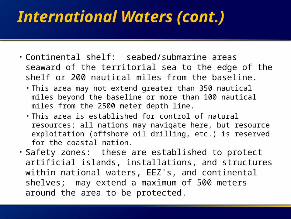
International Waters (cont.)
• Continental shelf: seabed/submarine areas seaward of the territorial sea to the edge of the shelf or 200 nautical miles from the baseline. • This area may not extend greater than 350 nautical miles
beyond the baseline or more than 100 nautical miles from the 2500 meter depth line.
• This area is established for control of natural resources; all nations may navigate here, but resource exploitation (offshore oil drilling, etc.) is reserved for the coastal nation.
• Safety zones: these are established to protect artificial islands, installations, and structures within national waters, EEZ's, and continental shelves; may extend a maximum of 500 meters around the area to be protected.

Navigation Within or Over-flight of National Waters
• International Strait: a narrow body of water which connects different parts of either the high seas or an EEZ, which could be claimed as national water but is necessary for navigation of the world’s vessels.
• Transit passage: the ships and aircraft or all nations have the right of unimpeded passage through straits and approaches for continuous and expeditious passage.
• Archipelagic passage: identical to transit passage, but applies to designated archipelagic sea lanes. Passage through other portions of archipelagic waters falls under innocent passage.

Navigation Within or Over-flight of Other Waters
• EEZ: open to all• Contiguous zone: open to all• High seas: open to all• National waters: restricted• Security/Defense zones: extend
beyond territorial sea for purposes of national security. Not recognized by the U.S.• Ex: Libya and the Gulf of Sidra

US Policy Regarding Other Areas
• Polar regions: both the arctic and Antarctic regions are open to all. The U.S. does not recognize any claims of sovereignty over these areas.
• Nuclear free zones: recognized by the U.S. to the extent that they do not infringe on other nations' rights of navigation and over-flight of the high seas.

Legal Divisions of the Oceans and Airspace
UN Convention on the Law of the Sea (1972-1982)

OFFSHORE ZONESNATIONAL AIR SPACE INTERNATIONAL AIR SPACE
TERRITORIALSEA
CONTIGUOUSZONE
HIGH SEASEEZINTERNALWATERS
BASELINE12NM
24NM
200NM
INTERNALWATERS
BASELINE

INTERNATIONAL WATERS
• COMPLETE FREEDOM OF NAVIGATION AND OVER-FLIGHT
• For warships, this includes:– Task Force Maneuvering– Flight Operations– Military Exercises– Surveillance– Intelligence Gathering– Ordnance Testing And Firing

EXCLUSIVE ECONOMIC ZONE
• U.S. Claim: 200 nm• LOS Limits: 200 nm
• Purpose: Provides for the protection of natural resources.
• Note:• Complete freedom of navigation and
over-flight exist.

CONTIGUOUS ZONE
• U.S. Claim = 12 nm• LOS Limits = 24 nm• NOT A SECURITY ZONE• Purpose: to prevent infringement
upon a nation’s customs, fiscal, immigration, or sanitary laws. (Protective Powers)
• Note: • Freedom of navigation and over-flight
exist, but must not be detrimental to above.

TERRITORIAL SEA
• Limits: 12 nm from a measured baseline
• Purpose: Extends the sovereignty of coastal states to the adjacent airspace and waters.
• Determining Baselines:• Normal Baselines (Low Water Marks)• Straight Baselines• Legal/Historical Bays
• Severe limits freedom of navigation and over-flight exist

INNOCENT PASSAGE
• Must not be prejudicial to peace, good order, or security.
• Must be continuous, expeditious, and on the surface.
• Prohibitions:• Launching/landing any aircraft or military
device.• Exercises involving any weapons.• Any activity not having a direct bearing on
passage• Stopping/Anchoring permitted only as required
for safety of navigation.

TRANSIT PASSAGE
• International Straits With Overlapping Territorial Seas
• “Normal Mode Of Operation”:• Submerged Transits Permitted For
Submarines• Formation Steaming Permitted• Warships May Launch And Recover
Aircraft

MALAYSIA
SUMATRA
SINGAPORE
JAVA
BORNEO
SOUTH CHINA SEA
THAILANDTRANSIT PASSAGE

Strait of Lombok
Strait of Malacca
15 days, 5,800 nm, and $7 million in additional fuel costs


U.S. Navy Regulations
• 0826. Search by Foreign Authorities.• 1. The commanding officer shall not permit a
ship under his or her command to be searched on any pretense whatsoever by any person representing a foreign state, nor permit any of the personnel within the confines of his or her command to be removed from the command by any such person, so long as he or she has the capacity to repel such act. If force should be exerted submission, the commanding officer is to resist that force to the utmost of his or her power.

INCSEA Agreement (1972)
• Agreement on the Prevention of Incidents on and over the High Seas (INCSEA)• A Navy-to-Navy Agreement signed in
1972 to reduce the risk of mutual interference while naval forces were operating on the high seas.

INCSEA Agreement
• Ships will observe both the letter and spirit of the international rules of the road.
• Surveillance ships will exercise good seamanship so as not to embarrass or endanger ships under surveillance.
• Ships will utilize special signals for announcing their operational intentions.
• Ships of one party will not simulate attacks, launch objects in the direction of, or illuminate the naviga tion bridges of ships of another party.
• Ships conducting exercises with submarines shall show appropriate signals to warn of submarines in the area.
• When approaching ships of the other party, especial ly when they are engaged in replenishment or flight operations, approach ships should remain well clear.
• Aircraft will use caution when approaching aircraft or ships of the other party.

Pollution Regulations
• The following minimum distances from shore must be observed when jettisoning waste overboard:• Pulped food/paper: 3nm• Shredded Glass/Metal: 12nm• Garbage (i.e. food contaminated trash): 12nm• Sewage (blackwater): 3nm, except in foreign
territorial seas• Waste water (greywater): anywhere, except in
foreign territorial seas• Oily Waste: If you have OCM/OWS, 12nm• Plastics: may not be dumped at sea• Medical waste: may not be dumped at seaFrom OPNAVINST
5090.1C

Voyage Planning and Time

Voyage Planning and Time
• AGENDA:• ETA/ETD• Determining Zone Time • Date-time Group (DTG) Format• Planning an Extended Ocean Voyage• Plotting a Great Circle Route• OTSR

Time Terminology
• Estimated Time of Arrival (ETA): the time and date of arrival that must be achieved. Usually specified by higher authority.
• Estimated Time of Departure (ETD): a computed estimate of the time and date of departure that will allow the ship to arrive on time.

Zone Time
• The rate at which the sun moves across the sky varies day to day due to the earth’s elliptic orbit about the sun.
• This makes use of actual time rather difficult.
• Instead, the theoretical mean sun, which passes completely around the earth once each 24 hours, is used to measure time.
The Mean Sun & Zone Time
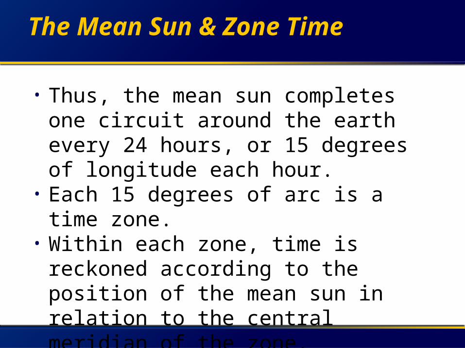
• Thus, the mean sun completes one circuit around the earth every 24 hours, or 15 degrees of longitude each hour.
• Each 15 degrees of arc is a time zone.
• Within each zone, time is reckoned according to the position of the mean sun in relation to the central meridian of the zone.

World Time Zones
Greenwich Mean Time (GMT)
• Centered on prime meridian.• Extends 7.5o degrees east and west
of the prime meridian.• Referred to as “zulu” time, because
the time zone is designated by “Z.”• Each additional time zone (as we
move east or west) has a boundary every 15 degrees past 7.5o.

The International Date Line
• The 24th time zone is split in half, with each zone on either side of the 180th meridian being only 7.5o wide.
• To remember what day it is on each side of the line, the phrase “San Francisco to Manila, Sunday to Monday” is used
Time Conversions
• During voyage planning, all times are normally expressed in terms of GMT to avoid confusion.
• As necessary, times are converted to the local time zone for ease of use.
• The formula for all conversions is:• zone time + zone description = GMT

Date Time Group (DTG)
• Official Navy format for expressing time and date. Also in all naval message traffic.
• Only use “L” for the time zone, not for “local”
• An example: 271115Q SEP 02 translates to:
• 27 Date - 2 digits• 1115Time - 4 digits• Q Time Zone - 1 letter• SEP Month - 3 letters• 02 Year - 2 digits

Shipboard Time
• During a transit, the ship’s clocks are set to the time zone in which the ship is located.
• As the ship transits eastward, clocks are periodically advanced 1 hour to conform to the proper time zone, and vice versa for westward travel.

The Voyage Planning Process
• Obtaining and updating charts and publications.
• Determination of arrival and departure dates.
• Plotting the intended track and use of Optimum Track Ship Routing (OTSR).

Questions?