Embed Size (px)
Citation preview
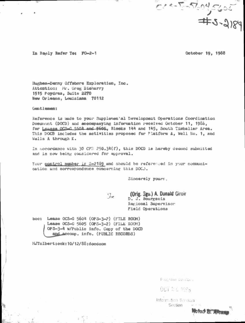
Im R%>ly m f r Tei FO-2-1 October 19, 1966
Hugh— Denny Off abor • Explore tion, Ioo. Attoutlonx Mr, Greg Cipherry 1515 Poydras, Suite 2270 Hew Orleans, Louisiana 70112
GejitlOMBt
Reference in laade to jour Suppleneo \ml Developoeat Ope ret lone Coordination Doounont (DOCD) end ecooopanving infoneation received October 11, 19&e, for *innfc •ne* faffi! Bloek* 144 end 1*5, South T label ler Areo. Thla DOCD include* the act ivit ies propose© for Plat fore A, Well Ro. 1, and Welle A throu&fl K.
In .ocordaDCc with 30 CF! 250.3*(f), this DOCD ia hereby deeued submitted tnd io now being cotsidored for approval.
Your ooBtrol miber i r S-218g and should bo referer oed in your cocnaunl-oetion and correspond one© ooacernlnf this DOO.
Sincerely your?
<n (Orig. 3|u.) A. Ooooht Giroir D. J . Boureeole hot: ional Supervisor Field Operationa
boot Lotvse OCS-0 5604 (OPS-3-?) (FILE ROOM) Lease OCS-G 5605 (OPS-3-2) (FILL ROOM)
| OPS-3-4 v/Publlo Info. Copy of tho DOCD V aat^cooop. info. (PUBLIC RECORDS)
MJTolbert scole: 10/12/88 :doooooei
OCT M.i 1S?b Inform..tion S. i vices
Section " »-»
Nbto*
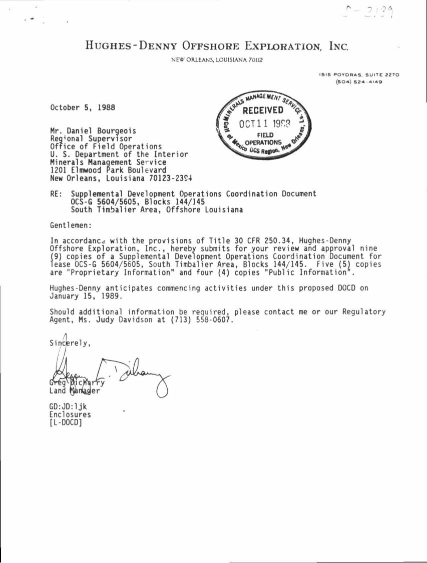
H U G H E S - D E N N Y OFFSHORE EXPLORATION, INC. NEW ORLEANS, LOUISIANA 70112
1315 POYDRAS. SUITE 2270
(SO*) 52* +149
October 5, 1988
Mr. Daniel Bourgeois Regional Supervisor Office of Field Operations U. S. Department of the Interior Minerals Management Service 1201 Elmwood Park Boulevard New Orleans, Louisiana 70123-2394
RE: Supplemental Development Operations Coordination Document OCS-G 5604/5605, Blocks 144/145 South Timbalier Area, Offshore Louisiana
Gentlemen:
In accordance with the provisions of Title 30 CFR 250.34, Hughes-Denny Offshore Exploration, Inc., herebv submits for your review and approval nine (9) copies of a Supplemental Development Operations Coordination Document for lease OCS-G 5604/5605, South Timbalier Area, Blocks 144/145. Five (5) copies are "Proprietary Information" and four (4) copies "Public Information .
Hughes-Denny anticipates commencing activities under this proposed DOCD on January 15, 1989.
Should additional information be required, please contact me or our Regulatory Agent, Ms. Judy Davidson at (713) 558-0607.
GD:JD:ljk Enclosures [L-D0CD]
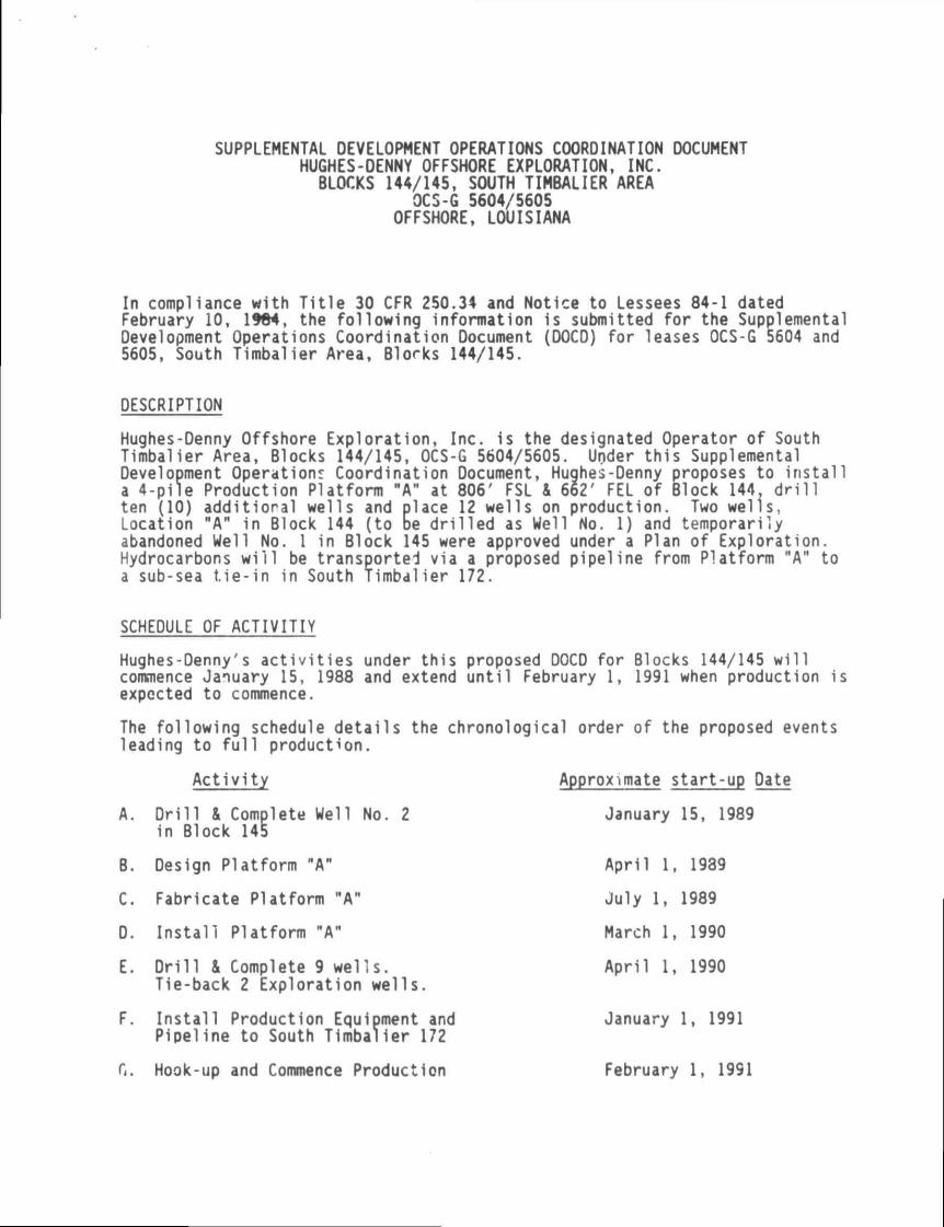
SUPPLEMENTAL DEVELOPMENT OPERATIONS COORDINATION DOCUMENT HUGHES-DENNY OFFSHORE EXPLORATION, INC. BLOCKS 144/145, SOUTH TIMBALIER AREA
OCS-G 5604/5605 OFFSHORE, LOUISIANA
In compliance with Title 30 CFR 250.34 and Notice to Lessees 84-1 dated February 10, 1984, the following infonnation is submitted for the Supplemental Development Operations Coordination Document (DOCD) for leases OCS-G 5604 and 5605, South Timbalier Area, Blocks 144/145.
DESCRIPTION
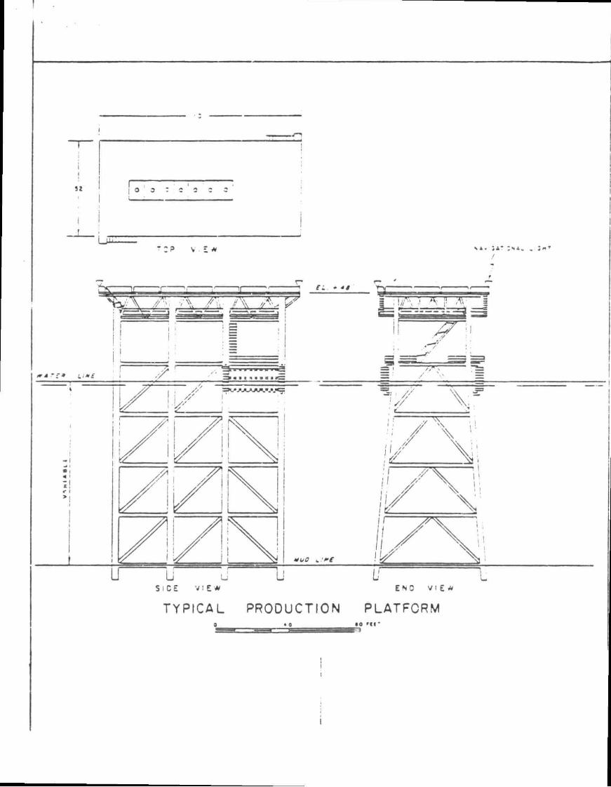
Hughes-Denny Offshore Exploration, I Timbalier Area, Blocks 144/145, OCS-Development Operations Coordination a 4-pile Production Platfonn "AM at ten (10) additional wells and place Location "A" in Block 144 (to be dri abandoned Well No. I in Block 145 we Hydrocarbons will be transported via a sub-sea tie-in in South Timbalier
nc. is the designated Operator of South G 5604/5605. Under this Supplemental Document, Hughes-Denny proposes to install 806' FSL & 662' FEL of Block 144. drill 12 wells on production. Two wells, lied as Well No. 1) and temporarily re approved under a Plan of Exploration, a proposed pipeline from Platform "A" to 172.
SCHEDULE OF ACTIVITIY
Hughes-Denny's activities under this proposed DOCD for Blocks 144/145 will commence January 15, 1988 and extend until February 1, 1991 when production is expected to commence.
The following schedule details the chronological order of the proposed events leading to full production.
Activity
A. Drill & Complete Well No. 2 in Block 145
B. Design Platform "A"
C. Fabricate Platform "A"
D. Install Platform "AM
E. Drill & Complete 9 wells. Tie-back 2 Exploration wells.
F. Install Production Equipment and Pipeline to South Timbalier 172
G. Hook-up and Commence Production
Approximate start-up Date
January 15, 1989
April 1, 1939
July 1, 1989
March 1, 1990
April 1, 1990
January 1, 1991
February 1, 1991
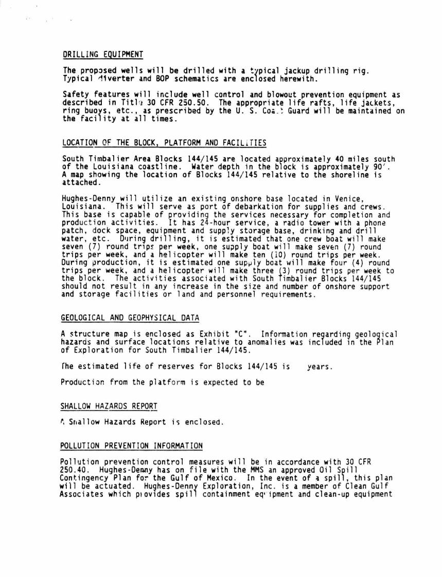
DRILLING EQUIPMENT
The proposed wells w i l l be d r i l l e d with a typical jackup d r i l l i n g r i g . Typical d i ve r te r and BOP schematics are enclosed herewith.
Safety features w i l l include well control and blowout prevention equipment as described in T i t l j 30 CFR 250.50. The appropriate l i f e r a f t s , l i f e jackets, r ing buoys, e tc . , as prescribed by the U. S. Cos.* Guard w i l l be maintained on the f a c i l i t y at a l l t imes.
LOCATION OF THE BLOCK, PLATFORM AND FACILiTIES
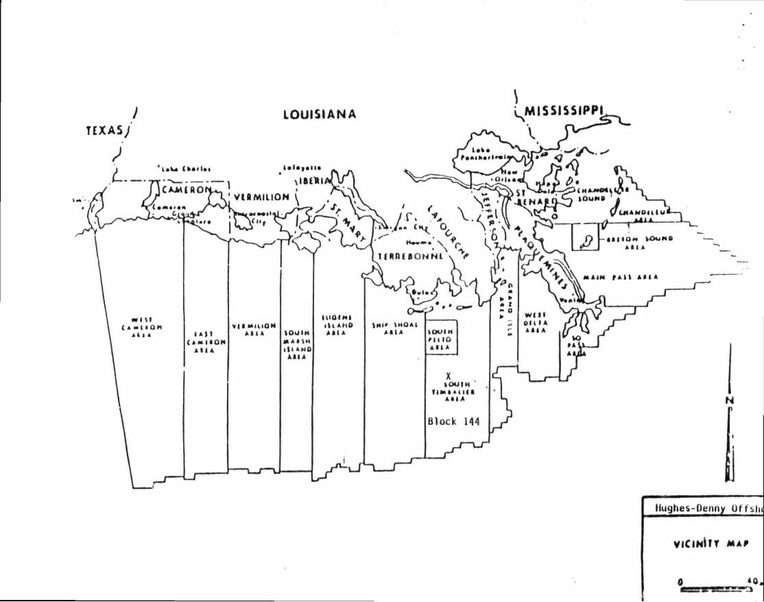
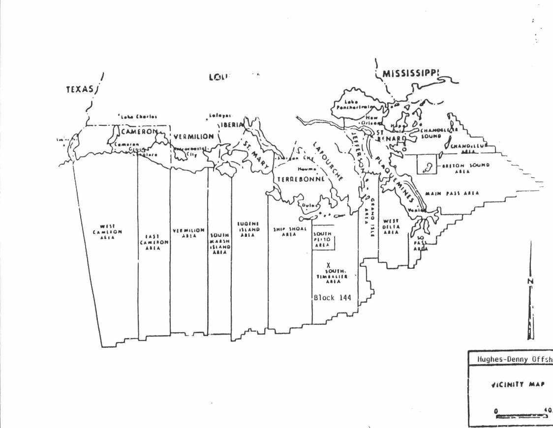
South Timbalier Area Blocks 144/145 are located approximately 40 miles south of the Louisiana coast l ine. Water depth in the block is approximately 90 . A map showing the locat ion of Blocks 144/145 re lat ive to the shoreline is attached.
Hughes-Denny w i l l u t i l i z e an exist ing onshore base located in Venice, Louisiana. This w i l l serve as port of debarkation for supplies and crews. This base is capable of providing the services necessary for completion and production a c t i v i t i e s . I t has 24-hour service, a radio tower with a phone patch, dock space, equipment and supply storage base, drinking and d r i l l water, e tc . During d r i l l i n g , i t is estimated that one crew boat w i l l make seven (7) round t r ips per week, one supply boat w i l l make seven (7) round t r ips per week, and a hel icopter w i l l make ten (iO) round t r ips per week. During production, i t is estimated one supply boat w i l l make four (4) round t r i ps per week, and a he l icopter w i l l make three (3) round t r ips per week to the block. The a c t i v i t i e s associated with South Timbalier Blocks 144/145 should not resul t in any increase in the size and number of onshore support and storage f a c i l i t i e s or land and personnel requirements.
GEOLOGICAL AND GEOPHYSICAL DATA
A structure map is enclosed as Exhibit "C". Information regarding geological hazards and surface locat ions re la t ive to anomalies was included in the Plan of Exploration for South Timbalier 144/145.
The estimated l i f e of reserves for Blocks 144/145 is years.
Production from the plat form is expected to be
SHALLOW HAZARDS REPORT
A Shallow Hazards Report is enclosed.
POLLUTION PREVENTION INFORMATION
Pol lut ion prevention control measures w i l l be in accordance with 30 CFR 250.40. Hughes-Denny has on f i l e with the MMS an approved Oil Spi l l Contingency Plan for the Gulf of Mexico. In the event of a s p i l l , th is plan w i l l be actuated. Hughes-Denny Exploration, Inc. is a member of Clean Gulf Associates which piovides s p i l l containment eq*ipment and clean-up equipment
at service bases located on the Gulf Coasts of Louisiana, Texas, Alabama, Florida and Mississippi. If a spill should occur from the proposed operations, the equipment located at Grand Isle, Louisiana would be utilized first, with additional equipment moved in from other bases, if necessary. Fast boat response with oil boom, skimmers, pump and storage tanks would require approximately 6-12 hours, including preparation time. A heavy equipment system would require approximately 48 hours, Including six hours preparation time.
Drill cuttings and excess drilling fluids will be disposed of in accordance with applicable environmental regulations. The drilling fluid components and additives to be used 1s enclosed.
EXHIBITS
Platform Drawings Vicinity Map & Location Plat Structure Map Rig Schematics Mud Additives Shallow Hazards Report Environmental Report Air Quality Review
Hughes-Denny Offsiu
VICIHI IT MAP
0
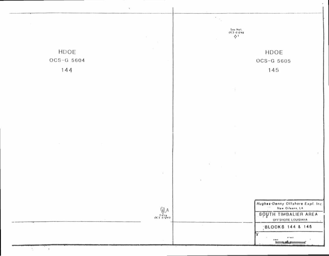
HDOE O C S - G 5C04
144
ocs a IJI3
Sou Hal. OCS G1/46
HDOE OCS-G 5605
145
Hugh* ) t -D inn f Of/short) Expl . Inc Mt* OiU«nt. I A
60JJTH TIMBALIER AREA orrsHonE LOUISIANA
0LO0K8 144 & 146
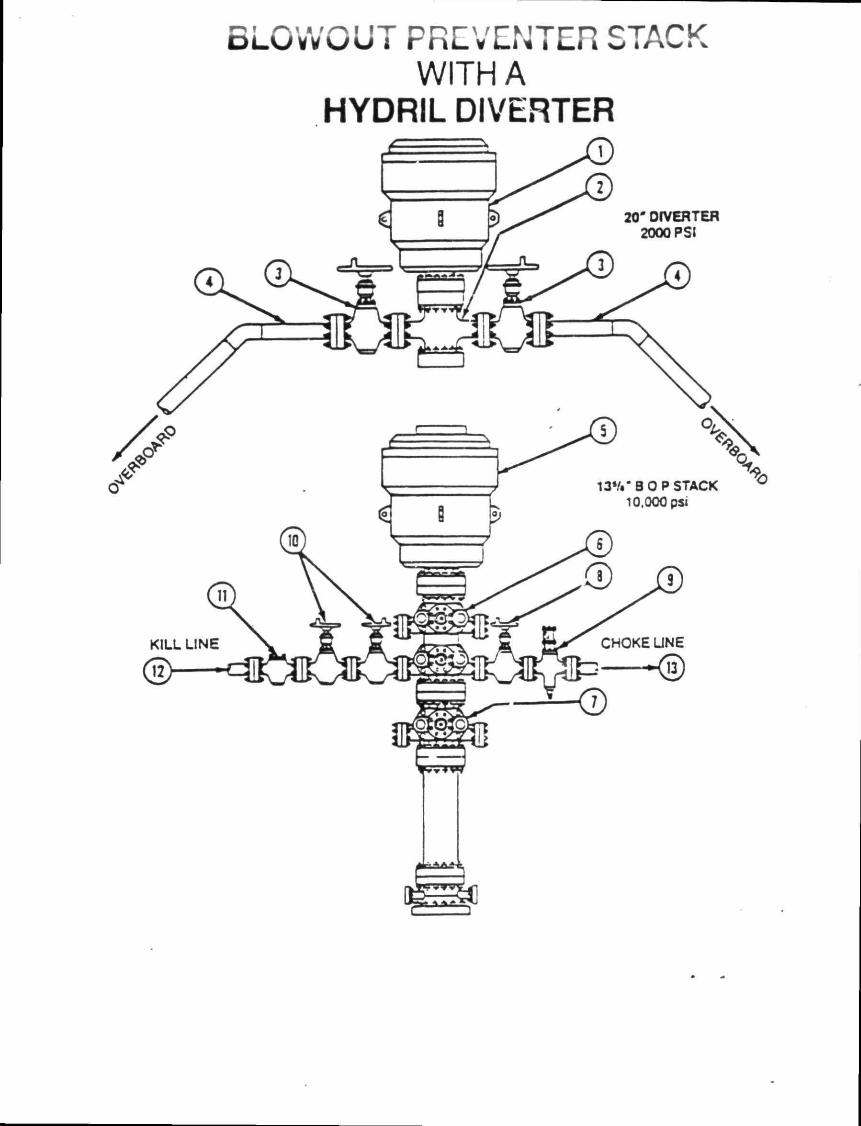
BLOWOUT PREVENTER STACK WITH A
HYDRIL DIVERTER
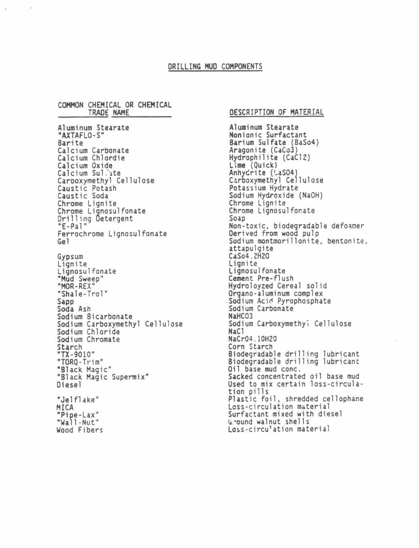
DRILLING MUD COMPONENTS
COMMON CHEMICAL OR CHEMICAL TRADE NAME
Aluminum Stearate "AXTAFLO-S" 8arite Calcium Carbonate Calcium Chlordie Calcium Oxide Calcium Sul .'ite Carboxymethyl Cellulose Caustic Potash Caustic Soda Chrome Lignite Chrome Lignosulfonate Dril1ing Detergent "E-Pal" Ferrochrome Lignosulfonate Gel
Gypsum Lignite Lignosulfonate "Mud Sweep" "MOR-REX" "Shale-Trol" Sapp Soda Ash Sodium Bicarbonate Sodium Carboxymethyl Cellulose Sodium Chloride Sodium Chromate Starch "TX-9010" "TORQ-Trim" "Black Magic" "Black Magic Supermix" Oiesel
"Jel Hake" MICA "P1pe-Lax" "Wall-Nut" Wood Fibers
DESCRIPTION OF MATERIAL
Aluminum Stearate Nonionic Surfactant Barium Sulfate (BaSo4) Aragonite (CaCo3) Hydrophilite (CaCI2) Lime (Quick) Anhydrite (US04) Carboxymethyl Cellulose Potassium Hydrate Sodium Hydroxide (NaOH) Chrome Lignite Chrome Lignosulfonate Soap Non-toxic, biodegradable defoamer Derived from wood pulp Sodium montmorillonite, bentonite, attapulgite CaSo4.2H20 Lignite Lignosulfonate Cement Pre-flush Hydroloyzed Cereal solid Organo-aluminum complex Sodium Acid Pyrophosphate Sodium Carbonate NaHC03 Sodium Carboxymethyl Cellulose NaCI NaCr04.10H20 Corn Starch Biodegradable drilling lubricant Biodegradable drilling lubricant Oil base mud cone. Sacked concentrated oil base mud Used to mix certain loss-circulation pills Plastic foil, shredded cellophane Loss-circulation material Surfactant mixed with diesel (a*ound walnut shells Loss-circ^ation material

niiflniiiiiiiiHiiiaiilHiim P.O. Box 218753 Houston. Texas 77218 713-558-0607
ENVIROHENTAL REPORT
FEDERAL LEASES OCS-G 5604/5605
SOUTH TIMBALIER AREA, BLOCKS 144/145
OFFSHORE, LOUISIANA
THE FOLLOWING ENVIRONMENTAL REPORT WAS PREPARED BY J. CONNOR CONSULTING FOR HUGHES-DENNY OFFSHORE EXPLORATION FOR COASTAL ZONE CONSISTENCY DETERMINATION BY THE STATE OF LOUISIANA ON OPERATIONS PROPOSED TO Bt CONDUCTED IN THE DEVELOPMENT OPERATIONS COORDINATION DOCUMENT FOR LEASES OCS-G 5604/5605. FOR INQUIRIES REGARDING THIS REPORT PLEASE CONTACT:
HUGHES-DENNY OFFSHORE EXPLORATION
1515 POYDRAS, SUITE 2270
NEW ORLEANS, LOUISIANA 701*2
oCTOBER, 1988
- i
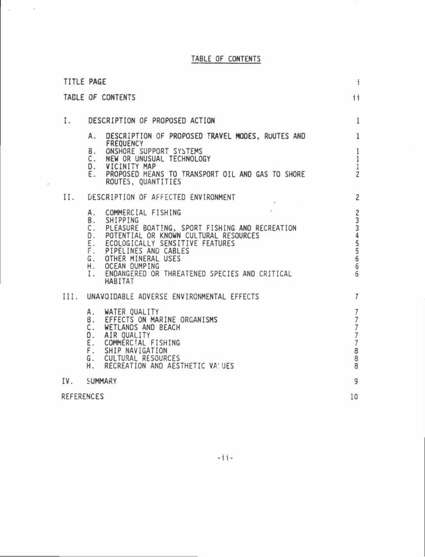
TABLE OF CONTENTS
TITLE PAGE i
TACLE OF CONTENTS ii
I. DESCRIPTION OF PROPOSED ACTION 1
A. DESCRIPTION OF PROPOSED TRAVEL MODES, ROUTES AND 1 FREQUENCY
B. ONSHORE SUPPORT SYSTEMS 1 C. NEW OR UNUSUAL TECHNOLOGY 1 D. VICINITY MAP 1 E. PROPOSED MEANS TO TRANSPORT OIL ANO GAS TO SHORE 2
ROUTES, QUANTITIES
II. DESCRIPTION OF AFFECTED ENVIRONMENT 2
A. COMMERCIAL FISHING 2 B. SHIPPING 3 C. PLEASURE BOATING, SPORT FISHING AND RECREATION 3 D. POTENTIAL OR KNOWN CULTURAL RESOURCES 4 E. ECOLOGICALLY SENSITIVE FEATURES 5 F. PIPELINES AND CABLES 5 G. OTHER MINERAL USES 6 H. OCEAN DUMPING 6 I. ENDANGERED OR THREATENED SPECIES AND CRITICAL 6
HABITAT
III. UNAVOIDABLE ADVERSE ENVIRONMENTAL EFFECTS 7
A. WATER QUALITY B. EFFECTS ON MARINE ORGANISMS C. WETLANDS AND BEACH D. AIR QUALITY E. COMMERCIAL FISHING F. SHIP NAVIGATION 8 G. CULTURAL RESOURCES 8
H. RECREATION AND AESTHETIC VA'UES 8
IV. SUMMARY 9
REFERENCES 10
-i i -
I . OESCRIPTION OF PROPOSED ACTION
Hughes-Denny plans to conduct development activities or South Timbalier Area Blocks 144/145, OCS-G 5604/5605.
As proposed, the Supplemental Development Operations Coordination Document for South Timbalier Area Blocks 144/145 will include: (1) install Platform "A", (2) d r i l l ten (10) additional wells and (3) place twelve wells on production.
At this time, planned commencement date for development activities is on or about January 15, 1S89.
A. DESCRIPTION OF PROPOSED TRAVEL MODES, ROUTES AND FREQUENCY
Crew, supply boats and helicopters will be dispatched from a support base located in Venice, Louisiana. The boats will normally move to the block via the most direct route from Venice, Louisiana, however, boat*; operating in the field may travel from other facilities nearby. Following is an estimate of trips to the proposed operation.
B. ONSHORE SUPPORT BASE
The proposed activities will Mtilize a support base located at Venice, Louisiana. Thii base provides 24-hour service, a radio tower with phone patch, dock space, office space, parking lot, equipment and supply storage space, drinking and dri l l water, etc. The proposed development activities will help to maintain this base at its present level of activity. No expansion of the physical facilities or the creation of new jobs is expected to result from the work planned in conjunction with this block.
C. NEW OR UNUSUAL TECHNOLOGY
No new techniques or unusual technology will be required for these operations.
D. VICINITY MAP
South Timbalier Area Blocks 144/145 are located approximately 40 miles offshore Louisiana. Water depth is approximately 72'. See Attachment I .
Dri11ing Operations Production Operations
Crew Boat Supply Boat Helicopter
7 trips per week 7 trips per week 10 trips per week
0 trip per week 4 trips per week J trips per week
-1-
E. PROPOSED MEANS TO TRANSPORT OIL AND GAS TO SHORE, ROUTES, QUANTITIES
Producible hydrocarbons will be transported via pipelines in and or near Blocks 144/145.
II. DESCRIPTION OF AFFECTED ENVIRONMENT
A. COMMERCIAL FISHING
The Gulf of Mexico is the single most important area for fisheries production in the United States. In 198$, the total landings of all fisheries in the Gulf was about 2.4 billion pounds, valued at $59$ million dockside, and represented about 38% of the total United States landings by pounds and 26% by value. In lc85, the top four U.S. ports in quantity of commercial fishery landings were Cameron, Louisiana; Pascagoula-Moss Point, Mississippi; and Dulac-Chauv4n and Empire-Venice, Louisiana.
The Gulf shrimp fishery represents the single most valuable fishery in the United States with landings (heads removed) averaging approximately 230 million lbs/yr. The major shrimp species include-brown, white, and pink shrimp. In 1981 production reached almost 270 million pounds worth over $401 million dockside. In addition to shrimp, the blue crab significantly contributes to the Gulf's crustacean landings. In 1985, about 56 million pounds of blue crabs, worth about $16 million, were taken in the Gulf's near-shore estuaries and sounds. Oysters are the main mollusk harvested in the Gulf's nearshore estuaries and sounds, and oyster landings in 1985 were approximately 26.5 million pounds valued at aMut $41 million.
In the Gulf the following commercial fishes were the most economically important in 1985 and are arranged in order of decreasing priority: gulf menhaden, groupers and scamp, red snapper, black mullet, red drum, yellowfin tuna, catfish and bullheads, swordfish, black drum, spotted seatrout, yellowtail snapper, pompano, vermilion snapper, and king mackerel and cero.
The menhaden purse seine fishery is the most important fishery in terms of pounds landed. In 1985, 1.9 billion pounds valued at $67 million were landed in the Gulf. Menhaden are used in the manufacture of fish meal and solubles for additives to livestock feeds, and production of f.sh t i l . Also, small amounts are used for bait and canned pet food.
The industrial bottomfish trawl fishery produces stock for the pet food industry, bait, animal food, and fishmeal. This fishery reached peak production in the early 1970's at about 115 millions pounds, worth about $2.8 million; however, it has declined in recent years.
Shrimp is by far the most valuable component of the Louisiana landings. The menhaden fishery is the largest in terms of pounds landed. In 1985, the total commercial landings for Louisiana were about 1.7 billion pounds, worth $229 million. Louisiana ranked first in the United States in pounds landed and second in value.
B. SHIPPING
Fairways play an important role in the avoidance of collisions on the OCS, particularly in the case of the large oceangoing vessels, but not all vessels stay within the fairways. Many others, such as fishing boats and OCS support vescels, travel through areas with high concentrations of fixed structures. In such cases the most important mitigation factor is the requirement for adequate marking and lighting of structures. After a structure nas been in place for a while, it often becomes a landmark and an aid to navigation for vessels that operate in the area on a regular basis.
South Timbalier 144/145 are clear of all shipping fairways and anchorage areas. The platform and each of the marine vessels servicing this operation will be equipped with all U. S. Coast Guard required navigational safety aids.
C. PLEASURE BOATING, SPORT FISHING AND RECREATION
The northern Gulf of Mexico coastal zone is one ofthe major recreational regions of the United States, particularly in connection with marine fishing and beach-related activities. The shorefronts along the Gulf coasts of Alabama, Mississippi, Louisiana, and Texas offer a diversity of natural and developed landscapes and seascapes. The coastal beaches, barrier islands, estuarine bays and sounds, river deltas, and tidal marshes are extensively and intensively utilized for recreational activity by residents of the Guif South and tourists from throughout the Nation, as well as from foreign countries. Publicly-owned and administered areas such as National seashores, parks, beaches, and wildlife lands, as well as specially designated preservation areas such as historic and natural sites and landmarks, wilderness areas, wildlife sanctuaries, and scenic rivers attract residents and visitors throughout the year. Commercial and private recreational facilities and establishments, such as resorts, marinas, amusement parks, and ornamental gardens, also serve as primary interest areas and support services for people who seek enjoyment from the recreational resources associated with the Gulf.
The two major recreational areas most directly associated with offshore leasing and potentially affected by it are the offshore marine environment and tKe coast, shorefront of the adjoining states. The only major recreational activity occurring on the OCS is offshore marine recreational fishing and diving. Studies, reports, and conference proceedings published by MMS and others have documented a substantial recreational fishery, including scuba diving, directly associated with oil and gas production platforms. The recreational fishing associated with oil and gas structures stems from their function as high profile artificial fishing reefs. A report on the 1984 Marine Recreational Fishery Statistics Surveys presented by NMKS at the Sixth Annual Gulf of Mexico Information Transfer Meeting indicates a majority of the offshore recreational fishing in the Central Gulf of Mexico is directly associated with oil and gas structures. There are currently about 4,000 offshore oil and gas structures in the Central and Western Gulf of Mexico. Many other studies have demonstrated that when oil and gas structures are accessible to marine recreational fishermen and scuba divers they are a major attraction for marine recreational activities and arr a positive influence on tourism and coastal economics.
-3-
With the exception of Grand Isle and vicinity and a stretch of beach area in Cameron Parish, (Peveto/Constance/Ocean View Beaches, Holly Beach, Hackberry Beach) Louisiana has very limited beach area suitable for recreation. Most of it is very narrow, of poor recreational quality and generally inaccessible by automobile, some of the highest quality beach areas in coastal Louisiana are found along the barrier Islands chain off Terrebonne Parish. Several add1t1oi .il significant recreational resources are found along the Gulf Coast. Louisiana has ornamental gardens, scenic roads, rivers, and trails.
0. POTENTIAL OR KNOWN CULTURAL RESOURCES
Archaeological resources are any objects or features which are man-made or modified by human activity. Significant archaeological resources are either historic or prehistoric and, as dafined by 36 CFR bO.6, generally include properties greater tha ; 50 years old which are associated with events that have made a significant contribution to the broad patterns of our history; are associated with the lives of persons significant in the past; embody the distinctive characteristics of a type, period, or method of construction; represent the work of a master; possess high artistic values; represent a significant and distinguishable entity whose components may lack individual distinction; or have yielded, or may be likely to yield, information important in prehistory or history.
Although most historic archaeological resources on the OCS are shipwrecks, other types of historic sites, such as the Ship Shoal Lighthouse, may occur in Federal waters.
Figures indicate that less than 2% of pre-20th century ships reported in the Gulf and less than 10% of all ships reported lost between 1500 and 1945 have known locations. Considering the problems with inaccurate wreck reporting, drift and breakup of wrecks, and ships which have been lost but never reported, it becomes apparent that very little Is really known about the locations of historic shipwrecks in the Gulf of Mexico.
In order to deal with the management problems of this largely unlocated resource base, a high probability zone for the occurrence of shipwrecks (Zone 1) was proposed by the baseline study (CEI, 1977). This zone was delineated by using geographic factors, such as approaches to seaports, straits, shoals, reefs, and historic shipping routes, as indicators of high shipwreck potential.
Required remote sensing surveys on the OCS have recorded evidence of approximately 57 potential wrecks. Ten of these aro definite wrecks while the remaining 47 would require further investigation for positive identification. Eighty percent of these possible wricks were recorded within Zone 1 which, according to the baseline study, is where the highest incidence of shipwrecks should occur.
E. ECOLOGICALLY SENSITIVE FEATURES
Barrier beaches are a common landform along the Gulf Coast and stretch in an irregular chain from Florida to Texas. These elongated, narrow landforms are comp sed of sand and other loose sediments transported by waves, currents, storm surges, and wind. In geological terms, barrier islands are a young phenomenon, being formed only in the last 5000 to 6000 years. The term "barrier" identifies the structure as one that protects other features, such as bays, estuaries, and marshes, from direct wave attack of the open ocean. The waters in these bays and estuaries are a blend of the terrestrial-freshwater systems of the mainland and the saltwater system of the ocean, and among the richest ecosystems known. Many of the species that inhabit the bays, estuaries, and adjacent marshes use these areas as spawning, nursery, and feed grounds.
Another benefit of both the islands and their adjacent marshes and bays is that of providing habitats for a large number of birds and other animals. The islands also provide habitat for several threatened or endangered species, for example, the loggerhead turtle, the southern bald eagle, alligators, and brown pelicans.
The shelf and shelf edge of the Central and Western Gulf are characterized by topographic features which are inhabited by benthic communities. The benthic organisms on these features appear to be depth related; however, the actual limiting factors are temperature and light penetration (turbidity and sedimentation).
The Central Gulf of Mexico lists 16 topographic features.
Shelf Edge Banks Midshelf Banks
Bright Bank Sonnier Bank McGrail Bank 29 Fathom Bank Rankin Bank Fishnet Bank Alderdice Bank Rezak Bank Sidner Bank Ewing Bank Jakkula Bank Bouma Bank Parker Bank Sackett Bank Diaphus Bank Sweet Bank
F. PIPELINES AND CABLES
Pipelines crossing Blocks 144/145 are described in detail in the Shallow Hazard Analysis submitted for these blocks.
Hughes-Oenny as a prudent operator will avoid all pipelines and cables in this block during development activities.
-5-
6. OTHER MINERAL USES
The activities proposed for South Timbalier 144/145 will have no direct or indirect impact on other mineral uses.
H. OCEAN DUMPING
Ocean dumping is prohibited in this area.
I. ENDANGERED OR THREATENED SPECIES ANO CRITICAL HABITAT
Five federally listed endangered whale species occur within the Central Gulf. These include fin, humpback right, sei, and sperm whales. Generally, these large cetaceans inhabit the continental slope and deep oceanic waters, occasionally they are sighted nearshore (Schmidly, 1981). Sperm whales have been sighted near the Louisiana Delta and offshore Brownsville (Fritts et al., 1983).
Four federally listed endangered turtle species (Kemp's ridley, green, hawksbill, and leatherback turtles) and one threatened species (loggerhead turtle) occur in the Gulf of Mexico.
The American alligator occurs generally throughout the Central Gulf coastal areas. The alligator is listed as endangered throughout its range except in the coastal areas of Florida and Texas where it is listed as threatened and in Louisiana where it is listed as "threatened by similarity of appearance".
The red-cockaded woodpecker occurs primarily in mature open pine forest throughout the Eastern and Central Gulf area and into eastern Texas.
Arctic peregrine falcons migrate along the eastern coast of Morida, the Florida Keys, and the Gulf coast of Texas. Some peregrine falcons overwinter along the Gulf coastal areas.
The endangered eskimo curlew's northward migration corridor crosses the Louisiana and Texas coastal areas.
Brown pelican's occur along the coast of Cameron Parish, Louisiana. Bald eagles inhabit several Gulf coastal counties.
These species may be affected by the development of coastal lands and/or the occurrence of oil spills which may affect the species directly or through their food sources. Since the proposed activities include no plans for the development of the coastal lands, the impact on endangered or threatened species is pr larily based on the occurrence of oil spills.
Hughes-Denny as a prudent operator, will take the necessary measures to reduce the probability of oO spills. Hughes-Denny's proposed development operations on Blocks H+/145 should not pose a threat to any endangered or threatened species.
III. UNAVOIDABLE A0VERSE ENVIRONMENTAL EFFECTS
A. WATER QUALITY
Production activities will temporarily reduce water quality adjacent to the location. This will Increase turbidity in a plume down-current from the work site. Released waters and a minor oil spill could also contribute to water quality degradation.
B. EFFECTS ON MARINE ORGANISMS
Some organisms will be killed and some will be temporarily functionally impaired as a result of development operations. The most affected groups will be plankton and benthos immediately around the platform. Damage will be both mechanical and toxicological. Discharge of hole cuttings will damage plankton within the plume and bury some of the less mobile benthic fauna. These impacts are considered to be localized, short te.m and reversible at the population level.
An oil spill could affect a broad spectrum of marine organisms. However, most effects would be localized and short term. Any effects on mammals and turtles would be significant.
C. WETLANDS AND BEACH
In the unlikely event of a spill occurring and reaching shore, organisms in wetland and beach habitats could be killed or functionally impaired. Human community disruption could also occur. Although all such effects would be localized, any effects on endangered species and/or critical habitats would be significant.
D. AIR QUALITY
The air quality at the lease site will be degraded temporarily during operations, but should return to normal once operations are measurably completed. Offshore activities probably will not affect onshore air quality. Air quality at the onshore base will be only insignificantly reduced by onshore activities. Any such effect will be temporary.
E. COMMERCIAL FISHING
Of the various types of fishing gear in use in the OCS areas, trawls have the greatest chance for operational conflicts with oil and gas activities. Losses may, however, be compensated under the Fishermen's Contingency Fund or other legal routes. Trawl nets can be snagged on underwater stubs causing damage or loss of the nets. In addition, it is conceivable that snags could damage underwater production equipment or pipelines causing a spill of oil or gas. Because safety equipment is installed, which shuts in production when a loss of pressure occurs, the likelihood of a major spill resulting thareby is considered very small. Less frequently, large objects which were lost
-7-
overboard from petroleum industry boats, pipeline lay barges, and platforms are caught by fishing gear resulting in damage to the gear and/or its catch of fish; however, occurrence of this type of incident is low. Also, commercial fishermen would probably not harvest fish in the area of an oil spill, as spilled oil could coat or contaminate commercial fish species rendering them unmarketable. Other unavoidable adverse impacts include loss of fish space caused by installation of unburied pipelines, rigs, platforms, or by other OCS-related structures. There may be some localized competition for shore facilities. These effects and any effect that the development operations will have on stocks of important species are considered minor.
F. ShIP NAVIGATION
Very little interference can be expected between the platform and marine vessels utilized during production operations and ships that use established fairways. However, at night and during rough weather, fog, and heavy seas, ships not using established fairways could collide with the platform.
G. CULTURAL RESOURCES
There is only a small probability that an unknown cultural resource exists in the lease area.
H. RECREATION AND AESTHETIC VALUES
The platform and marine vessels may represent an obstacle to some sport fisherman, but such an effect is expected to be negligible and not permanent.
Even though existing regulations and orders prohibit, indiscriminate littering of the marine environment with trash, offshore oil and gas operations involving men, machines, equipment, and supplies is bound to result in some littering of the ocean. Human nature and accidents associated with offshore operations will contribute some floatable debris to the ocean environment which will eventually come ashore on major recreational beaches.
The effects that normal operations or a minor oil spill would have on any fish stocks important to sport fishermen are also considered to be negligible.
A minor oil spill and/or non-petroleum floating debris could foul beaches inshore of the lease area. The fouling of the beaches would be an aesthetic detriment that could adversely affect recreation. Any effects on beach recreation could adversely affect tourism and, consequently, the local economy.
IV. SUMMARY
The proposed activity will be carried out and completed with the guarantee of the following Items.
A. The best available and safest technologies will be utilized throughout the project. This includes meeting all applicable requirements for equipment types, general project layout, safety systems, and equipment and monitoring systems.
B. All operations are covered by a Minerals Management Service approved 011 Spill Contingency Plan.
C. All applicable Federal, State and Local requirements regarding air emission and water quality ar.. discharge for the proposed activities, as well as any other permit conditions, will be compiled with.
D. The proposed activities described in detail In the Development Plan will comply with Louisiana's Coastal Management Program and will be conducted in a manner consistent with such Program.
-9-
REFERENCES
1. Final Environmental Impact Statement, Proposed Oil and Gas Lease Sales 94, 98 and 102, Gulf ot Hexico OCS Region OCS EIS, MMS 84-0057.
2. Final Environmental Impact Statement, Proposed Oil and Gas Lease Sales 94, 98 and 102, Gulf of Mexico OCS Region, OCS EIS, MMS 84-0057, visuals.
3. Fisheries of the United States, 1985, April, 1986.
4. The Ecology of Petroleum Platforms in the Northwestern Gulf of Mexico: A Community Profile, Bureau of Land Management Open File Report 82-03, July, 198Z.
5. Environmental Report West Cameron Area Blocks 516 and 524, March, 1987.
6. BLM Draft Environmental Impact Statement, OCS Oil and Gas Lease Sales A-52 and 62.
7. BLM Final Environmental Impact Statement, OCS -Oil and Gas Lease Sales A-52 and 62.
8. BLM Final Environmental Impact Statement, OCS Oil and Gas Lease Sale 47.
9. Minerals Management Service, 1983. Final Regional Environmental Impact Statement, Gulf Qf Mexico. U.S. Department of the Interior.
10. Final Environmental Impact Statement, Proposed Oil and Gas Lease Sales 110 and 112, Gulf of Mexico OCS Region, OCS EIS, MMS 86-0087.
11. Final Environmental Impact Statement, Proposed Oil and Gas cease Sales 110 and 112, Gulf of Mexico OCS Region, OCS EIS, MMS "86-0087, visuals.
12. Final Environmental Impact Statement, Proposed Oil and Gas Lease Sales 113, 115 and 116, Gulf of Mexico OCS Region, OCS EIS, MMS-87-0077.
-10-
Hughes-Denny Qffsh
0
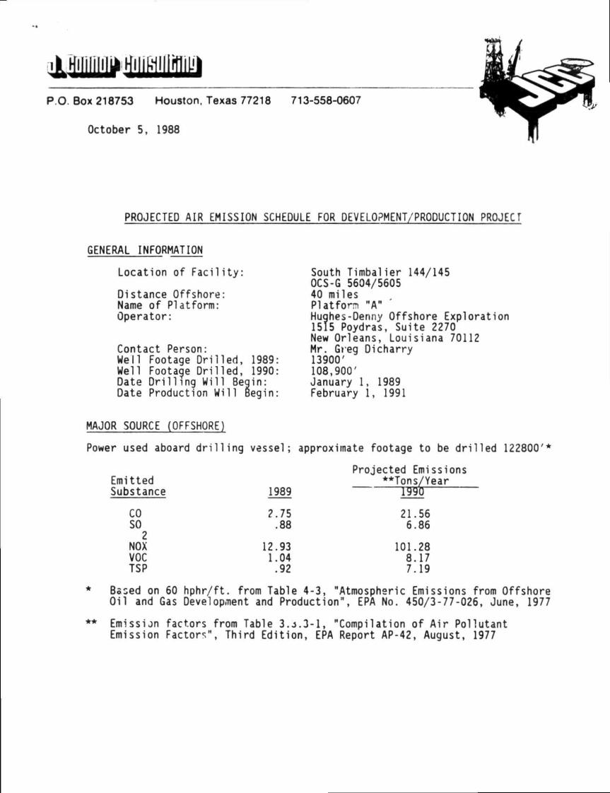
PROJECTED AIR EMISSION SCHEDULE FOR DEVELOPMENT/PRODUCTION PROJECT
GENERAL INFORMATION
Location of Facility: South Timbalier 144/145 OCS-G 5604/5605
Distance Offshore: 40 miles Name of Platform: Platform "A" Operator: Hughes-Denny Offshore Exploration
1515 Poydras, Suite 2270 New Orleans, Louisiana 70112
Contact Person: Mr. Greg Dicharry Well Footage Drilled, 1989: 13900' Well Footage Drilled, 1990: 108,900' Date Drilling Will Begin: January 1, 1989 Date Production Will Begin: February 1, 1991
MAJOR SOURCE (OFFSHORE)
Power used aboard drilling vessel; approximate footage to be drilled 122800'*
Projected Emissions Emitted **Tons/Year Substance 1989 1990
CO 2.75 21.56 SO 2
.88 6.86
NOX 12.93 101.28 VOC 1.04 8.17 TSP .92 7.19
Based on 60 hphr/ft. from Table 4-3, "Atmospheric Emissions from Offshore Oil and Gas Development and Production", EPA No. 450/3-77-026, June, 1977
Emission factors from Table 3.4.3-1, "Compilation of Air Pollutant Emission Factors", Third Edition, EPA Report AP-42, August, 1977
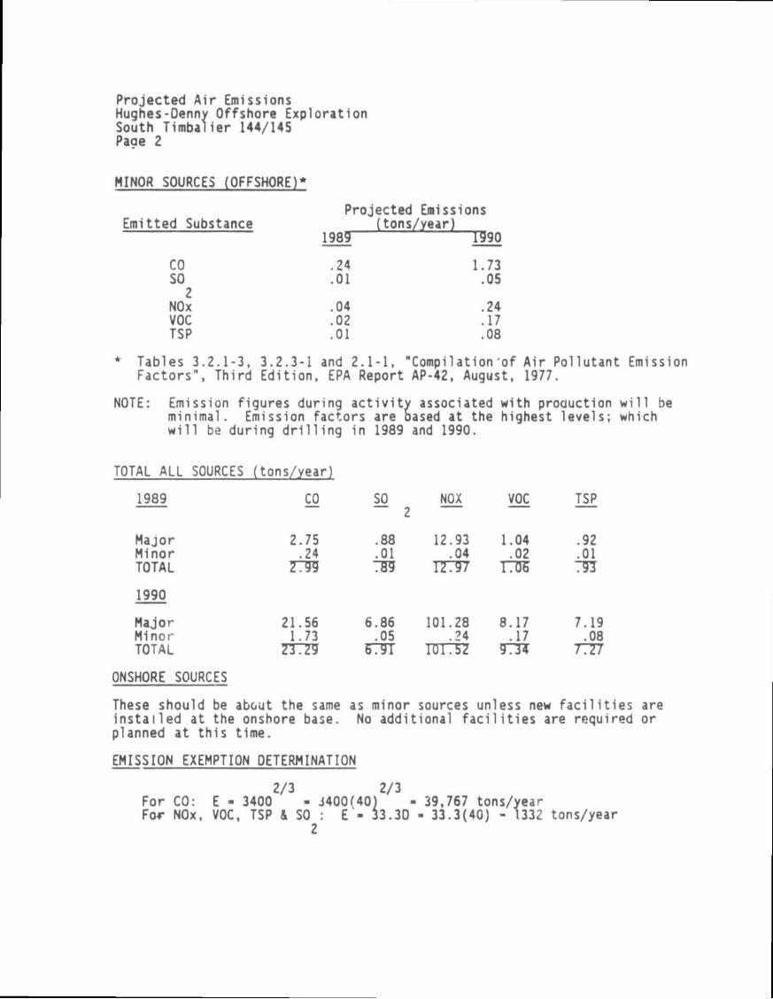
Projected Air Emissions Hughes-Oenny Offshore Exploration South Timbalier 144/145 Page 2
MINOR SOURCES (OFFSHORE)
Emitted Substance
CO SO 2
NOx VOC TSP
Projected Emissions (tons/year)
1989 T990
24 01
04 02 01
1.73 .05
.24
.17
.08
* Tables 3.2.1-3, 3.2.3-1 and 2.1-1, "Compi1ation of Air Pollutant Emission Factors", Third Edition, EPA Report AP-42, August, 1977.
NOTE: Emission figures during activity associated with production will be minimal. Emission factors are based at the highest levels; which will be during drilling in 1989 and 1990.
TOTAL ALL SOURCES (tons/year)
1989 CO SO NOX VOC TSP
Major Minor TOTAL
1990
Major Minor TOTAL
ONSHORE SOURCES
2.75 .24
7799
21.56 1.73
.88
.01 TS9
6.86 .05
67TT
12.93 .04
17797
101.28 .24
TUT37
1.04 .02 O S
8.17 .17
973*
.92
.01 791
7.19 .08
7777
These should be about the same installed at the onshore base, planned at this time.
as minor sources unless new facilities are No additional facilities are required or
EMISSION EXEMPTION DETERMINATION
2/3 2/3 For CO: E - 3400 - 3400(40) For NOx, VOC, TSP & SO : E - 33.30
2
39,767 tons/year . 33.3(40) - 1332 tons/year
Projected Air Emissions Hughes-Oenny Offshore Exploration South Timbalier 144/145 Page 3
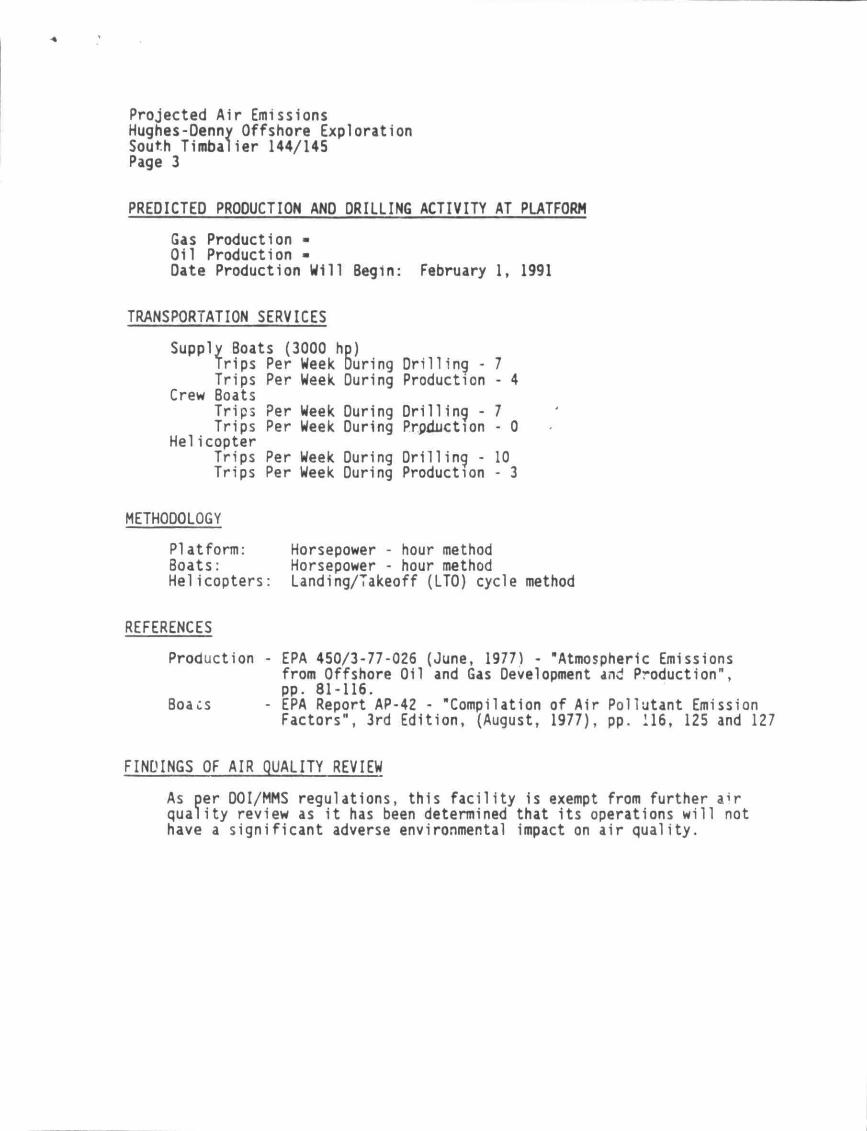
PREDICTED PROOUCTION AND DRILLING ACTIVITY AT PLATFORM
Gas Production -Oil Production -Date Production Will Begin: February 1, 1991
TRANSPORTATION SERVICES
Supply Boats (3000 hp) Trips Per Week During Drilling -
Per Week During Production Crew
Trips Boats Trips Trips
Helicopter Trips Trips
Per Week During Drilling -Per Week During Production
Per Week During Drilling -Per Week During Production
- 4
- 0
10 - 3
METHODOLOGY
Platform: Boats: Helicopters:
Horsepower - hour method Horsepower - hour method Landing/Takeoff (LT0) cycle method
REFERENCES
Production - EPA 450/3-77-026 (June, 1977) - "Atmospheric Emissions
Boacs
from Offshore Oil and Gas Development and Production pp. 81-116. EPA Report AP-42 - "Compilation of Air Factors", 3rd Edition, (August, 1977),
Pollutant Emission pp. 116, 125 and 127
FINDINGS OF AIR QUALITY REVIEW
As per DOI/MMS regulations, this facility is exempt from further a^r quality review as it has been determined that its operations will not have a significant adverse environmental impact on air quality.
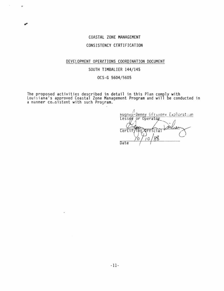
COASTAL ZONE MANAGEMENT
CONSISTENCY CERTIFICATION
DEVELOPMENT OPERATIONS COORDINATION DOCUMENT
SOUTH TIMBALIER 144/145
OCS-G 5604/5605
The proposed activities described in detail in this Plan comply with Louisiana's approved Coastal Zone Management Program and will be conducted in a manner consistent with such Program.
-11-