Embed Size (px)
Citation preview
WEST DORSET DISTRICT COUNCIL, ENGINEERING DIVISIONLYME REGIS ENVIRONMENTAL IMPROVEMENTS
STRATEGY PLAN
STRATEGY PLAN
August 2002
LYME REGIS ENVIRONMENTAL IMPROVEMENTS
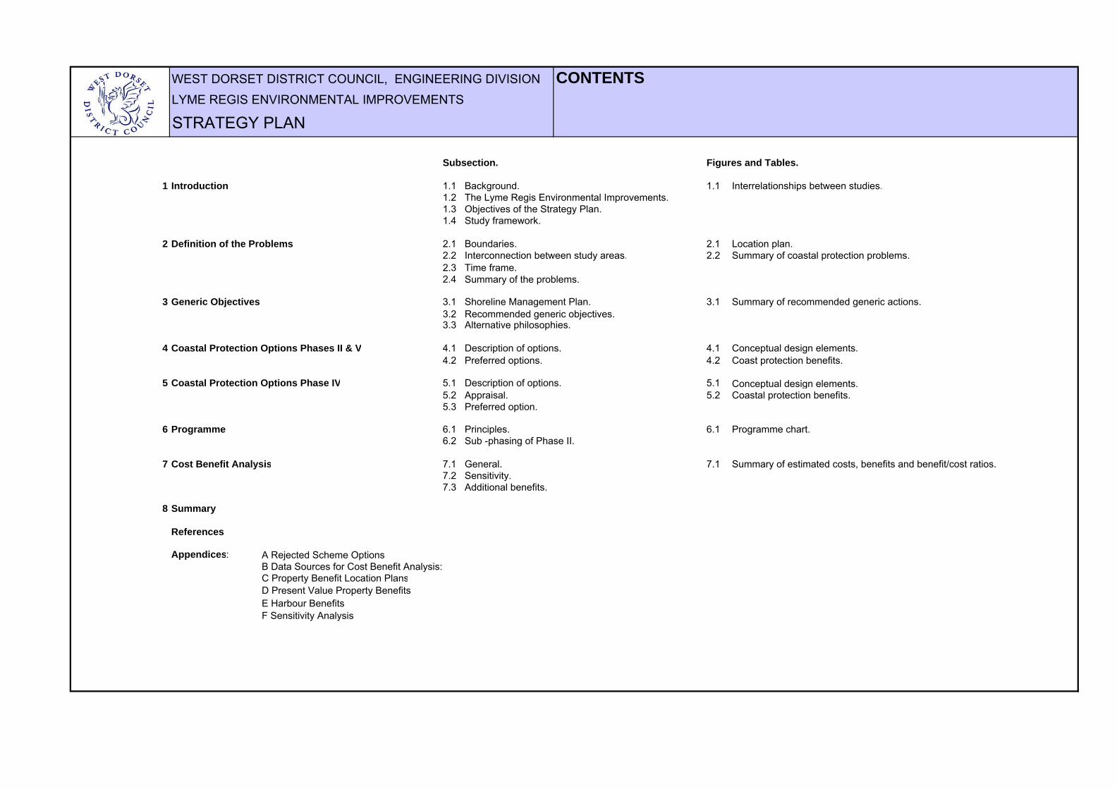
WEST DORSET DISTRICT COUNCIL, ENGINEERING DIVISION CONTENTSLYME REGIS ENVIRONMENTAL IMPROVEMENTS
STRATEGY PLAN
Subsection. Figures and Tables.
1 Introduction 1.1 Background. 1.1 Interrelationships between studies.1.2 The Lyme Regis Environmental Improvements.1.3 Objectives of the Strategy Plan.1.4 Study framework.
2 Definition of the Problems 2.1 Boundaries. 2.1 Location plan.2.2 Interconnection between study areas. 2.2 Summary of coastal protection problems.2.3 Time frame.2.4 Summary of the problems.
3 Generic Objectives 3.1 Shoreline Management Plan. 3.1 Summary of recommended generic actions.3.2 Recommended generic objectives.3.3 Alternative philosophies.
4 Coastal Protection Options Phases II & V 4.1 Description of options. 4.1 Conceptual design elements.4.2 Preferred options. 4.2 Coast protection benefits.
5 Coastal Protection Options Phase IV 5.1 Description of options. 5.1 Conceptual design elements.5.2 Appraisal. 5.2 Coastal protection benefits.5.3 Preferred option.
6 Programme 6.1 Principles. 6.1 Programme chart.6.2 Sub -phasing of Phase II.
7 Cost Benefit Analysis 7.1 General. 7.1 Summary of estimated costs, benefits and benefit/cost ratios.7.2 Sensitivity.7.3 Additional benefits.
8 Summary
References
Appendices: A Rejected Scheme OptionsB Data Sources for Cost Benefit Analysis:C Property Benefit Location PlansD Present Value Property BenefitsE Harbour BenefitsF Sensitivity Analysis
WEST DORSET DISTRICT COUNCIL, ENGINEERING DIVISION 1.0 INTRODUCTIONLYME REGIS ENVIRONMENTAL IMPROVEMENTS
STRATEGY PLAN
1.1 BackgroundLyme Regis is an ancient coastal town situated in Lyme Bay on the south coast of Britain. Itis both a popular residential area and a major holiday resort, with a summer population ofapproximately 14,000. Lyme Regis is famous for its unique harbour structure, the Cobb,which is the oldest working breakwater of its type in the country. The town's economy reliesheavily upon tourists who are attracted by the harbour, the beaches and the spectacularcoastal scenery.
The historical development of the town has been strongly influenced by coastal erosion andlandslipping. Over the centuries the coastline has been protected against marine erosion bythe construction of a series of sea walls, jetties and other defences of various forms. Thesedefences have been repaired and replaced in a piecemeal fashion in response to stormdamage and general decay so that today the town is protected by a variable complex ofageing structures.
Although the town has been partly protected from the direct erosive action of the sea, largeareas of it have been constructed on ancient coastal landslides which periodically becomereactivated resulting in disruption and damage to property.
1.3 Objectives of the Strategy PlanThe purpose of this Strategy Plan is essentially to bring together the findings of thePreliminary Studies, including early work on the conceptual design of engineering schemes,in order to establish an action plan for improving the coast protection situation at LymeRegis in the long term. The principal objectives of the report are:
1) to review the coast protection problems facing Lyme Regis;
2) to consider coast protection policy objectives;
3) to determine preferred coast protection management objectives including, whereappropriate, engineering scheme options;
4) to develop a programme for implementation of the management options.
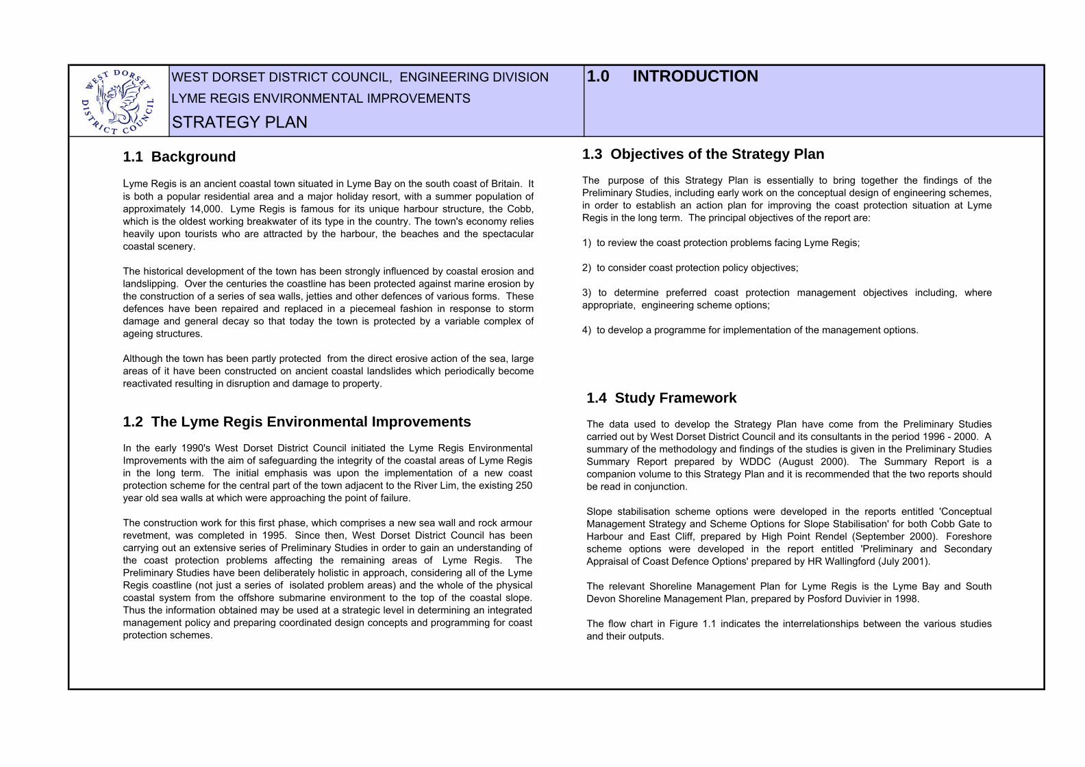
1.4 Study FrameworkThe data used to develop the Strategy Plan have come from the Preliminary Studiescarried out by West Dorset District Council and its consultants in the period 1996 - 2000. A summary of the methodology and findings of the studies is given in the Preliminary StudiesSummary Report prepared by WDDC (August 2000). The Summary Report is acompanion volume to this Strategy Plan and it is recommended that the two reports shouldbe read in conjunction.
Slope stabilisation scheme options were developed in the reports entitled 'ConceptualManagement Strategy and Scheme Options for Slope Stabilisation' for both Cobb Gate toHarbour and East Cliff, prepared by High Point Rendel (September 2000). Foreshorescheme options were developed in the report entitled 'Preliminary and SecondaryAppraisal of Coast Defence Options' prepared by HR Wallingford (July 2001).
The relevant Shoreline Management Plan for Lyme Regis is the Lyme Bay and SouthDevon Shoreline Management Plan, prepared by Posford Duvivier in 1998.
The flow chart in Figure 1.1 indicates the interrelationships between the various studiesand their outputs.
1.2 The Lyme Regis Environmental ImprovementsIn the early 1990's West Dorset District Council initiated the Lyme Regis EnvironmentalImprovements with the aim of safeguarding the integrity of the coastal areas of Lyme Regisin the long term. The initial emphasis was upon the implementation of a new coastprotection scheme for the central part of the town adjacent to the River Lim, the existing 250year old sea walls at which were approaching the point of failure.
The construction work for this first phase, which comprises a new sea wall and rock armourrevetment, was completed in 1995. Since then, West Dorset District Council has beencarrying out an extensive series of Preliminary Studies in order to gain an understanding ofthe coast protection problems affecting the remaining areas of Lyme Regis. ThePreliminary Studies have been deliberately holistic in approach, considering all of the LymeRegis coastline (not just a series of isolated problem areas) and the whole of the physicalcoastal system from the offshore submarine environment to the top of the coastal slope.Thus the information obtained may be used at a strategic level in determining an integratedmanagement policy and preparing coordinated design concepts and programming for coastprotection schemes.
WEST DORSET DISTRICT COUNCIL, ENGINEERING DIVISION FIGURE 1.1LYME REGIS ENVIRONMENTAL IMPROVEMENTS INTERRELATIONSHIPS BETWEEN STUDIESSTRATEGY PLAN
Individual Preliminary Studies
Preliminary Studies Summary Report (14/1)
Definition of problemsDefinition of generic
objectives (recommended actions)
Shoreline Management
Plan
Conceptual design of stabilisation works for slopes and foreshore
STRATEGY PLAN
Preferred management options and programme for
implementation
Studies
Output
WEST DORSET DISTRICT COUNCIL, ENGINEERING DIVISION 2.0 DEFINITION OF THE PROBLEMSLYME REGIS ENVIRONMENTAL IMPROVEMENTS
STRATEGY PLAN
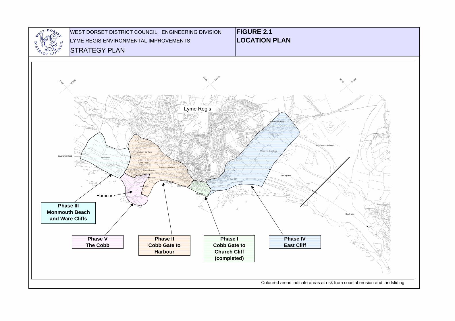
2.1 BoundariesThe area under consideration extends from Devonshire Head in the west to the Spittles inthe east, covering the whole of the urban coastal area of Lyme Regis (Figure 2.1).
The Devonshire Head boundary is defined as the westernmost limit of significant beachdeposits at Lyme, at the end of Monmouth Beach. It is also, coincidently, the point at whichthe county boundary between Devon and Dorset crosses the foreshore and hence marksthe westernmost extent of West Dorset District Council's jurisdiction as coast protectionauthority. The eastern boundary is defined as the point furthest to the west at whichsignificant amounts of beach-forming material are issued from the highly active landslideareas of the Spittles/Black Ven landslide complex. The Preliminary Studies have shownthat there is no significant longshore transport of beach-forming material into Lyme Regiseither from the west or east. In west there is no supply. In the east the material from theSpittles and Black Ven is taken eastwards rather than westwards. Furthermore, there areno sources of material in between. The area within the boundaries of the Strategy Plan istherefore independent of the adjacent areas in terms of longshore sediment transport.
The inland boundary of the Strategy Plan may be defined as the crest of the coastal slope,which represents the current landward influence of the sea on landslide processes.
In practice, areas outside of these boundaries have received attention in the studies. Forexample, when considering future landslide regression scenarios and cost benefit analyses,the study area was extended a nominal distance landward in order to allow for ahypothetical small expansion of the coastal landslide systems beyond their presentboundaries.
2.3 Time FrameThis Strategy Plan considers coast protection in the period extending up to the next fiftyyears, i.e. 2002 to 2052.
It is envisaged that the principal coast protection schemes described in the plan would beimplemented within the next ten years, i.e. before 2012.
2.4 Summary of the ProblemsThe coast protection challenges facing Lyme Regis have been established from thefindings of the Preliminary Studies. The main problems are essentially as follows:
1) the foreshore rock platforms are starved of beach material and are being lowered bythe erosive action of the sea;
2) previous coast protection works, such as sea walls and slope drainage systems, are ina poor condition and some elements are approaching the end of their practical life;
3) the coastal slopes are inherently unstable and prone to rapid and large scale landslideactivity;
As a result, a large part of the town is at risk from coastal erosion and landsliding.
Figure 2.2 gives a more detailed summary of the problems and the consequences thatwould arise from them in the 'do nothing ' scenario.
2.2 Interconnection between Study AreasFor the purposes of the Environmental Improvements, five study areas have been definedas indicated on Figure 2.1:
Phase I: Cobb Gate to Church Cliff (scheme completed)Phase II : Cobb Gate to the HarbourPhase III: Monmouth Beach and Ware CliffsPhase IV: East CliffPhase V: The Cobb
(2.2 continued)
Phases II, III and V are separated physically from Phase IV by the new coast protectionscheme for Phase I. As a result, it is considered that there is no interconnection betweenPhases II, III, V and Phase IV either in terms of overlapping benefit areas or physical coastalprocess such as sediment transfer. In theory, there is some overlap of the benefit areas for the Cobb and Phases II & III. Forexample, some of the properties to the north of the Cobb are under threat both from flooding as a result of a breach in the Cobb and landsliding from the slope behind. For the sake ofsimplicity, however, a simple boundary has been drawn between them as shown in Figure2.1and the conservative assumption made that there is no overlap (i.e. no one propertywould be under threat by both a breach in the Cobb and a landslide).
WEST DORSET DISTRICT COUNCIL, ENGINEERING DIVISION FIGURE 2.1LYME REGIS ENVIRONMENTAL IMPROVEMENTS LOCATION PLANSTRATEGY PLAN
33250091800
33350093000
33450094100
The Spittles
Black Ven
Phase VThe Cobb
Phase II Cobb Gate to
Harbour
Phase IVEast Cliff
Phase ICobb Gate to Church Cliff(completed)
Lyme Regis
Timber Hill Meadows
Old Charmouth Road
Charmouth Road
East Cliff
Church Cliffs
Gun Cliff
Langmoor GardensLister Gardens
Holmbush Car Park
Ware CliffsDevonshire Head
Cobb Road
Phase IIIMonmouth Beach
and Ware Cliffs
Cobb Gate
Lucy's Jetty
Front Beach
North Wall
Coloured areas indicate areas at risk from coastal erosion and landsliding
Harbour
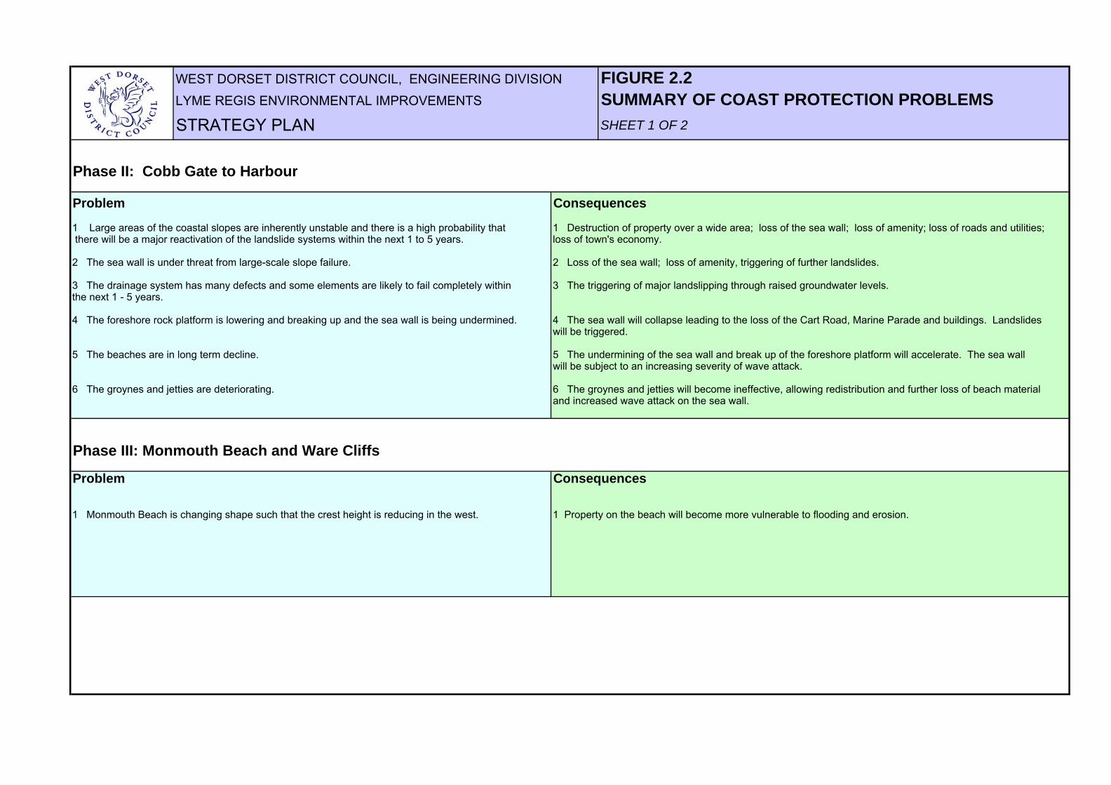
WEST DORSET DISTRICT COUNCIL, ENGINEERING DIVISION FIGURE 2.2LYME REGIS ENVIRONMENTAL IMPROVEMENTS SUMMARY OF COAST PROTECTION PROBLEMSSTRATEGY PLAN SHEET 1 OF 2
Phase II: Cobb Gate to Harbour
Problem Consequences
1 Large areas of the coastal slopes are inherently unstable and there is a high probability that 1 Destruction of property over a wide area; loss of the sea wall; loss of amenity; loss of roads and utilities; there will be a major reactivation of the landslide systems within the next 1 to 5 years. loss of town's economy.
2 The sea wall is under threat from large-scale slope failure. 2 Loss of the sea wall; loss of amenity, triggering of further landslides.
3 The drainage system has many defects and some elements are likely to fail completely within 3 The triggering of major landslipping through raised groundwater levels.the next 1 - 5 years.
4 The foreshore rock platform is lowering and breaking up and the sea wall is being undermined. 4 The sea wall will collapse leading to the loss of the Cart Road, Marine Parade and buildings. Landslideswill be triggered.
5 The beaches are in long term decline. 5 The undermining of the sea wall and break up of the foreshore platform will accelerate. The sea wall will be subject to an increasing severity of wave attack.
6 The groynes and jetties are deteriorating. 6 The groynes and jetties will become ineffective, allowing redistribution and further loss of beach material and increased wave attack on the sea wall.
Phase III: Monmouth Beach and Ware Cliffs
Problem Consequences
1 Monmouth Beach is changing shape such that the crest height is reducing in the west. 1 Property on the beach will become more vulnerable to flooding and erosion.

WEST DORSET DISTRICT COUNCIL, ENGINEERING DIVISION FIGURE 2.2LYME REGIS ENVIRONMENTAL IMPROVEMENTS SUMMARY OF COAST PROTECTION PROBLEMSSTRATEGY PLAN SHEET 2 OF 2
Phase IV: East Cliff
Problem Consequences
1 Large areas of the coastal slopes are inherently unstable and there is a high probability that 1 Destruction of property over a wide area; loss of roads and utilities.there will be a major reactivation of the landslide systems within the next 1 to 5 years.
2 The sea wall is under threat from large-scale cliff failure. 2 Loss of the sea wall, leading to further landsliding.
3 The eastern part of Lyme Regis is under threat from the continuing long-term westwards 3 Loss of meadows and allotments.expansion of the Spittles/Black Ven landslide system.
4 The drainage system has defects and its outfall is under threat from continuing 4 Raised groundwater levels triggering destructive landslipping. ground movements.
5 The sea wall is being outflanked at its eastern end. 5 Local loss of sea wall, local erosion of cliff, triggering of existing landsides.
6 The shore platform is lowering and breaking up, the sea wall is in a poor condition and is 6 The sea wall will be subject to an increasing severity of wave attack, will continue to deteriorate starting to be undermined. There is very little protection from beach material. and will eventually fail.
7 The groynes are dilapidated and may become a danger to the public. 7 Unacceptable danger to members of the public.
Phase V: The Cobb
Problem Consequences
1 The lower parts of the High Wall are deteriorating and are difficult to maintain. 1 The Cobb will fail by progressive collapse of the external masonry and hearting of the High Wall.This will lead to the loss of the harbour and flooding and erosion of nearby properties.
2 The Low Walkway is vulnerable to scouring by seawater and shingle overtopping the High Wall 2 Excessive scouring of the surface of the Low Walkway will lead quickly to the destruction of the during storms. Walkway. There is the possibility that the Cobb could then fail by the High Wall sliding on its mudstone
foundation under extreme wave conditions.

WEST DORSET DISTRICT COUNCIL, ENGINEERING DIVISION 3.0 GENERIC OBJECTIVESLYME REGIS ENVIRONMENTAL IMPROVEMENTS
STRATEGY PLAN
Coastal Process Management Location in Lyme Regis Preferred Strategic Unit Unit OptionCPU 3 MU 6 Cobb Gate to Harbour and Hold the Line
East CliffCPU 4 MU 7 Monmouth Beach Do nothing
3.3 Alternative PhilosophiesThe following alternatives have been considered :
Do nothing: would lead to severe consequences for the long term future of the town(Figure 2.2). Discordant with Preferred Strategic Options of the Shoreline ManagementPlan. Only acceptable for Monmouth Beach where there are just minor assets underthreat.
Do minimum: i.e. ongoing maintenance of structures, 'patch and mend'. This isessentially the philosophy which is currently in force. It does nothing to address theinherent instability of the foreshore and coastal slopes, nor the fundamental defects of thecoast protection structures. Hence it would lead to much the same consequences as inthe 'do nothing' case, and is discordant with the recommendations of the ShorelineManagement Plan. It is considered that ongoing maintenance would only be anacceptable coastal management strategy in non-urgent cases, such as the Cobb, in theshort term - in the long term it would become unsustainable.
React to failures once they have occurred: this is often what happened historically andis the equivalent of shutting the stable door after the horse has bolted. Although failureswould not be allowed to develop and extend inland as they would in the 'do nothing' case,there would still be the potential for severe damage and disruption. The remedial works totreat a failure once it had caused the damage would be significantly greater in cost thanthose required to prevent the failure in the first place, and would take place after theassets had been lost. Discordant with the Preferred Strategic Options of the ShorelineManagement Plan.
Early warning systems: in theory, these would give prior warning of landslide events toallow occupiers to leave premises and areas to be evacuated to help ensure publicsafety. They would do nothing to protect assets, hence if used in isolation would bediscordant with the guidelines in the Shoreline Management Plan. However, it may beappropriate to install them in any areas in which there is a high risk to life, but where it isnot feasible to carry out stabilisation works, for example because of access restrictions.
Coast protection works: major strengthening works comprising improvements to thecoast protection walls, the provision of beach renourishment and control structures, slopestabilisation and drainage works, is considered to be the only realistic philosophy whichwill meet the objectives of the Shoreline Management Plan. These are discussed in thefollowing sections (4 and 5).
3.1 Shoreline Management Plan
The Lyme Bay and South Devon Shoreline Management Plan (prepared by Posford Duvivier,1998) gives the following Preferred Strategic Options for Lyme Regis:
That is, hold the line for the urban areas and do nothing where there is little or nodevelopment.
3.2 Recommended Generic Objectives
Lyme Regis is faced with a formidable array of coast protection challenges. In order to fulfilthe recommendation of 'hold the line' in the Shoreline Management Plan, it is considered thatthere is no other realistic alternative in the long term other than to implement new coastprotection schemes.
On this basis, general objectives or actions have been determined that could be used toimprove the coast protection situation as part of new schemes (Figure 3.1). Section 9 of thePreliminary Studies Summary Report spells out how these have been developed from thedata obtained in the Preliminary Studies.
As the probability of damage due to marine erosion and landsliding are both relatively high,there would be little benefit in implementing foreshore protection works without also carryingout slope stabilisation works, and vice versa.
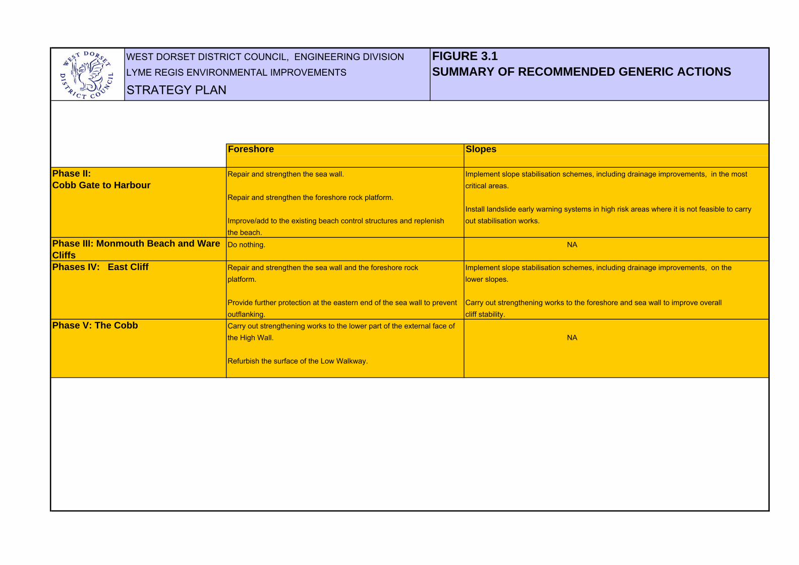
WEST DORSET DISTRICT COUNCIL, ENGINEERING DIVISION FIGURE 3.1LYME REGIS ENVIRONMENTAL IMPROVEMENTS SUMMARY OF RECOMMENDED GENERIC ACTIONSSTRATEGY PLAN
Foreshore Slopes
Phase II: Repair and strengthen the sea wall. Implement slope stabilisation schemes, including drainage improvements, in the most Cobb Gate to Harbour critical areas.
Repair and strengthen the foreshore rock platform. Install landslide early warning systems in high risk areas where it is not feasible to carry
Improve/add to the existing beach control structures and replenish out stabilisation works.the beach.Do nothing. NA
Phases IV: East Cliff Repair and strengthen the sea wall and the foreshore rock Implement slope stabilisation schemes, including drainage improvements, on the platform. lower slopes.
Provide further protection at the eastern end of the sea wall to prevent Carry out strengthening works to the foreshore and sea wall to improve overall outflanking. cliff stability.
Phase V: The Cobb Carry out strengthening works to the lower part of the external face of the High Wall. NA
Refurbish the surface of the Low Walkway.
Phase III: Monmouth Beach and Ware Cliffs

WEST DORSET DISTRICT COUNCIL, ENGINEERING DIVISION 4.0 COAST PROTECTION OPTIONSLYME REGIS ENVIRONMENTAL IMPROVEMENTS PHASES II AND V (COBB GATE TO HARBOUR)STRATEGY PLAN
4.1 Description of OptionsConceptual designs for coast protection management options have been developed to satisfythe generic objectives defined in Section 3, and are based upon the information obtained inthe Preliminary Studies. A description of each of the main scheme elements together with thecoast protection benefits is given in Figures 4.1 and 4.2. At the time of preparing thisstrategy plan, designs were at a more advanced stage of development for Phase II than theother phases, hence the descriptions are more detailed than for the other phases.
The proposals for each Phase are as follows :
Phase II (Cobb Gate to Harbour) - coast protection scheme comprising new seawall andbeach replenishment, slope strengthening and drainage. It is likely that the principal slopestrengthening element would comprise of bored piles and counterfort drains. Drainage wouldprobably comprise improvements to surface water drainage, trench and counterfort drains,and sub-horizontal drainage arrays. The newly replenished beach would be held in place bynew masonry jetties and an extension to the southern arm of Cobb in rock armour.
Phase III (Monmouth Beach and Ware Cliffs) - Do minimum. There would be no economicjustification for carrying out any coast protection actions in this area. However, in practice it islikely that ongoing maintenance would be carried out as a public service.
Phase V (The Cobb) - coast protection scheme comprising strengthening the foundation ofthe High Wall and resurfacing the Low Walkway.
4.2 Preferred OptionsSuch are the technical, economic and environmental constraints in the area between CobbGate and the Harbour that it is considered that there are no other general concepts whichcould be pursued as realistic alternatives to those presented.
The scheme options, illustrated in Figure 4.1 are therefore recommended as the preferredcoast protection options. Appendix A shows the considered alternatives to the preferredoptions, and gives reasons for their rejection. A rigorous process was undertaken to arriveat the preferred options, including brainstorming by a team of engineering staff andconsultants with coastal experience from both academic and practical backgrounds, inorder to produced a comprehensive list of coast protection options. These were appraisedand filtered to eliminate those which were not technically viable. An in-depth analysis of theremaining options was carried out in order to develop a short list of preferred options.Further detailed information on the development of the preferred options is given in High-Point Rendel (Dec 2001) and HR Wallingford (July 2001).

WEST DORSET DISTRICT COUNCIL FIGURE 4.1LYME REGIS ENVIRONMENTAL IMPROVEMENTS CONCEPTUAL DESIGN ELEMENTS STRATEGY PLAN PHASES II AND V (COBB GATE TO HARBOUR)
B
CD
H
F
G
E
New surface water and ground water carrier drainage
system.
Reinforced soil embankments
Soil nailing or ground anchors.
New masonry or timber jetty.
Beach replenishment.
(sand and shingle)
New masonry jetty
Slipped mass replaced by reinforced soil.
Counterfort drains.
Improvements to surface water
drainage system.
Cut-off drain intercepts major source of groundwater
Sub-horizontal drilled drainage arrays installed
during trials.
Bored piles.
North Wall Rockery realigned
Strengthening of toe of seawall.
No action at Monmouth Beach
Construction of drainage, pile grids and other strengthening measures provide robust
stabilisation works whilst maintaining character of area of local landscape importance.
Strengthening of toe of High Wall and resurfacing of low walkway ensures long-term
integrity of the Cobb.
New seawall prevents flooding of Marine Parade due to overtopping in extreme storms as well as
allowing emergency access to the Cobb for heavy plant at all states of the tide and giving support to
the toe of the hillside.
Rock armour extension holds replenished beach in place and provides additional
protection to nearshore ledges, the North Wall and the Cobb structure itself.
Use of drilled drainage reduces disruption during construction in
sensitive landscape and important access areas.
Harbour
N
0m 200m
WEST DORSET DISTRICT COUNCIL, ENGINEERING DIVISION FIGURE 4.2LYME REGIS ENVIRONMENTAL IMPROVEMENTS COAST PROTECTION BENEFITSSTRATEGY PLAN PHASES II AND V
Principal Benefits
Secondary benefits
Broad environmental and social benefits
Scope exists for scheme concept to be extended to include Cobb Road.
New seawall, masonry jetties and beach replenishment provide effective protection for existing sea wall and foreshore, whilst maintaining the character of the frontage. Balance of sand and shingle on the beach
maintains amenity value.
0m
Proposals for new surface water drainage offer
opportunities for surface water separation scheme.
Improvements to surface water drainage alleviate flash flooding in Cobb Road area
during heavy rainfall.
Scope may exist to extend scheme to deal with derelict and
unstable houses on Marine Parade.
Scheme elements are concordant with proposals to enhance Cobb Square
and harbour slipway area.
New surface to low walkway enhances both amenity and working conditions in
the harbour.
Bigger sand ammenity beach
Scheme offers opportunities to refurbish or rebuild existing damaged buildings, and re-instatement of footpaths lost to landslipping.
Better access along Cart Road in severe conditions due to reduced
overtopping .
Improvements to existing drainage
outfall arrangement enhances visual appearance and
amenity.
New lower promenade improves public access and amenity.
Provision of rock armour extension gives quieter
conditions in the harbour and harbour mouth . May allow greater number of summer moorings outside harbour.
Layout of gardens and access to Marine Parade improved
Improvements in stability, amenity, access, landscaping and general quality of the environment
benefits local economy and is concordant with integrated tourism regeneration policy. Schemes
would make the area more attractive and vibrant and may encourage further new landscaping, amenity and
business initiatives.
Area at risk of coastal erosion and landslipping which would be protected by the proposed scheme. The area includes 214 properties and associated infrastructure, the harbour and the principal amenity areas of Lyme Regis.
Harbour
Amenity beach
N
0m 200m
WEST DORSET DISTRICT COUNCIL, ENGINEERING DIVISION 5.0 COAST PROTECTION OPTIONSLYME REGIS ENVIRONMENTAL IMPROVEMENTS PHASE IV (EAST CLIFF)STRATEGY PLAN
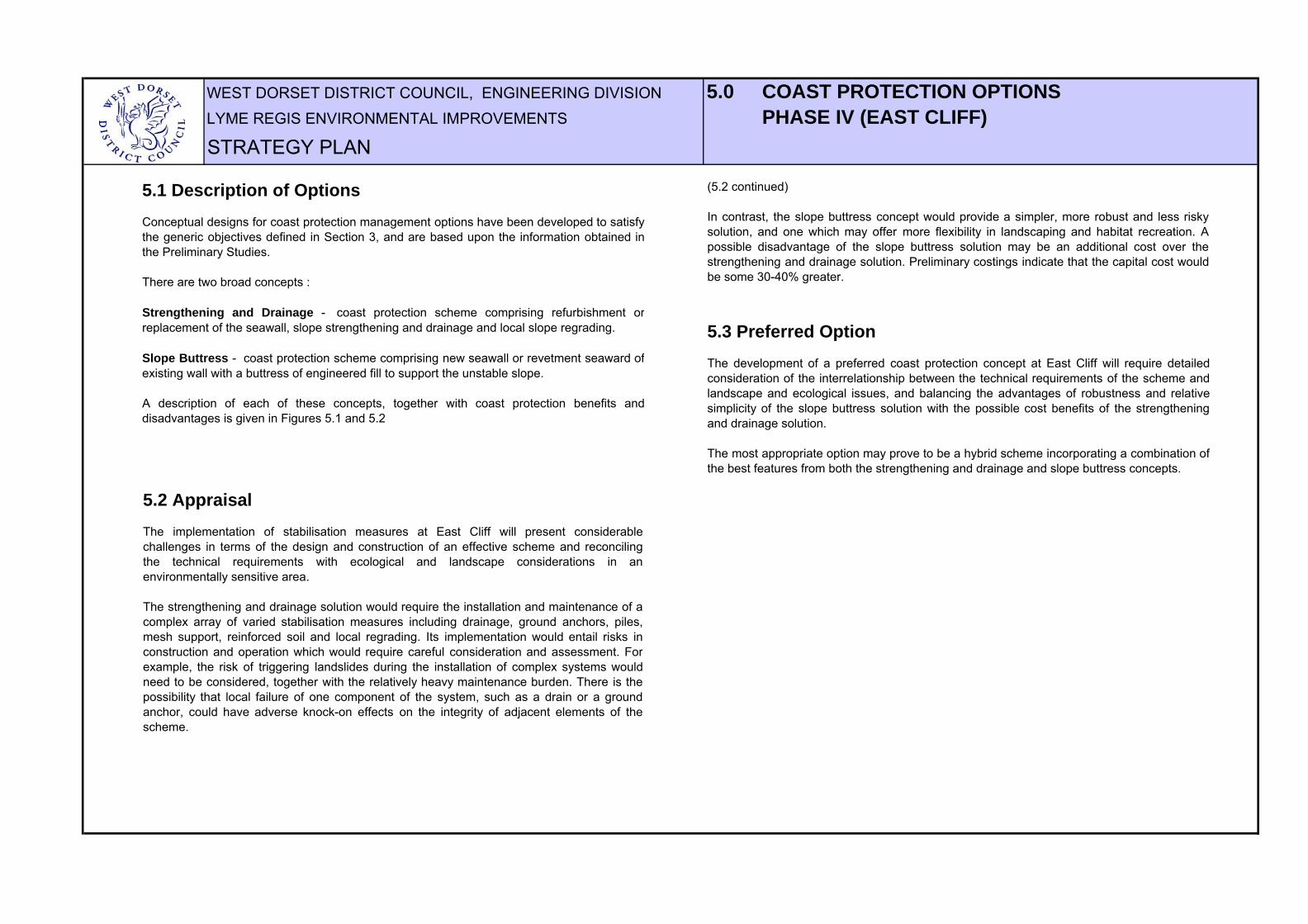
5.1 Description of OptionsConceptual designs for coast protection management options have been developed to satisfythe generic objectives defined in Section 3, and are based upon the information obtained inthe Preliminary Studies.
There are two broad concepts :
Strengthening and Drainage - coast protection scheme comprising refurbishment orreplacement of the seawall, slope strengthening and drainage and local slope regrading.
Slope Buttress - coast protection scheme comprising new seawall or revetment seaward ofexisting wall with a buttress of engineered fill to support the unstable slope.
A description of each of these concepts, together with coast protection benefits anddisadvantages is given in Figures 5.1 and 5.2
5.2 AppraisalThe implementation of stabilisation measures at East Cliff will present considerablechallenges in terms of the design and construction of an effective scheme and reconcilingthe technical requirements with ecological and landscape considerations in anenvironmentally sensitive area.
The strengthening and drainage solution would require the installation and maintenance of acomplex array of varied stabilisation measures including drainage, ground anchors, piles,mesh support, reinforced soil and local regrading. Its implementation would entail risks inconstruction and operation which would require careful consideration and assessment. Forexample, the risk of triggering landslides during the installation of complex systems wouldneed to be considered, together with the relatively heavy maintenance burden. There is thepossibility that local failure of one component of the system, such as a drain or a groundanchor, could have adverse knock-on effects on the integrity of adjacent elements of thescheme.
(5.2 continued)
In contrast, the slope buttress concept would provide a simpler, more robust and less riskysolution, and one which may offer more flexibility in landscaping and habitat recreation. Apossible disadvantage of the slope buttress solution may be an additional cost over thestrengthening and drainage solution. Preliminary costings indicate that the capital cost wouldbe some 30-40% greater.
5.3 Preferred OptionThe development of a preferred coast protection concept at East Cliff will require detailedconsideration of the interrelationship between the technical requirements of the scheme andlandscape and ecological issues, and balancing the advantages of robustness and relativesimplicity of the slope buttress solution with the possible cost benefits of the strengtheningand drainage solution.
The most appropriate option may prove to be a hybrid scheme incorporating a combination ofthe best features from both the strengthening and drainage and slope buttress concepts.
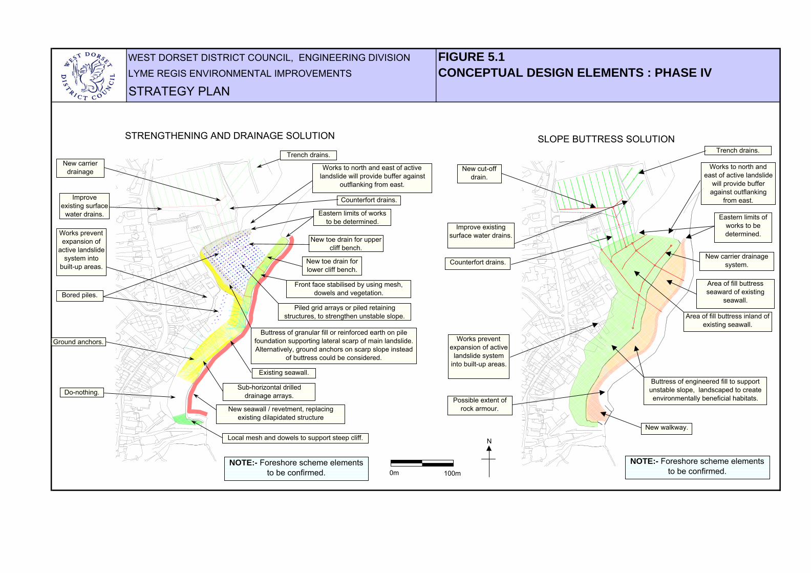
WEST DORSET DISTRICT COUNCIL, ENGINEERING DIVISION FIGURE 5.1LYME REGIS ENVIRONMENTAL IMPROVEMENTS CONCEPTUAL DESIGN ELEMENTS : PHASE IV STRATEGY PLAN
NOTE:- Foreshore scheme elements to be confirmed.
New carrier drainage
Trench drains.
Counterfort drains.
Eastern limits of works to be determined.
New toe drain for upper cliff bench.
New toe drain for lower cliff bench.
Front face stabilised by using mesh, dowels and vegetation.
Piled grid arrays or piled retaining structures, to strengthen unstable slope.
Buttress of granular fill or reinforced earth on pile foundation supporting lateral scarp of main landslide. Alternatively, ground anchors on scarp slope instead
of buttress could be considered.
Existing seawall.
New seawall / revetment, replacing existing dilapidated structure
Sub-horizontal drilled drainage arrays.
Local mesh and dowels to support steep cliff.
Do-nothing.
Ground anchors.
Bored piles.
Improve existing surface
water drains.
STRENGTHENING AND DRAINAGE SOLUTION
New carrier drainage system.
Area of fill buttress seaward of existing
seawall.
Eastern limits of works to be determined.
Possible extent of rock armour.
Counterfort drains.
New cut-off drain.
New walkway.
Buttress of engineered fill to support unstable slope, landscaped to create environmentally beneficial habitats.
Area of fill buttress inland of existing seawall.
Trench drains.
Improve existing surface water drains.
SLOPE BUTTRESS SOLUTION
NOTE:- Foreshore scheme elements to be confirmed.0m 100m
N
Works prevent expansion of
active landslide system into
built-up areas.
Works to north and east of active landslide will provide buffer against
outflanking from east.
Works prevent expansion of active
landslide system into built-up areas.
Works to north and east of active landslide
will provide buffer against outflanking
from east.

WEST DORSET DISTRICT COUNCIL, ENGINEERING DIVISION FIGURE 5.2LYME REGIS ENVIRONMENTAL IMPROVEMENTS COAST PROTECTION BENEFITS : PHASE IVSTRATEGY PLAN
Principal Benefits
Secondary benefits
Broad environmental and social benefits
Intensive works to toe of slope alleviates risk of landslide
recession inland, hence reduce need for disruptive works in
sensitive environmental areas higher on hillside.
STRENGTHENING AND DRAINAGE SOLUTION DISADVANTAGES :
Intensive and complex scheme involving significant risks during construction and
operation in terms of both landslide reactivation and cost escalations.
Heavy maintenance burden.
Substantial disruption to environmentally sensitive area.
Construction of drainage, pile grids and other strengthening measures provide stabilisation whilst maintain
existing landform and broad character of the area.
Improved and safer access to internationally important
geological exposures, and to beach at the Spittles and Black
Ven to the east.
Improvements in amenity, access, safety, visual
appearance and general quality of the environment benefit local
economy.
Opportunities to enhance Charmouth Road Car Park and improve amenity, with footpath links to beaches and Gun Cliff
Walk.
Opportunity to reinstate public footpath from East
Cliff Lane, lost to landslipping in the 1970's.
Opportunity to create new footpath along
top of seawall, improving safety for
coastal walkers.
Educational opportunities related to geology, ecology and
geomorphology.Habitat creation benefits nature
conservation interests.Improvements to
visual appearance of area.
SLOPE BUTTRESS SOLUTION DISADVANTAGES:
Substantial disruption to environmentally sensitive area.
Relatively high cost.
Aesthetics: Uniform engineered appearance abutting natural slope
Substantial scope for improvements to visual appearance and amenity use of area.
Slope buttress provides relatively simple and robust stabilisation. Low risk of landslide reactivation during
construction. Low maintenance burden.
Area at risk of coastal erosion and landslipping which would be protected by the proposed scheme.The area includes 172 properties with associated infrastructure and amenities.
0m 200m
N
WEST DORSET DISTRICT COUNCIL, ENGINEERING DIVISION 6.0 PROGRAMMELYME REGIS ENVIRONMENTAL IMPROVEMENTS
STRATEGY PLAN
6.1 Principles
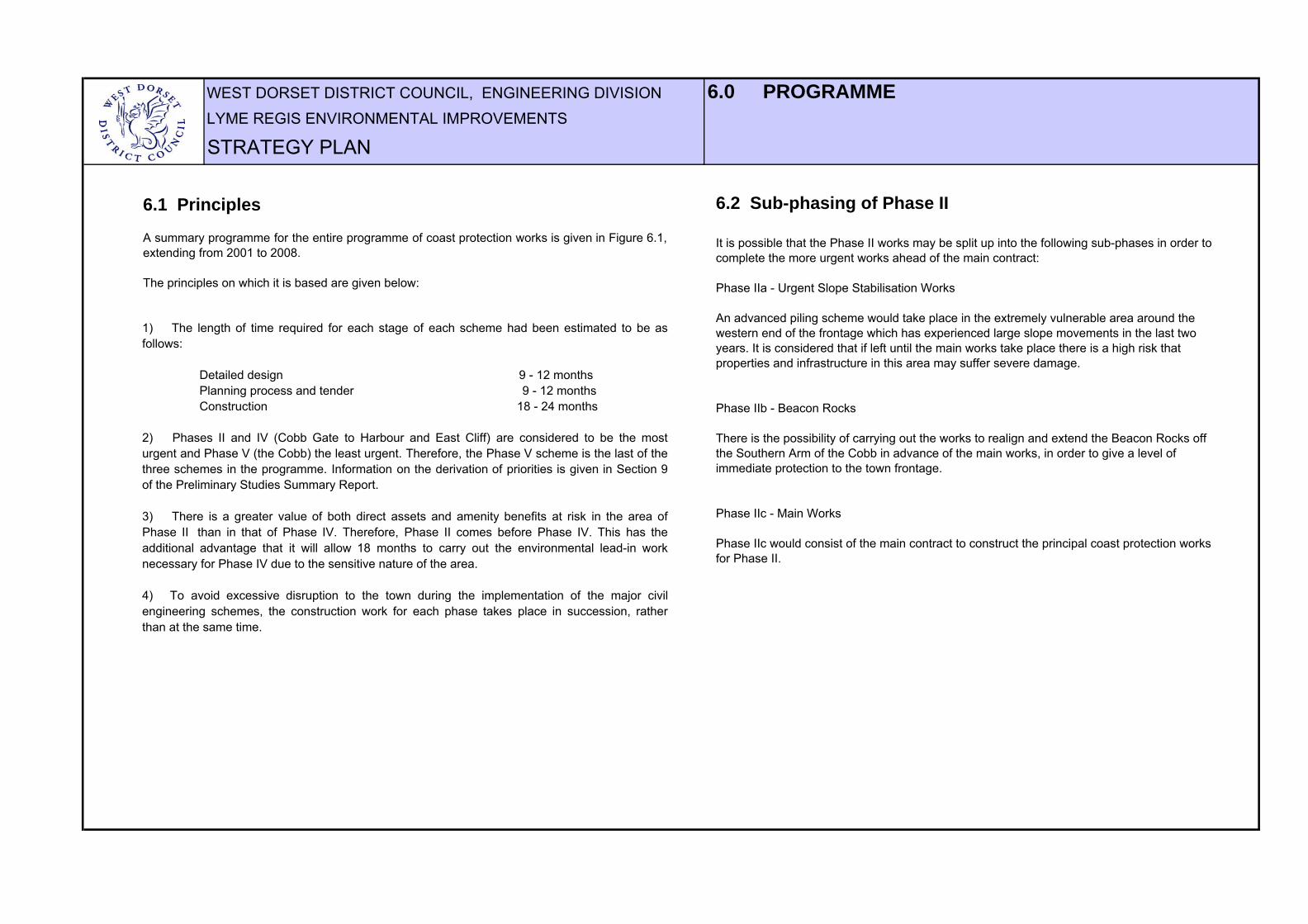
A summary programme for the entire programme of coast protection works is given in Figure 6.1,extending from 2001 to 2008.
The principles on which it is based are given below:
1) The length of time required for each stage of each scheme had been estimated to be asfollows:
Detailed design 9 - 12 months Planning process and tender 9 - 12 months Construction 18 - 24 months
2) Phases II and IV (Cobb Gate to Harbour and East Cliff) are considered to be the mosturgent and Phase V (the Cobb) the least urgent. Therefore, the Phase V scheme is the last of thethree schemes in the programme. Information on the derivation of priorities is given in Section 9of the Preliminary Studies Summary Report.
3) There is a greater value of both direct assets and amenity benefits at risk in the area ofPhase II than in that of Phase IV. Therefore, Phase II comes before Phase IV. This has theadditional advantage that it will allow 18 months to carry out the environmental lead-in worknecessary for Phase IV due to the sensitive nature of the area.
4) To avoid excessive disruption to the town during the implementation of the major civilengineering schemes, the construction work for each phase takes place in succession, ratherthan at the same time.
6.2 Sub-phasing of Phase II
It is possible that the Phase II works may be split up into the following sub-phases in order to complete the more urgent works ahead of the main contract:
Phase IIa - Urgent Slope Stabilisation Works
An advanced piling scheme would take place in the extremely vulnerable area around the western end of the frontage which has experienced large slope movements in the last two years. It is considered that if left until the main works take place there is a high risk that properties and infrastructure in this area may suffer severe damage.
Phase IIb - Beacon Rocks
There is the possibility of carrying out the works to realign and extend the Beacon Rocks off the Southern Arm of the Cobb in advance of the main works, in order to give a level of immediate protection to the town frontage.
Phase IIc - Main Works
Phase IIc would consist of the main contract to construct the principal coast protection works for Phase II.

WEST DORSET DISTRICT COUNCIL, ENGINEERING DIVISION FIGURE 6.1LYME REGIS ENVIRONMENTAL IMPROVEMENTS PROGRAMME CHARTSTRATEGY PLAN
2 3 4 1 2 3 4 1 2 3 4 1 2 3 4 1 2 3 4 1 2 3 4 1 2 3 4 1 2 3 420082007
2004/5 2005/6
2004
2006/7
2005 2006
2007/82003/4
Construction
MaintenancePHASE III: MONMOUTH BEACH
Planning process and tenderConstruction
Construction: Urgent WorksConstruction: Beacon Rocks
Maintenance
Maintenance
PHASE IV: EAST CLIFF
COAST PROTECTION SCHEME
Environmental lead-in work
Maintenance
PHASE V: THE COBB
Design
COAST PROTECTION SCHEME
Design
Planning process and tender
Planning process and tender
Construction: Main Works
PHASE II: COBB GATE TO HARBOUR
COAST PROTECTION SCHEME
Design
2001
DO MINIMUM
2008/9
YearQuarter
Financial year
2002 2003
2001/2 2002/3
**
*
** Submit Strategy Plan * DEFRA Approval

WEST DORSET DISTRICT COUNCIL, ENGINEERING DIVISION 7.0 COST BENEFIT ANALYSISLYME REGIS ENVIRONMENTAL IMPROVEMENTS
Table 7.1 Summary of estimated costs, benefits and benefit/cost ratios.
PropertyServices and infrastructure Amenity Harbour Property
Services and infrastructure Amenity Harbour
Phase II: Cobb Gate to Harbour
Phase IV: East Cliff
Phase V: The Cobb
84 9 7 100 34 4 60 2 100
Cost PV Cost Cost PV Cost Cost PV Cost
Phase II: Cobb Gate to Harbour
Phase IV: East Cliff
Phase V: The Cobb
9.90
12.140.220.01
TOTAL PV Cost £M
7.84 112.18 65.28
0.24
5.74
114.90 3.86
41.80
BENEFIT/COST RATIO
6.27
7.46 191.49
105.00
69.67
2.51 0.36 10.09 3.86 16.82
24.79 3.08
37.98 4.02 63.00
7.84
57.98
38.31
15.90
TOTAL £M
7.06
4.90
4.00
1.00
53.08
34.31
Non Discounted Value TOTAL £M
Present Value (PV) Benefits
Scheme
TOTAL
Scheme
TOTAL
% of Total
Number of Properties
297
172
63
0.02
532
1.35
0.95
94.44
0.20
Design Preliminaries
1.32
0.17
0.88
2.372.50
16.76
33.00
16.70 15.20 0.01
13.00 11.04
5.96
6.04
3.30 2.61 0.002 0.04 2.82
28.85 31.720.50
STRATEGY PLAN UPDATE - MAY 2003
£M £M
£M £M £M
Construction Contract Maintenance per Annum
7.1 GeneralThe purpose of this section is to demonstrate that there is sufficient economic benefit in implementing the proposed schemes toconfirm the economic viability of the coast protection strategy and hence attract DEFRA grant aid funding.
Table 7.1 below gives a summary of estimated present value benefits and costs, and the benefit cost ratio, for each of Phases II,IV and V, based on conservative assumptions. Explanatory notes on the sources of data are given in Appendix B. The total costof implementing all the proposed schemes is estimated at £33M.
The broad analysis indicates that there would be considerable economic benefits in implementing coast protection works for allthree of the Phases II, IV and V, with benefit cost ratios in excess of five. It is likely that, in a rigorous cost benefit analysiscarried out for each scheme, the benefit cost ratios would be significantly greater.
The relatively high benefit cost ratios demonstrating the economic viabilty of schemes are also concordant with the generalimpression that serious seawall failures or coastal instability would have a devestating effect on the town and, in the do nothingsecenario, would threaten its very viability as a commercial town in its present form.
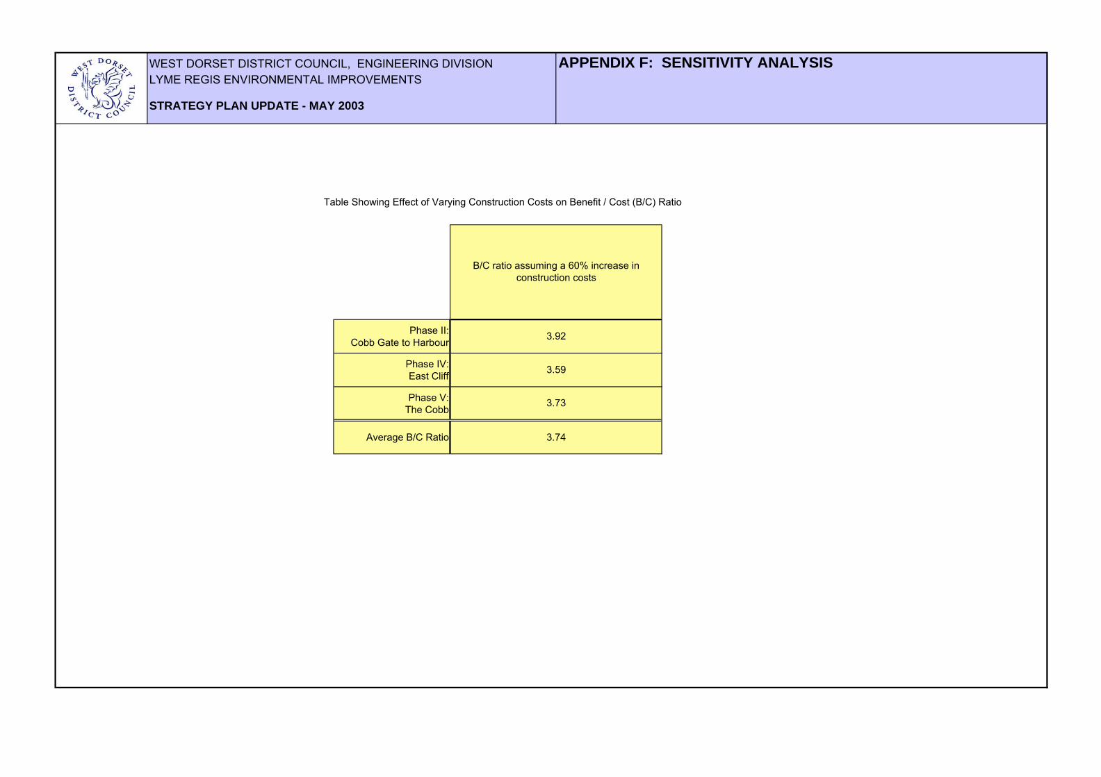
7.2 SensitivityTable 7.1 gives benefits and costs which are based upon "best estimates". Appendix F examinesthe sensitivity of the calculations by considering a 60% increase in the estimated cost ofconstruction. This indicates that the calculations are robust in the sense that high benefit costratios are still acheived with quite pessimistic assumptions of construction costs. The sensitivityanalysis shows that an increase of 60% in construction costs would still produce an overall benefitcost ratio of 3.74.
7.3 Additional benefits In addition to the economic benefits described by the cost benefit analysis, there would beconsiderable other benefits to society of implementing coast protection schemes. These wouldinclude, for example, reduction of stress and worry of residents and business people with premisesin vulnerable areas and improvements in amenity, access, landscaping and the quality of theenvironment, making the areas more attractive and vibrant and increasing the confidence of thetown generally.

WEST DORSET DISTRICT COUNCIL, ENGINEERING DIVISION 8.0 SUMMARYLYME REGIS ENVIRONMENTAL IMPROVEMENTS
STRATEGY PLAN UPDATE - MAY 2003
1) Large areas of Lyme Regis are at risk from coastal erosion and landsliding including:
532 properties valued at £94M Associated services and infrastructure valued conservatively at £9.9M The harbour, and main tourist and amenity areas of the town.
2) In order to fulfil the recommendation in the Shoreline Management Plan of 'hold the line' for the urban areas of the town, there are no other realistic alternatives in the long term other than to implement new coast protection schemes.
3) The most appropriate coast protection management options are as follows:- Phase II (Cobb Gate to Harbour) - coast protection scheme comprising a new seawall and beach replenishment, with new structures to hold the replenished beach and slope strengthening and drainage. Phase III (Monmouth Beach and Ware Cliffs) - Do nothing or do minimum. Phase IV (East Cliff) - coast protection scheme comprising either a) strengthening and drainage, local slope regrading and refurbishment or replacement of the seawall or b) slope buttress of engineered fill with new seawall or revetment seaward of the existing wall. Phase V (The Cobb) - coast protection scheme comprising strengthening the foundation of the High Wall and resurfacing the Low Walkway.
4) The schemes would need to be implemented over a period of seven years in order to limit disruption to the town to an acceptable level, and to allow time for the design and lead-in work for the complex schemes.
5) The total cost of implementing all the schemes is estimated to be £33M
6) The overall benefit / cost ratio of implementing all the schemes is approximately 6 : 1
7) There would also be considerable secondary benefits to the environment and society of implementing the schemes.

WEST DORSET DISTRICT COUNCIL, ENGINEERING DIVISION ReferencesLYME REGIS ENVIRONMENTAL IMPROVEMENTS
STRATEGY PLAN
Lyme Regis Environmental Improvements: Preliminary Studies Reports
10/1 Phases II & III: Conceptual Management Strategy and Scheme Options for Coastal Slope Stabilisation. Final report. September 2000.10/2 Phase IV: Conceptual Management Strategy and Scheme Options for Coastal Slope Stabilisation. Final report. September 2000.13/2 Phases II & III: Landslide Recession Scenarios. July 2000.13/3 Phase IV: Landslide Recession Scenarios. July 2000.13/4 Cobb Disaster Scenarios. August 1999.13/5 Phases II & III: Preliminary Assessment of Amenity Benefits. June 1999.13/6 Phases II & III and The Cobb: Preliminary Assessment of Property Benefits. March 2000.13/7 Phase IV: Preliminary Assessment of Property Benefits. March 2000.14/1 Summary Report. August 2000.
Lyme Regis Environmental Improvements: Phase II design reports
HR Wallingford. Preliminary and Secondary Appraisal of Coast Defence Options. July 2001.High-Point Rendel. Preliminary Design of Scheme Options for Coastal Slope Stabilisation. December 2001.Martin Diplock. Lyme Regis Environmental Improvements. Phase II. Property Valuation Survey. January 2002.
Shoreline Management Plan
Lyme Bay and South Devon Shoreline Management Plan. Posford Duvivier. 1998.
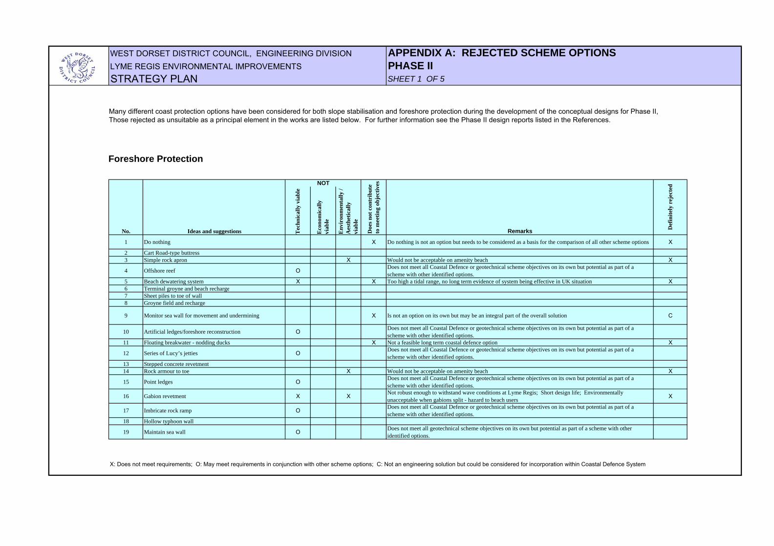
WEST DORSET DISTRICT COUNCIL, ENGINEERING DIVISION APPENDIX A: REJECTED SCHEME OPTIONSLYME REGIS ENVIRONMENTAL IMPROVEMENTS PHASE IISTRATEGY PLAN SHEET 1 OF 5
Tec
hnic
ally
via
ble
Eco
nom
ical
ly
viab
le
Env
iron
men
tally
/ A
esth
etic
ally
vi
able
1 Do nothing X Do nothing is not an option but needs to be considered as a basis for the comparison of all other scheme options X
2 Cart Road-type buttress3 Simple rock apron X Would not be acceptable on amenity beach X
4 Offshore reef O Does not meet all Coastal Defence or geotechnical scheme objectives on its own but potential as part of a scheme with other identified options.
5 Beach dewatering system X X Too high a tidal range, no long term evidence of system being effective in UK situation X6 Terminal groyne and beach recharge7 Sheet piles to toe of wall8 Groyne field and recharge
9 Monitor sea wall for movement and undermining X Is not an option on its own but may be an integral part of the overall solution C
10 Artificial ledges/foreshore reconstruction O Does not meet all Coastal Defence or geotechnical scheme objectives on its own but potential as part of a scheme with other identified options.
11 Floating breakwater - nodding ducks X Not a feasible long term coastal defence option X
12 Series of Lucy’s jetties O Does not meet all Coastal Defence or geotechnical scheme objectives on its own but potential as part of a scheme with other identified options.
13 Stepped concrete revetment14 Rock armour to toe X Would not be acceptable on amenity beach X
15 Point ledges O Does not meet all Coastal Defence or geotechnical scheme objectives on its own but potential as part of a scheme with other identified options.
16 Gabion revetment X X Not robust enough to withstand wave conditions at Lyme Regis; Short design life; Environmentally unacceptable when gabions split - hazard to beach users X
17 Imbricate rock ramp O Does not meet all Coastal Defence or geotechnical scheme objectives on its own but potential as part of a scheme with other identified options.
18 Hollow typhoon wall
19 Maintain sea wall O Does not meet all geotechnical scheme objectives on its own but potential as part of a scheme with other identified options.
X: Does not meet requirements; O: May meet requirements in conjunction with other scheme options; C: Not an engineering solution but could be considered for incorporation within Coastal Defence System
No. Ideas and suggestions
NOT
Doe
s not
con
trib
ute
to m
eetin
g ob
ject
ives
Remarks Def
inite
ly r
ejec
ted
Foreshore Protection
Many different coast protection options have been considered for both slope stabilisation and foreshore protection during the development of the conceptual designs for Phase II, Those rejected as unsuitable as a principal element in the works are listed below. For further information see the Phase II design reports listed in the References.
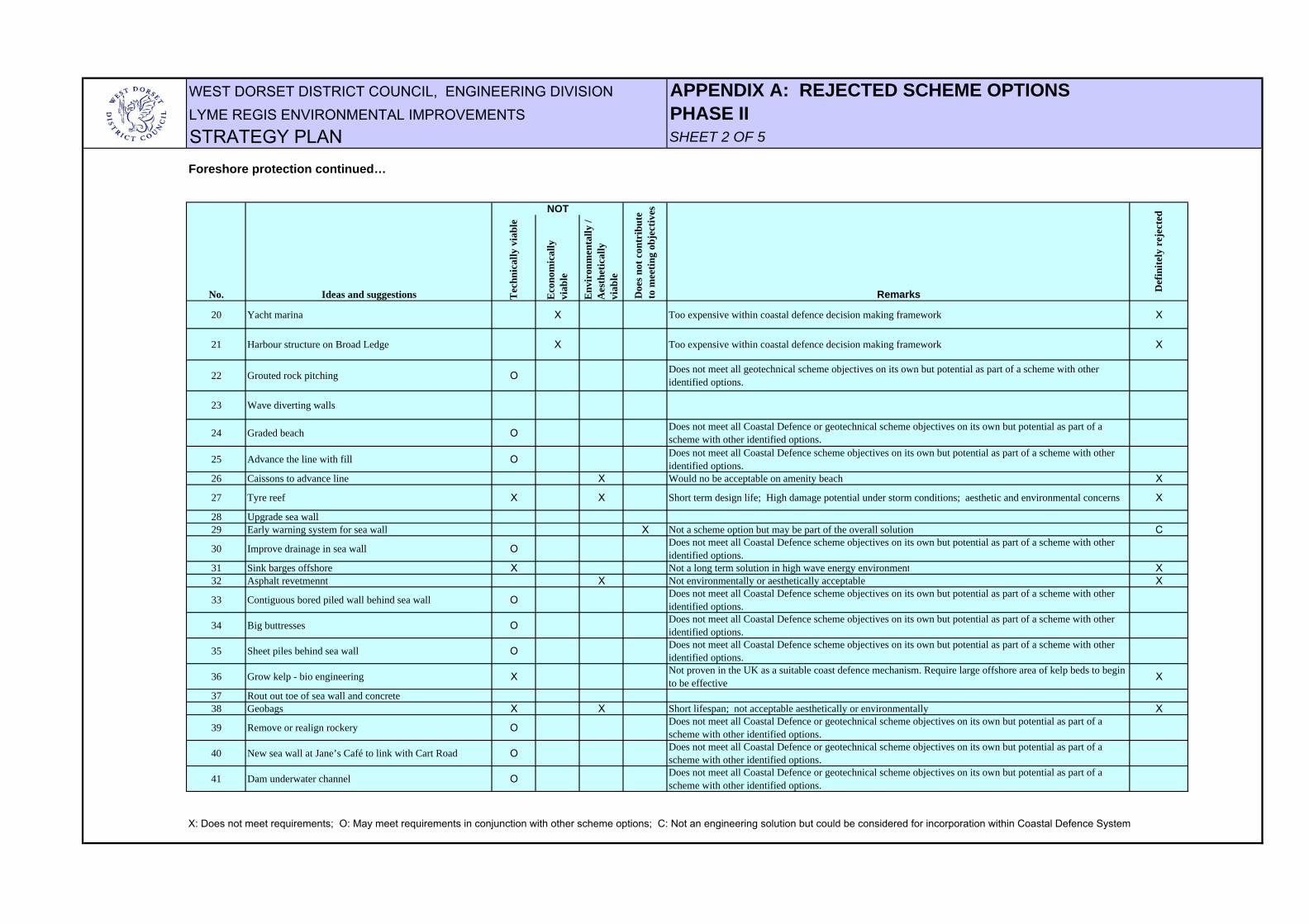
WEST DORSET DISTRICT COUNCIL, ENGINEERING DIVISION APPENDIX A: REJECTED SCHEME OPTIONSLYME REGIS ENVIRONMENTAL IMPROVEMENTS PHASE IISTRATEGY PLAN SHEET 2 OF 5
Tec
hnic
ally
via
ble
Eco
nom
ical
ly
viab
le
Env
iron
men
tally
/ A
esth
etic
ally
vi
able
20 Yacht marina X Too expensive within coastal defence decision making framework X
21 Harbour structure on Broad Ledge X Too expensive within coastal defence decision making framework X
22 Grouted rock pitching O Does not meet all geotechnical scheme objectives on its own but potential as part of a scheme with other identified options.
23 Wave diverting walls
24 Graded beach O Does not meet all Coastal Defence or geotechnical scheme objectives on its own but potential as part of a scheme with other identified options.
25 Advance the line with fill O Does not meet all Coastal Defence scheme objectives on its own but potential as part of a scheme with other identified options.
26 Caissons to advance line X Would no be acceptable on amenity beach X
27 Tyre reef X X Short term design life; High damage potential under storm conditions; aesthetic and environmental concerns X
28 Upgrade sea wall29 Early warning system for sea wall X Not a scheme option but may be part of the overall solution C
30 Improve drainage in sea wall O Does not meet all Coastal Defence scheme objectives on its own but potential as part of a scheme with other identified options.
31 Sink barges offshore X Not a long term solution in high wave energy environment X32 Asphalt revetmennt X Not environmentally or aesthetically acceptable X
33 Contiguous bored piled wall behind sea wall O Does not meet all Coastal Defence scheme objectives on its own but potential as part of a scheme with other identified options.
34 Big buttresses O Does not meet all Coastal Defence scheme objectives on its own but potential as part of a scheme with other identified options.
35 Sheet piles behind sea wall O Does not meet all Coastal Defence scheme objectives on its own but potential as part of a scheme with other identified options.
36 Grow kelp - bio engineering X Not proven in the UK as a suitable coast defence mechanism. Require large offshore area of kelp beds to begin to be effective X
37 Rout out toe of sea wall and concrete38 Geobags X X Short lifespan; not acceptable aesthetically or environmentally X
39 Remove or realign rockery O Does not meet all Coastal Defence or geotechnical scheme objectives on its own but potential as part of a scheme with other identified options.
40 New sea wall at Jane’s Café to link with Cart Road O Does not meet all Coastal Defence or geotechnical scheme objectives on its own but potential as part of a scheme with other identified options.
41 Dam underwater channel O Does not meet all Coastal Defence or geotechnical scheme objectives on its own but potential as part of a scheme with other identified options.
X: Does not meet requirements; O: May meet requirements in conjunction with other scheme options; C: Not an engineering solution but could be considered for incorporation within Coastal Defence System
Foreshore protection continued…
No. Ideas and suggestions
NOT
Doe
s not
con
trib
ute
to m
eetin
g ob
ject
ives
Remarks Def
inite
ly r
ejec
ted
WEST DORSET DISTRICT COUNCIL, ENGINEERING DIVISION APPENDIX A: REJECTED SCHEME OPTIONSLYME REGIS ENVIRONMENTAL IMPROVEMENTS PHASE IISTRATEGY PLAN SHEET 3 OF 5
Tec
hnic
ally
via
ble
Eco
nom
ical
ly
viab
le
Env
iron
men
tally
/ A
esth
etic
ally
vi
able
42 Extend Cobb O Does not meet all Coastal Defence or geotechnical scheme objectives on its own but potential as part of a scheme with other identified options. Potentially expensive.
43 Extend North Wall towards Lycy's Jetty and fill in X Significant loss of Town Beach sand beach area, therefore environmentally unacceptable X
44 Large rock groyne at Broad Ledge and beach recharge X Would require major structure - not acceptable on SSSI X
45 Pile within sea wall O Does not meet all Coastal Defence or geotechnical scheme objectives on its own but potential as part of a scheme with other identified options.
46 Move North Wall seawards (E) X Too expensive with respect to benefits gained X
47 Extend North Wall eastwards O Does not meet all Coastal Defence or geotechnical scheme objectives on its own but potential as part of a scheme with other identified options.
48 Reopen sluices at Cobb and remove sandbar X X Would cause loss of Monmouth Beach as only limited supply of shingle X49 Drain beach X Too high a tidal range, no beach, no evidence of system being effective in UK situation X50 Offshore breakwaters
51 Nearshore bund O Does not meet all Coastal Defence or geotechnical scheme objectives on its own but potential as part of a scheme with other identified options.
52 Coarsen beach O Does not meet all Coastal Defence or geotechnical scheme objectives on its own but potential as part of a scheme with other identified options.
53 Geotubes X X Short lifespan; not acceptable aesthetically or environmentally X54 Grout beach shingle X Variant of revetment options - not as technically satisfactory as other revetment options X
55 Replicate existing system seaward X Replicating the entire Town Beach seawall seawards is too expensive within the coastal defence decision making process X
56 Pressure relief drains O Does not meet all Coastal Defence or geotechnical scheme objectives on its own but potential as part of a scheme with other identified options.
57 Recharge submarine channel with sediment X Unlikely to improve beach levels sufficiently; may result in greater siltation in the harbour; high maintenance commitment X
58 Beach pumping/artificial sand recharge O Does not meet all Coastal Defence or geotechnical scheme objectives on its own but potential as part of a scheme with other identified options.
59 Annual small-scale recharge O Does not meet all Coastal Defence or geotechnical scheme objectives on its own but potential as part of a scheme with other identified options.
60 Shore parallel groynes
X: Does not meet requirements; O: May meet requirements in conjunction with other scheme options; C: Not an engineering solution but could be considered for incorporation within Coastal Defence System
Foreshore protection continued…
No. Ideas and suggestions
NOT
Doe
s not
con
trib
ute
to m
eetin
g ob
ject
ives
Remarks Def
inite
ly r
ejec
ted

WEST DORSET DISTRICT COUNCIL, ENGINEERING DIVISION APPENDIX A: REJECTED SCHEME OPTIONSLYME REGIS ENVIRONMENTAL IMPROVEMENTS PHASE IISTRATEGY PLAN SHEET 4 OF 5
Tec
hnic
ally
via
ble
Eco
nom
ical
ly
viab
le
Env
iron
men
tally
/ A
esth
etic
ally
vi
able
61 Accelerate failure of western cliffs to provide sediment X X X Would not meet coastal defence or geotechnical scheme objectives; high environmental impact X
62 Remove Humble Point X X X Would not meet coastal defence or geotechnical objectives; high environmental impact X
63 Design the beach, grading permeability etc. O Does not meet all Coastal Defence or geotechnical scheme objectives on its own but potential as part of a scheme with other identified options. Often expensive to achieve in practice.
64 Pebbles like tertapods X X X Expensive to manufacture sufficient quantity; unsuitable for recreation beach; untested X
65 Berosin geotextile in Town Beach Channel X Untested / effectiveness unquantifiable during design; potentiall short design life X66 Static Equilibrium Bay67 Surfing reefs X Effectiveness as Coastal Defence structure untested X
68 Create new jetty about present end of Cart Road O Does not meet all Coastal Defence or geotechnical scheme objectives on its own but potential as part of a scheme with other identified options.
69 Extension of Cart Road O Does not meet all Coastal Defence or geotechnical scheme objectives on its own but potential as part of a scheme with other identified options.
70 Concrete armour unit revetment X Unacceptable on amentiy beach X
71 Perched Beach (sand on rock) O Does not meet all Coastal Defence or geotechnical scheme objectives on its own but potential as part of a scheme with other identified options.
72 Extend & raise existing jetties O Does not meet all Coastal Defence or geotechnical scheme objectives on its own but potential as part of scheme with other identified options.
73 Rock revetment X Would not be acceptable on amenity beach X
74 Submerged breakwaters O Does not meet all Coastal Defence or geotechnical scheme objectives on its own but potential as part of scheme with other identified options.
75 Partly submerged breakwaters O Does not meet all Coastal Defence or geotechnical scheme objectives on its own but potential as part of scheme with other identified options.
76 Offshore caisson breakwater O Does not meet all Coastal Defence or geotechnical scheme objectives on its own but potential as part of scheme with other identified options.
77 Simple concrete apron O Does not meet all Coastal Defence or geotechnical scheme objectives on its own but potential as part of scheme with other identified options.
X: Does not meet requirements; O: May meet requirements in conjunction with other scheme options; C: Not an engineering solution but could be considered for incorporation within Coastal Defence System
Foreshore protection continued…
No. Ideas and suggestions
NOT
Doe
s not
con
trib
ute
to m
eetin
g ob
ject
ives
Remarks Def
inite
ly r
ejec
ted

WEST DORSET DISTRICT COUNCIL, ENGINEERING DIVISION APPENDIX A: REJECTED SCHEME OPTIONSLYME REGIS ENVIRONMENTAL IMPROVEMENTS PHASE IISTRATEGY PLAN SHEET 5 OF 5
Slope stabilisationPossible Scheme Reasons for rejection as principal stabilisation elementElement / Strategy
Slope reprofiling by cut and fill Not appropiate due to lack of space and possible deleterious affect on stability of overall landslide complex, may be used locally only.
Excavate or recompact landslide material Possibly use locally in shallow slips.
Vertical gravity drains Not appropiate due to risk of adding water to potential deeper seated slip surface, possibly reducing stability.
Drainage adits Not appropiate due to construction difficulties and high costs. Also collector drains vulnerable to post installation ground movement.
Ground anchors Possibly required to secure existing retaining walls or used locally on shallow slips but bored piles more suitable as principal stabilisation element.
Diaphragm walls Not appropiate due to high cost and possible adverse affect on groundwater regime.
Plant vegetation Would not improve deep-seated landslides.
Gabions Possibly use locally in shallow slips on lower slope, not appropriate as main element.
Crib Wall Possibly use locally in shallow slips on lower slope, not appropriate as main element.
Soil Nailing Possibly use locally in shallow slips on lower slope, not appropriate as main element.
Vertical pumped wells Not appropriate due to high maintenance burden.
Vertical gravity drains Not appropiate due to risk of adding water to potential deeper seated slip surface, possibly reducing stability.
WEST DORSET DISTRICT COUNCIL, ENGINEERING DIVISIONLYME REGIS ENVIRONMENTAL IMPROVEMENTS
SHEET 1 OF 2
PropertyServices and infrastructure Amenity Harbour Property
Services and infrastructure Amenity Harbour
Cost PV Cost Cost PV Cost Cost PV Cost
[1]
[2]
[3]
[4]
APPENDIX B1: DATA SOURCES FOR BENEFIT COST ANALYSIS: SUMMARY OF SOURCES
STRATEGY PLAN UPDATE - MAY 2003
15.90
41.80
7.84 3.86
34.31
191.49
63.00
38.31 24.79 3.08
2.51 0.36
7.46
Design Preliminaries
7.06 1.00
94.44 9.90
10.09
114.90112.18 65.28
Phase IV: East Cliff
33.00 28.85 0.02
0.95 0.88 13.00 11.04
2.50 2.37
Phase V: The Cobb
TOTAL
5.960.20 0.17 3.30 2.61
6.0431.72
0.002
Scheme
Phase II: Cobb Gate to Harbour
Phase IV: East Cliff
Phase V: The Cobb
TOTAL
53.08 4.90
4.00
15.2016.70
TOTAL £M
105.00
69.67
16.82
4.02
Present Value (PV) Benefits
3.86
Construction Contract
Scheme
Phase II: Cobb Gate to Harbour 1.35 1.32
2.82
0.01 0.22
6.27
12.14 5.74
16.760.01 0.24
0.50
532
Number of Properties
297
172
63
0.04
Market Value (MV) TOTAL £M
57.98
£M £M
£M £M £M
37.98
Maintenance per Annum
TOTAL PV Cost £M
7.84
BENEFIT/COST RATIO
The market value of properties in the areas indicated on the location plan for Phases II, III & V in Appendix C1 and calculated in Appendix D. It has been assumed that S9 will be affected byflooding and erosion resulting from a breach in the Cobb, but not landslipping, whereas in fact it could be affected by both.
The market value of properties in all the zones indicated on the location plan for Phase IV in Appendix C2 and calculated in Appendix D.
Present market value of properties in area S9 on the location plan for Phases II, III & V in Appendix C1, which would be affected by a breach in the Cobb as calculated in Appendix D.
Assume failure of Cobb Road within zone S10, with repair of the road to reinstate access to the property in areas S10, S12 and S9, and restoration of services costing £2.9M. Assume alsofailure of the Marine Parade, with restoration of the highway and services costing £2M giving a total market value of £4.9M. See Appendix H
[5]
[4]
[6]
[2]
[1]
[3] [7]
[8]
[9]
[10]
[11]
[12]
[13]
[14]
[14]
[14] [15]
[16]
[16]
[16]
[17]
[17]
[17]
[16]
[16]
[16]
[17]
[17]
[17]
[16]
[16]
[16]
[17]
[17]
[17]
WEST DORSET DISTRICT COUNCIL, ENGINEERING DIVISIONLYME REGIS ENVIRONMENTAL IMPROVEMENTS
SHEET 2 OF 2
[5]
[6]
[7]
[8]
[9]
[10]
[11]
[12]
[13]
[14]
[15]
[16]
[17]
APPENDIX B1: DATA SOURCES FOR BENEFIT COST ANALYSIS: SUMMARY OF SOURCES
STRATEGY PLAN UPDATE - MAY 2003
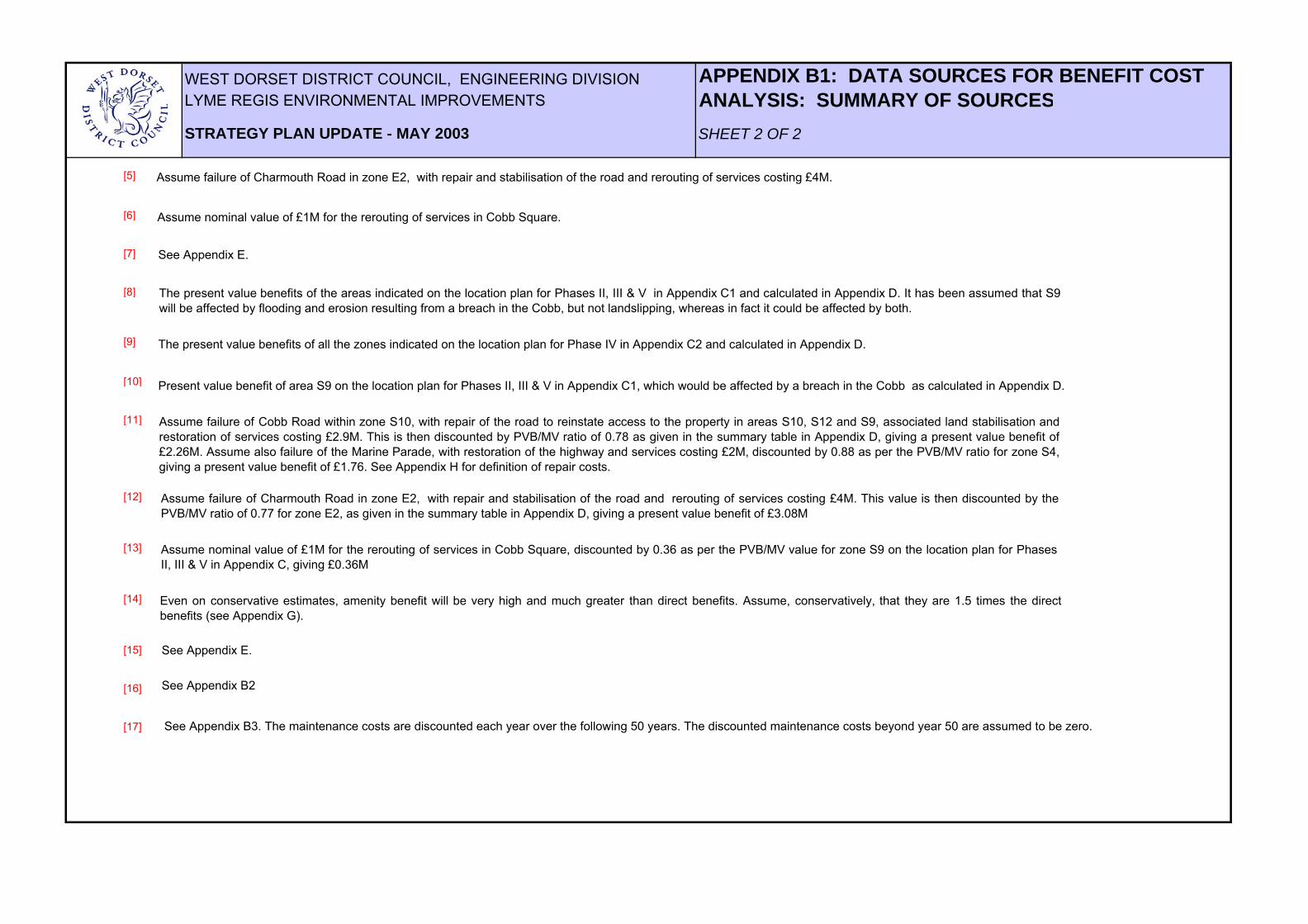
Assume failure of Charmouth Road in zone E2, with repair and stabilisation of the road and rerouting of services costing £4M.
Assume nominal value of £1M for the rerouting of services in Cobb Square.
See Appendix E.
The present value benefits of the areas indicated on the location plan for Phases II, III & V in Appendix C1 and calculated in Appendix D. It has been assumed that S9will be affected by flooding and erosion resulting from a breach in the Cobb, but not landslipping, whereas in fact it could be affected by both.
The present value benefits of all the zones indicated on the location plan for Phase IV in Appendix C2 and calculated in Appendix D.
Present value benefit of area S9 on the location plan for Phases II, III & V in Appendix C1, which would be affected by a breach in the Cobb as calculated in Appendix D.
Assume failure of Cobb Road within zone S10, with repair of the road to reinstate access to the property in areas S10, S12 and S9, associated land stabilisation andrestoration of services costing £2.9M. This is then discounted by PVB/MV ratio of 0.78 as given in the summary table in Appendix D, giving a present value benefit of£2.26M. Assume also failure of the Marine Parade, with restoration of the highway and services costing £2M, discounted by 0.88 as per the PVB/MV ratio for zone S4,giving a present value benefit of £1.76. See Appendix H for definition of repair costs.
Assume failure of Charmouth Road in zone E2, with repair and stabilisation of the road and rerouting of services costing £4M. This value is then discounted by thePVB/MV ratio of 0.77 for zone E2, as given in the summary table in Appendix D, giving a present value benefit of £3.08M
Assume nominal value of £1M for the rerouting of services in Cobb Square, discounted by 0.36 as per the PVB/MV value for zone S9 on the location plan for PhasesII, III & V in Appendix C, giving £0.36M
Even on conservative estimates, amenity benefit will be very high and much greater than direct benefits. Assume, conservatively, that they are 1.5 times the directbenefits (see Appendix G).
See Appendix E.
See Appendix B2
See Appendix B3. The maintenance costs are discounted each year over the following 50 years. The discounted maintenance costs beyond year 50 are assumed to be zero.
WEST DORSET DISTRICT COUNCIL, ENGINEERING DIVISIONLYME REGIS ENVIRONMENTAL IMPROVEMENTS
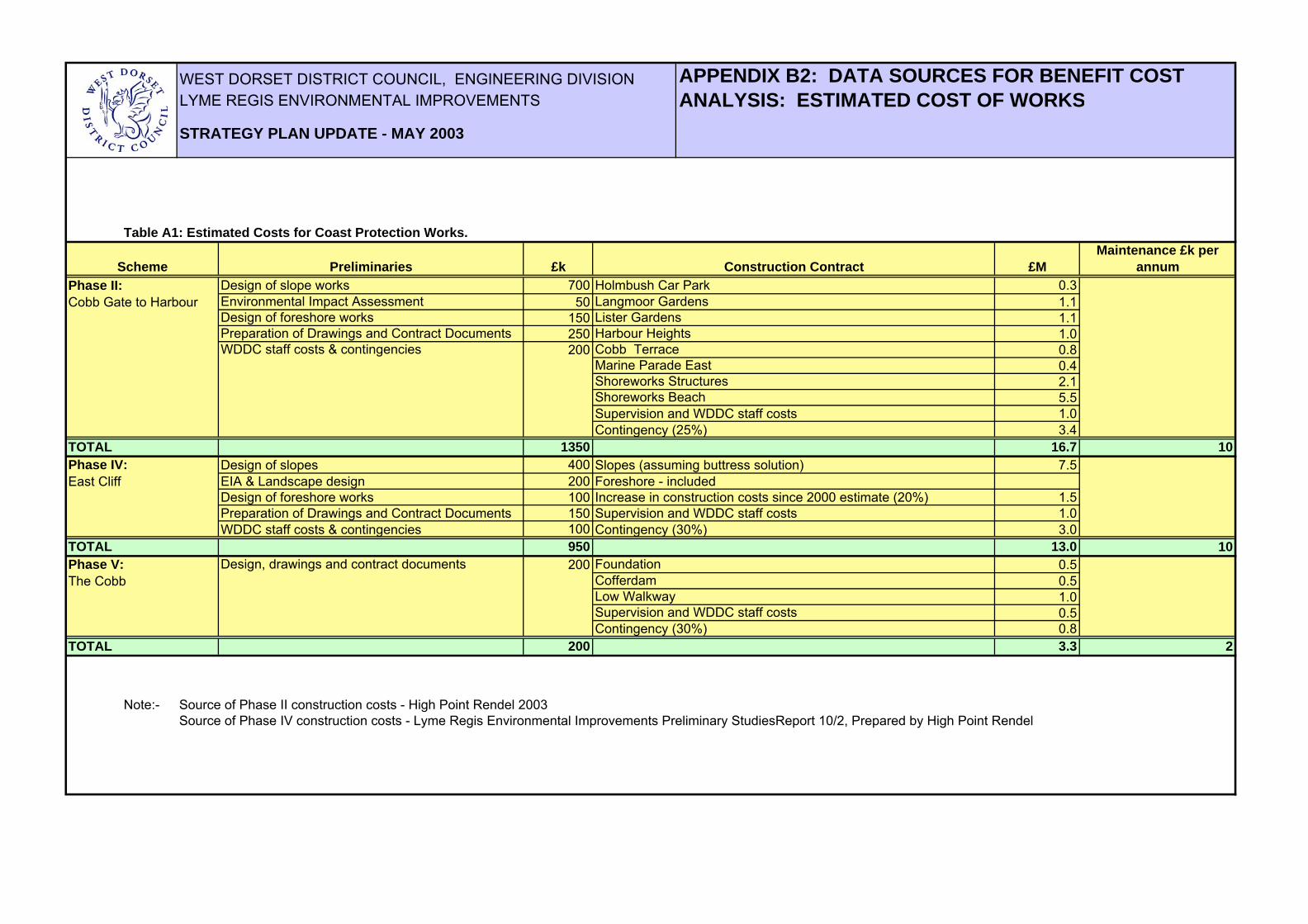
Table A1: Estimated Costs for Coast Protection Works.
£k £MPhase II: 700 0.3Cobb Gate to Harbour 50 1.1
150 1.1250 1.0200 0.8
0.42.15.5
Supervision and WDDC staff costs 1.0Contingency (25%) 3.4
TOTAL 1350 16.7Phase IV: Design of slopes 400 Slopes (assuming buttress solution) 7.5East Cliff EIA & Landscape design 200 Foreshore - included
Design of foreshore works 100 Increase in construction costs since 2000 estimate (20%) 1.5Preparation of Drawings and Contract Documents 150 Supervision and WDDC staff costs 1.0WDDC staff costs & contingencies 100 Contingency (30%) 3.0
TOTAL 950 13.0Phase V: 200 0.5The Cobb 0.5
1.00.50.8
TOTAL 200 3.3
Note:- Source of Phase II construction costs - High Point Rendel 2003Source of Phase IV construction costs - Lyme Regis Environmental Improvements Preliminary StudiesReport 10/2, Prepared by High Point Rendel
Preparation of Drawings and Contract Documents
Maintenance £k per annumScheme Preliminaries Construction Contract
2
Design of slope worksEnvironmental Impact AssessmentDesign of foreshore works
WDDC staff costs & contingencies
Langmoor Gardens
Contingency (30%)
Design, drawings and contract documents
Lister Gardens
Holmbush Car Park
APPENDIX B2: DATA SOURCES FOR BENEFIT COST ANALYSIS: ESTIMATED COST OF WORKS
Cofferdam
10
Low WalkwaySupervision and WDDC staff costs
STRATEGY PLAN UPDATE - MAY 2003
Foundation
Harbour Heights
10
Cobb Terrace
Shoreworks StructuresShoreworks Beach
Marine Parade East

WEST DORSET DISTRICT COUNCIL, ENGINEERING DIVISIONLYME REGIS ENVIRONMENTAL IMPROVEMENTS
Calculations for Present Value Design and Construction Costs
1 2 3 4 1 2 3 4 1 2 3 4 1 2 3 4 1 2 3 4 1 2 3 4 1 2 3 4 1 2 3 4 1 2
Present value = percentage of activity in year x discount factor for year x total cost of activity
Total present value = sum of present values for each activity
Discount factor assumes 3.5% test rate for years 0 - 30 and 3.0% from year 31
STRATEGY PLAN UPDATE - MAY 2003
PHASE IV: EAST CLIFF
Construction Total Cost £10.5M
PHASE V: THE COBB
YearQuarter
Discount Factor
Construction Total Cost £17.5M
PHASE II: COBB GATE TO HARBOUR
Preliminaries Total Cost £1M
Preliminaries Total Cost £0.1M
Preliminaries Total Cost £0.4M
Construction Total Cost £3.5M
37.5% * 0.871442 * £13M = £4.25M
50% * 0.841973 * £13M = £5.47M
37.5% * 0.933511 * £0.95M = £0.33M
50% * 0.901943 * £0.95M = £0.43M
12.5% * 0.871442 * £0.95M = £0.1M
2002 2003
1.000000 0.966184
2004 2005 2006 2008
12.5% * 0.871442 * £16.7M = £1.82M
44.5% * 1.00 * £1.35M = £0.6M
44.5% * 0.966184 * £1.35M = £0.58M
0.813501
Total Present Value = £5.85M + £7.53M + £1.82M = £15.2M
11% * 0.933511 * £1.35M = £0.14M
0.933511 0.901943 0.871442 0.841973
37.5% * 0.933511 * £16.7M = £5.85M
50% * 0.901943 * £16.7M = £7.53M
37.5% * 0.871442 * £0.2M = £0.07M
50% * 0.841973 * £0.2M = £0.08M
APPENDIX B3: DATA SOURCES FOR BENEFIT COST ANALYSIS: CALCULATIONS FOR PRESENT VALUE DESIGN AND CONSTRUCTION COSTS
Total Present Value = £1M + £1.3M + £0.31M = £2.61M
Total Present Value = £0.6M + £0.58M + £0.14 = £1.32M
Total Present Value = £4.25M + £5.47M + £1.32M = £11.04M
Total Present Value = £0.07M + £0.08M + £0.02M = £0.17M
0.785991
2007
12.5% * 0.759412 * £3.3M = £0.31M
2010
0.759412
37.5% * 0.813501 * £3.3M = £1M
50% * 0.785991 * £3.3M = £1.3M
Total Present Value = £0.33M + £0.43M + £0.1M = £0.88M
12.5% * 0.813501 * £13M = £1.32M
12.5% * 0.813501 * £0.2M = £0.02M
2009
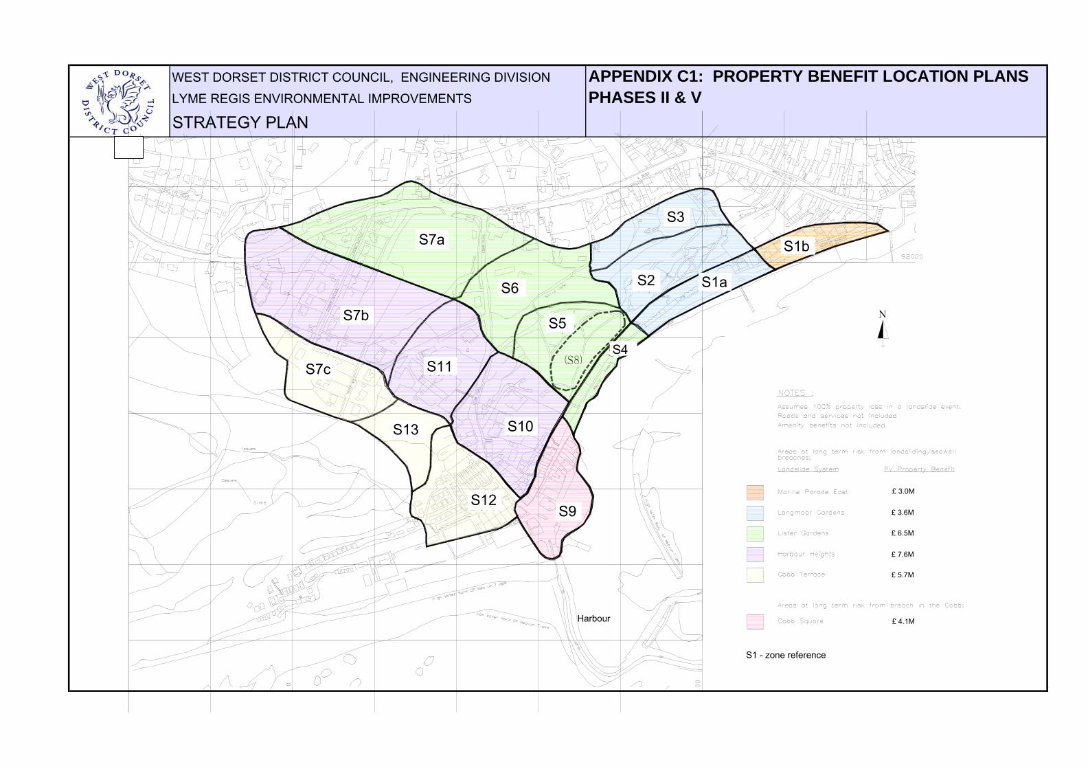
WEST DORSET DISTRICT COUNCIL, ENGINEERING DIVISION APPENDIX C1: PROPERTY BENEFIT LOCATION PLANSLYME REGIS ENVIRONMENTAL IMPROVEMENTS PHASES II & VSTRATEGY PLAN
1.7M
1.1M
S10
S6
S7b
2.0M
0.6M0.2M
2.0M
S7c S11
S13
S12
1.2MS7a
S5only
Amenity
1.1M
0.5M
S9
S4(S8)
S30.9M
1.1M
0.9MonlyAmenityS2
S1B
S1A
N
1.1MS9
S13
S7c
S12S9
S10
S11
S7b
S7a
S6
S5
S4
S3
S2 S1a
S1b
S1 - zone reference
£ 3.0M
£ 3.6M
£ 7.6M
£ 5.7M
£ 4.1M
£ 6.5M
Harbour
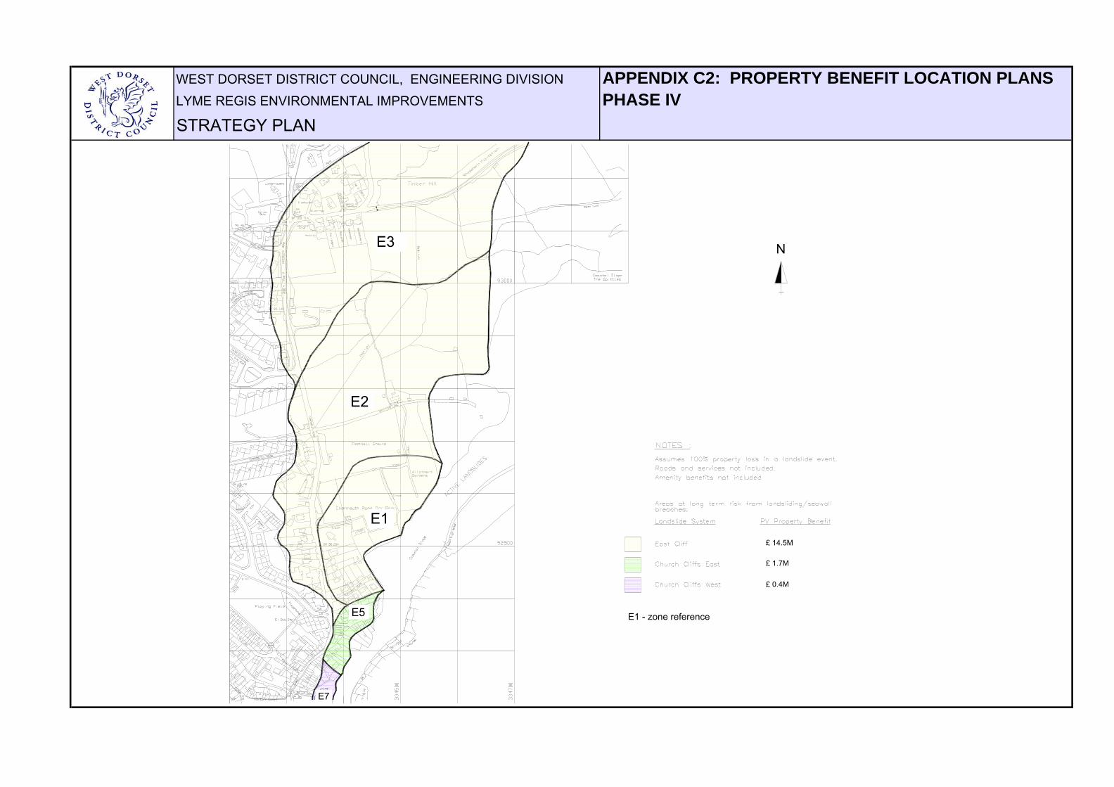
WEST DORSET DISTRICT COUNCIL, ENGINEERING DIVISION APPENDIX C2: PROPERTY BENEFIT LOCATION PLANSLYME REGIS ENVIRONMENTAL IMPROVEMENTS PHASE IVSTRATEGY PLAN
1.1M
0 2M
S5
S7
2.7M
5.3M
1.4M
S2
S1
S3
N
S1
E3
E2
E1
E5
E7
E1 - zone reference
N
£ 14.5M
£ 1.7M
£ 0.4M
WEST DORSET DISTRICT COUNCIL, ENGINEERING DIVISION APPENDIX D1: PRESENT VALUE PROPERTY BENEFITSLYME REGIS ENVIRONMENTAL IMPROVEMENTS PHASE II
SHEET 1 OF 8STRATEGY PLAN UPDATE - MAY 2003
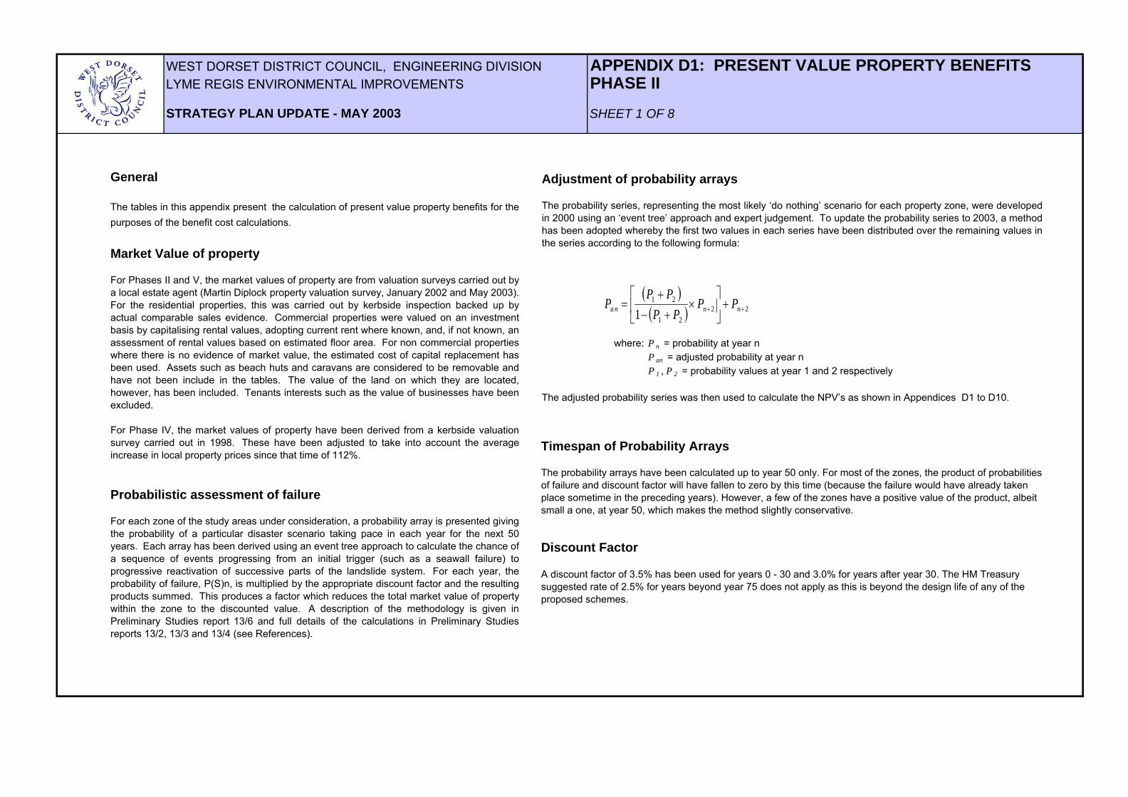
Adjustment of probability arrays
The probability series, representing the most likely ‘do nothing’ scenario for each property zone, were developedin 2000 using an ‘event tree’ approach and expert judgement. To update the probability series to 2003, a methodhas been adopted whereby the first two values in each series have been distributed over the remaining values inthe series according to the following formula:
where: P n = probability at year n P an = adjusted probability at year n P 1 , P 2 = probability values at year 1 and 2 respectively
The adjusted probability series was then used to calculate the NPV’s as shown in Appendices D1 to D10.
General
The tables in this appendix present the calculation of present value property benefits for thepurposes of the benefit cost calculations.
Market Value of property
For Phases II and V, the market values of property are from valuation surveys carried out bya local estate agent (Martin Diplock property valuation survey, January 2002 and May 2003).For the residential properties, this was carried out by kerbside inspection backed up byactual comparable sales evidence. Commercial properties were valued on an investmentbasis by capitalising rental values, adopting current rent where known, and, if not known, anassessment of rental values based on estimated floor area. For non commercial propertieswhere there is no evidence of market value, the estimated cost of capital replacement hasbeen used. Assets such as beach huts and caravans are considered to be removable andhave not been include in the tables. The value of the land on which they are located,however, has been included. Tenants interests such as the value of businesses have beenexcluded.
For Phase IV, the market values of property have been derived from a kerbside valuationsurvey carried out in 1998. These have been adjusted to take into account the averageincrease in local property prices since that time of 112%.
Probabilistic assessment of failure
For each zone of the study areas under consideration, a probability array is presented givingthe probability of a particular disaster scenario taking pace in each year for the next 50years. Each array has been derived using an event tree approach to calculate the chance ofa sequence of events progressing from an initial trigger (such as a seawall failure) toprogressive reactivation of successive parts of the landslide system. For each year, theprobability of failure, P(S)n, is multiplied by the appropriate discount factor and the resultingproducts summed. This produces a factor which reduces the total market value of propertywithin the zone to the discounted value. A description of the methodology is given inPreliminary Studies report 13/6 and full details of the calculations in Preliminary Studiesreports 13/2, 13/3 and 13/4 (see References).
( )( ) 22
21
21
1 ++ +⎥⎦
⎤⎢⎣
⎡×
+−+
= nna n PPPP
PPP
Timespan of Probability Arrays
The probability arrays have been calculated up to year 50 only. For most of the zones, the product of probabilities of failure and discount factor will have fallen to zero by this time (because the failure would have already taken place sometime in the preceding years). However, a few of the zones have a positive value of the product, albeit small a one, at year 50, which makes the method slightly conservative.
Discount Factor
A discount factor of 3.5% has been used for years 0 - 30 and 3.0% for years after year 30. The HM Treasury suggested rate of 2.5% for years beyond year 75 does not apply as this is beyond the design life of any of the proposed schemes.
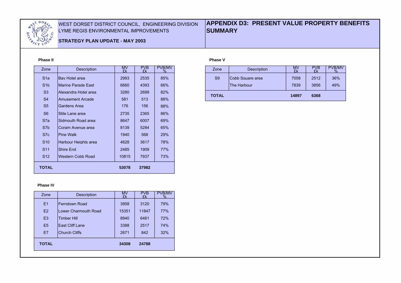
WEST DORSET DISTRICT COUNCIL, ENGINEERING DIVISIONLYME REGIS ENVIRONMENTAL IMPROVEMENTS
MV PVB PVB/MV MV PVB PVB/MV£k £k % £k £k %
S1a Bay Hotel area 2993 2535 85% S9 Cobb Square area 7058 2512 36%
S1b Marine Parade East 6660 4393 66% The Harbour 7839 3856 49%
S3 Alexandra Hotel area 3280 2699 82%
S4 Amusement Arcade 581 513 88%S5 Gardens Area 176 156 88%
S6 Stile Lane area 2735 2365 86%
S7a Sidmouth Road area 8647 6007 69%
S7b Coram Avenue area 8139 5284 65%
S7c Pine Walk 1940 568 29%
S10 Harbour Heights area 4628 3617 78%
S11 Shire End 2485 1909 77%
S12 Western Cobb Road 10815 7937 73%
TOTAL 53078 37982
MV PVB PVB/MV£k £k %
E1 Ferndown Road 3958 3120 79%
E2 Lower Charmouth Road 15351 11847 77%
E3 Timber Hill 8940 6461 72%
E5 East Cliff Lane 3388 2517 74%
E7 Church Cliffs 2671 842 32%
TOTAL 34308 24788
Phase II Phase V
Zone
Zone Description
Phase IV
Zone Description
6368TOTAL 14897
STRATEGY PLAN UPDATE - MAY 2003
APPENDIX D3: PRESENT VALUE PROPERTY BENEFITS SUMMARY
Description
WEST DORSET DISTRICT COUNCIL, ENGINEERING DIVISION APPENDIX F: SENSITIVITY ANALYSISLYME REGIS ENVIRONMENTAL IMPROVEMENTS
Phase II: Cobb Gate to Harbour
Phase IV: East Cliff
Phase V: The Cobb
Average B/C Ratio
STRATEGY PLAN UPDATE - MAY 2003
Table Showing Effect of Varying Construction Costs on Benefit / Cost (B/C) Ratio
3.74
B/C ratio assuming a 60% increase in construction costs
3.92
3.59
3.73
WEST DORSET DISTRICT COUNCIL, ENGINEERING DIVISION APPENDIX G: ASSESSMENT OF AMENITY BENEFITLYME REGIS ENVIRONMENTAL IMPROVEMENTS
SHEET 1 OF 2STRATEGY PLAN UPDATE - MAY 2003
1.0 Introduction
The precise mode, location and time of failure of the existing coastal defences at Lyme Regis, and the timescaleand nature of subsequent deterioration under a 'do nothing' scenario is difficult enough to predict. Its effect ontourism and recreational activities is even more problematic. In the following analysis, therefore, a simplifiedscenario has been investigated to give some indicative, not definitive, ranges of likely amenity benefits that couldbe realised with the provision of a coastal defence scheme. There are an infinite number of variables that couldbe investigated, but for reasons of clarity these have been kept to a minimum, and sufficient only to provide a firstorder sensitivity analysis.
2.0 Estimate of visitor numbers
The first requirement in calculating amenity benefits is an estimate of annual visitor numbers, which forms thebasis from which to consider likely losses without the provision of a future scheme. The figures available,specifically for Lyme Regis, are annual visitor numbers to the Tourist Information Centre (TIC) and a survey ofusers of the Cobb undertaken by WDDC between June and mid-September 1993.
The survey of Cobb users showed that at the peak of the holiday season, an average of 348 people per hour werewalking out onto the Cobb. If this is translated to 7 hours per day and for 92 days (June, July and August) thispredicts 224,112 visitors to the Cobb for the three months. If it is assumed that visitor numbers to the Cobb are areflection of total visitor numbers to Lyme Regis, and that the factor is 2.0, then the total for June, July and August1993 is 448,224.
To estimate the annual total, this figure for the three months in 1993 can be equated to TIC average visitornumbers for the same three months and this factor then used to scale up the figures to give a mean annual value.Using the TIC published data for the last four years, 98/99 to 01/02, this predicts approximately 0.9 million visitorsper year, which for the sake of convenience could be rounded up to 1 million. This figure seems reasonable in thelight of figures that have been published by the Dorset Tourism Data Project. For example, a built attraction suchas Poole Pottery had 1 million visitors in 1996 and Moors Valley Country Park 673,873.
The question then remains as to how these annual visitor numbers are likely to be affected over time due to adeterioration in the coastal frontage under the ‘do nothing’ scenario. It could reasonably be expected that therewould be a decline in the traditional ‘bucket and spade’ tourism. However, the Dorset and East Devon coast hasbeen designated a ‘World Heritage Site’ for its geological interest and it is anticipated that the numbers ofspecialist visitors will increase
as a result; in particular during the out of season ‘shoulder’ months. It cannot be predicted at this time how thistype of tourism is likely to develop, and for the purpose of calculating the amenity benefits it is assumed that thefall in the number of traditional visitors is balanced by a corresponding increase in the number of specialistvisitors. A constant value of 1 million visitors per annum has thus been adopted for the benefit calculations.
3.0 Value of amenity assetsResearch by the Flood Hazard Research Centre of Middlesex Polytechnic (‘The Economics of CoastalManagement’ [The Yellow Manual], 1992, recently replaced by ‘The Benefits of Flood and Coastal Defence:Techniques and Data for 2003’ [The Multicoloured Manual]), has indicated that benefits, particularly the benefitsof preventing the erosion of beaches, are likely to be among the most important benefits of coast protection, andin certain cases can be comparable to, or even higher than, those of protecting life and property. Among theother assets which are enjoyed for recreational use are promenades which, if a beach is lowered by erosion, canbe threatened by undermining. At Lyme Regis the threat to both beach and promenade use is also threatened bylandslipping.
There can be no doubt as to the importance of, and dependency on, the amenity benefits at Lyme Regis, both interms of its economic revenue and employment. Furthermore, any losses that are sustained as a result of a 'donothing' policy would be a loss to the national economy. Neighbouring resorts are already at capacity during thepeak holiday season and it is doubtful if visitors displaced from Lyme Regis could be accommodated elsewhere inthe immediate area.
There are a number of methods available for valuing recreational and amenity benefits that have no market pricei.e. willingness to pay; willingness to accept; and enjoyment per visit. Such methods, however, rely on usersurveys which assume that visitors can express a value of enjoyment or willingness to pay in money terms. Suchsurveys need to be conducted professionally and the results correctly interpreted if spurious and misleadingconclusions are not to be reached. In the absence of survey data for Lyme Regis, some indicative values havethus been considered from sample user surveys presented in the Multicoloured Manual. A standard table of dataon £ loss per adult visit with erosive changes at coastal sites has been compiled from a number of seafront usersurveys, updated to 2001 (Table 8.3). From the 4 sites initially analysed in the Yellow Manual, where there was adeterioration in the beach and promenade, the mean £ loss for local, day and staying visitors equated to £5.36 peradult visit. For additional sites considered in the Multicoloured Manual, and one in particular (Herne Bay), whereconditions are likely to be similar to that which would be experienced at Lyme Regis i.e. a deterioration in beach,seawall and promenade collapse in parts, a mean loss of £5.25 per adult per visit was predicted. If it is assumedfor the present analysis that there will be no additional benefits of enhancement following sea defence works, thenfor the purpose of assessing the Net Present Value of a string of discounted annual amenity benefits, a value of£5 per head per adult visit would seem appropriate. In all likelihood this value could be higher for the specialcharacter of Lyme Regis and its international ‘World Heritage Site’ designation, and for a sensitivity analysis avalue of £10 per head has also been included.

WEST DORSET DISTRICT COUNCIL, ENGINEERING DIVISION APPENDIX G: ASSESSMENT OF AMENITY BENEFITLYME REGIS ENVIRONMENTAL IMPROVEMENTS
SHEET 2 OF 2STRATEGY PLAN UPDATE - MAY 2003
4.0 Net Present Value of Amenity BenefitsFor this analysis, as described above, it has been assumed that total visitor numbers are 1 million per annum,
and that £ loss per adult visit with erosive change is between £5 and £10 per head. For calculating the string ofdiscounted benefits, with and without works, a scheme life of 50 years and an annual discount rate of 3.5% hasbeen adopted. To look at the sensitivity of the net present value (NPV) with the time the string of discountedbenefits might come into effect i.e. following the first failure of the seawall and continuing deterioration of thepromenade and beach, times of failure have been varied from year 0 (failure now) to a failure in year 25.
The NPV of a string of discounted benefits is calculated using the following formula:
NPV = A ( Ds - Dn+s ) r
where: A = present annual value r = discount rate (3.5%) Ds = Discount Factor at year benefit starts from base date Ds+n = Discount Factor at year benefit ends from base date (assume n = 50 year scheme life)
Applying this formula, the following table is obtained:
Year of Loss / NPV (£M) £/head 0 2 4 6 8 10 15 25 5 117.28 109.48 102.2 95.41 89.06 83.14 70 49.63 10 234.56 218.96 204.4 190.82 178.12 166.28 140 99.26
The shows the considerable spread in NPV values that can be obtained, given the variation in year of loss and the£ value loss per adult visit i.e. from £50M at £5/head with a failure in year 25 to £235M at £10/head for a failure atthe present time.
5.0 ConclusionsThe foregoing investigation of likely amenity benefits has given a clear indication of the importance of recreationand tourism in the benefit cost analysis for a coastal defence scheme at Lyme Regis. Because of the manyimponderables related to the likely effects of a 'do nothing' policy on visitor numbers, the values can be taken asindicative only. They do, however, give a potential range of values for a limited change in some of the moreimportant variables i.e. year of failure of the seawall/promenade and the potential loss in the value of enjoymentfor visitors.
The NPV of amenity benefits, even considering failure in 25 years for a value of £5/head, is around £50 million.This it is considered is a conservative lower estimate, and in all likelihood values would be in the much higherrange. In particular, it would seem highly unlikely considering the ‘do nothing’ case that a major failure would notoccur before year 25. The seawall is already showing signs of local distress in a number of areas and is currentlybeing undermined during periods of beach drawdown.
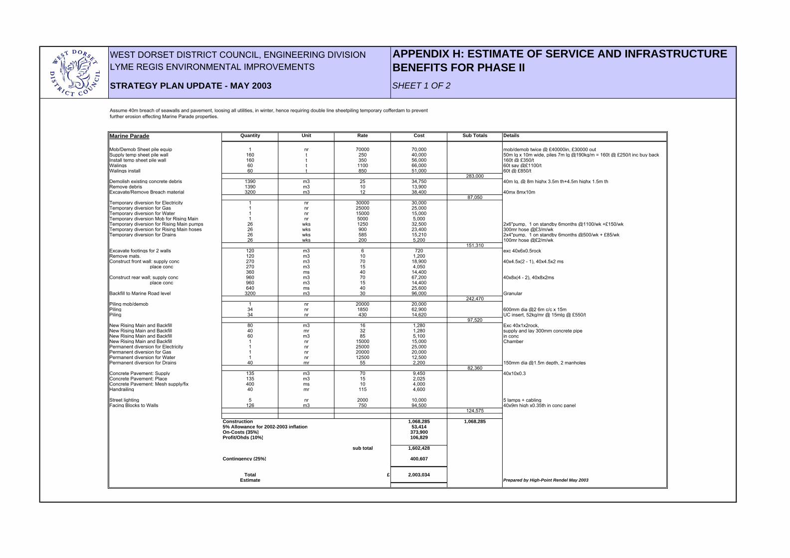
WEST DORSET DISTRICT COUNCIL, ENGINEERING DIVISION APPENDIX H: ESTIMATE OF SERVICE AND INFRASTRUCTURE LYME REGIS ENVIRONMENTAL IMPROVEMENTS BENEFITS FOR PHASE IISTRATEGY PLAN UPDATE - MAY 2003 SHEET 1 OF 2
Marine Parade Quantity Unit Rate Cost Sub Totals Details
Mob/Demob Sheet pile equip 1 nr 70000 70,000 mob/demob twice @ £40000in, £30000 outSupply temp sheet pile wall 160 t 250 40,000 50m lg x 10m wide, piles 7m lg @190kg/m = 160t @ £250/t inc buy backInstall temp sheet pile wall 160 t 350 56,000 160t @ £350/tWalings 60 t 1100 66,000 60t say @£1100/tWalings install 60 t 850 51,000 60t @ £850/t
283,000Demolish existing concrete debris 1390 m3 25 34,750 40m lg, @ 8m highx 3.5m th+4.5m highx 1.5m thRemove debris 1390 m3 10 13,900Excavate/Remove Breach material 3200 m3 12 38,400 40mx 8mx10m
87,050Temporary diversion for Electricity 1 nr 30000 30,000Temporary diversion for Gas 1 nr 25000 25,000Temporary diversion for Water 1 nr 15000 15,000Temporary diversion Mob for Rising Main 1 nr 5000 5,000Temporary diversion for Rising Main pumps 26 wks 1250 32,500 2x6"pump, 1 on standby 6months @1100/wk +£150/wkTemporary diversion for Rising Main hoses 26 wks 900 23,400 300mr hose @£3/m/wkTemporary diversion for Drains 26 wks 585 15,210 2x4"pump, 1 on standby 6months @500/wk + £85/wk
26 wks 200 5,200 100mr hose @£2/m/wk151,310
Excavate footings for 2 walls 120 m3 6 720 exc 40x6x0.5rockRemove mats. 120 m3 10 1,200Construct front wall: supply conc 270 m3 70 18,900 40x4.5x(2 - 1), 40x4.5x2 ms place conc 270 m3 15 4,050
360 ms 40 14,400Construct rear wall; supply conc 960 m3 70 67,200 40x8x(4 - 2), 40x8x2ms place conc 960 m3 15 14,400
640 ms 40 25,600Backfill to Marine Road level 3200 m3 30 96,000 Granular
242,470Piling mob/demob 1 nr 20000 20,000Piling 34 nr 1850 62,900 600mm dia @2 6m c/c x 15m Piling 34 nr 430 14,620 UC insert, 52kg/mr @ 15mlg @ £550/t
97,520New Rising Main and Backfill 80 m3 16 1,280 Exc 40x1x2rock,New Rising Main and Backfill 40 mr 32 1,280 supply and lay 300mm concrete pipe New Rising Main and Backfill 60 m3 85 5,100 in concNew Rising Main and Backfill 1 nr 15000 15,000 ChamberPermanent diversion for Electricity 1 nr 25000 25,000Permanent diversion for Gas 1 nr 20000 20,000Permanent diversion for Water 1 nr 12500 12,500Permanent diversion for Drains 40 mr 55 2,200 150mm dia @1.5m depth, 2 manholes
82,360Concrete Pavement: Supply 135 m3 70 9,450 40x10x0.3Concrete Pavement: Place 135 m3 15 2,025Concrete Pavement: Mesh supply/fix 400 ms 10 4,000Handrailing 40 mr 115 4,600
Street lighting 5 nr 2000 10,000 5 lamps + cablingFacing Blocks to Walls 126 m3 750 94,500 40x9m high x0.35th in conc panel
124,575
Construction 1,068,285 1,068,2855% Allowance for 2002-2003 inflation 53,414On-Costs (35%) 373,900Profit/Ohds (10%) 106,829
sub total 1,602,428
Contingency (25%) 400,607
Total £ 2,003,034Estimate Prepared by High-Point Rendel May 2003
Assume 40m breach of seawalls and pavement, loosing all utilities, in winter, hence requiring double line sheetpiling temporary cofferdam to prevent further erosion effecting Marine Parade properties.
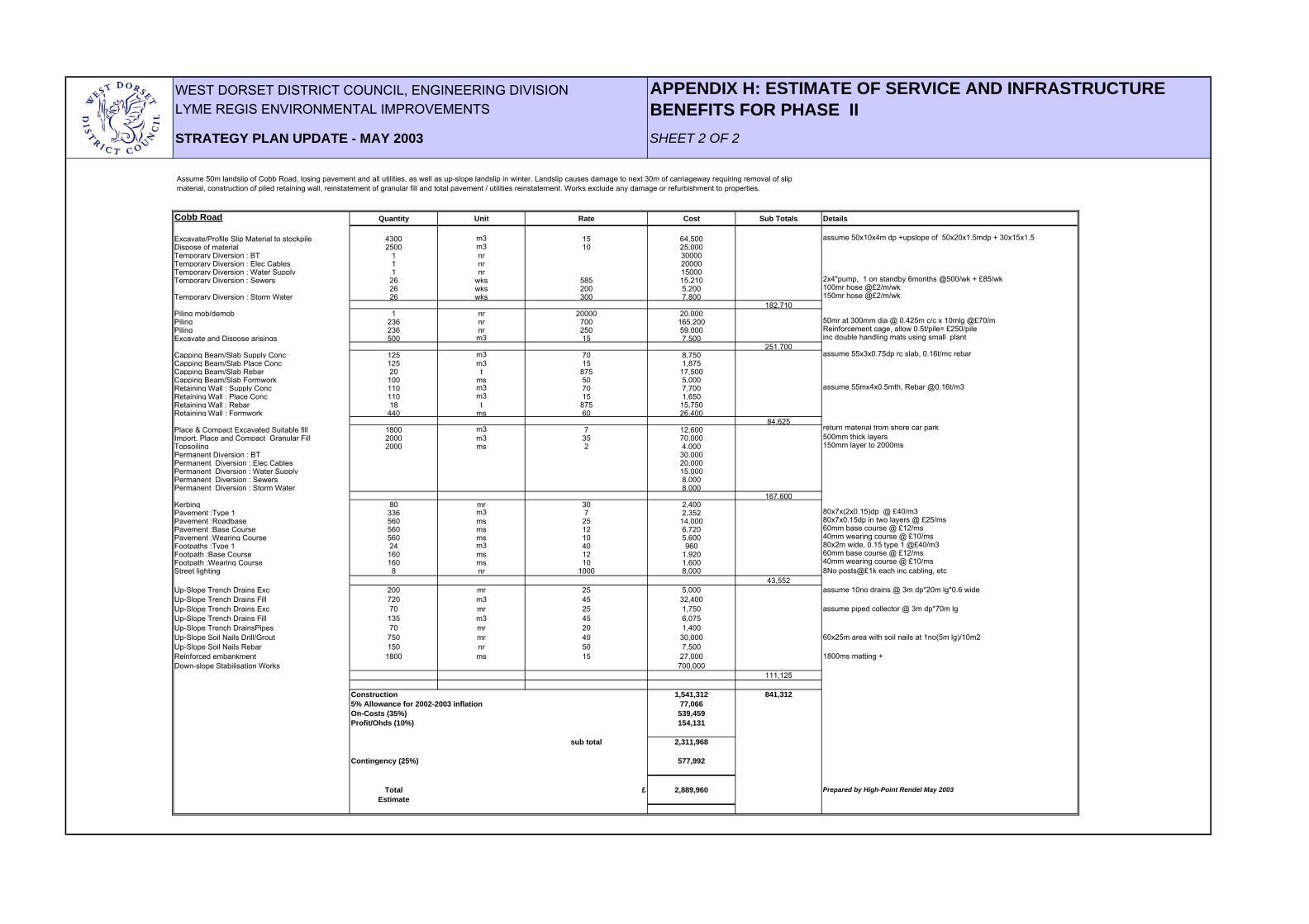
WEST DORSET DISTRICT COUNCIL, ENGINEERING DIVISION APPENDIX H: ESTIMATE OF SERVICE AND INFRASTRUCTURE LYME REGIS ENVIRONMENTAL IMPROVEMENTS BENEFITS FOR PHASE IISTRATEGY PLAN UPDATE - MAY 2003 SHEET 2 OF 2
Cobb Road Quantity Unit Rate Cost Sub Totals Details
Excavate/Profile Slip Material to stockpile 4300 m3 15 64,500 assume 50x10x4m dp +upslope of 50x20x1.5mdp + 30x15x1.5Dispose of material 2500 m3 10 25,000Temporary Diversion : BT 1 nr 30000Temporary Diversion : Elec Cables 1 nr 20000Temporary Diversion : Water Supply 1 nr 15000Temporary Diversion : Sewers 26 wks 585 15,210 2x4"pump, 1 on standby 6months @500/wk + £85/wk
26 wks 200 5,200 100mr hose @£2/m/wkTemporary Diversion : Storm Water 26 wks 300 7,800 150mr hose @£2/m/wk
182,710Piling mob/demob 1 nr 20000 20,000Piling 236 nr 700 165,200 50mr at 300mm dia @ 0.425m c/c x 10mlg @£70/mPiling 236 nr 250 59,000 Reinforcement cage, allow 0.5t/pile= £250/pile Excavate and Dispose arisings 500 m3 15 7,500 inc double handling mats using small plant
251,700Capping Beam/Slab Supply Conc 125 m3 70 8,750 assume 55x3x0.75dp rc slab, 0.16t/mc rebarCapping Beam/Slab Place Conc 125 m3 15 1,875Capping Beam/Slab Rebar 20 t 875 17,500Capping Beam/Slab Formwork 100 ms 50 5,000Retaining Wall : Supply Conc 110 m3 70 7,700 assume 55mx4x0.5mth, Rebar @0.16t/m3Retaining Wall : Place Conc 110 m3 15 1,650Retaining Wall : Rebar 18 t 875 15,750Retaining Wall : Formwork 440 ms 60 26,400
84,625Place & Compact Excavated Suitable fill 1800 m3 7 12,600 return material from shore car parkImport, Place and Compact Granular Fill 2000 m3 35 70,000 500mm thick layersTopsoiling 2000 ms 2 4,000 150mm layer to 2000msPermanent Diversion : BT 30,000Permanent Diversion : Elec Cables 20,000Permanent Diversion : Water Supply 15,000Permanent Diversion : Sewers 8,000Permanent Diversion : Storm Water 8,000
167,600Kerbing 80 mr 30 2,400Pavement :Type 1 336 m3 7 2,352 80x7x(2x0.15)dp @ £40/m3Pavement :Roadbase 560 ms 25 14,000 80x7x0.15dp in two layers @ £25/msPavement :Base Course 560 ms 12 6,720 60mm base course @ £12/msPavement :Wearing Course 560 ms 10 5,600 40mm wearing course @ £10/msFootpaths :Type 1 24 m3 40 960 80x2m wide, 0.15 type 1 @£40/m3Footpath :Base Course 160 ms 12 1,920 60mm base course @ £12/msFootpath :Wearing Course 160 ms 10 1,600 40mm wearing course @ £10/msStreet lighting 8 nr 1000 8,000 8No posts@£1k each inc cabling, etc
43,552Up-Slope Trench Drains Exc 200 mr 25 5,000 assume 10no drains @ 3m dp*20m lg*0.6 wideUp-Slope Trench Drains Fill 720 m3 45 32,400Up-Slope Trench Drains Exc 70 mr 25 1,750 assume piped collector @ 3m dp*70m lgUp-Slope Trench Drains Fill 135 m3 45 6,075Up-Slope Trench DrainsPipes 70 mr 20 1,400Up-Slope Soil Nails Drill/Grout 750 mr 40 30,000 60x25m area with soil nails at 1no(5m lg)/10m2Up-Slope Soil Nails Rebar 150 nr 50 7,500Reinforced embankment 1800 ms 15 27,000 1800ms matting + Down-slope Stabilisation Works 700,000
111,125
1,541,312 841,31277,066
539,459154,131
sub total 2,311,968
Contingency (25%) 577,992
Total £ 2,889,960 Prepared by High-Point Rendel May 2003Estimate
Construction5% Allowance for 2002-2003 inflationOn-Costs (35%)Profit/Ohds (10%)
Assume 50m landslip of Cobb Road, losing pavement and all utilities, as well as up-slope landslip in winter. Landslip causes damage to next 30m of carriageway requiring removal of slip material, construction of piled retaining wall, reinstatement of granular fill and total pavement / utilities reinstatement. Works exclude any damage or refurbishment to properties.