Embed Size (px)
Citation preview

LYON & REDWOOD COUNTY FARMS FOR SALE
This information provided herein is received from other sources and is believed to be correct NORTHWESTERN FARM MANAGEMENT COMPANY, Broker does not warrant its accuracy. We strongly suggest you contact the appropriate sources to confirm this information.
248.75 deeded acres of high quality, gently rolling farmland in southeastern Lyon & southwestern Redwood County, MN. The land includes approximately 224.6 tillable acres with a weighted CPI of 88.65. North Twin-Walnut Grove (51.6% of the soils-CPI 94 & 96) and Annton-North Twin (20% of soils-CPI 91) complexes are the most common soils. The sale also includes several desirable locations for new house construction or hobby acreages. Farms are being offered by private treaty sale, and offers may be made on any or all parcels. Sellers will also consider offers on split parcel sales. Location: The sale properties are located to the east and southeast of Tracy, MN.
[email protected]@nfmco.com • www.nfmco.com
Contact Eldon KrullOffice Ph: 507-532-5120
Cell Ph: 641-220-1824Fax: 507-532-0293
301 S. O’Connell St. Marshall, MN 56258 Farm Management • Farm Sales • Farm Appraisals
Broker
Aerial Map
map center: 44° 13' 57.49, -95° 36' 3.67 0ft 1027ft 2054ft
24-109N-40WLyon County
Minnesota
2/11/2019
Field borders provided by Farm Service Agency as of 5/21/2008.
Parcel 2
Parcel 1
Parcel 3
SALE INFORMATION: All properties sold ‘As Is.’ Land is under lease for 2020, and buyer will have the choice of opting out of lease or receiving 2020 payments.Seller will pay 2019 Real Estate Taxes and buyer shall pay 2020 Real Estate Taxes. Sale will not be contingent on financing. Cash sale with 15% earnest money required upon signing purchase agreement.
Additional information available at Northwestern Farm Management website (www.nfmco.com) or call Eldon Krull at 507-532-5120.
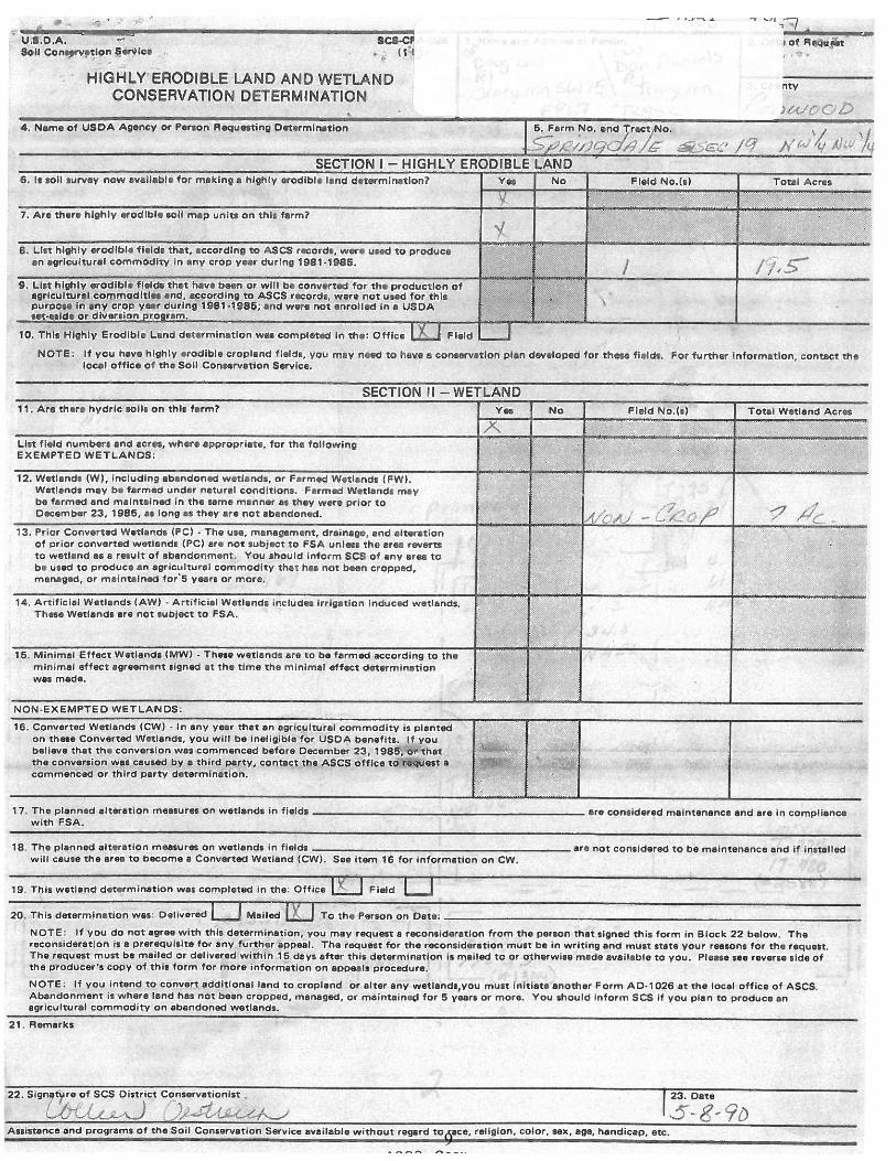
1 Pt S½ 24-109-40 140.08 135.74 91.4 8.80 $6,150 $5,6902 Pt. E½NE¼ 24-109-40 69.22 59.65 86.4 8.01 $4,800 $1,9903 NW¼NW¼ 19-109-39 39.45 29.21 80.5 8.20 $3,600 $888
Asking Price/Acre
2019 R.E. Tax Non-HS
Parcel #
Approximate Legal Description
Deeded Acres
Tillable Acres
CPI Pasture & Hunting Ac.
1

Aerial Map
map center: 44° 13' 57.49, -95° 36' 3.67 0ft 1027ft 2054ft
24-109N-40WLyon County
Minnesota
2/11/2019
Field borders provided by Farm Service Agency as of 5/21/2008.
2

State: MinnesotaLyonCounty:24-109N-40WLocation:
Township: MonroeAcres: 135.74Date: 2/11/2019
Soils data provided by USDA and NRCS.
Soils Map
Area Symbol: MN083, Soil Area Version: 15Area Symbol: MN083, Soil Area Version: 15Code Soil Description Acres Percent of field NonIrr Class Legend NonIrr Class *c Productivity Index
L198A North TwinWalnut Grove complex, 0 to 2 percent slopes 47.16 34.7% Iw 96
L225B AnntonNorth Twin complex, 3 to 6 percent slopes 41.53 30.6% IIe 91
L202A Pell CreekRomnell complex, 0 to 2 percent slopes 30.52 22.5% IIw 89
L198B North TwinWalnut Grove complex, 1 to 4 percent slopes 13.42 9.9% IIe 94
L207E BelviewRidgeton complex, 18 to 25 percent slopes, firm till substratum 3.11 2.3% VIe 40
Weighted Average 91.4
*c: Using Capabilities Class Dominant Condition Aggregation Method
Soils data provided by USDA and NRCS.
3

State: MinnesotaLyonCounty:24-109N-40WLocation:
Township: MonroeAcres: 59.65Date: 2/11/2019
Soils data provided by USDA and NRCS.
Soils Map
Area Symbol: MN083, Soil Area Version: 15Area Symbol: MN083, Soil Area Version: 15Code Soil Description Acres Percent of field NonIrr Class Legend NonIrr Class *c Productivity Index
L198B North TwinWalnut Grove complex, 1 to 4 percent slopes 34.69 58.2% IIe 94
L198A North TwinWalnut Grove complex, 0 to 2 percent slopes 7.91 13.3% Iw 96
L207E BelviewRidgeton complex, 18 to 25 percent slopes, firm till substratum 5.99 10.0% VIe 40
L202A Pell CreekRomnell complex, 0 to 2 percent slopes 5.66 9.5% IIw 89
L226C2 AnntonStorden, firm till complex, 6 to 12 percent slopes, moderately eroded 2.93 4.9% IIIe 79
L172D2 Storden, firm tillAnnton complex, 12 to 18 percent slopes, moderately eroded 2.47 4.1% IIIe 64
Weighted Average 86.4
*c: Using Capabilities Class Dominant Condition Aggregation Method
Soils data provided by USDA and NRCS.
4

State: MinnesotaRedwoodCounty:19-109N-39WLocation:
Township: SpringdaleAcres: 29.21Date: 6/11/2019
Soils data provided by USDA and NRCS.
Soils Map
Area Symbol: MN127, Soil Area Version: 17Code Soil Description Acres Percent of field NonIrr Class Legend NonIrr Class *c Productivity Index
L198B North TwinWalnut grove complex, 1 to 4 percent slopes 12.48 42.7% IIe 94
L207E BelviewRidgeton complex, 18 to 25 percent slopes, firm till substratum 4.44 15.2% VIe 40
L226C2 AnntonStorden, firm till complex, 6 to 12 percent slopes, moderately eroded 4.21 14.4% IIIe 79
L225B AnntonNorth Twin complex, 3 to 6 percent slopes 3.65 12.5% IIe 91
L172D2 Storden, firm tillAnnton complex, 12 to 18 percent slopes, moderately eroded 2.20 7.5% IIIe 64
L202A Pell CreekRomnell complex, 0 to 2 percent slopes 2.08 7.1% IIw 89
L198A North TwinWalnut grove complex, 0 to 2 percent slopes 0.08 0.3% Iw 96
1834 Coland clay loam, 0 to 2 percent slopes, frequently flooded 0.07 0.2% Vw 20
Weighted Average 80.5
*c: Using Capabilities Class Dominant Condition Aggregation MethodSoils data provided by USDA and NRCS.
5

6

7

8
9

10


![The Redwood gazette. (Redwood Falls, Minn.), 1933-07-27, [p ]](https://img.pdfslide.net/doc/110x75/62986ea183583b25e317e403/the-redwood-gazette-redwood-falls-minn-1933-07-27-p-.jpg)


![The Redwood gazette. (Redwood Falls, Minn.), 1909-05-19, [p ]](https://img.pdfslide.net/doc/110x75/61f3066c4fb1c01f2e62eb08/the-redwood-gazette-redwood-falls-minn-1909-05-19-p-.jpg)


![The Redwood gazette. (Redwood Falls, Minn.), 1921-10-05, [p ]](https://img.pdfslide.net/doc/110x75/61e75daafb034a33595cb385/the-redwood-gazette-redwood-falls-minn-1921-10-05-p-.jpg)