Embed Size (px)
Citation preview
Arizona Geological Surveywww.azgs.az.gov | repository.azgs.az.gov
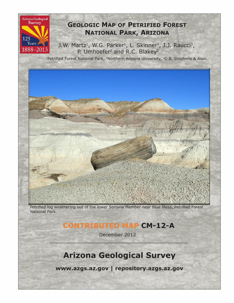
December 2012
Contributed MAp CM-12-A
GeoloGic Map of petrified forest NatioNal park, arizoNa
J.W. Martz1, W.G. Parker1, L. Skinner2, J.J. Raucci3,P. Umhoefer2 and R.C. Blakey2
1Petrified Forest National Park, 2Northern Arizona University, 3D.B. Stephens & Assn.
Petrified log weathering out of the lower Sonsela Member near Blue Mesa, Petrified Forest National Park.
Arizona Geological Survey
M. Lee Allison, State Geologist and Director
Manuscript approved for publication in December 2012Printed by the Arizona Geological Survey
All rights reserved
For an electronic copy of this publication: www.repository.azgs.az.govPrinted copies are on sale at the Arizona Experience Store
416 W. Congress, Tucson, AZ 85701 (520.770.3500)[email protected]
For information on the mission, objectives or geologic products of the Arizona Geological Survey visit www.azgs.az.gov.
This publication was prepared by an agency of the State of Arizona. The State of Arizona, or any agency thereof, or any of their employees, makes no warranty, expressed or implied, or assumes any legal liability or responsibility for the accuracy, completeness, or usefulness of any information, apparatus, product, or process disclosed in this report. Any use of trade,
product, or firm names in this publication is for descriptive purposes only and does not imply endorsement by the State of Arizona.
___________________________
Recommended Citation: Martz, J.W., Parker, W.G., Skinner, L. and Raucci, J.J., Umhoefer, P. and Blakey, R.C., 2012, Geologic Map of Petrified Forest National Park, Arizona. Arizona Geological Survey Contributed Map CR-12-A, 1 map sheet, 1:50,000 map scale, 18 p.
Arizona Geological Survey Contributed Report CM-12-A
Geologic Map of Petrified Forest National Park, Arizona
December 2012
J.W. Martz, W.G. Parker, L. Skinner, J.J. Raucci
P. Umhoefer and R.C. Blakey
Arizona Geological Survey Contributed Map Series
The Contributed Map Series provides non-AZGS authors with a forum for publishing documents concerning Arizona geology. While review comments may have been incorporated, this document does not necessarily conform to AZGS technical, editorial, or policy standards. The Arizona Geological Survey issues no warranty, expressed or implied, regarding the suitability of this product for a particular use. Moreover, the Arizona Geological Survey shall not be liable under any circumstances for any direct, indirect, special, incidental, or consequential damages with respect to claims by users of this product. The author(s) is solely responsible for the data and ideas expressed herein.
1
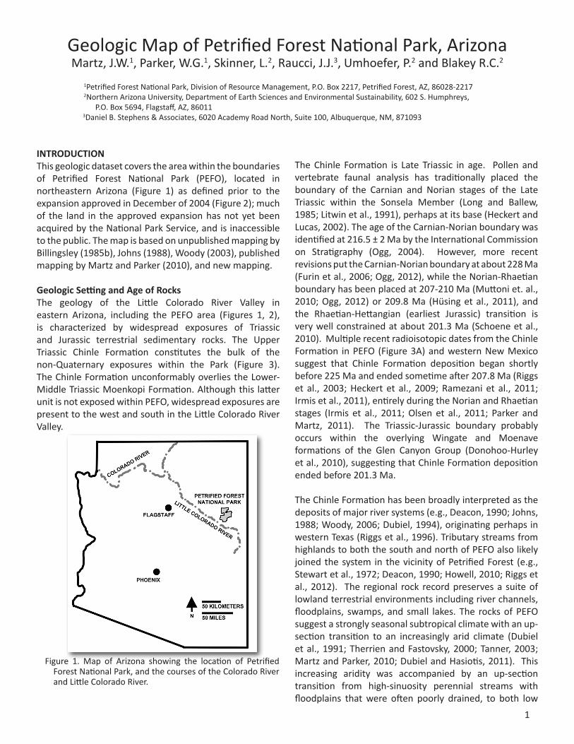
INTRODUCTIONThis geologic dataset covers the area within the boundaries of Petrified Forest National Park (PEFO), located in northeastern Arizona (Figure 1) as defined prior to the expansion approved in December of 2004 (Figure 2); much of the land in the approved expansion has not yet been acquired by the National Park Service, and is inaccessible to the public. The map is based on unpublished mapping by Billingsley (1985b), Johns (1988), Woody (2003), published mapping by Martz and Parker (2010), and new mapping.
Geologic Setting and Age of Rocks The geology of the Little Colorado River Valley in eastern Arizona, including the PEFO area (Figures 1, 2), is characterized by widespread exposures of Triassic and Jurassic terrestrial sedimentary rocks. The Upper Triassic Chinle Formation constitutes the bulk of the non-Quaternary exposures within the Park (Figure 3). The Chinle Formation unconformably overlies the Lower-Middle Triassic Moenkopi Formation. Although this latter unit is not exposed within PEFO, widespread exposures are present to the west and south in the Little Colorado River Valley.
The Chinle Formation is Late Triassic in age. Pollen and vertebrate faunal analysis has traditionally placed the boundary of the Carnian and Norian stages of the Late Triassic within the Sonsela Member (Long and Ballew, 1985; Litwin et al., 1991), perhaps at its base (Heckert and Lucas, 2002). The age of the Carnian-Norian boundary was identified at 216.5 ± 2 Ma by the International Commission on Stratigraphy (Ogg, 2004). However, more recent revisions put the Carnian-Norian boundary at about 228 Ma (Furin et al., 2006; Ogg, 2012), while the Norian-Rhaetian boundary has been placed at 207-210 Ma (Muttoni et. al., 2010; Ogg, 2012) or 209.8 Ma (Hüsing et al., 2011), and the Rhaetian-Hettangian (earliest Jurassic) transition is very well constrained at about 201.3 Ma (Schoene et al., 2010). Multiple recent radioisotopic dates from the Chinle Formation in PEFO (Figure 3A) and western New Mexico suggest that Chinle Formation deposition began shortly before 225 Ma and ended sometime after 207.8 Ma (Riggs et al., 2003; Heckert et al., 2009; Ramezani et al., 2011; Irmis et al., 2011), entirely during the Norian and Rhaetian stages (Irmis et al., 2011; Olsen et al., 2011; Parker and Martz, 2011). The Triassic-Jurassic boundary probably occurs within the overlying Wingate and Moenave formations of the Glen Canyon Group (Donohoo-Hurley et al., 2010), suggesting that Chinle Formation deposition ended before 201.3 Ma.
The Chinle Formation has been broadly interpreted as the deposits of major river systems (e.g., Deacon, 1990; Johns, 1988; Woody, 2006; Dubiel, 1994), originating perhaps in western Texas (Riggs et al., 1996). Tributary streams from highlands to both the south and north of PEFO also likely joined the system in the vicinity of Petrified Forest (e.g., Stewart et al., 1972; Deacon, 1990; Howell, 2010; Riggs et al., 2012). The regional rock record preserves a suite of lowland terrestrial environments including river channels, floodplains, swamps, and small lakes. The rocks of PEFO suggest a strongly seasonal subtropical climate with an up-section transition to an increasingly arid climate (Dubiel et al., 1991; Therrien and Fastovsky, 2000; Tanner, 2003; Martz and Parker, 2010; Dubiel and Hasiotis, 2011). This increasing aridity was accompanied by an up-section transition from high-sinuosity perennial streams with floodplains that were often poorly drained, to both low
Geologic Map of Petrified Forest National Park, ArizonaMartz, J.W.1, Parker, W.G.1, Skinner, L.2, Raucci, J.J.3, Umhoefer, P.2 and Blakey R.C.2
1Petrified Forest National Park, Division of Resource Management, P.O. Box 2217, Petrified Forest, AZ, 86028-2217 2Northern Arizona University, Department of Earth Sciences and Environmental Sustainability, 602 S. Humphreys,
P.O. Box 5694, Flagstaff, AZ, 86011 3Daniel B. Stephens & Associates, 6020 Academy Road North, Suite 100, Albuquerque, NM, 871093
Figure 1. Map of Arizona showing the location of Petrified Forest National Park, and the courses of the Colorado River and Little Colorado River.

2
Figure 2. Map of Petrified Forest National Park showing the pre-2004 park boundary (encompassing the current geologic map), 2004 boundary expansion, and geographic features discussed in the text.
3
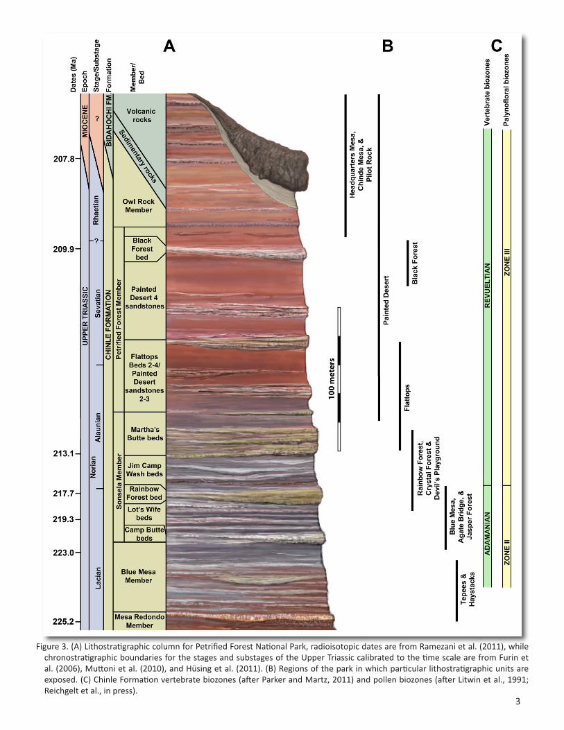
Figure 3. (A) Lithostratigraphic column for Petrified Forest National Park, radioisotopic dates are from Ramezani et al. (2011), while chronostratigraphic boundaries for the stages and substages of the Upper Triassic calibrated to the time scale are from Furin et al. (2006), Muttoni et al. (2010), and Hüsing et al. (2011). (B) Regions of the park in which particular lithostratigraphic units are exposed. (C) Chinle Formation vertebrate biozones (after Parker and Martz, 2011) and pollen biozones (after Litwin et al., 1991; Reichgelt et al., in press).
4
and high sinuosity perennial and ephemeral streams with better-drained floodplains, to mostly ephemeral streams and small lakes (Kraus and Middleton, 1987; Johns, 1988; Dubiel, 1993; Demko, 1995; Therrien and Fastovsky, 2000; Woody, 2006; Martz and Parker, 2010).
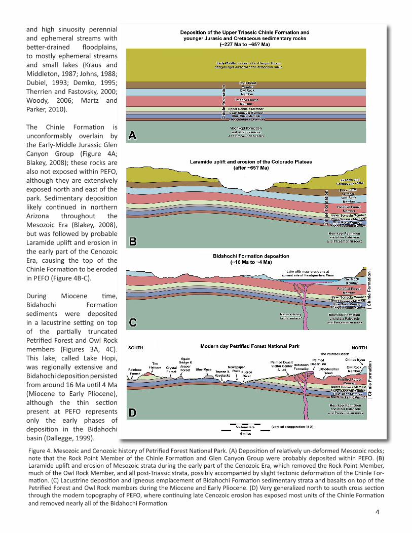
The Chinle Formation is unconformably overlain by the Early-Middle Jurassic Glen Canyon Group (Figure 4A; Blakey, 2008); these rocks are also not exposed within PEFO, although they are extensively exposed north and east of the park. Sedimentary deposition likely continued in northern Arizona throughout the Mesozoic Era (Blakey, 2008), but was followed by probable Laramide uplift and erosion in the early part of the Cenozoic Era, causing the top of the Chinle Formation to be eroded in PEFO (Figure 4B-C).
During Miocene time, Bidahochi Formation sediments were deposited in a lacustrine setting on top of the partially truncated Petrified Forest and Owl Rock members (Figures 3A, 4C). This lake, called Lake Hopi, was regionally extensive and Bidahochi deposition persisted from around 16 Ma until 4 Ma (Miocene to Early Pliocene), although the thin section present at PEFO represents only the early phases of deposition in the Bidahochi basin (Dallegge, 1999).
Figure 4. Mesozoic and Cenozoic history of Petrified Forest National Park. (A) Deposition of relatively un-deformed Mesozoic rocks; note that the Rock Point Member of the Chinle Formation and Glen Canyon Group were probably deposited within PEFO. (B) Laramide uplift and erosion of Mesozoic strata during the early part of the Cenozoic Era, which removed the Rock Point Member, much of the Owl Rock Member, and all post-Triassic strata, possibly accompanied by slight tectonic deformation of the Chinle For-mation. (C) Lacustrine deposition and igneous emplacement of Bidahochi Formation sedimentary strata and basalts on top of the Petrified Forest and Owl Rock members during the Miocene and Early Pliocene. (D) Very generalized north to south cross section through the modern topography of PEFO, where continuing late Cenozoic erosion has exposed most units of the Chinle Formation and removed nearly all of the Bidahochi Formation.
5
The Bidahochi sedimentary rocks at PEFO are similar to rocks near the base of the Bidahochi section (members 1 and 2 of Dallegge, 1999) and are therefore likely to be middle Miocene in age. Basaltic rocks of the Hopi Buttes volcanic field were emplaced between 8.2-4.5 Ma (Late Miocene and Early Pliocene), creating a series of maar volcanoes, lava flows, dikes and vents across the region (Dallegge, 1999). Subsequent Pliocene, Pleistocene, and Holocene erosion has left only remnants of the Bidahochi Formation within PEFO; these rocks cap Painted Desert Mesa and Pilot Rock in the northern region of the Park (Figures. 2, 3A, 4D).
Structural Geology
Regionally, the structural tilt of rocks is ~1°- 2° northeast. However, gentle warping of the strata is noted throughout PEFO. The most conspicuous examples of this warping are the sharp syncline of the Sinking Ship near Blue Mesa, the broad dome that elevates the Newspaper Rock area, a broad upwarp in The Devil’s Playground area north of I-40, the subtle syncline of the Flattops area, and the equally subtle anticline near the Rainbow Forest area. These structures may be tectonic in origin, possibly resulting from Laramide elevation of the Colorado Plateau. However, the Pennsylvanian/Permian Holbrook Basin underlies the Petrified Forest region and mobile salts within this basin are another possible cause of warping in the overlying strata (Akers, 1964; Neal and Rauzi, 1996). No significant faults have been observed within Petrified Forest National Park, although small fractures with a few meters of displacement are locally common.
Stratigraphic Nomenclature
The lithostratigraphic correlation and nomenclature of Upper Triassic rocks in the Petrified Forest region has been the subject of debate for over a century. This document uses the most recent revisions of Martz and Parker (2010) and Parker and Martz (2011), which have attempted to resolve these issues. The stratigraphic model of the Chinle Formation utilized in this mapping is summarized in Figure 3A. Users interested in a thorough discussion of the history of Chinle Formation stratigraphic nomenclature are referred to the recent summary works of Heckert and Lucas (2002), Woody (2006), and Martz and Parker (2010).
Lucas (1993) and Heckert and Lucas (2002) proposed raising the Chinle Formation to group status. In this document we retain many elements of Heckert and Lucas’ (2002) proposed formal stratigraphy but continue to treat the Chinle as a formation following other workers (e.g., Dubiel, 1994; Woody, 2006; Parker, 2006; Martz and Parker, 2010; Parker and Martz, 2011; Dubiel and Hasiotis, 2011;
Irmis et al., 2011), and the various divisions within PEFO as members. The five members of the Chinle Formation present in PEFO are, from lowest to highest: Mesa Redondo Member, Blue Mesa Member, Sonsela Member, Petrified Forest Member, and Owl Rock Member (Figures 3A, 5-11). A number of formal and informal key beds are present within these members and are described below.
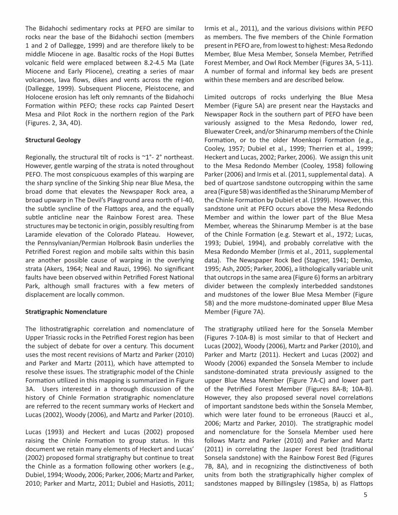
Limited outcrops of rocks underlying the Blue Mesa Member (Figure 5A) are present near the Haystacks and Newspaper Rock in the southern part of PEFO have been variously assigned to the Mesa Redondo, lower red, Bluewater Creek, and/or Shinarump members of the Chinle Formation, or to the older Moenkopi Formation (e.g., Cooley, 1957; Dubiel et al., 1999; Therrien et al., 1999; Heckert and Lucas, 2002; Parker, 2006). We assign this unit to the Mesa Redondo Member (Cooley, 1958) following Parker (2006) and Irmis et al. (2011, supplemental data). A bed of quartzose sandstone outcropping within the same area (Figure 5B) was identified as the Shinarump Member of the Chinle Formation by Dubiel et al. (1999). However, this sandstone unit at PEFO occurs above the Mesa Redondo Member and within the lower part of the Blue Mesa Member, whereas the Shinarump Member is at the base of the Chinle Formation (e.g. Stewart et al., 1972; Lucas, 1993; Dubiel, 1994), and probably correlative with the Mesa Redondo Member (Irmis et al., 2011, supplemental data). The Newspaper Rock Bed (Stagner, 1941; Demko, 1995; Ash, 2005; Parker, 2006), a lithologically variable unit that outcrops in the same area (Figure 6) forms an arbitrary divider between the complexly interbedded sandstones and mudstones of the lower Blue Mesa Member (Figure 5B) and the more mudstone-dominated upper Blue Mesa Member (Figure 7A).
The stratigraphy utilized here for the Sonsela Member (Figures 7-10A-B) is most similar to that of Heckert and Lucas (2002), Woody (2006), Martz and Parker (2010), and Parker and Martz (2011). Heckert and Lucas (2002) and Woody (2006) expanded the Sonsela Member to include sandstone-dominated strata previously assigned to the upper Blue Mesa Member (Figure 7A-C) and lower part of the Petrified Forest Member (Figures 8A-B; 10A-B). However, they also proposed several novel correlations of important sandstone beds within the Sonsela Member, which were later found to be erroneous (Raucci et al., 2006; Martz and Parker, 2010). The stratigraphic model and nomenclature for the Sonsela Member used here follows Martz and Parker (2010) and Parker and Martz (2011) in correlating the Jasper Forest bed (traditional Sonsela sandstone) with the Rainbow Forest Bed (Figures 7B, 8A), and in recognizing the distinctiveness of both units from both the stratigraphically higher complex of sandstones mapped by Billingsley (1985a, b) as Flattops
6
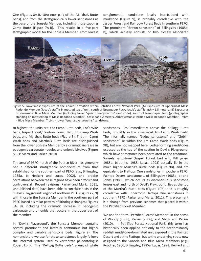
One (Figures 8A-B, 10A; now part of the Martha’s Butte beds), and from the stratigraphically lower sandstones at the base of the Sonsela Member, including those capping Camp Butte (Figure 7A-B). This results in a five-part stratigraphic model for the Sonsela Member. From lowest
to highest, the units are: the Camp Butte beds, Lot’s Wife beds, Jasper Forest/Rainbow Forest Bed, Jim Camp Wash beds, and Martha’s Butte beds (Figure 3). The Jim Camp Wash beds and Martha’s Butte beds are distinguished from the lower Sonsela Member by a dramatic increase in pedogenic carbonate nodules and unionid bivalves (Figure 8C-D; Martz and Parker, 2010).
The area of PEFO north of the Puerco River has generally had a different stratigraphic nomenclature from that established for the southern part of PEFO (e.g., Billingsley, 1985a, b; Heckert and Lucas, 2002), and precise correlations between these regions have been difficult and controversial. Recent revisions (Parker and Martz, 2011, unpublished data) have been able to correlate beds in the “Devil’s Playground” region of northern PEFO (Figures 2, 9) with those in the Sonsela Member in the southern part of PEFO based a similar pattern of lithologic changes (Figures 3A, 9), including the dramatic increase in pedogenic carbonate and unionids that occurs in the upper part of the member.
In “Devil’s Playground”, the Sonsela Member contains several prominent and laterally continuous but highly complex and variable sandstone beds (Figure 9). The nomenclature we use for these sandstones largely follows the informal system used by vertebrate paleontologist Robert Long. The “Kellogg Butte beds”, a unit of white
conglomeratic sandstone locally interbedded with mudstone (Figure 9), is probably correlative with the Jasper Forest and Rainbow Forest Beds in southern PEFO. The prominent “Brown sandstone” of Billingsley (1985a, b), which actually consists of two closely associated
sandstones, lies immediately above the Kellogg Butte beds, probably in the lowermost Jim Camp Wash beds. The informally named “Ledge sandstone” and “Goblin sandstone” lie within the Jim Camp Wash beds (Figure 9B), but are not mapped here. Ledge-forming sandstones exposed at the top of the section in Devil’s Playground, which have sometimes been correlated to the traditional Sonsela sandstone (Jasper Forest bed e.g., Billingsley, 1985a, b; Johns, 1988; Lucas, 1993) actually lie in the much higher Martha’s Butte beds (Figure 9B), and are equivalent to Flattops One sandstones in southern PEFO. Painted Desert sandstone 1 of Billingsley (1985a, b) and Johns (1988), which occurs as discontinuous sandstone lenses east and north of Devil’s Playground, lies at the top of the Martha’s Butte beds (Figure 10B), and is roughly correlative with uppermost Flattops One sandstones in southern PEFO (Parker and Martz, 2011). This placement is a change from previous schemes that placed it within the Petrified Forest Member.
We use the term “Petrified Forest Member” in the sense of Woody (2006), Parker (2006), and Martz and Parker (2010). In Petrified Forest National Park, this term has historically been applied not only to the predominantly reddish mudstone-dominated unit exposed in the Painted Desert and at the Flattops, but to the underlying strata now assigned to the Sonsela and Blue Mesa Members (e.g., Roadifer, 1966; Billingsley, 1985a; Lucas, 1993; Heckert and
Figure 5. Lowermost exposures of the Chinle Formation within Petrified Forest National Park. (A) Exposures of uppermost Mesa Redondo Member (Jacob’s staff is in mottled top of unit) south of Newspaper Rock. Jacob’s staff length = 1.5 meters. (B) Exposures of lowermost Blue Mesa Member (including lower “quartz overgrowths” sandstone), south of Newspaper Rock (photographer standing on mottled top of Mesa Redondo Member). Scale bar = 2 meters. Abbreviations: Trcmr = Mesa Redondo Member; Trcbm = Blue Mesa Member; Trcbls = lower “quartz overgrowths” sandstone.
7
Lucas, 2002). However, only the predominantly reddish upper unit, which has traditionally been called the “upper Petrified Forest Member” is probably correlative with the type section of the Petrified Forest Member in southern Utah (Gregory, 1950), so the term is restricted to that unit following Woody (2006). Lucas (1993) and Heckert and Lucas (2002) referred to this unit as the Painted Desert Member of the Petrified Forest Formation.
Within the Petrified Forest Member in the northern part of PEFO (Figure 10B-F), Painted Desert sandstones 2 and 4 (sensu Billingsley 1985a, b; Johns, 1988) are not mapped here. We follow Johns (1988, Appendix 1) in recognizing the Painted Desert 2 sandstones as a zone of locally prominent but discontinuous sandstone beds (Figure 10B) occurring between Painted Desert sandstone 1 and the Lithodendron Wash Bed, but at slightly different stratigraphic levels. Likewise, the Painted Desert 4 sandstones of Johns (1988) (Figure 10C), which include the “scour sandstone” of Kraus & Middleton (1987) and Zuber (1990), represent a zone of locally prominent but discontinuous sandstones lying between the Lithodendron Wash Bed and the Black Forest Bed. We accept the formalization of the Lithodendron Wash Bed (Figure 10B, D; formerly Painted Desert sandstone 3 of Billingsley, 1985a, b and Johns, 1988) proposed by Heckert and Lucas (2002).
The transition between the Petrified Forest Member and Owl Rock Member (Figure 11) is gradational. We follow Dubiel (1993) and Parker and Martz (2011) in assigning a distinctive well-calcified purple-gray bed (Figure 11A) less than twenty meters above the Black Forest Bed to the base of the Owl Rock Member. This differs from other workers (e.g., Ash, 1992; Lucas, 1993), who identified the first ledge-
forming carbonate bed exposed at Chinde Mesa (Figure 11B), which lies much higher above the Black Forest Bed, to the base of the Owl Rock Member. We consider the appearance of these ledge-forming carbonates to form an arbitrary boundary between the lower and upper parts of the Owl Rock Member.
Macrofossil Occurrence
The sandstones of the Sonsela Member are the primary source of petrified wood within PEFO. Wood traditionally assigned to the conifer genus Araucaryoxylon is most commonly found in the Jasper Forest bed, Rainbow Forest Bed (Figure 7D), and Black Forest Bed (Figure 10F), and the conifer genera Schilderia and Woodworthia are also known from the Black Forest Bed (Ash and Creber, 2000; Creber and Ash, 2004; Ash, 2005). These beds produce the spectacular “forests” found throughout the park, and the spectacular multi-colored trees at Jasper Forest, Crystal Forest, and Rainbow Forest lie within the Jasper Forest and Rainbow Forest Beds (Heckert and Lucas, 1998; Martz and Parker, 2010). Wood is less common, but locally abundant in the mudstones of the Blue Mesa Member, sandstones throughout the Sonsela Member, and the Petrified Forest Member below the Black Forest Bed. Recent work on wood histology suggests that the wood genus Araucaryoxylon may actually consist of multiple taxa (e.g., Savidge,
2007). Other plants known from the park include ferns, cycadophytes, ginkgophytes, bennetitales, lycopsids, and sphenopsids, which are mostly known from the Blue Mesa Member (Stagner, 1941; Ash, 2005), although localities also occur higher in the section (e.g., Herrick, 1999). Work on plant and pollen assemblages place an important floral overturn within the Chinle Formation in the park (Litwin
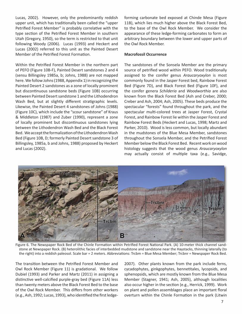
Figure 6. The Newspaper Rock Bed of the Chinle Formation within Petrified Forest National Park. (A) 10-meter thick channel sand-stone at Newspaper Rock. (B) heterolithic facies of interbedded mudstone and sandstone near the Haystacks, thinning laterally (to the right) into a reddish paleosol. Scale bar = 2 meters. Abbreviations: Trcbm = Blue Mesa Member; Trcbnr = Newspaper Rock Bed.

8
et al., 1991; Reichgelt et al., in press), in the middle of the Sonsela Member.
Vertebrate remains are especially concentrated in several stratigraphic horizons, most richly in the uppermost Blue Mesa Member and lower Jim Camp Wash beds, more locally in other parts of the Sonsela Member, high in the Petrified Forest Member, and in the Owl Rocks Member (Parker and Martz, 2011; Loughney et al., 2011; Behrensmeyer et al., 2011). Vertebrate remains include freshwater bony fish and sharks, metoposaurid temnospondyls, dicynodont therapsids, basal archosauromorphs and archosauriforms, and various groups of pseudosuchians (crocodylian-line archosaurs) and dinosauromorphs. Users interested in detailed information regarding taxonomy, distribution, and taphonomy of PEFO vertebrate fossils are referred to the summary works of Long and Murry (1995), Therrien and Fastovsky (2000), Parker and Irmis (2005), Irmis (2005), Parker and Martz (2011), and Loughney et al. (2011). Work
on vertebrate biostratigraphy places a vertebrate faunal overturn (between the Adamanian and Revueltian land vertebrate biozones) within the Sonsela Member, close to the level of the floral overturn (Figure 3C; Long and Ballew, 1985; Long and Padian, 1986; Heckert and Lucas, 2002; Parker and Martz, 2009, 2011).
Invertebrate macrofossils consist primarily of unionid bivalves, which are locally abundant, especially in the upper Sonsela Member (Figure 8D) and Petrified Forest Member (Good, 1998; Martz and Parker, 2010). However, gastropods, freshwater crustaceans, and trace fossils left by a variety of insects and other small arthropods, are also known (Dubiel, 1993; Hasiotis and Dubiel, 1993).
Figure 7. The uppermost Blue Mesa Member and lower Sonsela Member within Petrified Forest National Park. (A) Camp Butte, where the Newspaper Rock Bed is a reddish paleosol (the same seen in Figure 6B), the top of the Blue Mesa Member is predomi-nantly bluish mudstone, and the Camp Butte beds form a resistant ledge-forming sandstone. Scale bar = 5 meters. (B) Agate Mesa, where the Camp Butte beds are friable and heterolithic, the Lot’s Wife beds can be divided into lower purple mudstones inter-bedded with white sandstone lenses and upper drab-colored sandstones and mudstones, and the section is capped by the Jasper Forest bed. Scale bar = 2 meters. (C) Exposures just west of Blue Mesa, where the Jasper Forest bed forms only an eroded remnant (although it is a massive ledge-forming unit at Blue Mesa). Scale bar = 2 meters. (D) Petrified conifer log traditionally assigned to Araucaryoxylon arizonicum (Ash and Creber, 2000) weathering out of the Jasper Forest bed at Crystal Forest. Scale bar = 1 meter. Abbreviations: Trcbm = Blue Mesa Member; Trcbnr = Newspaper Rock Bed; Trcscb = Camp Butte beds; Trcslw = Lot’s Wife beds; Trcsrf = Jasper Forest/Rainbow Forest/Kellogg Butte beds.
9
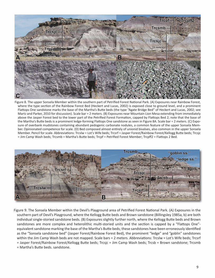
Figure 8. The upper Sonsela Member within the southern part of Petrified Forest National Park. (A) Exposures near Rainbow Forest, where the type section of the Rainbow Forest Bed (Heckert and Lucas, 2002) is exposed close to ground level, and a prominent Flattops One sandstone marks the base of the Martha’s Butte beds (the type “Agate Bridge Bed” of Heckert and Lucas, 2002; see Martz and Parker, 2010 for discussion). Scale bar = 2 meters. (B) Exposures near Mountain Lion Mesa extending from immediately above the Jasper Forest bed to the lower part of the Petrified Forest Formation, capped by Flattops Bed 2; note that the base of the Martha’s Butte beds is a prominent ledge-forming Flattops One sandstone as seen in Figure 8A. Scale bar = 2 meters. (C) Expo-sure of overbank mudstones containing abundant pedogenic carbonate nodules, a common feature of the upper Sonsela Mem-ber. Opinionated competence for scale. (D) Bed composed almost entirely of unionid bivalves, also common in the upper Sonsela Member. Pencil for scale. Abbreviations: Trcslw = Lot’s Wife beds; Trcsrf = Jasper Forest/Rainbow Forest/Kellogg Butte beds; Trcsjc = Jim Camp Wash beds; Trcsmb = Martha’s Butte beds; Trcpf = Petrified Forest Member; Trcpff2 = Flattops 2 Bed.
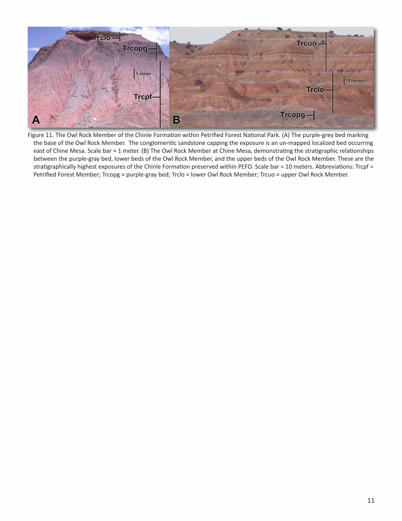
Figure 9. The Sonsela Member within the Devil’s Playground area of Petrified Forest National Park. (A) Exposures in the southern part of Devil’s Playground, where the Kellogg Butte beds and Brown sandstone (Billingsley 1985a, b) are both individual single-storied sandstone beds. (B) Exposures slightly further north, where the Kellogg Butte beds and Brown sandstones are more complex and heterolithic multi-storied units and the section is capped by a “Flattops One”-equivalent sandstone marking the base of the Martha’s Butte beds; these sandstones have been erroneously identified as the “Sonsela sandstone bed” (Jasper Forest/Rainbow Forest Bed), the prominent “ledge” and “goblin” sandstones within the Jim Camp Wash beds are not mapped. Scale bars = 2 meters. Abbreviations: Trcslw = Lot’s Wife beds; Trcsrf = Jasper Forest/Rainbow Forest/Kellogg Butte beds; Trcsjc = Jim Camp Wash beds; Trcsb = Brown sandstone; Trcsmb = Martha’s Butte beds. sandstone.

10
Figure 10. The Petrified Forest Member (=Painted Desert Member) within Petrified Forest National Park. (A) The Flattops south of the main park road, showing the transition between the Sonsela and Petrified Forest members, as well as the four Flattops sandstones; these are the stratigraphically highest exposures in the southern part of PEFO. Note the ledge-forming Flattops One sandstone capping the small mesa in the midground. Scale bar = 5 meters. (B) The Citadel on the east side of Wildhorse Wash, northeast of Devil’s Playground, showing roughly the same stratigraphic interval in Figure 10A. Painted Desert sandstone 1 and the un-mapped “Painted Desert 2 sandstone” form consecutively higher mesas approaching the Citadel, which is capped by the Lithodendron Wash Bed. Scale bar = 5 meters. (C) Reddish mudstones of the Petrified Forest Member in the Painted Desert, almost immediately above the Lithodendron Wash Bed. The “Painted Desert 4 sandstone” is un-mapped. (D) The Lithodendron Wash Bed as a massive, multi-storied channel sandstone near Lacey Point. (E) The uppermost Petrified Forest Member is locally truncated by Bidahochi Formation sedimentary strata and basalts at Headquarters Mesa; note that the white bed capping the ridge in the foreground is also the Black Forest Bed. Scale bar = 10 meters. (F) Petrified conifer logs traditionally assigned to Araucaryoxylon arizonicum (Ash and Creber, 2000) weathering out of the Black Forest Bed. Scale bar = 1 meter. Abbreviations: Trcsmb = Martha’s Butte beds; Trcpf = Petrified Forest Member; Trcpff2 = Flattops Bed 2; Trcpff3 = Flattops Bed 3; Trcpff4 = Flattops Bed 4; Trcspd1 = Painted Desert sandstone 1; Trcpd3 = Lithodendron Wash Bed; Trcpfbf = Black Forest Bed; Mibs = Bidahochi Formation sedimentary rocks; Mibv = Bidahochi Formation volcanic rocks.
11
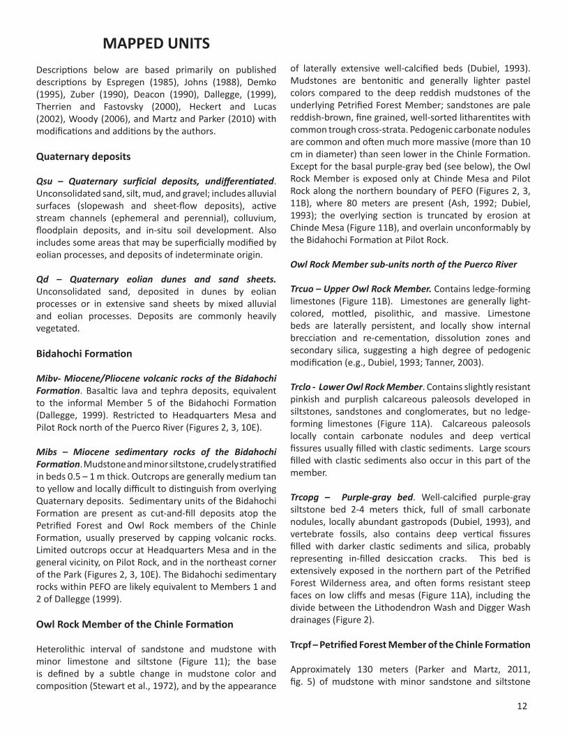
Figure 11. The Owl Rock Member of the Chinle Formation within Petrified Forest National Park. (A) The purple-grey bed marking the base of the Owl Rock Member. The conglomeritic sandstone capping the exposure is an un-mapped localized bed occurring east of Chine Mesa. Scale bar = 1 meter. (B) The Owl Rock Member at Chine Mesa, demonstrating the stratigraphic relationships between the purple-gray bed, lower beds of the Owl Rock Member, and the upper beds of the Owl Rock Member. These are the stratigraphically highest exposures of the Chinle Formation preserved within PEFO. Scale bar = 10 meters. Abbreviations: Trcpf = Petrified Forest Member; Trcopg = purple-gray bed; Trclo = lower Owl Rock Member; Trcuo = upper Owl Rock Member.
12
MAPPED UNITSDescriptions below are based primarily on published descriptions by Espregen (1985), Johns (1988), Demko (1995), Zuber (1990), Deacon (1990), Dallegge, (1999), Therrien and Fastovsky (2000), Heckert and Lucas (2002), Woody (2006), and Martz and Parker (2010) with modifications and additions by the authors.
Quaternary deposits
Qsu – Quaternary surficial deposits, undifferentiated. Unconsolidated sand, silt, mud, and gravel; includes alluvial surfaces (slopewash and sheet-flow deposits), active stream channels (ephemeral and perennial), colluvium, floodplain deposits, and in-situ soil development. Also includes some areas that may be superficially modified by eolian processes, and deposits of indeterminate origin.
Qd – Quaternary eolian dunes and sand sheets. Unconsolidated sand, deposited in dunes by eolian processes or in extensive sand sheets by mixed alluvial and eolian processes. Deposits are commonly heavily vegetated.
Bidahochi Formation
Mibv- Miocene/Pliocene volcanic rocks of the Bidahochi Formation. Basaltic lava and tephra deposits, equivalent to the informal Member 5 of the Bidahochi Formation (Dallegge, 1999). Restricted to Headquarters Mesa and Pilot Rock north of the Puerco River (Figures 2, 3, 10E).
Mibs – Miocene sedimentary rocks of the Bidahochi Formation. Mudstone and minor siltstone, crudely stratified in beds 0.5 – 1 m thick. Outcrops are generally medium tan to yellow and locally difficult to distinguish from overlying Quaternary deposits. Sedimentary units of the Bidahochi Formation are present as cut-and-fill deposits atop the Petrified Forest and Owl Rock members of the Chinle Formation, usually preserved by capping volcanic rocks. Limited outcrops occur at Headquarters Mesa and in the general vicinity, on Pilot Rock, and in the northeast corner of the Park (Figures 2, 3, 10E). The Bidahochi sedimentary rocks within PEFO are likely equivalent to Members 1 and 2 of Dallegge (1999).
Owl Rock Member of the Chinle Formation
Heterolithic interval of sandstone and mudstone with minor limestone and siltstone (Figure 11); the base is defined by a subtle change in mudstone color and composition (Stewart et al., 1972), and by the appearance
of laterally extensive well-calcified beds (Dubiel, 1993). Mudstones are bentonitic and generally lighter pastel colors compared to the deep reddish mudstones of the underlying Petrified Forest Member; sandstones are pale reddish-brown, fine grained, well-sorted litharentites with common trough cross-strata. Pedogenic carbonate nodules are common and often much more massive (more than 10 cm in diameter) than seen lower in the Chinle Formation. Except for the basal purple-gray bed (see below), the Owl Rock Member is exposed only at Chinde Mesa and Pilot Rock along the northern boundary of PEFO (Figures 2, 3, 11B), where 80 meters are present (Ash, 1992; Dubiel, 1993); the overlying section is truncated by erosion at Chinde Mesa (Figure 11B), and overlain unconformably by the Bidahochi Formation at Pilot Rock.
Owl Rock Member sub-units north of the Puerco River
Trcuo – Upper Owl Rock Member. Contains ledge-forming limestones (Figure 11B). Limestones are generally light-colored, mottled, pisolithic, and massive. Limestone beds are laterally persistent, and locally show internal brecciation and re-cementation, dissolution zones and secondary silica, suggesting a high degree of pedogenic modification (e.g., Dubiel, 1993; Tanner, 2003).
Trclo - Lower Owl Rock Member. Contains slightly resistant pinkish and purplish calcareous paleosols developed in siltstones, sandstones and conglomerates, but no ledge-forming limestones (Figure 11A). Calcareous paleosols locally contain carbonate nodules and deep vertical fissures usually filled with clastic sediments. Large scours filled with clastic sediments also occur in this part of the member.
Trcopg – Purple-gray bed. Well-calcified purple-gray siltstone bed 2-4 meters thick, full of small carbonate nodules, locally abundant gastropods (Dubiel, 1993), and vertebrate fossils, also contains deep vertical fissures filled with darker clastic sediments and silica, probably representing in-filled desiccation cracks. This bed is extensively exposed in the northern part of the Petrified Forest Wilderness area, and often forms resistant steep faces on low cliffs and mesas (Figure 11A), including the divide between the Lithodendron Wash and Digger Wash drainages (Figure 2).
Trcpf – Petrified Forest Member of the Chinle Formation
Approximately 130 meters (Parker and Martz, 2011, fig. 5) of mudstone with minor sandstone and siltstone

13
(Figure 10). The most prominent and laterally persistent sandstones have been granted formal bed status (see below). Consists primarily of pale red to purple mudstone with common, thin sandstone interbeds; commonly bright reddish orange. Large-scale scours are common in the upper part of the unit (Kraus and Middleton, 1987; Johns, 1988; Zuber, 1990). Bedding in the mudstones is typically 1-3 m thick and tabular, and mudstones contain abundant pedogenic carbonate nodules and vertic paleosols, especially greenish-gray mottling (Johns, 1988; Zuber, 1990; Tanner, 2003; Dubiel and Hasiotis, 2011).
Petrified Forest Member sub-units north of the Puerco River
Trcpfbf – Black Forest Bed. Up to 12.6 m of calcrete-nodule conglomerate and reworked tuffaceous sandstone, with finer-grained 0.1- to 0.2- m- thick sandstone and mudstone interbeds (Figure 10E-F). Conglomerate is basal, conformably overlain by finer-grained tuffaceous interval. Unit is rich in petrified wood (Figure 10F), as well as invertebrate and vertebrate remains (Ash, 1992; Riggs et al., 2003; Ash and Creber, 2000; Creber and Ash, 2004).
Trcpd3 – Lithodendron Wash Bed (Painted Desert sandstone 3). Generally fine-grained sandstone with minor conglomerate, coarse-grained sandstone and interbedded mudstone. Sandstones are pale gray to tan on fresh surfaces, often with gray and brown candy striping, but commonly weather to medium brown. The base of the unit is erosive and irregular, with local relief commonly exceeding 1 m, and up to 6 m (Johns, 1988). Internal cross-stratification is ubiquitous, including trough and planar cross-sets, lateral accretion sets, and rare channel forms. Conglomerates are generally intra-formational, composed primarily of re-worked pedogenic carbonate nodules, and extra-basinal clasts are rare. The unit may be single-storied or multi-storied (Figure 10D) with a total thickness up to 11 m. Vertebrate fossils are extremely common in uppermost part of the unit, and in the beds immediately above it (Parker and Martz, 2011). In the northern part of PEFO, the Lithodendron Wash Bed is present throughout southern part of the Petrified Forest Wilderness area, and along the south side of Lithodendron Wash, commonly as a cap on cliffs and mesas (Figures 2, 10B).
Petrified Forest Member sub-units south of the Puerco River
Trcpff2-4 – Flattops Beds 2-4. Generally fine- to medium- grained, moderately to well- sorted brownish-gray sandstones (Figure 10A). Planar and trough cross-strata are common, as well as horizontal and ripple laminae. Intraformational conglomerates composed predominantly
of reworked pedogenic carbonate are common, especially as lags at the base of scours. Extra-basinal clasts are rare (Espregen, 1985). Fossils are most commonly local beds of unionid bivalves, although vertebrate fossils are also known. Flattops Bed 2 is laterally extensive, but Beds 3 and 4 are restricted to the Flattops Mesas area along the main park road (Figures 2, 10A). Unit thicknesses are laterally variable, but are typically less than 10 m. Flattops Bed 2 is the thickest, being thicker than 10 m in some locations.
Sonsela Member of the Chinle Formation
Sandstone and mudstone with minor siltstone and conglomerate (Figures 7-10); the Sonsela Member is divided into five parts: basal sandstone and conglomerate (the Camp Butte beds), a lower mudstone/sandstone interval (the Lot’s Wife beds), a medial conglomeratic sandstone (the Jasper Forest/Rainbow Forest/Kellogg Butte beds), an upper mudstone/sandstone interval (the Jim Camp Wash beds) and a capping mudstone/sandstone interval with several prominent ledge-forming sandstones (the Martha’s Butte beds/Flattops One sandstones/Painted Desert 1 sandstone). The conglomerates and mudstones in the lower beds are dominated by extrabasinal volcanic clasts, chert, and quartzite (Deacon, 1990; Woody, 2006), while carbonate clasts and unionid bivalves are extremely abundant in conglomerates in the upper beds, as are pedogenic carbonate nodules in the interbedded mudstones (Figure 8C-D; Martz and Parker, 2010).
Trcsmb – Martha’s Butte beds/Flattops One sandstones. Sandstone and conglomerate complexly interbedded with mudstone (Figures 8, 9B, 10A-B); the top of the Sonsela Member in the nomenclature of Martz and Parker (2010). Resistant ledge-forming sandstones within this interval in southern PEFO are called Flattops One sandstones (following Billingsley, 1985a, b) and include the type “Agate Bridge Bed” of Heckert and Lucas (2002; Figure 8A), which they erroneously correlated with the Jasper Forest bed. Lithologically similar sandstones (including Painted Desert 1 sandstone; Figure 10B) cap the member in Devil’s Playground in northern PEFO. Flattops One sandstones are medium to coarse-grained, moderately to well-sorted, pale yellow-brown to dark brown (lighter on fresh surfaces), compositionally immature, and are commonly multi-storied with thin mudstone interbeds. Conglomerates are commonly carbonate nodule lags at the base of sandstone beds, as well as discrete lenses of pebble-size clasts. However, gravel-sized clasts of extra-basinal volcanic rock and chert are also common, as are beds composed almost entirely of unionid bivalves, often coated with layers of calcium carbonate. Structures consist of horizontal planar bedding, trough and planar cross-bedding, ripple bedding, lateral accretion beds, and
14
ridge and swale topography (Espregen, 1985; Woody, 2006). A dark silicified horizon similar to that seen in the Jim Cap Wash beds and Lot’s Wife beds occurs locally near the base of this unit (Martz and Parker, 2010). Vertebrate fossils, as well as white and orange petrified logs are locally abundant in this unit. Individual Flattops One sandstones are generally 2-6 meters thick, although multi-storied units may achieve a maximum thickness of 25 m and make up almost the entire thickness of the Martha’s Butte beds (Figure 3). Due to the discontinuous nature, complex interbedding, and variable thickness of the Flattops One sandstones, they have not been individually mapped. Although mudstones are usually purple, they sometimes have a distinctive pale blue color in northern PEFO, and are full of pedogenic carbonate nodules in both areas (Figure 8C). Some mudstones interbedded in this unit are locally well-lithified and possibly represent playa lake deposits (Espregen, 1985).
Martha’s Butte beds sub-units north of the Puerco River
Trcspd1- Painted Desert sandstone 1. Localized ledge-forming sandstone lenses, generally 1-5 meters thick, which occur at the top of the Martha’s Butte beds/Sonsela Member (Figure 10B). This sandstone is probably equivalent to the highest Flattops One sandstones in southern PEFO (Figure 10A). It is mapped due to historical confusion about its stratigraphic equivalence to beds in southern PEFO (Billingsley, 1985a, b; Heckert and Lucas, 2002) and its geographic separation from most Sonsela Member exposures further west in Devil’s Playground. The unit was previously correctly mapped and correlated by Johns (1988, fig. 2).
Trcsjc – Jim Camp Wash Beds. Sandstone, siltstone and mudstone; mudstones are pale gray, purple and less commonly red (Figures 8-9). Sandstones are typically fine- to medium-grained and poorly sorted; chert, calcareous nodules and unionid bivalve fragments are locally abundant. Sandstones are generally not laterally continuous and ribbon architecture is common; however, thicker, more resistant, and more laterally continuous sandstone beds are locally present (Martz and Parker, 2010; Parker and Martz, 2011), though only one, the “Brown sandstone” of Billingsley (1985a, b) is mapped here (see below). Sandstones in the Jim Camp Wash beds in Devil’s Playground (Figure 9) are generally thicker, more laterally persistent, and contain more extra-basinal chert, quartzite, and volcanic clasts than normally seen in southern PEFO. Bedding thickness varies throughout the Jim Camp Wash beds. Contacts are usually erosive and sharp and dominated by cut-and-fill architecture, and heterolithic intervals are locally common (Woody, 2006). As with the Martha’s Butte beds, interbedded mudstones
are rich in pedogenic carbonate nodules (Herrick, 1999; Woody, 2006; Martz and Parker, 2010). A distinctive reddish or orange horizon composed of silicified plant material occurs low in the unit (Creber and Ash, 1990; Martz and Parker, 2010; Driese et al., 2010), just below the level where pedogenic carbonate and unionids become abundant, and is associated with important faunal and floral overturns (Parker and Martz, 2011; Reichgelt et al., in press). Vertebrate fossils are extremely abundant. Total unit thickness is generally 25-30 m, but is thinner locally.
Jim Camp Wash beds sub-units north of the Puerco River
Trcsb – Brown sandstones. Sandstone and minor conglomerate (Figure 9), restricted to Devil’s Playground area north of I-40 (Figure 2), where it forms prominent blocky ledges. Although Billingsley (1985a, b) only identified a single “brown sandstone”, two closely associated sandstones with unusual dark chocolate brown or reddish brown colors occur in Devil’s Playground; the upper sandstone is usually thicker and more laterally persistent and is probably the unit Billingsley (1985a, b) was referring to. Sandstones are generally fine- to medium-grained, but coarser intervals are common, especially near the base of scours. Gravel-sized clasts are predominantly extra-basinal chert and volcanic clasts; pedogenic carbonate and unionids become abundant slightly higher than the Brown sandstone, suggesting that the Brown sandstone is correlative with the red silicified horizon in the Jim Camp Was beds in southern PEFO. Sandstone is pale tan or gray on fresh surfaces but weathers to medium brown across most of the exposed area (Figure 9A), although the upper Brown sandstone is locally white (Figure 9B). Internal structure ranges from massive or weakly laminated to complex cross-stratification. Total unit thickness ranges up to ~6 m, but lateral changes in thickness can be abrupt.
Trcsrf – Jasper Forest bed/Rainbow Forest Bed/Kellogg Butte bed. Sandstone and conglomerate, with common cobble-sized clasts of extrabasinal volcanic rocks, chert, and quartzite; clasts of re-worked intrabasinal bluish mudstone often dominating the lower part of the unit. These sandstones are usually multi-storied, with the dominant bedform being planar cross-bedding with lesser trough cross bedding and horizontal planar bedding (Espregen, 1985; Deacon, 1990). Reddish and multi-colored petrified logs are abundant in these units (Figure 7D; Heckert and Lucas, 1998; Ash and Creber, 2000; Ash, 2005), as are vertebrate fossils. The Jasper Forest bed (Figure 7B) and Rainbow Forest Bed (Figure 8A) are names for equivalent units respectively exposed north and south of the Flattops in southern PEFO, while the Kellogg Butte bed is the equivalent unit in Devil’s Playground (Figure 9). The Jasper Forest bed becomes a thinner and more friable
15
unit just north of the Flattops (Herrick, 1999; Martz and Parker, 2010). The Kellogg Butte bed also varies greatly in thickness and lithology, and is locally completely truncated by the Brown sandstones.
Trcslw – Lot’s Wife beds. Sandstone, siltstone and mudstone; mudstones are purple and less commonly bluish or gray (Figure 7B-C). In southern PEFO, exposures north of the Flattops mesas can locally be roughly divided into upper beds dominated by gray and reddish sandstone and conglomerate with minor purple and bluish mudstone, and lower beds dominated by purple mudstone interbedded with discontinuous gray and dull pinkish ribbon and sheet sandstones which are not usually very conglomeratic (Figure 7B; Martz and Parker, 2010). Conglomerates in the upper Lot’s Wife beds are dominated by clasts composed of chert, quartzite, volcanic rock, and intra-basinal mudstone rip-ups similar to those in the Jasper Forest bed. As with the Jim Camp Wash beds, contacts are usually erosive and sharp, and dominated by cut-and-fill architecture. Locally, a horizon of orange silicified plant material, similar to that in the lower Jim Camp Wash beds, is developed in the upper Lot’s Wife beds (Creber and Ash, 1990; Woody, 2006; Martz and Parker, 2010).
Trcscb – Camp Butte beds. Sandstone and conglomerate; the unit is the basal beds of the Sonsela Member, and includes the conglomeratic sandstone capping Camp Butte (Figure 7A-B; Murry, 1990; Woody, 2006). Sandstones are fine- to medium-grained, moderately well sorted, pale gray, and locally trough and planar cross-stratified. Conglomerates are rich in white and orange petrified wood, and pebble-sized clasts of andesite, rhyolite, chert, and quartzite, as well as bluish mudstone rip-ups. Individual beds are generally 1-4 m thick, and the total unit varies from multi-storied conglomeratic sandstones to thin sandstone ribbons interbedded with mudstones of the upper Blue Mesa Member (Woody, 2006; Martz and Parker, 2010). Total unit thickness is 0-15 m.
Trcbm – Blue Mesa Member of the Chinle Formation
Mudstone with minor siltstone and sandstone; banded dark blue, gray, yellow and red; structureless beds generally >2 m thick with diffuse boundaries; locally fossiliferous, with abundant wood and vertebrate remains. The upper part of the unit is dominated by greenish-gray, dark blue, and dark purple mudstones with thin, discontinuous ribbon sands (Figure 7A), and has the densest concentrations of vertebrate fossils in PEFO (e.g., Long and Murry, 1995; Therrien and Fastovsky, 2000). The lower part of the unit below the Newspaper Rock Bed (Figures 5B, 6) is composed of interbedded mudstone and sandstone, locally with minor conglomerate. Unit thickness is approximately 50
m, although the base is only exposed between the Tepees and Haystacks, south of Newspaper Rock (Figures 2, 3, 5).
Blue Mesa Member sub-units south of the Puerco River
Trcbnr – Newspaper Rock Bed. Sandstone with interbedded conglomerate and mudstone; the unit possesses complex internal geometry and strong lateral variation in lithology, color, and overall appearance. Around Newspaper Rock (Figure 6A), the unit is up to 10 m of yellow-brown, fine to medium-grained, well-sorted sandstone interbeded with thin layers of conglomerate composed of re-worked mudstone clasts, in which the sandstones contain small-scale trough cross beds, ripple cross-laminations, and lateral accretion bedding (Demko, 1995). Approaching the Tepees area, the unit becomes more complex (Figure 6B) and is composed of stacked fining-upward sequences of reddish, grayish, and greenish beds composed of fine- to very fine-grained sandstone with small trough cross beds and ripple cross-laminations, and mudstones locally containing abundant plant fossils and invertebrates (Stagner, 1941; Demko, 1995; Ash, 2005; Parker, 2006). In the Tepees and Blue Mesa areas (Figures 2, 6B, 7A), this unit grades laterally into a thin reddish paleosol generally not more than about 1 m thick (Demko, 1995; Parker, 2006) which is not mapped.
Trcbls – Lower “quartz overgrowths” sandstone unit. Discontinuous sandstone (Figure 5B); coarse-grained, quartzose with significant quartz overgrowths; irregular and lenticular bedding 0.5-1 m thick, trough cross-strata in 20-40 cm sets; unit is up to 2 m thick, locally exposed capping low mesas east of the Haystacks, and along cliffsides southeast of Newspaper Rock (Figure 2). The unit is only mapped where it is relatively coarse and resistant; elsewhere it thins into a more friable and finer-grained sandstone.
Trcmr – Mesa Redondo Member of the Chinle Formation
Sandstone and mudstone; mostly brick red with minor greenish-gray mottling, top meter or so of the unit is a well-developed gleyed oxisol with intense reddish, purple, yellow, and gray mottling (Figure 5A; e.g., Dubiel and Hasiotis, 2011, fig. 3D) capped by a horizon of silicified plant material similar to those seen in the Sonsela Mem-ber. Only the top of the unit is locally exposed between the Tepees and the Haystacks (Figures 2, 3, 5A); local thickness is uncertain, although the type section south of PEFO is about 40 m thick (Cooley, 1958).
16
REFERENCES CITEDAkers, J.P., 1964, Geology and ground water in the central part
of Apache County, Arizona: USGS water-supply paper 1771.Ash, S.R., 1992, The Black Forest Bed, a distinctive unit in the
Upper Triassic Chinle Formation, northeastern Arizona: Journal of the Arizona-Nevada Academy of Science, v. 24/25, p. 59-73.
Ash, S.R., 2005, Synopsis of the Upper Triassic flora of Petrified Forest National Park and vicinity, in Nesbitt, S.J., Parker, W.G., and Irmis, R.B., eds., Guidebook to the Triassic Formations of the Colorado Plateau in northern Arizona: Geology, Paleontology, and History, Mesa Southwest Museum Bulletin no. 9, p. 53-62.
Ash, S.R., and Creber, G.T., 2000, The Late Triassic Araucarioxylon arizonicum trees of the Petrified Forest National Park, Arizona, USA: Paleontology, v. 43, pt. 1, p. 15-28.
Behrensmeyer, A., Whatley, R., Parker, W., and McIntire, S. 2011. Taphonomic information from laboratory excavation of a new microvertebrate locality in the Owl Rock Member of the Chinle Formation, Petrified Forest National Park, Arizona: Society of Vertebrate Paleontology, 71st Annual Meeting Program and Abstracts, p. 68A
Billingsley, G.H., 1985a, General stratigraphy of the Petrified Forest National Park, Arizona, in Colbert, E.H., and Johnson, R.R., eds., The Petrified Forest Through the Ages: Museum of Northern Arizona Bulletin 54, p. 3-8.
Billingsley, G.H., 1985b, Geologic map of Petrified Forest National Park, Arizona: unpublished data, Petrified Forest Museum Association, Petrified Forest National Park, Arizona, scale 1:48.000.
Blakey, R.C., 2008, Pennsylvanian-Jurassic sedimentary basins of the Colorado Plateau and southern Rocky Mountains, in Hsü, K.J. ed., Sedimentary Basins of the World, Vol 5, The Sedimentary Basins of the United States and Canada, The Netherlands: Elsevier, p. 245 – 296.
Cooley, M.E., 1957, Geology of the Chinle Formation in the upper Little Colorado drainage area, Arizona and New Mexico [M.S. thesis]: Tuscon, University of Arizona, 317 p.
Cooley, M.E., 1958, The Mesa Redondo Member of the Chinle Formation, Apache and Navajo Counties, Arizona: Plateau, v. 31, no. 1, p. 7-15.
Creber, G.T., and Ash, S.R., 1990, Evidence of widespread fungal attack on Upper Triassic trees in the southwestern U.S.A: Review of Palaeobotany and Palynology, v. 63, p. 189-195.
Creber, G.T., and Ash, S.R., 2004, The Late Triassic Schilderia adamanica and Woodworthia arizonica trees of the Petrified Forest National Park, Arizona, USA. Palaeontology, v. 47, pt. 1, p. 21-38.
Dallegge, T.A., 1999, Correlation and Chronology of the Miocene-Pliocene Bidahochi Formation, Navajo and Hopi Nations, Northeastern Arizona [MS Thesis]: Northern Arizona University, Flagstaff, 304 p.
Deacon, M.W., 1990, Depositional analysis of the Sonsela Sandstone Bed, Chinle Formation, Northeast Arizona and Northwest New Mexico [MS Thesis]: Northern Arizona University, Flagstaff, 128 p.
Demko, T. M., 1995, Taphonomy of fossil plants in the Upper Triassic Chinle Formation [PhD Dissertation]: University of Arizona, Tuscon, 274 p.
Donohoo-Hurley, L.L., Geissman, J.W., and Lucas, S.G., 2010, Magnetostratigraphy of the uppermost Triassic and lowermost Jurassic Moenave Formation, western United
States: Geological Society of America Bulletin, v. 122, no. 11/12, p. 2005-2019.
Driese, S.G., Nordt, L.C., Atchley, S.C., Dworkin, S.I., and Trendell, A.M., 2010, Stop five: micromorphology and paleoclimatic significance of Mountain Lion Mesa “silcrete” and underlying paleosols, in Trendell, A., ed., Paleosols and Soil Surface System Analogs: SEPM-NSF Conference and Workshop, p. 111-122.
Dubiel, R.F., 1993, Depositional setting of the Owl Rock Member of the Upper Triassic Chinle Formation, Petrified Forest National Park and vicinity, Arizona: Bulletin of the New Mexico Museum of Natural History and Science, v. 3, p. 117-121.
Dubiel, R.F, 1994, Triassic deposystems, paleogeography, and paleoclimate of the Western Interior, in Caputo, M.V., Peterson, J.A., and Franczyk, K.J., eds., Mesozoic Systems of the Rocky Mountain Region, USA, p. 133-168.
Dubiel, R.F., and Hasiotis, S.T., 2011, Deposystems, paleosols, and climatic variability in a continental-scale system: the Upper Triassic Chinle Formation, Colorado Plateau, USA, in Davidson, S., and North, C., eds., From River to Rock Record: The Preservation of Fluvial Sediments and Their Subsequent Interpretation, SEPM Special Publication no. 97, p. 393-421.
Dubiel, R.F., Parrish, J.T., Parrish, J.M., and Good, S.C., 1991, The Pangean Megamonsoon-Evidence from the Upper Triassic Chinle Formation, Colorado Plateau: Palaios, v. 6, p. 347-370.
Dubiel, R.F., Hasiotis, S.T., and Demko, T.M., 1999, Incised valley fills in the lower part of the Chinle Formation, Petrified Forest National Park, Arizona: complete measured sections and regional stratigraphic implications of Upper Triassic rocks, in Santucci, V.L., and McClelland, L., eds., National Park Service Paleontological Research: Technical Report NPS/NRPO/GRTR-99/3, p. 78-84.
Espregen, W.A., 1985, Sedimentology and petrology of the Upper Petrified Forest Member of the Chinle Formation, Petrified Forest National Park and vicinity, Arizona [Master’s thesis]: Northern Arizona University, Flagstaff, 228 p.
Furin, S., Preto, N., Rigo, M., Roghi, G., Gianolla, P., Crowley, J.L., and Bowring, S.A., 2006, High precision U-Pb zircon age from the Triassic of Italy: Implications for the Triassic time scale and the Carnian origin of calcareous nannoplankton and dinosaurs: Geology, v. 34, no. 12, p. 1009-1012.
Good, S.C., 1998, Freshwater bivalve fauna of the Late Triassic (Carnian-Norian) Chinle, Dockum, and Dolores Formations of the Southwest United States, in Johnston, P.A., and Haggart, J.A., eds., Bivalves: An Eon of Evolution-Paleobiological Studies Honoring Norman D. Newell: University of Calgary Press, Calgary, p. 223-249.
Gregory, H.E., 1950, Geology and geography of the Zion Park Region, Utah and Arizona: United States Geological Society Professional Paper 220, 200 p.
Hasiotis, S.T., and Dubiel, R.F., 1993, Trace fossil assemblages in Chinle Formation alluvial deposits at the Tepees, Petrified Forest National Park, Arizona, in Heckert, A.B. and Morales, M., eds., The Nonmarine Triassic: New Mexico Museum of Natural History and Science Bulletin, v. 3, p. G42-G43
Heckert, A.B., and Lucas, S.G., 1998, Stratigraphic distribution and age of petrified wood in Petrified Forest National Park, Arizona, in Santucci, V.L., and McClelland, L., eds., National Park Service Paleontological Research: Technical Report NPS/NRGRD/GRDTR 98/01, p. 125-129.

17
Heckert, A.B. and Lucas, S.G., 2002, Revised Upper Triassic stratigraphy of the Petrified Forest National Park, Arizona (USA), in Heckert, A.B. and Lucas, S.G., eds., Upper Triassic Stratigraphy and Paleontology: New Mexico Museum of Natural History and Science Bulletin, v. 21, p. 1-23
Heckert, A.B., Lucas, S.G., Dickinson, W.R. and Mortensen, J.K., 2009, New ID-TIMS U-Pb ages for Chinle Group strata (Upper Triassic) in New Mexico and Arizona, correlation to the Newark Supergroup, and implications for the "long Norian": Geological Society of America Abstracts with Programs, v. 41, p. 123.
Herrick, A.S., 1999, Telling time in the Triassic: biochronology and stratigraphy of the Chinle Formation in Petrified Forest National Park, Arizona [MS thesis]: University of Rhode Island, Kingston, 93 p.
Howell, E. R., 2010, Depositional history of the Sonsela Member, Upper Triassic Chinle Formation, Petrified Forest National Park, Arizona [MS thesis]: Northern Arizona University, Flagstaff, 233 p.
Hüsing, S.K., Deenen, M.H.L., Koopmans, J.G., and Krijgsman, W., 2011, Magnetostratigraphic dating of the proposed Rhaetian GSSP at Steinbergkogel (Upper Triassic, Austria): Implications for the Late Triassic time scale: Earth and Planetary Science Letters, v. 302, p. 203-216.
Irmis, R.B., 2005, The vertebrate fauna of the Upper Triassic Chinle Formation in northern Arizona, in Nesbitt, S.J., Parker, W.G., and Irmis, R.B., eds., Guidebook to the Triassic Formations of the Colorado Plateau in northern Arizona: Geology, Paleontology, and History: Mesa Southwest Museum Bulletin, v. 9, p. 63-88.
Irmis, R.B., Mundil, R., Martz, J.W. and Parker, W.G., 2011, High-resolution U-Pb ages from the Upper Triassic Chinle Formation (New Mexico, USA) support a diachronous rise of dinosaurs: Earth and Planetary Science Letters, v. 309, no. 3-4, p. 258-267.
Johns, M.E., 1988, Architectural element analysis and depositional history of the Upper Petrified Forest Member of the Chinle Formation, Petrified Forest National Park, Arizona [MS Thesis]: Northern Arizona University, Flagstaff, 163 p.
Kraus, M.J., and Middleton, L.T., 1987, Dissected paleotopography and base-level changes in a Triassic fluvial sequence: Geology, v. 15, p. 18-21.
Litwin, R.J., Traverse, A., and Ash, S.R., 1991, Preliminary palynological zonation of the Chinle Formation, southwestern U.S.A., and its correlation to the Newark Supergroup (eastern U.S.A.): Review of Palaeobotany and Palynology, v. 68, p. 269-287.
Long, R.A., and Ballew, K.L., 1985, Aetosaur dermal armour from the Late Triassic of southwestern North America, with special reference to the Chinle Formation of Petrified Forest National Park, in Colbert, E.H., and Johnson, R.R., eds., The Petrified Forest Through the Ages: Museum of Northern Arizona Bulletin, v. 54, p. 45-68.
Long, R.A., and Murry, P.A., 1995, Late Triassic (Carnian and Norian) tetrapods from the southwestern United States: New Mexico Museum of Natural History and Science Bulletin, v. 4, 254 p.
Long, R.A., and Padian, K., 1986, Vertebrate biostratigraphy of the Late Triassic Chinle Formation, Petrified Forest National Park, Arizona: preliminary results, in Padian, K., ed., The Beginning of the Age of Dinosaurs: faunal change across the Triassic-Jurassic boundary: Cambridge, Cambridge University Press, p. 161-169.
Loughney, K.M., Fastovsky, D.E., and Parker, W.G., 2011, Vertebrate fossil preservation in blue paleosols from the
Petrified Forest National Park, Arizona, with implications for vertebrate biostratigraphy in the Chinle Formation: Palaios, v. 26, p. 700-719.
Lucas, S.G., 1993, The Chinle Group: revised stratigraphy and biochronology of Upper Triassic nonmarine strata in the western United States, in Morales, M., ed., Aspects of Mesozoic Geology and Paleontology of the Colorado Plateau: Museum of Northern Arizona Bulletin, v. 59, p. 27-50.
Martz, J.W., and Parker, W.G., 2010, Revised lithostratigraphy of the Sonsela Member (Chinle Formation, Upper Triassic) in the southern part of Petrified Forest National Park, Arizona: PLoS ONE v. 5, no. 2, 26 p. doi:10.1371/journal.pone.0009329
Murry, P.A., 1990, Stratigraphy of the Upper Triassic Petrified Forest Member (Chinle Formation) in Petrified Forest National Park, Arizona, USA.: Journal of Geology, v. 98, p. 780-789.
Muttoni, G., Kent, D.V., Jadoul, F., Olsen, P.E., Rigo, M., Galli, M.T., and Nicora, A., 2010, Rhaetian magneto-biostratigraphy from the Southern Alps (Italy): Constraints on Triassic chronology: Palaeogeography, Palaeoclimatology, and Paleoecology v. 285, p. 1-16.
Neal, J.T., and Rauzi, S.L., 1996, Storage opportunities in Arizona bedded evaporates: Solution Mining Research Institute, Meeting Paper (Fall, 1996), 16 p.
Ogg, J.G., 2004, The Triassic Period, in Gradstein, F.M., Ogg, J.G., and Smith, A.G., eds., A Geologic Time Scale 2004: Cambridge, Cambridge University Press, p. 271-306.
Ogg, J.G., 2012, Triassic, in Gradstein, F.M., Ogg, J.G., Schmitz, M.D., and Ogg, G, eds., The Geologic Timescale 2012: Boston, Elsevier, p. 681-730.
Olsen, P.E., Kent, D.V., and Whiteside, J.H., 2011, Implications of the Newark Supergroup-based astrochronology and geomagnetic polarity time scale (Newark-APTS) for the tempo and mode of the early diversification of the Dinosauria: Earth and Environmental Science Transactions of the Royal Society of Edinburgh v. 101, p. 201-229.
Parker, W.G., 2006, The stratigraphic distribution of major fossil localities in Petrified Forest National Park, Arizona, in Parker, W.G., Ash, S.R., and Irmis, R.B., eds., A Century of Research at Petrified Forest National Park 1906-2006. Museum of Northern Arizona Bulletin, v. 62, p. 46-62.
Parker, W.G., and Irmis, R.B., 2005, Advances in vertebrate paleontology based on new material from Petrified Forest National Park, Arizona, in Heckert, A.B., and Lucas, S.G., eds., Vertebrate Paleontology in Arizona: New Mexico Museum of Natural History and Science Bulletin, v. 29, p. 45-58.
Parker, W., and Martz, J., 2009, Constraining the stratigraphic position of the Late Triassic (Norian) Adamanian-Revueltian faunal transition in the Chinle Formation of Petrified Forest National Park, Arizona. Journal of Vertebrate Paleontology, v. 29, suppl. to no. 3, p. 162A
Parker, W., and Martz, J., 2011, The Late Triassic (Norian) Adamanian-Revueltian tetrapod faunal transition in the Chinle Formation of Petrified Forest National Park, Arizona, in Butler, R.J., Irmis, R.B., and Langer, M.C., eds., Late Triassic Terrestrial Biotas and the Rise of Dinosaurs: Earth and Environmental Science Transactions of the Royal Society of Edinburgh, v. 101, p. 231-260.
Ramezani, J., Hoke, G.D., Fastovsky, D.E., Bowring, S.A., Therrien, F., Dworkin, S.I., Atchley, S.C., and Nordt. L.C., 2011, High-precision U-Pb zircon geochronology of the Late Triassic Chinle Formation, Petrified Forest National Park (Arizona, USA): temporal constraints on the early evolution of dinosaurs: Geological Society of America, v. 123, p. 2142-2159.

18
Raucci, J.J., Blakey, R.C., and Umhoefer, P.J., 2006, A new geologic map of Petrified Forest National Park with emphasis on members and key beds of the Chinle Formation, in Parker, W.G., Ash, S.R., and Irmis, R.B., eds., A Century of Research at Petrified Forest National Park 1906-2006: Museum of Northern Arizona Bulletin, v. 62, p. 157-159.
Reichgelt, T., Parker, W.G., van Konijnenburgh-van Cittert, J.H.A., Martz, J.W., Kürschner, W.M., and Conran, J.G., in press, The palynology of the Sonsela Member (Late Triassic, Norian) at Petrified Forest National Park, Arizona, USA: Review of Palaeobotany and Palynology.
Riggs, N.R., Lehman, T.H., Gehrels, G.E., and Dickinson,W.R., 1996, Detrital zircons link between headwaters and terminus of the Upper Triassic Chinle-Dockum paleoriver system: Science, v. 237, p. 97-100.
Riggs, N.R., Ash, S.R., Barth, P.A., Gehrels G.A., and Wooden, J.L., 2003, Isotopic age of the Black Forest Bed, Chinle Formation, Arizona: An example of dating a continental sandstone: GSA Bulletin, v. 115, no. 11, p. 1315-1323.
Riggs, N.R., Barth, A.P., Gonzáles-León, C.M., Jacobson, C.E., Wooden, J.L., Howell, E.R., and Walker, J.D, 2012, Provenance of Upper Triassic strata in southwestern North America as suggested by isotopic analysis and chemistry of zircon crystals: Geological Society of America Special Paper, v. 487, p. 13-36.
Roadifer, J.E., 1966, Stratigraphy of the Petrified Forest National Park, Arizona [PhD dissertation]: University of Arizona, Tuscon, 152 pp.
Savidge, R.A., 2007, Wood anatomy of Late Triassic trees in petrified Forest National Park, Arizona, USA, in relation to Araucarioxylon arizonicum Knowlton, 1889: Bulletin of Geosciences, v. 84, no. 4, p. 301-328.
Schaltegger, U., Geux, J., Bartolini, A., Schoene, B., and Ovtcharova, M., 2008, Precise U-Pb age constraints for end-Triassic mass extinction, its correlation to volcanism and Hettangian post-extinction recovery: Earth and Planetary Science Letters, v. 297, p. 266-275.
Schoene, B., Geux, J., Bartolini, A., Schaltegger, U., and Blackburn, T.J., 2010, Correlating the end-Triassic mass extinction and flood basalt at the 100 ka level: Geology, v. 38, p. 387-390.
Stagner, H.R., 1941, Geology of the fossil leaf beds of the Petrified Forest National Monument, in Daugherty, L.H., ed., The Upper Triassic Flora of Arizona, Carnegie Institution of Washington Publication, v. 526, p. 9-17.
Stewart, J.H., Poole, F.G., and Wilson, R.F., 1972, Stratigraphy and origin of the Chinle Formation and related Upper Triassic strata in the Colorado Plateau region: United States Geological Survey Professional Paper 690, 336 pp.
Tanner, L.H., 2003, Pedogenic features of the Chinle Group, Four Corners region: evidence of Late Triassic aridification, in Lucas, S.G., Semken, S.C., Berglof, W., and Ulmer-Scholle, D. eds., Geology of the Zuni Plateau: New Mexico Geological Society Guidebook, v. 54, p. 269-280.
Therrien, F., and Fastovsky, D.E., 2000, Paleoenvironments of early theropods, Chinle Formation (Late Triassic), Petrified Forest National Park, Arizona: Palaios, v. 15, p. 194-211.
Therrien, F., Jones, M.M., Fastovsky, D.E., Herrick, A.S., and Hoke, G.D., 1999, The oldest Triassic strata exposed in Petrified Forest National Park revisited, in Santucci, V.L., and McClelland, L., eds., National Park Service Paleontological Research: Technical Report NPS/NRPO/GRTR-99/3, p. 101-109.
Woody, D.T., 2003, Geologic reassessment of the Sonsela Member of the Chinle Formation, Petrified Forest National
Park, Arizona [MS thesis]: Museum of Northern Arizona, Flagstaff, 205 pp.
Woody, D.T., 2006, Revised stratigraphy of the Lower Chinle Formation (Upper Triassic) of Petrified Forest National Park, Arizona, in Parker, W.G., Ash, S.R., and Irmis, R.B., eds., A Century of Research at Petrified Forest National Park 1906-2006: Museum of Northern Bulletin 62, p. 17-45.
Zuber, J.D., 1990, Geochemistry and sedimentology of paleosols in the Upper Petrified Forest Member, Chinle Formation, Petrified Forest National Park, Arizona [MS thesis]: Northern Arizona University, Flagstaff, 152 p.