Embed Size (px)
Citation preview
Maclaine Pont and the discovery of Bharada’s Hermitage
The Newsletter | No.58 | Autumn/Winter 20114 | The Study
When King Airlangga divided his realm between his two warring sons in 1052, he asked the Buddhist sage, Mpu Bharada, to draw the dividing-line between the Janggala and Panjalu kingdoms in Java. For nearly a millennium, the legends about this remarkable sage and his mysterious hermitage-cemetery at Lĕmah Tulis were handed down from one generation to the next. In 1926, the archaeologist Henri Maclaine Pont claimed to have excavated the hermitage site. But his findings passed into a strange oblivion. Now, after three years of intensive detective work, the present authors have resolved this mystery in Trowulan archaeology and can confirm Maclaine Pont’s remarkable claim.1 Amrit Gomperts, Arnoud Haag and Peter Carey
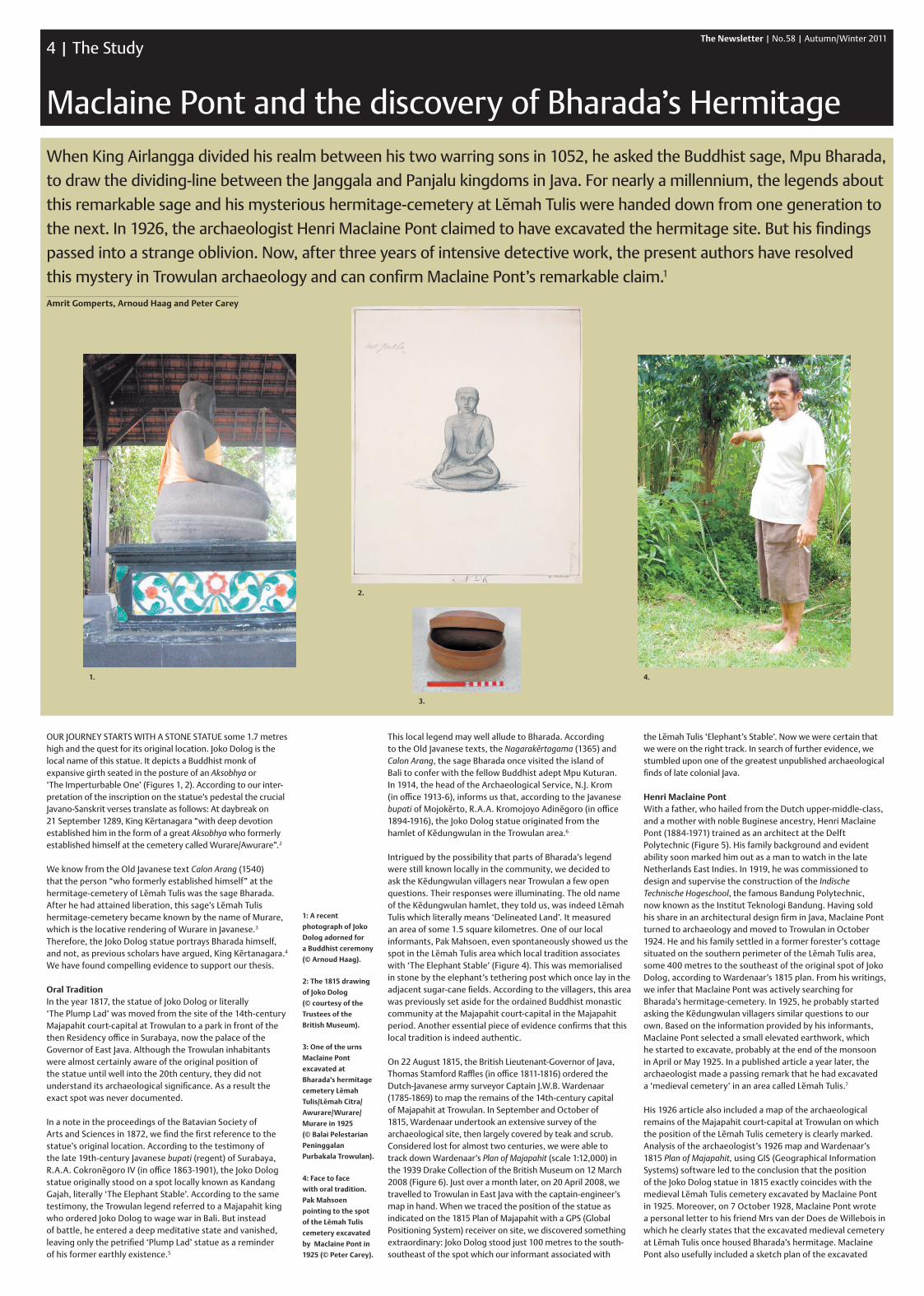
Our JOurNey STArTS WITH A STONe STATue some 1.7 metres high and the quest for its original location. Joko Dolog is the local name of this statue. It depicts a Buddhist monk of expansive girth seated in the posture of an Aksobhya or ‘The Imperturbable One’ (Figures 1, 2). According to our inter- pretation of the inscription on the statue’s pedestal the crucial Javano-Sanskrit verses translate as follows: At daybreak on 21 September 1289, King Kĕrtanagara “with deep devotion established him in the form of a great Aksobhya who formerly established himself at the cemetery called Wurare/Awurare”.2
We know from the Old Javanese text Calon Arang (1540) that the person “who formerly established himself” at the hermitage-cemetery of Lĕmah Tulis was the sage Bharada. After he had attained liberation, this sage’s Lĕmah Tulis hermitage-cemetery became known by the name of Murare, which is the locative rendering of Wurare in Javanese.3 Therefore, the Joko Dolog statue portrays Bharada himself, and not, as previous scholars have argued, King Kĕrtanagara.4 We have found compelling evidence to support our thesis.
Oral TraditionIn the year 1817, the statue of Joko Dolog or literally ‘The Plump Lad’ was moved from the site of the 14th-century Majapahit court-capital at Trowulan to a park in front of the then residency office in Surabaya, now the palace of the Governor of east Java. Although the Trowulan inhabitants were almost certainly aware of the original position of the statue until well into the 20th century, they did not understand its archaeological significance. As a result the exact spot was never documented.
In a note in the proceedings of the Batavian Society of Arts and Sciences in 1872, we find the first reference to the statue’s original location. According to the testimony of the late 19th-century Javanese bupati (regent) of Surabaya, r.A.A. Cokronĕgoro IV (in office 1863-1901), the Joko Dolog statue originally stood on a spot locally known as Kandang Gajah, literally ‘The elephant Stable’. According to the same testimony, the Trowulan legend referred to a Majapahit king who ordered Joko Dolog to wage war in Bali. But instead of battle, he entered a deep meditative state and vanished, leaving only the petrified ‘Plump Lad’ statue as a reminder of his former earthly existence.5
This local legend may well allude to Bharada. According to the Old Javanese texts, the Nagarakĕrtagama (1365) and Calon Arang, the sage Bharada once visited the island of Bali to confer with the fellow Buddhist adept Mpu Kuturan. In 1914, the head of the Archaeological Service, N.J. Krom (in office 1913-6), informs us that, according to the Javanese bupati of Mojokĕrto, r.A.A. Kromojoyo Adinĕgoro (in office 1894-1916), the Joko Dolog statue originated from the hamlet of Kĕdungwulan in the Trowulan area.6
Intrigued by the possibility that parts of Bharada’s legend were still known locally in the community, we decided to ask the Kĕdungwulan villagers near Trowulan a few open questions. Their responses were illuminating. The old name of the Kĕdungwulan hamlet, they told us, was indeed Lĕmah Tulis which literally means ‘Delineated Land’. It measured an area of some 1.5 square kilometres. One of our local informants, Pak Mahsoen, even spontaneously showed us the spot in the Lĕmah Tulis area which local tradition associates with ‘The elephant Stable’ (Figure 4). This was memorialised in stone by the elephant’s tethering post which once lay in the adjacent sugar-cane fields. According to the villagers, this area was previously set aside for the ordained Buddhist monastic community at the Majapahit court-capital in the Majapahit period. Another essential piece of evidence confirms that this local tradition is indeed authentic.
On 22 August 1815, the British Lieutenant-Governor of Java, Thomas Stamford raffles (in office 1811-1816) ordered the Dutch-Javanese army surveyor Captain J.W.B. Wardenaar (1785-1869) to map the remains of the 14th-century capital of Majapahit at Trowulan. In September and October of 1815, Wardenaar undertook an extensive survey of the archaeological site, then largely covered by teak and scrub. Considered lost for almost two centuries, we were able to track down Wardenaar’s Plan of Majapahit (scale 1:12,000) in the 1939 Drake Collection of the British Museum on 12 March 2008 (Figure 6). Just over a month later, on 20 April 2008, we travelled to Trowulan in east Java with the captain-engineer’s map in hand. When we traced the position of the statue as indicated on the 1815 Plan of Majapahit with a GPS (Global Positioning System) receiver on site, we discovered something extraordinary: Joko Dolog stood just 100 metres to the south-southeast of the spot which our informant associated with
1: A recent
photograph of Joko
Dolog adorned for
a Buddhist ceremony
(© Arnoud Haag).
2: The 1815 drawing
of Joko Dolog
(© courtesy of the
Trustees of the
British Museum).
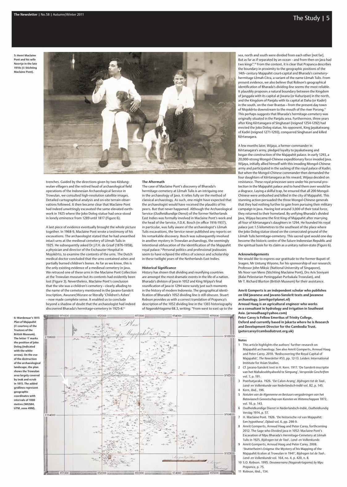
3: One of the urns
Maclaine Pont
excavated at
Bharada’s hermitage
cemetery Lĕmah
Tulis/Lĕmah Citra/
Awurare/Wurare/
Murare in 1925
(© Balai Pelestarian
Peninggalan
Purbakala Trowulan).
4: Face to face
with oral tradition.
Pak Mahsoen
pointing to the spot
of the Lĕmah Tulis
cemetery excavated
by Maclaine Pont in
1925 (© Peter Carey).
the Lĕmah Tulis ‘elephant’s Stable’. Now we were certain that we were on the right track. In search of further evidence, we stumbled upon one of the greatest unpublished archaeological finds of late colonial Java.
Henri Maclaine PontWith a father, who hailed from the Dutch upper-middle-class, and a mother with noble Buginese ancestry, Henri Maclaine Pont (1884-1971) trained as an architect at the Delft Polytechnic (Figure 5). His family background and evident ability soon marked him out as a man to watch in the late Netherlands east Indies. In 1919, he was commissioned to design and supervise the construction of the Indische Technische Hogeschool, the famous Bandung Polytechnic, now known as the Institut Teknologi Bandung. Having sold his share in an architectural design firm in Java, Maclaine Pont turned to archaeology and moved to Trowulan in October 1924. He and his family settled in a former forester’s cottage situated on the southern perimeter of the Lĕmah Tulis area, some 400 metres to the southeast of the original spot of Joko Dolog, according to Wardenaar’s 1815 plan. From his writings, we infer that Maclaine Pont was actively searching for Bharada’s hermitage-cemetery. In 1925, he probably started asking the Kĕdungwulan villagers similar questions to our own. Based on the information provided by his informants, Maclaine Pont selected a small elevated earthwork, which he started to excavate, probably at the end of the monsoon in April or May 1925. In a published article a year later, the archaeologist made a passing remark that he had excavated a ‘medieval cemetery’ in an area called Lĕmah Tulis.7
His 1926 article also included a map of the archaeological remains of the Majapahit court-capital at Trowulan on which the position of the Lĕmah Tulis cemetery is clearly marked. Analysis of the archaeologist’s 1926 map and Wardenaar’s 1815 Plan of Majapahit, using GIS (Geographical Information Systems) software led to the conclusion that the position of the Joko Dolog statue in 1815 exactly coincides with the medieval Lĕmah Tulis cemetery excavated by Maclaine Pont in 1925. Moreover, on 7 October 1928, Maclaine Pont wrote a personal letter to his friend Mrs van der Does de Willebois in which he clearly states that the excavated medieval cemetery at Lĕmah Tulis once housed Bharada’s hermitage. Maclaine Pont also usefully included a sketch plan of the excavated
1. 4.
2.
3.
The Newsletter | No.58 | Autumn/Winter 2011The Study | 5
trenches. Guided by the directions given by two Kĕdung- wulan villagers and the retired head of archaeological field operations of the Indonesian Archaeological Service in Trowulan, we consulted high-resolution satellite images. Detailed cartographical analysis and on-site terrain obser-vations followed. It then became clear that Maclaine Pont had indeed unwittingly excavated the same elevated earth-work in 1925 where the Joko Dolog statue had once stood in lonely eminence from 1289 until 1817 (Figure 6).
A last piece of evidence eventually brought the whole picture together. In 1968-9, Maclaine Pont wrote a testimony of his excavations. The archaeologist stated that he had unearthed intact urns at the medieval cemetery of Lĕmah Tulis in 1925. He subsequently asked Dr J.F.H. de Graaf (1876-1958), a physician and director of the Eschauzier Hospital in Mojokĕrto, to examine the contents of the urns. The Dutch medical doctor concluded that the urns contained ashes and partially burned children’s bones. As far as we know, this is the only existing evidence of a medieval cemetery in Java. We retraced one of these urns in the Maclaine Pont Collection at the Trowulan museum but its contents had evidently been lost (Figure 3). Nevertheless, Maclaine Pont’s conclusion that the site was a children’s cemetery – clearly alluding to the name of the cemetery mentioned in the Javano-Sanskrit inscription, Awurare/Wurare or literally ‘Children’s Ashes’ – now made complete sense. It enabled us to conclude beyond a shadow of doubt that the archaeologist had indeed discovered Bharada’s hermitage-cemetery in 1925-8.8
The AftermathThe case of Maclaine Pont’s discovery of Bharada’s hermitage-cemetery at Lĕmah Tulis is an intriguing one in the archaeology of Java. It relies fully on the method of classical archaeology. As such, one might have expected that the archaeologist would have received the plaudits of his peers. But that never happened. Although the Archaeological Service (Oudheidkundige Dienst) of the former Netherlands East Indies was formally involved in Maclaine Pont’s work and the head of the Service, F.D.K. Bosch (in office 1916-1937), in particular, was fully aware of the archaeologist’s Lĕmah Tulis excavations, the Service never published any reports on his remarkable discovery. Bosch was subsequently involved in another mystery in Trowulan archaeology, the seemingly intentional obfuscation of the identification of the Majapahit royal palace.9 Personal politics and professional jealousies seem to have eclipsed the ethics of science and scholarship in these twilight years of the Netherlands East Indies.
Historical SignificanceHistory has shown that dividing and reunifying countries are amongst the most dramatic events in the life of a nation. Bharada’s division of Java in 1052 and King Wijaya’s final reunification of Java in 1294 were surely just such moments in the history of modern Indonesia. The geographical identi- fication of Bharada’s 1052 dividing line is still obscure. Stuart Robson provides us with a correct translation of Prapanca’s description of the 1052 dividing line in the 1365 historiography of Nagarakĕrtagama 68.3, writing: “From west to east up to the
sea, north and south were divided from each other [not far]. But as far as if separated by an ocean – and from then on Java had two kings”.10 From the context, it is clear that Prapanca describes the boundary in proximity to the geographic positions of the 14th- century Majapahit court-capital and Bharada’s cemetery-hermitage Lĕmah Citra, a variant of the name Lĕmah Tulis. From present evidence, we also believe that Robson’s geographical identification of Bharada’s dividing-line seems the most reliable. It plausibly proposes a natural boundary between the Kingdom of Janggala with its capital at Jiwana (or Kahuripan) in the north, and the Kingdom of Panjalu with its capital at Daha (or Kadiri) in the south, on the river Brantas – from the present-day town of Mojokĕrto downstream to the mouth of the river Porong.11 This perhaps suggests that Bharada’s hermitage-cemetery was originally situated in the Panjalu area. Furthermore, three years after King Kĕrtanagara of Singhasari (reigned 1254-1292) had erected the Joko Dolog statue, his opponent, King Jayakatwang of Kadiri (reigned 1271-1293), conquered Singhasari and killed Kĕrtanagara.
A few months later, Wijaya, a former commander in Kĕrtanagara’s army, pledged loyalty to Jayakatwang and began the construction of the Majapahit palace. In early 1293, a 20,000-strong Mongol-Chinese expeditionary force invaded Java. Wijaya, initially allied himself with this invading Mongol-Chinese army and participated in the sacking of the royal palace of Kadiri. But when the Mongol-Chinese commander then demanded the four daughters of Kĕrtanagara as his reward, Wijaya decided on resistance. These royal princesses were under his personal pro-tection in the Majapahit palace and to hand them over would be a disgrace. Laying a skilful trap, he ensured that all 200 Mongol-Chinese were ambushed and killed in the city of Majapahit. This stunning action persuaded the three Mongol-Chinese generals that they had nothing further to gain from pursuing their military campaign in Java. Having lost around 3,000 of their total force, they returned to their homeland. By unifying Bharada’s divided Java, Wijaya became the first King of Majapahit after marrying all four of Kĕrtanagara’s daughters in 1294. He founded his royal palace just 1.5 kilometres to the southeast of the place where the Joko Dolog statue stood on the consecrated ground of the Lĕmah Tulis hermitage-cemetery. This sacred spot would one day become the historic centre of the future Indonesian Republic and the spiritual basis for its claim as a unitary nation-state (Figure 6).
AcknowledgementsWe would like to express our gratitude to the former Bupati of Sragen, Mr Untung Wiyono, for his sponsorship of our research; Professor John Miksic (National University of Singapore), Ms Noor van Mens (Stichting Maclaine Pont), Drs Aris Soviyani (Balai Pelestarian Peninggalan Purbakala Trowulan), and Mr T. Richard Blurton (British Museum) for their assistance.
Amrit Gomperts is an independent scholar who publishes on Old Javanese and Javano-Sanskrit texts and Javanese archaeology. ([email protected])Arnoud Haag is an agricultural engineer who works as a consultant in hydrology and irrigation in Southeast Asia. ([email protected])Peter Carey is Fellow Emeritus of Trinity College, Oxford and currently based in Jakarta where he is Research and Development Director for the Cambodia Trust. ([email protected])
Notes1 This article highlights the authors’ further research on
Majapahit archaeology. See also Amrit Gomperts, Arnoud Haag and Peter Carey. 2010. ‘Rediscovering the Royal Capital of Majapahit’, The Newsletter #53, pp. 12-13. Leiden: International Institute for Asian Studies.
2 Cf. Javano-Sanskrit text in H. Kern. 1917. ‘De Sanskrit-inscriptie van het Mahaksobhyabeeld te Simpang’, Verspreide Geschriften vol. 7, p. 191.
3 Poerbatjaraka. 1926. ‘De Calon-Arang’, Bijdragen tot de Taal-, Land- en Volkenkunde van Nederlandsch-Indië vol. 82, p. 145.
4 Kern, ibid., 196.5 Notulen van de Algemeene en Bestuurs-vergaderingen van het
Bataviaasch Genootschap van Kunsten en Wetenschappen 1872, vol. 10, p. 143.
6 Oudheidkundige Dienst in Nederlandsch-Indië, Oudheidkundig Verslag 1914, p. 57.
7 H. Maclaine Pont. 1926. ‘De historische rol van Majapahit: Een hypothese’, Djåwå vol. 6, pp. 298-9.
8 Amrit Gomperts, Arnoud Haag and Peter Carey, forthcoming 2012. The Sage who Divided Java in 1052: Maclaine Pont’s Excavation of Mpu Bharada’s Hermitage-Cemetery at Lĕmah Tulis in 1925, Bijdragen tot de Taal-, Land- en Volkenkunde.
9 Amrit Gomperts, Arnoud Haag and Peter Carey. 2008. ‘Stutterheim’s Enigma: the Mystery of his Mapping of the Majapahit Kraton at Trowulan in 1941’, Bijdragen tot de Taal-, Land- en Volkenkunde vol. 164, no. 4, p. 420, n. 8.
10 S.O. Robson. 1995. Desawarnana (Nagarakrtagama) by Mpu Prapanca, p. 75.
11 Robson, ibid., 134.
5: Henri Maclaine
Pont and his wife
Noortje in the late
1910s (© Stichting
Maclaine Pont).
6: Wardenaar’s 1815
Plan of Majapahit
(© courtesy of the
Trustees of the
British Museum).
The letter ‘I’ marks
the position of Joko
Dolog (indicated
with the white
arrow). On the eve
of the destruction
of the archaeological
landscape, the plan
shows the Trowulan
area largely covered
by teak and scrub
in 1815. The added
gridlines represent
geographic
coordinates with
intervals of 1000
metres (WGS84,
UTM, zone 49M).