Embed Size (px)
Citation preview

Chapter 6: Macquarie Park Corridor
City of Ryde Public Domain Technical Manual
Amend. No. Date approved Effective date Subject of amendment
Translation
2 City of Ryde Public Domain Manual Adopted 20 January 2016
Translation
Macquarie Park Corridor6.0 Macquarie Park Corridor
Public Domain Manual
1 21 January 2016 21 January 2016 Revised structure and updated provisions for consistency with Part 4.5 Macquarie Park Corridor of the Ryde Development Control Plan 2014 (as amended in June 2015).
Other key amendments include:
Addition of a new Open Space Network section to provide high-level design guidance relating to the function and character, paving and finishes, trees and landscaping, and lighting for public open space within Macquarie Park
Addition of a new Art in Public Spaces section to guide and encourage the incorporation of artworks in the public domain
Deletion of certain technical details that are addressed in relevant design guides and associated documents to remove repetition and ensure consistency
6.0

Table of Contents
City of Ryde Public Domain Technical Manual Final 20 January 2016 3
Table of Contents
Macquarie Park Corridor 6.0Public Domain Manual
1.0 INTRODUCTION 4
1.1 Purpose 4
1.2 What is the Public Domain? 4
1.3 Objectives of this Manual 4
1.4 How to Use this Manual 5
1.5 Structure of this Manual 5
1.6 Technical Guidelines and Associated Documents 6
1.7 Macquarie Park Planning Framework 7
1.8 Macquarie Park Corridor Character 9
2.0 DESIGN PRINCIPLES 10
3.0 ACCESS NETWORK 12
3.1 Streets Hierarchy 13
3.2 Access Network - Paving 15
3.3 Access Network - Cycleways 17
3.4 Access Network - Street Trees 19
3.5 Access Network - Street Lighting 25
4.0 OPEN SPACE NETWORK 27
5.1 Open Space - Function and Character 27
5.2 Open Space - Paving and Finishes 29
5.3 Open Space - Trees and Landscaping 30
5.4 Open Space - Rail Station Plazas 32
5.0 ART IN PUBLIC SPACES 34
6.0 TYPICAL LAYOUTS 36
6.1 New 20-metre wide Streets 36
6.2 New 16-metre wide Streets 38
6.3 New 14.5- metre wide Streets 40
6.4 Intersections 42
6.5 New Pedestrian Ways 44
6.6 Existing Streets 46
6.6.1 Delhi Road and Epping Road 46
6.6.2 Mixed Use , Commercial, or Business Character 49
6.6.3 Residential Character 55
Table of Contents

4 City of Ryde Public Domain Manual Final 20 January 2016
Macquarie Park Corridor6.0 Public Domain Manual
1.0 INTRODUCTION
1.1 Purpose
This Manual has been prepared by City Of Ryde to support the provisions of the Ryde Local Environmental Plan 2014 (RLEP) and the Ryde Development Control Plan 2014 (RDCP) in order to promote the revitalisation of the Macquarie Park Corridor. This document provides urban design guidelines and relevant information to assist developers and Council in undertaking public domain works within the Corridor.
1.2 What is the Public Domain?
Within the context of this document, the public domain represents all urban and natural elements, structures, and spaces that exist within the publicly-owned areas of the Ryde town centres and the relationship between them. The public domain also includes many privately-owned arcades, building forecourts, internal walkways, and other semi-public spaces as they also influence the overall character of the public domain.
1.3 Objectives of this Manual
The objectives of this manual is consistent with the City of Ryde 2025 Community Strategic Plan outcomes of Liveable Neighbourhoods, City of Connections, and City of Prosperity. This manual aims to establish a framework of design principles to guide the improvement of the public domain within the local centres. The main objectives are to:
1. Promote design solutions that enhance the amenity and character of the local area for residents, visitors, businesses, and other users.
2. Encourage the development of spaces that are attractive, well-used, robust, and safe for all users.
3. Provide new connections for better access and improved pedestrian and vehicular networks in centres.
4. Create flexible public spaces that will encourage diverse and different uses over time.
5. Encourage social interaction, a range of sensory experiences, and functionality through high-quality design.
6. Protect Macquarie Park’s landscape character and acknowledge its natural heritage.
7. Promote the seamless integration of the public and private domains.
8. Encourage sustainable environmental practices in town and neighbourhood centres within the City of Ryde.
9. Promote outdoor dining and street activation by improving pedestrian amenity and access to outdoor dining areas.

City of Ryde Public Domain Manual Final 20 January 2016 5
Macquarie Park Corridor 6.0Public Domain Manual
1.4 How to Use this Manual
This manual is to be used to inform the design of proposed public domain works in order to:
1. Influence the understanding of the site context, including infrastructure needs and desired future character;
2. Guide design and development decisions to ensure seamless integration of the public and private domain; and
3. Inform the choice of materials, street furniture, tree planting and landscaping, and other streetscape elements to be used within the Macquarie Park Corridor.
This document is to be read in conjunction with the Ryde Local Environmental Plan 2014, Ryde Development Control Plan 2014 (4.5 Macquarie Park Corridor), and relevant supporting Technical Guidelines and associated documents (listed in Table 1.6.1).
This Manual is to be reviewed annually or as required by Council to ensure its consistency with relevant State and local planning controls and standards.
Note: All proposed works covered by this Manual, including civic works relating to the open space network, are subject to the approval of the Manager Strategic City and/or Manager Asset Systems.
1.5 Structure of this Manual
This manual is comprised of the following sections:
Section 1: Introduction
This section details the purpose and objectives of this Manual, its use, and its relationship with relevant technical guidelines and associated documents. This section also provides an overview of the planning framework for Macquarie Park and its existing and desired future character.
Section 2: Design Principles
This section provides design principles to guide the development of the public domain within the Corridor.
Section 3: Access Network
This section provides a framework for the public domain access network including key objectives, strategies, and specifications for paving, street trees, street furniture, and fixtures.
Section 4: Open Space Network
This section provides a framework for the public domain open space network including key objectives, strategies, and specifications for paving, tree planting and landscaping, furniture, and fixtures.
Section 5: Public Art
This section provides information to guide the integration of artworks in the public domain to establish a distinct identity and character.
Section 6: Typical Layouts
This section provides information regarding the typical arrangement of streets with reference to streetscape elements including street lighting, tree planting and landscaping, street furniture, and fixtures.

6 City of Ryde Public Domain Manual Final 20 January 2016
Macquarie Park Corridor6.0 Public Domain Manual
1.6 Design Guides and Associated Documents
This manual is to be read in conjunction with the following design guides and associated plans and documents:
Document Description
Design Guide for Streets Guidelines to assist the design and construction of streets including paving, kerbing, driveways, etc.
Design Guide for Council-owned Street Lighting
Detailed guidelines for the design and installation of Council-owned street lighting, including multi-function light poles specifications, street lighting layout, and requirements for plan submission.
Street Lighting Schema for the Macquarie Park Business Area
Diagram to inform street lighting designers about the proposed configuration of the street lighting network owned by Council, including circuit zones for metering purposes.
Design Guide for Public Open Space
Guidelines to assist in the design and construction of parks including paving, landscaping, embellishment, and other associated public domain works.
Outdoor Dining Policy Policy applying to land owned or under the care, control, and management of Council. Outlines Council’s requirements for outdoor dining including having a minimum area of 4 square metres and maintaining a clear unobstructed pedestrian corridor (2 metres in width).
Shrimptons Creek Parklands Plan of Management
Sets out the vision for Shrimptons Creek Parklands to recognise the creek-line as an environmental and recreational spine in the City of Ryde. The parklands is also envisioned to provide clear connections to adjacent urban environments without compromising their natural character.
Ryde Street Tree Master Plan Informs and guides all street tree planting and assists the City of Ryde and the community in managing and expanding the urban forest.
Ryde Bicycle Strategy A comprehensive plan for improving the environment for people who ride bicycles for transport, health, and fitness to facilitate increased active transport patronage within the City of Ryde over the next 10 years and beyond.
Macquarie Park Pedestrian Access and Mobility Plan
Provides a framework for developing safe and convenient pedestrian routes and fostering improvements in personal mobility.
Ryde Public Art Policy Provides a framework for the delivery and administration of public art in the City of Ryde.
Table 1.6.1 Design Guides and Associated Documents
City of Ryde Public Domain Manual Final 20 January 2016 7
Macquarie Park Corridor 6.0Public Domain Manual
1.7 Macquarie Park Planning Framework
This document is consistent with the provisions of the following :
� Ryde Local Environmental Plan 2014 (RLEP) � Ryde Development Control Plan 2014 (RDCP) - Part 4.5 Macquarie Park
The RLEP and RDCP set out the broad framework for development within the Macquarie Park Corridor. This includes the expansion of the public domain to cater for people who will live, work, and visit Macquarie Park as it evolves from a business park that was established in 1960s to an urban centre supported by public transport and public domain infrastructure. The framework for the future public domain comprises:
� An Access Network that identifies and coordinates the delivery of proposed new roads and pedestrian ways.
� An Open Space Network that identifies new parklands and urban plazas.
Development in the Macquarie Park Corridor must occur within the framework of the objectives and controls of the RDCP 2014, which relate to the street layout, size and shape of city blocks, open spaces, and built form. The synthesis of these elements will define the public domain and strengthen the existing character and identity of the Corridor.

8 City of Ryde Public Domain Manual Final 20 January 2016
Macquarie Park Corridor6.0 Public Domain Manual
Eppi
ng R
oad
Wat
erlo
o Ro
ad
Tala
vera
Roa
d
Lane Cove Road
M2 Moto
rway
Delhi Road
Lane CoveNational Park
Lane CoveNational Park
Culloden Road
MacquarieUniversity
Eppi
ng R
oad
Wicks Road
Herring Road
M2
Existing Roads
Macquarie University roads
Macquarie Park Corridor Boundary
LEGEND
Figure 1.5.1 Macquarie Park Corridor Boundary and Existing Road Network
N

City of Ryde Public Domain Manual Final 20 January 2016 9
Macquarie Park Corridor 6.0Public Domain Manual
1.8 Macquarie Park Corridor Character
Existing Character
The Macquarie Park Corridor is located 12 kilometres from Sydney CBD and 13 kilometres from Parramatta CBD, with over 200 hectares of mixed use, commercial, and business land use. It is a nationally significant economic corridor for research and business, specialising in the communications, medical research, pharmaceutical and IT&T sectors.
The Corridor has three railway stations and access to bus transport, but there are limited linkages between existing roads and the surrounding road network. The urban structure is characterised by wide streets and large street blocks with a commercial core centered around Macquarie Park Station and Waterloo Road, a retail core anchored on Macquarie Shopping Centre, an educational and health precinct comprising Macquarie University and Macquarie Hospital, business park areas, and protected vegetation in the Lane Cove National Park and Shrimptons Creek.
VisionThe Macquarie Park Corridor is envisioned to mature into a premium location for globally competitive businessses with an enhanced sense of identity and strong links to the university and research institutions.
Desired Future Character
The Macquarie Park Corridor will be characterised by a high-quality, well-designed, safe, and liveable environment that reflects the natural setting. The Corridor will have accessible and vibrant focal points around the three railway stations and enhanced access and open space network to support its continuous commercial and business growth and the planned residential communities centred on the North Ryde Station and Macquarie University Station Priority Precincts.
The implementation of the RDCP 2014 and this document will guide development to achieve the vision and desired future character for the Macquarie Park Corridor through improved vehicular, pedestrian, and cycle permeability and connectivity to surrounding centres and regional open spaces.
Figure 1.8.1 Macquarie Park Corridor - Aerial Photo (December 2015)
EPPING ROAD
N
10 City of Ryde Public Domain Manual Final 20 January 2016
Macquarie Park Corridor6.0 Public Domain Manual
2.0 DESIGN PRINCIPLES
Promoting pedestrian access is central to the design of the public domain and increases opportunities for social interaction and community life. Streets and public spaces should be comfortable, safe, and engaging places that encourage people to stay. Pedestrian routes to and within Macquarie Park should be designed to be acccessible to everyone, promote walking, and reduce conflict between pedestrians, bicycles, and cars.
Public art, trees, directional signage, and street furniture should be incorporated into streets and public spaces as they not only contribute to the visual and spatial quality of the public domain but also improve the human experience by providing amenities such as shade, seating, and wayfinding. Sustainability outcomes can also be promoted in streets, parks, and urban spaces by including street trees where possible and implementing measures to harvest and reuse water.
The following key principles guide the design and development of publc spaces within the centres of the City of Ryde:
Liveability � Create spaces that provide a desirable setting and backdrop for social interaction and a
variety of activity � Provide unified streetscapes that are high-quality, durable, and timeless in design � Eliminate level changes and obstructions and promote consistent paving patterns as
much as possible
Active Transport � Prioritise pedestrian amenity by providing opportunities to expand the public domain � Eliminate pedestrian, cycle, and vehicle conflict as much as possible � Provide amenities such as seats, shelter, and bike racks to support pedestrian and bicycle
use
Landform and Views � Retain and/or reveal significant views from the public domain to waterways, heritage
items, and significant sites � Identify significant views and consider them in the selection and placement of public art,
street trees, and furniture
Trees � Integrate tree and landscape treatments to provide shade, interest, and amenity as well
as unify streetscapes � Create green corridors with increased tree planting and landscape treatments to reduce
the extent of hard surfaces and increase canopy cover, biodiversity, and microclimate
Public Art � Create public art that aids legibility and defines a sense of place and identity � Provide visual interest to everyday activities and social gatherings

City of Ryde Public Domain Manual Final 20 January 2016 11
Macquarie Park Corridor 6.0Public Domain Manual
Water Sensitive Urban Design � Collect and reuse stormwater for watering street trees and landscape elements where
possible � Treat stormwater as close to the source as possible � Collect and treat stormwater in bio-retention tree pits and/or rain and filter gardens that
are seamlessly integrated with the design of the public space
Safer by Design � Ensure that all publicly accessible pathways have sufficient width, lighting, and finishes to
enhance public safety � If possible, pathways should be adjacent to active spaces to improve amenity and safety � If possible, locate pathways where conflicts with vehicular traffic are avoided
Equitable Access and Use � Enable equitable and safe access for people of all ages and abilities in accordance with the
Building Code of Australia (BCA) and the Disability (Access to Premises – Buildings) Standards (Premises Standards) - AS 1428.
� Ensure continuous accessible paths of travel and circulation spaces and appropriate facilities for people who use wheelchairs and people who have ambulatory and sensory disabilities

12 City of Ryde Public Domain Manual Final 20 January 2016
Macquarie Park Corridor6.0 Public Domain Manual 4.53.0 ACCESS NETWORK
3.1 Streets Hierarchy
Objectivesa. Improve pedestrian, cycle, and vehicular accessibility and permeability to and within the
Macquarie Park Corridorb. Establish a clear hierarchy of public streets within the corridorc. Accommodate increased traffic movement within the corridord. Provide additional opportunities for on-street car parking
Strategy
The planning controls reinforces Waterloo, Herring, Talavera, and Lane Cove Roads as the principal streets within the Macquarie Park Corridor. In particular, the permissible height and FSR will see Waterloo and Herring Roads develop as main streets with a boulevard character. The network of existing streets will be augmented by proposed new streets to create an access network that aims to substantially improve traffic congestion and create a more permeable and amenable public domain for pedestrians and cyclists. The access network will also provide better access to parks and significant public places within the Corridor.
The hierarchy of existing and proposed new streets that comprise the access network is detailed below:
Existing Streets Hierarchy Carriageway Approx. Road Reserve Width
PrimaryEpping Road 26 metres (varies) 40 metresLane Cove Road 26 metres 30 metresHerring Road 23 metres 30 metresWaterloo Road (between Lane Cove and Herring Roads)
20 metres 30 metres
Delhi Road 12 metres (varies) 30 metresSecondaryTalavera Road 16 metres 25 metresKhartoum Road (between Talavera Road and M2 Motorway)
14 metres 25 metres
Khartoum Road (between Talavera and Waterloo Roads)
12 metres 20 metres
Byfield Street 12 metres 22 metresLyon Park Road 12 metres 21 metresWicks Road 12 metres 20 metresWaterloo Road (between Lane Cove and Wicks Roads)
12 metres 20 metres
Eden Park Drive 12 metres 20 metresCoolinga Street 11 metres 20 metresGiffnock Avenue 11 metres 20 metres
Table 3.1.1 Street Hierarchy - Primary and Secondary Streets

City of Ryde Public Domain Manual Final 20 January 2016 13
Macquarie Park Corridor 6.0Public Domain Manual4.5
Existing Streets Hierarchy Carriageway Approx. Road Reserve Width
TertiaryRivett Road 8 metres 12 metresRichardson Place 8 metres 12 metresJulius Avenue 12 metres 18 metresResidential CharacterWindsor Drive 13 metres 22 metresPeachtree Road 11 metres 21 metresLachlan Avenue 10 metres 20 metresCottonwood Crescent 15 metres 20 metresProposed New Streets and Connections Hierarchy20-metre wide streets 11 metres 20 metres14.5-metre wide streets 8.5 metres 14.5 metresPedestrian connections 2 metres (path) 6 metres
Table 3.1.2 Street Hierarchy - Tertiary and New Streets and Connections

14 City of Ryde Public Domain Manual Final 20 January 2016
Macquarie Park Corridor6.0 Public Domain Manual
Eppi
ng R
oad
Wat
erlo
o Ro
ad
Tala
vera
Roa
d
Lane Cove Road
M2 Moto
rway
Delhi Road
Lane CoveNational Park
Lane CoveNational Park
Culloden Road
MacquarieUniversity
Eppi
ng R
oad
Wicks Road
Herring Road
M2
Existing Roads
New 20-metre roads
Macquarie University roads
Macquarie Park Corridor Boundary
LEGEND
New 16-metre roads
New 14.5-metre roads
New Pedestrian Ways
Road
3
Road 28
Road
3
Road 27
Road
1Ro
ad 1
Road 17
Road 14
Road 16
Road 18 Road
2
Rd 24
Rd 19
Rd 26
Rd 15
Rd 20
Rd 25
Road 21
Rd 15
Road
6
Road
5
Road 13
Road 11
Road 30
Road 10Road 9
Road 12
Road
4
Road 8
Road
7
Road 38
Road 29
Road 31
Road 22 Road 23
Figure 3.1.1 Macquarie Park Corridor Road Types PlanN

City of Ryde Public Domain Manual Final 20 January 2016 15
Macquarie Park Corridor 6.0Public Domain Manual
3.2 Access Network - Paving
Objectivesa. Create a visually seamless and unified public domainb. Utilise robust and durable materials with a consistent colour and finish to create a visually
consistent ground planec. Achieve a safe and convenient pedestrian environment that encourages social interaction
and active transport, in accordance with the objectives of the Macquarie Park Corridor DCP
Strategy
The strategy for paving is to create a clear and coherent public domain finish that provides a unified and recognisable character and ensures the amenity of pedestrians and cyclists alike. Paving materials have also been selected for ease of maintenance, durability, and robustness.
The paving specifications reflect the local context, scale of streets, and their role within the access network hierarchy. For example, full-width granite paving on majority of Waterloo Road reflects its role as the central civic spine and as a primary pedestrian route that links the rail stations. The same paving treatment also applies for Lane Cove Road, Herring Road, and Talavera Road, in lieu of their desired future character and role within the access network hierarchy. The paving treatment for Epping and Delhi Roads responds to their local context where the width of the verge varies significantly. The paving specifications are further detailed below:
Location Description Specification ReferenceNew 20-metre wide street
To be dedicated to Council
Granite paving - full width footway
Section 6.1
New 16-metre wide street
To be dedicated to Council
Granite paving - full width footway
Section 6.2
New 14.5-metre wide street
To be dedicated to Council
Granite paving - full width footway
Section 6.3
New pedestrian ways Subject to easement or right of way as required by Council
Concrete paving with granite banding
Section 6.5
Existing primary streets (Epping and Delhi Roads)
30 to 40 metres wide overall
Granite paving (2.4 metres) with nature strip
Section 6.6.1
Existing Mixed Use, Commercial, or Business Character
18 to 25 metres wide overall
Granite paving - full width of the verge
The footway may vary between 2 to 5 metres
Section 6.6.2
Existing residential streets
12 to 20 metres wide overall
Granite paving (2.4 metres; varies) with nature strip
Section 6.6.3
Table 3.2.1 Paving Specifications for New and Existing Streets
Note: The verge refers to the area between the kerb and property boundary

16 City of Ryde Public Domain Manual Final 20 January 2016
Macquarie Park Corridor6.0 Public Domain Manual
Eppi
ng R
oad
Wat
erlo
o Ro
ad
Tala
vera
Roa
d
Lane Cove Road
M2 Moto
rway
Delhi Road
Lane CoveNational Park
Lane CoveNational Park
Culloden Road
MacquarieUniversity
Eppi
ng R
oad
Wicks Road
Herring Road
M2
Full granite paving
2.4-metre wide granite pavingwith nature strip
Macquarie University roads
Macquarie Park Corridor Boundary
LEGEND
Concrete path
Pedestrian ways - concrete with granite banding
Up to 2.4-metre wide (varies) granite paving with nature strip
Figure 3.2.1 Macquarie Park Corridor Paving PlanN
2.4-metre wide granite paving with nature strip
Concrete with granite banding
E.g. Quarry Road
E.g. Epping Road
Full-width granite paving
E.g. Lane Cove Road
Concrete path
E.g. Plassey Road
Full-width granite paving

City of Ryde Public Domain Manual Final 20 January 2016 17
Macquarie Park Corridor 6.0Public Domain Manual
3.3 Access Network - Cycleways
Objectivesa. Maximise cycle connections to regional cycle routes through and around the Corridorb. Support cycle use by creating a safe and high-quality cycle networkc. Maximise permeability and interchange opportunities with public transport within the
Corridord. Minimise conflict between pedestrians, cyclists, and public domain elements
Strategy
The Regional Bicycle Network is to be implemented as off-street shared cycleways in accordance with the Macquarie Park Public Domain Technical Manual. The Regional Bicycle Manual comprises:
� Waterloo Road; � Delhi Road; � Epping Road; � Lane Cove Road; � Khartoum Road; � M2 Motorway; and
� Shrimptons Creek pathways.
The Local Bicycle Network is to be implemented as off-street shared cycleways in accordance with the Macquarie Park Public Domain Technical Manual. The Local Bicycle Manual comprises:
� Lyon Park Road; � Talavera Road; � Wicks Road; � Proposed new roads (Numbers 17, 18, 19, 20, 21, and 26) in accordance with the Ryde
Bicycle Strategy 2014
Cycleways are to be located adajacent to property boundary to minimise conflict with street trees, lighting, signage, and other public domain elements.

18 City of Ryde Public Domain Manual Final 20 January 2016
Macquarie Park Corridor6.0 Public Domain Manual
Figure 3.3.1 Macquarie Park Corridor Cycle Network Plan
Eppi
ng R
oad
Wat
erlo
o Ro
ad
Tala
vera
Roa
d
Lane Cove Road
M2 Moto
rway
Delhi Road
Lane CoveNational Park
Lane CoveNational Park
Culloden Road
MacquarieUniversity
Eppi
ng R
oad
Wicks Road
Herring Road
Regional Bicycle Route
LEGEND
Local Bicycle Route
Local Links
New Shared Paths
Roads and Pedestrian Ways
N
Regional Bicycle Route On-ramp
T
T
T
T Rail Station

City of Ryde Public Domain Manual Final 20 January 2016 19
Macquarie Park Corridor 6.0Public Domain Manual
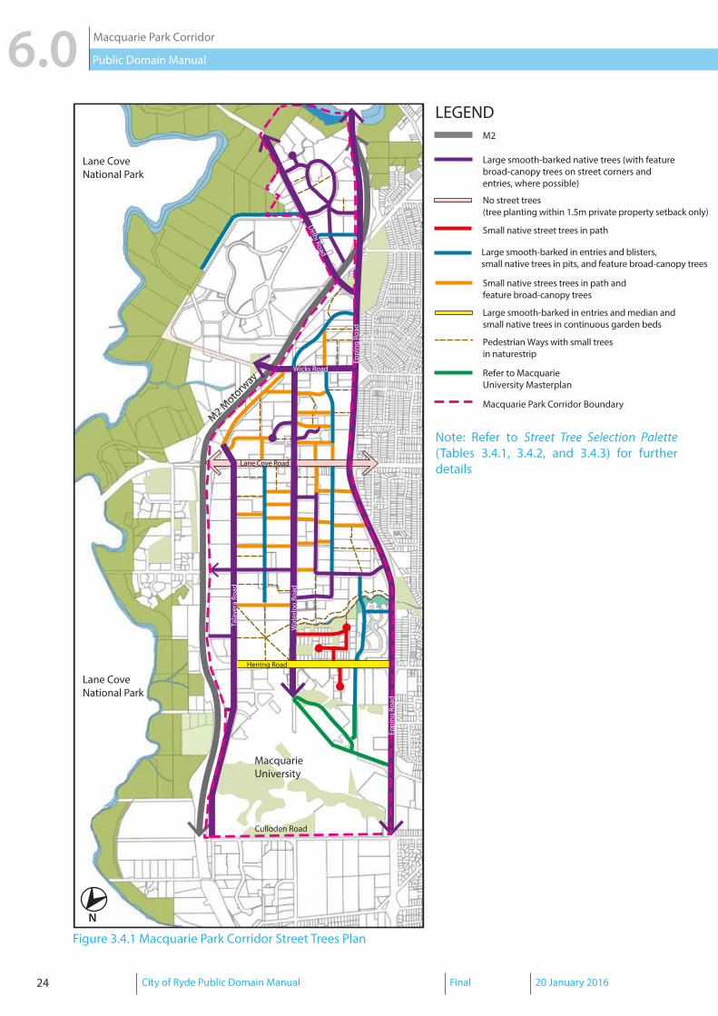
3.4 Access Network - Street Trees
Macquarie Park was once filled with a series of market gardens and orchards with vast tracts of bushland prior to the establishment of the Macquarie University and its development as an employment area in the mid-1960s. Although there are currently no extant remains of this market gardens and orchards heritage, Macquarie Park’s existing landscape character remains that of a green environment, which features trees and large lots with no front fencing that simulate an appearance of extensive open spaces.
Macquarie Park’s landscape character is defined by its predominant native tree canopy with minimal exotic tree canopy, its strong links to Lane Cove National Park, and its creeks and riparian coridors.
Native Tree Canopy and links to Lane Cove National Park
Macquarie Park has strong links to Lane Cove National Park, which is represented by native tree planting throughout its parks and streetscapes.
The existing native tree canopy is predominantly smooth-barked species such as Spotted Gum, with some rough-barked species such as Brush Box in residential character streets.
Native tree species are also planted within private property setbacks (1.5-metre setback from the property boundary), which create clear sightlines along pedestrian paths that are bounded by vegetation.
Minimal Exotic Tree Canopy
There are some existing exotic trees planted within private property setbacks, median strips, and within the verge along certain sections of Herring Road and Julius Avenue. The exotic tree canopy are predominantly Plane and Liquidambar trees, which create a shaded green ambience particularly during the summer season.
Understorey planting is also characterised by a combination of formal exotic shrub planting and native grass planting such as Orange Jessamine, Lilly Pilly, Duranta Sheena’s Gold, and Spiny-head Mat Rush.
Creeks and Riparian Corridors
There were four creeks that traveresed the Corridor (Industrial, Porters, Shrimptons, and University creeks), most of which have been piped and are not currently visible. Open space generally surrounds certain sections of creeks that remain open. Whilst the vegetation in some sections of the riparian corridors and creeks are comprised of exotic weeds, there are areas such as sections of Shrimptons Creek (near Waterloo Road) where revegetation of Sydney Turpentine Ironbark Forest species is evident.

20 City of Ryde Public Domain Manual Final 20 January 2016
Macquarie Park Corridor6.0 Public Domain Manual
Objectivesa. Create a desirable streetscape environment by providing a shaded ambience and ensuring
pedestrian amenityb. Respond to the local environment by utilising species that are of an appropriate scale and
type and that complements to the local context and streetscape characterc. Recognise the role of streets in habitat creation and provide bio-links and connectionsd. Define a unique landscape character for key streets and other street typologies by creating
signature gateway large-scale planting on key streets and smaller-scale planting on other street typologies.
e. Recognise the landscape heritage of market gardens and orchards within Macquarie Park
Strategy
Based on the existing landscape character of Macquarie Park, the following overall strategy is proposed for street tree planting within the Macquarie Park Corridor:
� Create a shaded ambience and improve pedestrian amenity by promoting a consistent street tree layout (Refer to Part 6.0 Typical Layouts) and by providing street tree planting within the verge, where possible.
� Complement existing landscape character by utilising smooth-barked native tree species such as Sydney Red Gum, Spotted Gum, and Forest Red Gum, where existing streetscape is predominantly native tree species while maintaining the minimal exotic tree canopy at certain locations where the existing streetscape has exotic tree species.
� Encourage native tree planting within the 1.5-metre private property setback (where possible) to reinforce the green landscape character of the Corridor and allow for clear sightlines on major roads such as Lane Cove Road and Waterloo Road.
� Encourage native grass understorey to native street tree planting with drought-tolerant species such as Lomandra Longifolia (‘Tanika’ Spiny-head Mat Rush) or Dianella caerulea (Blueberry lily or Blue flax-lily).
� Allow for feature native trees, particuarly on street corners and private property entry threshold that could contribute to the public domain.

City of Ryde Public Domain Manual Final 20 January 2016 21
Macquarie Park Corridor 6.0Public Domain Manual
Streets Tree Selection PaletteExisting PrimaryEpping Road, Waterloo Road (Lane Cove to Herring Road), Lane Cove Road, and Delhi Road
Large Smooth-barked Native Trees:Angophora costata (Sydney Red Gum); Corymbia maculata (Spotted Gum); Eucalyptus tereticornis (Forest Red Gum)
Trees within the1.5m private property setback:Angophora costata (Sydney Red Gum);Angophora floribunda (Rough-barked Apple);Corymbia maculata (Spotted Gum);Eucalyptus botryoides (Swamp Mahogany);Eucalyptus acmenoides (White Mahogany);Eucalyptus pilularis (Blackbutt);Eucalyptus piperita (Sydney Peppermint);Eucalyptus saligna (Sydney Blue Gum);Eucalyptus resinifera (Red Mahogany);Eucalyptus tereticornis (Forest Red Gum)
Feature Broad Canopy Trees (on street corners and private property entry threshold, where appropriate):Ficus rubiginosa (Port Jackson Fig);Platanus digitalis (Plane Tree);Ulmus parvifolia (Chinese Elm)
Herring Road Large Smooth-barked Native Trees:As listed above
Small Trees:Buckinghamia celsissima (Ivory Curl);Eleocarpus eumundii (Smooth Quandong);Eleocarpus reticulatus (Blueberry Ash);Flindersia australis (Crow’s Ash);Harpullia pendula (Tulipwood);Syncarpia glomulifera (Turpentine);Tristaniopsis laurina (Water Gum);Tristaniopsis laurina (‘Luscious’ Water Gum);Waterhousia floribunda (Weeping Lilly Pilly)
Trees within the1.5m private property setback and feature Broad Canopy Trees (on street corners and private property entry threshold, where appropriate):As listed above
Table 3.4.1 Street Tree Selection Palette for Existing Primary Streets

22 City of Ryde Public Domain Manual Final 20 January 2016
Macquarie Park Corridor6.0 Public Domain Manual
Existing SecondaryTalavera Road, Khartoum Road (Talavera Rd to M2), Khartoum Road (Talavera Rd to Waterloo Rd), Byfield, Lyon Park Road, Wicks Road, and Waterloo Road (Lane Cove Rd to Wicks Rd)
Large Smooth-barked Native Trees:Angophora costata (Sydney Red Gum); Corymbia maculata (Spotted Gum); Eucalyptus tereticornis (Forest Red Gum)
Trees within the1.5m private property setback:Angophora costata (Sydney Red Gum);Angophora floribunda (Rough-barked Apple);Corymbia maculata (Spotted Gum);Eucalyptus botryoides (Swamp Mahogany);Eucalyptus acmenoides (White Mahogany);Eucalyptus pilularis (Blackbutt);Eucalyptus piperita (Sydney Peppermint);Eucalyptus saligna (Sydney Blue Gum);Eucalyptus resinifera (Red Mahogany);Eucalyptus tereticornis (Forest Red Gum)
Eden Park Drive, Coolinga Street, Giffnock Avenue, and Julius Avenue
Small Trees:Angophora costata (Sydney Red Gum); Buckinghamia celsissima (Ivory Curl);Corymbia maculata (Spotted Gum); Eleocarpus eumundii (Smooth Quandong);Eleocarpus reticulatus (Blueberry Ash);Flindersia australis (Crow’s Ash);Harpullia pendula (Tulipwood);Pittosporum revolutum (Yellow Pittosporum);Syncarpia glomulifera (Turpentine);Tristaniopsis laurina (Water Gum);Tristaniopsis laurina (‘Luscious’ Water Gum);Waterhousia floribunda (Weeping Lilly Pilly)
Trees within the1.5m private property setback:As listed above
Existing TertiaryRivett Road and Richardson Place Large Smooth-barked Native Trees:
As listed above
Trees within the1.5m private property setback:As listed above
Table 3.4.2 Street Tree Selection Palette for Existing Secondary and Tertiary Streets

City of Ryde Public Domain Manual Final 20 January 2016 23
Macquarie Park Corridor 6.0Public Domain Manual
Existing Residential Character StreetsWindsor Drive, Peachtree Road, Lachlan Avenue, and Cottonwood Crescent
Small Trees:Buckinghamia celsissima (Ivory Curl);Eleocarpus eumundii (Smooth Quandong);Eleocarpus reticulatus (Blueberry Ash);Flindersia australis (Crow’s Ash);Harpullia pendula (Tulipwood);Pittosporum revolutum (Yellow Pittosporum);Syncarpia glomulifera (Turpentine);Tristaniopsis laurina (Water Gum);Tristaniopsis laurina (‘Luscious’ Water Gum);Waterhousia floribunda (Weeping Lilly Pilly)
Trees within the1.5m private property setback:Angophora costata (Sydney Red Gum);Angophora floribunda (Rough-barked Apple);Corymbia maculata (Spotted Gum);Eucalyptus botryoides (Swamp Mahogany);Eucalyptus acmenoides (White Mahogany);Eucalyptus pilularis (Blackbutt);Eucalyptus piperita (Sydney Peppermint);Eucalyptus saligna (Sydney Blue Gum);Eucalyptus resinifera (Red Mahogany);Eucalyptus tereticornis (Forest Red Gum)
New StreetsProposed new 20-metre wide street Large Smooth-barked Native Trees (entries
and blister planting):Angophora costata (Sydney Red Gum); Corymbia maculata (Spotted Gum); Eucalyptus tereticornis (Forest Red Gum)
Small Trees (for tree pits) and trees within the 1.5m private property setback:As listed above
Feature Broad Canopy Trees:Ficus rubiginosa (Port Jackson Fig);Platanus digitalis (Plane Tree);Ulmus parvifolia (Chinese Elm)
Proposed new 16-metre and 14.5-metre wide street
Small Trees (for tree pits):As listed above
Trees within the1.5m private property setback and feature Broad Canopy Native Trees:As listed above
Table 3.4.3 Street Tree Selection Palette for Existing Residential Character and New Streets
24 City of Ryde Public Domain Manual Final 20 January 2016
Macquarie Park Corridor6.0 Public Domain Manual
Eppi
ng R
oad
Wat
erlo
o Ro
ad
Tala
vera
Roa
d
Lane Cove Road
M2 Moto
rway
Delhi Road
Lane CoveNational Park
Lane CoveNational Park
Culloden Road
MacquarieUniversity
Eppi
ng R
oad
Wicks Road
Herring Road
M2
Large smooth-barked native trees (with feature broad-canopy trees on street corners and entries, where possible)
Refer to Macquarie University Masterplan
Macquarie Park Corridor Boundary
LEGEND
Small native street trees in path
Small native strees trees in path andfeature broad-canopy trees
Pedestrian Ways with small treesin naturestrip
Large smooth-barked in entries and median andsmall native trees in continuous garden beds
No street trees (tree planting within 1.5m private property setback only)
Large smooth-barked in entries and blisters, small native trees in pits, and feature broad-canopy trees
Figure 3.4.1 Macquarie Park Corridor Street Trees Plan
N
Note: Refer to Street Tree Selection Palette (Tables 3.4.1, 3.4.2, and 3.4.3) for further details

City of Ryde Public Domain Manual Final 20 January 2016 25
Macquarie Park Corridor 6.0Public Domain Manual
3.5 Access Network - Street Lighting
Objectivesa. Provide an access network with high pedestrian, cycling, and vehicular amenityb. Reinforce a sense of safety for the community by providing appropriate street lightingc. Provide a street lighting network that complements the local context, surrounding
developments, streetscape character, and other public domain elements
Strategy
The overall strategy is to deliver an enhanced street lighting network for the Macquarie Park Corridor through the development process and City of Ryde’s program of works.
Street lighting on multi-function poles (MFPs) must be installed as part of public domain works required for developments within the corridor. Following the final completion of the development and the public domain works, Council takes over the ownership and long-term maintenance responsibility of the street lighting.
Please refer to Figure 3.5.1 for the Street Lighting Network Plan and the Design Guide for Council-owned Street Lighting for further details.
Note: Certain developments that propose street lighting designs that vary from the Street Lighting Network Plan due to site-specific constraints and/or road configurations must be referred to Manager Asset Systems.

26 City of Ryde Public Domain Manual Final 20 January 2016
Macquarie Park Corridor6.0 Public Domain Manual
Eppi
ng R
oad
Wat
erlo
o Ro
ad
Tala
vera
Roa
d
Lane Cove Road
M2 Moto
rway
Delhi Road
Lane CoveNational Park
Lane CoveNational Park
Culloden Road
MacquarieUniversity
Eppi
ng R
oad
Wicks Road
Herring Road
M2
Staggered multi-function poles on both sides (refer to the Street Lighting Schema for the Macquarie Park Business Area)
Macquarie University roads(refer to Macquarie UniversityMasterplan)
Macquarie Park Corridor Boundary
LEGEND
Multi-function poles on one side(refer to the Street Lighting Schema for the Macquarie Park Business Area)
Standard pedestrian lights
Figure 3.5.1 Macquarie Park Corridor Street Lighting Plan
N
Note: Street lighting design and specifications are subject to Council’s approval. Reference should also be made to the Design Guide for Council-owned Street Lighting.

City of Ryde Public Domain Manual Final 20 January 2016 27
Macquarie Park Corridor 6.0Public Domain Manual
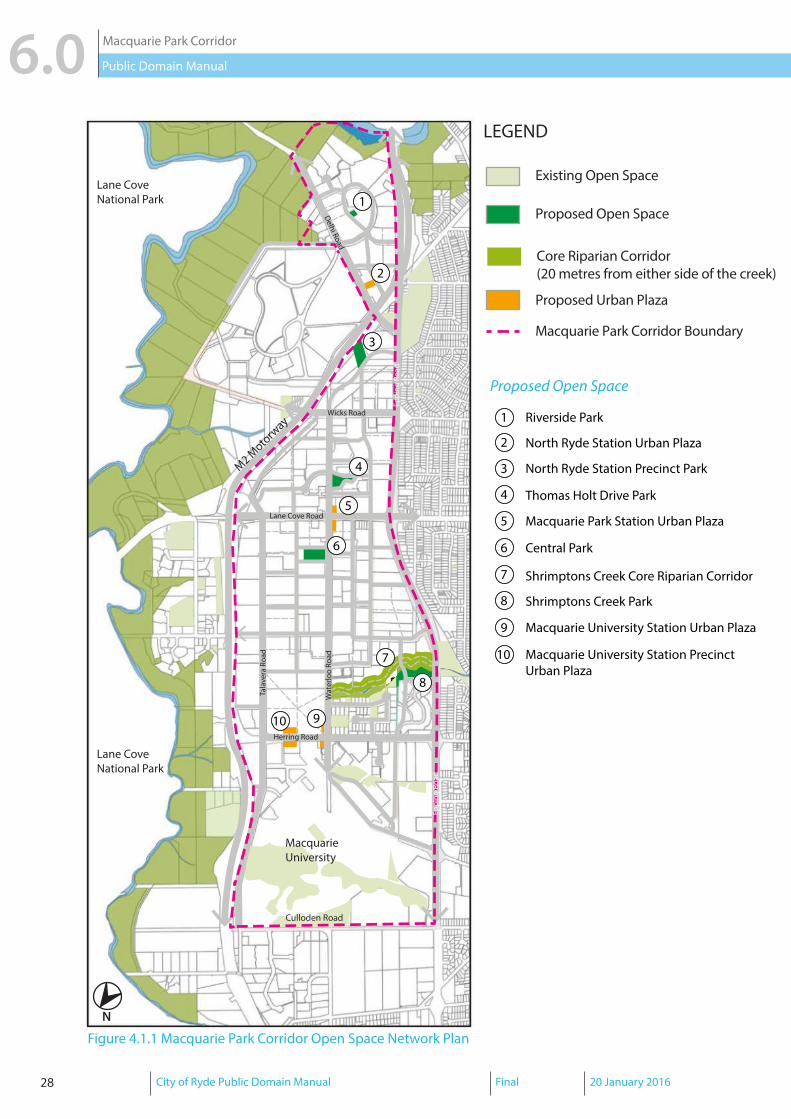
4.0 OPEN SPACE NETWORK
4.1 Open Space Network - Function and Character
Objectivesa. Provide a well-connected public open space network with a range of open space typologies
to accommodate active and passive recreational usesb. Create bio-links and canopy connections to existing vegetation communities and
contribute to stormwater and ecological managementc. Maximise the accessibility of useable open space and contribute to the pedestrian and
cycle network
Strategy
A new open space network will be provided by identifying new public space and augmenting existing public open spaces within the corridor. The new open space network will comprise of a range of typologies such as multi-function parklands, informal gathering and recreational areas, urban plazas, and rehabilitated and new vegetation reserves that are integrated with the access network to maximise pedestrian and cycle access.
Park Name/Address Minimum Area/Dimensions
Function and Indicative Character
Central Park (43-61 Waterloo Road) 1 hectare75 x 100 metres(if dimensions are altered, a minimum of 65 metres is required in any direction)
Multi-functionActive recreation (informal sport)Passive recreationCommunity events (cinemas, expos, etc.)Children’s play
Shrimptons Creek Parklands and Riparian Corridor
3.8 hectaresDimensions vary
Multi-functionActive transport (fitness trail, walking, and cycling)Active recreation (informal sport and skateboarding)Passive recreationChildren’s playRiparian Corridor/ native habitat
Riverside Park (Julius Avenue) 0.35 hectare60 x 60 metres
Multi-functionPassive recreationChildren’s playOutdoor diningNeighbourhood meeting place
Thomas Holt Park (Thomas Holt Drive) 0.40 hectareapprox. 100 x 40 metres
Multi-functionPassive recreationChildren’s playNeighbourhood meeting place
Table 4.1.1 Proposed New Open Space and Desired Function and Character
28 City of Ryde Public Domain Manual Final 20 January 2016
Macquarie Park Corridor6.0 Public Domain Manual
1
2
3
4
5
6
7
8
910
1
2
3
4
5
6
7
8
9
Riverside Park
North Ryde Station Urban Plaza
Thomas Holt Drive Park
Macquarie Park Station Urban Plaza
Central Park
Shrimptons Creek Core Riparian Corridor
Shrimptons Creek Park
Macquarie University Station Urban Plaza
Macquarie University Station Precinct Urban Plaza
10
North Ryde Station Precinct Park
Eppi
ng R
oad
Wat
erlo
o Ro
ad
Tala
vera
Roa
d
Lane Cove Road
M2 Moto
rway
Delhi Road
Lane CoveNational Park
Lane CoveNational Park
Culloden Road
MacquarieUniversity
Eppi
ng R
oad
Wicks Road
Herring Road
Existing Open Space
LEGEND
Proposed Open Space
Proposed Urban Plaza
Macquarie Park Corridor Boundary
Core Riparian Corridor (20 metres from either side of the creek)
Figure 4.1.1 Macquarie Park Corridor Open Space Network Plan
N
1
2
3
4
5
6
7
8
910
1
2
3
4
5
6
7
8
9
Riverside Park
North Ryde Station Urban Plaza
Thomas Holt Drive Park
Macquarie Park Station Urban Plaza
Central Park
Shrimptons Creek Core Riparian Corridor
Shrimptons Creek Park
Macquarie University Station Urban Plaza
Macquarie University Station Precinct Urban Plaza
10
North Ryde Station Precinct Park
Eppi
ng R
oad
Wat
erlo
o Ro
ad
Tala
vera
Roa
d
Lane Cove Road
M2 Moto
rway
Delhi Road
Lane CoveNational Park
Lane CoveNational Park
Culloden Road
MacquarieUniversity
Eppi
ng R
oad
Wicks Road
Herring Road
Existing Open Space
LEGEND
Proposed Open Space
Proposed Urban Plaza
Macquarie Park Corridor Boundary
Core Riparian Corridor (20 metres from either side of the creek)
Proposed Open Space

City of Ryde Public Domain Manual Final 20 January 2016 29
Macquarie Park Corridor 6.0Public Domain Manual
1
2
3
4
5
6
7
8
910
1
2
3
4
5
6
7
8
9
Riverside Park
North Ryde Station Urban Plaza
Thomas Holt Drive Park
Macquarie Park Station Urban Plaza
Central Park
Shrimptons Creek Core Riparian Corridor
Shrimptons Creek Park
Macquarie University Station Urban Plaza
Macquarie University Station Precinct Urban Plaza
10
North Ryde Station Precinct Park
Eppi
ng R
oad
Wat
erlo
o Ro
ad
Tala
vera
Roa
d
Lane Cove Road
M2 Moto
rway
Delhi Road
Lane CoveNational Park
Lane CoveNational Park
Culloden Road
MacquarieUniversity
Eppi
ng R
oad
Wicks Road
Herring Road
Existing Open Space
LEGEND
Proposed Open Space
Proposed Urban Plaza
Macquarie Park Corridor Boundary
Core Riparian Corridor (20 metres from either side of the creek)
4.2 Open Space Network - Paving and Finishes
Objectivesa. Create a public domain that is visually seamless and unifiedb. Provide a variety of open space typologies with appropriate facilitiesc. Utilise robust and durable materials with a consistent colour and finish to create a visually
consistent ground plane
d. Achieve environmental objectives in accordance with the RDCP 2014
Strategy
Finishes in parks and public open spaces should be consistent with streetscape materials. Continuity in materials is critical for internal park pathways that connect to external footpaths. Specific treatments for public open space can be incorporated using porous and permeable materials where possible, with an emphasis on durability and simplicity.
Note: The final designs including paving treatment, finishes, and fixtures for new open space are subject to Council’s approval (Manager Strategic City and/or Manager Asset Systems) and should be consistent with the provisions of the RDCP 2014 as indicated below.
Park Name/Address Minimum fixtures to be provided
Paving treatment for internal park pathways
Central Park (43-61 Waterloo Road) 10 x park benches;10 x bicycle parking spaces
Full granite paving
Shrimptons Creek Parklands and Core Riparian Corridor
6 x park benches; 6 x bicycle parking spaces; and pedestrian footbridge across Shrimptons Creek to improve connectivity between the existing residential precincts and Lyon Park Road
Concrete footpath with granite banding; full granite at key locations and street frontages
Riverside Park (Julius Avenue) 6 x park benches; 6 x bicycle parking spaces
Concrete footpath with granite banding; full granite at key locations and street frontages
Thomas Holt Park (Thomas Holt Drive) 6 x park benches; 6 x bicycle parking spaces; and landscaping that responds to natural topography of the park (e.g. terraced seating, etc.)
Concrete footpath with granite banding; full granite at key locations and street frontages
Table 4.2.1 New Open Space Paving and Finishes Key Specifications

30 City of Ryde Public Domain Manual Final 20 January 2016
Macquarie Park Corridor6.0 Public Domain Manual
4.3 Open Space Network - Trees and Landscaping
Objectivesa. Reflect and respond to the local environment through the use of endemic speciesb. Utilise species that are of an appropriate scale and type and that respond to the local
contextc. Recognise the role of streets in habitat creation and provide bio-links and connectionsd. Utilise native and exotic species that are of an appropriate scale and type to reinforce the
street hierarchy and provide colour and variety to the streetscape
Strategy
The overall strategy for trees and landscaping in public open spaces promotes a vegetation palette that provides a “reading” of the underlying geology and topography. This strategy assists in minimising weed infestation and allows for the creation of bio-links and canopy connections to Lane Cove National Park and existing vegetation communities.
Recommended TreesSydney Turpentine-Ironbark Forest (for bushlands and corridors within parks)Angophora costata (Sydney Red Gum); Angophora floribunda (Rough-barked Apple); Corymbia gummifera (Red Bloodwood); Corymbia maculata (Spotted Gum);Native Park Tree Species
Broad Canopy Trees (for shade and as specimen species)Ficus rubiginosa (Port Jackson Fig);Platanus digitalis (Plane Tree);Ulmus parvifolia (Chinese Elm)
Table 4.3.1 Recommended Trees Schedule for Open Space
Eucalyptus saligna (Sydney Blue Gum); Eucalyptus resinifera (Red Mahogany); Eucalyptus tereticornis (Forest Red Gum); Flindersia australis (Crow’s Ash); Harpullia pendula (Tulipwood); Melaleuca linariifolia (Flax-leaved Paperbark); Pittosporum revolutum (Yellow Pittosporum); Syncarpia glomulifera (Turpentine); Tristaniopsis laurina (Water Gum); Tristaniopsis laurina (‘Luscious’ Water Gum); Waterhousia floribunda (Weeping Lilly Pilly)
Angophora costata (Sydney Red Gum); Angophora floribunda (Rough-barked Apple); Buckinghamia celsissima (Ivory Curl); Corymbia gummifera (Red Bloodwood); Corymbia maculata (Spotted Gum);Eleocarpus eumundii (Smooth Quandong);Eleocarpus reticulatus (Blueberry Ash); Eucalyptus botryoides (Swamp Mahogany); Eucalyptus acmenoides (White Mahogany);Eucalyptus pilularis (Blackbutt); Eucalyptus piperita (Sydney Peppermint);
Eucalyptus globoidea (White Stringybark); Eucalyptus saligna (Sydney Blue Gum); Syncarpia glomulifera (Turpentine); Tristaniopsis laurina (Water Gum)

City of Ryde Public Domain Manual Final 20 January 2016 31
Macquarie Park Corridor 6.0Public Domain Manual
Table 4.3.2 below indicates the landscaping specifications for new public open space identified in the Part 4.5 Macquarie Park Corridor of the RDCP 2014.
Park Name/Address Landscaping to be provided
Tree and Landscaping palette
Central Park (43-61 Waterloo Road) Turf detention basin to minimum 50% of park area as the Central Park is on the overland flow alignment; subject to Council’s approval
Refer to Table 4.3.1
Shrimptons Creek Parklands and Core Riparian Corridor
Continuous core riparian zone (20 metres wide measured either side of the creek); subject to Council’s approval
Only endemic species may be used in the core riparian zone
Refer to Table 4.3.1 and NSW Office of Water’s Guidelines for Riparian Corridors on Waterfront Land (2012)
Riverside Park (Julius Avenue) Subject to design and Council’s approval
Refer to Table 4.3.1
Thomas Holt Park (Thomas Holt Drive) Subject to design and Council’s approval
Refer to Table 4.3.1
Table 4.3.2 New Open Space Tree and Landscaping Palette

32 City of Ryde Public Domain Manual Final 20 January 2016
Macquarie Park Corridor6.0 Public Domain Manual
4.4 Open Space Network - Rail Station Plazas
Objectivesa. Support the provision of rail station plazas with active building frontages and clear
unimpeded views and accessb. Utilise robust and durable materials with a consistent colour and finish to create a visually
unified and seamless public domainc. Provide wayfinding and reinforce a sense of safety for the community by providing
appropriate lighting and directional signage d. Provide sufficient furniture such as bins, seats, lighting, and bicycle parking in appropriate
locations
Strategy
The overall strategy is to integrate rail station plazas with the streetscape and other elements of the public domain by providing appropriate responses to level changes and continuity in materials. This would assist in promoting good design that provides opportunities for outdoor dining and social interaction and ensuring amenity and access for people of all ages and abilities.
Note: The final designs including paving treatment, finishes, and fixtures for new open space are subject to Council’s approval (Manager Strategic City) and should be consistent with the provisions of the RDCP 2014 as indicated below.
Rail Station Plaza Area/ Dimensions Minimum fixtures to be providedMacquarie Park Station Plaza (West)
0.35 hectaremin. 88 x 40 metres
10 x park benches;10 x bicycle parking spaces
Macquarie Park Station Plaza (East)
0.35 hectaremin. 88 x 40 metres
Minimum 10 x park benches;10 x bicycle parking spaces
Macquarie University Station Plaza (East)
0.67 hectaremin. 80 x 80 metres
Minimum 10 x park benches;10 x bicycle parking spaces
Table 4.4.1 Rail Station Plazas Minimum Required Fixtures
Elements SpecificationsPaving Treatment Full-granite equal to black - flame exfoliated
300 mm x 300 mm x 60 mm Lighting Subject to design and Council’s approvalSeats Botton and Gardiner Urban Seat (US11ALX)
Finish: Cast aluminium; powder coatBike Rack Model: LEDA BR85F Bike Rail
Dimensions: 850 x 1000 mm (200 mm in ground)Finish: 40NB(48.26) x 2.77mm Grade 304 Stainless Steel Pipe/Linished
Table 4.4.2 Rail Station Plazas Paving and Finishes Specifications
Detailed descriptions of paving types and finishes for rail station plazas are provided below:

City of Ryde Public Domain Manual Final 20 January 2016 33
Macquarie Park Corridor 6.0Public Domain Manual
Figure 4.4.1 Rail Station/Urban Plazas Precedent Images
New York, New York, USA - Bryant Park (42nd Street and Fifth Avenue Subway Station)
Melbourne, VIC - Federation Square (Flinders Street Station)
Detroit, Colorado, USA - Wynkoop Plaza (Union Station)
Perth, WA - City Square (The Esplanade)

34 City of Ryde Public Domain Manual Final 20 January 2016
Macquarie Park Corridor6.0 Public Domain Manual
5.0 ART IN PUBLIC SPACES
Art can make urban spaces attractive and welcoming, promote local identity, evoke business confidence, and attract investment. Artworks can enhance streetscapes and other spaces by creating interesting and distinctive urban environments, assisting navigation and wayfinding, and attracting pedestrian activity. High-quality and accessible public artworks can also be a destination in itself and create vital and engaging spaces that connect the private and public domains.
Artworks in public spaces within Macquarie Park can serve the following purposes:
� Create emblems or symbols that depict the identity of the place; � Establish a strong identity or signature to distinguish a special place or site; � Signify entry points; � Strengthen the character of the place; and
� Stimulate the interaction of ideas that is central to the vision for the Corridor.
Objectivesa. Include site-specific in the public domain in the Macquarie Park Corridorb. To create a distinctive urban environment and sense of placec. To reflect Macquarie Park’s local character, cultural identity, and natural environmentd. To create spaces (whether publicly or privately owned), which incorporate art that is at
the forefront of new ideas, original, creative, and innovative in its design and use of form, technique, and materials.
Strategya. Art must be publicly accessible (i.e. in locations where it can be viewed or experienced
from the public domain).b. Art must be integrated into the landscape and other elements of the site and public
domain (including paving, lighting design, tree planting and landscaping, outdoor seating, play equipment, etc).
c. Art in publicly accessible places must have regard to public safety and use materials that are robust, durable, and low maintenance.
d. The following themes provide a spectrum of ideas that can be explored and expressed through public art, arising from the Corridor’s history and desired future character:
- Innovation and technology - Transport (train, bus, or car) and people movement - Macquarie Park’s landscape heritage (e.g. market gardens and orchards) - Future of Macquarie Park - Natural Environment (e.g. water theme relating to the the Corridor’s creeks and
riparian corridors). e. Reference should be made to City of Ryde’s Public Art Policy.
City of Ryde Public Domain Manual Final 20 January 2016 35
Macquarie Park Corridor 6.0Public Domain Manual
Eppi
ng R
oad
Wat
erlo
o Ro
ad
Tala
vera
Roa
d
Lane Cove Road
M2 Moto
rway
Delhi Road
Lane CoveNational Park
Lane CoveNational Park
Culloden Road
MacquarieUniversity
Eppi
ng R
oad
Wicks Road
Herring Road
1
3
4
1
2
3
4
Medium-sized Feature Artworks at nodal points
Intimate scale artworks at high pedestrian activity areas
Delhi Road
PUBLIC ART IN THE PUBLIC DOMAIN
Central Park
Shrimptons Creek Parkland
Herring Road Urban Plaza
2
ICONIC ARTWORKS(approximate locations)
Figure 5.0.1 Macquarie Park Corridor Public Art Plan
Feature (medium-sized)
Intimate scale
Wuganmagulya Farm Cove Sydney Sculpture Walk,
Palm Beach, Florida, USA - Hilton Garden Inn
Iconic
Munich, Germany - Olafur Eliasson
Ryde Wharf Reserve, Ryde NSW - Jane Cavanaugh
NRoyal Botanic Gardens, Sydney NSW - Brenda L.
ART IN PUBLIC SPACES

36 City of Ryde Public Domain Manual Final 20 January 2016
Macquarie Park Corridor6.0 Public Domain Manual
6.0 TYPICAL LAYOUTS
This section provides guidelines for the correct placement and configuration of public domain elements such as street trees, furniture, lighting, and footpaths in the access network.
6.1 New 20-metre wide streetsThe following typical specifications apply to new 20-metre wide streets within the Corridor as indicated in Fig. 3.1.1 Macquarie Park Corridor Road Types Plan.
Elements Typical specificationFootpathPaved footpath 4.5 metres on both sides (Refer to typical layout diagram)Materials Granite paving equal to black - flame exfoliated
600 mm x 300 mm x 60 mm(Refer to Fig. 3.2.1 Macquarie Park Corridor Paving Plan)
Kerb Integral cast-in-situ concrete kerb and gutter; kerb ramp to be designed in accordance with desire lines, safety, and conflict zones (subject to Council’s approval)
Driveway Granite paving equal to black - flame exfoliated150 mm x 100 mm x 60 mm
Street TreesLayout In accordance with typical layout diagramSpacing Trees planted in 1.5 x 3 m pits spaced approximately 8 metres apart;
trees planted in 2.5 x 3 m kerb blisters spaced approximately 24 metres apart (subject to lighting design and other site-specific constraints)
Street FurnitureSeats Typically 1 per city block and at certain locations such as near train
stations, bus stops, and/or corners. Specification: Botton and Gardiner Urban Seat (US11ALX)Finish: Cast aluminium; powder coat
Bins In regular intervals, typically 1 per city block and at certain locations such as near train stations, bus stops, and outside food shops. Specification: City of Ryde model dual rubbish bins with butt binDimensions: 2 x 120 L; 15 mm perforationsFinish: Marine-grade stainless steel; mounts to Council specification
Bollards Installed as necessarySpecification: LEDA SSP80F Fixed Bollard 80NB (900mm high)Finish: Linished or brushed Grade 304 Stainless Steel
Bike rack 2 per city block located close to intersectionsSpecification: LEDA BR85F Bike Rail Dimensions: 850 x 1000 mm (200 mm in ground)Finish: 40 NB(48.26) x 2.77 mm Grade 304 Stainless Steel Pipe/Linished
Street LightingLayout Spaced 40 metres apart; staggered configuration (subject to design)Multi-function light pole
12 metres in height; refer to Design Guide for Council-owned Street Lighting for specification
Table 6.1.1 Typical Specifications for new 20-metre wide streets
Note: Street tree spacing, street lighting location and design, and paving layout may vary depending on site-specific constraints and are subject to Council’s approval.

City of Ryde Public Domain Manual Final 20 January 2016 37
Macquarie Park Corridor 6.0Public Domain Manual
Figure 6.1.1 Typical Layout - New 20-metre wide Streets (NOT TO SCALE)

38 City of Ryde Public Domain Manual Final 20 January 2016
Macquarie Park Corridor6.0 Public Domain Manual
6.2 New 16-metre wide streets
The following typical specifications apply to new 16-metre wide streets within the Corridor as indicated in Fig. 3.1.1 Macquarie Park Corridor Road Types Plan.
Elements Typical SpecificationsFootpathPaved footpath Full width: 2.5 metres on one side and 3.5 metres on the other side
(Refer to typical layout diagram)Materials Granite paving equal to black - flame exfoliated
600 mm x 300 mm x 60 mm(Refer to Fig. 3.2.1 Macquarie Park Corridor Paving Plan)
Kerb Integral cast-in-situ concrete kerb and gutter; kerb ramp to be designed in accordance with desire lines, safety, and conflict zones (subject to Council’s approval)
Driveway Granite paving equal to black - flame exfoliated150 mm x 100 mm x 60 mm
Street TreesLayout In accordance with typical layout diagramSpacing Trees planted in 2.5 x 3 m kerb blisters spaced approximately 16
metres apart (subject to lighting design and other site-specific constraints)
Street FurnitureBollards Installed as necessary
Specification: LEDA SSP80F Fixed Bollard 80NB (900mm high)Finish: Linished or brushed Grade 304 Stainless Steel
Bike rack 2 per city block located close to intersectionsSpecification: LEDA BR85F Bike Rail Dimensions: 850 x 1000 mm (200 mm in ground)Finish: 40NB(48.26) x 2.77mm Grade 304 Stainless Steel Pipe/Linished
Street LightingLayout Spaced 40 metres apart; staggered configuration (subject to design)Multi-function light pole
9 metres in height; refer to Design Guide for Council-owned Street Lighting for specification
Table 6.2.1 Typical Specifications for new 16-metre wide streets

City of Ryde Public Domain Manual Final 20 January 2016 39
Macquarie Park Corridor 6.0Public Domain Manual
Figure 6.2.1 Typical Layout - New 16-metre wide Streets (NOT TO SCALE)

40 City of Ryde Public Domain Manual Final 20 January 2016
Macquarie Park Corridor6.0 Public Domain Manual
6.3 New 14.5-metre wide streets
The following typical specifications apply to new 14.5-metre wide streets within the Corridor as indicated in Fig. 3.1.1 Macquarie Park Corridor Road Types Plan.
Elements Typical SpecificationsFootpathPaved footpath Full width: 2.5 metres on one side and 3.5 metres on the other side
(Refer to typical layout diagram)Materials Granite paving equal to black - flame exfoliated
600 mm x 300 mm x 60 mm(Refer to Fig. 3.2.1 Macquarie Park Corridor Paving Plan)
Kerb Integral cast-in-situ concrete kerb and gutter; kerb ramp to be designed in accordance with desire lines, safety, and conflict zones (subject to Council’s approval)
Driveway Granite paving equal to black - flame exfoliated150 mm x 100 mm x 60 mm
Street TreesLayout In accordance with typical layout diagramSpacing Trees planted in 1.5 x 3 m pits spaced approximately 8 metres apart;
trees planted in 2.5 x 3 m kerb blisters spaced approximately 16 metres apart (subject to lighting design and other site-specific constraints)
Street FurnitureBollards Installed as necessary
Specification: LEDA SSP80F Fixed Bollard 80NB (900mm high)Finish: Linished or brushed Grade 304 Stainless Steel
Bike rack 2 per city block located close to intersectionsSpecification: LEDA BR85F Bike Rail Dimensions: 850 x 1000 mm (200 mm in ground)Finish: 40NB(48.26) x 2.77mm Grade 304 Stainless Steel Pipe/Linished
Street LightingLayout Spaced 40 metres apart; staggered configuration (subject to design)Multi-function light pole
9 metres in height; refer to Design Guide for Council-owned Street Lighting for specification
Table 6.3.1 Typical Specifications for new 14.5-metre wide streets

City of Ryde Public Domain Manual Final 20 January 2016 41
Macquarie Park Corridor 6.0Public Domain Manual
Figure 6.3.1 Typical Layout - New 14.5-metre wide Streets (NOT TO SCALE)
Note: Where required by Council, an additional 0.5 metre footpath is to be provided to achieve a minimum 2.5-metre footpath. (Refer to Part 4.5 Clause 4.1(g) of the RDCP 2014)

42 City of Ryde Public Domain Manual Final 20 January 2016
Macquarie Park Corridor6.0 Public Domain Manual
6.4 Intersections
The following diagrams show typical layouts for intersections of various existing and new street typologies within the Corridor, as indicated in Fig. 3.1.1 Macquarie Park Corridor Road Types Plan.
Figure 6.4.1 New 20-metre, 16-metre, and 14.5-metre wide street intersection (NOT TO SCALE)

City of Ryde Public Domain Manual Final 20 January 2016 43
Macquarie Park Corridor 6.0Public Domain Manual
Figure 6.4.2 Typical Layout - 14.5-metre and 20-metre wide street intersection (NOT TO SCALE)
44 City of Ryde Public Domain Manual Final 20 January 2016
Macquarie Park Corridor6.0 Public Domain Manual
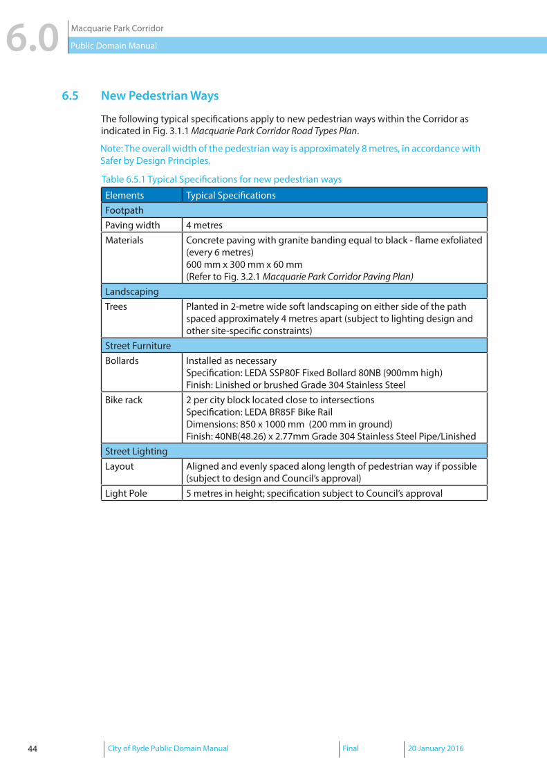
6.5 New Pedestrian Ways
The following typical specifications apply to new pedestrian ways within the Corridor as indicated in Fig. 3.1.1 Macquarie Park Corridor Road Types Plan.
Elements Typical SpecificationsFootpathPaving width 4 metresMaterials Concrete paving with granite banding equal to black - flame exfoliated
(every 6 metres)600 mm x 300 mm x 60 mm(Refer to Fig. 3.2.1 Macquarie Park Corridor Paving Plan)
LandscapingTrees Planted in 2-metre wide soft landscaping on either side of the path
spaced approximately 4 metres apart (subject to lighting design and other site-specific constraints)
Street FurnitureBollards Installed as necessary
Specification: LEDA SSP80F Fixed Bollard 80NB (900mm high)Finish: Linished or brushed Grade 304 Stainless Steel
Bike rack 2 per city block located close to intersectionsSpecification: LEDA BR85F Bike Rail Dimensions: 850 x 1000 mm (200 mm in ground)Finish: 40NB(48.26) x 2.77mm Grade 304 Stainless Steel Pipe/Linished
Street LightingLayout Aligned and evenly spaced along length of pedestrian way if possible
(subject to design and Council’s approval)Light Pole 5 metres in height; specification subject to Council’s approval
Table 6.5.1 Typical Specifications for new pedestrian ways
Note: The overall width of the pedestrian way is approximately 8 metres, in accordance with Safer by Design Principles.

City of Ryde Public Domain Manual Final 20 January 2016 45
Macquarie Park Corridor 6.0Public Domain Manual
Figure 6.5.1 Typical Layout - New Pedestrian Ways (NOT TO SCALE)

46 City of Ryde Public Domain Manual Final 20 January 2016
Macquarie Park Corridor6.0 Public Domain Manual
6.6.1 Existing Streets - Delhi Road and Epping RoadEpping Road and Delhi Road are characterised by very wide verges in some locations and
are both part of regional cycle routes. A consistent footpath width of at least 2.4 metres is
required, with wider paved areas at bus stops and intersections in order to accommodate
commuters and pedestrians waiting for traffic signals. This will also provide sufficient space
for street furniture, kerb ramps, lightng, and bicycle racks.
Elements Typical SpecificationsFootpathPaved footpath Full width at intersections and bus stops; 2.4-metre wide pavingMaterials Granite paving equal to black - flame exfoliated
600 mm x 300 mm x 60 mm(Refer to Fig. 3.2.1 Macquarie Park Corridor Paving Plan)
Kerb Integral cast-in-situ concrete kerb and gutter; kerb ramp to be designed in accordance with desire lines, safety, and conflict zones (subject to Council’s approval)
Driveway Granite paving equal to black - flame exfoliated150 mm x 100 mm x 60 mm
LandscapingStreet Trees Epping Road
Native grass species in nature strip and trees within the 1.5-metre private property setback
Delhi RoadTrees planted approximately 4 metres apart in continuous garden beds
(Refer to Fig. 3.4.1 Macquarie Park Corridor Street Trees Plan and typical layout diagram)
Nature Strip/ Garden beds
Native grass species such as Lomandra Longifolia (‘Tanika’ Spiny-head Mat Rush) or Dianella caerulea (Blueberry lily)(subject to Council and RMS approval)
Street FurnitureBollards Installed as necessary
Specification: LEDA SSP80F Fixed Bollard 80NB (900mm high)Finish: Linished or brushed Grade 304 Stainless Steel
Bike rack 2 per city block located close to intersectionsSpecification: LEDA BR85F Bike Rail Dimensions: 850 x 1000 mm (200 mm in ground)Finish: 40NB(48.26) x 2.77mm Grade 304 Stainless Steel Pipe/Linished
Street LightingLayout Refer to Street Lighting Schema for the Macquarie Park Business Area (to
be confirmed by Council)Multi-function light pole
12 metres in height; refer to Design Guide for Council-owned Street Lighting for specification
Table 6.6.1.1 Typical Specifications for Delhi Road and Epping Road

City of Ryde Public Domain Manual Final 20 January 2016 47
Macquarie Park Corridor 6.0Public Domain Manual
min
min
Figure 6.6.1.1 Epping Road Layout (northern side) - typically 40 metres wide (NOT TO SCALE)

48 City of Ryde Public Domain Manual Final 20 January 2016
Macquarie Park Corridor6.0 Public Domain Manual
4.35
m
Figure 6.6.1.2 Delhi Road Layout - typically 30 metres wide (NOT TO SCALE)
Note: Break in trees/garden beds to be located as necessary (approximately every 20 metres)

City of Ryde Public Domain Manual Final 20 January 2016 49
Macquarie Park Corridor 6.0Public Domain Manual
6.6.2 Existing Streets - Mixed Use, Commercial, or Business CharacterThe following typical specifications apply to existing streets in the Mixed Use, Commercial Core, and Business Park zones within the Corridor.
Elements Typical SpecificationsFootpathPaved footpath Full width: varies between approximately 2.4 to 5 metresMaterials Granite paving equal to black - flame exfoliated
600 mm x 300 mm x 60 mm(Refer to Fig. 3.2.1 Macquarie Park Corridor Paving Plan)
Kerb Integral cast-in-situ concrete kerb and gutter; kerb ramp to be designed in accordance with desire lines, safety, and conflict zones (subject to Council’s approval)
Driveway Granite paving equal to black - flame exfoliated150 mm x 100 mm x 60 mm
Street Trees and LandscapingHerring Road Trees planted in nature strip (approximately 8 metres apart ) with native
grass understorey such as Lomandra Longifolia (‘Tanika’ Spiny-head Mat Rush) or Dianella caerulea (Blueberry lily)(subject to lighting design and Council’s approval)
Lane Cove Road
Trees within 1.5 metre private property setback only (subject to lighting design and other site-specific constraints)
Waterloo/Secondary Roads
Trees planted in 1.5 x 3 m pits spaced approximately 8 metres apart(subject to lighting design and other site-specific constraints)
Tertiary Roads Trees planted in nature strip (approximately 8 metres apart ) with native grass understorey (subject to lighting design and Council’s approval)
Street FurnitureSeats 1 per city block; located near a point of interest
Specification: Botton and Gardiner Urban Seat (US11ALX)Finish: Cast aluminium; powder coat
Bins In regular intervals, typically 1 per city block and at certain locations such as outside train stations, bus stops, and outside shops (particularly food shops).Specification: City of Ryde model dual rubbish bins with butt binDimensions: 2 x 120 L; 15 mm perforationsFinish: Marine-grade stainless steel; mounts to Council specification
Bollards Installed as necessarySpecification: LEDA SSP80F Fixed Bollard 80NB (900mm high)Finish: Linished or brushed Grade 304 Stainless Steel
Bike rack 2 per city block located close to intersections or bus stops Specification: LEDA BR85F Bike Rail Dimensions: 850 x 1000 mm (200 mm in ground)Finish: 40NB(48.26) x 2.77mm Grade 304 Stainless Steel Pipe/Linished
Street LightingLayout Spaced 40 metres apart; staggered configuration (subject to design)Multi-function light pole
12 metres in height; refer to Design Guide for Council-owned Street Lighting for specification
Table 6.6.2.1 Typical Specifications for Existing Mixed Use/Commercial/Business Character Streets

50 City of Ryde Public Domain Manual Final 20 January 2016
Macquarie Park Corridor6.0 Public Domain Manual
Figure 6.6.2.1 Typical Layout - Mixed Use, Commercial, or Business Character Street (NOT TO SCALE) e.g. Waterloo Road - Typically 30 metres wide
Note: Street trees to be located where appropriate (subject to lighting design and infrastructure).
Use Citygreen Stratavault or similar to protect infrastructure services.

City of Ryde Public Domain Manual Final 20 January 2016 51
Macquarie Park Corridor 6.0Public Domain Manual
Figure 6.6.2.2 Typical Layout - Mixed Use, Commercial, or Business Character Street (NOT TO SCALE) e.g. Lane Cove Road - Typically 30 metres wide
2.0 - 4.0m 2.0 - 4.0m

52 City of Ryde Public Domain Manual Final 20 January 2016
Macquarie Park Corridor6.0 Public Domain Manual
Figure 6.6.2.3 Typical Layout - Mixed Use, Commercial, or Business Character Street (NOT TO SCALE) e.g. Herring Road - Typically 30 metres wide

City of Ryde Public Domain Manual Final 20 January 2016 53
Macquarie Park Corridor 6.0Public Domain Manual
Figure 6.6.2.4 Typical Layout - Mixed Use, Commercial, or Business Character Street (NOT TO SCALE) Secondary Road - Typically 20 metres wide

54 City of Ryde Public Domain Manual Final 20 January 2016
Macquarie Park Corridor6.0 Public Domain Manual
Figure 6.6.2.5 Typical Layout - Mixed Use, Commercial, or Business Character Street (NOT TO SCALE) e.g. Tertiary Road - Julius Avenue - typically 12 to 18 metres in wide
1.2m0.8m
1.2mto up
to 2.4mto up
to 2.4m
0.8m
to upto 2.4m
1.2mto up
to 2.4m
1.2m

City of Ryde Public Domain Manual Final 20 January 2016 55
Macquarie Park Corridor 6.0Public Domain Manual
6.6.3 Existing Streets - Residential Character
The following typical specifications apply to existing streets with a predominantly residential character within the Corridor.
Elements Typical SpecificationsFootpathPaved footpath Up to 2.4 metres (varies)
(Refer to typical layout diagram)Materials Granite paving equal to black - flame exfoliated
600 mm x 300 mm x 60 mm(Refer to Fig. 3.2.1 Macquarie Park Corridor Paving Plan)
Kerb Integral cast-in-situ concrete kerb and gutter; kerb ramp to be designed in accordance with desire lines, safety, and conflict zones (subject to Council’s approval)
Driveway Granite paving equal to black - flame exfoliated150 mm x 100 mm x 60 mm
LandscapingStreet Trees To match existing; trees planted in 1.5 x 3 m pits spaced approximately 8
metres apart (subject to lighting design and other site-specific constraints)Nature Strip Native grass species such as Lomandra Longifolia (‘Tanika’ Spiny-head Mat
Rush) or Dianella caerulea (Blueberry lily)(subject to Council’s approval)
Street FurnitureBollards Installed as necessary
Specification: LEDA SSP80F Fixed Bollard 80NB (900mm high)Finish: Linished or brushed Grade 304 Stainless Steel
Bike rack 2 per city block located close to intersections or bus stops Specification: LEDA BR85F Bike Rail Dimensions: 850 x 1000 mm (200 mm in ground)Finish: 40NB(48.26) x 2.77mm Grade 304 Stainless Steel Pipe/Linished
Street LightingLayout Stagerred configuration; refer to Street Lighting Schema for the Macquarie
Park Business Area (subject to design and to be confirmed by Council)Multi-function light pole
9 metres in height; refer to Design Guide for Council-owned Street Lighting for specification
Table 6.6.3.1 Typical Specifications for Existing Residential Character Streets

56 City of Ryde Public Domain Manual Final 20 January 2016
Macquarie Park Corridor6.0 Public Domain Manual
Figure 6.6.3.1 Typical Layout - Residential Character Street - typically 20 metres wide (NOT TO SCALE)

City of Ryde Public Domain Manual Final 20 January 2016 57
Macquarie Park Corridor 6.0Public Domain Manual
THIS PAGE HAS BEEN INTENTIONALLY LEFT BLANK
City of RydeCivic Centre1 Devlin StreetRyde NSW 2112
www.ryde.nsw.gov.au