Embed Size (px)
Citation preview
Macquarie University Macquarie University Central Courtyard Precinct Stormwater Management Strategy Planning Submission – SSDA
S_0-INFR-CV-RP-101
3 | 16 November 2017
This report takes into account the particular instructions and requirements of our client.
It is not intended for and should not be relied upon by any third party and no responsibility is undertaken to any third party. Job number 251278
Arup Arup Pty Ltd ABN 18 000 966 165
Arup Level 10 201 Kent Street PO Box 76 Millers Point Sydney 2000 Australia www.arup.com
S_0-INFR-CV-RP-101 | 3 | 16 November 2017 | Arup \\GLOBAL.ARUP.COM\AUSTRALASIA\SYD\PROJECTS\251000\251278-00 MAC UNI CENTRAL\WORK\INTERNAL\REPORTS\0 _PRECINCT INFRASTRUCTURE\#. SSDA & REF REPORT\STORMWATER MANAGEMENT STRATEGY REPORT - SSDA.DOCX
Document Verification
Job title Macquarie University Central Courtyard Precinct Job number
251278 Document title Stormwater Management Strategy Planning
Submission – SSDA
File reference
Document ref S_0-INFR-CV-RP-101 Revision Date Filename Stormwater Management Strategy Planning Submission –
SSDA.docx 1 20 Oct
2017 Description Draft issue for planning review
Prepared by Checked by Approved by
Name Mika Reinhardt N/A N/A
Signature 2 31 Oct
17 Filename Stormwater Management Strategy Planning Submission – SSDA rev2.docx
Description Issued for planning
Prepared by Checked by Approved by
Name Mika Reinhardt Duncan Crook Duncan Crook
Signature 3 16 Nov
17 Filename Stormwater Management Strategy Planning Submission – SSDA rev3.docx
Description Minor updates following review by Ethos Urban
Prepared by Checked by Approved by
Name Mika Reinhardt Duncan Crook Duncan Crook
Signature Filename
Description
Prepared by Checked by Approved by
Name
Signature Issue Document Verification with Document
Macquarie University Macquarie University Central Courtyard Precinct Stormwater Management Strategy Planning Submission – SSDA
S_0-INFR-CV-RP-101 | 3 | 16 November 2017 | Arup \\GLOBAL.ARUP.COM\AUSTRALASIA\SYD\PROJECTS\251000\251278-00 MAC UNI CENTRAL\WORK\INTERNAL\REPORTS\0 _PRECINCT INFRASTRUCTURE\#. SSDA & REF REPORT\STORMWATER MANAGEMENT STRATEGY REPORT - SSDA.DOCX
Contents Page
Glossary 1
1 Introduction 2
1.1 Project Description 2 1.2 Scope of this Report 6 1.3 Planning & Design Objectives 6 1.4 Arup’s Approach 7 1.5 Reference Documents 9
2 Existing Stormwater Management 10
2.1 Flood Risk 10 2.2 Stormwater Infrastructure 16 2.3 Stormwater Quality 17 2.4 On Site Detention 18
3 Overarching Strategy 19
4 Proposed Precinct 23
4.1 Potential Flood Affectation 23 4.2 Precinct Stormwater Drainage 26 4.3 Water Quality 28 4.4 On Site Detention 30
5 Proposed Mars Creek Modifications 31
5.1 Mars Creek Masterplan 31 5.2 Modifications 31 5.3 Flood Modelling Results and Effectiveness 37
6 Design interfaces 43
7 Erosion and Sediment Control 44
8 Conclusions 45
9 Recommendations for Further Works 46
Appendices
Appendix A
Flood Modelling Details

Macquarie University Macquarie University Central Courtyard Precinct Stormwater Management Strategy Planning Submission – SSDA
S_0-INFR-CV-RP-101 | 3 | 16 November 2017 | Arup \\GLOBAL.ARUP.COM\AUSTRALASIA\SYD\PROJECTS\251000\251278-00 MAC UNI CENTRAL\WORK\INTERNAL\REPORTS\0 _PRECINCT INFRASTRUCTURE\#. SSDA & REF REPORT\STORMWATER MANAGEMENT STRATEGY REPORT - SSDA.DOCX
Appendix B
Flood Maps
Appendix C
Mars Creek Options Assessment
Appendix D
Erosion and Sediment Control Plan and Details
Appendix E
Stormwater Drainage Plans
Macquarie University Macquarie University Central Courtyard Precinct Stormwater Management Strategy Planning Submission – SSDA
S_0-INFR-CV-RP-101 | 3 | 16 November 2017 | Arup \\GLOBAL.ARUP.COM\AUSTRALASIA\SYD\PROJECTS\251000\251278-00 MAC UNI CENTRAL\WORK\INTERNAL\REPORTS\0 _PRECINCT INFRASTRUCTURE\#. SSDA & REF REPORT\STORMWATER MANAGEMENT STRATEGY REPORT - SSDA.DOCX
Page 1
Glossary 1CC 1 Central Courtyard
ARI Annual Recurrence Interval
DCP Development Control Plan
DP&E Department of Planning and Environment
EP&A Act Environmental Planning and Assessment Act 1979
ESCP Erosion and Sediment Control Plan
GPT Gross Pollutant Trap
LEP Local Environmental Plan
LGA Local Government Area
MU Macquarie University
MUCCP Macquarie University Central Courtyard Precinct
MUMM Macquarie University Master Model
OSD On Site Detention
RCBC Reinforced Concrete Box Culvert
SEARS Secretary’s Environmental Assessment Requirements (Section 78A(8A) of the Environmental Planning and Assessment Act)
SSDA State Significant Development Application
WSUD Water Sensitive Urban Design
\\GLOBAL.ARUP.COM\AUSTRALASIA\SYD\PROJECTS\251000\251278-00 MAC UNI CENTRAL\WORK\INTERNAL\REPORTS\0 _PRECINCT INFRASTRUCTURE\#. SSDA & REF REPORT\EXECUTIVE SUMMARY - STORMWATER MANAGEMENT STRATEGY SSDA.DOCX
Arup Arup Pty Ltd ABN 18 000 966 165
Your ref Our ref 251278 File ref
Level 10 201 Kent Street PO Box 76 Millers Point
Sydney 2000 Australia
t +61 2 9320 9320 d +61 2 9320 9688 f +61 2 9320 9321
[email protected] www.arup.com
For the attention of Macquarie University c/o: - Ethos Urban
31 October 2017
Dear Sir/Madam
Macquarie University Central Courtyard Precinct (MUCCP) State Significant Planning Application (SSDA) Stormwater Management Strategy - Executive Summary
Arup’s stormwater management strategy report summarises a substantial body of work in relation to the proposed MUCCP development. The MUCCP is located in close proximity to a known flood affected area. The stormwater management strategy report presents an integrated storm water strategy considering localised overland flooding from the MUCCP and mainstream flooding from the adjacent Mars Creek.
The report describes stakeholder consultation, options analysis, design development and documentation. The approach presented addresses flood risk management, in-ground stormwater drainage infrastructure, grading of the site to manage surface runoff and strategies for improving water quality in the context of the SSDA.
The design strategies and details presented in this report aims to satisfy several primary objectives associated with the SSDA as follows:
Demonstrate to NSW Department of Planning that appropriate consideration has been given to the management of stormwater and the associated risks of flooding both within and surrounding the Macquarie University campus
Satisfy the relevant sections of the City of Ryde Council’s Development Control Plan (2014), in particular Part 8.2: Stormwater and Floodplain Management. A key objective is to mitigate any adverse off-site upstream or downstream flood impacts
Provide adequate collection, conveyance and discharge of rainfall within the development precinct and runoff from upstream areas. Replace and augment existing, poorly performing infrastructure
To deliver well considered and designed drainage infrastructure that is appropriate for the design life of the development and which can be readily maintained
The proposed drainage infrastructure will provide a suitable level of flood risk protection to the proposed precinct including consideration of flood planning levels for proposed and existing buildings
251278 31 October 2017 Page 2 of 2
\\GLOBAL.ARUP.COM\AUSTRALASIA\SYD\PROJECTS\251000\251278-00 MAC UNI CENTRAL\WORK\INTERNAL\REPORTS\0 _PRECINCT INFRASTRUCTURE\#. SSDA & REF REPORT\EXECUTIVE SUMMARY - STORMWATER MANAGEMENT STRATEGY SSDA.DOCX
Provide good water quality outcomes through the use of integrated drainage within soft landscaping in keeping with the principles of Water Sensitive Urban Design (WSUD)
Seek to integrate rainwater harvesting and reduce the precinct’s potable water demands in keeping with the sustainability drivers adopted as part of this development
Provide excellent visual and environmental amenity as the proposed approach will introduce significant changes to Macquarie Lake and the surrounding grounds
Considers the management of sediment and scour risk in the temporary condition during construction and provides a strategy for the control of erosion and deposition
Whilst these objectives are challenging, they are nevertheless considered mutually compatible and achievable with the use of creative design solutions. Arup has worked hard to develop a considered overarching stormwater management strategy that addresses the campus catchment as a whole as well as the Mars Creek and MUCCP areas independently for the purposes of the two separate planning pathways. Should you have any questions regarding the proposals, please do not hesitate to contact me. Yours faithfully
Duncan Crook Associate
Macquarie University Macquarie University Central Courtyard Precinct Stormwater Management Strategy Planning Submission – SSDA
S_0-INFR-CV-RP-101 | 3 | 16 November 2017 | Arup \\GLOBAL.ARUP.COM\AUSTRALASIA\SYD\PROJECTS\251000\251278-00 MAC UNI CENTRAL\WORK\INTERNAL\REPORTS\0 _PRECINCT INFRASTRUCTURE\#. SSDA & REF REPORT\STORMWATER MANAGEMENT STRATEGY REPORT - SSDA.DOCX
Page 2
1 Introduction This report supports a State Significant Development Application (SSDA) submitted to the Department of Planning and Environment (DP&E) pursuant to Part 4 of the Environmental Planning and Assessment Act 1979 (EP&A Act).
Macquarie University (MU) is seeking development consent for the first phase of the Macquarie University Central Courtyard Precinct (MUCCP) redevelopment. Under this application, consent is sought for redevelopment of Building C10A, construction of two student accommodation buildings (Buildings R1 and R2) and redevelopment of the landscaped Central Courtyard.
To the north of the proposed MUCCP is Mars Creek, an existing creek which runs through the MU campus from Epping Road on the south western side to Talavera Road on the north eastern side. Arup is aware of flooding impacts associated with Mars Creek on the existing site of the proposed MUCCP development. For this reason a detailed site specific flooding risk assessment has been undertaken for both Mars Creek and more generally as part of the MUCCP project and is discussed in this report.
1.1 Project Description
1.1.1 Background MU is a teaching and research institution of international, national and state significance. It is ranked among the top two per cent of universities in the world and holds a 5-star QS rating. MU is renowned for its innovative research and its commercial partnerships, with more than 100 leading companies located on Campus or in the surrounding Macquarie Park high-tech precinct.
The University was founded in 1964 and has since grown into a large research university with over 30,000 students and 3,000 staff. More than $1 billion has recently been invested in MU facilities and infrastructure to ensure students and staff can thrive in an inspiring and technologically advanced learning environment.
In March 2014, MU adopted the ‘Macquarie University Campus Master Plan 2014’. The Master Plan builds on the approved MU Concept Plan 2009 and sets out the physical framework to accommodate the University’s predicted needs, while ensuring flexibility into the future and enhancing the existing qualities of the University’s campus. Ongoing changes in teaching methodologies, new course opportunities, a desire to increase industry engagement and the potential for commercial opportunities on the Campus were all key considerations in the development of the Master Plan.
The increased utilisation of Mars Creek as a primary and secondary space is also a focus in the Master Plan with recommendations to rehabilitate a portion of the creek with a modified watercourse. A feasibility plan of the proposed modified watercourse was developed for MU by Storm Consulting in 2013.
Macquarie University Macquarie University Central Courtyard Precinct Stormwater Management Strategy Planning Submission – SSDA
S_0-INFR-CV-RP-101 | 3 | 16 November 2017 | Arup \\GLOBAL.ARUP.COM\AUSTRALASIA\SYD\PROJECTS\251000\251278-00 MAC UNI CENTRAL\WORK\INTERNAL\REPORTS\0 _PRECINCT INFRASTRUCTURE\#. SSDA & REF REPORT\STORMWATER MANAGEMENT STRATEGY REPORT - SSDA.DOCX
Page 3
The north west area of the proposed MUCCP site has previously experienced flooding impacts with MU Property staff having witnessed “… water up to the top of car windows” in the car park adjacent to Gymnasium Road during large storm events. These impacts were quantified in a Macquarie Park catchment wide flood study commissioned by the City of Ryde Council in 2008. The report, Macquarie Park Floodplain Risk Management Study & Plan, 2010, was produced by Bewsher Consulting.
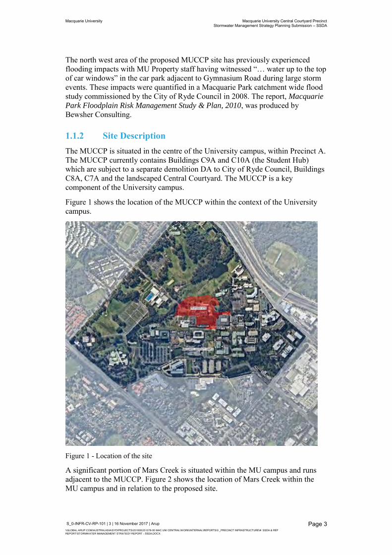
1.1.2 Site Description The MUCCP is situated in the centre of the University campus, within Precinct A. The MUCCP currently contains Buildings C9A and C10A (the Student Hub) which are subject to a separate demolition DA to City of Ryde Council, Buildings C8A, C7A and the landscaped Central Courtyard. The MUCCP is a key component of the University campus.
Figure 1 shows the location of the MUCCP within the context of the University campus.
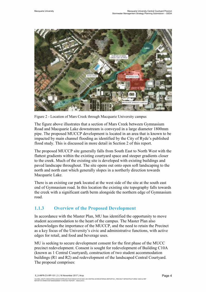
Figure 1 - Location of the site
A significant portion of Mars Creek is situated within the MU campus and runs adjacent to the MUCCP. Figure 2 shows the location of Mars Creek within the MU campus and in relation to the proposed site.
Macquarie University Macquarie University Central Courtyard Precinct Stormwater Management Strategy Planning Submission – SSDA
S_0-INFR-CV-RP-101 | 3 | 16 November 2017 | Arup \\GLOBAL.ARUP.COM\AUSTRALASIA\SYD\PROJECTS\251000\251278-00 MAC UNI CENTRAL\WORK\INTERNAL\REPORTS\0 _PRECINCT INFRASTRUCTURE\#. SSDA & REF REPORT\STORMWATER MANAGEMENT STRATEGY REPORT - SSDA.DOCX
Page 4
Figure 2 - Location of Mars Creek through Macquarie University campus
The figure above illustrates that a section of Mars Creek between Gymnasium Road and Macquarie Lake downstream is conveyed in a large diameter 1800mm pipe. The proposed MUCCP development is located in an area that is known to be impacted by main channel flooding as identified by the City of Ryde’s published flood study. This is discussed in more detail in Section 2 of this report.
The proposed MUCCP site generally falls from South East to North West with the flattest gradients within the existing courtyard space and steeper gradients closer to the creek. Much of the existing site is developed with existing buildings and paved landscape throughout. The site opens out onto open soft landscaping to the north and north east which generally slopes in a northerly direction towards Macquarie Lake.
There is an existing car park located at the west side of the site at the south east end of Gymnasium road. In this location the existing site topography falls towards the creek with a significant earth berm alongside the northern edge of Gymnasium road.
1.1.3 Overview of the Proposed Development In accordance with the Master Plan, MU has identified the opportunity to move student accommodation to the heart of the campus. The Master Plan also acknowledges the importance of the MUCCP, and the need to retain the Precinct as a key focus of the University’s civic and administrative functions, with active edges for retail, and food and beverage uses.
MU is seeking to secure development consent for the first phase of the MUCC precinct redevelopment. Consent is sought for redevelopment of Building C10A (known as 1 Central Courtyard), construction of two student accommodation buildings (R1 and R2) and redevelopment of the landscaped Central Courtyard. The proposal comprises:
Macquarie University Macquarie University Central Courtyard Precinct Stormwater Management Strategy Planning Submission – SSDA
S_0-INFR-CV-RP-101 | 3 | 16 November 2017 | Arup \\GLOBAL.ARUP.COM\AUSTRALASIA\SYD\PROJECTS\251000\251278-00 MAC UNI CENTRAL\WORK\INTERNAL\REPORTS\0 _PRECINCT INFRASTRUCTURE\#. SSDA & REF REPORT\STORMWATER MANAGEMENT STRATEGY REPORT - SSDA.DOCX
Page 5
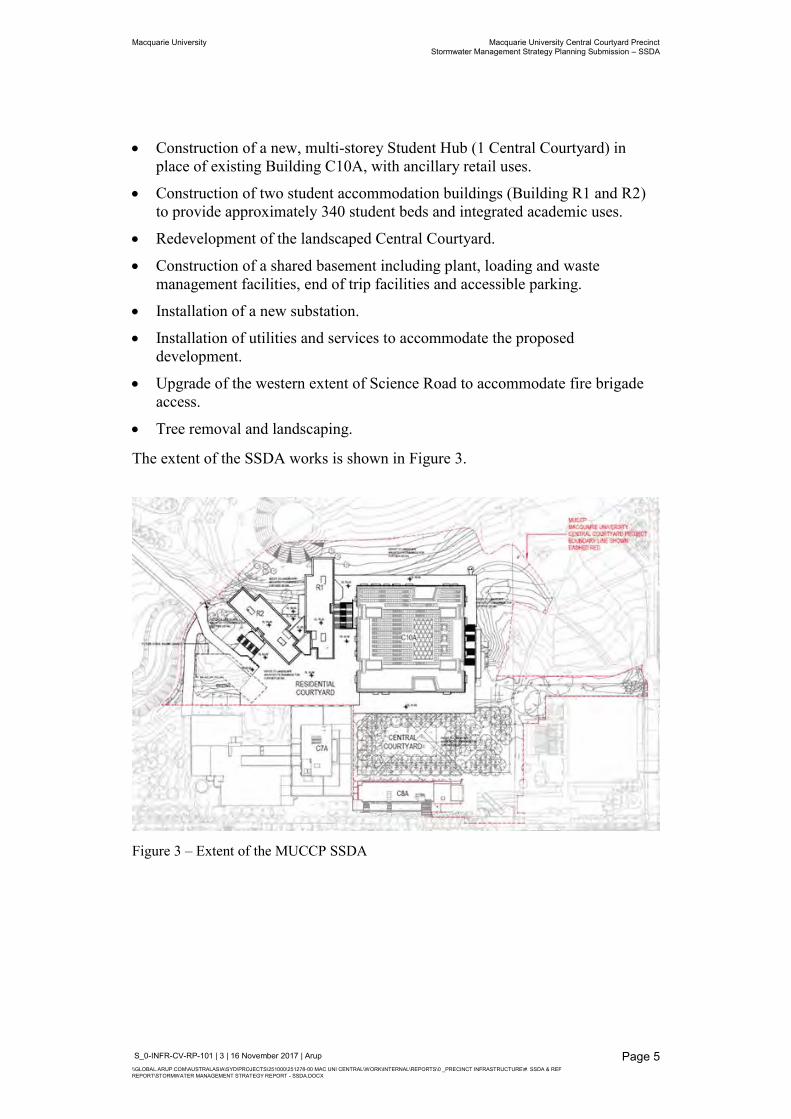
Construction of a new, multi-storey Student Hub (1 Central Courtyard) in place of existing Building C10A, with ancillary retail uses.
Construction of two student accommodation buildings (Building R1 and R2) to provide approximately 340 student beds and integrated academic uses.
Redevelopment of the landscaped Central Courtyard.
Construction of a shared basement including plant, loading and waste management facilities, end of trip facilities and accessible parking.
Installation of a new substation.
Installation of utilities and services to accommodate the proposed development.
Upgrade of the western extent of Science Road to accommodate fire brigade access.
Tree removal and landscaping.
The extent of the SSDA works is shown in Figure 3.
Figure 3 – Extent of the MUCCP SSDA
Macquarie University Macquarie University Central Courtyard Precinct Stormwater Management Strategy Planning Submission – SSDA
S_0-INFR-CV-RP-101 | 3 | 16 November 2017 | Arup \\GLOBAL.ARUP.COM\AUSTRALASIA\SYD\PROJECTS\251000\251278-00 MAC UNI CENTRAL\WORK\INTERNAL\REPORTS\0 _PRECINCT INFRASTRUCTURE\#. SSDA & REF REPORT\STORMWATER MANAGEMENT STRATEGY REPORT - SSDA.DOCX
Page 6
1.2 Scope of this Report This report has been prepared to describe and document Arup’s proposed strategy for stormwater management for the benefit of all stakeholders. The preparation of this strategy has involved several interdependent technical considerations as follows:
Flood risk management
Infrastructure to collect, convey and discharge stormwater
Stormwater quality
On-site detention and associated control of stormwater discharge from site
Sediment and erosion control measures during construction
In preparing this stormwater strategy report, due consideration has been given to the proximity of the proposed precinct to Mars Creek. As a consequence of flooding issues associated with the creek (described in Section 2.1 of this report) and the potential impacts on MUCCP, Arup have identified the need to develop an integrated stormwater management strategy which considers:
[1] The proposed Macquarie University Central Courtyard Precinct
[2] Associated modifications to Mars Creek
Consequently, this report presents the proposed overarching stormwater management strategy in two halves to address the items above separately. This is because from a technical perspective, the solutions are mutually dependent and integrated but they have been separated because of the planning pathways through which they are approved.
1.3 Planning & Design Objectives This report’s primary objective is to articulate the basis of the proposed stormwater management strategy and to demonstrate how the risks associated with rainfall and runoff will be managed to the satisfaction of Macquarie University, NSW Department of Planning and all associated stakeholders to which this planning application will be referred.
This includes the design requirements of the Local Government Area (LGA) - City of Ryde Council’s Development Control Plan (DCP 2014) and the associated Stormwater and Floodplain Management Technical Manual (accessed online Sep 2017). These requirements, together with the principles established in the NSW Floodplain Development Manual (2005) provide the most detailed criteria against which the MUCCP design performance will be assessed in the context of flood risk management including any off-site impacts.
Likewise, the provision of a new Ausgrid substation in relatively close proximity to the creek at the ground floor level of the building has also prompted mitigation of the risks associated with flood affection.
Macquarie University Macquarie University Central Courtyard Precinct Stormwater Management Strategy Planning Submission – SSDA
S_0-INFR-CV-RP-101 | 3 | 16 November 2017 | Arup \\GLOBAL.ARUP.COM\AUSTRALASIA\SYD\PROJECTS\251000\251278-00 MAC UNI CENTRAL\WORK\INTERNAL\REPORTS\0 _PRECINCT INFRASTRUCTURE\#. SSDA & REF REPORT\STORMWATER MANAGEMENT STRATEGY REPORT - SSDA.DOCX
Page 7
In addition to considering flood risk, this stormwater management strategy report aims to achieve the following:
To provide commentary on the design of new infrastructure associated with the development which will provide adequate collection, conveyance and discharge of rainfall within the precinct and runoff from upstream areas
To deliver well considered and designed drainage infrastructure that is appropriate for the design life of the development and which can be readily maintained
The proposed drainage infrastructure will provide a suitable level of flood risk protection to the proposed precinct
Provides good water quality outcomes through the use of soft landscaping in keeping with the principles of Water Sensitive Urban Design (WSUD)
Seek to integrate rainwater harvesting and reduce the precinct’s potable water demands in keeping with the sustainability drivers adopted as part of this development
Will provide excellent visual and environmental amenity as the proposed approach will introduce significant changes to Macquarie Lake and the surrounding grounds
Considers the management of sediment and scour risk in the temporary condition during construction and provides a strategy for the control of erosion and deposition
1.4 Arup’s Approach This structure of this report follows Arup’s approach to the project work which includes:
A review of the existing flooding and stormwater information in relation to the site
Refining City of Ryde’s flood model to create a project specific flood model for the MUCCP which includes both main channel flooding and overland flow
Assessment of the existing flood conditions and their potential impacts to the MUCCP
Identifying an overarching strategy to mitigate flood risk within the MU campus
Development of mitigation measures and options analysis
Development of precinct stormwater strategy and design of proposed infrastructure and integration with landscaping proposals including opportunities for Water Sensitive Urban Design (WSUD)
Preliminary hydraulic design and integration into flood model including assessment of effectiveness
Communicating key changes to the existing conditions and client consultation

Macquarie University Macquarie University Central Courtyard Precinct Stormwater Management Strategy Planning Submission – SSDA
S_0-INFR-CV-RP-101 | 3 | 16 November 2017 | Arup \\GLOBAL.ARUP.COM\AUSTRALASIA\SYD\PROJECTS\251000\251278-00 MAC UNI CENTRAL\WORK\INTERNAL\REPORTS\0 _PRECINCT INFRASTRUCTURE\#. SSDA & REF REPORT\STORMWATER MANAGEMENT STRATEGY REPORT - SSDA.DOCX
Page 8
Consideration of construction sequencing and sediment and erosion control
Documentation of the design proposals and performance
Identification of opportunities for further design development and ongoing improvement
Macquarie University Macquarie University Central Courtyard Precinct Stormwater Management Strategy Planning Submission – SSDA
S_0-INFR-CV-RP-101 | 3 | 16 November 2017 | Arup \\GLOBAL.ARUP.COM\AUSTRALASIA\SYD\PROJECTS\251000\251278-00 MAC UNI CENTRAL\WORK\INTERNAL\REPORTS\0 _PRECINCT INFRASTRUCTURE\#. SSDA & REF REPORT\STORMWATER MANAGEMENT STRATEGY REPORT - SSDA.DOCX
Page 9
1.5 Reference Documents Research and investigation presented in this report is based on information from a wide range of sources which include:
Macquarie University Design Guidelines
Macquarie University Master Plan 2014
Macquarie University Concept Plan 2009
Stormwater Management Plan & Utilities Management Plan (Rev. 1) prepared for Macquarie University, 16 June 2017, TTW
Floodplain Management Act 2005
Macquarie Park Floodplain Risk Management Study & Plan, 2010, Bewsher Consulting.
Mars Creek – Reach 3 Feasibility Plan, 2013, Storm Consulting
DBA Hydraulics existing services drawings. The services drawings are maintained by DBA Hydraulics and include information from survey and as-built drawings
NSW DP&E Secretary’s Environmental Assessment Requirements (SEARs) reference: 8875 dated: 13/10/17
City of Ryde Council DCP 2014
Part 8.2 Stormwater and Floodplain Management
Stormwater and Floodplain Technical Manual (accessed online Sep 2017)
Water Sensitive Urban Design Guidelines (accessed online Sep 2017)
Ausgrid specification NS141
Macquarie University Macquarie University Central Courtyard Precinct Stormwater Management Strategy Planning Submission – SSDA
S_0-INFR-CV-RP-101 | 3 | 16 November 2017 | Arup \\GLOBAL.ARUP.COM\AUSTRALASIA\SYD\PROJECTS\251000\251278-00 MAC UNI CENTRAL\WORK\INTERNAL\REPORTS\0 _PRECINCT INFRASTRUCTURE\#. SSDA & REF REPORT\STORMWATER MANAGEMENT STRATEGY REPORT - SSDA.DOCX
Page 10
2 Existing Stormwater Management
2.1 Flood Risk
2.1.1 Previous Flood Study The Macquarie Park Floodplain Risk Management Study & Plan – Flood Study Report was released in April 2010. The report was prepared by Bewsher Consulting and established design flood behaviour for four tributaries to the Lane Cove River that are located within the City of Ryde. The design rainfall temporal patterns were developed using standard techniques provided in Australian Rainfall and Runoff (AR&R) (Engineers Australia, 1987).
The purpose of the study was to identify flooding issues within the City of Ryde local government area (LGA). One of the tributaries investigated in the flood study was Mars Creek, which pertains to the current work. Arup has reviewed this flood study report as well as the accompanying TUFLOW model prepared by Bewsher as part of the works associated with the MUCCP project with prior permission from City of Ryde Council (correspondence with Guna Veerasingham, dated: 9th March 2017).
This literature review reveals the Mars Creek catchment area upstream of Macquarie Lake (including a proportion of the MU campus) covers an area of approximately 91 ha, which is bounded by Agincourt Road and Vimiera Road in the south west, Herring Road in the south east, and Culloden Road in the north-west. The catchment is a mixture of residential, mixed use and nature reserve.
The falls along Mars Creek are relatively steep, with an average gradient of approximately 1 in 10 from Epping Road to Gymnasium Road. At Gymnasium Road, Mars Creek is diverted into an 1800 mm diameter stormwater pipe for approximately 160 m where it outlets into a shallow, artificial channel of approximately 95m length before entering the lake. At the opposite end of the lake is a weir structure where flows overtop into the downstream channel and into an 1800 mm diameter stormwater culvert beneath Talavera Road.
Analysis of the existing flooding conditions within and immediately surround the MU campus and the MUCCP site is presented in Section 2.1.2.
2.1.2 Existing Flood Affectation – Mars Creek There are known flooding issues associated with Mars Creek within the MU campus and in proximity to the MUCCP development as identified in the Bewsher flood study and supported by anecdotal evidence provided by MU Property staff.
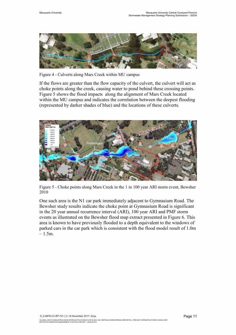
Mars Creek crosses beneath 4 roads and footbridges within the MU campus before reaching Macquarie Lake. Figure 4 shows these locations. At each of these points, the flows from the creek are conveyed through culverts situated beneath the roads.
Macquarie University Macquarie University Central Courtyard Precinct Stormwater Management Strategy Planning Submission – SSDA
S_0-INFR-CV-RP-101 | 3 | 16 November 2017 | Arup \\GLOBAL.ARUP.COM\AUSTRALASIA\SYD\PROJECTS\251000\251278-00 MAC UNI CENTRAL\WORK\INTERNAL\REPORTS\0 _PRECINCT INFRASTRUCTURE\#. SSDA & REF REPORT\STORMWATER MANAGEMENT STRATEGY REPORT - SSDA.DOCX
Page 11
Figure 4 - Culverts along Mars Creek within MU campus
If the flows are greater than the flow capacity of the culvert, the culvert will act as choke points along the creek, causing water to pond behind these crossing points. Figure 5 shows the flood impacts along the alignment of Mars Creek located within the MU campus and indicates the correlation between the deepest flooding (represented by darker shades of blue) and the locations of these culverts.
Figure 5 - Choke points along Mars Creek in the 1 in 100 year ARI storm event, Bewsher 2010
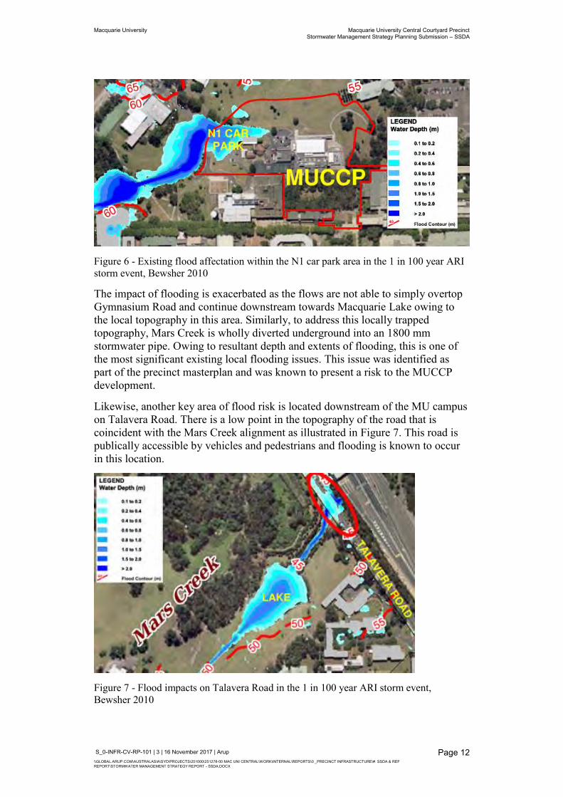
One such area is the N1 car park immediately adjacent to Gymnasium Road. The Bewsher study results indicate the choke point at Gymnasium Road is significant in the 20 year annual recurrence interval (ARI), 100 year ARI and PMF storm events as illustrated on the Bewsher flood map extract presented in Figure 6. This area is known to have previously flooded to a depth equivalent to the windows of parked cars in the car park which is consistent with the flood model result of 1.0m – 1.5m.
Macquarie University Macquarie University Central Courtyard Precinct Stormwater Management Strategy Planning Submission – SSDA
S_0-INFR-CV-RP-101 | 3 | 16 November 2017 | Arup \\GLOBAL.ARUP.COM\AUSTRALASIA\SYD\PROJECTS\251000\251278-00 MAC UNI CENTRAL\WORK\INTERNAL\REPORTS\0 _PRECINCT INFRASTRUCTURE\#. SSDA & REF REPORT\STORMWATER MANAGEMENT STRATEGY REPORT - SSDA.DOCX
Page 12
Figure 6 - Existing flood affectation within the N1 car park area in the 1 in 100 year ARI storm event, Bewsher 2010
The impact of flooding is exacerbated as the flows are not able to simply overtop Gymnasium Road and continue downstream towards Macquarie Lake owing to the local topography in this area. Similarly, to address this locally trapped topography, Mars Creek is wholly diverted underground into an 1800 mm stormwater pipe. Owing to resultant depth and extents of flooding, this is one of the most significant existing local flooding issues. This issue was identified as part of the precinct masterplan and was known to present a risk to the MUCCP development.
Likewise, another key area of flood risk is located downstream of the MU campus on Talavera Road. There is a low point in the topography of the road that is coincident with the Mars Creek alignment as illustrated in Figure 7. This road is publically accessible by vehicles and pedestrians and flooding is known to occur in this location.
Figure 7 - Flood impacts on Talavera Road in the 1 in 100 year ARI storm event, Bewsher 2010
Macquarie University Macquarie University Central Courtyard Precinct Stormwater Management Strategy Planning Submission – SSDA
S_0-INFR-CV-RP-101 | 3 | 16 November 2017 | Arup \\GLOBAL.ARUP.COM\AUSTRALASIA\SYD\PROJECTS\251000\251278-00 MAC UNI CENTRAL\WORK\INTERNAL\REPORTS\0 _PRECINCT INFRASTRUCTURE\#. SSDA & REF REPORT\STORMWATER MANAGEMENT STRATEGY REPORT - SSDA.DOCX
Page 13
2.1.3 Existing Flood Model Limitations In considering flooding, there are two principle types of affectation: mainstream (also known as fluvial) flooding and localised overland (also known as pluvial) flooding. Mainstream flooding is the result of overflows from the banks of creeks, rivers, lakes and dams. Overland flooding is the result of local rainfall and runoff and capacity issues in local stormwater networks. These are described in the City of Ryde Council DCP 2014.
For the Macquarie Park Floodplain Risk Management Study & Plan – Flood Study Report, 2010 which includes the portion of Mars Creek running through the MU campus, the Bewsher model aims to provide a commentary on the performance of the major creeks and rivers. The adopted approach involves the determination of simplified sub-catchment areas that drain to the creeks and rivers, estimating the flow hydrographs from each sub-catchment and applying these flow into input nodes situated along the creek.
This approach to flood modelling is rapid, but requires a number of simplifications and assumptions to be applied to the sub-catchments to account for the timing of the peak flows into the creek and can therefore be reliant on the judgement of the flood modeller. This approach is typically adopted where the flood modelling assessment aims to assess the performance of a whole catchment such as is the case for the Macquarie Park Floodplain Risk Management Study.
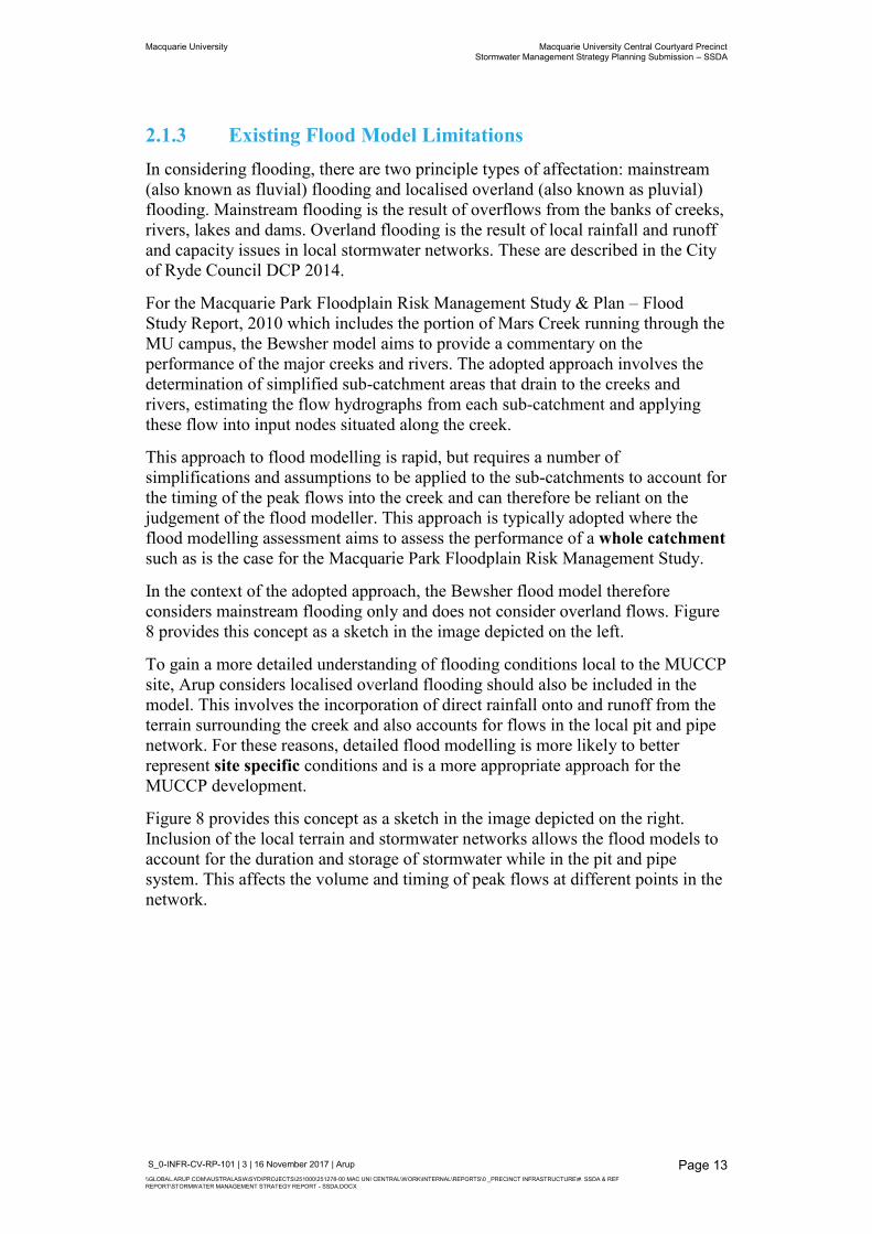
In the context of the adopted approach, the Bewsher flood model therefore considers mainstream flooding only and does not consider overland flows. Figure 8 provides this concept as a sketch in the image depicted on the left.
To gain a more detailed understanding of flooding conditions local to the MUCCP site, Arup considers localised overland flooding should also be included in the model. This involves the incorporation of direct rainfall onto and runoff from the terrain surrounding the creek and also accounts for flows in the local pit and pipe network. For these reasons, detailed flood modelling is more likely to better represent site specific conditions and is a more appropriate approach for the MUCCP development.
Figure 8 provides this concept as a sketch in the image depicted on the right. Inclusion of the local terrain and stormwater networks allows the flood models to account for the duration and storage of stormwater while in the pit and pipe system. This affects the volume and timing of peak flows at different points in the network.
Macquarie University Macquarie University Central Courtyard Precinct Stormwater Management Strategy Planning Submission – SSDA
S_0-INFR-CV-RP-101 | 3 | 16 November 2017 | Arup \\GLOBAL.ARUP.COM\AUSTRALASIA\SYD\PROJECTS\251000\251278-00 MAC UNI CENTRAL\WORK\INTERNAL\REPORTS\0 _PRECINCT INFRASTRUCTURE\#. SSDA & REF REPORT\STORMWATER MANAGEMENT STRATEGY REPORT - SSDA.DOCX
Page 14
Figure 8 - Visualisation of whole catchment and site specific flood modelling methods
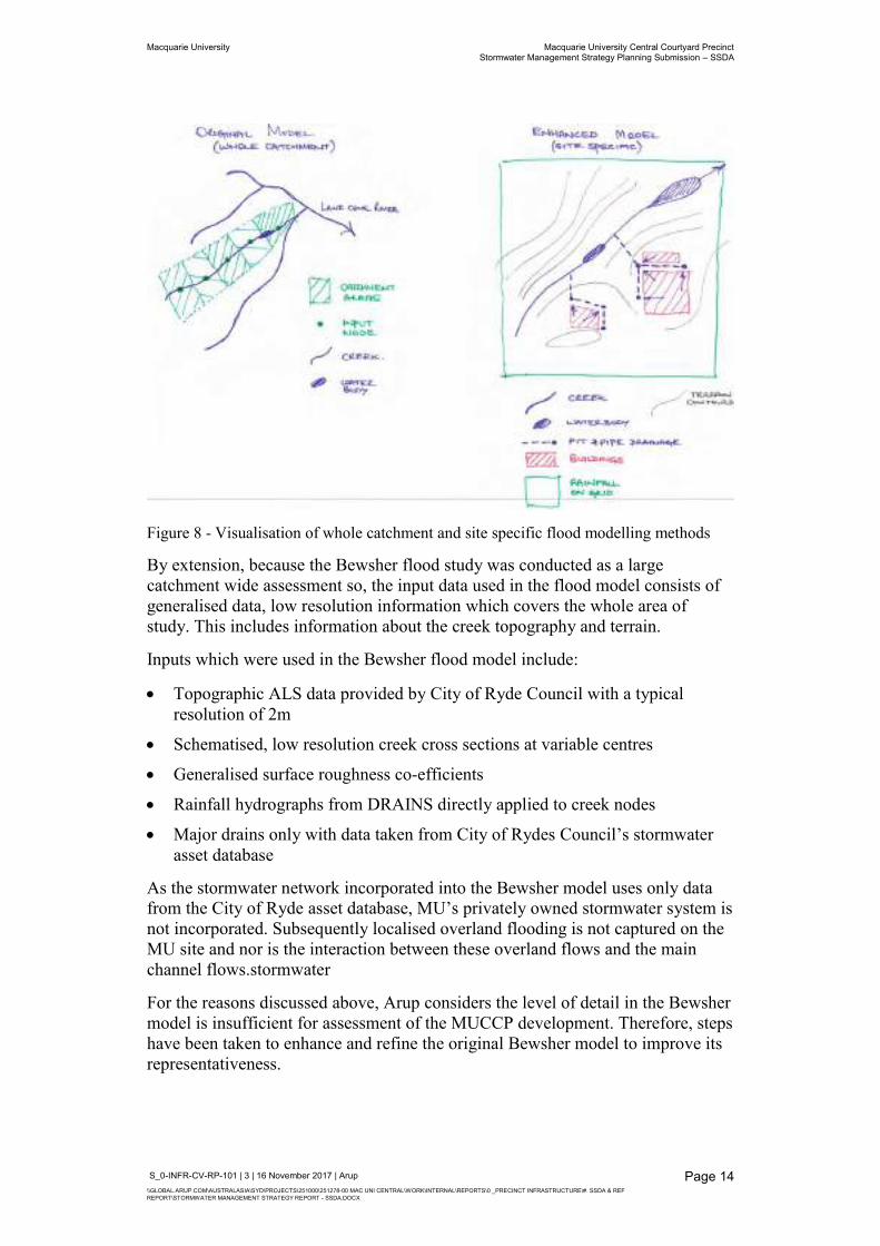
By extension, because the Bewsher flood study was conducted as a large catchment wide assessment so, the input data used in the flood model consists of generalised data, low resolution information which covers the whole area of study. This includes information about the creek topography and terrain.
Inputs which were used in the Bewsher flood model include:
Topographic ALS data provided by City of Ryde Council with a typical resolution of 2m
Schematised, low resolution creek cross sections at variable centres
Generalised surface roughness co-efficients
Rainfall hydrographs from DRAINS directly applied to creek nodes
Major drains only with data taken from City of Rydes Council’s stormwater asset database
As the stormwater network incorporated into the Bewsher model uses only data from the City of Ryde asset database, MU’s privately owned stormwater system is not incorporated. Subsequently localised overland flooding is not captured on the MU site and nor is the interaction between these overland flows and the main channel flows.stormwater
For the reasons discussed above, Arup considers the level of detail in the Bewsher model is insufficient for assessment of the MUCCP development. Therefore, steps have been taken to enhance and refine the original Bewsher model to improve its representativeness.
Macquarie University Macquarie University Central Courtyard Precinct Stormwater Management Strategy Planning Submission – SSDA
S_0-INFR-CV-RP-101 | 3 | 16 November 2017 | Arup \\GLOBAL.ARUP.COM\AUSTRALASIA\SYD\PROJECTS\251000\251278-00 MAC UNI CENTRAL\WORK\INTERNAL\REPORTS\0 _PRECINCT INFRASTRUCTURE\#. SSDA & REF REPORT\STORMWATER MANAGEMENT STRATEGY REPORT - SSDA.DOCX
Page 15
2.1.4 Arup Refined Existing Flood Model The Bewsher (2010) flood study TUFLOW hydraulic model and DRAINS hydrological model were provided to Arup to undertake the MUCCP flood assessment. A thorough review of the Bewsher DRAINS and TUFLOW models was undertaken to determine the suitability of the models for this project. A number of issues were identified as part of this review and which are summarised in Appendix A1.1.
Further to this review, the TUFLOW model was refined to provide a higher level of detail along Mars Creek and the MUCCP for the current flood assessment. Key refinements to the model include:
Incorporation of localised terrain using the detailed topographic survey undertaken by LTS Lockley in place of the cruder LiDAR survey to consider overland flow in the model
Improved estimation of the existing surface types extents and appropriate roughness values to represent infiltration and runoff
Enhanced resolution of the pit and pipe network within and upstream of the SSDA boundary
Incorporation of surveyed building footprints and downpipe connections to the pit and pipe network for enhanced sub-catchment definition
Utilisation of the rainfall on-grid method rather than the simplified hydrograph applied at node
Further refinements are outlined in Appendix A1.2. It is noted that the Arup refined flood model continues to use AR&R 1987 because it relies on the upstream flows and tailwater conditions predicted by the original Bewsher model and its associated calibration checks. In so doing, it is possible to directly compare the results of the refined model with the City of Ryde Council’s published model results which is in keeping with the approach outlined in the DCP.
Refining the model improves the representation of the site and therefore increases accuracy and reliability of the flood modelling results. This also allows for an accurate comparison of the effectiveness of the proposed solutions from both a drainage and a flood risk management perspective.
2.1.5 Existing Flood Affectation – Arup Refined Model The existing flood model was run for the following statistically significant design storm events:
1 in 20 year ARI
1 in 100 year ARI
1 in 100 year ARI + Climate Change (applied as a 10% uplift in keeping with the existing City of Ryde Council model)
Probable Maximum Flood (PMF)
Macquarie University Macquarie University Central Courtyard Precinct Stormwater Management Strategy Planning Submission – SSDA
S_0-INFR-CV-RP-101 | 3 | 16 November 2017 | Arup \\GLOBAL.ARUP.COM\AUSTRALASIA\SYD\PROJECTS\251000\251278-00 MAC UNI CENTRAL\WORK\INTERNAL\REPORTS\0 _PRECINCT INFRASTRUCTURE\#. SSDA & REF REPORT\STORMWATER MANAGEMENT STRATEGY REPORT - SSDA.DOCX
Page 16
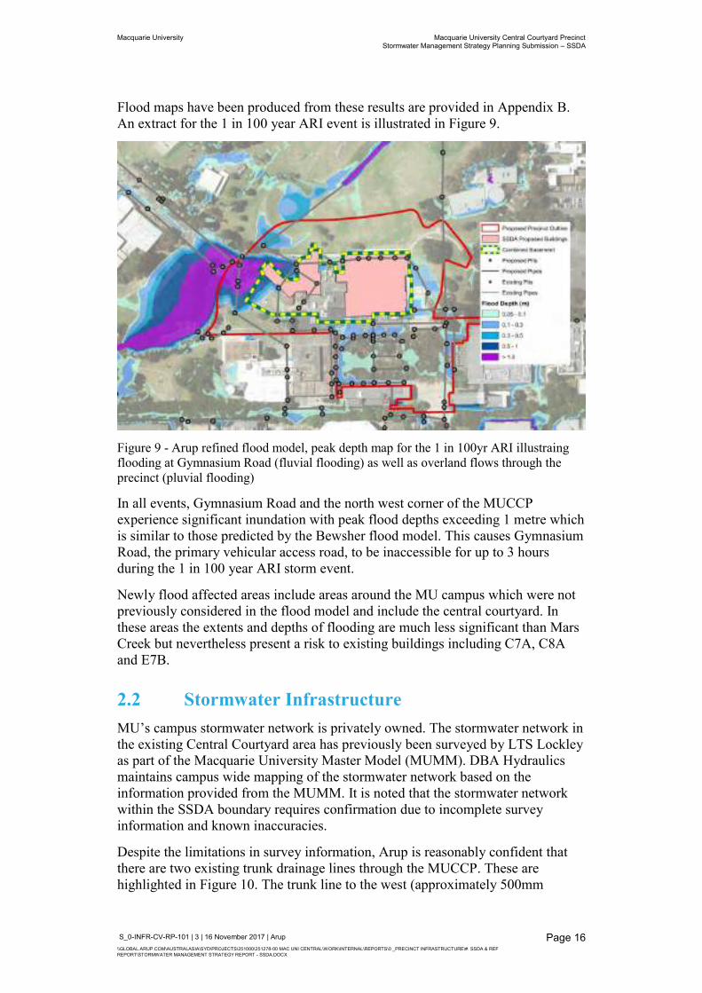
Flood maps have been produced from these results are provided in Appendix B. An extract for the 1 in 100 year ARI event is illustrated in Figure 9.
Figure 9 - Arup refined flood model, peak depth map for the 1 in 100yr ARI illustraing flooding at Gymnasium Road (fluvial flooding) as well as overland flows through the precinct (pluvial flooding)
In all events, Gymnasium Road and the north west corner of the MUCCP experience significant inundation with peak flood depths exceeding 1 metre which is similar to those predicted by the Bewsher flood model. This causes Gymnasium Road, the primary vehicular access road, to be inaccessible for up to 3 hours during the 1 in 100 year ARI storm event.
Newly flood affected areas include areas around the MU campus which were not previously considered in the flood model and include the central courtyard. In these areas the extents and depths of flooding are much less significant than Mars Creek but nevertheless present a risk to existing buildings including C7A, C8A and E7B.
2.2 Stormwater Infrastructure MU’s campus stormwater network is privately owned. The stormwater network in the existing Central Courtyard area has previously been surveyed by LTS Lockley as part of the Macquarie University Master Model (MUMM). DBA Hydraulics maintains campus wide mapping of the stormwater network based on the information provided from the MUMM. It is noted that the stormwater network within the SSDA boundary requires confirmation due to incomplete survey information and known inaccuracies.
Despite the limitations in survey information, Arup is reasonably confident that there are two existing trunk drainage lines through the MUCCP. These are highlighted in Figure 10. The trunk line to the west (approximately 500mm
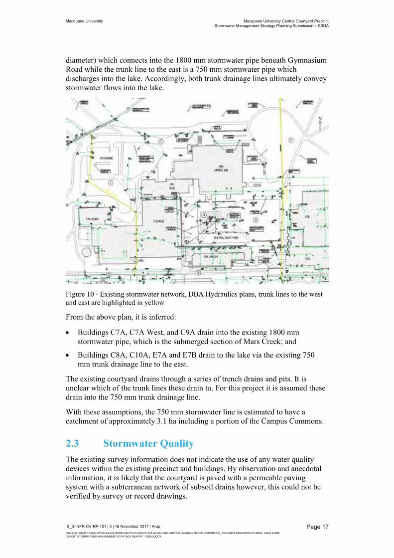
Macquarie University Macquarie University Central Courtyard Precinct Stormwater Management Strategy Planning Submission – SSDA
S_0-INFR-CV-RP-101 | 3 | 16 November 2017 | Arup \\GLOBAL.ARUP.COM\AUSTRALASIA\SYD\PROJECTS\251000\251278-00 MAC UNI CENTRAL\WORK\INTERNAL\REPORTS\0 _PRECINCT INFRASTRUCTURE\#. SSDA & REF REPORT\STORMWATER MANAGEMENT STRATEGY REPORT - SSDA.DOCX
Page 17
diameter) which connects into the 1800 mm stormwater pipe beneath Gymnasium Road while the trunk line to the east is a 750 mm stormwater pipe which discharges into the lake. Accordingly, both trunk drainage lines ultimately convey stormwater flows into the lake.
Figure 10 - Existing stormwater network, DBA Hydraulics plans, trunk lines to the west and east are highlighted in yellow
From the above plan, it is inferred:
Buildings C7A, C7A West, and C9A drain into the existing 1800 mm stormwater pipe, which is the submerged section of Mars Creek; and
Buildings C8A, C10A, E7A and E7B drain to the lake via the existing 750 mm trunk drainage line to the east.
The existing courtyard drains through a series of trench drains and pits. It is unclear which of the trunk lines these drain to. For this project it is assumed these drain into the 750 mm trunk drainage line.
With these assumptions, the 750 mm stormwater line is estimated to have a catchment of approximately 3.1 ha including a portion of the Campus Commons.
2.3 Stormwater Quality The existing survey information does not indicate the use of any water quality devices within the existing precinct and buildings. By observation and anecdotal information, it is likely that the courtyard is paved with a permeable paving system with a subterranean network of subsoil drains however, this could not be verified by survey or record drawings.
Macquarie University Macquarie University Central Courtyard Precinct Stormwater Management Strategy Planning Submission – SSDA
S_0-INFR-CV-RP-101 | 3 | 16 November 2017 | Arup \\GLOBAL.ARUP.COM\AUSTRALASIA\SYD\PROJECTS\251000\251278-00 MAC UNI CENTRAL\WORK\INTERNAL\REPORTS\0 _PRECINCT INFRASTRUCTURE\#. SSDA & REF REPORT\STORMWATER MANAGEMENT STRATEGY REPORT - SSDA.DOCX
Page 18
There is no information on existing water quality measures in the Stormwater Management Plan & Utilities Management Plan (Rev. 1) prepared by TTW (2017). It is currently not known how well the existing system performs in terms of water quality improvements.
2.4 On Site Detention The existing survey information does not indicate the use of on site detention (OSD) for the Central Courtyard, and Buildings C10A and C9A.
There is no information on existing OSD measures in the Stormwater Management Plan & Utilities Management Plan (Rev. 1) prepared by TTW (2017).
The lake, where the stormwater network outlets, acts as a retention basin only (i.e. it does not provide temporary detention of flow) and has an overflow weir at the eastern end. In storm events, flows are unrestricted and surge over the weir into the downstream creek.
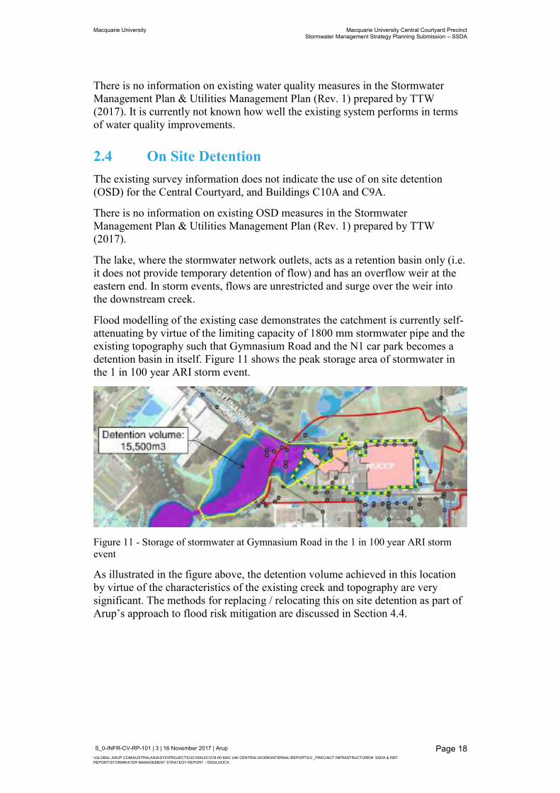
Flood modelling of the existing case demonstrates the catchment is currently self-attenuating by virtue of the limiting capacity of 1800 mm stormwater pipe and the existing topography such that Gymnasium Road and the N1 car park becomes a detention basin in itself. Figure 11 shows the peak storage area of stormwater in the 1 in 100 year ARI storm event.
Figure 11 - Storage of stormwater at Gymnasium Road in the 1 in 100 year ARI storm event
As illustrated in the figure above, the detention volume achieved in this location by virtue of the characteristics of the existing creek and topography are very significant. The methods for replacing / relocating this on site detention as part of Arup’s approach to flood risk mitigation are discussed in Section 4.4.
Macquarie University Macquarie University Central Courtyard Precinct Stormwater Management Strategy Planning Submission – SSDA
S_0-INFR-CV-RP-101 | 3 | 16 November 2017 | Arup \\GLOBAL.ARUP.COM\AUSTRALASIA\SYD\PROJECTS\251000\251278-00 MAC UNI CENTRAL\WORK\INTERNAL\REPORTS\0 _PRECINCT INFRASTRUCTURE\#. SSDA & REF REPORT\STORMWATER MANAGEMENT STRATEGY REPORT - SSDA.DOCX
Page 19
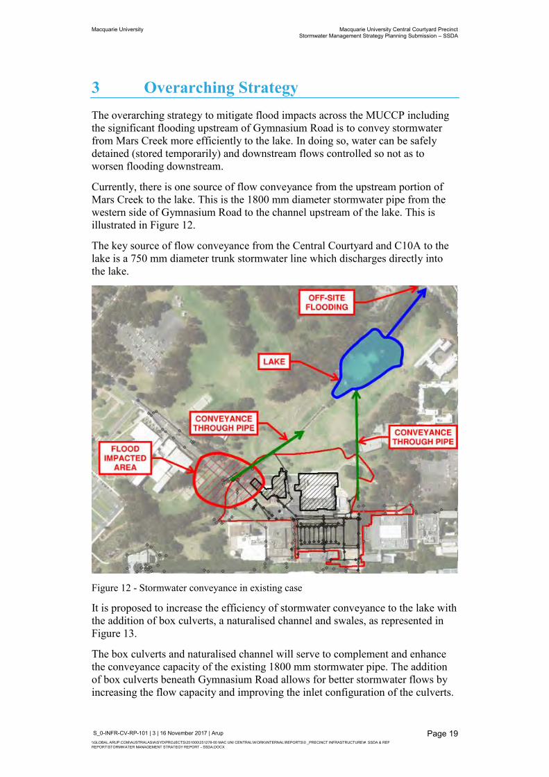
3 Overarching Strategy The overarching strategy to mitigate flood impacts across the MUCCP including the significant flooding upstream of Gymnasium Road is to convey stormwater from Mars Creek more efficiently to the lake. In doing so, water can be safely detained (stored temporarily) and downstream flows controlled so not as to worsen flooding downstream.
Currently, there is one source of flow conveyance from the upstream portion of Mars Creek to the lake. This is the 1800 mm diameter stormwater pipe from the western side of Gymnasium Road to the channel upstream of the lake. This is illustrated in Figure 12.
The key source of flow conveyance from the Central Courtyard and C10A to the lake is a 750 mm diameter trunk stormwater line which discharges directly into the lake.
Figure 12 - Stormwater conveyance in existing case
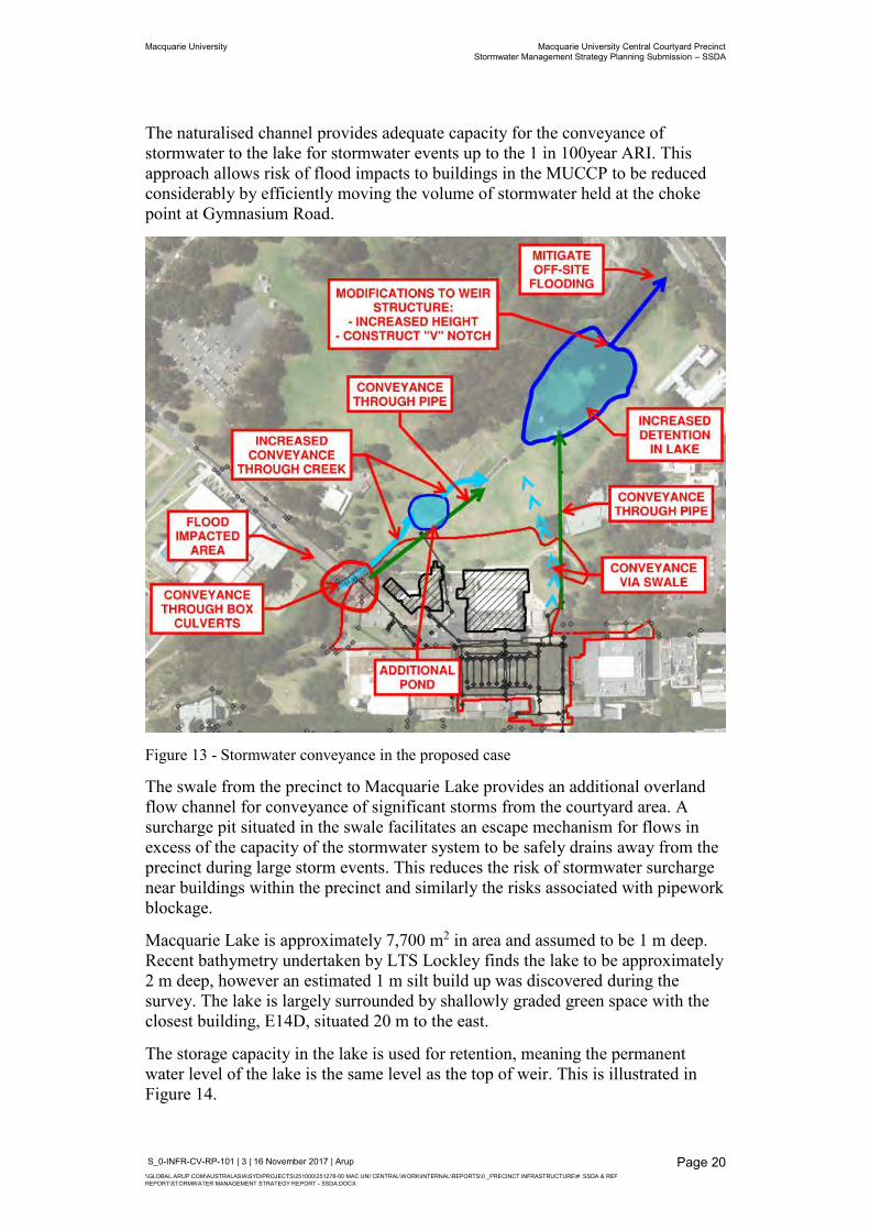
It is proposed to increase the efficiency of stormwater conveyance to the lake with the addition of box culverts, a naturalised channel and swales, as represented in Figure 13.
The box culverts and naturalised channel will serve to complement and enhance the conveyance capacity of the existing 1800 mm stormwater pipe. The addition of box culverts beneath Gymnasium Road allows for better stormwater flows by increasing the flow capacity and improving the inlet configuration of the culverts.
Macquarie University Macquarie University Central Courtyard Precinct Stormwater Management Strategy Planning Submission – SSDA
S_0-INFR-CV-RP-101 | 3 | 16 November 2017 | Arup \\GLOBAL.ARUP.COM\AUSTRALASIA\SYD\PROJECTS\251000\251278-00 MAC UNI CENTRAL\WORK\INTERNAL\REPORTS\0 _PRECINCT INFRASTRUCTURE\#. SSDA & REF REPORT\STORMWATER MANAGEMENT STRATEGY REPORT - SSDA.DOCX
Page 20
The naturalised channel provides adequate capacity for the conveyance of stormwater to the lake for stormwater events up to the 1 in 100year ARI. This approach allows risk of flood impacts to buildings in the MUCCP to be reduced considerably by efficiently moving the volume of stormwater held at the choke point at Gymnasium Road.
Figure 13 - Stormwater conveyance in the proposed case
The swale from the precinct to Macquarie Lake provides an additional overland flow channel for conveyance of significant storms from the courtyard area. A surcharge pit situated in the swale facilitates an escape mechanism for flows in excess of the capacity of the stormwater system to be safely drains away from the precinct during large storm events. This reduces the risk of stormwater surcharge near buildings within the precinct and similarly the risks associated with pipework blockage.
Macquarie Lake is approximately 7,700 m2 in area and assumed to be 1 m deep. Recent bathymetry undertaken by LTS Lockley finds the lake to be approximately 2 m deep, however an estimated 1 m silt build up was discovered during the survey. The lake is largely surrounded by shallowly graded green space with the closest building, E14D, situated 20 m to the east.
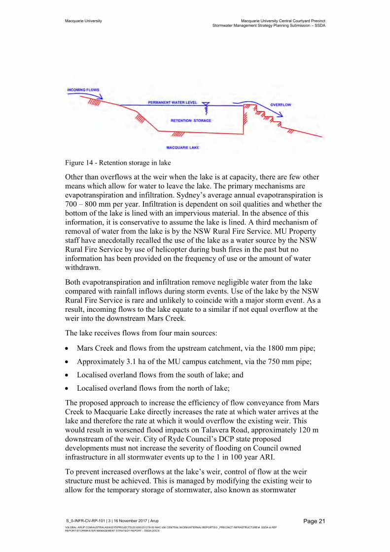
The storage capacity in the lake is used for retention, meaning the permanent water level of the lake is the same level as the top of weir. This is illustrated in Figure 14.
Macquarie University Macquarie University Central Courtyard Precinct Stormwater Management Strategy Planning Submission – SSDA
S_0-INFR-CV-RP-101 | 3 | 16 November 2017 | Arup \\GLOBAL.ARUP.COM\AUSTRALASIA\SYD\PROJECTS\251000\251278-00 MAC UNI CENTRAL\WORK\INTERNAL\REPORTS\0 _PRECINCT INFRASTRUCTURE\#. SSDA & REF REPORT\STORMWATER MANAGEMENT STRATEGY REPORT - SSDA.DOCX
Page 21
Figure 14 - Retention storage in lake
Other than overflows at the weir when the lake is at capacity, there are few other means which allow for water to leave the lake. The primary mechanisms are evapotranspiration and infiltration. Sydney’s average annual evapotranspiration is 700 – 800 mm per year. Infiltration is dependent on soil qualities and whether the bottom of the lake is lined with an impervious material. In the absence of this information, it is conservative to assume the lake is lined. A third mechanism of removal of water from the lake is by the NSW Rural Fire Service. MU Property staff have anecdotally recalled the use of the lake as a water source by the NSW Rural Fire Service by use of helicopter during bush fires in the past but no information has been provided on the frequency of use or the amount of water withdrawn.
Both evapotranspiration and infiltration remove negligible water from the lake compared with rainfall inflows during storm events. Use of the lake by the NSW Rural Fire Service is rare and unlikely to coincide with a major storm event. As a result, incoming flows to the lake equate to a similar if not equal overflow at the weir into the downstream Mars Creek.
The lake receives flows from four main sources:
Mars Creek and flows from the upstream catchment, via the 1800 mm pipe;
Approximately 3.1 ha of the MU campus catchment, via the 750 mm pipe;
Localised overland flows from the south of lake; and
Localised overland flows from the north of lake;
The proposed approach to increase the efficiency of flow conveyance from Mars Creek to Macquarie Lake directly increases the rate at which water arrives at the lake and therefore the rate at which it would overflow the existing weir. This would result in worsened flood impacts on Talavera Road, approximately 120 m downstream of the weir. City of Ryde Council’s DCP state proposed developments must not increase the severity of flooding on Council owned infrastructure in all stormwater events up to the 1 in 100 year ARI.
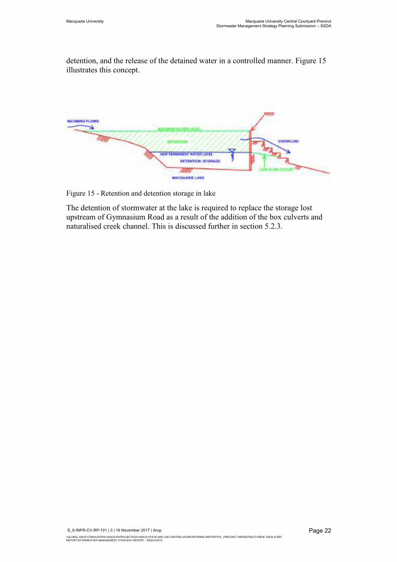
To prevent increased overflows at the lake’s weir, control of flow at the weir structure must be achieved. This is managed by modifying the existing weir to allow for the temporary storage of stormwater, also known as stormwater
Macquarie University Macquarie University Central Courtyard Precinct Stormwater Management Strategy Planning Submission – SSDA
S_0-INFR-CV-RP-101 | 3 | 16 November 2017 | Arup \\GLOBAL.ARUP.COM\AUSTRALASIA\SYD\PROJECTS\251000\251278-00 MAC UNI CENTRAL\WORK\INTERNAL\REPORTS\0 _PRECINCT INFRASTRUCTURE\#. SSDA & REF REPORT\STORMWATER MANAGEMENT STRATEGY REPORT - SSDA.DOCX
Page 22
detention, and the release of the detained water in a controlled manner. Figure 15 illustrates this concept.
Figure 15 - Retention and detention storage in lake
The detention of stormwater at the lake is required to replace the storage lost upstream of Gymnasium Road as a result of the addition of the box culverts and naturalised creek channel. This is discussed further in section 5.2.3.
Macquarie University Macquarie University Central Courtyard Precinct Stormwater Management Strategy Planning Submission – SSDA
S_0-INFR-CV-RP-101 | 3 | 16 November 2017 | Arup \\GLOBAL.ARUP.COM\AUSTRALASIA\SYD\PROJECTS\251000\251278-00 MAC UNI CENTRAL\WORK\INTERNAL\REPORTS\0 _PRECINCT INFRASTRUCTURE\#. SSDA & REF REPORT\STORMWATER MANAGEMENT STRATEGY REPORT - SSDA.DOCX
Page 23
4 Proposed Precinct
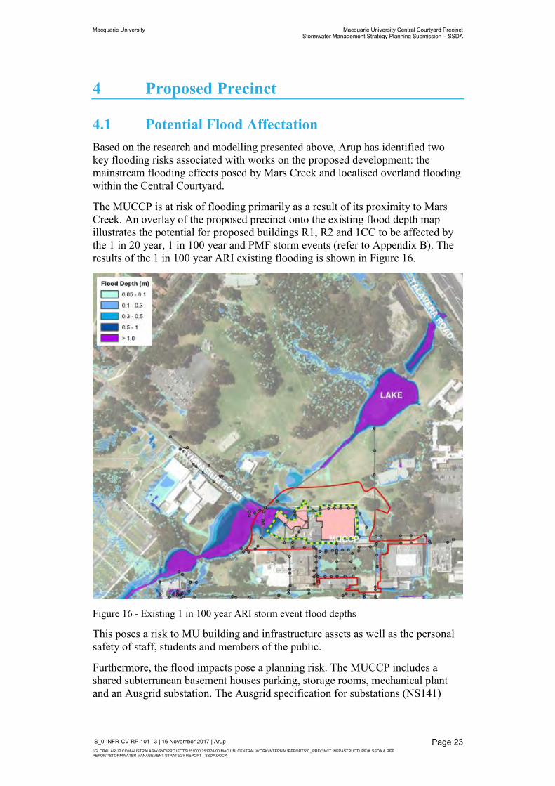
4.1 Potential Flood Affectation Based on the research and modelling presented above, Arup has identified two key flooding risks associated with works on the proposed development: the mainstream flooding effects posed by Mars Creek and localised overland flooding within the Central Courtyard.
The MUCCP is at risk of flooding primarily as a result of its proximity to Mars Creek. An overlay of the proposed precinct onto the existing flood depth map illustrates the potential for proposed buildings R1, R2 and 1CC to be affected by the 1 in 20 year, 1 in 100 year and PMF storm events (refer to Appendix B). The results of the 1 in 100 year ARI existing flooding is shown in Figure 16.
Figure 16 - Existing 1 in 100 year ARI storm event flood depths
This poses a risk to MU building and infrastructure assets as well as the personal safety of staff, students and members of the public.
Furthermore, the flood impacts pose a planning risk. The MUCCP includes a shared subterranean basement houses parking, storage rooms, mechanical plant and an Ausgrid substation. The Ausgrid specification for substations (NS141)
Macquarie University Macquarie University Central Courtyard Precinct Stormwater Management Strategy Planning Submission – SSDA
S_0-INFR-CV-RP-101 | 3 | 16 November 2017 | Arup \\GLOBAL.ARUP.COM\AUSTRALASIA\SYD\PROJECTS\251000\251278-00 MAC UNI CENTRAL\WORK\INTERNAL\REPORTS\0 _PRECINCT INFRASTRUCTURE\#. SSDA & REF REPORT\STORMWATER MANAGEMENT STRATEGY REPORT - SSDA.DOCX
Page 24
require the location of the substation to be immune in the 1 in 100 year ARI storm event.
In the context of the flood risks associated with mainstream flooding of Mars Creek, in the existing condition the MUCCP development is incompatible and would be flood affected. For the proposed precinct to be developed, resolution of the flood impacts at the Gymnasium Road choke point are first required to satisfy safety in design and authority requirements. This is an item expressly noted in the SEARs.
Flood modelling in the existing case shows also localised overland flood effects around the proposed MUCCP buildings in the 1 in 100 year ARI storm event. This does not satisfy the City of Ryde Council’s requirement for buildings to be flood immune in the 1 in 100 year ARI storm event. Therefore, flood risks associated with existing localised overland flooding are also incompatible with the MUCCP development.
Both flood risk associated with mainstream and overland flow issues need to mitigated as part of a considered, integrated stormwater management strategy for the MUCCP development.
4.1.1 Flood mitigation options As discussed in section 3, the overarching strategy to mitigate mainstream flooding impacts on the MUCCP is to increase flow efficiency from the upstream of Gymnasium Road to the lake. A number of options were considered to enable this including:
Improving the overland flow path over Gymnasium Road;
Pipe boring an additional pipe next to the existing; and
Different configurations of the additional box culverts and naturalised creek.
Appendix C1 discusses these options in more detail.
Following consultation with MU, a preferred design involving the addition of a box culvert and the naturalised creek was agreed upon. This design detailed in section 5.2.
Local overland flood impacts in the precinct have also been considered in relation to the overarching strategy. With limited information on the existing stormwater network in the precinct, it is unclear if the existing 750 mm trunk line has sufficient capacity in large storm events and where stormwater surcharges in these events. Options considered for mitigation of local overland flooding within the precinct include:
Upgrade of the existing 750 mm trunk drainage line from the Central Courtyard;
Construction of an additional trunk line adjacent to the existing; and
The addition of a surcharge pit and swale to convey overland flows to the lake.
Macquarie University Macquarie University Central Courtyard Precinct Stormwater Management Strategy Planning Submission – SSDA
S_0-INFR-CV-RP-101 | 3 | 16 November 2017 | Arup \\GLOBAL.ARUP.COM\AUSTRALASIA\SYD\PROJECTS\251000\251278-00 MAC UNI CENTRAL\WORK\INTERNAL\REPORTS\0 _PRECINCT INFRASTRUCTURE\#. SSDA & REF REPORT\STORMWATER MANAGEMENT STRATEGY REPORT - SSDA.DOCX
Page 25
Following flood modelling of the proposed precinct, a surcharge pit and swale has been selected as the preferred option in consultation with MU. This strategy is discussed in detail in section 4.2.2.
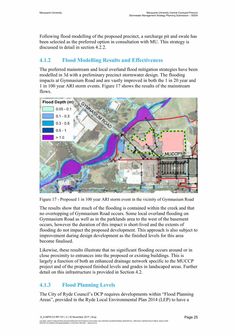
4.1.2 Flood Modelling Results and Effectiveness The preferred mainstream and local overland flood mitigation strategies have been modelled in 3d with a preliminary precinct stormwater design. The flooding impacts at Gymnasium Road and are vastly improved in both the 1 in 20 year and 1 in 100 year ARI storm events. Figure 17 shows the results of the mainstream flows.
Figure 17 - Proposed 1 in 100 year ARI storm event in the vicinity of Gymnasium Road
The results show that much of the flooding is contained within the creek and that no overtopping of Gymnasium Road occurs. Some local overland flooding on Gymnasium Road as well as in the parklands area to the west of the basement occurs, however the duration of this impact is short-lived and the extents of flooding do not impact the proposed development. This approach is also subject to improvement during design development as the finished levels for this area become finalised.
Likewise, these results illustrate that no significant flooding occurs around or in close proximity to entrances into the proposed or existing buildings. This is largely a function of both an enhanced drainage network specific to the MUCCP project and of the proposed finished levels and grades in landscaped areas. Further detail on this infrastructure is provided in Section 4.2.
4.1.3 Flood Planning Levels The City of Ryde Council’s DCP requires developments within “Flood Planning Areas”, provided in the Ryde Local Environmental Plan 2014 (LEP) to have a
Macquarie University Macquarie University Central Courtyard Precinct Stormwater Management Strategy Planning Submission – SSDA
S_0-INFR-CV-RP-101 | 3 | 16 November 2017 | Arup \\GLOBAL.ARUP.COM\AUSTRALASIA\SYD\PROJECTS\251000\251278-00 MAC UNI CENTRAL\WORK\INTERNAL\REPORTS\0 _PRECINCT INFRASTRUCTURE\#. SSDA & REF REPORT\STORMWATER MANAGEMENT STRATEGY REPORT - SSDA.DOCX
Page 26
finished floor level established at or above the flood planning level. The LEP states the flood planning level to be at the level of the 1 in 100 year ARI flood event plus 0.5m freeboard. However, the MUCCP site is not situated in an area defined as a flood planning area in the maps provided in LEP.
Although it is not strictly necessary for the development to adhere to these requirements, in undertaking detailed flooding modelling undertaken for this project and considering options for flood mitigation, Arup have attempted to comply with these requirements. This is particularly true of designing the new drainage infrastructure and landscape gradings to manage flows. In doing so, it has been possible to provide flood immunity to all buildings in the MUCCP development for all storm events up to and including the 1 in 100 year ARI storm event. This alsosatisfys Ausgrid requirements.
From the proposed flood modelling, the basement entrance on the west side of the precinct is affected by the probable maximum flooding (PMF) event and therefore classified as being at low flood risk, as per the DCP’s flood risk categories. Basement ramping and/or improvements in the drainage system will be further developed during detail design to manage this risk. Arup note that this basement is at grade and higher in elevation than the downstream lake and for this reason, it is possible to gravitate stormwater drainage from the basement without the need for pumping. For this reason, the basement could be considered a lower ground floor and is at a much lower risk of stormwater inundation.
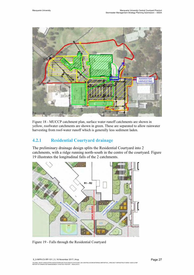
4.2 Precinct Stormwater Drainage The MUCCP’s preliminary stormwater design comprises of 3 catchments plus additional roof catchments. Figure 18 shows the surface water runoff catchments in yellow, roof catchments in green, and a rainwater harvesting tank in blue. As per City of Ryde’s DCP, the stormwater network has been designed for the 1 in 20 year ARI storm event and overland flows for the 1 in 100 year ARI storm event.
The rainwater harvesting tank captures roof drainage from buildings 1CC, R1 and R2 as well as the existing C7A and C8A buildings. The rainwater harvesting tank design feeds into a filtration system situated in the 1CC building for use in the precinct chillers. The MUCCP ESD Report discusses the re-use of stormwater in further detail. The overflow pipe from this tank connects to the 750 mm trunk drainage line.
Macquarie University Macquarie University Central Courtyard Precinct Stormwater Management Strategy Planning Submission – SSDA
S_0-INFR-CV-RP-101 | 3 | 16 November 2017 | Arup \\GLOBAL.ARUP.COM\AUSTRALASIA\SYD\PROJECTS\251000\251278-00 MAC UNI CENTRAL\WORK\INTERNAL\REPORTS\0 _PRECINCT INFRASTRUCTURE\#. SSDA & REF REPORT\STORMWATER MANAGEMENT STRATEGY REPORT - SSDA.DOCX
Page 27
Figure 18 - MUCCP catchment plan, surface water runoff catchments are shown in yellow, roofwater catchments are shown in green. These are separated to allow rainwater harvesting from roof-water runoff which is generally less sediment laden.
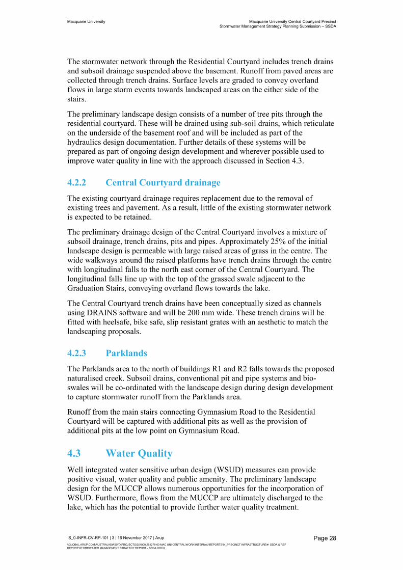
4.2.1 Residential Courtyard drainage The preliminary drainage design splits the Residential Courtyard into 2 catchments, with a ridge running north-south in the centre of the courtyard. Figure 19 illustrates the longitudinal falls of the 2 catchments.
Figure 19 - Falls through the Residential Courtyard
Macquarie University Macquarie University Central Courtyard Precinct Stormwater Management Strategy Planning Submission – SSDA
S_0-INFR-CV-RP-101 | 3 | 16 November 2017 | Arup \\GLOBAL.ARUP.COM\AUSTRALASIA\SYD\PROJECTS\251000\251278-00 MAC UNI CENTRAL\WORK\INTERNAL\REPORTS\0 _PRECINCT INFRASTRUCTURE\#. SSDA & REF REPORT\STORMWATER MANAGEMENT STRATEGY REPORT - SSDA.DOCX
Page 28
The stormwater network through the Residential Courtyard includes trench drains and subsoil drainage suspended above the basement. Runoff from paved areas are collected through trench drains. Surface levels are graded to convey overland flows in large storm events towards landscaped areas on the either side of the stairs.
The preliminary landscape design consists of a number of tree pits through the residential courtyard. These will be drained using sub-soil drains, which reticulate on the underside of the basement roof and will be included as part of the hydraulics design documentation. Further details of these systems will be prepared as part of ongoing design development and wherever possible used to improve water quality in line with the approach discussed in Section 4.3.
4.2.2 Central Courtyard drainage The existing courtyard drainage requires replacement due to the removal of existing trees and pavement. As a result, little of the existing stormwater network is expected to be retained.
The preliminary drainage design of the Central Courtyard involves a mixture of subsoil drainage, trench drains, pits and pipes. Approximately 25% of the initial landscape design is permeable with large raised areas of grass in the centre. The wide walkways around the raised platforms have trench drains through the centre with longitudinal falls to the north east corner of the Central Courtyard. The longitudinal falls line up with the top of the grassed swale adjacent to the Graduation Stairs, conveying overland flows towards the lake.
The Central Courtyard trench drains have been conceptually sized as channels using DRAINS software and will be 200 mm wide. These trench drains will be fitted with heelsafe, bike safe, slip resistant grates with an aesthetic to match the landscaping proposals.
4.2.3 Parklands The Parklands area to the north of buildings R1 and R2 falls towards the proposed naturalised creek. Subsoil drains, conventional pit and pipe systems and bio-swales will be co-ordinated with the landscape design during design development to capture stormwater runoff from the Parklands area.
Runoff from the main stairs connecting Gymnasium Road to the Residential Courtyard will be captured with additional pits as well as the provision of additional pits at the low point on Gymnasium Road.
4.3 Water Quality Well integrated water sensitive urban design (WSUD) measures can provide positive visual, water quality and public amenity. The preliminary landscape design for the MUCCP allows numerous opportunities for the incorporation of WSUD. Furthermore, flows from the MUCCP are ultimately discharged to the lake, which has the potential to provide further water quality treatment.
Macquarie University Macquarie University Central Courtyard Precinct Stormwater Management Strategy Planning Submission – SSDA
S_0-INFR-CV-RP-101 | 3 | 16 November 2017 | Arup \\GLOBAL.ARUP.COM\AUSTRALASIA\SYD\PROJECTS\251000\251278-00 MAC UNI CENTRAL\WORK\INTERNAL\REPORTS\0 _PRECINCT INFRASTRUCTURE\#. SSDA & REF REPORT\STORMWATER MANAGEMENT STRATEGY REPORT - SSDA.DOCX
Page 29
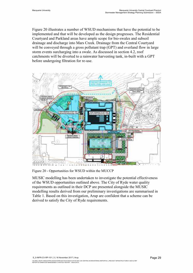
Figure 20 illustrates a number of WSUD mechanisms that have the potential to be implemented and that will be developed as the design progresses. The Residential Courtyard and Parkland areas have ample scope for bio-swales and subsoil drainage and discharge into Mars Creek. Drainage from the Central Courtyard will be conveyed through a gross pollutant trap (GPT) and overland flow in large storm events surcharging into a swale. As discussed in section 4.2, roof catchments will be diverted to a rainwater harvesting tank, in-built with a GPT before undergoing filtration for re-use.
Figure 20 - Opportunities for WSUD within the MUCCP
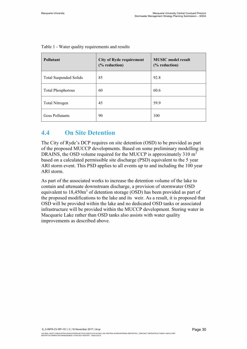
MUSIC modelling has been undertaken to investigate the potential effectiveness of the WSUD opportunities outlined above. The City of Ryde water quality requirements as outlined in their DCP are presented alongside the MUSIC modelling results derived from our preliminary investigations are summarised in Table 1. Based on this investigation, Arup are confident that a scheme can be derived to satisfy the City of Ryde requirements.
Macquarie University Macquarie University Central Courtyard Precinct Stormwater Management Strategy Planning Submission – SSDA
S_0-INFR-CV-RP-101 | 3 | 16 November 2017 | Arup \\GLOBAL.ARUP.COM\AUSTRALASIA\SYD\PROJECTS\251000\251278-00 MAC UNI CENTRAL\WORK\INTERNAL\REPORTS\0 _PRECINCT INFRASTRUCTURE\#. SSDA & REF REPORT\STORMWATER MANAGEMENT STRATEGY REPORT - SSDA.DOCX
Page 30
Table 1 - Water quality requirements and results
Pollutant City of Ryde requirement (% reduction)
MUSIC model result (% reduction)
Total Suspended Solids 85 92.8
Total Phosphorous 60 60.6
Total Nitrogen 45 59.9
Goss Pollutants 90 100
4.4 On Site Detention The City of Ryde’s DCP requires on site detention (OSD) to be provided as part of the proposed MUCCP developments. Based on some preliminary modelling in DRAINS, the OSD volume required for the MUCCP is approximately 310 m3 based on a calculated permissible site discharge (PSD) equivalent to the 5 year ARI storm event. This PSD applies to all events up to and including the 100 year ARI storm.
As part of the associated works to increase the detention volume of the lake to contain and attenuate downstream discharge, a provision of stormwater OSD equivalent to 18,450m3 of detention storage (OSD) has been provided as part of the proposed modifications to the lake and its weir. As a result, it is proposed that OSD will be provided within the lake and no dedicated OSD tanks or associated infrastructure will be provided within the MUCCP development. Storing water in Macquarie Lake rather than OSD tanks also assists with water quality improvements as described above.
Macquarie University Macquarie University Central Courtyard Precinct Stormwater Management Strategy Planning Submission – SSDA
S_0-INFR-CV-RP-101 | 3 | 16 November 2017 | Arup \\GLOBAL.ARUP.COM\AUSTRALASIA\SYD\PROJECTS\251000\251278-00 MAC UNI CENTRAL\WORK\INTERNAL\REPORTS\0 _PRECINCT INFRASTRUCTURE\#. SSDA & REF REPORT\STORMWATER MANAGEMENT STRATEGY REPORT - SSDA.DOCX
Page 31
5 Proposed Mars Creek Modifications
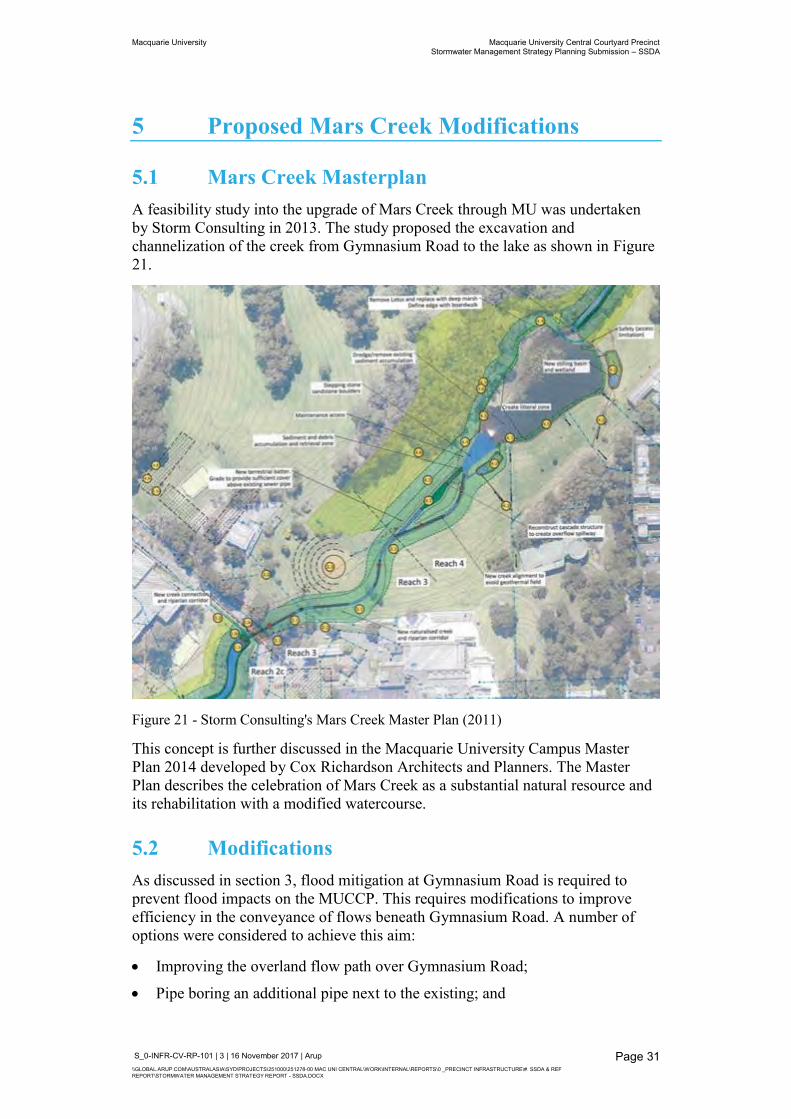
5.1 Mars Creek Masterplan A feasibility study into the upgrade of Mars Creek through MU was undertaken by Storm Consulting in 2013. The study proposed the excavation and channelization of the creek from Gymnasium Road to the lake as shown in Figure 21.
Figure 21 - Storm Consulting's Mars Creek Master Plan (2011)
This concept is further discussed in the Macquarie University Campus Master Plan 2014 developed by Cox Richardson Architects and Planners. The Master Plan describes the celebration of Mars Creek as a substantial natural resource and its rehabilitation with a modified watercourse.
5.2 Modifications As discussed in section 3, flood mitigation at Gymnasium Road is required to prevent flood impacts on the MUCCP. This requires modifications to improve efficiency in the conveyance of flows beneath Gymnasium Road. A number of options were considered to achieve this aim:
Improving the overland flow path over Gymnasium Road;
Pipe boring an additional pipe next to the existing; and
Macquarie University Macquarie University Central Courtyard Precinct Stormwater Management Strategy Planning Submission – SSDA
S_0-INFR-CV-RP-101 | 3 | 16 November 2017 | Arup \\GLOBAL.ARUP.COM\AUSTRALASIA\SYD\PROJECTS\251000\251278-00 MAC UNI CENTRAL\WORK\INTERNAL\REPORTS\0 _PRECINCT INFRASTRUCTURE\#. SSDA & REF REPORT\STORMWATER MANAGEMENT STRATEGY REPORT - SSDA.DOCX
Page 32
Different configurations of the additional box culverts and naturalised creek.
The increase in flows at through Mars Creek in turn affects the lake downstream and requires modifications at the lake’s weir to gain control of stormwater flows. Extensive optioneering of the modification at the lake structure was tested and modelled. These included:
The addition of low flow pipes in the existing weir;
Raising the existing weir level; and
Modifying the existing weir to include notches of various shapes and sizes.
Appendix C2 discusses these options in more detail.
5.2.1 Gymnasium Road culvert To accommodate the addition of a box culvert, the existing 1800 mm stormwater pipe requires some modification to avoid clashing headwalls. This involves shortening the pipe at the upstream end by 7.3 m and the construction of a new pit inlet structure. The new pit inlet structure is to be used as a secondary inlet, with the box culvert being the primary structure for flow conveyance. This allows for flows during small storm events to be discharged into the naturalised creek, adding to visual amenity.
Preliminary modelling sizes the box culvert beneath Gymnasium Road to be 2 m wide x 0.9 m high for a length of approximately 28.8 m. The proposed upstream invert level is 52.7 m. This is a reduction from the existing permanent water level of 53.4 m, however still allows for 1 m of standing water. The reduction in water level increases the detention storage capacity at this location during large storm events. The headwalls of the box culvert will be developed with the landscape as the design progresses.
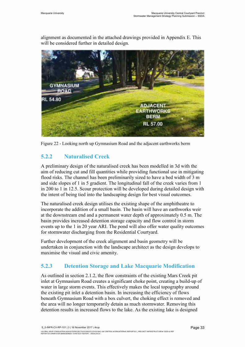
The preliminary design also involves changes to Gymnasium Road itself. It is proposed to re-grade the road from two way cross fall to one way cross fall. The purpose of this is to better maximise the cover over the box culvert and allow for utilities to cross beneath the road but above the top of the culverts. At present, the area where Gymnasium Road crosses Mars Creek has a high density of services crossings. It is also proposed to raise the lowest level of Gymnasium Road from 54.8 m to 55.0 m This allows for increased cover over the box culvert and improved accessibility to the MUCCP from Gymnasium Road due to shallower gradients.
Adjacent to Gymnasium Road on the north side is an existing earthworks berm. Figure 22 presents a photo of the berm. During large storm events when Gymnasium Road is overtopped by flows from the creek, the berm acts as barrier and prevents the surcharging water from spilling over the opposite side of the Road and down the lawn towards the lake. Instead, the stormwater is diverted back towards the proposed precinct. To prevent this from occurring, the removal of a proportion of the earthworks berm including a number of trees in the vicinity of those shown in Figure 22 is also proposed to create the proposed creek
Macquarie University Macquarie University Central Courtyard Precinct Stormwater Management Strategy Planning Submission – SSDA
S_0-INFR-CV-RP-101 | 3 | 16 November 2017 | Arup \\GLOBAL.ARUP.COM\AUSTRALASIA\SYD\PROJECTS\251000\251278-00 MAC UNI CENTRAL\WORK\INTERNAL\REPORTS\0 _PRECINCT INFRASTRUCTURE\#. SSDA & REF REPORT\STORMWATER MANAGEMENT STRATEGY REPORT - SSDA.DOCX
Page 33
alignment as documented in the attached drawings provided in Appendix E. This will be considered further in detailed design.
Figure 22 - Looking north up Gymnasium Road and the adjacent earthworks berm
5.2.2 Naturalised Creek A preliminary design of the naturalised creek has been modelled in 3d with the aim of reducing cut and fill quantities while providing functional use in mitigating flood risks. The channel has been preliminarily sized to have a bed width of 3 m and side slopes of 1 in 5 gradient. The longitudinal fall of the creek varies from 1 in 200 to 1 in 12.5. Scour protection will be developed during detailed design with the intent of being tied into the landscaping design for best visual outcomes.
The naturalised creek design utilises the existing shape of the amphitheatre to incorporate the addition of a small basin. The basin will have an earthworks weir at the downstream end and a permanent water depth of approximately 0.5 m. The basin provides increased detention storage capacity and flow control in storm events up to the 1 in 20 year ARI. The pond will also offer water quality outcomes for stormwater discharging from the Residential Courtyard.
Further development of the creek alignment and basin geometry will be undertaken in conjunction with the landscape architect as the design develops to maximise the visual and civic amenity.
5.2.3 Detention Storage and Lake Macquarie Modification As outlined in section 2.1.2, the flow constraints of the existing Mars Creek pit inlet at Gymnasium Road creates a significant choke point, creating a build-up of water in large storm events. This effectively makes the local topography around the existing pit inlet a detention basin. In increasing the efficiency of flows beneath Gymnasium Road with a box culvert, the choking effect is removed and the area will no longer temporarily detain as much stormwater. Removing this detention results in increased flows to the lake. As the existing lake is designed
Macquarie University Macquarie University Central Courtyard Precinct Stormwater Management Strategy Planning Submission – SSDA
S_0-INFR-CV-RP-101 | 3 | 16 November 2017 | Arup \\GLOBAL.ARUP.COM\AUSTRALASIA\SYD\PROJECTS\251000\251278-00 MAC UNI CENTRAL\WORK\INTERNAL\REPORTS\0 _PRECINCT INFRASTRUCTURE\#. SSDA & REF REPORT\STORMWATER MANAGEMENT STRATEGY REPORT - SSDA.DOCX
Page 34
for retention only (holding water permanently), it does not have capacity for detention, thereby allowing the increased flows to overtop the weir. This causes increased flood impacts downstream at Talavera Road.
To prevent the flood impacts at Talavera Road, the detention storage lost at Gymnasium Road must be reinstated at the lake. Therefore, it is necessary to modify the lake to incorporate detention while maintaining some retention so as not to compromise the visual amenity of the signature landscape feature. Figure 16 presents a schematic of detention and retention storage in the lake.
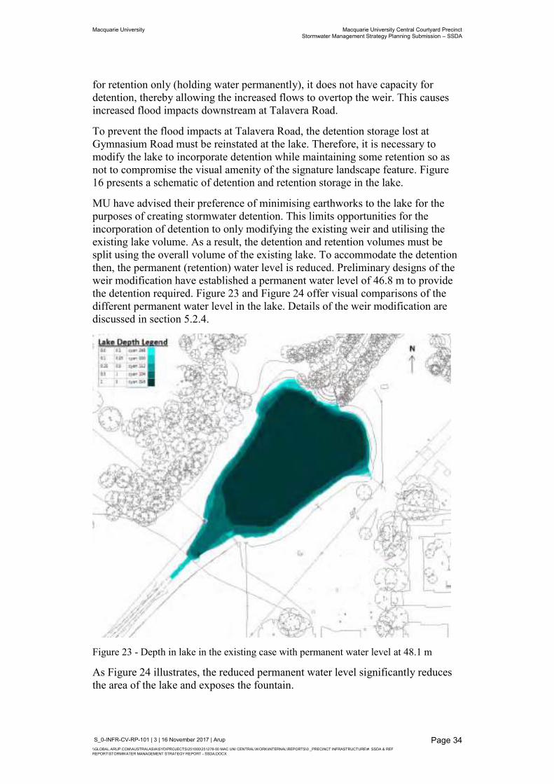
MU have advised their preference of minimising earthworks to the lake for the purposes of creating stormwater detention. This limits opportunities for the incorporation of detention to only modifying the existing weir and utilising the existing lake volume. As a result, the detention and retention volumes must be split using the overall volume of the existing lake. To accommodate the detention then, the permanent (retention) water level is reduced. Preliminary designs of the weir modification have established a permanent water level of 46.8 m to provide the detention required. Figure 23 and Figure 24 offer visual comparisons of the different permanent water level in the lake. Details of the weir modification are discussed in section 5.2.4.
Figure 23 - Depth in lake in the existing case with permanent water level at 48.1 m
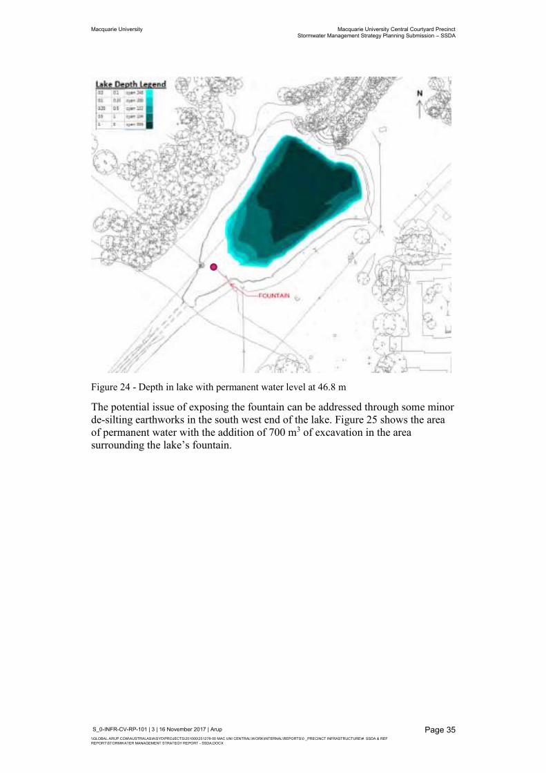
As Figure 24 illustrates, the reduced permanent water level significantly reduces the area of the lake and exposes the fountain.
Macquarie University Macquarie University Central Courtyard Precinct Stormwater Management Strategy Planning Submission – SSDA
S_0-INFR-CV-RP-101 | 3 | 16 November 2017 | Arup \\GLOBAL.ARUP.COM\AUSTRALASIA\SYD\PROJECTS\251000\251278-00 MAC UNI CENTRAL\WORK\INTERNAL\REPORTS\0 _PRECINCT INFRASTRUCTURE\#. SSDA & REF REPORT\STORMWATER MANAGEMENT STRATEGY REPORT - SSDA.DOCX
Page 35
Figure 24 - Depth in lake with permanent water level at 46.8 m
The potential issue of exposing the fountain can be addressed through some minor de-silting earthworks in the south west end of the lake. Figure 25 shows the area of permanent water with the addition of 700 m3 of excavation in the area surrounding the lake’s fountain.
Macquarie University Macquarie University Central Courtyard Precinct Stormwater Management Strategy Planning Submission – SSDA
S_0-INFR-CV-RP-101 | 3 | 16 November 2017 | Arup \\GLOBAL.ARUP.COM\AUSTRALASIA\SYD\PROJECTS\251000\251278-00 MAC UNI CENTRAL\WORK\INTERNAL\REPORTS\0 _PRECINCT INFRASTRUCTURE\#. SSDA & REF REPORT\STORMWATER MANAGEMENT STRATEGY REPORT - SSDA.DOCX
Page 36
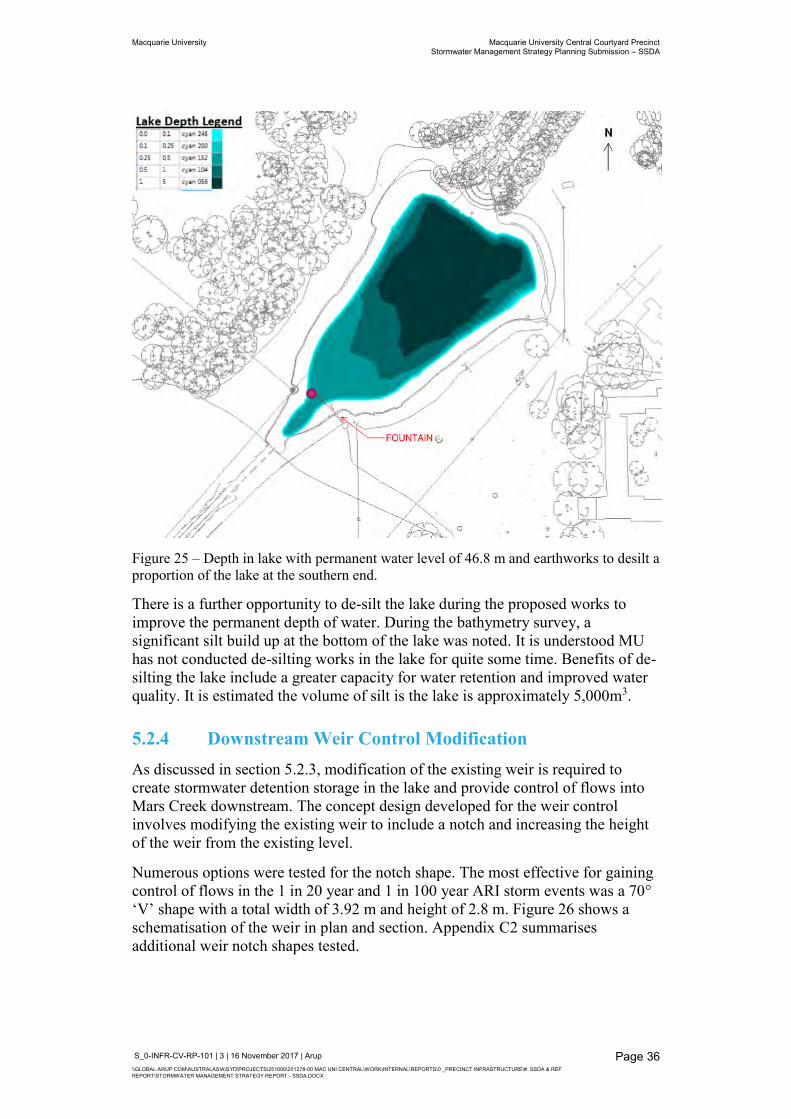
Figure 25 – Depth in lake with permanent water level of 46.8 m and earthworks to desilt a proportion of the lake at the southern end.
There is a further opportunity to de-silt the lake during the proposed works to improve the permanent depth of water. During the bathymetry survey, a significant silt build up at the bottom of the lake was noted. It is understood MU has not conducted de-silting works in the lake for quite some time. Benefits of de-silting the lake include a greater capacity for water retention and improved water quality. It is estimated the volume of silt is the lake is approximately 5,000m3.
5.2.4 Downstream Weir Control Modification As discussed in section 5.2.3, modification of the existing weir is required to create stormwater detention storage in the lake and provide control of flows into Mars Creek downstream. The concept design developed for the weir control involves modifying the existing weir to include a notch and increasing the height of the weir from the existing level.
Numerous options were tested for the notch shape. The most effective for gaining control of flows in the 1 in 20 year and 1 in 100 year ARI storm events was a 70° ‘V’ shape with a total width of 3.92 m and height of 2.8 m. Figure 26 shows a schematisation of the weir in plan and section. Appendix C2 summarises additional weir notch shapes tested.
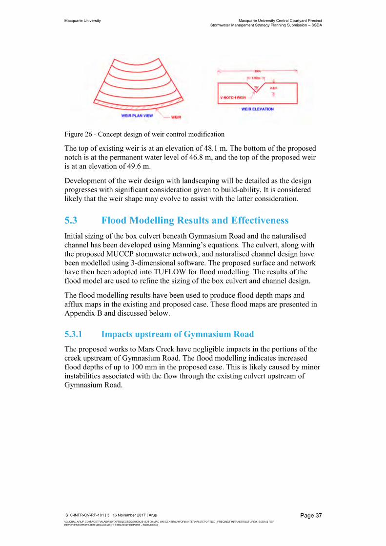
Macquarie University Macquarie University Central Courtyard Precinct Stormwater Management Strategy Planning Submission – SSDA
S_0-INFR-CV-RP-101 | 3 | 16 November 2017 | Arup \\GLOBAL.ARUP.COM\AUSTRALASIA\SYD\PROJECTS\251000\251278-00 MAC UNI CENTRAL\WORK\INTERNAL\REPORTS\0 _PRECINCT INFRASTRUCTURE\#. SSDA & REF REPORT\STORMWATER MANAGEMENT STRATEGY REPORT - SSDA.DOCX
Page 37
Figure 26 - Concept design of weir control modification
The top of existing weir is at an elevation of 48.1 m. The bottom of the proposed notch is at the permanent water level of 46.8 m, and the top of the proposed weir is at an elevation of 49.6 m.
Development of the weir design with landscaping will be detailed as the design progresses with significant consideration given to build-ability. It is considered likely that the weir shape may evolve to assist with the latter consideration.
5.3 Flood Modelling Results and Effectiveness Initial sizing of the box culvert beneath Gymnasium Road and the naturalised channel has been developed using Manning’s equations. The culvert, along with the proposed MUCCP stormwater network, and naturalised channel design have been modelled using 3-dimensional software. The proposed surface and network have then been adopted into TUFLOW for flood modelling. The results of the flood model are used to refine the sizing of the box culvert and channel design.
The flood modelling results have been used to produce flood depth maps and afflux maps in the existing and proposed case. These flood maps are presented in Appendix B and discussed below.
5.3.1 Impacts upstream of Gymnasium Road The proposed works to Mars Creek have negligible impacts in the portions of the creek upstream of Gymnasium Road. The flood modelling indicates increased flood depths of up to 100 mm in the proposed case. This is likely caused by minor instabilities associated with the flow through the existing culvert upstream of Gymnasium Road.
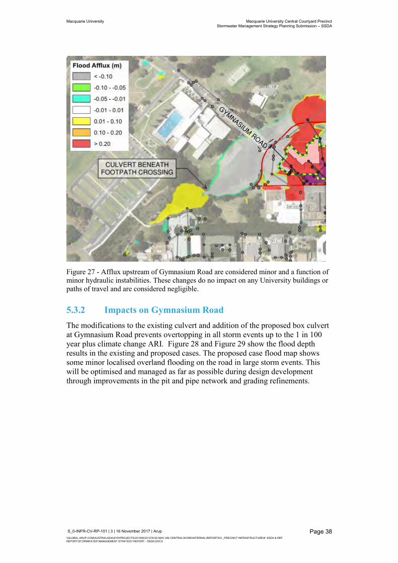
Macquarie University Macquarie University Central Courtyard Precinct Stormwater Management Strategy Planning Submission – SSDA
S_0-INFR-CV-RP-101 | 3 | 16 November 2017 | Arup \\GLOBAL.ARUP.COM\AUSTRALASIA\SYD\PROJECTS\251000\251278-00 MAC UNI CENTRAL\WORK\INTERNAL\REPORTS\0 _PRECINCT INFRASTRUCTURE\#. SSDA & REF REPORT\STORMWATER MANAGEMENT STRATEGY REPORT - SSDA.DOCX
Page 38
Figure 27 - Afflux upstream of Gymnasium Road are considered minor and a function of minor hydraulic instabilities. These changes do no impact on any University buildings or paths of travel and are considered negligible.
5.3.2 Impacts on Gymnasium Road The modifications to the existing culvert and addition of the proposed box culvert at Gymnasium Road prevents overtopping in all storm events up to the 1 in 100 year plus climate change ARI. Figure 28 and Figure 29 show the flood depth results in the existing and proposed cases. The proposed case flood map shows some minor localised overland flooding on the road in large storm events. This will be optimised and managed as far as possible during design development through improvements in the pit and pipe network and grading refinements.
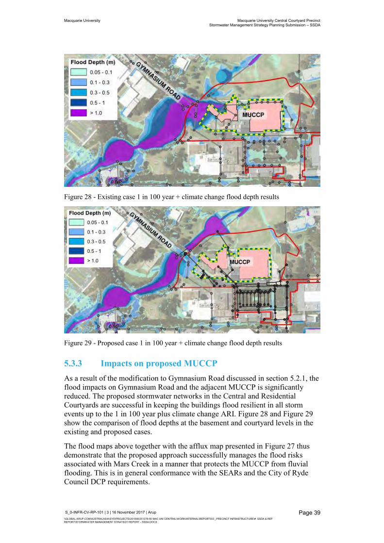
Macquarie University Macquarie University Central Courtyard Precinct Stormwater Management Strategy Planning Submission – SSDA
S_0-INFR-CV-RP-101 | 3 | 16 November 2017 | Arup \\GLOBAL.ARUP.COM\AUSTRALASIA\SYD\PROJECTS\251000\251278-00 MAC UNI CENTRAL\WORK\INTERNAL\REPORTS\0 _PRECINCT INFRASTRUCTURE\#. SSDA & REF REPORT\STORMWATER MANAGEMENT STRATEGY REPORT - SSDA.DOCX
Page 39
Figure 28 - Existing case 1 in 100 year + climate change flood depth results
Figure 29 - Proposed case 1 in 100 year + climate change flood depth results
5.3.3 Impacts on proposed MUCCP As a result of the modification to Gymnasium Road discussed in section 5.2.1, the flood impacts on Gymnasium Road and the adjacent MUCCP is significantly reduced. The proposed stormwater networks in the Central and Residential Courtyards are successful in keeping the buildings flood resilient in all storm events up to the 1 in 100 year plus climate change ARI. Figure 28 and Figure 29 show the comparison of flood depths at the basement and courtyard levels in the existing and proposed cases.
The flood maps above together with the afflux map presented in Figure 27 thus demonstrate that the proposed approach successfully manages the flood risks associated with Mars Creek in a manner that protects the MUCCP from fluvial flooding. This is in general conformance with the SEARs and the City of Ryde Council DCP requirements.
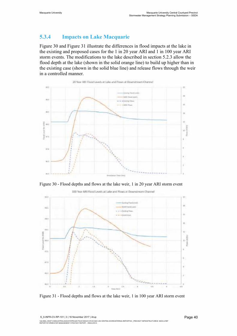
Macquarie University Macquarie University Central Courtyard Precinct Stormwater Management Strategy Planning Submission – SSDA
S_0-INFR-CV-RP-101 | 3 | 16 November 2017 | Arup \\GLOBAL.ARUP.COM\AUSTRALASIA\SYD\PROJECTS\251000\251278-00 MAC UNI CENTRAL\WORK\INTERNAL\REPORTS\0 _PRECINCT INFRASTRUCTURE\#. SSDA & REF REPORT\STORMWATER MANAGEMENT STRATEGY REPORT - SSDA.DOCX
Page 40
5.3.4 Impacts on Lake Macquarie Figure 30 and Figure 31 illustrate the differences in flood impacts at the lake in the existing and proposed cases for the 1 in 20 year ARI and 1 in 100 year ARI storm events. The modifications to the lake described in section 5.2.3 allow the flood depth at the lake (shown in the solid orange line) to build up higher than in the existing case (shown in the solid blue line) and release flows through the weir in a controlled manner.
Figure 30 - Flood depths and flows at the lake weir, 1 in 20 year ARI storm event
Figure 31 - Flood depths and flows at the lake weir, 1 in 100 year ARI storm event
Macquarie University Macquarie University Central Courtyard Precinct Stormwater Management Strategy Planning Submission – SSDA
S_0-INFR-CV-RP-101 | 3 | 16 November 2017 | Arup \\GLOBAL.ARUP.COM\AUSTRALASIA\SYD\PROJECTS\251000\251278-00 MAC UNI CENTRAL\WORK\INTERNAL\REPORTS\0 _PRECINCT INFRASTRUCTURE\#. SSDA & REF REPORT\STORMWATER MANAGEMENT STRATEGY REPORT - SSDA.DOCX
Page 41
The detention of stormwater increases the flow (shown in the dashed orange line) at a slower rate than existing (shown in the dashed blue line), delaying the peak flow in the proposed case and ensuring it is similar to the existing peak flow.
Table 2 and Table 3 provide the corresponding volumes of stormwater detention and retention for the storm events illustrated in Figure 30 and Figure 31.
Table 2 - Lake detention and retention volumes in the existing and proposed case in the 1 in 20 year ARI storm event
Table 3 - Lake detention and retention volumes in the existing and proposed case in the 1 in 100 year ARI storm event
As discussed in section 5.2.3, there is opportunity to increase the volume of retention in the lake in the proposed case by de-silting the lake. Additional minor excavation works are also desirable to maintain the operation of the fountain in the lake.
5.3.5 Impacts on Talavera Road The proposed modifications to the lake weir control structure results in favourable afflux (decreased peak flood depth) on Talavera Road in both the 1 in 20 year and 1 in 100 year ARI storm events. These results comply with the City of Ryde Council’s Stormwater and Floodplain Management Technical Manual.
The 1 in 100 year ARI afflux maps shows a minor positive afflux (increase in peak flood depth) in Mars Creek downstream of the lake weir but negative afflux on Talavera Road. Figure 32 shows this portion of the 1 in 100 year ARI afflux map.
Existing Volume (m3) Proposed Volume (m3)
Retention 11,800 (100%) 4,320 (22%)
Detention 0% 15,620 (78%)
Existing Volume (m3) Proposed Volume (m3)
Retention 11,800 (100%) 4,320 (19%)
Detention 0% 18,450 (81%)
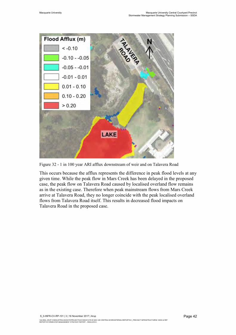
Macquarie University Macquarie University Central Courtyard Precinct Stormwater Management Strategy Planning Submission – SSDA
S_0-INFR-CV-RP-101 | 3 | 16 November 2017 | Arup \\GLOBAL.ARUP.COM\AUSTRALASIA\SYD\PROJECTS\251000\251278-00 MAC UNI CENTRAL\WORK\INTERNAL\REPORTS\0 _PRECINCT INFRASTRUCTURE\#. SSDA & REF REPORT\STORMWATER MANAGEMENT STRATEGY REPORT - SSDA.DOCX
Page 42
Figure 32 - 1 in 100 year ARI afflux downstream of weir and on Talavera Road
This occurs because the afflux represents the difference in peak flood levels at any given time. While the peak flow in Mars Creek has been delayed in the proposed case, the peak flow on Talavera Road caused by localised overland flow remains as in the existing case. Therefore when peak mainstream flows from Mars Creek arrive at Talavera Road, they no longer coincide with the peak localised overland flows from Talavera Road itself. This results in decreased flood impacts on Talavera Road in the proposed case.
Macquarie University Macquarie University Central Courtyard Precinct Stormwater Management Strategy Planning Submission – SSDA
S_0-INFR-CV-RP-101 | 3 | 16 November 2017 | Arup \\GLOBAL.ARUP.COM\AUSTRALASIA\SYD\PROJECTS\251000\251278-00 MAC UNI CENTRAL\WORK\INTERNAL\REPORTS\0 _PRECINCT INFRASTRUCTURE\#. SSDA & REF REPORT\STORMWATER MANAGEMENT STRATEGY REPORT - SSDA.DOCX
Page 43
6 Design interfaces The modifications to Mars Creek and the lake outlined in section 3 and discussed in section 5 have a significant impact on the existing landscape. The naturalised creek in proximity to the MUCCP will enhance the visual appearance of the ground surrounding Macquarie Lake as intended in the Macquarie University Master Plan 2014.
The alignment and associated earthworks of the proposed creek will be further developed with the landscape architect to create a smooth interface with the MUCCP. Aspects which will be considered in during design development include:
Accessibility and visual amenity from the MUCCP to the creek, amphitheatre basin and lake;
Opportunities for improved water balance, water quality and water re-use; and
Improved services corridors at Gymnasium Road to service the MUCCP.
Macquarie University Macquarie University Central Courtyard Precinct Stormwater Management Strategy Planning Submission – SSDA
S_0-INFR-CV-RP-101 | 3 | 16 November 2017 | Arup \\GLOBAL.ARUP.COM\AUSTRALASIA\SYD\PROJECTS\251000\251278-00 MAC UNI CENTRAL\WORK\INTERNAL\REPORTS\0 _PRECINCT INFRASTRUCTURE\#. SSDA & REF REPORT\STORMWATER MANAGEMENT STRATEGY REPORT - SSDA.DOCX
Page 44
7 Erosion and Sediment Control An erosion and sediment control plan (ESCP) has been developed for the MUCCP works and is given in Appendix D. The plan has been designed assuming the worst case conditions for erosion and sediment control during construction: after bulk excavation and prior to the construction of building foundations. The ESCP assumes the MUCCP is constructed concurrently with modification works for Mars Creek however, these works may be undertaken out of sequence. In this scenario the ESCP will be updated accordingly.
The ESCP for the Mars Creek and lake weir structure works will require a number of temporary cofferdams and active management of water flows through Mars Creek and the precinct to mitigate the impact of stormwater flows on live works. The burden of this responsibility will fall to the contractor and their methodology will be reviewed carefully prior to works commencing.
It is noted that if the works to Mars Creek are to be delayed until after commencement of construction of the proposed development that temporary stormwater flood mitigation measures are recommended to protect the precinct, machinery, staff, equipment and materials.
Macquarie University Macquarie University Central Courtyard Precinct Stormwater Management Strategy Planning Submission – SSDA
S_0-INFR-CV-RP-101 | 3 | 16 November 2017 | Arup \\GLOBAL.ARUP.COM\AUSTRALASIA\SYD\PROJECTS\251000\251278-00 MAC UNI CENTRAL\WORK\INTERNAL\REPORTS\0 _PRECINCT INFRASTRUCTURE\#. SSDA & REF REPORT\STORMWATER MANAGEMENT STRATEGY REPORT - SSDA.DOCX
Page 45
8 Conclusions The published City of Ryde Macquarie Park flooding assessment identified significant flood impacts associated with Mars Creek at Gymnasium Road where Mars Creek is diverted into a below ground stormwater pipe. The MU Master Plan 2014 and MU Concept Plan 2009 discusses the rehabilitation of this area through the construction of a naturalised creek.
The close proximity of the proposed MUCCP triggers the need to consider the flood impacts associated with the proposed developments concurrently with the masterplan proposals. Arup has undertaken a flood assessment, refining City of Ryde’s existing flood model to enable a site specific evaluation of flood impacts within and surrounding the MU campus. This refined model accounts for both mainstream flooding from Mars Creek and localised overland flooding within and surrounding the MUCCP development.
In the context of the existing flood risks associated with Mars Creek, the proposed MUCCP precinct is situated in a flood prone area and is at risk from significant flood affectation in events up to the 1 in 20year ARI. This would represent a risk to the new development and is unlikely to satisfy planning requirements.
Therefore, Arup have prepared an integrated flood mitigation strategy which mutually complements the proposed MUCCP development precinct and achieves the objectives of the Mars Creek masterplan. This predominantly involves civil works between Gymnasium Road and Macquarie Lake. The overarching strategy is to improve the efficiency and capacity of flow conveyance at Gymnasium Road. This is achieved through addition of a box culvert beneath construction of a naturalised channel.
The shift in flood storage at Gymnasium Road to Macquarie Lake has the potential to increase peak flows and flood impacts downstream. Therefore, modifications at the lake’s weir control structure are designed to provide a significant increase in on site detention. This allows flood water to be stored and downstream flows attenuated.
The stormwater network within the MUCCP has been designed to comply with City of Ryde’s DCP requirements. Consideration has been given to the separation of roofwater and surface water runoff as well as rainwater harvesting for reuse within the precinct. Preliminary coordination with the landscape architect indicates there are numerous opportunities to integrate the water sensitive urban design (WSUD) measures during detailed design to satisfy City of Ryde Council’s requirements.
Macquarie University Macquarie University Central Courtyard Precinct Stormwater Management Strategy Planning Submission – SSDA
S_0-INFR-CV-RP-101 | 3 | 16 November 2017 | Arup \\GLOBAL.ARUP.COM\AUSTRALASIA\SYD\PROJECTS\251000\251278-00 MAC UNI CENTRAL\WORK\INTERNAL\REPORTS\0 _PRECINCT INFRASTRUCTURE\#. SSDA & REF REPORT\STORMWATER MANAGEMENT STRATEGY REPORT - SSDA.DOCX
Page 46
9 Recommendations for Further Works There are a number of opportunities for further works that will be explored during design development. Key items that may be modified and developed include:
Optimisation of levels and grading around Mars Creek and the parklands areas to the west and north of the development for improved flow efficiencies, accessibility and visual amenity;
Landscaping and the integration of Mars Creek with Gymnasium Road and the MUCCP;
Opportunities for WSUD; and
Pit positions and services co-ordination to balance good access with visual amenity.
An operational and maintenance strategy and safety in design risk assessment will be developed during detailed design.
Consultation with authorities are required prior to further design of Mars Creek. Preliminary consultation with the NSW Office for Water has been undertaken. This will continue following submission of the Controlled Activities Application.
Additionally, Arup recommend these proposals be considered by the NSW Dam Safety Committee for review. It is important for dam safety criteria to be considered in the detailed design for modification of the existing weir.
Discussions with the NSW Rural Fire Service regarding potential issues with reducing the permanent water level of the lake will be undertaken following assessment of the Controlled Activities Application.
Other opportunities for further works around Mars Creek that may be explored following detailed design include:
Providing telemetry equipment for monitoring flow over the weir and use as a teaching aid; and
Investigations into the use of the lake as OSD for future projects subject to additional flood modelling and analysis.
Should it be desirable as part of the planning process, Arup are happy to present these proposals to NSW Department of Planning and Environment and/or City of Ryde Council including a discussion on the management of offsite impacts on Talavera Road to elaborate on our strategy.

Appendix A
Flood Modelling Details
Macquarie University Macquarie University Central Courtyard Precinct Stormwater Management Strategy Planning Submission – SSDA
S_0-INFR-CV-RP-101 | 3 | 16 November 2017 | Arup \\GLOBAL.ARUP.COM\AUSTRALASIA\SYD\PROJECTS\251000\251278-00 MAC UNI CENTRAL\WORK\INTERNAL\REPORTS\0 _PRECINCT INFRASTRUCTURE\#. SSDA & REF REPORT\STORMWATER MANAGEMENT STRATEGY REPORT - SSDA.DOCX
Page A1
A1 Flood Modelling Refinements
A1.1 Review of Bewsher TUFLOW Model The Macquarie Park Floodplain Risk Management Study & Plan (Bewsher, 2010) TUFLOW and DRAINS models were provided to Arup for the current SSDA flood assessment.
The Bewsher (2010) flood study developed a DRAINS hydrological model to derive runoff hydrographs for historical and design flood events for later input into the TUFLOW hydraulic model.
A TUFLOW hydraulic model was established to derive flood levels and velocities across the study area. The model covers an area of 327ha, which is bounded by Agincourt Road and Vimiera Road in the south west, Herring Road in the south east, and Lane Cove River to the East. The model adopted a 3m rectangular grid cell size to represent existing bathymetry using LiDAR data obtained in 2007.
A review of the DRAINS and TUFLOW models was undertaken and found a number of issues which may impact on the current flood assessment:
The Bewsher study focuses on defining flood behaviour along the main watercourses. Flood behaviour along Mars Creek uses subcatchment definition which is deemed coarse to analyse local overland flooding around MUCCP (i.e. runoff is not applied at pit/pipe level around precinct, rather lumped directly into Mars Creek);
The Bewsher TUFLOW model does not include stormwater network within Macquarie University;
The model resolution (3m grid) was deemed too coarse to capture ground features at the MUCCP development site;
Mars Creek schematisation at Gymnasium Road was found inaccurate. The 1D creek channel was connected directly at the culvert beneath Gymnasium Road, disregarding the inlet pit, just upstream of Gymnasium Road, which takes flows from Mars Creek once the level of at the creek exceeds pit level; and
The model does not incorporate buildings features and hydraulic roughness values for the MUCCP development site.
Further to this review, the TUFLOW model was refined to provide higher level of detail along Mars Creek and the MUCCP for the current flood assessment.
A1.2 Refinement of Existing Model for the MUCCP The Bewsher TUFLOW model has been refined by Arup for the MUCCP flood assessment. The key modifications include:
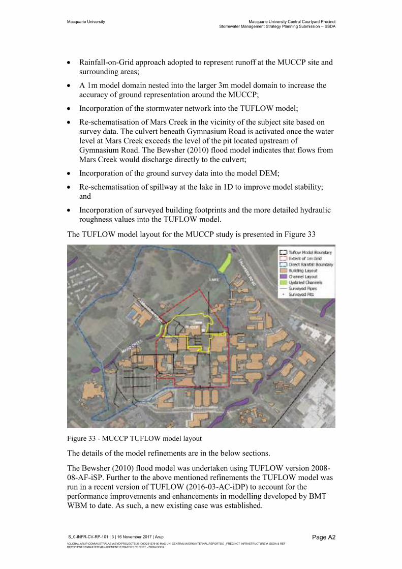
Macquarie University Macquarie University Central Courtyard Precinct Stormwater Management Strategy Planning Submission – SSDA
S_0-INFR-CV-RP-101 | 3 | 16 November 2017 | Arup \\GLOBAL.ARUP.COM\AUSTRALASIA\SYD\PROJECTS\251000\251278-00 MAC UNI CENTRAL\WORK\INTERNAL\REPORTS\0 _PRECINCT INFRASTRUCTURE\#. SSDA & REF REPORT\STORMWATER MANAGEMENT STRATEGY REPORT - SSDA.DOCX
Page A2
Rainfall-on-Grid approach adopted to represent runoff at the MUCCP site and surrounding areas;
A 1m model domain nested into the larger 3m model domain to increase the accuracy of ground representation around the MUCCP;
Incorporation of the stormwater network into the TUFLOW model;
Re-schematisation of Mars Creek in the vicinity of the subject site based on survey data. The culvert beneath Gymnasium Road is activated once the water level at Mars Creek exceeds the level of the pit located upstream of Gymnasium Road. The Bewsher (2010) flood model indicates that flows from Mars Creek would discharge directly to the culvert;
Incorporation of the ground survey data into the model DEM;
Re-schematisation of spillway at the lake in 1D to improve model stability; and
Incorporation of surveyed building footprints and the more detailed hydraulic roughness values into the TUFLOW model.
The TUFLOW model layout for the MUCCP study is presented in Figure 33
Figure 33 - MUCCP TUFLOW model layout
The details of the model refinements are in the below sections.
The Bewsher (2010) flood model was undertaken using TUFLOW version 2008-08-AF-iSP. Further to the above mentioned refinements the TUFLOW model was run in a recent version of TUFLOW (2016-03-AC-iDP) to account for the performance improvements and enhancements in modelling developed by BMT WBM to date. As such, a new existing case was established.
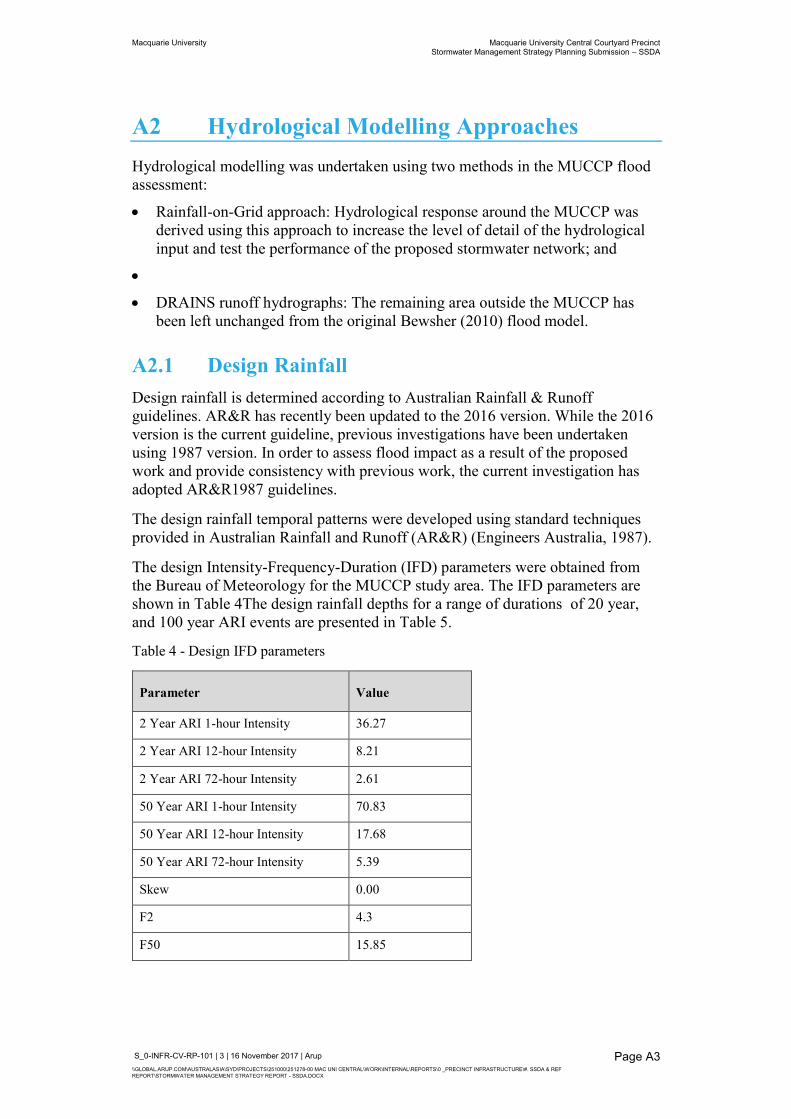
Macquarie University Macquarie University Central Courtyard Precinct Stormwater Management Strategy Planning Submission – SSDA
S_0-INFR-CV-RP-101 | 3 | 16 November 2017 | Arup \\GLOBAL.ARUP.COM\AUSTRALASIA\SYD\PROJECTS\251000\251278-00 MAC UNI CENTRAL\WORK\INTERNAL\REPORTS\0 _PRECINCT INFRASTRUCTURE\#. SSDA & REF REPORT\STORMWATER MANAGEMENT STRATEGY REPORT - SSDA.DOCX
Page A3
A2 Hydrological Modelling Approaches Hydrological modelling was undertaken using two methods in the MUCCP flood assessment:
Rainfall-on-Grid approach: Hydrological response around the MUCCP was derived using this approach to increase the level of detail of the hydrological input and test the performance of the proposed stormwater network; and
DRAINS runoff hydrographs: The remaining area outside the MUCCP has been left unchanged from the original Bewsher (2010) flood model.
A2.1 Design Rainfall Design rainfall is determined according to Australian Rainfall & Runoff guidelines. AR&R has recently been updated to the 2016 version. While the 2016 version is the current guideline, previous investigations have been undertaken using 1987 version. In order to assess flood impact as a result of the proposed work and provide consistency with previous work, the current investigation has adopted AR&R1987 guidelines.
The design rainfall temporal patterns were developed using standard techniques provided in Australian Rainfall and Runoff (AR&R) (Engineers Australia, 1987).
The design Intensity-Frequency-Duration (IFD) parameters were obtained from the Bureau of Meteorology for the MUCCP study area. The IFD parameters are shown in Table 4The design rainfall depths for a range of durations of 20 year, and 100 year ARI events are presented in Table 5.
Table 4 - Design IFD parameters
Parameter Value
2 Year ARI 1-hour Intensity 36.27
2 Year ARI 12-hour Intensity 8.21
2 Year ARI 72-hour Intensity 2.61
50 Year ARI 1-hour Intensity 70.83
50 Year ARI 12-hour Intensity 17.68
50 Year ARI 72-hour Intensity 5.39
Skew 0.00
F2 4.3
F50 15.85
Macquarie University Macquarie University Central Courtyard Precinct Stormwater Management Strategy Planning Submission – SSDA
S_0-INFR-CV-RP-101 | 3 | 16 November 2017 | Arup \\GLOBAL.ARUP.COM\AUSTRALASIA\SYD\PROJECTS\251000\251278-00 MAC UNI CENTRAL\WORK\INTERNAL\REPORTS\0 _PRECINCT INFRASTRUCTURE\#. SSDA & REF REPORT\STORMWATER MANAGEMENT STRATEGY REPORT - SSDA.DOCX
Page A4
Table 5 - Design Rainfall Depths (mm)
Year ARI 15 mins 30 mins 60 mins 90 mins 120 mins
20 31.6 43.8 60.6 75.8 82.2
100 40.7 56.5 78.8 99.5 107.8
No Areal Reduction Factors (ARF) were applied to the design rainfall depths due to the relative small catchment size that drains towards the project site, which is consistent with the previous investigations.
The design rainfall depth for the Probable Maximum Precipitation (PMP) with 15 minutes duration is 150mm, which was directly sourced from the Bewsher DRAINS model.
A2.2 Rainfall losses Rainfall losses are the amount of precipitation that does not contribute towards runoff. This loss is caused by a number of factors such as interception by vegetation, soil infiltration and depression storage. Rainfall loss values adopted within the “Rainfall-on-Grid” area are:
Initial loss for pervious areas: 10 mm;
Continuing loss for pervious areas: 2.5 mm/h;
Initial loss for impervious areas: 1 mm; and
Continuing loss for impervious areas: 0 mm/h.
A2.3 Critical Duration The Bewsher TUFLOW model results indicate that 2 hour event is the critical design event for 100 year and 20 year ARI, whilst 15 minute event is the critical event of PMF.
As discussed in section A1.1, the Bewsher model is not capable of defining the local overland flooding in details around the MUCCP. To undertake a further investigation of critical durations around the MUCCP, a sensitivity analysis was undertaken by simulating 100 year ARI with durations of 15, 30, 60, 90, and 120 minutes within the “Rainfall-on-Grid” area.
Figure 34 shows the flood level differences between the 2 hour event and the maximum results of 100 year ARI with a range of durations. The flood level differences are ±0.01m in general, indicating the 2 hour event is suitable to be the critical duration for the local flooding.

Macquarie University Macquarie University Central Courtyard Precinct Stormwater Management Strategy Planning Submission – SSDA
S_0-INFR-CV-RP-101 | 3 | 16 November 2017 | Arup \\GLOBAL.ARUP.COM\AUSTRALASIA\SYD\PROJECTS\251000\251278-00 MAC UNI CENTRAL\WORK\INTERNAL\REPORTS\0 _PRECINCT INFRASTRUCTURE\#. SSDA & REF REPORT\STORMWATER MANAGEMENT STRATEGY REPORT - SSDA.DOCX
Page A5
Figure 34 - Afflux of 2 hr flood levels
Be consistent with the Bewsher model, the MUCCP study adopted 2 hours as the critical duration for 100 year and 20 year ARI, and 15 minutes as the critical duration for PMF.
A2.4 Model domain The MUCCP hydraulic model was established using the Geocentric Datum of Australia (GDA 94, Zone 56) and Australian Height Datum (AHD) which is consistent with the Bewsher model.
The model covers an area of approximately 327 ha and it is established on a regular spaced grid of 3 m.
The model covers an area of approximately 11.8 ha and is established on 1m spaced grids nested within our area of interest and 3m spaced grids elsewhere as per Bewsher model.
A2.5 Terrain information A large portion of the MU campus has been surveyed by LTS Lockley who maintain a campus wide survey model called the Macquarie University Master Model (MUMM). The MUMM is comprised of several surveys over an unknown period of time and it the primary source of topographic information for this project.
The Bewsher flood model utilises a combination of airborne laser scanning (ALS) and surveyed cross-sections in the Mars Creek channel. ALS maps topographic surfaces however is unable to penetrate through water. Therefore survey of the creek and lake bathymetry is required. The survey of the creek is undertaken in cross-sections with corresponding points interpolated to create a channel.
Macquarie University Macquarie University Central Courtyard Precinct Stormwater Management Strategy Planning Submission – SSDA
S_0-INFR-CV-RP-101 | 3 | 16 November 2017 | Arup \\GLOBAL.ARUP.COM\AUSTRALASIA\SYD\PROJECTS\251000\251278-00 MAC UNI CENTRAL\WORK\INTERNAL\REPORTS\0 _PRECINCT INFRASTRUCTURE\#. SSDA & REF REPORT\STORMWATER MANAGEMENT STRATEGY REPORT - SSDA.DOCX
Page A6
Due to the large area of interest, the existing surface used in the hydraulic model has been derived using a combination of:
Mars Creek channel sections extracted from the Bewsher flood model, coupled with Mars Creek channel section survey data provided by LTS Lockley dated 6 September 2017 ;
Lake bathymetry from survey undertaken by LTS Lockley dated 6 September 2017;
Ground survey (partially contours, partially digital terrain model - DTM) previously undertaken by LTS Lockley and incorporated into the Macquarie University Master Model (MUMM); and
ALS data extracted from the Bewsher model.
To ensure a continuous surface between the channel sections and surrounding topography, a transition zone is required to smooth ‘jumps’ in the surface at the interface between different sources of topography. The critical area of concern is the interface between the surveyed top of embankment in the channel sections and the adjacent ground surface given by the DTM. These discrepancies in the interface are not unusual as the DTM interpolates between surveyed points.
The transition zone is modelled as a corridor from the top of embankment given in the channel sections for 5 meters for the length of the channel corridor. The 5 metre width ensures the transition is spaced across the largest spaced grid, 3 metres.
A2.6 Roughness Surface roughness values adopted in the Bewsher model are unable to represent the land uses in details within the MUCCP study area since the Bewsher study focuses on defining flood behaviour along the main watercourses. Therefore, a refinement of the surface roughness values within the ‘Rainfall-on-Grid’ area has been undertaken to capture the details of land uses based on aerial imagery. The updated surface roughness values are presented in Figure 35.
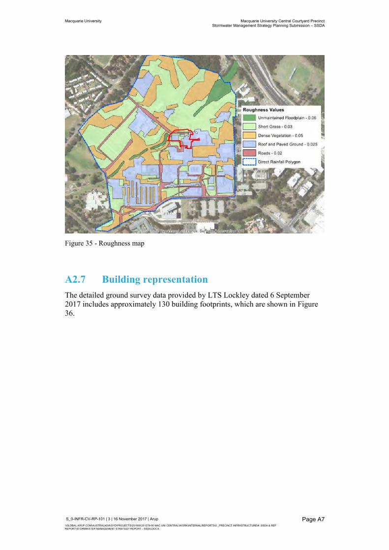
Macquarie University Macquarie University Central Courtyard Precinct Stormwater Management Strategy Planning Submission – SSDA
S_0-INFR-CV-RP-101 | 3 | 16 November 2017 | Arup \\GLOBAL.ARUP.COM\AUSTRALASIA\SYD\PROJECTS\251000\251278-00 MAC UNI CENTRAL\WORK\INTERNAL\REPORTS\0 _PRECINCT INFRASTRUCTURE\#. SSDA & REF REPORT\STORMWATER MANAGEMENT STRATEGY REPORT - SSDA.DOCX
Page A7
Figure 35 - Roughness map
A2.7 Building representation The detailed ground survey data provided by LTS Lockley dated 6 September 2017 includes approximately 130 building footprints, which are shown in Figure 36.
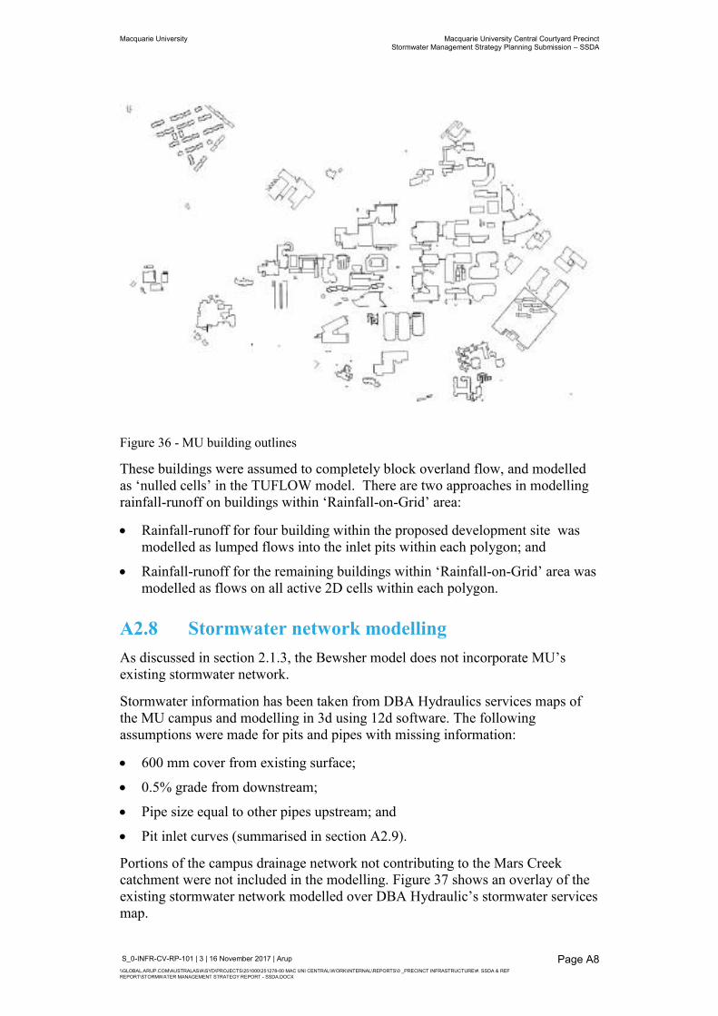
Macquarie University Macquarie University Central Courtyard Precinct Stormwater Management Strategy Planning Submission – SSDA
S_0-INFR-CV-RP-101 | 3 | 16 November 2017 | Arup \\GLOBAL.ARUP.COM\AUSTRALASIA\SYD\PROJECTS\251000\251278-00 MAC UNI CENTRAL\WORK\INTERNAL\REPORTS\0 _PRECINCT INFRASTRUCTURE\#. SSDA & REF REPORT\STORMWATER MANAGEMENT STRATEGY REPORT - SSDA.DOCX
Page A8
Figure 36 - MU building outlines
These buildings were assumed to completely block overland flow, and modelled as ‘nulled cells’ in the TUFLOW model. There are two approaches in modelling rainfall-runoff on buildings within ‘Rainfall-on-Grid’ area:
Rainfall-runoff for four building within the proposed development site was modelled as lumped flows into the inlet pits within each polygon; and
Rainfall-runoff for the remaining buildings within ‘Rainfall-on-Grid’ area was modelled as flows on all active 2D cells within each polygon.
A2.8 Stormwater network modelling As discussed in section 2.1.3, the Bewsher model does not incorporate MU’s existing stormwater network.
Stormwater information has been taken from DBA Hydraulics services maps of the MU campus and modelling in 3d using 12d software. The following assumptions were made for pits and pipes with missing information:
600 mm cover from existing surface;
0.5% grade from downstream;
Pipe size equal to other pipes upstream; and
Pit inlet curves (summarised in section A2.9).
Portions of the campus drainage network not contributing to the Mars Creek catchment were not included in the modelling. Figure 37 shows an overlay of the existing stormwater network modelled over DBA Hydraulic’s stormwater services map.
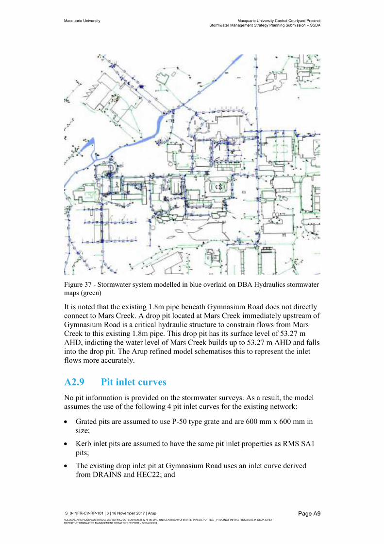
Macquarie University Macquarie University Central Courtyard Precinct Stormwater Management Strategy Planning Submission – SSDA
S_0-INFR-CV-RP-101 | 3 | 16 November 2017 | Arup \\GLOBAL.ARUP.COM\AUSTRALASIA\SYD\PROJECTS\251000\251278-00 MAC UNI CENTRAL\WORK\INTERNAL\REPORTS\0 _PRECINCT INFRASTRUCTURE\#. SSDA & REF REPORT\STORMWATER MANAGEMENT STRATEGY REPORT - SSDA.DOCX
Page A9
Figure 37 - Stormwater system modelled in blue overlaid on DBA Hydraulics stormwater maps (green)
It is noted that the existing 1.8m pipe beneath Gymnasium Road does not directly connect to Mars Creek. A drop pit located at Mars Creek immediately upstream of Gymnasium Road is a critical hydraulic structure to constrain flows from Mars Creek to this existing 1.8m pipe. This drop pit has its surface level of 53.27 m AHD, indicting the water level of Mars Creek builds up to 53.27 m AHD and falls into the drop pit. The Arup refined model schematises this to represent the inlet flows more accurately.
A2.9 Pit inlet curves No pit information is provided on the stormwater surveys. As a result, the model assumes the use of the following 4 pit inlet curves for the existing network:
Grated pits are assumed to use P-50 type grate and are 600 mm x 600 mm in size;
Kerb inlet pits are assumed to have the same pit inlet properties as RMS SA1 pits;
The existing drop inlet pit at Gymnasium Road uses an inlet curve derived from DRAINS and HEC22; and
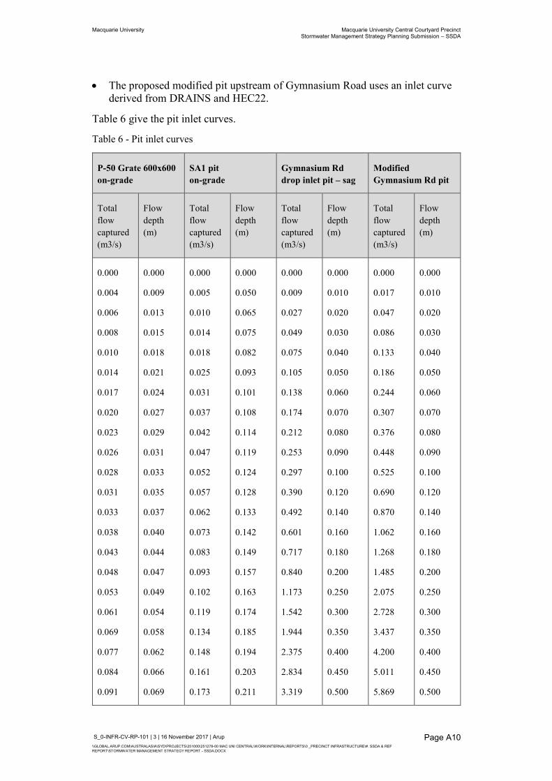
Macquarie University Macquarie University Central Courtyard Precinct Stormwater Management Strategy Planning Submission – SSDA
S_0-INFR-CV-RP-101 | 3 | 16 November 2017 | Arup \\GLOBAL.ARUP.COM\AUSTRALASIA\SYD\PROJECTS\251000\251278-00 MAC UNI CENTRAL\WORK\INTERNAL\REPORTS\0 _PRECINCT INFRASTRUCTURE\#. SSDA & REF REPORT\STORMWATER MANAGEMENT STRATEGY REPORT - SSDA.DOCX
Page A10
The proposed modified pit upstream of Gymnasium Road uses an inlet curve derived from DRAINS and HEC22.
Table 6 give the pit inlet curves.
Table 6 - Pit inlet curves
P-50 Grate 600x600 on-grade
SA1 pit on-grade
Gymnasium Rd drop inlet pit – sag
Modified Gymnasium Rd pit
Total flow captured (m3/s)
Flow depth (m)
Total flow captured (m3/s)
Flow depth (m)
Total flow captured (m3/s)
Flow depth (m)
Total flow captured (m3/s)
Flow depth (m)
0.000
0.004
0.006
0.008
0.010
0.014
0.017
0.020
0.023
0.026
0.028
0.031
0.033
0.038
0.043
0.048
0.053
0.061
0.069
0.077
0.084
0.091
0.000
0.009
0.013
0.015
0.018
0.021
0.024
0.027
0.029
0.031
0.033
0.035
0.037
0.040
0.044
0.047
0.049
0.054
0.058
0.062
0.066
0.069
0.000
0.005
0.010
0.014
0.018
0.025
0.031
0.037
0.042
0.047
0.052
0.057
0.062
0.073
0.083
0.093
0.102
0.119
0.134
0.148
0.161
0.173
0.000
0.050
0.065
0.075
0.082
0.093
0.101
0.108
0.114
0.119
0.124
0.128
0.133
0.142
0.149
0.157
0.163
0.174
0.185
0.194
0.203
0.211
0.000
0.009
0.027
0.049
0.075
0.105
0.138
0.174
0.212
0.253
0.297
0.390
0.492
0.601
0.717
0.840
1.173
1.542
1.944
2.375
2.834
3.319
0.000
0.010
0.020
0.030
0.040
0.050
0.060
0.070
0.080
0.090
0.100
0.120
0.140
0.160
0.180
0.200
0.250
0.300
0.350
0.400
0.450
0.500
0.000
0.017
0.047
0.086
0.133
0.186
0.244
0.307
0.376
0.448
0.525
0.690
0.870
1.062
1.268
1.485
2.075
2.728
3.437
4.200
5.011
5.869
0.000
0.010
0.020
0.030
0.040
0.050
0.060
0.070
0.080
0.090
0.100
0.120
0.140
0.160
0.180
0.200
0.250
0.300
0.350
0.400
0.450
0.500
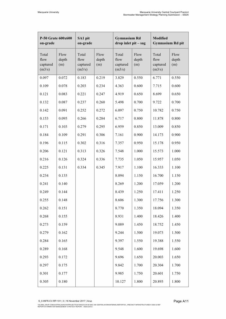
Macquarie University Macquarie University Central Courtyard Precinct Stormwater Management Strategy Planning Submission – SSDA
S_0-INFR-CV-RP-101 | 3 | 16 November 2017 | Arup \\GLOBAL.ARUP.COM\AUSTRALASIA\SYD\PROJECTS\251000\251278-00 MAC UNI CENTRAL\WORK\INTERNAL\REPORTS\0 _PRECINCT INFRASTRUCTURE\#. SSDA & REF REPORT\STORMWATER MANAGEMENT STRATEGY REPORT - SSDA.DOCX
Page A11
P-50 Grate 600x600 on-grade
SA1 pit on-grade
Gymnasium Rd drop inlet pit – sag
Modified Gymnasium Rd pit
Total flow captured (m3/s)
Flow depth (m)
Total flow captured (m3/s)
Flow depth (m)
Total flow captured (m3/s)
Flow depth (m)
Total flow captured (m3/s)
Flow depth (m)
0.097
0.109
0.121
0.132
0.142
0.153
0.171
0.184
0.196
0.206
0.216
0.225
0.234
0.241
0.249
0.255
0.262
0.268
0.273
0.279
0.284
0.289
0.293
0.297
0.301
0.305
0.072
0.078
0.083
0.087
0.091
0.095
0.103
0.109
0.115
0.121
0.126
0.131
0.135
0.140
0.144
0.148
0.151
0.155
0.159
0.162
0.165
0.168
0.172
0.175
0.177
0.180
0.183
0.203
0.221
0.237
0.252
0.266
0.279
0.291
0.302
0.313
0.324
0.334
0.219
0.234
0.247
0.260
0.272
0.284
0.295
0.306
0.316
0.326
0.336
0.345
3.829
4.363
4.919
5.498
6.097
6.717
6.959
7.161
7.357
7.548
7.735
7.917
8.094
8.269
8.439
8.606
8.770
8.931
9.089
9.244
9.397
9.548
9.696
9.842
9.985
10.127
0.550
0.600
0.650
0.700
0.750
0.800
0.850
0.900
0.950
1.000
1.050
1.100
1.150
1.200
1.250
1.300
1.350
1.400
1.450
1.500
1.550
1.600
1.650
1.700
1.750
1.800
6.771
7.715
8.699
9.722
10.782
11.878
13.009
14.173
15.178
15.573
15.957
16.333
16.700
17.059
17.411
17.756
18.094
18.426
18.752
19.073
19.388
19.698
20.003
20.304
20.601
20.893
0.550
0.600
0.650
0.700
0.750
0.800
0.850
0.900
0.950
1.000
1.050
1.100
1.150
1.200
1.250
1.300
1.350
1.400
1.450
1.500
1.550
1.600
1.650
1.700
1.750
1.800
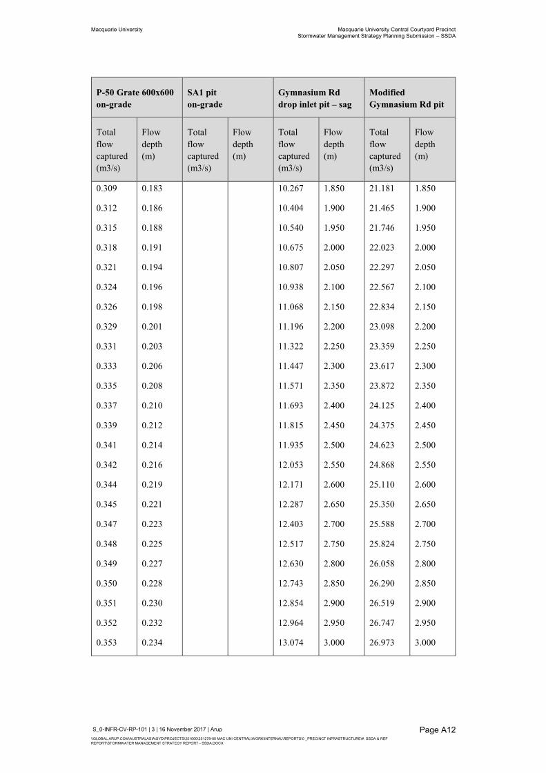
Macquarie University Macquarie University Central Courtyard Precinct Stormwater Management Strategy Planning Submission – SSDA
S_0-INFR-CV-RP-101 | 3 | 16 November 2017 | Arup \\GLOBAL.ARUP.COM\AUSTRALASIA\SYD\PROJECTS\251000\251278-00 MAC UNI CENTRAL\WORK\INTERNAL\REPORTS\0 _PRECINCT INFRASTRUCTURE\#. SSDA & REF REPORT\STORMWATER MANAGEMENT STRATEGY REPORT - SSDA.DOCX
Page A12
P-50 Grate 600x600 on-grade
SA1 pit on-grade
Gymnasium Rd drop inlet pit – sag
Modified Gymnasium Rd pit
Total flow captured (m3/s)
Flow depth (m)
Total flow captured (m3/s)
Flow depth (m)
Total flow captured (m3/s)
Flow depth (m)
Total flow captured (m3/s)
Flow depth (m)
0.309
0.312
0.315
0.318
0.321
0.324
0.326
0.329
0.331
0.333
0.335
0.337
0.339
0.341
0.342
0.344
0.345
0.347
0.348
0.349
0.350
0.351
0.352
0.353
0.183
0.186
0.188
0.191
0.194
0.196
0.198
0.201
0.203
0.206
0.208
0.210
0.212
0.214
0.216
0.219
0.221
0.223
0.225
0.227
0.228
0.230
0.232
0.234
10.267
10.404
10.540
10.675
10.807
10.938
11.068
11.196
11.322
11.447
11.571
11.693
11.815
11.935
12.053
12.171
12.287
12.403
12.517
12.630
12.743
12.854
12.964
13.074
1.850
1.900
1.950
2.000
2.050
2.100
2.150
2.200
2.250
2.300
2.350
2.400
2.450
2.500
2.550
2.600
2.650
2.700
2.750
2.800
2.850
2.900
2.950
3.000
21.181
21.465
21.746
22.023
22.297
22.567
22.834
23.098
23.359
23.617
23.872
24.125
24.375
24.623
24.868
25.110
25.350
25.588
25.824
26.058
26.290
26.519
26.747
26.973
1.850
1.900
1.950
2.000
2.050
2.100
2.150
2.200
2.250
2.300
2.350
2.400
2.450
2.500
2.550
2.600
2.650
2.700
2.750
2.800
2.850
2.900
2.950
3.000

Macquarie University Macquarie University Central Courtyard Precinct Stormwater Management Strategy Planning Submission – SSDA
S_0-INFR-CV-RP-101 | 3 | 16 November 2017 | Arup \\GLOBAL.ARUP.COM\AUSTRALASIA\SYD\PROJECTS\251000\251278-00 MAC UNI CENTRAL\WORK\INTERNAL\REPORTS\0 _PRECINCT INFRASTRUCTURE\#. SSDA & REF REPORT\STORMWATER MANAGEMENT STRATEGY REPORT - SSDA.DOCX
Page A13
A2.10 Blockage The Arup refined existing model has used the same inlet blockage factors as the Bewsher flood model:
20% blockage for on-grade inlets; and
50% blockage for sag inlets.

Appendix B
Flood Maps
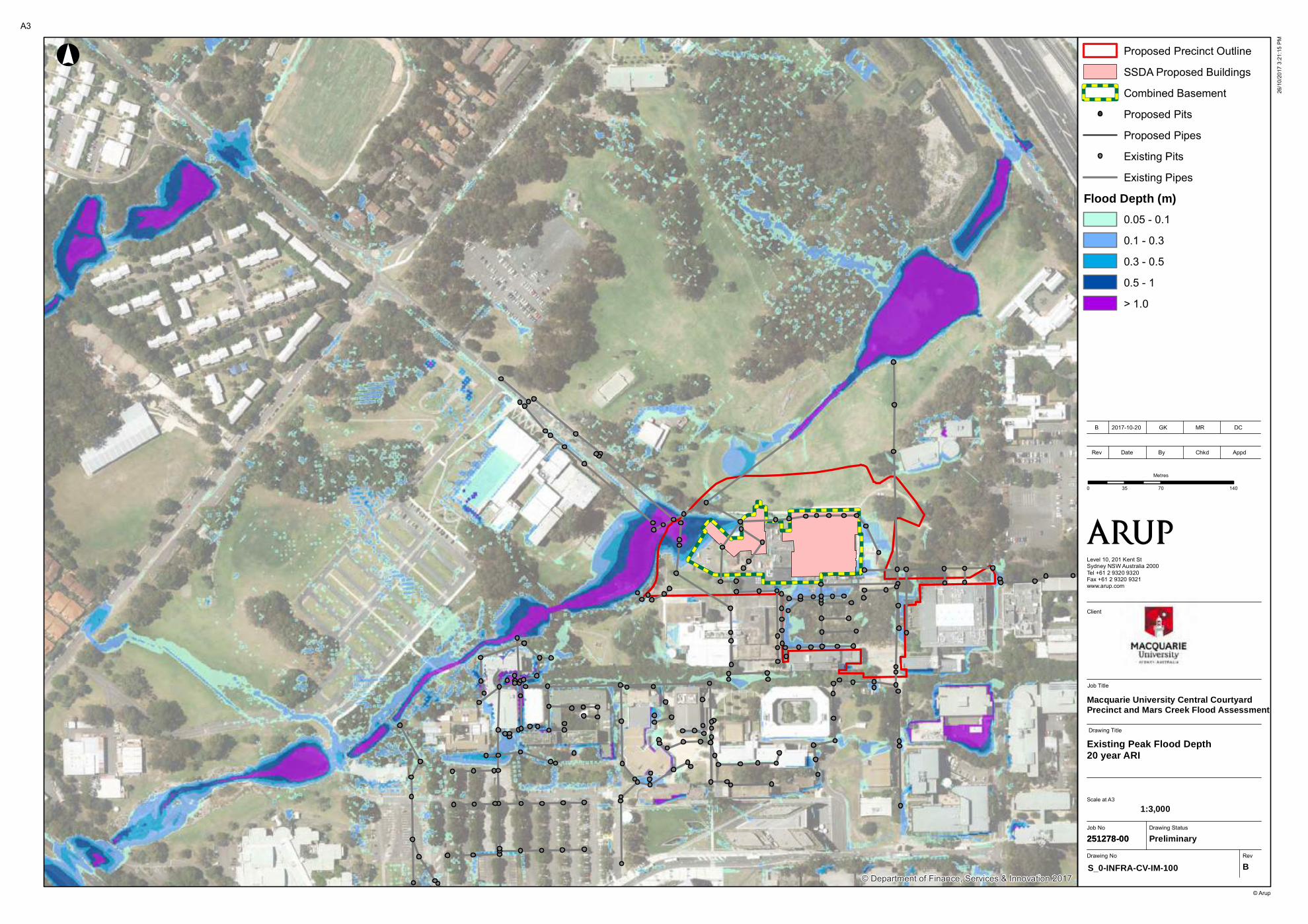
© Department of Finance, Services & Innovation 2017
Job No
251278-00
Drawing No Rev
S_0-INFRA-CV-IM-100 B
Drawing Status
Preliminary
Job Title
Level 10, 201 Kent StSydney NSW Australia 2000Tel +61 2 9320 9320Fax +61 2 9320 9321www.arup.com
0 70 14035
Metres
Proposed Precinct Outline
SSDA Proposed Buildings
Combined Basement
Proposed Pits
Proposed Pipes
Existing Pits
Existing Pipes
Flood Depth (m)
0.05 - 0.1
0.1 - 0.3
0.3 - 0.5
0.5 - 1
> 1.0
!°
© Arup
Macquarie University Central Courtyard Precinct and Mars Creek Flood Assessment
A3
26/1
0/20
17 3
:21:
15 P
M
Existing Peak Flood Depth20 year ARI
Scale at A3
Rev Date By Chkd Appd
B 2017-10-20 GK MR DC
251278-00
Drawing Title
1:3,000
Client

© Department of Finance, Services & Innovation 2017
Job No
251278-00
Drawing No Rev
S_0-INFRA-CV-IM-101 B
Drawing Status
Preliminary
Job Title
Level 10, 201 Kent StSydney NSW Australia 2000Tel +61 2 9320 9320Fax +61 2 9320 9321www.arup.com
0 70 14035
Metres
Proposed Precinct Outline
SSDA Proposed Buildings
Combined Basement
Proposed Pits
Proposed Pipes
Existing Pits
Existing Pipes
Flood Depth (m)
0.05 - 0.1
0.1 - 0.3
0.3 - 0.5
0.5 - 1
> 1.0
!°
© Arup
Macquarie University Central Courtyard Precinct and Mars Creek Flood Assessment
A3
26/1
0/20
17 3
:21:
31 P
M
Existing Peak Flood Depth100 year ARI
Scale at A3
Rev Date By Chkd Appd
B 2017-10-20 GK MR DC
251278-00
Drawing Title
1:3,000
Client
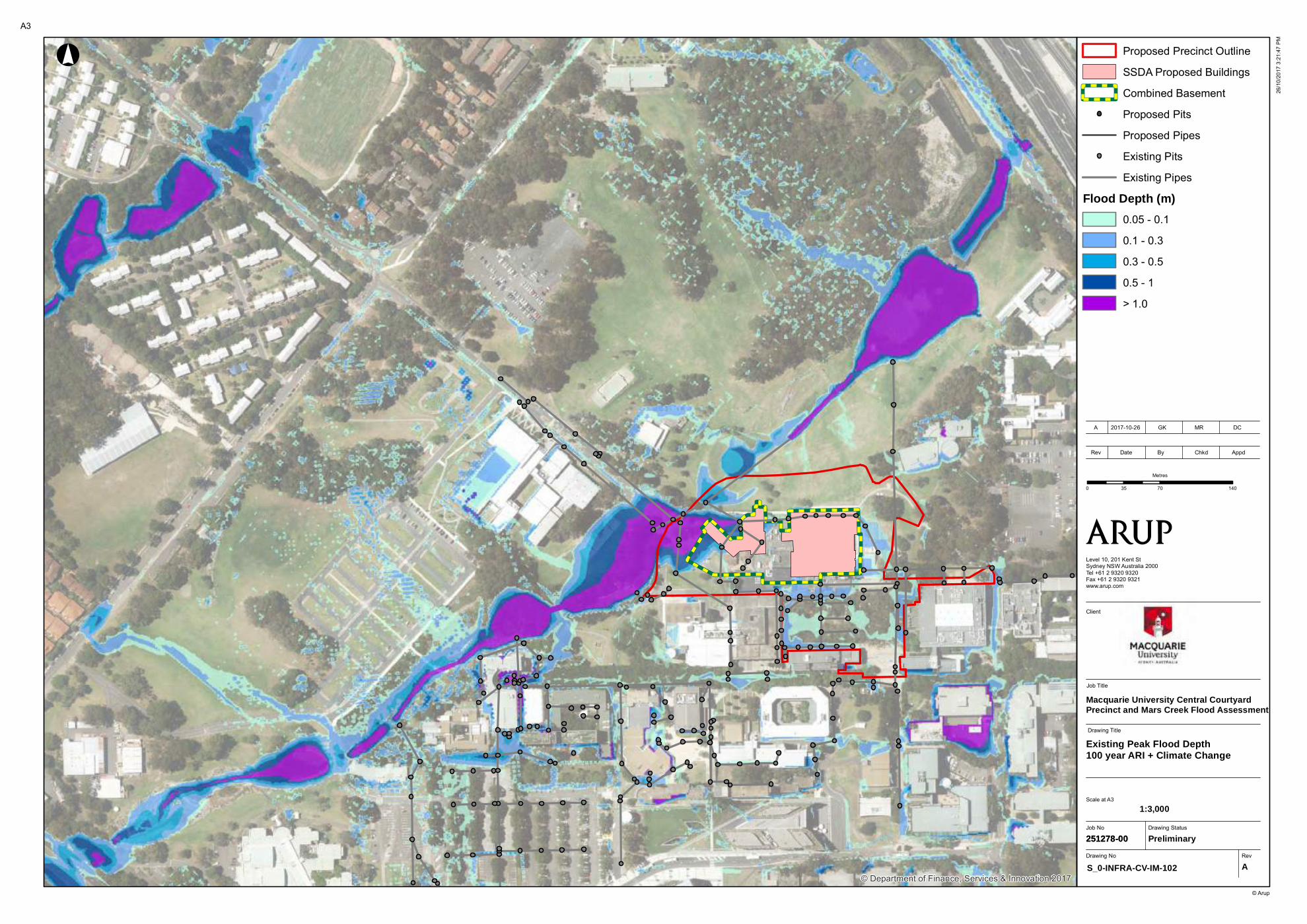
© Department of Finance, Services & Innovation 2017
Job No
251278-00
Drawing No Rev
S_0-INFRA-CV-IM-102 A
Drawing Status
Preliminary
Job Title
Level 10, 201 Kent StSydney NSW Australia 2000Tel +61 2 9320 9320Fax +61 2 9320 9321www.arup.com
0 70 14035
Metres
Proposed Precinct Outline
SSDA Proposed Buildings
Combined Basement
Proposed Pits
Proposed Pipes
Existing Pits
Existing Pipes
Flood Depth (m)
0.05 - 0.1
0.1 - 0.3
0.3 - 0.5
0.5 - 1
> 1.0
!°
© Arup
Macquarie University Central Courtyard Precinct and Mars Creek Flood Assessment
A3
26/1
0/20
17 3
:21:
47 P
M
Existing Peak Flood Depth100 year ARI + Climate Change
Scale at A3
Rev Date By Chkd Appd
A 2017-10-26 GK MR DC
251278-00
Drawing Title
1:3,000
Client
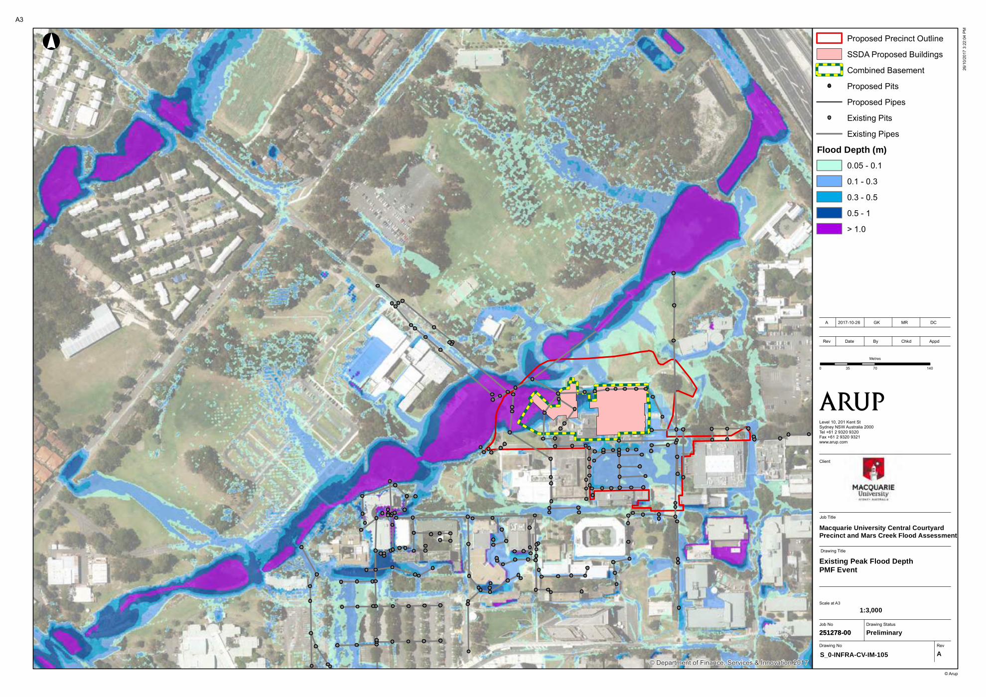
© Department of Finance, Services & Innovation 2017
Job No
251278-00
Drawing No Rev
S_0-INFRA-CV-IM-105 A
Drawing Status
Preliminary
Job Title
Level 10, 201 Kent StSydney NSW Australia 2000Tel +61 2 9320 9320Fax +61 2 9320 9321www.arup.com
0 70 14035
Metres
Proposed Precinct Outline
SSDA Proposed Buildings
Combined Basement
Proposed Pits
Proposed Pipes
Existing Pits
Existing Pipes
Flood Depth (m)
0.05 - 0.1
0.1 - 0.3
0.3 - 0.5
0.5 - 1
> 1.0
!°
© Arup
Macquarie University Central Courtyard Precinct and Mars Creek Flood Assessment
A3
26/1
0/20
17 3
:22:
04 P
M
Existing Peak Flood DepthPMF Event
Scale at A3
Rev Date By Chkd Appd
A 2017-10-26 GK MR DC
251278-00
Drawing Title
1:3,000
Client
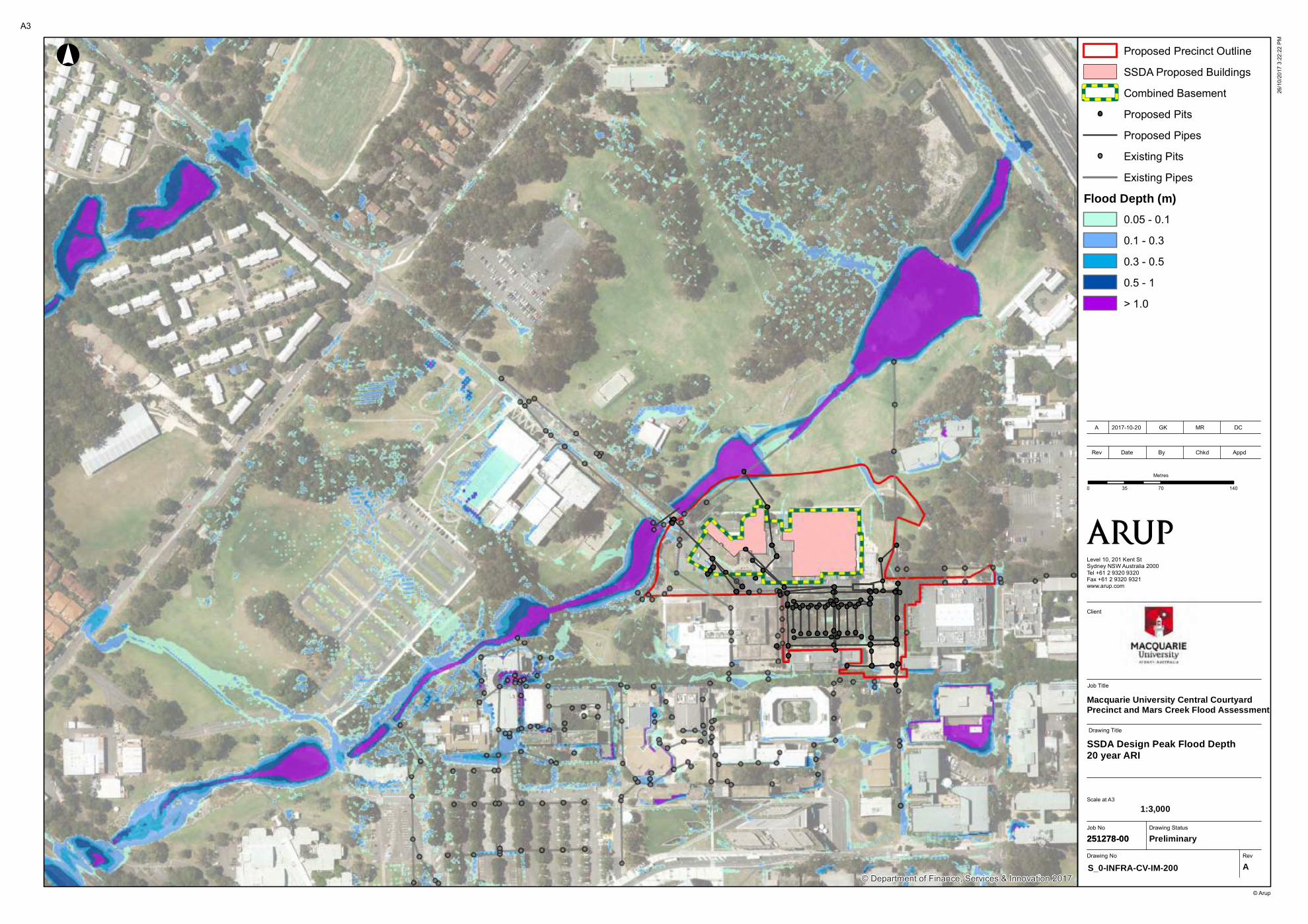
© Department of Finance, Services & Innovation 2017
Job No
251278-00
Drawing No Rev
S_0-INFRA-CV-IM-200 A
Drawing Status
Preliminary
Job Title
Level 10, 201 Kent StSydney NSW Australia 2000Tel +61 2 9320 9320Fax +61 2 9320 9321www.arup.com
0 70 14035
Metres
Proposed Precinct Outline
SSDA Proposed Buildings
Combined Basement
Proposed Pits
Proposed Pipes
Existing Pits
Existing Pipes
Flood Depth (m)
0.05 - 0.1
0.1 - 0.3
0.3 - 0.5
0.5 - 1
> 1.0
!°
© Arup
Macquarie University Central Courtyard Precinct and Mars Creek Flood Assessment
A3
26/1
0/20
17 3
:22:
22 P
M
SSDA Design Peak Flood Depth20 year ARI
Scale at A3
Rev Date By Chkd Appd
A 2017-10-20 GK MR DC
251278-00
Drawing Title
1:3,000
Client
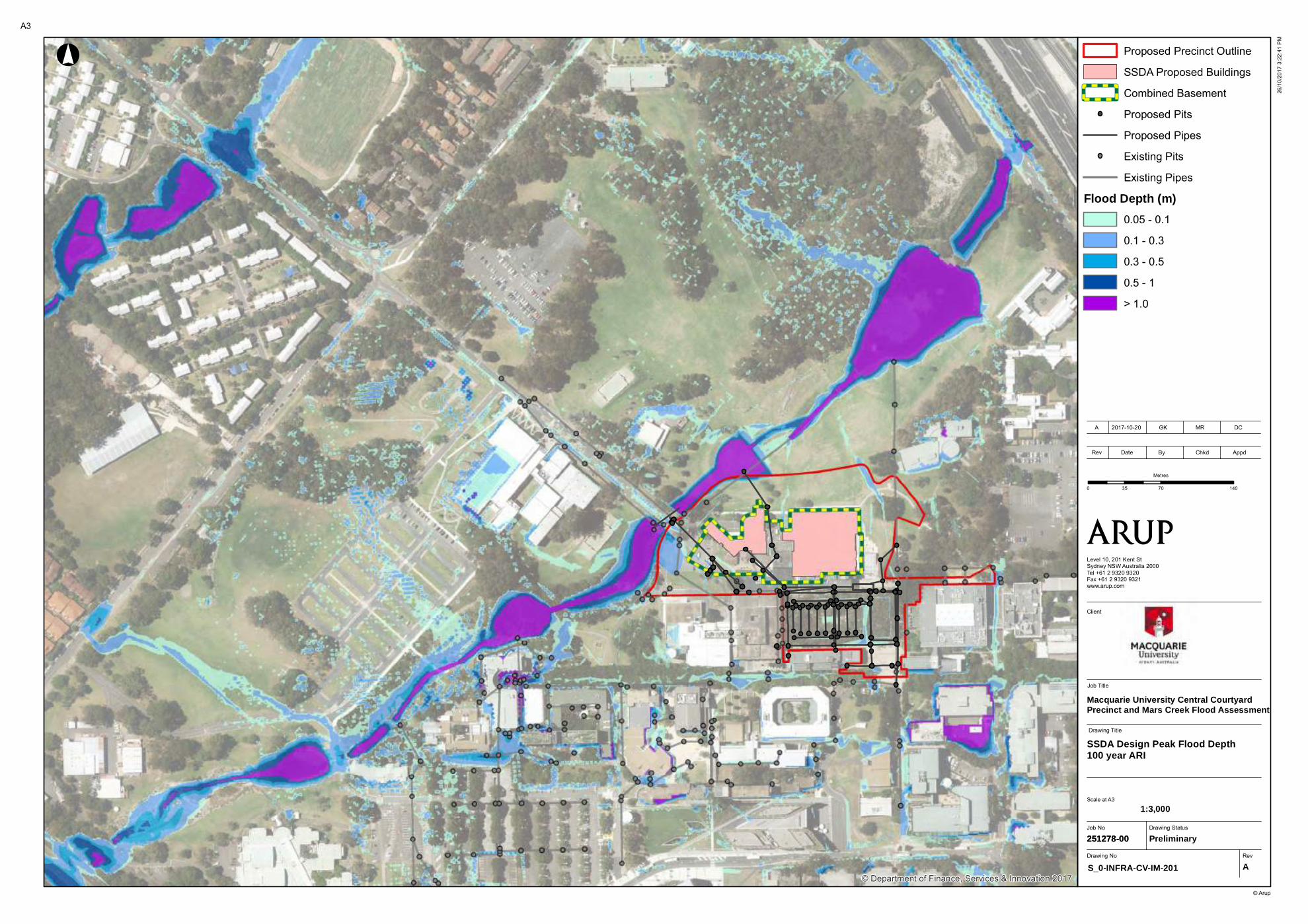
© Department of Finance, Services & Innovation 2017
Job No
251278-00
Drawing No Rev
S_0-INFRA-CV-IM-201 A
Drawing Status
Preliminary
Job Title
Level 10, 201 Kent StSydney NSW Australia 2000Tel +61 2 9320 9320Fax +61 2 9320 9321www.arup.com
0 70 14035
Metres
Proposed Precinct Outline
SSDA Proposed Buildings
Combined Basement
Proposed Pits
Proposed Pipes
Existing Pits
Existing Pipes
Flood Depth (m)
0.05 - 0.1
0.1 - 0.3
0.3 - 0.5
0.5 - 1
> 1.0
!°
© Arup
Macquarie University Central Courtyard Precinct and Mars Creek Flood Assessment
A3
26/1
0/20
17 3
:22:
41 P
M
SSDA Design Peak Flood Depth100 year ARI
Scale at A3
Rev Date By Chkd Appd
A 2017-10-20 GK MR DC
251278-00
Drawing Title
1:3,000
Client

© Department of Finance, Services & Innovation 2017
Job No
251278-00
Drawing No Rev
S_0-INFRA-CV-IM-202 A
Drawing Status
Preliminary
Job Title
Level 10, 201 Kent StSydney NSW Australia 2000Tel +61 2 9320 9320Fax +61 2 9320 9321www.arup.com
0 70 14035
Metres
Proposed Precinct Outline
SSDA Proposed Buildings
Combined Basement
Proposed Pits
Proposed Pipes
Existing Pits
Existing Pipes
Flood Depth (m)
0.05 - 0.1
0.1 - 0.3
0.3 - 0.5
0.5 - 1
> 1.0
!°
© Arup
Macquarie University Central Courtyard Precinct and Mars Creek Flood Assessment
A3
26/1
0/20
17 3
:23:
05 P
M
SSDA Design Peak Flood Depth100 year ARI + Climate Change
Scale at A3
Rev Date By Chkd Appd
A 2017-10-25 GK MR DC
251278-00
Drawing Title
1:3,000
Client
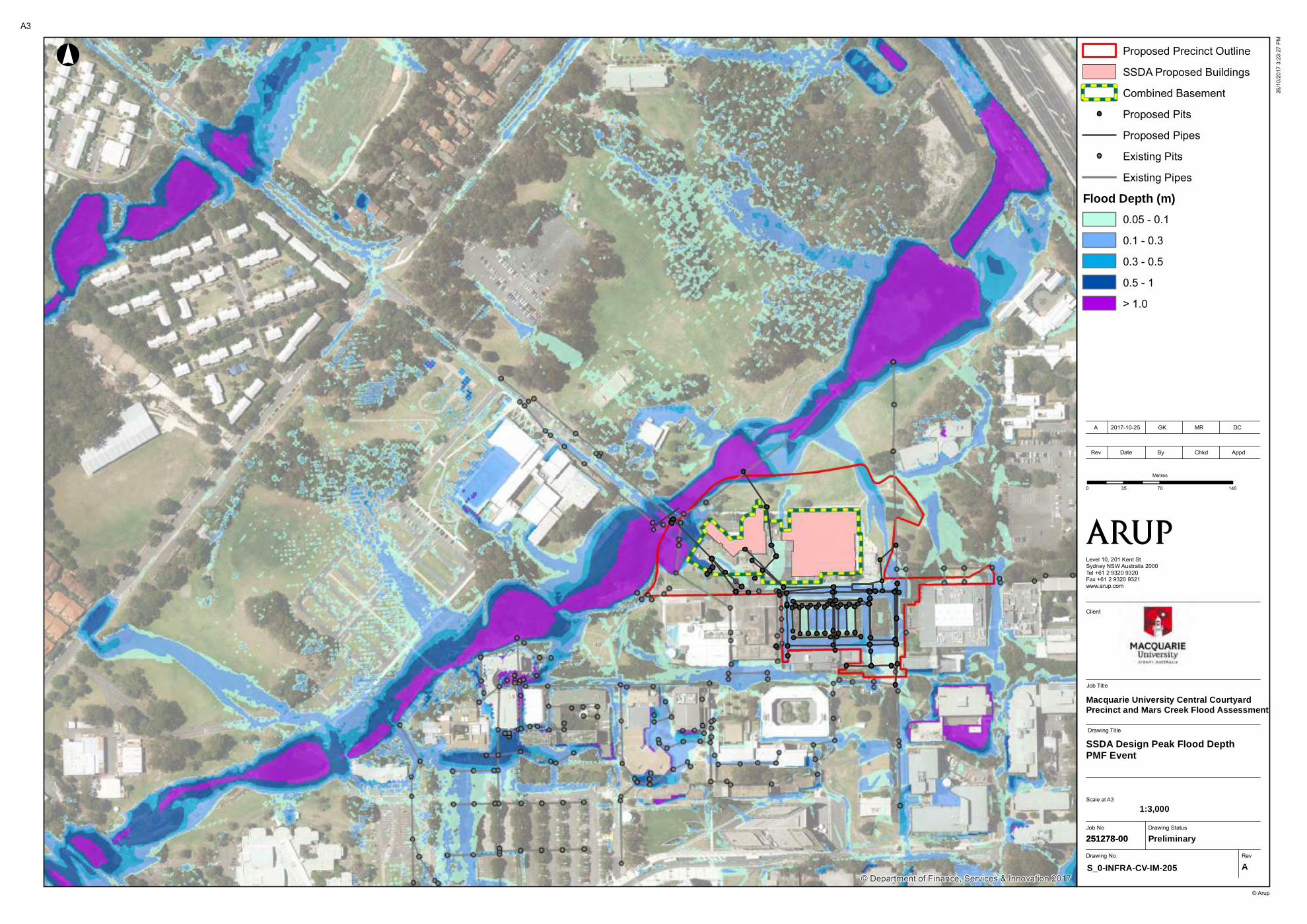
© Department of Finance, Services & Innovation 2017
Job No
251278-00
Drawing No Rev
S_0-INFRA-CV-IM-205 A
Drawing Status
Preliminary
Job Title
Level 10, 201 Kent StSydney NSW Australia 2000Tel +61 2 9320 9320Fax +61 2 9320 9321www.arup.com
0 70 14035
Metres
Proposed Precinct Outline
SSDA Proposed Buildings
Combined Basement
Proposed Pits
Proposed Pipes
Existing Pits
Existing Pipes
Flood Depth (m)
0.05 - 0.1
0.1 - 0.3
0.3 - 0.5
0.5 - 1
> 1.0
!°
© Arup
Macquarie University Central Courtyard Precinct and Mars Creek Flood Assessment
A3
26/1
0/20
17 3
:23:
27 P
M
SSDA Design Peak Flood DepthPMF Event
Scale at A3
Rev Date By Chkd Appd
A 2017-10-25 GK MR DC
251278-00
Drawing Title
1:3,000
Client
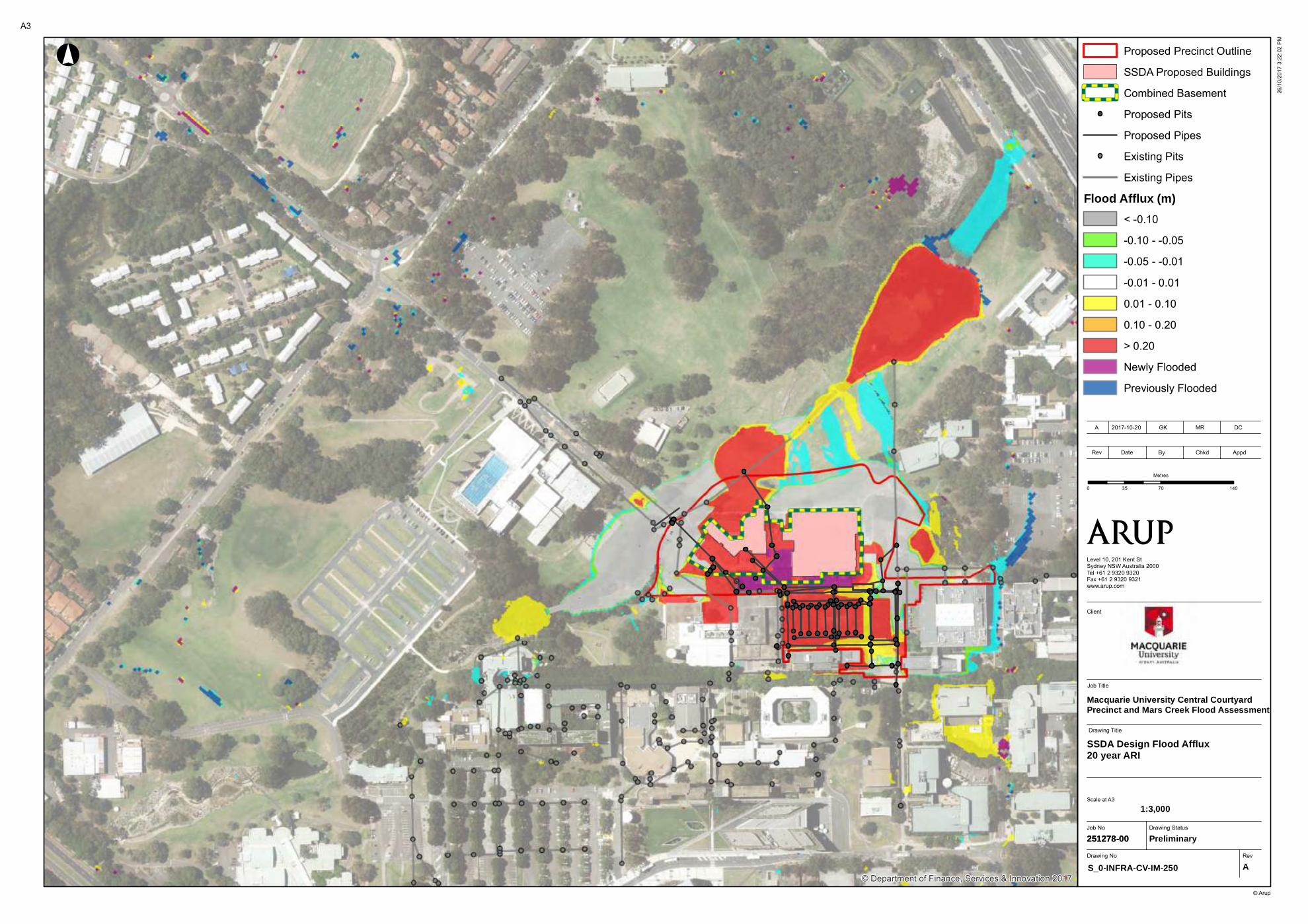
© Department of Finance, Services & Innovation 2017
Job No
251278-00
Drawing No Rev
S_0-INFRA-CV-IM-250 A
Drawing Status
Preliminary
Job Title
Client
Level 10, 201 Kent StSydney NSW Australia 2000Tel +61 2 9320 9320Fax +61 2 9320 9321www.arup.com
0 70 14035
Metres
Proposed Precinct Outline
SSDA Proposed Buildings
Combined Basement
Proposed Pits
Proposed Pipes
Existing Pits
Existing Pipes
Flood Afflux (m)
< -0.10
-0.10 - -0.05
-0.05 - -0.01
-0.01 - 0.01
0.01 - 0.10
0.10 - 0.20
> 0.20
Newly Flooded
Previously Flooded
!°
© Arup
A3
26/1
0/20
17 3
:22:
02 P
M
SSDA Design Flood Afflux20 year ARI
Scale at A3
Rev Date By Chkd Appd
A 2017-10-20 GK MR DC
Macquarie University Central Courtyard Precinct and Mars Creek Flood Assessment
251278-00
Drawing Title
1:3,000

© Department of Finance, Services & Innovation 2017
Job No
251278-00
Drawing No Rev
S_0-INFRA-CV-IM-251 A
Drawing Status
Preliminary
Job Title
Client
Level 10, 201 Kent StSydney NSW Australia 2000Tel +61 2 9320 9320Fax +61 2 9320 9321www.arup.com
0 70 14035
Metres
Proposed Precinct Outline
SSDA Proposed Buildings
Combined Basement
Proposed Pits
Proposed Pipes
Existing Pits
Existing Pipes
Flood Afflux (m)
< -0.10
-0.10 - -0.05
-0.05 - -0.01
-0.01 - 0.01
0.01 - 0.10
0.10 - 0.20
> 0.20
Newly Flooded
Previously Flooded
!°
© Arup
A3
26/1
0/20
17 3
:22:
32 P
M
SSDA Design Flood Afflux100 year ARI
Scale at A3
Rev Date By Chkd Appd
A 2017-10-25 GK MR DC
Macquarie University Central Courtyard Precinct and Mars Creek Flood Assessment
251278-00
Drawing Title
1:3,000

Appendix C
Mars Creek Options Assessment
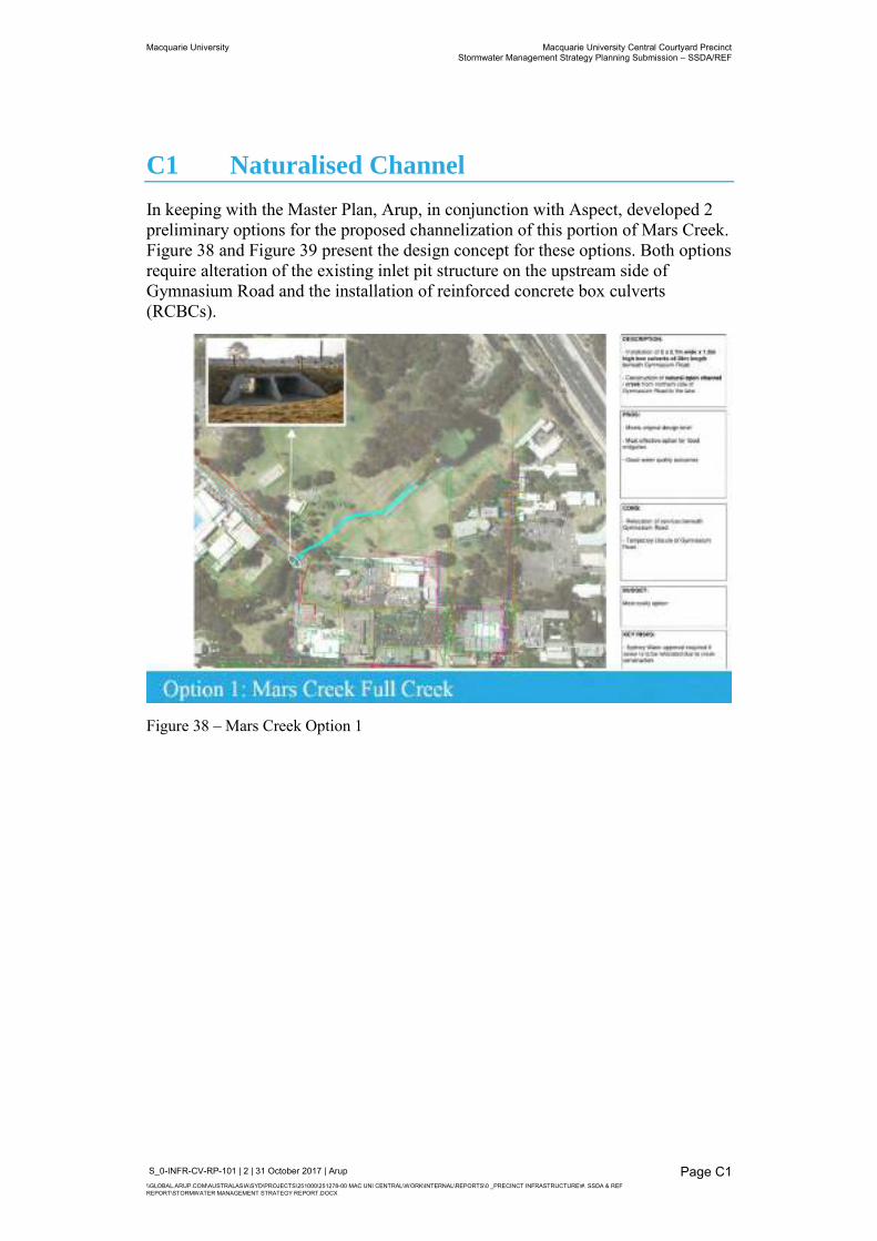
Macquarie University Macquarie University Central Courtyard Precinct Stormwater Management Strategy Planning Submission – SSDA/REF
S_0-INFR-CV-RP-101 | 2 | 31 October 2017 | Arup \\GLOBAL.ARUP.COM\AUSTRALASIA\SYD\PROJECTS\251000\251278-00 MAC UNI CENTRAL\WORK\INTERNAL\REPORTS\0 _PRECINCT INFRASTRUCTURE\#. SSDA & REF REPORT\STORMWATER MANAGEMENT STRATEGY REPORT.DOCX
Page C1
C1 Naturalised Channel
In keeping with the Master Plan, Arup, in conjunction with Aspect, developed 2 preliminary options for the proposed channelization of this portion of Mars Creek. Figure 38 and Figure 39 present the design concept for these options. Both options require alteration of the existing inlet pit structure on the upstream side of Gymnasium Road and the installation of reinforced concrete box culverts (RCBCs).
Figure 38 – Mars Creek Option 1
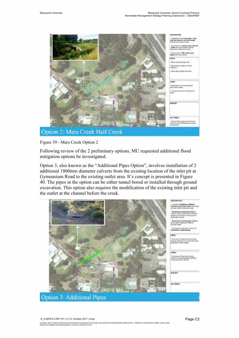
Macquarie University Macquarie University Central Courtyard Precinct Stormwater Management Strategy Planning Submission – SSDA/REF
S_0-INFR-CV-RP-101 | 2 | 31 October 2017 | Arup \\GLOBAL.ARUP.COM\AUSTRALASIA\SYD\PROJECTS\251000\251278-00 MAC UNI CENTRAL\WORK\INTERNAL\REPORTS\0 _PRECINCT INFRASTRUCTURE\#. SSDA & REF REPORT\STORMWATER MANAGEMENT STRATEGY REPORT.DOCX
Page C2
Figure 39 - Mars Creek Option 2
Following review of the 2 preliminary options, MU requested additional flood mitigation options be investigated.
Option 3, also known as the “Additional Pipes Option”, involves installation of 2 additional 1800mm diameter culverts from the existing location of the inlet pit at Gymnasium Road to the existing outlet area. It’s concept is presented in Figure 40. The pipes in the option can be either tunnel bored or installed through ground excavation. This option also requires the modification of the existing inlet pit and the outlet at the channel before the creek.
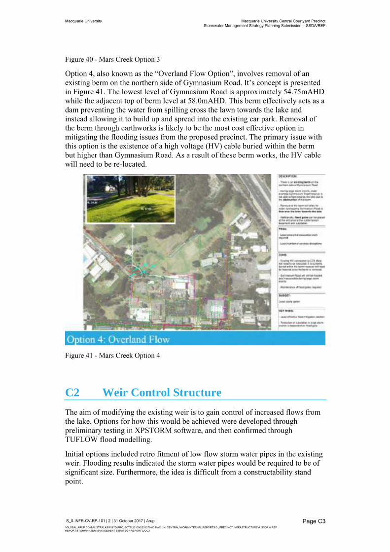
Macquarie University Macquarie University Central Courtyard Precinct Stormwater Management Strategy Planning Submission – SSDA/REF
S_0-INFR-CV-RP-101 | 2 | 31 October 2017 | Arup \\GLOBAL.ARUP.COM\AUSTRALASIA\SYD\PROJECTS\251000\251278-00 MAC UNI CENTRAL\WORK\INTERNAL\REPORTS\0 _PRECINCT INFRASTRUCTURE\#. SSDA & REF REPORT\STORMWATER MANAGEMENT STRATEGY REPORT.DOCX
Page C3
Figure 40 - Mars Creek Option 3
Option 4, also known as the “Overland Flow Option”, involves removal of an existing berm on the northern side of Gymnasium Road. It’s concept is presented in Figure 41. The lowest level of Gymnasium Road is approximately 54.75mAHD while the adjacent top of berm level at 58.0mAHD. This berm effectively acts as a dam preventing the water from spilling cross the lawn towards the lake and instead allowing it to build up and spread into the existing car park. Removal of the berm through earthworks is likely to be the most cost effective option in mitigating the flooding issues from the proposed precinct. The primary issue with this option is the existence of a high voltage (HV) cable buried within the berm but higher than Gymnasium Road. As a result of these berm works, the HV cable will need to be re-located.
Figure 41 - Mars Creek Option 4
C2 Weir Control Structure
The aim of modifying the existing weir is to gain control of increased flows from the lake. Options for how this would be achieved were developed through preliminary testing in XPSTORM software, and then confirmed through TUFLOW flood modelling.
Initial options included retro fitment of low flow storm water pipes in the existing weir. Flooding results indicated the storm water pipes would be required to be of significant size. Furthermore, the idea is difficult from a constructability stand point.
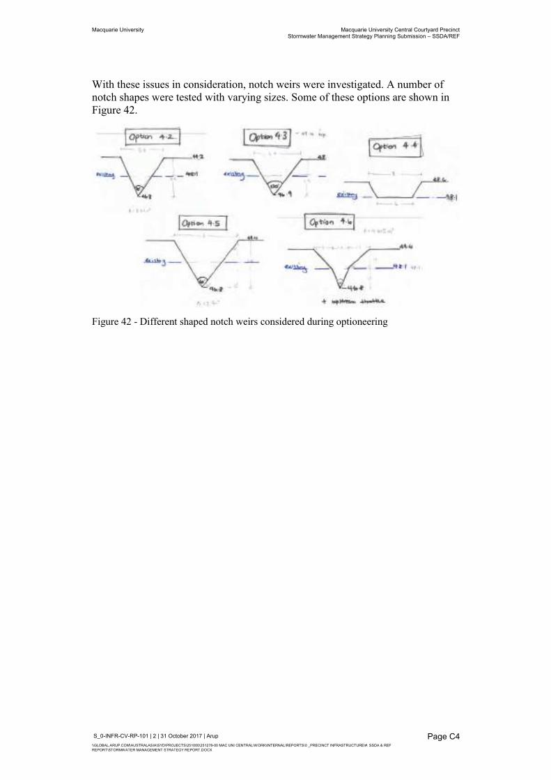
Macquarie University Macquarie University Central Courtyard Precinct Stormwater Management Strategy Planning Submission – SSDA/REF
S_0-INFR-CV-RP-101 | 2 | 31 October 2017 | Arup \\GLOBAL.ARUP.COM\AUSTRALASIA\SYD\PROJECTS\251000\251278-00 MAC UNI CENTRAL\WORK\INTERNAL\REPORTS\0 _PRECINCT INFRASTRUCTURE\#. SSDA & REF REPORT\STORMWATER MANAGEMENT STRATEGY REPORT.DOCX
Page C4
With these issues in consideration, notch weirs were investigated. A number of notch shapes were tested with varying sizes. Some of these options are shown in Figure 42.
Figure 42 - Different shaped notch weirs considered during optioneering

Appendix D
Erosion and Sediment Control Plan and Details
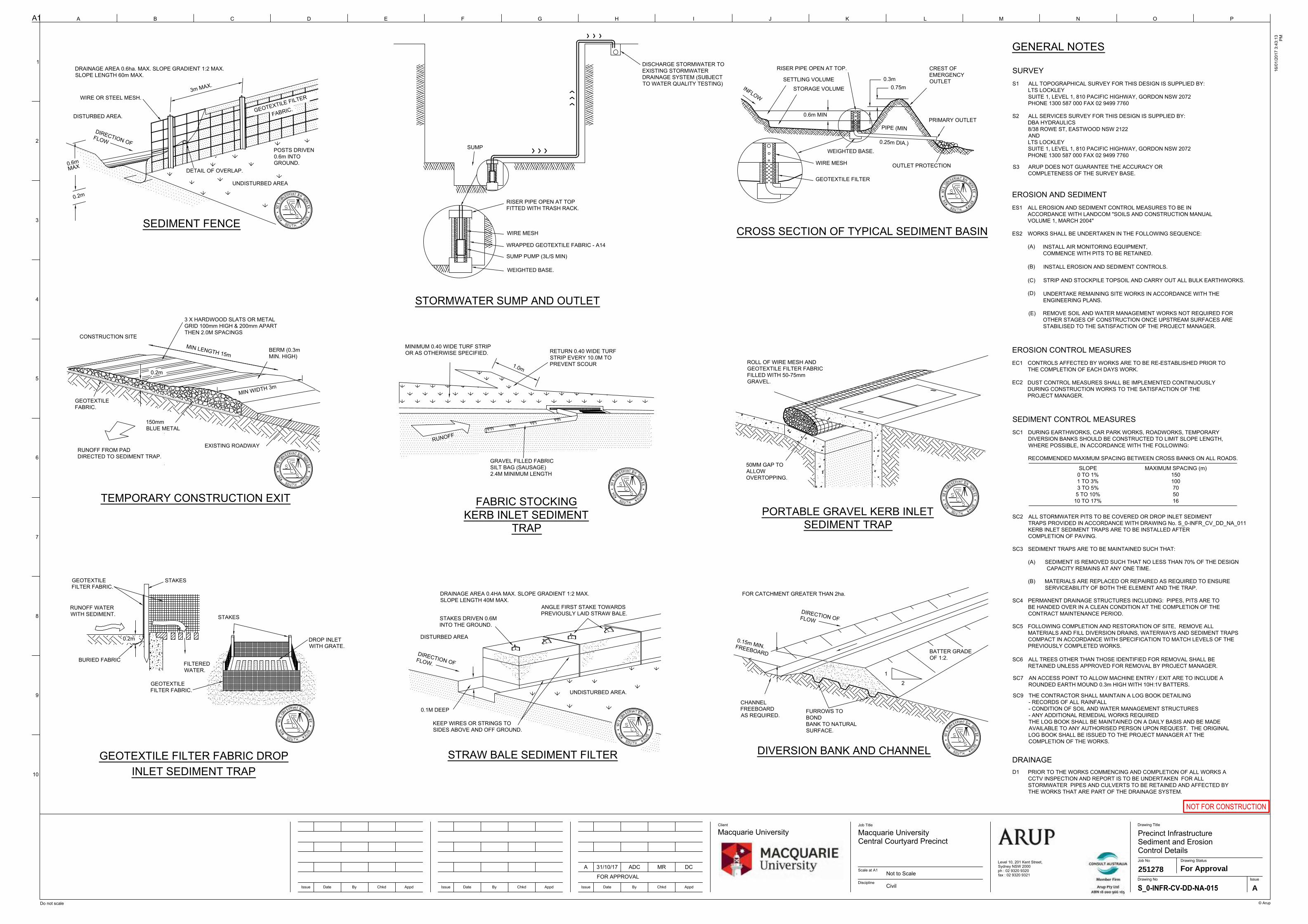
0.3m0.75m
STRAW BALE SEDIMENT FILTER
PORTABLE GRAVEL KERB INLETSEDIMENT TRAP
GEOTEXTILE FILTER FABRIC DROPINLET SEDIMENT TRAP
TEMPORARY CONSTRUCTION EXIT
SEDIMENT FENCE
DIVERSION BANK AND CHANNEL
CROSS SECTION OF TYPICAL SEDIMENT BASIN
DRAINAGE AREA 0.4HA MAX. SLOPE GRADIENT 1:2 MAX.SLOPE LENGTH 40M MAX.
ANGLE FIRST STAKE TOWARDSPREVIOUSLY LAID STRAW BALE.
STAKES DRIVEN 0.6MINTO THE GROUND.
DIRECTION OFFLOW.
0.1M DEEP
DISTURBED AREA
UNDISTURBED AREA.
ROLL OF WIRE MESH ANDGEOTEXTILE FILTER FABRICFILLED WITH 50-75mmGRAVEL.
50MM GAP TOALLOWOVERTOPPING.
CREST OFEMERGENCYOUTLET
OUTLET PROTECTION
WEIGHTED BASE.
WIRE MESH
GEOTEXTILE FILTER
STORAGE VOLUME
SETTLING VOLUME
0.6m MIN
INFLOW
PRIMARY OUTLET
0.25m DIA.)
PIPE (MIN
FOR CATCHMENT GREATER THAN 2ha.
2
1
BATTER GRADEOF 1:2.
DIRECTION OFFLOW
0.15m MIN.FREEBOARD
CHANNELFREEBOARDAS REQUIRED.
FURROWS TOBONDBANK TO NATURALSURFACE.
STAKES
STAKES
BURIED FABRIC
DROP INLETWITH GRATE.
GEOTEXTILEFILTER FABRIC.
FILTEREDWATER.
RUNOFF WATERWITH SEDIMENT.
GEOTEXTILEFILTER FABRIC.
0.2m
WIRE OR STEEL MESH.
DISTURBED AREA.
0.2m
UNDISTURBED AREA
DETAIL OF OVERLAP.
3m MAX.
GEOTEXTILE FILTER
POSTS DRIVEN0.6m INTOGROUND.
EXISTING ROADWAY
CONSTRUCTION SITE
MIN LENGTH 15m
0.2m
150mmBLUE METAL
RUNOFF FROM PADDIRECTED TO SEDIMENT TRAP.
GEOTEXTILEFABRIC.
BERM (0.3mMIN. HIGH)
FABRIC STOCKINGKERB INLET SEDIMENT
TRAP
GRAVEL FILLED FABRICSILT BAG (SAUSAGE)2.4M MINIMUM LENGTH
RUNOFF
1.0m
MINIMUM 0.40 WIDE TURF STRIPOR AS OTHERWISE SPECIFIED. RETURN 0.40 WIDE TURF
STRIP EVERY 10.0M TOPREVENT SCOUR
RISER PIPE OPEN AT TOP.DRAINAGE AREA 0.6ha. MAX. SLOPE GRADIENT 1:2 MAX.SLOPE LENGTH 60m MAX.
DIRECTION OFFLOW
0.6mMAX
MIN WIDTH 3m
KEEP WIRES OR STRINGS TOSIDES ABOVE AND OFF GROUND.
3 X HARDWOOD SLATS OR METALGRID 100mm HIGH & 200mm APARTTHEN 2.0M SPACINGS
WEIGHTED BASE.
SUMP PUMP (3L/S MIN)
WIRE MESH
WRAPPED GEOTEXTILE FABRIC - A14
STORMWATER SUMP AND OUTLET
RISER PIPE OPEN AT TOPFITTED WITH TRASH RACK.
DISCHARGE STORMWATER TOEXISTING STORMWATERDRAINAGE SYSTEM (SUBJECTTO WATER QUALITY TESTING)
SUMP
FABRIC.
ALL TOPOGRAPHICAL SURVEY FOR THIS DESIGN IS SUPPLIED BY:LTS LOCKLEYSUITE 1, LEVEL 1, 810 PACIFIC HIGHWAY, GORDON NSW 2072PHONE 1300 587 000 FAX 02 9499 7760
ALL SERVICES SURVEY FOR THIS DESIGN IS SUPPLIED BY:DBA HYDRAULICS8/38 ROWE ST, EASTWOOD NSW 2122ANDLTS LOCKLEYSUITE 1, LEVEL 1, 810 PACIFIC HIGHWAY, GORDON NSW 2072PHONE 1300 587 000 FAX 02 9499 7760
WORKS SHALL BE UNDERTAKEN IN THE FOLLOWING SEQUENCE:
ES1
ES2
(A)
(C)
(D)
(E)
UNDERTAKE REMAINING SITE WORKS IN ACCORDANCE WITH THEENGINEERING PLANS.
REMOVE SOIL AND WATER MANAGEMENT WORKS NOT REQUIRED FOROTHER STAGES OF CONSTRUCTION ONCE UPSTREAM SURFACES ARESTABILISED TO THE SATISFACTION OF THE PROJECT MANAGER.
ALL EROSION AND SEDIMENT CONTROL MEASURES TO BE INACCORDANCE WITH LANDCOM "SOILS AND CONSTRUCTION MANUALVOLUME 1, MARCH 2004"
EC1
EC2
CONTROLS AFFECTED BY WORKS ARE TO BE RE-ESTABLISHED PRIOR TOTHE COMPLETION OF EACH DAYS WORK.
DUST CONTROL MEASURES SHALL BE IMPLEMENTED CONTINUOUSLYDURING CONSTRUCTION WORKS TO THE SATISFACTION OF THEPROJECT MANAGER.
SC3
SC4
SC7
SEDIMENT TRAPS ARE TO BE MAINTAINED SUCH THAT:
(A)
(B) MATERIALS ARE REPLACED OR REPAIRED AS REQUIRED TO ENSURESERVICEABILITY OF BOTH THE ELEMENT AND THE TRAP.
SEDIMENT IS REMOVED SUCH THAT NO LESS THAN 70% OF THE DESIGN CAPACITY REMAINS AT ANY ONE TIME.
PERMANENT DRAINAGE STRUCTURES INCLUDING: PIPES, PITS ARE TOBE HANDED OVER IN A CLEAN CONDITION AT THE COMPLETION OF THECONTRACT MAINTENANCE PERIOD.
SC9
AN ACCESS POINT TO ALLOW MACHINE ENTRY / EXIT ARE TO INCLUDE AROUNDED EARTH MOUND 0.3m HIGH WITH 10H:1V BATTERS.
STRIP AND STOCKPILE TOPSOIL AND CARRY OUT ALL BULK EARTHWORKS.
DRAINAGE
EROSION AND SEDIMENT
EROSION CONTROL MEASURES
SEDIMENT CONTROL MEASURES
THE CONTRACTOR SHALL MAINTAIN A LOG BOOK DETAILING- RECORDS OF ALL RAINFALL- CONDITION OF SOIL AND WATER MANAGEMENT STRUCTURES- ANY ADDITIONAL REMEDIAL WORKS REQUIREDTHE LOG BOOK SHALL BE MAINTAINED ON A DAILY BASIS AND BE MADEAVAILABLE TO ANY AUTHORISED PERSON UPON REQUEST. THE ORIGINALLOG BOOK SHALL BE ISSUED TO THE PROJECT MANAGER AT THECOMPLETION OF THE WORKS.
SURVEY
GENERAL NOTES
S1
S2
SC1 DURING EARTHWORKS, CAR PARK WORKS, ROADWORKS, TEMPORARYDIVERSION BANKS SHOULD BE CONSTRUCTED TO LIMIT SLOPE LENGTH,WHERE POSSIBLE, IN ACCORDANCE WITH THE FOLLOWING:
SC2
RECOMMENDED MAXIMUM SPACING BETWEEN CROSS BANKS ON ALL ROADS.
MAXIMUM SPACING (m)150100705016
ALL STORMWATER PITS TO BE COVERED OR DROP INLET SEDIMENTTRAPS PROVIDED IN ACCORDANCE WITH DRAWING No. S_0-INFR_CV_DD_NA_011KERB INLET SEDIMENT TRAPS ARE TO BE INSTALLED AFTERCOMPLETION OF PAVING.
SLOPE0 TO 1%1 TO 3%3 TO 5%
5 TO 10%10 TO 17%
SC5
SC6 ALL TREES OTHER THAN THOSE IDENTIFIED FOR REMOVAL SHALL BERETAINED UNLESS APPROVED FOR REMOVAL BY PROJECT MANAGER.
FOLLOWING COMPLETION AND RESTORATION OF SITE, REMOVE ALLMATERIALS AND FILL DIVERSION DRAINS, WATERWAYS AND SEDIMENT TRAPSCOMPACT IN ACCORDANCE WITH SPECIFICATION TO MATCH LEVELS OF THEPREVIOUSLY COMPLETED WORKS.
D1 PRIOR TO THE WORKS COMMENCING AND COMPLETION OF ALL WORKS ACCTV INSPECTION AND REPORT IS TO BE UNDERTAKEN FOR ALLSTORMWATER PIPES AND CULVERTS TO BE RETAINED AND AFFECTED BYTHE WORKS THAT ARE PART OF THE DRAINAGE SYSTEM.
INSTALL EROSION AND SEDIMENT CONTROLS.(B)
INSTALL AIR MONITORING EQUIPMENT,COMMENCE WITH PITS TO BE RETAINED.
ARUP DOES NOT GUARANTEE THE ACCURACY ORCOMPLETENESS OF THE SURVEY BASE.
S3
A1
Do not scale
A B C D E F G H I J K L M N
1
2
3
4
5
6
7
8
9
10
Issue Date By Chkd Appd
O P
Client Job Title
© Arup
Scale at A1
Discipline
Drawing Title
16/0
1/20
17 3
:43:
13 PM
Level 10, 201 Kent Street,Sydney NSW 2000ph : 02 9320 9320fax : 02 9320 9321
Job No
IssueDrawing No
Drawing Status
Issue Date By Chkd AppdIssue Date By Chkd Appd
NOT FOR CONSTRUCTION
A
251278Not to ScaleFor Approval
Precinct InfrastructureSediment and ErosionControl Details
Macquarie UniversityCentral Courtyard Precinct
Macquarie University
CivilFOR APPROVAL
DCMRADC31/10/17A
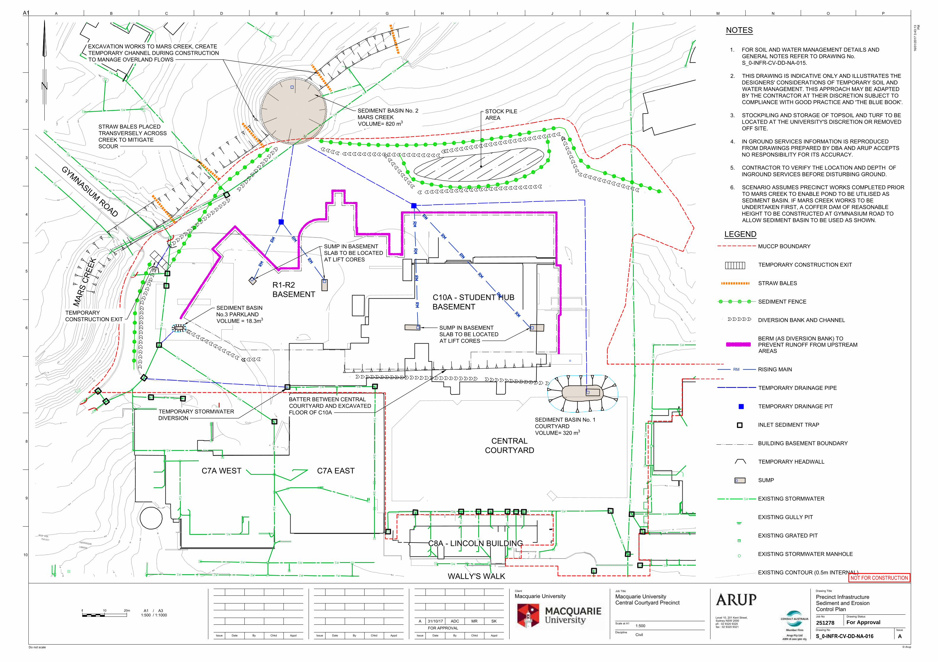
SW
SW
SWSW
SW
SW
SW
SW
SW SW SW
SW
SW
SW
SWSW
SWSW
SWSW
SW
SW
SW
SW
SW
SW
SW
SW
SW
SW
SW
SW
SW
SW
SW
SW
SW
SWSW
SW
SW
SW
SW
SW
SW
SW
SW SW
SW
SW
SW SW
SWSW
SW
SW
SWSW
SWSWSW
SW
SW
SW
SW
SWSW
SW
SWSWSWSWSW
C8A - LINCOLN BUILDING
C7A EASTC7A WEST
WALLY'S WALK
C8A - LINCOLN BUILDING
GYMNASIUM ROAD
MAR
S CR
EEK
C7A EASTC7A WEST
C10A - STUDENT HUBBASEMENT
CENTRALCOURTYARD
WALLY'S WALK
R1-R2BASEMENT
SEDIMENT BASIN No. 2MARS CREEKVOLUME= 820 m3
STOCK PILEAREA
EXCAVATION WORKS TO MARS CREEK, CREATETEMPORARY CHANNEL DURING CONSTRUCTIONTO MANAGE OVERLAND FLOWS
STRAW BALES PLACEDTRANSVERSELY ACROSSCREEK TO MITIGATESCOUR
SEDIMENT BASIN No. 1COURTYARDVOLUME= 320 m3
SUMP IN BASEMENTSLAB TO BE LOCATEDAT LIFT CORES
SUMP IN BASEMENTSLAB TO BE LOCATEDAT LIFT CORES
TEMPORARYCONSTRUCTION EXIT
SEDIMENT BASINNo.3 PARKLANDVOLUME = 18.3m3
LEGENDMUCCP BOUNDARY
TEMPORARY CONSTRUCTION EXIT
STRAW BALES
SEDIMENT FENCE
DIVERSION BANK AND CHANNEL
BERM (AS DIVERSION BANK) TOPREVENT RUNOFF FROM UPSTREAMAREAS
RISING MAIN
TEMPORARY DRAINAGE PIPE
TEMPORARY DRAINAGE PIT
INLET SEDIMENT TRAP
BUILDING BASEMENT BOUNDARY
TEMPORARY HEADWALL
SUMP
EXISTING STORMWATER
EXISTING GULLY PIT
EXISTING GRATED PIT
EXISTING STORMWATER MANHOLE
EXISTING CONTOUR (0.5m INTERNAL)
A1
Do not scale
A B C D E F G H I J K L M N
1
2
3
4
5
6
7
8
9
10
Issue Date By Chkd Appd
O P
Client Job Title
© Arup
Scale at A1
Discipline
Drawing Title
16/0
1/20
17 3
:43:
13 PM
Level 10, 201 Kent Street,Sydney NSW 2000ph : 02 9320 9320fax : 02 9320 9321
Job No
IssueDrawing No
Drawing Status
Issue Date By Chkd AppdIssue Date By Chkd Appd
NOT FOR CONSTRUCTION
A
2512781:500For Approval
Precinct InfrastructureSediment and ErosionControl Plan
Macquarie UniversityCentral Courtyard Precinct
Macquarie University
CivilFOR APPROVAL
SKMRADC31/10/17A
RM
NOTES
1. FOR SOIL AND WATER MANAGEMENT DETAILS ANDGENERAL NOTES REFER TO DRAWING No.S_0-INFR-CV-DD-NA-015.
2. THIS DRAWING IS INDICATIVE ONLY AND ILLUSTRATES THEDESIGNERS' CONSIDERATIONS OF TEMPORARY SOIL ANDWATER MANAGEMENT. THIS APPROACH MAY BE ADAPTEDBY THE CONTRACTOR AT THEIR DISCRETION SUBJECT TOCOMPLIANCE WITH GOOD PRACTICE AND 'THE BLUE BOOK'.
3. STOCKPILING AND STORAGE OF TOPSOIL AND TURF TO BELOCATED AT THE UNIVERSITY'S DISCRETION OR REMOVEDOFF SITE.
4. IN GROUND SERVICES INFORMATION IS REPRODUCEDFROM DRAWINGS PREPARED BY DBA AND ARUP ACCEPTSNO RESPONSIBILITY FOR ITS ACCURACY.
5. CONTRACTOR TO VERIFY THE LOCATION AND DEPTH OFINGROUND SERVICES BEFORE DISTURBING GROUND.
6. SCENARIO ASSUMES PRECINCT WORKS COMPLETED PRIORTO MARS CREEK TO ENABLE POND TO BE UTILISED ASSEDIMENT BASIN. IF MARS CREEK WORKS TO BEUNDERTAKEN FIRST, A COFFER DAM OF REASONABLEHEIGHT TO BE CONSTRUCTED AT GYMNASIUM ROAD TOALLOW SEDIMENT BASIN TO BE USED AS SHOWN.
SW
A1 / A3 1:500 / 1:1000
10 20m

Appendix E
Stormwater Drainage Plans
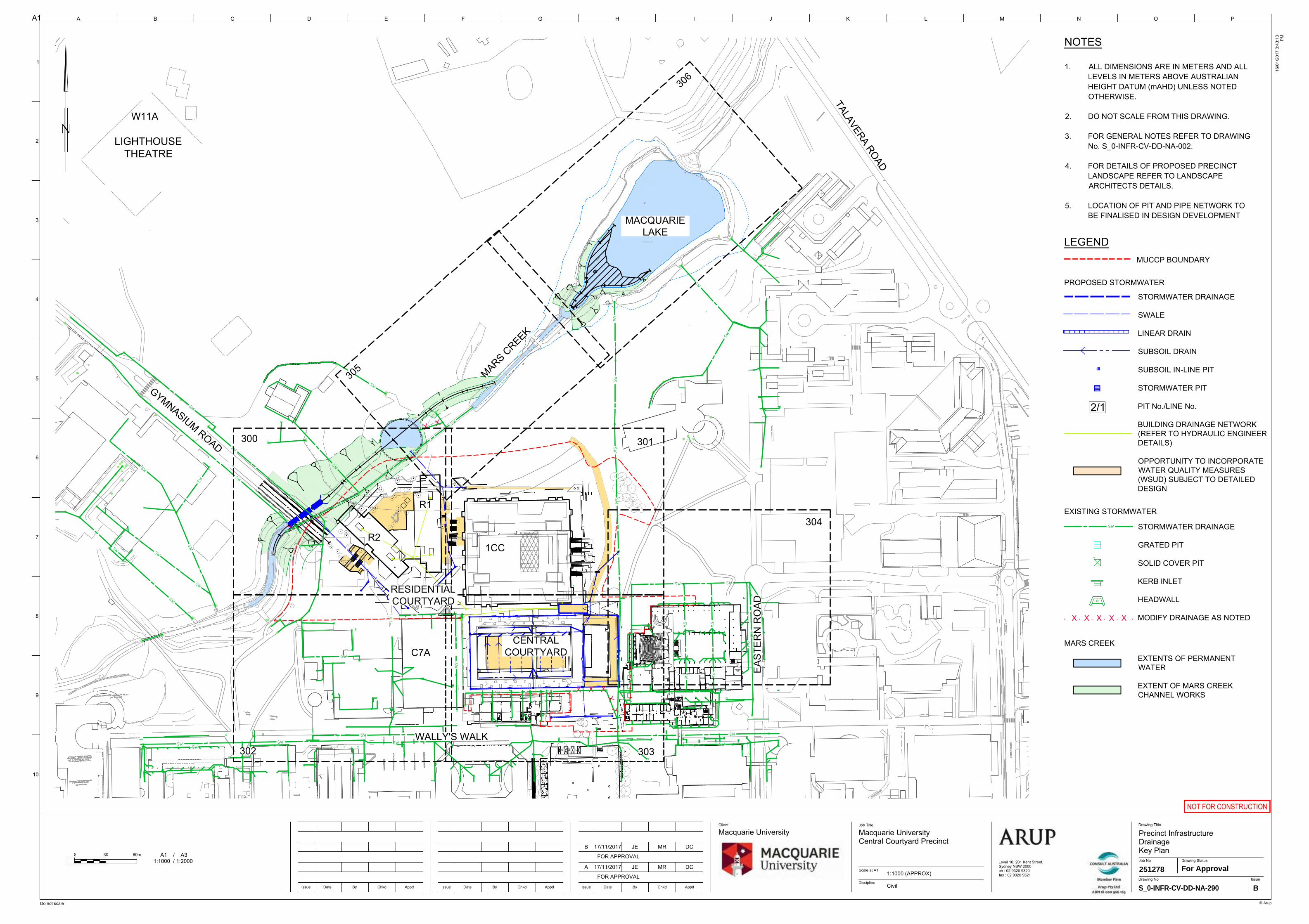
MU
00
123
LG.142
NEW SWITCHROOM
RL 62.23
123
LG.142
NEW SWITCHROOM
RL 62.23
MARS
MARS
CREEK
MACQUARIE LAKE
CREE
K
MAR
S
CREEK
CREE
K
X
X X XX
X
X X
SW
SW
SW
SW
SW
SW
SW
SW
SW
SWSW
SW
SWSW
SW
SW
SW
SWSW
SW SW
SW
SWSW
SW
SWSW
SWSW
SW
SW
SW
SW
SW
SW
SW
SW
SW
SW
SW
SW
SW SW
SW
SW
SWSW
LIGHTHOUSETHEATRE
RESIDENTIALCOURTYARD
CENTRALCOURTYARD
300 301
302 303
304
305
306
MARS CREEK
R1
1CCR2
C7A
W11A
WALLY'S WALK
GYMNASIUM ROAD
EAST
ERN
RO
AD
TALAVERA ROAD
MACQUARIELAKE
A1
Do not scale
A B C D E F G H I J K L M N
1
2
3
4
5
6
7
8
9
10
Issue Date By Chkd Appd
O P
Client Job Title
© Arup
Scale at A1
Discipline
Drawing Title
16/0
1/20
17 3
:43:
13 PM
Level 10, 201 Kent Street,Sydney NSW 2000ph : 02 9320 9320fax : 02 9320 9321
Job No
IssueDrawing No
Drawing Status
Issue Date By Chkd AppdIssue Date By Chkd Appd
NOT FOR CONSTRUCTION
S_0-INFR-CV-DD-NA-290 B
2512781:1000 (APPROX)For Approval
Precinct InfrastructureDrainageKey Plan
Macquarie UniversityCentral Courtyard Precinct
Macquarie University
Civil
B 17/11/2017 MRJE DC
FOR APPROVAL
FOR APPROVAL
DCMRJE17/11/2017A
NOTES
1. ALL DIMENSIONS ARE IN METERS AND ALLLEVELS IN METERS ABOVE AUSTRALIANHEIGHT DATUM (mAHD) UNLESS NOTEDOTHERWISE.
2. DO NOT SCALE FROM THIS DRAWING.
3. FOR GENERAL NOTES REFER TO DRAWINGNo. S_0-INFR-CV-DD-NA-002.
4. FOR DETAILS OF PROPOSED PRECINCTLANDSCAPE REFER TO LANDSCAPEARCHITECTS DETAILS.
5. LOCATION OF PIT AND PIPE NETWORK TOBE FINALISED IN DESIGN DEVELOPMENT
LEGEND
STORMWATER DRAINAGE
SWALE
LINEAR DRAIN
SUBSOIL DRAIN
SUBSOIL IN-LINE PIT
STORMWATER PIT
PIT No./LINE No.
BUILDING DRAINAGE NETWORK(REFER TO HYDRAULIC ENGINEERDETAILS)
OPPORTUNITY TO INCORPORATEWATER QUALITY MEASURES(WSUD) SUBJECT TO DETAILEDDESIGN
PROPOSED STORMWATER
MUCCP BOUNDARY
SW
EXISTING STORMWATER
STORMWATER DRAINAGE
GRATED PIT
SOLID COVER PIT
KERB INLET
HEADWALL
MODIFY DRAINAGE AS NOTED
A1 / A31:1000 / 1:2000
30 60m
2/1
MARS CREEK
EXTENTS OF PERMANENTWATER
EXTENT OF MARS CREEKCHANNEL WORKS
X X X X X
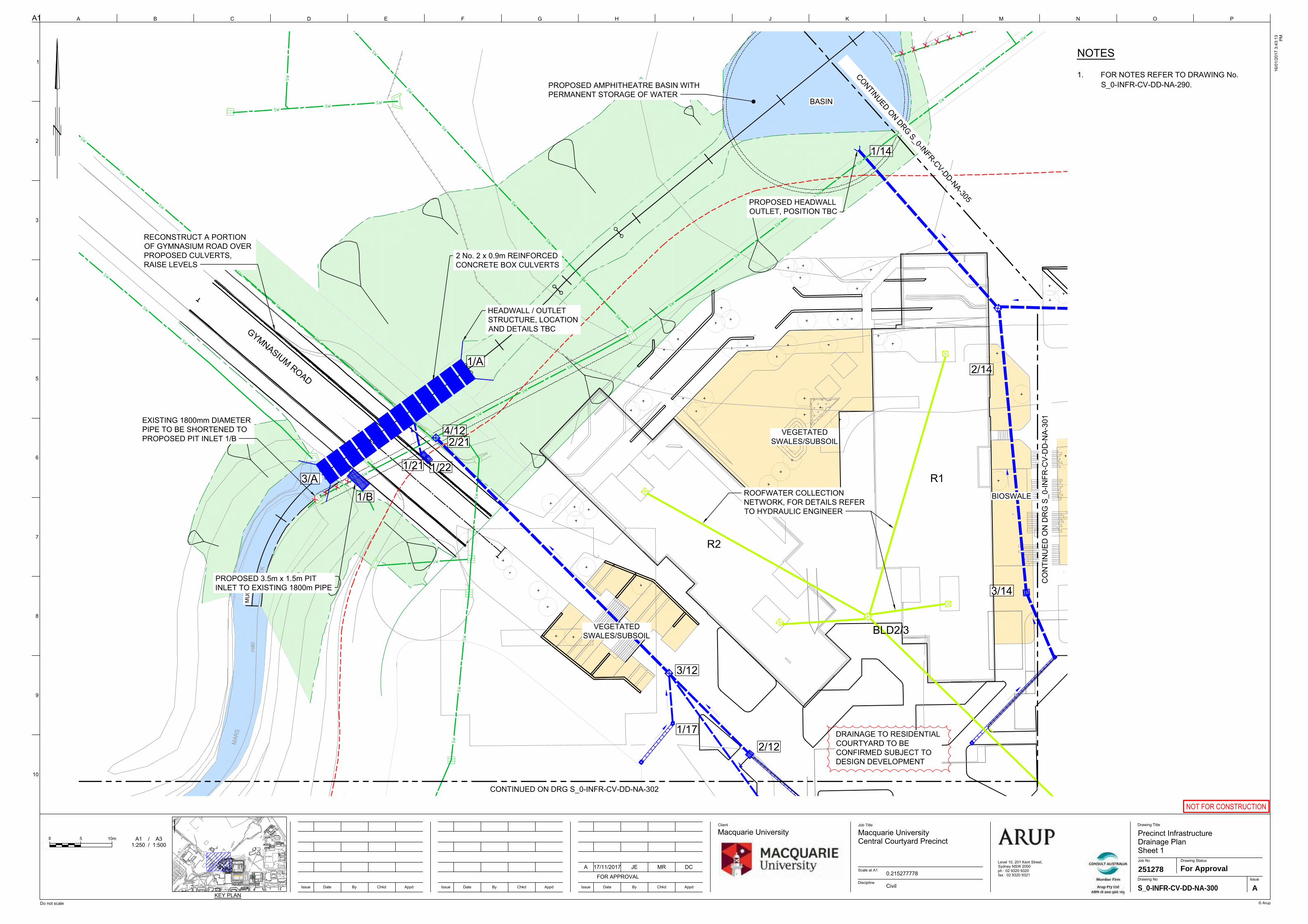
MU
00
CREE
K
MAR
S
SW
SW
SW
SW
SW
SW
SW
SW
SW
SW
SW
SW
SW
SW
SW
SW
SW
SWSW
SW
SW
SWSW
SW
SW
SW
SW
SW
SW
SW
SW
SW
SW
SW
SW
SW
SW
SW
SW
SW
SW
SW
SWSW
SW
4/12
3/12
2/12
3/14
2/14
1/14
1/17
1/A
1/B3/A
2/21
1/21 1/22
XX
XX
X X X X X X X
BLD2/3
R1
R2
GYMNASIUM ROAD
CO
NTI
NU
ED O
N D
RG
S_0
-INFR
-CV-
DD
-NA-
301
CONTINUED ON DRG S_0-INFR-CV-DD-NA-302
VEGETATEDSWALES/SUBSOIL
BASIN
VEGETATEDSWALES/SUBSOIL
BIOSWALE
PROPOSED 3.5m x 1.5m PITINLET TO EXISTING 1800m PIPE
EXISTING 1800mm DIAMETERPIPE TO BE SHORTENED TOPROPOSED PIT INLET 1/B
2 No. 2 x 0.9m REINFORCEDCONCRETE BOX CULVERTS
CONTINUED ON DRG S_0-INFR-CV-DD-NA-305
HEADWALL / OUTLETSTRUCTURE, LOCATIONAND DETAILS TBC
RECONSTRUCT A PORTIONOF GYMNASIUM ROAD OVERPROPOSED CULVERTS,RAISE LEVELS
PROPOSED AMPHITHEATRE BASIN WITHPERMANENT STORAGE OF WATER
PROPOSED HEADWALLOUTLET, POSITION TBC
ROOFWATER COLLECTIONNETWORK, FOR DETAILS REFERTO HYDRAULIC ENGINEER
DRAINAGE TO RESIDENTIALCOURTYARD TO BECONFIRMED SUBJECT TODESIGN DEVELOPMENT
123
LG.142
NEW SWITCHROOM
RL 62.23
MARS
MARS
CREEK
MACQUARIE LAKE
CREE
K
MAR
S
CREEK
A1
Do not scale
A B C D E F G H I J K L M N
1
2
3
4
5
6
7
8
9
10
Issue Date By Chkd Appd
O P
Client Job Title
© Arup
Scale at A1
Discipline
Drawing Title
16/0
1/20
17 3
:43:
13 PM
Level 10, 201 Kent Street,Sydney NSW 2000ph : 02 9320 9320fax : 02 9320 9321
Job No
IssueDrawing No
Drawing Status
Issue Date By Chkd AppdIssue Date By Chkd Appd
NOT FOR CONSTRUCTION
A1 / A31:250 / 1:500
5 10m
KEY PLAN
S_0-INFR-CV-DD-NA-300 A
2512780.215277778For Approval
Precinct InfrastructureDrainage PlanSheet 1
Macquarie UniversityCentral Courtyard Precinct
Macquarie University
CivilFOR APPROVAL
DCMRJE17/11/2017A
NOTES
1. FOR NOTES REFER TO DRAWING No.S_0-INFR-CV-DD-NA-290.
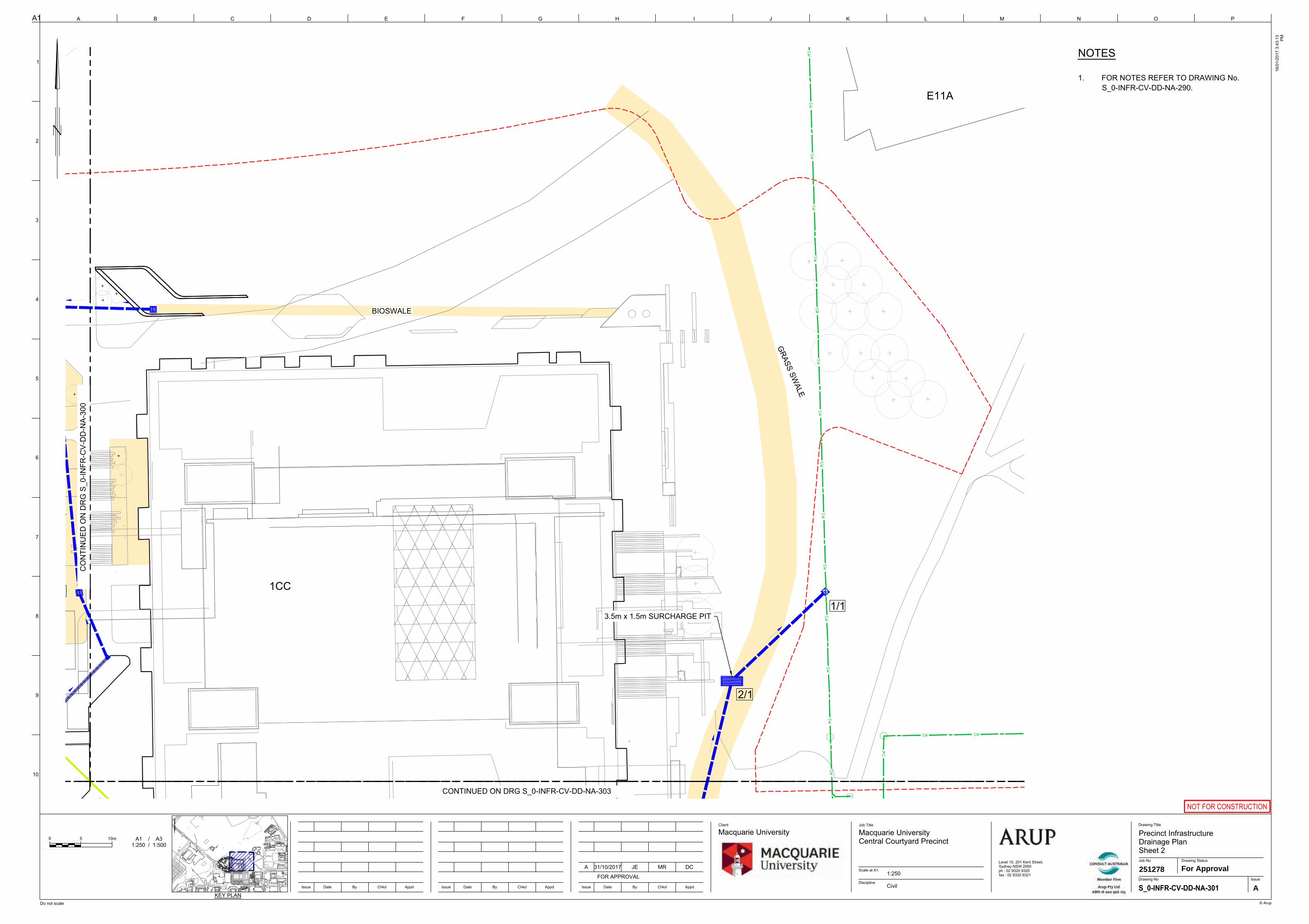
2/1
1/13/14
SWSW
SWSW
SWSW
SWSW
SWSW
SWSW
SWSW
SW
SW SW
SW
1CC
E11A
3.5m x 1.5m SURCHARGE PIT
CONTINUED ON DRG S_0-INFR-CV-DD-NA-303
CO
NTI
NU
ED O
N D
RG
S_0
-INFR
-CV-
DD
-NA-
300
BIOSWALE
GRASS SW
ALE
A1
Do not scale
A B C D E F G H I J K L M N
1
2
3
4
5
6
7
8
9
10
Issue Date By Chkd Appd
O P
Client Job Title
© Arup
Scale at A1
Discipline
Drawing Title
16/0
1/20
17 3
:43:
13 PM
Level 10, 201 Kent Street,Sydney NSW 2000ph : 02 9320 9320fax : 02 9320 9321
Job No
IssueDrawing No
Drawing Status
Issue Date By Chkd AppdIssue Date By Chkd Appd
NOT FOR CONSTRUCTION
A
2512781:250For Approval
Precinct InfrastructureDrainage PlanSheet 2
Macquarie UniversityCentral Courtyard Precinct
Macquarie University
CivilFOR APPROVAL
DCMRJE31/10/2017A
A1 / A31:250 / 1:500
5 10m
KEY PLAN
NOTES
1. FOR NOTES REFER TO DRAWING No.S_0-INFR-CV-DD-NA-290.
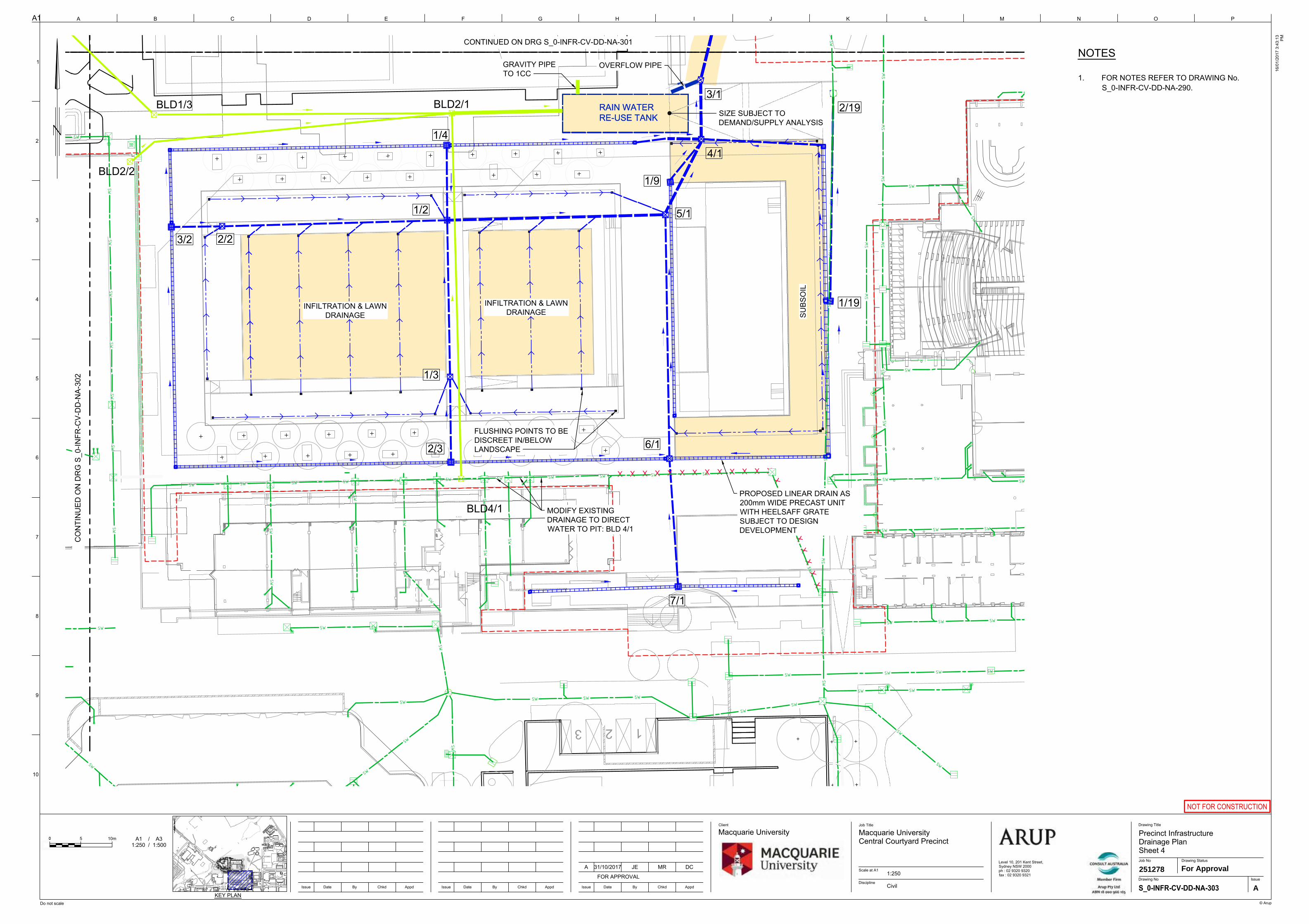
123
RL 62.23
RAIN WATERRE-USE TANK
4/1
3/12/19
7/1
6/1
5/1
3/2 2/2
1/2
1/3
1/4
1/9
1/19
2/3
X X X X X X X X X X X X X
XX
XX
XX
XX
XX
|
SW
SW
SW
SW
SW
SW
SW
SWSW
SWSW
SW
SWSW
SWSW
SWSWSW
SW
SW
SWSW
SWSW
SWSW
SW
SW
SW
SW
SWSW
SW SW SW
SW SW SWSW
SWSW
SW
SWSW
SW
SW SWSW
SWSWSW
SW
SW
SW
SW
SWSW
SWSW
SWSW
SWSW
SWSW
SWSW
SWSW
SWSW
SW
SW
SWSWSWSWSWSWSWSWSWSWSWSW
SW
RAIN WATERRE-USE TANK
BLD4/1
BLD2/1
BLD2/2
BLD1/3SIZE SUBJECT TODEMAND/SUPPLY ANALYSIS
OVERFLOW PIPEGRAVITY PIPETO 1CC
FLUSHING POINTS TO BEDISCREET IN/BELOWLANDSCAPE
PROPOSED LINEAR DRAIN AS200mm WIDE PRECAST UNITWITH HEELSAFF GRATESUBJECT TO DESIGNDEVELOPMENT
CONTINUED ON DRG S_0-INFR-CV-DD-NA-301
CO
NTI
NU
ED O
N D
RG
S_0
-INFR
-CV-
DD
-NA-
302
INFILTRATION & LAWNDRAINAGE
INFILTRATION & LAWNDRAINAGE SU
BSO
IL
MODIFY EXISTINGDRAINAGE TO DIRECTWATER TO PIT: BLD 4/1
A1
Do not scale
A B C D E F G H I J K L M N
1
2
3
4
5
6
7
8
9
10
Issue Date By Chkd Appd
O P
Client Job Title
© Arup
Scale at A1
Discipline
Drawing Title
16/0
1/20
17 3
:43:
13 PM
Level 10, 201 Kent Street,Sydney NSW 2000ph : 02 9320 9320fax : 02 9320 9321
Job No
IssueDrawing No
Drawing Status
Issue Date By Chkd AppdIssue Date By Chkd Appd
NOT FOR CONSTRUCTION
A1 / A31:250 / 1:500
5 10m
KEY PLAN
A
2512781:250For Approval
Precinct InfrastructureDrainage PlanSheet 4
Macquarie UniversityCentral Courtyard Precinct
Macquarie University
CivilFOR APPROVAL
DCMRJE31/10/2017A
NOTES
1. FOR NOTES REFER TO DRAWING No.S_0-INFR-CV-DD-NA-290.
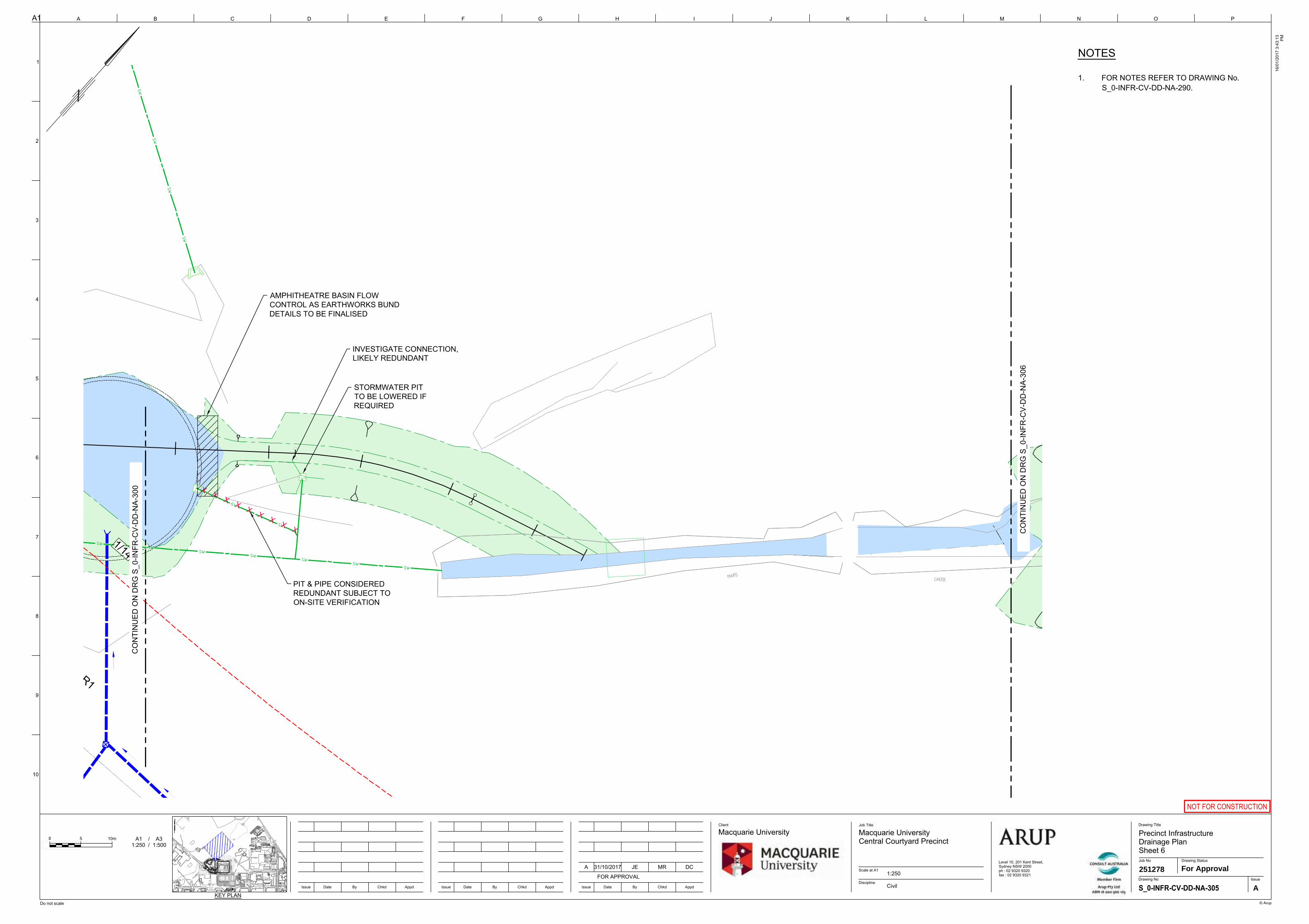
SWSW
SWSW
SWSW
SW
SW
SW
SW
SW
SW
SW
1/14
X X X X X X X X X
R1
CO
NTI
NU
ED O
N D
RG
S_0
-INFR
-CV-
DD
-NA-
300
CO
NTI
NU
ED O
N D
RG
S_0
-INFR
-CV-
DD
-NA-
306
STORMWATER PITTO BE LOWERED IFREQUIRED
INVESTIGATE CONNECTION,LIKELY REDUNDANT
PIT & PIPE CONSIDEREDREDUNDANT SUBJECT TOON-SITE VERIFICATION
AMPHITHEATRE BASIN FLOWCONTROL AS EARTHWORKS BUNDDETAILS TO BE FINALISED
A1
Do not scale
A B C D E F G H I J K L M N
1
2
3
4
5
6
7
8
9
10
Issue Date By Chkd Appd
O P
Client Job Title
© Arup
Scale at A1
Discipline
Drawing Title
16/0
1/20
17 3
:43:
13 PM
Level 10, 201 Kent Street,Sydney NSW 2000ph : 02 9320 9320fax : 02 9320 9321
Job No
IssueDrawing No
Drawing Status
Issue Date By Chkd AppdIssue Date By Chkd Appd
NOT FOR CONSTRUCTION
A1 / A31:250 / 1:500
5 10m
KEY PLAN
A
2512781:250For Approval
Precinct InfrastructureDrainage PlanSheet 6
Macquarie UniversityCentral Courtyard Precinct
Macquarie University
CivilFOR APPROVAL
DCMRJE31/10/2017A
NOTES
1. FOR NOTES REFER TO DRAWING No.S_0-INFR-CV-DD-NA-290.
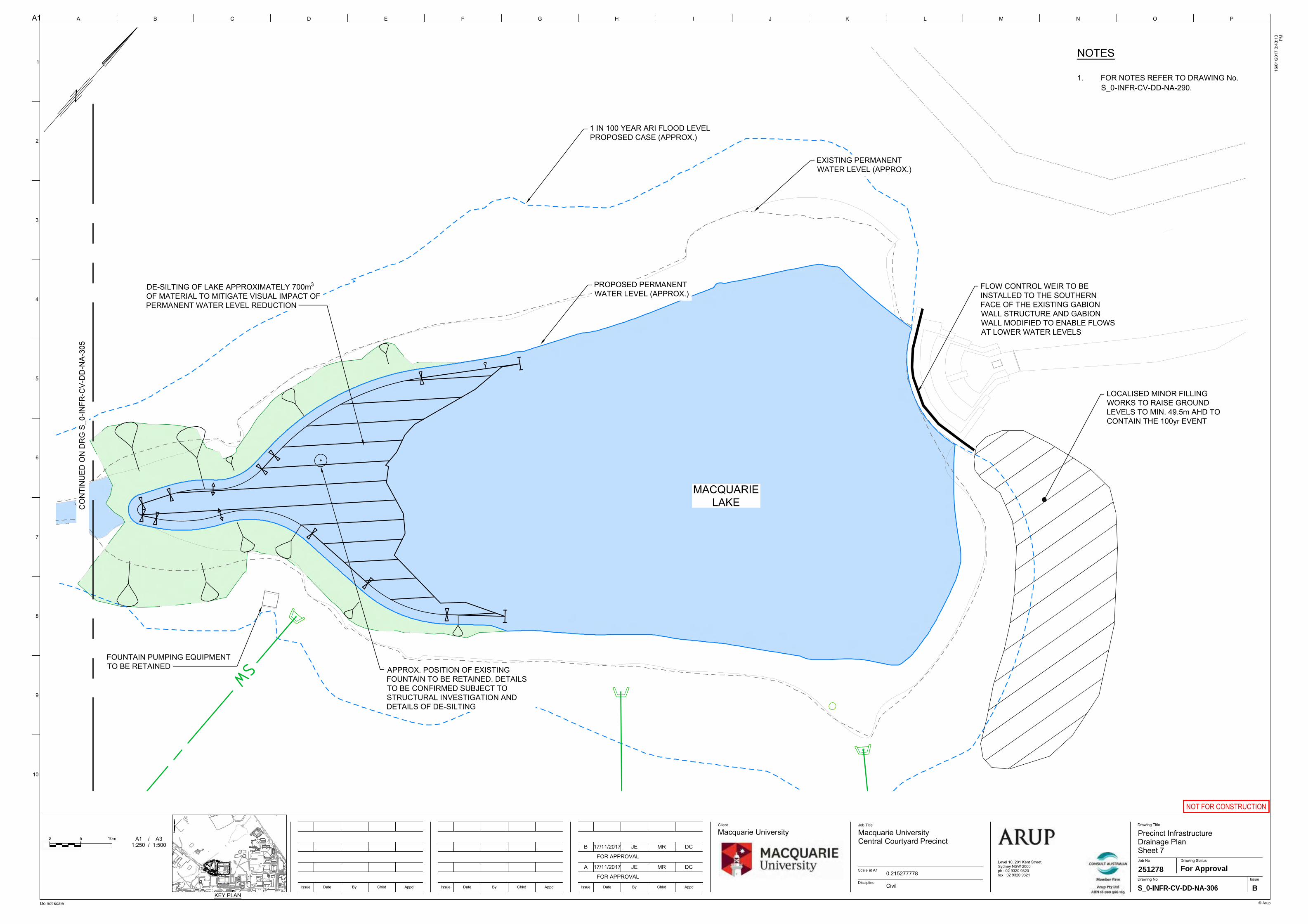
SW
CO
NTI
NU
ED O
N D
RG
S_0
-INFR
-CV-
DD
-NA-
305
MACQUARIELAKE
FLOW CONTROL WEIR TO BEINSTALLED TO THE SOUTHERNFACE OF THE EXISTING GABIONWALL STRUCTURE AND GABIONWALL MODIFIED TO ENABLE FLOWSAT LOWER WATER LEVELS
LOCALISED MINOR FILLINGWORKS TO RAISE GROUNDLEVELS TO MIN. 49.5m AHD TOCONTAIN THE 100yr EVENT
1 IN 100 YEAR ARI FLOOD LEVELPROPOSED CASE (APPROX.)
EXISTING PERMANENTWATER LEVEL (APPROX.)
PROPOSED PERMANENTWATER LEVEL (APPROX.)
DE-SILTING OF LAKE APPROXIMATELY 700m3
OF MATERIAL TO MITIGATE VISUAL IMPACT OFPERMANENT WATER LEVEL REDUCTION
APPROX. POSITION OF EXISTINGFOUNTAIN TO BE RETAINED. DETAILSTO BE CONFIRMED SUBJECT TOSTRUCTURAL INVESTIGATION ANDDETAILS OF DE-SILTING
FOUNTAIN PUMPING EQUIPMENTTO BE RETAINED
123
LG.142
NEW SWITCHROOM
RL 62.23
A1
Do not scale
A B C D E F G H I J K L M N
1
2
3
4
5
6
7
8
9
10
Issue Date By Chkd Appd
O P
Client Job Title
© Arup
Scale at A1
Discipline
Drawing Title
16/0
1/20
17 3
:43:
13 PM
Level 10, 201 Kent Street,Sydney NSW 2000ph : 02 9320 9320fax : 02 9320 9321
Job No
IssueDrawing No
Drawing Status
Issue Date By Chkd AppdIssue Date By Chkd Appd
NOT FOR CONSTRUCTION
A1 / A31:250 / 1:500
5 10m
KEY PLAN
S_0-INFR-CV-DD-NA-306 B
2512780.215277778For Approval
Precinct InfrastructureDrainage PlanSheet 7
Macquarie UniversityCentral Courtyard Precinct
Macquarie University
Civil
B 17/11/2017 MRJE DC
FOR APPROVAL
FOR APPROVAL
DCMRJE17/11/2017A
NOTES
1. FOR NOTES REFER TO DRAWING No.S_0-INFR-CV-DD-NA-290.
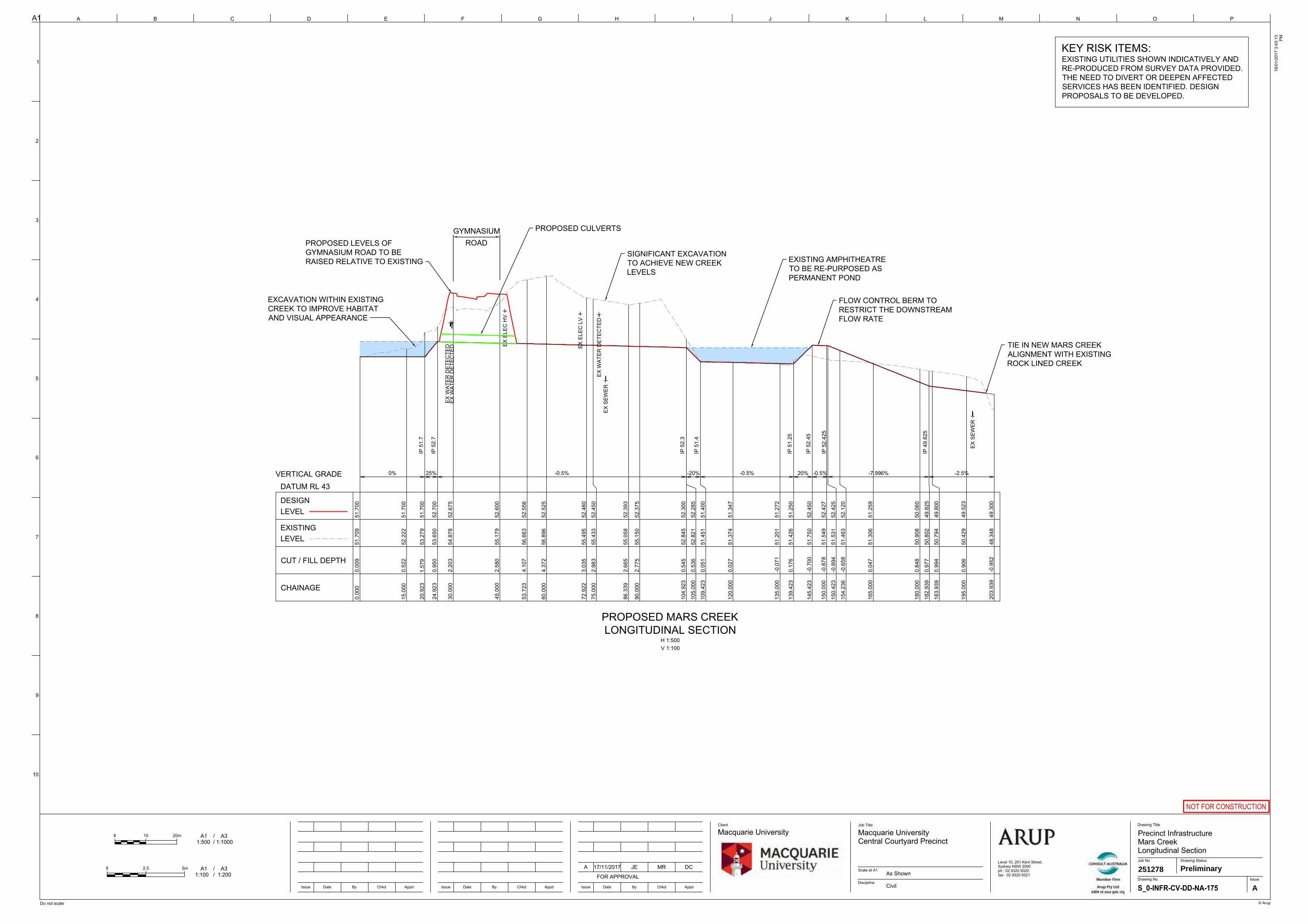
IP 5
1.7
IP 5
2.7
IP 5
2.3
IP 5
1.4
IP 5
1.25
IP 5
2.45
IP 5
2.42
5
IP 4
9.82
5
0% 25% -0.5% -20% -0.5% 20% -0.5% -7.996% -2.5%VERTICAL GRADE
0.00
00.
009
51.7
0951
.700
15.0
000.
522
52.2
2251
.700
20.9
231.
579
53.2
7951
.700
24.9
230.
950
53.6
5052
.700
30.0
002.
203
54.8
7852
.675
45.0
002.
580
55.1
7952
.600
53.7
234.
107
56.6
6352
.556
60.0
004.
372
56.8
9652
.525
72.9
223.
035
55.4
9552
.460
75.0
002.
983
55.4
3352
.450
86.3
392.
665
55.0
5852
.393
90.0
002.
775
55.1
5052
.375
104.
923
0.54
552
.845
52.3
00
105.
000
0.53
652
.821
52.2
85
109.
423
0.05
151
.451
51.4
00
120.
000
0.02
751
.374
51.3
47
135.
000
-0.0
7151
.201
51.2
72
139.
423
0.17
651
.426
51.2
50
145.
423
-0.7
0051
.750
52.4
50
150.
000
-0.8
7851
.549
52.4
27
150.
423
-0.8
9451
.531
52.4
25
154.
236
-0.6
5851
.463
52.1
20
165.
000
0.04
751
.306
51.2
59
180.
000
0.84
850
.908
50.0
60
182.
939
0.97
750
.802
49.8
25
183.
939
0.99
450
.794
49.8
00
195.
000
0.90
650
.429
49.5
23
203.
939
-0.9
5248
.348
49.3
00
CHAINAGE
CUT / FILL DEPTH
EXISTINGLEVEL
DESIGNLEVEL
EX E
LEC
LV
EX E
LEC
HV
EX S
EWER
EX S
EWER
EX W
ATER
DET
ECTE
DEX
WAT
ER D
ETEC
TED
EX W
ATER
DET
ECTE
D
DATUM RL 43
PROPOSED MARS CREEKLONGITUDINAL SECTION
H 1:500V 1:100
TIE IN NEW MARS CREEKALIGNMENT WITH EXISTINGROCK LINED CREEK
EXISTING AMPHITHEATRETO BE RE-PURPOSED ASPERMANENT POND
FLOW CONTROL BERM TORESTRICT THE DOWNSTREAMFLOW RATE
PROPOSED CULVERTS
PROPOSED LEVELS OFGYMNASIUM ROAD TO BERAISED RELATIVE TO EXISTING
SIGNIFICANT EXCAVATIONTO ACHIEVE NEW CREEKLEVELS
EXCAVATION WITHIN EXISTINGCREEK TO IMPROVE HABITATAND VISUAL APPEARANCE
KEY RISK ITEMS:EXISTING UTILITIES SHOWN INDICATIVELY ANDRE-PRODUCED FROM SURVEY DATA PROVIDED.THE NEED TO DIVERT OR DEEPEN AFFECTEDSERVICES HAS BEEN IDENTIFIED. DESIGNPROPOSALS TO BE DEVELOPED.
GYMNASIUMROAD
A1
Do not scale
A B C D E F G H I J K L M N
1
2
3
4
5
6
7
8
9
10
Issue Date By Chkd Appd
O P
Client Job Title
© Arup
Scale at A1
Discipline
Drawing Title
16/0
1/20
17 3
:43:
13 PM
Level 10, 201 Kent Street,Sydney NSW 2000ph : 02 9320 9320fax : 02 9320 9321
Job No
IssueDrawing No
Drawing Status
Issue Date By Chkd AppdIssue Date By Chkd Appd
NOT FOR CONSTRUCTION
A
251278As ShownPreliminary
Precinct InfrastructureMars CreekLongitudinal Section
Macquarie UniversityCentral Courtyard Precinct
Macquarie University
CivilFOR APPROVAL
DCMRJE17/11/2017A
A1 / A3 1:500 / 1:1000
10 20m
A1 / A3 1:100 / 1:200
2.5 5m