Embed Size (px)
Citation preview
8.13452 THACKERAY 010
13452
Magnetic and VLF-Electromagnetic Surveysby
Geosearch Consultants Limitedfor
Placer Dome Inc.on
Project 422 - Brinnie Lake GridThackeray Township, Ontario
To Accompany Maps 90-151-,152-,153-,154-A to D
July 26, 1990
RECEIVED
AUG-081990
MINING UNDS SECTION
INTRODUCTION
A total field magnetic survey and a VLF electromagnetic
survey were carried out for Placer Dome Inc. on Project 422
Brinnie Lake Grid in June 1990.
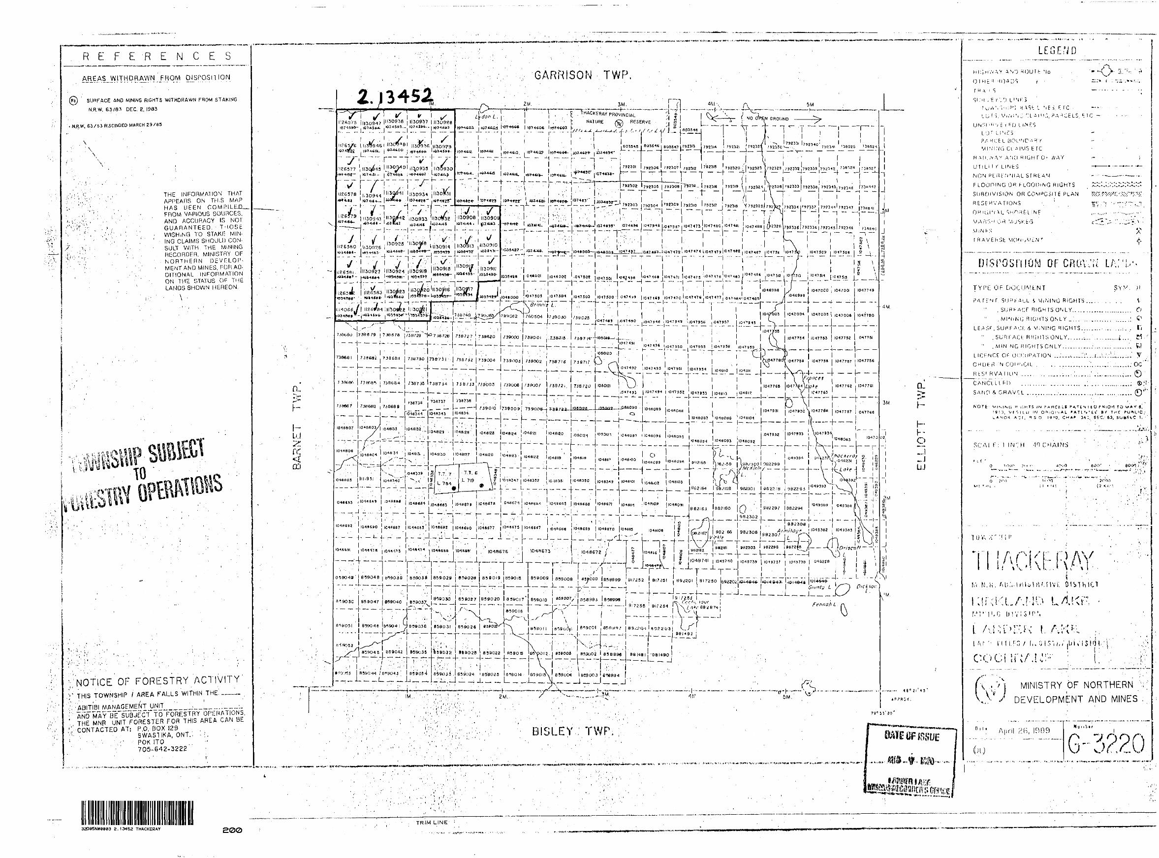
The property consists of 51 contiguous unpatented mining
claims, a list of which is appended to this report. The claim
group is located in the north west corner of Thackeray Township
approximately twenty three kilometers due east of the town of
Ramore, Ontario. Access to the property was made via motor
vehicle along secondary roads south from highway 101.
The purpose of the surveys was to outline geological
structures and delineate subsurface geo-electrical conductors
which may prove to be of economic interest.
The VLF electromagnetic survey outlined a region of many
conductive horizons which are thought to be due to surficial
conductivity rather than bedrock conductors. The magnetic survey
outlined a number of distinct rock units as well as a folded and
a faulted structure.
The accompanying maps show the area surveyed and the results
obtained. A technical data sheet is appended to the report.
m
l
O*
t~ m
-l i o .-5
V-'
-o
E?
"o S
^S
O
(T
)•Z
L H
?o
Fn q
gr—
"*
* 31
y
fo n
t7C
—
o 30
PROJECT 422
BRINNIE LAKE GRID
PREVIOUS WORK
In 1950 Dominion Gulf Company carried out ground magnetic and geological surveys, prospecting, stripping and trenching and diamond drilling on their Group II claims, which covered part of the southwest part of the Brinnie Lake grid (claims L.1114066, L.1126582-84 and L.1130920-23). Some stripping was apparently done in the area presently covered by Project 422, but no evidence of this was seen in the field. Drilling was carried out in Barnet Township.
Dominion GulF also carried out geological and magnetic surveys on their Group I claims, which overlap the west central and central parts of the Brinnie Lake grid (claims L.1126579-80, L.1130918, L.1130925-26, L.1130933-34).
In 1951 Dominion Gulf carried out additional geological and magnetic surveys, stripping and trenching on the Group II claim group.
In 1979 Noranda Exploration Co. Ltd. carried out ground magnetic and horizontal loop electromagnetic (HEM) surveys on a 4 claim group which overlapped onto part of the present Brinnie Lake Grid (claim L. 1130922, parts of L. 1130921 and L.1126584). One two-line conductor was located. It lies immediately south of the property boundary.
In 1985 Peter Island Resources Inc. carried out geological and HEM surveys on a 3-claim property which overlaps the western boundary of the present Brinnie Lake Grid (claim L.1126579). No significant results were indicated.
Noranda Exploration Co. Ltd. carried out an airborne magnetic and VLF survey in the northeastern part of Barnet Township. The eastern limit of the survey extended approximately 0.6 km. onto the present Brinnie Lake Grid.
In 1986 Cominco Ltd. carried out ground magnetometer, HEM and induced polarization surveys (IP) on Grid 2 of its Telgar Property, which overlaps the southeast part of the present Brinnie Lake Grid (claims L.1130908 - L.1130913). An HEM conductor was discovered on present claim L.1130911.
In 1987 Cominco tested the above conductor with a 180m. diamond drill hole. The hole (Tel-18) intersected locally carbonatized, silicified and hematized, pillowed and massive iron tholeiitic basalt flows. The HEM conductor appears to have been caused by a thin graphitic argillite horizon containing up to 2596 pyrite. No assays were reported on the drill log.
GENERAL GEOLOGY
The Brinnie Lake Grid is underlain by east-northeasterly striking iron- rich tholeiitic basalts and magnesium-rich tholeiitic basalts of the Kmojevis Group. Jensen (1982) indicates an easterly-striking anticlinal axis striking across the north part of the grid and an east-northeasterly striking synclinal axis striking across the southern part.
The eastern half of the property is underlain by sand and gravel of the Munro esker-outwash complex.
- 2 -
METHOD
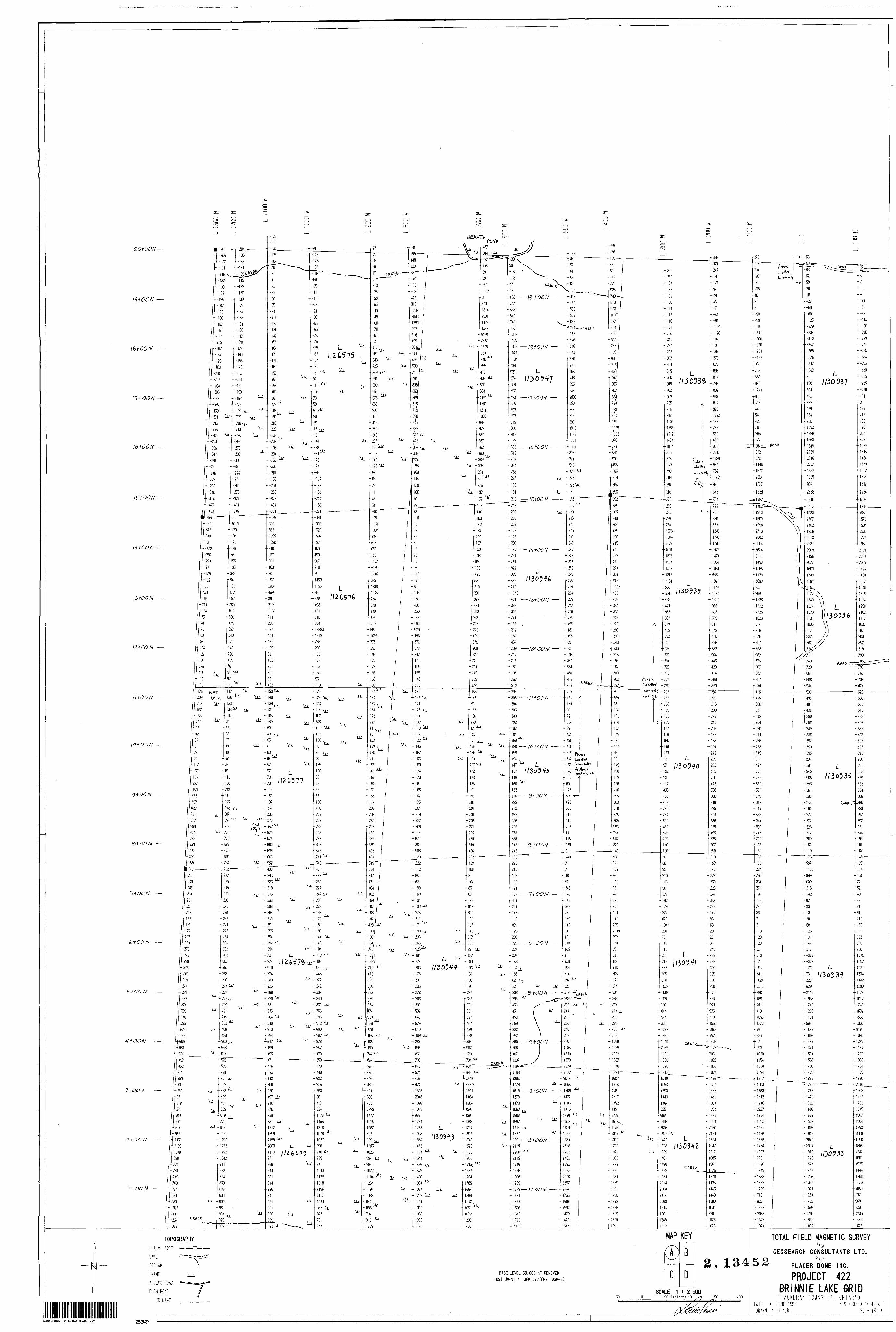
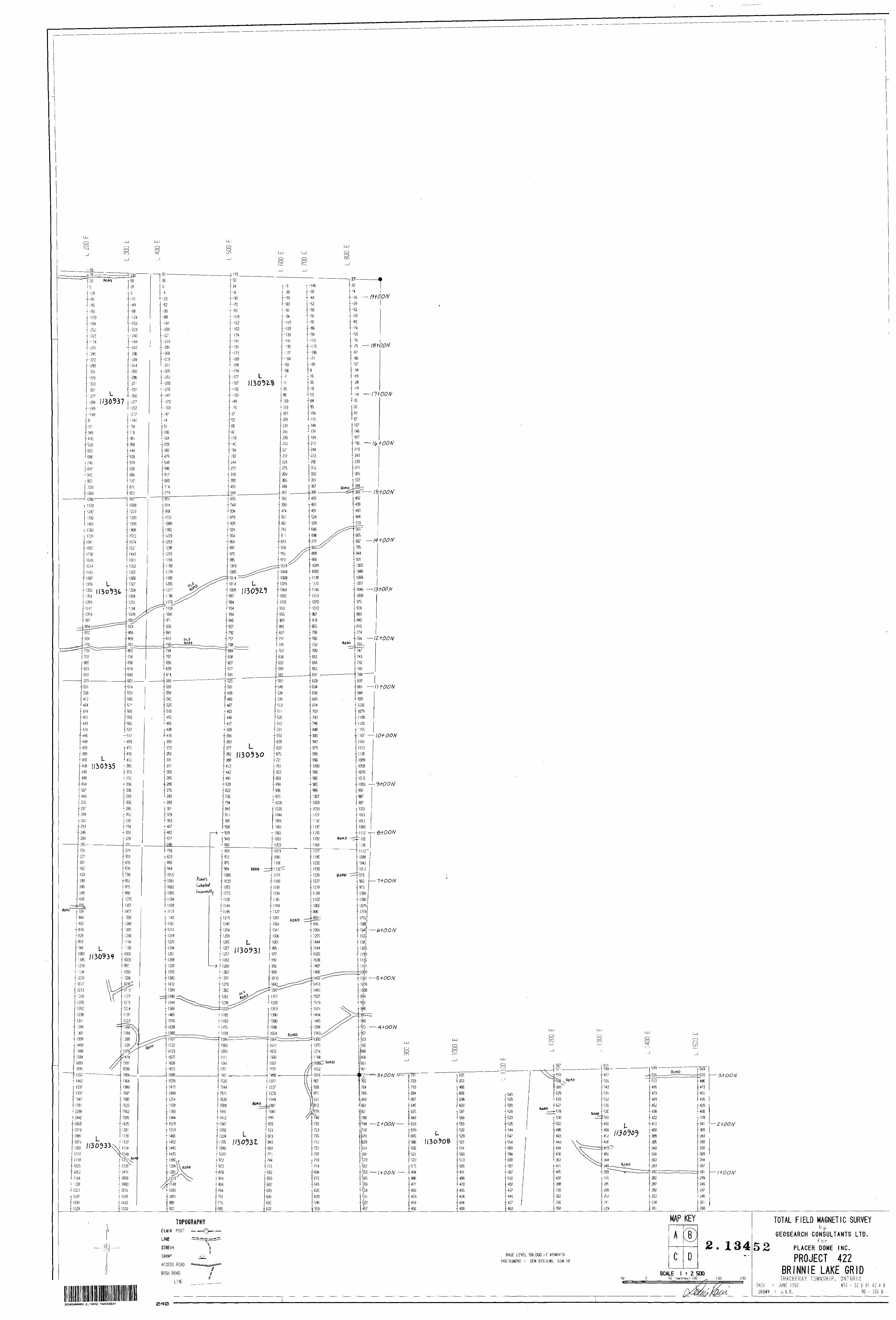
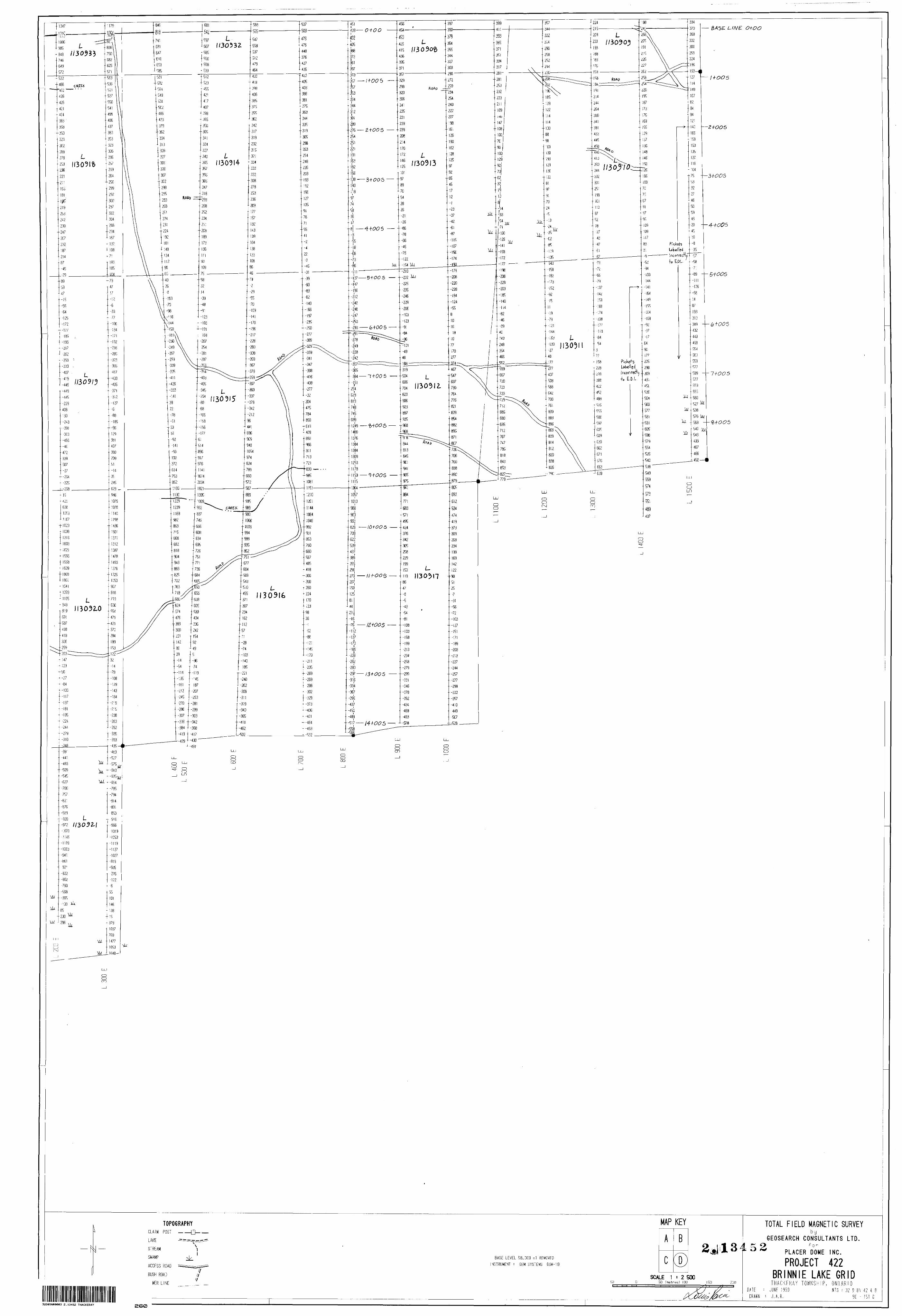
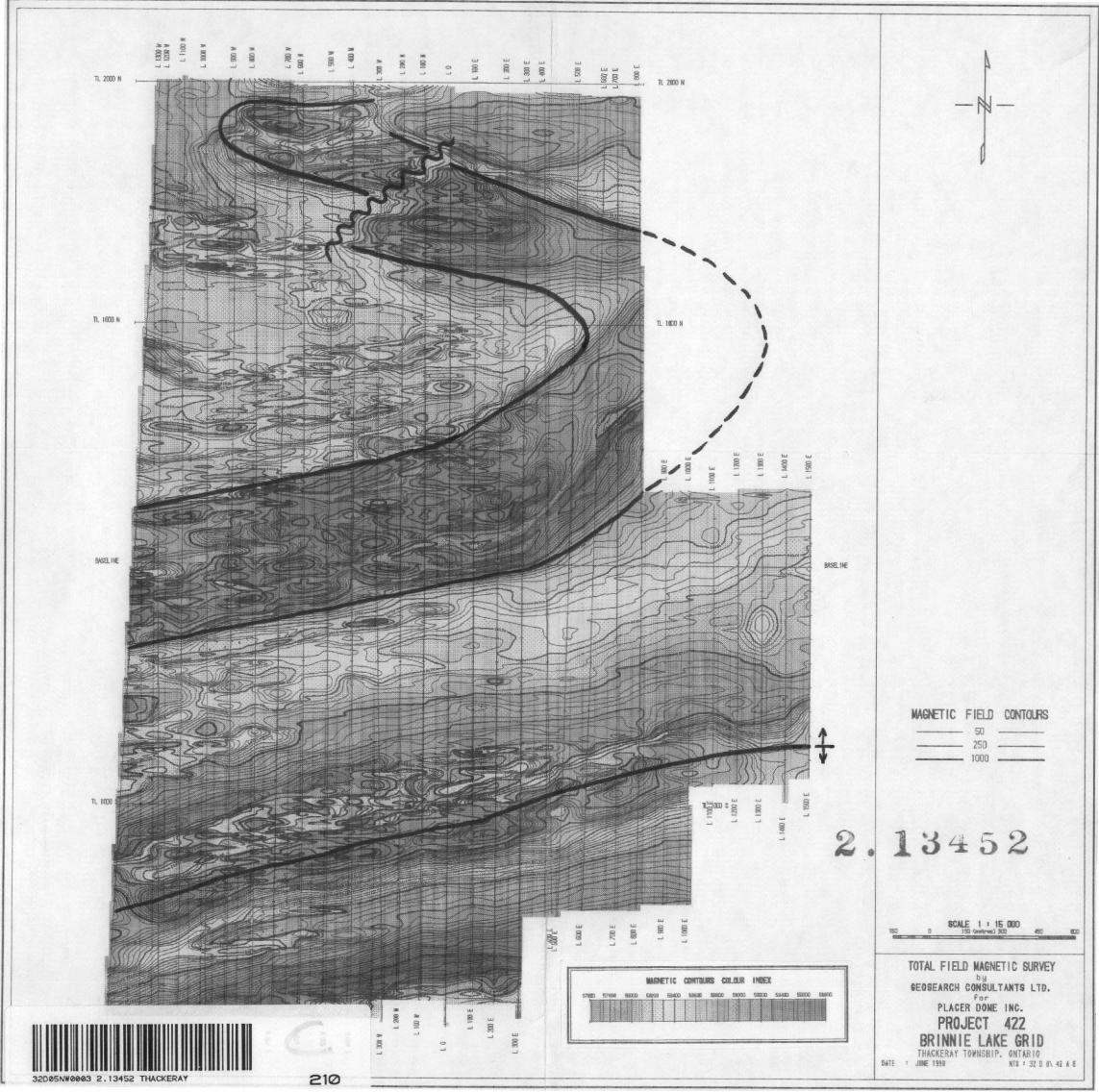
The total field magnetic survey was completed using Gem
Systems GSM - 18 proton precession magnetometers. Diurnal
variations in the magnetic field were corrected for by means of
a base station recorder with readings taken at three second
intervals. The corrected data was then posted. Map series 90-151,
and contoured, Map series 90-153.
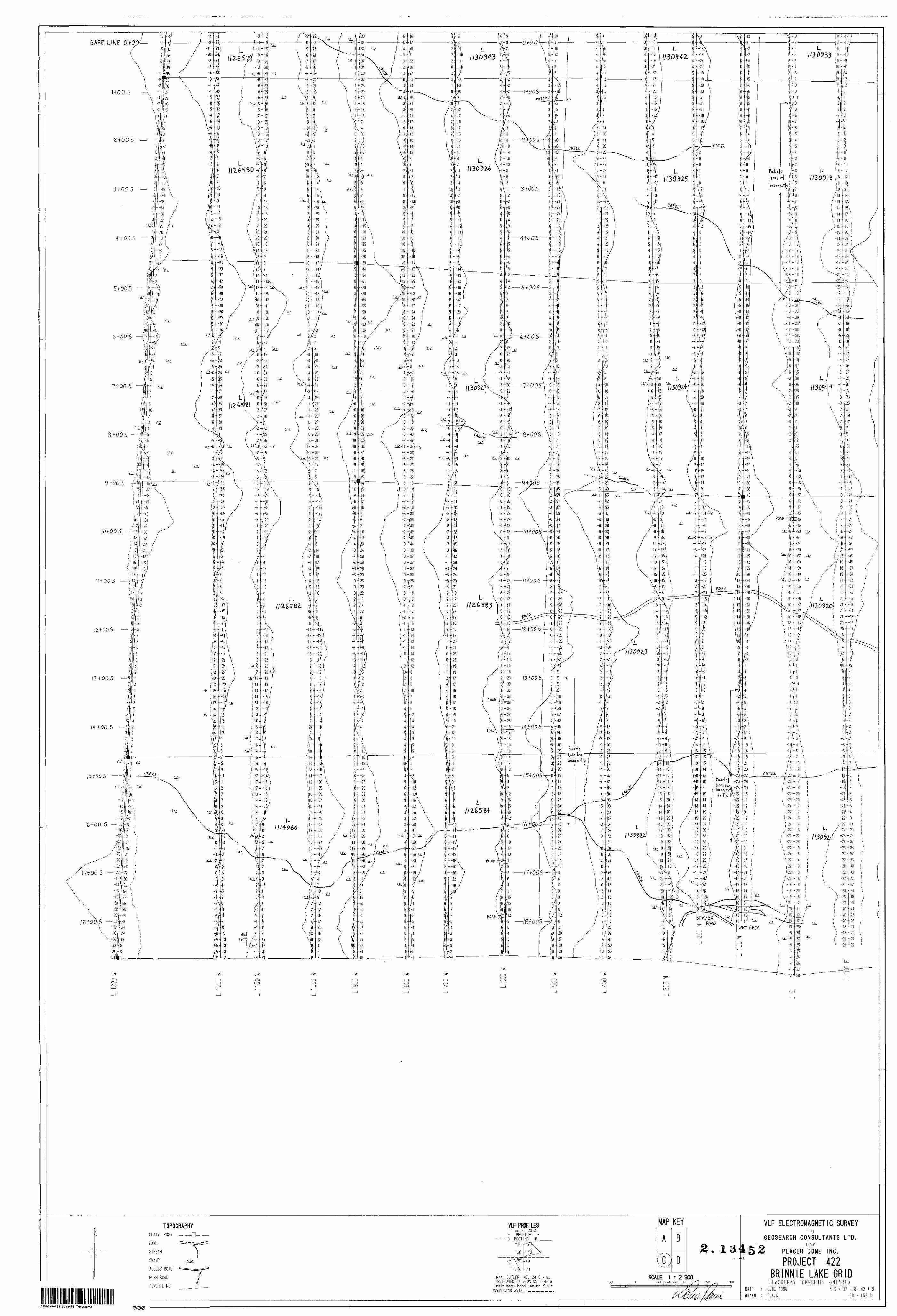
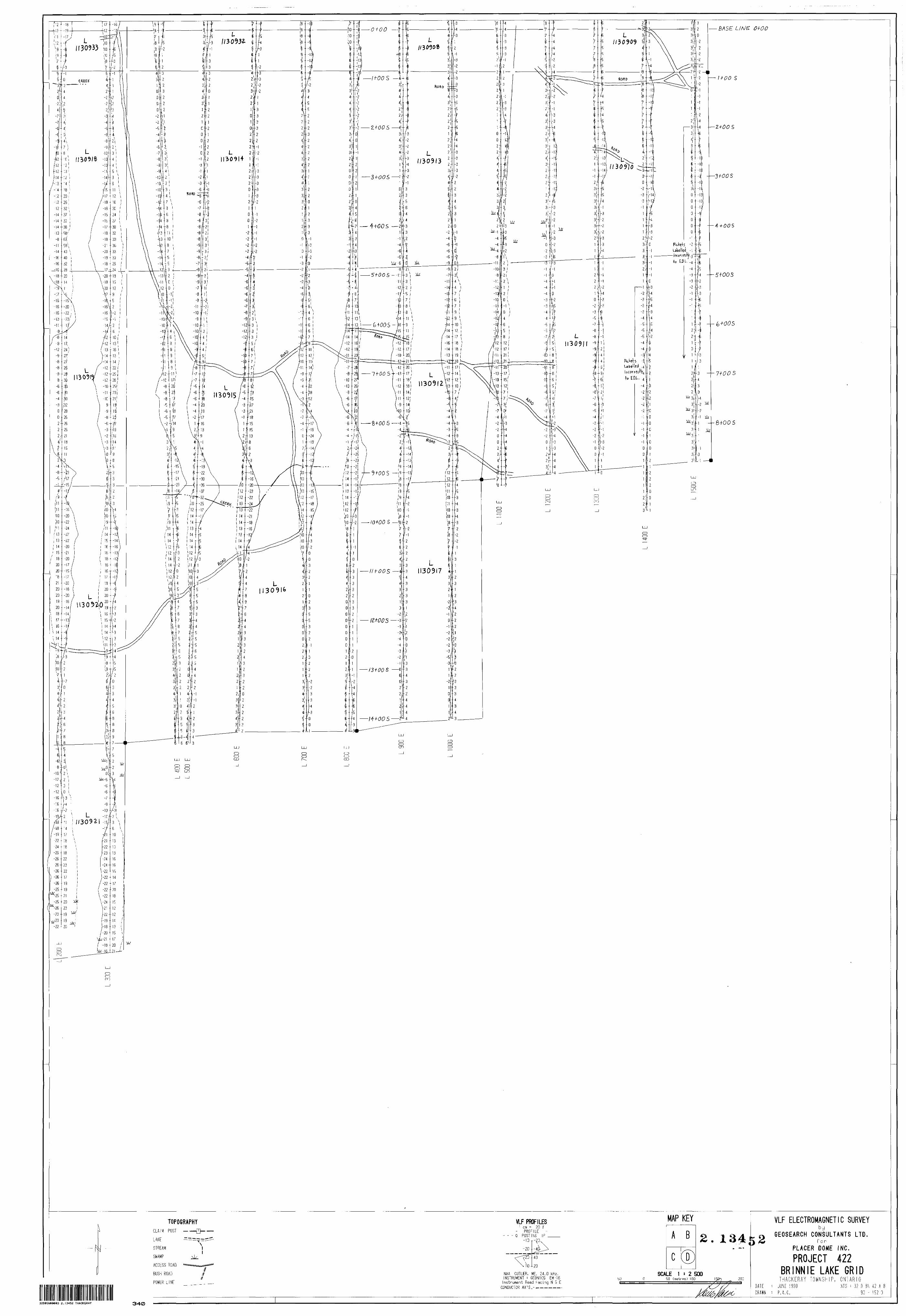
The VLF electromagnetic survey was carried out using Geonics
EM-16 receivers. The transmitting station used was NAA, located
near Cutler, Maine and transmitting at a frequency of 24.8 kHz.
The inphase and quadrature components measured were posted and
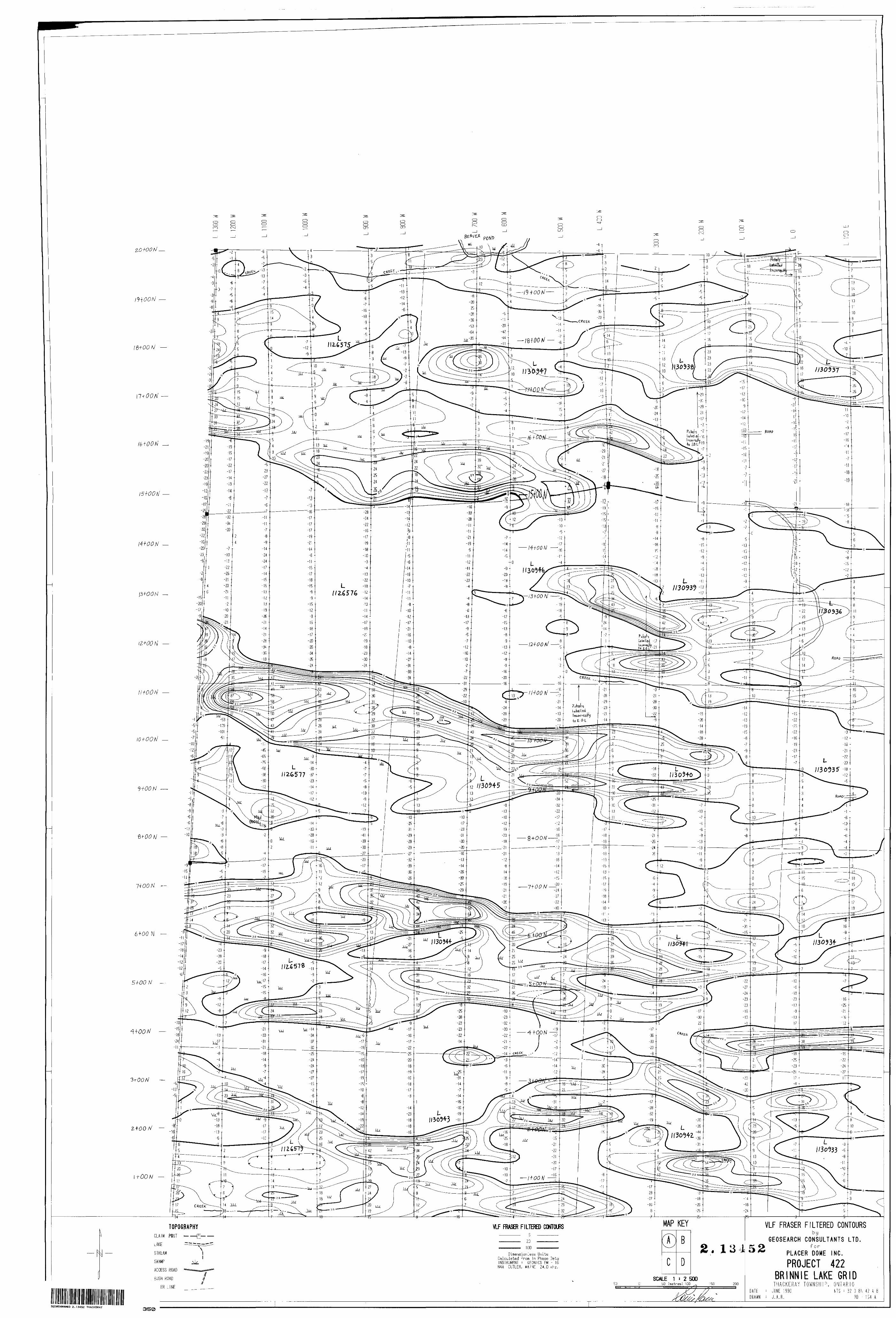
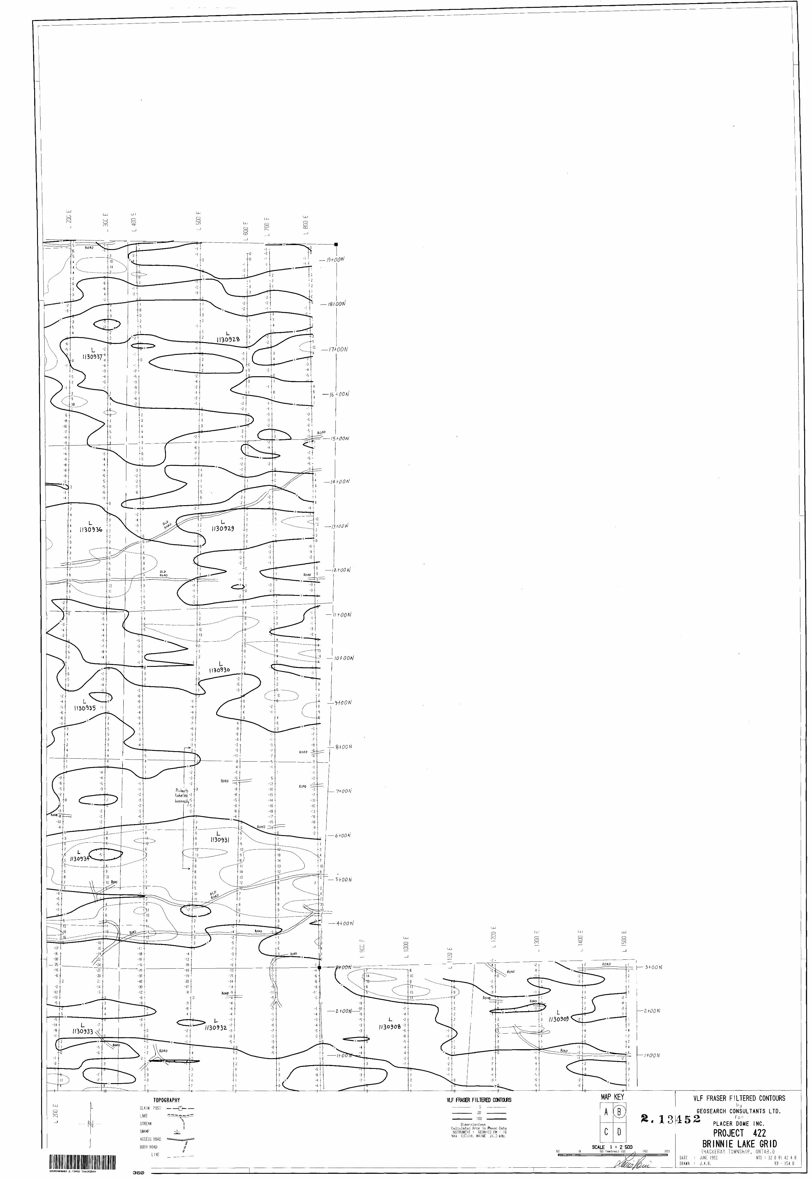
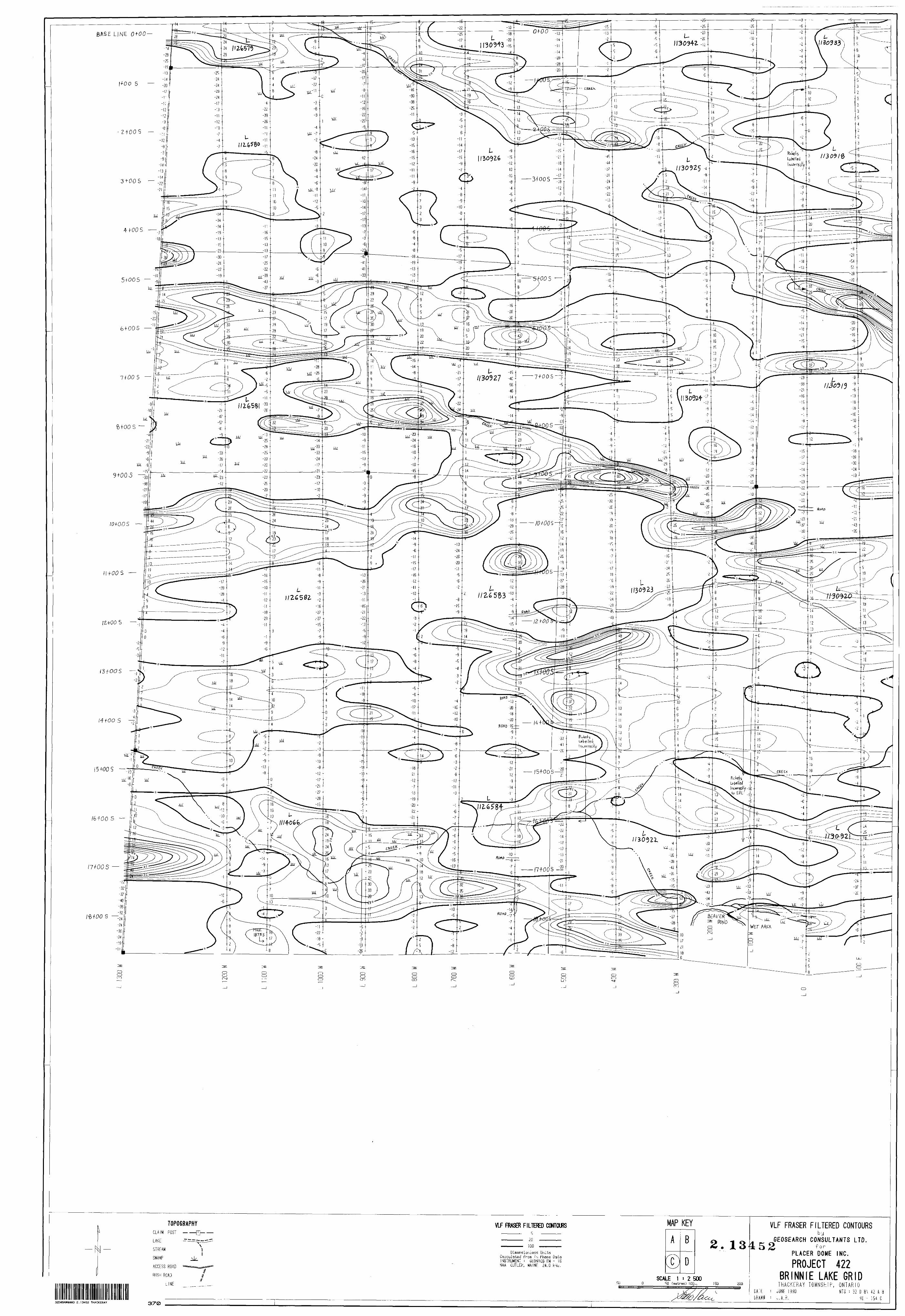
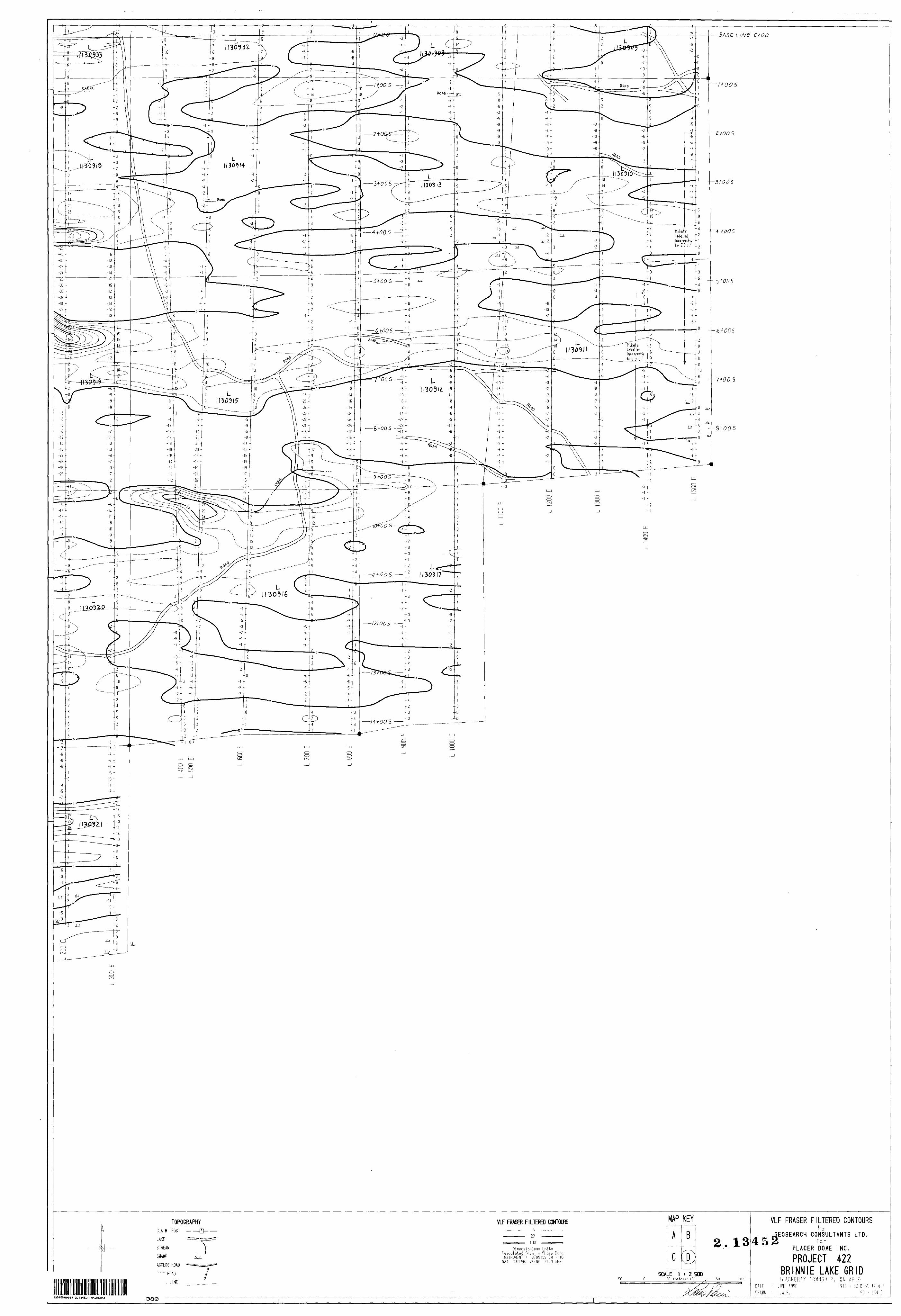
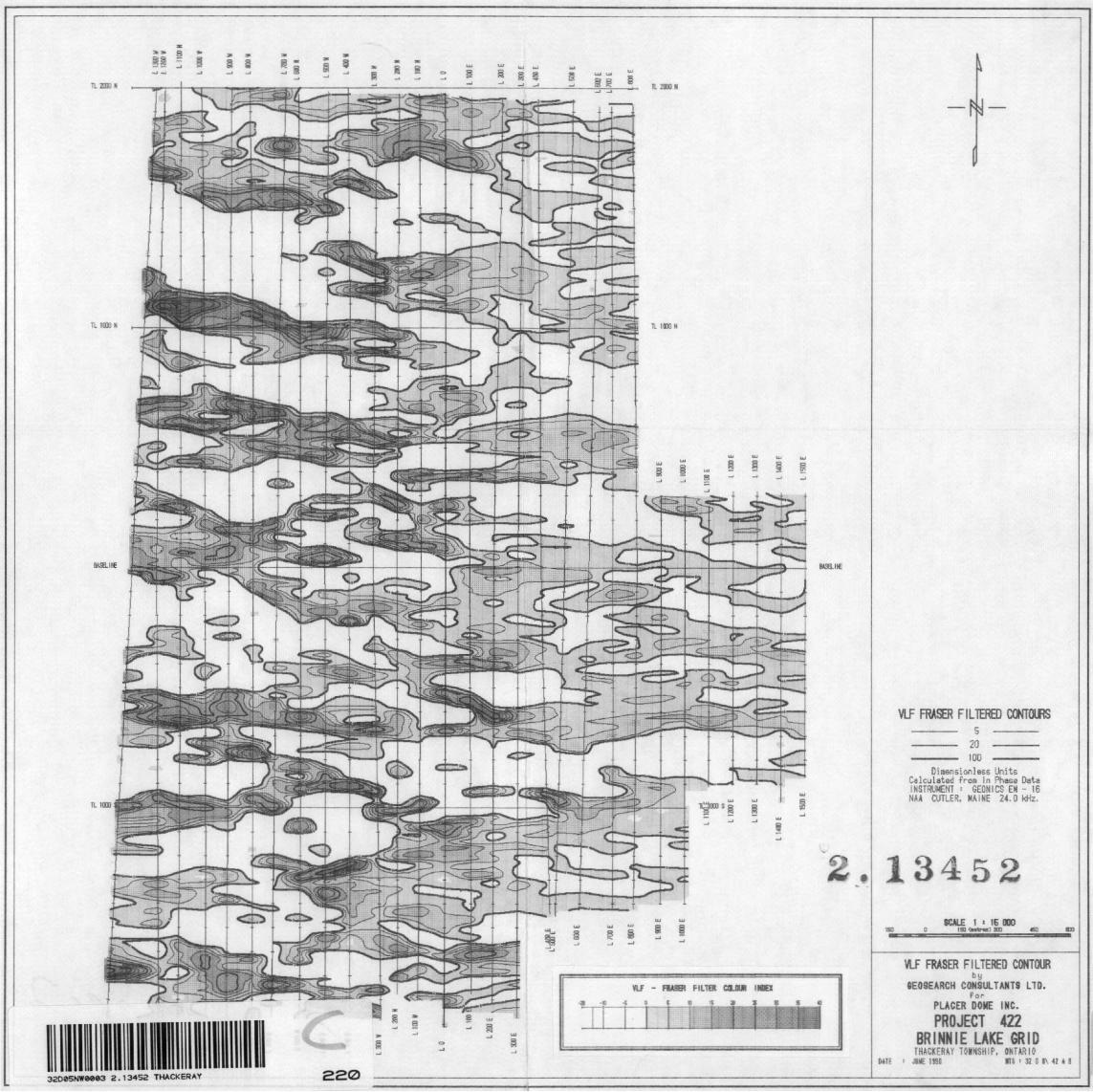
profiled, Map series 90-152. The inphase data was 'fraser filtered 1
and these dimensionless units were then posted and contoured,
Map series 90-154. Contouring of the magnetic and fraser filtered
data was completed by Geosearch Consultants using Geosoft software.
A coloured map of the magnetics and fraser filtered contour
data at a scale of 1:15,000 is included at the back of the report.
- 3 -
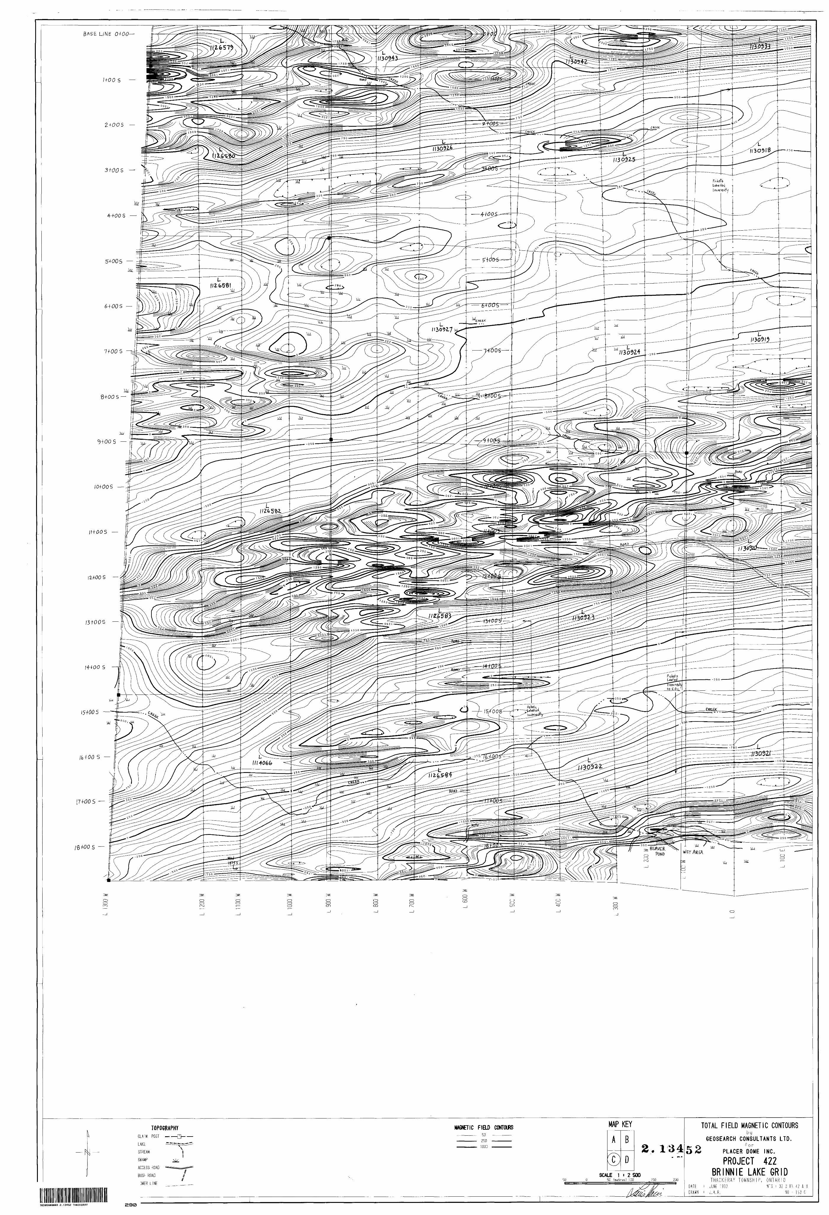
RESULTS
The total field magnetic survey results reveal a strong
regional east/northeast trend. Within this regional trend there
are distinct bands of different magnetic intensity, reflecting
changes in the magnetite content of the volcanic rocks.
The southern portion of the survey area outlines a magnetic
linear feature centred on a line extending from L13+OOW, 15+OOS to
L15+OOE, 8+OOS. This linear unit is flanked on both its north and
south sides, along its entire length by magnetic lows. The
symmetry of this suggests an anticlinal structure with its axis
along the line mentioned above. It is noted that the south side
of this anticline has a very uniform decrease in magnetic intensity,
whereas the northern edge does not. This northern edge is littered
with many isolated anomalies, yielding a very disturbed appearance.
This irregular pattern may be due to differential weathering of the
anticline.
Directly north of this structure is a magnetite rich folded
structure. The southern limb of the fold extends from L13+OOW,
0+00 to L8+OOE, 6+50N. The northern limb of the fold extends from
L8*OOE,12*OON to L2+OOW,15+OON. The nose of the fold is not
covered by the area surveyed and is directly east of the grid.
The southern limb of has a uniform width of 500 metres along its
- 4 -
length. The northern limb is quite narrow at its eastern extremity
and widens to 350 metres at its western end. This limb ends
abruptly, suggesting that it has been truncated by faulting.
This north east trending fault lies on a line extending from
L6+OOW, 11+OON to LO+00, 17+OON. West of this fault the magnetics
are much more disturbed.
Cradled within the limbs of the fold is an area with much
less magnetic intensity. A number of narrow magnetic bands are
observed lying parallel to the southern limb of the fold. These
are small features defined by numerous 'spotty' magnetic anomalies.
The locations of these are listed below.
1) from L13+OOW, 8+50N to Ll+OOW, 9+OON2) from L12+OOW, 5 + 50N to L2+OOW, 6 + 50N3) from L13+OOW, 4 + OON to L6+OOW, 4 + 50N4) from L10+OOW, 3+50N to L7+OOW, 3+75N
A number of similar features are noted in the magnetically
quiet area south of the fold. Their locations follow.
5) from L13+OOW, 4+50S to LO+00, 1+75S6) from L9+OOW, 6+OOS to L2+OOW, 4+OOS
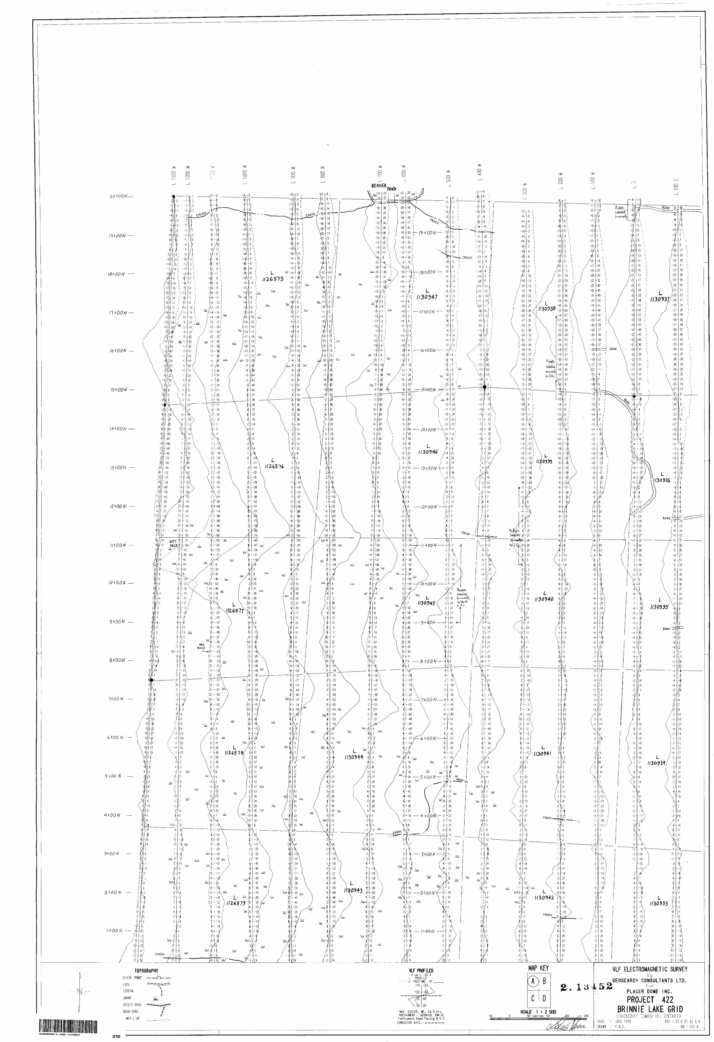
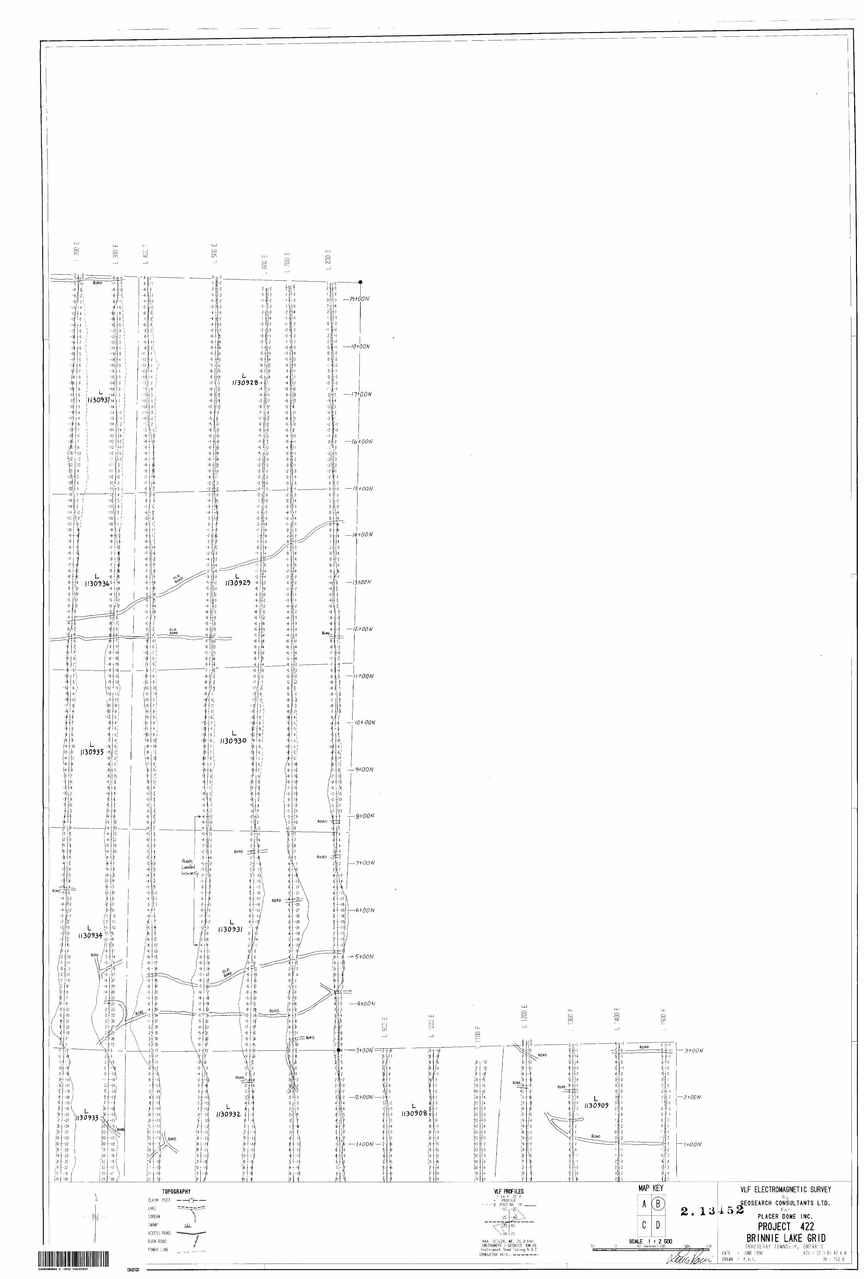
The VLF electromagnetic survey located many conductive
horizons. This is quite evident from the many anomalies observed
on the 'fraser filtered 1 contour maps. The magnetics describe
an area with much large scale structural control and conductive
zones would be expected to follow this pattern. The VLF conductive
horizons observed do not correlate at all with the magnetics.
- 5 -
Rather, there is a very strong correlation with the swamp and
creek areas. It is also observed that the western side of the
survey area has many more conductive horizons than the eastern
side. The line separating these two areas extends from L3+OOE,
19+OON to 16+OOE, 14+OOS, which represents the edge of the well
drained, sandy, high ground in the east with the swampy wet areas
to the west. Clearly the VLF-EM survey results reflect the
surficial conductivity of the area rather than bedrock conductors.
If bedrock conductors do exist on the property, they are not
visible in the data obtained. As such, no conductors are listed.
RECOMMENDATIONS
Due to the lack of effectiveness of the VLF-EM survey, and
the very real possibility that bedrock conductors were undetected,
it is recommended that a more discriminating electromagnetic survey,
such as HLEM, be employed over the grid. The magnetic survey
outlined a number of strucural features which warrant further
investigation. As always, the data presented here should be
used in conjunction with the known geology prior to further work.
Respectfully/submitted,
I)6uis RacicGeophysicistGeosearch Consultants Ltd.
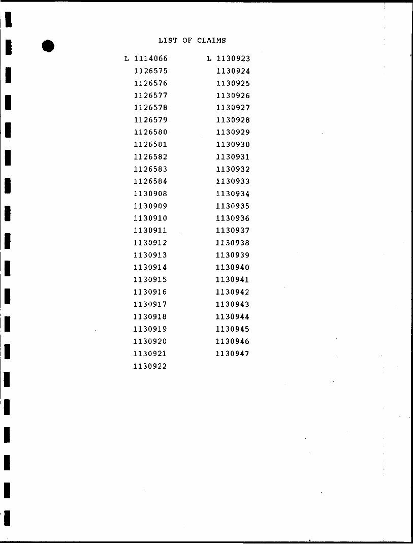
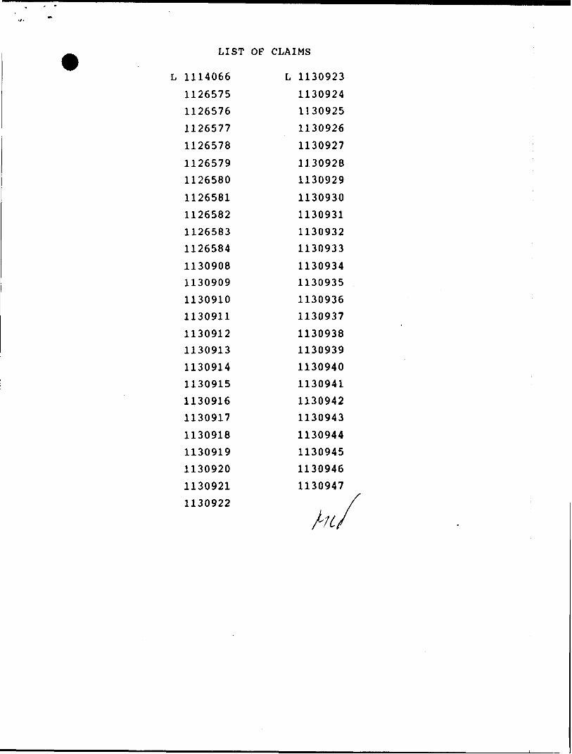
LIST OF CLAIMS
L 1114066
1126575
1126576
1126577
1126578
1126579
1126580
1126581
1126582
1126583
1126584
1130908
1130909
1130910
1130911
1130912
1130913
1130914
1130915
1130916
1130917
1130918
1130919
1130920
1130921
1130922
L 1130923
1130924
1130925
1130926
1130927
1130928
1130929
1130930
1130931
1130932
1130933
1130934
1130935
1130936
1130937
1130938
1130939
1130940
1130941
1130942
1130943
1130944
1130945
1130946
1130947
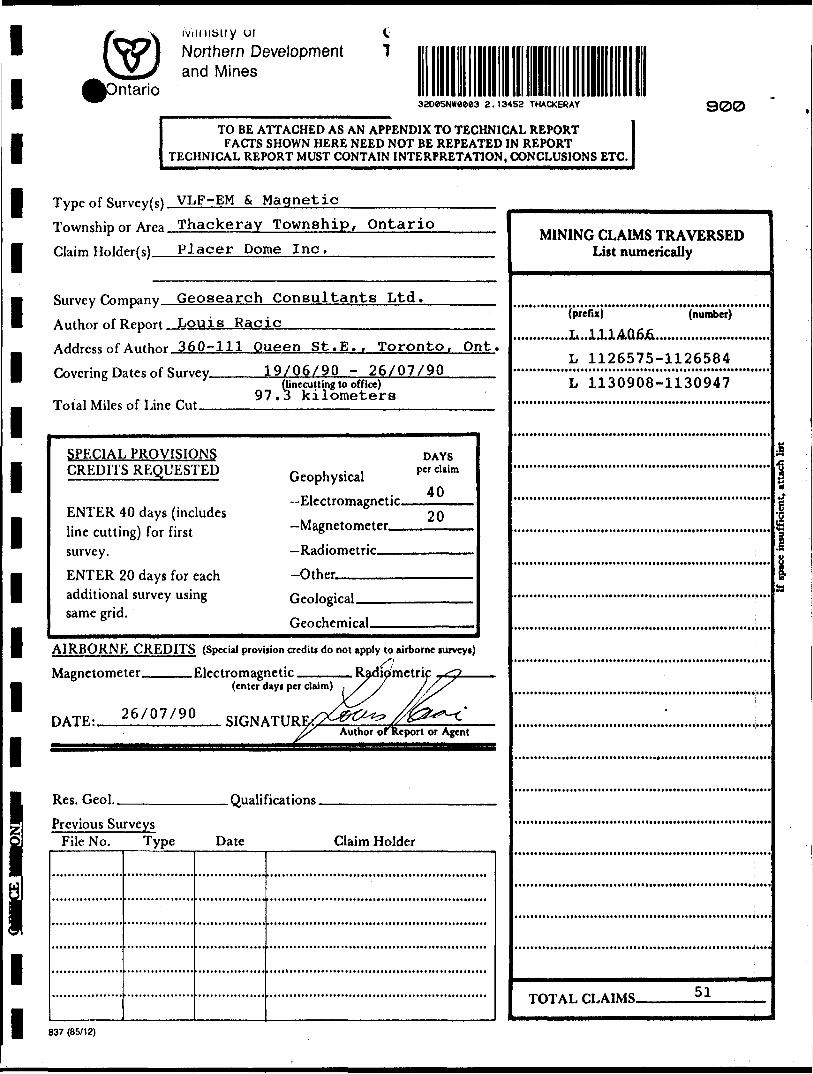
iviiiiibiiy ui C Northern Development l and Mines
ntarioTHACKERAY 900
TO BE ATTACHED AS AN APPENDIX TO TECHNICAL REPORTFACTS SHOWN HERE NEED NOT BE REPEATED IN REPORT
TECHNICAL REPORT MUST CONTAIN INTERPRETATION, CONCLUSIONS ETC.
Type of Survey(s) VLF-EM S MagneticTownship or Area Thackeray Township, Ontario Claim Hnlder(s) Placer Dome Inc.________
Survey Company Geosearch Consultants Ltd.Author of Report Louis RacicAddress of Author 360-111 Queen St. E.. Toronto, Ont.
Covering Dates of Survey.
Total Miles of Line Cut —
19/06/90 - 26/07/90(Unecutting to office)
97.3 kilometers
SPECIAL PROVISIONS CREDITS REQUESTED
ENTER 40 days (includes line cutting) for first survey.ENTER 20 days for each additional survey using same grid.
Geophysical—Electromagnetic.—Magnetometer——Radiometric———Other—————-
DAYSper claim
40
20
Geological.Geochemical.
AIRBORNE CREDITS (Special provision credit! do not apply to airborne turveyt)
Magnetometer. .Electromagnetic
DATE:. 26/07/90
(enter day* per claim)
SIGNATURAuthor of Report or Agent
Res. Geol.. .Qualifications.Previous Surveys
File No. Type Date Claim Holder
MINING CLAIMS TRAVERSED List numerically
(number)'(prefix)
.L...111AQ6J6.....................
L 1126575-1126584
L 1130908-1130947
l
l
lTOTAL CLAIMS. 51
837 (85/12)
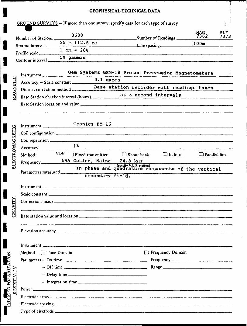
I GEOPHYS
— GROUND SURVEYS - If more than one survey.
M , ,o - 3680 Number nf -StatK*ns ,
| 0 . . , 25 m (12.5 ra) Station interval , ..,,.—,,,.. ... . 1 cm = 20% Profile scale , ....
1 - . . 50 gammas Contour interval ,
(CAL TECHNICAL DATA
specify data for each type of survey
MAGNnmher nf Readings 7 362
Line sparing 100m
VLF 7373
m instrument Gem systems GSM-18 Proton Precession Magnetometers
1 C A^nr^y-Sr^ronstant Ol1 V*™™*
| ™,,m,i ^r^rtinn method Base station recorder with readings taken
| -p Bas^ Station chfck-i" interval (hours) , . .Pasp Station Inration anH value .
1
at 3 second intervals
I r, In.trnnu.nt GeOniCS EM-16i— ir tS Coil configurationZ
1 C) C"?l s^paratinn .19-
S A^n^ary -1 0OP^ Method: VLF D Fixed transmitter
1 3 FrPq,,Pnry NAA Cutler, Maine^^ ^J
w In phase and — Parameters measured.m secondary
Tnstrumpnt
I Rralp constant^ H Tnrrprtinns maHp
1 "-m K t5 Base station vahip and loc^tinn .
1 F.lpvatinn arnirary
| Instrumpnt
Z Method D Time Domain
Io H Para^mPtPrs — On time< S3 ^M| - Off timp2 H
IS ^ - Delay time•H "^
O ^ — Integration timeB* (— l
IQ u] Power3 ^D F-lTtK'd'' array ,,fiJ*', Electrode spacing
I~ ( 1 b Type nf elertroHe
D Shoot back CD In line D Parallel 24.8 kHz
line
(ipedfy V.L.F. itation)quadrature components of the verticalfield.
D Frequency Domain FrequencyRange
l
i b O
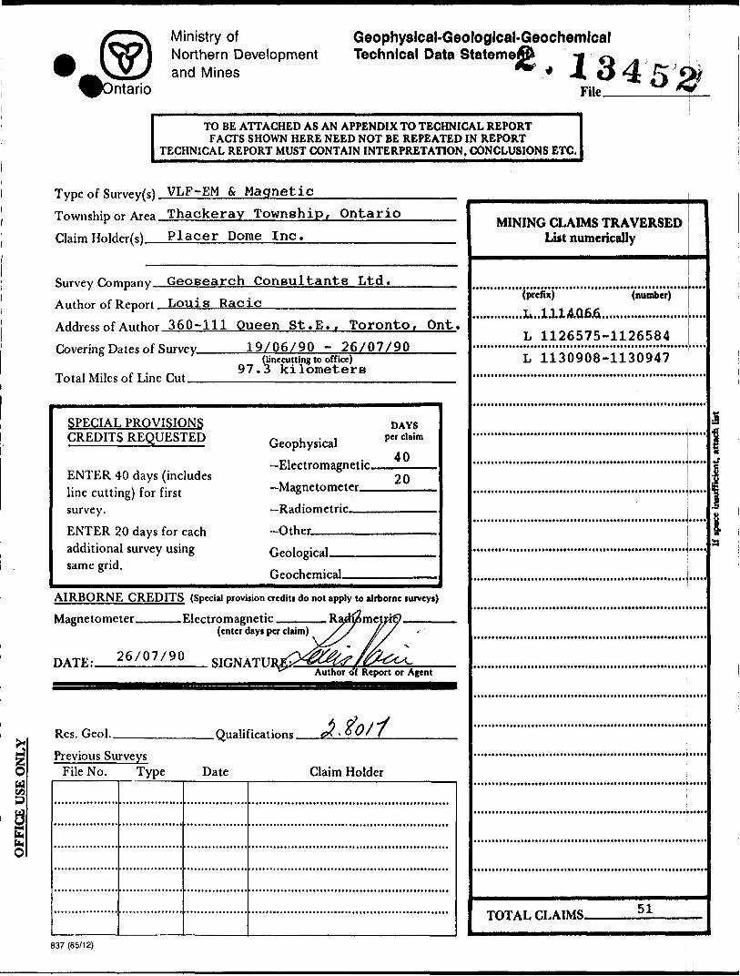
Ministry ofNorthern Developmentand Mines
Geophyslcal-Geologlcal-Geochemlcal Technical Data Stateme
ntario13450
FilP ** *Y
TO BE ATTACHED AS AN APPENDIX TO TECHNICAL REPORTFACTS SHOWN HERE NEED NOT BE REPEATED IN REPORT
TECHNICAL REPORT MUST CONTAIN INTERPRETATION, CONCLUSIONS ETC.
Type of Survey(s) VLF-EM S Magnetic—————^—Township or Area Thackeray Township, OntarioClaim Holdfr(s) Placer Dome Inc.———-————
Survey Company Geosearch Consultants Ltd.Author of Report Louis RacicAddress of Author 360-111 Queen St.E.. Toronto, Ont.Covering Dates of Survey.
Total Miles of Line
19/06/90 - 26/07/90Ojnecutting to office)
97.3 kilometers
SPECIAL PROVISIONS CREDITS REQUESTED
ENTER 40 days (includes line cutting) for first survey.ENTER 20 days for each additional survey using same grid.
Geophysical—Electromagnetic.—Magnetometer—.—Radiometric———Other-^————
DAYSper claim
40
20
Geological.Geochemical.
AIRBORNE CREDITS (Special provision crediti do not apply to airborne furveyi)
Magnetometer____ Electromagnetic
26/07/90DATE:.
(enter days per claim)
SIGNATUAuthor of Report or Agent
Res. Geol.. . QualificationsPrevious Surveys
File No. Type Date Claim Holder
MINING CLAIMS TRAVERSED List numerically
(number)(prefix)
......L...1114.Q6J6.....................
L 1126575-1126584
LI130908-1130947
l
• M
l
TOTAL CLAIMS. 51
837 (85/12)
GEOPHYSICAL TECHNICAL DATA
GROUND SURVEYS — If more than one survey, specify data for each type of survey
o c o r\ MAG — v 4JL- *3 O O U 71fi9 7171 Number of Stations_________________________Number of Readings ______' JP ^———.' ̂ / •*rr, i 25 m (12.5 m) T . . 100mStation interval ______________—.———————————Line spacing__________xuv"'———————j,.Profile scale______________!———————————————————————————————————————————-, . , 50 gammasContour interval ——————————————————————————————————————————————————————^
Instrument -^————Gem Systems GSM-18 Proton Precession Magnetometers_____C A oi t. 4. 0.1 gammaH Accuracy — Scale constant ——————————z—————————————————————————————————————g Diurnal correction method______Base station recorder with readings taken
j| Base Station check-in interval (hours)_________at 3 second intervals________________
: Station location and value ______________________________________________L
O
2
Instrument _________Geonics EM-16
ELECTROMAGNETKCoil configuration
Accuracy ,Method: VLF C
MA AFrequency ™nn
P ramore mPacnrpH
l%
] Fixed transmitter Cutler, Maine
In phase and
D Shoot back CD In line 24.8 kHz
(ipeqfy V.L.F. station)quadrature components of
D Parallel line
the verticalsecondary field.
Scale constantJH
made.
Base station value and location.
Method D Time Domain D Frequency Domain
Parameters - On time _________________________ Frequency ————
^— Delay time- Off time ___________________________ Range.
— Integration time.
rt u: PowerCJ Electrode array —
Electrode spacing . Type of i
tario •ii/ 1* e
Ministry ofNorthern Developmentand Mines
Ministere du D6veloppement du Nord et des Mines
ining Lands Section 159 Cedar Street, 4th Floor SUDBURY, Ontario P3E 6A5
Telephones (705) 670-7264 Fax: (705) 670-7262
Your File: W9008. 231 Our File : 2. 13452
December 3, 1990
Mining RecorderMinistry of Northern Development and Mines4 Government Road EastKIRKLAND LAKE, OntarioP2N 1A2
Dear Madam/Sir:
RE: Notice of Intent dated October 29, 1990 for Geophysical (Electromagnetic A Magnetometer) Survey submitted on Mining Claims L 1114066 et al in Thackeray Twp.
The assessment work credits, as listed with the above mentioned Notice of Intent have been approved as of the above date.
Please inform the recorded holder of these mining claims and so indicate on your records.
sincerely
R. C. GashinskiA/Provincial Manager, Mining LandsMines and Mines?aie-f)i'Vision
fcj/dvl 'Enclosure
cc: Mr. W. D. TiernanMining and Lands Commissioner Toronto, Ontario
Placer Dome Inc. Toronto, Ontario
Resident Geologist Kirkland Lake, Ontario
Louis Racic Toronto, Ontario
Ministry olNorthern Developmentand Mines
Ontario
Technical Assessment Work Credits
foate
1 Oct. 29/90
File
2.13452Mining Recorder^ Report of Work No.W9008.231
Recorded Holder
Placer Dome Inc.township or Are*
Thackeray Twp.Type of survey and number of
Assessment day* credit per claimGeophysical
EkrtrAmignMle 40
Magnetometer . 20
Radiam^rlK
i"dM**4 polerlfetfon . ,. .
OtS.r
Mining Claim* Aliened
-Ay. L 1H4066
1126575 - 584 1ncl.• -tv* 1130908 - 920 1ncl.
. 1130922 - 947 Incl.
day*
.dav*
Section 77 (19) See "Mining Claim* Assessed" column
Geological ,. ......^ .dun
GMchftmlcat ,. , -devt
Man day* Q Airborne Q
Special provision Q Ground ^)
Q Credit* have been reduced because of partial coverage of dal m*.
Q Credit* haw been reduced because of correction* to work data* and figure* of applicant.
Special credit* under section 77 (16) for the following mining dairm
Claim L 1130921 - 15 days - 30 days
magnetometer electromagnetic
No credits have been allowed for the following mining claimsnot sufficiently covered by the survey Q Insufficient technical data filed
The Mining Recorder may reduce the above credits if necessary in order that the total number of approved assessment day* recorded on each claim doe* not exceed the maximum allowed as follows: Geophysical - 80; Ceologocal - 40; Geochemical - 40; Section 77(19) - 60.
828 (85/12)
Ministry ofNorthern Developmentand Mines
•DOCUMENT NO.Ontario
Mining ActReport of Work 2* 134*52.(Geophysical, Geological and Geochemical Surveys)
Instructions- Pieate type or print- Refer to Sector* 7? the Mining Act tor assessment work requirements
ind maximum credits allowed per survey type- H number of mining claims traversed exceeds space on this form,
attach a list- Technical Reports and maps m duplicate should b* submitted to
Mining Lands Section. Mineral Development and Lands Branch:Type of Survey(s) Mining Division : Township or Area
Total Field Magnetic Larder Lake Thackeray Twp.Recorded Holder(s) Prospector'* Licence No.
Placer Dome Inc. T-837Address
P.O. Box 350,S15X //J 3 Telephone No
IBM Tower, TD Centre, Toronto, Ont. 868-6060Survey Company
Geosearch Consultants LimitedName and Address ol Author (of Geo-Technica! Report) Date ol Survey (from * to)
Louis Racic, 360-111 Queen St. E., Toronto, Ont. D l^ J)6( ^0| 0 26 J)7( fyQCredits Requested per Each Claim in Columns at rightSpecial Provisions
For first survey:
Enter 40 days. (This includes line cutting) - ' '*
For each additional survey: using the same grid:
Enter 20 days (for each)
Man Dayt
Complete reverse side and enter lotal(s) here
Airborne Credit*
Note: Special provisions credits do not apply to Airborne Surveys.
Geophysical
- Electromagnetic
- Magnetometer
- Other
Geological
Geochemical
Geophysical
- Electromagnetic
- Magnetometer
- Other
Geological
Geochemical
Electromagnetic
Magnetometer
Other
Total miles flown over claim(s).Date l
Days per Claim
40
20
Days per Claim
Days per Claim
Recorded Holder or Agent (Signature)
Mining Claims TraversedMining Claim
Prefix86'
——————
Numberi attached
List in numerical sequence) .Mining Claim
Prefixlist
\
MINI
NumberMining Claim
Prefix
AUG241UO
Number
,.
YG LANDS SECTION
———Total number of mining claims covered by this report of work. -
51
Certification Verifying Report or Work1 hereby certify that 1 have a personal and intimate knowledge of the tacts set forth in this Report of Work, having performed the work or witnessed same during and/or after its completion and annexed report is true.
360-111 Queen St. E., Toronto, Ont., M5CName and
For Office Use Only
Total Days Cr. Recorded
Date Recorded Mining Recorder Cr~"~'4r-*J*"V*
\ A. f 1.l-"i.4 '-f^T -* ' ' 'Date Approved as Rec&rded 5*evficial fvTanager.' Mining Lands
i z/^/y^ StlJPLn tuAAS/smJtsKAs
Received Sta
LARDER LAKE MINING DIVISION
AUG. 3t990
TIME
136J (89(06)
LIST OF CLAIMS
L 1114066
1126575
1126576
1126577
1126578
1126579
1126580
1126581
1126582
1126583
1126584
1130908
1130909
1130910
1130911
1130912
1130913
1130914
1130915
1130916
1130917
1130918
1130919
1130920
1130921
1130922
L 1130923
1130924
1130925
1130926
1130927
1130928
1130929
1130930
1130931
1130932
1130933
1130934
1130935
1130936
1130937
1130938
1130939
1130940
1130941
1130942
1130943
1130944
1130945
1130946
1130947
REFERENCES
GARRISON TWP.WTHDRAWN R M DISPOSn ION
SURFACE AND MINING RIGHTS WITHDRAWN FROM STAKING
N.R.W, 63/en, DEC, Z, 1983
H.R.W, 63/63 R1SCINOED MARCH 29/83I07T5S3- , IfcllJiSKM. i -"^—— -.- -, . --
-i-. ~ — L —. ...J ^. — —l ^.^ .
.—— --
792320 7^12/92329 2338792559 7923^"
THE INFORMATION THAT APPCAMS ON THIS MAP HAS L! E E N C O M l M i. i: P FROM VARIOUS SOURCES, AND ACCURACY IS NOT GUARANTEED, THOSE WISHING TO STAKf: MIN ING CLAIMS SHOULD CON' SULT WITH THE MINING RECORDER, MINISTRY OF NORTHERN DEVELOP MENT AND MINES, F: OR AD DITIONAL INFORMATION ON THE STATUS OF THE LANDS SHOWN HEREON,
~^
1 11130/11309,9 T\r-.*2.\ lo J! w—\-'7M-i — St- J-—~-\1017COO 1047001 l I047T4B
U-.-.:.I0yfi03 l 1047004 , I04700H |Q 47006 1047*760
J— — —— ,047P13 ^l
047T80\ I047T5B [ 1047758 | 1047737 11047756
- j- —— -
1047701
73900-J l 73900J | 739OOZ
— —— 4 — —•- ____ - 101719? [1017493 '1047951 ||Q4T951^1047951 ||04T951 jjoOUilO | lO^aill ! ^ —— , \^V,.L.
---U——-|, .
738737 l V3B7S8
'l04Ji|J j 1017494 l 1017958 ' 10^7853 | 1010,11 ilO*8iiZ j j ' V" l IC4TT6! ' 'r -., r -r--i~.r-|~.-r:M ^ ~ — — 4- — '——l M90IO 739009(7390
fio^S'l'l. 1048541 1(048341 l '' . '.
l ' . : ! ' '' i . l . ' li ..!
Q5IL22_110-3HO 9 O
| i
I017B3Z I017B33 J047B34-- -i-^-L^^Lr r fI04HI3D llOiaiZT JI01BI26 1(049183.'
.--J.---J.-.'- - L -- J ---- i ^__ i— —— Jai32IM I'UB^IS! l , j . l . j T- . T- -L___——— ^^
104BB63 l04B66fl I04B87I IQ4SII4 l01fll09 1048091j --L-'
- ;Jn^i '"!!16L l fT"LTL.L ir q^ 1019711 j 1049740 i I01975S \ 1019737 l I0197SD | ID1C228
-L ' - J-------B8 * ODV fl58993 l 858998B59047 059040 B5903?
855X346 85904 l 659036 85903I 8590 29
-'' - 1 -: - ' - \ - ! --...'.-..-"" I-.D i i 961430 : — — l— —— —j' - '.. r '
S LE Y'.: TWP.
;;NOTICE or FORESTRY ACTIVITY.'f THIS TOWNSHIP t AREA FALLS WITHIN THE
.,' ' AND MAY~BE SUBJECT TO FORSTRY
, THE MNP UNIT FORESTER FOR THIS AREA CAN BE. :, CONTACTED AT: P.O. BOX 129;" . SWASTIKA, ONT., '-i. ' ' ' '. /' POK ITO
705-642-3222'
L E G E N D
HU'jM'.VAV ANO ^OUllr 'lo .
O I'nt -i r^VD'5 i ' ' "
r w A " s
S' .'H , V: r 'J r.) L'"J( : 3
r w.v'i v-uf; -i vst L "IE ii. F i' c LO ; x i' 1 .'^'.:. ri AIM:.. HA-KELS.
UN 1"^ "-"v E t '-[J LiNtS
LOT L IN r 5p ^ 4i;tL aou'iD-i^ i'yiNI'-JG Ci AIMS tIC
n-Mi.,vA" A'ui RIGHT o^ //AYUIILMVLINE5
NON PL -Ifc'.'J'IIAL STHtAM
F LOOPING OR F LOOOiNG RIGHTSSUBDIVISION OHCOM^OillE PLAN
"'
c -
M i N H S
FRAVEHSE
Disposniow or cnavjiiTV PL OF DOC U W t: NT SYV.
\PA TtN r, S'.if^^LL i MiMNO RIGHTS ..,. . . . . . ., SUH^ACF RICH IS ONLY......................... (T )
, MINING RKiM'TS ONLY .;.. ........... ......: ^
. SUflf-'^Cf. 4 WiNING RIGHTS......... .., ....:. . I'l
, SURFACE HlUHlb ONLY........... . . ,,......( .. . M
, MINING MIGHTS ONLY.:.........:... .... .......'. R
E O*1 OCCUPATION .,:... l. ,.,.'i'. ..l'. J. .'. L,,., J, .' Y
-H IN coi.i'iCiL . . .. ........-..'.',......:'. ....,. t , oc'HVAf KIN ...... .. .,...;... i......:' . ;..,. ,.., .'....
(D'SANO A GHAVCL ..,......,....'....
NQTb' VlKlNU "'MMT5 IN PAMCt LSI91J, VI- S I t. i; IN OftiCi-iAL '•ATL'f'fct B/ T ^' E
^I.qSO H 70, CHAP 3*1. S t C, *3, SUbSkC 1.
scAi F; i IN'; H -in C
J O 00
! A r i x .1 i'-) AN7 il\\'\\,.l\f\\il - .M.N.K. AlJ.MUIIilMAnVi: ClSThlCT
KIKKLAMO LAKF, - r/; 1 'i M:; hivioip.1 , ' .
L AJU^r^x !, AKV; : ,i ^u -' iMi.rr, x f,.aur,/,/ .01:15101
! i: r*f'\ r-i \r * r- r ";;'
' : *
'\ vM s Vv J
MINISTRY OF NORTHERN - DEVELOPMENT AND MINES .
n '" N -j rtb
32D05N*9003 2.13452 THACKERAY 200
ZQtOON
m DON
VU
\u
IbiOON
15+OON
14-tOON —
M+OON
IZ+OON
tli-OONWETAREA
W
lO+OQN
9 + OON
~liOON
5+OO
VU
Z-tOON ~
OON
925\U
859
-57
POA/D-91
-35
\u. --
U6
VU
\u
YU.
L
26578^
YU
1U
822
C ft(-to
--38I
\U .
-55-167-125-no37915361045
-734 178 148 124 310 662 1095
Mi
iI2 ^ "
YU
\i/L
V.
378
-253
197173122135166133137^
-143 s135 vu130122117
121133129 v
\u
iU
u/
\uMi
\k
-''1
1 I W -^lu
i
j.
L
i
,l ^
Yit
\u
\1/Ut ~"
^ \u
vuYU
i
\uM/
— ————— —— i
\ i , A i f if/
105155H8150151146 iU121127 YU114109no iu117132^
-145
162166160174170181166
-162•175
20121922720311467
-36
503
222 11265
•62
198-109
1D4136^
273211
•171^
199 YU235
-266525^
481274
205 //3173201235
-278•306•339
591646529510409 \LC
-268
696tJCHtfbO
799•672
524406821
-135820481395135599312241273 L1008 (3
-1332 " JL
14B21 164
•1544 ^1599 \u
k ^
H/
VU
11525 j 1408-1394
--1354
1219 1111
- 1055' 1060
10901120
Jil
— IQ+OON —
L1/30^7
•IliOOH —
--1091
iU
78498510791002
26526524020418529621527123222127430161310534GG409
AU
L //30939
/T\
Pi&kets Ufeillfct\*icortitfa
294
436
"i
334331273275295239240-230 218
193167
20Q
2G3-35?^351-769
L //30939
Pfekets Labelle ii
rfteily .^E-O.L.j\
L//3o?4o
20 L-217 J/30M/443765
CHEE*.
625
U(iu
CREEk
275
/U*fe LftWW"
l ntavrtttfy
46
-58
L //30937
-385
-246
L 1/30936
ROAP
L //3o535
L //3D53^
L1130^33
TOPOGRAPHYCLA M POST
LAKE
STREAM
SWAMP
ACCESS ROAD
BUSH ROAD
!R L NE
MAP KEY
BASE LEVEL 58,000 nT REMOVED
INSTRUMENT: GEM SYSTEMS GSM-1
l
2. 134,
SCALE 1 i 2 500SO (metres) IDD 200
32O3SNW0003 2,13453 THACKERAY
TOTAL FIELD MAGNETIC SURVEYby
GEOSEARCH CONSULTANTS LTD.for
PLACER DOME INC.
PROJECT 422 BRINNIE LAKE GRID
DATE DRAWN
THACKERAY TOWNSHIP, JUNE 1990 J. A. P,
ONTAR ONTS : 32 D 8\ 42 A i
90 - 151 A
:r^^
'
^.ftOAO
..
..
--f
•E- E - E
1
- 1 - 1 --1
- 1 - 1 -1 - 1
Ki r--\L
••M
- 13 - 14 - 14 - 5 - 16 -16--15
- 14 ••13
- 13-13 -17 -22C . Ut--25E
- 237 - 198
167 - 50 - 131 - lil - 102
' 118 -132 -150 - 159/ - 1634 ' 152E
^•^^B———— 1^^
. —————— - — - — . ———————— - ——
LJJ ( — ̂ I..J.J LU
S CD CD ^ CD 0 _ , CO ^J-
__ 176- ———— Tb9~. - 9S ——— ———————— d-^- —— —————— j 35 Oftt
T --38—81—BS - -83
—170 - -194 - -250 - -220 .--174
—231 - -245
1-272 - -290 - -301 - -316 - -323 - -327 ---277 t-
-284 1/309371 -249 j -148 - 0
- 121 -349 -416 -520 -622 -696 -745 j 847 J91Q -953 - 1031 --1064
- I09b - 1150 - 1247 - 1333 -1461 - 1593 - 1735 --1841
1837 1738
' 1618 ' 1514 •1425 -1387 - 1376 L
1332 ||^09 5t - 1304- 1269 - Ml - 1079 - 937 __ ̂
-832--B04
-703 -665 -623
-633 - 570 ——————————
-556 -472 -464
•474 •451 443424 i tc-44b
•448 429 389
•406 L
•™ 1130935 -496 488 454 507 449 335 297 299 302 293 246 209 185 ———————— -
201 227 201 162 163 190 186 248 430 396.334 )44 32 78 29 59
48 L
Io5
218 '34
333 317 \\
- 13 \^^ 316 \\ ' 376 '350 ? 98
11QA — -s-
01 98 -1 98 - 1 98 -1 84 /'\ 95 /^, 95 s/ - 750 ——— ——— . —— -i,
42 -1 37 - 1 37 - 1 17 - 1 3 - 1 8 -19 - 1 t i3 --1 3
L "'3 -1o 1130533^.,] Vl v3 -\D - 1:l -14
1 IE - IE -IE
j 15 j, 4
13
-59 -29-3---21 . -49- -68 - -124
-153 - -228 - -240 . -244 ---242
- -236
- -234 ••-314 - -355 - -296 ' -271 ' -257
—306 - -277 - -252
j -217 j -145 --58
- 116 -261 -358 -449 -528 -579 •626 -684 -737 -621 -900
997 ——
-1099 - 1222 -1320
1399 1488 1572
-1574 1521 1443 1371 1322 1305 1306 1327
-1324 1304 1251 1184 1078 X
.98^X "924 866
-808 •761
803 738 696 674 640CHObUd ———
-574 559 566571 566 556 562537
-517 499 471 439 412 385
73 322
-306 306 293 356 286 262 23G 193 203 229 731279 359 470 578 739 851 875 380 1075 1357 1477 1356 '288 1265 1230 T 94
139 066 009
990 000 006 036^-
13 177 215 214
97 223 268 Os. 294 \ 280 j
378/^
474 931096904 964 889 697 585 523 562 505 125 281 76 07 14 48
38X
74 06 80 91 68 20 00
-3 -3
-^
— — i —— -
- —m ——
l
5 1 4 23 52 83 88 141 203 221 219 281 268 219
-211 305
-293 -293 -276 -247 -170 -103 -47
14 51 106 164 259 382 476 548 586 617 660 714 779851 914 958 1021 1089 1162 1223 1253 1238 1215 1194 1158 1178 1182 /^
cAs^x^-1217 *XX^
1196 .X^X
'l 104 1041 97
906 841Q1 Oolj OL&irn KOAD/riD' — - ————— ——— ̂
734 707 666 639
•614 •593- —————— ~ ————— ~
-569 -556 542 525 510
-492 •465 •438
A 1C
•393 -370
350 331
•317 •300
285 -280 •276 •280 •289
301 329
•363 •407 -483 i — } - •577 -.698' 759 •823
885 944 1015
-1081 ?M* 1082 Labelled inaq Ih&oirrtcrjv1 U J J 1
1104 •1103
- 119 - 1140 -1161 -1191-1218 -1 -1225 ' 1234 - 1 - 1261 - 1 •1298 -1 - 1325 — ) - 1 - 1355 - 1
1 CO'7 1
- 1402 - 1 - 1399 - 1
•1344 ^^^^^^^ - 1-1384 ^~^::::̂ z:;:i-1465 •1556 -l- 1 C3Ql bao -1680 -H
1722 - 1C •1723 - 10 - 1675 - 1 - 1626 ' 12 - 1622 - 13--IRflR --Id
- 1539 - 15 ' 1419 - 15
1340 - 15 •1254 -16 -1158 - 15 •1183 -14 ' 1344 - 14--1519 --13* -1513 -IE - 1466 - 122 •1452 - HE ' 1445 - 109 - 1425 - 102 - 1380.1 -972
" 1334 \\ ROAD " 92[1-IZbl/A. -*- a/o
• X1213 \^\ -844^'fl48 - 804- 1099 - 764 -1051 - 731 -986 - 715 •922 - 685
LL-
CD LJJ
LJD UJ LU CD
.— CD CD CO CD CD CD l\ —— 1
119-62
•24 T -9 ••-B —36
-33 --39 j -70 " -60 - -92 " -81- -ne --94- -122 -110 - -150 ' -120 - -174 -133 ••-181 ' -141 ---191 ---135
- -173 ' -127 - -169 ' -104 ••-188 ' -93 - -194 -56 - -177 L "-7
167 1130^2-fc 11' -130 ' 39 -103 J86
-49 j 109 ••-15 "129 •27 167 •53 '209 - 66 231 -42 24! - 16 ' 235 -140 -216 - 54 ' 221 - 192 ' 217 - 244 ' 224 - 275 - 275 -316 -269 -390 j 303 - 465 l 348
j 655 "342 -749 '393 "834 - 474 - 879 l 551 - 909 j 66! -924 742 -954 -811 --964 --873
- 997 -928 ^- - 975 "952 /y' - 985 J973 /S '
- 1 005 ^^^^^^J 1049 ^^1014 — -^^ \ 1069
-1014 L '1079-1009 (13092.*) " 1084- 997 -1065 -964 ' 1039 -934 -993 - 894 ' 956 •846 - 909 -827 ' ' 882 - 792 -837 -757 --797 •708^ 749-684~ ———— -702 -638 -656 -607 - 633 •577 ' 599
: l2T~ ~~ Hiea
- 493 j 534 483 j 534 467 J 513 463 l 51 1 446 l 520
•427 j 516 409 j 531
-394 -f 553
383 1 609 377 L 1 623
382 II3093O 675388 j 72! 4!3 j 781 442 l 823 481 j 869 538 J894 622 1 936 705 l 975 794 j 1006 945 T! 026 911 l 1044 90S l 1056 928 1 1063 939 j 1063 943 j 1061 966 j 1053969 1 1073 972 j 1081 975 l 1106 984 HMD :^f1!32 — 1000 j 174 1033 | 183 053 I 191 073 It 184 106 j 1181 144 li 164 195 -1127
215 " m ROAD —— 245 -1064254 --1041 259 - 1006
265 L ' 100]257 M3093J 985257 ^ -* s J975 262 j 982 260 j 992 262 l 989 257 JIOIO ^^—270 i.104^-^^^"'''""'"^-63 \p ..-^FIOB?-^^^?62 ^^^^ l i157 m^^^ j 122600-"""^ j 1313 86 j 1390 80 1 1500bl Ibob 09 - 1664 ROAO84 - —————— —————— - - 1 BfWr- ——— ~~- —— ~
62 - 1617 55 - 1602 11 ' 1556 41 1557 51 ' 1555 /f31 --1496 ————————— i- 25 -1377 44 - 1307 \V 71 ' 1209 \ 20 - M9
OrtkR-*Q ^4/r*!* 1 flQ7
1 ~~"~-1043 y 2 -999 V1 -959 2 -921 4 L . B73
5 //30932. 84Q0 803 3 ' 771
•744 - 721
- 690 - 632
633 - 645
62C - 602
———————— r 27
146 j 26 33 -14 44 ---l
-52 --2 -93 -5 -91 - -5 -91 -6 -86 - -7 -94 --5-no - -7- 15 —7 -106 - -E -71 - ~t -29 - -E 8 19 35 19 53 84 - 1 95 - 2 104 -4 115 6 144 -1 174 ' 1 189 -1 213 --1 244 ' 2 272 -2 290 - 'i 312 ' ; 332 331
367 P.D*D ^ .395 —————— —— ̂ -405 461 491 524 598 646 ^^^^ 698 X/^
-777 X/ 822 -S 899 968 1039 1082
138 1173
-1146 113
1070 1010 967 919 865 799 7607OO RX) ftv/oj __ : 700 ~^ 682 666E52m - -UJl ————
629ro ji-634 636 643 . 674 703 740 796 848
-900 943
•979 996 996 1000 986 980
-982 996 1027 1058 1093 1121
- 1130 1137
-1 156 182 *oAp -Z
- 184•1177
1195 1232 1236 1236 R0AP ^
-1227 1210 1168 1102 1006 890
-350: 935
-1064 •1255 •1444
1544 1565 1538 1497i tf^r-14bb ^— — —————
1453 1485
-1507 - 1519 - 1515 ^X^
1494 ^V^
1445 //^
-1300 - !255-•1214
-1168
i 105210)6 ———————————
967 928 871
•1951 812
;,779••Tie--733 t *j-j-723 - 720 - 712 •721 •737 -716 -714
•672 •649 •630 -629
596 ' 559
j 9 2 3 5 4 9 6
. —————— —————————————————————
FH
iab i u
\
6 7 4 9 ffi9 4 —— f-
3
3 7 07 46 67 90 ——ft 19 43 39 71 05 22 i39^ 366"^ —— l
*02 409 443 484512,565'
605 667 — h 765 344 931 1000 1048 1066 1057 1046 —— L 1008 975 924 883 840 810 774 764 — l 759- 747 743 732 766 788 ———
833
944 999 1036 1079 1108
126 11551 1 f*"7•1167 1161
153 1130 1089 1058 1039 1016
-1000 992 967 987 1001 1021 1051 1083
- 12 -1120 •1126
1112 1088 1043
- 1012 ::979
-962 973
- 1084 •1380 - 1629 - 1779 •1755 - 1686-1640
- 1505 - 1365 - 1269 ' 1199 - 136- 1101
il rv^n--1069
-1041 - 1016
1000 - 999 - 992 -988
— -985-- •986
- -y/j
957 333 306 B86 856 811 801
^ ^//T 765 764 789 843 861
' 821 780
- 748 - 710
670 - 639 - 614
591
-563-553
njnj^
-Us-556
524 ' 521 -503
457
i
L
— *..
iV QQN
iOOti
i+OON
i+OO tt
5+OOti
1-tQON
WOO H
1100N
11- DON
IO+OON
QtOON
-7+OON
(oiOON
&+OON
Q-^QC) NUJ U.J
LU CD CD
l, CD CD CD , , , LU t^J 01 CD — *— •^d"
CD "~ , ̂ CD CD . CD CD - — l — 1 ien — — '__ 1 __ | LU
^ T S67 -fill 0 , , : 571 ———————— ——— --598 ————————————— ^
'S-fUON —— j73l T-620 X^v;-559 --477 —-524 - 723 - 652 -^ '^568^0 ft P . ^65 - 51;
710 - 486 ' 583^ -543 4S - 694 - 656 543 '629 -531 47;
667 - 638 - 529 -616 -522 - 46^ -645 603 -509 - 607 - 510 452
-625 - 587 -524 ftOA^l^78 RoM ' ™ ' 43E -643 - 568 -523 -530 "'503 -422
2.+OON —— --G23 --559 -526 --503 --492 i --41:
•619 532 -544 486 - 466 //2 AQ/sOi ' 40C •605 ^ 529 -547 '463 -452 /'*/ 0 ^0 / -38? -586 |)30?08 -521 -554 -443 \^v^^ -436 3K -556 -514 -583 -434 X^^^rrm^liP 34C ' 521 -500 - 584 - 4Q6 \X -402 324
-520 -513 -600 - 363 ^xN^' 3G4 ' 30C-515 505 -567 -411 ^-'348 — ̂ JOAP^^^ .. 2BS
-\400N — "~ 494 " 491 ^" 56? ~" 40S " 33^~ ~~~~^ — ___ r " 29C•486 -486 -532 403 - 31G 282 -477 -470 482 - 388 - 285 287 -456 -455 - 457 - 390 -2G8 ' 282 - 459 -434 445 - 362 - 252 - 25; ••459 -434 - 427 "336 ' 241 ' 216 -456 -408 - 403 ' 358 229 -201
TOPOGRAPHY\i CLAIM POST — —— Q— —
m
t- 1i N
L/
lill'F-'H
STREAM \ 1
BUSH ROAD f/ li
\ MFIIIBASE LEVEL 58,000 nT REMOVED
INSTRUMENT: GEM SYSTEMS GSM-18
50 a
LU
CD CD LO
—J
•486 -473 - 451 -435 - 429 •400 -378
--341 — 2+00N -309
343 - 338 -328 •309 . 294 - 307
239 - 246 -247 •246 - 261
288
MAP KEY TOTAL FIELD MAGNETIC SURVEYs~^\ b y
AB) GEOSEARCH CONSULTANTS LTD. O 1 Qyf K 0 for^. 1*545^ PLACER DOME INC.
C D - PROJECT 422scALrTTTix, BRINNIE LAKE GRID
SD cmetresj 100 ^ iso 200 THACKERAY TOWNSH P, ONTAR 0j/ J /V , DAIt : JUNE I99U N1S : 32 D 8\ 42 A 8
C^^^/t&l&A D ^WN : J ' A - R - ' 90 " 151 B
—
h
906865 ————— —————
937826?47-867;34865122207 918332589!B93761132?Q
774 wnf~ *654 ———————————
529 1.
421 i i -j f r- -i ft3,, //Z-(flD77^JDJ
429710960 Ml '1022
r22!7
16561503 -^1402
•923
114710922216
-2023 - 1570
777 MT-- 77S ^
756731t -J i
676 }u710853118817B1 ii/
-1747 W 15521507 ^ ^ -114472B699 \\i8661276
-1G52 1926 ^
726 , B2,^9951043122515021610151314541428 13861146108210361305 ^13811432
-14111349 . Ml
10901014855 L
2.6580
005
2033 1784 1499 1337 1251 1058 834
-E58
490429399436
— o-t o o
----
1 1 1*1 ,0 *~—— 1 toe/ oCftEEk-"~
\•7 J /TIC—— ^ t (AX b
V
— 3+005 ——
1580 1499 —l T JJ
1421
17911790155513931491 —
166415261348123911601042949865
-777-671
5865204964264571002908
-436
•434
340336385
•329
l
t
CREEK
32^318
i 290
5+005
VI/
MI i
1+O05
9+0)5V
10+OOS
1 + 0(95
12+006 —
13-j-OOS —
14+005
-519-541-571-567-549-460-314-38
419723823972110011231109113111081020927872792766761748769780744769824
u. -
\L -
-
-10B \U95 Au37651237 AU-22-70-138-1 QQIDD-245-245-253-25S-287-337-372-411-458-513
CQQ000
-646-750
--847QQ i-Ob4
•-741 -2683GG 558677
•BIB-703
731QCCODD
927926650287 VU
' 154
i 964
l
37
7
3
3
1467- 1 295 —
1300129411851050940798714
-622
568536511m
I5400S
IkiOOS —
777
-584-16847169747243052510981621166688839465-26 41
L IIE.G582.
-59-113-91-168-166-210-262-313-383-410-454-487-508-569-617-643-707-696-611
-215 101
-372 907 1515 1149 935 1134 1438 1462 310
716 (-47*
- 197- 1518 ' 307 ' -49 ' -323
1663 612
--81
1176- 1336 ' 674
644 ' 960 ' 1574
1218-1562- 1675- 1504-1686-•1354
- 1130- 1063
-192-725
253
15701687
"
'
1
1
1
\uJ/
cft^-'^'Sr"
-\u-
W
VU -
-----
45648D173788B484-270
1190174C117810138841263101222841510
-911
17231201782733661578553
-435
375243231201170191
- -403
- 724•284 L-
-56 HUB' 656
793' 912--709
- 1853- 1148- -514
•2734130211131142
-12841102903888676537481394
-320
265•177
1061174517
24 "-46-4 j -66
-80 --I34-116-253
-356 360333•^iJyJ
512•848
392 .~ ——
8V /34 y--141-^
-232
-281 \u-361
-418. -483-552-566-639ccc-bbb
-642-679-772-842•-984-992-962
-942 -qu ——————— J-
-336-58
71 L 388 ^ TV385 1/2.651774
--191-177 —— ,.- — -*-23B-275-283-299-460-510
-570 -632-652-776-819-893
u*j*J
-900-985
-1186-1180-1340-676-778-4881iq —————————————
1838j 7QQ ——————————— .
1491 J-1266 J/30933110794D
1S7G.1397. ————————
1262' 1076
968B6S
817 -768712 "64?646 "576rn. --CT/7
VI
L//3092.41 ' J \J f t~ t
•----•--
'
--
IU
w)\U '-
\u^\uu/.
25
1 1-
037Waa3d ^^^~ 46 ^^^-^
69692633626963316
3536375188 68 6812 1
39-70-89-131-146-206-223 ^S**^~~-267 -*"^-250-316-171-171-228 -280-344-436-528-589-668-736
-904 naaaJo
-9D4 ^-1028-1109
--ilQ9iU-124?-1376 ^ -1558 ^ x
-1673 ^"^V-,,,
-208 -223-257-317-337-391-393-375-267-339-366-219-49
75316621072214 i?n318300728498 \U401
-1137 U/64-176
770QCCebb
104111081128
-11941146 R0*0josT^r^^~956
•3361156
•13191303
-1165•985
817•683556
•477404
•315-239
224 120 729QLa-40-56-58
--132-179
' -208. . -93]2JJ "~ 259t ••255N '-,
—232. -312 Pick
_ ~m
'
\.
sis. -369 Ubftlled..-428 Inmrre-Hy
-490 ^0 k.O.L.-546-605
••-640---707
' -751- -832- -906- ' -999 - -1056--1122- -1255---1366
- -1630- -1343 •-653•-626^
7L^^
iU
VU
iU
Ai^.
Z—
f -201
|-27B••-w
-326 } '-357
,-554 -466
PrdceJ-fUbftl/cJ
l ncorrec'Tiy
510 452 428 392 356 335 319
•299 292 277 258 256
K
97
154
L 113091?
1679-427
•-6
113 ROM) ^-286
--490 11^ --445
24B ^ -6679131327 \U -
- 1337- 1260-10B3 ^ -
1086:1350^^^
1491 ^\X1468 \X -i 253 ^^:
' 1034863
-739-663
554•490
440394313241
-180
137•33
-31' -48•-62
-91-131
--19I-212-238-268-302
•-309-346-357
dQU— iS?..-4S-512-542-597
-624-723
-810^--869
-951^•-1030•-IOB5
-1125-1165
-1278•-1316--126D
-1009-669-341
-179 ^ \U
A22-368
--499-875
2333856 ^141597G1113 \1/;039796775 ^736998125814171412 112
H3071156 ::\\
1C15 X^872769631507414
314241176
-72
29-39-74-91-153-164-183
--197•-222•-246-257-268-294-317
•-363
-399 ^•-437-503-579-646-700-691-803
--901-961
-1113 ip-1154-1266-1269-1276-1355-123!-961-679-336--247
-f 560
-313
L
-330-24727010821D581418:39613571416958137515111582172017821761159613741154
573447-3472632161781325717-10-44
L /309ZJ
o omCD CD
CDCD
CDCD CD
CDCD CO
CD CD OD
CD CD
CD CDCD CD
CD LO
__l
[ BEAVER\\ 3.
CDCD CD
CDm
CD
TOPOGRAPHYCLA M POST
LAKE
STREAM
SWAMP
ACCESS ROAD
MAP KEY
BASE LEVEL 58,000 nT REMOVED INSTRUMENT : GEM SYSTEMS 6SM-18
II
2. 13
LINESCALE 1 : 2 500
50 (metres; ; DO 200
i 50TOTAL FIELD MAGNETIC SURVEY
by EOSEARCH CONSULTANTS LTD.
for
PLACER DOME INC.
PROJECT 422 BRINNIE LAKE GRIDTHACKERAY TOWNSHIP, ONTAR O
320eSNW.Be03 2.13452 THACKERAY350
-
•MM^
.
-
-
-- .—
1347 mri/n-1086 -^2935 L
643 //30933748
649572522
488 CREEK"452 —— ' ' '
426•426•421•404•383
358-350-323
1179
rgil836U750 \682625571563
-530-521-537-550-541 \
499 \ \•436 j
437 1-383 \- 353 \\
l846moOJO
741
681647
681c/d -,'WL ———
597607 //J585
616 1556GOO j 558585 533
l 302 l 288278253236221
+ 211 155 181
219253242230
--247-207-232-187-214-97
-45 L-29
L.
323306295
-59-47- 15--56
-64
-125 1-172
-177t
113091ft--
-
-
257269264256299292300287322304ocoLOO
Z34167132i nolUo
71
103105104
-79
47-17•-12•-6•-33--77- -106--134
---185- -193-•-217
' -262-250-330-407-419-449-449-445-229
|5!2 523
j 455 j 421 417 407 399 365 356
i 305 341 324 327 340 365 357 355 365 347 318 293 268 252 234 21
L1/30332
588-555 —— ——— —————
547558537512478464433
-418
399•406
L H309I4
'
395375355362342317319292315321 334 333
22OB
537rnoMJ
476476448376427436423 405403386381375363344335
-319
3TJ5288263
•254 246 226203
-193
-929
-920 L972 H309U
-1070145169
1063949
l+oos
^-f-oo5
CD CDm
— BASE i-INE O+OO
CDCDen
LU
CD CD CD
CD CD CO
TOPOGRAPHYCLAIM POST ——Q—
LAKE
STREAM
MAP KEY
ACCESS
WER LIME
BASE LEVEL 58,000 nT REMOVED NSTRUMENT : GEM SYSTEMS GSM-13
TOTAL FIELD MAGNETIC SURVEYby
GEOSEARCH CONSULTANTS LTD.2*113452
SOSCALE 1 i 2 500
50 (metres) 100 150 200
2.13452 THACKERAY 260
PLACER DOME INC.
PROJECT 422 BRINNIE LAKE GRIDTHACKERAY TOWNSH
CD CD
ZO+OON
ll+OON —
/gf 00 A/ —
TOPOGRAPHY MAGJETIC FIELD CONTOURS MAP KEYCLA M POST
LAKE
STREAM
so2501000
ACCESS ROADl
50SCALE 1 i 2 500
50 (metresJ 100
TOTAL FIELD MAGNETIC CONTOURSby
^ - ^ - 6EOSEARCH CONSULTANTS LTD.2. 134J52..i" PLACER DOME INC.
l PROJECT 422 BRINNIE LAKE GRID
150 200
32D85N**003 2.13452 THACKERAY 270
DATE DRAWN
ONTARIONTS : 32 D 8\ 42 A f
90 - 153 A
— 1+OOti
TOPOGRAPHYCLAIM POSTLAKE
STREAM
SWAMP
ACCESS ROAD
BUSH ROAD
POWER L NE
MAGNETIC FIELD CONTOURS MAP KEY50
2501000
IISCALE 1 i 2 500
O 50 (metres)
2.13452 THACKERAY 280
TOTAL FIELD MAGNETIC CONTOURSby
GEOSEARCH CONSULTANTS LTD.for
PLACER DOME INC.
PROJECT 422 BRINNIE LAKE GRIDHACKERAY TOWNSHIP, ONTAR O
BASE LINE 0100
TOPOGRAPHYCLA M POST
LAKE
STREAM
SWAMP
ACCESS ROAD
BUSH ROAD
3WER L NE
l
MAGreiC FIELD CONTOURS502501000
50
MAP KEY
2. 134
SCALE 1 i 2 50050 Cmetres) 100 150 200
2.13452 THACKERAY 290
TOTAL FIELD MAGNETIC CONTOURSby
6EOSEARCH CONSULTANTS LTD.^ or
PLACER DOME INC.
PROJECT 422 BRINNIE LAKE GRID
DATEDRAWN
Ubell&dIncorrtcny H E.0.L/
TOPOGRAPHYCLAIM POST
LAKE
STREAM
ACCESS ROAD
LINE
MAGNETIC FIELD CONTOURS———— so —————————— 250 ———————————— 1QOO ——————
MAP KEY
A
C
B
®- —s
50SCALE 1 : 2 500
50 (metres) 100 150 200
2.13452 THACKERAY 300
TOTAL FIELD MAGNETIC CONTOURSby
6EOSEARCH CONSULTANTS LTD.for
PLACER DOME INC.
PROJECT 422 BRINNIE LAKE GRID
DATE DRAWN
HACKERAY TOWNSHIP, ONTARIO
1126575
L 1150538
L JIZ657S
1/30942.//Z6575
MAP KEY VLF ELECTROMAGNETIC SURVEYVLf PROFILESTOPOGRAPHYCLAIM posr ——[r\— —LAKE
1 cm = 20 * PROFILE Q POSTING IP
-IO-r-206EOSEARCH CONSULTANTS LTD.for
PLACER DOME INC.
PROJECT 422 BRINNIE LAKE GRIDSCALE 1 s 2 500
50 (metres) IDDNAA CUTLER, ME. 24.0 kHz. INSTRUMENT : GEONICS EM-16 nstrurrient Read Facing N 5 E
CONDUCTOR AXIS,-
HACKERAY T OWNSHIP,NTS : 32 D 8\ 42
32D9SNW0e83 3.13452 THACKERAY310
L -6
//309284
L 1130930L
1130935
L
J3093I
L //30909
L 1130933^ 11309086//3093Z
MAP KEYVLF PROFILESTOPOGRAPHYCLAIM POST
LAKE
STREAM
SWAMP
ACCESS ROAD
cm ^ 20 * PROFILE O POSTING IP
-10 T -20
SCALE 1 : 2 500NAA CUTLER, ME. 24.0 kHz. INSTRUMENT : GEON1CS EM-16 nstrument Read Facing N 5 E
CONDUCTOR AXIS.-
3+00*1
VLF ELECTROMAGNETIC SURVEYby
6EOSEARCH CONSULTANTS LID,
PLACER DOME INC.
PROJECT 422 BRINNIE LAKE GRID
DATE DRAWN
THACKERAY TOWNSHIP, ON1AR O
32De5MW0a03 2.I34S2 THACKERAY 320
BASE LIN/E 0+0L
I/Z657 W 30 9 42.
L //303/9II30925
S --6--H2D
lO--2713—20
MAP KEY VLF ELECTROMAGNETIC SURVEYby
6EOSEARCH CONSULTANTS LTD.Or
PLACER DOME
VLF PROFILESTOPOGRAPHYCLAIM POST
LAKE
cm - 20 lPROFILE
POSTING IP --!0 T -20
2. 13 INC.
PROJECT 422 BRINNIE LAKE GRIDSCALE 1 i 2 500
50 Cmetres) IDD /") 150NAA CUTLER, ME. 24.0 kHz. INSTRUMENT : GEONICS EM-1G nstrument Read Facing N 5 E
CONDUCTOR AX is.-THACKERAY
330
BASE LINE 0+00
MAP KEY- - - Q
cm ^ 20 t PROFILE
POSTING IP -10 T -^Q.
ACCESS
BUSH
POWER LINE
2.134k2
NAA CUTLER, ME. 24. Q kHz. INSTRUMENT : GEONICS EM-16 Instrument Read Facing N 5 E
CONDUCTOR AXIS.-———————-
50SCALE 1 i 2 500
50 (metres) 100 J501 200
32DI05NWW503 2,13452 THACKERAY 340
ELECTROMAGNETIC SURVEYby
6EOSEARCH CONSULTANTS LTD.for
PLACER DOME INC.
PROJECT 422 BRINNIE LAKE GRID
DATE DRAWN
HACKERAY TOHNSH P, ON;ARIG
/gf 00 A/
1+OOfit
14+00 M —
A/
6+00 A/
1400 N —
6+00N
5-fOO
1100 w —
TOPOGRAPHYCLAIM POST
LAKE
STREAM
ACCESS ROAD
BUSH ROAD
ER LINE
VLF FRASER FILTERED CONTOURS5
20 IDD
MAP KEY
Dimensionless Units Calculated from In Phase Data INSTRUMENT : GEONICS EM - 16 NAA CUTLER, MAINE 24.0 kHz,
2.134
SCALE l i 2 50050 tmetres) l DO ^ 150 200
VLF FRASER FILTERED CONTOURSby
GEOSEARCH CONSULTANTS LTD.K O for^^ PLACER DOME INC.
PROJECT 422 BRINNIE LAKE GRID
THACKERAY TOWNSH P, ONTARIODATE : JUNE i990 NTS : 32 D 8\ 42 iDRAWN : J.A.R. 90 - 154
32D*5NWB0e3 2.13452 THACKERAY350
LII303ZS
L(309Z9
L 130^35
L II3093I
10 ID Row
3 //30909u //3093^ //3030ft
MAP KEY VLF FRASER FILTERED CONTOURSVLF FRASER FILTERED CONTOURSTOPOGRAPHYCLA H POST
LAKE
STREAM
SWAMP
ACCESS ROAD
BUSH ROAD
L NE
GEOSEARCH CONSULTANTS LTD.for
PLACER DOME INC.DimensionlessCalculated from In Phase DataNSTRUMENT : GEONICS EM - 16NAA CUTLER, MAINE 24,0 kHz. PROJECT 422
BRINNIE LAKE GRIDTHACKERAY TOWNSHIP, ONTAR O
JUNE I99D NTS : 32 O 8\ 42J.O. 90 - 154
BASE LINE 0+00
TOPOGRAPHYCLAIM POST
LAKE
STREAM
ACCESS ROAD
RUSH ROAD
LINE
VL5 FRASER FILTERED CONTOURS5
20100
MAP KEY
Dimensionless Units Calculated from !n Phase Data INSTRUMENT : GEONICS EM - i B NAA CUTLER, MAINE 24.0 kHz.
A B
© D2.
SCALf 1 s 2 50050 C metres) 100^, ISO 200
32D05NW0083 2.13452 THACKERAY 370
DA;EDRAWN
VLF FRASER FILTERED CONTOURSby
GEOSEARCH CONSULTANTS LTD.for
PLACER DOME INC.
PROJECT 422 BRINNIE LAKE GRID
THACKERAY TOWNSHIP, ONTARIOoUNt" 1930 NTS : 32 D 6\ 42 io,A.R. 90 - 154
CLAIM POST
LAKE
STREAM
SWAMP
ACCESS ROAD """" ROAD
: LINE
VLF FRASER FILTERED CONTOURS5
20100
MAP KEY
iLl
Dimension l ess Unit?; Calculated from In Phase INSTRUMENT : GEONICS EM - 1C NAA CUTLER, MAINE 21.0 KHz.
9
A B
C®2. 13
50SCALE 1 : 2 500
SO Cmetres) IDD IRQ
32D05NW0083 2.13452 THACKERAY 380
45
VLF FRASER FILTERED CONTOURSby
J3EOSEARCH CONSULTANTS LTD.
PLACER DOME INC.
PROJECT 422 BRINNIE LAKE GRID
TOWNSHIP,
MAG*ETIC FIELD CONIORS502501000
(ULE 1 i 16 ODD
TOTAL F l ELD MAGNET l C SURVEYCDNT1UR CDLM INDEX
6E09EARCH CONSULTANTS LTD.for
PLACER DONE INC.
PROJECT 422 BRINNIE LAKE GRID
THMKERAV TWfNSNIP, ONTARIOKTt i 3Z D 8\ *1 A
32DBSNW0eft3 2.13452 THACKERAY 210
TLZJBN
TLItDJN
2000N
BBS.!*
32D*5NW*ae3 2.13452 THACKERAY
-N
Vlf FRASER FILTERED CONTOURS—————— 5 ——————
20100
UnitsCalculated from In Phase Data INSTRUMENT ' GEONICS EH - 16 MA CUTLER, MAINE 24.0 kHz,
13452SCALE l ' IE DDO
an AD an
VLF FRASER FILTERED CONTOURby
GEQSEARCH CONSULTANTS LTD.For
PLACER DOME INC.PROJECT 422
BRINNIE LAKE GRIDTHACKERAY TOKKSHIP, ONTARIO
D*TE ' JUNE USD NTS i 3? O l\ 41