Embed Size (px)
Citation preview
SOUTHERN CALIFORNIA ASSOCIATION OF GOVERNMENTS MAGLEV DEPLOYMENT PROGRAM
PART 1 - MILESTONE 3 PART 2 - MILESTONE 2 PART 3 - MILESTONE 2
CONCEPTUAL DESIGN OF STATIONS AND MAINTENANCE FACILITY
TECHNICAL REPORT
July 2006
Lockheed Martin- Integrated Systems and Solutions 2050 S. Blosser Road
Santa Maria, CA 93458
IBI Group 18401 Von Karman Avenue, Suite 110
Irvine, CA 92612
i
Phase 2: Preliminary Design of Stations & Maintenance Facilities
TABLE OF CONTENTS
Executive Summary.....................................................................................................................................1
INTRODUCTION ..................................................................................................................................................... 1 STATIONS.............................................................................................................................................................. 1 MAINTENANCE FACILITIES ................................................................................................................................... 2
Maglev Station Design Overview ...............................................................................................................3
MAGLEV STATION DESIGN CONCEPTS .................................................................................................................. 3 MAGLEV STATION FEATURES ............................................................................................................................... 5 MAGLEV STATION PROTOTYPES ........................................................................................................................... 7
2.3.1 Part 1 – San Gabriel Valley To Ontario Airport..............................................................................11
ONTARIO AIRPORT STATION ............................................................................................................................... 11 SAN GABRIEL VALLEY STATION – WEST COVINA SITE ...................................................................................... 17 SAN GABRIEL VALLEY STATION – INDUSTRY / SOUTH HURLEY SITE ................................................................. 25 SAN GABRIEL VALLEY STATION – INDUSTRY / PUENTE HILLS SITE ................................................................... 31
2.2.2 Part 2 – Los Angeles Union Station To San Gabriel Valley..........................................................35
LOS ANGELES UNION STATION........................................................................................................................... 35 2.2.3 Part 3 – West Los Angeles To Los Angeles Union Station ..........................................................45
WEST LOS ANGELES STATION ............................................................................................................................ 45 Maintenance Facility..................................................................................................................................53
CENTRAL MAINTENANCE FACILITY .................................................................................................................... 53 DECENTRAL MAINTENANCE FACILITY................................................................................................................ 55
1
Phase 2: Preliminary Design of Stations & Maintenance Facilities C O N C E P T U A L D E S I G N O F S T A T I O N S & M A I N T E N A N C E F A C I L I T I E S
EXECUTIVE SUMMARY
Introduction
This technical report describes the conceptual design of stations and maintenance facilities for the Maglev Initial Operating Segment (IOS) between Ontario International Airport and West Los Angeles. This technical report is identified as a deliverable under the following project milestones:
• Part I, Ontario International Airport (ONT) to San Gabriel Valley: Milestone III • Part II, San Gabriel Valley to Union Station: Milestone II • Part III, Union Station to West Los Angeles: Milestone II
Stations
Maglev stations are key regional transportation facilities designed to provide access for high volumes of passengers. The Maglev stations will provide regional and local intermodal connections, as well as national and international connections to passenger facilities at the Ontario International Airport and Los Angeles Union Station.
The aesthetic features of the stations are intended to reflect the intrinsic values of the Maglev system: advanced technology, movement, and speed. The conceptual design calls for open-air stations with natural light and ventilation to take advantage of the mild Southern California climate.
A “family” of stations is proposed for the Initial Operating Segment. These stations would share a common visual identity and would share common structural and functional elements. Each site-specific station design is based on an appropriate prototype, adjusted to fit the local conditions.
Four stations are proposed for the Initial Operating Segment:
• Ontario International Airport Station This station is proposed to be located north of the existing airport terminal. The station is designed for seamless integration with future light rail service serving local destinations within San Bernardino County.
• San Gabriel Valley Station This station would provide access to the growing residential communities and major commercial destinations of the San Gabriel Valley. There are three alternative sites for the San Gabriel Valley Station: one in West Covina on the San Bernardino Freeway (I-10) alignment, and two in the City of Industry on the Union Pacific Railroad (UPRR) and Pomona Freeway (SR-60) alignments. Conceptual designs are provided for all three potential station sites at the request of stakeholders, who ultimately will select one of the three alternative sites for final design and construction.
• Los Angeles Union Station Union Station is Southern California’s most important intermodal surface transportation hub. Its central location provides convenient access to Downtown Los Angeles. Union Station provides intermodal connections to two Metro Rail lines, six Metrolink commuter rail lines, four Amtrak long-distance rail routes, express buses serving the El Monte and Harbor Transitways, and numerous local bus routes.
2
Phase 2: Preliminary Design of Stations & Maintenance Facilities C O N C E P T U A L D E S I G N O F S T A T I O N S & M A I N T E N A N C E F A C I L I T I E S
• West Los Angeles Station This station would serve the major educational, recreational, cultural, and commercial attractions of West Los Angeles and surrounding communities. Two alternative sites are provided for a West Los Angeles Station near the interchange of the San Diego Freeway (I-405) and Wilshire Boulevard. It should also be noted that SCAG is currently conducting a study to locate a West Los Angeles Intermodal Facility that would likely include the maglev station. The alternative sites identified in this report may change in future phases based on the findings of SCAG’s West Los Angeles Intermodal Facility study.
Maintenance Facilities
The Maglev Initial Operating Segment (IOS) includes two maintenance facilities to facilitate routine servicing, cleaning, storage, and repair of vehicles as well as the equipment and infrastructure for guideway maintenance along the IOS route:
• Central Maintenance Facility The Central Maintenance Facility includes seven vehicle maintenance tracks, maintenance workshops, a vehicle washing facility, four parking tracks, offices, and the Maglev system operations control center. The proposed location for the Central Maintenance Facility is west of the Ontario International Airport.
• Decentral Maintenance Facility The Decentral Maintenance Facility provides a second location for minor vehicle maintenance and storage. It includes two vehicle maintenance tracks and one parking track. The proposed location for the Decentral Maintenance Facility is in West Los Angeles, on the opposite end of the Initial Operating Segment from the Central Maintenance Facility.
3
Phase 2: Preliminary Design of Stations & Maintenance Facilities C O N C E P T U A L D E S I G N O F S T A T I O N S & M A I N T E N A N C E F A C I L I T I E S
MAGLEV STATION DESIGN OVERVIEW
Maglev Station Design Concepts
Functional Requirements
The following functional requirements apply to all Maglev stations:
• Enable efficient access and movement of large volumes of passengers.
• Accommodate 8-unit trains (680’ platform length), with the potential for future expansion to 10-unit trains (850’ platform length).
• Support connections to other modes of transportation, including light rail, bus, shuttle, and taxi. In addition, allow for the option of remote airline check-in and baggage handling (possibility to be further developed in future phases dependent on resolution of all associated safety and security issues).
• Provide parking for Maglev passengers. The conceptual designs presented in this report meet 100% of the forecasted demand, primarily to provide a basis for cost estimates. Subsequent project phases will include coordination with local transportation providers to develop feeder and shuttle service to reduce parking requirements and traffic impacts.
• Provide full accessibility for disabled patrons and meet all ADA requirements.
• Interface with adjacent land uses including potential transit-oriented development (see Part 1 – Milestone 1, Potential for Transit Oriented Development).
Aesthetic Values
Stations will be sited in high-visibility locations along regional freeways, and at major destinations such as airports and shopping centers. The stations will be visible to literally millions of Southern California residents and visitors. The design should express the fundamental aesthetic values of the Maglev system:
Advanced Technology
Maglev is a sophisticated surface transportation technology. The stations are designed to express the technological sophistication of the system through the use of materials, lighting, and form. Movement
The Maglev system will offer unprecedented ease of movement throughout Southern California. Stations are designed for quick, convenient movement of passengers through the station facilities and into the train boarding areas. Speed
Maglev trains will enable passengers to traverse the Southern California region at unprecedented speeds. The aesthetic design of the proposed stations facilities reflects the high-speed nature of Maglev travel.
4
Phase 2: Preliminary Design of Stations & Maintenance Facilities C O N C E P T U A L D E S I G N O F S T A T I O N S & M A I N T E N A N C E F A C I L I T I E S
Materials
Primary Structure
The primary structural elements of the stations, including columns and platforms, will be constructed of cast-in-place concrete. The station must be structurally independent from the Maglev guideway. Station Roofs and Platform Enclosure
The proposed structural system of the station roof and platform enclosure will be composed of steel columns and beams. Exterior walls (windscreens) will be transparent glass or polycarbonate panels. Solar protection will be provided by louvers or perforated metal screens. The solid and translucent portions of the station roofs are designed to provide a comfortable balance of shade and natural light. Options for the translucent portions include glass and polycarbonate. The solid portion will be constructed of metal panels with a waterproof membrane. Platform Level
Platforms will be separated from the Maglev guideways and trains by glass platform doors eight to ten feet in height. The glass platform doors provide separation from arriving trains and the guideway area. The platforms are finished with ceramic tile flooring. Lobby Level
The lobby walls will be constructed using materials that provide visibility, natural light, and ample opportunities for cross-ventilation. Appropriate materials include glass, louvered glass, louvered metal, and perforated metal.
The exterior walls of the service rooms and retail spaces at the lobby level could be constructed of concrete block, or cast-in-place concrete with some areas clad in tile. Interior walls on the lobby level will be constructed using metal studs with drywall where appropriate.
The underside of the guideway will need to be enclosed to provide separation between the underside of the trains and occupied areas and to prevent wet trains from dripping onto the lobby level of the station. The enclosure could be constructed of a transparent material such as glass or polycarbonate. Plaza Level
Maglev stations will be major generators of pedestrian activity. Their surrounding areas will provide a hospitable pedestrian environment through the use of appropriate landscaping, sidewalk-level retail businesses incorporated into parking structures, and ample pedestrian-scale lighting.
Plazas will be constructed primarily of concrete, with other surface materials used as accents. Potential public art installations will add further interest to these areas.
Amenities will include outdoor seating and trash receptacles, and may include shelters for passengers waiting for arriving buses, taxis, or kiss and ride pickup.
Sustainability
The energy consumption requirements of the stations are reduced through the provision of natural lighting and ventilation. No air conditioning is required at the platform levels, and the stations will be lit at night using LED lighting or other high-efficiency lighting systems. The design of the station roofs provides the potential for photovoltaic solar panels to be installed.
5
Phase 2: Preliminary Design of Stations & Maintenance Facilities C O N C E P T U A L D E S I G N O F S T A T I O N S & M A I N T E N A N C E F A C I L I T I E S
Maglev Station Features
Plaza Level
The plaza level is the interface between the station and its environment. It includes intermodal facilities, potential convenience retail, and pedestrian-friendly street amenities. Intermodal Facilities
Each station provides intermodal facilities for passengers connecting with buses, taxis, and automobiles. Each station provides separate loading zones for buses and automobiles. Some stations also provide direct connections to adjacent airports or train stations. The plaza level also provides direct access to each station’s parking facilities. Pedestrian Amenities
The plaza level at each station includes trees and “soft” landscaping to lessen the visual impact of the large stations and parking garages. Pedestrian-scale lighting provides a friendly and secure pedestrian environment. Public art will be provided on the plaza level, providing additional interest to for the station plaza area. Retail
Retail and transit-oriented businesses will be encouraged at the base of the parking structures. In addition to providing a retail amenity for passengers, the presence of pedestrian-scale retail businesses creates a safer and more friendly environment for passengers. Access to Station Lobby
The plaza level provides direct access to the station lobby. Where the station lobby is constructed at ground level, the station immediately adjoins the plaza and lobby entrances are provided. Elevated stations provide access to the lobby level via pedestrian bridges.
Station Lobby
The station lobby may be located on the plaza level or on an elevated mezzanine. The lobby includes passenger information, ticketing, retail, restrooms, possible baggage facilities, and access to the platform level. Information Counter
An information counter is placed at a central location that is highly visible to those entering through the station’s main doors. Ticket Vending Machines
Automated Ticket Vending Machines (TVMs) are placed at convenient locations throughout the stations, including near the station entrances. It is expected that the vast majority of Maglev passengers would purchase their tickets at these automated machines. Retail Space
Each Maglev station provides space for retail establishments that could be of a character similar to those typically found in airports. For example, stations could include coffee shops, newsstands, and convenience stores.
6
Phase 2: Preliminary Design of Stations & Maintenance Facilities C O N C E P T U A L D E S I G N O F S T A T I O N S & M A I N T E N A N C E F A C I L I T I E S
Access to Platform Level
The train platforms are located directly above the station lobby. Access to the Maglev train platforms is provided via escalators and elevators. Any passenger screening for ticket verification or security purposes would occur at this point. Restrooms
Passenger restroom facilities are located at the ends of the station lobby. Service and Mechanical Functions
Service and mechanical functions would be located at the ends of the station and would be physically separated from the passenger lobby areas. Potential Baggage Facilities
If baggage facilities are included in the final design of the Maglev Initial Operating Segment, all baggage facilities will be located in the service area at one end of the Maglev station. Baggage facilities would include check-in and baggage claim, as well as a service elevator for secure delivery of baggage to the platform level.
Platform Level
Passenger Information
Information panels and system signage are provided at the platform level. Seating
Passenger seating is provided on the platform level, for riders waiting for their trains to arrive. Lighting and Sun Protection
The station roof systems are designed to allow natural light through to the platform level, while offering screening and shaded areas to protect passengers from intense sunlight. Lighting will provide illumination of the platforms and vertical circulation. Energy efficient lighting systems are recommended, such as solar powered LED fixtures. Platform Doors
All Maglev station designs include platform doors designed to prevent passengers from entering the track area. These doors open only in concert with the doors of a train. The platform doors remain closed at all times when a train is not present. Potential Baggage Area
If checked baggage facilities are included in the final design, a secure baggage service area will be provided at one end of the platform. A partition would separate the baggage area from the rest of the platform. The baggage service area would include a service elevator for transportation of baggage between the platform level and the lobby level of the station. Platform Lengths
The prototype stations are designed to accommodate 8-unit Maglev trains. The design of the station platforms allows the potential for future expansion of the platforms to accommodate 10-unit trains. A typical platform for an 8-unit train is approximately 680 feet in length. The platform length for a 10-unit train is typically approximately 850 feet.
7
Phase 2: Preliminary Design of Stations & Maintenance Facilities C O N C E P T U A L D E S I G N O F S T A T I O N S & M A I N T E N A N C E F A C I L I T I E S
Maglev Station Prototypes
Overview
A “family” of stations is proposed for the Initial Operating Segment. These stations share visual and functional elements and would be built using similar materials. Each station is based on a prototype adapted to meet site-specific requirements. These conceptual designs provide an opportunity to visualize the stations and generate a cost estimate for the proposed system. The station prototypes have the potential to be adapted to site-specific requirements and community input.
Mezzanine Stations
Due to the elevated nature of the Maglev system and its guideways, all station platforms are elevated. Where it is practical, access to the platform areas will be from at-grade entrance lobbies. Where site conditions require an entirely elevated station – for example, where the station is to be constructed above an existing transportation facility – the station lobby is constructed as a mezzanine level. At mezzanine stations, pedestrian bridges provide direct access to nearby intermodal transportation facilities, parking, and transit-oriented development.
Center/Side Platform Station Prototypes
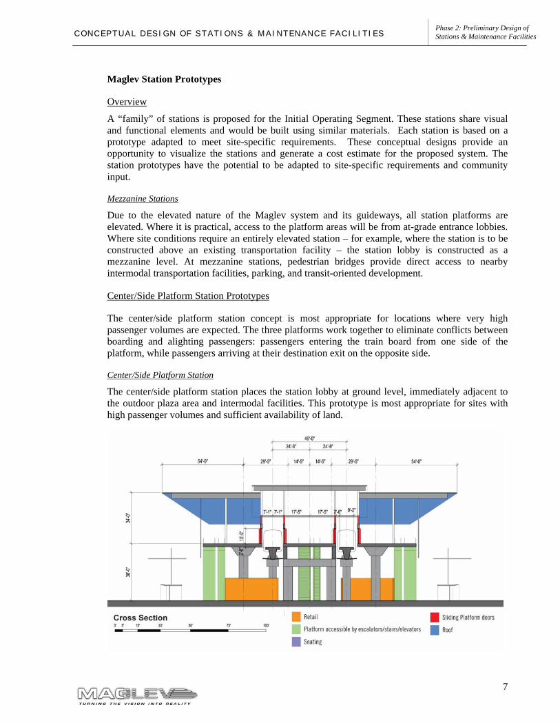
The center/side platform station concept is most appropriate for locations where very high passenger volumes are expected. The three platforms work together to eliminate conflicts between boarding and alighting passengers: passengers entering the train board from one side of the platform, while passengers arriving at their destination exit on the opposite side.
Center/Side Platform Station
The center/side platform station places the station lobby at ground level, immediately adjacent to the outdoor plaza area and intermodal facilities. This prototype is most appropriate for sites with high passenger volumes and sufficient availability of land.
8
Phase 2: Preliminary Design of Stations & Maintenance Facilities C O N C E P T U A L D E S I G N O F S T A T I O N S & M A I N T E N A N C E F A C I L I T I E S
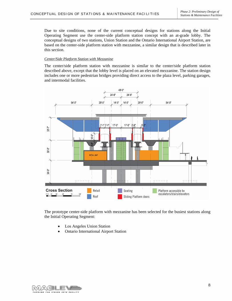
Due to site conditions, none of the current conceptual designs for stations along the Initial Operating Segment use the center-side platform station concept with an at-grade lobby. The conceptual designs of two stations, Union Station and the Ontario International Airport Station, are based on the center-side platform station with mezzanine, a similar design that is described later in this section.
Center/Side Platform Station with Mezzanine
The center/side platform station with mezzanine is similar to the center/side platform station described above, except that the lobby level is placed on an elevated mezzanine. The station design includes one or more pedestrian bridges providing direct access to the plaza level, parking garages, and intermodal facilities.
The prototype center-side platform with mezzanine has been selected for the busiest stations along the Initial Operating Segment:
• Los Angeles Union Station • Ontario International Airport Station
9
Phase 2: Preliminary Design of Stations & Maintenance Facilities C O N C E P T U A L D E S I G N O F S T A T I O N S & M A I N T E N A N C E F A C I L I T I E S
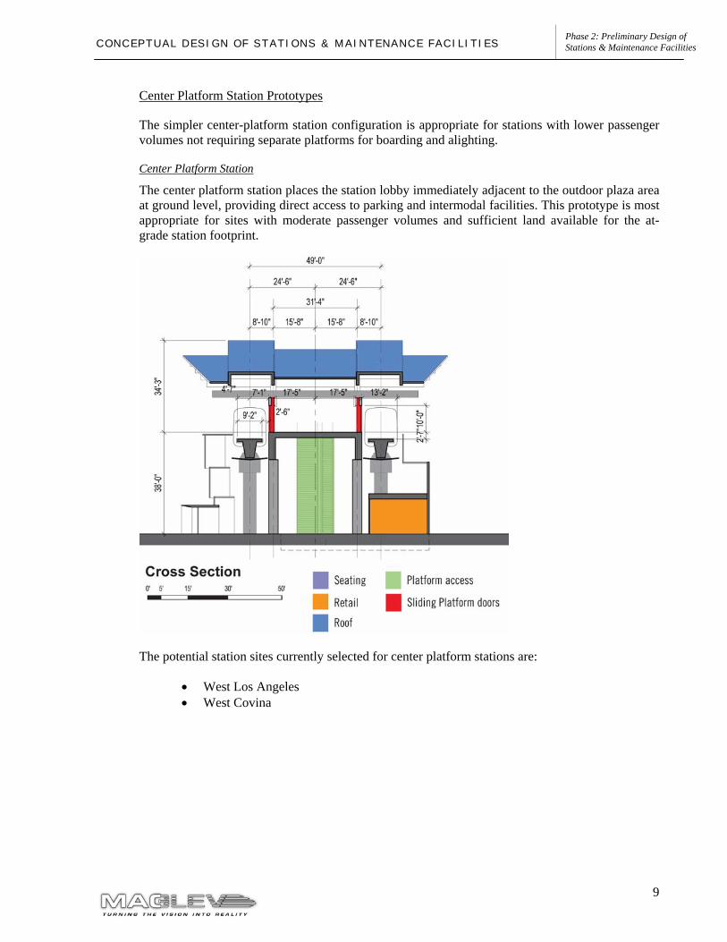
Center Platform Station Prototypes
The simpler center-platform station configuration is appropriate for stations with lower passenger volumes not requiring separate platforms for boarding and alighting.
Center Platform Station
The center platform station places the station lobby immediately adjacent to the outdoor plaza area at ground level, providing direct access to parking and intermodal facilities. This prototype is most appropriate for sites with moderate passenger volumes and sufficient land available for the at-grade station footprint.
The potential station sites currently selected for center platform stations are:
• West Los Angeles • West Covina
10
Phase 2: Preliminary Design of Stations & Maintenance Facilities C O N C E P T U A L D E S I G N O F S T A T I O N S & M A I N T E N A N C E F A C I L I T I E S
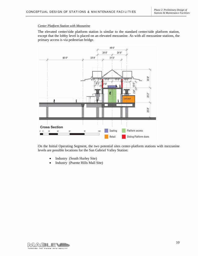
Center Platform Station with Mezzanine
The elevated center/side platform station is similar to the standard center/side platform station, except that the lobby level is placed on an elevated mezzanine. As with all mezzanine stations, the primary access is via pedestrian bridge.
On the Initial Operating Segment, the two potential sites center-platform stations with mezzanine levels are possible locations for the San Gabriel Valley Station:
• Industry (South Hurley Site) • Industry (Puente Hills Mall Site)
11
Phase 2: Preliminary Design of Stations & Maintenance Facilities C O N C E P T U A L D E S I G N O F S T A T I O N S & M A I N T E N A N C E F A C I L I T I E S
2.3.1 PART 1 – SAN GABRIEL VALLEY TO ONTARIO AIRPORT
Ontario Airport Station
Overview
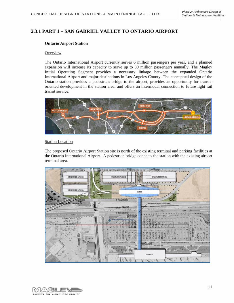
The Ontario International Airport currently serves 6 million passengers per year, and a planned expansion will increase its capacity to serve up to 30 million passengers annually. The Maglev Initial Operating Segment provides a necessary linkage between the expanded Ontario International Airport and major destinations in Los Angeles County. The conceptual design of the Ontario station provides a pedestrian bridge to the airport, provides an opportunity for transit-oriented development in the station area, and offers an intermodal connection to future light rail transit service.
Station Location
The proposed Ontario Airport Station site is north of the existing terminal and parking facilities at the Ontario International Airport. A pedestrian bridge connects the station with the existing airport terminal area.
12
Phase 2: Preliminary Design of Stations & Maintenance Facilities C O N C E P T U A L D E S I G N O F S T A T I O N S & M A I N T E N A N C E F A C I L I T I E S
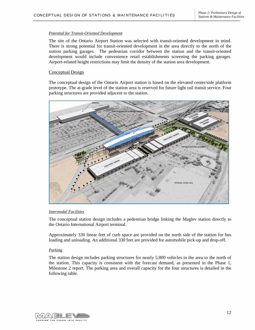
Potential for Transit-Oriented Development
The site of the Ontario Airport Station was selected with transit-oriented development in mind. There is strong potential for transit-oriented development in the area directly to the north of the station parking garages. The pedestrian corridor between the station and the transit-oriented development would include convenience retail establishments screening the parking garages. Airport-related height restrictions may limit the density of the station area development.
Conceptual Design
The conceptual design of the Ontario Airport station is based on the elevated center/side platform prototype. The at-grade level of the station area is reserved for future light rail transit service. Four parking structures are provided adjacent to the station.
Intermodal Facilities
The conceptual station design includes a pedestrian bridge linking the Maglev station directly to the Ontario International Airport terminal.
Approximately 330 linear feet of curb space are provided on the north side of the station for bus loading and unloading. An additional 330 feet are provided for automobile pick-up and drop-off.
Parking
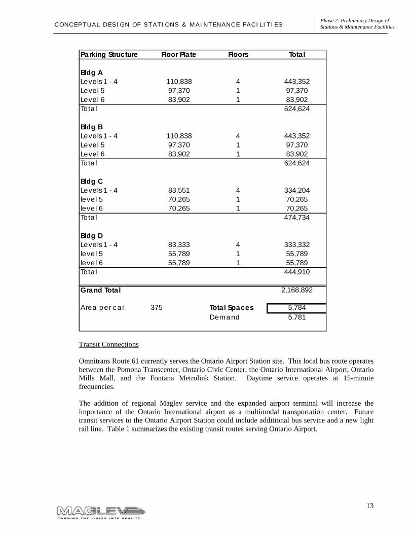
The station design includes parking structures for nearly 5,800 vehicles in the area to the north of the station. This capacity is consistent with the forecast demand, as presented in the Phase 1, Milestone 2 report. The parking area and overall capacity for the four structures is detailed in the following table.
13
Phase 2: Preliminary Design of Stations & Maintenance Facilities C O N C E P T U A L D E S I G N O F S T A T I O N S & M A I N T E N A N C E F A C I L I T I E S
Transit Connections
Omnitrans Route 61 currently serves the Ontario Airport Station site. This local bus route operates between the Pomona Transcenter, Ontario Civic Center, the Ontario International Airport, Ontario Mills Mall, and the Fontana Metrolink Station. Daytime service operates at 15-minute frequencies.
The addition of regional Maglev service and the expanded airport terminal will increase the importance of the Ontario International airport as a multimodal transportation center. Future transit services to the Ontario Airport Station could include additional bus service and a new light rail line. Table 1 summarizes the existing transit routes serving Ontario Airport.
Parking Structure Floor Plate Floors Total
Bldg ALevels 1 - 4 110,838 4 443,352Level 5 97,370 1 97,370Level 6 83,902 1 83,902Total 624,624
Bldg BLevels 1 - 4 110,838 4 443,352Level 5 97,370 1 97,370Level 6 83,902 1 83,902Total 624,624
Bldg CLevels 1 - 4 83,551 4 334,204level 5 70,265 1 70,265level 6 70,265 1 70,265Total 474,734
Bldg DLevels 1 - 4 83,333 4 333,332level 5 55,789 1 55,789level 6 55,789 1 55,789Total 444,910
Grand Total 2,168,892
Area per car 375 Total Spaces 5,784Demand 5,781
14
Phase 2: Preliminary Design of Stations & Maintenance Facilities C O N C E P T U A L D E S I G N O F S T A T I O N S & M A I N T E N A N C E F A C I L I T I E S
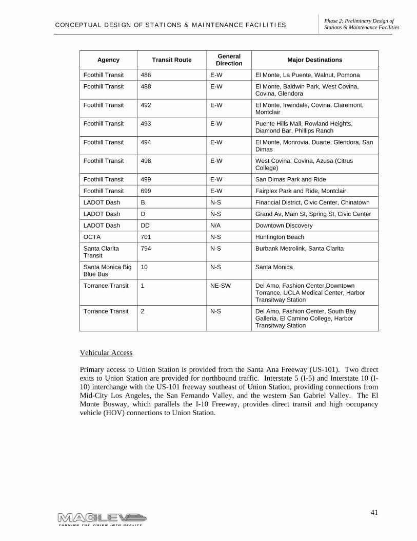
Table 1: Transit Service at Ontario International Airport
Agency Transit Route
General Direction Major Destinations
OmniTrans 61 E-W Pomona Transit Center, Indian Hill Mall, Ontario Civic Center, Ontario Convention Center, Ontario Mills Mall, Fontana Metrolink
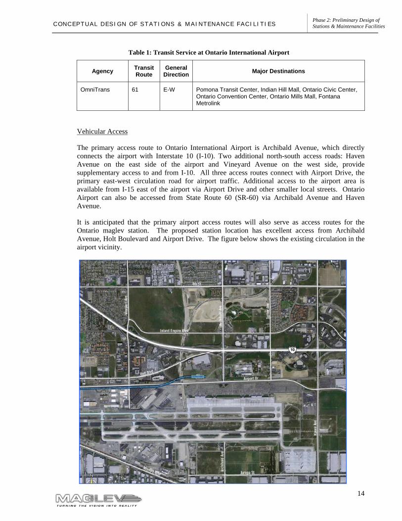
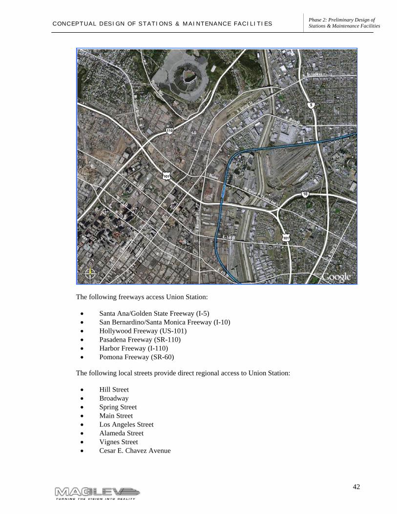
Vehicular Access
The primary access route to Ontario International Airport is Archibald Avenue, which directly connects the airport with Interstate 10 (I-10). Two additional north-south access roads: Haven Avenue on the east side of the airport and Vineyard Avenue on the west side, provide supplementary access to and from I-10. All three access routes connect with Airport Drive, the primary east-west circulation road for airport traffic. Additional access to the airport area is available from I-15 east of the airport via Airport Drive and other smaller local streets. Ontario Airport can also be accessed from State Route 60 (SR-60) via Archibald Avenue and Haven Avenue.
It is anticipated that the primary airport access routes will also serve as access routes for the Ontario maglev station. The proposed station location has excellent access from Archibald Avenue, Holt Boulevard and Airport Drive. The figure below shows the existing circulation in the airport vicinity.
15
Phase 2: Preliminary Design of Stations & Maintenance Facilities C O N C E P T U A L D E S I G N O F S T A T I O N S & M A I N T E N A N C E F A C I L I T I E S
The following freeways provide access the Ontario Airport
• San Bernardino Freeway (I-10) • Ontario Freeway (I-15) • Pomona Freeway (SR-60)
The following local streets provide direct regional access to Ontario Airport
• Airport Drive • Archibald Avenue • Haven Avenue • Vineyard Avenue • Holt Boulevard • Grove Avenue • Mission Boulevard
Traffic Volumes
Traffic volume conditions were evaluated for the Ontario International Airport area in the June 2005 Ontario International Airport Vicinity Ground Access Study completed by SCAG. This study evaluated existing conditions and two different future scenarios. The first scenario looked at all fully funded transportation projects planned for surrounding freeways and streets. The second scenario analyzed the SCAG Regional Transportation Plan (RTP) anticipated improvements, which contains all fully funded projects, partially funded projects, and regional project priorities. From these scenarios, future transportation deficiencies were identified.
The study confirmed that a majority of freeway segments located near the Ontario station experience traffic volumes that exceed capacity, particularly during peak periods. This is especially true for freeway segments traveling from west to east, including I-10, which is the primary access route to Ontario Airport, and the SR-60. The existing conditions analysis also identified high levels of congestion on selected roadways in the vicinity of the airport and the maglev station. However, these roads were not those directly accessing the airport facilities.
An analysis of Scenario 1 in the future condition with funded projects found that congestion is expected in the vicinity of the airport, as well as on many key access roads to the airport. Additional roadway improvements would likely be necessary to address the identified congestion levels.
In the second scenario, evaluating traffic conditions based on RTP projects, roadway and freeway congestion was expected in the vicinity of Ontario Airport, as well as many key access roads to the airport. The implementation of the RTP projects would significantly reduce the forecasted levels of congestion on roadways and freeways near Ontario Airport.
Maglev Station Traffic Impacts
The ridership modeling performed in the Phase 1 of the Maglev Deployment Program determined that 42%-43% of the passengers accessing the Ontario Airport station during peak hour would do so by auto. This is a relatively low auto access rate, and it is attributed to the fact that much of the access to the maglev station is expected to be by passengers connecting between Ontario Airport
16
Phase 2: Preliminary Design of Stations & Maintenance Facilities C O N C E P T U A L D E S I G N O F S T A T I O N S & M A I N T E N A N C E F A C I L I T I E S
and the maglev system. The Phase 1 modeling effort estimated AM peak hour automobile trips to the station at 2,224 trips at horizon year 2025.
A detailed traffic impact analysis for the Ontario Airport maglev station will be conducted at a later phase of the program as part of the environmental process. It is anticipated that the increased traffic volumes accessing the airport and maglev station will ultimately require some traffic infrastructure improvements in order to increase roadway capacity to accommodate traffic generated by the maglev station. Some of the improvements that would be considered include:
• Street widening; • Improved traffic signalization; and • Direct access ramps between I-10 and the maglev station and parking facilities.
17
Phase 2: Preliminary Design of Stations & Maintenance Facilities C O N C E P T U A L D E S I G N O F S T A T I O N S & M A I N T E N A N C E F A C I L I T I E S
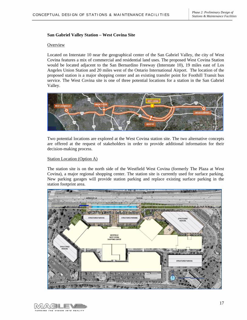
San Gabriel Valley Station – West Covina Site
Overview
Located on Interstate 10 near the geographical center of the San Gabriel Valley, the city of West Covina features a mix of commercial and residential land uses. The proposed West Covina Station would be located adjacent to the San Bernardino Freeway (Interstate 10), 19 miles east of Los Angeles Union Station and 20 miles west of the Ontario International Airport. The location of the proposed station is a major shopping center and an existing transfer point for Foothill Transit bus service. The West Covina site is one of three potential locations for a station in the San Gabriel Valley.
Two potential locations are explored at the West Covina station site. The two alternative concepts are offered at the request of stakeholders in order to provide additional information for their decision-making process.
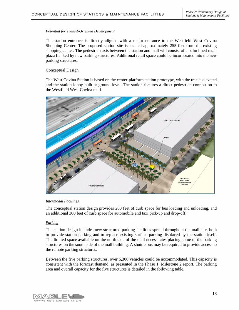
Station Location (Option A)
The station site is on the north side of the Westfield West Covina (formerly The Plaza at West Covina), a major regional shopping center. The station site is currently used for surface parking. New parking garages will provide station parking and replace existing surface parking in the station footprint area.
18
Phase 2: Preliminary Design of Stations & Maintenance Facilities C O N C E P T U A L D E S I G N O F S T A T I O N S & M A I N T E N A N C E F A C I L I T I E S
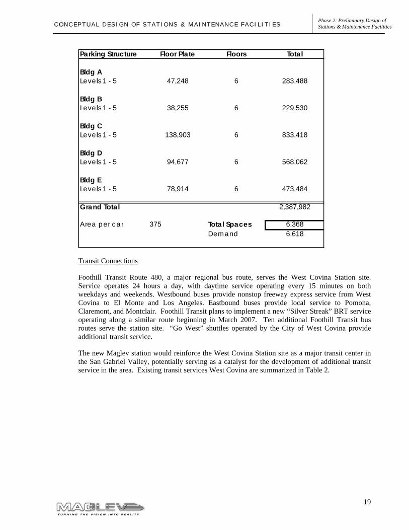
Potential for Transit-Oriented Development
The station entrance is directly aligned with a major entrance to the Westfield West Covina Shopping Center. The proposed station site is located approximately 255 feet from the existing shopping center. The pedestrian axis between the station and mall will consist of a palm lined retail plaza flanked by new parking structures. Additional retail space could be incorporated into the new parking structures.
Conceptual Design
The West Covina Station is based on the center-platform station prototype, with the tracks elevated and the station lobby built at ground level. The station features a direct pedestrian connection to the Westfield West Covina mall.
Intermodal Facilities
The conceptual station design provides 260 feet of curb space for bus loading and unloading, and an additional 300 feet of curb space for automobile and taxi pick-up and drop-off.
Parking
The station design includes new structured parking facilities spread throughout the mall site, both to provide station parking and to replace existing surface parking displaced by the station itself. The limited space available on the north side of the mall necessitates placing some of the parking structures on the south side of the mall building. A shuttle bus may be required to provide access to the remote parking structures.
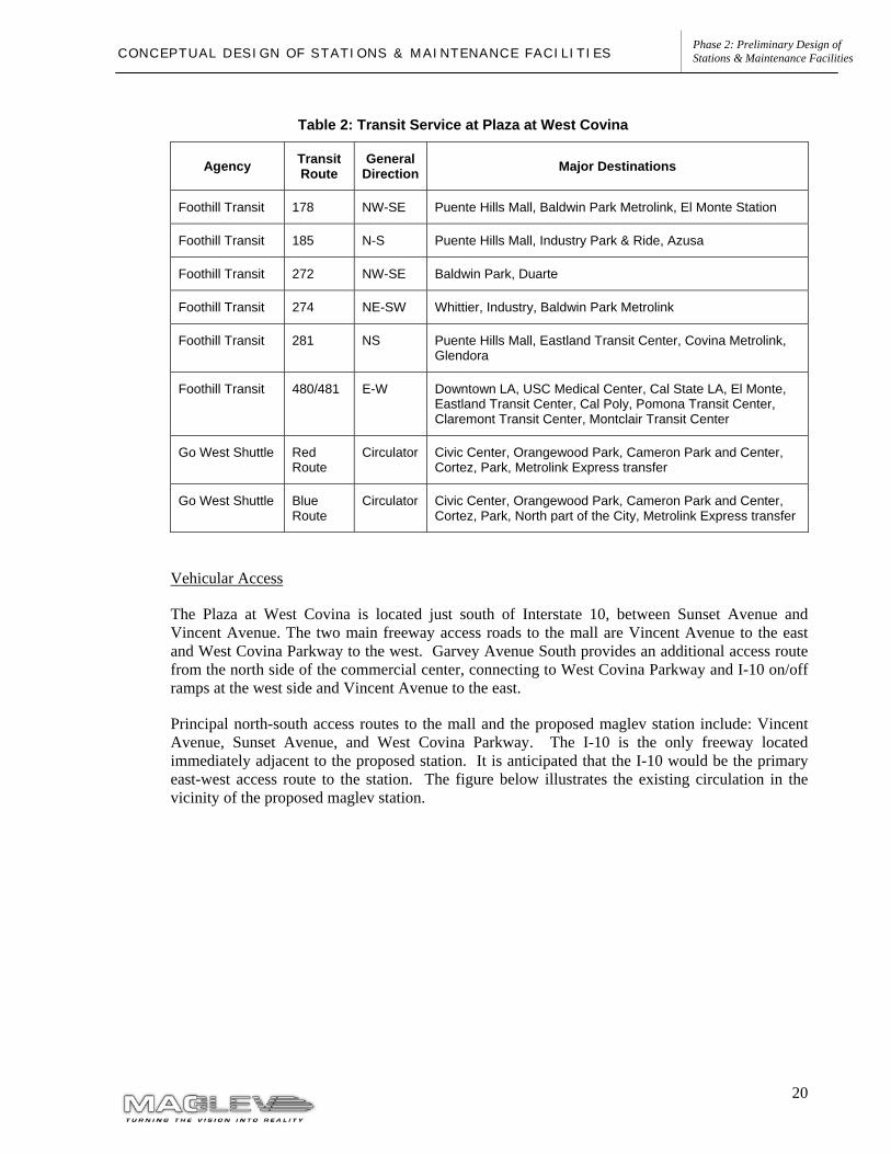
Between the five parking structures, over 6,300 vehicles could be accommodated. This capacity is consistent with the forecast demand, as presented in the Phase 1, Milestone 2 report. The parking area and overall capacity for the five structures is detailed in the following table.
19
Phase 2: Preliminary Design of Stations & Maintenance Facilities C O N C E P T U A L D E S I G N O F S T A T I O N S & M A I N T E N A N C E F A C I L I T I E S
Transit Connections
Foothill Transit Route 480, a major regional bus route, serves the West Covina Station site. Service operates 24 hours a day, with daytime service operating every 15 minutes on both weekdays and weekends. Westbound buses provide nonstop freeway express service from West Covina to El Monte and Los Angeles. Eastbound buses provide local service to Pomona, Claremont, and Montclair. Foothill Transit plans to implement a new “Silver Streak” BRT service operating along a similar route beginning in March 2007. Ten additional Foothill Transit bus routes serve the station site. “Go West” shuttles operated by the City of West Covina provide additional transit service.
The new Maglev station would reinforce the West Covina Station site as a major transit center in the San Gabriel Valley, potentially serving as a catalyst for the development of additional transit service in the area. Existing transit services West Covina are summarized in Table 2.
Parking Structure Floor Plate Floors Total
Bldg ALevels 1 - 5 47,248 6 283,488
Bldg BLevels 1 - 5 38,255 6 229,530
Bldg CLevels 1 - 5 138,903 6 833,418
Bldg DLevels 1 - 5 94,677 6 568,062
Bldg ELevels 1 - 5 78,914 6 473,484
Grand Total 2,387,982
Area per car 375 Total Spaces 6,368Demand 6,618
20
Phase 2: Preliminary Design of Stations & Maintenance Facilities C O N C E P T U A L D E S I G N O F S T A T I O N S & M A I N T E N A N C E F A C I L I T I E S
Table 2: Transit Service at Plaza at West Covina
Agency Transit Route
General Direction Major Destinations
Foothill Transit 178 NW-SE Puente Hills Mall, Baldwin Park Metrolink, El Monte Station
Foothill Transit 185 N-S Puente Hills Mall, Industry Park & Ride, Azusa
Foothill Transit 272 NW-SE Baldwin Park, Duarte
Foothill Transit 274 NE-SW Whittier, Industry, Baldwin Park Metrolink
Foothill Transit 281 NS Puente Hills Mall, Eastland Transit Center, Covina Metrolink, Glendora
Foothill Transit 480/481 E-W Downtown LA, USC Medical Center, Cal State LA, El Monte, Eastland Transit Center, Cal Poly, Pomona Transit Center, Claremont Transit Center, Montclair Transit Center
Go West Shuttle Red Route
Circulator Civic Center, Orangewood Park, Cameron Park and Center, Cortez, Park, Metrolink Express transfer
Go West Shuttle Blue Route
Circulator Civic Center, Orangewood Park, Cameron Park and Center, Cortez, Park, North part of the City, Metrolink Express transfer
Vehicular Access
The Plaza at West Covina is located just south of Interstate 10, between Sunset Avenue and Vincent Avenue. The two main freeway access roads to the mall are Vincent Avenue to the east and West Covina Parkway to the west. Garvey Avenue South provides an additional access route from the north side of the commercial center, connecting to West Covina Parkway and I-10 on/off ramps at the west side and Vincent Avenue to the east.
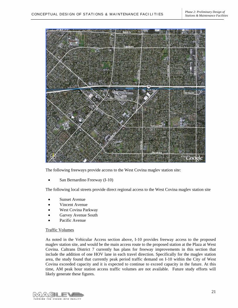
Principal north-south access routes to the mall and the proposed maglev station include: Vincent Avenue, Sunset Avenue, and West Covina Parkway. The I-10 is the only freeway located immediately adjacent to the proposed station. It is anticipated that the I-10 would be the primary east-west access route to the station. The figure below illustrates the existing circulation in the vicinity of the proposed maglev station.
21
Phase 2: Preliminary Design of Stations & Maintenance Facilities C O N C E P T U A L D E S I G N O F S T A T I O N S & M A I N T E N A N C E F A C I L I T I E S
The following freeways provide access to the West Covina maglev station site:
• San Bernardino Freeway (I-10)
The following local streets provide direct regional access to the West Covina maglev station site
• Sunset Avenue • Vincent Avenue • West Covina Parkway • Garvey Avenue South • Pacific Avenue
Traffic Volumes
As noted in the Vehicular Access section above, I-10 provides freeway access to the proposed maglev station site, and would be the main access route to the proposed station at the Plaza at West Covina. Caltrans District 7 currently has plans for freeway improvements in this section that include the addition of one HOV lane in each travel direction. Specifically for the maglev station area, the study found that currently peak period traffic demand on I-10 within the City of West Covina exceeded capacity and it is expected to continue to exceed capacity in the future. At this time, AM peak hour station access traffic volumes are not available. Future study efforts will likely generate these figures.
22
Phase 2: Preliminary Design of Stations & Maintenance Facilities C O N C E P T U A L D E S I G N O F S T A T I O N S & M A I N T E N A N C E F A C I L I T I E S
Maglev Station Traffic Impacts
The ridership assessments performed in the Phase 1 of the project determined that about 70% of the passengers accessing the West Covina station during peak hour would do so by auto. The West Covina station exhibited the highest access rate by vehicle of any other station in the maglev IOS. The high auto access rate results in a need of at least 6,600 parking spaces in this location. The parking could be provided by creating structure parking above the existing mall surface parking facilities.
A detailed traffic impact analysis for the Plaza at West Covina maglev station will be conducted at a later phase of the program as part of the environmental process. It is estimated that the increased traffic volumes accessing the mall and maglev station will ultimately require some infrastructure improvements in order to increase roadways capacity for the street system to be able to accommodate the additional traffic. Some of the improvements that would be considered include:
• Street widening; • Improved traffic signalization; and • Direct access ramps between I-10 and the maglev station and parking facilities.
23
Phase 2: Preliminary Design of Stations & Maintenance Facilities C O N C E P T U A L D E S I G N O F S T A T I O N S & M A I N T E N A N C E F A C I L I T I E S
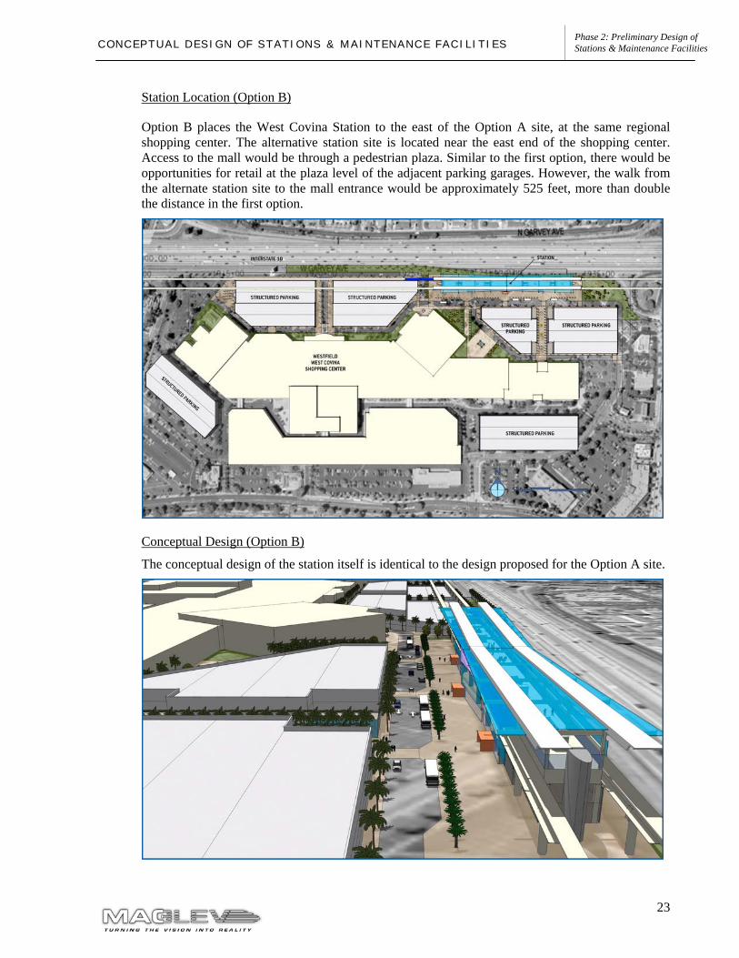
Station Location (Option B)
Option B places the West Covina Station to the east of the Option A site, at the same regional shopping center. The alternative station site is located near the east end of the shopping center. Access to the mall would be through a pedestrian plaza. Similar to the first option, there would be opportunities for retail at the plaza level of the adjacent parking garages. However, the walk from the alternate station site to the mall entrance would be approximately 525 feet, more than double the distance in the first option.
Conceptual Design (Option B)
The conceptual design of the station itself is identical to the design proposed for the Option A site.
24
Phase 2: Preliminary Design of Stations & Maintenance Facilities C O N C E P T U A L D E S I G N O F S T A T I O N S & M A I N T E N A N C E F A C I L I T I E S
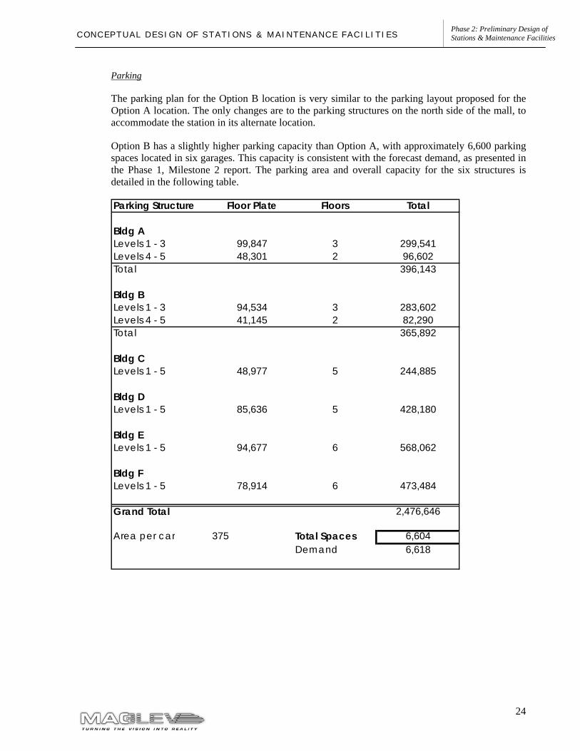
Parking
The parking plan for the Option B location is very similar to the parking layout proposed for the Option A location. The only changes are to the parking structures on the north side of the mall, to accommodate the station in its alternate location.
Option B has a slightly higher parking capacity than Option A, with approximately 6,600 parking spaces located in six garages. This capacity is consistent with the forecast demand, as presented in the Phase 1, Milestone 2 report. The parking area and overall capacity for the six structures is detailed in the following table.
Parking Structure Floor Plate Floors Total
Bldg ALevels 1 - 3 99,847 3 299,541Levels 4 - 5 48,301 2 96,602Total 396,143
Bldg BLevels 1 - 3 94,534 3 283,602Levels 4 - 5 41,145 2 82,290Total 365,892
Bldg CLevels 1 - 5 48,977 5 244,885
Bldg DLevels 1 - 5 85,636 5 428,180
Bldg ELevels 1 - 5 94,677 6 568,062
Bldg FLevels 1 - 5 78,914 6 473,484
Grand Total 2,476,646
Area per car 375 Total Spaces 6,604Demand 6,618
25
Phase 2: Preliminary Design of Stations & Maintenance Facilities C O N C E P T U A L D E S I G N O F S T A T I O N S & M A I N T E N A N C E F A C I L I T I E S
San Gabriel Valley Station – Industry / South Hurley Site
Overview
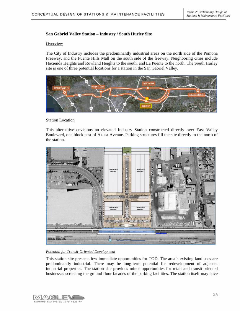
The City of Industry includes the predominantly industrial areas on the north side of the Pomona Freeway, and the Puente Hills Mall on the south side of the freeway. Neighboring cities include Hacienda Heights and Rowland Heights to the south, and La Puente to the north. The South Hurley site is one of three potential locations for a station in the San Gabriel Valley.
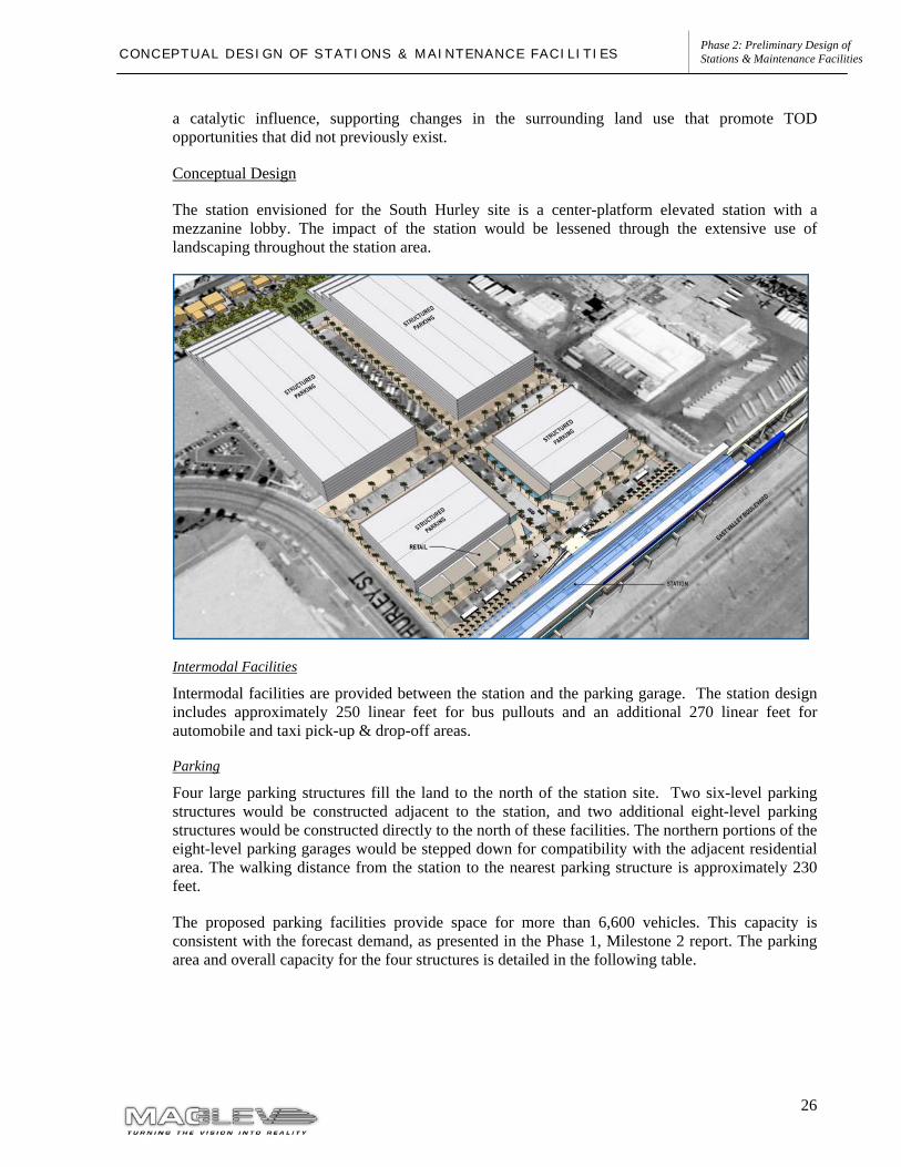
Station Location
This alternative envisions an elevated Industry Station constructed directly over East Valley Boulevard, one block east of Azusa Avenue. Parking structures fill the site directly to the north of the station.
Potential for Transit-Oriented Development
This station site presents few immediate opportunities for TOD. The area’s existing land uses are predominantly industrial. There may be long-term potential for redevelopment of adjacent industrial properties. The station site provides minor opportunities for retail and transit-oriented businesses screening the ground floor facades of the parking facilities. The station itself may have
26
Phase 2: Preliminary Design of Stations & Maintenance Facilities C O N C E P T U A L D E S I G N O F S T A T I O N S & M A I N T E N A N C E F A C I L I T I E S
a catalytic influence, supporting changes in the surrounding land use that promote TOD opportunities that did not previously exist.
Conceptual Design
The station envisioned for the South Hurley site is a center-platform elevated station with a mezzanine lobby. The impact of the station would be lessened through the extensive use of landscaping throughout the station area.
Intermodal Facilities
Intermodal facilities are provided between the station and the parking garage. The station design includes approximately 250 linear feet for bus pullouts and an additional 270 linear feet for automobile and taxi pick-up & drop-off areas.
Parking
Four large parking structures fill the land to the north of the station site. Two six-level parking structures would be constructed adjacent to the station, and two additional eight-level parking structures would be constructed directly to the north of these facilities. The northern portions of the eight-level parking garages would be stepped down for compatibility with the adjacent residential area. The walking distance from the station to the nearest parking structure is approximately 230 feet.
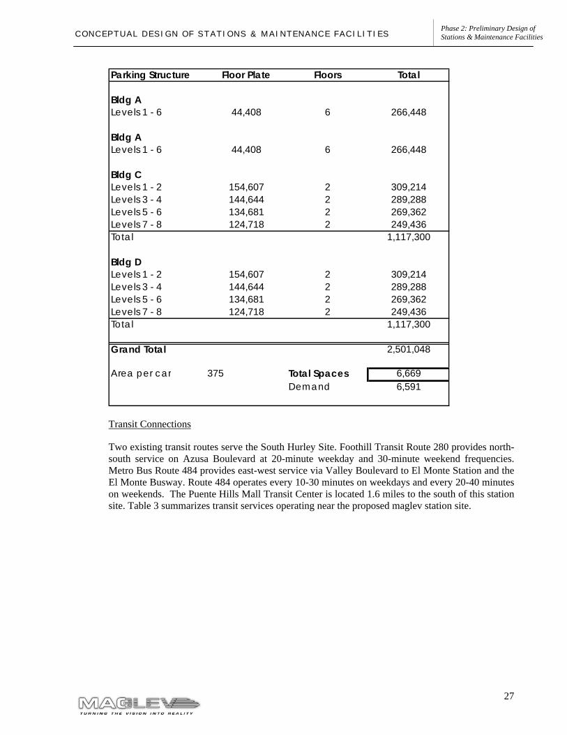
The proposed parking facilities provide space for more than 6,600 vehicles. This capacity is consistent with the forecast demand, as presented in the Phase 1, Milestone 2 report. The parking area and overall capacity for the four structures is detailed in the following table.
27
Phase 2: Preliminary Design of Stations & Maintenance Facilities C O N C E P T U A L D E S I G N O F S T A T I O N S & M A I N T E N A N C E F A C I L I T I E S
Transit Connections
Two existing transit routes serve the South Hurley Site. Foothill Transit Route 280 provides north-south service on Azusa Boulevard at 20-minute weekday and 30-minute weekend frequencies. Metro Bus Route 484 provides east-west service via Valley Boulevard to El Monte Station and the El Monte Busway. Route 484 operates every 10-30 minutes on weekdays and every 20-40 minutes on weekends. The Puente Hills Mall Transit Center is located 1.6 miles to the south of this station site. Table 3 summarizes transit services operating near the proposed maglev station site.
Parking Structure Floor Plate Floors Total
Bldg ALevels 1 - 6 44,408 6 266,448
Bldg ALevels 1 - 6 44,408 6 266,448
Bldg CLevels 1 - 2 154,607 2 309,214Levels 3 - 4 144,644 2 289,288Levels 5 - 6 134,681 2 269,362Levels 7 - 8 124,718 2 249,436Total 1,117,300
Bldg DLevels 1 - 2 154,607 2 309,214Levels 3 - 4 144,644 2 289,288Levels 5 - 6 134,681 2 269,362Levels 7 - 8 124,718 2 249,436Total 1,117,300
Grand Total 2,501,048
Area per car 375 Total Spaces 6,669Demand 6,591
28
Phase 2: Preliminary Design of Stations & Maintenance Facilities C O N C E P T U A L D E S I G N O F S T A T I O N S & M A I N T E N A N C E F A C I L I T I E S
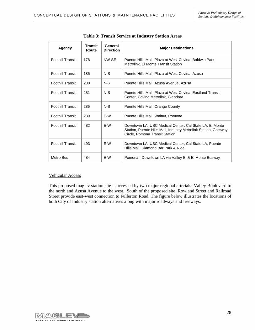
Table 3: Transit Service at Industry Station Areas
Agency Transit Route
General Direction Major Destinations
Foothill Transit 178 NW-SE Puente Hills Mall, Plaza at West Covina, Baldwin Park Metrolink, El Monte Transit Station
Foothill Transit 185 N-S Puente Hills Mall, Plaza at West Covina, Azusa
Foothill Transit 280 N-S Puente Hills Mall, Azusa Avenue, Azusa
Foothill Transit 281 N-S Puente Hills Mall, Plaza at West Covina, Eastland Transit Center, Covina Metrolink, Glendora
Foothill Transit 285 N-S Puente Hills Mall, Orange County
Foothill Transit 289 E-W Puente Hills Mall, Walnut, Pomona
Foothill Transit 482 E-W Downtown LA, USC Medical Center, Cal State LA, El Monte Station, Puente Hills Mall, Industry Metrolink Station, Gateway Circle, Pomona Transit Station
Foothill Transit 493 E-W Downtown LA, USC Medical Center, Cal State LA, Puente Hills Mall, Diamond Bar Park & Ride
Metro Bus 484 E-W Pomona - Downtown LA via Valley Bl & El Monte Busway
Vehicular Access
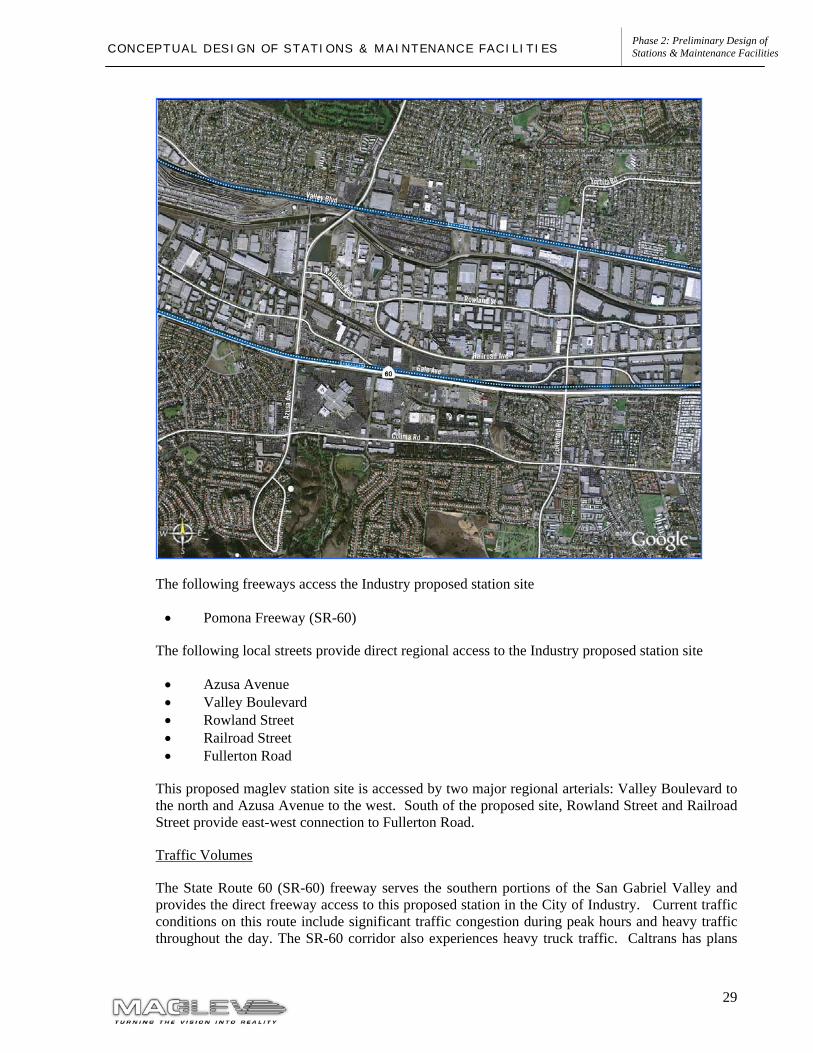
This proposed maglev station site is accessed by two major regional arterials: Valley Boulevard to the north and Azusa Avenue to the west. South of the proposed site, Rowland Street and Railroad Street provide east-west connection to Fullerton Road. The figure below illustrates the locations of both City of Industry station alternatives along with major roadways and freeways.
29
Phase 2: Preliminary Design of Stations & Maintenance Facilities C O N C E P T U A L D E S I G N O F S T A T I O N S & M A I N T E N A N C E F A C I L I T I E S
The following freeways access the Industry proposed station site
• Pomona Freeway (SR-60)
The following local streets provide direct regional access to the Industry proposed station site
• Azusa Avenue • Valley Boulevard • Rowland Street • Railroad Street • Fullerton Road
This proposed maglev station site is accessed by two major regional arterials: Valley Boulevard to the north and Azusa Avenue to the west. South of the proposed site, Rowland Street and Railroad Street provide east-west connection to Fullerton Road.
Traffic Volumes
The State Route 60 (SR-60) freeway serves the southern portions of the San Gabriel Valley and provides the direct freeway access to this proposed station in the City of Industry. Current traffic conditions on this route include significant traffic congestion during peak hours and heavy traffic throughout the day. The SR-60 corridor also experiences heavy truck traffic. Caltrans has plans
30
Phase 2: Preliminary Design of Stations & Maintenance Facilities C O N C E P T U A L D E S I G N O F S T A T I O N S & M A I N T E N A N C E F A C I L I T I E S
for HOV lanes along the highway. Exclusive truck lanes built to separate truck traffic from general purpose traffic have also been studied for the SR-60 corridor. No decision on the implementation of truck lanes has occurred at this time.
Valley Boulevard is primary east-west roadway serving the station area. Valley Boulevard traverses the full length of the San Gabriel Valley and carries a significant amount of traffic and trucks to and from industrial facilities in the City of Industry.
Azusa Avenue serves as one of the major north-south arterial roadways in the San Gabriel Valley. Azusa Avenue provides an interchange with the SR-60 freeway would likely be the primary vehicular access route from the freeway to the maglev station.
The ridership assessments performed in the Phase 1 of the Maglev Deployment Program determined that about 50% of passengers traveling to this proposed maglev station during the peak hour would do so by auto. Parking spaces for 3,376 vehicles are assumed for the City of Industry-Hurley Site station option.
Maglev Station Traffic Impacts
The Phase 1 modeling effort estimated AM peak hour automobile trips to the City of Industry-Hurley Site maglev station at 1,508 trips for horizon year 2025. A detailed traffic impact analysis for the proposed stations will be conducted at a later phase of the program as part of the environmental process.
It is estimated that the increased traffic volumes accessing the maglev station will ultimately require some infrastructure improvements in order to increase roadway capacity. Some of the improvements that would be considered include:
• Street widening; • Improved traffic signalization; and • Direct access ramps between Azuza Avenue and the maglev station and parking facility.
31
Phase 2: Preliminary Design of Stations & Maintenance Facilities C O N C E P T U A L D E S I G N O F S T A T I O N S & M A I N T E N A N C E F A C I L I T I E S
San Gabriel Valley Station – Industry / Puente Hills Site
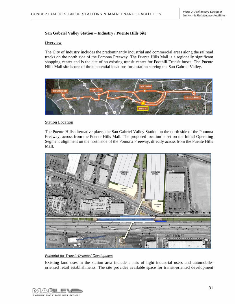
Overview
The City of Industry includes the predominantly industrial and commercial areas along the railroad tracks on the north side of the Pomona Freeway. The Puente Hills Mall is a regionally significant shopping center and is the site of an existing transit center for Foothill Transit buses. The Puente Hills Mall site is one of three potential locations for a station serving the San Gabriel Valley.
Station Location
The Puente Hills alternative places the San Gabriel Valley Station on the north side of the Pomona Freeway, across from the Puente Hills Mall. The proposed location is set on the Initial Operating Segment alignment on the north side of the Pomona Freeway, directly across from the Puente Hills Mall.
Potential for Transit-Oriented Development
Existing land uses in the station area include a mix of light industrial users and automobile-oriented retail establishments. The site provides available space for transit-oriented development
32
Phase 2: Preliminary Design of Stations & Maintenance Facilities C O N C E P T U A L D E S I G N O F S T A T I O N S & M A I N T E N A N C E F A C I L I T I E S
screening the parking structures. There is a potential for redevelopment of nearby light-intensity uses such as car dealerships and surface parking lots.
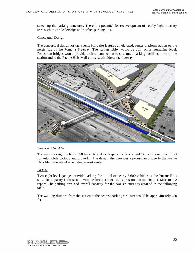
Conceptual Design
The conceptual design for the Puente Hills site features an elevated, center-platform station on the north side of the Pomona Freeway. The station lobby would be built on a mezzanine level. Pedestrian bridges would provide a direct connection to structured parking facilities north of the station and to the Puente Hills Mall on the south side of the freeway.
Intermodal Facilities
The station design includes 350 linear feet of curb space for buses, and 240 additional linear feet for automobile pick-up and drop-off. The design also provides a pedestrian bridge to the Puente Hills Mall, the site of an existing transit center.
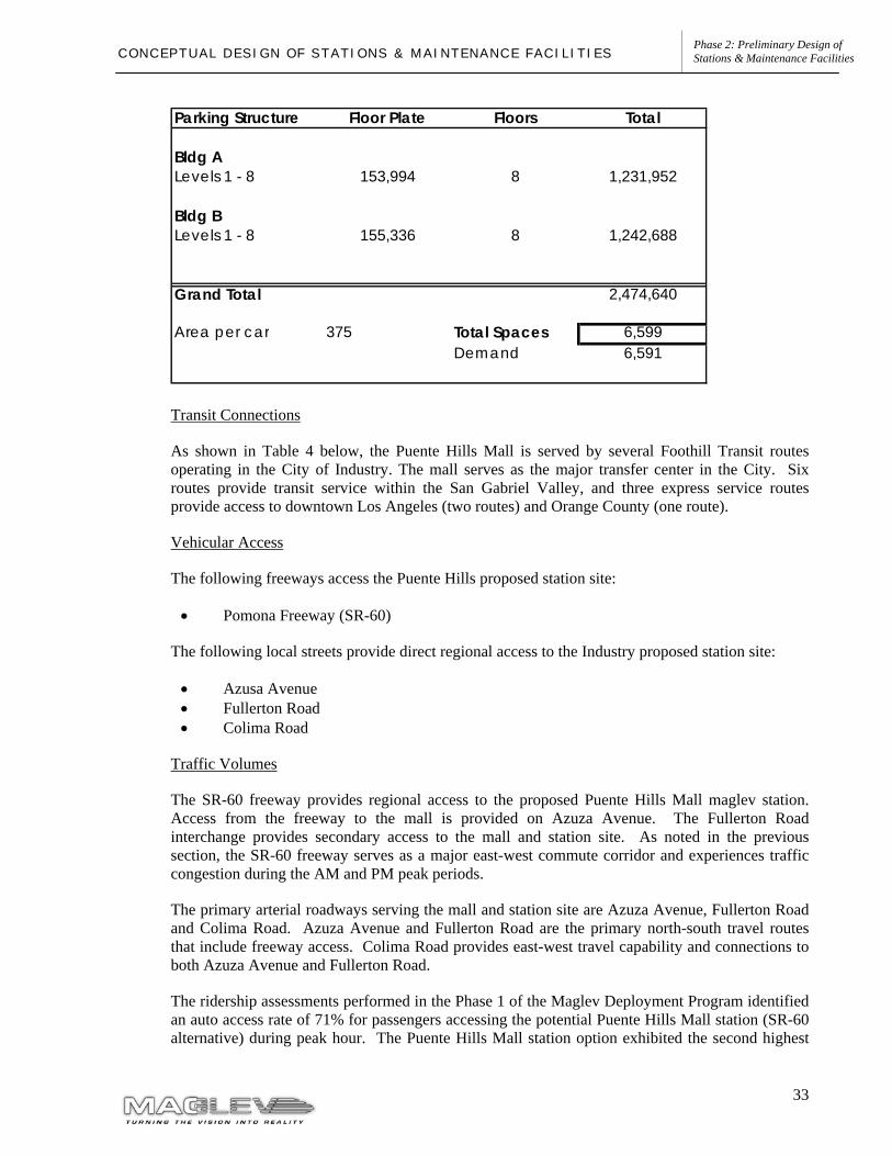
Parking
Two eight-level garages provide parking for a total of nearly 6,600 vehicles at the Puente Hills site. This capacity is consistent with the forecast demand, as presented in the Phase 1, Milestone 2 report. The parking area and overall capacity for the two structures is detailed in the following table.
The walking distance from the station to the nearest parking structure would be approximately 450 feet.
33
Phase 2: Preliminary Design of Stations & Maintenance Facilities C O N C E P T U A L D E S I G N O F S T A T I O N S & M A I N T E N A N C E F A C I L I T I E S
Transit Connections
As shown in Table 4 below, the Puente Hills Mall is served by several Foothill Transit routes operating in the City of Industry. The mall serves as the major transfer center in the City. Six routes provide transit service within the San Gabriel Valley, and three express service routes provide access to downtown Los Angeles (two routes) and Orange County (one route).
Vehicular Access
The following freeways access the Puente Hills proposed station site:
• Pomona Freeway (SR-60)
The following local streets provide direct regional access to the Industry proposed station site:
• Azusa Avenue • Fullerton Road • Colima Road
Traffic Volumes
The SR-60 freeway provides regional access to the proposed Puente Hills Mall maglev station. Access from the freeway to the mall is provided on Azuza Avenue. The Fullerton Road interchange provides secondary access to the mall and station site. As noted in the previous section, the SR-60 freeway serves as a major east-west commute corridor and experiences traffic congestion during the AM and PM peak periods.
The primary arterial roadways serving the mall and station site are Azuza Avenue, Fullerton Road and Colima Road. Azuza Avenue and Fullerton Road are the primary north-south travel routes that include freeway access. Colima Road provides east-west travel capability and connections to both Azuza Avenue and Fullerton Road.
The ridership assessments performed in the Phase 1 of the Maglev Deployment Program identified an auto access rate of 71% for passengers accessing the potential Puente Hills Mall station (SR-60 alternative) during peak hour. The Puente Hills Mall station option exhibited the second highest
Parking Structure Floor Plate Floors Total
Bldg ALevels 1 - 8 153,994 8 1,231,952
Bldg BLevels 1 - 8 155,336 8 1,242,688
Grand Total 2,474,640
Area per car 375 Total Spaces 6,599Demand 6,591
34
Phase 2: Preliminary Design of Stations & Maintenance Facilities C O N C E P T U A L D E S I G N O F S T A T I O N S & M A I N T E N A N C E F A C I L I T I E S
access rates by automobiles any station in the maglev system (second to West Covina). It is estimated that about 6,500 parking spaces would be necessary in this location to serve the station.
Maglev Station Traffic Impacts
The Phase 1 modeling effort estimated AM peak hour automobile trips to the City of Industry- Puente Hills maglev station at 2,131 trips for horizon year 2025. A detailed traffic impact analysis for the proposed stations will be conducted at a later phase of the program as part of the environmental process.
It is estimated that the increased traffic volumes accessing the maglev station will ultimately require some infrastructure improvements in order to increase roadway capacity. Some of the improvements that would be considered include:
• Street widening; • Interchange improvements; • Improved traffic signalization; and • Direct access ramps between SR-60 freeway and the maglev station and parking facility.
35
Phase 2: Preliminary Design of Stations & Maintenance Facilities C O N C E P T U A L D E S I G N O F S T A T I O N S & M A I N T E N A N C E F A C I L I T I E S
2.2.2 PART 2 – LOS ANGELES UNION STATION TO SAN GABRIEL VALLEY
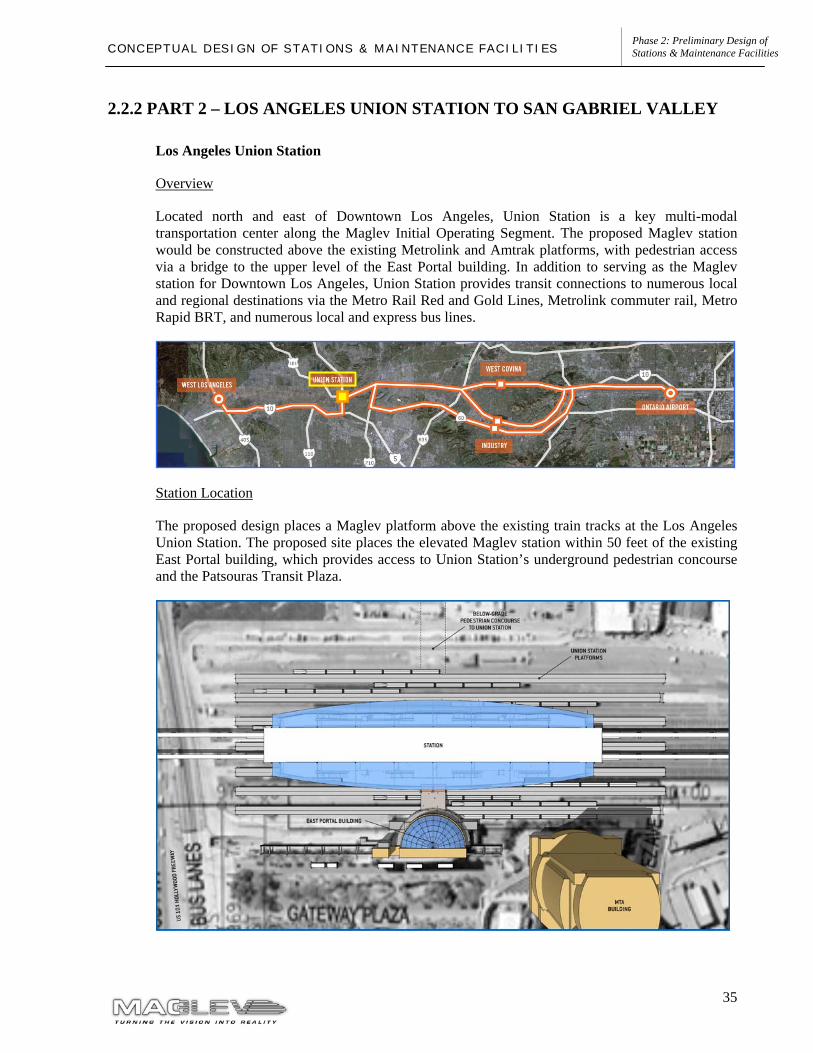
Los Angeles Union Station
Overview
Located north and east of Downtown Los Angeles, Union Station is a key multi-modal transportation center along the Maglev Initial Operating Segment. The proposed Maglev station would be constructed above the existing Metrolink and Amtrak platforms, with pedestrian access via a bridge to the upper level of the East Portal building. In addition to serving as the Maglev station for Downtown Los Angeles, Union Station provides transit connections to numerous local and regional destinations via the Metro Rail Red and Gold Lines, Metrolink commuter rail, Metro Rapid BRT, and numerous local and express bus lines.
Station Location
The proposed design places a Maglev platform above the existing train tracks at the Los Angeles Union Station. The proposed site places the elevated Maglev station within 50 feet of the existing East Portal building, which provides access to Union Station’s underground pedestrian concourse and the Patsouras Transit Plaza.
36
Phase 2: Preliminary Design of Stations & Maintenance Facilities C O N C E P T U A L D E S I G N O F S T A T I O N S & M A I N T E N A N C E F A C I L I T I E S
Potential for Transit-Oriented Development
Union Station is a large multi-modal facility with limited convenience retail already located within the station. Downtown Los Angeles is already the site of significant mixed-use redevelopment. Potential redevelopment opportunities in the station area could be enhanced through the creation of improved pedestrian linkages between Union Station and potentially redevelopable land on the south side of the US-101 freeway.
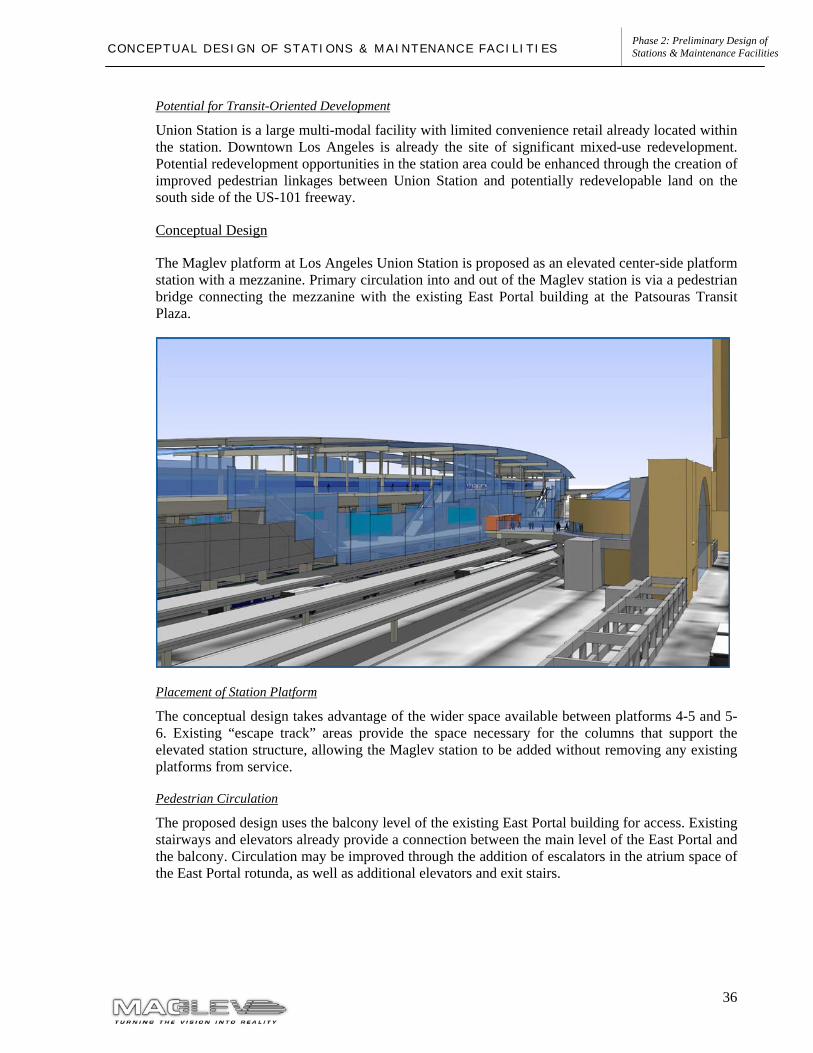
Conceptual Design
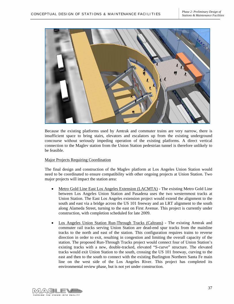
The Maglev platform at Los Angeles Union Station is proposed as an elevated center-side platform station with a mezzanine. Primary circulation into and out of the Maglev station is via a pedestrian bridge connecting the mezzanine with the existing East Portal building at the Patsouras Transit Plaza.
Placement of Station Platform
The conceptual design takes advantage of the wider space available between platforms 4-5 and 5-6. Existing “escape track” areas provide the space necessary for the columns that support the elevated station structure, allowing the Maglev station to be added without removing any existing platforms from service.
Pedestrian Circulation
The proposed design uses the balcony level of the existing East Portal building for access. Existing stairways and elevators already provide a connection between the main level of the East Portal and the balcony. Circulation may be improved through the addition of escalators in the atrium space of the East Portal rotunda, as well as additional elevators and exit stairs.
37
Phase 2: Preliminary Design of Stations & Maintenance Facilities C O N C E P T U A L D E S I G N O F S T A T I O N S & M A I N T E N A N C E F A C I L I T I E S
Because the existing platforms used by Amtrak and commuter trains are very narrow, there is insufficient space to bring stairs, elevators and escalators up from the existing underground concourse without seriously impeding operation of the existing platforms. A direct vertical connection to the Maglev station from the Union Station pedestrian tunnel is therefore unlikely to be feasible.
Major Projects Requiring Coordination
The final design and construction of the Maglev platform at Los Angeles Union Station would need to be coordinated to ensure compatibility with other ongoing projects at Union Station. Two major projects will impact the station area:
• Metro Gold Line East Los Angeles Extension (LACMTA) - The existing Metro Gold Line between Los Angeles Union Station and Pasadena uses the two westernmost tracks at Union Station. The East Los Angeles extension project would extend the alignment to the south and east via a bridge across the US 101 freeway and an LRT alignment to the south along Alameda Street, turning to the east on First Avenue. This project is currently under construction, with completion scheduled for late 2009.
• Los Angeles Union Station Run-Through Tracks (Caltrans) - The existing Amtrak and commuter rail tracks serving Union Station are dead-end spur tracks from the mainline tracks to the north and east of the station. This configuration requires trains to reverse direction in order to exit, resulting in congestion and limiting the overall capacity of the station. The proposed Run-Through Tracks project would connect four of Union Station’s existing tracks with a new, double-tracked, elevated “S-curve” structure. The elevated tracks would exit Union Station to the south, crossing the US 101 freeway, curving to the east and then to the south to connect with the existing Burlington Northern Santa Fe main line on the west side of the Los Angeles River. This project has completed its environmental review phase, but is not yet under construction.
38
Phase 2: Preliminary Design of Stations & Maintenance Facilities C O N C E P T U A L D E S I G N O F S T A T I O N S & M A I N T E N A N C E F A C I L I T I E S
Parking
On-site public parking currently exists in the Gateway Parking Garage underneath the Patsouras Transit Plaza. Opportunities to construct additional parking facilities are limited. The need for station parking is mitigated to some extent by the availability of numerous existing transit services at Union Station. Conceptual design of a parking garage at this location has been delayed due to uncertainties regarding redevelopment plans around Union Station. However, a forecasted demand of 3,500 spaces has been identified, as presented in Phase 1, Milestone 2. This demand should be incorporated into the overall parking demand for the redevelopment around Union Station. There may be opportunities for cooperation and coordination between different projects leading to the development of shared parking facilities.
Intermodal Facilities
Transit bus connections are provided at the Patsouras Transit Plaza and at the Union Station stop on the El Monte Busway. Taxis are provided at the main Union Station building. Auto pick-up and drop-off areas are provided at the front entrance to Union Station on Alameda Street and at the Patsouras Transit Plaza.
Transit Connections
Los Angeles Union Station currently serves more than 50,000 riders per day, offering direct connections to numerous rail and bus transit services:
• Metro Gold Line trains to Pasadena, with planned extensions to the northern San Gabriel Valley and East Los Angeles.
• Metro Red Line trains to Downtown Los Angeles, Wilshire Boulevard, Hollywood, and Universal City, with connections to the Metro Blue Line serving Long Beach and the Metro Orange Line to the San Fernando Valley.
• Metrolink commuter rail service to Southern California destinations including Orange County, San Bernardino, Riverside, Ventura County, and the Antelope Valley.
• Express buses serving the El Monte Busway and the Harbor Transitway.
• Amtrak “Pacific Surfliner” trains with multiple daily departures to San Diego, Santa Barbara, San Luis Obispo, and intermediate points.
• Non-stop “Flyaway” buses to the Los Angeles International Airport.
• Amtrak buses to Bakersfield, connecting with trains to the Bay Area and Sacramento.
• Daily Amtrak trains serving long-distance destinations including Seattle, Portland, Chicago, Dallas, Saint Louis, New Orleans, Orlando, and numerous intermediate points.
• Los Angeles Department of Transportation (LADOT) DASH buses serving Downtown Los Angeles.
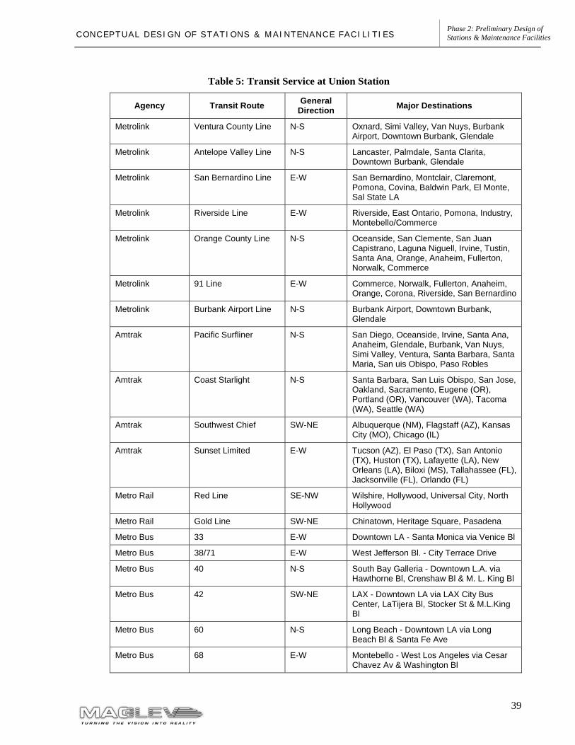
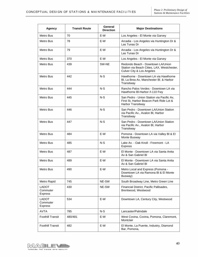
Transit services accessing Union Station are summarized in Table 5.
39
Phase 2: Preliminary Design of Stations & Maintenance Facilities C O N C E P T U A L D E S I G N O F S T A T I O N S & M A I N T E N A N C E F A C I L I T I E S
Table 5: Transit Service at Union Station
Agency Transit Route General Direction Major Destinations
Metrolink Ventura County Line N-S Oxnard, Simi Valley, Van Nuys, Burbank Airport, Downtown Burbank, Glendale
Metrolink Antelope Valley Line N-S Lancaster, Palmdale, Santa Clarita, Downtown Burbank, Glendale
Metrolink San Bernardino Line E-W San Bernardino, Montclair, Claremont, Pomona, Covina, Baldwin Park, El Monte, Sal State LA
Metrolink Riverside Line E-W Riverside, East Ontario, Pomona, Industry, Montebello/Commerce
Metrolink Orange County Line N-S Oceanside, San Clemente, San Juan Capistrano, Laguna Niguell, Irvine, Tustin, Santa Ana, Orange, Anaheim, Fullerton, Norwalk, Commerce
Metrolink 91 Line E-W Commerce, Norwalk, Fullerton, Anaheim, Orange, Corona, Riverside, San Bernardino
Metrolink Burbank Airport Line N-S Burbank Airport, Downtown Burbank, Glendale
Amtrak Pacific Surfliner N-S San Diego, Oceanside, Irvine, Santa Ana, Anaheim, Glendale, Burbank, Van Nuys, Simi Valley, Ventura, Santa Barbara, Santa Maria, San uis Obispo, Paso Robles
Amtrak Coast Starlight N-S Santa Barbara, San Luis Obispo, San Jose, Oakland, Sacramento, Eugene (OR), Portland (OR), Vancouver (WA), Tacoma (WA), Seattle (WA)
Amtrak Southwest Chief SW-NE Albuquerque (NM), Flagstaff (AZ), Kansas City (MO), Chicago (IL)
Amtrak Sunset Limited E-W Tucson (AZ), El Paso (TX), San Antonio (TX), Huston (TX), Lafayette (LA), New Orleans (LA), Biloxi (MS), Tallahassee (FL), Jacksonville (FL), Orlando (FL)
Metro Rail Red Line SE-NW Wilshire, Hollywood, Universal City, North Hollywood
Metro Rail Gold Line SW-NE Chinatown, Heritage Square, Pasadena
Metro Bus 33 E-W Downtown LA - Santa Monica via Venice Bl
Metro Bus 38/71 E-W West Jefferson Bl. - City Terrace Drive
Metro Bus 40 N-S South Bay Galleria - Downtown L.A. via Hawthorne Bl, Crenshaw Bl & M. L. King Bl
Metro Bus 42 SW-NE LAX - Downtown LA via LAX City Bus Center, LaTijera Bl, Stocker St & M.L.King Bl
Metro Bus 60 N-S Long Beach - Downtown LA via Long Beach Bl & Santa Fe Ave
Metro Bus 68 E-W Montebello - West Los Angeles via Cesar Chavez Av & Washington Bl
40
Phase 2: Preliminary Design of Stations & Maintenance Facilities C O N C E P T U A L D E S I G N O F S T A T I O N S & M A I N T E N A N C E F A C I L I T I E S
Agency Transit Route General Direction Major Destinations
Metro Bus 70 E-W Los Angeles - El Monte via Garvey
Metro Bus 78 E-W Arcadia - Los Angeles via Huntington Dr & Las Tunas Dr
Metro Bus 79 E-W Arcadia - Los Angeles via Huntington Dr & Las Tunas Dr
Metro Bus 370 E-W Los Angeles - El Monte via Garvey
Metro Bus 439 SW-NE Redondo Beach - Downtown LA/Union Station via Beach Cities, LAX, Westchester, Culver City & Los Angeles
Metro Bus 442 N-S Hawthorne - Downtown LA via Hawthorne Bl, La Brea Av, Manchester Bl. & Harbor Transitway
Metro Bus 444 N-S Rancho Palos Verdes - Downtown LA via Hawthorne Bl-Harbor /I-110 Fwy
Metro Bus 445 N-S San Pedro - Union Station via Pacific Av, First St, Harbor Beacon Park Ride Lot & Harbor Transitway
Metro Bus 446 N-S San Pedro - Downtown LA/Union Station via Pacific Av., Avalon Bl, Harbor Transitway
Metro Bus 447 N-S San Pedro - Downtown LA/Union Station via Pacific Av., Avalon Bl, Harbor Transitway
Metro Bus 484 E-W Pomona - Downtown LA via Valley Bl & El Monte Busway
Metro Bus 485 N-S Lake Av. - Oak Knoll - Freemont - LA Express
Metro Bus 487 E-W El Monte - Downtown LA via Santa Anita Av & San Gabriel Bl
Metro Bus 489 E-W El Monte - Downtown LA via Santa Anita Av & San Gabriel Bl
Metro Bus 490 E-W Metro Local and Express (Pomona - Downtown LA via Ramona Bl & El Monte Busway)
Metro Rapid 745 NE-SW South Broadway Line, Metro Green Line
LADOT Commuter Express
430 NE-SW Financial District, Pacific Pallisades, Brentwood, Westwood
LADOT Commuter Express
534 E-W Downtown LA, Century City, Westwood
AVTA 785 N-S Lancaster/Palmdale
Foothill Transit 480/481 E-W West Covina, Covina, Pomona, Claremont, Montclair
Foothill Transit 482 E-W El Monte, La Puente, Industry, Diamond Bar, Pomona,
41
Phase 2: Preliminary Design of Stations & Maintenance Facilities C O N C E P T U A L D E S I G N O F S T A T I O N S & M A I N T E N A N C E F A C I L I T I E S
Agency Transit Route General Direction Major Destinations
Foothill Transit 486 E-W El Monte, La Puente, Walnut, Pomona
Foothill Transit 488 E-W El Monte, Baldwin Park, West Covina, Covina, Glendora
Foothill Transit 492 E-W El Monte, Irwindale, Covina, Claremont, Montclair
Foothill Transit 493 E-W Puente Hills Mall, Rowland Heights, Diamond Bar, Phillips Ranch
Foothill Transit 494 E-W El Monte, Monrovia, Duarte, Glendora, San Dimas
Foothill Transit 498 E-W West Covina, Covina, Azusa (Citrus College)
Foothill Transit 499 E-W San Dimas Park and Ride
Foothill Transit 699 E-W Fairplex Park and Ride, Montclair
LADOT Dash B N-S Financial District, Civic Center, Chinatown
LADOT Dash D N-S Grand Av, Main St, Spring St, Civic Center
LADOT Dash DD N/A Downtown Discovery
OCTA 701 N-S Huntington Beach
Santa Clarita Transit
794 N-S Burbank Metrolink, Santa Clarita
Santa Monica Big Blue Bus
10 N-S Santa Monica
Torrance Transit 1 NE-SW Del Amo, Fashion Center,Downtown Torrance, UCLA Medical Center, Harbor Transitway Station
Torrance Transit 2 N-S Del Amo, Fashion Center, South Bay Galleria, El Camino College, Harbor Transitway Station
Vehicular Access
Primary access to Union Station is provided from the Santa Ana Freeway (US-101). Two direct exits to Union Station are provided for northbound traffic. Interstate 5 (I-5) and Interstate 10 (I-10) interchange with the US-101 freeway southeast of Union Station, providing connections from Mid-City Los Angeles, the San Fernando Valley, and the western San Gabriel Valley. The El Monte Busway, which parallels the I-10 Freeway, provides direct transit and high occupancy vehicle (HOV) connections to Union Station.
42
Phase 2: Preliminary Design of Stations & Maintenance Facilities C O N C E P T U A L D E S I G N O F S T A T I O N S & M A I N T E N A N C E F A C I L I T I E S
The following freeways access Union Station:
• Santa Ana/Golden State Freeway (I-5) • San Bernardino/Santa Monica Freeway (I-10) • Hollywood Freeway (US-101) • Pasadena Freeway (SR-110) • Harbor Freeway (I-110) • Pomona Freeway (SR-60)
The following local streets provide direct regional access to Union Station:
• Hill Street • Broadway • Spring Street • Main Street • Los Angeles Street • Alameda Street • Vignes Street • Cesar E. Chavez Avenue
43
Phase 2: Preliminary Design of Stations & Maintenance Facilities C O N C E P T U A L D E S I G N O F S T A T I O N S & M A I N T E N A N C E F A C I L I T I E S
Alameda Street, Cesar E. Chavez Avenue, and Vignes Street are immediately adjacent to Union Station, and provide connections to the US-101 freeway. Access from the SR-110 freeway is provided via Hill Street. Connections to Union Station from the I-5 freeway are available from Spring Street, Broadway, and Main Street, which also provide access to Downtown Los Angeles as well.
Traffic Volumes
The analysis in this section is a summary of the Roadway Evaluation section of Phase 1 of the SCAG Maglev Deployment Program, Milestone 3: Union Station Capacity and Access Study (July 2003).
The streets surrounding Union Station currently experience large volumes of traffic, as well as a higher than average percentage of buses relative to total traffic in the area. The study in Phase 1 found that many of the arterials surrounding Union Station currently operate at unacceptable level of service (LOS E or F) during peak hours. The following is a list of those segments that were analyzed during Phase 1 and were found to be operating at unacceptable LOS:
• Hill Street n/o College Street SB AM Peak • Hill Street s/o Alpine Street SB AM Peak • Broadway n/o Bishops Road SB AM Peak • Broadway n/o College Street NB PM Peak • Broadway s/o Alpine Street NB PM Peak • Main Street s/o Interstate 5 SB AM Peak • Alameda Street s/o Temple Street SB AM Peak, NB PM Peak • Center Street s/o Jackson Street SB AM Peak
The following freeway segments were found to be operating at LOS E or F during the peak hours:
• US-101 n/o Hill Street NB AM Peak, SB PM Peak • US-101 n/o Mission Road SB PM Peak • SR-110 n/o Hill Street NB PM Peak • I-5 s/o SR-110 SB AM Peak, Both Directions PM Peak • I-5 n/o Main Street SB AM Peak, NB PM Peak
The ridership assessments performed in the Phase 1 of the project determined that only about 23% of the passengers accessing Union Station during peak hour would do so by auto. Union Station exhibited the lowest access rate by vehicle of any other station in the system. The auto access rate was translated to a need of parking spaces in the amount of 3,500 in this location. AM peak hour automobile trips to the station are estimated to be 998 trips in horizon year 2025.
Maglev Station Traffic Impacts
The Phase 1 study concluded that the area around Union Station will be more congested in the future. But as the primary transit hub in Los Angeles, the volume of additional maglev related traffic that is expected on the highway network is not expected to significantly increase the number of study segments and ramps that would operate at LOS of E or F. However, some study segments and ramps are expected to experience significant impacts due to natural traffic growth in the station area, as well as because of other projects and planned development.
44
Phase 2: Preliminary Design of Stations & Maintenance Facilities C O N C E P T U A L D E S I G N O F S T A T I O N S & M A I N T E N A N C E F A C I L I T I E S
It is estimated that the increased traffic volumes accessing Union Station will ultimately require some roadway infrastructure improvements. Suggestions for future improvements developed during Phase 1 are listed below:
• An extra lane could be provided at the Mission Road on-ramp SB US-101 that would feed directly into an auxiliary lane for the First Street off ramp.
• Consider adding an on-ramp between Los Angeles Street and Vignes Street for the southbound direction.
• To address the impacts on Hill Street and the impacts on US-101, the Alameda Bypass as discussed in the LAUPT Long-Range Capacity and Access Study should be constructed. This bypass will directly connect I-5 and/or SR 110 to Union Station.
• Bus egress at Gateway Plaza may be a significant problem in the near future. The existing exit lanes onto Vignes Street cannot handle the bus queues at the peak hour. Re-striping or reconfiguration of this exit should be studied and considered. Also, bus operations should be studied to see if there are any bus routes that could provide passenger access by stopping on streets adjacent to Union Station. This will ease congestion in Gateway Plaza and will also make better use of all pedestrian access facilities to Union Station from all directions.
• All the recommended further studies listed in the LAUPT Long-Range Capacity and Access Study in sections 4.3.3 and 4.3.4 should also be considered in detail as the buildout of Union Station occurs.
As is the case with the other maglev station areas, a detailed traffic impact analysis for the proposed station will be conducted at a later phase of the program as part of the environmental process.
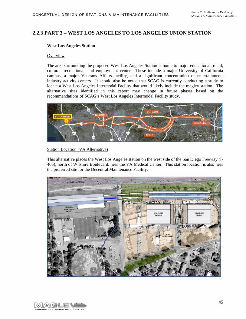
45
Phase 2: Preliminary Design of Stations & Maintenance Facilities C O N C E P T U A L D E S I G N O F S T A T I O N S & M A I N T E N A N C E F A C I L I T I E S
2.2.3 PART 3 – WEST LOS ANGELES TO LOS ANGELES UNION STATION
West Los Angeles Station
Overview
The area surrounding the proposed West Los Angeles Station is home to major educational, retail, cultural, recreational, and employment centers. These include a major University of California campus, a major Veterans Affairs facility, and a significant concentration of entertainment-industry activity centers. It should also be noted that SCAG is currently conducting a study to locate a West Los Angeles Intermodal Facility that would likely include the maglev station. The alternative sites identified in this report may change in future phases based on the recommendations of SCAG’s West Los Angeles Intermodal Facility study.
Station Location (VA Alternative)
This alternative places the West Los Angeles station on the west side of the San Diego Freeway (I-405), north of Wilshire Boulevard, near the VA Medical Center. This station location is also near the preferred site for the Decentral Maintenance Facility.
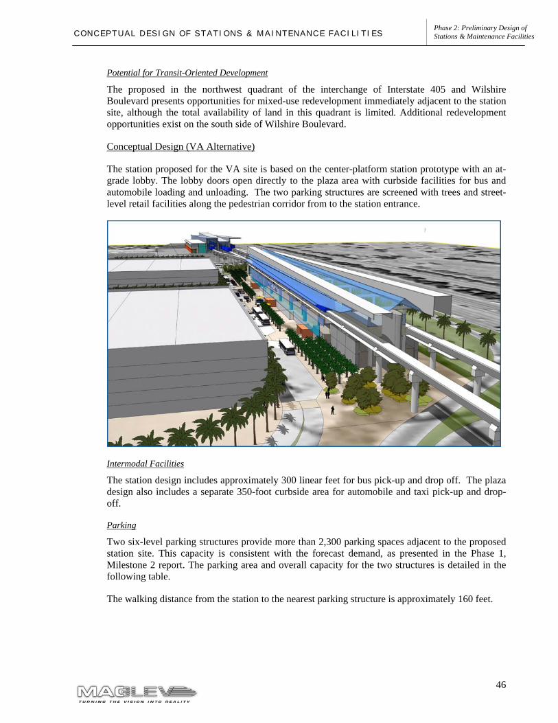
46
Phase 2: Preliminary Design of Stations & Maintenance Facilities C O N C E P T U A L D E S I G N O F S T A T I O N S & M A I N T E N A N C E F A C I L I T I E S
Potential for Transit-Oriented Development
The proposed in the northwest quadrant of the interchange of Interstate 405 and Wilshire Boulevard presents opportunities for mixed-use redevelopment immediately adjacent to the station site, although the total availability of land in this quadrant is limited. Additional redevelopment opportunities exist on the south side of Wilshire Boulevard.
Conceptual Design (VA Alternative)
The station proposed for the VA site is based on the center-platform station prototype with an at-grade lobby. The lobby doors open directly to the plaza area with curbside facilities for bus and automobile loading and unloading. The two parking structures are screened with trees and street-level retail facilities along the pedestrian corridor from to the station entrance.
Intermodal Facilities
The station design includes approximately 300 linear feet for bus pick-up and drop off. The plaza design also includes a separate 350-foot curbside area for automobile and taxi pick-up and drop-off.
Parking
Two six-level parking structures provide more than 2,300 parking spaces adjacent to the proposed station site. This capacity is consistent with the forecast demand, as presented in the Phase 1, Milestone 2 report. The parking area and overall capacity for the two structures is detailed in the following table.
The walking distance from the station to the nearest parking structure is approximately 160 feet.
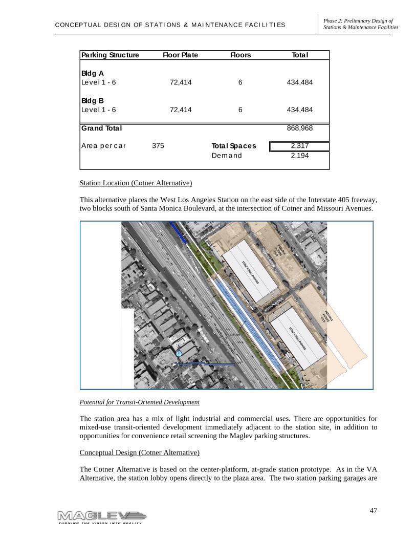
47
Phase 2: Preliminary Design of Stations & Maintenance Facilities C O N C E P T U A L D E S I G N O F S T A T I O N S & M A I N T E N A N C E F A C I L I T I E S
Station Location (Cotner Alternative)
This alternative places the West Los Angeles Station on the east side of the Interstate 405 freeway, two blocks south of Santa Monica Boulevard, at the intersection of Cotner and Missouri Avenues.
Potential for Transit-Oriented Development
The station area has a mix of light industrial and commercial uses. There are opportunities for mixed-use transit-oriented development immediately adjacent to the station site, in addition to opportunities for convenience retail screening the Maglev parking structures.
Conceptual Design (Cotner Alternative)
The Cotner Alternative is based on the center-platform, at-grade station prototype. As in the VA Alternative, the station lobby opens directly to the plaza area. The two station parking garages are
Parking Structure Floor Plate Floors Total
Bldg ALevel 1 - 6 72,414 6 434,484
Bldg BLevel 1 - 6 72,414 6 434,484
Grand Total 868,968
Area per car 375 Total Spaces 2,317Demand 2,194
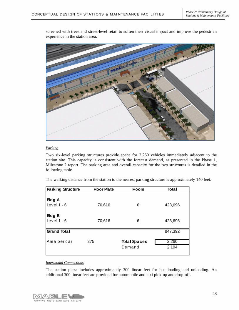
48
Phase 2: Preliminary Design of Stations & Maintenance Facilities C O N C E P T U A L D E S I G N O F S T A T I O N S & M A I N T E N A N C E F A C I L I T I E S
screened with trees and street-level retail to soften their visual impact and improve the pedestrian experience in the station area.
Parking
Two six-level parking structures provide space for 2,260 vehicles immediately adjacent to the station site. This capacity is consistent with the forecast demand, as presented in the Phase 1, Milestone 2 report. The parking area and overall capacity for the two structures is detailed in the following table.
The walking distance from the station to the nearest parking structure is approximately 140 feet.
Intermodal Connections
The station plaza includes approximately 300 linear feet for bus loading and unloading. An additional 300 linear feet are provided for automobile and taxi pick-up and drop-off.
Parking Structure Floor Plate Floors Total
Bldg ALevel 1 - 6 70,616 6 423,696
Bldg BLevel 1 - 6 70,616 6 423,696
Grand Total 847,392
Area per car 375 Total Spaces 2,260Demand 2,194
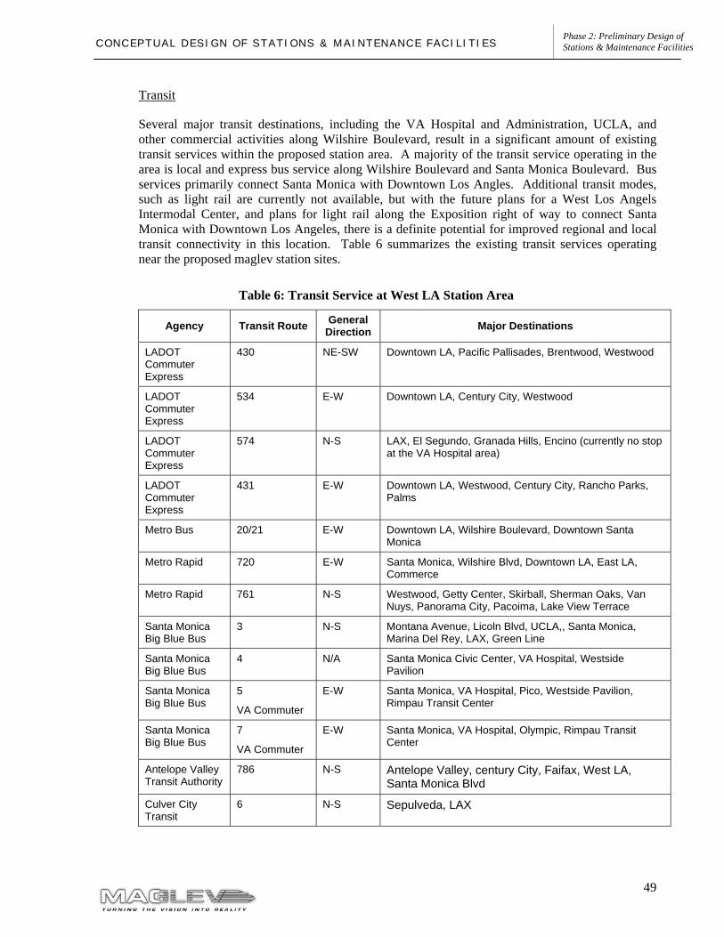
49
Phase 2: Preliminary Design of Stations & Maintenance Facilities C O N C E P T U A L D E S I G N O F S T A T I O N S & M A I N T E N A N C E F A C I L I T I E S
Transit
Several major transit destinations, including the VA Hospital and Administration, UCLA, and other commercial activities along Wilshire Boulevard, result in a significant amount of existing transit services within the proposed station area. A majority of the transit service operating in the area is local and express bus service along Wilshire Boulevard and Santa Monica Boulevard. Bus services primarily connect Santa Monica with Downtown Los Angles. Additional transit modes, such as light rail are currently not available, but with the future plans for a West Los Angels Intermodal Center, and plans for light rail along the Exposition right of way to connect Santa Monica with Downtown Los Angeles, there is a definite potential for improved regional and local transit connectivity in this location. Table 6 summarizes the existing transit services operating near the proposed maglev station sites.
Table 6: Transit Service at West LA Station Area
Agency Transit Route General Direction Major Destinations
LADOT Commuter Express
430 NE-SW Downtown LA, Pacific Pallisades, Brentwood, Westwood
LADOT Commuter Express
534 E-W Downtown LA, Century City, Westwood
LADOT Commuter Express
574 N-S LAX, El Segundo, Granada Hills, Encino (currently no stop at the VA Hospital area)
LADOT Commuter Express
431 E-W Downtown LA, Westwood, Century City, Rancho Parks, Palms
Metro Bus 20/21 E-W Downtown LA, Wilshire Boulevard, Downtown Santa Monica
Metro Rapid 720 E-W Santa Monica, Wilshire Blvd, Downtown LA, East LA, Commerce
Metro Rapid 761 N-S Westwood, Getty Center, Skirball, Sherman Oaks, Van Nuys, Panorama City, Pacoima, Lake View Terrace
Santa Monica Big Blue Bus
3 N-S Montana Avenue, Licoln Blvd, UCLA,, Santa Monica, Marina Del Rey, LAX, Green Line
Santa Monica Big Blue Bus
4 N/A Santa Monica Civic Center, VA Hospital, Westside Pavilion
Santa Monica Big Blue Bus
5
VA Commuter
E-W Santa Monica, VA Hospital, Pico, Westside Pavilion, Rimpau Transit Center
Santa Monica Big Blue Bus
7
VA Commuter
E-W Santa Monica, VA Hospital, Olympic, Rimpau Transit Center
Antelope Valley Transit Authority
786 N-S Antelope Valley, century City, Faifax, West LA, Santa Monica Blvd
Culver City Transit
6 N-S Sepulveda, LAX

50
Phase 2: Preliminary Design of Stations & Maintenance Facilities C O N C E P T U A L D E S I G N O F S T A T I O N S & M A I N T E N A N C E F A C I L I T I E S
Vehicular Access
The I-405/Wilshire Boulevard interchange is a central location that provides a strong connection to the surrounding area of West Los Angeles. In addition to the superior freeway and arterial access to this location, this area is centrally located for providing access to the several major destinations including the Veterans Administration complex, UCLA, and other major employment and entertainment centers.
I-405, which is a north-south route, provides the primary freeway access route to the station location, connecting to LAX in the south and the San Fernando Valley in the north. The I-10 freeway is located a few miles south of the station area and provides for east-west regional travel. Wilshire Boulevard and Santa Monica Boulevard are the primary east-west arterial roadways near the maglev station sites. Sepulveda Boulevard is the major north-south roadway corridor within the station area. The figure below illustrates the existing circulation network in the vicinity of the proposed station.
The following freeways access the West Los Angeles proposed station site
• San Diego Freeway (I-405) • Santa Monica Freeway (I-10), located 2 miles south
51
Phase 2: Preliminary Design of Stations & Maintenance Facilities C O N C E P T U A L D E S I G N O F S T A T I O N S & M A I N T E N A N C E F A C I L I T I E S
The following local streets provide direct regional access to the West Los Angeles proposed station site:
Veteran Administration Site Alternative
• Wilshire Boulevard • Sepulveda Boulevard • San Vicente Boulevard • Ohio Avenue • Constitution Avenue
Cotner Avenue Alternative
• Wilshire Boulevard • Sepulveda Boulevard • San Vicente Boulevard • Santa Monica Boulevard
Traffic Volumes
California Department of Transportation (Caltrans), District 7 identifies the segment of the I-405 between LAX and Wilshire Boulevard as one of the busiest freeways in the Los Angeles region. The I-405 is the only north-south freeway west of downtown Los Angeles, and is crucial to the mobility of the entire Westside. To improve traffic flow, Caltrans is adding contiguous segments of High Occupancy Vehicle (HOV) lanes to I-405 between the I-105 and US-101 freeways. These projects, coupled with additional improvements to this corridor, including improvements to the I-405/US-101 interchange are expected to improve mobility along this corridor.
The traffic issues for this station area were evaluated in the final EIR report of the Wilshire Bus Rapid Transit (BRT) Project study completed August 2002. The study established that there is substantial peak hour congestion on Wilshire Boulevard and its vicinity, with Wilshire Boulevard between Westwood and Bundy operating at an unacceptable level of service (LOS) E or F. Volumes drop off significantly west of the I-405 Freeway, as a large volume of traffic gets on or off the freeway.
Santa Monica Boulevard also experiences high traffic volumes during the AM and PM peak periods. The City of Los Angeles and MTA are currently implementing a transit corridor on Santa Monica Boulevard that will offer more frequent and efficient bus transit services in the corridor. As part of the HOV lane construction on the I-405, a direct connector from the HOV lanes on the I-405 will be provided to Santa Monica Boulevard.
The ridership assessments performed in the Phase 1 of the Maglev Deployment Program determined that about 27% of the passengers accessing the West Los Angeles station during peak hour would do so by auto. The West Los Angeles station exhibited one of the lowest auto access rates in the maglev system, reflecting the extensive transit network already in place around the station. The auto access figures result in a need of about 2,140 park-and-ride spaces in this location. Phase 1 estimated that AM peak hour automobile trips to the station would be 523 trips at horizon year 2025.
52
Phase 2: Preliminary Design of Stations & Maintenance Facilities C O N C E P T U A L D E S I G N O F S T A T I O N S & M A I N T E N A N C E F A C I L I T I E S
Maglev Station Traffic Impacts
As is the case with the other maglev station areas, a detailed traffic impact analysis for the proposed station will be conducted at a later phase of the program as part of the environmental process. It is estimated that the increased traffic volumes accessing the maglev station will ultimately require some infrastructure improvements in order to increase roadways capacity for the street system to be able to accommodate the additional traffic. Some of the improvements that would be considered include:
• Street widening; • Interchange improvements on I-405 • Improved traffic signalization; and • Direct access ramps between I-405 and the maglev station and parking facility.
53
Phase 2: Preliminary Design of Stations & Maintenance Facilities C O N C E P T U A L D E S I G N O F S T A T I O N S & M A I N T E N A N C E F A C I L I T I E S
MAINTENANCE FACILITY
Central Maintenance Facility
Overview
The Central Maintenance Facility is where the majority of the maintenance work for the Maglev system is based. It is the location of the Operation Control Center, where the operation and dispatch of the fully automated Maglev train system is controlled and monitored. The Central Maintenance Facility is also the primary location of Maglev vehicle parking tracks.
Location
The proposed site of the Central Maintenance Facility is west of the Ontario International Airport Station, south of the Initial Operating Segment alignment on State Street.
Activities
The activities taking place or based at the Central Maintenance Facility include:
• Scheduled maintenance measures for all Maglev equipment along route • Scheduled inspection, servicing, and interior cleaning of Maglev vehicles • Scheduled overhaul of Maglev vehicles • Quick exchange of Maglev vehicle modules • Unscheduled maintenance measures • Repairs • Maglev vehicle integration (re-assembly of vehicles after shipment) • Painting of Maglev vehicles • Maglev vehicle battery maintenance • Parking of Maglev vehicles and maintenance vehicles • Vehicle washing • Maintenance management for all Maglev subsystems • Preparation of maintenance vehicles for nightly activities • Administrative and management office work • Parts and equipment storage
Facility Requirements
The Central Maintenance Facility includes the following facilities to accommodate the required activities:
• System Operation Control Center • System offices • Maintenance offices • Maintenance workshops • Spare parts storage and tracking • Seven Maglev vehicle maintenance tracks • One Maglev vehicle washing track • Four outdoor Maglev and/or guideway maintenance vehicle parking tracks
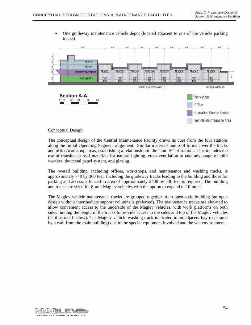
54
Phase 2: Preliminary Design of Stations & Maintenance Facilities C O N C E P T U A L D E S I G N O F S T A T I O N S & M A I N T E N A N C E F A C I L I T I E S
• One guideway maintenance vehicle depot (located adjacent to one of the vehicle parking tracks)
Conceptual Design
The conceptual design of the Central Maintenance Facility draws its cues from the four stations along the Initial Operating Segment alignment. Similar materials and roof forms cover the tracks and office/workshop areas, establishing a relationship to the “family” of stations. This includes the use of translucent roof materials for natural lighting, cross-ventilation to take advantage of mild weather, the metal panel system, and glazing.
The overall building, including offices, workshops, and maintenance and washing tracks, is approximately 740 by 360 feet. Including the guideway tracks leading to the building and those for parking and access, a fenced-in area of approximately 2400 by 430 feet is required. The building and tracks are sized for 8-unit Maglev vehicles with the option to expand to 10-units.
The Maglev vehicle maintenance tracks are grouped together in an open-style building (an open design without intermediate support columns is preferred). The maintenance tracks are elevated to allow convenient access to the underside of the Maglev vehicles, with work platforms on both sides running the length of the tracks to provide access to the sides and top of the Maglev vehicles (as illustrated below). The Maglev vehicle washing track is located in an adjacent bay (separated by a wall from the main building) due to the special equipment involved and the wet environment.
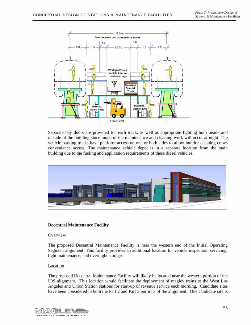
55
Phase 2: Preliminary Design of Stations & Maintenance Facilities C O N C E P T U A L D E S I G N O F S T A T I O N S & M A I N T E N A N C E F A C I L I T I E S
Work platforms: Vehicle interior, undercarriage
Material, Spare Parts
Area between two maintenance tracks
Floor Level
Material, Spare Parts
Standard/ Special Tools
Work platforms: Vehicle interior, undercarriage
Material, Spare Parts
Area between two maintenance tracks
Floor Level
Material, Spare Parts
Standard/ Special Tools
Separate bay doors are provided for each track, as well as appropriate lighting both inside and outside of the building since much of the maintenance and cleaning work will occur at night. The vehicle parking tracks have platform access on one or both sides to allow interior cleaning crews convenience access. The maintenance vehicle depot is in a separate location from the main building due to the fueling and application requirements of these diesel vehicles.
Decentral Maintenance Facility
Overview
The proposed Decentral Maintenance Facility is near the western end of the Initial Operating Segment alignment. This facility provides an additional location for vehicle inspection, servicing, light maintenance, and overnight storage.
Location
The proposed Decentral Maintenance Facility will likely be located near the western portion of the IOS alignment. This location would facilitate the deployment of maglev trains to the West Los Angeles and Union Station stations for start-up of revenue service each morning. Candidate sites have been considered in both the Part 2 and Part 3 portions of the alignment. One candidate site is

56
Phase 2: Preliminary Design of Stations & Maintenance Facilities C O N C E P T U A L D E S I G N O F S T A T I O N S & M A I N T E N A N C E F A C I L I T I E S
located on the west side of Interstate 405 at the VA Medical Center site. This site is shown in the Preliminary Engineering plans. The facility is set to the west of the extended Maglev alignment in order to allow for future extension of the system northward along the freeway corridor.
Activities
Maintenance activities taking place or based at the Decentral Maintenance Facility include:
• Scheduled maintenance measures for all Maglev equipment along route • Scheduled inspection, servicing, and interior cleaning of Maglev vehicles • Quick exchange of Maglev vehicle modules • Unscheduled maintenance measures of short duration • Parking of Maglev and maintenance vehicles • Preparation of maintenance vehicles for nightly activities
Facility Requirements
The facilities required to accomplish the decentralized maintenance activities include:
• Maintenance offices • Maintenance workshops • Spare parts storage and tracking • Two Maglev vehicle maintenance tracks • One Maglev and/or guideway maintenance vehicle parking track • One guideway maintenance vehicle depot (located adjacent to the vehicle parking track)
Conceptual Design
Like the Central Maintenance Facility, the Decentral Maintenance Facility uses materials and roof forms similar to those of the stations, establishing a relationship to the Maglev station “family.”
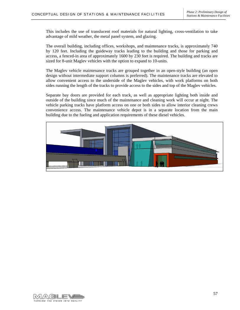
57
Phase 2: Preliminary Design of Stations & Maintenance Facilities C O N C E P T U A L D E S I G N O F S T A T I O N S & M A I N T E N A N C E F A C I L I T I E S
This includes the use of translucent roof materials for natural lighting, cross-ventilation to take advantage of mild weather, the metal panel system, and glazing.
The overall building, including offices, workshops, and maintenance tracks, is approximately 740 by 120 feet. Including the guideway tracks leading to the building and those for parking and access, a fenced-in area of approximately 1600 by 230 feet is required. The building and tracks are sized for 8-unit Maglev vehicles with the option to expand to 10-units.
The Maglev vehicle maintenance tracks are grouped together in an open-style building (an open design without intermediate support columns is preferred). The maintenance tracks are elevated to allow convenient access to the underside of the Maglev vehicles, with work platforms on both sides running the length of the tracks to provide access to the sides and top of the Maglev vehicles.
Separate bay doors are provided for each track, as well as appropriate lighting both inside and outside of the building since much of the maintenance and cleaning work will occur at night. The vehicle parking tracks have platform access on one or both sides to allow interior cleaning crews convenience access. The maintenance vehicle depot is in a separate location from the main building due to the fueling and application requirements of these diesel vehicles.


![Maglev resumé]](https://img.pdfslide.net/doc/110x75/5571f8a849795991698dd702/maglev-resume.jpg)