Embed Size (px)
Citation preview
MAIN STREET HANDBOOK i
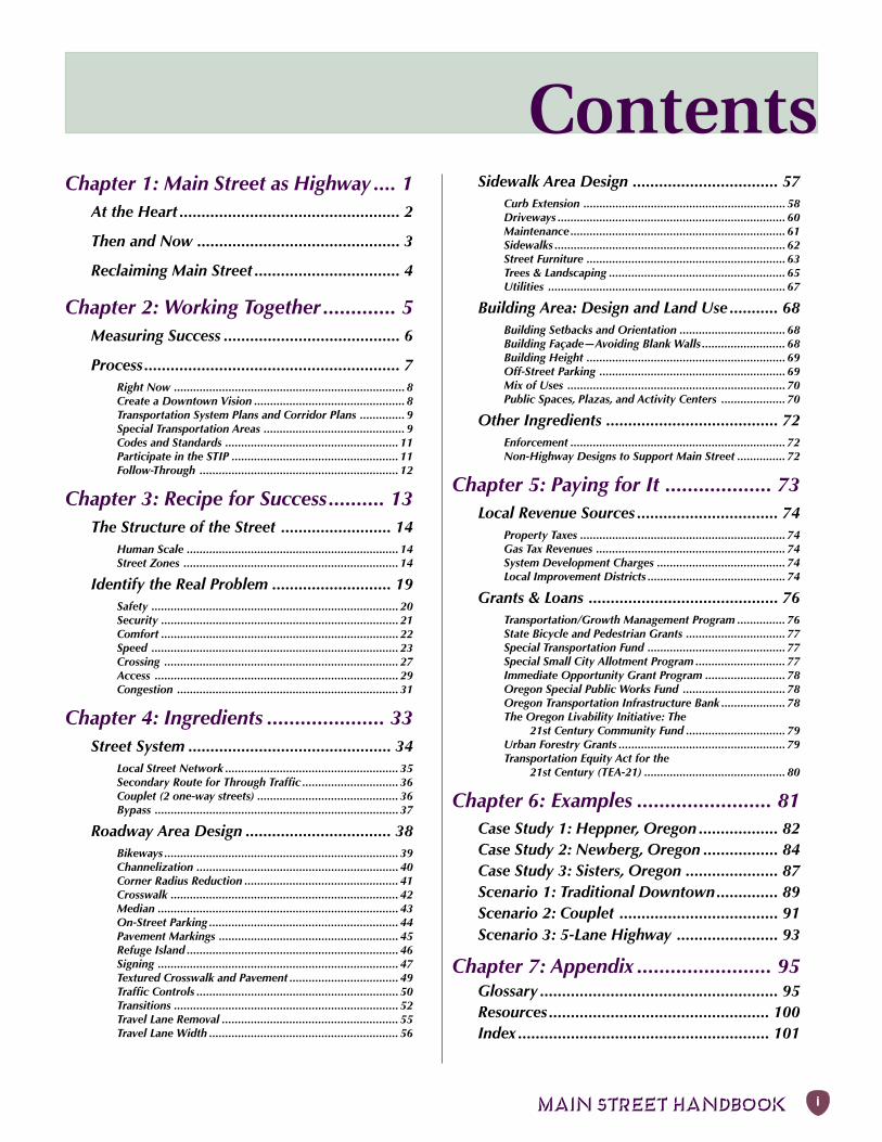
ContentsChapter 1: Main Street as Highway .... 1
At the Heart .................................................. 2
Then and Now .............................................. 3
Reclaiming Main Street ................................. 4
Chapter 2: Working Together ............. 5Measuring Success ........................................ 6
Process.......................................................... 7Right Now ........................................................................ 8Create a Downtown Vision ............................................... 8Transportation System Plans and Corridor Plans .............. 9Special Transportation Areas ............................................ 9Codes and Standards ...................................................... 11Participate in the STIP .................................................... 11Follow-Through .............................................................. 12
Chapter 3: Recipe for Success.......... 13The Structure of the Street ......................... 14
Human Scale .................................................................. 14Street Zones ................................................................... 14
Identify the Real Problem ........................... 19Safety ............................................................................. 20Security .......................................................................... 21Comfort .......................................................................... 22Speed ............................................................................. 23Crossing ......................................................................... 27Access ............................................................................ 29Congestion ..................................................................... 31
Chapter 4: Ingredients ..................... 33Street System .............................................. 34
Local Street Network ...................................................... 35Secondary Route for Through Traffic .............................. 36Couplet (2 one-way streets) ............................................ 36Bypass ............................................................................ 37
Roadway Area Design ................................. 38Bikeways ......................................................................... 39Channelization ............................................................... 40Corner Radius Reduction ................................................ 41Crosswalk ....................................................................... 42Median ........................................................................... 43On-Street Parking ........................................................... 44Pavement Markings ........................................................ 45Refuge Island .................................................................. 46Signing ........................................................................... 47Textured Crosswalk and Pavement .................................. 49Traffic Controls ............................................................... 50Transitions ...................................................................... 52Travel Lane Removal ....................................................... 55Travel Lane Width ........................................................... 56
Sidewalk Area Design ................................. 57Curb Extension ............................................................... 58Driveways ....................................................................... 60Maintenance ................................................................... 61Sidewalks ........................................................................ 62Street Furniture .............................................................. 63Trees & Landscaping ....................................................... 65Utilities .......................................................................... 67
Building Area: Design and Land Use ........... 68Building Setbacks and Orientation ................................. 68Building Façade—Avoiding Blank Walls .......................... 68Building Height .............................................................. 69Off-Street Parking .......................................................... 69Mix of Uses .................................................................... 70Public Spaces, Plazas, and Activity Centers .................... 70
Other Ingredients ....................................... 72Enforcement ................................................................... 72Non-Highway Designs to Support Main Street ............... 72
Chapter 5: Paying for It ................... 73Local Revenue Sources ................................ 74
Property Taxes ................................................................ 74Gas Tax Revenues ........................................................... 74System Development Charges ........................................ 74Local Improvement Districts ........................................... 74
Grants & Loans ........................................... 76Transportation/Growth Management Program ............... 76State Bicycle and Pedestrian Grants ............................... 77Special Transportation Fund ........................................... 77Special Small City Allotment Program ............................ 77Immediate Opportunity Grant Program ......................... 78Oregon Special Public Works Fund ................................ 78Oregon Transportation Infrastructure Bank .................... 78The Oregon Livability Initiative: The
21st Century Community Fund ............................... 79Urban Forestry Grants .................................................... 79Transportation Equity Act for the
21st Century (TEA-21) ............................................ 80
Chapter 6: Examples ........................ 81Case Study 1: Heppner, Oregon .................. 82Case Study 2: Newberg, Oregon ................. 84Case Study 3: Sisters, Oregon ..................... 87Scenario 1: Traditional Downtown.............. 89Scenario 2: Couplet .................................... 91Scenario 3: 5-Lane Highway ....................... 93
Chapter 7: Appendix ........................ 95Glossary ...................................................... 95Resources .................................................. 100Index ......................................................... 101
ii MAIN STREET HANDBOOK
AcknowledgementsThis project was funded by the Transportation and Growth Management (TGM)
Program, a joint program of theOregon Department of Transportation (ODOT) and the
Oregon Department of Land Conservation and Development (DLCD).Additional funds were provided by the
ODOT Bicycle and Pedestrian Program and by theOregon Downtown Development Association (ODDA)
through a grant from the Oregon Economic and Community Development Dept.
TGM Program Staff
Pamela Kambur, TGM Outreach Coordinator, DLCDLainie Smith, Urban Growth Program Coordinator, DLCD
Consultant Team
Karen Swirsky, David Evans and Associates, Inc.Nils Eddy, David Evans and Associates, Inc.
David Olsen, David Evans and Associates, Inc.Brian Rankin, David Evans and Associates, Inc.
Dan Burden, Walkable CommunitiesPat Kliewer, Kliewer and Associates
Steering Committee
Kent Belleque, Highway Design Manual Manager, ODOT Project SupportVicki Hilliard, Executive Director, ODDA
Lynn Peterson, Transportation Advocate,1000 Friend of OregonLidwien Rahman, TGM Grant Coordinator, ODOT Region 1
Michael Ronkin, Program Manager, ODOT Bicycle and Pedestrian ProgramTerry Wheeler, Transportation Design Manager, ODOT Technical Services
November 1999
MAIN STREET HANDBOOK 1
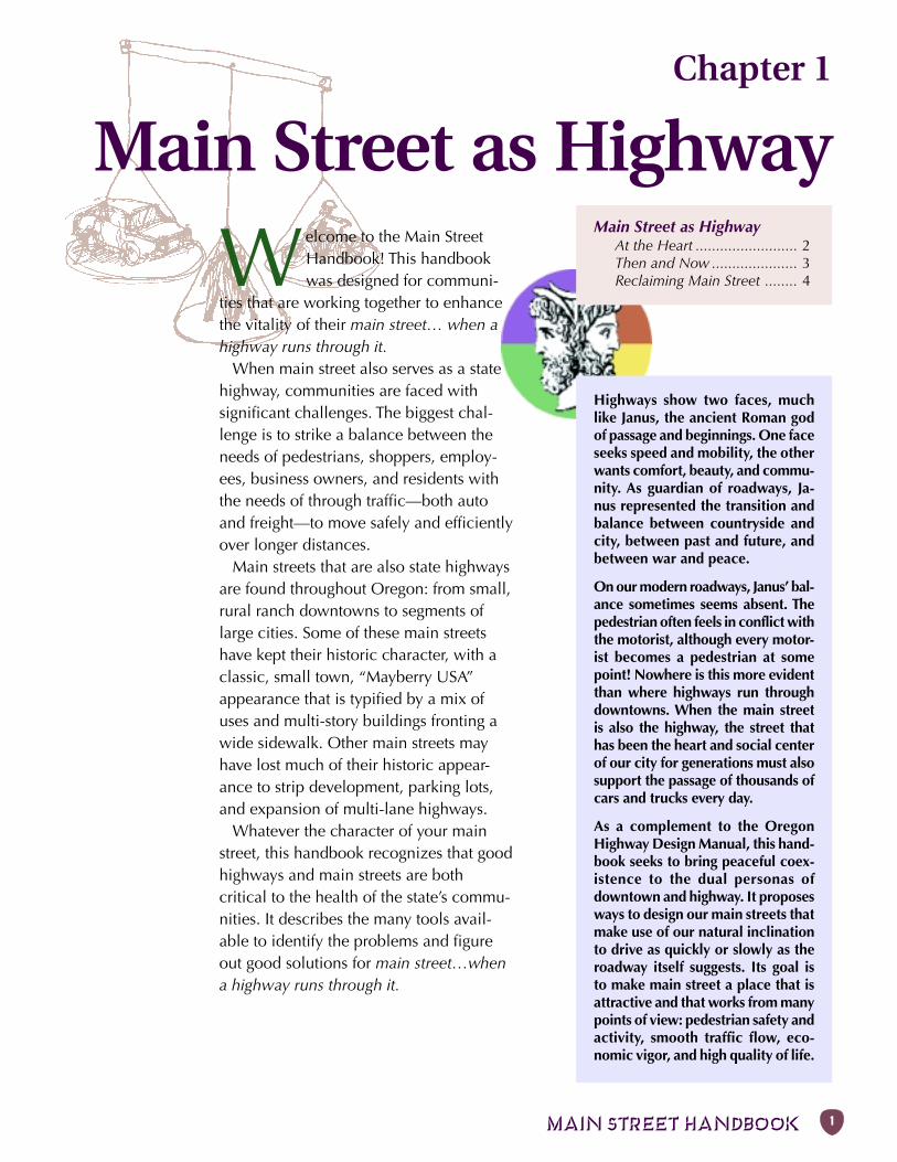
Chapter 1
Main Street as Highway
Welcome to the Main StreetHandbook! This handbookwas designed for communi-
ties that are working together to enhancethe vitality of their main street… when ahighway runs through it.
When main street also serves as a statehighway, communities are faced withsignificant challenges. The biggest chal-lenge is to strike a balance between theneeds of pedestrians, shoppers, employ-ees, business owners, and residents withthe needs of through traffic—both autoand freight—to move safely and efficientlyover longer distances.
Main streets that are also state highwaysare found throughout Oregon: from small,rural ranch downtowns to segments oflarge cities. Some of these main streetshave kept their historic character, with aclassic, small town, “Mayberry USA”appearance that is typified by a mix ofuses and multi-story buildings fronting awide sidewalk. Other main streets mayhave lost much of their historic appear-ance to strip development, parking lots,and expansion of multi-lane highways.
Whatever the character of your mainstreet, this handbook recognizes that goodhighways and main streets are bothcritical to the health of the state’s commu-nities. It describes the many tools avail-able to identify the problems and figureout good solutions for main street…whena highway runs through it.
Main Street as HighwayAt the Heart ......................... 2Then and Now ..................... 3Reclaiming Main Street ........ 4
Highways show two faces, muchlike Janus, the ancient Roman godof passage and beginnings. One faceseeks speed and mobility, the otherwants comfort, beauty, and commu-nity. As guardian of roadways, Ja-nus represented the transition andbalance between countryside andcity, between past and future, andbetween war and peace.
On our modern roadways, Janus’ bal-ance sometimes seems absent. Thepedestrian often feels in conflict withthe motorist, although every motor-ist becomes a pedestrian at somepoint! Nowhere is this more evidentthan where highways run throughdowntowns. When the main streetis also the highway, the street thathas been the heart and social centerof our city for generations must alsosupport the passage of thousands ofcars and trucks every day.
As a complement to the OregonHighway Design Manual, this hand-book seeks to bring peaceful coex-istence to the dual personas ofdowntown and highway. It proposesways to design our main streets thatmake use of our natural inclinationto drive as quickly or slowly as theroadway itself suggests. Its goal isto make main street a place that isattractive and that works from manypoints of view: pedestrian safety andactivity, smooth traffic flow, eco-nomic vigor, and high quality of life.
2 Chapter 1: MAIN STREET AS HIGHWAY
“Main Street is
where you have
parades.”
–Focus Group
Participant,
April 1999
Main street
caters to
pedestrians.
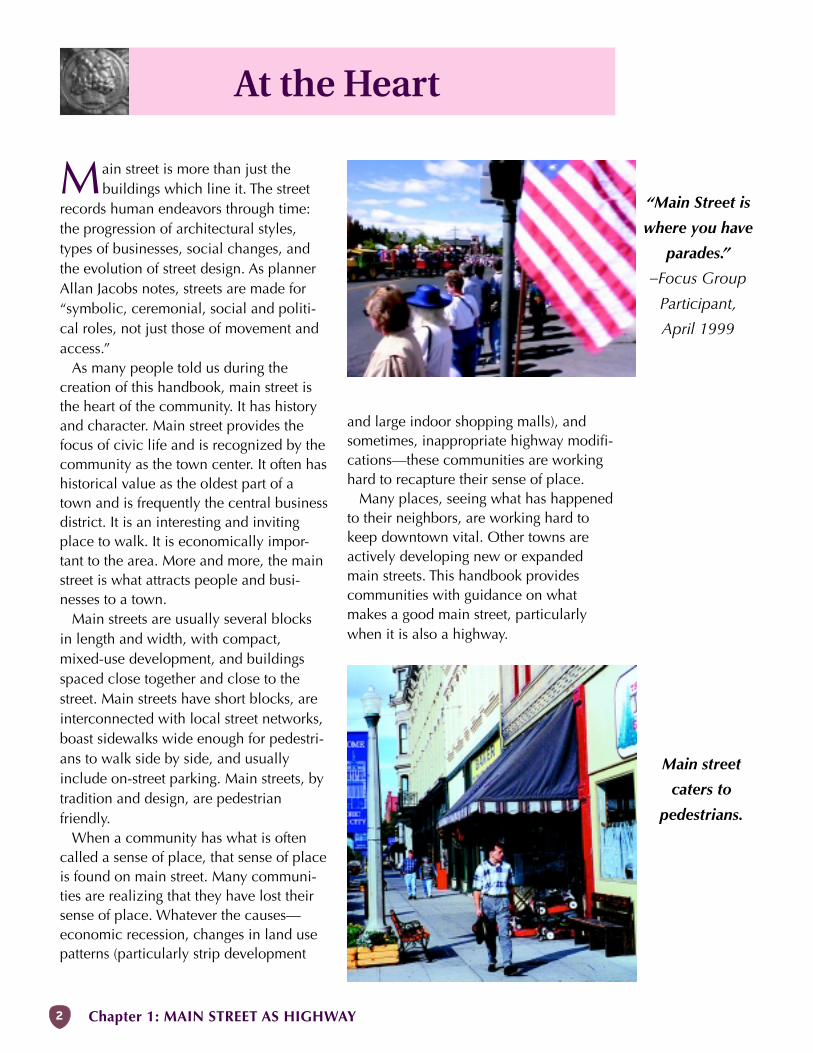
At the Heart
Main street is more than just thebuildings which line it. The street
records human endeavors through time:the progression of architectural styles,types of businesses, social changes, andthe evolution of street design. As plannerAllan Jacobs notes, streets are made for“symbolic, ceremonial, social and politi-cal roles, not just those of movement andaccess.”
As many people told us during thecreation of this handbook, main street isthe heart of the community. It has historyand character. Main street provides thefocus of civic life and is recognized by thecommunity as the town center. It often hashistorical value as the oldest part of atown and is frequently the central businessdistrict. It is an interesting and invitingplace to walk. It is economically impor-tant to the area. More and more, the mainstreet is what attracts people and busi-nesses to a town.
Main streets are usually several blocksin length and width, with compact,mixed-use development, and buildingsspaced close together and close to thestreet. Main streets have short blocks, areinterconnected with local street networks,boast sidewalks wide enough for pedestri-ans to walk side by side, and usuallyinclude on-street parking. Main streets, bytradition and design, are pedestrianfriendly.
When a community has what is oftencalled a sense of place, that sense of placeis found on main street. Many communi-ties are realizing that they have lost theirsense of place. Whatever the causes—economic recession, changes in land usepatterns (particularly strip development
and large indoor shopping malls), andsometimes, inappropriate highway modifi-cations—these communities are workinghard to recapture their sense of place.
Many places, seeing what has happenedto their neighbors, are working hard tokeep downtown vital. Other towns areactively developing new or expandedmain streets. This handbook providescommunities with guidance on whatmakes a good main street, particularlywhen it is also a highway.
MAIN STREET HANDBOOK 3
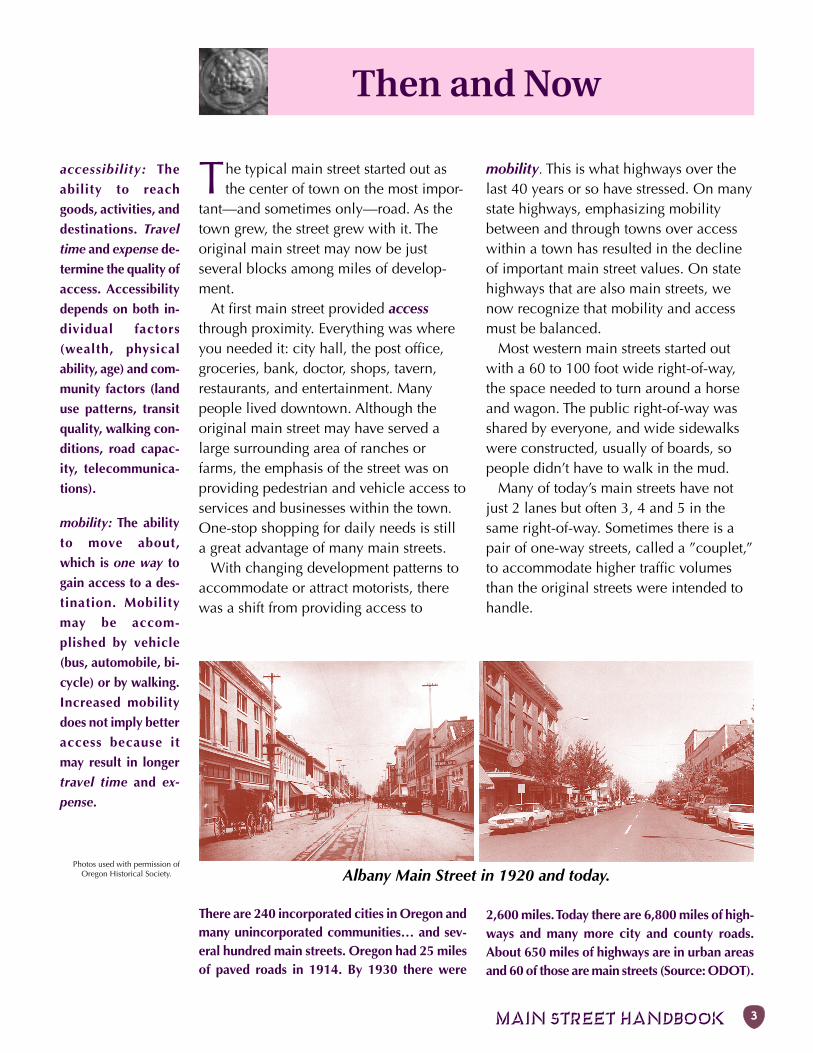
Albany Main Street in 1920 and today.
accessibility: The
ability to reach
goods, activities, and
destinations. Travel
time and expense de-
termine the quality of
access. Accessibility
depends on both in-
dividual factors
(wealth, physical
ability, age) and com-
munity factors (land
use patterns, transit
quality, walking con-
ditions, road capac-
ity, telecommunica-
tions).
mobility: The ability
to move about,
which is one way to
gain access to a des-
tination. Mobility
may be accom-
plished by vehicle
(bus, automobile, bi-
cycle) or by walking.
Increased mobility
does not imply better
access because it
may result in longer
travel time and ex-
pense.
There are 240 incorporated cities in Oregon andmany unincorporated communities… and sev-eral hundred main streets. Oregon had 25 milesof paved roads in 1914. By 1930 there were
2,600 miles. Today there are 6,800 miles of high-ways and many more city and county roads.About 650 miles of highways are in urban areasand 60 of those are main streets (Source: ODOT).
Then and Now
The typical main street started out asthe center of town on the most impor-
tant—and sometimes only—road. As thetown grew, the street grew with it. Theoriginal main street may now be justseveral blocks among miles of develop-ment.
At first main street provided accessthrough proximity. Everything was whereyou needed it: city hall, the post office,groceries, bank, doctor, shops, tavern,restaurants, and entertainment. Manypeople lived downtown. Although theoriginal main street may have served alarge surrounding area of ranches orfarms, the emphasis of the street was onproviding pedestrian and vehicle access toservices and businesses within the town.One-stop shopping for daily needs is stilla great advantage of many main streets.
With changing development patterns toaccommodate or attract motorists, therewas a shift from providing access to
mobility. This is what highways over thelast 40 years or so have stressed. On manystate highways, emphasizing mobilitybetween and through towns over accesswithin a town has resulted in the declineof important main street values. On statehighways that are also main streets, wenow recognize that mobility and accessmust be balanced.
Most western main streets started outwith a 60 to 100 foot wide right-of-way,the space needed to turn around a horseand wagon. The public right-of-way wasshared by everyone, and wide sidewalkswere constructed, usually of boards, sopeople didn’t have to walk in the mud.
Many of today’s main streets have notjust 2 lanes but often 3, 4 and 5 in thesame right-of-way. Sometimes there is apair of one-way streets, called a ”couplet,”to accommodate higher traffic volumesthan the original streets were intended tohandle.
Photos used with permission ofOregon Historical Society.
4 Chapter 1: MAIN STREET AS HIGHWAY
Don’t know what a
word means?
Refer to the Glossary
in the Appendix.
WHAT’S NEXT
Chapter 2: Working Together gives the
background you’ll need to get involved.
tChapter 3: Recipe for Success explores
typical issues and how to approach them.
3Chapter 4: Ingredients details the individual
measures that, in the proper mix, will get
main street back on its feet.
lChapter 5: Paying for It gives you some ideas
for creative financing.
QChapter 6: Examples discusses some real and
hypothetical main streets.
OChapter 7: Appendix includes a Glossary,
Resources, and Index.
Reclaiming Main Street
The heavy traffic of today’s highwaysdoes not mean that main street has to
sacrifice the qualities that bring people toit. Many deplorable conditions—trafficnoise, collisions, poor walking environ-ment, and loss of business—have hap-pened in part due to:
• An emphasis on mobility over acces-sibility, which can result in higherspeeds than are appropriate to themain street environment (for ex-ample, streets that appear very wideduring off-peak hours).
• A drifting away from the classic streetdesign principles such as widesidewalks and placing buildingscorrectly in relation to the street.
• A lack of knowledge or understand-ing about how to apply certaintechniques that slow traffic, oftenreferred to as ”traffic calming,” tomajor streets.
• Changes in zoning and land use haveled to commercial developmentoutside of the city core, typified bystrip development and discount “bigbox” stores that can draw businessaway from downtown.
This handbook provides tools and ideasfor reclaiming the main street qualities ofthe highway by making the street lookgood and work well.
These tools provide ways to restorehighways and connecting streets to theirintended function, which is to provideboth mobility and accessibility, but indiffering combinations.
The techniques included in this hand-book can help to:
• Encourage drivers to drive at thedesired speed.
• Improve the aesthetic appearance ofthe street.
• Enhance the street environment,particularly for pedestrians.
• Minimize conflicts between highwayusers: pedestrians, bicyclists, transit,freight carriers, and motorists.
• Encourage through traffic to stay onthe highway.
• Provide other routes for local traffic.• Increase the economic vitality of a
community.Reclaiming main street can improve the
quality of life in the heart of the commu-nity—the real purpose of this handbook.x
MAIN STREET HANDBOOK 5
Chapter 2
Working Together
Successful main street projects needstate and local governments andcommunity stakeholders to work
together, collaborate in planning anddecision making, and share responsibilityfor construction and maintenance.
There are many different private interestsand government agencies involved inbuilding and maintaining main street. Anytime a change is proposed, everyoneaffected needs to be consulted.
Possible players include:• The public that uses main street.• Residents in the downtown and along
main street.• The business and building owners in
the downtown and along main street.• Chamber of Commerce.• Downtown Association.• City (police, fire, ambulance, garbage
collection, utilities, public works,snow plowing, maintenance, parks,schools, and libraries as appropriate).
• County (if unincorporated or ifCounty funds or services used).
• Oregon Department of Transporta-tion.
Working TogetherMeasuring Success .................. 6Process ................................... 7
“We are confronted by insurmountable
opportunities.“ –Pogo
• State Historic Preservation Office.• U.S. Postal Service (if mail delivery is
affected).• Federal Highway Administration (if
Federal funds are used).Critical tools to encourage collaboration
include a community’s downtown planand Transportation System Plan, as well asthe city codes and ordinances that shapedevelopment. Strong agency coordinationneeds to be balanced with public involve-ment.
When it is finally decided to go aheadwith a project, the implementation be-comes a challenge. Once the project isbuilt, it is important to measure success inmeaningful ways.
Scores of policies
and guidelines at all
levels of government
affect main street
projects. Key docu-
ments are described
in the Glossary. ACRONYMSACT: Area Commission on Transportation
ODOT: Oregon Department of Transportation
OTC: Oregon Transportation Commission
STA: Special Transportation Area
STIP: State Transportation Improvement Program
TSP: Transportation System Plan
For definitions of these and other terms, refer tothe Glossary in the Appendix.
6 Chapter 2: WORKING TOGETHER
Measuring Success
Community support for a main streetcan be exhibited in many ways that aredifficult to measure, such as a feeling ofpride and enhanced community identity.Other measures of successful planninginclude the amount of participation, awillingness to fund elements of the projectsuch as landscaping and maintenance,and commitment to associated projectssuch as parallel city streets and accessmanagement.
Over the long-term, main street projectscan be considered successful if they resultin:
• More people on the street, especiallychildren.
• An increase in walking and bicycling.• Lower crime, particularly vandalism.• An increase in private reinvestment.• Economic vitality, which could be
measured by a decrease in thevacancy rate, a more diverse businessmix, extended hours that stores areopen, and a rise in real estate values.
The final step in the process of a mainstreet project is also the one to start
with—how to measure its success. What iswanted from a project to improve adowntown? The components of what willbe judged successful should be used asthe project goals.
Traditionally, highway projects havebeen judged based on several factors:
• On-time and in-budget.• Miles of new pavement.• Level of service for motor vehicles.• Crash reduction.• Minimization of litigation.• Special project goals.• Satisfaction surveys (businesses,
pedestrians, motorists).However, these goals don’t necessarily
give a good indication of how well aproject supports a town’s main streetwhich is more concerned with access andlocal activities. For main street projects,some suggested factors that can be mea-sured quickly include:
• Targeted speeds met.• Smooth traffic flow (fewer delays at
intersections).• Improved comfort in crossing the
highway, for both pedestrians andmotorists (delays and wait time forpedestrians, turning movements formotorists, and reduction in crashfrequency or severity).
“Children are like
the canaries in the
coal mine: an
indicator species of
urban health.
Children are small
and vulnerable and
need to be
protected. If a city
lacks children...
such a place
presents an
environment
uncomfortable,
noisy, and
dangerous.“
–Seattle developer
David Sucher
“Drop in on a conversation at a transportation planning meeting-one
attended mainly by transportation planners and engineers. You’ll
probably hear plenty about LOS and TIPs, VMT and EIS. But what may
get lost in all the acronyms and all the details is that planning our
transportation system is ultimately about trying to improve
our QOL—our quality of life.
“While all of these evaluation tools are important, none capture just
how transportation is affecting ordinary people in their everyday lives.
Some of these impacts can be difficult to measure. But it is important
to begin the search for the quality-of-life equivalents of the engineers’
level-of-service, so that everyone can join in the discussion
about our transportation future.“
–Barbara McCann, Surface Transportation Policy Project
MAIN STREET HANDBOOK 7
Process
dynamic and very public vision of whatthe community wants the main street tobe—and committing to that vision. It alsomeans continuously promoting the visionto decision-makers at all levels.
Establish and maintain close contactwith local ODOT representatives so thatany projects that might affect the down-town are known and discussed well aheadof formal scoping (where project compo-nents and costs are identified). Make sureeveryone understands your city’s willing-ness to work as a team member from theearliest planning stages.
Get the top management on-board andin basic agreement to the project goalsand design. The most important ODOTpeople to keep in touch with are theregion and area managers, federal aidspecialist, planners, and project managers.
There are several planning steps thatevery community can take to make surethat this vision is created and expressed ina way that is accessible to citizens andagencies alike.
Keep your head up,
your eyes and ears
open, and talk to
everyone!
When main streets are also highways, they are managed by
ODOT, and any proposed changes to thestreet must be reviewed and accepted byODOT before they're implemented. Longbefore a highway project comes to a mainstreet, the government agencies and thecommunity must sit down to communica-te and plan. If enough coordinationdoesn’t happen, the result can be discon-tent from all concerned.
The discontent is avoidable. WhileODOT has relatively formal proceduresfor planning, funding, scoping, designing,and building highway projects, the key tomaking sure local main street interests areconsidered is simple: Keep your head up,your eyes and ears open, and talk toeveryone!
However, there is more to successfulmain streets than just paying attention. Thecommunities that are best positioned totake advantage of funding and otheropportunities are those that have donetheir homework. This means creating a
See also:
Agency contacts
are listed in the
Appendix under
Resources.
RIGHT NOW ➜ Get main street into current projects and planning.
VISION ➜ Create written & visual plan with projects.
TRANSPORTATION PLAN ➜ Include main street vision in formal plan.
CODES & STANDARDS ➜ Adopt supporting development codes & standards.
CONTACTS ➜ Maintain agency communications.
STIP ➜ Get projects included in State Transportation Improvement Program
MEASURE SUCCESS ➜ Compare results to goals.
8 Chapter 2: WORKING TOGETHER
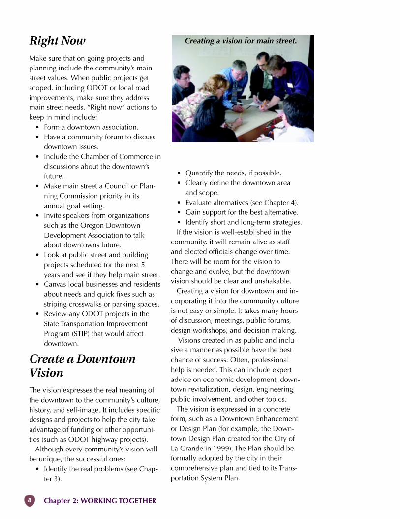
Creating a vision for main street.Right NowMake sure that on-going projects andplanning include the community’s mainstreet values. When public projects getscoped, including ODOT or local roadimprovements, make sure they addressmain street needs. “Right now” actions tokeep in mind include:
• Form a downtown association.• Have a community forum to discuss
downtown issues.• Include the Chamber of Commerce in
discussions about the downtown’sfuture.
• Make main street a Council or Plan-ning Commission priority in itsannual goal setting.
• Invite speakers from organizationssuch as the Oregon DowntownDevelopment Association to talkabout downtowns future.
• Look at public street and buildingprojects scheduled for the next 5years and see if they help main street.
• Canvas local businesses and residentsabout needs and quick fixes such asstriping crosswalks or parking spaces.
• Review any ODOT projects in theState Transportation ImprovementProgram (STIP) that would affectdowntown.
Create a DowntownVisionThe vision expresses the real meaning ofthe downtown to the community’s culture,history, and self-image. It includes specificdesigns and projects to help the city takeadvantage of funding or other opportuni-ties (such as ODOT highway projects).
Although every community’s vision willbe unique, the successful ones:
• Identify the real problems (see Chap-ter 3).
• Quantify the needs, if possible.• Clearly define the downtown area
and scope.• Evaluate alternatives (see Chapter 4).• Gain support for the best alternative.• Identify short and long-term strategies.If the vision is well-established in the
community, it will remain alive as staffand elected officials change over time.There will be room for the vision tochange and evolve, but the downtownvision should be clear and unshakable.
Creating a vision for downtown and in-corporating it into the community cultureis not easy or simple. It takes many hoursof discussion, meetings, public forums,design workshops, and decision-making.
Visions created in as public and inclu-sive a manner as possible have the bestchance of success. Often, professionalhelp is needed. This can include expertadvice on economic development, down-town revitalization, design, engineering,public involvement, and other topics.
The vision is expressed in a concreteform, such as a Downtown Enhancementor Design Plan (for example, the Down-town Design Plan created for the City ofLa Grande in 1999). The Plan should beformally adopted by the city in theircomprehensive plan and tied to its Trans-portation System Plan.
MAIN STREET HANDBOOK 9
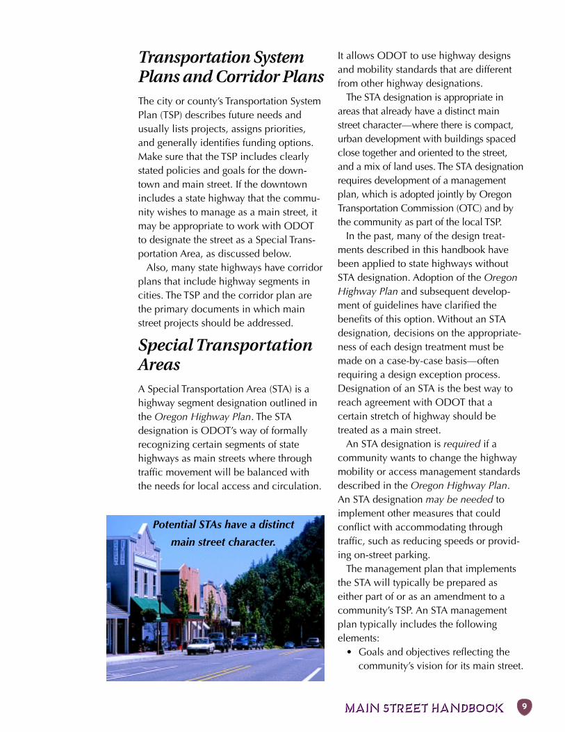
Potential STAs have a distinct
main street character.
Transportation SystemPlans and Corridor PlansThe city or county’s Transportation SystemPlan (TSP) describes future needs andusually lists projects, assigns priorities,and generally identifies funding options.Make sure that the TSP includes clearlystated policies and goals for the down-town and main street. If the downtownincludes a state highway that the commu-nity wishes to manage as a main street, itmay be appropriate to work with ODOTto designate the street as a Special Trans-portation Area, as discussed below.
Also, many state highways have corridorplans that include highway segments incities. The TSP and the corridor plan arethe primary documents in which mainstreet projects should be addressed.
Special TransportationAreasA Special Transportation Area (STA) is ahighway segment designation outlined inthe Oregon Highway Plan. The STAdesignation is ODOT’s way of formallyrecognizing certain segments of statehighways as main streets where throughtraffic movement will be balanced withthe needs for local access and circulation.
It allows ODOT to use highway designsand mobility standards that are differentfrom other highway designations.
The STA designation is appropriate inareas that already have a distinct mainstreet character—where there is compact,urban development with buildings spacedclose together and oriented to the street,and a mix of land uses. The STA designationrequires development of a managementplan, which is adopted jointly by OregonTransportation Commission (OTC) and bythe community as part of the local TSP.
In the past, many of the design treat-ments described in this handbook havebeen applied to state highways withoutSTA designation. Adoption of the OregonHighway Plan and subsequent develop-ment of guidelines have clarified thebenefits of this option. Without an STAdesignation, decisions on the appropriate-ness of each design treatment must bemade on a case-by-case basis—oftenrequiring a design exception process.Designation of an STA is the best way toreach agreement with ODOT that acertain stretch of highway should betreated as a main street.
An STA designation is required if acommunity wants to change the highwaymobility or access management standardsdescribed in the Oregon Highway Plan.An STA designation may be needed toimplement other measures that couldconflict with accommodating throughtraffic, such as reducing speeds or provid-ing on-street parking.
The management plan that implementsthe STA will typically be prepared aseither part of or as an amendment to acommunity’s TSP. An STA managementplan typically includes the followingelements:
• Goals and objectives reflecting thecommunity’s vision for its main street.
10 Chapter 2: WORKING TOGETHER
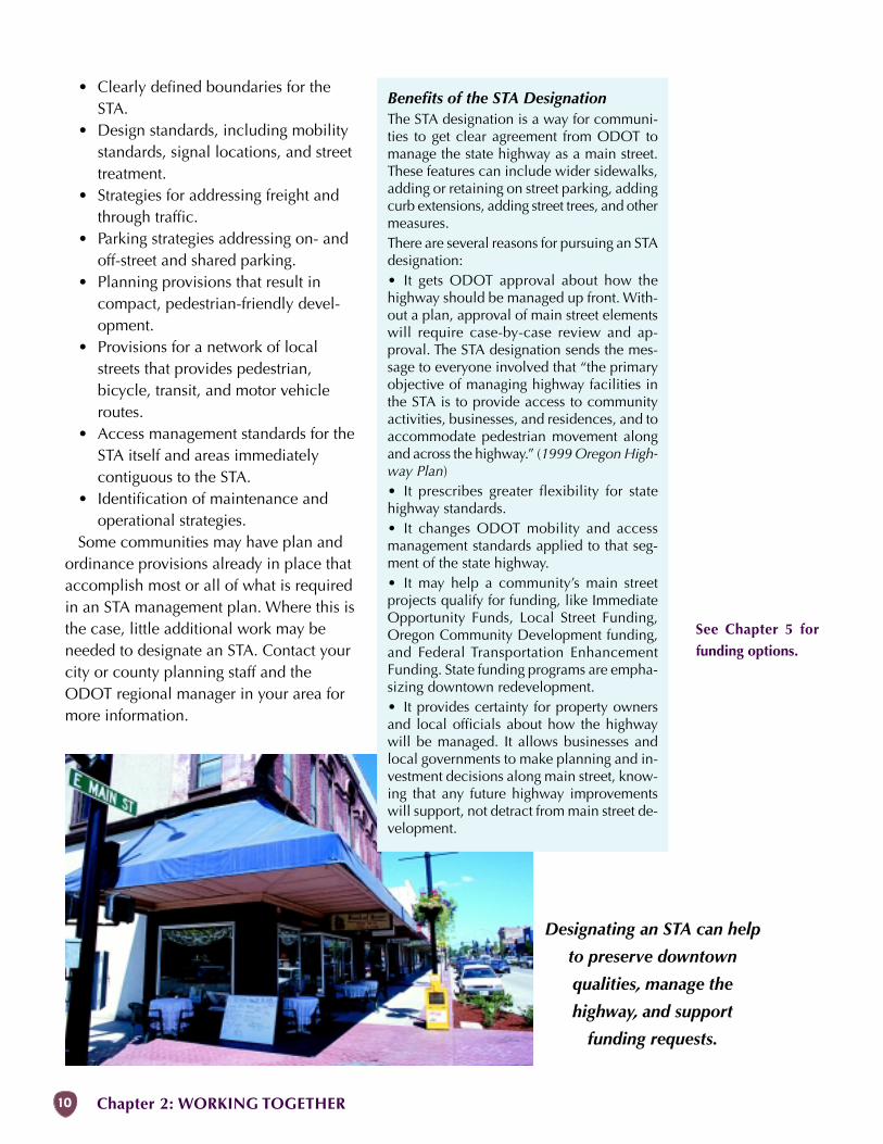
Designating an STA can help
to preserve downtown
qualities, manage the
highway, and support
funding requests.
• Clearly defined boundaries for theSTA.
• Design standards, including mobilitystandards, signal locations, and streettreatment.
• Strategies for addressing freight andthrough traffic.
• Parking strategies addressing on- andoff-street and shared parking.
• Planning provisions that result incompact, pedestrian-friendly devel-opment.
• Provisions for a network of localstreets that provides pedestrian,bicycle, transit, and motor vehicleroutes.
• Access management standards for theSTA itself and areas immediatelycontiguous to the STA.
• Identification of maintenance andoperational strategies.
Some communities may have plan andordinance provisions already in place thataccomplish most or all of what is requiredin an STA management plan. Where this isthe case, little additional work may beneeded to designate an STA. Contact yourcity or county planning staff and theODOT regional manager in your area formore information.
Benefits of the STA DesignationThe STA designation is a way for communi-ties to get clear agreement from ODOT tomanage the state highway as a main street.These features can include wider sidewalks,adding or retaining on street parking, addingcurb extensions, adding street trees, and othermeasures.There are several reasons for pursuing an STAdesignation:• It gets ODOT approval about how thehighway should be managed up front. With-out a plan, approval of main street elementswill require case-by-case review and ap-proval. The STA designation sends the mes-sage to everyone involved that “the primaryobjective of managing highway facilities inthe STA is to provide access to communityactivities, businesses, and residences, and toaccommodate pedestrian movement alongand across the highway.” (1999 Oregon High-way Plan)• It prescribes greater flexibility for statehighway standards.• It changes ODOT mobility and accessmanagement standards applied to that seg-ment of the state highway.• It may help a community’s main streetprojects qualify for funding, like ImmediateOpportunity Funds, Local Street Funding,Oregon Community Development funding,and Federal Transportation EnhancementFunding. State funding programs are empha-sizing downtown redevelopment.• It provides certainty for property ownersand local officials about how the highwaywill be managed. It allows businesses andlocal governments to make planning and in-vestment decisions along main street, know-ing that any future highway improvementswill support, not detract from main street de-velopment.
See Chapter 5 for
funding options.
MAIN STREET HANDBOOK 11
Codes and StandardsLocal codes and standards can encouragegood main street design (e.g.., how build-ings are oriented to the street, where theoff-street parking is located, access andparking management, wide sidewalks,etc.). Ideas for good downtown develop-ment will fail if they are not allowed be-cause of outdated, inappropriate, or in-complete ordinances. Even worse is theslow degradation of downtown fromcounterproductive parking requirements,setbacks, sign standards, etc.
Building codes require certain items,such as modern plumbing and roofs thatdon’t leak. But it is possible to have a newor remodeled building meet these de-mands and still fit in with the scale andtexture of downtown. Design guidelinesfor setbacks, roof lines, proportion of win-dows to walls, building materials, signs,and other basics can make sure that a newbuilding adds to downtown.
Examples of good development codes fordowntown are available in the Smart De-velopment Code Handbook (1997) pub-lished by the Transportation and GrowthManagement (TGM) Program. The hand-book describes common obstacles to gooddevelopment and provides guidance in de-termining whether local codes and stan-dards encourage or impede smart develop-ment. The TGM Model Development Codeand User’s Guide for Small Cities (1999)provides examples of specific code lan-guage.
Participate in the STIPProjects usually originate from ODOT’stransportation management systems, trans-portation system plans, or corridor plansthrough cities, counties, Area Commis-sions on Transportation (ACTs), or localgroups (such as downtown associations).
Once a transportation need has beenidentified, in a TSP or corridor plan or byODOT, the first step towards getting theproject implemented is to determine itsrelative priority among all the other identi-fied needs. As may be expected, identifiedprojects far outweigh available funds. Theprocess of assigning priorities is most suc-cessful when started at the local govern-ment or ACT level and advanced upwardsthrough ODOT to the Oregon Transporta-tion Commission.
Projects are entered into the draft StateTransportation Improvement Program(STIP) as priority and revenues allow. Dur-ing the open public input period betweenthe draft STIP and the final approved STIP,projects identified in the draft may bechanged due to public input or issues de-termined during project scoping.
The project scope is documented in aprospectus, which:
• describes the project’s nature andlimits,
• estimates the costs of constructionand right-of-way purchase,
• identifies environmental, land use,and funding issues, and
• is used to obtain the necessary ap-provals to begin work.
It is very important that the prospectusclearly communicates the specific goalsand objectives of the project. The prospec-tus for any project being developed for theSTIP is available from ODOT for reviewby local agencies and the public.
The key to success is to start off with aproject that is scoped properly and thendetailed properly in the prospectus. Notethat there are portions of a project, such assome street furniture, that may not befunded by ODOT; other sources of fund-ing must be identified in the early stagesof planning.
See Building Area:
Design and Land
Use in Chapter 4 for
for more develop-
ment code issues.
12 Chapter 2: WORKING TOGETHER
There are two major project types in theSTIP: modernization and preservation.Modernization projects are roadwaychanges built to accommodate existingtraffic and projected traffic growth. Typicalmodernization projects include:
• Addition of lanes.• New alignments.• Grade separations (over- and under-
passes).• Intersection changes.Preservation projects are meant to add
useful life to the road without increasingcapacity. Typical preservation projects in-clude paving with only minor safety im-provements.
Over the last several years, the funding inthe STIP has reflected ODOT’s focus on pre-serving existing roads and improving safetybefore adding new facilities. Fortunately forcities interested in improving their down-towns, preservation and safety are both is-sues that have a direct effect on main street.
The Oregon Transportation Commissionadopted a major improvements policy inthe Oregon Highway Plan to maintainhighway performance and improve safetyby improving system efficiency and man-agement before adding capacity. The pri-orities are to:
1. Protect the existing system.2. Improve efficiency and capacity of
existing highway facilities.3. Add capacity to the existing system.4. Add new facilities to the system.The STIP is for a 4-year period, with a 2-
year overlap (for example, 2002-2005).Public hearings on the proposed STIP con-tent are held during the spring before theactual funding year, and are adopted bythe Oregon Transportation Commission inthe fall of the same year. Revenue fore-casts for the STIP are initiated about 2years before the actual project period.
Since the content of the STIP is influ-enced by public and local government in-
put, it is critical for cities to maintain con-tact with local ODOT representatives, par-ticularly the region and area managers.State policy encourages citizens, busi-nesses and groups to have input into deci-sions that affect state highways (per Policy2D in the Oregon Highway Plan).
STIP projects are usually years in themaking, so cities and individuals need tomake the effort to keep locally importantprojects alive. In times of funding short-falls, the projects that have long-termchampions are the ones that get funded.
Follow-ThroughDo not relax after a project is added to theSTIP. Keep in touch with the project man-ager during the design phases to learnhow the main street objectives are beingaddressed. If ODOT highway design ex-ceptions are needed because of nonstand-ard elements (such as on-street parkingless than 8 ft wide), make sure that thesehave approval. Sometimes a project maybe assigned a new manager, in which caseit is wise to go through the history of theproject with them because they may notbe aware of the original discussions andcommunity objectives. During projectconstruction, check with the project man-ager on progress and any issues that maycome up—some design decisions are nec-essarily made in the field and you want tomake sure they are consistent with theproject’s objectives.Finally, do a walk-through of the com-pleted project andcongratulate themanager and teamon a job welldone! x
EXAMPLEMany downtown projects, such as Heppner(described in the case studies in Chapter 6),have been initiated by ODOT preservationoverlay projects, which are listed in the STIP.Because Heppner had an existing plan forits downtown, the city was able to work withODOT to expand the project scope beyonda simple pavement overlay, and was able toleverage additional funds for other downtownimprovements.
See Chapter 6 for
other examples.
MAIN STREET HANDBOOK 13
Recipe for SuccessThe Structure of the Street ... 14
Human Scale ................... 14Street Zones ..................... 14
Identify the Real Problem ..... 19Safety ............................... 20Security ............................ 21Comfort ........................... 22Speed .............................. 23Crossing ........................... 27Access ............................. 29Congestion ....................... 31
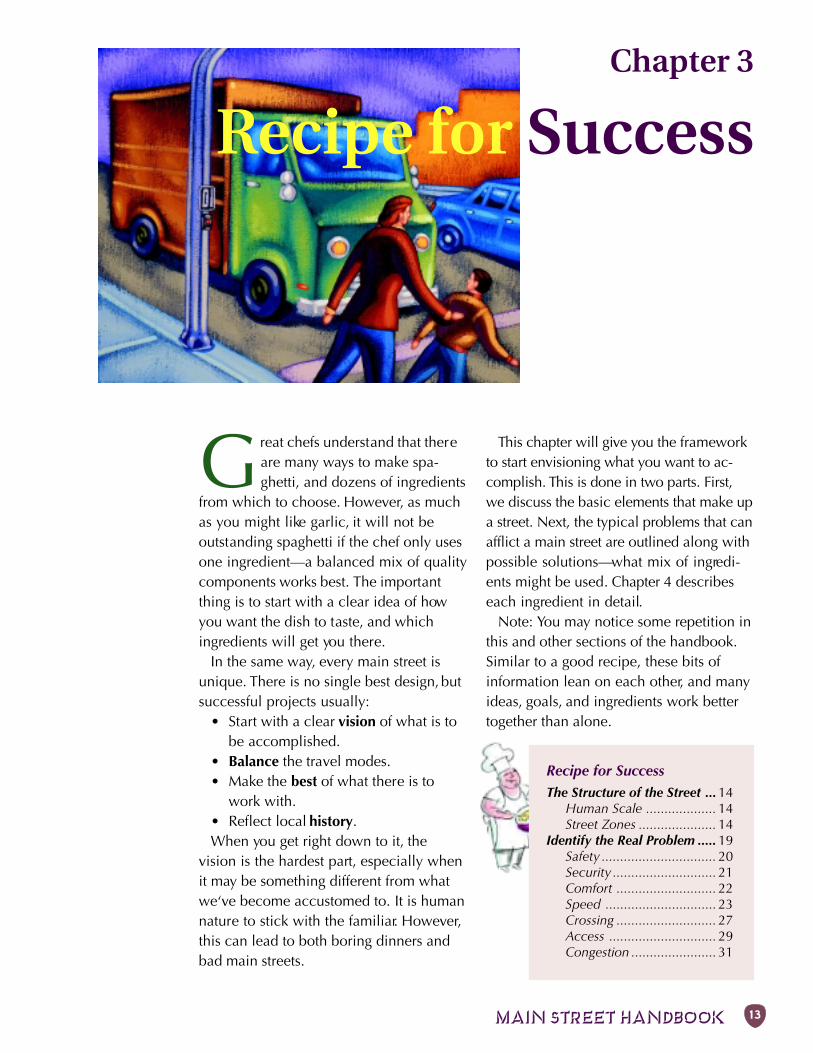
Great chefs understand that thereare many ways to make spa-ghetti, and dozens of ingredients
from which to choose. However, as muchas you might like garlic, it will not beoutstanding spaghetti if the chef only usesone ingredient—a balanced mix of qualitycomponents works best. The importantthing is to start with a clear idea of howyou want the dish to taste, and whichingredients will get you there.
In the same way, every main street isunique. There is no single best design, butsuccessful projects usually:
• Start with a clear vision of what is tobe accomplished.
• Balance the travel modes.• Make the best of what there is to
work with.• Reflect local history.When you get right down to it, the
vision is the hardest part, especially whenit may be something different from whatwe‘ve become accustomed to. It is humannature to stick with the familiar. However,this can lead to both boring dinners andbad main streets.
This chapter will give you the frameworkto start envisioning what you want to ac-complish. This is done in two parts. First,we discuss the basic elements that make upa street. Next, the typical problems that canafflict a main street are outlined along withpossible solutions—what mix of ingredi-ents might be used. Chapter 4 describeseach ingredient in detail.
Note: You may notice some repetition inthis and other sections of the handbook.Similar to a good recipe, these bits ofinformation lean on each other, and manyideas, goals, and ingredients work bettertogether than alone.
Chapter 3
Recipe for Success
Chapter 3: RECIPE FOR SUCCESS14
The Structure of the Street
LENG
TH
WIDTH
HEI
GH
T
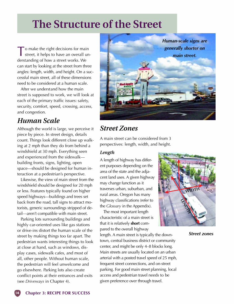
Street ZonesA main street can be considered from 3perspectives: length, width, and height.
Length
A length of highway has differ-ent purposes depending on thearea of the state and the adja-cent land uses. A given highwaymay change function as ittraverses urban, suburban, andrural areas. Oregon has manyhighway classifications (refer tothe Glossary in the Appendix).
The most important lengthcharacteristic of a main street isthat it is relatively short com-pared to the overall highwaylength. A main street is typically the down-town, central business district or communitycenter, and might be only 4–8 blocks long.Main streets are usually located on an urbanarterial with a posted travel speed of 25 mph,frequent street connections, and on-streetparking. For good main street planning, localaccess and pedestrian travel needs to begiven preference over through travel.
To make the right decisions for mainstreet, it helps to have an overall un-
derstanding of how a street works. Wecan start by looking at the street from threeangles: length, width, and height. On a suc-cessful main street, all of these dimensionsneed to be considered at a human scale.
After we understand how the mainstreet is supposed to work, we will look ateach of the primary traffic issues: safety,security, comfort, speed, crossing, access,and congestion.
Human ScaleAlthough the world is large, we perceive itpiece by piece. In street design, detailscount. Things look different close up walk-ing at 2 mph than they do from behind awindshield at 30 mph. Everything seenand experienced from the sidewalk—building fronts, signs, lighting, openspace—should be designed for human in-teraction at a pedestrian’s perspective.
Likewise, the view of main street from thewindshield should be designed for 20 mphor less. Features typically found on higherspeed highways—buildings and trees setback from the road, tall signs to attract mo-torists, generic surroundings stripped of de-tail—aren’t compatible with main street.
Parking lots surrounding buildings andhighly car-oriented uses like gas stationsor drive-ins distort the human scale of thestreet by making things too far apart. Thepedestrian wants interesting things to lookat close at hand, such as windows, dis-play cases, sidewalk cafes, and most ofall, other people. Without human scale,the pedestrian will feel unwelcome andgo elsewhere. Parking lots also createconflict points at their entrances and exits(see Driveways in Chapter 4).
Human-scale signs are
generally shorter on
main street.
Street zones
MAIN STREET HANDBOOK 15
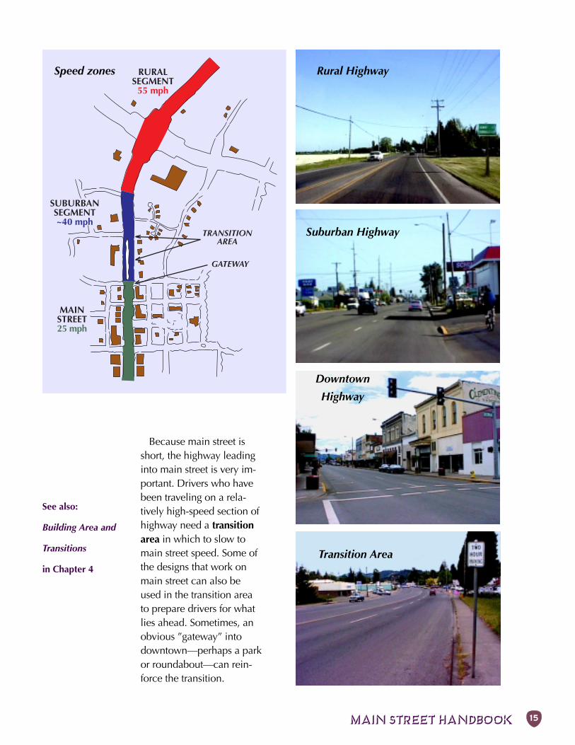
Rural Highway
Suburban Highway
Downtown
Highway
Transition Area
SUBURBANSEGMENT~40 mph
MAINSTREET25 mph
RURALSEGMENT
55 mph
GATEWAY
TRANSITIONAREA
Speed zones
See also:
Building Area and
Transitions
in Chapter 4
Because main street isshort, the highway leadinginto main street is very im-portant. Drivers who havebeen traveling on a rela-tively high-speed section ofhighway need a transitionarea in which to slow tomain street speed. Some ofthe designs that work onmain street can also beused in the transition areato prepare drivers for whatlies ahead. Sometimes, anobvious ”gateway” intodowntown—perhaps a parkor roundabout—can rein-force the transition.
Chapter 3: RECIPE FOR SUCCESS16
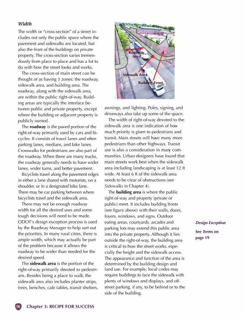
Width
The width or “cross-section” of a street in-cludes not only the public space where thepavement and sidewalks are located, butalso the front of the buildings on privateproperty. The cross-section varies tremen-dously from place to place and has a lot todo with how the street looks and works.
The cross-section of main street can bethought of as having 3 zones: the roadway,sidewalk area, and building area. Theroadway, along with the sidewalk area,are within the public right-of-way. Build-ing areas are typically the interface be-tween public and private property, exceptwhere the building or adjacent property ispublicly owned.
The roadway is the paved portion of theright-of-way primarily used by cars and bi-cycles. It consists of travel lanes and oftenparking lanes, medians, and bike lanes.Crosswalks for pedestrians are also part ofthe roadway. When there are many trucks,the roadway generally needs to have widerlanes, wider turns, and better pavement.
Bicyclists travel along the pavement edgesin either a lane shared with motorists, on ashoulder, or in a designated bike lane.There may be car parking between wherebicyclists travel and the sidewalk area.
There may not be enough roadwaywidth for all the desired uses and sometough decisions will need to be made.ODOT‘s design exception process is usedby the Roadway Manager to help sort outthe priorities. In many rural cities, there isample width, which may actually be partof the problem because it allows theroadway to be wider than needed for thedesired speed.
The sidewalk area is the portion of theright-of-way primarily devoted to pedestri-ans. Besides being a place to walk, thesidewalk area also includes planter strips,trees, benches, cafe tables, transit shelters,
awnings, and lighting. Poles, signing, anddriveways also take up some of the space.
The width of right-of-way devoted to thesidewalk area is one indication of howmuch priority is given to pedestrians andtransit. Main streets will have many morepedestrians than other highways. Transituse is also a consideration in many com-munities. Urban designers have found thatmain streets work best when the sidewalkarea including landscaping is at least 12 ftwide. At least 6 ft of the sidewalk areaneeds to be clear of obstructions (seeSidewalks in Chapter 4).
The building area is where the publicright-of-way and property (private orpublic) meet. It includes building fronts(see figure above) with their walls, doors,foyers, windows, and signs. Outdooreating areas, courtyards, arcades andparking lots may extend this public areainto the private property. Although it liesoutside the right-of-way, the building areais critical to how the street works, espe-cially the height and the sidewalk access.The appearance and function of the area isdetermined by the building design andland use. For example, local codes mayrequire buildings to face the sidewalk withplenty of windows and displays, and off-street parking, if any, to be behind or to theside of the building.
Design Exception
See Terms on
page 19
MAIN STREET HANDBOOK 17
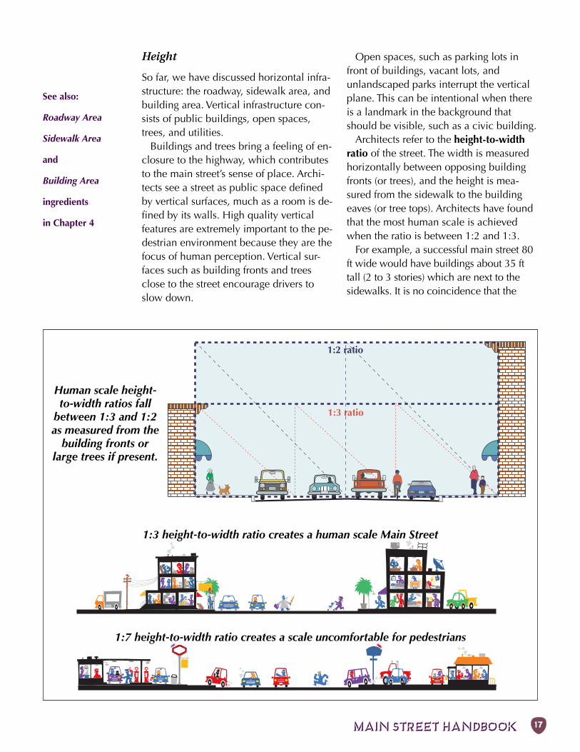
Street areas1:3 ratio
1:2 ratio
Human scale height-to-width ratios fall
between 1:3 and 1:2as measured from the
building fronts orlarge trees if present.
Height
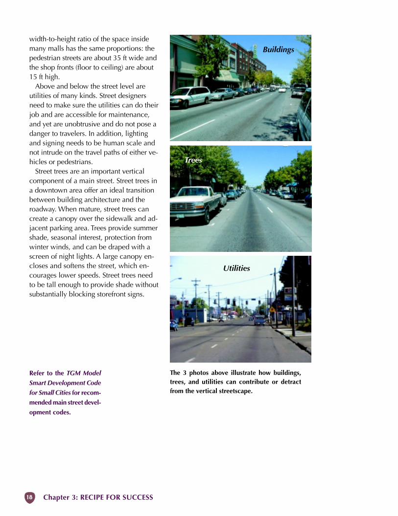
So far, we have discussed horizontal infra-structure: the roadway, sidewalk area, andbuilding area. Vertical infrastructure con-sists of public buildings, open spaces,trees, and utilities.
Buildings and trees bring a feeling of en-closure to the highway, which contributesto the main street’s sense of place. Archi-tects see a street as public space definedby vertical surfaces, much as a room is de-fined by its walls. High quality verticalfeatures are extremely important to the pe-destrian environment because they are thefocus of human perception. Vertical sur-faces such as building fronts and treesclose to the street encourage drivers toslow down.
See also:
Roadway Area
Sidewalk Area
and
Building Area
ingredients
in Chapter 4
Open spaces, such as parking lots infront of buildings, vacant lots, andunlandscaped parks interrupt the verticalplane. This can be intentional when thereis a landmark in the background thatshould be visible, such as a civic building.
Architects refer to the height-to-widthratio of the street. The width is measuredhorizontally between opposing buildingfronts (or trees), and the height is mea-sured from the sidewalk to the buildingeaves (or tree tops). Architects have foundthat the most human scale is achievedwhen the ratio is between 1:2 and 1:3.
For example, a successful main street 80ft wide would have buildings about 35 fttall (2 to 3 stories) which are next to thesidewalks. It is no coincidence that the
1:3 height-to-width ratio creates a human scale Main Street
1:7 height-to-width ratio creates a scale uncomfortable for pedestrians
Chapter 3: RECIPE FOR SUCCESS18
Refer to the TGM Model
Smart Development Code
for Small Cities for recom-
mended main street devel-
opment codes.
Buildings
Trees
Utilities
The 3 photos above illustrate how buildings,trees, and utilities can contribute or detractfrom the vertical streetscape.
width-to-height ratio of the space insidemany malls has the same proportions: thepedestrian streets are about 35 ft wide andthe shop fronts (floor to ceiling) are about15 ft high.
Above and below the street level areutilities of many kinds. Street designersneed to make sure the utilities can do theirjob and are accessible for maintenance,and yet are unobtrusive and do not pose adanger to travelers. In addition, lightingand signing needs to be human scale andnot intrude on the travel paths of either ve-hicles or pedestrians.
Street trees are an important verticalcomponent of a main street. Street trees ina downtown area offer an ideal transitionbetween building architecture and theroadway. When mature, street trees cancreate a canopy over the sidewalk and ad-jacent parking area. Trees provide summershade, seasonal interest, protection fromwinter winds, and can be draped with ascreen of night lights. A large canopy en-closes and softens the street, which en-courages lower speeds. Street trees needto be tall enough to provide shade withoutsubstantially blocking storefront signs.
MAIN STREET HANDBOOK 19
Design Exception: An ODOT procedure for usinghighway designs that deviate from the adoptedstandard in the Highway Design Manual.
Gateway: Something that marks the entrance todowntown.
Planter strip: A strip of right-of-way for trees andscrubs, usually between the sidewalk and roadway.
Right-of-way (ROW): A strip of public landbetween private properties that typically includesthe roadway and sidewalks.
Roadway: The paved portion of the highway, notincluding the sidewalk.
Also refer to the Glossary in the Appendix.
TYPICAL MAIN STREET CONCERNS
Safety• Can’t walk to stores.• Can’t turn left safely.• Bikes use the sidewalks.
Security• Downtown doesn’t feel safe.• There is too much graffiti.
Comfort• Noisy.• Unsightly.• Nowhere for kids or the elderly.
Speed• Traffic exceeds posted speed.• Drivers don’t slow down.
Crossing• Stop sign or signal wanted.• Crosswalks aren’t marked.• Kids can’t cross safely.
Access• Not enough parking.• Delivery trucks block street.• Median not acceptable to businesses.• Downtown not accessible to the dis-
abled.Congestion
• Too much traffic and delay.• Highway doesn’t meet performance
standards.• Too many trucks.• Cut-through traffic in neighborhoods.
Identify the Real Problem
It feels like there’s something wrong withmain street. But what is the problem?
Maybe there are only a few pedestrians,and you believe that this situation wouldbe improved by installing a traffic signal tomake it easier to cross the street. How-ever, a traffic signal may cause otherproblems. Sometimes a community willseize upon a specific solution, whenperhaps the best thing to do is take a stepback and get a better underst anding of thereal problem.
What is at the heart of the problem? Ismain street unsafe? How is it unsafe? Arethere too many cars, or is the problemreally that they are going too fast? Arethere too many driveway cuts? Are theremissing sidewalks?
This section of the handbook describesthe issues most often raised about mainstreets. It discusses the importance ofidentifying the real problems so thateffective fixes can be found.
Once the problems are well defined,move on to Chapter 4, which describessolutions (or ”ingredients”) in detail.
TERMSADA: Americans with Disabilities Act
Arterial: A road normally designated to carry trafficthrough an area rather than to local destinations.
Basic rule: A state law requiring vehicles to bedriven at a speed appropriate for the conditions.
Bikeway: Any of various facilities for bicycle travel(shared roadway, bike lane, etc.).
Canopy: The cover created by the upper branchesof trees.
Conflict: A collision or near collision whichrequires evasive action, generally between avehicle and another vehicle or pedestrian.
Although this Hand-
book focuses on the
physical problems of
main street, other
factors such as socio-
economic policies
and land use plan-
ning also contribute
to the success of a
main street.
Land use is discussed
under Building Area
in Chapter 4.
Chapter 3: RECIPE FOR SUCCESS20
Typical statement: “My grandmother can’twalk to the store.“
Possible problems: Sidewalks absent, poorlymaintained, or do not meet needs of the eld-erly (uneven surface, no ramps, etc.).
Potential ingredients: Basic sidewalkimprovements and maintenance.
S
Typical statement: “It’s scary to turn left onthe highway.“
Possible problems: Misuse of continuous cen-ter turn lane, too many driveways, multiplelanes to cross, and high speeds.
Potential ingredients: Raised median, chan-nelization, driveway management, traffic con-trols, and fewer travel lanes.
o
Typical statement: “How can we get the bikesoff of the sidewalks?“
Possible problems: Riders on sidewalk be-cause of poor street facilities or because theywant to go in the opposite direction and can’tcross the street easily.
Potential ingredients: Bikeways and frequent,short crossings.
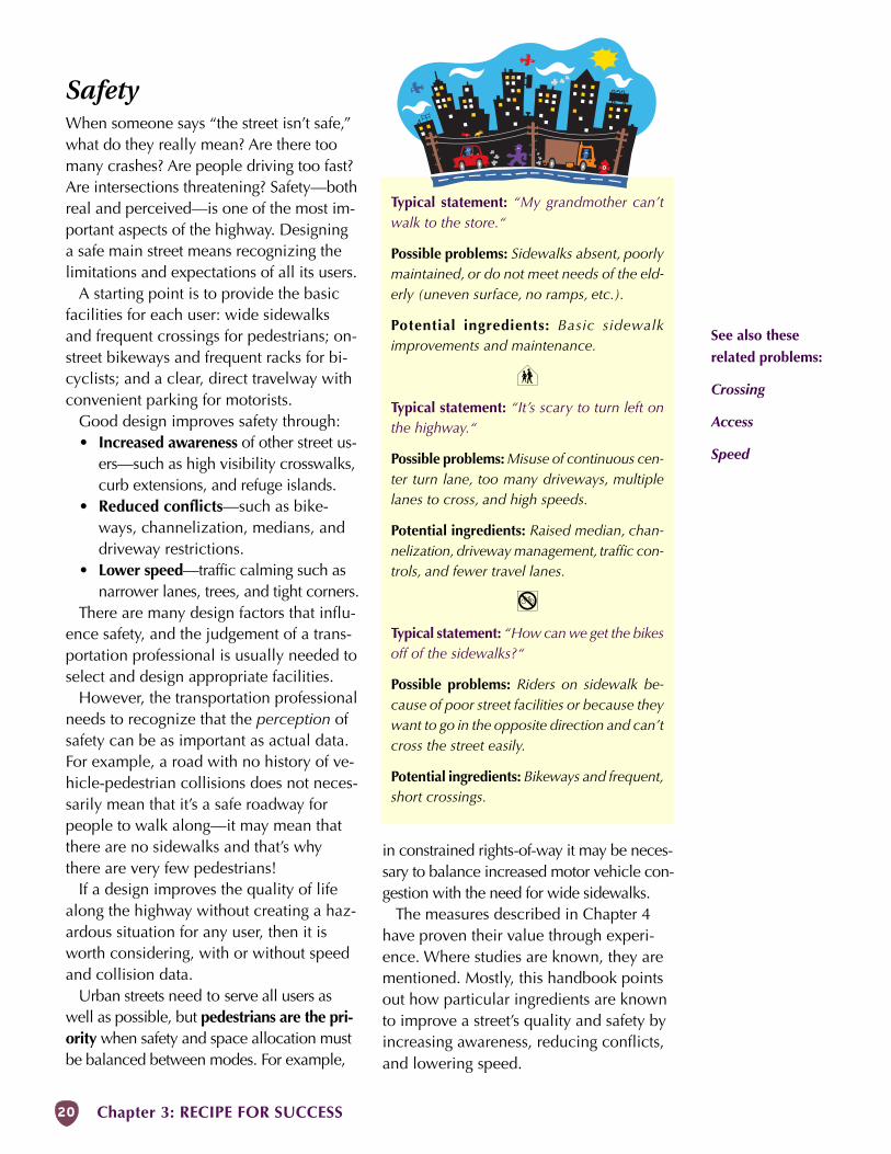
SafetyWhen someone says “the street isn’t safe,”what do they really mean? Are there toomany crashes? Are people driving too fast?Are intersections threatening? Safety—bothreal and perceived—is one of the most im-portant aspects of the highway. Designinga safe main street means recognizing thelimitations and expectations of all its users.
A starting point is to provide the basicfacilities for each user: wide sidewalksand frequent crossings for pedestrians; on-street bikeways and frequent racks for bi-cyclists; and a clear, direct travelway withconvenient parking for motorists.
Good design improves safety through:• Increased awareness of other street us-
ers—such as high visibility crosswalks,curb extensions, and refuge islands.
• Reduced conflicts—such as bike-ways, channelization, medians, anddriveway restrictions.
• Lower speed—traffic calming such asnarrower lanes, trees, and tight corners.
There are many design factors that influ-ence safety, and the judgement of a trans-portation professional is usually needed toselect and design appropriate facilities.
However, the transportation professionalneeds to recognize that the perception ofsafety can be as important as actual data.For example, a road with no history of ve-hicle-pedestrian collisions does not neces-sarily mean that it’s a safe roadway forpeople to walk along—it may mean thatthere are no sidewalks and that’s whythere are very few pedestrians!
If a design improves the quality of lifealong the highway without creating a haz-ardous situation for any user, then it isworth considering, with or without speedand collision data.
Urban streets need to serve all users aswell as possible, but pedestrians are the pri-ority when safety and space allocation mustbe balanced between modes. For example,
in constrained rights-of-way it may be neces-sary to balance increased motor vehicle con-gestion with the need for wide sidewalks.
The measures described in Chapter 4have proven their value through experi-ence. Where studies are known, they arementioned. Mostly, this handbook pointsout how particular ingredients are knownto improve a street’s quality and safety byincreasing awareness, reducing conflicts,and lowering speed.
See also these
related problems:
Crossing
Access
Speed
MAIN STREET HANDBOOK 21
EXAMPLES
In Bend, Oregon, the downtown association
worked with young people to build, install,
landscape, and maintain large concrete
planters. As a result of this new sense of own-
ership by young people who had not previ-
ously felt welcome in downtown, vandalism
(particularly graffiti) has decreased markedly.
In some cities, downtown merchants agree
to leave shop lights on until a set hour. Com-
bined with street and pedestrian lighting, this
practice adds an extra element of security to
main street. An added benefit is that people
can window shop after closing time.
Typical problem: “The downtown isn’t safeafter dark.“
Possible issues: Lack of good public spaces,too few people, poor lighting, and poor main-tenance.
Potential ingredients: Maintenance, street fur-niture (lighting, etc.), and evening activities.
ism) and increase perceived safety.Physically, a sense of security is created
through adequate lighting, removal ofovergrown vegetation and other “hidingplaces,” readily available telephones,buildings set close to the sidewalk, andfrequent shops and windows. It doesn’thurt to have the police department locateddowntown, either!
Ownership is a related principle. Whenthe community is proud of its downtown,everyone who owns a business or worksand shops on main street feels ownership.When the sense of ownership is strong,the street is well-maintained, and bad be-havior is not tolerated.
The ownership principle can be used todecrease vandalism. What this means instreet design is the creation of spaceswhere people are present and can observeeach other, and where they have enoughsense of ownership of the street that theywill take some action when troublehappens.
To be sure, creating a feeling of securitydemands a great deal of energy andresources. Urban safety issues are com-plex and go far beyond the physical—however, good design can greatly de-crease the impacts of these problems onmain street.
“Do not protect
yourself by a fence,
but rather by your
friends.”
–Czeck proverb
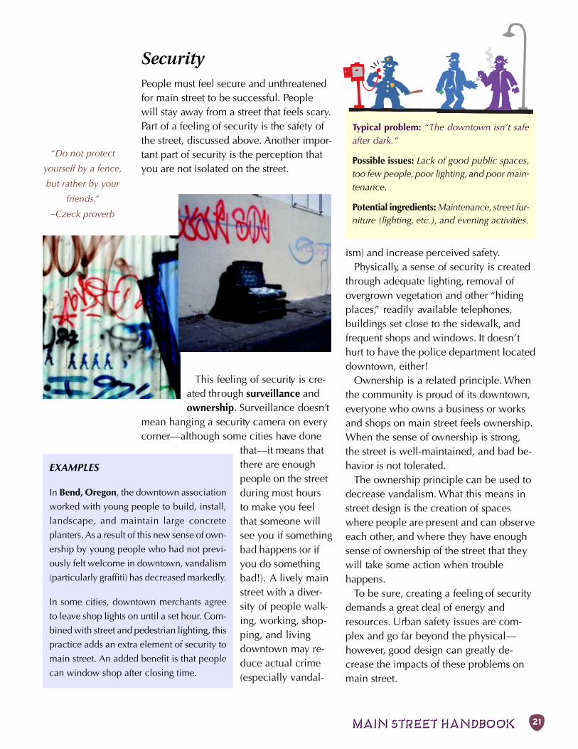
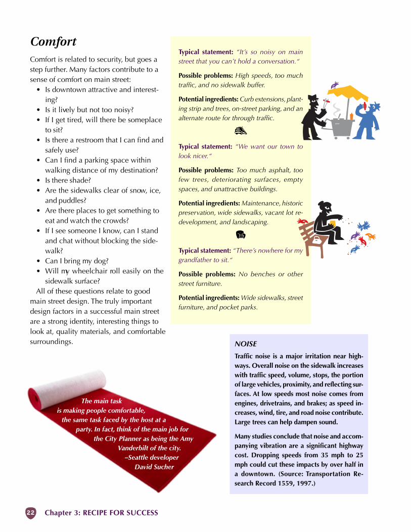
SecurityPeople must feel secure and unthreatenedfor main street to be successful. Peoplewill stay away from a street that feels scary.Part of a feeling of security is the safety ofthe street, discussed above. Another impor-tant part of security is the perception thatyou are not isolated on the street.
This feeling of security is cre-ated through surveillance andownership. Surveillance doesn’t
mean hanging a security camera on everycorner—although some cities have done
that—it means thatthere are enoughpeople on the streetduring most hoursto make you feelthat someone willsee you if somethingbad happens (or ifyou do somethingbad!). A lively mainstreet with a diver-sity of people walk-ing, working, shop-ping, and livingdowntown may re-duce actual crime(especially vandal-
Chapter 3: RECIPE FOR SUCCESS22
Typical statement: “It’s so noisy on mainstreet that you can’t hold a conversation.“
Possible problems: High speeds, too muchtraffic, and no sidewalk buffer.
Potential ingredients: Curb extensions, plant-ing strip and trees, on-street parking, and analternate route for through traffic.
g
Typical statement: “We want our town tolook nicer.“
Possible problems: Too much asphalt, toofew trees, deteriorating surfaces, emptyspaces, and unattractive buildings.
Potential ingredients: Maintenance, historicpreservation, wide sidewalks, vacant lot re-development, and landscaping.
2
Typical statement: “There’s nowhere for mygrandfather to sit.“
Possible problems: No benches or otherstreet furniture.
Potential ingredients: Wide sidewalks, streetfurniture, and pocket parks.
NOISE
Traffic noise is a major irritation near high-ways. Overall noise on the sidewalk increaseswith traffic speed, volume, stops, the portionof large vehicles, proximity, and reflecting sur-faces. At low speeds most noise comes fromengines, drivetrains, and brakes; as speed in-creases, wind, tire, and road noise contribute.Large trees can help dampen sound.
Many studies conclude that noise and accom-panying vibration are a significant highwaycost. Dropping speeds from 35 mph to 25mph could cut these impacts by over half ina downtown. (Source: Transportation Re-search Record 1559, 1997.)
The main taskis making people comfortable,
the same task faced by the host at aparty. In fact, think of the main job for
the City Planner as being the AmyVanderbilt of the city.
–Seattle developerDavid Sucher
ComfortComfort is related to security, but goes astep further. Many factors contribute to asense of comfort on main street:
• Is downtown attractive and interest-ing?
• Is it lively but not too noisy?• If I get tired, will there be someplace
to sit?• Is there a restroom that I can find and
safely use?• Can I find a parking space within
walking distance of my destination?• Is there shade?• Are the sidewalks clear of snow, ice,
and puddles?• Are there places to get something to
eat and watch the crowds?• If I see someone I know, can I stand
and chat without blocking the side-walk?
• Can I bring my dog?• Will my wheelchair roll easily on the
sidewalk surface?All of these questions relate to good
main street design. The truly importantdesign factors in a successful main streetare a strong identity, interesting things tolook at, quality materials, and comfortablesurroundings.
MAIN STREET HANDBOOK 23
SpeedSpeed is one of the most talked abouthighway issues and most highway designis closely related to it, but it is surprisinglydifficult to understand. The differences be-tween posted speed, design speed, andrunning speed are hard to grasp, espe-cially as they relate to low-speed pedes-trian areas. The Basic Rule also compli-cates the issue.
In a nutshell, the speed of a street seg-ment can be defined as follows:
Posted speed — The maximum speedconsidered prudent to drive consider-ing land use and other factors. Someposted speeds are set by statute andothers are set by the State SpeedBoard.
Design speed — The maximum safespeed that can be driven in free-flowingtraffic and good weather. The designspeed has a direct effect on the cost,safety, and capacity of the roadway.
Running speed — The average speed atwhich most vehicles travel in a givensection of highway.
Basic Rule — The appropriate speed forthe conditions.
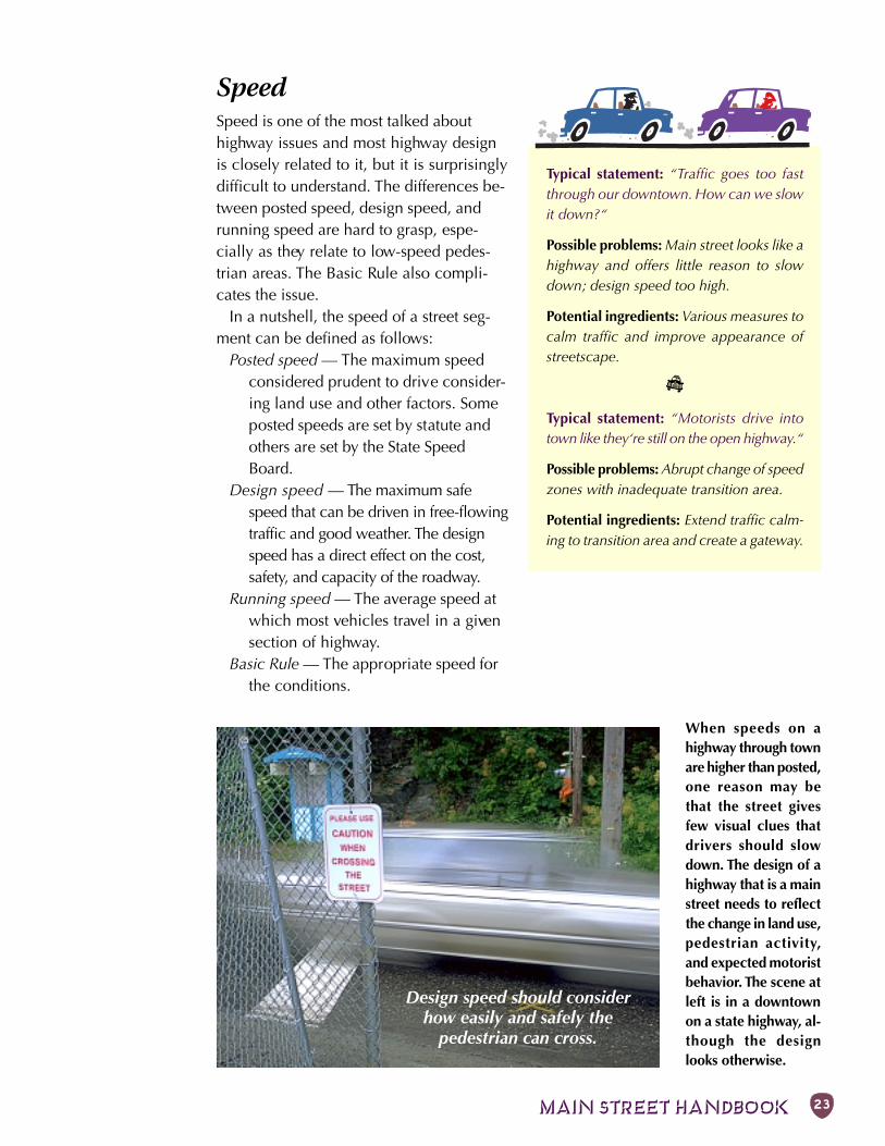
When speeds on ahighway through townare higher than posted,one reason may bethat the street givesfew visual clues thatdrivers should slowdown. The design of ahighway that is a mainstreet needs to reflectthe change in land use,pedestrian activity,and expected motoristbehavior. The scene atleft is in a downtownon a state highway, al-though the designlooks otherwise.
Typical statement: “Traffic goes too fastthrough our downtown. How can we slowit down?“
Possible problems: Main street looks like ahighway and offers little reason to slowdown; design speed too high.
Potential ingredients: Various measures tocalm traffic and improve appearance ofstreetscape.
D
Typical statement: “Motorists drive intotown like they‘re still on the open highway.“
Possible problems: Abrupt change of speedzones with inadequate transition area.
Potential ingredients: Extend traffic calm-ing to transition area and create a gateway.
Design speed should considerhow easily and safely the
pedestrian can cross.
Chapter 3: RECIPE FOR SUCCESS24
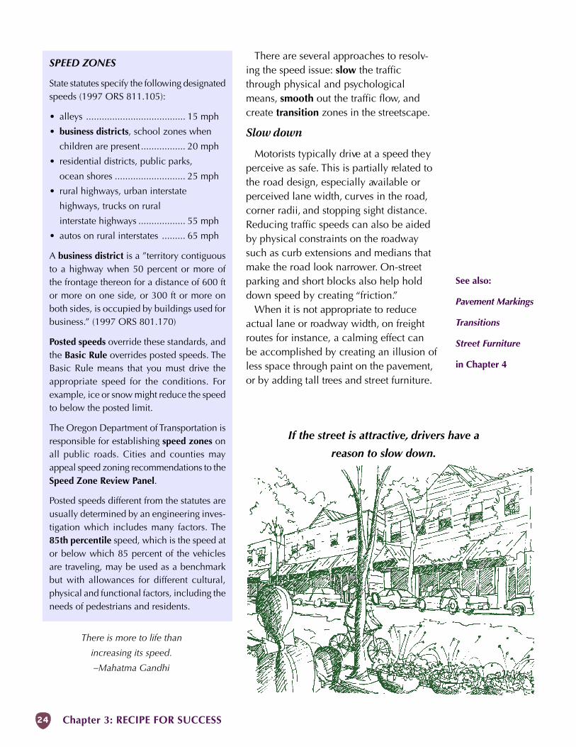
There are several approaches to resolv-ing the speed issue: slow the trafficthrough physical and psychologicalmeans, smooth out the traffic flow, andcreate transition zones in the streetscape.
Slow down
Motorists typically drive at a speed theyperceive as safe. This is partially related tothe road design, especially available orperceived lane width, curves in the road,corner radii, and stopping sight distance.Reducing traffic speeds can also be aidedby physical constraints on the roadwaysuch as curb extensions and medians thatmake the road look narrower. On-streetparking and short blocks also help holddown speed by creating “friction.”
When it is not appropriate to reduceactual lane or roadway width, on freightroutes for instance, a calming effect canbe accomplished by creating an illusion ofless space through paint on the pavement,or by adding tall trees and street furniture.
If the street is attractive, drivers have a
reason to slow down.
SPEED ZONES
State statutes specify the following designatedspeeds (1997 ORS 811.105):
• alleys ...................................... 15 mph
• business districts, school zones when
children are present................. 20 mph
• residential districts, public parks,
ocean shores ........................... 25 mph
• rural highways, urban interstate
highways, trucks on rural
interstate highways .................. 55 mph
• autos on rural interstates ......... 65 mph
A business district is a ”territory contiguousto a highway when 50 percent or more ofthe frontage thereon for a distance of 600 ftor more on one side, or 300 ft or more onboth sides, is occupied by buildings used forbusiness.” (1997 ORS 801.170)
Posted speeds override these standards, andthe Basic Rule overrides posted speeds. TheBasic Rule means that you must drive theappropriate speed for the conditions. Forexample, ice or snow might reduce the speedto below the posted limit.
The Oregon Department of Transportation isresponsible for establishing speed zones onall public roads. Cities and counties mayappeal speed zoning recommendations to theSpeed Zone Review Panel.
Posted speeds different from the statutes areusually determined by an engineering inves-tigation which includes many factors. The85th percentile speed, which is the speed ator below which 85 percent of the vehiclesare traveling, may be used as a benchmarkbut with allowances for different cultural,physical and functional factors, including theneeds of pedestrians and residents.
There is more to life than
increasing its speed.
–Mahatma Gandhi
See also:
Pavement Markings
Transitions
Street Furniture
in Chapter 4
MAIN STREET HANDBOOK 25
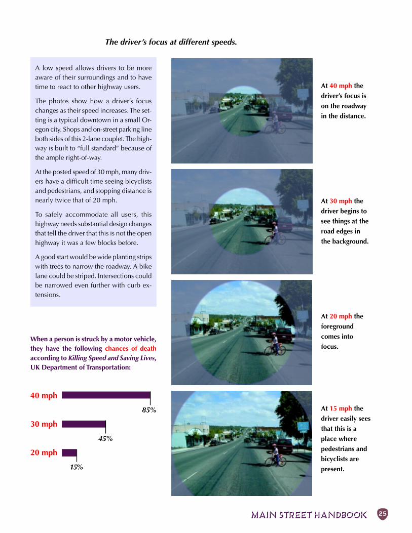
The driver’s focus at different speeds.
At 40 mph the
driver’s focus is
on the roadway
in the distance.
At 30 mph the
driver begins to
see things at the
road edges in
the background.
At 20 mph the
foreground
comes into
focus.
At 15 mph the
driver easily sees
that this is a
place where
pedestrians and
bicyclists are
present.
When a person is struck by a motor vehicle,they have the following chances of deathaccording to Killing Speed and Saving Lives,UK Department of Transportation:
40 mph
85%
30 mph
45%
20 mph
15%
A low speed allows drivers to be moreaware of their surroundings and to havetime to react to other highway users.
The photos show how a driver’s focuschanges as their speed increases. The set-ting is a typical downtown in a small Or-egon city. Shops and on-street parking lineboth sides of this 2-lane couplet. The high-way is built to “full standard” because ofthe ample right-of-way.
At the posted speed of 30 mph, many driv-ers have a difficult time seeing bicyclistsand pedestrians, and stopping distance isnearly twice that of 20 mph.
To safely accommodate all users, thishighway needs substantial design changesthat tell the driver that this is not the openhighway it was a few blocks before.
A good start would be wide planting stripswith trees to narrow the roadway. A bikelane could be striped. Intersections couldbe narrowed even further with curb ex-tensions.
Chapter 3: RECIPE FOR SUCCESS26
“Be not afraid of
going slowly, be
afraid only of
standing still.”
–Chinese proverb
Good design also includes an attractivestreetscape that makes drivers want toslow down. In particular, visible outdoorcafés and other sidewalk activities beckonthe motorist to enjoy the surroundings.
Smooth outSpeeding and general traffic operation canoften be addressed by smoothing out thetraffic flow. Slow, steady traffic conditionsare safer and can handle more cars thanerratic, stop-and-go conditions. There areseveral proven ways to smooth out traffic:
• Synchronize a series of signals at a lowspeed with short, fixed-length cycles.
• Shift driveway accesses so that thereare fewer than one or two drivewaysper block; combine driveways or shiftthem to side streets.
• Convert 4-lane streets to 3 lanes (2travel lanes with a center turn lane)where there are large numbers of leftturns; 3 lanes can work better than 4because turning cars can wait with-out blocking a through lane.
• At an intersection close to the begin-ning of main street, install a modernroundabout (a slow-speed intersectiontreatment where entering motoristsyield to those already in the intersec-tion) to compel drivers to slow down.
TransitionThe boundaries of a good downtown areeasy to identify. As you travel along a suc-cessful main street, the pavement widthand sidewalk width, building types, andlandscaping change to provide a cleartransition into the downtown. This cluesthe motorist to slow down and expect pe-destrians, cars pulling out from parking, andsomeplace pleasant to stop. There are sev-eral ways to reinforce the proper message:
• Add a gateway: make the entrance tothe downtown look special with curbs,a landscaped median, fountain, monu-ment marker, a welcome sign, publicart, or banners announcing events.
• Add other visual cues that make thedriver aware that they are entering anarea of intense human activity such asplanters, landscaping, ornamental light-ing, flags, benches, and other street fur-niture. These send a clear message thatpeople are present. Strong vertical ele-ments near the curb line such as treesalso visually narrow the street.
• Widen the sidewalks and make thehighway look narrower. In smallercommunities, moving from a ruralhighway section with shoulders anddriveways to an urban section withcurbs, sidewalks, and on-street parkingis a strong visual cue.
• Construct a modern roundabout withan attractive center island.
• Long-term, encourage redevelopmentof off-street parking to bring buildingscloser to the street.
• Emphasize access management at theentrances to downtown by adding me-dians and combining driveways.
These features are not necessarily expen-sive but do require community vision andcommitment. As the city grows, the mainstreet can be expanded into the properly de-signed transition area.
LIABILITYAt some point in the effort to reduce traffic speeds, someone mayquestion the potential liability of introducing traffic calming onto ahighway. This has not proven to be a problem on urban streets. In1997, the Institute of Transportation Engineers surveyed 68 agenciesresponsible for about 900 traffic calming projects and found that only6 lawsuits out of 1,500 filed against these agencies involved trafficcalming, and only 2 of the suits were successful.Experience confirms that the potential benefits of traffic calming faroutweigh the potential liability. Lawsuits can be minimized in thesame way as other aspects of highway design:• Clear policy.• Good process that involves the public and documents the need.• Appropriate design based on established goals.• Consideration of users, especially the young, elderly, and disabled.• Clear and consistent signing and marking.• Proper maintenance.If in doubt about a particular project, consult legal counsel and otheragencies that have implemented similar designs.
See also:
Transitionsin Chapter 4
MAIN STREET HANDBOOK 27
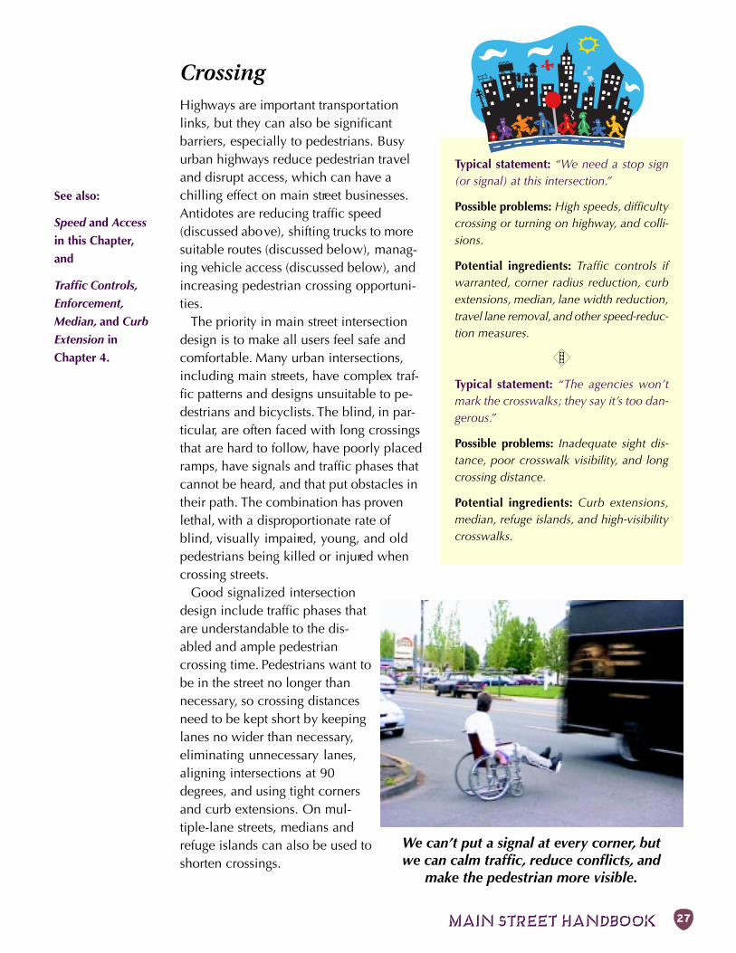
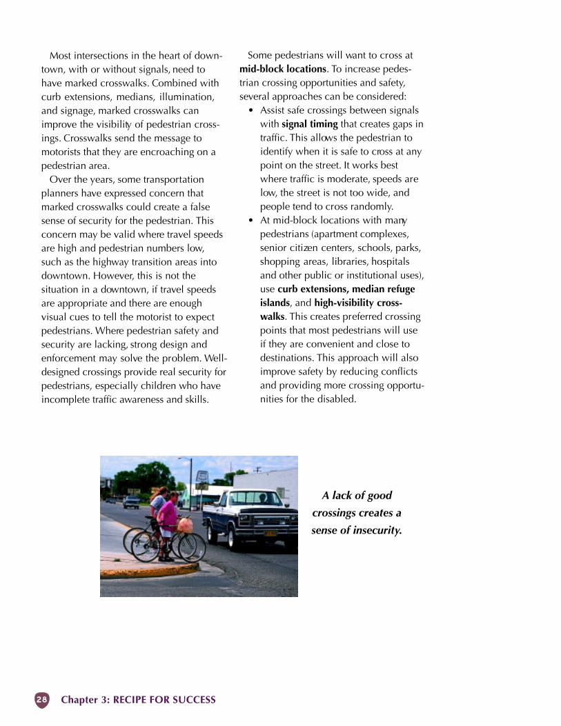
CrossingHighways are important transportationlinks, but they can also be significantbarriers, especially to pedestrians. Busyurban highways reduce pedestrian traveland disrupt access, which can have achilling effect on main street businesses.Antidotes are reducing traffic speed(discussed above), shifting trucks to moresuitable routes (discussed below), manag-ing vehicle access (discussed below), andincreasing pedestrian crossing opportuni-ties.
The priority in main street intersectiondesign is to make all users feel safe andcomfortable. Many urban intersections,including main streets, have complex traf-fic patterns and designs unsuitable to pe-destrians and bicyclists. The blind, in par-ticular, are often faced with long crossingsthat are hard to follow, have poorly placedramps, have signals and traffic phases thatcannot be heard, and that put obstacles intheir path. The combination has provenlethal, with a disproportionate rate ofblind, visually impaired, young, and oldpedestrians being killed or injured whencrossing streets.
Good signalized intersectiondesign include traffic phases thatare understandable to the dis-abled and ample pedestriancrossing time. Pedestrians want tobe in the street no longer thannecessary, so crossing distancesneed to be kept short by keepinglanes no wider than necessary,eliminating unnecessary lanes,aligning intersections at 90degrees, and using tight cornersand curb extensions. On mul-tiple-lane streets, medians andrefuge islands can also be used toshorten crossings.
Typical statement: “We need a stop sign(or signal) at this intersection.”
Possible problems: High speeds, difficultycrossing or turning on highway, and colli-sions.
Potential ingredients: Traffic controls ifwarranted, corner radius reduction, curbextensions, median, lane width reduction,travel lane removal, and other speed-reduc-tion measures.
H
Typical statement: “The agencies won’tmark the crosswalks; they say it’s too dan-gerous.”
Possible problems: Inadequate sight dis-tance, poor crosswalk visibility, and longcrossing distance.
Potential ingredients: Curb extensions,median, refuge islands, and high-visibilitycrosswalks.
We can’t put a signal at every corner, butwe can calm traffic, reduce conflicts, and
make the pedestrian more visible.
See also:
Speed and Access
in this Chapter,
and
Traffic Controls,
Enforcement,
Median, and Curb
Extension in
Chapter 4.
Chapter 3: RECIPE FOR SUCCESS28
Most intersections in the heart of down-town, with or without signals, need tohave marked crosswalks. Combined withcurb extensions, medians, illumination,and signage, marked crosswalks canimprove the visibility of pedestrian cross-ings. Crosswalks send the message tomotorists that they are encroaching on apedestrian area.
Over the years, some transportationplanners have expressed concern thatmarked crosswalks could create a falsesense of security for the pedestrian. Thisconcern may be valid where travel speedsare high and pedestrian numbers low,such as the highway transition areas intodowntown. However, this is not thesituation in a downtown, if travel speedsare appropriate and there are enoughvisual cues to tell the motorist to expectpedestrians. Where pedestrian safety andsecurity are lacking, strong design andenforcement may solve the problem. Well-designed crossings provide real security forpedestrians, especially children who haveincomplete traffic awareness and skills.
Some pedestrians will want to cross atmid-block locations. To increase pedes-trian crossing opportunities and safety,several approaches can be considered:
• Assist safe crossings between signalswith signal timing that creates gaps intraffic. This allows the pedestrian toidentify when it is safe to cross at anypoint on the street. It works bestwhere traffic is moderate, speeds arelow, the street is not too wide, andpeople tend to cross randomly.
• At mid-block locations with manypedestrians (apartment complexes,senior citizen centers, schools, parks,shopping areas, libraries, hospitalsand other public or institutional uses),use curb extensions, median refugeislands, and high-visibility cross-walks. This creates preferred crossingpoints that most pedestrians will useif they are convenient and close todestinations. This approach will alsoimprove safety by reducing conflictsand providing more crossing opportu-nities for the disabled.
A lack of good
crossings creates a
sense of insecurity.
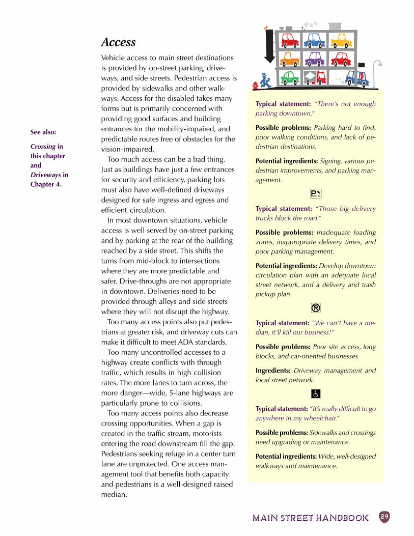
MAIN STREET HANDBOOK 29
AccessVehicle access to main street destinationsis provided by on-street parking, drive-ways, and side streets. Pedestrian access isprovided by sidewalks and other walk-ways. Access for the disabled takes manyforms but is primarily concerned withproviding good surfaces and buildingentrances for the mobility-impaired, andpredictable routes free of obstacles for thevision-impaired.
Too much access can be a bad thing.Just as buildings have just a few entrancesfor security and efficiency, parking lotsmust also have well-defined drivewaysdesigned for safe ingress and egress andefficient circulation.
In most downtown situations, vehicleaccess is well served by on-street parkingand by parking at the rear of the buildingreached by a side street. This shifts theturns from mid-block to intersectionswhere they are more predictable andsafer. Drive-throughs are not appropriatein downtown. Deliveries need to beprovided through alleys and side streetswhere they will not disrupt the highway.
Too many access points also put pedes-trians at greater risk, and driveway cuts canmake it difficult to meet ADA standards.
Too many uncontrolled accesses to ahighway create conflicts with throughtraffic, which results in high collisionrates. The more lanes to turn across, themore danger—wide, 5-lane highways areparticularly prone to collisions.
Too many access points also decreasecrossing opportunities. When a gap iscreated in the traffic stream, motoristsentering the road downstream fill the gap.Pedestrians seeking refuge in a center turnlane are unprotected. One access man-agement tool that benefits both capacityand pedestrians is a well-designed raisedmedian.
Typical statement: “There’s not enoughparking downtown.”
Possible problems: Parking hard to find,poor walking conditions, and lack of pe-destrian destinations.
Potential ingredients: Signing, various pe-destrian improvements, and parking man-agement.
R
Typical statement: “Those big deliverytrucks block the road.”
Possible problems: Inadequate loadingzones, inappropriate delivery times, andpoor parking management.
Potential ingredients: Develop downtowncirculation plan with an adequate localstreet network, and a delivery and trashpickup plan.
Q
Typical statement: “We can’t have a me-dian, it’ll kill our business!”
Possible problems: Poor site access, longblocks, and car-oriented businesses.
Ingredients: Driveway management andlocal street network.
T
Typical statement: “It’s really difficult to goanywhere in my wheelchair.”
Possible problems: Sidewalks and crossingsneed upgrading or maintenance.
Potential ingredients: Wide, well-designedwalkways and maintenance.
See also:
Crossing inthis chapterandDriveways inChapter 4.
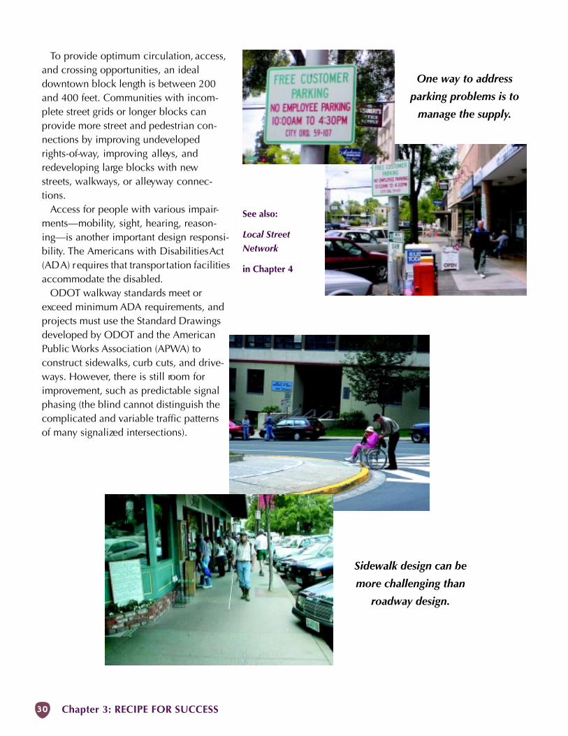
Chapter 3: RECIPE FOR SUCCESS30
To provide optimum circulation, access,and crossing opportunities, an idealdowntown block length is between 200and 400 feet. Communities with incom-plete street grids or longer blocks canprovide more street and pedestrian con-nections by improving undevelopedrights-of-way, improving alleys, andredeveloping large blocks with newstreets, walkways, or alleyway connec-tions.
Access for people with various impair-ments—mobility, sight, hearing, reason-ing—is another important design responsi-bility. The Americans with Disabilities Act(ADA) requires that transportation facilitiesaccommodate the disabled.
ODOT walkway standards meet orexceed minimum ADA requirements, andprojects must use the Standard Drawingsdeveloped by ODOT and the AmericanPublic Works Association (APWA) toconstruct sidewalks, curb cuts, and drive-ways. However, there is still room forimprovement, such as predictable signalphasing (the blind cannot distinguish thecomplicated and variable traffic patternsof many signalized intersections).
One way to address
parking problems is to
manage the supply.
Sidewalk design can be
more challenging than
roadway design.
See also:
Local Street
Network
in Chapter 4
MAIN STREET HANDBOOK 31
CongestionCongestion is usually at the top of thecomplaint list for highways and mainstreet. However, congestion is a slipperything. In most places, congestion meansdelay for motorists and other road users,but only peaks once or twice a day.
It is undesirable to build all of ourhighways for the worst possible conges-tion because it can result in roads that areunnecessarily wide and expensive andthat encourage low-value trips. We needto look carefully at what we‘re trying to
Typical statement: “There’s too much traf-fic downtown.”
Possible problems: Overreliance on high-way for local traffic, inadequate access, andunattractive street.
Potential ingredients: Local street networkand various sidewalk area improvements.
Q
Typical statement: “The highway is failingto reach its designated mobility standard.”
Possible problems: Lack of alternate routesand inefficient use of existing routes.
Potential ingredients: Local street network,transit, secondary route, couplet, bypass,and traffic controls.
§
Typical statement: “If only there was someway to get the big trucks out of down-town—they’re so noisy and smelly!”
Possible problems: Few alternatives for lo-cal traffic, sidewalks too narrow, and un-coordinated signal timing.
Potential ingredients: Truck route arounddowntown, wider sidewalks, buffer for side-walk, and improved signal timing.
i
Typical statement: “Cars cut through ourneighborhood to avoid the highway.”
Possible problems: Delay at main street in-tersections and overbuilt local streets.
Potential ingredients: Traffic controls andimproved local street network.
EXAMPLE
In some places, congestion only occurs when
there is a holiday weekend or a big event, as
in Sisters, Oregon. As the planning director
of that city says, “Most days you could bowl
on the state highway without fear, but around
a dozen times a year, it can take 20 minutes
to travel 6 blocks.”
To cope with predictable congestion, the city
and ODOT agreed to sign temporary detours
around main street on parallel arterials for
peak congestion periods.
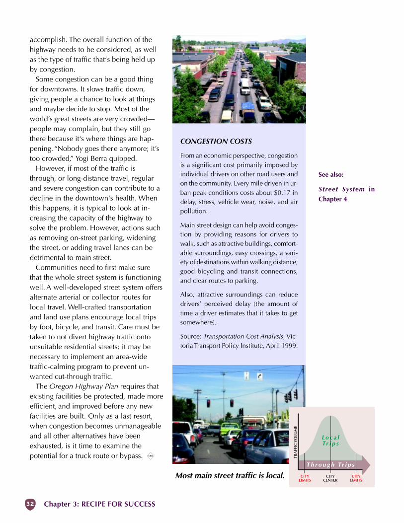
Chapter 3: RECIPE FOR SUCCESS32
accomplish. The overall function of thehighway needs to be considered, as wellas the type of traffic that‘s being held upby congestion.
Some congestion can be a good thingfor downtowns. It slows traffic down,giving people a chance to look at thingsand maybe decide to stop. Most of theworld‘s great streets are very crowded—people may complain, but they still gothere because it‘s where things are hap-pening. “Nobody goes there anymore; it’stoo crowded,” Yogi Berra quipped.
However, if most of the traffic isthrough, or long-distance travel, regularand severe congestion can contribute to adecline in the downtown‘s health. Whenthis happens, it is typical to look at in-creasing the capacity of the highway tosolve the problem. However, actions suchas removing on-street parking, wideningthe street, or adding travel lanes can bedetrimental to main street.
Communities need to first make surethat the whole street system is functioningwell. A well-developed street system offersalternate arterial or collector routes forlocal travel. Well-crafted transportationand land use plans encourage local tripsby foot, bicycle, and transit. Care must betaken to not divert highway traffic ontounsuitable residential streets; it may benecessary to implement an area-widetraffic-calming program to prevent un-wanted cut-through traffic.
The Oregon Highway Plan requires thatexisting facilities be protected, made moreefficient, and improved before any newfacilities are built. Only as a last resort,when congestion becomes unmanageableand all other alternatives have beenexhausted, is it time to examine thepotential for a truck route or bypass. x
CONGESTION COSTS
From an economic perspective, congestionis a significant cost primarily imposed byindividual drivers on other road users andon the community. Every mile driven in ur-ban peak conditions costs about $0.17 indelay, stress, vehicle wear, noise, and airpollution.
Main street design can help avoid conges-tion by providing reasons for drivers towalk, such as attractive buildings, comfort-able surroundings, easy crossings, a vari-ety of destinations within walking distance,good bicycling and transit connections,and clear routes to parking.
Also, attractive surroundings can reducedrivers’ perceived delay (the amount oftime a driver estimates that it takes to getsomewhere).
Source: Transportation Cost Analysis, Vic-toria Transport Policy Institute, April 1999.
TRA
FFIC
VO
LUM
E
CITYCENTER
Most main street traffic is local.
See also:
Street System in
Chapter 4
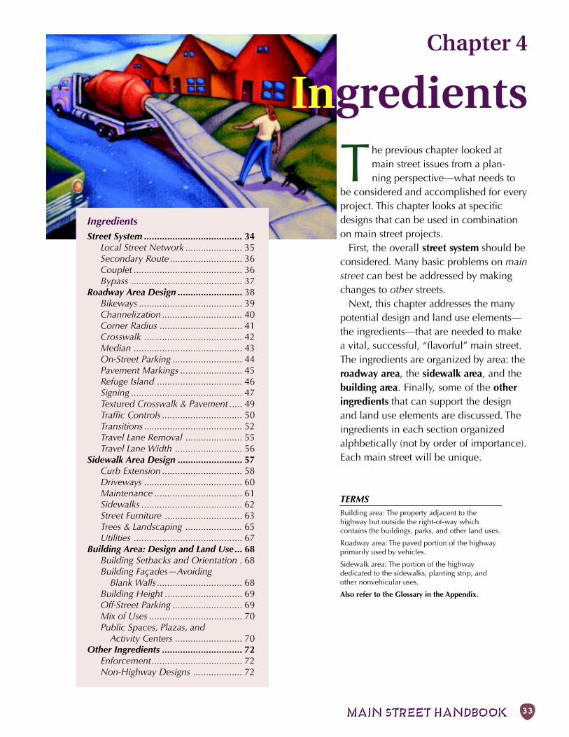
MAIN STREET HANDBOOK 33
Chapter 4
Ingredients
IngredientsStreet System ...................................... 34
Local Street Network ...................... 35Secondary Route ............................ 36Couplet .......................................... 36Bypass ........................................... 37
Roadway Area Design ......................... 38Bikeways ........................................ 39Channelization ............................... 40Corner Radius ................................ 41Crosswalk ...................................... 42Median .......................................... 43On-Street Parking ........................... 44Pavement Markings ........................ 45Refuge Island ................................. 46Signing ........................................... 47Textured Crosswalk & Pavement ..... 49Traffic Controls ............................... 50Transitions ...................................... 52Travel Lane Removal ...................... 55Travel Lane Width .......................... 56
Sidewalk Area Design ......................... 57Curb Extension ............................... 58Driveways ...................................... 60Maintenance .................................. 61Sidewalks ....................................... 62Street Furniture .............................. 63Trees & Landscaping ...................... 65Utilities .......................................... 67
Building Area: Design and Land Use... 68Building Setbacks and Orientation . 68Building Façades—Avoiding
Blank Walls ................................. 68Building Height .............................. 69Off-Street Parking ........................... 69Mix of Uses .................................... 70Public Spaces, Plazas, and
Activity Centers .......................... 70Other Ingredients ............................... 72
Enforcement................................... 72Non-Highway Designs ................... 72
The previous chapter looked atmain street issues from a plan-ning perspective—what needs to
be considered and accomplished for everyproject. This chapter looks at specificdesigns that can be used in combinationon main street projects.
First, the overall street system should beconsidered. Many basic problems on mainstreet can best be addressed by makingchanges to other streets.
Next, this chapter addresses the manypotential design and land use elements—the ingredients—that are needed to makea vital, successful, “flavorful” main street.The ingredients are organized by area: theroadway area, the sidewalk area, and thebuilding area. Finally, some of the otheringredients that can support the designand land use elements are discussed. Theingredients in each section organizedalphbetically (not by order of importance).Each main street will be unique.
TERMSBuilding area: The property adjacent to thehighway but outside the right-of-way whichcontains the buildings, parks, and other land uses.
Roadway area: The paved portion of the highwayprimarily used by vehicles.
Sidewalk area: The portion of the highwaydedicated to the sidewalks, planting strip, andother nonvehicular uses.
Also refer to the Glossary in the Appendix.
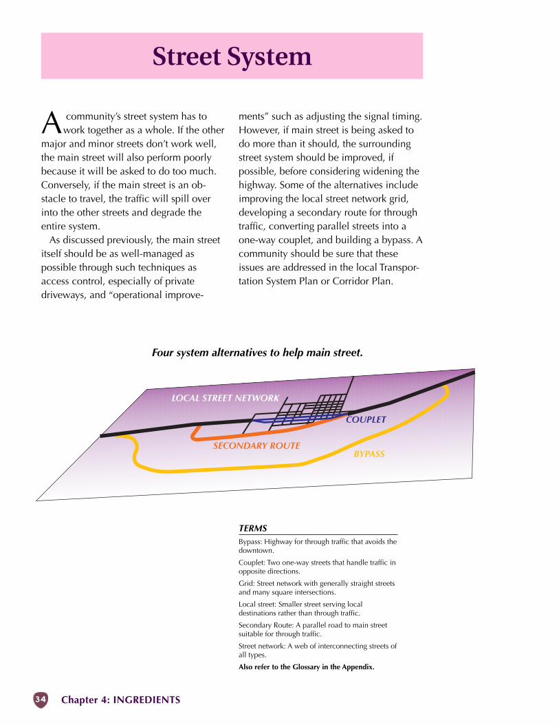
34 Chapter 4: INGREDIENTS
Street System
A community’s street system has towork together as a whole. If the other
major and minor streets don’t work well,the main street will also perform poorlybecause it will be asked to do too much.Conversely, if the main street is an ob-stacle to travel, the traffic will spill overinto the other streets and degrade theentire system.
As discussed previously, the main streetitself should be as well-managed aspossible through such techniques asaccess control, especially of privatedriveways, and “operational improve-
ments” such as adjusting the signal timing.However, if main street is being asked todo more than it should, the surroundingstreet system should be improved, ifpossible, before considering widening thehighway. Some of the alternatives includeimproving the local street network grid,developing a secondary route for throughtraffic, converting parallel streets into aone-way couplet, and building a bypass. Acommunity should be sure that theseissues are addressed in the local Transpor-tation System Plan or Corridor Plan.
BYPASSSECONDARY ROUTE
COUPLET
LOCAL STREET NETWORK
Four system alternatives to help main street.
TERMSBypass: Highway for through traffic that avoids thedowntown.
Couplet: Two one-way streets that handle traffic inopposite directions.
Grid: Street network with generally straight streetsand many square intersections.
Local street: Smaller street serving localdestinations rather than through traffic.
Secondary Route: A parallel road to main streetsuitable for through traffic.
Street network: A web of interconnecting streets ofall types.
Also refer to the Glossary in the Appendix.
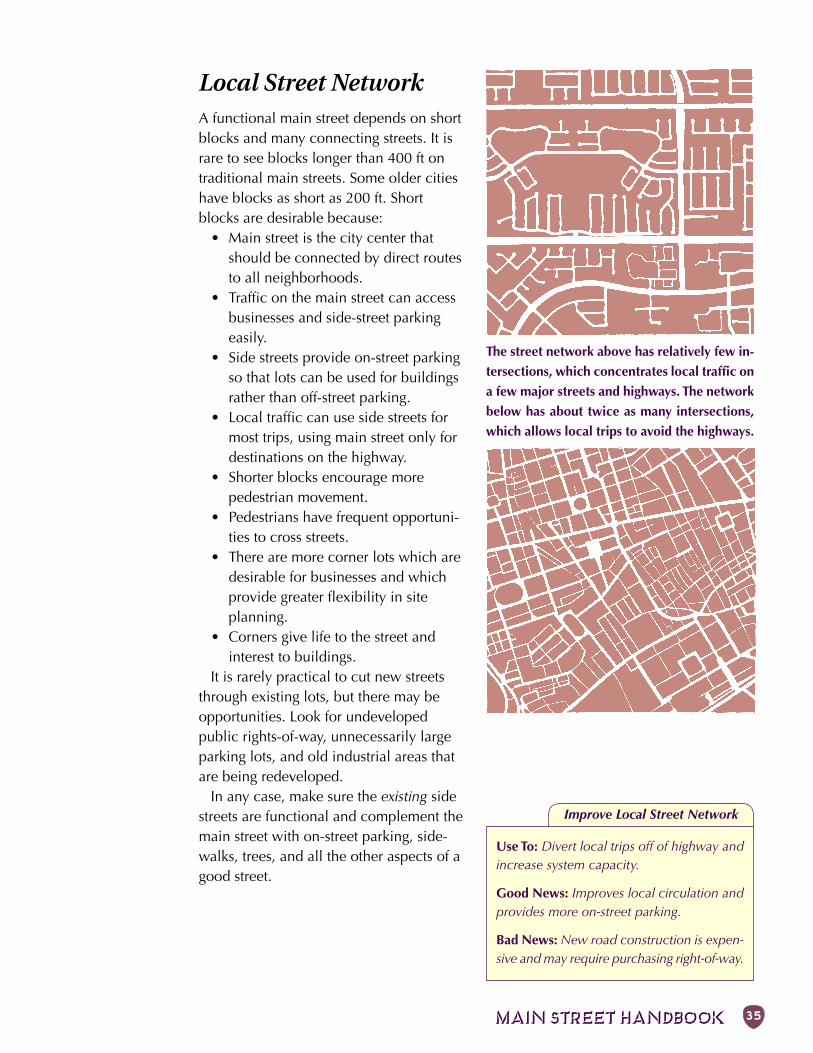
MAIN STREET HANDBOOK 35
Improve Local Street Network
Local Street NetworkA functional main street depends on shortblocks and many connecting streets. It israre to see blocks longer than 400 ft ontraditional main streets. Some older citieshave blocks as short as 200 ft. Shortblocks are desirable because:
• Main street is the city center thatshould be connected by direct routesto all neighborhoods.
• Traffic on the main street can accessbusinesses and side-street parkingeasily.
• Side streets provide on-street parkingso that lots can be used for buildingsrather than off-street parking.
• Local traffic can use side streets formost trips, using main street only fordestinations on the highway.
• Shorter blocks encourage morepedestrian movement.
• Pedestrians have frequent opportuni-ties to cross streets.
• There are more corner lots which aredesirable for businesses and whichprovide greater flexibility in siteplanning.
• Corners give life to the street andinterest to buildings.
It is rarely practical to cut new streetsthrough existing lots, but there may beopportunities. Look for undevelopedpublic rights-of-way, unnecessarily largeparking lots, and old industrial areas thatare being redeveloped.
In any case, make sure the existing sidestreets are functional and complement themain street with on-street parking, side-walks, trees, and all the other aspects of agood street.
Use To: Divert local trips off of highway andincrease system capacity.
Good News: Improves local circulation andprovides more on-street parking.
Bad News: New road construction is expen-sive and may require purchasing right-of-way.
The street network above has relatively few in-
tersections, which concentrates local traffic on
a few major streets and highways. The network
below has about twice as many intersections,
which allows local trips to avoid the highways.
36 Chapter 4: INGREDIENTS
Secondary Route forThrough TrafficWhat is the role of the main street in thelarger community? Is main street the onlythrough route or are there other existingor potential roads that can be used bythrough or local traffic? You may find thatyou can route some of the traffic, espe-cially trucks, onto a parallel street. Thiswill distribute the traffic on more streetsand relieve main street of having to carrythe full load.
Look for these potential characteristicsin a parallel route:
• Minimal out-of-direction travel; traveltime should be faster, or at least noslower, than the main street.
• Few interruptions (stop signs, activerailroads, etc.).
• Good intersections where the parallelroute leaves and rejoins the highway.
• Adequate width, geometry andstructure for the anticipated traffic.
• Suitable adjacent land uses.• Good, clear signage.Sometimes existing roads can be modi-
fied without too much difficulty by widen-ing a few blocks and upgrading intersec-tions. If these improvements are plannedanyway, it may be a matter of movingthem ahead of other projects.
Couplet (2 one-waystreets)A couplet is two streets acting as one: traf-fic flows one-way on both streets but inopposite directions. The two streets areusually a block apart and stretch throughthe downtown. Once outside the down-town, the couplet rejoins to form a normaltwo-way street.
Couplets are fairly common becausethey are an easy way to increase highwaycapacity. They have an added benefit forpedestrians who need only look in one di-rection when crossing the street. However,this benefit may be offset by higher vehiclespeed on one-way streets and the risk ofcars in the far lane not seeing or failing tostop for a crossing pedestrian. Also, mer-chants along a proposed couplet some-times resist the one-way travel for fear thathalf the traffic will miss their stores.
Two-way streets tend to have lower traf-fic speeds because the opposing lanes cre-ate a sense of friction which causes driversto slow down. If there is extra width (abovestandard) when 2-way streets are madeinto one-way couplets, speed increasescan be counteracted by adding bike lanes,on-street parking, wider sidewalks, streettrees, and curb extensions.
Drivers can be confused by one-waystreets and bicyclists object to the out-of-direction travel. A large grid of one-waystreets can be frustrating to all users.Ample signing, good intersection design atthe beginning and end, and frequent park-ing opportunitiesare particularly im-portant with cou-plets. If a coupletproves unsuccessful,the streets can al-ways be returned totwo-way operation.
Create Second Through Route
Use To: Divert some through trips aroundmain street.
Good News: Removes some trucks frommain street and speeds their travel.
Bad News: Depends on having a fairly di-rect route that can be improved.
Make Parallel Streets One-Way
Use To: Increase capacity of main street.
Good News: Relatively inexpensive and hassome advantages to pedestrians.
Bad News: Tends to increase speed and hassome disadvantages for all users.
It is particularly im-
portant to involve
residents and busi-
ness owners when
planning secondary
routes, couplets and
bypasses.
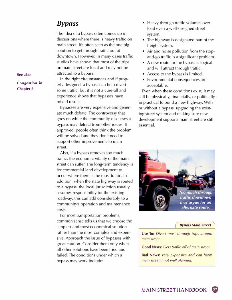
MAIN STREET HANDBOOK 37
BypassThe idea of a bypass often comes up indiscussions where there is heavy traffic onmain street. It’s often seen as the one bigsolution to get through traffic out ofdowntown. However, in many cases trafficstudies have shown that most of the tripson main street are local and may not beattracted to a bypass.
In the right circumstances and if prop-erly designed, a bypass can help divertsome traffic, but it is not a cure-all andexperience shows that bypasses havemixed results.
Bypasses are very expensive and gener-ate much debate. The controversy thatgoes on while the community discusses abypass may detract from other issues. Ifapproved, people often think the problemwill be solved and they don’t need tosupport other improvements to mainstreet.
Also, if a bypass removes too muchtraffic, the economic vitality of the mainstreet can suffer. The long-term tendency isfor commercial land development tooccur where there is the most traffic. Inaddition, when the state highway is routedto a bypass, the local jurisdiction usuallyassumes responsibility for the existingroadway; this can add considerably to acommunity’s operation and maintenancecosts.
For most transportation problems,common sense tells us that we choose thesimplest and most economical solutionrather than the most complex and expen-sive. Approach the issue of bypasses withgreat caution. Consider them only whenall other solutions have been tried andfailed. The conditions under which abypass may work include:
• Heavy through traffic volumes over-load even a well-designed streetsystem.
• The highway is designated part of thefreight system.
• Air and noise pollution from the stop-and-go traffic is a significant problem.
• A new route for the bypass is logicaland will attract through traffic.
• Access to the bypass is limited.• Environmental consequences are
acceptable.Even when these conditions exist, it may
still be physically, financially, or politicallyimpractical to build a new highway. Withor without a bypass, upgrading the exist-ing street system and making sure newdevelopment supports main street are stillessential.
Bypass Main Street
Use To: Divert most through trips aroundmain street.
Good News: Gets traffic off of main street.
Bad News: Very expensive and can harmmain street if not well planned.
Too much throughtraffic downtownmay argue for analternate route.
See also:
Congestion in
Chapter 3
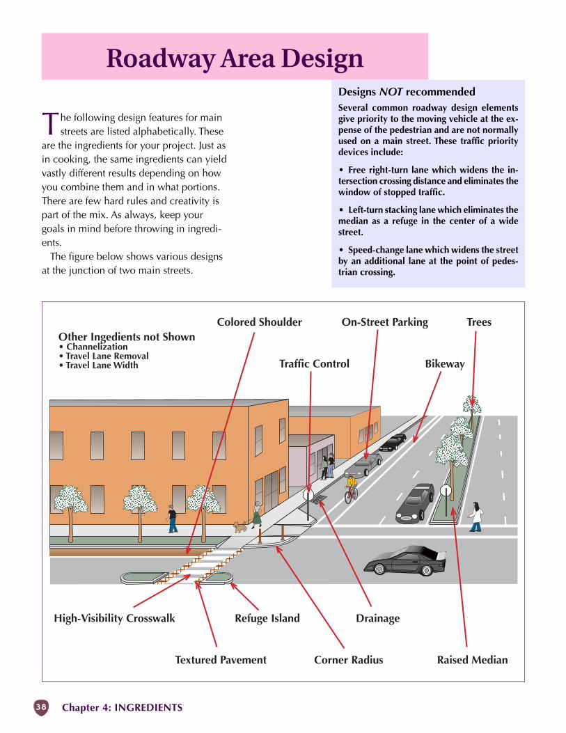
38 Chapter 4: INGREDIENTS
Bikeway
Corner Radius
High-Visibility Crosswalk
Raised Median
On-Street Parking
Refuge Island
Textured Pavement
TreesOther Ingedients not Shown• Channelization• Travel Lane Removal• Travel Lane Width
Colored Shoulder
Traffic Control
Drainage
Roadway Area Design
The following design features for mainstreets are listed alphabetically. These
are the ingredients for your project. Just asin cooking, the same ingredients can yieldvastly different results depending on howyou combine them and in what portions.There are few hard rules and creativity ispart of the mix. As always, keep yourgoals in mind before throwing in ingredi-ents.
The figure below shows various designsat the junction of two main streets.
Designs NOT recommendedSeveral common roadway design elementsgive priority to the moving vehicle at the ex-pense of the pedestrian and are not normallyused on a main street. These traffic prioritydevices include:
• Free right-turn lane which widens the in-tersection crossing distance and eliminates thewindow of stopped traffic.
• Left-turn stacking lane which eliminates themedian as a refuge in the center of a widestreet.
• Speed-change lane which widens the streetby an additional lane at the point of pedes-trian crossing.
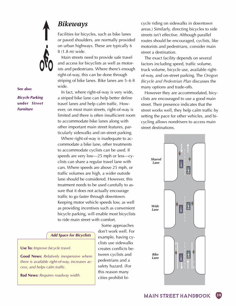
MAIN STREET HANDBOOK 39
SharedLane
WideLane
BikeLane
BikewaysFacilities for bicycles, such as bike lanesor paved shoulders, are normally providedon urban highways. These are typically 6ft (1.8 m) wide.
Main streets need to provide safe traveland access for bicyclists as well as motor-ists and pedestrians. Where there’s enoughright-of-way, this can be done throughstriping of bike lanes. Bike lanes are 5–6 ftwide.
In fact, where right-of-way is very wide,a striped bike lane can help better definetravel lanes and help calm traffic. How-ever, on most main streets, right-of-way islimited and there is often insufficient roomto accommodate bike lanes along withother important main street features, par-ticularly sidewalks and on-street parking.
Where right-of-way is inadequate to ac-commodate a bike lane, other treatmentsto accommodate cyclists can be used. Ifspeeds are very low—25 mph or less—cy-clists can share a regular travel lane withcars. Where speeds are above 25 mph, ortraffic volumes are high, a wider outsidelane should be considered. However, thistreatment needs to be used carefully to as-sure that it does not actually encouragetraffic to go faster through downtown.Keeping motor vehicle speeds low, as wellas providing incentives such as convenientbicycle parking, will enable most bicycliststo ride main street with comfort.
Some approachesdon’t work well. Forexample, having cy-clists use sidewalkscreates conflicts be-tween cyclists andpedestrians and asafety hazard. (Forthis reason manycities prohibit bi-
See also:
Bicycle Parking
under Street
Furniture
Add Space for Bicyclists
Use To: Improve bicycle travel.
Good News: Relatively inexpensive wherethere is available right-of-way, increases ac-cess, and helps calm traffic.
Bad News: Requires roadway width.
cycle riding on sidewalks in downtownareas.) Similarly, directing bicycles to sidestreets isn’t effective. Although parallelroutes should be encouraged, cyclists, likemotorists and pedestrians, consider mainstreet a destination.
The exact facility depends on severalfactors including speed, traffic volume,truck volume, bicycle use, available right-of-way, and on-street parking. The OregonBicycle and Pedestrian Plan discusses themany options and trade-offs.
However they are accommodated, bicy-clists are encouraged to use a good mainstreet. Their presence indicates that thestreet works well, they help calm traffic bysetting the pace for other vehicles, and bi-cycling allows nondrivers to access mainstreet destinations.
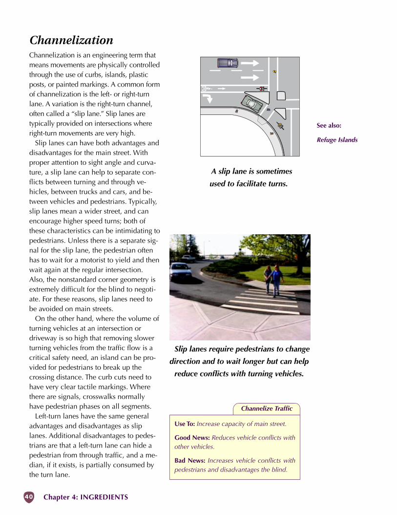
40 Chapter 4: INGREDIENTS
A slip lane is sometimes
used to facilitate turns.
Slip lanes require pedestrians to change
direction and to wait longer but can help
reduce conflicts with turning vehicles.
ChannelizationChannelization is an engineering term thatmeans movements are physically controlledthrough the use of curbs, islands, plasticposts, or painted markings. A common formof channelization is the left- or right-turnlane. A variation is the right-turn channel,often called a “slip lane.” Slip lanes aretypically provided on intersections whereright-turn movements are very high.
Slip lanes can have both advantages anddisadvantages for the main street. Withproper attention to sight angle and curva-ture, a slip lane can help to separate con-flicts between turning and through ve-hicles, between trucks and cars, and be-tween vehicles and pedestrians. Typically,slip lanes mean a wider street, and canencourage higher speed turns; both ofthese characteristics can be intimidating topedestrians. Unless there is a separate sig-nal for the slip lane, the pedestrian oftenhas to wait for a motorist to yield and thenwait again at the regular intersection.Also, the nonstandard corner geometry isextremely difficult for the blind to negoti-ate. For these reasons, slip lanes need tobe avoided on main streets.
On the other hand, where the volume ofturning vehicles at an intersection ordriveway is so high that removing slowerturning vehicles from the traffic flow is acritical safety need, an island can be pro-vided for pedestrians to break up thecrossing distance. The curb cuts need tohave very clear tactile markings. Wherethere are signals, crosswalks normallyhave pedestrian phases on all segments.
Left-turn lanes have the same generaladvantages and disadvantages as sliplanes. Additional disadvantages to pedes-trians are that a left-turn lane can hide apedestrian from through traffic, and a me-dian, if it exists, is partially consumed bythe turn lane.
See also:
Refuge Islands
Channelize Traffic
Use To: Increase capacity of main street.
Good News: Reduces vehicle conflicts withother vehicles.
Bad News: Increases vehicle conflicts withpedestrians and disadvantages the blind.
MAIN STREET HANDBOOK 41
streets, 40 ft (12 m) or more where largetruck combinations and buses turn fre-quently, and that ”radii dimensions shouldbe coordinated with crosswalk distancesor special designs to make crosswalks safefor all pedestrians.” It stresses that ”ad-equate radii for vehicles must be balancedagainst the needs of pedestrians and thedifficulty of acquiring additional right-of-way or corner setbacks.”
Rather than use a circular radius atlarge-radius corners (40 ft or more),alternative designs include symmetricalcompound curves, asymmetrical com-pound curves, or simple radius curveswith tapers. These designs better fit thepaths of turning vehicles and improveoperations.
At an intersection where there is aparking lane or bike lane on either street,the extra width serves to increase theturning radius by 6–14 ft (1.8–4.2 m) sothat the actual curb radius can be re-duced. Where main street intersects lesserstreets, the turning radius is based on theexpected vehicle type making the turn.On one-way streets, 2 of the 4 corners canhave very small radii since turns are notallowed.
As with all main street design, it is impor-tant to remember that every corner is uniqueand needs to be designed individually.
Corner RadiusWhat engineers call the “corner curbradius” is the sharpness of the corner. Onmost older traditional main streets, thecorners are often very sharp, with a smallcorner radius; this is one of the mosteffective tools for controlling speed. Avehicle turning a corner has to clear thecurb, and the sharper the corner, theslower the vehicle must go.
Pedestrians rely on intersections to crossroadways. At the same time, by addingleft- and right-turn lanes and large turningradii, intersections are often the widestparts of the street. A wide street increasesthe pedestrian’s threshold gap for crossing,thereby degrading mobility. The distancepedestrians must cross is an importantconsideration in design; every corner isunique.
For curb radii on arterial streets, theGreen Book (see Glossary) recommends25 ft (7.5 m) or more at minor crossstreets, 30 ft (9 m) or more at major cross
Reduce Corner Radius
Use To: Shorten and align pedestrian cross-ings; reduce vehicle turning speed; improvepedestrian visibility.
Good News: Greatly improves pedestrianconvenience and safety.
Bad News: May not work where large ve-hicles must turn.
R1 = Actual curb radiusR2 = Effective radiusR3 = Curb radius neededwithout bike lane &parking
R2
R1
R3
On-street parking & bike lanepermit a tighter corner.
See also:
Curb Extension
42 Chapter 4: INGREDIENTS
Marked crosswalks are standard
on main street intersections.
A short crossing distance is
imperative for slow pedestrians.
Two parallel lines may not be
seen by motorists.
CrosswalkLegal crosswalks exist on all legs of allintersections, including T-intersections,except where closed by ordinance andappropriately signed. Crosswalks may bemarked or unmarked. Marked crosswalksalert motorists that they are approaching ahigh pedestrian area, assuming that theycan see the markings. Some crosswalksalso have signs and even flashing beaconsto attract attention. Curb extensions andrefuge islands also help alert the motoristto crosswalks.
Flexibility in Highway Design notes thattwo parallel painted lines are generallynot enough of a distinguishing marking forcrosswalks. Often motorists confuse theselines with the stopping line and pull rightup into the crosswalk. At a minimum, aladder pattern type of striping or paintinginside the crosswalk area is recommendedto improve visibility. Colored crosswalkscan also help visibility. A stop bar mayalso help discourage motorists fromstopping in the crosswalk.
Lighting is also important for crosswalks.The crosswalk needs to be well-lit fromabove. Some communities are also con-sidering the use of embedded lighting tomake the crosswalk highly visible at night.
Provide Crosswalks
Use To: Improve pedestrian crossing oppor-tunities and comfort.
Good News: Helps identify preferred cross-ing locations and get the attention of driv-ers.
Bad News: Needs to be visible and worksbest with other measures to improve cross-ings and slow traffic.
See also:
Corner Radius
Curb Extension
Median
Refuge Island
Textured Pavement
Traffic Controls
MAIN STREET HANDBOOK 43
MedianWide streets—four or more lanes—gener-ally need a raised median to lessen theamount of continuous asphalt. Mediansprovide a physical separation betweentravel lanes, a refuge area for pedestrians,a space for attractive landscaping, and aplace to store snow when needed.
Raised medians reduce conflicts be-tween pedestrians and vehicles becausethey allow pedestrians to cross only onedirection of traffic at a time. Also, there isless continuous exposure for the pedes-trian because it takes less time to crossone or two lanes of traffic than two orfour. Pedestrian crossing times on an un-signalized, multilane street without a me-dian are up to 10 times longer than theyare with a median (National CooperativeHighway Research Program, Report 294A,June 1987).
Where raised medians are used for ac-cess management, they need to be con-structed so they also provide a pedestrianrefuge.
Where it is not possible to provide acontinuous raised median, island refugescan be created at and between intersec-tions and other accesses. These are typi-cally located across from high pedestriangenerators such as schools, park en-trances, libraries, and parking lots.
In most instances, the width of theraised median is the width of the centerturn-lane, minus the necessary shy dis-tance (for the desired speed) on each side.Where street width is limited, even a 4-ftmedian can be beneficial.
Ideally, raised medians are constructedwith a smooth, traversable surface, such asconcrete or brick pavers. If a median isalso landscaped, the plants need to bespaced far enough apart to allow passageby pedestrians. Low-growing plants willallow pedestrians to be seen by motorists.
On the 5-lane urban highways that oftenlead into a downtown, installing a raisedmedian in place of a continuous centerleft-turn lane has the effect of reducing shydistance on one side. Reducing the shydistance from 6 to 4 ft typically results in aspeed drop of about 0.4 mph; going from6 to 2-ft shy distance drops the speed byabout 0.9 mph (Highway CapacityManual, Transportation Research Board,1994).
Speed studies on city streets show evengreater reductions of nearly 2 mph forraised medians alone and 5 mph whenused with curb extensions (Anne ArundelCounty, Maryland).
Although raised medians have an initialconstruction cost and any landscapingwill require maintenance, long-term costscompared to paving are roughly equiva-lent.
Construct Raised Median
Use To: Improve overall street appearanceand operation, including slowing traffic.
Good News: Benefits all users, especiallypedestrians.
Bad News: Takes up width; may complicatedrainage.
See also:
Driveways
Refuge Island
Landscaped median in Sweet Home has
breaks for pedestrians.
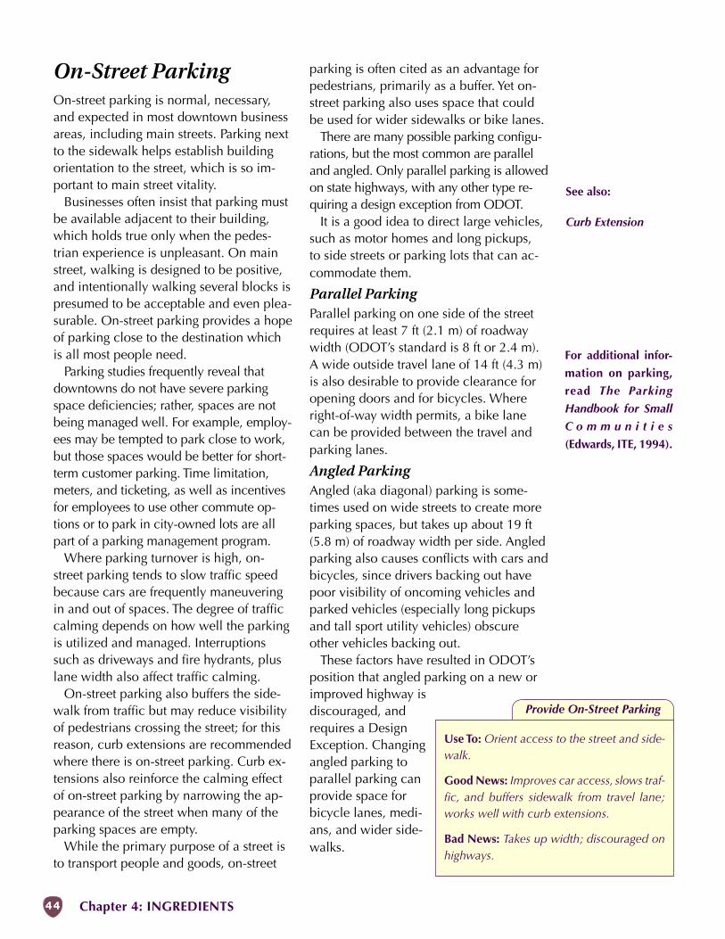
44 Chapter 4: INGREDIENTS
On-Street ParkingOn-street parking is normal, necessary,and expected in most downtown businessareas, including main streets. Parking nextto the sidewalk helps establish buildingorientation to the street, which is so im-portant to main street vitality.
Businesses often insist that parking mustbe available adjacent to their building,which holds true only when the pedes-trian experience is unpleasant. On mainstreet, walking is designed to be positive,and intentionally walking several blocks ispresumed to be acceptable and even plea-surable. On-street parking provides a hopeof parking close to the destination whichis all most people need.
Parking studies frequently reveal thatdowntowns do not have severe parkingspace deficiencies; rather, spaces are notbeing managed well. For example, employ-ees may be tempted to park close to work,but those spaces would be better for short-term customer parking. Time limitation,meters, and ticketing, as well as incentivesfor employees to use other commute op-tions or to park in city-owned lots are allpart of a parking management program.
Where parking turnover is high, on-street parking tends to slow traffic speedbecause cars are frequently maneuveringin and out of spaces. The degree of trafficcalming depends on how well the parkingis utilized and managed. Interruptionssuch as driveways and fire hydrants, pluslane width also affect traffic calming.
On-street parking also buffers the side-walk from traffic but may reduce visibilityof pedestrians crossing the street; for thisreason, curb extensions are recommendedwhere there is on-street parking. Curb ex-tensions also reinforce the calming effectof on-street parking by narrowing the ap-pearance of the street when many of theparking spaces are empty.
While the primary purpose of a street isto transport people and goods, on-street
parking is often cited as an advantage forpedestrians, primarily as a buffer. Yet on-street parking also uses space that couldbe used for wider sidewalks or bike lanes.
There are many possible parking configu-rations, but the most common are paralleland angled. Only parallel parking is allowedon state highways, with any other type re-quiring a design exception from ODOT.
It is a good idea to direct large vehicles,such as motor homes and long pickups,to side streets or parking lots that can ac-commodate them.
Parallel ParkingParallel parking on one side of the streetrequires at least 7 ft (2.1 m) of roadwaywidth (ODOT’s standard is 8 ft or 2.4 m).A wide outside travel lane of 14 ft (4.3 m)is also desirable to provide clearance foropening doors and for bicycles. Whereright-of-way width permits, a bike lanecan be provided between the travel andparking lanes.
Angled ParkingAngled (aka diagonal) parking is some-times used on wide streets to create moreparking spaces, but takes up about 19 ft(5.8 m) of roadway width per side. Angledparking also causes conflicts with cars andbicycles, since drivers backing out havepoor visibility of oncoming vehicles andparked vehicles (especially long pickupsand tall sport utility vehicles) obscureother vehicles backing out.
These factors have resulted in ODOT’sposition that angled parking on a new orimproved highway isdiscouraged, andrequires a DesignException. Changingangled parking toparallel parking canprovide space forbicycle lanes, medi-ans, and wider side-walks.
Provide On-Street Parking
Use To: Orient access to the street and side-walk.
Good News: Improves car access, slows traf-fic, and buffers sidewalk from travel lane;works well with curb extensions.
Bad News: Takes up width; discouraged onhighways.
See also:
Curb Extension
For additional infor-
mation on parking,
read The Parking
Handbook for Small
C o m m u n i t i e s
(Edwards, ITE, 1994).
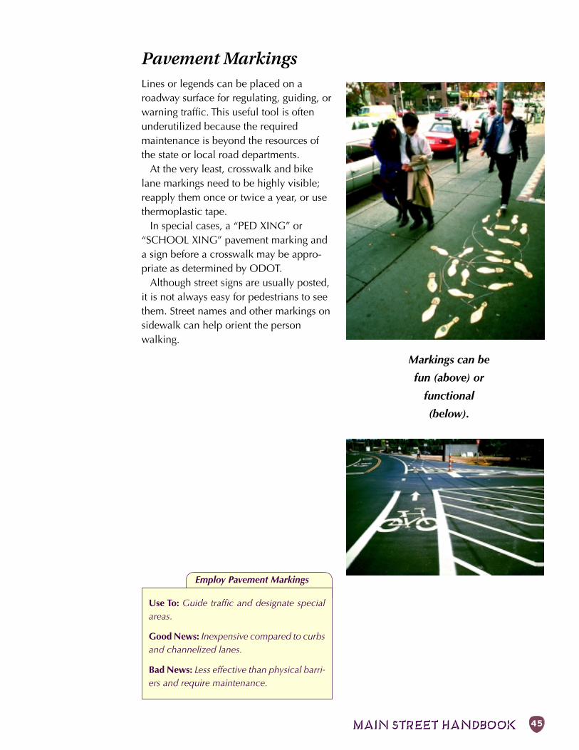
MAIN STREET HANDBOOK 45
Employ Pavement Markings
Use To: Guide traffic and designate specialareas.
Good News: Inexpensive compared to curbsand channelized lanes.
Bad News: Less effective than physical barri-ers and require maintenance.
Markings can be
fun (above) or
functional
(below).
Pavement MarkingsLines or legends can be placed on aroadway surface for regulating, guiding, orwarning traffic. This useful tool is oftenunderutilized because the requiredmaintenance is beyond the resources ofthe state or local road departments.
At the very least, crosswalk and bikelane markings need to be highly visible;reapply them once or twice a year, or usethermoplastic tape.
In special cases, a “PED XING” or“SCHOOL XING” pavement marking anda sign before a crosswalk may be appro-priate as determined by ODOT.
Although street signs are usually posted,it is not always easy for pedestrians to seethem. Street names and other markings onsidewalk can help orient the personwalking.
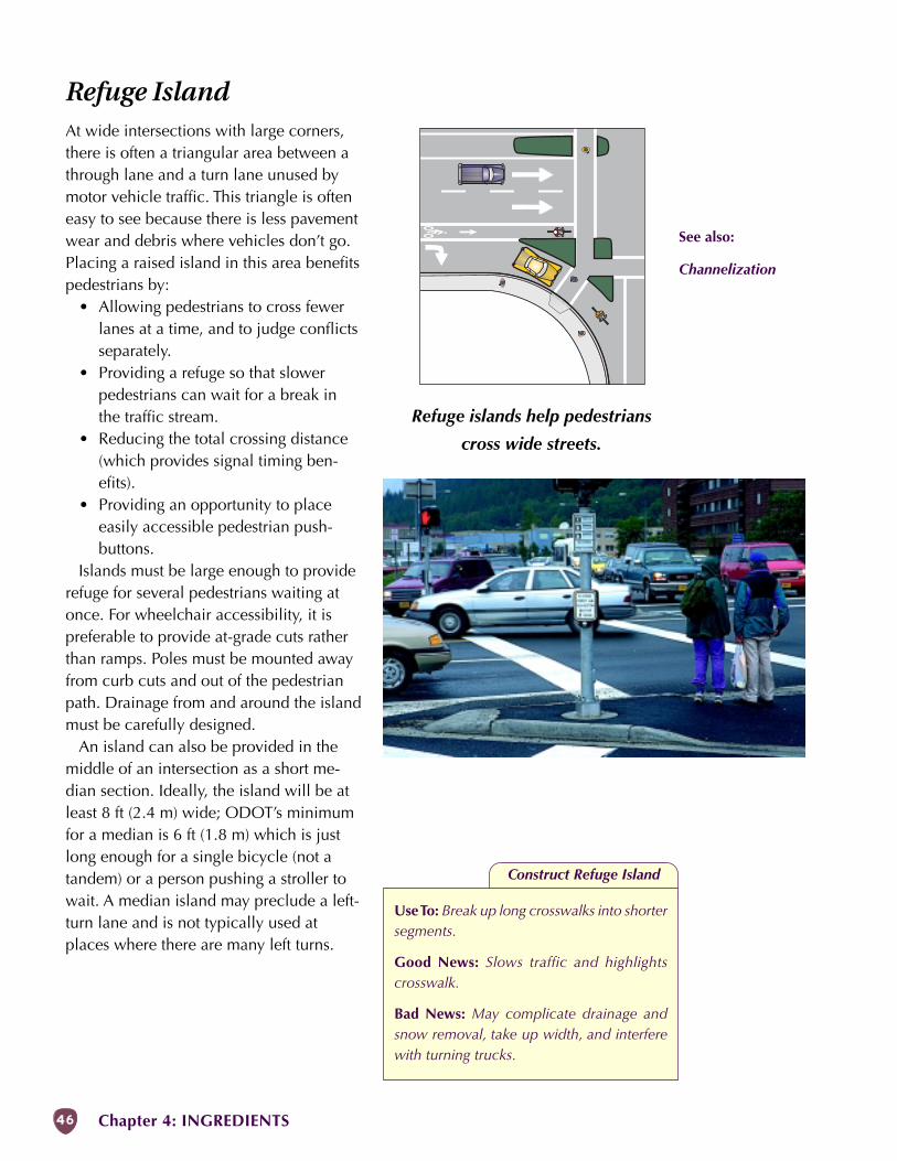
46 Chapter 4: INGREDIENTS
Refuge IslandAt wide intersections with large corners,there is often a triangular area between athrough lane and a turn lane unused bymotor vehicle traffic. This triangle is ofteneasy to see because there is less pavementwear and debris where vehicles don’t go.Placing a raised island in this area benefitspedestrians by:
• Allowing pedestrians to cross fewerlanes at a time, and to judge conflictsseparately.
• Providing a refuge so that slowerpedestrians can wait for a break inthe traffic stream.
• Reducing the total crossing distance(which provides signal timing ben-efits).
• Providing an opportunity to placeeasily accessible pedestrian push-buttons.
Islands must be large enough to providerefuge for several pedestrians waiting atonce. For wheelchair accessibility, it ispreferable to provide at-grade cuts ratherthan ramps. Poles must be mounted awayfrom curb cuts and out of the pedestrianpath. Drainage from and around the islandmust be carefully designed.
An island can also be provided in themiddle of an intersection as a short me-dian section. Ideally, the island will be atleast 8 ft (2.4 m) wide; ODOT’s minimumfor a median is 6 ft (1.8 m) which is justlong enough for a single bicycle (not atandem) or a person pushing a stroller towait. A median island may preclude a left-turn lane and is not typically used atplaces where there are many left turns.
Construct Refuge Island
Use To: Break up long crosswalks into shortersegments.
Good News: Slows traffic and highlightscrosswalk.
Bad News: May complicate drainage andsnow removal, take up width, and interferewith turning trucks.
Refuge islands help pedestrians
cross wide streets.
See also:
Channelization
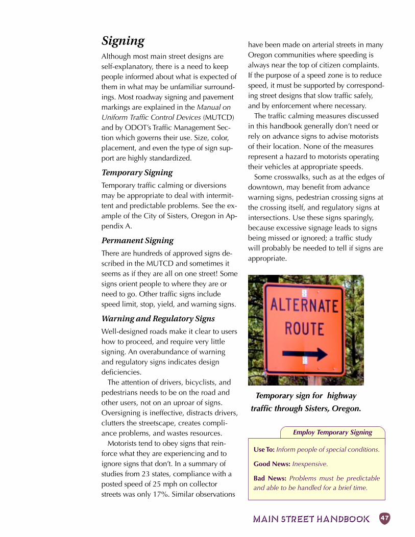
MAIN STREET HANDBOOK 47
SigningAlthough most main street designs areself-explanatory, there is a need to keeppeople informed about what is expected ofthem in what may be unfamiliar surround-ings. Most roadway signing and pavementmarkings are explained in the Manual onUniform Traffic Control Devices (MUTCD)and by ODOT’s Traffic Management Sec-tion which governs their use. Size, color,placement, and even the type of sign sup-port are highly standardized.
Temporary Signing
Temporary traffic calming or diversionsmay be appropriate to deal with intermit-tent and predictable problems. See the ex-ample of the City of Sisters, Oregon in Ap-pendix A.
Permanent Signing
There are hundreds of approved signs de-scribed in the MUTCD and sometimes itseems as if they are all on one street! Somesigns orient people to where they are orneed to go. Other traffic signs includespeed limit, stop, yield, and warning signs.
Warning and Regulatory Signs
Well-designed roads make it clear to usershow to proceed, and require very littlesigning. An overabundance of warningand regulatory signs indicates designdeficiencies.
The attention of drivers, bicyclists, andpedestrians needs to be on the road andother users, not on an uproar of signs.Oversigning is ineffective, distracts drivers,clutters the streetscape, creates compli-ance problems, and wastes resources.
Motorists tend to obey signs that rein-force what they are experiencing and toignore signs that don’t. In a summary ofstudies from 23 states, compliance with aposted speed of 25 mph on collectorstreets was only 17%. Similar observations
have been made on arterial streets in manyOregon communities where speeding isalways near the top of citizen complaints.If the purpose of a speed zone is to reducespeed, it must be supported by correspond-ing street designs that slow traffic safely,and by enforcement where necessary.
The traffic calming measures discussedin this handbook generally don’t need orrely on advance signs to advise motoristsof their location. None of the measuresrepresent a hazard to motorists operatingtheir vehicles at appropriate speeds.
Some crosswalks, such as at the edges ofdowntown, may benefit from advancewarning signs, pedestrian crossing signs atthe crossing itself, and regulatory signs atintersections. Use these signs sparingly,because excessive signage leads to signsbeing missed or ignored; a traffic studywill probably be needed to tell if signs areappropriate.
Employ Temporary Signing
Use To: Inform people of special conditions.
Good News: Inexpensive.
Bad News: Problems must be predictableand able to be handled for a brief time.
Temporary sign for highway
traffic through Sisters, Oregon.

48 Chapter 4: INGREDIENTS
Sign W11A-2 isused only atcrosswalks
Sign W11-2may be used in
advance ofcrossings or inareas of high
pedestrian use
Pedestrian Crossing signs are sometimesused at locations where a crossing is notnormally encountered. This is usually atmid-block locations, where the adjacentland use is likely to generate a fairly highnumber of crossings.
Informational Signs
Information signs can be used to:• Explain signal synchronization in ad-
vance of a series of signals. Clearlyindicate the ideal travel speed (i.e.,20 mph).
• Give directions to parking and otherdestinations at the gateways to mainstreet.
• Provide differential directional signsfor motorists and for pedestrians.
For motorists, signs are normally large,mounted fairly high, and indicate destina-tions relatively far away; they may not ad-equately serve pedestrians.
For pedestrians, standard signs andmarkings have not been developed. Ingeneral, signs need to be lower, smaller,and in the pedestrians line of sight. Dis-tances given in measurements meaningfulto pedestrians such as blocks or averagewalking time are more useful. Examples ofkey destinations are libraries, schools, mu-seums, entertainment centers, and shop-ping districts. On one-way streets, streetsigns that face both ways can be read byfoot traffic from both directions.
Employ Permanent Signing
Use To: Inform or warn drivers, bicyclists, andpedestrians.
Good News: Inexpensive; informational signshelp orient visitors.
Bad News: Warning signs tend to have lim-ited effectiveness; too many signs clutter thestreetscape.
To avoid adding clutter to the ex-isting street signs, cluster signstogether on one post, placedin strategic locations. Kiosks,"finger posts," and buildingcorners are also good locationsfor pedestrian-oriented signs. Thebest signs are unobtrusive, easy to read,aesthetic, and placed in such a way thatthey are visible to pedestrians and not tomotorists.
To add interest in the downtown and toprovide pedestrians with useful informa-tion, signs can:
• List the stores, perhaps on amap, at a central gather-ing place.
• Tell about historic struc-tures and local landmarks.
• Identify special plants andnatural features.
• Recognize people who have donatedenergy and resources to making mainstreet work.
Since no standards have yet been devel-oped in Oregon for pedestrian-only signs,please consult with ODOT and work to-gether to ensure that size, lettering andplacement are mutually beneficial. Thefollowing example can be used as a start-ing point:
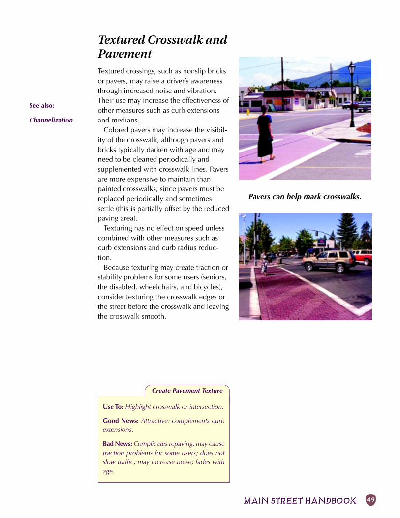
MAIN STREET HANDBOOK 49
See also:
Channelization
Textured Crosswalk andPavementTextured crossings, such as nonslip bricksor pavers, may raise a driver’s awarenessthrough increased noise and vibration.Their use may increase the effectiveness ofother measures such as curb extensionsand medians.
Colored pavers may increase the visibil-ity of the crosswalk, although pavers andbricks typically darken with age and mayneed to be cleaned periodically andsupplemented with crosswalk lines. Paversare more expensive to maintain thanpainted crosswalks, since pavers must bereplaced periodically and sometimessettle (this is partially offset by the reducedpaving area).
Texturing has no effect on speed unlesscombined with other measures such ascurb extensions and curb radius reduc-tion.
Because texturing may create traction orstability problems for some users (seniors,the disabled, wheelchairs, and bicycles),consider texturing the crosswalk edges orthe street before the crosswalk and leavingthe crosswalk smooth.
Create Pavement Texture
Use To: Highlight crosswalk or intersection.
Good News: Attractive; complements curbextensions.
Bad News: Complicates repaving; may causetraction problems for some users; does notslow traffic; may increase noise; fades withage.
Pavers can help mark crosswalks.
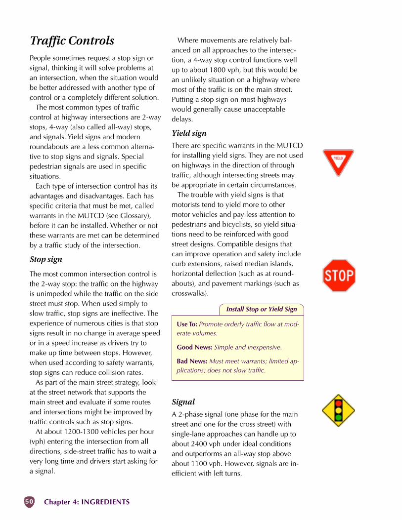
50 Chapter 4: INGREDIENTS
Traffic ControlsPeople sometimes request a stop sign orsignal, thinking it will solve problems atan intersection, when the situation wouldbe better addressed with another type ofcontrol or a completely different solution.
The most common types of trafficcontrol at highway intersections are 2-waystops, 4-way (also called all-way) stops,and signals. Yield signs and modernroundabouts are a less common alterna-tive to stop signs and signals. Specialpedestrian signals are used in specificsituations.
Each type of intersection control has itsadvantages and disadvantages. Each hasspecific criteria that must be met, calledwarrants in the MUTCD (see Glossary),before it can be installed. Whether or notthese warrants are met can be determinedby a traffic study of the intersection.
Stop sign
The most common intersection control isthe 2-way stop: the traffic on the highwayis unimpeded while the traffic on the sidestreet must stop. When used simply toslow traffic, stop signs are ineffective. Theexperience of numerous cities is that stopsigns result in no change in average speedor in a speed increase as drivers try tomake up time between stops. However,when used according to safety warrants,stop signs can reduce collision rates.
As part of the main street strategy, lookat the street network that supports themain street and evaluate if some routesand intersections might be improved bytraffic controls such as stop signs.
At about 1200-1300 vehicles per hour(vph) entering the intersection from alldirections, side-street traffic has to wait avery long time and drivers start asking fora signal.
Where movements are relatively bal-anced on all approaches to the intersec-tion, a 4-way stop control functions wellup to about 1800 vph, but this would bean unlikely situation on a highway wheremost of the traffic is on the main street.Putting a stop sign on most highwayswould generally cause unacceptabledelays.
Yield sign
There are specific warrants in the MUTCDfor installing yield signs. They are not usedon highways in the direction of throughtraffic, although intersecting streets maybe appropriate in certain circumstances.
The trouble with yield signs is thatmotorists tend to yield more to othermotor vehicles and pay less attention topedestrians and bicyclists, so yield situa-tions need to be reinforced with goodstreet designs. Compatible designs thatcan improve operation and safety includecurb extensions, raised median islands,horizontal deflection (such as at round-abouts), and pavement markings (such ascrosswalks).
Signal
A 2-phase signal (one phase for the mainstreet and one for the cross street) withsingle-lane approaches can handle up toabout 2400 vph under ideal conditionsand outperforms an all-way stop aboveabout 1100 vph. However, signals are in-efficient with left turns.
Install Stop or Yield Sign
Use To: Promote orderly traffic flow at mod-erate volumes.
Good News: Simple and inexpensive.
Bad News: Must meet warrants; limited ap-plications; does not slow traffic.
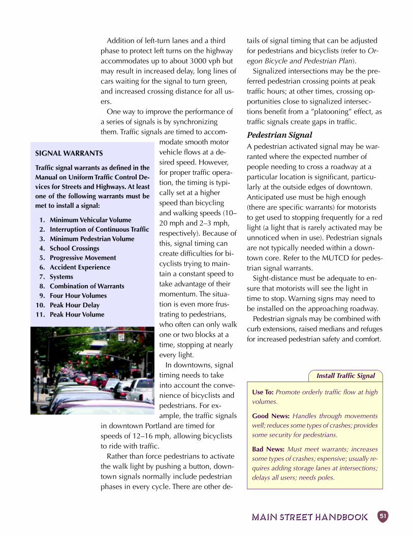
MAIN STREET HANDBOOK 51
Addition of left-turn lanes and a thirdphase to protect left turns on the highwayaccommodates up to about 3000 vph butmay result in increased delay, long lines ofcars waiting for the signal to turn green,and increased crossing distance for all us-ers.
One way to improve the performance ofa series of signals is by synchronizingthem. Traffic signals are timed to accom-
modate smooth motorvehicle flows at a de-sired speed. However,for proper traffic opera-tion, the timing is typi-cally set at a higherspeed than bicyclingand walking speeds (10–20 mph and 2–3 mph,respectively). Because ofthis, signal timing cancreate difficulties for bi-cyclists trying to main-tain a constant speed totake advantage of theirmomentum. The situa-tion is even more frus-trating to pedestrians,who often can only walkone or two blocks at atime, stopping at nearlyevery light.
In downtowns, signaltiming needs to takeinto account the conve-nience of bicyclists andpedestrians. For ex-ample, the traffic signals
in downtown Portland are timed forspeeds of 12–16 mph, allowing bicycliststo ride with traffic.
Rather than force pedestrians to activatethe walk light by pushing a button, down-town signals normally include pedestrianphases in every cycle. There are other de-
tails of signal timing that can be adjustedfor pedestrians and bicyclists (refer to Or-egon Bicycle and Pedestrian Plan).
Signalized intersections may be the pre-ferred pedestrian crossing points at peaktraffic hours; at other times, crossing op-portunities close to signalized intersec-tions benefit from a ”platooning” effect, astraffic signals create gaps in traffic.
Pedestrian SignalA pedestrian activated signal may be war-ranted where the expected number ofpeople needing to cross a roadway at aparticular location is significant, particu-larly at the outside edges of downtown.Anticipated use must be high enough(there are specific warrants) for motoriststo get used to stopping frequently for a redlight (a light that is rarely activated may beunnoticed when in use). Pedestrian signalsare not typically needed within a down-town core. Refer to the MUTCD for pedes-trian signal warrants.
Sight-distance must be adequate to en-sure that motorists will see the light intime to stop. Warning signs may need tobe installed on the approaching roadway.
Pedestrian signals may be combined withcurb extensions, raised medians and refugesfor increased pedestrian safety and comfort.
SIGNAL WARRANTS
Traffic signal warrants as defined in theManual on Uniform Traffic Control De-vices for Streets and Highways. At leastone of the following warrants must bemet to install a signal:
1. Minimum Vehicular Volume2. Interruption of Continuous Traffic3. Minimum Pedestrian Volume4. School Crossings5. Progressive Movement6. Accident Experience7. Systems8. Combination of Warrants9. Four Hour Volumes
10. Peak Hour Delay11. Peak Hour Volume
Install Traffic Signal
Use To: Promote orderly traffic flow at highvolumes.
Good News: Handles through movementswell; reduces some types of crashes; providessome security for pedestrians.
Bad News: Must meet warrants; increasessome types of crashes; expensive; usually re-quires adding storage lanes at intersections;delays all users; needs poles.
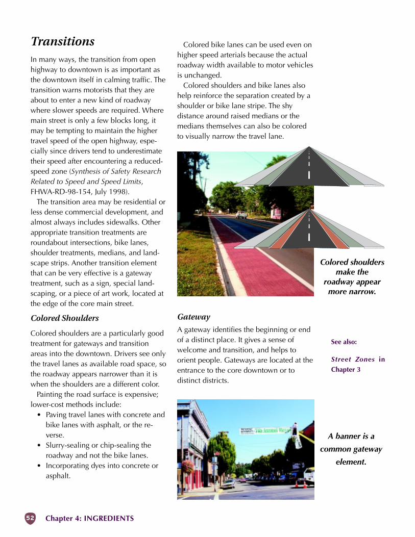
52 Chapter 4: INGREDIENTS
Colored shouldersmake the
roadway appearmore narrow.
A banner is a
common gateway
element.
TransitionsIn many ways, the transition from openhighway to downtown is as important asthe downtown itself in calming traffic. Thetransition warns motorists that they areabout to enter a new kind of roadwaywhere slower speeds are required. Wheremain street is only a few blocks long, itmay be tempting to maintain the highertravel speed of the open highway, espe-cially since drivers tend to underestimatetheir speed after encountering a reduced-speed zone (Synthesis of Safety ResearchRelated to Speed and Speed Limits,FHWA-RD-98-154, July 1998).
The transition area may be residential orless dense commercial development, andalmost always includes sidewalks. Otherappropriate transition treatments areroundabout intersections, bike lanes,shoulder treatments, medians, and land-scape strips. Another transition elementthat can be very effective is a gatewaytreatment, such as a sign, special land-scaping, or a piece of art work, located atthe edge of the core main street.
Colored Shoulders
Colored shoulders are a particularly goodtreatment for gateways and transitionareas into the downtown. Drivers see onlythe travel lanes as available road space, sothe roadway appears narrower than it iswhen the shoulders are a different color.
Painting the road surface is expensive;lower-cost methods include:
• Paving travel lanes with concrete andbike lanes with asphalt, or the re-verse.
• Slurry-sealing or chip-sealing theroadway and not the bike lanes.
• Incorporating dyes into concrete orasphalt.
Colored bike lanes can be used even onhigher speed arterials because the actualroadway width available to motor vehiclesis unchanged.
Colored shoulders and bike lanes alsohelp reinforce the separation created by ashoulder or bike lane stripe. The shydistance around raised medians or themedians themselves can also be coloredto visually narrow the travel lane.
Gateway
A gateway identifies the beginning or endof a distinct place. It gives a sense ofwelcome and transition, and helps toorient people. Gateways are located at theentrance to the core downtown or todistinct districts.
See also:
Street Zones in
Chapter 3
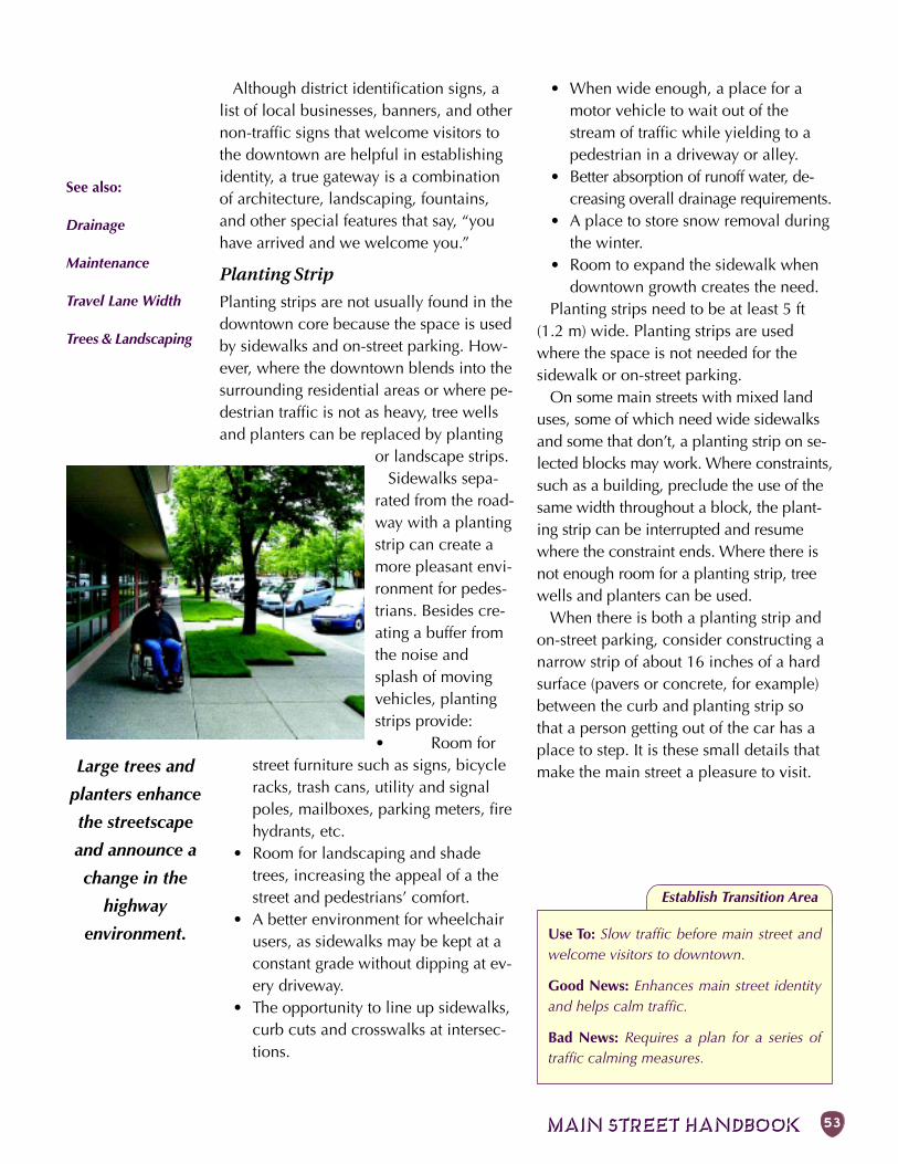
MAIN STREET HANDBOOK 53
Large trees and
planters enhance
the streetscape
and announce a
change in the
highway
environment.
Establish Transition Area
Although district identification signs, alist of local businesses, banners, and othernon-traffic signs that welcome visitors tothe downtown are helpful in establishingidentity, a true gateway is a combinationof architecture, landscaping, fountains,and other special features that say, “youhave arrived and we welcome you.”
Planting Strip
Planting strips are not usually found in thedowntown core because the space is usedby sidewalks and on-street parking. How-ever, where the downtown blends into thesurrounding residential areas or where pe-destrian traffic is not as heavy, tree wellsand planters can be replaced by planting
or landscape strips.Sidewalks sepa-
rated from the road-way with a plantingstrip can create amore pleasant envi-ronment for pedes-trians. Besides cre-ating a buffer fromthe noise andsplash of movingvehicles, plantingstrips provide:• Room for
street furniture such as signs, bicycleracks, trash cans, utility and signalpoles, mailboxes, parking meters, firehydrants, etc.
• Room for landscaping and shadetrees, increasing the appeal of a thestreet and pedestrians’ comfort.
• A better environment for wheelchairusers, as sidewalks may be kept at aconstant grade without dipping at ev-ery driveway.
• The opportunity to line up sidewalks,curb cuts and crosswalks at intersec-tions.
Use To: Slow traffic before main street andwelcome visitors to downtown.
Good News: Enhances main street identityand helps calm traffic.
Bad News: Requires a plan for a series oftraffic calming measures.
• When wide enough, a place for amotor vehicle to wait out of thestream of traffic while yielding to apedestrian in a driveway or alley.
• Better absorption of runoff water, de-creasing overall drainage requirements.
• A place to store snow removal duringthe winter.
• Room to expand the sidewalk whendowntown growth creates the need.
Planting strips need to be at least 5 ft(1.2 m) wide. Planting strips are usedwhere the space is not needed for thesidewalk or on-street parking.
On some main streets with mixed landuses, some of which need wide sidewalksand some that don’t, a planting strip on se-lected blocks may work. Where constraints,such as a building, preclude the use of thesame width throughout a block, the plant-ing strip can be interrupted and resumewhere the constraint ends. Where there isnot enough room for a planting strip, treewells and planters can be used.
When there is both a planting strip andon-street parking, consider constructing anarrow strip of about 16 inches of a hardsurface (pavers or concrete, for example)between the curb and planting strip sothat a person getting out of the car has aplace to step. It is these small details thatmake the main street a pleasure to visit.
See also:
Drainage
Maintenance
Travel Lane Width
Trees & Landscaping
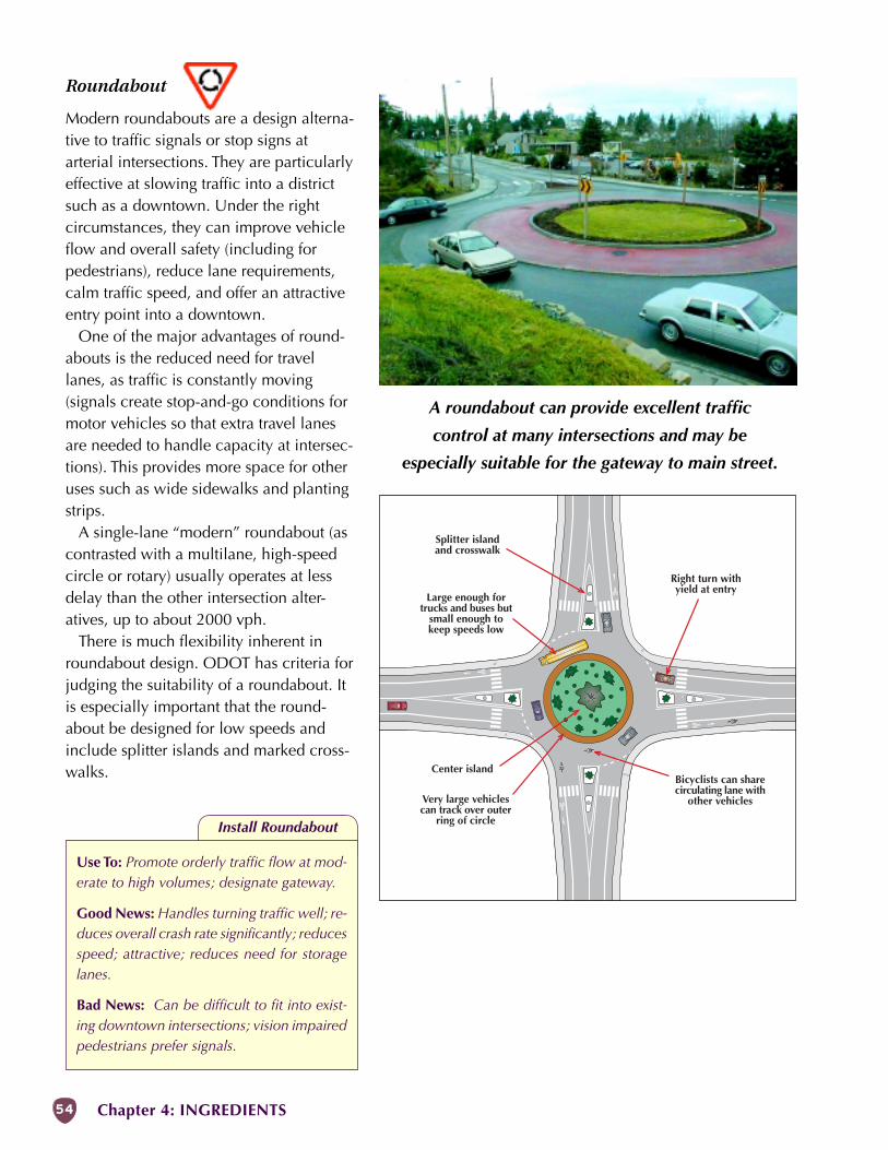
54 Chapter 4: INGREDIENTS
Center island
Splitter islandand crosswalk
Right turn withyield at entry
Bicyclists can sharecirculating lane with
other vehicles
Large enough fortrucks and buses but
small enough tokeep speeds low
Very large vehiclescan track over outer
ring of circle
A roundabout can provide excellent traffic
control at many intersections and may be
especially suitable for the gateway to main street.
Install Roundabout
Use To: Promote orderly traffic flow at mod-erate to high volumes; designate gateway.
Good News: Handles turning traffic well; re-duces overall crash rate significantly; reducesspeed; attractive; reduces need for storagelanes.
Bad News: Can be difficult to fit into exist-ing downtown intersections; vision impairedpedestrians prefer signals.
Roundabout
Modern roundabouts are a design alterna-tive to traffic signals or stop signs atarterial intersections. They are particularlyeffective at slowing traffic into a districtsuch as a downtown. Under the rightcircumstances, they can improve vehicleflow and overall safety (including forpedestrians), reduce lane requirements,calm traffic speed, and offer an attractiveentry point into a downtown.
One of the major advantages of round-abouts is the reduced need for travellanes, as traffic is constantly moving(signals create stop-and-go conditions formotor vehicles so that extra travel lanesare needed to handle capacity at intersec-tions). This provides more space for otheruses such as wide sidewalks and plantingstrips.
A single-lane “modern” roundabout (ascontrasted with a multilane, high-speedcircle or rotary) usually operates at lessdelay than the other intersection alter-atives, up to about 2000 vph.
There is much flexibility inherent inroundabout design. ODOT has criteria forjudging the suitability of a roundabout. Itis especially important that the round-about be designed for low speeds andinclude splitter islands and marked cross-walks.
MAIN STREET HANDBOOK 55
Travel Lane RemovalReducing the number of travel lanes,particularly from 4 to 3 (2 travel laneswith a center turn lane), is a proven wayto decrease speeds, smooth traffic flow,and reduce crashes. Up to 18,000 ADT(average daily traffic) can normally beaccommodated on 3-lane roads, witheven more in some situations.
Motorists on 4-lane highways, oftenseeing an empty lane in their direction,tend to drive faster than they should. Theyalso seek to match the speed of otherdrivers, so that the fastest vehicles tend toset prevailing speeds.
During peak volumes, when moreturning movements occur, motorists driveclose to one another, preventing motoristsbehind them from seeing ahead. Last-second lane swapping to get aroundturning vehicles leads to side-swipe andrear-end crashes.
Head-on collisions also occur when left-turning drivers try to turn across bothoncoming lanes, only to discover too latethat a car in the second lane was tempo-rarily screened from view.
Pedestrians and bicyclists have difficultyfinding gaps across 4 and 5 lanes, whichdiscourages walking (and transit use) andpromotes dangerous wrong-way bicycleriding. Even when a car in one lane stopsfor crossing pedestrians, cars in theadjacent lane may not stop, which hascontributed to many pedestrian fatalities.
Converting the street down to 3 andeven 2 lanes can correct these problems.On main street highway segments, thewidth formerly used for a travel lane canbe used for bike lanes, parking lanes, orwider sidewalks. If a center lane is part ofthe design, it can be used for pedestrianrefuge islands. And by narrowing thehighway in the commercial core, it is
easier for customers to cross the highwayto other businesses.
Removing lanes may result in conges-tion at key intersections which can oftenbe remedied by incorporating turn lanes,improved signal timing, or roundabouts.Improving alternate routes and streetconnectivity may also allow main street toundergo a lane reduction. When lookingat a lane reduction, consider access foremergency vehicles during congestedperiods.
Examples of Oregon highway mainstreets that have been converted from 4 to3 lanes can be found in Prineville andBaker City.
Reduce Number of Travel Lanes
Use To: Reclaim width for other uses.
Good News: Improves appearance, safety forall users, and balance.
Bad News: Peak traffic congestion may re-quire improvements at intersections or onother streets.
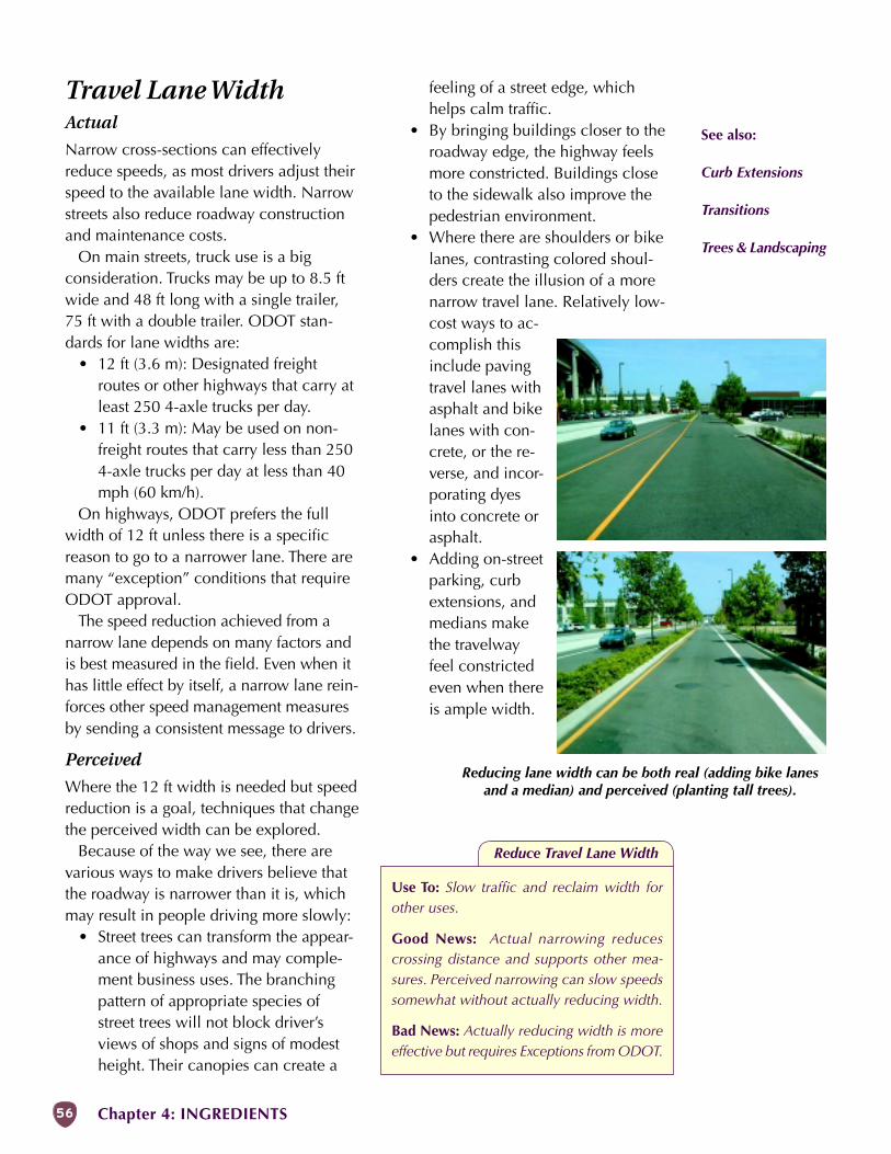
56 Chapter 4: INGREDIENTS
Reduce Travel Lane Width
Use To: Slow traffic and reclaim width forother uses.
Good News: Actual narrowing reducescrossing distance and supports other mea-sures. Perceived narrowing can slow speedssomewhat without actually reducing width.
Bad News: Actually reducing width is moreeffective but requires Exceptions from ODOT.
Reducing lane width can be both real (adding bike lanesand a median) and perceived (planting tall trees).
feeling of a street edge, whichhelps calm traffic.
• By bringing buildings closer to theroadway edge, the highway feelsmore constricted. Buildings closeto the sidewalk also improve thepedestrian environment.
• Where there are shoulders or bikelanes, contrasting colored shoul-ders create the illusion of a morenarrow travel lane. Relatively low-cost ways to ac-complish thisinclude pavingtravel lanes withasphalt and bikelanes with con-crete, or the re-verse, and incor-porating dyesinto concrete orasphalt.
• Adding on-streetparking, curbextensions, andmedians makethe travelwayfeel constrictedeven when thereis ample width.
Travel Lane WidthActual
Narrow cross-sections can effectivelyreduce speeds, as most drivers adjust theirspeed to the available lane width. Narrowstreets also reduce roadway constructionand maintenance costs.
On main streets, truck use is a bigconsideration. Trucks may be up to 8.5 ftwide and 48 ft long with a single trailer,75 ft with a double trailer. ODOT stan-dards for lane widths are:
• 12 ft (3.6 m): Designated freightroutes or other highways that carry atleast 250 4-axle trucks per day.
• 11 ft (3.3 m): May be used on non-freight routes that carry less than 2504-axle trucks per day at less than 40mph (60 km/h).
On highways, ODOT prefers the fullwidth of 12 ft unless there is a specificreason to go to a narrower lane. There aremany “exception” conditions that requireODOT approval.
The speed reduction achieved from anarrow lane depends on many factors andis best measured in the field. Even when ithas little effect by itself, a narrow lane rein-forces other speed management measuresby sending a consistent message to drivers.
Perceived
Where the 12 ft width is needed but speedreduction is a goal, techniques that changethe perceived width can be explored.
Because of the way we see, there arevarious ways to make drivers believe thatthe roadway is narrower than it is, whichmay result in people driving more slowly:
• Street trees can transform the appear-ance of highways and may comple-ment business uses. The branchingpattern of appropriate species ofstreet trees will not block driver’sviews of shops and signs of modestheight. Their canopies can create a
See also:
Curb Extensions
Transitions
Trees & Landscaping
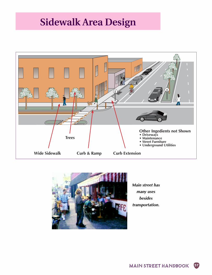
MAIN STREET HANDBOOK 57
Wide Sidewalk
Other Ingedients not Shown• Driveways• Maintenance• Street Furniture• Underground Utilities
Curb ExtensionCurb & Ramp
Trees
Sidewalk Area Design
Main street has
many uses
besides
transportation.
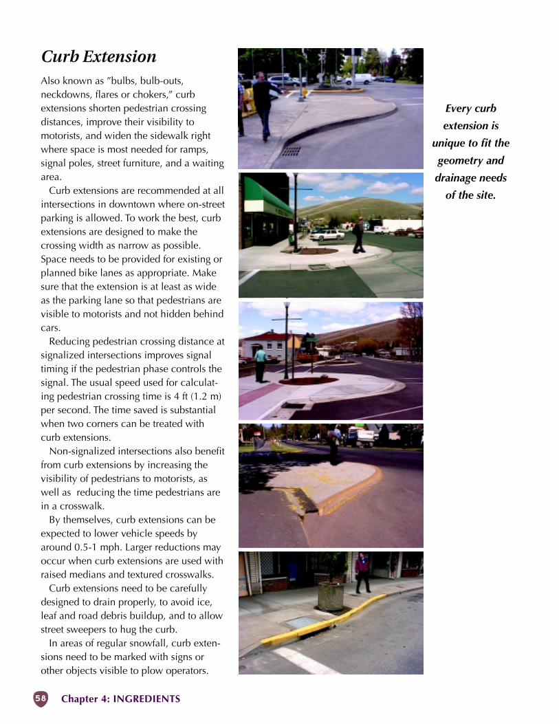
58 Chapter 4: INGREDIENTS
Every curb
extension is
unique to fit the
geometry and
drainage needs
of the site.
Curb ExtensionAlso known as ”bulbs, bulb-outs,neckdowns, flares or chokers,” curbextensions shorten pedestrian crossingdistances, improve their visibility tomotorists, and widen the sidewalk rightwhere space is most needed for ramps,signal poles, street furniture, and a waitingarea.
Curb extensions are recommended at allintersections in downtown where on-streetparking is allowed. To work the best, curbextensions are designed to make thecrossing width as narrow as possible.Space needs to be provided for existing orplanned bike lanes as appropriate. Makesure that the extension is at least as wideas the parking lane so that pedestrians arevisible to motorists and not hidden behindcars.
Reducing pedestrian crossing distance atsignalized intersections improves signaltiming if the pedestrian phase controls thesignal. The usual speed used for calculat-ing pedestrian crossing time is 4 ft (1.2 m)per second. The time saved is substantialwhen two corners can be treated withcurb extensions.
Non-signalized intersections also benefitfrom curb extensions by increasing thevisibility of pedestrians to motorists, aswell as reducing the time pedestrians arein a crosswalk.
By themselves, curb extensions can beexpected to lower vehicle speeds byaround 0.5-1 mph. Larger reductions mayoccur when curb extensions are used withraised medians and textured crosswalks.
Curb extensions need to be carefullydesigned to drain properly, to avoid ice,leaf and road debris buildup, and to allowstreet sweepers to hug the curb.
In areas of regular snowfall, curb exten-sions need to be marked with signs orother objects visible to plow operators.
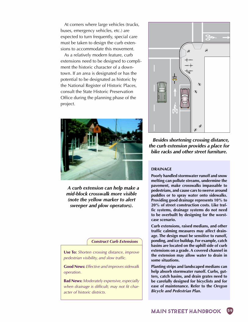
MAIN STREET HANDBOOK 59
Besides shortening crossing distance,the curb extension provides a place forbike racks and other street furniture.
A curb extension can help make amid-block crosswalk more visible(note the yellow marker to alertsweeper and plow operators).
At corners where large vehicles (trucks,buses, emergency vehicles, etc.) areexpected to turn frequently, special caremust be taken to design the curb exten-sions to accommodate this movement.
As a relatively modern feature, curbextensions need to be designed to compli-ment the historic character of a down-town. If an area is designated or has thepotential to be designated as historic bythe National Register of Historic Places,consult the State Historic PreservationOffice during the planning phase of theproject.
Construct Curb Extensions
Use To: Shorten crossing distance, improvepedestrian visibility, and slow traffic.
Good News: Effective and improves sidewalkoperation.
Bad News: Moderately expensive, especiallywhen drainage is difficult; may not fit char-acter of historic districts.
DRAINAGE
Poorly handled stormwater runoff and snowmelting can pollute streams, undermine thepavement, make crosswalks impassable topedestrians, and cause cars to swerve aroundpuddles or to spray water onto sidewalks.Providing good drainage represents 10% to20% of street construction costs. Like traf-fic systems, drainage systems do not needto be overbuilt by designing for the worst-case scenario.
Curb extensions, raised medians, and othertraffic calming measures may affect drain-age. The design must be sensitive to runoff,ponding, and ice buildup. For example, catchbasins are located on the uphill side of curbextensions on a grade. A covered channel inthe extension may allow water to drain insome situations.
Planting strips and landscaped medians canhelp absorb stormwater runoff. Curbs, gut-ters, catch basins, and drain grates need tobe carefully designed for bicyclists and forease of maintenance. Refer to the OregonBicycle and Pedestrian Plan.
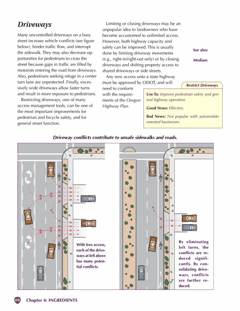
60 Chapter 4: INGREDIENTS
With free access,each of the drive-ways at left abovehas many poten-tial conflicts.
By eliminatingleft turns, theconflicts are re-duced signifi-cantly. By con-solidating drive-ways, conflictsare further re-duced.
Driveway conflicts contribute to unsafe sidewalks and roads.
See also:
Medians
DrivewaysMany uncontrolled driveways on a busystreet increase vehicle conflicts (see figurebelow), hinder traffic flow, and interruptthe sidewalk. They may also decrease op-portunities for pedestrians to cross thestreet because gaps in traffic are filled bymotorists entering the road from driveways.Also, pedestrians seeking refuge in a centerturn lane are unprotected. Finally, exces-sively wide driveways allow faster turnsand result in more exposure to pedestrians.
Restricting driveways, one of manyaccess management tools, can be one ofthe most important improvements forpedestrian and bicycle safety, and forgeneral street function.
Limiting or closing driveways may be anunpopular idea to landowners who havebecome accustomed to unlimited access.However, both highway capacity andsafety can be improved. This is usuallydone by limiting driveway movements(e.g., right-in/right-out only) or by closingdriveways and shifting property access toshared driveways or side streets.
Any new access onto a state highwaymust be approved by ODOT, and willneed to conformwith the require-ments of the OregonHighway Plan.
Restrict Driveways
Use To: Improve pedestrian safety and gen-eral highway operation.
Good News: Effective.
Bad News: Not popular with automobile-oriented businesses.
MAIN STREET HANDBOOK 61
MaintenanceMaintenance can be one of the trickiestissues to address with main street projects.Communities may resist installing mediansor landscaping because of maintenancecosts. In most communities, an intergov-ernmental agreement describes whosweeps the street, freshens the paint, andremoves the snow. Other issues to beworked out at the local level are garbagepickup, sidewalk maintenance, landscap-ing, and street furniture maintenance andrepair. In some communities, the down-town association shares costs with the cityor county and park district.
Walkways
Without regular maintenance, trash anddebris collect on sidewalks and concretefalls apart. Surface deterioration can beboth unpleasant and unsafe. Regularmaintenance protects the community’s in-vestment in walkways.
Where people congregate, their belovedpets come along. It seems like a little thing,but a station for dog waste (with a garbagecan and free plastic bags) makes mainstreet more inviting for everyone and in-creases peer pressure to clean up after pets.
Striping
Signs and pavement markings are easy tosee when they are new. Over time, signsmay fall into disrepair and markings maybecome hard to see, especially at night. It
is important to keepthe lane lines vis-ible, especially ifthere is a bike lane.
Signs and pave-ment markings needto be kept in a read-able condition, es-pecially those di-rected at motorists.
Pedestrians and bicyclists rely on motoristsobserving the signs and legends that regu-late their movements. Examples includeSTOP signs, stop bars, lane lines, etc.Maintenance programs need to:
• Inspect signs and legends regularly,including reflectivity at night.
• Replace defective signs quickly.• Retrace legends, crosswalks and
other pavement markings in thespring; in high-use areas or wherestudded tires are common, these mayrequire another paint application inthe fall.
Landscaping
Landscaping requires maintenance tokeep plants in good condition, trim veg-etation and remove debris. Vegetation en-croaching into bikeways or walkways isboth a nuisance and a safety problem.Roots need to be controlled to preventthem from heaving the sidewalk. Ad-equate clearances and sight-distancesneed to be maintained at driveways andintersections. Pedestrians and bicyclistsmust be visible to approaching motorists,rather than hidden by overgrown shrubs orlow-hanging branches, which can also ob-scure signs.
Local ordinances can ensure that veg-etation on private property is regularlymaintained. Some jurisdictions require ad-jacent land owners to control vegetation,or else maintenance personnel performthe work and bill the property owner.
The key to quality landscaping is inchoosing the appropriate materials andmaintenance. Property owners must par-ticipate in both aspects. What drives thesuccess is the shared social expectationthat taking care of the streetscape is theresponsible thing to do. And it shows thatthe property owner cares about the com-munity.
Increase Maintenance Operations
Use To: Improve main street environment andsafety.
Good News: Shows pride and a healthystreet.
Bad News: Requires on-going commitmentand funding.
See also:
Curb Extension
Drainage
Trees & Landscaping
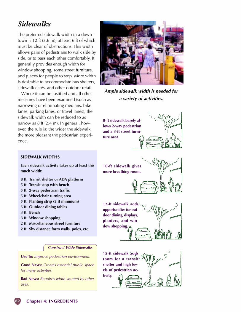
62 Chapter 4: INGREDIENTS
8-ft sidewalk barely al-lows 2-way pedestrianand a 3-ft street furni-ture area.
10-ft sidewalk givesmore breathing room.
12-ft sidewalk addsopportunities for out-door dining, displays,planters, and win-dow shopping.
15-ft sidewalk addsroom for a transitshelter and high lev-els of pedestrian ac-tivity.
Ample sidewalk width is needed for
a variety of activities.
Construct Wide Sidewalks
Use To: Improve pedestrian environment.
Good News: Creates essential public spacefor many activities.
Bad News: Requires width wanted by otheruses.
SidewalksThe preferred sidewalk width in a down-town is 12 ft (3.6 m), at least 6 ft of whichmust be clear of obstructions. This widthallows pairs of pedestrians to walk side byside, or to pass each other comfortably. Itgenerally provides enough width forwindow shopping, some street furniture,and places for people to stop. More widthis desirable to accommodate bus shelters,sidewalk cafés, and other outdoor retail.
Where it can be justified and all othermeasures have been examined (such asnarrowing or eliminating medians, bikelanes, parking lanes, or travel lanes), thesidewalk width can be reduced to asnarrow as 8 ft (2.4 m). In general, how-ever, the rule is: the wider the sidewalk,the more pleasant the pedestrian experi-ence.
SIDEWALK WIDTHS
Each sidewalk activity takes up at least thismuch width:
8 ft Transit shelter or ADA platform5 ft Transit stop with bench5 ft 2-way pedestrian traffic5 ft Wheelchair turning area5 ft Planting strip (3 ft minimum)5 ft Outdoor dining tables3 ft Bench3 ft Window shopping2 ft Miscellaneous street furniture2 ft Shy distance form walls, poles, etc.
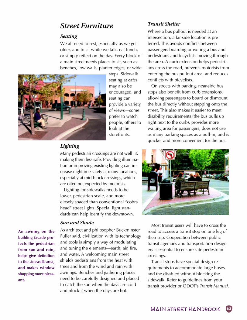
MAIN STREET HANDBOOK 63
Street FurnitureSeating
We all need to rest, especially as we getolder, and to sit while we talk, eat lunch,or simply reflect on the day. Every block ofa main street needs places to sit, such asbenches, low walls, planter edges, or wide
steps. Sidewalkseating at cafesmay also beencouraged, andseating canprovide a varietyof views—someprefer to watchpeople, others tolook at thestorefronts.
Lighting
Many pedestrian crossings are not well lit,making them less safe. Providing illumina-tion or improving existing lighting can in-crease nighttime safety at many locations,especially at mid-block crossings, whichare often not expected by motorists.
Lighting for sidewalks needs to belower, pedestrian scale, and moreclosely spaced than conventional “cobrahead” street lights. Special light stan-dards can help identify the downtown.
Sun and Shade
As architect and philosopher BuckminsterFuller said, civilization with its technologyand tools is simply a way of modulatingand tuning the elements—earth, air, fire,and water. A welcoming main streetshields pedestrians from the heat withtrees and from the wind and rain withawnings. Benches and gathering placesneed to be carefully designed and placedto catch the sun when the days are coldand block it when the days are hot.
Transit Shelter
Where a bus pullout is needed at anintersection, a far-side location is pre-ferred. This avoids conflicts betweenpassengers boarding or exiting a bus andpedestrians and bicyclists moving throughthe area. A curb extension helps pedestri-ans cross the road, prevents motorists fromentering the bus pullout area, and reducesconflicts with bicyclists.
On streets with parking, near-side busstops also benefit from curb extensions,allowing passengers to board or dismountthe bus directly without stepping onto thestreet. This also makes it easier to meetdisability requirements (the bus pulls upright next to the curb), provides morewaiting area for passengers, does not useas many parking spaces as a pull-in, and isquicker and more convenient for the bus.
Most transit users will have to cross theroad to access a transit stop on one leg oftheir trip. Cooperation between publictransit agencies and transportation design-ers is essential to ensure safe pedestriancrossings.
Transit stops have special design re-quirements to accommodate large busesand the disabled without blocking thesidewalk. Refer to guidelines from yourtransit provider or ODOT’s Transit Manual.
An awning on the
building facade pro-
tects the pedestrian
from sun and rain,
helps give definition
to the sidewalk area,
and makes window
shopping more pleas-
ant.
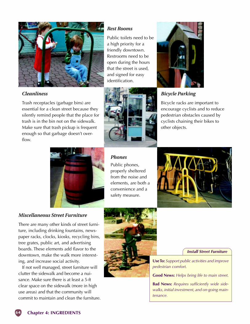
64 Chapter 4: INGREDIENTS
Install Street Furniture
Use To: Support public activities and improvepedestrian comfort.
Good News: Helps bring life to main street.
Bad News: Requires sufficiently wide side-walks, initial investment, and on-going main-tenance.
Cleanliness
Trash receptacles (garbage bins) areessential for a clean street because theysilently remind people that the place fortrash is in the bin not on the sidewalk.Make sure that trash pickup is frequentenough so that garbage doesn’t over-flow.
Phones
Public phones,properly shelteredfrom the noise andelements, are both aconvenience and asafety measure.
Rest Rooms
Public toilets need to bea high priority for afriendly downtown.Restrooms need to beopen during the hoursthat the street is used,and signed for easyidentification.
Bicycle Parking
Bicycle racks are important toencourage cyclists and to reducepedestrian obstacles caused bycyclists chaining their bikes toother objects.
Miscellaneous Street Furniture
There are many other kinds of street furni-ture, including drinking fountains, news-paper racks, clocks, kiosks, recycling bins,tree grates, public art, and advertisingboards. These elements add flavor to thedowntown, make the walk more interest-ing, and increase social activity.
If not well managed, street furniture willclutter the sidewalk and become a nui-sance. Make sure there is at least a 5-ftclear space on the sidewalk (more in highuse areas) and that the community willcommit to maintain and clean the furniture.
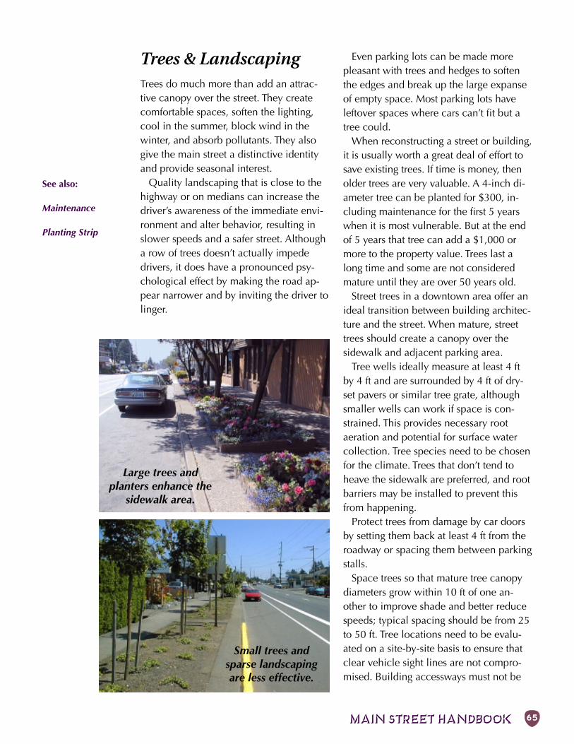
MAIN STREET HANDBOOK 65
Large trees andplanters enhance the
sidewalk area.
Small trees andsparse landscapingare less effective.
Trees & LandscapingTrees do much more than add an attrac-tive canopy over the street. They createcomfortable spaces, soften the lighting,cool in the summer, block wind in thewinter, and absorb pollutants. They alsogive the main street a distinctive identityand provide seasonal interest.
Quality landscaping that is close to thehighway or on medians can increase thedriver’s awareness of the immediate envi-ronment and alter behavior, resulting inslower speeds and a safer street. Althougha row of trees doesn’t actually impededrivers, it does have a pronounced psy-chological effect by making the road ap-pear narrower and by inviting the driver tolinger.
Even parking lots can be made morepleasant with trees and hedges to softenthe edges and break up the large expanseof empty space. Most parking lots haveleftover spaces where cars can’t fit but atree could.
When reconstructing a street or building,it is usually worth a great deal of effort tosave existing trees. If time is money, thenolder trees are very valuable. A 4-inch di-ameter tree can be planted for $300, in-cluding maintenance for the first 5 yearswhen it is most vulnerable. But at the endof 5 years that tree can add a $1,000 ormore to the property value. Trees last along time and some are not consideredmature until they are over 50 years old.
Street trees in a downtown area offer anideal transition between building architec-ture and the street. When mature, streettrees should create a canopy over thesidewalk and adjacent parking area.
Tree wells ideally measure at least 4 ftby 4 ft and are surrounded by 4 ft of dry-set pavers or similar tree grate, althoughsmaller wells can work if space is con-strained. This provides necessary rootaeration and potential for surface watercollection. Tree species need to be chosenfor the climate. Trees that don’t tend toheave the sidewalk are preferred, and rootbarriers may be installed to prevent thisfrom happening.
Protect trees from damage by car doorsby setting them back at least 4 ft from theroadway or spacing them between parkingstalls.
Space trees so that mature tree canopydiameters grow within 10 ft of one an-other to improve shade and better reducespeeds; typical spacing should be from 25to 50 ft. Tree locations need to be evalu-ated on a site-by-site basis to ensure thatclear vehicle sight lines are not compro-mised. Building accessways must not be
See also:
Maintenance
Planting Strip
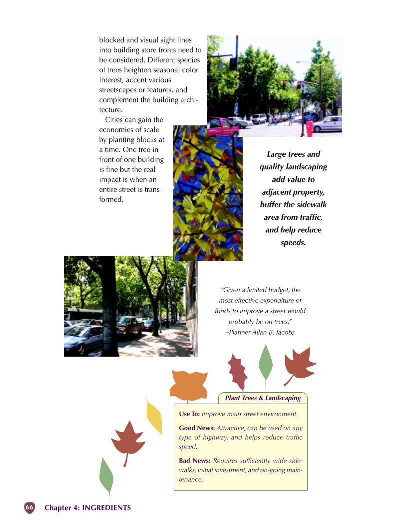
66 Chapter 4: INGREDIENTS
Plant Trees & Landscaping
Use To: Improve main street environment.
Good News: Attractive, can be used on anytype of highway, and helps reduce trafficspeed.
Bad News: Requires sufficiently wide side-walks, initial investment, and on-going main-tenance.
Large trees and
quality landscaping
add value to
adjacent property,
buffer the sidewalk
area from traffic,
and help reduce
speeds.
“Given a limited budget, the
most effective expenditure of
funds to improve a street would
probably be on trees.”
–Planner Allan B. Jacobs
blocked and visual sight linesinto building store fronts need tobe considered. Different speciesof trees heighten seasonal colorinterest, accent variousstreetscapes or features, andcomplement the building archi-tecture.
Cities can gain theeconomies of scaleby planting blocks ata time. One tree infront of one buildingis fine but the realimpact is when anentire street is trans-formed.
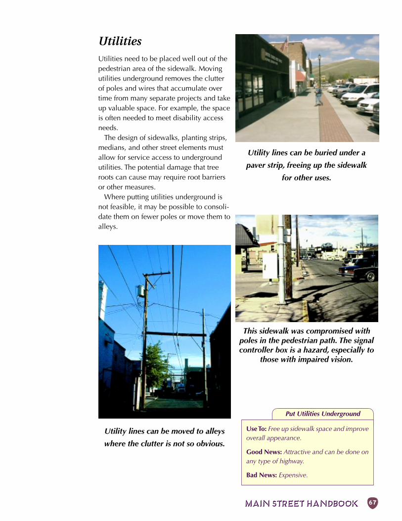
MAIN STREET HANDBOOK 67
Utility lines can be buried under a
paver strip, freeing up the sidewalk
for other uses.
This sidewalk was compromised withpoles in the pedestrian path. The signalcontroller box is a hazard, especially to
those with impaired vision.
Utility lines can be moved to alleys
where the clutter is not so obvious.
UtilitiesUtilities need to be placed well out of thepedestrian area of the sidewalk. Movingutilities underground removes the clutterof poles and wires that accumulate overtime from many separate projects and takeup valuable space. For example, the spaceis often needed to meet disability accessneeds.
The design of sidewalks, planting strips,medians, and other street elements mustallow for service access to undergroundutilities. The potential damage that treeroots can cause may require root barriersor other measures.
Where putting utilities underground isnot feasible, it may be possible to consoli-date them on fewer poles or move them toalleys.
Put Utilities Underground
Use To: Free up sidewalk space and improveoverall appearance.
Good News: Attractive and can be done onany type of highway.
Bad News: Expensive.
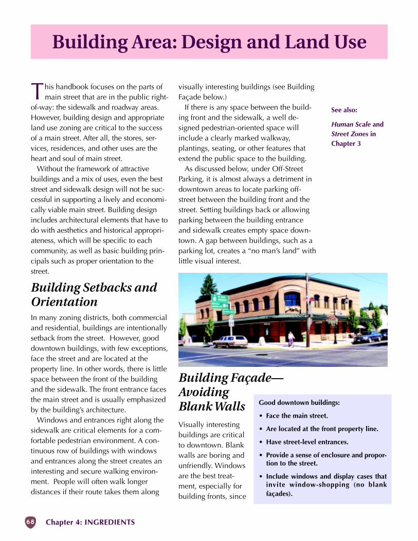
68 Chapter 4: INGREDIENTS
Building Area: Design and Land Use
visually interesting buildings (see BuildingFaçade below.)
If there is any space between the build-ing front and the sidewalk, a well de-signed pedestrian-oriented space willinclude a clearly marked walkway,plantings, seating, or other features thatextend the public space to the building.
As discussed below, under Off-StreetParking, it is almost always a detriment indowntown areas to locate parking off-street between the building front and thestreet. Setting buildings back or allowingparking between the building entranceand sidewalk creates empty space down-town. A gap between buildings, such as aparking lot, creates a “no man’s land” withlittle visual interest.
Building Façade—AvoidingBlank WallsVisually interestingbuildings are criticalto downtown. Blankwalls are boring andunfriendly. Windowsare the best treat-ment, especially forbuilding fronts, since
This handbook focuses on the parts ofmain street that are in the public right-
of-way: the sidewalk and roadway areas.However, building design and appropriateland use zoning are critical to the successof a main street. After all, the stores, ser-vices, residences, and other uses are theheart and soul of main street.
Without the framework of attractivebuildings and a mix of uses, even the beststreet and sidewalk design will not be suc-cessful in supporting a lively and economi-cally viable main street. Building designincludes architectural elements that have todo with aesthetics and historical appropri-ateness, which will be specific to eachcommunity, as well as basic building prin-cipals such as proper orientation to thestreet.
Building Setbacks andOrientationIn many zoning districts, both commercialand residential, buildings are intentionallysetback from the street. However, gooddowntown buildings, with few exceptions,face the street and are located at theproperty line. In other words, there is littlespace between the front of the buildingand the sidewalk. The front entrance facesthe main street and is usually emphasizedby the building’s architecture.
Windows and entrances right along thesidewalk are critical elements for a com-fortable pedestrian environment. A con-tinuous row of buildings with windowsand entrances along the street creates aninteresting and secure walking environ-ment. People will often walk longerdistances if their route takes them along
Good downtown buildings:
• Face the main street.
• Are located at the front property line.
• Have street-level entrances.
• Provide a sense of enclosure and propor-tion to the street.
• Include windows and display cases thatinvite window-shopping (no blankfaçades).
See also:
Human Scale andStreet Zones inChapter 3
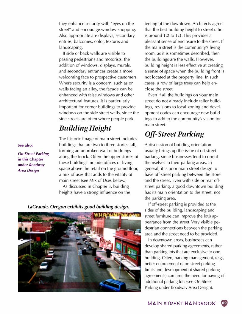
MAIN STREET HANDBOOK 69
they enhance security with “eyes on thestreet” and encourage window-shopping.Also appropriate are displays, secondaryentries, balconies, color, texture, andlandscaping.
If side or back walls are visible topassing pedestrians and motorists, theaddition of windows, displays, murals,and secondary entrances create a morewelcoming face to prospective customers.Where security is a concern, such as onwalls facing an alley, the façade can beenhanced with false windows and otherarchitectural features. It is particularlyimportant for corner buildings to providewindows on the side street walls, since theside streets are often where people park.
Building HeightThe historic image of main street includesbuildings that are two to three stories tall,forming an unbroken wall of buildingsalong the block. Often the upper stories ofthese buildings include offices or livingspace above the retail on the ground floor,a mix of uses that adds to the vitality ofmain street (see Mix of Uses below.)
As discussed in Chapter 3, buildingheights have a strong influence on the
feeling of the downtown. Architects agreethat the best building height to street ratiois around 1:2 to 1:3. This provides apleasant sense of enclosure to the street. Ifthe main street is the community’s livingroom, as it is sometimes described, thenthe buildings are the walls. However,building height is less effective at creatinga sense of space when the building front isnot located at the property line. In suchcases, a row of large trees can help en-close the street.
Even if all the buildings on your mainstreet do not already include taller build-ings, revisions to local zoning and devel-opment codes can encourage new build-ings to add to the community’s vision formain street.
Off-Street ParkingA discussion of building orientationusually brings up the issue of off-streetparking, since businesses tend to orientthemselves to their parking areas. Ingeneral, it is poor main street design tohave off-street parking between the storeand the street. Even with side or rear off-street parking, a good downtown buildinghas its main orientation to the street, notthe parking area.
If off-street parking is provided at thesides of the building, landscaping andstreet furniture can improve the lot’s ap-pearance from the street. Very visible pe-destrian connections between the parkingarea and the street need to be provided.
In downtown areas, businesses candevelop shared parking agreements, ratherthan parking lots that are exclusive to onebuilding. Often, parking management, (e.g.,better enforcement of on street parkinglimits and development of shared parkingagreements) can limit the need for paving ofadditional parking lots (see On-StreetParking under Roadway Area Design).
LaGrande, Oregon exhibits good building design.
See also:
On-Street Parkingin this Chapterunder RoadwayArea Design
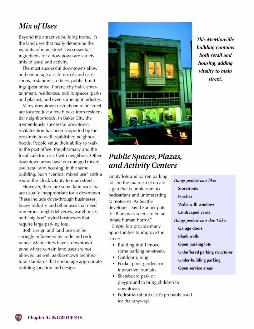
70 Chapter 4: INGREDIENTS
Mix of UsesBeyond the attractive building fronts, it’sthe land uses that really determine theviability of main street. Two essentialingredients for a downtown are variety(mix of uses) and activity.
The most successful downtowns allowand encourage a rich mix of land uses:shops, restaurants, offices, public build-ings (post office, library, city hall), enter-tainment, residences, public spaces (parksand plazas), and even some light industry.
Many downtown districts on main streetare located just a few blocks from residen-tial neighborhoods. In Baker City, thetremendously successful downtownrevitalization has been supported by theproximity to well established neighbor-hoods. People value their ability to walkto the post office, the pharmacy and thelocal café for a visit with neighbors. Otherdowntown areas have encouraged mixeduse (retail and housing) in the samebuilding. Such “vertical mixed use” adds around-the-clock vitality to main street.
However, there are some land uses thatare usually inappropriate for a downtown.These include drive-through businesses,heavy industry and other uses that neednumerous freight deliveries, warehouses,and “big box” styled businesses thatrequire large parking lots.
Both design and land use can bestrongly influenced by code and ordi-nance. Many cities have a downtownzone where certain land uses are notallowed, as well as downtown architec-tural standards that encourage appropriatebuilding location and design.
Public Spaces, Plazas,and Activity CentersEmpty lots and barren parkinglots on the main street createa gap that is unpleasant topedestrians and uninterestingto motorists. As Seattledeveloper David Sucher putsit: “Blankness seems to be aninnate human horror.”
Empty lots provide manyopportunities to improve thestreet:
• Building in-fill (movesome parking on-street).
• Outdoor dining.• Pocket park, garden, or
interactive fountain.• Skateboard park or
playground to bring children todowntown.
• Pedestrian shortcut (it’s probably usedfor that anyway).
Things pedestrians like:
Storefronts
Porches
Walls with windows
Landscaped yards
Things pedestrians don’t like:
Garage doors
Blank walls
Open parking lots
Unbuffered parking structures
Under-building parking
Open service areas
This McMinnville
building contains
both retail and
housing, adding
vitality to main
street.
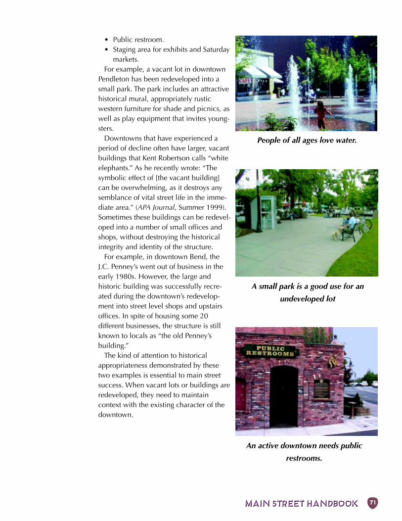
MAIN STREET HANDBOOK 71
• Public restroom.• Staging area for exhibits and Saturday
markets.For example, a vacant lot in downtown
Pendleton has been redeveloped into asmall park. The park includes an attractivehistorical mural, appropriately rusticwestern furniture for shade and picnics, aswell as play equipment that invites young-sters.
Downtowns that have experienced aperiod of decline often have larger, vacantbuildings that Kent Robertson calls “whiteelephants.” As he recently wrote: “Thesymbolic effect of [the vacant building]can be overwhelming, as it destroys anysemblance of vital street life in the imme-diate area.” (APA Journal, Summer 1999).Sometimes these buildings can be redevel-oped into a number of small offices andshops, without destroying the historicalintegrity and identity of the structure.
For example, in downtown Bend, theJ.C. Penney’s went out of business in theearly 1980s. However, the large andhistoric building was successfully recre-ated during the downtown’s redevelop-ment into street level shops and upstairsoffices. In spite of housing some 20different businesses, the structure is stillknown to locals as “the old Penney’sbuilding.”
The kind of attention to historicalappropriateness demonstrated by thesetwo examples is essential to main streetsuccess. When vacant lots or buildings areredeveloped, they need to maintaincontext with the existing character of thedowntown.
A small park is a good use for an
undeveloped lot
People of all ages love water.
An active downtown needs public
restrooms.
72 Chapter 4: INGREDIENTS
Other Ingredients
Enforcement
Most of the measures described in thishandbook influence traffic through
physical means, such as raised medians andlandscaping, and are largely self-enforcing.
Design, however, is not a substitute forenforcement of traffic laws. For example,many drivers do not know that crosswalksexist at unmarked intersections and thatthey violate the law by not yielding to pe-destrians at these locations.
Lack of enforcement also leads to laxbehavior. For example, if there is no pen-alty for parking on a sidewalk, thenpeople will begin to consider that behav-ior acceptable.
Other measures that attempt to regulatebehavior, such as speed zones and cross-walks, require at least some enforcementto achieve their goals. There is often theneed for intense initial enforcement fol-lowed by ongoing efforts when compli-ance inevitably declines.
Enforcement can be costly, and it is al-most never possible to provide at all re-quired times. Consequently, measureswhich rely primarily on enforcement arenot as effective as self-enforcing designs.New techniques such as photo-radar andcameras at signals have shown promise asdeterrents, but these approaches work bestto reinforce good road design, not as theprimary solution to enforcement problems.
Non-Highway Designsto Support Main StreetThere are several designs commonly usedon minor streets and driveways that,although they are generally inappropriateon highways, can be part of an overallstrategy to improve the surrounding streetnetwork that supports main street.
Speed humps, raised crosswalks, andraised intersections allow vehicles totravel at 30 mph (50 km/h) or less withminimal discomfort, but driving over thehump at higher speeds will rock thevehicle. They can be used in a pedestrianarea in combination with textured andcolored pavement so that crosswalks aremore visible and motorists learn to expectpedestrians. Avoid these designs ondesignated emergency response routesand where the grade exceeds about 8%.
Extending the concrete sidewalk acrossthe intersection—in effect, treating thestreet as if it were a driveway—can be aneffective way to slow traffic and drawattention to the sidewalk. The sidewalkcan be kept at grade or dropped, just likeat driveways, but is more effective if it isdesigned like a raised crosswalk. Sidewalkextensions are standard on alleys but canalso be used where local streets meetmain street. x
Expand Efforts to Side Streets
Use To: Support improvements on mainstreet.
Good News: More things can be done onoff-highway streets.
Bad News: Local funding usually needed.
Enforce the Traffic Laws
Use To: Make people more aware of the lawsand persuade them to comply.
Good News: Gets people attention.
Bad News: Expensive and on-going effort.
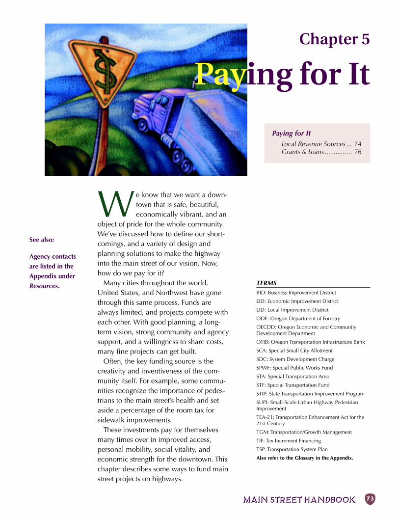
MAIN STREET HANDBOOK 73
TERMSBID: Business Improvement District
EID: Economic Improvement District
LID: Local Improvement District
ODF: Oregon Department of Forestry
OECDD: Oregon Economic and CommunityDevelopment Department
OTIB: Oregon Transportation Infrastructure Bank
SCA: Special Small City Allotment
SDC: System Development Charge
SPWF: Special Public Works Fund
STA: Special Transportation Area
STF: Special Transportation Fund
STIP: State Transportation Improvement Program
SUPI: Small-Scale Urban Highway PedestrianImprovement
TEA-21: Transportation Enhancement Act for the21st Century
TGM: Transportation/Growth Management
TIF: Tax Increment Financing
TSP: Transportation System Plan
Also refer to the Glossary in the Appendix.
Paying for ItLocal Revenue Sources ... 74Grants & Loans ............... 76
Chapter 5
Paying for It
We know that we want a down-town that is safe, beautiful,economically vibrant, and an
object of pride for the whole community.We’ve discussed how to define our short-comings, and a variety of design andplanning solutions to make the highwayinto the main street of our vision. Now,how do we pay for it?
Many cities throughout the world,United States, and Northwest have gonethrough this same process. Funds arealways limited, and projects compete witheach other. With good planning, a long-term vision, strong community and agencysupport, and a willingness to share costs,many fine projects can get built.
Often, the key funding source is thecreativity and inventiveness of the com-munity itself. For example, some commu-nities recognize the importance of pedes-trians to the main street’s health and setaside a percentage of the room tax forsidewalk improvements.
These investments pay for themselvesmany times over in improved access,personal mobility, social vitality, andeconomic strength for the downtown. Thischapter describes some ways to fund mainstreet projects on highways.
See also:
Agency contacts
are listed in the
Appendix under
Resources.
74 Chapter 5: PAYING FOR IT
Local Revenue Sources
System DevelopmentChargesSystem Development Charges (SDCs) arebecoming an increasingly popular way tofund public works infrastructure neededfor new development. The objective ofSDCs is to allocate portions of the costsassociated with capital improvements tothe developments that will increasedemand on transportation, sewer, or otherpublic systems. Although SDCs haveproven an effective tool in funding itemslike road widening or intersection up-grades triggered by the increases in trafficlinked to a certain new development, theyare not usually used to make generalinfrastructure improvements.
Local ImprovementDistrictsOregon Statutes allow the creation ofseveral different kinds of local fundingdistricts to finance different kinds ofimprovements to main streets. Some ofthese districts can fund capital improve-ment projects like sidewalk enhance-ments, while others support smallerprojects and program activities.
The following is a brief description ofspecific district types and what kinds ofimprovement they can fund. Each of thesemechanisms is limited to a specific area ordistrict where the taxpayers are the pri-mary beneficiaries of the improvements.Each process must be improved by thecommunity’s City Council.
Property Taxes
Property taxes are typically the primaryrevenue source for local governments
to upgrade public infrastructure. However,property taxes go into general fund opera-tions and are not used in most Oregoncities for street improvements or mainte-nance (these are more typically fundedout of gas taxes, discussed below). Depen-dence on property taxes has changed withthe passage of several ballot initiativesduring the 1990s. In general, these mea-sures limit property tax rates for purposesother than payment of certain voter-approved general obligation indebtedness.
Gas Tax RevenuesIn Oregon, the state collects gas taxes,vehicle registration fees, overweight andoverheight fines, and truck taxes andreturns a portion of the revenues to citiesand counties. Oregon cities typically usetheir state gas tax allocation to fund streetconstruction and maintenance. However,these funds can be used to make anytransportation-related improvements onlywithin the public right-of-way, includingsidewalks, intersection upgrades forpedestrians, and bicycle lanes.
State statute (ORS 366.514) requires thatif there is a need for walkways or bike-ways, then the governing jurisdiction shallexpend a reasonable amount of the gastax revenues to construct the neededfacilities. The statute also requires thatsidewalks be built when new streets areconstructed or existing streets are recon-structed.
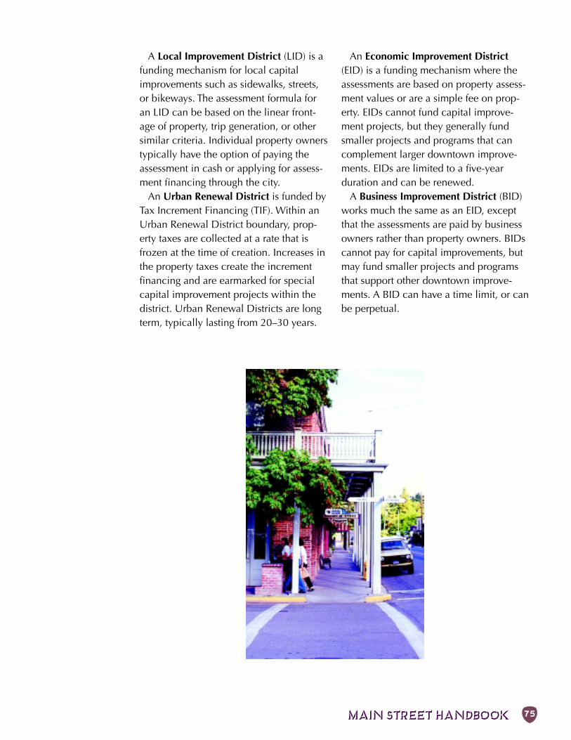
MAIN STREET HANDBOOK 75
A Local Improvement District (LID) is afunding mechanism for local capitalimprovements such as sidewalks, streets,or bikeways. The assessment formula foran LID can be based on the linear front-age of property, trip generation, or othersimilar criteria. Individual property ownerstypically have the option of paying theassessment in cash or applying for assess-ment financing through the city.
An Urban Renewal District is funded byTax Increment Financing (TIF). Within anUrban Renewal District boundary, prop-erty taxes are collected at a rate that isfrozen at the time of creation. Increases inthe property taxes create the incrementfinancing and are earmarked for specialcapital improvement projects within thedistrict. Urban Renewal Districts are longterm, typically lasting from 20–30 years.
An Economic Improvement District(EID) is a funding mechanism where theassessments are based on property assess-ment values or are a simple fee on prop-erty. EIDs cannot fund capital improve-ment projects, but they generally fundsmaller projects and programs that cancomplement larger downtown improve-ments. EIDs are limited to a five-yearduration and can be renewed.
A Business Improvement District (BID)works much the same as an EID, exceptthat the assessments are paid by businessowners rather than property owners. BIDscannot pay for capital improvements, butmay fund smaller projects and programsthat support other downtown improve-ments. A BID can have a time limit, or canbe perpetual.
76 Chapter 5: PAYING FOR IT
There are a variety of State and Federalgrant and loan programs available,
most with specific requirements relating toeconomic development or specific transpor-tation issues. Most programs require amatch from the local jurisdiction as a condi-tion of approval. Grant and loan programscannot be considered a secure long-termfunding source because they are highlycompetitive and subject to change.
Most of the programs available for trans-portation projects are funded and admin-istered through ODOT or the Oregon Eco-nomic and Community Development De-partment (OECDD). Some programswhich may be appropriate for main streetprojects are described below.
Transportation/GrowthManagement ProgramThe Transportation and Growth Manage-ment Program (TGM) promotes urbanplanning and design that results in com-pact development and pedestrian, bicycle,and transit-friendly options for local com-munities.
Initiated in 1993, TGM is a joint effort oftwo state agencies: the Oregon Depart-ment of Transportation and the Depart-ment of Land Conservation and Develop-ment. TGM supports local governments intheir efforts to manage growth and pro-vides a variety of grants and technical as-sistance programs. Program services areprovided in the following four areas.
Grants to Local Governments: Each bi-ennium, approximately $6.7 million is al-located by the legislature for grants to lo-cal governments. Grant assistance is avail-able in three categories:
1. Implementing the Transportation Pan-ning Rule by preparing TransportationSystem Plans and developing ordi-nances and appropriate street designstandards.
2. Planning for land use and transporta-tion alternatives such as downtownredevelopment planning and designa-tion of Special Transportation Areas.
3. Coordinating and implementing urbangrowth management strategies includ-ing development of intergovernmentalagreements and special area plans.
TGM staff are available to assist localcommunities with design and implemen-tation of projects as requested.
Quick Response Teams: Specialists inplanning and urban design are under con-tract to provide rapid response on devel-opment proposals. This service is avail-able to developers and communities thatare confronting urban design, develop-ment and regulatory problems.
“Smart Development” Code Assistance:In an effort to removeregulatory obstacles tosmart development, TGMstaff and consultants helplocal governments withplanning workshops anddevelopment code lan-guage. A model small cit-ies development code andmodel infill/redevelop-ment handbook are also available.
Outreach and Education: TGM providesongoing outreach to local communities inorder to promote the concepts of smartdevelopment. Workshops for neighbor-hood groups, planning commissionersand members of the business community
Grants & Loans
Smart Development:
• Provides a mix of uses.
• Uses land resources efficiently.
• Fully utilizes urban services.
• Provides transportation options.
• Uses detailed, human-scale design.
MAIN STREET HANDBOOK 77
are available throughout the state. Publi-cations, such as this Main Street Hand-book, and videos are available free ofcharge to Oregon residents.
State Bicycle andPedestrian GrantsODOT’s Bicycle and Pedestrian Programadministers two grant programs to assist inthe development of walking and bicyclingimprovements: local grants and Small-ScaleUrban Highway Pedestrian Improvement(SUPI) programs. For both these grants, cit-ies that have adopted plans with identifiedprojects will be in the best position.
Cities and counties can apply for localgrants for bicycle and pedestrian projectswithin the right-of-way of local streets. Lo-cal Grants up to $100,000 are shared 80%State/20% local. Projects that consider theneeds of children, elderly, disabled, andtransit users are given special consider-ation. There must be support for theproject from local elected officials. Appli-cations for the Local Grant program aremailed out to all Oregon jurisdictions ev-ery other year.
In the SUPI process, cities and countieshelp ODOT identify sections of urbanhighways where improvements areneeded. Examples of eligible projects in-clude:
• completing short missing sections ofsidewalks,
• ADA upgrades• crossing improvements (e.g., curb ex-
tensions, refuges, crosswalks), and• intersection improvements (e.g., is-
lands and realignment).SUPI projects are located on highways
that have no modernization projectsscheduled for the foreseeable future.Projects that have a local funding matchare typically viewed the most favorably be-cause this indicates strong local support.
Projects on highways that cost more than$100,000, require right-of-way, or haveenvironmental impacts need to be submit-ted to ODOT for inclusion in the STIP.
Special TransportationFundThe Special Transportation Fund (STF)Program maintains, develops, and im-proves transportation services for peoplewith disabilities and people over 60 yearsof age. Financed by a two-cent tax oneach pack of cigarettes sold in the state,the annual distribution of this fund isapproximately $5 million. Three-quartersof these funds are distributed to masstransit and transportation districts. Wheresuch districts do not exist, counties re-ceive funds on a per-capita basis. Theremaining funds are distributed on adiscretionary basis. The STF is managed byODOT.
Special Small CityAllotment ProgramThe Special Small City Allotment (SCA)Program is restricted to cities with popula-tions under 5,000. Unlike some othergrant programs, no locally funded matchis required for participation. Grantamounts are limited to $25,000 and mustbe earmarked for surface projects (drain-age, curbs, sidewalks, etc.).
The program allows jurisdictions to usethe grants to leverage local funds on non-surface projects if the grant is used specifi-cally to repair the affected area. Criteriafor the $1 million in total annual grantfunds include traffic volume, the 5-yearrate of population growth, surface wear ofthe road, and the time since the last SCAgrant. The SCA is managed by ODOT.
78 Chapter 5: PAYING FOR IT
Immediate OpportunityGrant ProgramThe Oregon Economic and CommunityDevelopment Department (OECDD) andODOT administer a program designed toassist local and regional economic devel-opment. The primary factors in determin-ing eligible projects for the ImmediateOpportunity Fund Program are improve-ment of public roads, inclusion of aneconomic development-related project ofregional significance, creation or retentionof primary employment, and ability toprovide local funds (50/50) to matchgrant. The maximum amount of any grantunder the program is $500,000.
Oregon Special PublicWorks FundThe Special Public Works Fund (SPWF),through OECDD, distributes grant andloan assistance from the Oregon Lotteryfor economic development projects incommunities throughout the state. To beawarded funds, a project must supportbusinesses wishing to locate, expand, orremain in Oregon. SPWF awards can beused for improvement, expansion, andnew construction of transportation facili-ties. The SPWF emphasizes loans to assurethat funds will return to the state over timefor reinvestment in other local economicdevelopment projects.
Oregon TransportationInfrastructure BankThe Oregon Transportation InfrastructureBank (OITB) is a project financing tool forOregon communities to help meet needfor transportation system maintenance andimprovements. As a project financing tool,the OITB works much like a private bank.It provides project loans and a range ofcredit enhancement services to help fi-nance eligible transportation projects. Eli-gible projects are projects that meet fed-eral-aid highway criteria or meet the defi-nition of a transit capital project.
Eligible agencies are cities, counties,port districts, other special districts, stateagencies, tribal governments, and privateentities. The benefits include faster projectcompletion, savings on maintenance costsby replacing worn facilities sooner, ad-vancing high-priority TEA-21 federal fundsto eliminate the 4–6 year waiting periodfor grants, and advancing other projectsthat have future sources of funding identi-fied. Proposed projects must meet theOTIB selection criteria, including theability to repay the loan. The OTIB hasapproved loans varying in size from$170,000 to $5 million.
An application for an OTIB loan is re-viewed, scored, and ranked by ODOT, andthen presented to the Oregon TransportationCommission, which approves or denies theloan. For approved applications, ODOTand the applicant enter into an interagencyand loan agreements to close the loan.Loan terms vary from 2 to 10 years.
MAIN STREET HANDBOOK 79
The Oregon LivabilityInitiative: The 21st Cen-tury Community FundThe Oregon Livability Initiative wascreated by Governor Kitzhaber to encour-age job creation in rural Oregon throughinvestments in housing, transportation,water, and sewer. The initiative seeks torevitalize downtowns and main streets,reduce sprawl and traffic congestion,reward development of affordable hous-ing, and rebuild rural and distressedeconomies.
The Oregon Livability Initiative includesthe 21st Century Community Fund, whichleverages existing revenues from both theOregon Lottery and transportation funds toinvest in affordable housing, transporta-tion, water, sewer and main streets. Thisfund specifically targets rural and eco-nomically distressed communities, provid-ing funding for passenger rail and con-necting buses, elderly and disable transitservices, access and right-of-way pur-chases, and improvements to the localstreet network.
The 21st Community Fund has been allo-cated as follows for the 1999-2001 bien-nium for transportation-related project:
• Passenger Rail & Connecting Buses,$10 million state general fund.
• Elderly & Disabled Transit Service, $9million state general fund and $10million federal funds (TEA-21), lever-aging $6-10 million of DHR funds.
• Access/Right of Way Purchases,$20million revenue bonds (highwayfund).
• Local Street Networks, $30 millionrevenue bonds (highway fund).
The fund will be managed by OECDD.The Oregon Livability Initiative also
includes $25 million in revenue bonds tocreate a “Community Incentive Fund”
administered by the Oregon Housing andCommunity Services Department. Flexiblegrants and loans will provide local gov-ernments and developers with state fundsto help revitalize downtowns and commu-nity centers and put affordable housingclose to jobs.
Urban Forestry GrantsThe Oregon Department of Forestry’s(ODF) Urban and Community ForestryUnit supports the stewardship of Oregon’surban and community forests. Part of theprogram’s goal is to foster public aware-ness of the contributions urban forestsmake to the quality of life and the envi-ronmental and economic well-being ofOregon cities.
Through the Urban Forestry activities,on-site technical and financial assistanceis available for communities, nonprofitgroups, and civic organizations who wantto plant and properly maintain treeswithin their urban areas, especially streettrees. Written information on tree protec-tion ordinances, inventories, tree care,planting, tree selection, and urban forestmanagement are also available. Contactthe ODF for more information on theUrban Forestry Program.
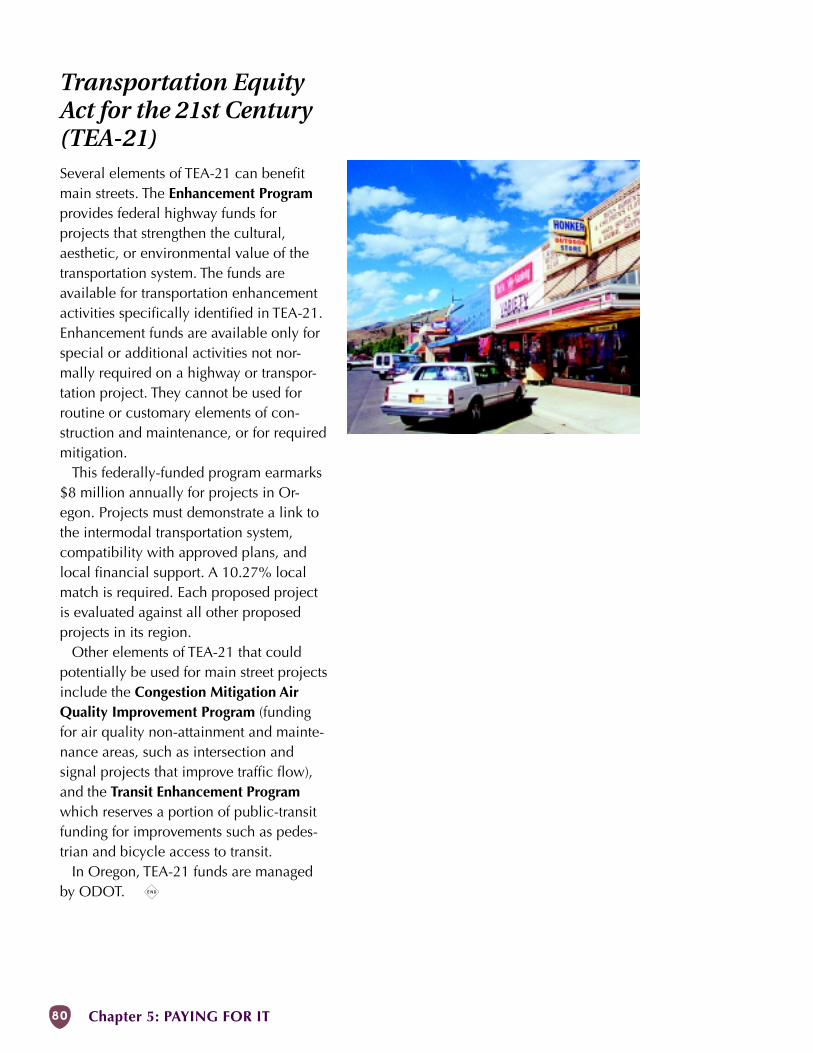
80 Chapter 5: PAYING FOR IT
Transportation EquityAct for the 21st Century(TEA-21)Several elements of TEA-21 can benefitmain streets. The Enhancement Programprovides federal highway funds forprojects that strengthen the cultural,aesthetic, or environmental value of thetransportation system. The funds areavailable for transportation enhancementactivities specifically identified in TEA-21.Enhancement funds are available only forspecial or additional activities not nor-mally required on a highway or transpor-tation project. They cannot be used forroutine or customary elements of con-struction and maintenance, or for requiredmitigation.
This federally-funded program earmarks$8 million annually for projects in Or-egon. Projects must demonstrate a link tothe intermodal transportation system,compatibility with approved plans, andlocal financial support. A 10.27% localmatch is required. Each proposed projectis evaluated against all other proposedprojects in its region.
Other elements of TEA-21 that couldpotentially be used for main street projectsinclude the Congestion Mitigation AirQuality Improvement Program (fundingfor air quality non-attainment and mainte-nance areas, such as intersection andsignal projects that improve traffic flow),and the Transit Enhancement Programwhich reserves a portion of public-transitfunding for improvements such as pedes-trian and bicycle access to transit.
In Oregon, TEA-21 funds are managedby ODOT. x
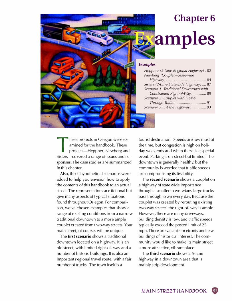
MAIN STREET HANDBOOK 81
ExamplesHeppner (2-Lane Regional Highway) . 82Newberg (Couplet—Statewide
Highway) ...................................... 84Sisters (2-Lane Statewide Highway) .... 87Scenario 1: Traditional Downtown with
Constrained Right-of-Way .............. 89Scenario 2: Couplet with Heavy
Through Traffic ............................. 91Scenario 3: 5-Lane Highway ............... 93
Chapter 6
Examples
Three projects in Oregon were ex-amined for the handbook. Theseprojects—Heppner, Newberg and
Sisters—covered a range of issues and re-sponses. The case studies are summarizedin this chapter.
Also, three hypothetical scenarios wereadded to help you envision how to applythe contents of this handbook to an actualstreet. The representations ar e fictional butgive many aspects of t ypical situationsfound throughout Or egon. For compari-son, we’ve chosen examples that show arange of existing conditions from a narro wtraditional downtown to a more amplecouplet created from t wo-way streets. Yourmain street, of course, will be unique.
The first scenario shows a traditionaldowntown located on a highway. It is anold street, with limited right-of- way and anumber of historic buildings. It is also animportant r egional travel route, with a fairnumber of trucks. The town itself is a
tourist destination. Speeds are low most ofthe time, but congestion is high on holi-day weekends and when there is a specialevent. Parking is on-str eet but limited. Thedowntown is generally healthy, but thecommunity is worried that tr affic speedsare compromising its livability.
The second scenario shows a couplet ona highway of state wide importancethrough a smaller to wn. Many large truckspass through to wn every day. Because thecouplet was created by rerouting existingtwo-way streets, the right-of- way is ample.However, there are many driveways,building density is low, and traffic speedstypically exceed the posted limit of 25mph. There are vacant stor efronts and fe wbuildings of historic al interest. The com-munity would like to make its main str eeta more attr active, vibrant place.
The third scenario shows a 5-lanehighway in a downtown area that ismainly strip development.
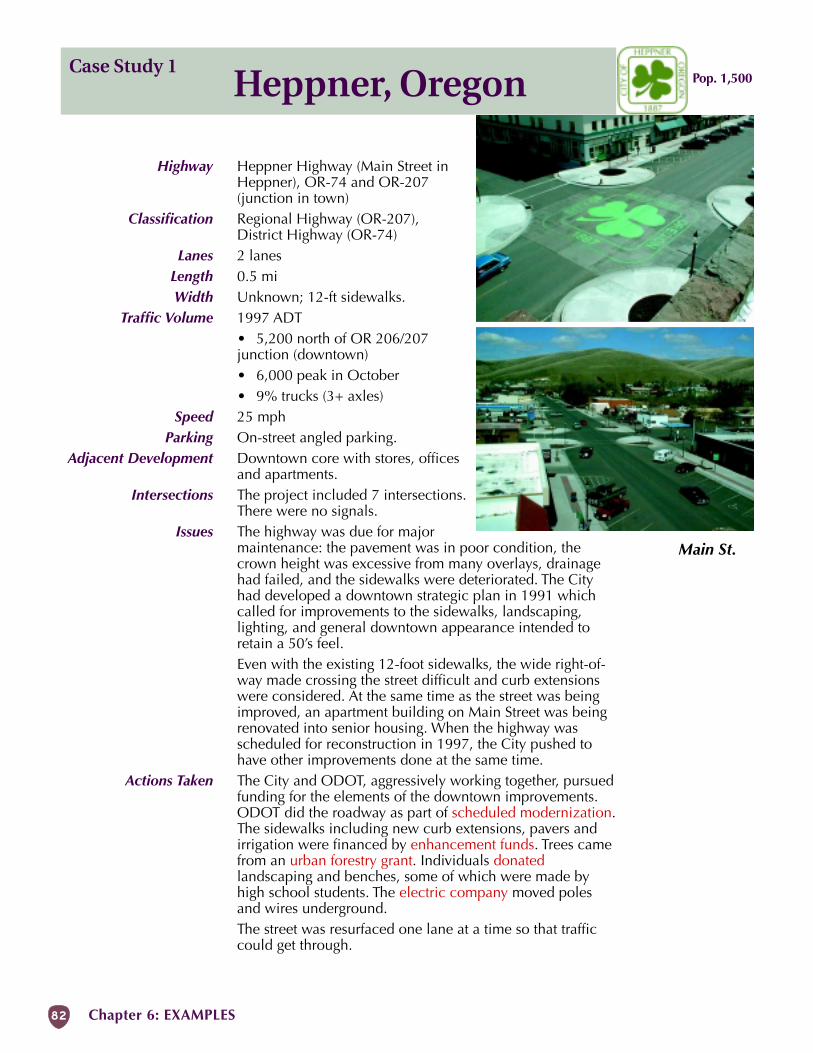
82 Chapter 6: EXAMPLES
Heppner, OregonCase Study 1
Main St.
Pop. 1,500
Highway Heppner Highway (Main Street inHeppner), OR-74 and OR-207(junction in town)
Classification Regional Highway (OR-207),District Highway (OR-74)
Lanes 2 lanesLength 0.5 miWidth Unknown; 12-ft sidewalks.
Traffic Volume 1997 ADT• 5,200 north of OR 206/207junction (downtown)• 6,000 peak in October• 9% trucks (3+ axles)
Speed 25 mphParking On-street angled parking.
Adjacent Development Downtown core with stores, officesand apartments.
Intersections The project included 7 intersections.There were no signals.
Issues The highway was due for majormaintenance: the pavement was in poor condition, thecrown height was excessive from many overlays, drainagehad failed, and the sidewalks were deteriorated. The Cityhad developed a downtown strategic plan in 1991 whichcalled for improvements to the sidewalks, landscaping,lighting, and general downtown appearance intended toretain a 50’s feel.Even with the existing 12-foot sidewalks, the wide right-of-way made crossing the street difficult and curb extensionswere considered. At the same time as the street was beingimproved, an apartment building on Main Street was beingrenovated into senior housing. When the highway wasscheduled for reconstruction in 1997, the City pushed tohave other improvements done at the same time.
Actions Taken The City and ODOT, aggressively working together, pursuedfunding for the elements of the downtown improvements.ODOT did the roadway as part of scheduled modernization.The sidewalks including new curb extensions, pavers andirrigation were financed by enhancement funds. Trees camefrom an urban forestry grant. Individuals donatedlandscaping and benches, some of which were made byhigh school students. The electric company moved polesand wires underground.The street was resurfaced one lane at a time so that trafficcould get through.
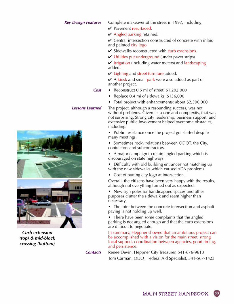
MAIN STREET HANDBOOK 83
Key Design Features Complete makeover of the street in 1997, including:✔ Pavement resurfaced.✔ Angled parking retained.✔ Central intersection constructed of concrete with inlaidand painted city logo.✔ Sidewalks reconstructed with curb extensions.✔ Utilities put underground (under paver strips).✔ Irrigation (including water meters) and landscapingadded.✔ Lighting and street furniture added.✔ A kiosk and small park were also added as part ofanother project.
Cost • Reconstruct 0.5 mi of street: $1,292,000• Replace 0.4 mi of sidewalks: $136,000• Total project with enhancements: about $2,300,000
Lessons Learned The project, although a resounding success, was notwithout problems. Given its scope and complexity, that wasnot surprising. Strong city leadership, business support, andextensive public involvement helped overcome obstacles,including:• Public resistance once the project got started despitemany meetings.• Sometimes rocky relations between ODOT, the City,contractors and subcontractors.• A major campaign to retain angled parking which isdiscouraged on state highways.• Difficulty with old building entrances not matching upwith the new sidewalks which caused ADA problems.• Cost of putting city logo at intersection.Overall, the citizens have been very happy with the results,although not everything turned out as expected:• New sign poles for handicapped spaces and otherpurposes clutter the sidewalk and seem higher thannecessary.• The joint between the concrete intersection and asphaltpaving is not holding up well.• There have been some complaints that the angledparking is not angled enough and that the curb extensionsare difficult to negotiate.In summary, Heppner showed that an ambitious project canbe accomplished with a vision for the main street, stronglocal support, coordination between agencies, good timing,and persistence.
Contacts Renee Devin, Heppner City Treasurer, 541-676-9618Tom Carman, ODOT Federal Aid Specialist, 541-567-1423
Curb extension(top) & mid-blockcrossing (bottom)
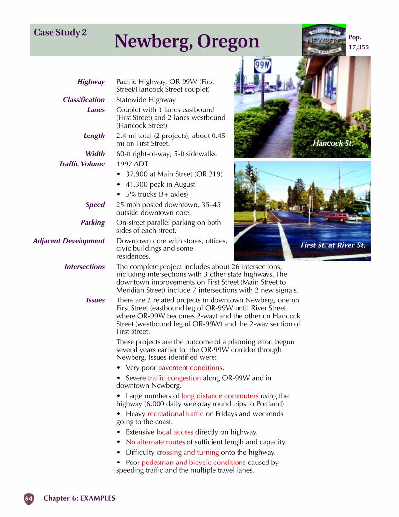
84 Chapter 6: EXAMPLES
Case Study 2Newberg, Oregon
Hancock St.
First St. at River St.
Pop.
17,355
Highway Pacific Highway, OR-99W (FirstStreet/Hancock Street couplet)
Classification Statewide HighwayLanes Couplet with 3 lanes eastbound
(First Street) and 2 lanes westbound(Hancock Street)
Length 2.4 mi total (2 projects), about 0.45mi on First Street.
Width 60-ft right-of-way; 5-ft sidewalks.Traffic Volume 1997 ADT
• 37,900 at Main Street (OR 219)• 41,300 peak in August• 5% trucks (3+ axles)
Speed 25 mph posted downtown, 35–45outside downtown core.
Parking On-street parallel parking on bothsides of each street.
Adjacent Development Downtown core with stores, offices,civic buildings and someresidences.
Intersections The complete project includes about 26 intersections,including intersections with 3 other state highways. Thedowntown improvements on First Street (Main Street toMeridian Street) include 7 intersections with 2 new signals.
Issues There are 2 related projects in downtown Newberg, one onFirst Street (eastbound leg of OR-99W until River Streetwhere OR-99W becomes 2-way) and the other on HancockStreet (westbound leg of OR-99W) and the 2-way section ofFirst Street.These projects are the outcome of a planning effort begunseveral years earlier for the OR-99W corridor throughNewberg. Issues identified were:• Very poor pavement conditions.• Severe traffic congestion along OR-99W and indowntown Newberg.• Large numbers of long distance commuters using thehighway (6,000 daily weekday round trips to Portland).• Heavy recreational traffic on Fridays and weekendsgoing to the coast.• Extensive local access directly on highway.• No alternate routes of sufficient length and capacity.• Difficulty crossing and turning onto the highway.• Poor pedestrian and bicycle conditions caused byspeeding traffic and the multiple travel lanes.
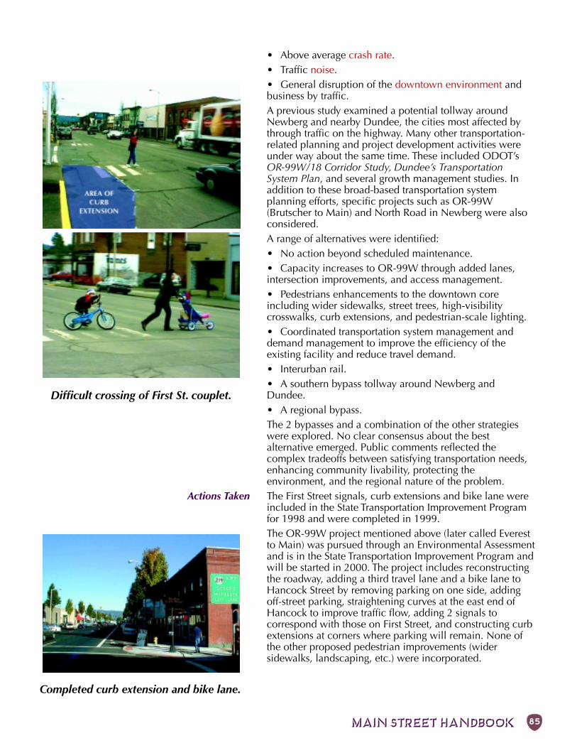
MAIN STREET HANDBOOK 85
Difficult crossing of First St. couplet.
Completed curb extension and bike lane.
• Above average crash rate.• Traffic noise.• General disruption of the downtown environment andbusiness by traffic.A previous study examined a potential tollway aroundNewberg and nearby Dundee, the cities most affected bythrough traffic on the highway. Many other transportation-related planning and project development activities wereunder way about the same time. These included ODOT’sOR-99W/18 Corridor Study, Dundee’s TransportationSystem Plan, and several growth management studies. Inaddition to these broad-based transportation systemplanning efforts, specific projects such as OR-99W(Brutscher to Main) and North Road in Newberg were alsoconsidered.A range of alternatives were identified:• No action beyond scheduled maintenance.• Capacity increases to OR-99W through added lanes,intersection improvements, and access management.• Pedestrians enhancements to the downtown coreincluding wider sidewalks, street trees, high-visibilitycrosswalks, curb extensions, and pedestrian-scale lighting.• Coordinated transportation system management anddemand management to improve the efficiency of theexisting facility and reduce travel demand.• Interurban rail.• A southern bypass tollway around Newberg andDundee.• A regional bypass.The 2 bypasses and a combination of the other strategieswere explored. No clear consensus about the bestalternative emerged. Public comments reflected thecomplex tradeoffs between satisfying transportation needs,enhancing community livability, protecting theenvironment, and the regional nature of the problem.
Actions Taken The First Street signals, curb extensions and bike lane wereincluded in the State Transportation Improvement Programfor 1998 and were completed in 1999.The OR-99W project mentioned above (later called Everestto Main) was pursued through an Environmental Assessmentand is in the State Transportation Improvement Program andwill be started in 2000. The project includes reconstructingthe roadway, adding a third travel lane and a bike lane toHancock Street by removing parking on one side, addingoff-street parking, straightening curves at the east end ofHancock to improve traffic flow, adding 2 signals tocorrespond with those on First Street, and constructing curbextensions at corners where parking will remain. None ofthe other proposed pedestrian improvements (widersidewalks, landscaping, etc.) were incorporated.
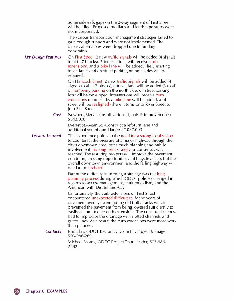
86 Chapter 6: EXAMPLES
Some sidewalk gaps on the 2-way segment of First Streetwill be filled. Proposed medians and landscape strips werenot incorporated.The various transportation management strategies failed togain enough support and were not implemented. Thebypass alternatives were dropped due to fundingconstraints.
Key Design Features On First Street, 2 new traffic signals will be added (4 signalstotal in 7 blocks), 3 intersections will receive curbextensions, and a bike lane will be added. The 3 existingtravel lanes and on-street parking on both sides will beretained.On Hancock Street, 2 new traffic signals will be added (4signals total in 7 blocks), a travel lane will be added (3 total)by removing parking on the north side, off-street parkinglots will be developed, intersections will receive curbextensions on one side, a bike lane will be added, andstreet will be realigned where it turns onto River Street tojoin First Street.
Cost Newberg Signals (Install various signals & improvements):$842,000Everest St.–Main St. (Construct a left-turn lane andadditional southbound lane): $7,087,000
Lessons Learned This experience points to the need for a strong local visionto counteract the pressure of a major highway through thecity’s downtown core. After much planning and publicinvolvement, no long-term strategy or consensus wasreached. The resulting projects will improve the pavementcondition, crossing opportunities and bicycle access but theoverall downtown environment and the failing highway willneed to be revisited.Part of the difficulty in forming a strategy was the longplanning process during which ODOT policies changed inregards to access management, multimodalism, and theAmerican with Disabilities Act.Unfortunately, the curb extensions on First Streetencountered unexpected difficulties. Many years ofpavement overlays were hiding old trolly tracks whichprevented the pavement from being lowered sufficiently toeasily accommodate curb extensions. The construction crewhad to improvise the drainage with slotted channels andgutter lines. As a result, the curb extensions were more workthan planned.
Contacts Ron Clay, ODOT Region 2, District 3, Project Manager,503-986-2691Michael Morris, ODOT Project Team Leader, 503-986-2682.
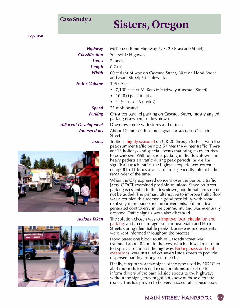
MAIN STREET HANDBOOK 87
Case Study 3Sisters, Oregon
Pop. 850
Highway McKenzie-Bend Highway, U.S. 20 (Cascade Street)Classification Statewide Highway
Lanes 2 lanesLength 0.7 miWidth 60-ft right-of-way on Cascade Street, 80 ft on Hood Street
and Main Street; 6-ft sidewalks.Traffic Volume 1997 ADT
• 7,100 east of McKenzie Highway (Cascade Street)• 10,000 peak in July• 11% trucks (3+ axles)
Speed 25 mph postedParking On-street parallel parking on Cascade Street, mostly angled
parking elsewhere in downtown.Adjacent Development Downtown core with stores and offices.
Intersections About 12 intersections; no signals or stops on CascadeStreet.
Issues Traffic is highly seasonal on OR-20 through Sisters, with thepeak summer traffic being 2.5 times the winter traffic. Thereare 13 holidays and special events that bring many touriststo downtown. With on-street parking in the downtown andheavy pedestrian traffic during peak periods, as well assignificant truck traffic, the highway experiences extremedelays 8 to 11 times a year. Traffic is generally tolerable theremainder of the time.When the City expressed concern over the periodic trafficjams, ODOT examined possible solutions. Since on-streetparking is essential to the downtown, additional lanes couldnot be added. The primary alternative to improve traffic flowwas a couplet; this seemed a good possibility with somerelatively minor side-street improvements, but the ideagenerated controversy in the community and was eventuallydropped. Traffic signals were also discussed.
Actions Taken The solution chosen was to improve local circulation andparking, and to encourage traffic to use Main and HoodStreets during identifiable peaks. Businesses and residentswere kept informed throughout the process.Hood Street one block south of Cascade Street wasextended about 0.2 mi to the west which allows local trafficto bypass a section of the highway. Parking bays and curbextensions were installed on several side streets to providedispersed parking throughout the city.Finally, temporary active signs of the type used by ODOT toalert motorists to special road conditions are set up toinform drivers of the parallel side streets to the highway;without the signs, they might not know of these alternateroutes. This has proven to be very successful as businesses
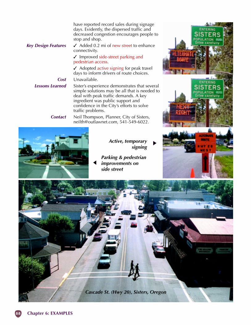
88 Chapter 6: EXAMPLES
Cascade St. (Hwy 20), Sisters, Oregon
Active, temporarysigning
Parking & pedestrianimprovements onside street
have reported record sales during signagedays. Evidently, the dispersed traffic anddecreased congestion encourages people tostop and shop.
Key Design Features � Added 0.2 mi of new street to enhanceconnectivity.� Improved side-street parking andpedestrian access.� Adopted active signing for peak traveldays to inform drivers of route choices.
Cost Unavailable.Lessons Learned Sister’s experience demonstrates that several
simple solutions may be all that is needed todeal with peak traffic demands. A keyingredient was public support andconfidence in the City’s efforts to solvetraffic problems.
Contact Neil Thompson, Planner, City of Sisters,[email protected], 541-549-6022.
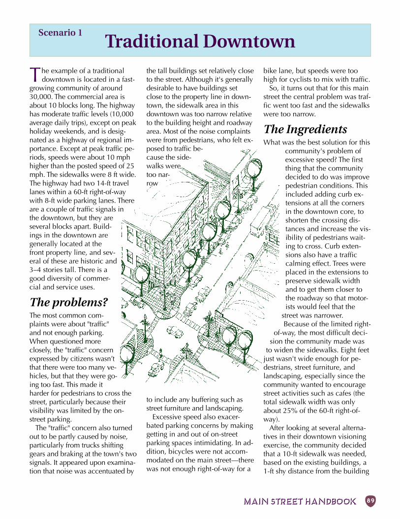
MAIN STREET HANDBOOK 89
Scenario 1Traditional Downtown
The example of a traditionaldowntown is located in a fast-
growing community of around30,000. The commercial area isabout 10 blocks long. The highwayhas moderate traffic levels (10,000average daily trips), except on peakholiday weekends, and is desig-nated as a highway of regional im-portance. Except at peak traffic pe-riods, speeds were about 10 mphhigher than the posted speed of 25mph. The sidewalks were 8 ft wide.The highway had two 14-ft travellanes within a 60-ft right-of-waywith 8-ft wide parking lanes. Thereare a couple of traffic signals inthe downtown, but they areseveral blocks apart. Build-ings in the downtown aregenerally located at thefront property line, and sev-eral of these are historic and3–4 stories tall. There is agood diversity of commer-cial and service uses.
The problems?The most common com-plaints were about "traffic"and not enough parking.When questioned moreclosely, the "traffic" concernexpressed by citizens wasn’tthat there were too many ve-hicles, but that they were go-ing too fast. This made itharder for pedestrians to cross thestreet, particularly because theirvisibility was limited by the on-street parking.
The "traffic" concern also turnedout to be partly caused by noise,particularly from trucks shiftinggears and braking at the town's twosignals. It appeared upon examina-tion that noise was accentuated by
the tall buildings set relatively closeto the street. Although it's generallydesirable to have buildings setclose to the property line in down-town, the sidewalk area in thisdowntown was too narrow relativeto the building height and roadwayarea. Most of the noise complaintswere from pedestrians, who felt ex-posed to traffic be-cause the side-walks weretoo nar-row
to include any buffering such asstreet furniture and landscaping.
Excessive speed also exacer-bated parking concerns by makinggetting in and out of on-streetparking spaces intimidating. In ad-dition, bicycles were not accom-modated on the main street—therewas not enough right-of-way for a
bike lane, but speeds were toohigh for cyclists to mix with traffic.
So, it turns out that for this mainstreet the central problem was traf-fic went too fast and the sidewalkswere too narrow.
The IngredientsWhat was the best solution for this
community's problem ofexcessive speed? The firstthing that the communitydecided to do was improvepedestrian conditions. Thisincluded adding curb ex-tensions at all the cornersin the downtown core, toshorten the crossing dis-tances and increase the vis-ibility of pedestrians wait-ing to cross. Curb exten-sions also have a trafficcalming effect. Trees wereplaced in the extensions topreserve sidewalk widthand to get them closer tothe roadway so that motor-ists would feel that the
street was narrower.Because of the limited right-
of-way, the most difficult deci-sion the community made was
to widen the sidewalks. Eight feetjust wasn't wide enough for pe-destrians, street furniture, andlandscaping, especially since thecommunity wanted to encouragestreet activities such as cafes (thetotal sidewalk width was onlyabout 25% of the 60-ft right-of-way).
After looking at several alterna-tives in their downtown visioningexercise, the community decidedthat a 10-ft sidewalk was needed,based on the existing buildings, a1-ft shy distance from the building
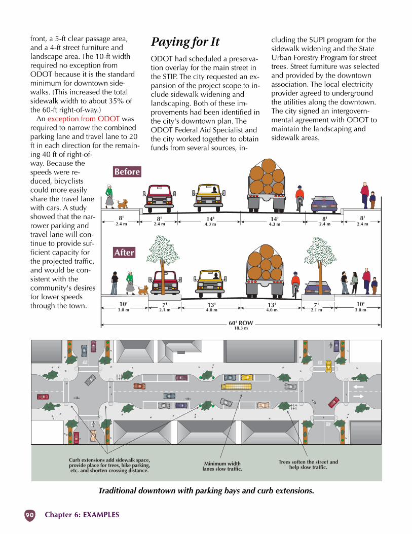
90 Chapter 6: EXAMPLES
Minimum widthlanes slow traffic.
Trees soften the street andhelp slow traffic.
Curb extensions add sidewalk space,provide place for trees, bike parking,etc. and shorten crossing distance.
Not to Scale
front, a 5-ft clear passage area,and a 4-ft street furniture andlandscape area. The 10-ft widthrequired no exception fromODOT because it is the standardminimum for downtown side-walks. (This increased the totalsidewalk width to about 35% ofthe 60-ft right-of-way.)
An exception from ODOT wasrequired to narrow the combinedparking lane and travel lane to 20ft in each direction for the remain-ing 40 ft of right-of-way. Because thespeeds were re-duced, bicyclistscould more easilyshare the travel lanewith cars. A studyshowed that the nar-rower parking andtravel lane will con-tinue to provide suf-ficient capacity forthe projected traffic,and would be con-sistent with thecommunity's desiresfor lower speedsthrough the town.
Before
After
10'3.0 m
60' ROW18.3 m
13'4.0 m
13'4.0 m
7'2.1 m
7'2.1 m
10'3.0 m
8'2.4 m
14'4.3 m
14'4.3 m
8'2.4 m
8'2.4 m
8'2.4 m
Paying for ItODOT had scheduled a preserva-tion overlay for the main street inthe STIP. The city requested an ex-pansion of the project scope to in-clude sidewalk widening andlandscaping. Both of these im-provements had been identified inthe city's downtown plan. TheODOT Federal Aid Specialist andthe city worked together to obtainfunds from several sources, in-
Traditional downtown with parking bays and curb extensions.
cluding the SUPI program for thesidewalk widening and the StateUrban Forestry Program for streettrees. Street furniture was selectedand provided by the downtownassociation. The local electricityprovider agreed to undergroundthe utilities along the downtown.The city signed an intergovern-mental agreement with ODOT tomaintain the landscaping andsidewalk areas.
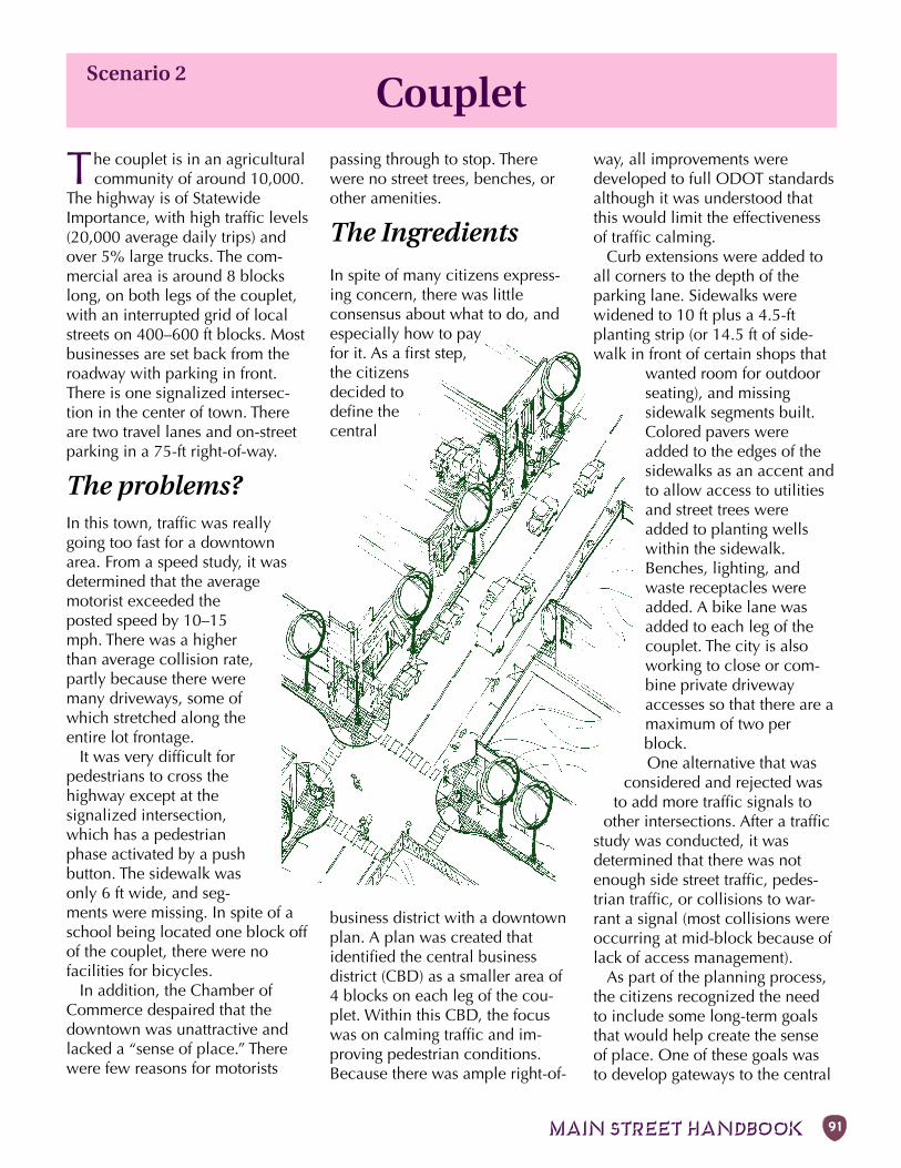
MAIN STREET HANDBOOK 91
Scenario 2Couplet
The couplet is in an agriculturalcommunity of around 10,000.
The highway is of StatewideImportance, with high traffic levels(20,000 average daily trips) andover 5% large trucks. The com-mercial area is around 8 blockslong, on both legs of the couplet,with an interrupted grid of localstreets on 400–600 ft blocks. Mostbusinesses are set back from theroadway with parking in front.There is one signalized intersec-tion in the center of town. Thereare two travel lanes and on-streetparking in a 75-ft right-of-way.
The problems?In this town, traffic was reallygoing too fast for a downtownarea. From a speed study, it wasdetermined that the averagemotorist exceeded theposted speed by 10–15mph. There was a higherthan average collision rate,partly because there weremany driveways, some ofwhich stretched along theentire lot frontage.
It was very difficult forpedestrians to cross thehighway except at thesignalized intersection,which has a pedestrianphase activated by a pushbutton. The sidewalk wasonly 6 ft wide, and seg-ments were missing. In spite of aschool being located one block offof the couplet, there were nofacilities for bicycles.
In addition, the Chamber ofCommerce despaired that thedowntown was unattractive andlacked a “sense of place.” Therewere few reasons for motorists
passing through to stop. Therewere no street trees, benches, orother amenities.
The Ingredients
In spite of many citizens express-ing concern, there was littleconsensus about what to do, andespecially how to payfor it. As a first step,the citizensdecided todefine thecentral
business district with a downtownplan. A plan was created thatidentified the central businessdistrict (CBD) as a smaller area of4 blocks on each leg of the cou-plet. Within this CBD, the focuswas on calming traffic and im-proving pedestrian conditions.Because there was ample right-of-
way, all improvements weredeveloped to full ODOT standardsalthough it was understood thatthis would limit the effectivenessof traffic calming.
Curb extensions were added toall corners to the depth of theparking lane. Sidewalks werewidened to 10 ft plus a 4.5-ftplanting strip (or 14.5 ft of side-walk in front of certain shops that
wanted room for outdoorseating), and missingsidewalk segments built.Colored pavers wereadded to the edges of thesidewalks as an accent andto allow access to utilitiesand street trees wereadded to planting wellswithin the sidewalk.Benches, lighting, andwaste receptacles wereadded. A bike lane wasadded to each leg of thecouplet. The city is alsoworking to close or com-bine private drivewayaccesses so that there are amaximum of two perblock.One alternative that was
considered and rejected wasto add more traffic signals to
other intersections. After a trafficstudy was conducted, it wasdetermined that there was notenough side street traffic, pedes-trian traffic, or collisions to war-rant a signal (most collisions wereoccurring at mid-block because oflack of access management).
As part of the planning process,the citizens recognized the needto include some long-term goalsthat would help create the senseof place. One of these goals wasto develop gateways to the central
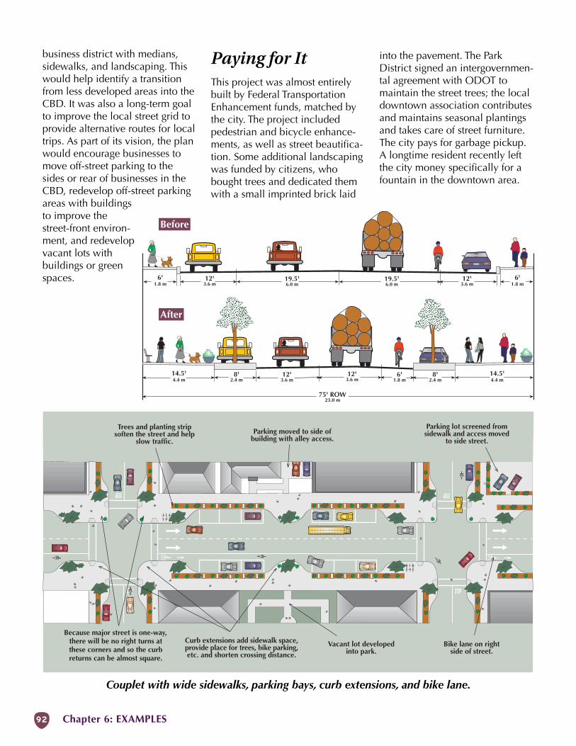
92 Chapter 6: EXAMPLES
business district with medians,sidewalks, and landscaping. Thiswould help identify a transitionfrom less developed areas into theCBD. It was also a long-term goalto improve the local street grid toprovide alternative routes for localtrips. As part of its vision, the planwould encourage businesses tomove off-street parking to thesides or rear of businesses in theCBD, redevelop off-street parkingareas with buildingsto improve thestreet-front environ-ment, and redevelopvacant lots withbuildings or greenspaces.
Couplet with wide sidewalks, parking bays, curb extensions, and bike lane.
Paying for ItThis project was almost entirelybuilt by Federal TransportationEnhancement funds, matched bythe city. The project includedpedestrian and bicycle enhance-ments, as well as street beautifica-tion. Some additional landscapingwas funded by citizens, whobought trees and dedicated themwith a small imprinted brick laid
Because major street is one-way,there will be no right turns atthese corners and so the curbreturns can be almost square.
Trees and planting stripsoften the street and help
slow traffic.
Bike lane on rightside of street.
Curb extensions add sidewalk space,provide place for trees, bike parking,etc. and shorten crossing distance.
Not to Scale
Parking moved to side ofbuilding with alley access.
Parking lot screened fromsidewalk and access moved
to side street.
Vacant lot developedinto park.
Before
After
14.5'4.4 m
75' ROW23.0 m
12'3.6 m
12'3.6 m
6'1.8 m
8'2.4 m
8'2.4 m
14.5'4.4 m
6'1.8 m
19.5'6.0 m
19.5'6.0 m
12'3.6 m
12'3.6 m
6'1.8 m
into the pavement. The ParkDistrict signed an intergovernmen-tal agreement with ODOT tomaintain the street trees; the localdowntown association contributesand maintains seasonal plantingsand takes care of street furniture.The city pays for garbage pickup.A longtime resident recently leftthe city money specifically for afountain in the downtown area.
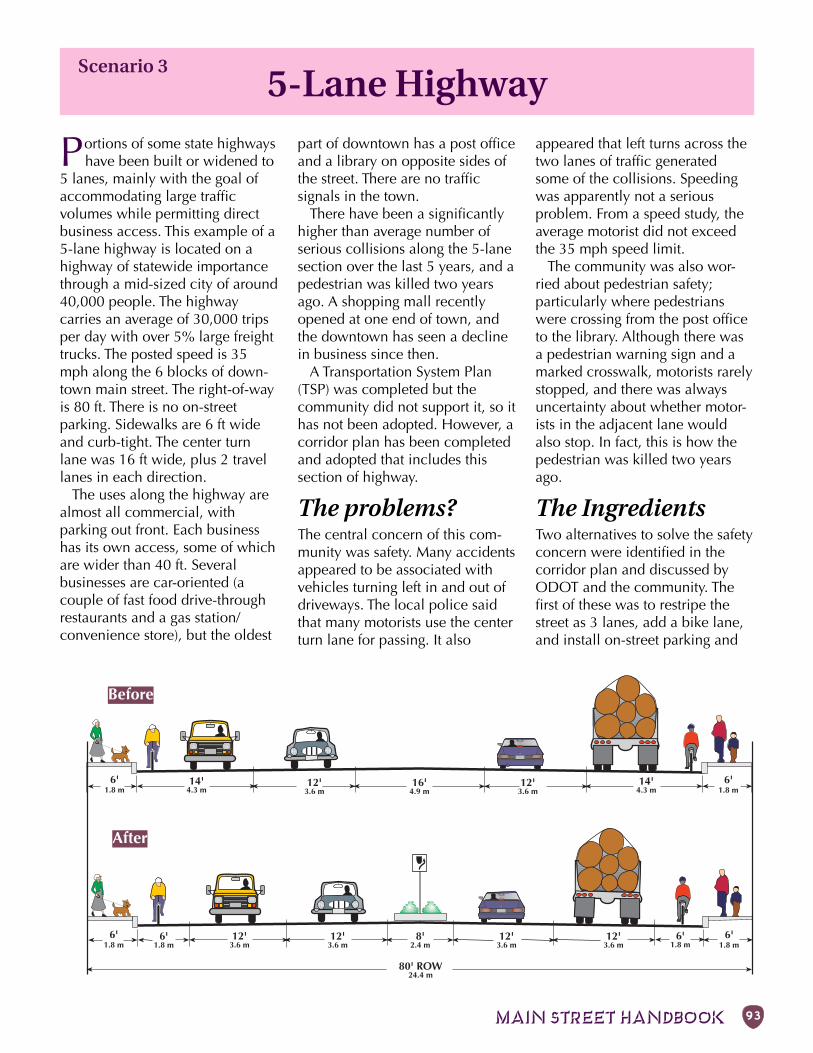
MAIN STREET HANDBOOK 93
Before
After
80' ROW24.4 m
6'1.8 m
12'3.6 m
16'4.9 m
12'3.6 m
14'4.3 m
14'4.3 m
6'1.8 m
6'1.8 m
12'3.6 m
8'2.4 m
12'3.6 m
12'3.6 m
12'3.6 m
6'1.8 m
6'1.8 m
6'1.8 m
5-Lane Highwaypart of downtown has a post officeand a library on opposite sides ofthe street. There are no trafficsignals in the town.
There have been a significantlyhigher than average number ofserious collisions along the 5-lanesection over the last 5 years, and apedestrian was killed two yearsago. A shopping mall recentlyopened at one end of town, andthe downtown has seen a declinein business since then.
A Transportation System Plan(TSP) was completed but thecommunity did not support it, so ithas not been adopted. However, acorridor plan has been completedand adopted that includes thissection of highway.
The problems?The central concern of this com-munity was safety. Many accidentsappeared to be associated withvehicles turning left in and out ofdriveways. The local police saidthat many motorists use the centerturn lane for passing. It also
Portions of some state highwayshave been built or widened to
5 lanes, mainly with the goal ofaccommodating large trafficvolumes while permitting directbusiness access. This example of a5-lane highway is located on ahighway of statewide importancethrough a mid-sized city of around40,000 people. The highwaycarries an average of 30,000 tripsper day with over 5% large freighttrucks. The posted speed is 35mph along the 6 blocks of down-town main street. The right-of-wayis 80 ft. There is no on-streetparking. Sidewalks are 6 ft wideand curb-tight. The center turnlane was 16 ft wide, plus 2 travellanes in each direction.
The uses along the highway arealmost all commercial, withparking out front. Each businesshas its own access, some of whichare wider than 40 ft. Severalbusinesses are car-oriented (acouple of fast food drive-throughrestaurants and a gas station/convenience store), but the oldest
Scenario 3
appeared that left turns across thetwo lanes of traffic generatedsome of the collisions. Speedingwas apparently not a seriousproblem. From a speed study, theaverage motorist did not exceedthe 35 mph speed limit.
The community was also wor-ried about pedestrian safety;particularly where pedestrianswere crossing from the post officeto the library. Although there wasa pedestrian warning sign and amarked crosswalk, motorists rarelystopped, and there was alwaysuncertainty about whether motor-ists in the adjacent lane wouldalso stop. In fact, this is how thepedestrian was killed two yearsago.
The IngredientsTwo alternatives to solve the safetyconcern were identified in thecorridor plan and discussed byODOT and the community. Thefirst of these was to restripe thestreet as 3 lanes, add a bike lane,and install on-street parking and
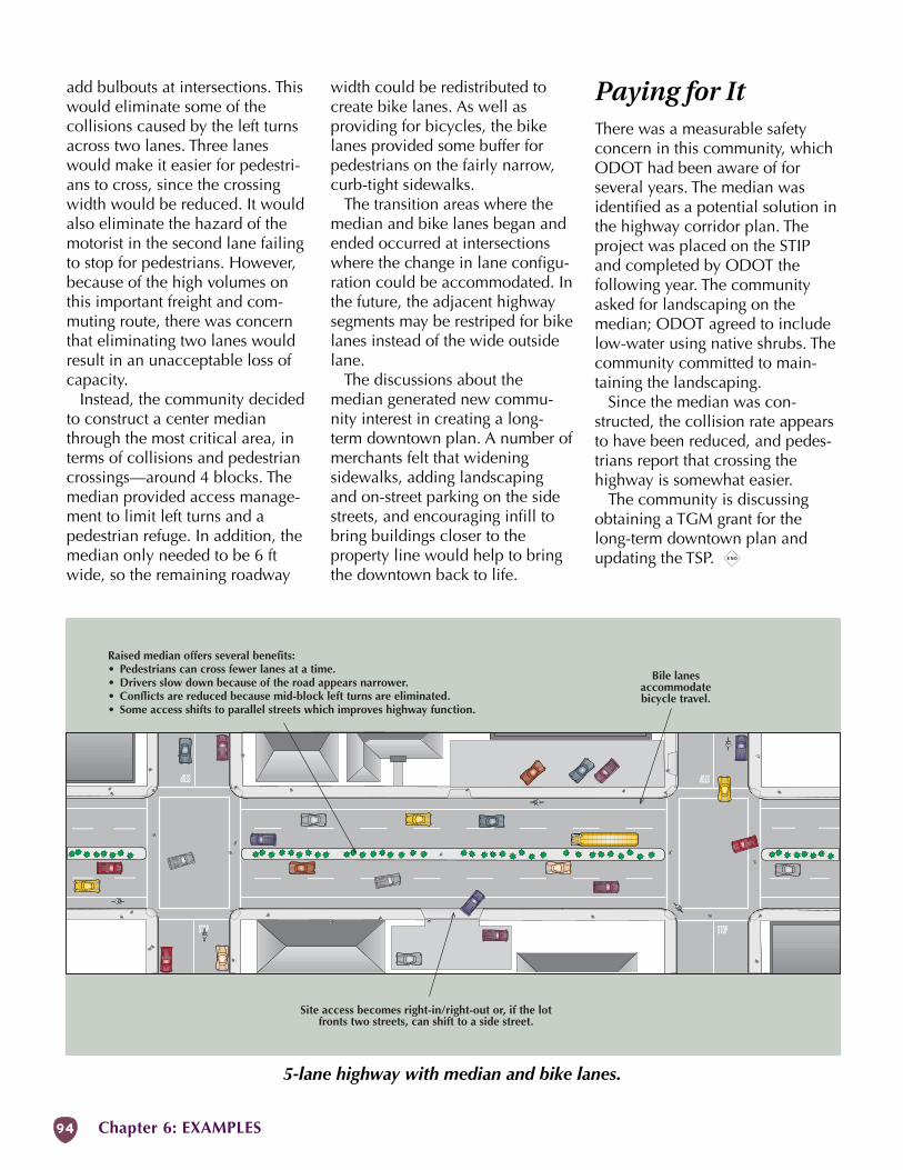
94 Chapter 6: EXAMPLES
Raised median offers several benefits:• Pedestrians can cross fewer lanes at a time.• Drivers slow down because of the road appears narrower.• Conflicts are reduced because mid-block left turns are eliminated.• Some access shifts to parallel streets which improves highway function.
Site access becomes right-in/right-out or, if the lotfronts two streets, can shift to a side street.
Not to Scale
Bile lanesaccommodatebicycle travel.
add bulbouts at intersections. Thiswould eliminate some of thecollisions caused by the left turnsacross two lanes. Three laneswould make it easier for pedestri-ans to cross, since the crossingwidth would be reduced. It wouldalso eliminate the hazard of themotorist in the second lane failingto stop for pedestrians. However,because of the high volumes onthis important freight and com-muting route, there was concernthat eliminating two lanes wouldresult in an unacceptable loss ofcapacity.
Instead, the community decidedto construct a center medianthrough the most critical area, interms of collisions and pedestriancrossings—around 4 blocks. Themedian provided access manage-ment to limit left turns and apedestrian refuge. In addition, themedian only needed to be 6 ftwide, so the remaining roadway
width could be redistributed tocreate bike lanes. As well asproviding for bicycles, the bikelanes provided some buffer forpedestrians on the fairly narrow,curb-tight sidewalks.
The transition areas where themedian and bike lanes began andended occurred at intersectionswhere the change in lane configu-ration could be accommodated. Inthe future, the adjacent highwaysegments may be restriped for bikelanes instead of the wide outsidelane.
The discussions about themedian generated new commu-nity interest in creating a long-term downtown plan. A number ofmerchants felt that wideningsidewalks, adding landscapingand on-street parking on the sidestreets, and encouraging infill tobring buildings closer to theproperty line would help to bringthe downtown back to life.
5-lane highway with median and bike lanes.
Paying for ItThere was a measurable safetyconcern in this community, whichODOT had been aware of forseveral years. The median wasidentified as a potential solution inthe highway corridor plan. Theproject was placed on the STIPand completed by ODOT thefollowing year. The communityasked for landscaping on themedian; ODOT agreed to includelow-water using native shrubs. Thecommunity committed to main-taining the landscaping.
Since the median was con-structed, the collision rate appearsto have been reduced, and pedes-trians report that crossing thehighway is somewhat easier.
The community is discussingobtaining a TGM grant for thelong-term downtown plan andupdating the TSP. x
MAIN STREET HANDBOOK 95
AppendixGlossary ...... 95Resources .1 0 0Index .........101 Appendix
Glossary
AASHTO: American Association of State Highway andTransportation Officials. See also: Green Book.
Access Management: Measures regulating access to the high-way from streets and driveways. Main streets generally fea-ture short blocks with many street connections and few drive-ways, since most parking is on-street. Refer to the OregonHighway Plan for access standards. See also: Deviation.
Area Commission on Transportation (ACT): A body char-tered by the Oregon Transportation Commission (OTC) andcomposed of local transportation representatives, electedofficials, and business representations of 2–4 counties.ACTs propose and comment on policy set by the OTC,propose programs and projects, and provide citizens andofficials with a link to the OTC.
Americans with Disabilities Act (ADA): Civil rights legisla-tion passed in 1990. ADA influences street design as de-scribed in the ADA Accessibility Guidelines (ADAAG). Mostrelevant aspects of ADA are discussed in the Oregon Bicycleand Pedestrian Plan.
Alignment: Geometric arrangement of the highway includ-ing width, slope, curvature, etc.
APWA: American Public Works Association.
Arterial: A road designated to carry traffic through an arearather than to local destinations.
Average Daily Traffic (ADT): The measurement of the aver-age number of vehicles passing a certain point each day,usually given as a total for both directions. Traffic duringthe peak hour is normally about one-tenth of the ADT.
Balanced Use: The combination of land uses within anarea, such as a downtown, such that residents do not needto leave the area on a daily basis.
Basic Rule: A state statute (ORS 811.100) that requires ve-hicles to be driven at speeds “reasonable and prudent” forthe conditions (traffic, highway surface and width, inter-section hazards, weather, visibility, etc.).
BID: Business Improvement District.
Bike Lane: A portion of a roadway which has been desig-nated by striping and pavement markings for the preferen-tial or exclusive use of bicyclists.
Bikeway: The appropriate design treatment for bicyclists,based primarily on motor vehicle traffic volumes andspeeds. Main street bikeway types include the shared road-way, wide lane, shoulder bikeway, and bike lane.
Capacity: The number of vehicles that can travel past agiven point on a sustained basis. Vehicle capacity respondsto 3 factors: the number of travel lanes, the degree of con-nectivity, and generated traffic. In urban conditions, lanecapacity ranges from 600 to 900 vehicles per hour.
Center Turn Lane: See: Continuous Two-Way Left-Turn Lane.
Central Business District (CBD): A traditional downtownarea usually characterized by established businessesfronting the street, a concentration of public buildings,sidewalks, slow traffic speeds, on-street parking, and acompact grid street system. Main street usually runsthrough the CBD.
Channelization: The separation of vehicle and pedestrianmovements at an intersection into defined paths throughthe use of islands.
Collector: A street designated to carry traffic between localstreets and arterials, or from local street to local street.
Community: A sustainable human habitat which is completeand compact. The smallest community is a neighborhood.
Continuous Two-Way Left-Turn Lane (CTWLTL): A travers-able median that is designed to accommodate left-turnegress movements from opposite directions. Aka centerturn lane and two-way left-turn lane (TWLTL).
Corner Radius: See: Intersection Curb Radius.
Corridor Plan: A transportation plan for an entire length ofhighway which may include many different classifications.Corridor plans are coordinated with the cities and otherjurisdictions through which the highway passes.
Couplet: Two one-way streets that handle traffic in the op-posite directions. Couplets are typically created by con-verting existing two-way streets
Chapter 7
Chapter 7: APPENDIX96
Glossary (cont’d)
Cross-Section: Diagrammatic presentation of a highwayprofile at right angles to the centerline at a given location.
Crosswalk: Portion of a roadway designated for pedestriancrossing, marked or unmarked. Unmarked crosswalks arethe natural extension of the shoulder, curb line, or sidewalk.
Deviation: A departure from an access management stan-dard. See: Access Management.
Department of Land Conservation and Development(DLCD): State agency that assists cities and counties in ap-plying Oregon’s land use laws, and aids in assuring com-pliance with Oregon's Statewide goals and guidelines.
Design Exception: A deviation from the Highway DesignManual standards that must be approved by the RoadwayManager.
EID: Economic Improvement District.
Enclosure: One of the physical attributes of streets andopen spaces that contributes to a sense of place. Enclosureis adjusted primarily by building setback and height, andby trees. See also: Vertical Plane.
Expressway: A highway that provides for safe and efficienthigh speed and high volume traffic with limited access. Amain street is never an expressway.
Federal Highway Administration (FHWA): Federal agencywhich oversees and funds highway-related activities thataffect the national interest.
Flexibility in Highway Design: A 1997 publication byAASHTO and the FHWA to accompany the Green Book. Itshows engineers and managers how sensitivity to localneeds can result in better projects.
Frontage Road: A road designated and designed to servelocal traffic parallel and adjacent to a highway.
Gateway: An highly varied urban element which marks theentrance of a district. Gateways are useful for orientationwithin the city. See also: Transition Area.
Grade: A measure of the steepness of a roadway, bikeway,or walkway, expressed in a ratio of vertical rise per hori-zontal distance, usually in percent; e.g., a 5% grade equals5 m of rise over a 100 m horizontal distance.
Grade Separation: The vertical separation of conflictingtravelways with a structure, such as a pedestrian bridgeover the highway.
Green Book: AASHTO’s “A Policy on Geometric Design ofHighways and Streets” which provides guidelines (notstandards) for roadway design. The Green Book empha-sizes joint use of transportation corridors by pedestrians,cyclists, and public transit vehicles, and encourages flex-ibile designs tailored to particular situations. In Oregon,the Green Book is modified by the Highway DesignManual. See also: Flexibility in Highway Design.
Grid Pattern: A web of intersecting streets, which is recti-linear in its alignment and orthogonal at its intersections.See: Street Network.
Highway: A general term denoting a public way for pur-poses of travel, including the entire area within the right-of-way. See sidebar on next page for specific highway clas-sifications used in Oregon.
Human Scale: Site and building design elements that aredimensionally less than those intended to accommodateautomobile traffic, flow and buffering.
Intersection Curb Radius: The curved edge of a thorough-fare at an intersection, measured at the edge of the travellanes (excluding the parking and bike lanes). Aka cornerradius and curb return radius.
Land Conservation and Development Commission(LCDC): A group of citizen volunteers appointed by theGovernor to direct the Department of Land Conservationand Development.
Land Use: The type of activity that the land is used for. On amain street, common land uses are commercial, office, resi-dential, light industrial, and public (library, city hall, etc.).
Level of Service (LOS): The condition of traffic flow or de-lay expressed as a range from LOS “A” which representsunimpeded flow to LOS “F” which represents severe con-gestion. LOS was replaced by “mobility” in the 1999 Or-egon Highway Plan.
Local Street: A street designated to provide access to andfrom local residences or businesses.
Median: The portion of the roadway which separates op-posing traffic streams.
Mobility: In planning terms, mobility is the ordinary move-ment of the population by any means, including by directtravel or by means which reduce the need to travel such asproximity of destinations and teleworking. In highwayterms, mobility is defined as the movement of vehicles.
Mobility Standard: ODOT has established performancegoals for different highway classifications to aid in plan-ning, design, and management. Motor vehicle mobility isdetermined by volume-to-capacity ratio. Refer to the Or-egon Highway Plan for mobility standards. See: Volume-to-Capacity Ratio.
Mode (or Modal): A means of moving people or goods.Modes such as rail, transit, carpooling, walking, and bicy-cling that provide transportation alternatives to single-oc-cupancy automobiles are sometimes called “alternativemodes.”
Modernization: Highway projects that accommodate exist-ing traffic or projected traffic growth by adding capacity.See: Preservation.
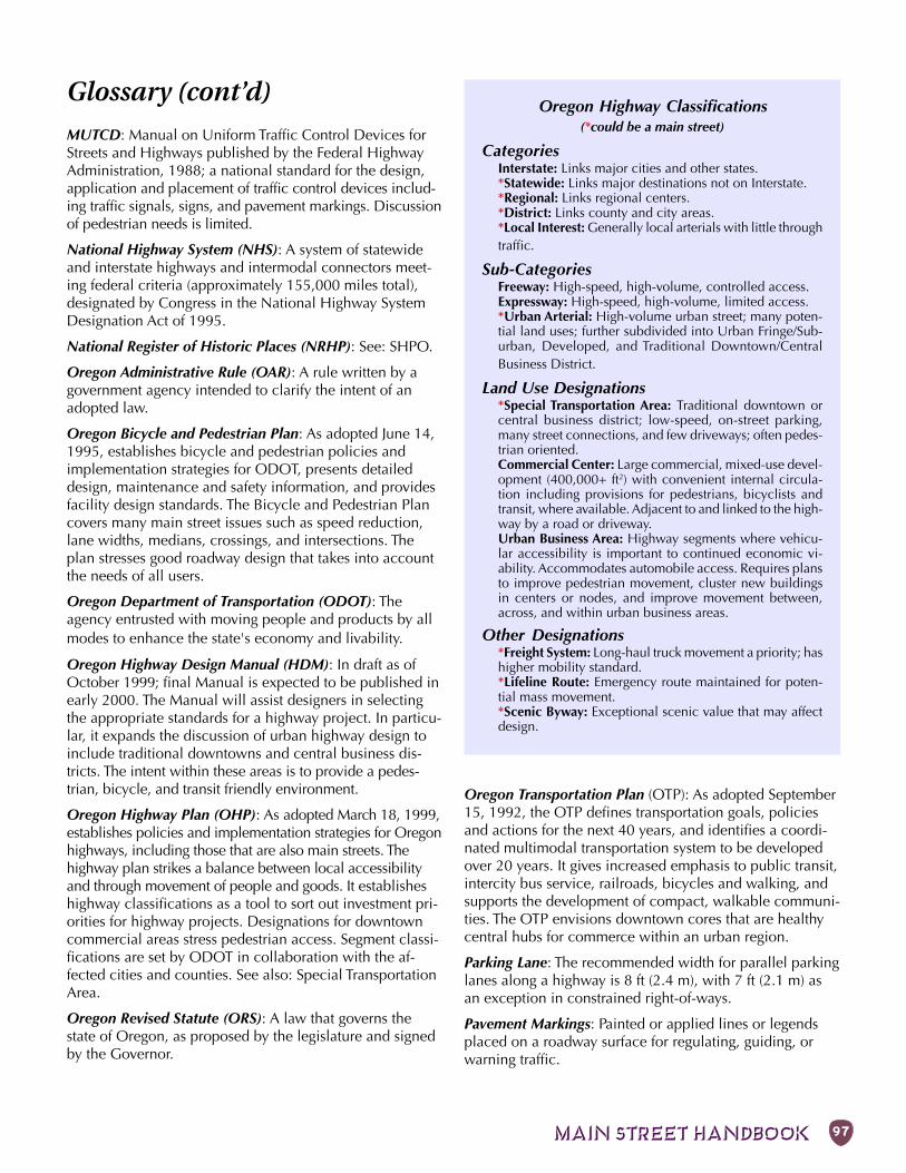
MAIN STREET HANDBOOK 97
MUTCD: Manual on Uniform Traffic Control Devices forStreets and Highways published by the Federal HighwayAdministration, 1988; a national standard for the design,application and placement of traffic control devices includ-ing traffic signals, signs, and pavement markings. Discussionof pedestrian needs is limited.
National Highway System (NHS): A system of statewideand interstate highways and intermodal connectors meet-ing federal criteria (approximately 155,000 miles total),designated by Congress in the National Highway SystemDesignation Act of 1995.
National Register of Historic Places (NRHP): See: SHPO.
Oregon Administrative Rule (OAR): A rule written by agovernment agency intended to clarify the intent of anadopted law.
Oregon Bicycle and Pedestrian Plan: As adopted June 14,1995, establishes bicycle and pedestrian policies andimplementation strategies for ODOT, presents detaileddesign, maintenance and safety information, and providesfacility design standards. The Bicycle and Pedestrian Plancovers many main street issues such as speed reduction,lane widths, medians, crossings, and intersections. Theplan stresses good roadway design that takes into accountthe needs of all users.
Oregon Department of Transportation (ODOT): Theagency entrusted with moving people and products by allmodes to enhance the state's economy and livability.
Oregon Highway Design Manual (HDM): In draft as ofOctober 1999; final Manual is expected to be published inearly 2000. The Manual will assist designers in selectingthe appropriate standards for a highway project. In particu-lar, it expands the discussion of urban highway design toinclude traditional downtowns and central business dis-tricts. The intent within these areas is to provide a pedes-trian, bicycle, and transit friendly environment.
Oregon Highway Plan (OHP): As adopted March 18, 1999,establishes policies and implementation strategies for Oregonhighways, including those that are also main streets. Thehighway plan strikes a balance between local accessibilityand through movement of people and goods. It establisheshighway classifications as a tool to sort out investment pri-orities for highway projects. Designations for downtowncommercial areas stress pedestrian access. Segment classi-fications are set by ODOT in collaboration with the af-fected cities and counties. See also: Special TransportationArea.
Oregon Revised Statute (ORS): A law that governs thestate of Oregon, as proposed by the legislature and signedby the Governor.
Glossary (cont’d)Oregon Highway Classifications
(*could be a main street)
CategoriesInterstate: Links major cities and other states.*Statewide: Links major destinations not on Interstate.*Regional: Links regional centers.*District: Links county and city areas.*Local Interest: Generally local arterials with little throughtraffic.
Sub-CategoriesFreeway: High-speed, high-volume, controlled access.Expressway: High-speed, high-volume, limited access.*Urban Arterial: High-volume urban street; many poten-tial land uses; further subdivided into Urban Fringe/Sub-urban, Developed, and Traditional Downtown/CentralBusiness District.
Land Use Designations*Special Transportation Area: Traditional downtown orcentral business district; low-speed, on-street parking,many street connections, and few driveways; often pedes-trian oriented.Commercial Center: Large commercial, mixed-use devel-opment (400,000+ ft2) with convenient internal circula-tion including provisions for pedestrians, bicyclists andtransit, where available. Adjacent to and linked to the high-way by a road or driveway.Urban Business Area: Highway segments where vehicu-lar accessibility is important to continued economic vi-ability. Accommodates automobile access. Requires plansto improve pedestrian movement, cluster new buildingsin centers or nodes, and improve movement between,across, and within urban business areas.
Other Designations*Freight System: Long-haul truck movement a priority; hashigher mobility standard.*Lifeline Route: Emergency route maintained for poten-tial mass movement.*Scenic Byway: Exceptional scenic value that may affectdesign.
Oregon Transportation Plan (OTP): As adopted September15, 1992, the OTP defines transportation goals, policiesand actions for the next 40 years, and identifies a coordi-nated multimodal transportation system to be developedover 20 years. It gives increased emphasis to public transit,intercity bus service, railroads, bicycles and walking, andsupports the development of compact, walkable communi-ties. The OTP envisions downtown cores that are healthycentral hubs for commerce within an urban region.
Parking Lane: The recommended width for parallel parkinglanes along a highway is 8 ft (2.4 m), with 7 ft (2.1 m) asan exception in constrained right-of-ways.
Pavement Markings: Painted or applied lines or legendsplaced on a roadway surface for regulating, guiding, orwarning traffic.
Chapter 7: APPENDIX98
Pavement Width: The width of vehicular pavement of astreet, including moving and parking lanes but excludingplanters and sidewalks. See also: Roadway.
Pavement: The impervious surface dedicated to the circu-lation and parking of vehicles. Sound environmental prac-tice endeavors to minimize paved area which is consid-ered detrimental to the watershed and increases the cost ofdrainage.
Peak Hour: Hour of the day with the most traffic, usuallyduring the evening commute time but sometimes includingthe morning commute time or early afternoon.
Pedestrian: A person on foot, in a wheelchair, or walking abicycle.
Pedestrian Friendly: Design qualities that make walkingattractive, including places people want to go and goodfacilities on which to get there.
Pedestrian Scale: See Human Scale.
Planting Strip: That section of the sidewalk area which ac-commodates street trees and scrubs.
Preservation: Projects that rebuild or extend the servicelife of highways. Preservation projects add useful life to thehighway without increasing capacity. See: Modernization.
Prospectus: An internal ODOT tool that defines a projectin its planning stage. The prospectus describes project lim-its, costs and funding, environmental issues, and approvals.
Quality of Life (QOL): A measure of human well-beingrelated to personal choice, including availability of leisuretime, discretionary income, and travel options.
Raised Median: A nontraversable median where curbs areused to elevate the surface of the median above the sur-face of the adjacent traffic face. Pedestrians may normallycross the median but vehicles may not. See: Median.
Refuge Island: A nontraversable section of median orchannelization device on which pedestrians can take ref-uge while crossing the highway.
Right-of-Way (ROW): The composite public area dedicatedexclusively to circulation—both physical and social—in-cluding the roadway and pedestrian area.
Roadway: The paved portion of the street which is prima-rily occupied by vehicles, including the travel lanes andparking lanes. The roadway may also include a medianand refuge islands.
Roadway Manager: The ODOT person responsible formaking exceptions to the design standards.
Roundabout: An intersection design where traffic circu-lates around a central island rather than proceedingstraight through and which has special features to reduceconflicts inherent in conventional intersections.
Secondary Route: A parallel road to main street suitable asan alternate route for through traffic, especially trucks.
Sense of Place: A highly desirable but elusive quality of aneighborhood or city, often recognized only when it islost. An effective sense of place is created by many inter-dependent elements, such as: the setting, buildings, streets,meeting places, connections between important places,activities, and the presence of people.
Shared Roadway: A type of bikeway where bicyclists andmotor vehicles share a travel lane.
Shoulder: The portion of a highway that is contiguous tothe travel lanes provided for pedestrians (when there is nosidewalk), bicyclists, emergency use by vehicles, and forlateral support of the base and surface.
Shy Distance: The lateral (side) clearance of a walkway orvehicle travel lane as measured from the outside edge ofthe walkway or lane to the nearest vertical obstacle suchas a building, fence, or pole.
Sidewalk: A walkway separated from the roadway with acurb, constructed of a durable, hard and smooth surface,designed for preferential or exclusive use by pedestrians.
Sidewalk Area: That portion of a street right-of-way whichis dedicated to uses other than moving and parking ve-hicles. It includes primarily the sidewalks, plantings, andstreet furniture.
Sight Distance: The distance a person can see along anunobstructed line of sight.
Slip Lane: A wide-radius, right-turn channel to facilitatehigh volumes of turning vehicles. See: Channelization.
Small-Scale Urban Highway Pedestrian Improvement(SUPI): An ODOT program administered by the OregonBicycle and Pedestrian Program that helps cities andcounties complete small pedestrian projects on urbanhighways.
Smart Development: Development that implements thestate’s land use and transportation goals in urban areas. Itis "smart" because it: uses land efficiently; facilitates arange of transportation choices; fully utilizes existingpublic facilities; combines residential, commercial, andcommunity service activities within a neighborhood tocreate a lively and safe environment; is designed to thescale and comfort of people; and uses locally-appropriatedesign to reinforce community identity and heritage.
Special Transportation Area (STA): A highway classifica-tion identified in a corridor plan or local transportationsystem plan. An STA is characterized by a downtown, busi-ness district, or community center on an Urban Arterial(not Expressway) with speeds no more than 25 mph (40km/h), frequent street connections, and on-street parking.
Glossary (cont’d)
MAIN STREET HANDBOOK 99
In an STA, local access and pedestrian travel is more im-portant than through traffic movement. The STA designa-tion allows changes from the usual highway standardswithin the downtown, such as shorter block lengths andhigher levels of local congestion. This is balanced by strictaccess management on the highway outside of the down-town. STAs, as well as the other land use area designa-tions, are applied to a specific area through the adoptionof a Transportation System Plan or Corridor Plan. (Throughthe ODOT Exception Process, some STA design elementsmay be applied to an appropriate highway segment whennot a designated STA.) See also: Oregon Highway Plan.
State Historic Preservation Office (SHPO): Agency prima-rily concerned with the preservation of historic structuresand districts, such as property on, or eligible for, the Na-tional Register of Historic Places. Any use of federal high-way funds in a main street project requires review bySHPO to determine if the project could have an adverseeffect on historic resources.
State Transportation Improvement Program (STIP):ODOT’s adopted list of major projects covering 4 years.
Street: A place of movement and activity, defined by thecontinuous line of buildings along its edges which have aparticular scale, dimension, form, and detail unique toeach street.
Street Network: A web of intersecting streets, which maybe diagonal, curvilinear, or irregular in its alignment andvariable at its intersections. See: Grid Pattern.
Streetscape: The combination of planters, sidewalks, streettrees, and street lights.
Terminal Vista: A building, sculpture, hill, or other largeobject at the end of a street segment. A terminal vista tendsto slow the motorist and gives the pedestrian a landmarkwith which to orient themselves.
TIF: Tax Increment Financing.
Threshold Gap: The distance from a pedestrian to an on-coming motor vehicle sufficient for 50% of pedestrians tochoose to cross a street.
Traffic Calming: A set of techniques which serve to reducethe speed and aggressiveness of traffic. Such strategies in-clude lane narrowing, on-street parking, sidewalk exten-sions into the roadway, surface variations, and visual clueson a vertical plane. Although traffic calming is often a ret-rofit to deal with identified problems, it is also an impor-tant aspect of new construction to prevent problems fromoccurring. See: Traffic Priority Device.
Traffic Control Device: Signs, signals or other fixtures,whether permanent or temporary, placed on or adjacent toa travelway by authority of a public body having jurisdic-tion to regulate, warn, or guide traffic.
Traffic Management: The mitigation of traffic congestionachieved by methods other than proximity of destinations,road construction, or the provision of transit. The principalmethods are: transit, car-pooling, staggering of work hours,and variable rate road tolls.
Traffic Priority Device: The various techniques which as-sign priority to the moving vehicle at the expense of thepedestrian; having the opposite effect of traffic calming.
Traffic Volume: The number of vehicles that pass a givenpoint for a given length of time (hour, day, year). See: Aver-age Daily Traffic and Capacity.
Transit: The four general types of transit systems are heavyrail, light rail, buses, and trolleys. In addition, there are hy-brids such as taxi fleets and rental cars.
Transit Stop: The waiting area for bus or rail. The experi-ence of waiting is considered to be as important as anyother consideration in encouraging the use of transit bythose who have the choice.
Transition Area: A length of street where an obvious changesoccur such as street width, building types, speed limit, orlandscaping. A well-defined transition area before main streetmay be necessary to help slow traffic. See also: Gateway.
Transportation Demand Management (TDM): Actionswhich are designed to change travel behavior in order to im-prove performance of transportation facilities and to reduceneed for additional road capacity. Methods may include butare not limited to the use of alternative modes, ride-sharingand vanpool programs, and trip-reduction ordinances.
Transportation Growth Management (TGM): A programadministered by the Department of Land Conservation andDevelopment to assist cities and counties in dealing withtransportation issues.
Transportation Needs: Estimates of the movement ofpeople and goods consistent with an acknowledged com-prehensive plan and state requirements such as the TPR.Needs are typically based on projections of future traveldemand resulting from a continuation of current trends asmodified by policy objectives (such as avoiding principalreliance on any one mode of transportation).
Transportation Planning Rule (TRP): Oregon Administra-tive Rule 660-12 that establishes the relationship betweentransportation and land use planning. The TPR stresses thata community’s land use plan amendments and zonechanges that may affect a transportation facility should beconsistent with the adopted function, capacity, and perfor-mance measures for the affected facility. Some of the TPRrequirements that applicable to main streets include bi-cycle parking, bikeways and sidewalks, and safe and con-venient pedestrian and bicycle access from the sidewalk,
Glossary (cont’d)
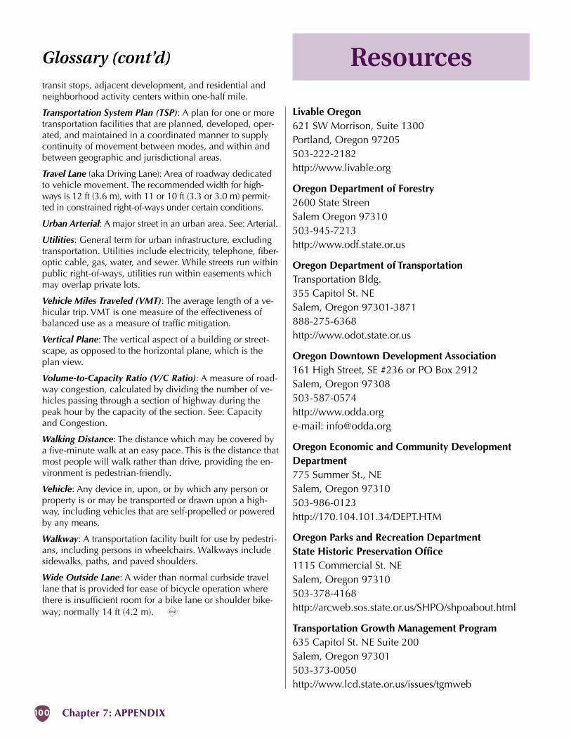
Chapter 7: APPENDIX100
Resources
Livable Oregon621 SW Morrison, Suite 1300Portland, Oregon 97205503-222-2182http://www.livable.org
Oregon Department of Forestry2600 State StreenSalem Oregon 97310503-945-7213http://www.odf.state.or.us
Oregon Department of TransportationTransportation Bldg.355 Capitol St. NESalem, Oregon 97301-3871888-275-6368http://www.odot.state.or.us
Oregon Downtown Development Association161 High Street, SE #236 or PO Box 2912Salem, Oregon 97308503-587-0574http://www.odda.orge-mail: [email protected]
Oregon Economic and Community DevelopmentDepartment775 Summer St., NESalem, Oregon 97310503-986-0123http://170.104.101.34/DEPT.HTM
Oregon Parks and Recreation DepartmentState Historic Preservation Office1115 Commercial St. NESalem, Oregon 97310503-378-4168http://arcweb.sos.state.or.us/SHPO/shpoabout.html
Transportation Growth Management Program635 Capitol St. NE Suite 200Salem, Oregon 97301503-373-0050http://www.lcd.state.or.us/issues/tgmweb
transit stops, adjacent development, and residential andneighborhood activity centers within one-half mile.
Transportation System Plan (TSP): A plan for one or moretransportation facilities that are planned, developed, oper-ated, and maintained in a coordinated manner to supplycontinuity of movement between modes, and within andbetween geographic and jurisdictional areas.
Travel Lane (aka Driving Lane): Area of roadway dedicatedto vehicle movement. The recommended width for high-ways is 12 ft (3.6 m), with 11 or 10 ft (3.3 or 3.0 m) permit-ted in constrained right-of-ways under certain conditions.
Urban Arterial: A major street in an urban area. See: Arterial.
Utilities: General term for urban infrastructure, excludingtransportation. Utilities include electricity, telephone, fiber-optic cable, gas, water, and sewer. While streets run withinpublic right-of-ways, utilities run within easements whichmay overlap private lots.
Vehicle Miles Traveled (VMT): The average length of a ve-hicular trip. VMT is one measure of the effectiveness ofbalanced use as a measure of traffic mitigation.
Vertical Plane: The vertical aspect of a building or street-scape, as opposed to the horizontal plane, which is theplan view.
Volume-to-Capacity Ratio (V/C Ratio): A measure of road-way congestion, calculated by dividing the number of ve-hicles passing through a section of highway during thepeak hour by the capacity of the section. See: Capacityand Congestion.
Walking Distance: The distance which may be covered bya five-minute walk at an easy pace. This is the distance thatmost people will walk rather than drive, providing the en-vironment is pedestrian-friendly.
Vehicle: Any device in, upon, or by which any person orproperty is or may be transported or drawn upon a high-way, including vehicles that are self-propelled or poweredby any means.
Walkway: A transportation facility built for use by pedestri-ans, including persons in wheelchairs. Walkways includesidewalks, paths, and paved shoulders.
Wide Outside Lane: A wider than normal curbside travellane that is provided for ease of bicycle operation wherethere is insufficient room for a bike lane or shoulder bike-way; normally 14 ft (4.2 m). x
Glossary (cont’d)
MAIN STREET HANDBOOK 101
Index
Aaccess ............................................. 3, 29activity centers .................................... 70ADA ............................................ 27, 30angled parking .................................... 44Area Commission on
Transportation ............................ 11awareness
crosswalk ........................................ 20curb extension ................................ 20refuge island ................................... 20
awning ................................................ 63
BBaker City ..................................... 55, 70Basic Rule ..................................... 23, 24Bend ................................................... 21Bicycle and Pedestrian Program .......... 77bicycle racks ....................................... 64bike lane ............................................. 39bikeway .............................................. 39block length ........................................ 30building
area........................................... 16, 68codes & ordinances ......................... 70design ............................................. 68entrances ........................................ 68façade ............................................. 68height .............................................. 69height to street ratio ........................ 69orientation ...................................... 68setback ............................................ 68windows ......................................... 68
bulb-out. See curb extensionbusiness improvement district ............. 75bypass ................................................. 37
Ccase study
Heppner .......................................... 82Newberg ......................................... 84Sisters .............................................. 87
channelization .................................... 40classifications, highway ................. 14, 97cleanliness .......................................... 64colored shoulder ................................. 52comfort ............................................... 22congestion .......................................... 31
costs ................................................ 32corner radius ....................................... 41Corridor Plan ........................................ 9couplet ................................................ 36cross-section. See widthcrossing............................................... 27
mid-block ....................................... 28crosswalk ..................................... 28, 42
ladder ............................................. 42
lighting............................................ 42mid-block ....................................... 49textured........................................... 49
curbextension ........................................ 58radius .............................................. 41
Ddesign
building .......................................... 68exception .................. 9, 12, 16, 19, 44factors ............................................. 22ingredients ...................................... 33intersection ..................................... 27non-highway ................................... 72
speed humps ............................... 72plan .................................................. 8roadway area .................................. 38sidewalk .......................................... 57
development codes ............................. 11drainage .............................................. 59drive-through ...................................... 29driveway ....................................... 26, 60
Eeconomic improvement district ........... 75enforcement ........................................ 72exception. See design, exception
Ffunding ............................................... 73
Ggas tax................................................. 74gateway .................................. 15, 26, 52grants .................................................. 76
Hheight ............................................ 17, 69height-to-width ratio ..................... 17, 69Heppner ........................................ 12, 82highway
as barrier ......................................... 27classifications ............................ 14, 97
Highway Design Manual ....................... 1historical preservation ......................... 71horizontal infrastructure ...................... 17human scale ........................................ 14
IImmediate Opportunity Grant Program 78informational signs .............................. 48infrastructure
horizontal ....................................... 17vertical ............................................ 17
ingredientsbuilding .......................................... 68
roadway .......................................... 38sidewalk .......................................... 57street system.................................... 34
intersection design .............................. 27island, refuge ...................................... 46
JJacobs, Allan ................................... 2, 66
LLaGrande ........................................ 8, 69land use .............................................. 70landscaping.................................. 61, 65length.................................................. 14
block ............................................... 35liability ................................................ 26lighting................................................ 63
crosswalk ........................................ 42local improvement district ................... 74local street network ............................. 35
Mmaintenance ....................................... 61McMinnville ....................................... 70median................................................ 43
raised .............................................. 28mid-block crossing .............................. 28mixed use ........................................... 70mobility ................................................ 3modernization..................................... 12MUTCD .............................................. 47
NNational Register of Historic Places ..... 99Newberg ............................................. 84noise .................................................. 22
OODOT
Traffic Management Section ............ 47on-street parking ................................. 44open spaces. See vacant lotsOregon Highway Plan ... 9, 10, 12, 32, 60Oregon Livability Initiative. See 21st
Century Community FundOregon Transportation
Infrastructure Bank ..................... 78
Pparallel parking ................................... 44parking
angled ............................................. 44off-street .......................................... 69on-street .......................................... 44parallel ............................................ 44
pavementmarkings ......................................... 45
Chapter 7: APPENDIX102
Index (cont’d)textured........................................... 49
pedestrianpriority ...................................... 14, 20scale. See human scalesignal .............................................. 51
perceptionhuman. See heightsafety .............................................. 20
phones ................................................ 64planting strip ....................................... 53plazas ................................................. 70Pendleton ............................................ 71Portland .............................................. 51preservation ........................................ 12Prineville ............................................. 55process .................................................. 7property tax ......................................... 74prospectus ........................................... 11public space........................................ 70
Qquick response teams .......................... 76
Rraised median ..................................... 28ratio, height-to-width .......................... 17reduction
corner radius ................................... 41travel lane ....................................... 55
refuge island ................................. 40, 46regulatory signs ................................... 47rest rooms ........................................... 64right-of-way .......................................... 3roadway .............................................. 16
area................................................. 38Robertson, Kent ................................... 71roundabout ................................... 26, 54
Ssafety .................................................. 20
perception ....................................... 20SCA Program ....................................... 77scenario
5-lane highway ............................... 93couplet ............................................ 91traditional downtown ...................... 89
seating ................................................ 63secondary route .................................. 36security ............................................... 21
eyes on the street ............................ 69ownership ....................................... 21surveillance ..................................... 21
sense of place ....................................... 2shoulder
colored ........................................... 52sidewalk .............................................. 62
activity ............................................ 26area........................................... 16, 57design ............................................. 57width ........................................ 16, 62
signinformational .................................. 48regulatory ........................................ 47warning ........................................... 47
signal .................................................. 50pedestrian ....................................... 51synchronizing ........................... 26, 51timing ............................................. 27warrants .......................................... 51
signingpermanent ....................................... 47temporary ....................................... 47
Sisters ...................................... 31, 47, 87slip lane .............................................. 40smart development ........................ 11, 76Special Public Works Fund .................. 78Special Transportation Area ................... 9
benefits ........................................... 10Special Transportation Fund ................ 77speed .................................................. 23
85th percentile ................................ 24Basic Rule ................................. 23, 24chances of death ............................. 25driver’s focus ................................... 25zones .............................................. 24
Speed Zone Review Panel ................... 24State Historic Preservation Office ........ 99State Speed Board ............................... 23State Transportation Improvement
Program.................................. 8, 11stop sign .............................................. 50street
block length .................................... 35furniture .......................................... 63length .............................................. 14local network .................................. 35structure .......................................... 14system ............................................. 34trees ................................................ 18width .............................................. 16zones .............................................. 14
striping ................................................ 61success measurement ............................ 6Sucher, David .......................... 6, 22, 70SUPI Program...................................... 77system development charge ................ 74
Ttax
gas .................................................. 74property .......................................... 74
tax increment financing....................... 75TEA-21 ................................................ 80textured surface................................... 49TGM Program ..................................... 76through traffic
secondary route .............................. 36traffic
controls ........................................... 50flow ................................................ 26
noise ............................................... 22secondary route .............................. 36
traffic calming ....................................... 4liability ............................................ 26slow down ...................................... 24smooth out ...................................... 26
traffic controls ..................................... 50pedestrian signal ............................. 51roundabout ..................................... 54signal .............................................. 50stop sign .......................................... 50yield sign ........................................ 50
Traffic Management Section ................ 47transit shelter ....................................... 63transition area .............................. 15, 26transitions ........................................... 52Transportation System Plan ................... 9travel lane
reduction .................................. 26, 55width .............................................. 56
trees ........................................... 18, 6521st Century Community Fund ........... 79
UUrban Forestry Grant ........................... 79urban renewal district ......................... 75utilities ......................................... 18, 67
Vvacant lots .................................... 17, 70vandalism ........................................... 21vertical infrastructure .......................... 17vertical plane. See heightvision ............................................. 8, 13
Wwalkway .............................................. 61warning signs ...................................... 47wide outside lane ................................ 39width .................................................. 16
building area ................................... 16perceived ........................................ 56roadway .......................................... 16sidewalk .......................................... 16travel lane ....................................... 56
Yyield sign ............................................ 50
Zzones
building area ................................... 16height .............................................. 17length .............................................. 14roadway .......................................... 16sidewalk area .................................. 16speed .............................................. 24street ............................................... 14width .............................................. 16