Embed Size (px)
Citation preview
The Dissertation Committee for Brian Patrick Jones Certifies that
this is the approved version of the following dissertation:
Making the Ocean:
Global Space, Sailor Practice, and Bureaucratic Archives
in the Sixteenth-Century Spanish Maritime Empire
Committee:
__________________________________Jorge Cañizares-Esguerra, Supervisor
__________________________________Susan Deans-Smith
__________________________________Bruce Hunt
__________________________________Neil Kamil
__________________________________María M. Portuondo
Making the Ocean:
Global Space, Sailor Practice, and Bureaucratic Archives
in the Sixteenth-Century Spanish Maritime Empire
by
Brian Patrick Jones, B.A.
Dissertation
Presented to the Faculty of the Graduate School of
The University of Texas at Austin
in Partial Fulfillment
of the Requirements
for the Degree of
Doctor of Philosophy
The University of Texas at Austin
December 2014
iii
Acknowledgements
I would like to thank my supervisor Jorge Cañizares for his support of this project
and for his challenging feedback that has made this project a better project and me a
better historian. Thanks also to the other members of my dissertation committee—Susan
Deans-Smith, Bruce Hunt, Neil Kamil, and María Portuondo—for sharing their time and
insights with me on this project. In addition to those I have already mentioned, I have had
the privilege of being exposed to a variety of different perspectives on history in the
classroom, including in particular my classes with Abigail Lustig, Robert Olwell, Jim
Sidbury, and Ann Twinam.
I also appreciate the friendships and intellectual partnerships I have made with my
colleagues in the history department at UT. Michael Schmidt has been a stimulating
partner in countless conversations regarding far-ranging topics affecting our work and
otherwise. This dissertation has largely been an individual effort, but founding The
Appendix with my partners Ben Breen, Felipe Cruz, and Chris Heaney was anything but,
and I am grateful to them for the opportunity to build the kind of collaborative project I
could never achieve on my own. Other colleagues and visiting scholars from whose
work, friendship, and insights I have benefited while at UT include Matt Childs, Becca
Havens, Kyle Shelton, Cameron Strang, Jim Sweet, and Laurie Wood.
My work has been supported by several fellowships for which I am very grateful.
I spent a summer on fellowship at the Huntington Library in San Marino, CA and
received a Marie L. and William R. Hartland Fellowship to work at the John Carter
Brown Library in Providence, RI. A fellowship from the history department at UT
supported a year of research at the Archivo General de Indias in Seville. I appreciate
financial support, but am also particularly thankful for the help from the staff at each of
these institutions in hunting down and collecting materials. I want to thank the staff and
fellows at the John Carter Brown Library in particular where the feeling of supportive
intellectual community came at a pivotal time for my project. Ralph Bauer, Kaja Cook,
iv
Jesse Cromwell, Christian Crouch, Susan Danforth, Charlie Foy, Elena Schneider, and
Ken Ward shared much appreciated personal expertise, helpful feedback, and
camaraderie.
Finally, I am thankful to my family for their encouragement and support during
this process and particularly to my wife Sarah for joining me on my research and
enduring the associated stresses, but more importantly for joining me in laying the
groundwork for a hopeful and shared future as this selfish pursuit recedes into past.
v
Making the Ocean: Global Space, Sailor Practice, and Bureaucratic
Archives in the Sixteenth-Century Spanish Maritime Empire
Brian Patrick Jones, Ph.D.
The University of Texas at Austin, 2014
Supervisor: Jorge Cañizares-Esguerra
This dissertation is about the long-distance navigators who constructed a global
marine world as agents of the sixteenth-century Spanish maritime empire. The hard-won
pragmatic and empirical expertise on which they relied developed in an uneasy tension
with the priorities of the bureaucracy centered at the Casa de la Contratación in Seville.
In the Atlantic, bureaucratic standardization driven by the Casa made commercial ocean
travel increasingly routine, while exploratory sailors, particularly in the Pacific, continued
to apply their expertise in unknown and unpredictable waters. The quotidian and the
pragmatic defined these long-distance mariners’ relationship to their environment. They
organized space into networks of knowable pathways that connected places identified by
names and markers that communicated the sailors’ experience to future navigators; they
interpreted local conditions based on inferences from distant stimuli and ocean-scale
systems; and they introduced their natural and human surroundings to metropolitan and
colonial scholars and administrators. The resources and instruments developed by the
Casa informed these practices, but voyages of discovery always remained outside of
direct institutional control from Seville. This relationship—between the local, individual,
and contingent on the one hand and the universal, bureaucratic, and synthetic on the
other—not only defined the dynamics of intellectual authority governing scientific
endeavors under the Spanish monarchy, but also shaped strategies for projecting imperial
claims across areas of uneven and limited physical control, whether marine or terrestrial.
Reevaluating the balance between marine and terrestrial territorial claims recasts the
vi
Americas as a waypoint into the Pacific and beyond for the globally-aware westward
gaze of Spanish imperial ambition. More fundamentally, it highlights the multicentric and
networked arrangement of power in the early modern period by refocusing our attention
on those islands, whether literal or figurative, of physical Spanish presence surrounded by
spaces of hypothetical control. The Spanish empire’s maritime orientation during the
sixteenth century developed the intellectual, political, and institutional strategies to
balance and resolve these tensions between embodied and archival knowledges, local
contingencies and universal frameworks that defined the distribution of power under the
Spanish monarchy.
vii
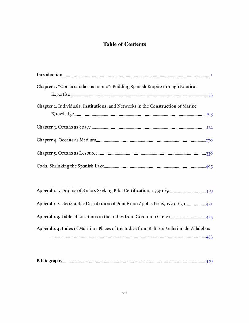
Table of Contents
Introduction 1
Chapter 1. “Con la sonda enal mano”: Building Spanish Empire through Nautical Expertise 33
Chapter 2. Individuals, Institutions, and Networks in the Construction of Marine Knowledge 103
Chapter 3. Oceans as Space 174
Chapter 4. Oceans as Medium 270
Chapter 5. Oceans as Resource 338
Coda. Shrinking the Spanish Lake 405
Appendix 1. Origins of Sailors Seeking Pilot Certification, 1559-1650 419
Appendix 2. Geographic Distribution of Pilot Exam Applications, 1559-1650 421
Appendix 3. Table of Locations in the Indies from Gerónimo Girava 425
Appendix 4. Index of Maritime Places of the Indies from Baltasar Vellerino de Villalobos 433
Bibliography 439
1
Introduction
This dissertation is about the epistemological consequences of long-distance
seafaring on behalf of the Spanish empire in the long sixteenth century. It addresses the
role of mariners sailing under the Spanish flag—pilots and navigators in particular—in
creating a global world-ocean. These seamen were not only creative contributors in their
own right, but the mobile connectors of networks of sailors, scholars, fishermen, and
bureaucrats and their ships, boats, texts, instruments, and specimens that collectively
defined new notions of global space and systems and moved bodies of knowledge
between previously unconnected and little-connected places. To credit the sailors of the
Spanish maritime enterprise with globalizing the marine world offers a challenge to
existing chronologies and geographies of globally-aware scientific projects, a
reevaluation of the geographical focus of the historiography of sixteenth-century
Spanish empire, a new spatial frame for understanding territorial sovereignty in the
early modern Spanish monarchy, and an exploration of the relationship between
institutions and individuals in constructing scientific knowledge.¹
¹ In referring to ‘globalization’ and ‘global history,’ I am indebted to Miles Ogborn’s approach to the terms in his introduction to Global Lives. Rather than attempting a single explanation for the arrival of a globalized world, I am interested in tracing one of many globalizations—in this case, the construction of the world’s oceans as a coherent set of spaces, places, and systems. My interest in studying the global aspects of this process has been in identifying those moments when historical actors invoked their own notions of the global to explain their actions or when the physical fact of their global interactions produced unintended consequences. I am less interested in applying a contemporary logic of comprehensive globalization or of global comparative perspectives to historical processes. Serge
2
Between the late fifteenth and early seventeenth centuries, European sailors
expanded from pursuing the most tenuous exploratory voyages to near-Atlantic islands
such as the Canaries and the Azores to performing routine, scheduled commercial
voyages across every ocean of the globe. Portuguese navigators made the earliest of these
moves, while by the end of the period there were many European imperial and
commercial enterprises capable of promoting long-range and even circumnavigatory
ocean voyages. The Spanish monarchy quickly ramped up its own maritime activity with
voyages of conquest to the Canary Islands and most famously in 1492 with the approval
by Ferdinand and Isabella of Christopher Columbus’s plan to reach Cipangu (Japan) by
traveling through the tropical band westwards into the Ocean Sea. Just a decade later, in
1503, they had established the Casa de la Contratación to manage the promotion of trade
and resource extraction from the Indies which now, as a result of the Columbian
voyages, were plural— the East and the West. Two decades later, another voyage
organized from Spain and led by Ferdinand Magellan and then Sebastián Elcano had
circumnavigated the globe. The next several decades saw the incremental development
Gruzinski in his exploration of two cosmographies produced contemporaneously in Mexico City and Istanbul in the first decade of the seventeenth century outlined the distinction between the physical fact of the ‘planetary’ character of Philip II’s empire and the struggle of his two authors to develop a ’global’ consciousness that could accommodate it. To use his terminology, the globalization in which these sailors participated took the planetary expanse of the world’s oceans and developed coherent global schemes that would organize and describe them. Miles Ogborn, Global Lives: Britain and the World, 1550-1880 (New York: Cambridge University Press, 2008), 1-15; Serge Gruzinski, What Time is It There? America and Islam at the Dawn of Modern Times (Malden, MA: Polity Press, 2010).
3
of the Carrera de Indias, a regularly scheduled trading fleet that crossed the Atlantic
between the American trading ports and Seville. A similar, though less elaborate, trade
began in the Pacific in 1565 with the establishment of the Carrera del Mar del Sur, or the
Manila Galleon trade. All through this period and into the seventeenth century,
exploratory voyages were organized from both Spain and the Americas. By the middle of
the seventeenth century, however, increased competition from European rivals and
financial difficulties combined to discourage Philip IV from continuing to finance
exploratory voyages in the Pacific.
During this long sixteenth century of maritime empire in Spain, sailors on
Spanish vessels pushed the boundaries of known marine space in what would become
known as the Atlantic and Pacific Oceans while the Spanish monarchy supported the
development of charts, instruments, and practices for their improvement.
Improvements in the reliability of pilot practice, however, necessarily reduced the
hermeneutic burden of the pilot’s craft. In other words, higher quality instruments,
more detailed charts, and better information regarding weather patterns, to name a few
factors, reduced the uncertainty that required pilots to read their environment,
synthesize these inputs, and make judgments from them. As the Carrera de Indias made
voyaging in the Atlantic increasingly routine, much of the nautical activity in the Pacific
continued to be exploratory. Nonetheless, the sailors in the Pacific benefited from the
4
institutional improvements and rationalization promoted by the Casa de la Contratación
in support of the Carrera de Indias. The benefits of institutional organization and
support combined with the persistence of marginal spaces where practical navigation
relied on more sophisticated problem-solving were parallel influences on the
development of marine knowledge in the Spanish empire.
I will use the expedition led by Pedro Sarmiento de Gamboa in 1579 to map the
Strait of Magellan for future settlement and fortification to introduce new themes
throughout this dissertation. In its characteristics both on the scale of the expedition as
a whole—its geography, its strategic motivations, the institutional context of its
organization—and at the scale of its individual participants—its several navigational
experts’ approach to navigating and mapping the strait, their career trajectories after the
voyage, and the politics of authority on board and with representatives of the
monarchy—the voyage led by Sarmiento encapsulates the sixteenth-century Spanish
maritime enterprise. The expedition was a response to the unexpected and catastrophic
arrival of Francis Drake off the Pacific coast of Spanish America and was tasked with
surveying the strait for future fortifications against further encroachments by European
rivals. Sarmiento and the fleet’s three pilots spent several weeks sounding and mapping
the strait’s many channels, naming places of interest, engaging (sometimes violently)
with the inhabitants of its islands and coastlines, and recording its weather, currents,
5
and flora and fauna. At the end, they entered the Atlantic Ocean and sailed on to Spain,
the first sailors to connect the Pacific to the Atlantic by heading east. Sarmiento would
deliver his voluminous notes of their activities to monarchical representatives in Spain;
two of the pilots, Fernando Lamero and Hernán Alonso, were named as sources in José
de Acosta’s Historia natural y moral de las Indias written in the Americas, but published in
Seville in 1590. Collectively, these sailors’ practice, communications, and movements—
and the spatial, geographical, and institutional contexts in which they took place—
exemplify the construction of a global marine knowledge on behalf of the Spanish
maritime empire.²
Long-range pilots’ occupational practice aligns them neatly with many subjects
of recent interest to historians of science in the sixteenth-century Spanish empire.
Having established the once-dismissed presence of an active culture of scientific enquiry
in Spain and the Spanish Americas, scholars have moved beyond these existence proofs
of scientific modernity to explore its peculiar contours in the Iberian world. The starting
point for most, but not all, of these studies has been the crisis of taxonomy and
synthesis that the opening of the Indies to Europe presented to existing models of the
² Pedro Sarmiento de Gamboa, Viaje al Estrecho de Magallanes y noticia de la expedición que después hizo para poblarlo, Colección Reservada del Museo del Fin del Mundo (Buenos Aires: Eubeda, 2005); José de Acosta, Historia natural y moral de las Indias, (1590; Madrid: Ediciones de Cultura Hispánica, 1998); José de Acosta, Natural and Moral History of the Indies, ed. Jane E. Mangan, trans. Frances Lopez-Morillas, (1590; Durham, NC: Duke University Press, 2002).
6
natural world. The Spanish empire developed institutions to organize this new data and
to promote and to control its collection and analysis. Entrepreneurial individuals in the
Americas and the Caribbean addressed themselves to solving technical problems
relating to mining, pearl-fishing, and other profitable endeavors that capitalized on
knowledge of the natural world. Engineers surveyed and designed fortifications and
harbors. Collectively, the historiographical consensus on the culture of scientific enquiry
in the Spanish empire has focused on its pragmatic bent and on the close relationship
between officially organized projects and entrepreneurial activity. As a community of
workers whose trade required intimate knowledge of the natural world and technical
mastery of complex machines, sailors look very much like many of the other
occupational groups whose practical natural knowledge these scholars have studied. As
participants in the institutional infrastructure built around maritime trade, as a class
they clearly pursued their occupations as agents of imperial expansion, and their work
was clearly defined, at least in part, by imperial priorities.
The nature of long-distance seafaring, however, makes the seamen who
conducted these ships particularly interesting for the role that movement, space, and
distance play in their work. On their ships they were vectors of Iberian knowledge of the
sea, carrying it into contact with spaces and people where local contingencies required
7
that they adjust their assumptions or accommodate new information.³ They also simply
moved through great spaces, providing them with opportunities to encounter
phenomena such as currents that necessarily existed in space on a scale at which they
were previously not knowable. Sailors did not simply cross oceans from one point to
another; their journeys involved a continuous process of observation, analysis, and
adjustment. Nonetheless, it is typical to define exploratory voyages by their moments of
discovery, to fix the moment of arrival on shore in space and time as the the endpoint of
the process. It is no accident that the word ‘discovery’ has significance in the language of
science as well; these shoreline discoveries are the moments of invention in the
literature of exploration. Just as the history of science literature has shown us the
incremental, sometimes haphazard, processes behind scientific creation, however,
these places were not simply discovered in isolated moments, but rather created and
embedded in a space defined by the relationships of many places to one another,
organized by sailors in networks and taxonomies, according to the accumulation of their
experiences.
³ It would be difficult to address the role of networks and the transfer of knowledge across distance without recognizing the effects of actor-network theory, perhaps most famously examined by Bruno Latour in Science in Action, on recent historians of science. In terms of its relationship to this project, actor-network theory is a call to study the material and social circumstances of local clusters of collaborators and how they combine with the distortions and translations inherent in communicating between localities. For a succinct presentation of these concerns in conjunction with early modern global knowledge networks, see Bruno Latour, Science in Action: How to Follow Scientists and Engineers through Society, (Cambridge, MA: Harvard University Press, 1987), 228-232.
8
Scholars have described the sixteenth and seventeenth centuries as an Age of
Discovery. The word ‘discovery’ in this context serves two roles. It reflects a modern
desire to write the hagiography of European explorers as modernizing heroes and to
celebrate their achievements as unique moments of inspired creation. Nineteenth- and
twentieth-century historians have celebrated these figures as founders of nations and
their achievements as justification for European and North American hegemony. This
celebratory mode places exaggerated emphasis on the expertise of individual navigators
at the expense of unnamed and multinational contributors among the ships’ crews and
non-European peoples the explorers encountered. More recently, the hagiographic
connotations of ‘discovery’ have been the subject of popular ridicule and scholarly
skepticism. From the perspective of contemporary, postcolonial politics, the rejection of
the language of discovery challenges the implicit presumption that Europeans earned
their conquests.
Invocations of the language of ‘discovery’ in the context of the history of science
also suggest a positivist conception of knowledge creation that runs counter to the
historiographical perspective that guides this project. I approach knowledge creation as
a process that is necessarily embedded in social relationships and institutional politics
and pursued through a variety of labors in a variety of locales. The notion of an
individual discoverer or a single moment of discovery are antithetical to this approach.
9
The language of ‘discovery’, however, was also in the mouths of the historical
navigators themselves. The phrase ir á descubrir described voyaging with a particular
perspective and from a particular attitude.⁴ When we abandon the language of discovery
entirely, we lose this perspective on how sixteenth-century Spanish sailors saw their own
work and fail to take seriously the complex combination of design and contingency,
theory and practice that went into building a body of marine natural historical
knowledge. I will from time to time use the language of discovery in this dissertation in
order to credit this historical perspective, but when I do so, I do not intend to ignore the
well-founded political and historiographical critiques of this language.
My arrival at terms such as ‘long-distance seafaring’ and ‘long-range oceangoing’
for describing the navigational moment I study here was intentional. First, the scale and
distance of these voyages are essential factors in their transformative effects. This
expanded scale had a number of consequences, both practical and epistemological, for
sailors that had not accompanied older forms of navigation. Practically speaking, the
duration of voyages meant provisions would be stretched and support was more distant
or unavailable in the event of catastrophe. More subtly, in traveling across longer
⁴ Pedro Sarmiento de Gamboa, for example, used this language as a matter of course to describe his efforts in the Strait of Magellan, but the language originates in the Portuguese of the late fifteenth century. Sarmiento de Gamboa, Viaje al Estrecho de Magallanes, 116-117; Luís Adão da Fonseca, “Prologue: The Discovery of Atlantic Space,” in Portugal, The Pathfinder: Journeys from the Medieval toward the Modern World, 1300-ca.1600, ed. George D. Winius (Madison, WI: The Hispanic Seminary of Medieval Studies, 1995), 15.
10
distances, particularly longitudinally, at faster speeds than had previously been possible,
they witnessed phenomena and contended with problems that were evident at scale.
These sailors’ movement through space was continuous (as was their observation of that
space), and the entirety of the distance they traveled informed the conclusions they
would draw about the working of the world’s oceans.
This continuity of movement, measurement, and observation—and the iterative
description of the oceans that they facilitated—encourage me to avoid a different class
of terminology when describing these phenomena. In the historiography of the Age of
Sail, there is considerable reliance on terms that imply the traversal of bounded space:
trans-oceanic, transatlantic, trans-Pacific, etc. I have tried to avoid this language for two
reasons. First, many of these voyages should not be understood primarily as traversals;
the process by which they moved through space was as important or even more
important than their destination. They were missions of observation, measurement, and
discovery shaped by constant vigilance. Secondly, these terms imply crossing a space or
a container; they imply the boundedness of the space in which the journey took place.
This dissertation argues that sailors constructed and defined these same oceanic spaces
through their practice of safe wayfinding and the many moments of naming,
measurement, and judgment (and the many concomitant elisions and dismissals) of
which that practice was composed. To use these terms in describing Spanish navigation
11
in the sixteenth-century presupposes oceanic spaces and categories that were still in the
process of becoming.⁵
It was precisely the sailors’ encounters with these spaces and their movements
through them that were the engine bringing them into being. Ships move according to
specific technologically-determined rules: they move at different speeds and with
different degrees of control in relation to different points of wind; they may or may not
be able to traverse a certain area of shallows based on the depth of their draft.
Environmental concerns also affect their movements such as when currents facilitate or
impede travel in certain directions. Finally there is a human component to their
movement: they may only respond to these environment and technological cues
according to the observational and physical limitations of the people who control them.
As sailors on sixteenth-century vessels moved through unknown and little-known
oceanic space, all of these factors combined to determine their approach to safely
finding their way through that space and, in turn, to define their representation of that
space to others. As they connected, labeled, and ordered these spaces according to their
needs, they created them as bounded spaces (the boundaries of which constantly
⁵ By way of contrast, I have used the term ‘transatlantic’ to describe the Carrera de Indias which was a trading system that was based on a relative geographic consensus regarding the arrangement of Atlantic space and proceeded according to defined endpoints and boundaries. The uneven precision with which different parts of the world’s oceans were known will be an important interpretative tool throughout this dissertation.
12
changed and expanded through the period) with new names, contents, and
connections.⁶
At the same time that they developed strategies to connect and describe space,
sailors on Spanish vessels also developed techniques to identify unique places within
this ordered space. Yi-Fu Tuan’s notion of place as a space that has become familiar
informs the distinction I make here.⁷ Just as sailors needed to be able to communicate
regarding the arrangement of oceanic space in order to facilitate safe movement through
it, they needed to be able to provide a sort of familiarity-by-proxy to future sailors so that
they would know when they arrived at their destination. This constant context-switch
between specificities and generalities, places and spaces was an essential aspect of sailor
navigational practice—to know with high degrees of precision one’s position in globally
distributed space—and informed the spatial and geographical dynamics of their
political, social, and intellectual interactions.
⁶ The first European name for the Pacific Ocean was the Mar del Sur, or South Sea, a name created according to the local logic of Vasco Núñez de Balboa’s encounter with it from the south-facing shore of the Darién. O.H.K. Spate has traced the transition in nomenclature in sixteenth and seventeenth century texts from this regionally appropriate name to the more general category geography inherent in the label ‘Pacific Ocean’. He has credited this process of replacement to European geographic discovery, but also to the expansion of the existing East Asian thalassic trading cultures into an oceanic trading system with the European colonies in the Americas. O.H.K. Spate, “‘South Sea’ to ‘Pacific Ocean’: A Note on Nomenclature,” The Journal of Pacific History 12, no. 4 (1977): 205-211.⁷ Yi-Fu Tuan, Space and Place: The Perspective of Experience (Minneapolis: University of Minnesota Press, 1977), 73.
13
The tension between space and place resonates with the tension between the
universal and the local in the history of science. The positivist origins of the discipline—
concerned with tracing the progressive discovery and revelation of scientific truths—
necessarily dealt in universalities. The next generations introduced locality,
microhistory, and contingency in search of the social and cultural context of knowledge
creation.⁸ Most recently, scholars have asked whether the focus on locality has
proceeded so far as to remove the possibility of a general analysis.⁹ In studying the many
moments of observation and judgment sailors made, their connection to non-European
knowledges in the Pacific, and their synthesis into reusable and relatable universalities
in occupational, scholarly, and bureaucratic contexts, this project connects the specific
knowledges of many moments and localities through their translation into more general
⁸ David Turnbull has been both an early and a prolific supporter of introducing locality into the history of science, particularly in connection to the Pacific world, arguing that all knowledges are local and that locality is an essential determinant in the process of knowledge production and in the translation of knowledge to new contexts. David Turnbull, “Local Knowledge and Comparative Scientific Traditions,” Knowledge & Policy 6, no. 3/4: 29-54.Contributions to this literature of science and locality have proliferated to address subjects from exploring previously ignored venues and cultures of scientific enquiry to identifying localized variations in previously undifferentiated grand narratives of scientific progress to reevaluating and collapsing spatially defined hierarchies of the diffusion of scientific and technical knowledge, including: Jorge Cañizares-Esguerra, Nature, Empire, and Nation: Explorations of the History of Science in the Iberian World (Stanford, CA: Stanford University Press, 2006); James Delbourgo A Most Amazing Scene of Wonders: Electricity and Enlightenment in Early America (Cambridge, MA: Harvard University Press, 2006); Neil Safier, Measuring the New World: Enlightenment Science and South America (Chicago: The University of Chicago Press, 2008); Simon Schaffer, Lissa Roberts, Kapil Raj and James Delbourgo, eds., The Brokered World: Go-Betweens and Global Intelligence, 1770-1820 (Sagamore Beach, MA: Science History Publications, 2009); Charles W.J. Withers, Placing the Enlightenment: Thinking Geographically about the Age of Reason (Chicago: The University of Chicago Press, 2007).⁹ James A. Secord, “Knowledge in Transit,” Isis 95, no. 4 (December 2004): 654-672.
14
schemes. This process of making many local contingencies into coherent universalities
is, in fact, a major component of the globalizing effects of the long-range sailor
perspective.
While space, time, and distance as they relate to the construction of scientific
knowledge have been the preoccupation of many historians of science in recent
generations, studies of spatial knowledge itself have had their own trajectory. Similar to
positivist histories of science, the traditional mode of this historiography consisted of
cartographic histories defined primarily by their interest in tracing improvements in
mapping comprehensiveness, accuracy, and precision over time.¹⁰ More recently,
historical studies of the analysis, measurement, and representation of space have
become more diverse and more sensitive to many of the same concerns that have
interested historians of science. Historians have studied historical geographers as
technicians participating in the early modern turn to knowledge-making through
¹⁰ J.B. Harley’s essays remade the history of cartography using tools from visual culture studies and other disciplines to allow for the study of maps according to their own hermeneutics, moving beyond tracing incrementally more precise representations of physical space. David Turnbull has made a succinct case for applying the constructivist approaches from the history of science literature to the history of cartography with particular analysis of Spanish maritime charting. For an example of scholarship that takes up these challenges, Chandra Mukerji has shown how the early modern publishing market shaped the quality of cartographic information in many maps and atlases. J.B. Harley, “The Map and the Development of the History of Cartography,” in The History of Cartography: Cartography in Prehistoric, Ancient, and Medieval Europe and the Mediterranean, eds. J.B. Harley and David Woodward, vol. 1 (Chicago: The University of Chicago Press, 1987); J.B. Harley, The New Nature of Maps: Essays in the History of Cartography (Baltimore, MD: Johns Hopkins University Press, 2001); David Turnbull, “Cartography and Science in Early Modern Europe: Mapping the Construction of Knowledge Spaces,” Imago Mundi 48 (1996): 5-24. Chandra Mukerji, “Printing, Cartography and Conceptions of Place in Renaissance Europe,” Media Culture Society 28 (2006): 651-669.
15
empiricism.¹¹ They have studied the way that maps reflect and shape imperial power.¹²
There has even been a proliferation of environmental histories of the sea and marine
space that treat it less as a subject of analysis by historical actors, but as a historical agent
and historical subject itself.¹³ In studying sailor engagement with and representations of
the world’s oceans as a space, this dissertation contributes to each of these
contemporary discussions of space and history.
¹¹ David N. Livingstone, Putting Science in its Place: Geographies of Scientific Knowledge (Chicago: The University of Chicago Press, 2003); Charles W.J. Withers, “Geography, Science, and the Scientific Revolution,” in Geography and Revolution, eds. David N. Livingstone and Charles W.J. Withers (Chicago: The University of Chicago Press, 2005).¹² James R. Akerman, ed., The Imperial Map: Cartography and the Mastery of Empire (Chicago: The University of Chicago Press, 2009); David Buisseret, ed., Monarchs, Ministers, and Maps: The Emergence of Cartography as a Tool of Government in Early Modern Europe (Chicago: The University of Chicago Press, 1992); Lesley B. Cormack, Charting an Empire: Geography at the English Universities, 1580-1620 (Chicago: The University of Chicago Press, 1997); Ricardo Padrón, The Spacious Word: Cartography, Literature, and Empire in Early Modern Spain (Chicago: The University of Chicago Press, 2004); Dennis Reinhartz and Gerald D. Saxon, eds., Mapping and Empire: Soldier-Engineers on the Southwestern Frontier (Austin: University of Texas Press, 2005); Benjamin Schmidt, “Mapping an Empire: Cartographic and Colonial Rivalry in Seventeenth-Century Dutch and English North America,” The William and Mary Quarterly, Third Series 54, no. 3 (July 1997): 549-578; Alison Sandman, “Controlling Knowledge: Navigation, Cartography, and Secrecy in the Early Modern Atlantic,” in Science and Empire in the Atlantic World, eds. James Delbourgo and Nicholas Dew (New York: Routledge, 2008).¹³ Jeffrey Bolster’s 2008 essay in American Historical Review has become a common reference point for scholars arguing for the importance of including marine environmental histories in ocean-basin studies such as the historiography on the Atlantic World. More recently, his work on the ecological catastrophe wrought by the Atlantic fishery relies heavily on environmental history methodologies. In the Pacific, J.R. McNeill has laid a foundation with his comprehensive grand narrative of the Pacific ecosphere, while more recently scholars such as Gregory Cushman have used environmental history methodologies in combination with other perspectives to explore the ecological components of empire, cultural exchange, and other common subjects of interest in the history of the Pacific. W. Jeffrey Bolster, “Putting the Ocean in Atlantic History: Maritime Communities and Marine Ecology in the Northwest Atlantic, 1500-1800,” The American Historical Review 113, no. 1 (February 2008): 19-47; W. Jeffrey Bolster, The Mortal Sea: Fishing the Atlantic in the Age of Sail (Cambridge, MA: The Belknap Press of Harvard University Press, 2012); J.R. McNeill, “Of Rats and Men: A Synoptic Environmental History of the Island Pacific,” Journal of World History 5, no. 2 (Fall 1994): 299-349; Gregory T. Cushman, Guano and the Opening of the Pacific World: A Global Ecological History (New York: Cambridge University Press, 2013).
16
In exploring the roles of science in empire and of space and place in science, this
project also unsurprisingly has consequences for the spatial dynamics of the Spanish
empire in the long sixteenth century. In terms of distance and space traveled, the oceans
that Spanish ships explored represented a space potentially as large or larger than the
terrestrial territories they claimed. There were different conceptual and legal standards
to be applied when considering dominion over land or dominion over the seas, but in
practice the role of space in empire in the sixteenth-century was primarily one of
possibility. Actual points of strong imperial presence, settlement, and control were
limited, but casting the boundaries of claims as broadly as possible was an exercise in
securing the broadest possible catchment of future discoveries. The European arrival in
the Americas introduced this role of space on land, but the sea had long held this
potential.¹⁴
Navigators and other sailors on long-distance exploratory voyages counted on
their ability to wield vocabularies of space and place both to make their own way and to
¹⁴ All of this concern for localities and networks in the construction of knowledge has made historians of science the most concerned with space as a historical agent, but increasingly other historians are beginning to think about the causal role of space in historical processes. Charles Withers has described what he calls the “spatial turn” in history. Examples of this spatially-informed history that have influenced this dissertation include Lauren Benton’s study of geographic tropes in the legal language of empire and sovereignty and Sylvia Sellers-García’s study of changing notions of space and time through studies of the mails in colonial and post-independence Guatemala. Charles W.J. Withers, “Place and the ‘Spatial Turn’ in Geography and in History,” Journal of the History of Ideas 70, no. 4 (October 2009): 637-658; Lauren Benton, A Search for Sovereignty: Law and Geography in European Empires, 1400-1900 (New York: Cambridge University Press, 2010); Sylvia Sellers-García, Distance and Documents at the Spanish Empire’s Periphery (Palo Alto, CA: Stanford University Press, 2013).
17
indicate the way for those who would follow them. Finding their way required that they
be comfortable with abstractions that organized space across vast distances;
communicating their position to others meant marking places with their individual
experiences. Sailors relied on common vocabularies and rubrics for naming and
describing places embedding them in consistent and predictable schemes to be applied
in new locations. These strategies for organizing and relating space and place had
consequences beyond navigational practice. Identifying a place creates an instance of
implied presence; naming places, measuring their dimensions, marking them with
monuments, and physically transforming them were all elements of both imperial
possession-taking ceremonies and quotidian sailor practice.¹⁵ On the other hand,
organizing and describing space according to abstract containers and theoretical
schemes creates the promise of a presence. Sailor techniques established a baseline of
information about the spaces between without observing them directly; for the
monarchy, this knowledge served as a foundation upon which to assert their capacity to
exert control over that space in the future. Literal and figurative islands of Spanish
presence would project the promise of control in the future.
¹⁵ Patricia Seed has provided a comparative overview of different possession-taking practices among early modern empires. Her central conceit of unique culturally-determined approaches belonging to each empire may be overstated as others have argued and as I do in Chapter 1 of this dissertation, but the variety of practices she explores is no less instructive as a consequence. Patricia Seed, Ceremonies of Possession in Europe’s Conquest of the New World, 1492-1640 (New York: Cambridge University Press, 1995).
18
The Atlantic Ocean had promised possibilities to the European peoples on its
northeastern rim for centuries before Iberian navigators broke the boundaries of the
near Atlantic. The history of European engagement with the Atlantic was as a sea of
islands, a history that only continued with the Portuguese and Spanish conquest of the
Azores and Canaries.¹⁶ The presumed plethora of islands extended to hypothesized
islands that proved not to exist. When the Spanish approached the Pacific, they intended
to recreate this Atlantic experience. Voyages that reached the tropics of the western
Pacific found these assumptions confirmed among the thousands of islands and atolls
that comprised the various Polynesian, Melanesian, and Micronesian archipelagos they
encountered. Baja and Alta California were presumed to be islands separated from the
mainland by the hypothetical Strait of Anián.¹⁷ Terra Incognita Australis was assumed to
loom somewhere in the southern Pacific. The Islas del Armenio and the islands Rica de
Oro and Rica de Plata retreated further and further north into the upper latitudes as the
spaces of possibility for unknown islands receded in front of explorers.¹⁸ When Pedro
Fernándes de Quirós took possession at Vanuatu, he claimed all of the seas and islands
¹⁶ John Gillis, Islands of the Mind: How the Human Imagination Created the Atlantic World (New York: Palgrave MacMillan, 2004), 46. John Gillis has attributed to Europeans an “islomania” that caused them to imagine all possible lands as islands.¹⁷ W. Michael Mathes, “Introduction” in Fakes, Frauds, and Fabricators: Ferrer Maldonado, de Fuca, and de Fonte: The Strait of Anian, 1542-1792 (Fairfield, WA: Ye Galleon Press, 1999).¹⁸ Warren L. Cook, Flood Tide of Empire: Spain and the Pacific Northwest, 1543-1819 (New Haven, CT: Yale University Press, 1973), 16.
19
beyond it as well. Even though in theory the seas would not be controlled, in practice
dominance of access to oceanic space promised the island contents of those seas to the
interested empire.¹⁹
Even on land, territorial control was not a hallmark of Spain’s sixteenth-century
empire. Spanish rule consisted of designing institutions and regulations to promote
indirect control at a distance through improved communication and record-keeping. By
reintroducing the oceans into the space of possibility for the Spanish empire, the
metaphorical islands of Spanish control in the mostly un-integrated American
continents reflect the physical islands and coastlines of potential conquest. On land,
these pockets of control were connected through the theory of imperial organization
and sometimes tenuous and unpredictable links of communication rather than through
control of intervening spaces.²⁰ The Pacific islands, both real and hypothetical, of
¹⁹ That these islands and other geographical features were hypothetical and that some turned out not to exist is not to say that they were mythical. W.A.R. Richardson has argued that the Spanish and Portuguese were relatively “modest,” or perhaps one could say “practical,” in their refusal to insert hypothetical lands and other features into maps of the sea when other contemporary European mapping traditions tended to fill voids with conjectural islands and creatures. This willingness to leave voids on maps may be observed in the 1533 map of the Americas and the Philippines by Alonso de Chaves which leaves more than half of the horizontal span of the map, the part that corresponds to the Pacific Ocean, empty except for the Equator rendered in red. The Iberian preference not to mythologize on marine maps suggests the conviction that those empty spaces would be filled with useful representations of real spaces soon enough. W.A.R. Richardson, “Mercator’s Southern Continent: Its Origins, Influence and Gradual Demise,” in Science, Empire and the European Exploration of the Pacific, ed. Tony Ballantyne, The Pacific World Series, Volume 6 (Burlington, VT: Ashgate, 2004), 12; Luisa Martín Merás, Cartografía marítima hispana: La imagen de América (Barcelona: Lunwerg Editores, 1993), 98-99.²⁰ Gillis, Islands of the Mind, 86-87. John Gillis has suggested that political development in Europe proceeded “archipelagically” even on land and that distinguishing politically between mainlands and islands, in the medieval and early modern periods particularly, creates an exaggerated impression of the connectedness
20
potential conquest and settlement would connect to the rest of the empire in much the
same way. Reintegrating the maritime orientation of imperial ambitions into our
understanding of the imperial project reinforces this image of the intangible, networked
character of sixteenth-century Spanish empire.
That the authority of the Spanish monarchy developed from both networked and
centralized sources makes its maritime enterprise an important object of study with
regard to the nature of empire in the early modern period. To address the balance of
these relationships is to define what we mean when we describe Spain and its extra-
peninsular presence in the sixteenth century as an ‘empire’ to begin with. The Spanish
themselves would have been more likely to refer to the ‘monarchy’ than to ‘empire’, but
the political, institutional, geographical, and demographic characteristics of the
sixteenth-century Spanish monarchy invite us to discuss it as one nonetheless. The
arrangement of authority in the sixteenth-century Spanish maritime enterprise informs
many questions of interest to contemporary imperial historians. To what extent are
empires defined by the hegemonic cultures with which we associate them and to what
of land places. Losing the notion of mainlands, he argues, can provide us with a new sense of history. Historians of the Spanish colonies in the Americas will recognize this image of islands of control on the Spanish mainland, and Gillis’s intervention should encourage us to draw the Spanish empire off of the land and to think about it in terms of marine space. John Gillis’s The Human Shore, his most recent work, is a more general exploration of what we as historians may gain by remembering the role of the boundary between land and sea in the long span of human history and recentering the spatial dimensions of our historical narratives around the seashore. John R. Gillis, The Human Shore: Seacoasts in History (Chicago: The University of Chicago Press, 2012).
21
extent are they created by the combined multitude of their subjects? When does it make
sense to discuss metropoles and peripheries and when should we focus instead on the
many local centers of power and their relationships with their many overlapping local
spheres of influence? What are the intangible elements from which an empire emerges
beyond a tangible extra-territorial institutional presence?²¹ The constraints of geography
and space on the decentralizing and consolidating tendencies of empire are visible in the
complex negotiation of influence and authority between sailors on individual vessels and
representatives of Spanish maritime institutions. Given the centrality of maritime
projects to the expansion of the sixteenth-century Spanish monarchy these tensions,
and their specific spatial relationships, would define the arrangement of Spanish
imperial power.
In some ways it was precisely the implementation of ambitious and (ideally)
centralized institutions that made the long sixteenth-century of maritime empire in
Spain ‘Spanish.’ As a result, there is a wealth of ready archival material in the Archivo
General de Indias in Seville, an archive with its roots in the same archival bureaucracy at
the Casa de Contratación covered in this dissertation. The existence of this archive
proves an exceptional resource for the study of Spanish imperial science, but it can also
²¹ For a short introduction to these and other topics of current concern to imperial historians, see Frederick Cooper, “Empire Multiplied: A Review Essay,” Comparative Studies in Society and History 46, no. 2 (April 2004): 247-272.
22
be a distraction. Its centrality, size, and availability can encourage us to overemphasize
the importance and success of central organization in facilitating knowledge creation in
the Spanish empire. The documents stored there were created according to the interests
of administrators—whether because they were themselves the creators or they were the
intended audience—making the interests and perspectives of other participants in this
global enterprise more difficult to identify. Among the sources I have used in this project
are sailor relations of their experiences at sea, ships’ registries, the proceedings of
exámenes de pilotos, petitions of sailors for recognition of their service to the crown, and
viceregal reports from the Americas. All of them provide important context to the
operations of the global Spanish maritime enterprise, but all of them were also created
with specific metropole-defined concerns in mind. The networks in which these
administrative and archival institutions played the role of ‘center,’ however, were
distributed globally, and many of the actors that contributed to them devoted themselves
to pursuits that did not tie so directly back to the center.
The focus of this dissertation is on the role of sailors, particularly sailors on
exploratory voyages, as both contributors and connectors in the networks that created
and spread marine knowledge in the sixteenth-century Spanish empire. They are present
in the archives, but the vast majority of their time was spent in only tenuous connection
to imperial bureaucratic infrastructure. As a group, sailors did not create textual records
23
of their own (though some of the navigators discussed in this dissertation who had
cosmographical or religious training were prolific writers). In order to balance the
institutionally mediated sources available in the Archivo General de Indias, I have also
read published naturalists in order to draw out information regarding marine matters
that they have received from sailors. Conveniently, the naturalists sometimes even
explicitly quoted their sailor informants by name; more frequently, though, I have had to
make inferences based on the citation of technical information that implies sailor
practices and perspectives.
Together these threads define the process by which embodied artisanal
knowledge (exploratory sailors) and increasingly robust and well-organized archival
bureaucracies (the Casa de la Contratación) confronted an expanding planetary space by
developing global perspectives and networks. Sailors were the engine of this process; it
was their judgments in reaction to encounters with new environments and people that
filled the archives and informed more theoretically-oriented discussions of policy and
practice. The bureaucracy, however, was the armature that supported, guided, and made
permanent the exertions and observations of these sailors. The institutional memory
contained in the derroteros, charts, and other instruments produced and maintained by
the Casa de la Contratación was an information-creation and -sharing mechanism in its
24
own right, constructed in parallel to the oral tradition of sailor artisanal memory, but it
was also a container and an amplifier for that memory.
The most obvious way in which the Spanish monarchy applied scientific and
technical expertise to the project of imperial expansion was in following the Portuguese
lead of promoting astronomical navigation. When we talk about the pursuit of scientific
empire it is frequently this type of behavior that we focus on: the promotion of
investigation into a particular area of scientific inquiry. In doing so, however, we
exaggerate the importance of the content of knowledge production as a site of
experimentation and creativity at the expense of innovations in the means of knowledge
production. The creation of archival techniques in the Spanish empire if anything were
even more important, collecting the many individual observations of sailors and
producing from them an increasingly standardized set of practices. The archives
transformed these individual knowledges into institutional knowledge and, by
consolidating divergent experience into a single repository, provided the
epistemological continuity and stability necessary to serve as a foundation for the
development of commercial bureaucracy.
In addition to rationalizing individual experience for application in large-scale
enterprises, archival bureaucracy facilitates the projection of power at a distance.
Bureaucracy addressed the problem of the spatial distribution of imperial power in the
25
early modern period—the aforementioned archipelago of territorial control, whether
bounded by land or sea—through predictability and repeatability. While an archive
necessarily existed in only a single location, the common assumptions and practices
developed from that archive facilitated parallel action in far-flung places with limited
direct communication. That same set of core bureaucratic practices and expectations
provided a blueprint according to which an imperial presence might be instantiated in
new locations. In addressing sixteenth-century Spanish imperial power as a maritime
enterprise, I argue in favor of expanding the space of theoretical control around pockets
of physical Spanish presence; in addressing the tension between the creative work of
individual sailors and its aggregation in archives and instruments at the Casa de la
Contratación, I explore one thread of imperial presence and control that bureaucracy
facilitated. This dissertation draws together analyses of space, knowledge-making,
distance, and power in this roundtrip of a moment of individual judgment in alien,
undifferentiated space, to its synthesis in a central repository, to its repeated future
applications in now-familiar and -delineated places.
This relationship—between the local, individual, and contingent on the one
hand and the universal, bureaucratic, and synthetic on the other—not only defined the
dynamics of intellectual authority governing scientific endeavors under the Spanish
monarchy, but also shaped strategies for projecting imperial claims across areas of
26
uneven and limited physical control, whether marine or terrestrial. Reevaluating the
balance between marine and terrestrial territorial claims recasts the Americas as a
waypoint into the Pacific and beyond for the globally-aware westward gaze of Spanish
imperial ambition. This adjustment establishes important historical context for the role
the Spanish monarchy and the independent states of Latin America would play in the
increasingly integrated Pacific world of the eighteenth and nineteenth centuries.²²
Revisiting the sixteenth-century Spanish monarchy as a maritime empire challenges
traditional treatments of the Spanish monarchy as a terrestrial empire in the Americas.
This preoccupation with terrestrial authority may reflect the reality of later stages of
Spanish colonial rule, but in the sixteenth century the geographical boundaries of
Spain’s imperial ambitions were far from settled. Putting the Spanish empire at sea
addresses these distortions resulting from reading later imperial boundaries backwards
into the sixteenth century.
More fundamentally, this tension between the local and the universal highlights
the multicentric and networked arrangement of power in the early modern period by
refocusing our attention on those islands, whether literal or figurative, of physical
Spanish presence surrounded by spaces of hypothetical control. Sailor practice
²² For growing scholarship exploring what it might mean to discuss a ‘Pacific World’, see: David Armitage and Alison Bashford, eds., Pacific Histories: Ocean, Land, People (New York: Palgrave Macmillan, 2014); David Igler, The Great Ocean: Pacific Worlds from Captain Cook to the Gold Rush (New York: Oxford University Press, 2012).
27
developed oceanic space as a mesh of well-traveled routes with little-known and
unsupervised—not to say unknown or unorganized—interstices. These spaces between
the routes they traveled were embedded in the systems of tides, currents, and winds that
governed their progress and were recorded in the charts and itineraries produced from
their travels. This practice provided a degree of integration for unmonitored marine
spaces that did not proceed as naturally from the conditions and practice of terrestrial
exploration. Nonetheless, terrestrial space presented the same problems of uneven
distribution of control and presence to the monarchy. The Spanish empire’s maritime
orientation during the sixteenth century developed the intellectual, political, and
institutional strategies to balance and resolve these tensions between embodied and
archival knowledges, local contingencies and universal frameworks that defined the
distribution of power under the Spanish monarchy.
***
In the first chapter, I will argue for the importance of recognizing the strong
maritime orientation of the Spanish empire in the sixteenth century. The English
language historiography has focused on the terrestrial Spanish empire for a variety of
reasons, including: old assumptions about the technical backwardness of an
obscurantist Spanish monarchy, the strong presence and important contributions of
28
non-Spaniards in many of the most important voyages and offices, and the tendency to
read the boundaries of the Spanish empire back from the boundaries of the modern
nation-states descended from it rather than from the contours of its historical
ambitions. The bureaucrats and explorers, projectors and conquerors who served as the
agents of the sixteenth-century imperial expansion, however, had no intention of
settling for terrestrial empire in the Americas; instead, they wished to move constantly
westward, expanding the dominion of the Catholic Spanish monarchy on a global scale.
They did so on the strength of the human and technical resources from throughout the
Iberian Peninsula and the rest of the Habsburg possessions. Emblematic of the
pragmatic approach to maritime empire was the pilot—ideally a constant and hyper-
vigilant observer who recorded and synthesized data about the world’s oceans. It was
through precisely this non-Castilian collection of contributors and institutions that the
maritime enterprise became ‘Spanish’.
The organization, efficacy, and politics of the institutions and agents that served
this maritime enterprise are the subject of the second chapter. In order to understand
how sailor epistemologies affected European conceptions of the marine, it is important
to study their ways of knowing and their ways of communicating within their own craft
community and beyond. Sailors, and particularly pilots, were exemplars of the
pragmatic orientation of imperial expansion under the Spanish monarchy, both in their
29
practice at sea and in their reliance on the development of a complex regulatory
bureaucracy for the administration of maritime activity in the metropole. As sailors
recorded, mapped, and solved problems, they provided the materials that administrators
at the Casa de la Contratación used to make long-range sailing increasingly reliable. The
spatial distribution of this regulation was uneven, however. As the efficiencies of the
Carrera de Indias in the Atlantic increased, opportunities for sailors to encounter
anomalous situations that required their creative and interpretive expertise to master
became scarce. The Pacific, on the other hand, remained a largely unpredictable space
throughout the period, and yet sailors there benefited from the accretion of information
and best practices facilitated by the administration in Seville. This tension between
regulation and the unknown defined the sailor-driven culture of maritime innovation in
sixteenth-century Spain.
Having made the case for the maritime orientation of the sixteenth century
Spanish empire and the internal politics and pathways of marine knowledge among its
participants and institutions, the following three chapters explore three different ways in
which sailors engaged with the ocean: as a space, as a medium for large-scale systems,
and as a resource.
Mapping the contours and contents of the oceans was the aspect of the marine
sciences that most aligned with the priorities held by imperial administrators, and the

30
third chapter explores how the sailor’s responses to their demands dictated the spatial
arrangement of global oceanic space that reached the metropole. Institutional priorities
in mapping the oceans were two-fold: strategic interests would be served by publicizing
and distributing maps that established territorial claims; commercial interests would be
served by establishing safe and predictable routes for shipping. For their part, seamen
were interested in safe wayfinding, finding their position, and generally making the
space around them knowable. While the continental-scale information from maps was
of greatest strategic value when it was published, the granular, local-scale details of
coastlines and shallows that concerned pilots were considered most valuable when
protected as imperial secrets. The interaction between sailor practices of spatial
measurement and representation and the several uses to which they were put in the
Spanish maritime enterprise defined perceptions of a globally connected world ocean.
The spaces that sailors under the Spanish flag connected and constructed in the
previous chapter become containers for large-scale natural systems and phenomena in
Chapter 4. The mobility of the long-range sailing vessel provided a moving observation
platform from which sailors observed marine phenomena such as currents and tides at a
far larger scale than had previously been possible. In addition to freedom of movement,
the culture of collectively and iteratively building representations of marine space meant
that sailors could make inferences from historical data gathered on past expeditions.
31
The tools they developed to synthesize these data, and to make predictions from them,
facilitated an unprecedented level of global-scale systemic thinking. More than
integrating an ever-increasing portion of the Earth’s surface into organized descriptions
and representations, Spanish sailors introduced a new perspective on the natural world:
systems of global variation and influence.
The great distances that Spanish sailors traveled also meant they were frequently
far from sources of material support while in constant peril in pursuit of an
unpredictable occupation. Chapter 5 explores the sailor encounter with the ocean as a
resource and argues that the extractive relationship sailors developed with their
surroundings in order to reprovision distinguished the marine material in the work of
Spanish naturalists from that of their Continental contemporaries. Sailors’ physical
insecurity also had the potential to make them dependent on the knowledge and
expertise of non-European peoples they encountered for material and technical
assistance in securing support from the environment. It was in the context of knowledge
about flora and fauna that Spanish sailors’ engagement with the marine environment
facilitated the accumulation of a global human network in addition to the globally-
determined spaces they organized in other aspects of their craft.
Ships sailing on behalf of the Spanish crown connected the world’s oceans
during the long sixteenth century, and the diverse, multi-national groups of seamen who
32
sailed them collectively introduced the land-bound to this newly global marine world.
Collectively they served as agents of Spain’s maritime empire, the enterprise from which
the strategies that balanced the distribution of power under the Spanish monarchy
developed. Resituating Spanish imperial ambitions in the marine and understanding the
practical epistemologies of the men who opened, connected, and created that space for
Spain reveals the geography of sovereignty under the Spanish monarchy and the complex
and tenuous beginnings of a globalized world.
33
Chapter 1“Con la sonda enal mano”: Building Spanish Empire through Nautical Expertise
There was little “Spanish” about the fifteenth-century Iberian plunge into the
Atlantic. The Portuguese rounded the western cape of African and sailed beyond the
line. The Galicians, Basques, and Cantabrians followed the cod fishery into the North
Atlantic waters, perhaps as far as Newfoundland. The Aragonese, Catalans, and Muslim
Andalusians remained primarily within the bounds of the traditional Mediterranean
maritime trading system. Popular and historiographical consensus have singled out the
Columbian voyages of the final decade of that century for their momentous role in the
opening of the Americas to European exploration, conquest, and settlement, but they
were also the first voyages to fit the pattern that would come to define the long sixteenth
century of (primarily Habsburg) Spanish maritime empire. Ferdinand and Isabella,
monarchs of a Catholic and increasingly-unified Spain, contracted an Italian on an
official voyage of discovery westward, of his own speculative design, that would be
organized in and depart from Palos de la Frontera, one of the complex of Andalusian
ports that included Seville, Sanlúcar de Barrameda, and Cádiz. In all of these elements—
the peninsular geography of the voyage’s organization, its westward orientation, the
non-Castilian composition of its crew, and the entrepreneurial nature of its
34
development—the first expedition led by Christopher Columbus begins Spain’s long
sixteenth century as a maritime empire.
One crucial element left out in citing the Columbian voyages as a framework for
Spanish maritime empire is the importance of the Pacific. From the earliest years of the
American conquest, Spanish conquerors, scholars, bureaucrats, and viceroys saw the
Pacific as the pathway to future conquests and as their own domain, uncontested by
other European powers until the incursions by the English corsairs in the final decade of
the sixteenth century. Spain would largely abandon its ambitions for the Pacific
eventually, but to understand the imperial ambitions of the Spanish in the sixteenth
century, it is essential to understand the scope of their their maritime ambitions.
The history of the Spanish Americas in the sixteenth century has been well-
explored as a period of terrestrial conquest. This approach is in part the result of a
natural interest in the pre-national histories of the Spanish-speaking countries of
Central and South America. To focus on sixteenth-century Spain as a terrestrial empire,
however, is to distort the real geographical boundaries of Spanish territorial aspirations.
It is also to treat as a void the oceans that, in purely spatial terms, represented so much
of the area of possibility for the sixteenth century Spanish imperial enterprise. When
the wars for national independence began in the early nineteenth century it is true that
the boundaries of Spanish colonial ambitions had largely settled in South and Central
35
America, the Caribbean, and the Philippines. Three hundred years earlier, however, the
Spanish had no notion of limiting themselves to the Americas, and sailors on ships
sailing under the Spanish flag pushed the boundaries of known marine space, connected
previously separate parts of the globe, and dictated the terms on which land-bound
scholars and imperial administrators would encounter the increasingly global oceans. In
this chapter, I will show the strong maritime orientation of the sixteenth-century
Spanish empire in order to set the stage for the central role of sailors on long-range
Spanish sailing vessels in defining European notions of a global marine world.
***
In February of 1579, the English adventurer Francis Drake appeared off the coast
of Callao in Peru, creating a crisis among Spanish colonial officials accustomed to their
uncontested control of the Mar del Sur, the eastern area of what we now call the Pacific
Ocean. Before Drake, only two European sailing expeditions had successfully traversed
the Strait of Magellan at the southern tip of South America in order to enter the Pacific
from the Atlantic: the namesake circumnavigation of 1520 initiated by Ferdinand
Magellan and completed by Sebastián Elcano and the 1526 expedition from Spain to the
Moluccas led by García Jofre de Loaísa.¹ These were not the only attempts to cross—Juan
¹ Spanish records, and generations of historians following their lead, Hispanicized names of non-Castilian sailors on Spanish vessels. The role of non-Castilian sailors in the Spanish maritime enterprise is an
36
Ladrillero explored the coasts of Chile during the 1550s venturing deep into the strait and
successfully returning—but the length of the voyage around the southern end of the
minimally-colonized continent combined with the technical difficulty in crossing the
strait meant that the strait’s strategic significance remained more in its ability to
obstruct than to connect. It ensured that the Pacific would remain, to use O.H.K. Spate’s
famous construction, a “Spanish Lake” connected to the Atlantic by overland routes and
protected from incursions by other European empires.²
Consequently, Pedro Sarmiento de Gamboa would be the leader of the first
expedition to cross the strait successfully from west to east, connecting the Pacific to the
important aspect of this dissertation, so in most cases I have tried to render sailors’ names in their original language. Two exceptions—Fernão de Magalhães and Cristoforo Colombo, or Ferdinand Magellan and Christopher Columbus—are sufficiently recognizable that I have chosen to retain these spellings for the sake of readability.² Spate’s work outlines the operation of a Spanish system in the Pacific Ocean that centered on an axis between Manila and New Spain, relatively undisturbed by other empires. Spate portrays the English and Dutch incursions by Drake, Cavendish, and Schouten of the late sixteenth and early seventeenth centuries as geostrategic interventions in a Spanish space, rather than having lasting geographical consequences. This concept of a “Spanish Lake” has defined the scholarship of succeeding generations of historians studying the Spanish in the Pacific, for example: Mercedes Maroto Camino’s Producing the Pacific and Miriam Estensen’s Terra Australis Incognita. Henry Kamen rightly advises against attributing too much credit to the Spanish for this phenomenon; they only explored relatively narrow bands of the ocean and were protected from competition from East Asian powers by a lack of interest in long-distance navigation and from European competitors by the dangers inherent in crossing the Strait of Magellan. Where Spate discounts the Dutch and English interventions for their lack of geographical rather than geostrategic consequences, it is precisely those geostrategic consequences that interest Kamen. Both angles are important context for this dissertation. O.H.K. Spate, The Spanish Lake, 2nd ed (Canberra: The Australian National University E Press, 2004); Mercedes Maroto Camino, Producing the Pacific: Maps and Narratives of Spanish Exploration (1567-1606), Portada Hispánica, 18 (New York: Rodopi, 2005); Miriam Estensen, Terra Australis Incognita: The Spanish Quest for the mysterious Great South Land (Crows Nest, NSW: Allen & Unwin, 2006); Henry Kamen, Empire: How Spain Became a World Power, 1492-1763 (New York: HarperCollins, 2003), 236-237.
37
Atlantic, when Francisco de Toledo, the Viceroy of Peru, sent him to map the strait and
to discover the safest passage through it.³ Sarmiento already had both experience as a
navigator on other important Spanish-operated voyages in the Pacific and training as a
cosmographer. One of his more notable projects had combined these bodies of
expertise: he had developed a proposal for an expedition to find Tierra Incognita Australis
based on cosmographical arguments that it must exist and his own technical capacity to
find it. By the time the fleet set sail in 1565, however, he would serve only as a
navigational advisor after the viceroy Lope García de Castro named his inexperienced
nephew Álvaro de Mendaña captain. The expedition was not wholly unsuccessful—it
was the first to encounter and survey Tuvalu and the Solomon Islands—but Sarmiento
was ultimately frustrated in his larger ambitions for Spain to discover and claim the
hypothetical southern continent by the relatively conservative routing Mendaña and the
pilots selected over his protestations.
Pedro Sarmiento de Gamboa was not alone in this vision for Spain in the Pacific.
The sixteenth and early seventeenth centuries saw repeated voyages to explore and map
³ There are some scholars who credit the Ladrillero expedition with being the first voyage to cross the Strait of Magellan from west to east. I would not argue with that interpretation—Ladrillero navigated the entire strait to the Atlantic coast and returned safely—and either way it is most important simply to understand that crossings of the strait were incredibly rare. I choose to pay special attention to Sarmiento’s crossing because he and his crew proceeded into the Atlantic, rather than returning the way they had come, and connected the Pacific to established Iberian maritime pathways. I will address this spatial aspect of Sarmiento’s achievement in greater detail in Chapter 3.
38
the large ocean, mostly organized and launched from the Americas. These expeditions
were not of only academic interest, of course; Spanish, and particularly American
viceregal, power would be well-served by a dominant presence in the Pacific. The
potential for a large, undiscovered southern continent, for one, meant the possibilities
of swathes of territory and many potential subjects to conquer and convert.⁴ The Manila
galleons from the Philippines to New Spain, starting in the second half of the century,
placed the American viceroyalties at the center of the Spanish imperial economic and
transportation networks.⁵ That one contemporary name for the Philippines in
widespread use was ‘Islas del Poniente’ shows how quickly Spanish geographical
categories had reoriented such that these islands formerly of the ‘Indias Orientales’ were
now understood to lie west across the Pacific.⁶ This westward orientation into the
⁴ Ricardo Padrón, “Charting Empire, Charting Difference: Gómara’s Historia general de las Indias and Spanish Maritime Cartography,” Colonial Latin American Review 11, no. 1 (2002): 51. Ricardo Padrón has asserted that the argument for the existence of a Southern Continent out of a desire for symmetry was a relative commonplace and has analyzed its role in the history and geography of Francisco López de Gómara.⁵ Katharine Bjork, “The Link That Kept the Philippines Spanish: Mexican Merchant Interests and the Manila Trade, 1571-1815,” Journal of World History 9, no. 1 (Spring 1998): 25-50. Katharine Bjork has argued in fact that it was mercantile interests in Mexico rather than metropolitan strategic interests in Spain that motivated the maintenance of a colonial presence in the Philippines.⁶ Ricardo Padrón, “A Sea of Denial: The Early Modern Spanish Invention of the Pacific Rim,” Hispanic Review 77, no. 1 (Winter 2009): 11, 15. Ricardo Padrón has presented Spanish cartography in the Pacific during the sixteenth century as a project in constructing the Pacific Ocean as a coherent space. The conceptual shift of East Asia from the eastern edge of the Eurasian landmass to the western edge of the Pacific Ocean is part of this process.
39
Pacific from the Americas is one of the preoccupations of the Spanish colonial era that
gets lost when scholars neglect to take maritime ambitions seriously.
In the years since his participation in the discovery expedition to the Solomon
Islands, Sarmiento had accompanied the viceroy as the official viceregal cosmographer
on his five-year survey of Perú, from which experience he produced his famous Historia
Índica.⁷ In spite of Sarmiento’s enthusiastic historiographical efforts in defense of
dominion in the Andes, Toledo never took much advantage of the materials he created.
However, when the English corsairs presented a threat to Spain’s self-perception as the
hegemon of the Pacific, he remembered Sarmiento and charged him to captain an
expedition, the first and only time Sarmiento would serve in that role. In the context of
these encroachments by other European powers on Spanish control of the Pacific,
Toledo’s organization of a survey of the Strait of Magellan demonstrates the same
impulse to control through observation as had his Andean travels. While it was unusual
for a viceroy to travel the extent of his territory, it was possible. To travel by sea to the
remote strait, however, was not and required a mariner proxy to represent the viceroy.
When considered in these terms, the expedition to the Strait of Magellan demonstrates
⁷ Pedro Sarmiento de Gamboa, História índica (Buenos Aires: Espasa-Calpe Argentina, 1942). Sarmiento’s history shows the hallmarks of his cosmographical training rather than being a straight chronicle. Divided in three parts, it covers the geography of the Andes before moving on to the history of the Inca and then to the history of Spanish conquest. Sarmiento’s purpose was to weigh in on contemporary debates regarding Spanish dominion in the New World, but for present purposes it is sufficient to note that he was a published cosmographer and chronicler before departing for the Strait of Magellan.
40
both the practical importance maritime empire held for Spanish imperial officials and
the power and flexibility sailors gained through the exigencies of distance.⁸
***
It is at this point cliché to praise the maritime prowess of the Portuguese empire,
but we should remember that the Spanish, particularly in the sixteenth century, also
looked out at the Ocean Sea and then the Mar del Sur and beyond, seeing them as
pathways to expansion and basing their imperial ambitions on maritime science and
technology. In 1519, Martín Fernández de Enciso, recently returned from his
participation in the Pedro Arias Dávila expedition in the Darien and Castilla del Oro,
published his Suma de geografía with instructions to the young Charles V and filled it with
nautical tables and parables of nautical prowess.⁹ Seven years later, Gonzalo Fernández
de Oviedo, also a participant in the Castilian conquests in the Caribbean, opened his
Sumario de la historia natural with a chapter on navigation and framed his introduction to
⁸ Pablo Emilio Pérez-Mallaína Bueno and Bibiano Torres Ramírez, La armada del Mar del Sur (Sevilla: Escuelas de Estudios Hispano-Americanos de Sevilla, C.S.I.C., 1987). At the same time that the Sarmiento expedition was being organized, Toledo proposed to (and received authorization from Philip II to) organize the Armada del Mar del Sur, initially consisting of two galeras suitable for coastal naval confrontation. The parallel organization of this navy and the Sarmiento exploratory expedition highlights the strategic importance that could accompany voyages of discovery.⁹ Martin Fernández de Enciso, Suma de geographia que trata de todas las partidas y provincias del mundo: en especial delas indias. y trata largamente del arte del marear juntamente con la espera en romance: conel regimiento del sol y del norte: agora nuevamente emendada de algunos defectos que tenia enla impression passada (Sevilla: J. Cromberger, 1530).
41
the islands of the Caribbean and the coasts of Tierra Firme in succeeding chapters as a
sailing itinerary.¹⁰ Decades later, looking back over the sixteenth century in his
exhaustive history of the Spanish discovery and exploration in the Indies, Antonio de
Herrera y Tordesillas took care to impress his reader with the difficulty of the Spanish
exploits, implicitly celebrating the technological mastery that allowed them to tame the
Atlantic in advance of the other European powers.¹¹ The frontispiece of António de León
Pinelo’s Epitome de la Biblioteca Oriental i Occidental, Nautica i Geográfica, published in 1629,
succinctly synthesizes this construction of navigational science as the foundation of the
Spanish American enterprise.¹²
¹⁰ Gonzalo Fernández de Oviedo, Sumario de la natural historia de las Indias, ed. José Miranda (México: Fondo de Cultura Económica, 1996).¹¹ Antonio de Herrera y Tordesillas, Description de las Indias Ocidentales de Antonio de Herrara coronista mayor de Su Magestad de las Indias, y su coronista de Castilla (1601-1615; Madrid: Enla Oficina Real de Nicolas Rodriguez Franco, 1730), 2.8-2.9, 2.136.¹² Antonio de León Pinelo, Epitome de la Biblioteca Oriental i Occidental, Nautica i Geografica (Madrid: Juan Gonzalez, 1629).
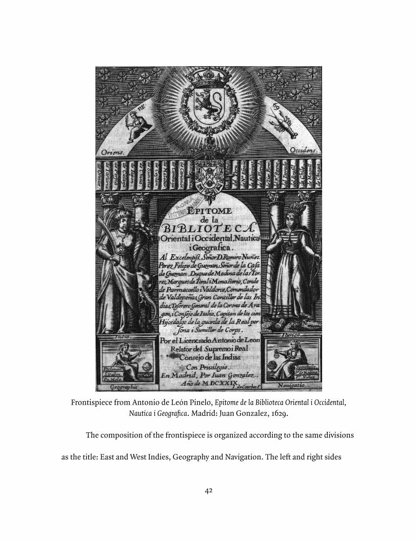
42
Frontispiece from Antonio de León Pinelo, Epitome de la Biblioteca Oriental i Occidental, Nautica i Geografica. Madrid: Juan Gonzalez, 1629.
The composition of the frontispiece is organized according to the same divisions
as the title: East and West Indies, Geography and Navigation. The left and right sides
43
collect symbols meant to represent the East and West Indies, respectively, reflected over
the vertical axis. Along the top are bound volumes with titles referencing places in the
East and West. The titles of these volumes themselves reflect both the material and
territorial aspirations of the Spanish empire—among the West Indies, for example, are
listed the Philippines and the hypothetical El Dorado. This transposition of the
Philippines from East to West when presented in combination with the mythical El
Dorado highlights the fact that the Pacific, as the next step in a westward progression
from Spain through the Americas, was the next space of possibility for the Spanish.
Below this library shelf two female figures, in stereotypical warrior dress from each
continent, are arranged in front of columns and paired with a representative animal: an
elephant for the East and a caiman for the West. In the foundation of the columns on
either side are the labels ‘India’ and ‘Ibérica’ along with vignettes representing the study
of geography and navigation.
These literal foundations on either side of the frontispiece contain the
metaphorical foundations of its message. The left side, the East, rests on the vignette
representing geography. In this illustration, a figure reclines on volumes by the ancient
geographers Ptolemy, Strabo, and Pomponius Mela and holds a square towards a globe.
On the right, Pinelo claims the West Indies including the Pacific bounded to the west by
the Philippines for Spain and Portugal in labeling the column ‘Ibérica’. In its foundation,
44
is a mirror image of the geographical scene on the left. In this case, it represents
navigation, with a figure reclining on three volumes while holding an astrolabe against
an armillary sphere. In this case, the authors represent modern advancements in
astronomy, particularly as it was applied to navigation in the Iberian world: Sacrobosco,
whose late medieval update of Ptolemaic cosmology was widely influential in early
modern Europe, and the navigational theorists and cosmographers Pedro de Medina and
Pedro Nunes.
Antonio de León Pinelo’s synthesis of navigational and geographical literature
may not have privileged Portuguese over Spanish achievements in navigation, but
modern historians (writing in English) have generally dismissed the innovative or
creative aspects of Spanish maritime exploits.¹³ On one hand, the uniqueness of the
Portuguese maritime orientation and prowess has been overdetermined, while the
¹³ Nicolas Wey-Gómez’s recent Tropics of Empire is a notable example of English-language historiography beginning to take Age of Discovery Spanish maritime science seriously. Historians writing in Spanish, on the other hand, have a long history of covering the institutions and practices I discuss in this dissertation, including early institutional histories such as José Pulido Rubio’s El piloto mayor de la Casa de la Contratación, a renewed interest in celebrating Spanish cartographical and nautical history promoted around the quincentennial of the Columbian voyages such as Amancio Landín Carrasco’s Descubrimientos espanoles en el Mar del Sur, Luisa Martín Merás’s Cartografía marítima hispana, and Mariano Cuesta Domingo’s Normativa para descubrimientos y ordenanzas del Bosque de Segovia, and more recently more critical studies such as Consuelo Varela’s La caída de Cristóbal Colón. Nicolás Wey-Gómez, The Tropics of Empire: Why Columbus Sailed South to the Indies (Cambridge, MA: The MIT Press, 2008); José Pulido Rubio, El piloto maor de la Casa de la Contratación de Sevilla: Pilotos mayores, catedráticos de cosmografia y cosmógrafos (Sevilla: Escuela de Estudios Hispano-Americanos, 1950); Amancio Landín Carrasco, ed., Descubrimientos españoles en el Mar del Sur, 3 vols (Madrid: Editorial Naval, 1992); Martín Merás, Cartografía marítima hispana; Mariano Cuesta Domingo, Normativa para descubrimientos y ordenanzas del bosque de Segovia (Madrid: Gráficas Lormo, 1994); Consuelo Varela, La caída de Cristóbal Colón : el juicio de Bobadilla (Madrid : Marcial Pons Historia, 2006).
45
Spanish have been studied primarily as a terrestrial empire in the Americas.¹⁴ Typical
presentations of the Spanish maritime enterprise focus on its reliance on non-Spanish,
particularly Portuguese, sailors in its early phases and its suffering at the hands of a
technologically superior English power in later periods. These characterizations roughly
bound the sixteenth century without commenting on Spanish successes during that
century. I hope instead to identify a maritime Spain in the sixteenth century itself,
connecting these two chronological bookends.
The inclination to highlight the deficiencies of Spanish seafaring rises from a
different set of historiographical predispositions: the traditional dismissal of the
Spanish empire as an obscurantist, anti-intellectual environment. This stereotype of
Spanish backwardness has been well debunked by recent historians of science in the
Iberian empires. While this study of the maritime enterprise in sixteenth-century Spain
provides one more avenue along which to locate an active culture of scientific inquiry
and technical innovation in the Spanish empire, its primary goal is to move beyond this
¹⁴ Jerry Brotton has critiqued exceptional treatments of the Portuguese empire, arguing that instead they should be understood within the mainstream of Renaissance-era European intellectual trends, and Charles Verlinden has demonstrated the prevalence of non-Portuguese Europeans on Portuguese sailing vessels of the period. Similarly, the popularly-held romance of Henry the Navigator’s academy at Sagres has been at least complicated, and perhaps debunked, by several recent scholars, including Peter Russell. Jerry Brotton, Trading Territories: Mapping the Early Modern World (1997; London: Reaktion Books, 2004), 48; Charles Verlinden, “European Participation in the Portuguese Discovery Era”, in Portugal, The Pathfinder: Journeys from the Medieval toward the Modern World, 1300-ca.1600, ed. George D. Winius (Madison, WI: The Hispanic Seminary of Medieval Studies, 1995); Peter Russell, Prince Henry “the Navigator”: a life (New Haven, CT: Yale University Press, 2000).
46
critique to develop new ideas that take their departure from this new consensus. Re-
evaluating the maritime orientation of the Spanish empire in the sixteenth century and
its consequences is one of many such opportunities.
Patricia Seed’s Ceremonies of Possession provides a good example of the
historiographical assumptions regarding a terrestrial and intellectually backward Spain.
Seed’s central conceit is to define different modes of possession-taking among the
English, French, Spanish, Portuguese, and Dutch empires.¹⁵ Succeeding historians have
challenged Seed’s strict compartmentalization of these imperial identities, but it is
precisely the work’s generalizations regarding a broad swathe of major early modern
European empires that make it useful for interrogating imperial stereotypes
conventionally held among English-language historians. Seed was not writing a
maritime history, but given that the focus of her study was specifically those moments
during which Europeans performed their claims of possession of non-European places,
she necessarily devotes significant attention to those shoreline moments when sailors
arrived in new places. For Seed, the Portuguese were the seafaring measurers who made
their claims to places through astronomical observation and geographical
measurement. It is not this characterization that is inaccurate as much as it is Seed’s
¹⁵ Patricia Seed, Ceremonies of Possession, 3.
47
assertion that the Portuguese were unique in this regard.¹⁶ Seed bases her chapter on the
Spanish, on the other hand, on the reading of the requerimiento, the legalistic and
medieval characteristics of which she chooses to make her focus. Similarly, the problem
here is not that the requerimiento played no role in Spanish conceptions of possession-
taking, but the distortion inherent in reducing the Spanish approach to possession to a
single legal ritual. It both reinforces received stereotypes of a moribund Spanish
intellectual culture that lagged behind the rest of Renaissance Europe and excludes the
Spanish practices derived from scientific navigation that mirrored those Seed attributes
to the Portuguese.¹⁷
The organizational structure of the book itself also lends itself to this critique,
following chapter-by-chapter from the English to the French, the Spanish, the
Portuguese, and finally to the Dutch. The relationship Seed establishes by placing the
Dutch after the Portuguese sets up a passing of the torch of maritime empire between
the two. In placing the Spanish before the Portuguese in the sequence, Seed emphasizes
the medieval antecedents of the requerimiento and juxtaposes it with the blossoming of
Renaissance, modern scientific measurement among the Portuguese. Seed’s focus, of
¹⁶ Ibid., 108-109.¹⁷ José María López Piñero, El arte de navegar en la España del Renacimiento, 2nd ed. (Barcelona: Editorial Labor, S.A., 1986), 21. José María López Piñero has demonstrated the roots of these historiographical trends in nineteenth-century nationalisms that among American and British scholars were meant to justify their contemporary ascendancy and among Spanish and Portuguese scholars to recapture past glories.
48
course, was not on maritime practices or technology; hers was a generalist study of
European empires that sought to highlight the culturally-determined variety of European
territorial possession. However, it is for this reason that Seed’s decisions serve as a
helpful indicator of the collective assumptions shared by her peers. Seed’s decision to
focus on the maritime character of the Portuguese and the Dutch while removing the
Spanish from that conversation reflects this historiographical atmosphere. As this
chapter shows, however, the Spanish in fact were, variably, direct recipients of,
contributors to, and competitors with Portuguese geodetical, astronomical, and
navigational expertise.
***
This historiographical distinction between Spanish and Portuguese maritime
exploits, in addition to being largely only a concern of English-language scholars, also
both results from and reinforces an artificial and ahistorical segmentation of an inter-
mingled, peninsular collection of traditions. First, using the word ‘Spanish’ to describe
sailors or nautical activity during this period is something of a convenient anachronism;
more specifically we are discussing the imperial ambitions of the Castilian crown and
the collection of men that sailed on its behalf.¹⁸ A very small portion of these men were
¹⁸ Spate, Spanish Lake, 13. As O.H.K. Spate has argued, the long-distance seafaring ambitions of the Spanish crown were focused in Castile rather than Aragon. Spate’s point is that this division of resources
49
themselves Castilian. Most came instead from elsewhere in the Iberian Peninsula and
the Mediterranean and near-Atlantic worlds, including Vizcaya, Galicia, Andalucía,
Genoa, the Canary Islands, Corsica, and, certainly not least, Portugal. A conventional
criticism of Spanish maritime achievements has been that so many of them were in fact
accomplished by Portuguese navigators. Among the famous navigators who will appear
in later chapters, some were Portuguese—Sebastião Rodrigues Soromenho and Pedro
Fernandes de Quirós—and some were not—Andrés de Urdaneta was Basque while
Pedro Sarmiento de Gamboa’s parents were Galician and Basque. What they share, in
fact, is that none of them is Castilian. These men continued maritime traditions that
pre-dated the unification of the Iberian peninsula under the Spanish crown and had
overlapped and combined long before the institutions promoted by the Habsburg
monarchs thrust them together.¹⁹ The story of the Spanish maritime empire of the
sixteenth century is the Spanish crown’s application of an institutional structure to the
pre-existing human and technical maritime resources of the Iberian Peninsula and, less
so, of the Habsburg possessions in general.
was primarily determined by the longtime Aragonese orientation towards the Mediterranean world and its specific seafaring practices, another way in which pre-Spanish Iberian maritime cultures manifest in sixteenth-century Spanish maritime activity.¹⁹ Brotton, Trading Territories, 104. The community of Spanish sailors was not unique in this regard. Jeremy Brotton, for example, has discussed the continuity of representation and organization over centuries in Mediterranean portolan charts in the face of widespread political and diplomatic change on land.
50
The institutional footprint of the monarchy’s maritime infrastructure followed
these pre-unification geographical boundaries. The main transshipment point from the
Indies was in Andalucía at Seville by way of its deep water port at Sanlúcar de Barrameda.
Seville was already one of the largest cities in Castile and the population and commercial
center of its region, but it was also only one of a series of ports extending south to Cádiz.
Nonetheless, goods and people arriving and working in these ports were drawn into
Seville’s orbit, and when the Casa de la Contratación was founded in 1503, it was
founded in Seville, codifying this pattern.²⁰ During the 1520s there was a short-lived
parallel Casa de la Contratación in La Coruña that was devoted to trade to the Especería.
These two locations connected to the two major traditional maritime zones of
the Iberian peninsula and took advantage of those zones as sources for manpower. In the
case of the longer-lived Casa de la Contratación at Seville, voluminous records of sailors
applying to be certified as pilots in the Carrera de Indias demonstrate the prevalence of
applicants from the Andalusian cities and towns of Ayamonte, Palos, Huelva, Seville
(particularly the neighborhood of Triana), and Cádiz; from the Canaries; and from the
²⁰ When Christopher Columbus left Spain on his first voyage, for example, he departed from Palos de la Frontera which had been a bustling port city in the fifteenth century. With the codification of Sanlúcar and Seville as the mandatory port of embarkation for the Indies, Palos’s fortunes fell and the region re-oriented around Seville as its center. The center of gravity changed again, when the Spanish navy moved its operations to Cádiz after the Guadalquivir between Sanlúcar and Seville became impassable from silting.
51
Portuguese Algarve ports of Tarifa and Faro.²¹ A similar certification program was never
established at the Casa de la Contratación for the East Indies before it was shuttered in
1529, but the personnel of the expedition led by Fray García Jofre de Loaísa—the most
important to depart during the period—were northerners, with Basques in particular
serving in key roles, aside from Jofre de Loaísa himself who was Castilian. As was typical
on Spanish expeditions of the era, however, someone in Jofre de Loaísa’s position
typically earned his commission through political access, rather than technical merit,
and had largely supervisory and quasi-military responsibilities, rather than navigational
ones. Where his Castilian origins may not have connected him to traditional seafaring
communities, they did put him in a position to capitalize on political patronage. These
regionally-determined pathways into the Spanish maritime apparatus help to explain the
lacunae in the English-language historiography of a collective ‘Spanish’ maritime activity
in the sixteenth century. The Spanish maritime enterprise became ‘Spanish’ through the
collection of regionally-distinctive parts.²²
In addition to following the organization of existing Iberian maritime
communities in laying out the institutional boundaries of its maritime bureaucracy, the
sixteenth-century Spanish monarchy competed directly with its Iberian neighbor the
²¹ AGI, CONTRATACION, leg. 52A-55B, 5780. Pilot exams from 1559-1650. ²² See Appendix 1 in this dissertation for more detail on the origins of sailors who applied for certification as pilots during this period.
52
Portuguese for the right to organize and control the world’s oceans and did so using
precisely the same tools: those of the astronomer, the cosmographer, and the navigator.
The circumstances surrounding the closure of the Casa de la Contratación at La Coruña
are perhaps the best example of the crowns’ common strategies and their sailors’ shared
techniques. When the Spanish crown relinquished its claims to the Moluccas in the 1529
Treaty of Zaragoza, it also closed the recently established trade board. The Treaty of
Tordesillas between Spain and Portugal had not addressed the other side of the globe in
normalizing the division established by Pope Alexander VI between possible Spanish
and Portuguese territories in the New World. This omission meant violent competition
between the Spanish and Portuguese when they met in the Spice Islands a few years
later. The Treaty of Zaragoza fixed the antimeridian of the Tordesillas line and was the
culmination of a years-long dispute anchored by the geodetic debates at the 1525 Junta de
Badajoz where Spanish and Portuguese cosmographers offered conflicting calculations
of longitude that placed the antimeridian to one side or the other of important
territories. Not coincidentally 1525 was also the year that the Jofre de Loaísa expedition
departed for the Moluccas from La Coruña. This combination of politically-engaged
astronomical and geodetic arguments with exploratory voyages demonstrates the
Spanish crown’s active engagement with precisely the same nautically-oriented
53
expansionist techniques that have colored historiographical stereotypes of the
Portuguese.²³
So, perhaps it is true that there is not a specifically ‘Spanish’ maritime tradition
in the early sixteenth century or a prototypical Spanish sailor; however, that is not to say
that there were not Spanish maritime institutions and Spanish maritime ambitions. The
outsized influence this apparent lack of tradition has had on the focus of English-
language historians—resulting in large part from the ahistorical reliance on ‘Spain’ as a
container for that tradition at the expense of the several roots of Iberian nautical
culture—has distorted historians’ understanding of the preoccupations and ambitions
of metropolitan and colonial administrators and scholars. There was in fact a strong
maritime orientation in the sixteenth-century Spanish empire, both among officials and
institutions of the monarchy and among independent actors seeking opportunities for
access to political patronage and personal wealth and prestige. The medieval and early
modern maritime history of the Iberian Peninsula resists these binary imperial
containers of Spanish and Portuguese. Having arrived in the sixteenth century, what was
‘Spanish’ about the maritime character of the growing empire was precisely that imperial
²³ Padrón, “Charting Empire, Charting Difference,” 48. The third chapter of this dissertation will go into more detail regarding the specifics of how sailor practice constructed Spanish understandings of space. Ricardo Padrón, in identifying the maritime traditions in Spanish cartography, has argued that these influences provided the Spanish with a “unique territorial imagination.” Whether politically determined or the result of practical exigencies, the spatial language of sixteenth-century Spanish imperial expansion was rooted in the tools of navigation.
54
institutional layer that facilitated the application of Iberian technical expertise at a global
scale. That this organization rested on foundations developed by non-Castilian Iberian
sailors in previous centuries should not distract from the real importance the Spanish
crown placed on maritime expansion and nautical expertise in the sixteenth century. To
recognize this maritime orientation in sixteenth-century Spain allows us to reevaluate
well-known documents of imperial aspirations and to find in them the signs of active
networks of marine knowledge transfer that amassed some of the earliest
understandings about the global ocean world.
***
In 1519, Martín Fernández de Enciso dedicated his Suma de geografía to the young
Charles V, newly King of Spain and Holy Roman Emperor. A landmark in geographical
and cartographical writing, receiving three editions in the first half of the sixteenth
century, the work presented the first description of the New World to appear in Spanish
print. Fernández de Enciso had recently returned from having participated in the
conquest of the Caribbean and the Darién. In addition to his personal experience with
the earliest days of the Spanish expansion in the Americas, he had the benefit of
cosmographical training. In dedicating his work to Charles, he presented himself as the
Aristotle to Charles’s Alexander the Great, a rhetorical device that invites his reader to
55
infer his didactic purpose. Even though he did not hold an official position as an
educator or steward of the king, his pedagogical pose provides insight into the priorities
of early promoters of New World empire, regardless of whether he found his stated
audience. The volume was, after all, in general publication; Fernández de Enciso’s
positioning of himself as tutor to the king was a performance for a general readership as
much as or more than it was for Charles. The result is a work that provides a helpful
overview of the epistemological framework—a combination of medieval scholasticism,
practical experience, and modern techniques of measurement and instrumentation—
that defined the worldview shared by the leaders of the early Spanish maritime
expansion.
The work begins with an introductory discussion of Sacrobosco’s Tractatus de
Sphaera, the widely-read thirteenth-century explication of geocentric cosmology. Three
centuries after its publication, it continued to be the most accessible introduction to the
state of the art of astronomical knowledge in Europe. The theoretical content outlined in
this section is abstract, consisting of a collection of mathematical arguments for the
trajectories of celestial bodies and the organization of terrestrial space. Collectively,
these rules described a unified system that explained the earth as a complete, global
system and its role within the cosmos. Its inclusion in the introduction, then, was meant
56
to provide the necessary cosmographical foundations for a young Catholic ruler who
would seek to expand globally the dominions of the Church and of Spain.
Enciso updated the medieval treatise, however, situating it within a geography of
recent Portuguese and Spanish discoveries. The equator, for example, is no longer
simply an imaginary line wrapping the globe equidistant from the poles; it is also
situated not far from São Tome. The sphere itself becomes not just a schema
demarcating abstracted zones, but the real world globe split between Spain and Portugal
along the meridian laid out by the Treaty of Tordesillas.²⁴
This particular line was not only distinguished from those that described the
Ptolemaic sphere by its presentation in terms of human geography, however; it framed
the competition between the Spanish and Portuguese empires in the first quarter of the
sixteenth century. The treaty line of 1494 had not taken global space into account,
leaving the apportionment of territory on the other side of the globe undefined. A more
cosmographically-adept monarch might have taken better advantage of the possibilities
presented by the deficiencies of the treaty. Enciso seems to suggest that a familiarity
with the theoretical organization of global space, particularly in connection to its
celestial context, would serve the young Charles in his obligation to secure the physical
boundaries of terrestrial empire. In bringing this politically-determined, historically-
²⁴ Enciso, Suma de geographia, fol. 7v.
57
contingent, and imperfect meridian into his discussion of the abstract perfection of the
Aristotelian sphere, Enciso indicates the stakes for his astronomical theorizing:
knowledge of the celestial, and the ability to leverage and manipulate that knowledge,
had real-world, political consequences.
Finally, this opening section concludes with a series of tables of astronomical
data describing phenomena such as the change in the sun’s declination over the course
of each leap year cycle and practical instructions for making astronomical observations
at sea, prefiguring the formula for the artes de navegar that scholars such as Martín Cortés
de Albacar and Pedro de Medina would produce over the remainder of the century.²⁵ The
presence of these tables in the introduction are more evidence of Enciso’s interest in
bringing the abstractions of scholastic astronomy into the practical application of
²⁵José María López Piñero reminds us that the arte de navegar (art of navigation) in the sixteenth century was understood as a combination of humanistic and applied knowledge from geography and cosmography, including a diverse array of practices including the direction of sailing vessels and the creation of navigational charts. The term came to be associated with a genre of publications in Spain and Portugal of the sixteenth and seventeenth centuries, beginning with Pedro de Medina’s Arte de Navegar written in Seville when he, as a Casa de la Contratación-licensed instrument maker, discovered the lack of shared knowledge between the communities of theoreticians and practitioners. López Piñero, El arte de navegar, 23, 69; Ursula Lamb, “The cosmographies of Pedro de Medina,” Homenaje al Profesor Rodríguez Moñino, Estudios de erudición que le ofrecen sus amigos y discípulos hispanistas Norte Americanos, (Madrid: Editorial Castalia, 1966), 4.Other authors who published works in the genre that I reference in this dissertation included Rodrigo Zamorano, Lázaro de Flores, and Luis Serrão Pimentel. Rodrigo de Zamorano, Compendio del arte de navegar, del licenciado Rodrigo Çamorano, cosmografo y piloto mayor de Su Magestad. Catedratico de cosografia en la Casa dela Contratacion de las Indias (Sevilla : En casa de Ioan de Leon, 1588); Lazaro de Flores, Arte de navegar (Madrid: Por Iulian de Paredes, impressor de Libros, en la Plaçuela del Angel, 1673); Luis Serraõ Pimentel, Arte pratica de navegar e regimento de pilotos (Lisboa: Na impressaõ de Antonio Craesbeeck de Mello Impressor de S. Alteza, 1681).
58
imperial power. The solar declination tables, for example, represent a daily sampling of
the sun’s apparent travel along the ecliptic.²⁶ Enciso had already described the ecliptic,
along with various other lines that organized the celestial sphere, more succinctly earlier
in the introduction. In the astronomical tradition, he used geometrical figures that
described the orientation of the ecliptic relative to the sphere accompanied by a
succinct, mathematical explication of the relationship that the figure illustrated.²⁷ In
other words, in very little printed space he outlined a precise and comprehensive
description of the apparent motion of the sun relative to the earth. The declination
tables, in contrast, even though they describe precisely the same phenomenon occupy
many pages of the volume and are both less comprehensive and less precise than the
abstracted figure.²⁸ In terms of astronomical utility, then, the more verbose tables would
seem to be a waste of valuable page real estate. Fernández de Enciso must have applied
some other rubric of utility to have felt it was important to include this material. The key
lies in his presumption of a mobile, human observer.
²⁶ The Earth’s axis of rotation is tilted relative to the plane of the Earth’s orbit around the Sun. As a result, the plane containing the Sun’s ecliptic intersects the plane containing the Earth’s equator at an angle. The seasons are the most immediately tangible effects of this relationship, but for the purposes of navigation, more important is that it means an observer on the earth’s surface will perceive the sun’s travel across the sky to vary relative to the Earth’s equator over the course of the year.²⁷ Enciso, Suma de geographia, fol. 7.²⁸ They are less comprehensive in that they describe a set of points—a series of instances of observation—rather than a continuous path. They are less precise in that these moments of observation result in measurements rounded to values that would fit in the space of the table and measure not the apparent motion of the sun itself, but the second-order phenomenon of the sun’s declination from the horizon at a given latitude.
59
The organization of the declination table reveals important differences between
the requirements of theoretical astronomy and pragmatic astronomical knowledge
applied to navigation. The table’s purpose was to provide an observers’s latitude through
triangulation with the trajectory of the ecliptic relative to the horizon. The tilt of the
earth’s axis makes this calculation possible by making the sun’s apparent motion across
the celestial sphere occur obliquely relative to the terrestrial frame of reference. The
sun’s elevation above the horizon when viewed at noon from a given point on the earth’s
surface will vary from day to day over the course of the year as a result. Because the
position of the horizon on the earth’s surface is dependent on the position and viewing
direction of the observer, the sun’s elevation relative to the horizon will also vary with
the latitude of the observer. Given a day of the quadrennial cycle ending with the
bissextile year on the Julian calendar and a viewing angle to sight the noontime sun
above the horizon, then, someone using the table could calculate their latitude.²⁹ In
contrast to the earlier figures describing the ecliptic, the purpose of the table was not to
calculate the position of the sun, but to calculate the position of the observer. The
abstract mathematical principles that Fernández de Enciso had laid out to begin the
introduction were not important for their own sake, but in showing the provenance of
²⁹ The bissextile year is now more commonly known as a leap year. The term derives from the particular calendar arithmetic employed to correct for calendrical drift in the creation of the Julian calendar. Enciso uses the term ‘bissextile’ and his work predates the introduction of the Gregorian calendar which changed this calculation slightly, so I have retained the term.
60
his calculations for this table that would allow observers to calculate their latitude. That
this table concludes his cosmographical introduction demonstrates that Fernández de
Enciso’s work addressed the moving observer who would apply this mathematical
knowledge to moving through the physical world, rather than to cosmographers
concerned with universal abstractions.
Following these tables, Fernández de Enciso transitions to the main body of the
work, a global geography that continues to highlight Enciso’s blend of scholastic and
artisanal traditions with contemporary innovations in service of the exploration of a
global space by sailors. Superficially, the geography adheres to the medieval genre of the
narrative itinerary, specifically one that follows coastlines as a coasting sailor would
before venturing inland at points of interest. However, as Ricardo Padrón has
demonstrated, Enciso augments this formula by fixing his descriptive mapping within a
fixed coordinate plane.³⁰ Enciso gives his descriptions a trajectory—they move in a
specific direction through space—but he also fixes them between points on either end,
typically ports, and cites specific latitude and longitude coordinate pairs for those
points. Not only does this represent a modernizing cosmography as Padrón argues, but
it reflects Enciso’s awareness of the problems of global navigation. Centuries of
navigational practice in the Mediterranean and North Atlantic had been based on dead-
³⁰ Padrón, The Spacious Word, 90.
61
reckoning and coasting in well-traveled spaces based on routes inherited through oral
tradition. Connecting these well-known, previously separate navigational basins to one
another and to previously unknown areas, however, would require placing them within a
larger context.³¹ In its combination of itinerary and plane, then, the first Spanish
geography of the New World was conceptualized within the practical worldview of the
long-distance mariner.³²
This approach gives the work a predictable rhythm. Enciso mostly follows the
coastline, pauses the progression at ports and major rivers to name and describe them,
and gives an overview of the hinterland of major regions when crossing from one to the
next. For example, he proceeds from Gibraltar to Málaga, inland from there to mention
Granada, then back to the coast for Cartagena. His description of Cartagena leads him
to introduce the coastal kingdoms of Murcia and Valencia and from there to the interior
to identify the kingdom of Aragon. From Aragon, the Ebro River brings him back to the
coast where he proceeds to Barcelona, Narbonne, Marseilles, Genoa, and on east into
³¹ Felipe Fernández-Armesto and Roger Smith have both remarked on these zones of maritime technology and navigational practice separated by the Iberian Peninsula. Felipe Fernández-Armesto, Before Columbus: Exploration and Colonization from the Mediterranean to the Atlantic, 1229-1492 (Philadelphia: University of Pennsylvania Press, 1987); Roger C. Smith, Vanguard of Empire: Ships of Exploration in the Age of Columbus (New York: Oxford University Press, 1993).³² Alison D. Sandman, “Mirroring the World: Sea Charts, Navigation, and Territorial Claims in Sixteenth-Century Spain,” in Merchants and Marvels: Commerce, Science, and Art in Early Modern Europe, ed. Paula Findlen and Pamela Smith (New York: Routledge, 2001). Alison Sandman has used the contentious development of a padrón real, a universal navigational chart, to highlight the collision between pilot and cosmographer priorities and the incompatibility between their spatial epistemologies.
62
the Mediterranean.³³ The pattern moves Enciso through the world quickly; the passage
from Gibraltar to Genoa occupies only four pages of the volume. The description is
almost exclusively chorographic with limited digression into the affairs of individual
human actors.³⁴ It is not without narrative, but it is an implicit spatial narrative that
carries the reader from place to place, rather than a relation of the exploits of other
human actors. In his extensive geography, Enciso breaks this pattern of detailed
chorography only for two parables regarding the importance of scientific and technical
knowledge to a king’s power. These anecdotes are salient for their interruption of the
work’s overall format, and in this intrusion signal their importance in Enciso’s
pedagogical mission.
The more general lesson comes from a reformulation of one of the popular
medieval allegories based on the life of Alexander the Great: in this case, his search for
the source of the Ganges River. In Enciso’s account, Alexander sends two ships up the
³³ Enciso, Suma de geographia, fol. 30v-32.³⁴ With the ‘re-discovery’ of Ptolemaic geography, Ptolemy’s taxonomy of studies of place and space also reentered use, including chorography, or the practice of local description. Richard Kagan has studied the use of chorographic descriptions of places in the Spanish Americas to strengthen the identity of colonial cities and towns as places. Lesley Cormack identifies the local specificity of chorographic description as essential to the English practice of geography in service to creating a unique sense of separate identity for an English empire. In the context of these readings, we should ask why Enciso focuses the bulk of his chorography to coastal places and particularly port cities. If chorography involves consciously creating a narrative or identity for places, then Enciso’s description of Spain as a series of coastal ports with continental hinterlands indicates his impression of Spain’s character. Richard L. Kagan, Urban Images of the Hispanic World, 1493-1793 (New Haven, CT: Yale University Press, 2000), 11-17. Cormack, Charting an Empire, 12, 164-168.
63
river with provisions for a long exploratory voyage. Eventually the ships come to a heavy
chain hung across the river from a castle on its banks. When the sailors try to breach the
barrier, an old man appears from the castle walls to confront them.
The sailors identified themselves to the man as representatives of Alexander,
king of the entire world. The man scoffs at the claim, asking how Alexander could assert
dominion over something of which he knows so little. He continues that Alexander will
continue in his ignorance because he has no intention of allowing the sailors to continue
upstream beyond the barrier. When they demanded that they be allowed to return with
something for their troubles, the man gave the sailors a ring with a human eye rendered
in stone. When they returned to Alexander with only this ring to show for their troubles,
he was suspicious of the value of their spoils. However, when he placed the ring on a
scale, he found that it outweighed all of his previously won treasures combined.
Alexander responded with anger and disbelief, but Aristotle intervened to explain that
the ring’s weight demonstrated the scale of the universe he had yet to discover and that
Alexander should accept the challenge of pushing the boundaries of what he did not
know. Instead, Alexander jealously threw it into the river to hide the evidence of his
ignorance. Rather than sinking, the ring floated back up the river, against the current,
64
with flames coming from its eye, staring back at Alexander. For Enciso, the episode
marks the end of Alexander’s eastward progress.³⁵
Although Enciso retains some of the supernatural elements of the popular
parable, he situates it explicitly in the real world and in terms of his vision of the
responsible management of empire. The episode happens on the Ganges River and
appears in the flow of Enciso’s geography in the appropriate moment in his traversal of
the globe. The fleet that encounters the strange castle with its impassable barrier had
been organized by Alexander with an explicitly exploratory purpose. Upon the
expedition’s return, Aristotle’s seizure of the moment to instruct his pupil on the
importance of scientific knowledge to imperial power marks a clear corollary to Enciso’s
ambitions for his own relationship to the young Charles.³⁶
The second of the parables that interrupt the rhythm of the work presents a more
specifically nautical lesson. Enciso lays this parable into his description of the riches
available in the East Indies, where in 1519 the boundaries of Spanish and Portuguese
³⁵ Enciso, Suma de geographia, fol. 34v-35v.³⁶ Andrés Prieto, “Alexander and the Geographer’s Eye: Allegories of Knowledge in Martín Fernández de Enciso’s Suma de geographía (1519),” Hispanic Review 78, no. 2 (Spring 2010): 169-188. Andrés Prieto has provided a close reading of Enciso’s treatment of the episode in contrast to its various manifestations in medieval romances. There was disagreement among different versions of the legend as to location—sometimes it was the Nile, sometimes the Ganges, sometimes less specific. The moral of the parable in medieval presentations focused on Alexander’s cupidity and his jealous protection of his earthly treasures rather than on the exploration and knowledge of the world introduced by Enciso. The way Prieto contrasts Enciso’s specific narrative choices from the generic conventions employed in medieval treatments of the parable makes its pedagogical purpose clear in the context of an expansionist sixteenth-century Spain clear.
65
maritime ambitions had still yet to settle. He pauses the usual litany of details to linger
over a retelling of Solomon’s search for the raw materials for his temple and the
frustration of his ambitions when the ships he sent to Tarsis and Ophir for gold and
silver were unexpectedly delayed. In Enciso’s telling, the ancient seamen ran into two
serious problems on their return: they could only sail before the wind—in other words,
their direction of travel was dependent on the direction of the winds—and they did not
know the underwater contours of the channels through which their ships could pass.³⁷
The tale carries an implicit warning to Charles that he will only achieve his mission to
build his Church and empire through seafaring prowess and nautical science. The
religious frame of the allegory is particularly significant given its East Indian location, as
it was papal law that framed the territorial disputes regarding the Spice Islands. While
the didactic passage explicitly and implicitly suggests the importance of nautical
technology generally, Solomon’s ships’ inability to find channels for safe passage, in
particular, serves as a parable about the importance of hydrography and the centrality of
practical pilotage to the promotion of expansion. Where the Alexandrian parable had
focused on the ruler’s lack of openness to gaining new knowledge, Enciso’s interest in
this case was pragmatic—to promote the application of practical expertise to the
³⁷ Enciso, Suma de geographia, fol. 45v.

66
problems of imperial expansion—an argument born of active participation in and first-
hand experience of the American conquest.³⁸
Given Enciso’s personal history, this focus on the importance of long-distance
seafaring and its requisite technical skills should not be surprising. He traveled from
Seville to Santo Domingo in the first decade of the sixteenth century and was involved in
organizing a colonizing expedition to the Darien in 1509, leading his own vessel there in
1510. Having been sent back to Spain by a mutinous Vasco Núñez de Balboa, he returned
with Pedro Arias Dávila in 1514 to depose Balboa and, upon succeeding, returned to
Spain for the final time in 1517.³⁹ Not only was Enciso a geographer, he was a geographer
who had crossed the Atlantic four times and been intimately involved with the early
Spanish exploration and conquest of the Darien and parts of Tierra Firme by sea.
Gonzalo Fernández de Oviedo y Valdés, whose natural history of the Americas was both
the first of its kind produced from first-hand observation and was cited across Europe
³⁸ That Enciso finds strategic value both at the lower level of practical wayfinding techniques and the higher level of general knowledge about the world should not be taken for granted. D. Graham Burnett’s study of nineteenth-century U.S. hydrographers, by comparison, shows that a clear interest in the strategic value of specific forms of nautical knowledge does not always accompany interest in marine knowledge generally. D. Graham Burnett, “Hydrographic Discipline among the Navigators: Charting an ‘Empire of Commerce and Science’ in the Nineteenth-Century Pacific,” in The Imperial Map: Cartography and the Mastery of Empire, ed. James R. Akerman (Chicago: The University of Chicago Press, 2009).³⁹ María del Carmen Mena García makes a case study of the organization of the fleet that would carry Pedro Arias Dávila to his governorship in Castilla del Oro that analyzes the financing, supply, and personnel of the Flota de Indias and provides important context for Enciso’s encounter with the New World. María del Carmen Mena García, Sevilla y las Flotas de Indias: La Gran Armada de Castilla del Oro (1513-1514) (Seville: Universidad de Sevilla, 1998).
67
for more than a century after its publication, shared a similar personal history. Oviedo
was also a participant in the early conquest of the Caribbean; he also traveled across the
Atlantic multiple times over the course of his career. He shared Enciso’s celebration of
hands-on experience as the most direct pathway to knowledge and the development of
technical expertise and understanding of the natural world as essential tools of imperial
expansion. These authors wrote two of the most popular published naturalist
descriptions and geographies of the spaces of possible Spanish conquest in the early
sixteenth century and promoted the maritime dimensions of those possibilities. Their
experience with and promotion of pragmatic technical expertise as a tool of empire
reflected and shaped the priorities of the early Spanish imperial expansion and show the
influence of men of the sea on that enterprise.
***
Antonio de Herrera y Tordesillas began publishing his four volume chronicle of
the sixteenth-century Spanish Empire entitled Historia general de los hechos de los Castellanos
en las islas y tierra firme del Mar Oceano in 1601. The work is essentially a long chronological
exploration of Charles V and Philip II’s application of the advice proposed by the likes of
Martín Fernández de Enciso to the project of expansionist conquest. Its preface is an
orderly catalog of “Descripciones” that outline the geographical dimensions of the Indies,
68
their institutional organization along both governmental and ecclesiastical lines, and
the men who had served in key administrative positions over the intervening century.
First among all of the descriptions, however, comes the demarcation of the West Indies
followed by an explication of the navigation from Spain to the Indies.⁴⁰ After this
introductory catalog of background details, the main body of the work appears to follow
a straightforward chronicle of conquest and expansion, organized around campaigns led
by key individuals.⁴¹
To describe the structure in this way, however, is to miss the small digressions
from narrative and inversions of the heroic cast of key characters that provide important
insight into Herrera’s understanding of what underpinned the sixteenth-century
expansion. The vast majority of the work’s short chapters describe chronologically-
linked episodes, but there are important exceptions. For example, in the middle of the
exploration of the Darién led by Vasco Núñez de Balboa appears a chapter about the
⁴⁰ Herrera, Description de las Indias Ocidentales, 1.1-2.⁴¹ Richard L. Kagan, Clio and the Crown: The Politics of History in Medieval and Early Modern Spain (Baltimore, MD: The Johns Hopkins University Press, 2009), 148, 173, 178. Richard Kagan has characterized Herrera’s history as the stereotypical “plodding” official history that compensated with a copious catalog of events for what it lacked in theological or legal theory, but argues for the intentionality of this presentation. Herrera may not have engaged much with the legal theory of dominion or other questions that occupied theorists of Spanish empire in the sixteenth century, but in his narrative those who abuse imperial power repeatedly receive their just punishment through the exercise of good governance by the Spanish crown. Herrera’s history was also a history of Spanish empire as an institution larger than any individual monarch, making the source of this mediating influence the offices of empire, not Charles V or Philip II themselves.
69
source of salinity in sea water.⁴² Similarly, a chapter on a volcano in Michoacán
interrupts the conquest led by Hernán Cortés while a chapter on the development of
navigational charts slips in after an account of Francisco Piçarro’s campaign in Perú.⁴³
The tables of contents for each Decada are punctuated by marginal labels that
identify the year in which the events of the following chapters occurred. This
presentation has the side effect of identifying these digressive natural historical chapters
as having a temporality; in other words, it suggests that the salinity of sea water is
defined in one way or another by the year 1515. It would likely be too much to suggest
that this connection was intentional on Herrera’s part, but the coincidence nonetheless
provides insight into the paths knowledge of the natural world took into published
canon in the early modern Iberian world. New interventions in natural historical
knowledge tended to happen out in the world and to be the result of the actions of men
otherwise occupied by activities not explicitly directed to the pursuit of knowledge for its
own sake. The situation of these atemporal informational chapters within a
chronological progression attributes these pieces of knowledge of the natural world to
the actors in the surrounding chronicle. These actors were not always sailors, as the
chapter on the volcano in Michoacán demonstrates, but frequently they were and,
⁴² Antonio de Herrera y Tordesillas. Historia general de los hechos de los castellanos en las islas i Tierra Firme del Mar Oceano (Madrid: En la Emplenta Real, 1601-1615), Vol. 1, Decada 2, Libro Primero, Cap. 9.⁴³ Ibid., Vol. 1, Decada 2, Libro Primero, Cap. 12.
70
whether marine and terrestrial, these digressions show the intermingling of conquest,
observation, and chronicle.
In Herrera’s telling, these actors, particularly while at sea, take center stage. His
narrative of the early transatlantic crossings in particular lingers over the details of the
hardships and humiliations experienced by men on board. These episodes were the
trials through which they earned the accomplishments attributed to them. There are
several possible trajectories along which Herrera may intend for these episodes to
augment the Spanish claims to these territories and the individual actors’ claims to
credit for their achievements. We might read them as times in the wilderness after
which, having passed God’s test, the tested were successful in their exploits.⁴⁴ Similarly,
they are dramatizations of the work expended in service of discovery and the expansion
of the boundaries of understanding. Information about the New World came through
⁴⁴ The genre of shipwreck literature popular in Portugal and Spain in the period supports this reading when applied to sailors. In these stories the the time on land after the wreck is the wilderness time, but the rhythm of the telling is the same. The influence of shipwreck and survival on sailor engagement with their environment in more practical terms will appear in Chapter 5. An eighteenth-century Portuguese publication, História trágico-marítima by Bernardo Gomes de Brito, famously collected stories of wrecked Portuguese East Indiamen in a genre-defining anthology. C.R. Boxer has published a modern translation of the stories, and Josiah Blackmore has read them as a popular expression of anti-colonial and anti-expansionist sentiment in the Iberian world. Bernardo Gomes de Brito, The Tragic History of the Sea, ed. and trans. C.R. Boxer (Minneapolis: University of Minnesota Press, 2001); Josiah Blackmore, Manifest Perdition: Shipwreck Narrative and the Disruption of Empire (Minneapolis: University of Minnesota Press, 2002).
71
the exertions of Spanish sailors, and their work gave them, and therefore their king,
some degree of ownership over those discoveries.⁴⁵
This focus on work and sacrifice in recounting the early voyages of Spanish
discovery and conquest to the Americas directly affects the way that Herrera engages
with the question of how American Indians got to the New World. Two things were clear
to him: that the Indians did not originate in the New World, but in the Old, and that they
lacked the technological capacity to have arrived by sea.⁴⁶ Their not having originated in
the New World serves to undermine their claim to the land, casting them as just one of
several peoples in competition for dominion over the continent.⁴⁷ In juxtaposing the
⁴⁵ Mary Terrall, “Heroic Narratives of Quest and Discovery,” Configurations 6, no. 2 (1998): 223-242. Mary Terrall has explored the invocation of imagery of heroic exertions in scientific discovery during the Enlightenment.⁴⁶ Herrera, Description de las Indias Ocidentales, 2.9. Herrera’s assumption that Indians simply lacked the mental sophistication to have reached the Americas through technical navigation is a corollary to the commonly held intellectual justification for Spanish dominion based on the Aristotelian theory of natural slavery. Anthony Pagden, The Fall of Natural Man: The American Indian and the Origins of Comparative Ethnology (New York: Cambridge University Press, 1982), 27-56.⁴⁷ To cast the question of rights to labor and produce of indigenous Americans in terms of capacity for rational thought and the consequent ability to develop and apply technology was not unique to Herrera, but his connection of this line of argument to the ability to reach the continent by sea rather than to develop the land is more unusual. The legal question of dominion was a complex and contentious subject in the first half of the sixteenth, involving defenses based not only on technical prowess but papal sanction and medieval Spanish legal traditions based on the experience of the Christian conquest of Al-Andalus as they were packaged in the requerimiento. Anthony Pagden has explained the progression of legal theories about the foundations of legal dominion, land use and development, and property rights in the first decades of Spanish empire in the Americas in the chapter entitled “Dispossessing the Barbarian: Rights and Property in Spanish America” in Anthony Pagden, Spanish Imperialism and the Political Imagination: Studies in European and Spanish-American Social and Political Theory 1513-1830 (New Haven, CT: Yale University Press, 1990), 13-36. D.A. Brading has also explored the issue with a more specific focus on the Lascasian debates in his chapter “The Great Debate” in D.A. Brading, The First America: The Spanish Monarchy, Creole Patriots, and the Liberal State, 1492-1867 (New York: Cambridge University Press, 1991), 79-101.
72
apparent lack of indigenous navigational prowess with stories of the difficulties Spanish
navigators were able to overcome, Herrera makes the case that Spanish mastery of
navigational science and technology justifies its terrestrial dominion in the Americas.
Herrera’s chronicle is not only a retrospective narrative of Spanish exploration in
the Atlantic and conquest of the Americas since the era of Enciso and Oviedo, but an
account of the ongoing exploratory efforts in the Pacific. Although a variety of other
pressures would cause Spain to curtail its ambitions in the Pacific by the middle of the
seventeenth century, in its first decade, Herrera still saw the American empire as only
one phase of Spanish expansion.⁴⁸ Throughout his narrative, expansion in the Pacific
receives attention equal with the consolidation of the terrestrial empire in the Americas.
Not surprisingly, for Herrera this Pacific phase would proceed on the same foundation as
the successful Atlantic phase had: nautical expertise.⁴⁹
As authors, Enciso and Herrera frame the sixteenth century Spanish imperial
enterprise: in terms of chronology, occupational connection to the bureaucracy, and
geographical perspective. Enciso published his geography in the 1510s and Herrera his
chronicle in the 1600s and 1610s. Enciso was an adventurer who participated in the early
conquest and returned to the Iberian Peninsula to write his geography as a speculative
⁴⁸ Spate, Spanish Lake, 142.⁴⁹ For example, Herrera addresses himself in great detail to the technical responsibilities of the several pilots and masters of the ships of the García Jofre de Loaísa expedition for their safe arrival in the Malucos, Herrera, Historia general de los hechos de los castellanos, Volume 2, Decada 3, 274.
73
project seeking royal patronage; Herrera wrote in his official capacity as royal chronicler.
Enciso was of the earliest generation of Spaniards to set foot in the Americas; Herrera
never did. With regard to Spanish imperial ambitions, however, they were of the same
mind—nautical science and technology were essential to success. Enciso was
prognosticating, and it is tempting to continue to develop the opposition between the
two men by characterizing Herrera’s work as one of memorialization. In some ways, it
was. Herrera was recording the legends of the great achievements of Spaniards in
exploring and conquering the Americas, but he also understood himself to be creating a
snapshot of progress at the turn of the seventeenth century of a continuing project of
expansion. Herrera’s hagiography of Spanish exploits in the Atlantic was also a call to
action for future exploits in the Pacific. These two men were by no means the only
scholars and projectors who argued the importance of maritime prowess, but their
chronological, geographical, and professional distance makes their shared prescription
for the promotion of maritime empire all the more salient.
***
It was not just the Spanish that maintained these images of Spanish maritime
power and portrayed the Atlantic as an Iberian domain; many of their European
contemporaries agreed. The Italian Paolo Giovio, in his De romanis piscibus libellus of 1528,
74
digressed from his detailed entry on the sturgeon, one of the only Atlantic fish in the
work, to praise the “admirable navigation” of the Spanish and Portuguese in the Atlantic
Ocean that was bringing the fruits of previously unknown lands and seas to Europe.⁵⁰ It
was not uncommon to associate fishes with their catchment areas and the ports that
supported their fishing. Guillaume Rondelet in his 1554 Libri de Piscibus Marinis, for
example, informed readers that the fish Romans called “ochiado” was called “oblado” by
Marseillaises, “iblada” by Niçoises, and “nigr’oil” by the Montpelliérains and repeated
this port-based naming scheme in the majority of entries in his compendium.⁵¹ When
Giovio attributed the introduction of the sturgeon to Europe to the Spanish and
Portuguese, then, he did so from a Mediterranean context in which working marine
space through fishing fixed that space within the influence of the people doing the
fishing. When Giovio cited the Spanish and Portuguese as conduits to the Atlantic
sturgeon fishing grounds, he implied that they were Spanish and Portuguese spaces.
These sixteenth century Continental ichthyologies were overwhelmingly focused
on a Mediterranean world; when the Indies fleetingly appear, they tend to do so filtered
through Iberian influence. In Pierre Belon’s 1553 La nature & diversité des poissons, he
includes the scie de mer (or saw-fish) for which, having only the reports of overseas
⁵⁰ Paolo Giovio, De Romanis Piscibus Libellus, doctus, copiosus & elegans, iam recens æditus (Antverpiæ: per Ioannem Grapheum, 1528), c3.⁵¹ Guillaume Rondelet, Libri de Piscibus Marinis, in quibus veræ Piscium effigies expressæ sunt. Quæ in tota Piscium historia contineantur, indicat Elenchus pagina non et decima, (Lugduni, Apud Matthiam Bonhomme, 1554), 126
75
merchants, he declines to include a drawing from life. Instead he provides a rendering of
a specimen of the fish’s beak brought to him from the Indies, the only part of the animal
he has seen with his own eyes. Although the French merchants gave the fish the French
name langue de serpent, Belon chose to use a French translation of the Spanish and
Portuguese: scie de mer from pez sierra and peixe-serra.⁵² The problem with regard to
specimens from the Indies for each of these Mediterranean ichthyologists was not one of
interest, but of access. When their access relied on transactions across Spanish and
Portuguese spaces or the involvement of Spanish and Portuguese actors, their
publications showed the marks of that influence.
Similarly, after his 1585 voyage to Virginia for Walter Ralegh, the Englishman
John White created an impressive series of natural historical and ethnographic
illustrations, labeling the vast majority of his marine creatures with Spanish or
Portuguese names, many without an English alternative.⁵³ Only a small set of specimens
from Roanoke Island and its environs, an area with no significant Spanish presence,
⁵² Pierre Belon, La nature & diversité des poissons, Avec leur pourtraicts, representez au plus pres deu naturel (Paris: Chez Charles Estienne, Imprimeur ordinaire du Roy, 1555), 58.⁵³ These specimens include: “Oio de buey” for the Spanish ojo de buey or ox-eye; “Rebeso” (derived from the Spanish besar for ‘to kiss’) for the remora or suckerfish; “Duratho” for the Spanish dorado or dolphinfish; “Bolador” (Spanish for ‘flier’) for the flying fish; “Caracol” (the Spanish word for snails with spiral shells) for the hermit crab, presumably conflating the shells with the animals that inhabited them; and “Alcatrassa” for the Spanish alcatraz or pelican. Kim Sloan, A New World: England’s First View of America (Chapel Hill, NC: The University of North Carolina Press, 2007), 183, 185, 189, 201, 205.
76
carried indigenous names instead.⁵⁴ As White traveled the Atlantic under the English
flag, then, he was constantly reminded of Spanish and Portuguese primacy in that space,
as the merchants with whom Belon collaborated had been, and built on the foundations
of their natural historical knowledge.
***
To speak of the ‘Atlantic Ocean’ in this way is not a straightforward proposition
with regard to the sixteenth century. Giovio used the term unambiguously, but the
geographical break in White’s animal names demonstrates an older, different idea of the
organization of the Atlantic basin.⁵⁵ In the fifteenth century, when the Portuguese
ventured south beyond Cabo Verde, they understood themselves to be entering a new
marine space that contemporary cartographers matched to the Ethiopian Sea of ancient
geography. The space they had left in doing so would have been known by a variety of
names in different European maritime traditions including the Western Ocean or the
⁵⁴ For example, White labels a flowering “Wisakon” after the Algonquian name for it. Sloan, A New World,172.⁵⁵ Fernández-Armesto, Before Columbus. Felipe Fernández-Armesto has explored the human and geographical dimensions of this pre-Atlantic ocean.
77
Northern Sea.⁵⁶ The conceptual combination of these spaces into a single unit known as
the Atlantic Ocean emerged fitfully over the course of the sixteenth century.
These constructions of oceanic space changed in large part as a reflection of the
specific requirements and input of common sailors. If the Ethiopian Sea or larger
Atlantic ocean operated as Iberian spaces, it was because of the working sailors who had
colonized them with their names for the fishes, winds, and currents, and the power of
this prerogative was not lost on metropolitan scholars. In his 1561 Reportorio de los tiempos,
Jerónimo de Chaves included a diagram of the twelve major winds, using their classical,
Mediterranean names of Septentrio, Auster, and so on.⁵⁷ However, in the same text, he
alerts the reader that sailors in the Atlantic had created a different set of names for the
winds that suited their purposes: norte, sud, and others that reflect our contemporary
directional usage.⁵⁸ Perhaps the economy of language provided by these labels as
opposed to the older Mediterranean, scholarly terms meant that they were more useful
on the deck of a ship; certainly the standardization of the new vocabulary was more
useful in expanding oceanic space than the older labels with their place-oriented
⁵⁶ Fonseca, “Prologue: The Discovery of Atlantic Space”. Bolster, The Mortal Sea, 14. Luís Adão da Fonseca and Jeffrey Bolster have explored traditional naming schemes among Iberian navigators and English fishermen, respectively.⁵⁷ I will follow up with a more complete discussion of the fixed spatial derivations of Mediterranean wind taxonomies in Chapter 3.⁵⁸ Jerónimo de Chaves, Chronographia ò Reportorio de los Tiempos el mas copioso y preciso que hasta agora ha salido a luz (Sevilla: En casa de Juan Gutierrez, impressor de libros de libros en cal de Genoua, 1561), fol. 70v-71.
78
derivations.⁵⁹ Chaves was not alone in taking note of this phenomenon. Five years earlier
in his 1556 Dos libros de cosmographia, Gerónimo Girava included the following global map
on which he has labeled the winds using the terminology that Chaves would later
attribute to Atlantic sailors.⁶⁰ By the early seventeenth century, cosmographers and
chroniclers such as Antonio de Herrera y Tordesillas relied overwhelmingly on this sailor
vocabulary.
⁵⁹ Navigators did not abandon the older labels completely and seem to have varied their usage depending on their audience and context. Pedro Sarmiento de Gamboa, for example, mostly used the newer labels in his derroteros, but still used the word “septentrión” in some circumstances, particularly when discussing cosmographical abstractions and when addressing royal authorities. An interesting case appears in his relation of the voyage to map the Strait of Magellan when he talks about making observations of the Antarctic pole in a similar fashion as they would in the northern hemisphere by saying “como se hace de la estrella norte al septentrión.” The North Star, the tool of sailor practice, is “la estrella norte,” while for contrast, the abstraction of ‘the North’ is “septentrión.” Sarmiento, Viaje al Estrecho de Magallanes, 163.⁶⁰ The tension between Girava’s wind names in the text and on his map is a prime example of a deficiency of published maps highlighted by Boies Penrose. Although they could not be distributed so widely, manuscript maps tended to carry more up-to-date information both for the greater flexibility of production and the greater security implied by their limited distribution. Published atlases, on the other hand, tended to be a mixed bag cobbled together from new information and older maps of inconsistent provenance. Penrose particularly singles out precisely this map from Girava for the “amateurishness” of the outlines it uses for the American continents. To translate this assertion from Penrose from the maps themselves to the labels of the winds, this characteristic of published maps provides additional justification to understand the terminology used in the text to be up-to-date and the terminology from the map to represent an older vocabulary. Boies Penrose, Travel and Discovery in the Renaissance, 1420-1620, (Cambridge, MA: Harvard University Press, 1952), 241-273, 256.
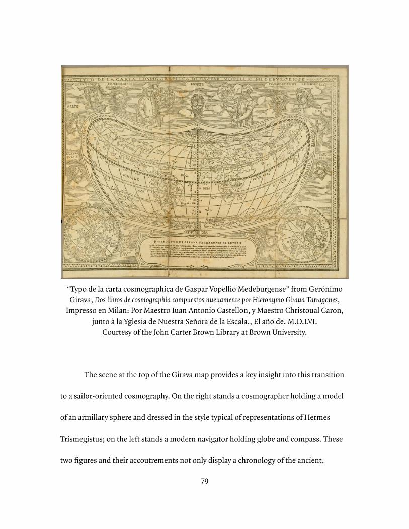
79
“Typo de la carta cosmographica de Gaspar Vopellio Medeburgense” from Gerónimo Girava, Dos libros de cosmographia compuestos nueuamente por Hieronymo Giraua Tarragones,
Impresso en Milan: Por Maestro Iuan Antonio Castellon, y Maestro Christoual Caron, junto à la Yglesia de Nuestra Señora de la Escala., El año de. M.D.LVI.
Courtesy of the John Carter Brown Library at Brown University.
The scene at the top of the Girava map provides a key insight into this transition
to a sailor-oriented cosmography. On the right stands a cosmographer holding a model
of an armillary sphere and dressed in the style typical of representations of Hermes
Trismegistus; on the left stands a modern navigator holding globe and compass. These
two figures and their accoutrements not only display a chronology of the ancient,
80
medieval, and contemporary foundations of Spanish scientific culture, but also, in their
two occupations, the fusion of theory and practice that formed sixteenth-century
Spanish cosmographical expertise. It is particularly important to note that in this case, it
is the working navigator, not the cosmographer, that is displayed as the modern figure,
reflecting the pragmatic character of Spanish interests in scientific and technological
development.
During the sixteenth century, then, ships sailing under the Portuguese and
Spanish flags established themselves across a diverse spread of the marine zones that
comprised what would come to be known as the Atlantic Ocean. Not only were Spanish
and Portuguese ships introducing their respective countrymen to these spaces, but
common names for places and animals from these areas used throughout Europe
demonstrate the diffusion of their influence. In other words, it was not only the Iberian
empires themselves who saw their future in their maritime expansion, but their
Continental peers recognized them as the European vanguard in much of what would
become the Atlantic. As to that ‘becoming,’ the integration of the Atlantic into a unified
space was done through the work of sailors; the vocabulary that defined the space in its
boundaries and directional language was a sailor vocabulary. Spanish scholars and
administrators both understood that long-distance seafarers could be their window to
an oceanic world they would never visit themselves. These intellectual and political elites
81
consistently singled out one class of sailors in particular—the pilot—as emblems of the
kind of expertise these landsmen sought. That pilots appeared so frequently as
representatives of practical maritime expertise provides insight into the values held by
contemporary intellectual and political elites. However, as I will argue in more detail in
Chapter 2, pilot priorities were frequently at odds with those who remained in
metropolitan centers. Both the nature of pilot practice and their conflict with scholars’
and administrators’ priorities shaped the pathways of sailor observations of the marine
world into natural historical consensus and its applications.
***
Considered as a group, sailors shared that they had access to marine spaces that
remained obscure to others; however, within the occupational class of mariners, there
were different degrees of engagement with and understanding of the marine world. I will
address the division of labor and authority on board in greater detail in the following
chapter, but for present purposes it is helpful to note that, even in advance of the
modernization and professionalization of the standing Spanish navy that would come
towards the end of the seventeenth century, there was at least some rough division of
responsibility on sixteenth-century Spanish vessels.⁶¹ This separation fell primarily
⁶¹ Pablo Emilio Pérez-Mallaína Bueno, Spain’s Men of the Sea: Daily Life on the Indies Fleets in the Sixteenth Century (Baltimore, MD: Johns Hopkins University Press, 1998), 35-36.
82
along two axes: social standing and navigational prowess. Ships’ masters and captains,
when present, would in most cases be the only men on board of elevated birth. Pilots,
however, transcended this social boundary on board, or at least frustrated it, by virtue of
their navigational expertise. Upon return to land, their accounts were grudgingly given
attention by official cosmographers and bureaucrats who required useful information
about marine spaces beyond their reach. While any sailor, then, traveled to areas and
witnessed phenomena that land-bound observers could not, it was the pilot whose
elevated technical understanding and position of responsibility made him so central a
figure of the shipboard community that his observations and impressions were those
sought by scholars and officials. It was through these ‘professional observers’ that
Spanish scholars saw the route to a modern cosmography and to a global empire built on
the application of maritime technological and scientific expertise.
Throughout contemporary written treatments of the Spanish Empire at sea, the
ship’s pilot holds an idealized place that exemplifies the balance of confidence at sea,
capacity for action, scientific administration, and accumulated natural knowledge upon
which the maritime culture and imperial ambitions of Spain rested. In his seminal
natural history of the Americas, Gonzalo Fernández de Oviedo, for example, credited his
access to and information about the sea, so fundamental a framing device to his work, to
83
“prudentes e sabios pilotos.”⁶² It is instructive that Oviedo chose those two adjectives—
prudent and wise—to describe the capable pilot. This construction of the competent
pilot suggests both a pragmatic orientation won through hands-on experience and
access to a body of knowledge from which to make well-informed decisions. In this
sense, the pilot in Oviedo’s construction is a synecdoche of the pragmatic empire
espoused by promoters such as Martín Fernández de Enciso, and Oviedo was not alone
among men of letters in the sixteenth-century Spanish empire in making this
connection between tradesman, cosmographical knowledge, and practical application
to expansion and conquest. The ship’s pilots became increasingly prevalent as trusted
sources, real and imagined, in chronicles, cosmographies, and natural histories in the
intellectual projects of the Spanish sixteenth century.
The utility of the pilot as an emblem of the aspirations of promoters of Spanish
imperial expansion lay in their combination of three traits. They had access to a body of
traditional craft knowledge as inheritors of the secrets of astronomical navigation. They
were by trade and by administrative decree continual observers and recorders of their
environment. Finally, they were mobile agents who applied an analytical perspective and
craft secrets in pushing the boundaries of known space, a literal vanguard of empire.⁶³
⁶² Gonzalo Fernández de Oviedo, Historia general y natural de las Indias, Biblioteca de autores españoles desde la formación del lenguaje hasta nuestros días (Madrid: Ediciones Atlas, 1959), 29.⁶³ Smith, Vanguard of Empire.
84
These roles, of course, were not so neatly packaged in practice; pilots’ appearances in
texts tended to include two or more of the above themes.
***
Pilots’ association with secret maritime knowledge did not only give them an
useful connection to traditions that predated the unified Spanish crown, but also had
important resonance with contemporary ideas regarding the process of discovery and
the revelation of scientific truths. The typical mode of the pilot was as a possessor of
secret knowledge: unveiling hidden obstacles along coastlines, inferring direction and
position by reading the stars, intuiting future weather conditions from environmental
cues.⁶⁴ Pilots also shared the privilege with all sailors of having the potential to travel to
places that people who would never go to sea necessarily could not, although the pilot
had the special distinction of being trusted to be able to return to those places and to
reveal them to others.
One of the most-repeated founding legends of the Spanish maritime empire
places the secret knowledge of pilots at the root of Christopher Columbus’s epoch-
making first voyage to the Americas. It has been one of the most persistent myths
surrounding the Columbian voyages that Columbus had advance knowledge of
⁶⁴ E.G.R. Taylor, The Haven-Finding Art: A History of Navigation from Odysseus to Captain Cook (New York: Abelard-Shuman Limited, 1957).
85
unexplored lands out on the Ocean Sea from a shipwreck survivor. Modern scholars have
demonstrated the unlikelihood that any such exchange of information took place;
however, the legend was a common one in the sixteenth century, and tellingly the
informant was cast not just as a sailor, but as a pilot. Gonzalo Fernández de Oviedo, for
example, acknowledged the legend, but allowed that the origins, and even the existence,
of the sailor were uncertain—was he Andalusian? Basque? Portuguese?—and that the
rumor, even if true, might not be creditable at face value.⁶⁵ The island reported could
easily have been Madeira or even Cabo Verde. Oviedo’s skepticism likely results from two
sources: his chronological proximity to the Columbian voyages meant that the rumor
had had little time to crystallize into a simple legend and his professional proximity to
them meant his self-interest would be served if the discovery of the Americas were the
result of applied science and technology rather than happenstance. By the early
seventeenth century, however, the pure legend had emerged, unencumbered by the
complexities presented with contemporary familiarity with professional circumstances
and rumor. When the cosmographer and publisher Enrico Martínez published his
Reportorio de los tiempos, y historia natural desta nueva españa in 1606, he reported
unambiguously that a sailor had informed Columbus of the lands to the west and that he
was a Spanish pilot, not allowing for the the possibility that the tale was apocryphal or
⁶⁵ Oviedo, Historia general y natural de las Indias, 16.
86
that, if the sailor existed, the lands he spoke of were simply previously known islands he
had been too disoriented to identify.⁶⁶
The pilot’s possession of secret knowledge appealed to sixteenth-century
scholars. For one, this expertise highlighted the crown of Castile’s succession to the
several ancestral maritime traditions of the Iberian Peninsula. The peninsula bridged the
two major maritime technology zones of medieval Europe, the North Sea and the
Mediterranean, but it also included diverse cultural communities of practice that meant
the human as well of the technological elements of this tradition were important. Castile
itself had a limited maritime past, but the commercial histories of the Basques and
Galicians of the north and Andalusians of the south had been as seagoing traders and
fishermen for hundreds of years. These communities spanned modern political borders.
The period of unification of the crowns of Spain and Portugal actually only made official
an informal relationship among seafarers that had existed for centuries in which the
maritime orientation of Huelva and Tarifa, for example, were more linked to one another
than Huelva would have been to A Coruña or Tarifa to Porto.⁶⁷ The Castilian crown of
⁶⁶ Enrico Martinez, Reportorio de los tiempos, y historia natural desta nueva españa (Mexico: En la Emprenta del mesmo autor año de 1606), 130-131.⁶⁷ Henry Kamen and C.H. Haring have both discussed the pre-Spanish boundaries of Iberian maritime communities from which the Castilians would draw a synthetic expertise (and Kamen in particular reminds us of the late medieval Muslim expertise in navigation that informed Andalusian sailors even after their expulsion). Clarence Henry Haring, Trade and Navigation between Spain and the Indies in the Time of the Hapsburgs (Cambridge, MA: Harvard University Press, 1918), 15. Kamen, Empire, 23.
87
the sixteenth century presided over an only recently, and in many ways partially, unified
peninsula. In terms of its maritime history, the pilot was a useful emblem for a
connection to the pasts of the non-Castilian corners of the peninsula, newly united.
Their craft expertise followed them as a class of people, accruing to the Crown’s credit
without the need to invest in its development.
Secret knowledge also had powerful connotations for sixteenth-century scientific
practitioners. The practical knowledge of craft communities, frequently distributed in
books of secrets and recipes, provided raw material for more elite scientific practitioners
to incorporate into their own work. In packaging the material into a curated collection
and, typically, presenting the information in the form of step-by-step recipes that would
instruct the reader through a procedural experience, the craftsman author of these works
also had a great degree of control over the reader’s reception of the information.⁶⁸
Process and the tangible experience of work were precisely those aspects of craft, of
course, that interested scholars with a growing sense of the importance of empirical
data. In alchemical experimentation, for example, the truth comes from breaking down,
stripping away, burning, and otherwise transforming material to reveal its true essence.
Ralph Bauer has argued for the usefulness of applying alchemical interpretations to
⁶⁸ William Eamon, Science and the Secrets of Nature: Books of Secrets in Medieval and Early Modern Culture (Princeton, NJ: Princeton University Press, 1994), 8-9. William Eamon has argued that these books “ were not merely passive vehicles for the transmission of ‘raw data’ to natural philosophers, but were bearers of attitudes and values that proved instrumental in shaping scientific culture.”
88
European understanding of exploration.⁶⁹ Voyages of discovery and experiences in the
wilderness of the New World from this perspective reveal new truths in opening and
unveiling new spaces similar to the way an alchemist broke apart materials to find their
essence. In writing about Columbus’s first voyage and his crews struggles in crossing the
Sargasso Sea, Antonio de Herrera y Tordesillas dramatizes this mode of knowledge
creation.
The Sargasso Sea is the colloquial name for the area within the North Atlantic
Gyre, a system of four currents—the Gulfstream, the North Atlantic Current, the Canary
Current, and the North Atlantic Equatorial Current—that pulls seaweed and other
detritus into a large mass in the center of the North Atlantic. The seaweed can be quite
thick to the point of obscuring the movements of the waters beneath as well as hiding
larger pieces of flotsam that might damage a ship’s hull if struck at an unlucky angle. In
other words it presented both a visual and a physical impediment to crossing the
Atlantic. Conventional narratives of European maritime feats during the Age of
Discovery credit Columbus with being the first to cross the area successfully.
⁶⁹ Bauer’s work will appear in The Alchemy of Conquest: Religion, Science, and the Secrets of the New World, (in progress), and was presented in the lecture “A New World of Secrets: the esoteric hermeneutics of discovery in the early modern Atlantic world.” The John Carter Brown Library, Providence, RI, 27 October 2010. Similarly, Walter Woodward has made the case for understanding John Winthrop’s Massachusetts Bay colony as an alchemical project. Walter W. Woodward, Prospero’s America: John Winthrop , Jr., Alchemy, and the Creation of New England Culture, 1606-1676, Omohundro Institute of Early American History and Culture (Chapel Hill: The University of North Carolina Press, 2010).
89
In recounting the first voyage by Columbus, Herrera revels in the details of the
fleet’s struggles in crossing the Sargasso Sea and the unusual sights they witnessed
there.⁷⁰ The story becomes one of the application of technology in the form of the
Spaniards’ ships against the obstinate resistance of nature, facilitated and supported by
the extreme exertions and forbearance of the sailors on board. In Herrera’s telling, the
Sargasso Sea becomes emblematic of all of the obstacles encountered in developing the
transatlantic crossing, and when the sailors finally part the wall of vegetation obscuring
the object of their efforts, they unveil the New World. This relationship between the
sailors, the obfuscatory seaweed, and the eventual revelation of the New World
recapitulates the alchemical approach to knowledge creation through stripping away and
breaking down materials to reveal their true inner nature. This literary conceit connects
the sixteenth century intellectual regard for pilots to their role as sources of secret
material and practical wisdom.
Pilot practice, particularly hydrographical observation, shares common features
with the approach to knowledge creation associated by sixteenth century scholars with
alchemical investigation. Pilots ‘saw’ the contours and composition of the ocean floor
past the obfuscation of the water’s surface. They did so by pulling samples of the mud
and sand at the bottom from the water into the air and reading them. Not only were they
⁷⁰ Herrera, Description de las Indias Ocidentales, 2.35-36.
90
tradesmen who relied on the oral transmission of secret, craft knowledge among
members of their class, but at least some aspects of their craft were also reminiscent of
the mechanics of alchemical investigation that were so closely associated with access to
secret knowledge in the sixteenth century. The metaphorical alchemy of pilot practice
provides a helpful point of entry into understanding the interaction between the self-
mythologizing character of Spanish maritime ambitions and the practical orientation of
the Spanish maritime enterprise.
***
There is a phrase that appears throughout pilot-created and pilot-related
materials that encapsulates the pilot’s position at this crux between maritime myth-
making and pragmatic expedience. Whether recounting the traversal of a potentially
dangerous and unknown waterway or warning future navigators who would do the same,
pilots frequently described the need to proceed “con la sonda en la mano”. The phrase
appears sufficiently frequently in derroteros and other descriptions of voyages that we
can consider it a term of art for a careful approach to shallow waters. The phrase literally
describes the pilot practice of hydrography, and its conflation with situations of
impending danger makes clear the sixteenth-century sailor’s identification of safe
conduct of a vessel with the pilot’s practice. It is this figure, the pilot with sounding line
91
in hand, actively sampling the seafloor and keeping an eye out for dangers obscured
from view to inexpert observers, that is emblematic of the centrality of the pilot both to
Spanish myth-making about their maritime history and connection to secret marine
knowledge, but also to their practical role in the Spanish maritime enterprise.
If the primary purpose of a long-range sailing vessel is simply to move from one
place to another, during the discovery period its clear second order purpose was to
investigate unknown space and, consequently, to serve as a vector of Spanish control and
territorial possession. The ship, then, needed to be a center of recording and mapping if
it was to serve this purpose well. Since pilots were already constantly observing and
measuring as part of their own primary occupation of finding safe passage, they were
perfect candidates for the secondary task of recording and compiling those observations
for collation and archiving in Seville. The office of the Piloto Mayor’s instructions to
pilots to record the visual markers of their routes along with important bathymetric data
demonstrates an institutional acknowledgment of this purpose for sailing vessels. The
repeated exhortations over the course of the sixteenth century represent both refined
specifications for what categories of information were useful, but also a frustration that
pilots did not always participate in the mandated reporting in a way that satisfied
92
administrators.⁷¹ The persistence of the pilot as a literary symbol of investigation
throughout the period, though, suggests that this frustration was more about the
transmission of information to its institutional repositories in predictable and
standardized fashion, rather than the disciplining of pilots to make the observations in
the first place. The following chapter will explore the relationship between the sailors as
observers and the administrators in Seville as keepers of records and enforcers of
practice more thoroughly, but regardless of any difficulties in communication and
collaboration it is clear both that this kind of practical exploratory work was part of
sailors’ quotidian responsibilities and that metropolitan administrators recognized its
importance.
This concept of proceeding “con la sonda en la mano” also became a recurring
motif in sixteenth-century Spanish chronicles and natural histories, casting the pilot as
an emblem of investigatory empire. In its use outside of navigational texts, it serves to
describe the idealized posture of the pilot—the hyper-vigilant, deliberate, and
comprehensive hydrographical observer navigating the dangers of unknown waters. For
scholars as widely dispersed across the long sixteenth century as Oviedo and Herrera y
Tordesillas, the frequent invocation of this image clearly demonstrates the scholarly
⁷¹ Luis Navarro García, “La Gente de Mar en Sevilla en el Siglo XVI,” Revista de Historia de América 67/68 (January-December 1969): 4. Luis Navarro García has a succinct summary of the periodic, increasingly stringent, and sometimes redundant regulations on pilot practice and certification at the Casa de la Contratación.
93
conception of a pilot as an active and careful judge of his surroundings.⁷² As such a
judge, he not only serves his designated purpose of safely guiding ships across the ocean
and recording the contours of his environment, but he becomes a source of important
information about the marine environment. Just as the pilot’s association with secret
knowledge connected him both to the self-mythologizing efforts of a newly organized
maritime empire and to the practical quotidian requirements of its administration, his
identification as a vigilant observer and recorder of information about marine and
littoral spaces made him important to both official and unofficial compilers of scientific
knowledge in the Spanish empire.
***
While the Spanish monarchy promoted increasingly sophisticated mechanisms
for collecting information about the natural world over the course of the sixteenth
century, independent (and quasi-independent) scholars in Spain and the Spanish
Americas created large, influential natural histories, herbals, and other studies of the
natural world. As a result of the European exposure to the East and West Indies, the
sixteenth century was a time of significant increase in this category of publications, and
they had broad influence on European intellectual culture beyond the Iberian
⁷² Herrera, Description de las Indias Ocidentales, 2.16. Antonio de Herrera y Tordesillas invokes this image in connection with Vicente Yañez Pinzón, for example.
94
Peninsula.⁷³ The sailors on Spanish vessels were not only instrumental informants in the
official imperial administration; they were invaluable collaborators for these
independent scholars as well.
Natural historians of the sixteenth century, as a rule, were terrestrial creatures.⁷⁴
Their social position meant necessity would not force them to sea, and few destinations
available to them required long-distance ocean travel.⁷⁵ However, it was at this time, that
the foundations of natural history began to shift from the exegesis of classical
⁷³ The concept of ‘independent’ intellectual endeavor requires elaboration in the context of the sixteenth-century Spanish monarchy. Networks of patronage, norms regarding official secrecy, and administrative overlap between governmental, university, and religious institutions meant that no elite scholar would have reached a position from which to publish a scholarly volume having pursued a career entirely outside of institutional or personal influence from the monarchy and its representatives. The sense in which I use the term here is simply to describe scholars who published works while not actively employed by the monarchy in scholarly positions such as the Royal Cosmographer. Despite the fact that much information about the Indies was shared internally within the institutions of the monarchy in manuscript form, there were important scholars producing works of natural history that were published. Many of these works were translated into other European languages and had an enormous impact on the intellectual culture of early modern Europe. Richard Kagan’s exploration of Gonzalo Fernández de Oviedo’s efforts to secure patronage, for example, demonstrates the complexity these influences: Oviedo’s desire was to win a post as a royal chronicler and he submitted his Sumario of his natural history by way of application; Charles V refused him the position, but provided him with a small stipend to support the production of the remainder of his Historia general. Kagan, Clio and the Crown, 69-71.⁷⁴ Helen M. Rozwadowksi, “Small World: Forging a Scientific Maritime Culture for Oceanography,” Isis 87, no. 3 (September 1996): 411-12. Helen Rozwadowski has shown that this alienation of scientists from shipboard life was still a defining factor of ocean science as late as the middle of the nineteenth century.⁷⁵ Pérez-Mallaína Bueno, Spain’s Men of the Sea, 33-34. Though it is not his primary interest, Pablo Emilio Pérez-Mallaína has described the marginal social position of sixteenth-century Spanish sailors and the risks of going to sea. Other works devoted to the marginal social world of people who went to sea include: Peter Linebaugh and Marcus Rediker, The Many-Headed Hydra: Sailors, Slaves, Commoners, and the Hidden History of the Revolutionary Atlantic (Boston: Beacon Press, 2000); Paul A. Gilje. Liberty on the Waterfront: American Maritime Culture in the Age of Revolution (Philadelphia: University of Pennsylvania Press, 2007); Barry R. Burg, Sodomy and the Pirate Tradition: English Sea Rovers in the Seventeenth-Century Caribbean, 2nd ed (New York: NYU Press, 1995).
95
authorities towards direct observation.⁷⁶ This empirical turn shaped the practice of
marine natural history in the sixteenth century, emphasizing those areas of knowledge
for which natural historians could find specimens to observe or informants to observe
for them. With fishermen and fishmongers their most readily available assistants,
sixteenth century European marine natural historians almost exclusively turned to
ichthyology, as opposed to bathymetric studies of ocean floor composition, tracing tidal
cycles, or analysis of the ocean’s salinity.⁷⁷ This collaborative relationship between
naturalists and marine workers is exemplified in Paolo Giovio’s aforementioned 1528
treatise on Roman fish, perhaps the earliest example of this new focus, which relied
exclusively on the fishmongers at the Roman market for information about deep-sea
species.
Guillaume’s Rondelet’s 1554 compendium of marine fishes takes a more
systematic approach, but is no less reliant on testimony from non-learned sources.
Generally, he based his taxonomy on classical materials, but this foundation posed
problems when those sources disagreed with one another. In the case of the species
⁷⁶ Brian W. Ogilvie, The Science of Describing: Natural History in Renaissance Europe (Chicago: The University of Chicago Press, 2006); Antonio Barrera-Osorio, Experiencing Nature: The Spanish American Empire and the Early Scientific Revolution (Austin: University of Texas Press, 2006); David Freedberg, The Eye of the Lynx : Galileo, His Friends, and the Beginnings of Modern Natural History (Chicago: The University of Chicago Press, 2002).⁷⁷ Margaret Deacon, Scientists and the Sea, 1650-1900: A Study of Marine Science (New York: Academic Press, 1971), 69-88. Quantitative rather than qualitative empirical studies of the sea began to appear in the seventeenth century and later, when for example Robert Boyle would submit results of his experiments with the salinity of sea water or Luigi Marsili published his systematic measurements of tidal levels.
96
Erythrinus, Rondelet found that Aristotle classified it as a deep-sea fish while Oppian
claimed it lived near shore—a conflict between competing classical authors that he
could not personally resolve empirically.⁷⁸ Instead, he interviewed fishermen and
learned that the fish lived in the open sea and was only found close to shore in unusual
circumstances, a resolution which he took to be conclusive. For Rondelet, in fact,
consultation with fishermen and fishmongers was not the exception, but the rule, as his
aforementioned inclusion of local names from regions and individual ports throughout
the western Mediterranean attests.
Atlantic fishes appear in each of these compendia, but only those fish wrapped
up in the world trade of marine commodities, such as the cod, are described in any
detail. Giovio provides a useful example in this case; by far the most extensive chapter in
his work addresses the cod, the origins of which he ascribes to Iberian fishing efforts.
Earlier in this chapter, the discussion of the entry for the scie de mer in Belon’s
ichthyology mentioned his merchant informants, another example of the commercial
context of much information about sea life. Both of these cases show the problems
posed by access for metropolitan scholars, and the Iberian inflections of their
treatments remind us of the importance of Spanish and Portuguese sailors in providing
this access.
⁷⁸ Rondelet, Libri de Piscibus Marinis, 144.
97
In combination, these characteristics of the sixteenth-century European
ichthyologies demonstrate the importance of Spanish sailors for the distribution of
information about the marine world for purposes beyond practical exploitation by the
Spanish monarchy. Compared with their peers in the rest of Europe, sixteenth-century
Iberian naturalists had at least two advantages when it came to marine observation of
this newly-opened ocean: they had greater opportunities to make the voyage to the New
World themselves and access to sailors with continually expanding knowledge of that
world. By virtue of their early presence in many of these marine spaces and the efforts of
the Spanish monarchy to create an organized infrastructure for collecting information
about the natural world, the Spanish naturalists defined in large degree the transmission
of material into the Western European natural historical discourse about the Indies.⁷⁹
The naturalist José de Acosta was born in Spain, but traveled as a Jesuit
missionary to Peru where he spent more than fifteen years and produced one of the most
widely-read early descriptions of the New World in his Historia natural y moral de las Indias.
That voyage gave him the opportunity to observe directly the marine space that formed
the experience of the men who would serve as his informants. Seeing flying fish for the
⁷⁹ The transmission and dispersion of natural knowledge is neither a simple nor an automatic process. Marcy Norton has explored the slow, complicated transmission of chocolate and tobacco from the New World throughout the European continent through the Iberian Peninsula, highlighting the cultural factors that might impede the spread of interest in one New World organic commodity relative to another. Marcy Norton, Sacred Gifts, Profane Pleasures: A History of Tobacco and Chocolate in the Atlantic World (Ithaca, NY: Cornell University Press, 2008).
98
first time, he described their flight, identified their predators, and described their
physical appearance in some limited detail.⁸⁰ However, he was not yet sufficiently well-
acquainted with marine animals to know that this particular fish was not exclusive to the
Indies. Though the voyage gave Acosta an idea of what the open-sea environment was
like, he still required more adept seafarers to filter the natural marine world for him.
When he took note of the same practice of wind-naming among sailors noted by
Gerónimo Girava, he could not square his landed experience of winds as fixed rather
than relative phenomena without questioning the sailors on board.⁸¹ Similarly, Acosta
relies on the word of sailors that birds may often be sighted hundreds of leagues away
from land to confirm his own assumptions he has taken from Pliny and Aristotle.⁸²
Other Spanish natural historians and geographers also benefitted from the head
start available to them relative to their European peers when it came to long-range
oceanic travel, as they frequently participated in the Spanish enterprise as
missionaries—as with Acosta—or as conquerors—as with Gonzalo Fernández de
Oviedo and Martín Fernández de Enciso—in addition to their scholarly pursuits.
Experience is cumulative, of course, and even Iberian scholars who had been to sea were
not the seasoned hands that sailors were. Acosta’s discussion of seasickness may give
⁸⁰ Acosta, Natural and Moral History of the Indies, 133-134.⁸¹ Ibid., 111-112.⁸² Ibid., 234.
99
the best demonstration of his literal and figurative discomfort at sea. Acosta himself
experienced a strong seasickness on his voyage to the Americas and attributed it his
inexperience. However, he hypothesized that the unpleasantness was due to the effects
of sea breezes on people unaccustomed to them, rather than to the motion of the
vessel.⁸³ Seasickness was a common complaint among landsmen.⁸⁴ A century later, in
fact, English naturalist Hans Sloane would open his natural history with a detailed
narrative of his experience with seasickness on his transatlantic voyage, including an
explicit reference to Acosta, although Sloane dismissed Acosta’s explanation.⁸⁵
This disagreement between Acosta and Sloane demonstrates both the primacy of
Iberian accounts of the New World and the centrality of experience when defining the
natural world. A century of long-distance ocean travel had provided a better explanation
for the discomfort new ocean travelers felt, but Acosta’s account was still the explanation
of record. Given their chronological privilege, Spaniards like Acosta tended to be the
first to explain many things about both the New World and the newly open Ocean Sea
⁸³ Ibid., 118-119.⁸⁴ Carla Rahn Phillips has translated the satirical letter Eugenio de Salazar, a metropolitan jurist who sailed to Hispaniola to take up a post in Santo Domingo, wrote to a friend at home. The letter provides a humorous account of the trials a land lubber would experience at sea in the late sixteenth century including rather horrific descriptions of the seasickness that claimed everyone on board who was not a sailor. Carla Rahn Phillips, Life at Sea in the Sixteenth Century: The Landlubber’s Lament of Eugenio de Salazar, The James Ford Bell Lectures, no. 24 (Minneapolis: Associates of the James Ford Bell Library, University of Minnesota, 1987), 6.⁸⁵ Hans Sloane, A Voyage to the Islands Madera, Barbados, Nieves, S. Christophers and Jamaica, with the Natural History of the Herbs and Trees, Four-footed Beasts, Fishes, Birds, Insects, Reptiles, &c. of the last of those Islands, (London, 1707), 1-3.
100
that connected it to the Old. Sailors, whether navigators, captains, or common seamen,
knew this expanding marine environment through experience and provided essential
access to marine knowledge for land-bound scholars, Crown administrators, and
promoters of Spanish empire.
***
In this chapter I have set out to demonstrate the ahistorical limits that neglecting
Spanish maritime ambitions and activities have imposed on our understanding of both
the spatial imagination of agents and promoters of the Spanish empire and of the
important role of sailors in providing information to land-bound scholars and
administrators about this expanding ocean world. We must remember that in the
sixteenth and seventeenth centuries, Portuguese and Spanish scientific knowledge and
practice were closely linked and their maritime traditions intermingled. The Spanish
institutionalization of both, the Casa de la Contratación, was founded on Portuguese
models.⁸⁶ It was the thorough institutionalization of maritime expansion and empirical
investigation that was the Spanish monarchy’s transformative contribution. To forget the
pervasiveness of the maritime orientation of Spanish expansionist and technological
concerns in the sixteenth century is not only to focus ahistorically on the growing
⁸⁶ Edward Collins, “Francisco Faleiro and Scientific Methodology at the Casa de la Contratación in the Sixteenth Century,” Imago Mundi: The International Journal for the History of Cartography 65, no. 1 (2013): 25-36.
101
terrestrial empire in the Americas, but to lose the contributions of a large class of
working sailors and of the non-European people with whom they communicated to
European knowledge of the natural world.
In particular, the ship’s pilot proved emblematic of the ideal mariner-observer,
and though men in that role were certainly not the only sailors to shape the transmission
of marine knowledge, the several practical requirements of the job of navigation and
wayfinding in the era—observation and recording of environmental indicators,
sounding the ocean floor, identifying wind and weather systems in space, among
others—meant navigators had the most varied sources of experience to share and the
most tools with which to articulate them.
These transmissions of knowledge, however, occurred within an evolving
institutional context and had their own politics, both on land and at sea. For the officials
at the Casa de la Contratación, for example, actual pilots rarely seemed to live up to the
ideal espoused in literary treatments. Recurring mandates from the Pilot Major
reiterating pilots’ responsibilities suggest that pilots frequently failed to perform their
duties to the Crown’s satisfaction. The typical position of officials was that pilots were a
necessary evil—an unruly group of common sailors who did not take well to instruction,
but nonetheless served an important purpose. Pilot skills surely varied from individual
to individual, but these poor impressions of pilot behavior had more to do with
102
institutional politics and competing visions for the Spanish maritime enterprise. Pilots,
for their part, had great personal interest in maximizing the safety of long-range
wayfinding in the ocean, and their lack of submission to administrative policies
frequently came from sincere convictions regarding the relative utility of different
approaches to navigation rather than any lack of discipline. This tension between the
institutionalization of navigation and marine empiricism on the one hand and the
requirements and expertise of individual sailors on the other was a constant influence on
the construction of marine knowledge. The next chapter will explore the specifics of
these politics of scientific authority and administration in the Spanish maritime
enterprise.
103
Chapter 2Individuals, Institutions, and Networks in the Construction of Marine Knowledge
In order to understand the effects of sailor epistemologies on European
conceptions of the world’s oceans and the increasingly globalized world they defined, we
must understand both sailors’ ways of knowing the world around them and the
institutions and processes that shaped their communication beyond their own
community. Over the course of a long sixteenth century, ships sailing under the Spanish
flag connected the globe; however, not all parts of the world ocean were equally
accessible. While the subtropical band of the North Atlantic was well-traveled by regular
mercantile fleets, the Indian Ocean was crossed by only a couple of circumnavigatory
voyages, limping westward towards more familiar waters. In the West Indies, an
increasingly complex bureaucracy to regulate trade developed over the course of the
century, while its institutional complement for the East Indies lasted less than a decade.
In short, regulation and communication became less consistent and less predictable
with movement westward from the Iberian peninsula around the globe and north and
south into the upper latitudes. The coexistence of these different zones of activity
defined maritime practice in the sixteenth-century Spanish empire: institutional support
and standardization developed in the Atlantic while piecemeal, exploratory voyaging
persisted in the Pacific. The interaction between institutional policies and politics in the
metropolitan and colonial centers of navigation, on the one hand, and shipboard politics
104
and practices at sea, on the other, defined the pathways of marine knowledge from
sailors to a broader audience.
***
Returning to Pedro Sarmiento de Gamboa’s expedition to map the Strait of
Magellan, the shipboard community’s determination of the safest path through the strait
highlights the complex process of finding consensus and sharing knowledge about the
ocean. Over the course of several weeks, the pilots made several forays in smaller boats
into the strait, making close observations of depths and coastlines, before returning to
the bay where the rest of the fleet had anchored and sheltered during this investigatory
phase.¹ The problem was that the Strait of Magellan is actually not a single, well-defined
passage from the Pacific to the Atlantic, but a complex series of channels between
islands and rocky coastlines. The arrangement and density of these obstacles meant that
routine traversal of the strait was not a foregone conclusion. Historically, crews who had
attempted the dangerous crossing had suffered significant losses, and no crew had ever
successfully traversed the strait from west to east and continued into the Atlantic. The
pilots needed to decide whether any of the passageways they had found warranted an
¹ Sarmiento, Viaje al Estrecho de Magallanes, 72, 84, 97. Pedro Sarmiento de Gamboa, Antón Pablos, and Hernando Lamero led three discovery ventures in small boats while Hernán Alonso remained behind to supervise the ships.
105
attempt to cross and which, if any, they would use. In order to compare their
observations and develop a consensus, they had to be able to employ a standardized
vocabulary to describe the relative safety or danger of a given passage to those who had
not seen it for themselves.
While the primary goal of this mission was to develop a map of the strait for
fortification against rival European powers coming from the east, it was also expected
that they would find the safest way through and then head to Spain to share their results.
Sarmiento convened the pilots and ordered the fleet’s scribe to record and notarize their
testimonies. There was considerable disagreement. Sarmiento provided his report first,
in which he made the case for one of two main passages based on their observations of
currents, winds, and depths. Antón Pablo, the chief pilot on the main ship, argued for
the other of the two choices; Hernando Lamero, the chief pilot of the second ship,
rejected both and demanded a return to Chile; finally, Hernán Alonso, who had not
himself participated in the discoveries, corroborated Sarmiento’s choice. Despite their
disagreement, each pilot presented data of a similar variety and level of detail to
Sarmiento’s.²
This episode includes many of the elements of the process of knowledge-making
² Ibid., 113-117.
106
at sea that I will explore in this chapter. It was the men in the fleet with practical
navigational expertise who made the decision, and they did so based on marshaling and
comparing empirical data. The deliberations were documented by a notary and included
in chronological sequence with the most senior navigator’s—in this case, Sarmiento—
relation of the voyage. The participants acted with the full awareness that their decision
had the potential to be reviewed at a later date by a remote audience—the Viceroy
Francisco de Toledo, officials at the Casa de la Contratación in Seville, and perhaps even
officials at the Consejo de Indias. Finally, it was not an accident that the eventual
consensus landed on the route that Sarmiento had chosen from the beginning. His was
the most experienced perspective, he was the captain of the fleet, and he had the
corroboration of at least one of the other pilots.
Between the exploratory forays led by the several pilots and the consensus-
making process led by Sarmiento and recorded for posterity, this episode encapsulates
the ways marine knowledge was made on Spanish ships in the sixteenth century. Despite
the unusual circumstances of the Sarmiento expedition, in which a notary on location
took immediate testimonies regarding a project in progress, the purpose and audience
was the same as for relations traditionally made at the end of a voyage.³ In these
³ The Sarmiento voyage was somewhat unusual in this regard not for the presence of the scribe, but for calling upon him to record the details of a significant disagreement among experts at a critical moment in the expedition. On ships in the Carrera de Indias, the scribe would primarily have been expected to keep
107
testimonies, we see the pilots, having amassed a great deal of natural knowledge of a
locality, compare it against their prior experience and use it as the basis for making
independent conclusions. In other words, we see these pilots demonstrate their ability
to serve as scientific collaborators and informants. Nonetheless, the disagreement
inevitably resolves according to Sarmiento’s judgment.
That Sarmiento’s position carried the day had a great deal to do with political
power. Sarmiento’s position of privilege in the shipboard hierarchy gave him a position
of intellectual authority in interactions within the Spanish imperial bureaucracy. As a
captain who also had cosmographical training, he also would have had a greater deal of
intellectual authority among metropolitan scholars than would the common pilots.
However, outside of official venues, the individual pilots were free to communicate
directly with naturalists without the mediation of Sarmiento or the Casa de la
Contratación, as both Hernando Alonso and Fernando Lamero would with José de
Acosta about their time in the Strait of Magellan.⁴ This mix of conclusions made from a
synthesis of data recorded in the field; of the problems related to communicating across
track of the ship’s stores and cargo, but would also be available to record any legal proceedings that took place at sea. On voyages of discovery, on which the participants were more self-conscious of the value of their decisions for posterity, the scribe’s role frequently expanded to record moments of particular technical or historical significance, such as claims of territorial possession or navigational disagreements with the potential for great consequences. Pérez-Mallaína Bueno, Spain’s Men of the Sea, 80. Haring, Trade and Navigation between Spain and the Indies, 24-25.⁴ Acosta, Natural and Moral History of the Indies, 130.
108
great distances; of the tensions between strict hierarchies of authority and independent
actors far from centers of administration; and of the balance of strategic, political, and
intellectual concerns that mediated navigational decisions underline the myriad of
variables involved in making sailor knowledge in the sixteenth century.
***
Little more than a decade after the first of the Columbian voyages, in 1503, the
Spanish monarchs Ferdinand and Isabella founded the Casa de la Contratación in order
to manage the great influx of goods that they anticipated from the Indies and any future
lands that voyages of discovery might open to Spanish exploitation. In its initial state,
the institution was relatively small and simple, but over the course of the sixteenth
century the flexibility of its mission led administrators to create a variety of offices
devoted to all manner of activities related to moving ships, people, and goods across the
ocean. Navigation and maritime technology were part of the Casa de la Contratación’s
mission from its earliest years—marked officially by the establishment of the office of
the Piloto Mayor in 1510—but contestation over the degree and character of the
institutional control it would exert over navigational practice played a role in the creation
of marine knowledge on Spanish ships throughout the sixteenth century.⁵
⁵ The Universidad de Sevilla hosted a 2003 conference to celebrate the quincentennial of the Casa de la
109
The development and expansion of the Casa de la Contratación provides insight
into the Spanish ideal of bureaucratic solutions to problems of technical development
and knowledge creation, even if its plans rarely came to fruition as designed. Founded
with a specific commercial purpose, the board initially addressed itself to the
unsurprising activities of registering ships’ manifests and levying duties. Very quickly,
however, the office of the Piloto Mayor was created, and the activities of the board
expanded to the training and certification of pilots, the creation of unified patterns for
navigational charts, and the approval of instruments. It is important to understand,
however, that expanding the activities of the Casa into these technical areas did not
reflect an expansion in the board’s mission. Instead, these were refinements in its
pursuit of the promotion of trade in the Indies made according to the holistic and
vertically-integrated approach to technical problems that characterized Spanish
administration in the sixteenth century. The safe arrival of ships carrying goods for trade
was a necessary component of a successful transatlantic commercial enterprise. It was
not that administrators were uninterested in the promotion of navigation as a motivator
of innovation and discovery, but that their primary concern was with the promotion of
Contratación, the collected papers of which provide both considerable detail into its operations and a demonstration of its continued importance to Spanish empire historians. Antonio Acosta Rodríguez, Adolfo González Rodríguez, and Enriqueta Vila Vilar, eds., La Casa de la Contratación y la navegación entre España y las Indias (Sevilla: Universidad de Sevilla, Consejo Superior de Investigaciones Científicas, Fundación El Monte, 2003).
110
commerce rather than of technical expertise and scientific advancement for their own
sake. This absence of a culture of scientific inquiry in more academic settings that might
be more familiar to modern observers has distracted previous generations of historians
from recognizing the variety of scientific endeavors in the Spanish empire, but more
recent historiography has focused a great deal of attention to exploring the application
of technical and scientific expertise in the service of imperial expansion and commercial
exploitation in sixteenth-century Spain.⁶
This pragmatic orientation, however, meant that bureaucratic decisions did not
always maximize opportunities for knowledge creation. The bifurcation of the trade
administration into two Casas de Contratación at Seville and La Coruña, for example,
demonstrates the limitations that commercial priorities could place on scientific
⁶ The work of the previous generation of historians of science in early modern Spain may best be exemplified by David Goodman’s exploration of the material limitations that financial difficulties placed on Philip II’s interest in deploying scientific development in the service of imperial power. The new focus on scientific advancements in the Spanish empire takes several tacks. Jorge Cañizares-Esguerra has developed concepts such as “chivalric epistemology” and “patriotic science” in service of his assertion of the Iberian celebration of specific forms of scientific inquiry that both expand our understanding of what scientific activity looked like in the early modern period and situate it in the Iberian world. Antonio Barrera-Osorio has described an active culture of experimentation and empiricism in the Spanish American colonies, while María Portuondo has explored the ways that bureaucratic institutions uniquely shaped Spanish scientific projects. Most recently, however, Arndt Brendecke has sought to frustrate these presentations by returning to Goodman’s focus on the distance between imperial ambitions and their implementation and execution. David C. Goodman, Power and Penury: Government, Technology, and Science in Philip II’s Spain (New York: Cambridge University Press, 1988); Cañizares-Esguerra, Nature, Empire, and Nation; Jorge Cañizares-Esguerra, How to Write the History of the New World: Histories, Epistemologies, and Identities in the Eighteenth-Century Atlantic World (Stanford, CA: Stanford University Press, 2001); Barrera-Osorio, Experiencing Nature; María M. Portuondo, Secret Science: Spanish Cosmography and the New World (Chicago: The University of Chicago Press, 2009); Arndt Brendecke, Imperio e información: Funciones del saber en el dominio colonial español, trans. Griselda Mársico (Madrid: Iberoamericana, 2012).
111
perspectives.⁷ The motivation for the split was to promote commerce in what
administrators construed as two distinct trading zones. While the Casa at Seville
continued to invest resources into developing a pattern chart, designing navigational
instruments, and pursuing other forms of technological and scientific support for
navigators, there were no parallel programs at the Casa at La Coruña.⁸ The geographical
separation between the two, however, meant that the technical development in Seville,
particularly in terms of charts, was devoted exclusively to voyages directed towards the
Caribbean. While promoters of trade with the East Indies continued to hold out hopes
for the discovery of a Northwest Passage through the Americas, they did not have the
benefit of the same resources put into research into technical development and
administration at Seville.⁹ If the priority had been to maximize geodetic and
⁷ Ursula Lamb, “Cosmographers of Seville: nautical science and social experience,” in First Images of America, ed. F. Chiappelli (Berkeley: University of California Press, 1976), 679. Ursula Lamb has discussed the prioritization of commercial interests over technical advancement in moments of conflict between the two.⁸ The short-lived existence of the Casa at La Coruña and its position as an auxiliary to the main Casa at Seville meant a narrow focus on strictly commercial activity and minimal attention to the maintenance of notarial records for posterity. Oscar Pazos, Xosé Manuel Cerviño, and Juan José Losada. Galicia y el mar: Geografía e historia del mar gallego (Pontevedra: Nigratrea, 2001), 84-86; María del Carmen Saavedra Vázquez, La Coruña durante el reinado de Felipe II (A Coruña: Diputación Provincial de A Coruña, 1989), 33; István Szászdi León-Borja, “La Casa de la Contratación de Sevilla y sus hermanas indianas,” in La Casa de la Contratación y la navegación entre España y las Indias, ed. Antonio Acosta Rodríguez, Adolfo González Rodríguez, and Enriqueta Vila Vilar, (Sevilla: Universidad de Sevilla, Consejo Superior de Investigaciones Científicas, Fundación El Monte, 2003).⁹ W. Michael Mathes has connected both the voyages of discovery up the coast of Alta California and Spanish anxiety regarding the exploits of English corsairs in the Pacific to the belief that California was an island separated from the mainlined by the Strait of Anián. Amancio Landín Carrasco has traced the persistence of the Spanish interest in reaching the Pacific by the north from the earliest days of the American conquest through the final decade of the eighteenth century. W. Michael Mathes, “Spanish
112
cartographic knowledge, the two institutions would have been unified so that
cartographic work could benefit from a unified perspective and from the most
geographically dispersed data available. The pragmatic commercial benefits of
compartmentalizing the trade into two markets, however, outweighed the theoretical
benefits of a more holistic research initiative.
Structurally, the Spanish administrative bureaucracy only covered the global
distribution of Spanish maritime activity unevenly, but even when considered only
within these geographical bounds, the reality of bureaucratic control in sixteenth-
century Spain was never as complete as its ideal. Imperfect policy, imperfect
enforcement, and imperfect application combined with internal politics and personal
rivalry to mitigate against the successful implementation of regulatory designs.
Prescriptive policies and bureaucratic expectations could define the approach to marine
observation for sailors and facilitate the synthesis of those observations. Other realities
of long-range seafaring—weather, difficulties in communication, piracy, security
concerns, etc.—impeded the reception of that knowledge in the center. While these
factors defined the network that fed sailor observations to the metropole, institutional
politics at the center had their own effects.
Maritime Charting of the Gulf of Mexico and the California Coast,” in Mapping and Empire: Soldier-Engineers on the Southwestern Frontier, ed. Dennis Reinhartz and Gerald D. Saxon (Austin: University of Texas Press, 2005); Amancio Landín Carrasco, Galicia e os descubrimientos oceánicos (A Coruña: Gráfico Galaico, 1991), 142.
113
***
The central internal conflict around navigation in the Casa de la Contratación in
the sixteenth century pitted proponents of theoretical navigation—who focused on the
importance of astronomical observation and a unified and mathematically precise
representation of the world—and proponents of pragmatism—who celebrated the
contributions of pilot craft and defended less precise tools when they fit within proven
and established navigational techniques. Alison Sandman has explored in great detail
the effects of this confrontation, including the strategic consequences inherent in
parsing and defending imperial secrets and the compromises involved in defining the
priorities for cartographical representation.¹⁰ One theme common across her several
essays is the success of the more theoretical cosmographers and bureaucrats in
promoting their program of standardization over the messy pragmatism the pilots
championed while grudgingly accepting the pilots as a necessarily evil.
Most importantly for understanding the trajectory of the political balance within
¹⁰ Sandman has published a series of articles and essays exploring the relationship between theoretical and practical navigational knowledge in the sixteenth century: Alison Sandman, “An Apologia for the Pilotsʼ Charts: Politics, Projections and Pilotsʼ Reports in Early Modern Spain,” Imago Mundi 56, no. 1 (January 2004): 7-22; Sandman, “Controlling Knowledge”; Sandman, “Mirroring the World”; Alison Sandman, “Educating pilots: licensing exams, Cosmography classes, and the Universidad de Mareantes in 16th century Spain,” in Fernando Oliveira e o Seu Tempo: Humanismo e Arte de Navegar no Renascimento Europeu (1450-1650), Actas da IX Reunião Internacional de História da Náutica e da Hidrografia, ed. Inácio Guerreiro and Francisco Contente Domingues (Cascais: Patrimonia, 1999).
114
the Casa de la Contratación between pilots and cosmographers, Sandman has followed
the evolution of the exámenes de pilotos, specifically of the questionnaire aspirants would
answer and of the training in instrumental navigation they would receive. The earliest
form of the exams required that a prospective pilot appear in front of a panel including
the Piloto Mayor and any certified pilots available in Seville at the time and that he
provide witnesses who were certified pilots themselves who could attest to his
experience sailing in the geographical area for which he was applying to be certified.¹¹
Sandman traces, over the course of the sixteenth century, an increasing emphasis on the
standardization, centralized training, and reliance on instruments favored by
cosmographers, leaving only a lingering role for the testimonies regarding experience
favored by the pilots.¹² She frames the end of this period of transition with a petition
from the Universidad de Mareantes—having been founded in the 1560s by sailors, pilots,
and shipowners in order to organize for the purposes of just this sort of dispute—that
demanded that the testimonies to experience be retained in the examinations. The
petition itself was successful, but the move demonstrates the final acceptance on the
part of sailors and their advocates of the cosmographers’ standardizing agenda. They
would continue to cite the importance of experience in their craft, but they had
¹¹ Pulido Rubio, El piloto mayor, 131-144. José Pulido Rubio has described the process and setting for the pilot exams in detail.¹² Sandman, “Educating pilots”.
115
surrendered to the authority of the Casa de la Contratación to examine them.
According to Seth Kimmel, this political conflict between working navigators
and cosmographers is embedded in the institutional history of the Casa de la
Contratación itself. His interpretation focuses on what he calls a “cartographic rhetoric
of accuracy” among proponents of theoretical navigation, asserting their institutional
and personal interest in this rhetoric over their concern for empiricism per se. In focusing
on cartographic representation and measurement, interested parties voiced political
dissent by critiquing science rather than imperial authority.¹³ He points to the licensing
requirements for instrument-makers and to the fact that the cosmographers at the Casa
who pushed for the importance of mathematically-precise observation and
instrumentation were the licensed instrument-makers themselves.¹⁴ Their commercial
interest in capitalizing on those exclusive contracts not only meant promoting precise
maritime cartography, but required that they deflect the blame for failures of navigation
that led to material losses for powerful patrons. It is a commonplace to find bureaucrats
and cosmographers of the period lamenting the unruly, stubborn, and uneducated pilots
who would not apply themselves to proper navigational techniques; Kimmel ties the
development of this stereotype to the commercial and political necessity of
¹³ Seth R. Kimmel, “Interpreting Inaccuracy: The Fiction of Longitude in Early Modern Spain,” Journal of Medieval and Early Modern Studies 40, no. 2 (Spring 2010): 300, 303-304.¹⁴Ibid., 305.
116
administrators to find a scapegoat for the failures of the enterprise for which they were
overseers.¹⁵ The success of this scapegoating relied on the pilots’ relative political
weakness as a group. Within the Casa, they were essential, if not always celebrated,
contributors. However, outside of the Casa, their essential importance was not visible,
and they lacked the access that the wealthier and socially well-placed cosmographers
possessed.
The tensions between, to put it a bit simply, the pilot faction and the
cosmographer faction within the Casa de la Contratación—and the eventual dominance
of the cosmographer point of view—result from precisely this balance between practical
importance and social marginality that characterized the pilots as a group. Within the
Casa, they were essential contributors, included in the discussions that would define
their occupation and frequently able to force outcomes that compromised core priorities
of more elite participants. At sea, the lack of immediate bureaucratic supervision meant
a great deal of freedom, in fact, to flout even those compromised policy positions in
favor of sticking to their preferred methods. The persistence of the testimonies to
experience in the exams; the long, detailed responses pilots gave to those questions
regarding experience in contrast to the lip service they paid to the questions regarding
the use of instruments; and the repetitive nature of regulatory pronouncements from the
¹⁵ Ibid., 310
117
Casa on pilot behavior all suggest that pilots exercised a great deal of freedom in the field
and continued to practice their craft according to their own principles in the face of
attempts from the Casa cosmographers to control them. At sea, technical expertise
meant authority and freedom of practice for the pilots, but on land and in their
interactions with bureaucratic institutions, it did not provide the same power.
Outside of the Casa de la Contratación, a lack of lay competency in the practical
aspects of navigation meant that pilots did not enjoy the same political protection that
their essential pragmatic importance provided them within the Casa. Sandman, for
example, shows that when the question of the padrón real went to the Consejo de Indias,
presented by the Casa cosmographers who had standing there when the pilots did not,
the theoretical position won easy acceptance.¹⁶ This disparity in political access meant
that the cosmographers had an outsized influence on the way that geographical and
technical information about the marine world affected imperial policy as a whole. To
find the effects of sailor knowledge, it is important then to look in those places where
practical necessity forced the hands of more politically powerful administrators—as was
the case in the slowly evolving compromise over pilot examinations—or where those
political concerns were not at issue—as was the case in publications produced by
scholars outside of the Spanish maritime operational hierarchy. For this reason, when
¹⁶ Sandman, “Mirroring the World.”
118
discussing the mainland reception of sailor knowledge regarding the ocean and the
institutional and political factors that shaped consensus on marine knowledge, it will be
important to look beyond institutional documentation. Nonetheless, the institutional
role of sailors in the larger maritime administration affected their engagement with their
surroundings at sea and the communication and construction of their observations and
determinations regarding those surroundings. Even when sailor knowledge appears
more explicitly in the work of independent scholars, it carries with it assumptions
derived from the experience of working within the bounds of Casa regulations and
expectations.
This tension between the importance of pilots within the maritime
administration and their relative invisibility outside of it reflects in some ways the
reciprocity between technical improvements developed to facilitate the Indies trade in
the Atlantic and the persistence of dangerous exploratory voyaging in the Pacific. In
spite of increasing regulation and standardization, there were still parts of the Spanish
maritime enterprise in the sixteenth century that were little-controlled from Seville.
That the Atlantic route from Seville to the several Spanish Caribbean ports and back via
Havana was the only well-regulated area of navigation is not to say that there were no
voyages to other areas. In fact, every voyage discussed in this dissertation occurred
119
either in the earliest years of Caribbean navigation before the pilot certification program
and the Flota routine were established or in areas for which there was never any training
or certification. This focus on voyages outside of the Carrera de Indias and the Flota
system is not an accident. The routine of the Flota was a product of the incremental
aggregation over time of solved problems; the creative work of wayfinding and
navigating happened outside of the bounds of these well-trod spaces where tests for
pilot skills persisted. In relation to these less mature marine spaces, the institutional
oversight of the Casa de la Contratación provided a foundation of archival reference and
best practices to which pilots could refer, while in the more mature spaces encompassed
by the Carrera de Indias it (ideally) prescribed the entirety of pilot practice.¹⁷
The result tends to resemble an inverse relationship between experimentation
and consolidation over time that began with large degrees of autonomy on the part of
individual sailors at the most distant margins of regulation by the Casa de la
¹⁷ This tension reflects Thomas Kuhn’s theory of the periodic need to upend “normal science,” the most typical phase of scientific inquiry in which consensus leads to cumulative improvements on existing ideas and inattention to or suppression of contrary data, with anomalous discoveries that lead to knowledge creation through their disruption of the existing paradigm. In this case, the administrators’ interest in stability and predictability privileged the pursuit of consensus while sailors understood the surprising circumstances they could encounter outside of prescribed routes.The sailors in this sense were the ‘technicians’ in the global experiments run by Spanish maritime enterprise, and in insisting that their techniques be given a place in the bureaucratic regulations they strained against the inherent invisibility that Steven Shapin has attributed to the social role of the technician in early modern experimental culture. Thomas S. Kuhn, The Structure of Scientific Revolutions, 3rd ed. (Chicago: The University of Chicago Press, 1996), 163-164; Steven Shapin, A Social History of Truth: Civility and Science in Seventeenth-Century England (Chicago: The University of Chicago Press, 1994), 360.
120
Contratación and proceeded towards stricter regulation and increased standardization
and commoditization. The priorities of these two groups were shaped by their different
relationships to the occupational and physical distance that separated them. The
administrators, as those left behind, sought to create a universally applicable framework
within which to pursue imperial interests. The sailors, as those at risk, were motivated,
fundamentally, by their own survival and had the freedom from direct supervision to
pursue pragmatic alternatives to secure that safety. To understand the nature of
knowledge construction at sea in the sixteenth century requires understanding how
these priorities worked in concert: how sailors pursuing their own interests served as
imperfect participants in administrators’ idealized schemes.
***
More than any other consideration, difficulties bred by distance determined the
shape of maritime policy and regulation in sixteenth-century Spain. While many
promoters of Spanish empire had clear ambitions that expansion would come through
maritime prowess, their ambitions were not, of course, sufficient to produce results. In
fact, it was the desire to control for the consequences of frustrated intentions that more
frequently guided the institutional and regulatory environment created around maritime
activity than it was innovation, expansion, or improvement. In spite of their best efforts,
121
administrators’ plans and designs frequently failed to produce reliable results against
the woolly prospects of managing the behavior of groups of sailors distributed across the
globe. The determining factor in the Spanish monarchy’s ability to control the
development of their maritime expansion in the sixteenth century was frequently neither
a failure of imagination nor an inability to design and build infrastructure, but simple
distance—and the contingencies that distance bred.
Deviations from the regulators’ ideals took many forms. Some were natural,
inevitable accidents: ships lost to storms or hidden hazards. Some were the result of
human error or interference from rivals: beginning a voyage in the wrong season could
lead to shipwreck as was the case for the voyage captained by Diego Flores de Valdes to
settle the Strait of Magellan or corsairs sailing under English and French flags might
capture merchant vessels sailing in the wide-open and unpatroled upper latitudes.
Uncertain environment and freedom from surveillance meant that sailors could also
break protocols and pursue their own interests, as Fernando Lamero seems to have done
when the Sarmiento expedition was separated in a storm and he returned to the Pacific
as he had wished to do all along.¹⁸
¹⁸ AGI, PATRONATO leg. 33, núm. 3, ram. 46, Pedro Sarmiento de Gamboa’s relation of the Flores de Valdes expedition; AGI, MEXICO leg. 23, núm. 50, bl. 5, Sebastião Rodrigues Soromenho’s relation and derrotero for voyage from the Philippines to New Spain; Sarmiento, Viaje al Estrecho de Magallanes.
122
The frustration of designed practices was neither universal nor absolute,
however. Time and repetition helped regulations to produce their intended results more
predictably on the most well-traveled routes. By the end of the sixteenth century, the
route of the Flota de Indias had become something like routine. It was well-regulated
according to both the seasonal cycle of departures and the sea lanes ships would follow.
The pilots who guided the ships were the closest thing to career sailors working in Spain
before the advent of the modern Spanish navy: they sailed on Flota ships in informal
apprenticeships before becoming pilots, were trained and certified by the Casa de la
Contratación, and once certified, consulted on the examinations of future pilots.¹⁹ Over
the course of the century, this focus on regulation and standardization transformed the
practice of trans-Atlantic navigation, commoditizing the knowledge necessary to pursue
it and minimizing the risks involved.²⁰ As a result of the uneven geographical
distribution of Casa officials’ regulatory focus, however, the benefits of regulation and
standardization accrued mostly to the Carrera de Indias while Spanish maritime activity
¹⁹ Pérez-Mallaína Bueno, Spain’s Men of the Sea, 35-36, 39. Sometimes the ‘apprentice’ experience of a prospective pilot was not so informal. The office of piloto acompañado was sometimes necessary when a ship’s lord could not find two certified pilots in time for the scheduled departure of his ship. On these occasions, he could petition the Casa de la Contratación to certify a sailor to assist his primary pilot in the role of piloto acompañado. This role could be a pathway to future certification as a full pilot, as it was for Domingo de Fonseca who was certified as piloto acompañado in 1627 and as piloto in 1632. AGI, CONTRATACION leg. 55A, núm. 51; leg. 55B, núm. 10.²⁰ The mitigation of risk, of course, was only relative. A seasonal schedule of voyages geared to the known weather patterns of the Atlantic went a long way towards avoiding the most egregious storms, but in what will become a recurring theme of later chapters, long-range sailing in the sixteenth century was never without risk.
123
in other areas remained more ad hoc.
This sixteenth-century moment of unevenly distributed knowledge of the world’s
oceans created the special circumstances in which sailors in the Spanish maritime
enterprise redefined European understanding of oceanic, and even global, space. While
in the Atlantic, relatively standardized and predictable methods of navigation,
centralized authority and oversight, and repeatable patterns for voyages increasingly
organized nautical activity, in the Pacific much of the navigation continued to be
exploratory and was initiated by individuals without a direct mandate or oversight from
metropolitan institutions. While administrators addressed themselves to the practical
improvement of navigation on the Carrera de Indias, voyages of exploration and
settlement to other areas continued to contend with the problems of unknown waters
and weather and unpredictable sources of food and water. For example, standardization
of pilot knowledge and practice in the Carrera de Indias increasingly removed the more
creative and intuitive aspects of the pilot’s trade; its goal was to create a repeatable
algorithm for traveling from one point to another and a rubric that could be applied
without ambiguity to any situation encountered along the way. The earliest voyages in
any area, however, necessarily would not have this foundation of iterative mapping
knowledge to guide them; pilots on these voyages had to do the primary work of
124
investigating their surroundings rather than the secondary work of interpreting
information received from others and comparing it to their surroundings. Nonetheless,
even when the geographical specifics of a voyage fell outside of existing collections of
knowledge, its pilot benefited from other improvements of practices and
instrumentation guided by the Casa de la Contratación.
***
The limitations that distance placed on bureaucratic ambitions combined with
the geographical determination of administrative organization to make the Pacific an
area relatively free from direct influence from Seville. While the Casa at Seville continued
to make policy and establish standard practices for the trade in the West Indies, the
governing body for Spanish activities in the Pacific was abolished in its first decade,
having only launched one major voyage during its tenure.²¹ The result was that the
majority of Spanish maritime activity in the Pacific was actually organized in the
Americas rather than in the metropole. This arrangement was less a matter of explicit
policy, than it was the result of entrepreneurial viceroys, merchants, and other men of
means organizing their own voyages of exploration in the absence of a regulatory
²¹ The voyage led by García Jofre de Loaísa to establish the route from the Iberian Peninsula to the Spice Islands via the Strait of Magellan was the only major expedition to be organized from La Coruña during the Casa’s tenure. For a succinct introduction to the strategic context for the expedition, see Landín Carrasco, Descubrimientos españoles en el Mar del Sur, 189-193.
125
apparatus.
Voyages originating from the Indies did not follow any particular pattern. When
Andrés de Urdaneta pitched his plan to sail to the upper northern latitudes to find a
return route across the Pacific, he addressed himself to Miguel López de Legazpi, the
Governor-General of the Philippines, but also the captain under whom he had sailed to
the Philippines to begin with.²² When the Peruvian Viceroy Lope García de Castro
agreed to organize the 1565 expedition that would discover the Solomon Islands, he did
so in pursuit of personal political interests—to promote his nephew professionally and
to control disruptive factions in his capital—and without any specific mandate from the
center. Not only were his political interests local, but the epistemological framework for
designing the mission was distinctly American as well. His faith, and that of his advisor
Pedro Sarmiento de Gamboa, in the potential for discovering new territories derived
from a synthesis of Ptolemaic traditions assuming the balanced distribution of
continental landforms around the globe and the Inca geographical tradition that
promised the existence of the islands Hahuachumbi and Ninachumbi in the ocean to the
west.²³ Each of these voyages had their own distinct contexts of creation, and none was
²² Spate, Spanish Lake, 105. O.H.K. Spate attributes Urdaneta’s ability to secure support for his plan specifically to the political context of Legazpi’s Phillipines colony in the aftermath of the successful voyage of discovery and settlement that he had led there and in which Urdaneta had been a participant.²³ Amancio Landín Carrasco asserts the generally accepted existence of these islands among Spanish colonials in Perú in the sixteenth century and argues that it continued to motivate Pedro Sarmiento de
126
organized around only local variables, but the key commonality between these and many
other voyages in the Pacific was their organization outside of the official hierarchy of
maritime administration.
I have referred to the Casa de la Contratación in Seville as an administrative
‘center’, but the organization of maritime activity in the Pacific shows that it was only
one center among several. Because the Pacific basin and the Manila Galleon were
connected to the Atlantic Indies trade through the Viceroyalty of New Spain, revisiting
Spanish maritime activity in the Pacific provides an opportunity to redistribute our
understanding of the geographic balance of administration in the Spanish empire.
Expanding our mental map of the locations of operational control in the Spanish empire
can serve several revisionist purposes—in the first chapter of this dissertation, this
insight informed a reevaluation of the dimensions of Spanish territorial ambitions—but
here I mean to highlight the dynamics of marine knowledge creation in the diverse
geographic zones of Spanish maritime activity.
As it turns out, most of the voyages that ended up having long-term effects on
Spanish understanding of the marine world were initiated outside of this framework. It
Gamboa in his decisions over the course of the voyage. The islands are now commonly presumed to be the Galápagos. Landín Carrasco, Galicia e os descubrimientos oceánicos, 60; Landín Carrasco, Descubrimientos españoles en el Mar del Sur, 538, 556.
127
was the collision of the needs of safe wayfinding with unknown spaces that occasioned
the most frequent challenges to existing practices and assumptions. That so many
voyages were necessarily organized outside of Casa control, then, turned out to be a
boon for the development of marine knowledge. The Casa only managed trade to the
West Indies, and struggled even to enforce its control over that. Nonetheless,
bureaucratic regulation, no matter how partial, tended over time towards more
predictable patterns of work and knowledge-making. In terms of Casa ambitions, this
increased integration of Atlantic navigation was, of course, a success. However, in terms
of the expansion of marine knowledge, the persistence of unknown space and less
routine voyages in the Pacific presented a zone of experimentation to which sailors could
apply the increasingly stable practices and knowledge developed within the
bureaucratically bounded world of the Atlantic.
***
The roots of much of this decentralization and distribution of authority lie in the
specific nature of the origins of the Spanish empire. My treatment of Spanish maritime
bureaucracy as it promoted a culture of empirical pragmatism follows recent historians’
presentations of the Habsburg Spanish empire as a decentralized and ultimately ad hoc
128
construction.²⁴ Henry Kamen has traced the roots of the inherently decentralized nature
of imperial rule in Spain to the largely absentee reign of Charles V for whom Spain was
only one of several European territories. With the succession of Philip II, the seat of
Habsburg power over those same European domains moved to Spain, but the mold had
been set: Habsburg empire was exercised mostly through relatively indirect power over
loosely-linked territories. In this sense, Rio de Plata or the Philippines could easily be
brought under Spanish rule without flexing existing categories of understanding Spanish
power, but the pattern for that integration was only partial.²⁵ This arrangement meant
that Spain had nominal authority over large swathes of territory, but limited opportunity
to exact a level of material support from that dominion that could maintain the military
and institutional apparatus necessary to control them. Official Spanish military and
maritime ambitions were, until well past the period under discussion in this
dissertation, largely at the mercy of the abilities and efficiency of people over whom
²⁴ That the Spanish Empire was administered inefficiently and survived on the artificial support of the precious metals mined in its American possessions has been convention among historians writing in English. In this characterization, operational inefficiency resulted from territorial overreach and bureaucratic bloat. More recent treatments of the empire have returned to this conventional narrative, but find the lack of efficacy in limited administrative power, the difficulties posed by distance, and the partial implementation of policies rather than in excessive ambitions. Henry Kamen’s Empire is emblematic of this school that emphasizes the limitations of Spanish imperial power from its inception rather than tracing its rise and subsequent collapse. Arndt Brendecke in his Imperio e información has applied a similar framework more specifically to the role of imperial networks and institutions. Kamen, Empire. Brendecke, Imperio e información.²⁵ Kamen, Empire, 153-154.
129
officials had only limited control, including many who were not even Spanish subjects.²⁶
When it comes to the sixteenth-century Spanish maritime enterprise, American-
originated voyages in the Pacific were a prime example of this decentralized and
‘entrepreneurial’ approach that organized so much of the exploration and conquest.²⁷
Most of the voyages that provide the source materials for this dissertation were
organized in this way. Pedro Sarmiento de Gamboa’s voyage to the Strait of Magellan was
ordered by Francisco de Toledo, the Viceroy of Perú. The voyage led by Álvaro de
Mendaña that would name the Solomon Islands was theorized and proposed by
Sarmiento and sanctioned and funded by another viceroy of Perú, Lope García de Castro.
Andrés de Urdaneta sold Miguel López de Legazpi on his plan to seek out a northern
route from west to east across the Pacific. When the Consejo de Indias granted exclusive
rights to the (as yet hypothetical) pearl fisheries of Alta California to Sevillian merchant
Tomás de Cardona and his partners, they sent his nephew Nicolás de Cardona to
²⁶ Ibid., 157. In a concise overview of the process of organizing a voyage from Spain—including securing the capitulación or contract, arranging funding by forming a compañía, and engaging a comitre to recruit a crew—Louis-André Vigneras gives a clear indication of the various layers of mediation and intermediaries involved. Louis-André Vigneras, The Discovery of South America and the Andalusian Voyages, Studies in the History of Discoveries (Chicago: The University of Chicago Press, 1976), 23-43.²⁷ Antonio Barrera-Osorio’s work has presented the Spanish Americas as a place of lively conversation and collaboration between craftsmen, inventors, and scholars in pursuit of material gain. This work exists in communication with a more general trend among historians of science to explore the role of projectors seeking patronage and material support for scientific and technical projects at court, among which Pamela Smith’s work of Johann Joachim Becher and Peter Mancall’s work on Richard Hakluyt are exemplary. Barrera-Osorio, Experiencing Nature; Pamela H. Smith, The Business of Alchemy: Science and Culture in the Holy Roman Empire (Princeton, NJ: Princeton University Press, 1994); Peter C. Mancall, Hakluyt’s Promise: An Elizabethan’s Obsession for an English America (New Haven, CT: Yale University Press, 2007).
130
Acapulco where, in 1611, he commissioned three ships to be built and embarked to
explore the Californian coast. Juan de Grijalva and Martín de Acosta sailed the coast of
Chile at the behest of Hernán Cortés. The circumstances of these expeditions run the
gamut: prospecting voyages to identify specific resources in already-explored spaces,
voyages of conquest arranged on an ad hoc basis in the middle of an ongoing campaign,
voyages of exploration organized with the imprimatur of a viceroy, voyages of
exploration almost wholly-organized by an individual navigator, and combinations
thereof.²⁸
Even the regular voyages organized from Spain might be colored by this
entrepreneurial or improvisational approach when it became necessary to accommodate
the practices of less regulated spaces. In the Pacific this flexibility meant expanding the
community of contributors to the official Spanish maritime enterprise as a result of local
considerations that did not exist in the peninsular metropole. In 1596, the Viceroy of
New Spain, Gaspar de Zúñiga wrote to the king to provide an update on recent events in
his conduct of the Carrera del Mar del Sur, or the Manila Galleon trade route. Given the
²⁸ Relations from these voyages include, respectively: Sarmiento, Viaje al Estrecho de Magallanes; AGI, PATRONATO leg. 18, núm. 10, ram. 8, bl. 7, Pedro Sarmiento de Gamboa’s relation of the expedition led by Mendaña; AGI, PATRONATO leg. 37, ram. 36, Andrés de Urdaneta’s relation of the Loaísa expedition; Nicolás de Cardona, Geographic and Hydrographic Descriptions of Many Northern and Southern Lands and Seas in the Indies, Specifically of the Disocvery of the Kingdom of California (1632), trans. and ed. W. Michael Mathes (Los Angeles, CA: Dawson’s Book Shop, 1974); AGI, PATRONATO 20, núm. 5, ram. 7, Juan de Grijalva and Martín de Acosta derrotero.
131
recent loss of the galleon San Agustín piloted by Sebastião Rodrigues Soromenho and
surveys of Cabo Mendocino and the rest of the Alta California coast, he had a lot of news
to report. The lost ship would have to be replaced with American construction, and
Zúñiga reassured the king that rebuilding efforts were already underway.²⁹ In a relatively
rare appearance in archival records, Zúñiga mentioned that the artisans building the new
ships were indios. This introduction of the craft contributions of non-Spaniards into the
records of the Spanish maritime enterprise only makes plain what was in fact a common
consequence of the decentralized nature of Spanish empire.³⁰
As the indio artisans working in the shipyards in New Spain show, this reliance
on non-Spanish labor and expertise extended to the maritime enterprise, but it is also
important to understand the degree of authority given to the contributions of non-
Spaniards. The first published shipbuilding manual was written by Diego García de
Palacio based on his observations in the same shipyards where the indio shipbuilders
referenced in Zúñiga’s letter worked and published in New Spain only a decade before
the viceroy’s letter.³¹ The manual follows the European models of the artes de navegar in
outlining practically-oriented rules for astronomical navigation and expands on them
²⁹ AGI, MEXICO leg. 23, núm. 50, bl. 1.³⁰ Kamen, Empire, 11.³¹ Diego García de Palacio, Instrucción Nautica para navegar del Doctor Diego arcía de Palacio del Colegio de Su Majestad y Oidor en la Real Audiencia, vol 8, Colección de Incunables Americanos (Madrid: Ediciones Cultura Hispánica, 1944).
132
with precise descriptions of the ratios of various dimensions of ships’ designs that best
addressed the needs of ships sailing where the Spanish were most active. Missing,
however, was any attribution of shipbuilding knowledge to indio artisans. That is not to
say, of course, that their expertise would not have been present in ships built in
American shipyards, but that in terms of intellectual authority, Spaniards and Creoles
did not recognize indio shipbuilders as possessors of a special expertise. At sea,
however, the stakes were more immediate and the options for collaborators were more
limited. In the Pacific, native islanders served the essential purpose of guiding local
navigation and, in contrast to the artisans in the shipyards of New Spain, received credit
for doing so in written accounts.
Pedro Fernandes de Quirós was among the leaders of Pacific expeditions who
credited local navigators with important roles in wayfinding among the islands. His use
of the word ‘práctico’ to describe the competency of one navigator with regard to local
waters is the same vocabulary that would be used by contemporaries to describe the
technical competency of a Spanish pilot.³² Quirós, however, restricts his commendation
of the native sailor’s knowledge specifically to the islands where he lived; it is an
acknowledgment only of the primacy of his experience in those waters rather than of any
³² Justo Zaragoza, ed., Historia del descubrimiento de las regiones austriales: Hecho por el general Pedro Fernández de Quirós, Colección Mundus Novus, 7 (Madrid: Dove, 1992), 254-255.
133
technical ability. Quirós presents him as something more like a harbor pilot, someone
tied to a particular location—a harbor, a navigable river—who ‘guest-piloted’ ships on
their final approach in shallow waters. In the early modern Spanish usage, the word
‘piloto’ referred to the long-distance navigator in charge of guiding a ship from point-to-
point using the techniques of celestial navigation, and Quirós does not use the word to
describe his native guide. The native navigator did guide the Spanish ships from point-
to-point and island-to-island, however, necessarily demonstrating an abstract technical
practice distinct from simple familiarity with the landscape.³³ That Quirós would not
credit him with the label ‘piloto’ identifies his position in the hierarchy of intellectual
authority on problems of navigation—at the bottom.³⁴ As was so frequently the case,
³³ Ben Finney’s overview of the navigational and cartographic traditions of Oceania provides a helpful introduction to what these local navigators would have known and how they would have conceived of space over long distances. For a detailed analysis of a specific Polynesian navigational culture, Thomas Gladwin has studied the sailors from Pulawat Atoll in the Caroline Islands, their cosmology, and their contemporary and historical navigational practice, while David Lewis’s account of organizing a demonstration voyage with a combined team of navigators from several traditions popularized studies of Polynesian navigation techniques. David Turnbull reminds that even those navigational techniques of Pacific Ocean peoples that seem to resemble European techniques were defined by different local logics. For example, Gladwin uses the language of ‘dead reckoning’ to describe point-to-point navigation, as Quirós very likely would have, but Turnbull reminds us that there is no counting or measurement in Pacific navigational practice and therefore no ‘reckoning’ other than tracking one’s position relative to mental markers. Ben Finney, “Nautical Cartography and Traditional Navigation in Oceania,” in The History of Cartography: Cartography in the Traditional African, American, Arctic, Australian, and Pacific Societies, vol. 2, bk. 3, ed. David Woodward and G. Malcolm Lewis (Chicago: The University of Chicago Press, 1998); Thomas Gladwin, East is a Big Bird: Navigation and Logic on Puluwat Atoll (Cambridge, MA: Harvard University Press, 1970); David Lewis, We, the Navigators: The Ancient Art of Landfinding in the Pacific (Honolulu: The University Press of Hawaii, 1972); David Turnbull, “Comparing Knowledge Systems: Pacific Navigation and Western Science,” in Science of Pacific Island Peoples: Ocean and Coastal Studies, vol. 1, eds. John Morrison, Paul Geraghty, and Linda Crowl (Suva, Fiji: Institute of Pacific Studies, The University of the South Pacific, 1994), 133.³⁴ David Turnbull, “(En)-Countering Knowledge Traditions: The Story of Cook and Tupaia,” Humanities
134
necessity made room in Spanish maritime organization for people who otherwise would
be unwelcome. In the case of the islanders, they were allowed only in the most menial
roles and tended not to become long-term members of shipboard communities in spite
of the essential importance of their contributions to finding safe passage through
uncharted shallows in the Pacific archipelagos. Similar requirements, however, meant
far greater integration for a number of other non-Spaniards.
Non-Spaniards of European descent could provide similar benefits in expanded
geographical perspective without disrupting expectations of the social composition of
the shipboard community as thoroughly. Technically, Casa de la Contratación
regulations prohibited foreign-born sailors, including people born in the Spanish
Americas, from participating as pilots in the Carrera de Indias.³⁵ With special
allowances, Portuguese could be approved during the period when the crowns were
unified.³⁶ There was a Portuguese pilot, for example, who served on the expedition to
Research no. 1 (2000): 59, 67. In David Turnbull’s analysis of the navigational collaboration between the British navigator James Cook and the Raiatean navigator Tupaia contrasts Cook’s clear interest in the means by which the Raiateans reached their island, presumably by some form of long-distance ocean travel, and his lack of interest in Tupaia’s insight on any navigational matters other than local pilotage.³⁵ Haring, Trade and Navigation between Spain and the Indies, 260-261. José Pulido Rubio points out that it was more common to have royal cosmographers and other more elite positions filled by men of foreign birth because the relative anonymity and mobility of common sailors made for a greater risk that they would abscond having been provided with access to imperial navigational secrets. Pulido Rubio, El piloto mayor, 56-57.³⁶ For example, the year 1616 seems to have been a particularly problematic year for hiring Spanish-born pilots, as all eight pilots examined that year claimed Portuguese birth. AGI, CONTRATACION leg. 5780, núm. 51-60.
135
colonize the Strait of Magellan led by Diego Flores de Valdes named Pedro Jorxe. When
he petitioned for payment for his services on that voyage, he cited his familiarity with
the waters of Flanders, England, and the Indies as evidence of his value, a value that
presumably explained his inclusion in the expedition in spite of his Portuguese
ancestry.³⁷ Haring makes the point that the situation was even more flexible in the
Pacific where a dearth of available sailors meant that foreign-born, but able-bodied,
sailors could not be turned away. In fact, a 1572 cédula officially recognized the legality of
hiring foreign-born pilots in the Pacific, while they were still officially prohibited from
certification for the Carrera de Indias.³⁸
Claims to ancestry were malleable and difficult to verify in the sixteenth century.
It is probable that a larger portion of the sailors on Spanish vessels were foreign-born
than institutional records would suggest. There were pilots of Portuguese and Italian
birth who petitioned that they be considered naturalized Spaniards based on the
³⁷ While elsewhere in this chapter I have argued that Spanish activities in the Pacific highlight the limitations posed on navigational experience placed by the regulation in the Atlantic, Pedro Jorxe’s citation of his experience in English and Flemish waters shows another consequence of this limitation: it overdeveloped pilot experience along the prescribed transatlantic routes at the expense of broader understanding of the space of the Atlantic. AGI, PATRONATO leg. 33, núm. 3, ram. 56, p. 1.³⁸ Haring, Trade and Navigation between Spain and the Indies, 160-161.
136
duration of their residence in Spain and their marriage to a woman of Spanish birth.³⁹ It
is likely that this path to eligibility through naturalization provided access to the Indies
trade for men hailing from outside the Habsburg possessions as well: men claiming
Portuguese ancestry who applied for naturalization tended not to discuss the details of
their own parentage because it was that of their Spanish wives that was important. There
were also the Spanish-born pilots who carried Hispanicized versions of surnames that
suggested non-Spanish parentage.⁴⁰ Though he does not restrict himself to maritime
society in particular, Kamen notes that official imperial chroniclers were often silent on
the question of nationality and that in practice, for example, Frenchmen and Germans
could pass as being from the Habsburg Low Countries.⁴¹
With varying degrees of integration and acceptance, then, the increasingly
global-scale maritime enterprise pursued under the Spanish flag was made possible by
people from many parts of Europe, the Americas, and the Pacific. The international
composition of the maritime labor force was largely accidental; necessity forced the
³⁹ The cases of Portuguese are much higher during the years of the unified crowns, but there are Portuguese pilots certified on this basis both before and after this period. The Italians, primarily of Genoese descent, are only a handful. Representative records include AGI, CONTRATACION leg. 5780, núm. 4; leg. 52A, núm. 22, 29.⁴⁰ Among the pilots examined in the period, there were men with names such as Pedro Toscano and Francisco Alemán, suggesting non-Spanish ancestry though they were themselves Spanish-born. AGI, CONTRATACION leg. 56A, núm. 4; leg. 5780, núm. 94.⁴¹ Kamen, Empire, 133.
137
hand of administrators and individual captains when it came to accepting the
contributions of non-Spaniards. Accepted grudgingly or not, the presence of
international contributions to Spanish maritime activity was clear and reminds us the
contributions made by different groups were not always in direct proportion to their
visibility in archival records. Naturalists such as José de Acosta and Gonzalo Fernández
de Oviedo, although their own biases manifested in their presentation of contributions
by non-Spaniards, were at least unencumbered by these legal and bureaucratic
imperatives to obscure the role of non-Spaniards. The traces of the indio shipbuilders
and pilots highlighted in official correspondence and official willingness to look the
other way with regard to sailor origins in times of labor and expertise shortages—which
were essentially constant elements of the sixteenth century—should encourage us to
imagine a broader community of participants from beyond Spain, and even beyond the
Iberian peninsula, in opposition to official presentations of the personnel involved in
building the Spanish maritime empire.
***
Decentralization was not always accidental. The vast distances between Spanish
territories dictated that policies take into account the difficulty officials would encounter
in communicating with one another and with subjects. The resulting loosely-coupled
138
relationships existed by design and consisted of well-defined expectations of and
responsibilities for the participants. Even in these areas for which the imperial
bureaucracy attempted to maintain indirect control, however, their ability to enforce
regulations rarely rose to their enthusiasm for enacting them. Henry Kamen has made
the case that commerce provides a helpful angle from which to study the limits of
imperial control in the context of transatlantic regulation.⁴² Given the role that the
Carrera de Indias played as the material lifeline of the Spanish monarchy, the stakes in
regulating trade were incredibly high. Officials at the Casa de la Contratación addressed
themselves to this problem by establishing the customs house in Seville as the legally-
mandated funnel through which all American trade would flow. This trade would be
carried by the Flota de Indias, a strictly-regulated and -scheduled treasure fleet that
would travel from Seville to the Indies, splitting in the Caribbean to deliver their cargoes
to the several Caribbean ports, and reconnecting in Havana before returning across the
Atlantic. The problem was that these regulatory and planning ambitions did not reflect
the reality of the trade.
The actual operation of commerce between the Americas and the peninsula, as
well as within the Americas, was rife with violations, inefficiencies, and delays.
Contraband was rampant, particularly in those areas, such as the Rio de Plata, for which
⁴² Ibid., 143
139
there was no official trade allowance. First, the Flota’s schedule, even though it was to be
the only means to convey goods across the Atlantic, was not standardized until 1564.⁴³
Even once the schedule had been standardized to a semi-annual cycle, those departures
in reality were fraught with delays, resulting at least in part from the reality that Casa
regulations regarding the Flota—whether in terms of schedule, reporting, provisioning,
or staffing—were only ever observed partially.⁴⁴ These delays did not only affect
commerce; the primary inefficiency in communication between the Americas and the
peninsula was the unpredictable timing of the mails caused by the irregular schedule of
the Flota.⁴⁵ As with efforts to control navigational practice, the failure to regulate
commerce was primarily combatted with more regulation and more bureaucracy.
Among Clarence Haring’s several critiques of the inefficiencies of the Casa de la
Contratación was that personal interests and political favors caused the size of the
bureaucracy to expand far beyond what was required to manage the volume of trade that
it managed.⁴⁶ The navigational bureaucracy was, of course, itself developed in service of
the Indies trade, and the same pathologies that scholars have identified in commercial
corruption and the contraband trade affected the administration of maritime regulation.
⁴³ Haring, Trade and Navigation between Spain and the Indies, 207.⁴⁴ Ibid., 90-91, 205.⁴⁵ Sellers-García, Distance and Documents at the Spanish Empire’s Periphery, 81.⁴⁶ Haring, Trade and Navigation between Spain and the Indies, 56.
140
Bureaucratic bloat and inefficiency have long been tropes of Spanish imperial
historiography, and to study the operation of the sixteenth-century maritime enterprise
is to see these stereotypes largely born out. Reach frequently exceeded grasp when it
came to maritime policy as it did in trade regulation and other areas of imperial control.
However, it is important not to focus exclusively on testing the results of a given
regulation when for the purposes of the current discussion the expectations expressed
through policy were equally important. Whether policy prescriptions created their
desired outcomes, the prescription informed the behavior of the men in the field
nonetheless. Inefficiency and failure of implementation were not, however, universal.
The geographical scale at which the Spanish maritime enterprise operated,
decentralized and ad hoc or not, would not have been possible without considerable
organizational and technical achievement.⁴⁷
For all of its frustrations and partially-implemented and -observed policies,
Clarence Haring reminds us that the Flota, given the circumstances of long-distance
⁴⁷ Geoffrey Parker’s treatment of the strategic aspects of Philip II’s government provides a nuanced perspective on the tensions between organizational best intentions and failures of implementation. Particularly after his unification of the crowns of Spain and Portugal in 1580, Philip was the first monarch to claim responsibility for an empire with a truly global spread and some of the practices that have been presented as bloat or inefficiency were purposeful solutions to real problems of managing overwhelming amounts of information concerning events at great distances. Redundant bureaucracy, duplicate and triplicate mail routes, and Philip’s insistence that he be involved in all decisions were not necessarily inefficient as they were honest about the difficulties and weaknesses of communication in the technological environment of the sixteenth century. Geoffrey Parker, The Grand Strategy of Philip II (New Haven, CT: Yale University Press, 1998).
141
navigation in the sixteenth-century, was actually remarkably safe over the long course of
its history.⁴⁸ In the context of Haring’s focus on the themes of mismanagement,
bureaucratic bloat, and inefficient administration in his comprehensive history of the
Casa de la Contratación, this reminder carries additional weight. Casa policies were
perhaps imperfectly conceived and certainly imperfectly enforced, but it is important to
remember that acknowledging these inefficiencies is not to say that it was completely
ineffectual. Many failures were based on temporary material circumstance and
contingency. Unreliable scheduling and lack of necessary resources, material or human,
were primary contributors to the problems. Losses to bad weather, human error, and
piracy did exist, but were reduced over the course of the century on the well-regulated
Carrera de Indias routes as the Casa de la Contratación addressed itself to mitigating
these vulnerabilities through regulation and organization.
The complex role of the Casa de la Contratación in the creation of marine
knowledge makes it important to understand the dimensions of administrative efficacy
in the Spanish empire generally. Casa regulations, perfectly implemented, would mean
no room for the problem-solving that made pilotage a creative endeavor; however,
without the organizing influence of the Casa, pilots would not have the benefit of
comparing their observations against the archive of inherited observations or of using
⁴⁸ Haring, Trade and Navigation between Spain and the Indies, 235.
142
improved instruments developed with the Casa’s support. The tendency of the Habsburg
monarchs to build out complex infrastructure that only partially covered its goals
created the peculiar set of circumstances that defined the sixteenth-century Spanish
maritime enterprise and the scientific activities it facilitated.⁴⁹
***
One of the most important factors affecting the creation and distribution of
marine knowledge was the tension between the primacy placed by the Habsburg
monarchy on secret knowledge as a source of imperial power and the importance of
shared knowledge for safe navigation. In instrumental terms, it is relatively easy to
⁴⁹ In suggesting that the commercial bureaucracy of the Spanish empire would tend towards freezing maritime innovation if its goals were perfectly met, my argument gives the appearance of contradicting recent historiographical trends exemplified by the work of Harold Cook who has located the roots of the Scientific Revolution in the growth of an early modern global exchange economy. Cook’s argument, however, concerns knowledge taken from the objects of exchange themselves, primarily materia medica, rather than the means by which objects were moved and exchanged. In this dissertation, many of the categories of knowledge I discuss were developed through the movement across global space itself, rather than in encounters facilitated by that movement. The regulation of sailor movements through oceanic space limited their encounters with the unknown and the anomalous and, consequently, their opportunities for experimentation and knowledge creation, just as Dutch regulation of the market for materia medica in service of predictability over discovery would have limited opportunities for serendipitous discovery in the context of Cook’s study. In other words, when representatives of the Casa de la Contratación or Piloto Mayor regulated and restricted sailor movements and behaviors in the promotion of trade, they may in fact have been facilitating knowledge creation via an exchange economy in other areas, but they limited the opportunities for specific categories of marine knowledge creation. In Chapter 5, covering sailors’ extractive relationship with marine resources largely without administrative oversight, we see the benefits of exchange for knowledge creation in a fashion that is more compatible with the world Cook has studied. Harold J. Cook, Matters of Exchange: Commerce, Medicine, and Science in the Dutch Golden Age (New Haven, CT: Yale University Press, 2007).
143
understand the importance of geographical knowledge to imperial power in the early
modern period. In an expansionist ‘age of discovery,’ discoveries created opportunities
for the expansion of political and religious dominion, economic exploitation, and
further discovery. The significance of natural knowledge in these same instrumental
terms is less explicit, but no less important. Knowledge of the natural world might
identify new commodities for trade or uncover new techniques and processes for
improving the extractive potential of existing commodities and territories. As Alison
Sandman has demonstrated, however, imperial secrecy could never be complete.⁵⁰
Geographical and natural knowledge had a softer power as well: broadcasting one’s
possession of that information to others established territorial claims and advertised
expertise. The balancing act that monarchical officials needed to negotiate was to share
enough information regarding their achievements to receive credit for them while not
giving rivals sufficient material with which to duplicate them easily.
This uneasy compromise around secrecy had particular importance when it came
to promoting maritime wayfinding and expansion. The central purpose of exploratory
⁵⁰ Sandman, “Controlling Knowledge.” Onésimo Almeida has described a similar issue with the documents created by Portuguese sailors which promoted an active conversation about maritime technology and practice, but by their nature would not be distributed beyond Portugal. Onésimo T. Almeida, “Science During the Portuguese Maritime Discoveries: A Telling Case of Interaction Between Experimenters and Theoreticians,” in Science in the Spanish and Portuguese Empires, 1500-1800, eds. Daniela Bleichmar, Paula de Vos, Kristin Huffine, and Kevin Sheehan (Stanford, CA: Stanford University Press, 2009), 78.
144
voyages was discovery, but discovery was useless unless it resulted in a demonstrable
claim. Particularly in the context of exploration in the Pacific and on the southern coasts
of South America, the physical Spanish presence was so limited (even non-existent) that
the only defense of those territories available to the crown was in broadcasting that the
Spanish had been there first and in the technical difficulty other Europeans would have
in recreating the effort to reach them. Sharing too much geographic detail would leave
the door open for rivals to do just that.⁵¹
The pilot was at the crux of these countervailing interests. The maps made to
broadcast new discoveries tended to be made with terrestrial interests in mind; they
would be of limited use for navigation. Long-distance wayfinding in the sixteenth
century continued to combine celestial navigation techniques made possible by
improved instrumentation with the most traditional dead reckoning and coasting
techniques. For a ship to travel from Sanlúcar de Barrameda to San Juan de Ulúa, its
⁵¹ Relations of the exploration of the coast of Alta California serve as a useful example here. The voyages of João Rodrigues Cabrilho are absent from early imperial chronicles because the still partial exploration of that coast meant the Spanish could not establish a thorough claim to know it. To make matters worse, part of that uncertainty covered the location of the entrance to a possible Northwestern Passage around North America. In this case, broadcasting the geographical knowledge they possessed would have exposed strategic weakness rather than strength, so the information was suppressed. Cook, Flood Tide of Empire, 4-5.The way secrecy affected publication of materials like this varied over time, of course. Richard Kagan has suggested that Gonzalo Fernández de Oviedo was likely surprised when the comprehensive natural history that he had begun producing for Charles V would not be published because, by the time he finished, Philip II had succeeded to the throne and made knowledge of the natural world an imperial secret. Similarly, he suggests that José de Acosta was able to publish his natural history during another moment of transition, between the relative institutional weakness of the office under Arías de Loyola and when Antonio de Herrera y Tordesillas was able to bring it renewed strength. Kagan, Clio and the Crown, 157, 171-172.
145
navigator would follow several repeatable steps combining these techniques: first, travel
by dead reckoning to the Canary Islands; having provisioned there, sail south and west
until a predetermined latitudinal parallel identified by celestial observation; sail due
west along that parallel, maintaining elevation by celestial navigation; having arrived in
the Caribbean, travel by dead reckoning from island to island, coasting along the larger
islands, before arriving in San Juan de Ulúa.⁵² Maps that privileged the display of lines of
latitude in parallel, as in the Mercator projection, might serve this middle part of the
journey—when pilots would be concerned only with celestial observation to maintain
latitude—but lacked the coastal details necessary to be useful for coasting and could
introduce distortions in the relationships between points that would hinder the ability to
connect multiple points by dead reckoning. The maps asserted the Spanish monarch’s
knowledge of and resulting claim to territory, but the instrumental information traveled
with the pilots themselves and lay in the pilot-created derroteros. These granular data
culled from their collective experience filled in the maps’ rough outlines with the
positions of secret obstacles and landmarks without which navigators from other
maritime nations could not recreate their routes.
The conception of pilots as a craft community might encourage us to accept
⁵² Chapter 3 of this dissertation will provide a more expansive discussion of the relationship between these navigational practices and sailor understanding of space.
146
unambiguously the stereotype of early modern craft practitioners as secretive. Joyce
Chapin’s essay on Benjamin Franklin and his involvement in collecting and publishing
mariners’ knowledge of the Atlantic Ocean, for example, relies on the premise that the
inherently secretive nature of mariners delayed the broadcast of maritime knowledge but
for the active intervention of a publisher like Benjamin Franklin.⁵³ This notion of
maritime knowledge as secret is too simplistic to apply to the Spanish empire. Iberian
pilots certainly had a popular reputation for obscuring the practice of their trade to
outsiders, but the central organizing authority of the Casa de la Contratación explicitly
required that they share and promote their observations.⁵⁴ The Casa protected this
information compiled through official channels as imperial secrets, but the culture of
collecting and reporting trained pilots as informants. It also engendered an environment
in which naturalists and sailors communicated freely about sailor knowledge of the sea,
in spite of what we traditionally have understood to be the secrecy of the artisan and the
⁵³ Joyce E. Chaplin, “Knowing the Ocean: Benjamin Franklin and the Circulation of Atlantic Knowledge,” in Science and Empire in the Atlantic World, eds. James Delbourgo and Nicholas Dew (New York: Routledge, 2008).⁵⁴ For a detailed analysis of the instruments and documents carried by a representative pilot of the early seventeenth century, see James D. Buttinger, Gladys M. Rivera and Amanda E. Buttinger, “Mateo Jorge, a Pilot of the Casa de la Contratación 16th Century Sevilla: a Study in the Transmission of Science and Technology as Expressed in the Graphics of a Rutter of Practical Navigation,” in La Casa de la Contratación y la navegación entre España y las Indias, eds. Antonio Acosta Rodríguez, Adolfo González Rodríguez, and Enriqueta Vila Vilar (Sevilla: Universidad de Sevilla, Consejo Superior de Investigaciones Científicas, Fundación El Monte, 2003).
147
sailor.⁵⁵
Supporting these pilots presented the Spanish administration with the problem
of finding a balance within their own organization that mirrored their diplomatic and
strategic balance between publication and secrecy. How would they make practical
information available to those who needed it while maintaining the security of that
information? Pilot knowledge was inherently personal and experiential, but to expand
pilot practice from a regional to a global scale required externalizing this personal
knowledge into some standardized format that would be accessible to and reproducible
by others. The Casa de la Contratación managed the creation, maintenance, and
distribution of derroteros for this purpose.⁵⁶ Derroteros, however, were an imperfect
solution to this problem.
To create and maintain a derrotero meant collecting information from navigators
experienced with the route in question and, ideally, making incremental improvements
to the information contained in the records over time with repeat voyages. Given the
⁵⁵ Acosta, Natural and Moral History of the Indies, 130.⁵⁶ Derroteros were prose itineraries that described the route from one place to another, citing landmarks, changes in course, estimates of distance traveled along that course, and unusual dangers that might be found along the way. Derroteros improved over time, accommodating new generations of information from more recent voyages. They were designed to describe an algorithm for reaching one place from another: a set of repeatable steps to follow in order to arrive safely. The derrotero was the repository of the granular wayfinding information that must be kept secret. Chapter 3 of this dissertation will explore the consequences of sailors’ reliance on these wayfinding aids for spatial understanding of the world’s oceans.
148
communications technology of the sixteenth century, this requirement most frequently
meant that pilots would have to appear at the Casa to provide oral testimony to be
transcribed and entered into the archives. These appearances necessarily occurred after
months-long voyages, requiring that useful logs had been maintained and safely made it
to the end of the voyage. The unpredictability of long-range voyaging and pilots’ variable
levels of cooperation with regulations meant that the materials provided in the
derroteros were never as comprehensive, current, or accurate as the regulatory ideal
would have them be.⁵⁷
The approach was not only imperfect in the fidelity of the data it could present,
however. That it had to be carried to sea with the pilot for reference meant that it was
also imperfectly secure. In order for the information to be useful, it needed to be
packaged in a transportable and transferrable format. This portability, of course, made it
vulnerable to theft, and derroteros and logbooks were frequently among the most
valuable spoils from captured ships in the sixteenth century. The pilots embodied a great
deal of knowledge and practical expertise and were similarly vulnerable to capture.⁵⁸ The
⁵⁷ Sellers-García, Distance and Documents at the Spanish Empire’s Periphery. In her study of mail networks in Guatemala from the colonial period to the early national period, Sellers-García has cited the “composite document” as being a form typical of the Spanish administration in the sixteenth century. Documents traveled from place-to-place over relatively long periods of time and were as a result the product of several authors writing at different times.⁵⁸ W. Michael Mathes has asserted the value of logbooks in imperial rivalries in his overview essay on early modern Spanish maritime charting. Kris Lane’s history of northern European piracy and extralegal
149
Spanish sailors themselves were aware of the instrumental value of their documents and
frequently threw them overboard rather than risk their capture when confronted with
enemy vessels. For example, when he was captured on his return from the settlement
expedition led by Diego Flores de Valdés to the Strait of Magellan, Pedro Sarmiento de
Gamboa threw a number of documents relating to navigational secrets into the sea,
saving only those which he had written in a private script.⁵⁹
As the embodiment of navigational knowledge, pilots and navigators themselves
tended to be the most valuable prisoners that might be taken from captured ships. While
derroteros would need to be interpreted and deciphered, a pilot could simply do the
work himself. When Drake traversed the Strait of Magellan to enter the Pacific, he did so
with the help of the Portuguese pilot Nuno da Silva, whom he had taken prisoner when
he captured the ship helmed by Silva near Cabo Verde.⁶⁰ Sebastião Rodrigues
Soromenho, whose shipwreck on the coast of Alta California will be important in
Chapter 5, spent his career before that voyage as the chief pilot of the Manila galleon.
One year, the fleet from Manila was captured by English corsairs while Soromenho
maritime action in the Spanish Americas describes the English practice of taking logbooks and capturing pilots. Mathes, “Spanish Maritime Charting of the Gulf of Mexico and the California Coast,” 3; Kris E. Lane, Pillaging the Empire: Piracy in the Americas, 1500-1750, Latin American Realities (Armonk, NY: M.E. Sharpe, 1998), 45-46, 141.⁵⁹ AGI, PATRONATO leg. 33, núm. 3, ram. 68, bl. 1, pp. 151-152.⁶⁰ Mathes, “Introduction,” in Fakes, Frauds, and Fabricators, iv-v.
150
served as pilot. When Soromenho appeared before the audiencia in México to petition for
recognition for his service to the crown, the episode received attention as a primary
achievement of his career.⁶¹ In his appearance, Soromenho explained that when it
became clear that confrontation with the corsairs would not be avoided, he hid himself
so that he would not be captured.⁶² His plan worked, the corsairs presumably captured
and looted what they could, but the fleet continued to New Spain with Soromenho’s
guidance. He supplied the anecdote as evidence of his prudent conservation of his secret
knowledge and expertise. Abandoning his wayfinding duties in the short term in service
of the more abstract duty of preserving himself as the embodiment of imperial secrets
demonstrates his nuanced understanding of his role in the epistemology of knowledge
and power in the Habsburg empire. By hiding during the confrontation, he may not have
been contributing to the tactical preservation of the convoy, but he was doing what he
could to ensure that he would not share Nuno da Silva’s fate.
Pedro Sarmiento de Gamboa was not as fortunate. He was captured late in his
career on a return voyage from the disastrous expedition to settle the Strait of Magellan
where he would have served as governor.⁶³ On the return route through the North
⁶¹ AGI, MEXICO leg. 221, núm. 2, p. 2.⁶² AGI, MEXICO leg. 221, núm. 2. ⁶³ The details of the enormous expedition to settle the Strait and its disaster-ridden history will appear in more detail in Chapter Five of this dissertation.
151
Atlantic his fleet was captured by a fleet under the command of Walter Ralegh. Ralegh
took Sarmiento prisoner, delivering him as a prize to Queen Elizabeth, along with only
one other person from the captured ship: the ship’s pilot.⁶⁴ Even in the context of
capturing a notable like Sarmiento—a published chronicler and cosmographer, a career
explorer in the Pacific, and a (failed) colonial governor—Ralegh still recognized the
value of taking the pilot. Sarmiento appeared in an interview before Elizabeth in
exchange for his release back to Spain. However, on the way from England to Spain, he
was again taken prisoner, this time by French corsairs, and imprisoned again.⁶⁵ This
sequence of events encapsulates the risks inherent in relying on pilots as repositories of
navigational knowledge: when captured, the pilots (and Sarmiento as a navigational
expert) were desirable prisoners and were vulnerable in the long-distance travel
environment of the sixteenth century, as Sarmiento’s repeated bad luck attests.
***
When considered throughout the sixteenth-century history of the Spanish
maritime enterprise, within the Carrera de Indias or not, the role of piloto evolved,
⁶⁴ AGI, PATRONATO leg. 33, núm. 3, ram. 68, bl. 1, pp. 142-143.⁶⁵ Sarmiento’s experiences on the return from the Strait are available thanks to his appearance before Philip II upon his eventual return to Spain and the recording of that visit. Sarmiento does not mention what happened to the pilot after his capture.
152
tightening the category of sailors it represented over the course of the century. In the
earliest exploratory phases of open-sea navigation, pilotos would have been responsible
for far more theoretical comprehension and interpretive ingenuity in reading and
negotiating their environment than would the typical pilot of the Indies trade at the end
of the century. As Clarence Haring has explained, at the time of the founding of the Casa
de la Contratación, there was a great deal of fungibility in the categories of pilot,
geographer, and cosmographer before these roles were institutionalized and
standardized in support of the seasonal trading system. There was in fact a separate title
that identified these pilots who were expected to have advanced cosmographical insight,
pilotos reales, that distinguished them from the more workman-like pilots who would later
come to define the role.⁶⁶ Some of the pilots with whom Gonzalo Fernández de Oviedo
spoke would have been classified in this role: Vicente Yáñez Pinzón, for example, sailed
to the Americas before even the founding of the Casa de la Contratación let alone its
assumption of responsibility for defining pilot responsibilities. Perhaps more
significantly, Oviedo seems unconcerned with the careful parsing of these categories; all
of his navigator informants are simply “pilotos”. Esteban Gómez was another of the pilots
who served as a source of information for Oviedo, but Oviedo’s citation of his personal
experience of having traveled to Bacallaos places his career outside of the more typical
⁶⁶ Haring, Trade and Navigation between Spain and the Indies, 36-37.
153
and regulated voyages to the Spanish Indies.⁶⁷
This more flexible role for the ‘pilot’ is essential for opening space for creativity
in navigational work. Those sailors who took responsibility for wayfinding on ships in
the Pacific—usually, but not always, with the official title of ‘pilot’—were forced by
circumstance to take the great theoretical and interpretative step of applying and
adapting their training and inherited notions to unknown and little-known seas and
spaces. The principles of celestial navigation (mostly) applied without regard to position
on the earth’s surface, and in the Pacific they remained essential throughout the
sixteenth century in the absence of well-developed derroteros.⁶⁸ That absence of
derroteros also meant that the environmental factors that with derrotero in hand would
have signaled a progression along a prescribed itinerary in this context required a deeper
level of interpretation. The payoff of this increased analytical burden was a class of
sailors with the tools and motivation to serve as mobile, pragmatic naturalist-observers.
The following three chapters of this dissertation will explore the myriad of connections
between practical necessity, institutional prescription, and natural phenomena that
⁶⁷ Oviedo, Sumario de la natural historia de las Indias, 127-128.⁶⁸ The night sky will vary with position, of course, and different stars indicate the direction of the north and south poles. However, in sixteenth-century terms, the most important aspect of celestial navigation would be taking solar elevations in order to determine latitude. The tables used to triangulate these values would have value in either the northern or the southern hemisphere, but would need to be adjusted relative to the calendar to accommodate the reflected cycle of the seasons.
154
defined sailor-derived knowledge.
In contrast to the Pacific, knowledge of the Atlantic within the Spanish purview
stabilized more quickly. To be sure, the earliest voyages among the islands of the
Caribbean, along the coasts of Tierra Firme, and into the North Atlantic looked much
the same as Pacific navigation, but this early exploratory phase was over far more
quickly. With the foundation of the Casa de la Contratación and the increasing
standardization and regulation of the Carrera de Indias, navigation under the Spanish
flag in the Atlantic became increasingly predictable. That is not to say that the dangers of
long-range oceangoing had been completely conquered in the Atlantic nor that Atlantic
sailors contributed nothing to scientific knowledge of the ocean world, but that,
increasingly, institutional prescription narrowed the opportunities to do the same
creative work done in the Pacific.
In terms of promoting the standardization of pilot knowledge, pilot examination
and certification was the best tool retained by the Casa de la Contratación. Some degree
of fluency in celestial navigation techniques had been expected of applicants from the
beginning of the certification program, but in 1552, the Casa de la Contratación
established the office of catedrático. The catedrático would be one of the resident
cosmographers and would provide in-house instruction to prospective pilots in a variety
155
of theoretical and technical subjects related to navigation for a period of a few months.⁶⁹
Generally speaking, pilots did not consider this material to be essential for the practice
of their craft, being more interested in the more qualitative and empirical aspects of
hands-on navigation. In terms of the classes themselves, the cosmographers bemoaned
the limited theoretical capacity of their students to cover advanced material, while their
students suspected self-interest and corruption motivated their instructors more the
promotion of advanced navigation techniques.⁷⁰ The confusion and contestation over
the goals, content, and importance of the courses meant that the instructional
component of pilot certification was unable to provide more than a lowest common
denominator of theoretical navigation knowledge.
A major component of the pilot exam was the testimony of past shipmates who
could vouch for the prospective pilot that he had been at sea for a minimum number of
years, understood the rudiments of navigation, and had experience sailing in the
geographical area for which he has seeking certification. This aspect of the examination
process highlights the tension at the heart of the Casa administrators’ relationship to
⁶⁹ As with so many aspects of the Casa’s organization, the period of instruction was a matter of contention between officials and pilots and varied over the course of the century from compromise to compromise. ⁷⁰ They were not likely wrong. Before the institution of the catedrático, Casa cosmographers provided the instruction in their homes. The move to bring the instruction in-house was in part a response to a scandal in which prospective pilots accused Diego Gutierrez and Pedro de Medina of accepting bribes to pass candidates who were technically unfit or foreign. Sandman, “Educating pilots,” 100-101.
156
pilot expertise. Its persistence demonstrates the collective power of the pilots to impede
the promotion of theoretical navigation techniques over the course of the sixteenth
century. As Casa administrators tended to be proponents of theoretical navigation, this
resistance went hand-in-hand with pilots’ desire to maintain control over their own craft
community. Not only was a pilot’s experience, then, a necessary condition of his
certification, but that experience would be ratified by other active pilots rather than by
an administrator.
The testimonies to experience in their own way promoted the commoditization
of navigational knowledge in the Atlantic, however. The exams were apportioned
according to geographical area, based on the different routes into which the Flota would
split once it had arrived in the Caribbean, along with a short period during which some
certifications were given for locations on the coast of West Africa.⁷¹ Not only were there
no areas listed where the treasure ships did not go, there were not even exams for the
⁷¹ The transatlantic slave trade is little visible in sixteenth-century regulations on navigation training, but the smattering of certifications demonstrate that there was some standardization around navigational practice there. In fact, in Vellerino de Villalobos’s Luz de Navegantes he included a route from Cabo Verde to Dominica, which did not mention the slave trade or even specific ports on the West African coast, but this trajectory clearly connects the West African slaving ports to the Spanish Caribbean. Baltasar Vellerino de Villalobos, Luz de navegantes: donde se hallaran las derrotas y señas de las partes maritimas de las Indias, Islas y Tierra Firme del Mar Oceano; edición facsimil, (Madrid: Museo Naval de Madrid, Universidad de Salamanca, 1984), fol. 33.José Pulido Rubio addressed pilotage in the slave trade, but asserted that certification was not necessary for slaving ships. The presence of a few West African locations in applications for pilot certification, then, likely suggest sailors trying to make career transitions from the slave trade to the Carrera de Indias. Pulido Rubio, El piloto mayor, 201-202.
157
Manila galleon route nor for the coastal Pacific routes that connected Lima to Panama
and Acapulco. Tellingly, the pilot witnesses, when establishing the applicant’s
experiential bonafides, related them to geography as well, overwhelmingly reiterating
the categories for which the applicant was seeking certification. On the one hand, this
pattern in the testimonies demonstrates the connection that experience held for pilots
with geography and space. Experiential testimony was only relevant in terms of safe
wayfinding if that experience had taken place in the same space that the pilot would be
traveling in the future. At the same time, it meant that there was increasingly less and
less experimental navigation in the Carrera de Indias over the course of the sixteenth
century. Pilots who would be certified in the trade could, in theory, only be certified for
areas where they had years of experience sailing in those waters with men who had
previously been certified based on their own prior experience sailing in those waters.
Whether administrators or pilots were more successful in ensuring that their
priorities would define the certification process, over time, the process would transform
pilot knowledge into a commodity. The geographical areas in which prospective pilots
were expected to demonstrate competency were increasingly prescribed and
compartmentalized; experience within the system was a necessary criterion for
certification by the administrators of the system; and an applicant required personal
158
relationships with and approval from already established members of the certified
group. In combination, these requirements both funneled navigational expertise in
Atlantic navigation into a restricted community of limited scope and increasingly limited
the boundaries of experience relevant to navigational expertise.
***
These institutional limitations and boundaries on the patterns of knowledge
creation and distribution in the sixteenth-century Spanish empire, however, were not
the only factors directing the effects of sailor practice on early modern Spanish
understanding of the marine world. Just as there was a tension between the well-
supported, and increasingly commoditized, navigation in the Atlantic and the more
experimental craft in the Pacific, an unofficial sphere of knowledge transfer existed
outside of, yet still dependent on, the effects of institutional management in the Casa de
la Contratación and the Consejo de Indias. Sailor contributions were not exclusively
made outside of this reporting apparatus, of course. Francisco López de Gómara, for
example, cited the cosmographical charts from the Casa de la Contratación, sourced in
large part from pilot reports, as the basis for the maps he created for his chronicles.⁷²
Nonetheless, whether mediated by officials in Seville or not, sailor knowledge from the
⁷² Cited in Padrón, “Charting Empire, Charting Difference,” 51.
159
field would appear in published naturalist scholarship and proceeded from the specific
practical circumstances of long-distance navigation.
For scholars working outside of the Casa de la Contratación, the boundaries set
by institutional politics did not apply. Gonzalo Fernández de Oviedo succinctly
establishes how broadly he casts his net for informants in decrying his inability to find
helpful information regarding the operation of the tides: neither cosmographers nor
pilots, neither sailors nor natives had been able to satisfy his enquiries.⁷³ The pilots
whom Oviedo consulted would not have been participants in the well-ordered training
regime of the Casa de la Contratación described above; it would be a few decades before
the training and certification requirements began to expand. However, even later in the
century, consulting pilots would not necessarily mean simply receiving regurgitated
Casa de la Contratación prescriptions. In Juan Escalante de Mendoza’s treatise on
navigation, his fictive pilot asserts that the knowledge he shares does not come from any
book, but from his own experience and from communication with his peers.⁷⁴ Although
not typical, it was certainly possible throughout the sixteenth century for masters and
pilots of ships to be unlettered.⁷⁵ These examples suggest the existence of networks of
⁷³ Oviedo, Sumario de la natural historia de las Indias, 110-111.⁷⁴ Juan de Escalante de Mendoza, Itinerario de navegación de los mares y tierras occidentales, (1575; Madrid: Museo Naval, 1985), 216.⁷⁵ AGI, PATRONATO leg. 18, núm. 7, ram. 1, p. 1.
160
communication outside of those defined by the Casa de la Contratación, practices not
established through its regulations, and as a result, knowledge defined by communities
and practices that existed outside of and in parallel to the official paradigm.
Deborah Harkness’s work on the community of practice among the apothecaries,
herbalists, and naturalists of Lime Street in Elizabethan London is suggestive in
imagining how the community of pilots would relate to independent scholars and to the
institutions of the Habsburg monarchy both. Harkness attributes to these urban
craftsmen an active culture of scientific inquiry that has been of limited enduring
visibility because of the priority placed on local, face-to-face relationships over the
creation of manuscripts. This community surrounded, and even predated, the academic
society of natural historians spearheaded by Francis Bacon in Elizabethan England. In
fact, she asserts that one of Bacon’s motivations in writing The New Atlantis was to
describe an institutional framework within which intellectual elites could take control of
the existing unruly scientific culture of the city. If this hypothetical academy were to
come to fruition, it might have included within it some of the projects led by William
Cecil, whose administration of scientific and technical initiatives Harkness presents as a
sort of Elizabethan-era ‘Big Science’.⁷⁶
⁷⁶ Deborah E. Harkness, The Jewel House: Elizabethan London and the Scientific Revolution (New Haven, CT : Yale University Press, 2007), 6, 8, 55, 143, 214. Steven Harris has invoked the twentieth-century model of ‘Big
161
The parallels are numerous. It is not difficult to read in Pablo Emilio Pérez-
Mallaíana’s description of sixteenth-century Seville, and particularly of the sailor
neighborhood of Triana, the kind of close-knit urban circumstances that would facilitate
craft community among sailors and navigators. No one familiar with Alison Sandman’s
work on the royal cosmographers’ frustration in dealing with pilots would be surprised
to read about Francis Bacon’s frustrations with London apothecaries, nor would readers
of María Portuondo’s study of the large-scale scientific initiatives facilitated by Spanish
bureaucracy be surprised by William Cecil’s programs. It is not the goal of this project to
study this interface between communities of practice, scholars, and government
institutions in detail, but Harkness’s work has provided ample material from which to
develop some suggestions for the Spanish case.
***
Having addressed the social and political dynamics of marine knowledge in
Science’ to describe the role in knowledge-production of early-modern long-distance corporations such as the Casa de la Contratación and the Dutch East India Company, while an Antonio Barrera-Osorio essay about the promotion of science inside and outside of institutional contexts has used Francisco Hernández’s medical expedition to the Americas in order to explore circumstances in Sevilla similar to those Harkness described on Lime Street. María Portuondo’s perspective on Hernández, however, was that he was something of a reluctant empiricist, and it was his interactions with imperial institutions that directed him towards projects with utilitarian applications. Steven J. Harris, “Long-Distance Corporations, Big Sciences, and the Geography of Knowledge,” Configurations 6, no. 2 (1998): 269-304; Antonio Barrera-Osorio, “Knowledge and Empiricism in the Sixteenth-Century Spanish Atlantic World,” in Science in the Spanish and Portuguese Empires, 1500-1800, eds. Daniela Bleichmar, Paula de Vos, Kristin Huffine, and Kevin Sheehan (Stanford, CA: Stanford University Press, 2009); Portuondo, Secret Science, 95.
162
connection to the institutional infrastructure of the Spanish empire, it is important also
to understand the context in which sailor knowledge was made in the field. Of course,
sailors were not just simple conduits of data to be sorted and synthesized by scholars
and bureaucrats in the metropole; they made their own judgments and did their own
creative work in developing ways of understanding the expanding ocean world.
Shipboard politics, navigational practice, and the contingencies of long-distance ocean
travel all shaped the ways that sailors came to know their environment and distanced the
sailors from most officials at the Casa in terms of the experiential component of their
marine knowledge.⁷⁷
Given the epistemological turn in the natural sciences ongoing in Europe during
the sixteenth century, this question of experience is essential to the development of
scientific authority. As Brian Ogilvie has demonstrated in his study of the development
of natural history as a scientific discipline, as scholars developed approaches to their
work that privileged first-hand observation and hands-on experience as ways of
knowing, they experienced a crisis of authority. If experience was an important source of
knowledge, how could they justify their position of intellectual authority over men who
⁷⁷ Particularly in the early years of the Casa de la Contratación, the office of the Piloto Mayor was held by men not only who had been to sea, but who had participated and led some of the earliest long-distance exploratory voyages. Over the course of the sixteenth century, the maturation of the office as an institution meant a different, more-politicized set of criteria than simple navigational and exploratory experience came to define the role.
163
worked with the processes they studied? For Ogilvie’s natural historians, the key was to
create their own opportunities for observation and experience, to do so within
particular, controlled circumstances to the best of their ability, and to perform the kinds
of synthetic and taxonomic transformations on those data for which tradesmen did not,
supposedly, have the capacity.⁷⁸
Long-distance travel by sea opened up a range of questions about geography,
geodesy, flora, and fauna that people who had not been to sea simply could not answer.
When cosmographers and naturalists in sixteenth-century Spain looked to sailors to
inform them in this regard, they found a class of tradesmen who had their own ways of
knowing the world around them that, at times, put them at odds with scholars’ needs.
This epistemological conflict was the source of the political conflicts between pilots and
cosmographers, proponents of practice and proponents of theory, explored by Alison
Sandman. It is this construction of knowledge ‘in the field’ that we lose when focusing
only on the internal institutional politics in Seville.
***
⁷⁸ While Brian Ogilvie’s interest is in the development of natural history as a scientific discipline centered on empirical observation, David Freedberg in his study of the Accademia dei Lincei has focused more directly on the consequences of the acts of looking and observation on the nature of the knowledge produced. While sixteenth-century sailors may not have developed as sophisticated a sense of their own position as observers as the seventeenth-century Lincean scholars would, watching and looking carefully were nonetheless essential techniques of their craft. Freedberg, Eye of the Lynx.
164
Knowledge creation in the field took many forms on long-distance ocean
voyages. Pilots recorded observations of weather patterns and animals. They sampled
the composition of the ocean floor and mapped the contours of coastlines. They noted
the presence of currents and their relationship to landscape and weather. The work of
navigation, and particularly the hands-on work of pilotage, were perhaps best suited to
engaging with the broadest array of natural phenomena, but they by no means had a
monopoly among sailors on engaging with the natural world. Common sailors
witnessed all of the same phenomena that pilots recorded and developed syntheses of
that information. As discussed in the previous chapter, pilots were the prototypical
mariner-informant for sixteenth-century Spanish naturalists, but they were not the
exclusive source of information among sailors.⁷⁹
The foundation of pilot authority was navigational expertise. On land, it was their
expertise that gained them access to discussions where intellectual and governmental
elites begrudged their inconvenient, but necessary, participation. At sea, navigational
expertise secured the pilot’s authority as well, but in this case his role was celebrated
rather than begrudged. When Sebastião Rodrigues Soromenho appeared before the
⁷⁹ Two counter-examples demonstrate exceptions to this generalization: José de Acosta attributed his knowledge of an island that served as a source for an unusual pitch-like substance to “sailors” as did Gonzalo Fernández de Oviedo his knowledge of the patterns by which hurricanes organized themselves at sea. Both episodes appear in greater detail in later chapters.
165
audiencia of México for consideration of his career as the chief pilot of the Manila
Galleon, his former shipmates came to his defense in connection to an episode when
their ship had been captured by English corsairs. Soromenho was without fault in the
encounter, they argued, because he had adhered to the practices of prudent
navigation.⁸⁰
In addition to being responsible for the safe conduct of the ship and its crew,
there was authority in being the keeper of the record for a voyage. Whether in the form
of written logs or oral testimonies after a voyage, the pilot was also one of the only, and
frequently the only, person on board whose synthesized impressions of the events of the
voyage would enter an official record. Masters kept the ships’ records, the registros de
navíos, but their area of responsibility was the operation of the shipboard economy. Their
records were materially oriented, perhaps useful for recreating a human narrative of a
voyage—when did food and water begin to run low? how badly were supplies hit by that
storm?—but an unlikely place to find judgments made on the natural surroundings of
the ship. Captains, particularly of exploratory voyages, created relations of their
experience, and these would be more likely to have similar kinds of observations to
pilot-created documents, particularly on those occasions when captains came from a
⁸⁰ AGI, MEXICO leg. 221, núm. 2, p. 2.
166
navigational background.⁸¹ It was relatively rare, to start, for ships to have someone in
the role of captain, although most exploratory voyages did. It was similarly rare,
however, for captains to have any navigational expertise. They tended to win their
positions through political access, and their responsibilities were military and even
diplomatic rather than navigational.
Authority to know, to synthesize, to decide, and to report combined in different
arrangements at sea and on land to define the construction of marine knowledge in the
field and its integration into more traditional scholarly exchanges. Simply being at sea
gave all sailors discrete opportunities to observe natural phenomena and specimens to
which the land-bound did not have access. On some subjects, then, any sailor could be
an informant to a naturalist. Pilots, or other men on board with navigational expertise,
however, had access to information about less superficial and more continuous
phenomena: weather patterns, currents, and winds, for example. That is not to say that
common sailors would not have their own observations of these systems, but navigators
had occupational cause to observe them thoroughly and the consequent authority to
record their observations for archiving and synthesis in the records of the Casa de la
Contratación. Of course these skills made them fruitful sources for naturalists as well.
⁸¹ For an overview on the three officer roles on sixteenth-century Spanish ships—the captain, the master, and the pilot— Pérez-Mallaína Bueno, Spain’s Men of the Sea, 84-92.
167
The only limitation on the authority of pilots to determine the record of knowledge-
making on a voyage was if there was a captain on board who had navigational expertise.
The political access necessary to be assigned captain in the first place would mean that
the voice of the captain would supersede that of the pilots on those occasions when
captains had navigational training.
The disagreements over routing decisions on the expedition led by Álvaro de
Mendaña that discovered the Solomon Islands dramatize how complex sorting out
authority could become on some voyages. As mentioned above, it was Pedro Sarmiento
de Gamboa who had proposed the possibility of finding islands in the vicinity of the
Solomons based on a synthesis of European and Inca cosmologies. However, Sarmiento
was not the chief pilot of the voyage, Hernando Gallego was. The contentious
relationship between the two, in addition to other wayfinding complications from the
voyage, is made plain in a petition made by the maese del campo Pedro Ortega de Valencia
for recognition for his services on the voyage. The main point of contention between
Sarmiento and Gallego from the beginning was that Gallego set the fleet on a course at a
latitude incompatible with Sarmiento’s hypothesized location for the islands he sought.
The fleet followed Gallego’s route because he was the chief pilot, but his decision was
second-guessed not only by Sarmiento, but by Ortega. As maese del campo, Ortega served a
168
military role without any navigational authority; that he cited Sarmiento’s
cosmographical expertise as justification for his own challenge of Gallego’s route
mirrors onboard the credibility that political and intellectual prestige enjoyed over
practical expertise within the bureaucracy on land.⁸²
The reason navigational and routing issues came up in Ortega’s appearance in
the first place was that he had himself been the source of wayfinding problems on the
voyage. Several members of the ship’s crew were invited to testify regarding an incident
in which Ortega had advocated crossing two shallow bays in order to make landfall at an
island visible in the distance. As it involved disembarking, and possible contact with the
island’s inhabitants, Ortega claimed a role in the discussion. In his petition, he claimed
his promotion of this course of action as evidence of his bravery in service of the crown,
perhaps tacitly acknowledging the dangers inherent in what he had proposed.⁸³ He was
overruled, however, by Gallego and the pilots of the other ships in the fleet who cited a
combination of receding tides and unmarked shallows in advocating a different course
of action.⁸⁴ Ortega’s insertion of himself into this wayfinding situation shows the
complexities around authority that could arise in some circumstances at sea. Was
⁸² AGI, PATRONATO leg. 18, núm. 10, ram. 4, bl. 1, p. 3.⁸³ Ibid., p. 6⁸⁴ Ibid., p. 19
169
crossing these bays in order to make an approach on land an issue of navigational
wayfinding? That the pilots collectively were able to assert that it was and that their
priorities would carry suggests the authority that claiming interests in safe wayfinding
provided them.
It was not uncommon to need to sort out a difference of opinion on more-
routine, less-contentious navigational issues as well. Safety concerns meant it was rare
for ships to sail individually. Merchant ships sailed in convoy with more heavily-armed
vessels for protection from piracy. Exploratory voyages tended to include fleets of
multiple ships because the redundancy of equipment provided insurance against
catastrophe. The presence of several vessels with several competent commanders also
gave the captain of the fleet the flexibility to send trained observers along different
routes in order to multiply his ability to digest the arrangement of the space around
them.⁸⁵ Each of these ships had pilots, with the pilot of the captain’s own ship serving as
the chief pilot of the fleet. This variety of perspectives required a means of collating and
synthesizing opinions and resolving disputes.
Perhaps the most common occasion for inviting and resolving disagreement was
⁸⁵ This technique will have particular importance in a later chapter in analyzing the decision by Pedro Fernandes de Quirós to split his fleet into two parts and send them along two different trajectories across open ocean in order to test a hypothesis about the geography of the Pacific. More typically, it provided captains with the ability to send out a single ship on a shorter voyage of reconnaissance while the body of the fleet remained behind in a more secure location.
170
in the periodic—typically daily, weather permitting—meeting to take a solar elevation in
order to establish latitude. Each of the pilots in the fleet, including the captain in some
cases, would make their own observation and calculate position based off of that
observation and the results compared.⁸⁶ The precision of the instruments, the
instability of making observations from the deck of a ship at sea, and the variable
technical abilities of the observers meant these calculations were frequently not in
precise agreement, and sometimes sufficiently divergent to have real practical
consequences. In the presence of other markers of position, particularly shorelines,
comparing the measurements against a chart or derrotero and the visual environment
might resolve the disagreement, but on voyages of discovery the fleet might be in
unknown waters, open sea, or both. These moments in particular are instructive for
understanding the arrangement of intellectual authority on board because there had to
be resolution without recourse to any other documentation. The only determining factor
was the intellectual authority of the participants.
It is difficult to establish a universal rule to apply to these moments because there
was no policy that prescribed the path to resolution. In the case of voyages with captains
who were expert navigators, the captain’s word was the end of the disagreement
⁸⁶ Although the captaincy was primarily a military position with limited navigational responsibility in theory, in the case of exploratory voyages, the men assigned to be captains frequently, but not always, had navigational expertise and experience.
171
regardless of other results. If a chief pilot’s measurement was corroborated by at least
one other measurement, then that would be the measurement of record. Regardless of
circumstance, disputes eventually sorted themselves out along the lines of prescribed
shipboard authority. Proficiency at observation and extrapolation from observed data
was presumed to follow seniority and experience, and position on board tended to
follow the same rules, so this conflation of maritime and intellectual authority covered
most situations.
***
The politics of the creation and distribution of knowledge have recently become a
popular subject among historians of science in the early modern Spanish empire,
including increasing attention to the institutional context of knowledge creation. María
Portuondo’s study of the Casa de la Contratación and the Consejo de Indias is exemplary
of the possibilities provided by the study of metropolitan institutions. It should not be
surprising that her exploration of the role of institutional organization in the
development of knowledge of the New World has been instructive in drafting this
dissertation. Alison Sandman’s work cited throughout this chapter has explored this
material in specific connection to scientific navigation and pilots. Both bodies of work
show their indebtedness to the work of scholars such as Ursula Lamb and David
172
Goodman, two of the earliest scholars in the English language to take the scientific and
technical exploits of Habsburg institutions seriously.
The effects on knowledge creation of institutions in the Indies has been
comparatively less well-explored. The work on the colonial mails by Sylvia Sellers-García
cited above demonstrates the potential for understanding the spatial and institutional
constraints on the ways in which information was collected and distributed in the
Spanish Americas. Barbara Mundy’s work on the relaciones geográficas has explored how
cultural, social, and institutional factors in the Americas introduced unexpected
information and perspectives into government documents designed by metropolitan
bureaucrats.⁸⁷ In terms of the institutional, social, and political effects Spanish
maritime policy had on the making of marine knowledge, this dissertation seeks out the
unexpected intrusions of practical compromises in the field, the contributions of
unsanctioned collaborators, and other contingencies introduced by the distributed
nature of the Spanish maritime empire and the great distances it covered.
A recurring theme of this chapter, and of the historiography of Spanish imperial
institutions in general, has been the ultimately ineffectual and partial application of
ambitious and complex regulatory plans. At the same time, I follow recent
⁸⁷ Barbara Mundy, The Mapping of New Spain: Indigenous Cartography and the Maps of the Relaciones Geográficas (Chicago: The University of Chicago Press, 1996).
173
historiographical trends in arguing for the importance of the Spanish bureaucracy in
defining a sixteenth-century Spanish imperial culture founded on empiricism and the
application of science and technology to the development of empire. The problem, then,
is to resolve this apparent tension between the assertion of ineffectiveness on the one
hand and of constructive guidance and contribution on the other. I argue that Spanish
administrators’ ambitions to provide navigational tools and organize navigational
information on a global scale supported individual navigators who nonetheless were
forced to exercise their own creativity and intuition in the large areas of maritime
practice where administrators’ ambitions exceeded their grasp. The following three
chapters will explore three different ways sailors related to and understood their marine
world and how the ways that engagement aligned with or frustrated institutional
expectations shaped the introduction of information about an increasingly global ocean
world to Spain.
174
Chapter 3Oceans as Space
This is the first of three chapters that will explore sailor approaches to creating
and organizing marine knowledge within the institutional and practical context of
Spain’s long sixteenth century of maritime empire. While later chapters will address
sailors’ identification of the ocean as a medium for large-scale systems and their
extractive relationship towards the ocean as a source of material support, the current
chapter argues for the role of sailor practice and sailor priorities in defining global
oceanic space. In tasking sailors to venture beyond the known seas, representatives of
the monarchy in Spain sought to discover and define the boundaries of those seas and to
locate new lands within them to conquer and convert for the expansion of empire and
Church. It was in service of these goals of exploring, discovering, and mapping space
that the regulatory and research apparatus developed around maritime activity in the
Spanish empire devoted most of its explicit attention. The cosmographers and
bureaucrats at the Casa de la Contratación and the Consejo de Indias sought to develop
techniques, instructions, and data that would provide security to these exploratory
voyages, but that concern for safe wayfinding was only a means to the end of developing
strategic positions across the globe and mapping their resultant claims accurately in
order to defend them against imperial rivals.
175
The sailors, however, approached the world’s oceans from an entirely different
perspective as they pushed the unstable boundaries of known marine space. Where
administrators concerned themselves with the strategic consequences of knowing and
mapping space at continental scale, sailors required far more granular data in order to
guide their individual vessels through the peculiar configurations of coastlines, shoals,
and shallows they encountered from day to day. They juggled two competing problems
of space and place: the need to give definition to specific places within the sometimes
inscrutable and chaotic expanse of the ocean and the need to integrate these individual
places into a coherent system for organizing and communicating spatial relationships.
The resulting practices they developed around navigation and observing and naming
their surroundings shaped the point of view through which information regarding the
contours of the world’s oceans reached land-bound rulers, administrators, and scholars
in the Americas, the Iberian Peninsula, and the rest of Europe.
***
176
On April 10, 1580, the small fleet captained by Pedro Sarmiento de Gamboa
reached Ascension after having made their successful traversal of the Strait of Magellan
from the Pacific to the Atlantic. First, they took the sun’s elevation, locating themselves
with regard to latitude. With this information, Sarmiento confirmed that they had in fact
reached Isla Ascensión, an island that he described as being on the route to India. Then
the pilots set about mapping the contours of the island and the surrounding ocean floor,
finding a better harbor on the opposite side of the island from the traditional anchorage
identified in existing itineraries. The sailors also set some small pigs and tortoises
ashore to guarantee a food source for presumed return visits by themselves and others.
Finally, they installed a memorial of their arrival as the first ship to reach the island
having departed from Peru—implicitly, the first ship to have crossed from the South Sea
to the Atlantic.¹ These two days the expedition spent at the island were a microcosm of
the ways that sailor worldviews and the practical requirements of long-range seafaring
defined and constructed oceanic space. In sounding the space around the island and
finding a new harbor, they engaged in the mundane, cumulative process of mapping the
ocean in progressive detail. In leaving behind the animals, they changed the physical
environment, but also drew future expeditions to Ascension by increasing its value as a
provisioning station. Finally, in commemorating their arrival at Ascension after a west-
¹ Sarmiento, Viaje al Estrecho de Magallanes, 180-181.
177
to-east traversal of the Strait of Magellan as a unique achievement and connecting the
island to the India route, they provide a window onto the particular way that sailors
conceived of oceanic space.² Collectively, these actions provide important insight into
the way that the practical needs of sailors defined the European conception of and
encounter with a globally organized oceanic world.
***
The degree to which Iberian exploration of the Atlantic, led by the Portuguese
and systematized by the Spanish, marked a turning point in European conceptions of the
ocean has been a point of debate for historians of the “Age of Discovery” since the late
nineteenth century. Much of this energy has been spent on making or debunking claims
to the mantle of the heroic discoverer. The popularity among English language scholars
of studying the North Atlantic voyages of early Norse explorers, Bristol fishermen, and
other non-Iberian seaman of the late medieval and early modern periods carries,
sometimes explicitly, the suggestion that these voyages minimize the importance of the
Iberian activities of the fifteenth and sixteenth centuries, particularly those of the
² Charles Withers has argued that the study of geography in seventeenth and eighteenth Scottish universities serves as an example of how surveying and other technical trades based on measurement contributed to the expansion of a culture of scientific empiricism in the British Isles. It is not difficult to make the leap to understanding pilots measuring and surveying oceanic space from sixteenth-century Spanish ships in a similar fashion. Withers, “Geography, Science, and the Scientific Revolution.”
178
Spanish.³ Which modern-day national community possesses the best ancestral claim to
those European sailors who first saw what would only much later be understood to be
the American continents is a question of only ahistorical, contemporary interest. The
fertility of this historiographical area for several generations of historians does, however,
provide insight into an important question of early modern oceanic exploration that has
received relatively short shrift: what was the historical evolution of European
conceptions of oceanic space? The late fifteenth century expansion of Iberian
exploration in the Atlantic marks a transitional moment in the way European peoples
conceived of and organized oceanic space.
In the centuries before this transitional moment, European seafaring life had
existed in two separate systems—one centered in the Mediterranean and the other
combining the near north Atlantic Ocean with the North and Baltic Seas. Historians
have attributed Portugal’s early engagement in broader exploration to its geographical
position at the boundary of these two systems, allowing its sailors and shipbuilders to
combine techniques developed in these two distinct marine environments into a new set
³ This historiographical tradition has largely fallen by the wayside, but assumptions regarding Iberian, and particularly Spanish, cosmographical ignorance and the portrayal of Columbus as an inept bungler remain with us in the popular imagination. Representative works include Ian Cameron’s Lodestone and Evening Star Carl Sauer’s Northern Mists. Nicolás Wey-Gómez‘s The Tropics of Empire provides a helpful rebuttal to arguments that Spanish exploration in this period, and the Columbian voyages in particular, were somehow the result of cosmographical naïveté. Ian Cameron, Lodestone and Evening Star: The Epic Voyages of Discovery, 1493 B.C.-1896 A.D. (New York: Dutton, 1966); Carl Ortwin Sauer, Northern Mists (Berkeley: University of California Press, 1968); Wey-Gómez, The Tropics of Empire.
179
of technologies to apply to long-range navigation.⁴ Less attention has been paid to
contemporary epistemological changes regarding the nature of the ocean itself and the
space it encompassed. Before the long-distance Iberian voyages, this vision of the
marine world was bounded and tethered to port cities.
***
The expansion of the oceanic world coincided with the growth of the discipline of
natural history—with a number of ambitious ichthyologies published by European
scholars in the first half of the sixteenth century. As in most contemporaneous natural
historical treatments of animals, these works took the form of catalogs of water
creatures, drawing from a broader category of animals than we now imagine when using
the label “fish”. These ichthyologies collected them primarily according to physical and
biological traits such as the presence of spiny fins or the manner of birthing offspring.
The generalized category of comparison on spatial terms was the Aristotelian vocabulary
⁴ Felipe Fernández-Armesto has made a thorough presentation of the geographical elements of Portugal’s early entrance into the Atlantic, while Luís Adão da Fonseca and Charles Verlinden have underscored Portugal’s situation at the cruz of separate European human and technical maritime cultures. Roger C. Smith focused specifically on shipbuilding technologies and the Iberian combination of North Sea and Mediterranean ship designs into a complex of technology suitable for long-range seafaring. Similarly, J.H. Parry has argued that the combination of the Mediterranean reliance on portolan charts and the Northern European experience facing the challenges of tides, tidal streams, and uneven ocean floors prepared Iberian navigators with the complete set of navigational tools for long-range navigation. Fernández-Armesto, Before Columbus; Fonseca, “Prologue: The Discovery of Atlantic Space”; Verlinden, “European Participation in the Portuguese Discovery Era”; Smith, Vanguard of Empire; J.H. Parry, The Discovery of the Sea (1974; Berkeley: University of California Press, 1981), 34-35.
180
of shoreline, rocky water, and the deep sea fish.⁵ These spatial categories, however, were
abstract; they did not fix specimens in a specific oceanic geography.⁶
The ports into which fishermen brought their catch defined the geographic
component of these ichthyologies. Natural historical scholars were not seafaring men,
and their only contact with sea creatures beyond the shore was by proxy through a sailor,
fisherman, or fishmonger. Paolo Giovio wrote his 1528 De Romanis Piscibus Libellus based
on interviews with the tradesmen at the Roman fishmarket. Pierre Belon’s 1555 La nature
et diversité des poissons encompasses a broader view of the Mediterranean, but is still very
⁵ Perhaps the most famous modern ichthyology is Georges Cuvier’s 22-volume Histoire Naturelle des Poissons published over two decades beginning in 1828. His first volume traces the development of the practice of ichthyology in Europe from antiquity to present. The spatial categories Aristotle employed to classify fishes serve as a useful entry to Cuvier’s theory of the development of ichthyological practice. Aristotle published a systematic classification of over 100 Mediterranean fishes, but the categories he used were incompatible with the goals of modern ichthyologists because he based them on traits that could not be universally observed in individual specimens of the fish. Information regarding where a fish could be found, for example, was not readable from its body, and worse, any individual fish might be found in unusual circumstances inconsistent with its species’s usual ambit. Sixteenth-century ichthyologists made the transitional step of introducing more specificity to these categories by combining structural observations with human geography, leading to an increasing reliance on discrete structural traits—skeletal composition, position and number of fins, etc.—for classification by the eighteenth century. Georges Cuvier, Historical Portrait of the Progress of Ichthyology, from Its Origins to Our Own Time, ed. Theodore W. Pietsch, trans. Abby J. Simpson (Baltimore, MD: The Johns Hopkins University Press, 1995), 3-5.⁶ Although the eighteenth-century would see an explosion of natural historical works devoted to sea creatures, mostly following the work of Swedish naturalist Peter Artedi, frequently credited with founding the discipline of ichthyology, there were a number of European naturalists of the sixteenth and seventeenth centuries who produced natural historical taxonomies of fishes. These taxonomies may not have been as comprehensively systematic as that developed by Artedi, but neither are they devoid of attempts to create post-Aristotelian innovations in the classification and analysis of fishes. Peter Artedi, Petri Artedi Sueci, medici, Icthyologia sive opera omnia de piscibus, (Lugduni Batavorum: Apud Conradum Wishoff, 1738); Belon, La nature & diversité des poissons; Giovio, De Romanis Piscibus Libellus; Rondelet, Libri de Piscibus Marinis; Ippolito Salviani, Aquatilium animalium historiae, liber primus, cum eorumdem formis, aere excusis (Romae: Apud Hippolytum Salvianum, 1554); Francis Willughby, Francisci Willughbeii Armig. De historia piscium libri quatuor (Oxonii: e Theatro Sheloniano, 1686).
181
port-centric. Without providing named places or areas in which specimens of a
particular species might be found, Belon frequently provides local names for animals in
addition to their names in more standardized vocabularies such as Latin, French, or
Spanish. For example, the entry on what Belon labels a “diable de mer,” what we would
call a ‘monkfish,’ provides the Bordelaise name ‘Pescheteau’ and the Marseillaise name
‘Baudroy,’ while in his entry for the “glaucus” he includes the Genovese name ‘Fegaro,’
the Venetian name ‘Gorbetto,’ and informs the reader that the Marseillaises and Romans
do not distinguish the species from the “umbre.”⁷ Guillaume Rondelet provided similar
details in his 1554 Libri de Piscibus Marinis: the fish Romans called “ochiado” was called
“oblado” by Marseallaises, “iblada” by Niçoises, and “nigr’oil” by the Montpelliérains. It
was not that these works did not treat the Mediterranean as an undifferentiated space,
but the only points of differentiation were places of connection and contact between
land and sea.
When Pedro de Medina wrote in 1545 that the ocean was spacious, he was
articulating a change in the conception of oceanic space driven by Iberian explorations
of the fifteenth and early sixteenth centuries. Where previous generations of Europeans
and European contemporaries of other parts of the continent had conceived of marine
space being of two sorts—the space bounded by its connections to terrestrial ports and
⁷ Belon, La nature & diversité des poissons, 76-77, 103.
182
the space beyond—Medina imagined a single oceanic space that spanned these
categories.⁸ As discussed in the first chapter, when Giovio attributed the presence of
sturgeon in the Roman market to the achievements of the Spanish and Portuguese or
John White later in the century organized his sea creatures according to Spanish and
Portuguese names, these peers showed the legacy of Iberian influence on the integration
of pelagic oceans into the practical maritime space of sixteenth century Europe.
The expansion of the oceanic world, of course, did not only occur in the wake of
Spanish vessels. Famously, it was Portuguese ships that rounded Cape Bojador and were
the first European ships, of the modern period at least, to sail the South Atlantic.
Similarly, Portuguese sailors were far more active than any other Europeans in the Indian
Ocean over the sixteenth century. In fact, the Indian Ocean of the sixteenth century was
understood to be a Portuguese space. When Juan Sebastián Elcano continued the
Magellan expedition westward through the Indian Ocean, the implicit break of the
Treaty of Tordesillas exacerbated the impending geopolitical and geodetic crisis between
the Spanish and Portuguese crowns that would be decided in the Treaty of Zaragoza in
1529.⁹ There would always be a larger presence of northern European exploratory
voyages in the North Atlantic than there would be Spanish voyages, in spite of Spanish
⁸ Padrón, The Spacious Word, 69.⁹ Landín Carrasco, Descubrimientos españoles en el Mar del Sur, 84-86; Harry Kelsey, “Finding the Way Home: Spanish Exploration of the Round-Trip Route across the Pacific Ocean”The Western Historical Quarterly 17, no. 2 (April 1986): 154.
183
plans to the contrary. In the second half of the sixteenth century, again in spite of the
best efforts of the Spanish monarchy and colonial viceroys, three non-Spanish European
circumnavigatory voyages crossed the Pacific: Francis Drake in 1577, Thomas Cavendish
in 1586-88, and Oliver Van Noort 1598-1601. These voyages, however, were drawn more by
the combination of a relatively vulnerable Pacific coastline in Spain’s South American
territories and the wealth of those areas. There was little interest in exploration for
exploration’s sake or for the sake of expanding geodetic knowledge on these voyages.¹⁰
Spanish ships were not the only vessels making long-range voyages under
European flags during the long sixteenth century, nor did they cover all parts of those
oceans evenly. However, the institutional backbone that organized the Spanish-led
voyages provided them with a unique context that provided the actions of the sailors on
board with their spatial and geographic consequences. Sailors certainly communicated
amongst themselves and passed on knowledge without institutional mediation;
however, in the case of spatial knowledge, the immediate personal interests of sailors in
safe wayfinding coincided with the geostrategic and geopolitical interests of central
administrators in a way that made the accumulation of institutional knowledge
important. Without the accretion of specific place knowledge from voyage to voyage, the
¹⁰ Camino, Producing the Pacific, 36.
184
kinds of quotidian practical needs and considerations discussed in this chapter would
not have the same long-term effects.
***
The exploration, definition, and accurate representation of space were of central
importance to Spanish imperial administrators in the sixteenth century. Of primary
interest was the ability to substantiate territorial claims in competition with other
expanding European powers through the development of geographical knowledge and
the ability to measure space and to calculate position with precision.¹¹ In the case of the
early sixteenth century, cosmographical research and innovation in Spain were
particularly directed towards the dispute with Portugal over the calculation of the
obverse of the Treaty of Tordesillas line of demarcation.
As discussed in the previous chapter, there was an inherent tension in the use of
cosmographical knowledge in service of imperial competition. The Spanish monarchy
initially took a primarily defensive posture regarding these state secrets, censoring the
publication of any information that would help other European powers reach and
¹¹ López Piñero, El arte de navegar, 78. José María López Piñero has discussed the iterative accumulation of geographical knowledge by the Spanish monarchy through the collection of sailor observations. Luisa Martín Merás provides a helpful catalog of the charts, maps, and manuals that were produced with the oversight of the Casa de la Contratación in the sixteenth century. Martín Merás, Cartografía marítima hispana, 76-150.
185
threaten Spanish control over their New World possessions.¹² The problem was that
cartographic and astronomical observations did not only have purely instrumental
utility. In addition to providing wayfinding direction to navigators, these data served a
diplomatic purpose in establishing territorial claims. The subtle balance that Spanish
administrators developed over the course of the sixteenth century was to deploy
selectively the kind of rationalized, centralized representations favored by
cosmographers and to retain pilot knowledge about wayfinding exigencies in specific
localities as secrets.¹³ Official interest in more traditional forms of pilot knowledge
would eventually recede, but this emphasis on its secrecy demonstrates the centrality of
its role over the course of the sixteenth century.
The foundations of European imperial claims of possession in the early modern
period were culturally determined. Different burgeoning European empires established
their claims through different techniques and symbols. In the first chapter, I discussed
Patricia Seed’s comparative construction of imperial claims among the major early
modern European exploratory empires in which she finds distinct, individual claiming
strategies in each of them, making particular contrast between Portuguese and Spanish
strategies. Leaving aside Seed’s in depth analysis of the legal and intellectual roots of the
¹² Sandman,“Controlling Knowledge,” 32-33.¹³ Ibid., 40.
186
Spanish reading of the requerimiento, her construction of a distinct break between Spanish
and Portuguese claims of possession—put simply, in which the Portuguese claim by
astronomical observation and measurement while the Spanish claim through a
ceremonial pronouncement—is representative of a long tradition of developing an
obscurantist identity for the Spanish empire in the English-language literature.¹⁴
The Spanish approach to newly encountered places followed much more of a
continuum with Portuguese practices than this obscurantist motif allows. This
continuation should not be surprising. Portuguese participated extensively in the
growing Spanish infrastructure of exploration. Portuguese, Galician, Cantabrian, and
Basque sailors had shared the North Atlantic for centuries, while the maritime
community on either side of the Odiana River between the Portuguese Algarve and
Spanish Huelva had a long collaborative history as well. When sailors on Spanish vessels
(many of them Portuguese) arrived at a new island, they also went through a series of
prescribed geodetic measurements as Seed describes for the Portuguese. In sailor
relations, at least, encounters with a new place invariably include the establishment of
these geographic details and rarely give any indication as to whether the requerimiento
was read.
¹⁴ Seed, Ceremonies of Possession, Chapters 3 and 4.
187
Key to this discrepancy is the fact that Seed addressed the Portuguese as a global
maritime empire and the Spanish as a terrestrial empire in the Americas. If sailors on
Spanish vessels seem to engage in some of the same ceremonies of possession as those
Seed credits to the Portuguese, perhaps the root of these practices lies as much in the
sailor’s craft as in his cultural identity. The scholarly tendency to ignore the essential
role maritime technology played in Spain’s imperial ambitions is the fundamental cause
of this failure to see the importance placed on geodetic observations in the first
encounters of Spanish vessels with new places, which were so frequently the first
Spanish encounters of any sort with those places. These measurements and observations
were being recorded and collected even if they were not being presented on maps. To
credit the ritual of position-finding as a peculiarly Portuguese way of making space
ignores the very similar patterns followed on Spanish voyages of discovery in the
sixteenth century.
Given the censorship of geographic information and its distribution primarily in
manuscript, maps tended to be more scarce in the Spanish exploratory and imperial
efforts of the sixteenth century than they would be in later empires. This absence of
accessible sources has led scholars to focus on the geodetic expeditions of the
eighteenth century when considering Spanish influence on marine sciences.¹⁵ These
¹⁵ The most famous of the Spanish expeditions in the Pacific during the eighteenth century was that led by
188
scientific expeditions certainly pursued more comprehensive programs of measurement
than did the Spanish voyages of the sixteenth century; however, it would be a mistake to
minimize the importance of mapping and measurement from the earliest stages of
Spanish-sponsored exploration. As early as the fifteenth century, in fact, Spanish vessels
carried Italian engineers to the Canaries to measure and build.¹⁶ Pilots on Spanish
vessels in the earliest stages of exploration in the Caribbean submitted their
observations and notations to the Casa de la Contratación. Bringing this tradition of
empirical pragmatism with them, Spanish vessels were the only European ships to
engage with the Pacific as a complete ocean basin for a period of almost one hundred
years, measuring, positioning, and describing as they went.
Alessandro Malaspina. Juan Pimentel has placed the Malaspina expedition in the context of the major terrestrial expeditions of the same period: the French and Spanish joint geodetic expedition led by Charles Marie de la Condamine and the botanical expedition led by José Celestino Mutis. Neil Safier’s work on Condamine and the diverse networks of contributors beyond the European directors of his expedition provides helpful context to the cross-cultural translations members of the Malaspina company would have encountered in the Pacific. Iris Engstrand has focused on the Malaspina expedition in particular and noted other features similar to those outlined in this dissertation for the sixteenth century including the international character of the personnel and interference from strategic interests in publicizing their findings. Juan Pimentel, Viajeros científicos: Tres grandes expediciones al nuevo mundo: Jorge Juan, Mutis, Malaspina (Novatores. Madrid: Nivola, 2001); Safier, Measuring the New World; Iris H. Wilson Engstrand, “Of Fish and Men: Spanish Marine Science during the Late Eighteenth Century,” Pacific Historical Review 69, no. 1 (February 2000): 3-30.¹⁶ David Buisseret, “Spanish Military Engineers in the New World before 1750,” in Mapping and Empire: Soldier-Engineers on the Southwestern Frontier, ed. Dennis Reinhartz and Gerald D. Saxon (Austin: University of Texas Press, 2005).
189
In the words of Ricardo Padrón, cartography in the Spanish Atlantic and global
empire was an emergent phenomenon.¹⁷ In the absence of the consolidation,
publication, and distribution of geographical data on printed maps, cartographic
information in the long sixteenth century of the Spanish empire existed in the aggregate
of manuscript reports, oral testimonies, and engineering schematics collected by
institutional offices such as the Consejo de Indias and the Casa de la Contratación
depending on the area of endeavor in which the data was collected.
Geographical information of this sort came from a variety of sources, but the
people most consistently pushing the boundaries of exploration across the broadest
expanse of the globe were sailors on Spanish vessels. Of those sailors, the pilots, of
course, were those whose job expectations made them the most likely observers and
recorders of information regarding the spaces through which they traveled. It was not
just that pilots were already doing the kind of work that required them to be vigilant of
their surroundings, however. Casa de la Contratación policy also evolved over the course
of the sixteenth century to define an increasingly rationalized system of instrument
¹⁷ Padrón, The Spacious Word, 13.
190
innovation and archival resources to support them, even as standardized techniques and
routes constrained the interpretative responsibilities of pilots.¹⁸
***
Observation and recording of the natural environment were necessary aspects of
standard navigational practice in the period. Without the means to establish
longitudinal position at sea, descriptive cues including references to landmarks,
currents, and flora and fauna provided necessary supporting information with which to
fix one’s position along a specific latitude. Take for example, the long middle part of the
transatlantic voyage as practiced by Spanish navigators of the sixteenth century. Having
headed south and west from Sanlúcar de Barrameda and arrived in the Canary Islands,
navigators might set off directly for the Indies or continue to Cabo Verde. Sailing the
course to the West Indies meant sailing southwest until reaching an elevation between
the fourteenth and fifteenth parallels and heading due west. The pilot would keep a tally
of the hours and days passed at roughly-measured speeds. With these data, he could
calculate the distance traveled along the specified parallel and estimate the time until
arrival at the desired location. Alternatively, sailing to Cabo Verde first removed some
¹⁸ José Pulido Rubio’s work on the Casa de la Contratación is the definitive description of the institutional organization of that regulatory body along with transcriptions of key policy documents. María Portuondo has placed the knowledge work of this institution in relation to other institutions of the monarchy that were involved in the development of Spanish cosmography. Pulido Rubio, El piloto mayor; Portuondo, Secret Science.

191
guesswork and shortened the time out of sight of land. Dominica lay 650 leagues west of
Isla de Santiago in the Cabo Verde islands along a course between the fourteenth and
fifteenth parallels.¹⁹ With variable winds and weather and imprecise techniques for
measuring the ship’s rate of travel, however, the pilot could not simply travel these 650
leagues and immediately change course to the next point on his itinerary such as San
Juan de Ulúa or Cartagena de Indias. Instead, these estimates gave the pilot an
indication of when he should begin to keep an eye out for the chorographic indicators he
had from the reports of previous navigators. In this case, the pilot would know to look
for Dominica’s large bay on its southern shore if his company needed to take on water
from one of the numerous freshwater springs there, before pursuing the next branch of
their voyage.²⁰
In this example, we can see the final practical authority the chorographic data of
the derrotero held over the quantified distances of the sea chart. If observations of altitude
and measurements of distance at sea could be trusted with more precision, changes in
course could be made at abstract coordinates on a chart rather than in the vicinity of a
tangible landmark, and observations of this sort would be less important. However, with
contemporary instrumentation, these quantifiable measurements were only signals of
¹⁹ Vellerino, Luz de navegantes, fol. 33.²⁰ Ibid., fol. 47v.
192
when it would be helpful to be ready to observe environmental cues in order to time a
change of course.²¹
Given the common assumption that associates modernity with mathematical
precision and instrumentation, it is important to remember that not only were Spanish
navigators designing and building a plethora of new instruments during the sixteenth
century, but that the transition from dead reckoning to instrumental navigation was not
nearly so abrupt as we might imagine. It is true that with the introduction of methods of
calculating reliable values for both latitude and longitude at sea these chorographic
descriptions became less important for long-distance navigation; however, coasting
pilots, who operated in environments full of obstacles that were too small to be located
reliably at the levels of precision possible with contemporary instruments, continued to
rely on this sort of data for several centuries. It would not be until the twentieth century
that this practice would be obviated entirely by sufficiently precise cartographic and
positioning instruments to rely exclusively on charts.²²
²¹ The pilots themselves would not necessarily have understood themselves to be practicing ‘chorography,’ but contemporary geographers and cosmographers would have. As Lesley Cormack has argued, chorography was also wrapped up in chronology—to describe places with local detail frequently implied human history and human perspectives. In much the same way, sailors’ observations of chorographic details of places embedded their personal stories of their encounters with new places. Cormack, Charting an Empire, 183-184.²² The best resource on the navigational traditions pertinent to sixteenth-century Spanish vessels continues to be The Haven-finding Art by E.G.R. Taylor who traces European pilotage from antiquity to present. The chapter “Technical Problems and Solutions” in J.H. Parry’s The Discovery of the Sea provides a helpful overview of the specific technical moment discussed here and the innovations, compromises, and continuities in navigational practice and ship and instrument design that accompanied it. Taylor, The
193
***
In the context of Casa prescriptions for rationalization and standardization, the
sailor experience was highly disruptive. The Casa programs provided a foundation
without which long-range seafaring would not have been possible, but the practical
exigencies of navigation meant that sailors repurposed these tools to their own interests.
In the sailors’ hands, the navigational chart was no longer an absolute, authoritative
representation of the real distribution of oceanic space, but only one piece of an
assortment of data to be considered in relation to the pilot’s first-hand experience of a
locality.
This relationship between pilot and wayfinding data was not only a result of Casa
regulations, but in fact a consequence of existing navigational practices that served as a
determining factor in the development of those regulations. In the European tradition,
representations of space had traditionally taken the form of maps created by an
individual creator. The maps may have had different purposes, conceived of space
differently, and collected their data from different sources, but universally their creators
presented them as works of individual authorship²³. In physically traveling beyond the
Haven-Finding Art; Parry, The Discovery of the Sea, 139-163.²³ A helpful overview of European mapping traditions is David Buissert’s The Mapmaker’s Quest, while the essential collected volume in understanding the foundations of current scholarship on the evolution of European cartography during the medieval and early modern periods continues to be the first volume of J.B. Harley and David Woodward’s The History of Cartography. David Buisseret, The Mapmaker’s Quest: Depicting
194
reliable boundaries of existing maps, sailors were in a uniquely powerful position to
reshape the representation of those spaces and to disrupt the means by which these
representations were produced. Collectively, they rejected the use of a unified chart and
instead relied on a combination of data including personal experience, regional charts,
written and oral itineraries from other sailors, interviews with local inhabitants, and
readings of the natural environment. It is not that Casa officials dismissed the
importance of these data, but officials’ interest in the data’s collection was in service to
their usefulness to official cosmographers. However, sailors continued to require access
to the derroteros that were the cumulative product of this non-elite data-gathering. In
doing so, they demonstrated a preference for the accumulated wisdom of their peers
over the singular expertise of individual scholars. In continually asserting this
preference, pilots forced the Casa to continue maintaining the apparatus that supported
this style of navigation in spite of official preferences for a more abstracted, rationalized
approach.²⁴ Casa policies eventually legitimized this decentralized approach and
embraced its efficacy in mapping the global oceans.
New Worlds in Renaissance Europe (New York: Oxford University Press, 2003); J.B. Harley and David Woodward, eds., The History of Cartography: Cartography in Prehistoric, Ancient, and Medieval Europe and the Mediterranean, vol. 1 (Chicago: The University of Chicago Press, 1987).²⁴ Sandman, “Mirroring the World.” Alison Sandman’s explanation of the controversy over the production of a padrón real provides a case study that perfectly encapsulates these conflicting priorities.
195
It was not only in their practice that long-range sailors proved disruptive for
European conceptions of space. Oceanic space had traditionally been understood to
exist in discrete basins, defined by both geographical and cultural boundaries. Oceanic
basin systems have been treated most famously in Western scholarship by historians of
the Mediterranean. However, they were in fact myriad, and included the connection of
North Atlantic and North Sea by Basque and Asturian traders as well as the merchants of
the Hanseatic League; the cyclical movement of Arab traders from the Peninsula, to the
Indian sub-continent, to the Horn of Africa, and back; and inter-island trade in the
South China Sea. In considering these other examples, it becomes apparent that the
prevalence of the Mediterranean example may have overdetermined the importance of a
bounded geography (or at least one bounded by land).²⁵ In each of these cases,
commercial practice and inter-cultural boundaries set up basin systems that were very
much reminiscent of the Mediterranean world, suggesting that these characteristics
constitute positive markers of an oceanic basin. It is not that they are not also bounded
²⁵ For analysis of changes in the conceptualization of ocean space over time, see Martin Lewis’s “Dividing Oceanic Space.” For historical treatments of representative areas, see George Hourani’s Arab Seafaring in Indian Ocean and K.N. Chaudhuri’s Trade and Civilisation in the Indian Ocean, the chapter on the Cantabrian and Vizcayan North Atlantic fisheries and the Hermandad de las Marismas in Carl Sauer’s Northern Mists, and for an overview of the Hanseatic League and their integration of North and Baltic Sea space, see G.V. Scammell’s The World Encompassed. Martin W. Lewis, “Dividing the Ocean Sea,”Geographical Review 89, no. 2 (April 1999): 188-241; George Fadlo Hourani, Arab Seafaring in the Indian Ocean in Ancient and Early Medieval Times (Princeton, NJ: Princeton University Press, 1951); K.N. Chaudhuri, Trade and Civilisation in the Indian Ocean: An Economic History from the Rise of Islam to 1750 (New York: Cambridge University Press, 1985); Sauer, Northern Mists, 56-79; G.V. Scammell, The World Encompassed: The First European Maritime Empires, c.800-1650 (Berkeley: University of California Press, 1981).
196
spaces, but these boundaries need not only be coastlines. They may be the perimeter of
trade hegemonies, strong currents and weather systems that privilege the movement of
ships in certain directions, or lack of certainty or established value in traveling in
particular directions.
Sailors on ships under the Portuguese and Spanish flags during the fifteenth and
sixteenth centuries certainly passed physical landmarks and entered physical areas for
the first time as Europeans by sea, but they also traversed the boundaries of most of
these previously separate cultural and practical maritime systems in a relatively short
period of time. Some impediments to navigation were physical: for example, the storms
in upper latitudes a ship’s company must survive when rounding the southern tips of
Africa or South America. Others were culturally determined: early European sailors’
distrust of what transformed environment might await them “below the line” or the
traditional hegemony of Arab traders in the Indian Ocean. These physical and cultural
spatial boundaries did not disappear, but over the course of the fifteenth and sixteenth
centuries they became more permeable. This gradual collapse of practical and cultural
divisions between oceanic basins lay the groundwork for the eventual redefinition of
oceanic space according to oceanic and climatological systems, and the sailors on these
vessels were both the creators and the vectors of these changes.²⁶ Their presence at the
²⁶ The focus of this dissertation is on the development of maritime practices and technologies and the
197
vanguard of this redefinition of oceanic space meant that it would be their worldviews,
technologies, and practical requirements that would shape the reconceptualization of
these spaces.
This chapter began by telling the story of the arrival of Pedro Sarmiento de
Gamboa and his crew at the South Atlantic island Ascension after having traversed the
Strait of Magellan from the Mar del Sur or Pacific Ocean. The motivation for his voyage
had been the appearance of the English corsairs in what the Spanish had understood to
be a Spanish space. When he arrived at Ascension, he considered the exploratory phase
of his assignment complete because he had reconnected with a familiar oceanic space:
the India Route followed by Portuguese ships from the Iberian Peninsula into the Indian
Ocean. From the perspective of a sailor, then, the previously little-acknowledge island
became a point of connection between two oceanic basins and the communities of
experience and practice that defined them.
***
expansion of European understanding of the marine world; however, the process of exploration and discovery in this period can not be detached from conquest and violence. In addition to more exclusively nautical developments that opened these basins, shipboard artillery and improvements in techniques and discipline around nautical gunnery provided Iberian ships access to areas, particularly the Indian Ocean, where they may otherwise have been barred from entry. J.H. Parry provides an analysis of the relative superiority of Iberian nautical armaments in the sixteenth century. J.H. Parry, The Age of Reconnaissance: Discovery, Exploration and Settlement 1450 to 1650 (1963; Berkeley: University of California Press, 1981), 115-124.
198
Although navigational practice was not static from the late-fifteenth through the
early-seventeenth centuries, the period can be defined by the persistence of traditional
observational and interpretive navigational techniques in combination with increasingly
institutional organization and distribution of data. Speaking in the first decade of the
seventeenth century, Pedro Fernandes de Quirós delivered detailed instructions to the
pilots of the ships in his fleet regarding the proper method of safe wayfinding.²⁷ The
detail and variety of techniques he outlined were the result of a long career as a well-
respected navigator, but in their basic contours they are not so different from the
techniques applied by any navigator on Iberian voyages of exploration from the fifteenth
century.²⁸
The instructions began with the admonition to take a daily elevation, recording
the ship’s position on a chart having taken into account any deviation from its intended
course resulting from contrary winds or currents. Along with this record, they were to
²⁷ Zaragoza, ed., Historia del descubrimiento de las regiones austriales, 322-328.²⁸ This moment is also salient for the contrast between growing sailor expertise and shrinking institutional appetite for exploration in the early seventeenth century. Kevin Sheehan has pointed out that part of the challenge Quirós faced in arranging his voyages was Philip III’s growing suspicion that improved mapping of the Pacific might present more of a strategic liability in its potential to assist other European powers in their efforts to explore the ocean than it did a benefit to the Spanish. When Quirós stood off of Callao and delivered a clear and comprehensive summation of practical navigational knowledge accumulated over the sixteenth century, he did so as the leader of one of the final exploratory voyages of Spain’s long maritime century. Kevin Sheehan, “Voyaging in the Spanish Baroque: Science and Patronage in the Pacific Voyage of Pedro Fernández de Quirós, 1605-1606,” in Science in the Spanish and Portuguese Empires, 1500-1800, ed. Daniela Bleichmar, Paula De Vos, Kristin Huffine, and Kevin Sheehan (Stanford, CA: Stanford University Press, 2009), 238.
199
calculate the likely northeasting of the compass at their current longitude and to
corroborate their findings according to the sun and known stars. They were to record the
existence of islands, populated and unpopulated, the order of landmarks and ports
along the coast with their señas (the term of art in pilotage for the unique visual markers
of a place), where provisions of fresh water or timber could be made, ethnographic
details regarding the people they encountered, and a number of other details. He
finished these instructions with the typical reminder that their relations should be
comprehensive and truthful so that they would be of best service to the king.
This run through the common expectations of practical seamanship, though,
was only the beginning of the remarks Quirós made to the crews under his command.
He went on to expand on those instructions with the specific tricks of the trade of an
experienced, senior craftsman.²⁹ He warned to take great care when sailing at night in
winds or high seas to take note when those effects disappeared quickly because that was
likely the effect of land lying in close proximity. If there were leaves and branches
floating on the water, that meant land in the direction from which the wind was blowing.
²⁹ Quirós’s information about practical navigation came from a long career of experience that he began as a coastal pilot and finished as the captain of some of the final voyages of Pacific exploration in this phase of Spanish maritime activity. Kevin Sheehan has demonstrated the importance of Quirós’s tireless pursuit of political patronage in paving his way for this career trajectory and for the organization of his voyage in the face of fading interest in Pacific navigation. In the context of this dissertation, his instructions are illuminating because his peculiar career trajectory provided him with a larger platform for sharing navigational knowledge than most other sailors who would have shared his practical background. Sheehan, “Voyaging in the Spanish Baroque.”
200
Different animals would be present or exhibit certain behaviors in the vicinity of a
current. These specific details were the aspects of quotidian navigational practice that
were not prescribed by the Piloto Mayor or tested in the pilots’ exam.
This level of additional detail and specificity demonstrates the liveliness of
exchange in practical piloting techniques outside of official bureaucratic channels. At
the same time, it shows a reliance on the same basic techniques as those used, for
example, by Juan Ladrillero when he sailed from the same port roughly eighty years
earlier. In demonstrating both the continuity of navigational practice and its existence,
at least on ships engaged in exploration, in a practical realm outside of Casa
prescription, Quirós’s instructions illustrate the degree to which navigational practice,
particularly in the Pacific away from the regulation of the Carrera de Indias, existed in a
world of sailors’ devising. This practice was within the general bounds of Casa
prescription, but the main defining characteristics existed outside of that obligation.
This contingent nature of sailor practice meant that the specific favorite
techniques of one navigator might vary from those favored by another. Similarly, an
individual navigator’s body of techniques might change over the course of his career.
Among the dozens of techniques for observing the marine environment that Quirós
presented, for example, he said nothing about thunder. In contrast, on his first voyage in
the Pacific, Pedro Sarmiento de Gamboa made repeated judgments based on the idea
201
that hearing thunder suggested proximity to land.³⁰ Later in his career, on his voyage to
the Strait of Magellan, however, he did not employ this technique at all. Inclement
weather was less of a problem on that voyage than it had been in the Pacific, and they
spent much of their time in sight of land. This combination meant fewer opportunities
to apply the rules about thunder both for a lack of inputs and for an absence of need. It
may also be the case that in the intervening decades he had become dissuaded of the
efficacy of the thunder as an indicator of land. In either case, the different approaches
demonstrate the contingency of the evolution of individual navigational practice in any
given navigator’s career.
In addition to the variable and inconsistent collections of abilities and techniques
that resulted in these very individual histories of skill acquisition, the process of finding
one’s position at sea was itself very unpredictable. Without a reliable means to calculate
longitude at sea, navigators used instrumental calculation of latitude and observation of
their natural environment and interpretation of those observations against an inherited
body of practical knowledge and position knowledge embodied in derroteros and charts.
Between well-established points, they estimated distance traveled on a particular
heading since their last known position. On those intermediary legs, they estimated
their position to the best of their ability, calling the practice finding position por fantasía,
³⁰ AGI, PATRONATO leg. 18, núm. 10, ram. 8, bl. 7, pp. 4, 6-7.
202
a rather matter-of-fact statement of the degree of trust they placed in these
calculations.³¹ The technique was nonetheless better than not keeping track at all and
served navigators in knowing when to be watchful for signs that they were in space
where they could establish a more well-defined position. The point is not that they had
no knowledge of their position, but that the precision with which they could establish
their position varied in degree over the course of a voyage.
Sometimes, though, the worst happened, and a navigator and his ship’s company
might collectively have absolutely no idea of their position. In those cases, the only
option was to keep moving until they reached a known position. In the best cases, this
would mean coasting until an identifiable seña. An early voyage that left Santo Domingo
on Palm Sunday in 1528 found itself lost somewhere on the coast of Tierra Firme after a
storm. The voyage predated by decades any systematic training and vetting of pilots, and
the unnamed pilot of the voyage seemed to be in over his head.³² Having found shore
without knowing their position, the crew simply coasted the northern shore of Tierra
Firme along present-day Venezuela until they found a landmark that matched their
³¹ Pedro Sarmiento de Gamboa invokes this construction in his relation, but its presence in navigational manuals demonstrates that it was also a widely-employed term of art in the period. Scholars whose navigational manuals employ the term include Rodrigo de Zamorano and Andrés García de Céspedes. In fact, the term was still being used a century later, appearing in Lazaro de Flores’s 1673 Arte de navegar. Sarmiento, Viaje al Estrecho de Magallanes, 63;Flores, Arte de navegar, 97; Zamorano, Compendio del arte de navegar, fol. 44v; Andrés García de Céspedes, Regimiento de navegación, (Madrid: En casa de I. de la Cuesta, 1606), fol. 97v-98.³² AGI, PATRONATO leg. 18, núm. 7, ram. 1, p. 1.
203
derrotero. They eventually found their position and resumed the planned itinerary, but
the pilot apparently had had enough and deserted in Aruba. The voyage continued to
experience problems and ended in a shipwreck on the Serrana Bank where its master
remained for eight years before being rescued and sharing his story.
Coastlines and islands were not the only landmarks that could serve this
purpose. When this happened in the deep sea, there might not be an obvious trajectory
such as a coastline to follow, but the strategy was the same. Reaching a particular depth
along a certain heading might alert the pilot that he had traveled at least a certain
distance along his current heading, improving his ability to corroborate the position he
had been tracking por fantasía. Similarly, the movements of sea weeds on the surface
might signal arrival in a current to follow in a new direction or birds coming from a
particular direction might provide cause to change course to arrive at the as yet below
the horizon island the pilot sought.
While metropolitan cosmographers, and the administrators who followed their
lead, sought to establish a unified spatial representation to encompass the world’s
oceans, the men who sailed past the periphery of the known ocean and filled in the fuzzy
edges of knowledge understood their position in oceanic space on the basis of daily
practical concerns. Those aspects of navigational practice that colored how sailors
understood space were contingent on personal experience and the environmental
204
conditions of a particular voyage. The ways in which sailors had to engage with central
regulations and institutionally-developed tools such as charts depended on
unpredictable environmental realities that were frequently at cross purposes with official
plans. Sailors on Spanish vessels, then, defined oceanic space through improvised and
contingent reactions to unpredictable environments based on the selective application
of centrally-defined regulations and tools.
In the sixteenth and seventeenth centuries, sailors endured long-range ocean
voyages in small, crowded ships for periods of unpredictable durations in often hellish
conditions. It was impossible to be completely assured of how many provisions might be
needed and space for storing them was tight. As a result, the safest and most reliable
route from one point to another was governed as much by the availability of safe
harbors, water, and provisions as it was by the technologies of positioning and
wayfinding. Vellerino, in his entry for La Gomera in the Canary Islands, included an
illustration of a goat on its shores in order to signal the presence of livestock there to be
taken on board.³³ The Canaries were the last stop for vessels leaving Spain before
crossing the Atlantic, and the fact that provisioning food was already a consideration
after the relatively short voyage between Sanlúcar de Barrameda or Cádiz and the
Canaries is an indication of the relatively narrow margins on which vessels were
³³ Vellerino, Luz de navegantes, fol. 39v.
205
supplied. Similarly, Escalante de Mendoza cataloged the resources available at ports on
Hispaniola depending on which coast of the island a ship would be traveling. Whether
leaving the Caribbean for the return trip across the Atlantic or having successfully
crossed and needing to resupply before moving on to the final destination somewhere
along the coasts of New Spain or Tierra Firme, Hispaniola was an important inflection
point for the trans-Atlantic voyages.³⁴ These considerations regarding secure and
predictable provisioning were not inconsequential for merchant voyages that followed
well-established routes, but they took on an entirely different level of importance for
voyages of exploration.
Although Spanish-organized seafaring voyages spanned much of the globe
during the sixteenth century, the spread for mercantile voyages was significantly more
restricted. When applying for examination as pilots in the Indies trade, candidates
announced a specific geographical area in which they would be seeking certification.
The categories were somewhat fluid over time and from candidate to candidate, but
taken collectively fit entirely within the basin defined by the Gulf of Mexico, the
Caribbean Sea, and the northern coast of South America. There was no pilot exam for
the Pacific islands or the Strait of Magellan, for example. The reason for this restricted
view was that the pilot examinations served to admit pilots onto ships engaged in the
³⁴ Escalante de Mendoza, Itinerario de navegación de los mares y tierras occidentales, 135.
206
trans-Atlantic Indies trade in general and the flota system in particular. As a shipowner,
Escalante de Mendoza’s organization of his manual is instructive. He arranged the work
in three parts, collected geographically: the navigation of the Guadalquivir River and the
environs of Seville and Sanlúcar de Barrameda, the journey from Sanlúcar to the ports of
the Indies, and the return to Seville.³⁵ These were the normal boundaries of Spanish
maritime activity; only a relative few entrepreneurial voyages, the Manila galleons, and
voyages of an explicit exploratory nature ventured beyond them.
Sailing for long periods of time and beyond the margins of reliable sources for
reprovisioning, exploratory voyages needed to be able to supplement the stores that
could be accommodated on board with food and materials drawn from their
environment. Such considerations were sufficiently important to cause catastrophic
breaks in command in a fleet when captains and masters disagreed regarding
appropriate action. When the men on the voyage Álvaro de Mendaña led to the Solomon
Islands in 1567 ran into foul weather, they were left with a dearth of supplies and
thanking God for their deliverance so that they could continue spreading his word. Now
on the cusp of running out of supplies, their immediate navigational priority had turned
from their original mission to finding additional provisions. Already dissatisfied with
Hernán Gallego’s piloting, for Sarmiento the final straw that led him to confront
³⁵ Ibid., 19.
207
Mendaña over Gallego’s inadequacies was the plan to re-route to a small island in order
to reprovision. Sarmiento argued that the island was clearly too small to promise much
by way of provisions and that local boatsmen coming from a different direction
suggested a larger population—and therefore a larger island promising provisions—
elsewhere.³⁶ This confrontation and crisis of command over the correct reading of the
human and physical landscape to locate likely sources of supply demonstrates the
essential motivating force that the need for provisions exerted over the movement of a
long-range sailing vessel.
In the case of particularly long voyages, seasonal variations added an additional
layer of danger to that caused by dwindling provisions. While merchant voyages were
scheduled according to a very predictable calendar determined by seasonal weather
systems, exploratory voyages did not have the same luxury. The best efforts were made
not to sail at dangerous times of the year, but voyages might extend unpredictably. In
fact, as will be addressed in the next chapter, it was in large part the sailors on these
voyages of discovery who identified these weather patterns and shared information
about them. In the event that a fleet was caught out in bad weather, a sheltered natural
harbor nearby would be simple serendipity. When running up against seasonal bad
weather, however, a safe wintering harbor was an important point on the plan for a
³⁶ AGI, PATRONATO leg. 18, núm. 10, ram. 8, bl. 7, p. 16.
208
voyage. As early as the 1557 Juan Ladrillero expedition south to the Strait of Magellan
along the Chilean coast, Ladrillero reported locations that would serve as helpful
wintering harbors, including spending a period of time wintering himself.³⁷ The
location of these wintering harbors and those reported by other voyages would shape the
passage of all future expeditions traveling through the area at a time of year that required
shelter from the weather.
Practical sailor concerns did not only affect conceptions of space, but led to
physical changes in the environment as well. It was common practice to set livestock
such as pigs or goats ashore on islands so that they would serve as future sources for
reprovisioning. In the absence of natural predators, these animal populations
sometimes overran the small islands on which they were left, making for real changes in
the physical environment of the place just as they created new nodes of provisioning that
drew oceanic space towards them. Similarly, sailors constructed physical monuments to
serve as wayfinding aids, to commemorate claims of possession, and to mark their
personal trajectories through oceanic space, to name only a few typical motivations.³⁸
These markers changed conceptions of the organization of space for navigational and
³⁷ AGI, PATRONATO leg. 33, núm. 1, ram. 1, p. 47.³⁸ In her study of the mid-nineteenth Anglo-American awakening to the deep sea, Helen M. Rozwadowski has shown how sampling, measuring, and marking oceanic places mapped the personal as well as national histories of mariners onto oceanic space. Helen M. Rozwadowski, Fathoming the Ocean: the Discovery and Exploration of the Deep Sea (Cambridge, MA: The Belknap Press of Harvard University Press, 2005), 62-65.
209
political reasons, but they also of course existed as physical presences in the physical
world. Some of the earliest changes by Europeans to the natural and built environments
of oceanic places distant from Europe were wrought by sailors.
***
The second Pacific voyage led by Alvaro de Mendaña in 1595, on which Pedro
Fernandes de Quirós served as pilot, failed to locate the Solomon Islands despite having
arrived at the position that Quirós understood the pilot of the first Mendaña voyage,
Hernán Gallego, to have indicated. In compiling his relation of his Pacific voyages years
later, Quirós devoted an entire chapter to defending his proper application of
navigational technique in relocating the Solomon Islands according to Gallego’s
positional data. His core assertion was simply that Gallego was not where he said he was
when the first Mendaña fleet arrived at the Solomon Islands. Quirós had the benefit of
hindsight in constructing his argument, but that chronological distance should not
diminish the analytical usefulness of his rhetoric in understanding the practical
contours of the pilot relationship to oceanic space.
Quirós cited three possible explanations for his failure to locate the Solomon
Islands: that their position had been recorded inaccurately and that they were at a more
distant western longitude, that their position had been intentionally misrepresented in
210
order to protect the prestige of their discovery, or that instrument failure or poor
technique had caused a misreading of their latitude. The inaccurately recorded longitude
is the explanation he clearly considers to be the most acceptable within the expected
conduct of a pilot, and that is the charge that he sets out to justify.³⁹
In order to justify his charge that Gallego had misidentified the location of his
discovery, Quirós outlines the discrepancies between Gallego’s measurements of his
voyage’s movement through space and what Quirós understands to be the shared and
correct definition of that space. He cites Gallego’s reporting of his heading, the distance
traveled on that heading, and his starting position to establish that Gallego would not
have encountered the Islas de los Barbudos on his approach to the Islas de Salomon.
Quirós argues that given that the Islas de los Barbudos span between 8°N and 10°N in
latitude they lie to the northwest of the reported position of the Islas de Salomon and
would not have been encountered on the route that Gallego described. In this argument,
Quirós recreates Gallego’s voyage using only the variables of dead reckoning—heading,
distance, the point of departure as a reference—while he wrapped his challenge in the
presumed universal inviolability of latitude.⁴⁰ This strategy might suggest Quirós’s
privileging of the sort of universal, abstract models of space favored by the royal
³⁹ Zaragoza, ed., Historia del descubrimiento de las regiones austriales, 274-275.⁴⁰ Ibid., 277-278.
211
cosmographers; however, when he proceeded to the defense of his own position-
finding, he resorted to precisely the kind of traditional dead reckoning practices that he
used to critique Gallego’s calculation.
Quirós was at pains to establish that he was in fact where Gallego said he should
be when he did not find the Islas de Salomon. He says that he saw floating palm leaves
just as Gallego had, but that he attributed the presence of these leaves to his proximity to
New Guinea. Gallego, had he proceeded on the route he described, should have been as
much as 450 leagues away from New Guinea and therefore should not have been seeing
the same señas. For Quirós, the fact that he was seeing the same señas meant that
Gallego must not have been where he thought he was. Similarly, Quirós cites Gallego’s
report that he found many populated islands as evidence that he had inaccurately
recorded his position. For Quirós, the existence of a large quantity of populated islands
was a clear indication of his proximity to New Guinea rather than near the Solomons
which lie beyond an easy sailing distance from New Guinea.⁴¹
Whether or not Quirós’s arguments were compelling, the hybrid sources of
credible positioning data he employs are instructive. Quirós leads his challenge of
Gallego’s report with reference to the latitude of the Islas de los Barbudos, relying on the
geodetic grid increasingly commonly held to be the universal standard for describing
⁴¹ Ibid., 281-282.
212
position on the Earth’s surface. However, even this initial challenge relies in his ability to
translate dead reckoning wayfinding to a planar grid, and he moves on to more
traditional techniques when it comes time to defend his own identification of his
location. That Quirós had taken a different trajectory to the purported location of the
Solomon Islands than had Gallego raised the question of the source of the
disagreement. Did the error lie in Quirós’s navigation to the point marked by Gallego or
in Gallego’s original calculation of his position? Quirós’s argument that he correctly hit
his desired location relies on his reading of the señas and his comparison of them to
those cited in the Gallego relation rather than on an appeal to the grid. That Quirós led
with a citation of latitude suggests his awareness of the credibility his audience placed in
the universal grid. As he developed his argument, however, he engaged much more
directly with Gallego’s language of señas and based the bulk of his defense on those
grounds, claiming that Gallego missed important visual markers and disregarded
communication with locals regarding his position, for example.
Quirós allowed that Gallego, coming from a different direction, would have seen
different señas on his approach. How seriously Quirós took this disclaimer is unclear;
throughout the rest of the chapter, he repeatedly and clearly ascribes the confusion to a
failure of seamanship on Gallego’s part.⁴² Though it appears only to be a gentlemanly
⁴² Ibid., 278-279.
213
gesture of mercy embedded in an otherwise stinging condemnation, that Quirós
considered Gallego’s access to a different set of señas to be a plausible explanation to the
confusion regarding positional communication underscores the persistence of pilot
reliance on traditional dead reckoning techniques as they selectively adopted the
modernization and rationalization increasingly encouraged by Casa administrators.
Finally, in all of this it is important to note that Quirós directed his criticism to
Gallego rather than to Alvaro de Mendaña. The navigational dispute involved the two
navigators, not the captain in his role of executive oversight, and provides insight into
the textual culture of the more accomplished navigators pushing the boundaries of
Spanish exploratory efforts. The relations and testimonies collected by the Casa de la
Contratación were not collected in vain. References in later relations that indicate the
author’s knowledge of previous reports abound; this episode shows not only Quirós’s
familiarity with the Gallego relation, but his assumption that at least some of his
audience would share that familiarity and that it was in his interest to defend himself
accordingly. Similarly, the dispute fell specifically on conflicting application of
techniques to measure and represent space; in order to pass judgment on the dispute,
Quirós’s audience had to create their own understanding of the spatial conflict in terms
of the sailor techniques and vocabulary involved.
214
***
When Pedro Fernandes de Quirós spoke to the assembled officers and crews of
the three ships under his command before leaving Callao in 1605, he outlined his plan
for crossing the Pacific. The three ships would sail separately. The almirante Luis Vaz de
Torres would first sail north in the almiranta San Pedro and then west along a different
parallel than that which Quirós would take in the capitana San Pedro y San Pablo and the
third smaller vessel, the patache Los Tres Reyes. Quirós’s plan was that the ships would
meet each other at Bahía Graciosa having traversed two separate routes. The ship that
arrived first would wait for the others for a period of three months before leaving a
record of their exploits to this point in the base of a cross and proceeding westward on a
circumnavigation.⁴³
That Quirós prescribed a waiting period of three months for the ships to
reconvene at Bahía Graciosa suggests his understanding of the unpredictability of long-
distance ocean crossings after a long career as a navigator. Splitting the fleet into two
units was also a response to this unpredictability. Clearly, it provided insurance,
spreading out the risk that the ships would run into bad weather that would keep them
from their destination. More interestingly, however, it was also a geodetic experiment.
The presumption was that both ships would arrive safely and that, having traveled along
⁴³ Ibid., 321.
215
two different routes, they would have important comparative data with which to
triangulate the position of their destination and to begin to create a more
comprehensive understanding of the Pacific Ocean as a space.
These voyages proceeded through space already fixed according to longitude and
latitude, yet Quirós, one of the most experienced Pacific navigators of the long sixteenth
century, still saw value in this strategy of triangulating two separate routes to a point
across a relatively unknown space. Several aspects of the sailor practice of navigation as
it diverged from its more theoretical or scholastic formulations are apparent in this
decision. First, for Quirós and other navigators there was simply practical value in
firsthand observations of a space. The route on which he sent Vaz de Torres was also
similar to that taken by Gallego on the first Alvaro de Mendaña expedition, and, in
recreating it, Vaz de Torres would provide something of a repeatable test of Quirós’s
theories regarding his missed connection with Gallego in the Solomon Islands.
Similarly, as Quirós was concerned with comparing his voyage against Gallego’s, so
could he and Vaz de Torres compare their voyages, beginning to build a comparative
framework of different trajectories across the Pacific that built a mesh representative of
the whole.
In order to understand how sailors measured, named, and otherwise engaged
with oceanic space, it is first necessary to understand how they conceived of it and how
216
they planned their movements across it. Given our familiarity with marine charts and
contemporary cosmographers’ interest in developing a universal chart that presented all
of the world’s oceans in a single rationalized grid, it can be difficult to avoid thinking
about oceanic space in terms of a continuous plane. Sixteenth-century sailors, however,
conceived of oceanic space as a mesh of networked nodes with spaces in between of little
interest. These nodes might be a particularly visible outcropping, a dangerous shallows,
or an island known to have a population of feral goats left by a previous expedition.
Known positions, dangers, identifiability, and resources for reprovisioning governed the
sailor’s needs at sea and guided their movements through space. Rather than a field of
open waters, the ocean was a series of roads or routes from one point of interest to
another.
This organization can be seen in the manuscript, unified derrotero for the West
Indies that Baltasar Vellerino de Villalobos compiled for the Consejo de Indias in 1592.
The manual lists a series of locations with their identifying landmarks and the sailing
directions from one to another for the purposes of dead reckoning. The result was that
the space between identifiable locations is typically elided. In the most extreme
example, the itinerary skips from the Canaries to Dominica, with no description of the
intervening space. This elision, of course, corresponds with the Atlantic crossing. Aside
from the dangers presented by weather, this route by the end of the sixteenth century
217
was technically trivial for any trained pilot and was sufficiently described by its two
endpoints in the Canaries and the Antilles. After the Antilles, however, the routing
becomes interesting again. Vellerino, for example, created entirely separate parts of his
book to cover the cases in which a ship would proceed from Dominica to New Spain or
from Dominica to Honduras.
This separation of the Caribbean basin into different areas of expertise reflected
the way that the pilot’s exam developed over the course of the sixteenth century. Before
sitting for an exam, a pilot declared the geographical area or areas for which he was
seeking certification. These area designations were enforced in practice. A pilot who had
been certified for one area might appear for examination for another twenty years
later.⁴⁴ A ship’s lord might seek special dispensation to promote a sailor of his company
to acting pilot under certain circumstances, such a lack of pilots certified for his
destination available in Seville, Cádiz, or Sanlúcar de Barrameda at the time of the ship’s
intended departure.⁴⁵
⁴⁴ For example, Diego Lorenzo appeared in 1584 to be examined on Nueva España et al. and in 1591 for Tierra Firme et al. Juan de la Feria appeared to be certified for Nueva España et al. in 1615 and again in 1625 to be certified for Tierra Firme et al. AGI, CONTRATACION leg. 52A, núm. 23; leg. 5780, núm. 50.⁴⁵ Pulido Rubio, El piloto mayor, 191. Casa regulations required that pilots on vessels participating in the flota be paired with another pilot or have assistants (pilotos acompañados) who did not need to be certified pilots. Most of these dispensations (aprobaciones) concerned pilotos acompañados, but uncertified sailors might also come to serve as pilots in this fashion as well. In 1618, one ship’s lord sought permission for Gregorio Gentil to serve as piloto principal and for Juan de Lugo to serve as his piloto acompañado though neither had been examined as pilots. AGI, CONTRATACION leg. 5780, núm. 65.
218
These geographical boundaries, then, had both bureaucratic and practical power
in the mindset of participants in the large-scale Spanish seafaring apparatus. In order to
demonstrate his fitness for navigating a certain area, a prospective pilot relied on the
testimonies of his peers presented through the examination process. Every aspect of the
examination was generalizable to any applicant except for a question regarding how long
the witness knew the examinee to have been sailing in the area in question and whether
he had ever been in the same crew on a voyage to that area. The geographical
segmentation therefore was a function of experience. In other words, sailors who had
travelled in an area were those trusted to navigate there, not those who demonstrated
familiarity with charts or derroteros specific to the region.⁴⁶ This requirement
demonstrates the bureaucracy’s interest in trying to map these regions to areas of sailor
activity, to split the Caribbean basin according to the ways that sailors already
understood it to be divided.
The categories, however, were not monolithic. They tended to fall into two major
groups: Santo Domingo, Havana, and New Spain on one hand and Tierra Firme on the
other. These were the officially partitioned categories. However, many petitions did not
⁴⁶ Appendix 2 shows the distribution of geographical areas for which pilots sought certification. There were changes over time in how the standard categories were clustered—Puerto Rico was added to New Spain, Havana, and Santo Domingo in the 1640s, for example—but for the purposes of this section, the many outliers and the inconsistent citation of even the standard categories demonstrate the individual and personalized connections pilots had to these spaces in contrast to the standards applied by the Casa de la Contratación.
219
follow the format.⁴⁷ Prospective pilots themselves dictated the geographic terms of their
examinations. In the reading of the final certification the Pilot Major’s representative
might reformulate the pilot’s request in terms of the Casa geographical orthography, but
non-standard locations introduced by pilots frequently survived the entire examination
process. Pilot requests always fell into the same general zones as the standard
categories, but might add Honduras to New Spain or cite different ports along Tierra
Firme from applicant to applicant. These discontinuities demonstrate the inability of
bureaucratically determined categories to encapsulate sailor movements accurately, and
sailors’ partial independence in defining the spatial terms of their examination.⁴⁸
The Vellerino de Villalobos volume’s organization provides a more complete
picture of the late sixteenth-century sailor’s spatial understanding of the Caribbean
basin. It presents not a coherent, undifferentiated continuum, but a web connecting
different branching points between zones of relative safety and relatively unknown
spaces. Vellerino’s itinerary demonstrates that this spatial construction continued to be
⁴⁷ When Rodrigo Alonso appeared for examination in 1613, for example, he declared his intention to demonstrate familiarity with the Golfo Dulce, Honduras, Nueva España, and Trujillo. These places reflected his career experience, presumably at least partially outside of the Carrera de Indias. However, when he was certified, the panel standardized his certification to the category ‘Nueva España, Havana, y Santo Domingo’. AGI, CONTRATACION leg. 54A, núm. 58.⁴⁸ See Appendix 2 in this dissertation for a more detailed breakdown of geographical compartments referenced in applications for pilot certification.
220
true in the Caribbean at the end of the sixteenth century even though by that time it was
a relatively well-trod space when compared to contemporary explorations of the Pacific.
This identification of inflection points in the trajectories of ships was not
restricted to terrestrial locations. The whole of the Atlantic crossing may have been
elided, but other marine places were of essential interest. In other words, it was not
oceanic space that was left out, it was space that was inconsequential to dead reckoning
navigation that did not merit inclusion. For example, a channel identified between
Dominica and Matanino receives similar billing to any island or port. Vellerino
introduces it with a separate locational header and provides señas and other important
identifying information as he does for all locations he covers. He devoted this kind of
attention to it because it was the safest place to pass through the Lesser Antilles.⁴⁹ In
Vellerino’s catalog it becomes a place because of its utility to sailors.
This branching pattern was a continual process when traveling in more crowded
spaces such as the Caribbean. For example, again returning to the Vellerino de Villalobos
itinerary, having embarked upon the route from Dominica to Honduras, it was
recommended that a pilot coast along the southern edge of Hispaniola. Leaving the port
of Ocoa heading west, the pilot would reach Cabo Tiburón—likely today’s Cabo Beata,
the southernmost point of Hispaniola—and choose his change of heading based on
⁴⁹ Vellerino, Luz de navegantes, fol. 49v.
221
whether his ship was headed to Santiago de Cuba or to Honduras.⁵⁰ This branching
process would repeat until the ship reached its destination. In spaces of limited
navigational peril, the branching nodes came further apart—in extreme cases as far
apart as the Canaries and the Leeward Islands. In more crowded spaces, the branches
came more quickly. The resultant sailor vision of oceanic space is that of a mesh of these
nodes and branches with greater and lesser articulation determined not by areas of
human population or points of commercial or geopolitical interest, but on the practical
requirements of safe wayfinding. Any given ship may have traveled these branching
roads in the interest of commerce or conquest, but the shape of the roads, the way they
shaped the ocean, was determined by quotidian sailor requirements.
In the episode that introduced this chapter, Pedro Sarmiento de Gamboa’s
expedition to sound and map the Strait of Magellan had reached Ascension Island
having traversed the strait from west to east for the first time. When Sarmiento
recognized that it was Ascension at which he and his crew had arrived, he declared that
their arrival at this position meant that they had connected to the India Route.⁵¹
Sarmiento had not been to Ascension before. He had not traveled to the East Indies by
way of the Cape of Good Hope before. He was not connecting to past experience of
⁵⁰ Ibid., fol. 14v.⁵¹ Sarmiento, Viaje al Estrecho de Magallanes, 180-181.
222
traveling through this space, he was placing himself at an identifiable point in the shared
sailor geography of the Atlantic Ocean. The India Route was a constructed space that
provided navigators with a relatively limited area within the vastness of the ocean with
which to familiarize themselves. Long-range ocean travel was made no less
unpredictable by this construction; bad weather could still blow ships off of known
routes for weeks at a time. However, the routes provided a point of reference, a place of
security to which navigators could seek to return following a confrontation with bad
weather or other time spent traveling through unlabeled space. When Sarmiento arrived
at Ascension, he could celebrate that the most difficult part of the voyage was over. They
had reconnected with known space.
This branching navigational strategy not only provided a a sense of security for
normal navigation or a place of return for wayward navigators, it facilitated systematic
exploratory efforts. When the Quirós expedition sought the Southern Continent, Quirós
constructed his plan in terms of the “road” (camino) one would take to the Moluccas. The
term provided a standardized shorthand both in providing instruction to the officers of
other ships in his fleet and in relating the early stages of the voyage that were incidental
to the core importance of the exploratory effort. In Quirós’s plan, the ships would follow
this more predictable Moluccas route as long as possible until their final opportunity to
depart in search of the Southern Continent. This formulation theoretically both made
223
his efforts repeatable and placed them in a framework within which they could be
compared with other voyages. If Quirós were unsuccessful on this occasion, he or
another navigator could return to sail along the Moluccas route until a different point
and try again.
This nodal pattern of spatial organization resulted exclusively from practical
navigational considerations, though it had far-reaching and long-term consequences in
determining which marine spaces were known in Spain and the extent to which they
were known. In other words, spatial knowledge was a question of access, exposure, and
observation, and sailors’ wayfinding practice determined these factors for them. As their
wayfinding practice was largely a function of the technologies at their disposal, sailor-
defined spaces were largely technologically determined.
The piece of sailor technology that was most explicitly related to the
representation of space was the navigational chart. During the sixteenth century, these
charts were the object of great controversy in the Spanish monarchy’s scientific
administration as Alison Sandman has amply explored. The source of the controversy lay
in the representational limitations of the two dimensional plane of the chart and the
conflicting goals of publicizing geographical knowledge for diplomatic purposes and
standardizing navigational knowledge. Any mathematical projection that would
represent the Earth’s curved surface on a two dimensional plane would necessarily
224
involve curved lines; pilots finding their way by magnetic compass, however, required
straight rhumb lines along which to align their compass heading.⁵²
The compass itself was not a unproblematic piece of technology either. A
magnetized compass needle, of course, does not actually point to the North Pole, but
points to magnetic north, at the time believed to be a magnetic island or mountain near
true north. As a result of the discrepancy between true north and magnetic north, the
deflection of the magnetic needle’s point from true north changed with movement east
and west. The systemic consequences of “northeasting,” as Spanish sailors called it
given their mostly western departures from the Iberian peninsula, will be addressed in
the next chapter. In the context of the current discussion, the need to keep track of the
compass needle’s deflection simply serves as another way that navigational technology
shaped sailor conceptions of space.
As charts and compasses shaped large-scale perceptions of space, the sounding
line was one of the pilot’s avenues for understanding the immediate space around him.
A pilot would throw this weighted, metered line over the side and let it run to the ocean
floor, noting the depth by the amount of line that ran out on the way to the bottom. The
line ended in a weight that was covered with wax or tallow so that it would hopefully
return from the ocean floor with evidence of its composition. This process then both
⁵² Sandman, “An Apologia for the Pilotsʼ Charts,” 12-13.
225
mapped the vertical displacement of the ocean floor and the nature of its surface, though
it did so only in a series of point values wherever the lead was thrown with interpolations
left to the imagine and experience of the pilot.
This distributed style of sampling position data had several effects on the ways
that sailors were able to know the space around them. In some cases, it provided a
positional point of reference in areas that otherwise lacked landmarks. According to the
Vellerino itinerary, when traveling from Cabo San Antón to San Juan de Ulua a pilot who
found himself in 30 brazas (a measurement roughly equivalent to a fathom, known as a
braza inglesa) of depth would know that he was in the final approach of the journey.⁵³ In
describing an island in his natural history, José de Acosta singled it out as an island
around which the ocean floor could not be sounded.⁵⁴ The absence of the floor might
not provide positive confirmation of position as Vellerino’s citation of depth could, but it
could, in signifying an unusual depth in the immediate vicinity of an island, serve in
conjunction with other señas to identify a place.⁵⁵
⁵³ Vellerino, Luz de navegantes, fol. 15.⁵⁴ Acosta, Natural and Moral History of the Indies, 160. Margaret Deacon mentions a similar observation from Antonio Pigafetta’s account of the expedition led by Ferdinand Magellan. Sounding lines carried by sailing vessels were necessarily of finite length, making it impossible to know the ocean floor beyond a certain depth. The geological processes that form atolls make for very steeply sloping submarine margins, suggesting these islands near which sailors could not find any bottom were likely atolls. Deacon, Scientists and the Sea, 41-42.⁵⁵ Because of the tendency of sailors of this period, and really until the nineteenth century, to stick to well-defined routes across the deep ocean when possible, the depths known to sixteenth-century navigators did not usually extend beyond 100 fathoms. The commercial whalers of the North Atlantic were likely the first
226
At the same time, the technique necessarily made for only incomplete images of
the bottom. Knowledge of the floor in a particular area would only be as good as access
to that area had been historically; conversely, lack of knowledge of what lay beneath the
surface might preclude plots from entering an area to sound it if the surrounding area
indicated the possibility that the bottom might be problematic. When Hernando
Escalante de Fontaneda related what he knew of the geography of the Indies, he referred
to the existence of a broad channel that no pilot had yet dared to cross because some
low-lying, treeless islands of sand suggested hidden shallows.⁵⁶ Given the opportunity,
these areas would eventually be mapped, but Fontaneda’s testimony demonstrates the
importance of technological constraints and sailor access in the transmission of spatial
knowledge.
Derroteros and their descriptions of señas, sometimes even included as line
drawings, were another important technology of small-scale wayfinding and positioning
for pilots. The relationship of a pilot on board a ship to the coastline was that of a sea-
level observer looking at the horizon and the interruption of that horizon made by trees,
promontories, mountains, and other landscape features. This perspective defines the
seamen to confront the fullness of the third dimension of marine space. Rozwadowski, Fathoming the Ocean, 39, 48-9.⁵⁶ Hernando Escalante de Fontaneda was a Spanish sailor who had lived in captivity for eight years in Florida in the early years of the sixteenth century. Upon his return to Spain, he shared detailed information about the oceanic space surrounding Florida and the Bahamas. AGI, PATRONATO leg. 18, núm. 5, ram. 1, p. 2.
227
resulting reportage and drawings, skewing the representation of spaces on the human
scale to depiction in elevation rather than in plan. As a result, the large-scale contours of
oceanic spaces existed in the horizontal plane of the navigational charts, the interiors
were relatively empty, and the small-scale shorelines were more detailed in the vertical
plane of drawn elevations of señas.
***
Ascension was already well-known when Sarmiento’s fleet arrived. In 1503 the
Portuguese navigator Afonso de Albuquerque may have been the first European to see it,
but at the very least he was the one to name it, having come upon it on the feast day of
the Ascension. Much of the time Spanish sailors spent at sea during the sixteenth
century, however, was necessarily spent in unknown waters. When a previously
unknown island or other geographical feature presented itself, it was these sailors who
had the opportunity to name it. The maps of what would become the Atlantic and Pacific
Oceans, then, filled with toponyms created by Spanish sailors over the course of the long
sixteenth century. This naming was not of only superficial importance. In reading the
names Spanish sailors gave to geographical features, and which features they chose to
name, we can gain insight into the way they understood the oceanic space through
228
which they moved and, consequently, the contours of that space as they passed them on
to their fellow Spaniards stuck on shore.⁵⁷
In his Dos libros de cosmographia published in 1556, Gerónimo Girava provides a
table of what he considered to be the most significant geographical locations in the West
Indies—including cities, towns, islands, ports, and rivers—along with their longitude
and latitude. Of the 175 places on the list, at least 81 can be understood to be places of
primary, if not exclusive, interest to sailors: bays, inlets, capes, islands, ports, and straits
as opposed to rivers or settlements.⁵⁸ The contrast in toponyms for these “sailor-places”
relative to the landed places is striking. Each group includes toponyms that reference the
saints and monarch or take a descriptive cue from the environment; however, the landed
toponyms overwhelmingly reflect variations on local names in indigenous languages,
while among the places of importance to sailors only a few of the places among the more
than eighty take an indigenous name: for example, el Cabo de Iucatan or la Farallón de
⁵⁷ Keith Basso’s anthropological work with Western Apache toponyms demonstrates the many levels at which naming places can embed individual and cultural knowledge in places. Spanish sailors of the sixteenth century had a different set of interests and naming practices, of course, but the ability of toponyms to inform later visitors of the history, purpose, or meaning of a place is instructive nonetheless. Keith H. Basso, Wisdom Sits in Places: Landscape and Language Among the Western Apache (Albuquerque: University of New Mexico Press, 1996).⁵⁸ Gerónimo Girava, Dos libros de cosmographia: Compuestos nuevamente por Hieronymo Girava Tarragones (Milan: Por Maestro Iuan Antonio Castellon, y Maestro Christoual Caron, junto à la Yglesia de Nuestra Señora de la Escala, 1556), 228-243. I have included a table of these placenames in Appendix 3.
229
Darien.⁵⁹ In other words, descriptive and religious names are overrepresented in the
sailor-generated toponyms. There are ports and islands named for a variety of saints.
There are capes named for their white sands, the reefs off their coast, and the sea lions
that populate the surrounding waters. There are inlets named for their shallow bottoms,
and islands named for the fresh water they provide. The index of named places included
in Vellerino’s Luz de navegantes displays a similar breakdown between places of settler
interest and places of navigational interest.⁶⁰ A notable exception in this list is the
Estrecho Magallanes, or Strait of Magellan, which is the only location named for a
person who was neither a monarch nor a saint; however, this name was applied later by
Charles I in commemoration of the circumnavigation. The participants in the Magellan
expedition themselves, adhering more closely to the pattern established above, chose
the name Estrecho de Todos los Santos to mark their entrance into the strait on All
Saints’ Day.
Generally, when ships came upon a seemingly previously unknown geographical
feature to label, their crews went through an implicit checklist of naming conventions
before selecting a name. If there had recently been some hardship the crew had survived,
they were likely to name their place of refuge for a virgin or saint who had provided them
⁵⁹ In both of these cases, at least, these are large-scale geographical areas that would not qualify as ‘señas’ in spite of being labeled as a ‘cape’ or ‘promontory’.⁶⁰ Vellerino, Luz de navegantes, unnumbered folios. I have included the toponym index from Vellerino’s derrotero in Appendix 4.
230
protection. If they understood the discovery to be particularly momentous, they named
the place for God—the Trinity, the Holy Spirit, or the Savior, for example—or perhaps
the monarch or another patron who had supported the voyage. Absent those
considerations, if the discovery fell on a saint’s day or some other day in the Catholic
calendar, they named the place accordingly, as Magellan’s crew did with Estrecho de
Todos los Santos. Finally, if there were no other defining circumstances to the occasion,
they tended to name the place based on some environmental descriptor that would
assist in identifying it to future navigators. They tended not to use indigenous names for
places whether they knew the local name or not. Collectively, this approach to creating
toponyms reflects the sailor’s worldview. In special circumstances, the ocean was a
dangerous place, and the identification of a single spot could have outsized
consequences for future exploration. In normal circumstances, the ocean was space one
moved across in hopefully predictable patterns, marking one’s position in time, and it
was, to a European observer, seemingly devoid of pre-existing human organization.⁶¹
A large number of toponyms created by sailors on Spanish vessels carried
religious significance or at least made use of Catholic iconography and Biblical
⁶¹ Paul Carter’s spatial history of Australia begins with an exploration of the variety of factors that influenced the eighteenth-century British navigator James Cook’s choice of names for places on the Australian coast. Many of the factors that defined the worldview of the typical sailor on a sixteenth-century Spanish ship would have been different, but Carter’s introductory essay to take these placenames seriously as indicators of Cook’s worldview. Paul Carter, The Road to Botany Bay: An Exploration of Landscape and History, 2nd ed. (1987; Minneapolis: University of Minnesota Press, 2010), 9-19.
231
references. Some of these labels reflected the captain’s providential sense of mission.
Others commemorated an important moment in a voyage, whether of public importance
in the race to shape oceanic space according to the interests of European empires or of
personal significance to the ship’s crew who endured the dangers and privations of long-
distance ocean exploration. Collectively, these places labeled with names taken from a
common symbolic vocabulary of Catholic religiosity mapped a history of the exploratory
efforts of sailors onto oceanic spaces in a largely standardized vocabulary laden with
Iberian Catholic cultural significance.
The Spanish expedition that made the most enthusiastic use of religiously
determined toponyms was perhaps that led by the Portuguese navigator Pedro
Fernandes de Quirós which departed from Peru in late 1605 in search of the Southern
Continent. Quirós famously understood his mission in millenarian terms, seeking a
New Jerusalem and the Southern Continent whose existence he assumed because it
would repeat the arrangement of the continents in the hemisphere of the Old World. The
accounts of the 1595 voyage led by Álvaro de Mendaña on which he served as a pilot and
this second one which he led must be read with an understanding of the unique
circumstances of their production. In contrast to many of the relations of voyages
created during this period which were authored by the participant himself or transcribed
from oral testimony by the participant, the Quirós relations are the product of a
232
collaboration between Quirós and his amanuensis, the poet Belmonte de Bermúdez. The
result is famously allegorical and heroic in presentation.⁶² However, this authorship
need not interfere with the significance of this account for the purpose of understanding
the role of religiosity in sailors’ articulation of their marine environment into places. It is
true that Quirós makes more frequent and more allegorical references to this body of
symbolic language, but the basic strategies that define his narrative are common to
Iberian sailors as a group.
The fleet sailed for twenty four days across the Pacific before they began to
encounter islands. In that time they survived serious storms and were confronted with
the insecurity and peril associated with traversing such a large expanse of ocean without
the help of landmarks or other cues from the natural environment. The most perilous
moments of the voyage were still to come, however. Having spent a couple of weeks
making their way past various islands—noting whether they were populated, their
elevation from the equator and their westward displacement relative to Lima, and other
identifying characteristics—the pilots convened on the capitana to determine their
position. Although such conferences were hardly rare, this particular meeting was
necessary so that the pilots could come to a consensus regarding the degree to which the
⁶² Mercedes Maroto Camino, Exploring the explorers: Spaniards in Oceania, 1519-1794 (New York: Manchester University Press, 2008), 66.
233
storms had pushed them off course and to determine the amount of variation in the
compass they needed to accommodate at this extreme western longitude. They decided
that they should continue their course to north-northwest and would see the Marquesas
on the horizon to the north-northeast shortly.⁶³
This renewed sense of confidence, however, was only temporary. That evening, a
dense, black cloudbank coalesced in the northwest, advancing on the ships directly
along their heading. In spite of their best preparations, the storm was soon on them,
inundating them with high seas. Lightning struck and thunder clapped all around them.
The pilots shouted the best they could over the noise, and the sailors pleaded and cried
in fear. The head friar onboard stood with a cross in hand, warding off the violent winds
and seas. Later, many among the men would report that they had seen San Telmo (St.
Elmo), the patron saint of sailors, appear to watch over the ship. After a horrible,
terrifying night, the next day brought an island into view. They could not find a good
port or suitable bottom where they could anchor. The wood available was not much
more than scrub brush, insufficient to repair their thrashed rigging. However, it was an
island, a fixed point on the globe to which they could apply a position. They determined
it was 1030 leagues west of Lima and 20°30' south latitude. They named it San Telmo.⁶⁴
⁶³ Zaragoza, ed., Historia del descubrimiento de las regiones austriales, 337.⁶⁴ Ibid., 338-339.
234
This episode demonstrates the commemorative and talismanic power of
toponyms to sailors. The island of San Telmo would not feature in future explorations in
the Pacific Islands. It was small, provided neither a sheltered harbor nor even an
anchorage, and offered little in the way of supplies. However, for the sailors in Quirós’s
fleet, the island’s presence commemorated the moment of their deliverance from the
storm and a likely death. In naming it San Telmo, they paid tribute to the forces that had
protected them from danger, but also ensured that the memory of their hardship and
sacrifice would be embedded in future charts and maps of the Pacific.
In another context, the telling of this episode might have been rendered in
plainer language, with less narrative detail of the terror of the elements and the ships’
and sailors’ deliverance from them. Most relations of voyages were produced in a more
matter-of-fact style, listing dates, distances, positions, and reportage of natural details
and interactions with indigenous populations. The presentation provided in this case
reflects Quirós’s particular sense of millenarian mission and Belmonte’s literary
sensibility. In their hands, this episode not only validated the contributions of the sailors
on Spanish ships, but demonstrated that Quirós and his crew had God’s support in
pursuit of their goal. In another far less perilous situation, Quirós displayed a similar
naming strategy. Later in their voyage, as they continued closer to Quirós’s goal, they
came across an island where they were able to make a tenuous anchorage. In spite of the
235
difficulty of anchoring, however, the island itself provided a wealth of provisions and
material with which to replenish. Quirós was aware of the local name for the island,
Tamauco, but decided instead to apply his own: Nuestra Señora del Socorro, for the
timely sustenance they found there.⁶⁵ The relation presents the island in Edenic terms;
it is difficult to approach by sea, but within its bounded shores the natural environment
provides an abundance of anything they ships’ crews might need. This balance, between
the abundance hidden within the island’s interior and the difficult shores that protect it,
suggest the availability of these resources only for those able (or chosen) to access them.
Naming it accordingly, Quirós construed this turn of events as a justification of his goals.
Similarly, an island that served as a particularly useful visual marker for its tall trees was
called Portales de Belen (Gates of Bethlehem) while another was called Peregrina
(Pilgrim).⁶⁶ He would continue to employ religious toponyms with this elevated
allegorical sensibility for the remainder of this second voyage.
The clearest example of this strategy on the part of Quirós came when he named
the island of Austrialia de Espíritu Santo, in modern-day Vanuatu, and in doing so took
possession of all islands and oceans from that point to the South Pole in the name of
Spain and Philip III.⁶⁷ The night before, he had selected from among members of the
⁶⁵ Ibid., 379.⁶⁶ Ibid., 388, 364.⁶⁷ Ibid., 403-409.
236
crew in order to found ministries of war and the sea to provide a command structure for
the work of conquest he presumed to be forthcoming. Having named the men to their
new positions, he inducted them to the order of the Caballeros del Espíritu Sancto
(Knights of the Holy Spirit) and informed them of their responsibilities to serve God in
the pacification, population, and conservation of the lands they would discover in the
Southern Continent. The “Austrialia” segment of the name, in its reference to “Austria,”
celebrated the Spanish Habsburg monarchs’ patronage of exploration and the expansion
of the global Catholic Church. The “Espíritu Santo” portion of the name is more
significant to understanding the functioning of sailor-created religious toponyms.
This naming ceremony took place on the Pentecost, or the Pascua del Espíritu
Santo, the day seven weeks after Easter when Christ appeared before his twelve apostles.
Quirós’s fleet spent days in the vicinity of the island before he decided that it was time to
make this most momentous possession-taking ceremony of the voyage. It was not
simple coincidence that he happened to initiate the ceremony on the day of the
Pentecost. The island that he would name Espíritu Santo was the largest landmass that
they had encountered so far on their voyage, and the fleet came upon it after a series of
relatively frequent (in the context of the trans-Pacific voyage) encounters with
inhabitants of various islands on the days between Holy Week and the Pentecost. The
climax of this calendrical progression and the appearance of this large landmass that
237
held a possibility of being connected to Terra Incognita presented a confluence of events
that validated Quirós’s image of his own providential mission. Tellingly, Quirós took
possession of all of the seas and lands in the seas south of Austrialia de Espíritu Santo.
He knew it was possible that he had not yet found what he had been seeking; he picked
the moment for his possession-taking based on the calendar as much as he did for the
importance of the point that the ceremony took place. In other words, it was more
important to connect the place-making ritual to an identifiable and significant point on
the liturgical calendar than it was to ensure that the place being made had a unique
geographical significance.
Quirós’s sense of mission was peculiarly extreme, but the talismanic utility he
sought to derive in drawing toponyms from religious iconography was a general sailor
practice. On one of the exploratory surveys Pedro Sarmiento led in the Strait of
Magellan, he located an island near the entrance of the narrow channel from the
northwest into the complex of channels that was collectively conceptualized as the
Strait. The narrow northwestern channel provided an effective bottleneck; the only other
access from the Pacific to the internal strait was from a southwestern channel beginning
in the very high southern latitudes which had yet to be explored. Having applied names
to many islands and landmarks throughout the area, here he chose to make a special
possession-taking ceremony. He placed a cross on the island and named it Isla de la Cruz
238
in order to warn future settlers and fortifiers of the Strait of the dangers posed by enemy
pirates and indigenous inhabitants at that point.⁶⁸
From Isla de la Cruz, Sarmiento reported seeing whales, dolphins, and sea lions
in addition to a variety of other sea creatures and birds. It is also the only point in this
voyage at which he remarked on seeing floating ice floes. In spite of these identifying
characteristics, he made a somewhat unusual use of a possession-taking ceremony,
placed a cross, and then named the island for that cross. As mentioned above, Sarmiento
understood the cross to be a warning. It was therefore useful for its visual specificity and
differentiation from the landscape; however, his description of Isla de la Cruz
establishes that there was already a wealth of natural visual indicators associated with
the location. The cross had more than simply a visual, path-marking purpose. It was also
a ward against Protestant and non-Christian encroachment on this key link between the
Atlantic and Pacific. The material cross itself served this purpose in the physical
environment, but naming the island for the cross translated this talismanic power to the
map.
For the central possession-taking ceremony of the voyage, Sarmiento went
ashore near Punta de Santana which lies roughly halfway through the strait along the
preferred course and in a wide-open bay relative to the constrained spaces of the rest of
⁶⁸ Sarmiento, Viaje al Estrecho de Magallanes, 134.
239
the strait. This spot would be the place from which the whole of the strait would be
claimed for Spain. On shore, Sarmiento oversaw the construction of another cross made
out of wood. This one had a container set in its stone foundation and an inscription in
the post of the cross indicating that this case contained a letter. The letter was
Sarmiento’s declaration that he had taken possession of the Strait in the name of the
Crown of Castilla and León and that he had named it Estrecho de Madre de Diós, whom
Sarmiento understood to be the protector of this particular voyage of discovery.⁶⁹ The
strait had been named previously—Estrecho Todos los Santos, Estrecho Magallanes, etc.
—names with which Sarmiento was certainly familiar. However, Sarmiento took the
discoverer’s privilege of naming the strait again, labeling it with a name that connected it
specifically to his voyage. The invocation of Mary demonstrates and commemorates the
momentous nature of this occasion on this voyage that was so essential in securing
Spain’s control of the Pacific.
One might suspect that in employing these symbols in his naming practices and
possession-taking ceremonies Pedro Sarmiento was simply reiterating established
norms without a real commitment to their talismanic power. In contrast to Quirós,
certainly, Sarmiento’s presentation of his voyage takes a much more pragmatic bent.
However, just as the members of the Quirós voyage named the island San Telmo to
⁶⁹ Ibid., 142-143.
240
commemorate their deliverance from a terrible storm, the men of the fleet led by
Sarmiento exhibited their own faith in celebrating their own safe passage through bad
weather in the upper southern latitudes by naming the bay that marked their arrival near
the strait for the Holy Trinity (Bahía Golfo de la Sanctísima Trenidad).⁷⁰ In this case,
however, although Sarmiento specifically invoked the Trinity in giving thanks for their
safety and went on to name the bay accordingly, he also took note of three high points
on land that provided a unique landmark for the spot. For those points, he named the
adjacent cape Cabo de Tres-Puntas, but it is not difficult to see the coincidence of the
spatial marker with the chosen religious reference of the Trinity.
Whether this coincidence results from Sarmiento’s essential pragmatism’s
effects on his expressions of devotion or a fundamental religiosity entering his practice
is beside the point. The millennial didacticism of Quirós’s presentation of his second
voyage was not typical of voyages on Spanish vessels in the sixteenth and seventeenth
centuries; however, it is important not to discount the centrality of Catholic religiosity to
the perceptions of the mariners who executed the Spanish maritime expansion. In this
spirit, it is simply the combination of religiosity and pragmatism in Sarmiento’s account
that is instructive rather than teasing out which is the dominant influence. Religious
allegory and Catholic imagery did not take these voyages out of real world space for
⁷⁰ Ibid., 64.
241
these sailors; rather, sailors used them as tools to make the world around them their
own.
***
The pragmatism of religious placenaming becomes most evident in the practice
of naming places according to the liturgical calendar. Sixteenth-century Spanish sailors
ventured out into a rapidly expanding global ocean. In fact, a particular ship’s crew
might on any given day be at the vanguard of men pushing the limits of space known to
Europeans. In addition to the instability of determining their position against a
constantly shifting and expanding map, they were at the added disadvantage of being
unable to establish their longitude at sea reliably with contemporary instrumentation.
The unpredictability of the sailor experience on these margins of known space was felt
similarly in the administrative centers as a lack of control. Similarly, royal officials at the
Casa de la Contratación and the Consejo de Indias worried about their ability to control
the conduct and activities of ship’s crews who sometimes spent years out of contact.
When combined with a distrust in the validity of old-fashioned navigational methods,
this presumed unruliness created anxiety among administrators regarding the
possibility of material losses resulting from poor discipline and human error.
242
One source of structure was the liturgical calendar. It was common for practical
navigational manuals and even cosmographical treatises to have instructions and tables
for calculating the various saints’ days and other holidays of the Catholic calendar in four
year cycles marked by the leap year. The inclusion of these tables seems to be an
innovation of Pedro de Medina in his Arte de navegar, the genre-defining navigational
manual first published in 1545.⁷¹ Medina was the household tutor for the Duke of
Medina-Sidonia and aspired to the office of Cosmographer Major, traveling to Seville to
pursue his ambition in the late 1530s. It was at this time that he produced his
Cosmographia for Charles V, but his more practically oriented Arte de navegar was the first
work of his lifetime to receive a public audience. It did, however, receive an extensive
public audience, translated and republished many times over the following decades and
establishing the genre of the practical navigational manual. Given the Arte’s official
audience, it is useful to consider whose priorities the presence of these tables reflects.
Regardless of religious conviction, the calculation of feast days was unlikely to have been
⁷¹ María Portuondo has provided a succinct overview of the development of the navigational manual as a genre. María M. Portuondo, “Cosmography at the Casa, Consejo, and Corte During the Century of Discovery,” in Science in the Spanish and Portuguese Empires, 1500-1800, ed. Daniela Bleichmar, Paula De Vos, Kristin Huffine, and Kevin Sheehan (Stanford, CA: Stanford University Press, 2009), 63-65.
243
a traditional, pre-existing concern of shipboard life given the necessity for solar
observation and calendrical calculation in determining the schedule.⁷²
Medina broke his Arte de navegar into eight thematically collected books with their
constituent chapters elaborating technical details in each theme. These themes include
an opening Aristotelian cosmology, explications of the natures of the sea and the wind,
and more instructional sections on lunar phases, polar elevations, and the magnetic
compass. The fourth book explains the theoretical importance of taking solar elevations
for determining latitude and including practical instruction on performing the
observation and calculating its significance. Similar to other books in the volume, the
chapters proceed from a theoretical explication of terminology (e.g., degree, horizon,
declination, and elevation) to practical instructions on measuring the sun’s elevation
from the horizon and using it to calculate the latitude of one’s position.⁷³
The final chapters of the book on solar elevations concern themselves with
calendrical variables in calculations: how the sun’s declination varies according to the
day of the year and where the year falls in the solar cycle. Medina provides this
information in the form of page after page of tables in which each day of the four year
⁷² The shipowner Escalante de Mendoza, for example, lamented sailors’ inability to keep track of the quartile year, presuming both the importance of keeping track of such data and the inability of common sailors to do so without tables. Escalante, Itinerario de navegación de los mares y tierras occidentales, 96.⁷³ Medina, Pedro de. Arte de navegar en que se contienen todas las Reglas, Declaraciones, Secretos, y Avisos, que a la buena navegación son necessarios. (Valladolid: Francisco Fernández de Cordova, 1545).
244
cycle from leap year to leap year in the Julian calendar is listed with its solar declination
in degrees and minutes. Following these tables is a calendar of feast days that
recapitulates in abbreviated form the declination data from the previous table alongside
their dominical letters.⁷⁴ Finally comes a table of the dates of the movable feast days for
each year from the year of publication 1545 extrapolated through 1600 (although the
institution of the Gregorian calendar in 1582 would eventually render the remainder of
the table moot).
There is a contextual transition in the progression through the final chapters of
charts in this section that illustrates the important link between seemingly
epiphenomenal religious iconography and pragmatic calculation. The first charts serve
the practical and immediate needs of the pilot in finding his position at sea on different
days of the solar year. These are followed by the calendar of feast days which connects
this solar calendar to the liturgical calendar in its rows of solar declinations, dominical
letters, and feast days. Finally, the calendar of moveable feasts, though it falls in a book
ostensibly about solar observations, refers only to the liturgical calendar without any
solar data. This conflation of the calculation of the Catholic feast calendar with finding
⁷⁴ Dominical letters are mnemonics for tracking the connection between the days of the seven-day week to the days of the annual calendar. The first seven letters of the alphabet are used to identify a common year depending on which day the first Sunday falls. From there, the Catholic holidays and feast days can be calculated using the dominical letter for that year and relating it to the days of the annual calendar. In a leap year, two dominical letters are necessary: one one to define the year before the leap day and one to define the remainder of the year.
245
position and tracking the passage of time at sea represents a very specific Spanish
cultural influence on the sailor’s representation of time and space at sea.
The Arte de navegar was published and translated in multiple editions throughout
Europe over a period of about forty years after its initial publication. Not only was it the
first work of its kind upon its publication in 1545, but this sustained disciplinary
presence across the major maritime powers of Europe in the second half of the sixteenth
century meant that it was a genre-defining influence as well. This section on identifying
the days of the liturgical calendar was one such genre trope that persisted beyond
Medina’s work, at least in works by Catholic scholars, in spite of its apparent irrelevance
to the task of scientific navigation. In fact, this genre convention continued throughout
the seventeenth century as seen in Manoel de Figueiredo’s Hidrographia published in
Lisbon in 1625 and Luis Serrão Pimentel’s Arte pratica de navegar e regimento de pilotos
published in Lisbon in 1681 both of which included provisions for calculating the
moveable feast days.⁷⁵
The Cosmographer Major Andrés García de Céspedes also included provisions
for calculating the moveable feast days while at sea in his 1606 Regimiento de navegación,
providing important insight into the priorities of administrators in defending their
⁷⁵ Manoel de Figueiredo, Hidrographia, exame de pilotos, no qual se contem as regras que todo Piloto deve guardar em suas navegações (Lisboa: Impresso por Vicente Alvarez, 1625) fol. 46. For Pimentel’s reference material and instructions for calculating the liturgical calendar: Pimentel, Arte pratica de navegar e regimento de pilotos, 184-194.
246
inclusion. García de Céspedes allows that teaching sailors the dominical number for
locating the moveable feasts lacks any bearing on their ability to find their way safely.
However, he argues that because ships frequently sail without priests, sailors should
carry tables such as those published by Pedro de Medina and in order to use them they
must know the dominical letter.⁷⁶ In other words, García de Céspedes claims a moral as
well as a technical supervisory role over the ship’s community. It is important that their
progression across the ocean be kept in time with the liturgical calendar. This calendar
then shapes the way that sailors perceive the chronology of their movements through
oceanic space.
These navigational manuals, however, gave no instruction regarding naming
places or tracking itineraries in terms of saints’ days, although recommendations from
the Casa de la Contratación did include the suggestion that places be named for
religious holidays. However, not only did Albuquerque’s naming of Ascension based on
the date of his arrival there demonstrate that this particular naming practice predated
any bureaucratic requirement, the situational utility and power sailors seem to have
found in this category of names suggest that it was they who—in the unstable, shifting
spatial environment of the expanding ocean world—took to naming places according to
the Catholic liturgical calendar and to marking their itineraries with frequent reference
⁷⁶ García de Céspedes, Regimiento de navegación, fol. 82v.
247
to that calendar. This chronological constancy provided a framework that grounded
their shifting spatial environment.⁷⁷
***
The first organized Spanish expedition that left in search of the Southern
Continent in the Pacific was led by Álvaro de Mendaña and left the port of Callao in 1567.
Hernán Gallego served as the pilot major for the fleet, and his log of their progress
across the Pacific provides excellent insight into the pragmatic preoccupations of mid-
sixteenth-century expeditions. Gallego’s account certainly carries none of the
aforementioned chivalric millenarianism of the Quirós relation compiled by Belmonte,
nor does it show the geopolitical urgency of Sarmiento’s voyage to the Strait.⁷⁸ His
account adheres to a structure of sequential encounters with previously unknown
islands. With each new island, he noted the date of their arrival and perhaps the island’s
relative position to the previous island or the arrangement of landmarks in its vicinity.
Frequently he included the indigenous name for the island. These passages—when they
⁷⁷ Yi-Fu Tuan has discussed the role of experiential and historical narratives for grounding the remoteness and abstractness of space into a knowable place. In this context, it becomes clear how sailors recording their experience and the familiar Catholic calendar into toponyms helped to make the alien ocean knowable. Tuan, Space and Place, 118-135.⁷⁸ Jennifer Goodman and Jorge Cañizares-Esguerra have both explored the role of late medieval chivalric romances in defining the self-image of sixteenth-century Spanish explorers. Jennifer R. Goodman, Chivalry and Exploration, 1298-1630 (Rochester, NY: Boydell Press, 1998); Jorge Cañizares-Esguerra, Puritan Conquistadors: Iberianizing the Atlantic, 1550-1700 (Stanford, CA: Stanford University Press, 2006).
248
deal with previously unknown islands—invariably end with Gallego applying the name
that the sailors of the Mendaña fleet gave to the island and citing the circumstantial
motivation for selecting that particular name.
Leaving Isla de Santa Isabel, or Samba in the local language, in the Solomon
Islands on Palm Sunday of 1568, the Mendaña fleet came upon an island fourteen
leagues due west from an identifiable ensenada on Santa Isabel itself. There is no
indication that they stopped at the island, yet they knew that it was called Malaíta in the
local language. This knowledge suggests that they had interviewed inhabitants of the
islands of the area, certainly those of Santa Isabel/Samba but perhaps others as well,
regarding the local geography. In the context of the locally constructed geography
signaled by the use of the name “Malaíta”, Gallego cites the existence of two small
islands on the road from Santa Isabel to Malaíta and another six roughly a league off the
recommended trajectory.⁷⁹ Gallego did not have indigenous names for these two small
islands in his path and did not apply names to them himself. He did, however, have the
name Malaíta for the larger, more distant island. Nonetheless, to this island he applied
the name Isla de Ramos in observance of Palm Sunday. In his selective application of
Hispanicized names to indigenous geographical knowledge, Gallego demonstrated the
⁷⁹ Zaragoza, ed., Historia del descubrimiento de las regiones austriales, 95.
249
capacity for ordering alien spaces that the Catholic calendar provided to sailors on
Spanish vessels.
The places that Gallego chose to name in this case related directly to the set of
toponyms that he had received from his local interlocutors on Santa Isabel/Samba. It is
not that Gallego (or Spanish sailors in general, in fact) neglected to name any
geographic features that were not large islands. In fact, just days before Gallego had
named an area of shoals the Bajos de la Candelaria for having crossed them during the
festival of the Virgen de la Candelaria.⁸⁰ It was important to name the Bajos de la
Candelaria in order to be able to identify the potentially hazardous area. The
aforementioned isletas that stood on the road between Malaíta and Samba presented a
similar navigational difficulty. In the case of the isletas, however, Gallego neglected to
name them. In doing so, he reiterated the indigenous construction of the space, which
also lacked names for these places as far as he knew, in his own naming. He also
obliterated the indigenous names he did have with European ones readily available from
the Catholic liturgical calendar. The calendrical names were particularly powerful in this
regard. In not relating descriptively to the landscape, they existed solely in the temporal
context of the voyage as it related to the chronological standard of the liturgical calendar.
In other words, having accepted spatial information about the area from indigenous
⁸⁰ Ibid., 94.
250
informants, Gallego repackaged it into a predictable and abstracted organization
ordered completely according to a European-derived system.
***
Yi-Fu Tuan has suggested, in his study of the human creation of and attachment
to places, that there was a shift in European cosmological perspectives during the early
modern period from a vertically integrated cosmos to a more secular and horizontally
dispersed representation of the universe. This invocation of verticality is not simply a
description of a spatial orientation. In other words, Tuan does not mean that early
modern European cosmologies tended to be more concerned with the heavens above
them. Rather, he seeks to highlight the spatiotemporal boundedness of the early modern
European cosmology.⁸¹ This worldview certainly includes a preoccupation with the
celestial, but it also binds this space to the human realm and to the function of space
and time in that realm. The medieval T-O maps in their focus on identifying a central
axis for the globe—and in placing this axis at Jerusalem—demonstrates this sense of
⁸¹ Yi-Fu Tuan, Topophilia: A Study of Environmental Perception, Attitudes, and Values (1974; New York: Columbia University Press, 1990), 129. Similarly, John Gillis has argued that the European interest in island places during the Age of Discovery had to do with their provision of a bounded, knowable place within an otherwise expanding and threatening marine space. Gillis, Islands of the Mind, 62.
251
verticality.⁸² Tuan relates boundedness of space in this worldview to bounded, cyclical
time—for example, the feast day calendar of the Catholic church to use an example
germane to the worldview of a sixteenth century Spanish sailor.
As these Spanish sailors destroyed their inherited vertically-integrated
cosmologies represented in Ptolemaic geography and the T-O map, they held on to the
security of the Catholic calendar. Any seagoing sailor of the sixteenth century would take
the spherical nature of the Earth for granted; all but the simplest navigational
principles—techniques related to dead reckoning and coasting—depended on
understanding the properties of a sphere. However, it would be a mistake to conflate this
knowledge with an understanding of the proportions and arrangement of the globe as
we know it. There was still disagreement over the diameter of the globe. There were vast
swathes of marine space in which the men sailing on Spanish vessels in the sixteenth
century did not know what they could expect to find. There were islands that surprised
when they were discovered just as there were those that surprised when they proved not
to exist. In response to the physically decentering and intellectually disorienting
consequences of this unstable context, sailors on Spanish vessels repeatedly reiterated
their European spatiotemporal worldview by naming islands and other places for the
⁸² David Woodward, “Medieval Mappaemundi,” in The History of Cartography: Cartography in Prehistoric, Ancient, and Medieval Europe and the Mediterranean, ed. J.B. Harley and David Woodward, vol. 1 (Chicago: The University of Chicago Press, 1987).
252
feast days of the liturgical calendar that coincided with their arrival. In this sense, sailors
mapped the Catholic calendar onto the Pacific Ocean.
Scholars have suggested that a mission of evangelization motivated these naming
practices; however, returning to the chart of important places in the Indies from Girava’s
cosmography, we can ask why are religious toponyms over-represented among sea
locations specifically relative to landed locations? Attributing the phenomenon
exclusively to an evangelical mission seems to ignore the relative dearth of religious and
priests on board ships, particularly in connection to vessels on explicitly exploratory
missions.⁸³ Similarly, the names do not appear to be for the consumption of locals. The
vast majority of places named in this fashion were not settled with permanent
populations of Europeans who would put the names into continued use, and, as
demonstrated in the Gallego relation, for example, local names in indigenous languages
were frequently acknowledged in parallel with the application of a European name.
The most likely counter-example in this regard would be Pedro Fernandes de
Quirós. His relation shows evidence of the more pragmatic strategies established in the
Gallego relation in spite of his sense of providential mission. For example, on the feast
day of St. Mark, the Quirós expedition came upon an island about 7 or 8 leagues wide
that was a rounded hill in the shape of a sugar tower with a flattened top. He apparently
⁸³ Camino, Producing the Pacific, 106.
253
saw inhabitants of the island—he remarks on their physical appearance—but there is no
indication that any boats landed at the island nor that any locals came to meet them in
the ships.⁸⁴ Quirós did not name the island for any aspect of the detailed descriptive
information he had regarding its physical appearance. He did not know the name the
locals used for the place, but also made no effort to evangelize them. He named it San
Marcos, simply because they had encountered it on that saint’s day.
Given the infrequency of attempts at evangelization between ships’ crews and
Pacific island inhabitants, even in the case of so religiously oriented an expedition as
that led by Quirós, it seems more likely that these names were instead for the
consumption of the sailors themselves and their peers. These calendrical names were
the method by which they reined in the disruptive effects of their globe-spanning
occupation and left the marks of their individual histories on the space they traveled.
The calendar was not necessarily the only source of these names, however. Having
established the calendar of saints’ days as a common lexicon for toponyms, sailors
sometimes had to expand beyond this calendrical focus for purely pragmatic reasons. In
the close reconnaissance missions performed by members of the Sarmiento expedition
to the Strait, a dense landscape of bays, points, capes, channels, and islands had to be
named. The nature of the space was such that necessarily there were frequently many
⁸⁴ Zaragoza, ed., Historia del descubrimiento de las regiones austriales, 386.
254
more than one place to name on any given day. This bay might be named for Santa
Mónica. That ensenada for San Gerónimo.⁸⁵ Sarmiento does do not share his
motivations or those of his crew for selecting these names in either case. There were
places that required names and did not have distinguishing characteristics that
suggested other names, so they looked to the common vocabulary of the Catholic saints.
Superficially, this may appear to be a conservative reaction. When compared to
the alternatives of inventing entirely new names with no Old World antecedents or
universally accepting toponyms in local usage, perhaps that is so. However, one may also
see in the implementation of these liturgical toponyms an evolving sense of globally
synchronized systems. It was a common practice in the Spanish empire (as in other early
modern European empires) to reuse placenames from Europe based on rebuilding
communal affiliations or creating historical connections to the Old World. This
toponymic repetition sought to recreate non-European places in the image of Europe. In
contrast, the sailors’ calendrical naming practice acknowledges and accepts the spatial
uniqueness of globally dispersed places while attempting to wrap them in the
synchronicity of the Catholic liturgical calendar. In referring to an abstract, non-spatial
lexicon for placenames, the sailors expressed no interest in a specific spatial character
for the place. Instead, their system placed a priority on the ability to generate
⁸⁵ Sarmiento, Viaje al Estrecho de Magallanes, 131.
255
placenames in a standardized and reproducible vocabulary across a globally diverse
space.
The bulk of named places sailors on Spanish vessels recorded were not, however,
religiously determined. The set of marine places that were of interest to the land-bound
was only a small subset of the places of which sailors took notice. The nature of pilot
wayfinding practice was such that marine space appeared much denser to the sailor than
to the layman. Many of these names would never make it to a general-use map. Sailors
named currents or features on the ocean bottom that people with different priorities and
perspectives simply never noticed. Oceanic space, however, was mapped according to
sailor information and the set of noteworthy places and available names necessarily
passed through the filter of sailor interests. As a result, the world’s oceans, in being
named and organized by sailors, were fixed on maps differently than they would have
been if they had been named by people with landed priorities.
In his Itinerario, Escalante de Mendoza provides a pithy encapsulation of the sailor
approach to space and place in the mouth of his hypothetical pilot interlocutor. The
work presents a set of sailing directions between ports in the Spanish Atlantic within the
framework of a dialogue between a cosmographer and a pilot. In Escalante’s
presentation, the cosmographer presumes to educate the pilot about the world, but the
pilot, across many digressions throughout the work, argues for and demonstrates the
256
knowledge-creating value of the practical approach to the ocean and navigation
practiced by those who share his craft. As a ship’s owner, Escalante’s opinion regarding
the importance of a pilot on board ship and their general capabilities as a class of
seamen provides an interesting third-party insight distinct from those typically involved
in the conflicts between pilots and cosmographers. His success suggests that he was
well-versed in the practical exigencies of long-distance seafaring and that he had a
career’s worth of experience in judging the practical value of a skilled and knowledgeable
pilot. It is in this spirit that the pilot teaches the cosmographer about the importance of
señas:
Señor Tristán, there is no land or province whose shores do not display some specific characteristics that can be found in those parts, but nowhere else, and the sight of which signals to ships that they sail in the area where these signs tend to be visible, and it is these signs that we seek out in these islands, so on future approaches to these islands we will expect to see the rain showers that we’ve experienced tonight.⁸⁶
For the pilot, then, places were the collection of their unique visual
characteristics and practical consequences in addition to, or perhaps even more than,
positions relative to a coordinate system or a chart. This chorographic approach to place
identification meant that descriptive toponyms had actual practical utility for the pilot in
his wayfinding: the place named for its appearance was an important marker in the
⁸⁶ Escalante, Itinerario de navegación de los mares y tierras occidentales, 117. The translation above is mine.
257
reconstruction of itineraries by future pilots. It was also, however, as a result of having
been singled out for one feature for identification over another, a newly created place or
perhaps a different place than that which had come before. Frequently, but not always,
these señas made their way into the names of the places themselves.
Descriptive toponyms came from a variety of sources. The most common sort
selected a specific landscape feature that distinguished the place from its surroundings
or otherwise marked a visual characteristic of the place. Many of this class of toponyms
remarked on local flora or fauna when a population of animals or a particularly
numerous stand of trees, for example, separated a point or an island from its
surroundings. These names had a clear practical purpose in identifying discrete places.
Sailors had other practical considerations than wayfinding and determining position,
however. Particularly on exploratory vessels, they also existed constantly on the verge of
running out of supplies on voyages of indeterminate length through poorly defined
space. As a result, another category of description that existed in parallel with more
explicit visual description were names that indicated a place’s value as a provisioning
station.
The late sixteenth century in Spain saw a growing interest in the construction
and publication of a series of derroteros and itineraries that provide useful sources for
toponyms in places where Spanish navigation was more well-established. These sources
258
are helpful because they demonstrate the canonization of sailor placenames in
institutional and published lexicons. In many cases, important discoveries or places
whose strategic significance attracted official notice were renamed later; however, these
published itineraries—which are essentially catalogs of places with notations of relative
directions and distances between them—demonstrate the volume of sailor names that
did enter the sixteenth and early seventeenth century Spanish geographical canon. One
such work was the unified derrotero of the West Indies produced by Baltasar Vellerino de
Villalobos on commission for the Council of the Indias in 1592. The work is replete with
places that provide names based on geographical features such as Punta de los Cayos or
Isla Blanca. Punta de los Cayos was a useful landmark on a long trip along a coastline.
Punta de los Cayos identified a place where a point ended in a collection of white sand
shoals that marked the departure point from which ships should head towards the port
of Ocoa when traveling from Dominica to New Spain.⁸⁷ Isla Blanca was an unremarkable
low-lying white sand island that lay next to a series of islets that superficially appeared to
present a navigational peril. According to Vellerino, however, pilots should pass
confidently between the keys because the bottom was passable throughout the whole
⁸⁷ Vellerino, Luz de Navegantes, fol. 13.
259
area.⁸⁸ In this case, the island was not a landmark in itself, but identified an adjacent
area of interest to pilots.
Although most geographically descriptive landmarks were similar to those taken
from Vellerino above, not all of them were so literal. Sarmiento and his crew, for
example, named a promontory in the Strait of Magellan Hocico de Caiman for its
resemblance to the crocodilian creatures’ snouts.⁸⁹ In Escalante’s dialogue between pilot
and cosmographer, the pilot refers to the bajos de los Alacranes now known as Arrecife
Alacranes—or Scorpion Shallows and Scorpion Reef, respectively—off the coast of
Yucatán.⁹⁰ Rather than a comment on a preponderance of hypothetical scorpions that
inhabited the islands of the reef system, the name referred to the half-moon shape of the
exposed parts of the reef that resemble a scorpion’s raised tail both in their shape and in
their potential to injure a ship’s hull. In cases such as the Bajos de los Alacranes sailor
perspective was encoded into a toponym in a way that may not be immediately obvious
to those without immediate experience of the place.
These cases in which names contained figurative references to animals, however,
represented the minority of animal toponyms. More commonly, sailors chose toponyms
that included references to flora or fauna to signify the literal presence of a population of
⁸⁸ Ibid., fol. 104v.⁸⁹ Sarmiento, Viaje al Estrecho de Magallanes, 76.⁹⁰ Escalante, Itinerario de navegación de los mares y tierras occidentales, 159.
260
that creature. Vellerino’s derrotero of the Atlantic and Caribbean demonstrates that this
practice was common from the earliest decades of Spanish exploration such as with
Cabo Tiburón (Shark Cape) off the coast of Darién.⁹¹ Sarmiento employed the same
strategy in exploring the Strait, naming places such as Isla de Lobos (Sea Lion Island)
because the sea lions there were particularly large.⁹² These placenames based on flora
and fauna demonstrate the importance of these signals as part of the visual environment
for sailors and the practical purpose that cues in the visual environment served. The
result is that the oceanic map is not only a place of silhouetted promontories and ocean
bottoms, but of clusters of sea lions, sharks, and pelicans.
The difference between names based on physical landmarks and those based on
animal populations is that animal populations are not necessarily permanent or
stationary. The names based on the physical characteristics of landmarks might privilege
sights that sailors would be more likely to notice, but the names based on animal
populations were necessarily only snapshots of a particular moment. The hope, of
course, was that the sea lions would be there next time a Spanish ship came by and
would help to situate the island in connection to the experiences of previous voyages.
However, animal movements can be seasonal, or populations may experience collapse,
⁹¹ Vellerino, Luz de navegantes, fol. 14.⁹² Sarmiento, Viaje al Estrecho de Magallanes, 85.
261
particularly upon exposure to long-distance sailors hungry for provisions. As a result
these names captured a moment of sailor perception on the map that may not persist
past the voyage from which the place was named, let alone centuries into the future.
The Sarmiento voyage to the Strait of Magellan provides an example of an
interesting twist on this practice of naming places for plant and animal populations.
Sarmiento minimized the presence of indigenous toponyms in his derrotero of the
Strait; however, the native inhabitants of the Strait are not completely absent from the
placenames he did record. Instead, they appear in a similar presentation to the plants
and animals noted in other placenames as descriptive markers. On one occasion,
Sarmiento and his crew stopped in a inlet for the night where the inhabitants gathered
on the shore and raised their collective voices, whether among themselves or towards
the ships’ crew, in celebration, welcome, or threat, Sarmiento does not bother to venture
a guess. Instead, he simply names the place the Playa de las Voces (Beach of the Voices)
and moves on. The bay in which they stopped similarly received the name Bahía de la
Gente (Bay of the People), a construction reminiscent of Isla de Lobos.⁹³ For Sarmiento,
the native people were a part of the landscape.
This approach contrasts sharply with that followed by members of the Pacific
voyages, including Sarmiento himself, both before and after Sarmiento was in the Strait
⁹³ Ibid., 139-140.
262
of Magellan. Accounts of the voyages led by Mendaña and Quirós, for example, show
interest in the names for islands in local languages and never use Sarmiento’s
naturalistic syntax to name a place for its human inhabitants without any
acknowledgment of their individual linguistic or cultural identity. This distinction
suggests something different about the spaces in the imagination of the Spanish sailors
involved. In the Pacific islands, the ships’ crews were beyond the margins of reliable
material support, European cultural contact, and frequently even European geographic
knowledge. In the Strait of Magellan, by contrast, Sarmiento was on an expedition
whose explicit purpose was to map the strait in close detail so that it could be fortified
and colonized in order to secure Spanish control of the South Sea. In other words,
Spanish sailors in the Pacific were frequently dependent on the local expertise of those
indigenous peoples with whom they came in contact, while Sarmiento and his crew were
in a space that, while in a dangerous climate and full of treacherous navigational
challenges not yet well-known to Europeans, fell well within the Spanish self-image of
their imperial dominion.⁹⁴
Finally, not all placenames that held descriptive data were exclusively descriptive.
Some placenames held allegorical significance that gave a figurative sense of the physical
⁹⁴ Chapter 5 of this dissertation, which shows the extractive relationship of sailors towards their surroundings, explores in greater detail the role of danger and privation in pushing sailors on Spanish ships to seek guidance, information, and assistance from non-European peoples.
263
environment of their surroundings. Names of this sort, perhaps not surprisingly, most
frequently signaled danger, extreme conditions, or other hardships. These toponyms
tend to represent an earlier period in exploration; the examples available come primarily
from the Canaries and the Caribbean. For example, the pilot in Escalante’s Itinerario
informs the cosmographer of a place whose name was a subject of contention among
generations of sailors, but which he believed to refer to an anecdote in which a ship
carrying mares to the Canaries was lost in a storm. Similarly, he cites the existence of
some particularly dangerous shallows in the Canaries named the Salvajes (Savages).⁹⁵
Similarly, a good source for early information about placenames in the Caribbean
comes from the appearance of Hernando de Escalante Fontaneda before the Consejo de
Indias after his return from captivity in Florida. As a young man he had been
shipwrecked off the coast of Florida only to be found decades later by Pedro Menendez
de Avilés for whom he served as a translator in the conquest of Florida before returning
to Spain to share his story. His testimony as a result provides a helpfully timeshifted look
at the map of the Caribbean. According to Escalante de Fontaneda, Los Martires (the
Martyrs) were so named because of the suffering that had occurred there, but also
because the shape of the rocks in silhouette from a distance suggested people
⁹⁵ Escalante, Itinerario de navegación de los mares y tierras occidentales, 76.
264
suffering.⁹⁶ Vellerino de Villalobos’s derrotero, omitting this level of detail, confirms
that Los Martires are a dangerous place for navigation.⁹⁷ For Escalante de Fontaneda,
the story of the shipwrecks off Los Martires was more experientially and chronologically
relatable than it was for Escalante de Mendoza. For Vellerino, the allegorical density that
the name “los Martires” carried for Escalante de Fontaneda had been reduced to its
functional message of “danger”.
Although different voyages and different sailor chronicles show different levels of
engagement between the crews aboard Spanish exploratory vessels and the non-
European peoples they encountered, the constant is that indigenous toponyms do not
enter the sailor lexicon at the same rate that they do for places on land. Hernando
Escalante de Fontaneda, for example, carried a wealth of knowledge of indigenous
placenames in Florida and the Bahamas from his time in captivity, but provided Spanish
language alternatives for the marine places.⁹⁸ The participants in voyages in the Pacific
islands as demonstrated above made frequent use of local experts in navigation and
wayfinding to orient themselves towards the next island and knew the names of the
islands as the islanders named them. However, these names infrequently appear in the
accounts and are always replaced with a Spanish language name when they are included.
⁹⁶ AGI, PATRONATO leg. 18, núm. 5, ram. 1, p. 1.⁹⁷ Vellerino, Luz de navegantes, fols. 23-23v.⁹⁸ AGI, PATRONATO leg. 18, núm. 5, ram. 1, p. 2.
265
As mentioned above, Pedro Sarmiento de Gamboa’s exploration of the Strait of Magellan
paid little heed to the existing local construction of the space and treated its human
inhabitants more as features of the landscape than as potential collaborators in its
exploration.
That these men, all with different approaches to engaging with local knowledge
of the space around them, shared their elision of indigenous toponyms demonstrates a
common thread through sailor approaches to naming space that differs from the
Spanish landed conquest of the Americas, for example. This elision demonstrates that
the sailors had no interest in shared settlement of the space with its local inhabitants;
these names were markers intended for future sailors rather than to be used in the
development of a hybrid society. As a consequence, the maps of oceanic space explored
by Spanish vessels, the Pacific Ocean in particular, exhibit a sort of homogenous
Spanish-ness not shared by the land empire. This Spanish-labeled container for the
oceans, their places, and their peoples reinforced Spanish self-conceptions that their
maritime technological prowess entitled them to global dominion.
Sailors did not always name places with themselves as their audience. In fact,
some of the most well-known examples of sailor-named places do not carry names that
have much to do with the practical requirements of navigation. It is not coincidence that
the occasions of naming and possession-taking most likely to be transmitted through
266
history were frequently those that did not have audiences that were primarily sailors.
These occasions were most frequently those occasions or places that the sailors
understood either to have great geopolitical significance or to represent the ostensible
goal of their voyage. These were frequently the same occasions, but not always. Sailors
tended to choose these occasions to select a name that would serve as a tribute to the
patron of the voyage. When Quirós laid claim to the southern seas on Pascua de Espíritu
Santo, for example, he may have invoked his chosen day in the second half of the name
Austrialia de Espíritu Santo, but first came a tribute to the Habsburgs. Similarly, when
the Quirós voyage came upon the largest island in the Solomons that they had yet to
encounter, on what Belmonte declared to be the happiest day of their voyage yet, they
named the island La Cardona for the Duke of Sesa who had provided important support
to Quirós in arranging the voyage.⁹⁹
Collectively, the sailor-created toponyms explored in this section demonstrate
the different priorities in organizing and labeling space held by maritime and terrestrial
communities. Spanish and Portuguese cosmographers and other European scholars of
geography, astronomy, and related geodetic disciplines consumed the expanding body of
knowledge regarding the world’s oceans through this filter of sailor-determined
toponyms.
⁹⁹ Zaragoza, ed., Historia del descubrimiento de las regiones austriales, 393.
267
***
The primary administrative concern of the Spanish monarchy when it came to
long-range navigation was to have as accurate a representation of the world’s oceans and
their contours as possible and to retain that knowledge for its own strategic purposes as
best it could. Despite institutional resources directed to the formal study of
mathematics, astronomy, and cosmography in order to develop abstract, universal
representations of this space, over the course of the long sixteenth century, they were
never able to separate the creation of cosmographical knowledge of oceanic space from
sailor input completely. Sailors’ simple presence as firsthand observers meant that they
had the potential to be useful sources, of course, but more importantly the centrality to
the imperial enterprise of their ability to find their way successfully meant that it was in
the monarchy’s interest for any representation of oceanic space to take their needs
seriously.
As a result, the increasingly coherent image of the ocean world available to
interested parties in Europe and the Americas was defined and delivered to them by
sailors. It was arranged and connected according to the needs of sailor wayfinding and
survival. It was named and packaged in ways that marked the histories of individual
voyages and their participants, whether spectacular or mundane. It included places and
268
spaces that others might have ignored or not even noticed; it described them at levels of
detail uniquely available to the sailor perspective.
Without sailor input, administrators’ notions of space remained those of the
land-bound and suffered from a lack of experiential knowledge of what made for
important signals and data when finding one’s way across the ocean. Between the
Spanish arrival in the Moluccas, for example, and their eventual cession of their claim on
those islands to the Portuguese in the Treaty of Zaragoza, there was considerable
pressure on cosmographers and astronomers to establish geodetic arguments that
located the obverse of the Treaty of Tordesillas meridian of demarcation in the South
China Sea in such a way that left the Spice Islands on the Spanish side of that line. The
science was not on their side; however, a more practical concern also entered into the
eventual Spanish decision to abandon their claim. They were unable to sail successfully
eastward across the Pacific Ocean from the Spice Islands to their American possessions;
the prevailing current in the then-known latitudes made it impossible. It was not until
1565, when Andrés de Urdaneta sailed north from the Philippines on suspicion that he
would find the current to cycle back eastward in the northern latitudes, that they would
overcome this obstacle. Above the 40th parallel, he found that the strong current did
turn eastward and he was able to sail to North America, establishing the tornaviaje route
that the Manila Galleons would soon take on a yearly basis. It was Urdaneta’s lifelong
269
experience as a sailor and navigator that gave him the insight regarding large-scale
oceanic systems necessary to attempt his tornaviaje. Spanish administrators understood
their fundamental interest in mapping oceanic space, but they had a land-bound
perspective regarding what there was in the ocean to map. In the following chapter, we
will see the epistemological consequences that sailors’ long-distance journeys had for
understanding the existence of large-scale, and even global, systems invisible to a land-
bound and (relatively) stationary observer.
270
Chapter 4Oceans as Medium
While sailors provided the necessary information to draw new contours of the
ocean spaces on maps of the globe and filled their own itineraries with increasingly
detailed descriptions of the places around that globe, they also found themselves in a
position to offer insights on the systems that affected the movements of the oceans
within those spaces. Their far-ranging mobility combined with their technical expertise
in reading the opaque signals of wind and waves to give them unique perspective on
large-scale oceanic systems such as currents and tides. These subjects were not of
immediate interest to imperial administrators, but serendipity and contingency made
apparent the strategic significance of this special field of sailor knowledge over and over
again during the sixteenth century. Among those responsible for making maritime
policy, only the Pilots Major would have had field experience with these phenomena. As
a result, sailors largely determined the way that information about tides, currents, and
other large-scale systems affected imperial policy and scholarly treatments of the
subject.
This tension between sailor and administrator perspectives recasts the language
of the previous chapter. In terms of mapping and measuring space, the strategic
concerns of the cosmographers and bureaucrats led them to seek universal frameworks
in which to work with space and to publish discoveries at a large-grained level of detail
271
that served diplomatic and strategic, rather than practical, purposes. The sailors, on the
other hand, were largely concerned with the particular, the local, and the immediate.
Cosmographers used records of their movements around the globe to synthesize spaces
defined by broad strokes, while their own wayfinding and safety needs led them to focus
on the peculiarities of individual places. When it came to systemic thinking, however,
local and global frames flip. The sailors as observers moving through these large spaces
were able to see phenomena that operated on a scale far larger than what the stationary
administrators and scholars at home in Spain could witness.
The sailor approach to this systemic thinking was to make frequent,
instantaneous observations and judgments and to compare and synthesize those results
according to their distribution in time and space. From this (relatively large-grained and
imprecise) sampling, the suggestion of current and weather systems emerged and
allowed sailors to make inferences regarding the operation of those systems in spaces
they had yet to travel themselves. While in terms of space and place they had developed
strategies that allowed them to wrangle the ever-expanding global ocean into
taxonomies they could manage, when it came to oceanic systems they developed tools
that allowed them to generalize, communicate, and make predictions regarding global-
scale phenomena that no single individual could observe.
272
***
Arriving at the Pacific entrance to the Strait of Magellan on November 17, 1579,
the fleet led by Pedro Sarmiento de Gamboa found a safe base for their operations.
Having christened the harbor Nuestra Señora del Rosario, Sarmiento left on the first of
three exploratory boat trips into the dangerous channels of the strait after a week of
preparations. Of the three pilots in the fleet, Anton Pablos, a pilot from his own ship,
and Fernando Lamero, the chief pilot of the second ship, accompanied him on this first
trip while Hernando Alonso stayed behind to oversee the ships. They spent two months
exploring and surveying the many inlets, coves, and false passageways of the Strait in
this fashion. This period of close hydrographic analysis produced a wealth of
observational data that would be shared by Hernando Alonso and Fernando Lamero in
interviews with the Jesuit natural historian José de Acosta’s upon their eventual return to
Perú.
Acosta’s access to these pilots as sources exemplifies the opportunity the Spanish
maritime enterprise provided Spanish and Spanish American naturalists to understand
the ocean as a medium for large-scale, global systems. While the previous chapter
demonstrated Spanish sailors’ influence on conceptualizations of oceanic space,
administrators and cosmographers tended only to be interested in the contours and
273
distribution of the ocean, not in the ocean as a context for a variety of internal systems.
With the close investigation of the oceanic environment Spanish sailors performed
across vast distances over the course of the sixteenth and early seventeenth centuries,
however, scholars for the first time had access to data that allowed them to make
assertions about the systems that operated within the ocean as a medium,
understanding it as something other than a void defined only by the absence of land. In
Alonso, for example, Acosta found the unique privilege of access to systematic
observation of the tides at the confluence of what he still understood to be two distinct
oceanic basins: the Atlantic and Pacific Oceans. In so doing, he was the first to be able to
apply a combination of empirical observation and a global theory of oceanic space to the
popular contemporary mystery of the tides.
To say that sailor observations of large-scale phenomena had scholarly
consequences is not to say that they did not have strategic importance as well. Even
when royal cosmographers did not necessarily recognize the intellectual significance of
the sailor approach to large-scale systems and independent naturalists did not include
the information in their own formulations of oceanic space, expansions of sailor
understanding could produce real practical change in the operation of the imperial
maritime enterprise. In fact, it is precisely the disconnect between the clear strategic
benefits of these sailor discoveries and the central administrators’ continued lack of
274
interest in them that provides insight into the large epistemological gap between the two
communities. The development of the tornaviaje from the Philippines to North America
by Andrés de Urdaneta is emblematic of the way these emergent sailor innovations could
have far-reaching practical benefits for the monarchy’s interests.
As noted in the previous chapter, Andrés de Urdaneta sailed north to sail east
across the Pacific in 1565 based on his hypothesis that the current that had prevented
this crossing for decades would turn in the upper northern latitudes. This moment had
clear epoch-making strategic, but also epistemological, consequences. The
establishment of the tornaviaje ushered in at least a half century of relatively uncontested
Spanish control in the Pacific, but it is also an early example of a long-range navigator
making tangible improvements on a route or technique by making an inference about a
large-scale, ocean-wide system that was not immediately observable. ‘Blue water’
currents in open sea presented an inherently difficult observational problem—for
sailors, but also for natural historians. Currents in coastal areas caused by large amounts
of water being forced to move through relatively small spaces were one thing. A single
channel and the visibly rapidly moving water provided a clear encapsulation of a
phenomenon in a single space. A land-based observer could stand in a single location or
move to a few locations around the perimeter of the area and come to a relatively
complete understanding of the water’s movement in that space. Rip currents, as another
275
example of non-tidal movement, may not result from any visible landmark, but only
occur on beach breaks, making any observer a near-shore swimmer or someone
standing on shore. There were not instruments or standards of measurement to apply to
this motion, but the relative motion of the water would have been plain to see from the
fixed reference of the landed observer. To the limited degree natural historians spoke
about non-tidal movements in seawater before long-range navigation, it was these local
phenomena on which they commented.
The problem with large-scale, blue water currents in contrast to coastal currents
is that they operate in a space far too large to be perceived by a single, stationary
observer and by definition move through vast spaces with little to no land breaking the
ocean’s surface. This class of current had only an anecdotal presence in early-sixteenth-
century thinking about oceanic space. The reason for Andrés de Urdaneta’s voyage
north, of course, was that the strong westward current in the subtropical latitudes of the
Pacific had prevented Spanish ships from sailing east from the Philippines to Alta
California. It was not that Spanish administrators and navigators did not know about the
current; in fact, imperial policy was made based on the understanding that the current
made return navigation from the Philippines impossible. What was missing from the
picture was how currents worked. Andrés de Urdaneta had a career’s worth of
experience interviewing navigators and developed a theory that the water must cycle
276
through the northern half of the Pacific in a clockwise fashion.¹ Not only did he have the
experience of a long career in the Pacific from which to draw, but he was part of an active
community of exploratory navigators in the Spanish East Indies in the mid-sixteenth
century. As O.H.K. Spate has demonstrated, several contemporary navigators active in
the Spanish Pacific hypothesized the possibility of making the return trip by heading
north looking for the current to turn.² By sailing north, a ship could ride the current
eastward through the upper latitudes rather than trying to fight them in the lower
latitudes. Not only did no one know the westward current was there until sailors tried to
return across the Pacific and discovered that they could not, but it required time and a
synthesis of first hand observations by sailors moving through the space for someone to
hypothesize what the current did and where it went. In the sixteenth century, the only
people with the privilege of this large-scale perspective were sailors on long-range
sailing vessels.
¹ Kelsey, “Finding the Way Home,” 158-159. As confidant to the viceroy Luis de Velasco, Urdaneta had easy access to the records of relevant Pacific voyages such as the expeditions led by João Rodrigues Cabrilho and Ruy López de Villalobos. In 1561, he had even petitioned Philip II to have the port of embarkation for the Philippines from Navidad to Acapulco, showing a longer career of interest in the ocean-scale arrangement of the Manila trade.² Spate, Spanish Lake, 105. That of these navigators it would be Urdaneta to make the voyage should be attributed at least in part to his patronage relationship with the Governor-General Miguel López de Legazpi—for whom he had served as pilot on the voyage of discovery and conquest to the Philippines—who wrote letters endorsing Urdaneta’s plan and petitioning for material support from the monarchy. AGI, FILIPINAS leg. 6, ram. 1, núm. 2, 3.
277
The tides were another oceanic phenomenon of intellectual and strategic interest
to sixteenth century scholars. There was a much longer European naturalist tradition in
describing, classifying, and explaining the tides, but much of this tradition, as was the
case with most European writing about the marine world, was Mediterranean-centric.
Being mostly enclosed but for the Strait of Gibraltar at its western end, however, the
Mediterranean manifests very limited tidal changes relative to coastal areas around
larger bodies of water. The history of European theories on the tides took place within
this sheltered marine basin, and the status quo of knowledge about the tides was, as a
result, very much bound up in the local qualities of this place. They were vulnerable to
just the sort of challenges presented by the expanded perspectives that long-range
sailors introduced to the understanding of currents.
The prevailing theories in sixteenth-century Europe regarding the operation of
the tides were very much still rooted in Aristotelian cosmological models. The
bibliography published by Antonio de León Pinelo, which includes two works by Italian
hydrographers of the mid-sixteenth century, serves as a helpful indicator of what
previous works on tides might have influenced sixteenth-century Spanish naturalists.³
Of these two, I have been able to locate the work by Federico Delfino, listed by León
³Antonio de León Pinelo, Epitome de la Biblioteca Oriental i Occidental, Nautica i Geografica (Madrid: Juan Gonzalez, 1629), 151.
278
Pinelo as Del fluxo i refluxo de la mar, i mareas and published in Venice in 1559 as De fluxu et
refluxu aquae maris. However, as it turns out, the Italian geographer and historian Paolo
Revelli has convincingly demonstrated that the Delfino work on the tides is in fact
largely plagiarized from the fourteenth-century text De fluxu atque refluxu maris by Jacopo
Dondi.⁴ Dondi explicitly founded his hydrographical and astronomical lineage in
Aristotle and traced it through Galen and Abu Ma’shar al-Balkhi, beginning his essay
with the statement of six core propositions regarding the operation of the tides—for
example, that the two-part tidal cycle occurred twice daily and that the high and low
points of that cycle did not occur at the same time of day—and exploring the
astronomical explanations for these propositions.⁵ The fourth and final chapter,
however, is the most interesting in the context of providing a base of comparison with
tidal explanations created outside of the Mediterranean.
Dondi’s final chapter takes on the question of why the tides do not always behave
predictably. He cites three variables that contribute to tidal variations and anomalies:
regional variation according to location, the interaction of celestial bodies aside from
the sun and moon, and atmospheric effects including winds and weather.⁶ The regional
variation would seem to imply a frame of analysis similar to that of long-range seafaring,
⁴ Paolo Revelli, “Il trattato della Marea di Jacopo Dondi,” Rivista Geografica Italiana 19 (1912): 203.⁵ Ibid., 238-254.⁶ Ibid., 251-254.
279
however, what Dondi meant by regional variation had to do with the distribution of
places in Aristotelian climes distributed in latitudinal bands around the sphere of the
Earth. He did not mean the kind of local specificity that Oviedo or Acosta would discuss
in conjunction with the Isthmus of Darién or the Strait of Magellan. Similarly, the scale
at which Dondi was interested in atmospheric effects reflected his Mediterranean
position. For Dondi, it was the winds off of Sicily that contributed to the local effects on
the tides there, rather than the winds that traveled across the whole of the
Mediterranean basin, let alone larger ocean basins. This epistemological tension
between local and regional thinking—that location-dependent judgements could be
predicted on a regional basis and atmospheric ones must be observed on a local basis—
was a product of intellectual identification with scholastic tradition, but also with his
relatively stationary and physically sheltered experience in the Mediterranean. It also
happens to be the converse of a very similar tension between local observation and
regional conclusions I plan to explore in this chapter’s discussion of the consequences of
long-range ocean-going for system-scale thinking.
***
The Spanish seaborne exploratory enterprise provided José de Acosta with a
privileged position from which to understand the tides relative to other naturalists in the
280
European tradition. His interest, however, was not unique. Gonzalo Fernández de
Oviedo, famously the earliest published naturalist observer of the New World, was
intrigued by the more exaggerated tides reported in the Americas and by the possibility
that the rumored large rivers in the Americas might be responsible.⁷ Both of these
scholars reported on hydrographical measurement and sampling from sailors and, in
Oviedo’s case at least, of their own making. The (limited) precision and vocabulary of
their observations were, of course, a product of the conceptual and practical tools
available to the them at the time. Eventually, early eighteenth-century naturalists would
bring more precision and instrumentation into their investigations of the tides, and with
it a new vocabulary to describe their process. Luigi Marsili, for example, installed
himself in a observation post at the mouth of a port in order to compile tables of
temperature measurements and to track tides and currents through variations in those
temperatures. He presented his tables and conclusions in his “physical history” (histoire
physique) of the sea, where they co-existed with his admission that for some information
he continued to require the insight of fishermen and pilots despite his instrumentation.⁸
That this tension persists in a study published in 1725 is perhaps not surprising, but it
does provide important context for the similar, though far less precise, empirical work
⁷ Oviedo, Sumario de la natural historia de las Indias, 110-111.⁸ Luigi Ferdinando Marsili, Histoire physqie de la mer. Ouvrage enrichi de figures dessinées d’après le Naturel (Amsterdam, Aux dépens de la Compagnie, 1725), 44-46.
281
done by Spanish naturalists in the Americas as long as two centuries earlier. Later in the
chapter, the work by Acosta and Oviedo in hydrography will provide insight into two of
the most important ways that sailors could provide information to naturalists that might
otherwise not be available to them: connecting them to observational data from across
large, otherwise inaccessible, areas of the ocean and giving them information about the
world below the ocean’s surface.
It was not only systems that moved within the ocean itself on which sailors
provided a unique perspective. Winds, storms, seasonal weather, and temperature were
all large-scale natural systems that sailors, and particularly those sailors responsible for
navigation, observed from a unique vantage point. The sailing departure dates from
Sanlúcar de Barrameda, for example, depended on distant weather systems that would
never be felt by anyone on land. Even in the relatively well-sheltered Caribbean, the final
approach from the western end of Cuba at Cabo San Antón to San Juan de Ulua off the
port of Veracruz varied between summer and winter.⁹ In the Pacific, Quirós cited his
ability to make judgments regarding distant weather conditions as their effects traveled
in the waves and combined conclusions regarding seasonal winds and seaweed patterns
to track position and currents.¹⁰
⁹ Vellerino, Luz de navegantes, fol. 16-16v.¹⁰ Zaragoza, ed., Historia del descubrimiento de las regiones austriales, 235-236, 453-454.
282
New geographies also presented new extremes of weather. The Indies presented
a new category of storms in hurricanes that began their lives in the middle of the
Atlantic Ocean where only sailors could see them, while frequently violent weather and
frozen waters beset the upper latitudes. R. Bohun, an English naturalist who published A
Discourse Concerning the Origine and Properties of Wind in 1671, cited the work of Spanish
naturalists of the previous century as being instrumental in his thinking on the subject
and expressed a similar reliance on the insight of regular seamen on systemic oceanic
phenomena.¹¹ These phenomena were less ocean-specific than tides or currents—there
were extremes of weather on land as well, of course—but sailors moved through large
swaths of weather and climactic systems gaining a first hand perspective on a wider array
of meteorological phenomena than any other identifiable group of observers at that
time.
The degree to which sailors influenced the understanding and representation of
the winds is apparent in shifting usage of directional language in the sixteenth century.
Northerly winds in the Iberian Peninsula and in other parts of the northern coast of the
Mediterranean were named tramontanas (with variations in local languages), suggesting
that they came from across the mountains. These names had specific meanings situated
¹¹ R. Bohun, A Discourse Concerning the Origine and Properties of Wind. With An Historicall Account of Hurricanes, and other Tempestuous Winds, (Oxford: Printed by W. Hall for Tho. Bowman, 1671), 44-45, 164-165, 268-270, 77-79.
283
in the specific geographical context for their use. Long-range sailors, on the other hand,
traversed the spaces of local wind names relatively quickly and spent long times away
from any landmarks against which to define winds. In running down the names of winds
in different areas, royal cosmographer Jerónimo de Chaves in his 1561 Reportorio de los
tiempos, continually describes the labels ‘north’, ‘southwest’, and so on as identifiers for
“winds of the Ocean sea,” meaning that he ascribed the application of abstract,
generalized directional language to winds to be a sailor innovation, and particularly one
of long-range sailors in the Ocean Sea, not those of the Mediterranean.¹² Stretching the
physical boundaries of the observational field for these phenomena, sailors were also at
the vanguard of conceptualizing their operations on a global scale.
Some systems sailors had to accommodate in their calculations did not have any
physical presence that could be observed or felt without instrumentation. In traveling
great distances latitudinally around the globe, sailors observed the drifting of the
magnetic compass away from true north. In fact, cosmographers began to include tables
of compass declinations in navigational manuals so that navigators would have an easy
reference to track the movement of the needle. Gonzalo Fernández de Oviedo identified
it as one of the most significant natural phenomena to be gleaned from the section of his
¹² Chaves, Chronographia ò Reportorio de los Tiempos, fol. 69v-71.
284
work that addressed early oceanic navigation.¹³ This phenomenon was sufficiently
practically-oriented and historically-situated, in fact, that there were two words for the
phenomenon—northeasting and northwesting—depending on the direction of travel
from the meridian of true north. The word northwesting predominates in the Spanish
sources as the word northeasting predominates in the Portuguese, reflecting the
historical trajectories from true north of those two seaborne empires and demonstrating
just the sailor-driven origins of this particular form of systemic thinking.
In each of these cases, no single sailor observed and conceptualized a ocean-
scale system as an individual or in a a specific moment of inspiration. These regional-
and global-scale understandings of winds, currents, and other systems were the product
of long careers of experience and generations of textual and oral transfer of expertise.
They were explanations that emerged out of an accumulation of the insight of many
individuals created through many, many instantaneous measurements, judgments, and
decisions. It was this tension between local observation and emergent regional or
systemic inference that defined sailors’ analytical approach to oceanic space.
***
¹³ Oviedo, Historia general y natural de las Indias, 13.
285
Although Urdaneta had established the tornaviaje in 1565, the specifics of
navigation on the far end of the route, in Alta California, were vague. After a crossing of
several weeks, it was not uncommon for ships to be in need of reprovisioning before
their trip down the Pacific coast of North America to Acapulco, but very little was known
about the coastline and the resources available there. In 1595, the chief pilot assigned to
the Manila galleon was one experienced in the annual trade, Sebastião Rodrigues
Soromenho, chosen for his navigational expertise so that he could develop a more
detailed derrotero of the Urdaneta tornaviaje that would include a survey of the Alta
California coastline in addition to bringing the convoy safely to Acapulco. Soromenho
followed the Urdaneta route, making detailed notes of his frequent changes in heading
to compensate for his drift in the powerful current.¹⁴ Once he reaches 37°N, however,
the timeline of the derrotero relaxes, with far longer stretches of time between smaller
changes of course and confirmations of position, reflecting the relative ease of
navigation upon having picked up the return current.¹⁵ The scale of the derrotero once
again narrows when the expedition reaches the coastal waters of North America, the
discovery phase of the expedition. In his relation, Soromenho associates the initiation of
the discovery phase with beginning to sound actively while sailing.¹⁶
¹⁴ AGI, MEXICO leg. 23, núm. 50, bl. 5, p. 4.¹⁵ Ibid., p. 6.¹⁶ Ibid., pp. 8-9.
286
This more condensed discovery phase is simultaneously distinct from and an
element of the ocean-wide voyage as a whole. It is distinct not so much spatially, but
informationally. The Soromenho expedition was the first time that this Alta California
section of the Manila galleon voyage had been addressed in such detail, while the earlier
phases of the route had been recorded in detail previously. Successive voyages would
benefit from Soromenho’s close inspection, and this coastal phase would eventually
require as little detail in the relations of future voyages as Soromenho had applied to the
earlier stages of his own expedition.¹⁷
This segmentation of the route according to the level of analytical detail required
of the navigator and derrotero author, however, was only a practical division. Spatially,
Soromenho conceived of the voyage as being very much connected in a contiguous
system. The current he had ridden across the Pacific now returned down the California
coastline, and in making his detailed reporting of the natural resources available in Alta
California, he related them to similar species in the Philippines.¹⁸ Still, before reaching
¹⁷ I have focused primarily on the Pacific Ocean, and the coast of Alta California in particular, as a place where this kind of exploratory coastal sounding persisted as voyaging in the Atlantic became more regulated. It was not the only one, however. Robert Weddle has studied the Gulf of Mexico as a space that was similarly peripheral to the marine highway of the Carrera de Indias and describes very similar processes of exploratory sounding along the Gulf Coast. Robert S. Weddle, “Coastal Exploration and Mapping: A Concomitant of the Entradas,” in The Mapping of the Entradas into the Greater Southwest, ed. Dennis Reinhartz and Gerald D. Saxon (Norman: University of Oklahoma Press, 1998).¹⁸ AGI, MEXICO leg. 23, núm. 50, bl. 5, pp. 19-20. Joyce Chaplin has analyzed similar strategies in the English Atlantic and found that claims to local knowledge and familiarity with the relationship of natural circumstances on either side of the ocean facilitated claims to territory through good stewardship and reduced the perceived exoticness of frontiers. Joyce E. Chaplin, Subject Matter: Technology, the Body, and Science
287
Acapulco, the ship would wreck, forcing the survivors, still led by Soromenho, to build a
launch from scavenged materials in order to continue their voyage and variably to rely on
the support of the native inhabitants or to scrounge for acorns, herbs, and wildlife to
sustain themselves. Soromenho recorded his remaining observations of California flora
and fauna largely in the process of this daily negotiation of survival, throwing into sharp
relief the tension between the local and hemispheric scales of his approach to
understanding the Pacific.¹⁹
The balance between the local observation and the systemic conclusion provides
essential insight into the nature of sailor knowledge production as it will be explored in
this chapter. Having outlined the wide variety of large-scale systems—climate, weather,
tides, currents, winds, and so on—with which sailors had both a practical obligation and
the geographical opportunity to develop a familiarity, it is important to note the way that
this systemic knowledge developed. These were not models based on the a priori
assumptions of cosmographers; they emerged day after day from individual points of
on the Anglo-American Frontier, 1500-1676 (Cambridge, MA: Harvard University Press, 2001), 235-238.¹⁹ Perhaps the most famous story of shipwrecked Spanish sailors comes from Álvar Núñez Cabeza de Vaca’s relation of his trials after the wreck of the expedition led by Pánfilo de Narváez. Andrés Reséndez succinctly narrates the portion of Cabeza de Vaca’s experience that most resembles Soromenho’s. Having wrecked near the Florida coast, the survivors built a group of rafts from pitch and timber scrounged from their surroundings and the wreckage and set off coasting to the west along the Gulf Coast. Their reliance on scavenging and interactions with the native people along the coast show that the experience of Soromenho’s crew was not an outlier. Andrés Reséndez, A Land so Strange: The Epic Journey of Cabeza de Vaca: The Extraordinary Tale of a Shipwrecked Spaniard Who Walked across America in the Sixteenth Century (New York: Basic Books, 2007), 111-132.
288
observational data collected by navigators and shared through traditional networks of
sailor experiential knowledge and, increasingly over the course of the sixteenth century,
through the institutional apparatus developed by the Spanish monarchy. As outlined in
Chapter 2, this global institutional framework provided key technical foundations for
the global-scale epistemological changes wrought by those sailors who made long-range
oceangoing voyages. When Soromenho contextualized his hydrographic discovery along
the California coastline in terms of his Pacific-wide systemic thinking, he performed the
same shift in analytical scale that all long-range navigators did many times a day, a
flexibility in perspective for which few of their contemporaries had a need. In analyzing
the nature of sailor knowledge production, it is important to keep both of these
contexts—the local vs. the global; the context of observation vs. the scale of inference—
in mind in order to see the effects of sailor practical epistemologies on the work of
natural historical scholars and the strategic calculations of imperial administrators.
***
This tension between the local and the global played not only on the content of
observations, but also on the arrangement of authority in the Spanish sea-going
enterprise, both commercial and exploratory, in the long sixteenth century. The
monarchy founded the Casa de la Contratación in the first decade of the sixteenth
289
century in order to provide structure to the rapidly growing Spanish maritime
expansion. The conception of the institution as a trade board exhibits both the
organizational complexity and the technical innovation required to develop and operate
a large-scale, eventually global, trading network by sea in the sixteenth century.
Supporting the construction of ships, organizing convoys, registering the movements of
people to and from the colonies, the creating and collecting ship manifests, and
enforcing duties are all unsurprising responsibilities of an early modern trade
commission. However, the practical problems presented by long-range ocean travel
meant that it was also in the Casa’s interest to develop new technologies and practices at
the cutting edge of navigational science and to develop rubrics by which practitioners
could be judged in their ability to perform in this technically sophisticated environment.
The Casa de la Contratación, then, as María Portuondo has covered expertly in
Secret Science, was an essential part of a centralized institutional framework for the
promotion of the cosmographical sciences in the sixteenth century Spanish monarchy.
Abstract, theoretical sciences such as mathematics and astronomy were the domain of
university faculties, but the Casa and its resident cosmographers, pilots, and
administrators served an essential role in developing the more empirical side of
scientific knowledge production in the Spanish overseas enterprise. Different groups at
290
the Casa, however, applied this empirical perspective variably to different bodies of
natural knowledge according to occupational priorities.²⁰
Administrators at the Casa expected that authority in the construction of
scientific knowledge would reflect the centralized organization of their bureaucracy.
When it came to collating geographical surveys or administering pilots’ exams in the
metropole, this assumption proved to be relatively safe. However, there were once again
significant differences between trade voyages along increasingly well-established routes
and exploratory expeditions. On the one hand, pilots in the Carrera de Indias required
certification, were recorded on the manifest of every ship, and traveled mostly along
routes prescribed in official derroteros. However, the nature of the maritime exploratory
enterprise was such that the Casa’s most important empirical observers traversed the
globe far from centralized supervision, frequently on expeditions originating in the
Indies.
This tension over authority regarding navigational and marine knowledge
coincided with a collision in priorities as well. Just as central administrators’ beliefs
²⁰ Portuondo’s Secret Science demonstrates the complex negotiation by Spanish cosmographers and other scholars to accommodate the challenges to existing epistemologies posed by the geographical, astronomical, and natural historical information appearing from the New World and how their culture of scientific enquiry operated within the bounds of Spanish imperial focus on scientific information as imperial secrets. A shorter essay titled “Cosmography at the Casa, Consejo, and Corte During the Century of Discovery” succinctly compares the cosmographical questions presented by activity at sea that were pursued in the Casa to the terrestrial questions pursued at the Consejo.
291
regarding the nature of knowledge production reflected their central position in the
administrative framework, their understanding of the organization and operation of the
oceanic world was that of a relatively stationary observer with strategic interests shaped
by experiences from an era before the global maritime expansion. In connecting and
moving through this newly globalized context, sailors had the simple opportunity to
witness natural phenomena on a larger scale, but soon discovered the occupational
benefit that came from understanding them as well. The strategic importance of ships
and navigational prowess would suggest any understanding that provided occupational
benefits to sailors would be prioritized by administrators at the Casa, but without the
benefit of first-hand perspective on issues of material importance at sea, the bureaucrats
continued to prioritize questions that did not maximize sailor interests or marine
knowledge.
As previous chapters have demonstrated, it is not that Casa administrators and
cosmographers were uninterested in sailor observations. The Pilot Major’s office
continued to task pilots with recording their observations of currents, winds, weather,
and flora and fauna, but it was the pilots’ insistence on the necessity of derroteros,
rather than an interest in the material for its own sake, that motivated these
instructions. Not only was the maintenance of these records a practical compromise, but
it carried with it administrators’ and official cosmographers’ assumptions regarding the
292
supposed inability of pilots as a class to engage with more mathematical and abstract
navigational techniques. The role of the eyewitness within the Spanish bureaucracy,
then, was complicated by the competing tendencies of intellectual dismissal and
pragmatic accommodation.
This status as first-hand observers of oceanic phenomena did not only give
sailors special privileges, however grudgingly accepted by central administrators. These
navigational developments coincided with the sixteenth-century beginnings of an
empirical turn in the natural sciences.²¹ While sailors on Spanish vessels traveled the
world’s oceans measuring distances and depths, observing currents and animal
populations, and describing the landscapes, they generated a wealth of data for
interested natural historians. In the sixteenth century it was the rare natural historian
²¹ Favoring empirical observation over humanist textual analysis—in Steven Shapin’s words to “rely not on the testimony of humans but on the testimony of nature”—was the fundamental epistemological turn in the study of nature during the sixteenth and seventeenth centuries. Brian Ogilvie has made the argument that in the case of natural history in particular its unifying characteristic was in its focus on description of the observed qualities of nature. Antonio Barrera-Osorio, in fact, has made the case that Spanish empire in the Atlantic World encouraged the creation and development of an empirical engagement in the natural world and that this perspective caused changes in the natural sciences across Europe. Paula Findlen and William Eamon have shown the importance of this perspective and the collaboration between empiricists and unlettered craftsmen out in the world beyond the study elsewhere in Europe. Steven Shapin, however, reminds that there are always local variations: where in Barrera-Osorio’s Spanish empire empiricist collaboration with craftsmen took on a more pragmatically inclusive bent, in Shapin’s England the laboratory technician received little credit for being the one whose hands performed the work. Steven Shapin, The Scientific Revolution (Chicago: The University of Chicago Press, 1996), 69; Ogilvie, The Science of Describing; Antonio Barrera-Osorio, “Empiricism in the Spanish Atlantic World,” in Science and Empire in the Atlantic World, ed. James Delbourgo and Nicholas Dew (New York: Routledge, 2008); Paula Findlen, Possessing Nature: Museums, Collecting, and Scientific Culture in Early Modern Italy (Berkeley: University of California Press, 1994), 170-171; Eamon, Science and the Secrets of Nature, 143; Shapin, A Social History of Truth, 381.
293
who had been to sea himself. In fact, some of the earliest to do so were Spanish
naturalists such as Gonzalo Fernández de Oviedo and José de Acosta who traveled from
Spain to the New World as colonists. As scholars who both employed the term historia
natural to describe their work, they exhibited the concern typical of natural historians
beginning in the sixteenth century to base their conclusions off of first-hand experience,
either their own or that of an informant. Oviedo explicitly made the promise that he will
identify by name those informants who have told him about things that he has not
witnessed himself.²² When it came to matters of the sea, marine tradesmen such as
fishermen and sailors proved to be essential informants in the newly empirical natural
historical enterprise.
To understand the contributions of these sailors as natural historical observers,
we must understand “natural history” in the holistic terms sixteenth-century scholars
intended when they used the term. Later generations of natural historians would
coalesce into a relatively professionalized discipline centered on the description and
classification of natural specimens into the sort of well-ordered taxonomies most
famously associated with Carl Linnaeus. In the sixteenth century, however, scholars
understood natural historical inquiry to be a more-diverse, less-ordered pursuit.²³ It is
²² Oviedo, Historia general y natural de las Indias, 223.²³ Between the fifteenth and seventeenth centuries, natural history underwent a series of changes in methodology, social purpose, and content that transformed it from the scholastic exegesis of classical
294
true that plants and animals as specimens of individual interest appear almost not at all
in the records made by sailors in this era, perhaps explaining the absence to date of
treatments of these sources as natural historical documents.²⁴ Their reports do,
however, include relatively detailed reports on the workings of tides and currents in
space, the distribution of plant and animal populations over large areas, and large-scale
weather systems.
One derrotero, produced by the Portuguese pilot Martín de Acosta who sailed
with Hernando de Grijalva in the Mar del Sur in 1533 at the behest of Hernán Cortés,
provides a curious exception to this tendency among sailors not to record the specifics
natural historians to the systematic taxonomy associated with Linnaeus. Paula Findlen has outlined the fifteenth-century revival of natural historical inquiry as a leisure activity in courtly culture, arguing for the importance of this social setting in the evolution of the discipline in relation to gentlemanly curiosity in a far-ranging areas of interest. Brian Ogilvie has made the most comprehensive argument for the development of natural history as a self-aware discipline and corroborates Findlen’s association of natural history with elite pursuits. William Ashworth has discussed Conrad Gesner’s Historiae Animalium as a representative transitional text in this moment, citing the inclusion of images in connection to textual descriptions of animals as an innovation on classical authorities. Again, Ogilvie corroborates this aspect of the early modern transformation of the practice by citing visual description as the primary methodology of sixteenth-century natural history. It was this requirement for empirical information that would bring natural history out of the gentleman’s study, as scholars such as Antonio Barrera-Osorio and Deborah Harkness have shown. These practical considerations also served to distribute the areas of inquiry that were of interest to natural historians. Paul Findlen, “Courting Nature,” in Cultures of Natural History, ed. Nicholas Jardin, J.A. Secord, and Emma C. Spary (New York: Cambridge University Press, 1996); Ogilvie, The Science of Describing; William B. Ashworth, “Emblematic Natural History of the Renaissance,” in Cultures of Natural History, ed. Nicholas Jardin, J.A. Secord, and Emma C. Spary (New York: Cambridge University Press, 1996); Barrera-Osorio, Experiencing Nature; Harkness, The Jewel House.²⁴ Taking specimens at sea would have required a great deal of planning and provisioning that was beyond the capacity of these vulnerable voyages. Bonnie Stadelman has cataloged the many difficulties involved in packing and transporting specimens for natural historical study at sea in the seventeenth century. Bonnie S. Stadelman, “Flora and Fauna versus Mice and Mold,” The William And Mary Quarterly Third Series 28, no. 4 (October 1971): 595-606.
295
of animals they encountered at sea. Off the coast near Acapulco, Martín saw an
unfamiliar creature off the bow. The members of the ship’s company disagreed as to
what it was that they had seen. Some claimed it was just a sea lion. Others agreed with
Martín that it was something as yet unfamiliar. As the author of the derrotero, and
therefore the keeper of the record, it was Martín who had the privilege of recording the
final verdict for posterity. He stated that the creature had a dog’s head, a man’s torso,
and a fish’s tail. He was unsure whether the tail was covered in scales or not and
provided illustrations of both hypothetical options.²⁵ In all likelihood, of course, it was
just a sea lion.
The anecdote demonstrates that pilots on Spanish vessels were as potentially
unreliable as any other witness, but it also provides insight into the absence of specific
animal specimens in derroteros and other sailor testimonies.²⁶ The animals they saw
were frequently partially or fully submerged in water, out of reach, and moving
independently of the sailors’ own moving observation platform. In addition to their
difficulties in observing subtle differences between animals through this obfuscation,
²⁵ AGI, PATRONATO leg. 20, núm. 5, ram. 7.²⁶ Mary Louise Pratt has explored issues of reliability and authority in the accounts of travelers and their role in the construction of natural historical knowledge. She may study a later period and a different class of elite, urbane traveler rather than working sailors, but her work is a helpful reminder of the mutability of first-hand impressions as they are repeated over time and of the way that the social, material, and political contexts of a traveler’s engagement with his or her surroundings affect those impressions. Mary Louise Pratt, Imperial Eyes: Travel Writing and Transculturation, 2nd ed (New York: Routledge, 2008).
296
their priority was not to establish difference between specimens, but to identify
recognizable species. As will be explored in the next chapter, the sailors were interested in
the presence of animal populations as indicators of position and as sources of nutrition.
These interests placed a premium on identifying recognizable and familiar animals over
exotic ones. Similarly, in their limited space on board, they did not carry drawing
materials or cages or specimen jars or other tools of the natural historical trade. In short,
their interests and capabilities were not aligned with being natural historical collectors.
However, they did carry instruments to measure their position in and movement
through space and the depth of the ocean floor below them. They did have an existential
interest in noting aberrations from the familiar movements of wind and water, and they
did record them. It was in this sense that they were natural historical observers.
Spanish and Spanish American naturalists seized on this opportunity to employ
sailors’ specific perspectives in a way officials did not. The naturalists’ lack of
engagement with more strategic interests meant they were less susceptible to
institutional values that prescribed specific ways to think about the ocean, space, and
geography. The royal cosmographers at the Casa were not uninterested in empirical
data, but when it came to navigational priorities they had to consider the monarchy’s
strategic and academic interests. Although of the several institutional environments
where cosmography was practiced in Spain, the Casa de la Contratación was the most
297
interested in practical navigational knowledge, Casa cosmographers nonetheless
competed with other scholars with an even more theoretical orientation.²⁷ Sailors were
important informants, but they informed a system of understanding the oceanic world
that was defined by different priorities. When sailors communicated with natural
historians, they did not experience the same interference.
***
Both navigational practice and long-ranging movement at sea meant that sailors
had a unique ability to perceive large-scale natural phenomena within the medium of the
ocean, but the relative breadth and speed of their movements also meant that they
frustrated notions of distance and connected different parts of large-scale human
systems into more globally connected wholes. To return to the story that opened this
chapter, the different trajectories of pilot knowledge from the Straits of Magellan to José
de Acosta in Perú in the years following Pedro Sarmiento de Gamboa’s 1579 expedition
show pilots informing, globalizing, and disrupting natural and human systems on a
global scale. This process had its mundane origins in a series of exploratory
²⁷ María Portuondo has used the example of the competition between the astronomer Jerónimo Muñoz and the Casa cosmographer Rodrigo Zamorano for a professorship of mathematics at the University of Salamanca to demonstrate the greater respectability of Muñoz’s theoretical astronomy outside of the Casa de la Contratación. Nonetheless, once he had successfully secured the position, Muñoz blended his theoretical expertise in astronomy with applied lessons from cosmography in his work. Portuondo, Secret Science, 44-45.
298
reconnaissances that Sarmiento and his pilots made in small launches from the harbor
Nuestra Señora del Rosario into the Strait between December 1579 and February 1580.
As outlined in the previous chapter, the reconnaissance took the form of a series
of excursions in small launches, typically manned by Sarmiento himself, one of the
pilots, and a handful of common sailors. They named points of interest, encountered
native inhabitants and, sometimes, communicated with them. They recorded textual
and graphical representations of the señas that would point the way for future
navigators. They noted unusual phenomena as when Sarmiento recorded his
observation of icebergs or remarked on the strange colored, moving celestial
phenomenon they saw one night.²⁸ Aside from these isolated oddities, however,
Sarmiento focused considerable attention on recording the movements of the currents
and tides, which he considered to have a special importance in the strait. He remarked
repeatedly on the complexity of their movements, understood that they behaved very
differently in different channels and passages, and having made a comparative survey of
them, attributed their general operation to the influence of the oceanic tides on either
end of the system.²⁹
²⁸ Sarmiento, Viaje al Estrecho de Magallanes, 134, 132.²⁹ Ibid., 131-140, particularly 140.
299
In spite of this period of careful, collaborative analysis, however, the three pilots
would not all cross the strait together. When Sarmiento assembled the pilots to discuss
the alternatives for traversing the strait, there was disagreement regarding which route
was safer and even whether they should attempt the crossing in large, sea-going vessels
at all. Pablos and Alonso disagreed as to the channel to follow, but Fernando Lamero
opposed the idea of crossing at all, arguing that they should pursue a route by the open
sea that he believed to exist beyond Tierra del Fuego.³⁰ Lamero, in fact, ended up
making neither the crossing nor the open sea route, having turned back in the almiranta
in a storm, leaving Alonso and Pablos to assist Sarmiento.³¹ On February 24, 1580, they
safely cleared the strait and eventually reconnected with established Spanish maritime
pathways when they reached Cabo Verde that August.³² Arriving in Cabo Verde and
knowing that they had survived the less predictable segment of the voyage, Sarmiento
decided that Alonso would split from the fleet and sail directly back to Perú to report on
their success to Viceroy Toledo and to provide him with a copy of their written records.
³⁰ Ibid., 114-115.³¹ Ibid., 119, 114-115. The almiranta, the second ship in the fleet, was separated from the capitana, the primary ship in the fleet on which the captain sailed, in a storm during the night soon after embarking on the crossing. There was collective speculation that, given Lamero’s opposition to attempting the crossing, this separation had been his plan from the beginning; however, Lamero would later tell Acosta that he had intended to try to meet back up with the expedition on the other side of the Strait by an open sea route, but the almirante, the officer responsible for the almiranta, had insisted that he direct the ship back to Chile. Acosta, Natural and Moral History of the Indies, 127-128.³² Sarmiento, Viaje al Estrecho de Magallanes, 166.
300
Two of the pilots from the expedition, then, had returned to Perú without
returning to the administrative center in Seville, having done so for two different
reasons both representative of constraints that defined the Spanish maritime enterprise.
In the context of the spatial thinking described in the previous chapter, Lamero returned
based on his fear of the unpredictable nature of the crossing, while Alonso remained
with the fleet until reaching the relative navigational security of the waters around Cabo
Verde. Their different paths were responses to similar contingencies, but Alonso’s
planned departure at all provides insight into the scale of the world in which sailors
moved relative to their peers. This scale, and sailors’ relative mobility within it, meant
not only that they pushed physical boundaries of distance, but that they presented real
problems for human-scale legal and bureaucratic organization.
Sarmiento sent Alonso to Perú both to save the time and redundancy of the entire
ship’s crew going first to Seville to report and then to Perú, but also because Viceroy
Toledo was the immediate patron of the voyage. The distributed and redundant
arrangement of political authority that the Spanish monarchy had established to address
the stress that distance placed on its ability to govern was frustrated by sailors’
movements.³³ Spanish subjects who might receive an assignment from a viceroy in the
³³ Alejandro Cañeque’s analysis of the foundations and performance of viceregal power in colonial Mexico provides insight into the ways that the design of Spanish governance repeated the personal and institutional power of the monarchy across vast distances. Sylvia Sellers-García’s work on the colonial mails in Guatemala addresses the consequences from the same difficulties on the more mundane daily
301
Americas and within months report its results to the king and his representatives in
Spain were few, and only sailors would experience this traversal of the governing
hierarchy with any regularity. When Alonso returned to Perú by the traditional route
through the Caribbean and then by land from the Caribbean to the South Sea, he
completed his rather roundabout circumnavigation of the South American continent and
demonstrated the fluidity with which expanding exploratory space could be brought into
communication with this now well-established route between the metropole and the
Spanish Main.
Within Sarmiento’s decision to send Alonso early, then, were embedded both the
way that sailors’ lives and movements stressed traditional assumptions about the
practical size of the world and its determination of political and commercial structures
and how sailors were opening new ways of conceiving space on a larger scale. Sarmiento
served two masters on two continents. Unlike most Spanish subjects, he and the
members of his crew were sufficiently mobile to do so literally and personally, rather
than by limiting themselves to the indirect and symbolic pathways of power the Spanish
monarchy had designed to connect far-flung areas to the metropole. In this specific
instance, the physical route by which they crossed these human boundaries broke
operations of the colonial apparatus. Alejandro Cañeque, The King’s Living Image: The Culture and Politics of Viceregal Power in Colonial Mexico (New York: Routledge, 2004); Sellers-García, Distance and Documents at the Spanish Empire’s Periphery.
302
several natural boundaries as well, connecting several marine basins and rounding an
entire continent by sea.
***
The Jesuit naturalist José de Acosta was in Perú upon Alonso’s arrival, and this
confluence of events would provide the marine content of his natural history of the
Indies with an essential boost. Acosta would name both Alonso and Lamero among the
pilots whom he used as sources, despite the fact that the two pilots had different
relationships to the official records of the expedition. Given his departure, Fernando
Lamero’s impressions from the voyage would not be included officially, while Alonso
had followed the voyage to its completion, continued contributing to its record the
entire time, and even received the privilege of presenting that record to the viceroy. In
spite of their having returned from the expedition under very different circumstances,
both proved useful informants to Acosta in constructing his natural history.
José de Acosta declared the tides to be one of nature’s most remarkable secrets,
citing two generally held, and contradictory, theories regarding their basic operation.
One position, he summarized, held that the world’s oceans rose and fell in balanced
opposition to each other on different sides of the globe, while the other held that the
tides were the world’s oceans essentially boiling up and receding everywhere at the same
303
time. This difference of opinion resulted in large part from trying to accommodate the
regularity that celestial influence on the tides would imply with apparent local
variations. Acosta declared that it would not be possible to understand the tides from
any other point on the Earth’s surface than the Strait of Magellan, which he believed to
have the unique property of being an isolated channel between two vast oceans,
combining the local and the oceanic scale in one relatively well-defined place. He cited
the testimony of Hernando Alonso from the Sarmiento expedition that, when the tides
rose, the waters rushed from the South Sea and the North Sea simultaneously, filling the
Strait from both sides towards the middle.³⁴ Acosta concluded that, given that the North
and South Seas were entirely separate bodies of water and the Strait was the only point of
communication between their waters, the fact that the tides rose together there implied
that all of the world’s waters must rise together.³⁵
Acosta’s assertion regarding the tides, however, was based on an incomplete
understanding of the physical arrangement of the oceans. He believed the Strait of
Magellan to be a unique chokepoint between the North and South Seas, while we know
that the strait is a passage between the mainland South American continent and Tierra
³⁴ Acosta, Natural and Moral History of the Indies, 131-132.³⁵ William Bourne presented a theory of the tides in his 1578 The Treasure for Travellers that attributed the diurnal tides to the influence of the primum mobile and spring tides to lunar influence and that the Americas posed an obstacle to these movements that explained anomalies. He credits the raw materials for his synthesis to reports from Spanish sailors. Deacon, Scientists and the Sea, 43-47.
304
del Fuego with open ocean beyond. Rather than the waters of two distinct oceanic basins
rising simultaneously and collectively, the tidal action witnessed by the Sarmiento
expedition can be explained by the localized increase of tidal waters in the oceanic
waters around Tierra del Fuego pushing their way into the Strait. It was not that no
contemporaries of Acosta were open to the possibility to the strait’s being bounded by a
relatively small island.³⁶ Fernando Lamero, in fact, told Acosta that even after departing
from the Sarmiento expedition, he had argued that the almiranta should explore up the
coast of the southern side of the strait in order to verify his theory that it was bounded by
an island. The almirante and the soldiers on his ship, however, had insisted that they
return to the safety of Chile and Perú after their trials in the strait. In his natural history,
Acosta acknowledged all of this, but cited the assurance of the newly minted Viceroy of
Perú, Martín Enríquez de Almansa, that the island theory was only a fabrication by
Francis Drake.³⁷
There is an important conceptual contradiction between his assertion that the
Strait is the only place from which the tides can be understood—an assertion that
assumes the primacy of first-hand observation—and his apparent acceptance of the
viceroy’s dismissal of the island theory as rumor. Enríquez had become viceroy shortly
³⁶ For background on the evolution of cartographic uncertainty regarding the nature of Tierra del Fuego and its relationship to the Southern Continent, see J. Enterline, “The Southern Continent and the False Strait of Magellan,” Imago Mundi 26 (1972): 48-58.³⁷ Acosta, Natural and Moral History of the Indies, 127-128.
305
after the voyage ended. He had previously been the Viceroy of New Spain and had only
recently arrived in Perú in order to take office, so while he would certainly have been
mindful of the activities of English corsairs in the Pacific given his role in the Philippines
trade, he had no direct personal connection to the specific efforts to explore and secure
the Strait. He did not have a history of cosmographical or navigational expertise. With
this lack of personal experience with operations in the Strait and technical expertise in
relevant occupations, it is curious that Acosta would give credence to Enríquez’s
assertion over Lamero’s doubt.
It would be easy to attribute the inclusion to political savvy on Acosta’s part—
that he was simply cozying up to his future patron—but his conclusion about the
geographical situation of the Strait of Magellan has wide-ranging ramifications for his
theories of the tides. If he were simply scoring political points, he surely could have
found cause to include Enríquez’s opinion on a different issue. It could also be that
Acosta was responding to the circumstances under which the two pilots returned to
Perú. Acosta referred to Hernando Alonso as the lead pilot of the expedition—perhaps
Alonso took advantage of the absence of Pedro Sarmiento and Antón Pablos to present
himself as such or maybe Acosta made an assumption based on his charge to inform the
viceroy of results of their voyage.³⁸ As the expedition was organized when it originally
³⁸ Ibid., 130.
306
left Callao, however, Lamero would have been Alonso’s superior: the chief pilot of the
almiranta versus a secondary pilot on the capitana. Regardless of the source of Acosta’s
inflated understanding of Alonso’s official position, it was his perception of Alonso’s
official imprimatur that in contrast made Lamero’s interest in further exploration
suspect. The episode serves as a helpful reminder that strategic concerns and
institutional biases, though they were weakened away from the center of control in
Seville, were certainly not absent.
As movement and distance were the sailor’s milieu, the knowledge and
experiential value that sailors carried was not necessarily limited to the pathways of
authority prescribed by the monarchy’s information collection apparatus. This flexibility
allowed them to contribute information at different levels of the information collection
hierarchy; it did not, however, mean that they were always free from the intrusions of
more institutionally oriented concerns.
***
In previous chapters, I have returned periodically to both the sixteenth-century
trope of the pilot as an archetypal eyewitness or observer and Spanish administrators’
practical expectation that their pilots fulfill this idealized role. In first introducing this
trope, I cited the term of art “con sonda enla mano”—and the state of preparedness for
307
hydrographic observation that it describes—to be an indication of the practice of
hydrography as an emblem of the pilot as a hypervigilant observer. This image of the
pilot peering over the bow and its apparent contradiction with this chapter’s focus on
large systems at an oceanic and even global scale highlights the tension between these
many isolated instants of observation, judgment, or measurement and the global-scale
epistemological shifts they encouraged.
The previous chapter covered sailor understandings and constructions of space.
The cumulative descriptions, elisions, and movements between places created maps—
both literal and figurative, graphical and textual—of those spaces from a collection of
individual moments. To most Western readers, this process is likely not surprising. It is
common and comfortable from the perspective of modern Western historical tradition
to understand the Age of Sail and the Age of Discovery as a time when seaborne
European explorers made maps of unknown, blank spaces. The previous chapter
provides a more detailed analysis of this process, but it is very much the same story in its
broad strokes: sailors’ daily encounters with unknown places cumulatively made the
oceans into known spaces. When it comes to similar processes of coming to know
things other than space, however, historians have not attributed much importance to the
sailors on these sixteenth-century Spanish vessels.

308
This approach to scientific knowledge construction has been glossed
“Humboldtian science,” for the German naturalist and explorer Alexander von
Humboldt’s interest in explaining and understanding the interconnectedness of natural
systems through systematic measurement. However, historians of science have tended
to frame this practice as a nineteenth-century phenomenon, particularly associated with
the crystallization of the natural sciences into distinct, professionalized disciplines with
precisely the sort of specific boundaries of inquiry that the natural historians of the
sixteenth century eschewed. Scholars have (ahistorically) constructed this movement as
the split between natural philosophy and natural history; however, that is a distinction
that is not helpful in understanding early modern Spanish and Spanish American
scholars who used the terms interchangeably in describing their own work and actually
preferred the term ‘historia natural’ as the complement to their human (or “moral”)
histories.³⁹
³⁹ Donald Kelley has discussed the semantic flexibility of the term ‘history’ in the sixteenth century, suggesting that the only constant was that it implied study that accounted for human-scale time and space. When scholars chose to define their work as ‘natural history’ as opposed to ‘cosmography,’ then, one element of their decision was an interest in situating their work in the human world. Acosta’s combination title Historia natural y moral demonstrates his understanding of the connection between the two spheres, but there is historicity even in the work of those natural historians who rejected this connection. Laurent Pinon has shown that the work of Conrad Gesner—who rejected its historicity in explicit terms—in fact demonstrates a clear awareness of its place in history through its reverence for tracing textual authority to antiquity and its interest in providing intellectual value for posterity. Donald R. Kelley, “Between History and System,” in Historia: Empiricism and Erudition in Early Modern Europe, ed. Gianna Pomata and Nancy G. Siraisi (Cambridge, MA: The MIT Press, 2005); Laurent Pinon, “Conrad Gessner and the Historical Depth of Renaissance Natural History,” in Historia: Empiricism and Erudition in Early Modern Europe, ed. Gianna Pomata and Nancy G. Siraisi (Cambridge, MA: The MIT Press, 2005).
309
We should not fall into the trap of ignoring the prevalence of this worldview in
the navigational practice of sailors on sixteenth-century Spanish ships simply because
scholars have tended to overdetermine the accumulation of small samples of data into a
large whole as an altogether more ‘modern’ practice. In the specifics of precision of
measurement and deep interpretation by a single individual, it is true that the Spanish
sailors as individual practitioners may pale in comparison to Humboldt. However, the
two approaches share a common epistemological foundation: each aggregates many
instants of measurement or observation, relatively insignificant in the absence of a larger
context, into a picture that is greater than the sum of its parts.⁴⁰ Humboldt traveled, in
part, with the specific intention of recording comprehensive collections of
measurements (of temperatures, for example) from dispersed locations and devised
techniques of representation (isothermal lines) with which to make comparative studies
of global temperature distributions. His motivation for this project existed in the context
of his belief in the interconnectedness of natural systems and the influence of global
⁴⁰ In Eric Mills’s study of the rise of mathematical modeling physical oceanography, he identifies Humboldt as a transitional figure between early modern navigators and modern physical scientists precisely for his systematic conceptions of oceanic currents. Mills’s material on sixteenth-century understanding of currents, however, comes primarily from Margaret Deacon’s work with published English and Northern European scholars. His identification of a greater degree of complexity of in Humboldt’s systemic inferences and predictions is accurate, but should not discount the uniqueness of the ocean-scale observational perspective that sailors on Spanish ships brought to bear in the sixteenth century. Eric L. Mills, The Fluid Envelope of Our Planet: How the Study of Ocean Currents Became a Science, (Buffalo, NY: University of Toronto Press, 2009).
310
phenomena on local circumstance.⁴¹ That Spanish sailors’ information gathering was
motivated by their interest in securing safe travel—in contrast to traveling in order to
gather information—certainly informs their relationship to the work as a self-aware
scientific practice, but it should not change the epistemological consequences of their
construction of ocean-scale and global-scale arguments about the operation of natural
marine phenomena.⁴²
The material on the operations of tides in José de Acosta’s natural history of the
Americas puts the peculiar position of sailors and navigators in the practice of natural
history in the sixteenth century into sharp relief. This tension between their tight, local
⁴¹ Michael Dettelbach has a historiographical overview of the origins of the term ‘Humboldtian science’ and a critique of the insights (and limitations) it has contributed to the history of nineteenth-century science. Jorge Cañizares-Esguerra has challenged the assumption that Humboldt’s biogeographical perspective was exclusively a European importation, citing the influence of the Spanish American intellectual millieu and the legacy of eighteenth-century botanical expeditions such as that led by José Celestino Mutis on Humboldt’s thinking. Laura Dassow Walls’s intellectual biography of Humboldt is a helpful presentation of the more typical ‘Humboldt-centric’ narrative that understands him as the progenitor of a nineteenth-century explosion of Humboldtian scientific expeditions in the Americas. Michael Dettelbach, “Humboldtian science,” in Cultures of Natural History, ed. N. Jardine, J.A. Secord and E.C. Spary (New York: Cambridge University Press, 1996); Jorge Cañizares-Esguerra, “How Derivative Was Humboldt? Microcosmic Nature Narratives in Early Modern Spanish America and the (Other) Origins of Humboldt’s Ecological Sensibilities,” in Colonial Botany: Science, Commerce, and Politics in the Early Modern World, ed. Londa Schiebinger and Claudia Swan (Philadelphia: University of Pennsylvania Press, 2005); Laura Dassow Walls, The Passage to Cosmos: Alexander von Humboldt and the Shaping of America (Chicago: The University of Chicago Press, 2009).⁴² It was not only sailors on Spanish ships who worked with natural systems on this scale in advance of a ‘Humboldtian’ perspective. Joyce Chaplin has discussed Benjamin Franklin’s collaboration with Anglo-American whalers to create a map of the Gulf Stream in the mid-eighteenth century. The whalers for their part knew about the current because of its influence on their ability to move through their whaling grounds. Chaplin demonstrates Franklin’s interest in mapping the current for the practical purpose of facilitating the delivery of mails and for the strategic purpose of presenting the North Atlantic as a unified Anglo-American ocean rim. Joyce E. Chaplin, The First Scientific American: Benjamin Franklin and the Pursuit of Genius (New York: Basic Books, 2006), 196-200.
311
observations and their traversal of the globe, as individuals and as a class, made them
uniquely prepared to contribute to a growing natural historical discipline, increasingly
determined to be defined through first-hand, empirical observation.
This section has focused on how the observations Sarmiento and his pilots made
of the currents and tides in the Strait of Magellan provided José de Acosta with
experiential data from which he made his own assertions regarding the global
operations of the tides. Marine systems do not exist in isolation, however. Acosta had
the privilege of focusing only on the tidal implications of the sailors’ observations. The
practice of navigation, on the other hand, required that the sailors be able to combine
their readings of different systems into a single practical judgment. When Pedro
Sarmiento collected the pilots of his fleet, for example, he did not only ask that they cast
their vote in favor of a particular route through the Strait as mentioned above. He also
wanted them to make a judgment regarding what date would be the most advantageous
to their departure.⁴³ Sarmiento’s concern regarding the date in this context can be
understood as a concern about the weather. In other words, he expected his pilots to
combine their understanding of the ways that local currents within the Strait were
influenced by the daily global tidal cycle and adjust it for their understanding of regional
seasonal weather patterns. This context-switching between local-, regional-, and global-
⁴³ Sarmiento, Viaje al Estrecho de Magallanes, 114-115.
312
scale thinking and making practical prescriptions based on their synthesis was an
important factor in how sailor practice encouraged globalized epistemologies.
***
The first great naturalist scholar of the Spanish Americas, Gonzalo Fernández de
Oviedo y Valdes, shared this fascination with the tides. He cited the growth and
shrinking of the seas as one of the great mysteries of nature—one unknown to any
cosmographer, astrologer, man of the sea, or indigenous person (natural) whom he had
consulted. In a precursor to Acosta’s identification of the special status of the Strait of
Magellan as a place to observe the tides, Oviedo identified the isthmus at Darién with its
roughly twenty leagues from Nombre de Diós to Panamá as an unusual place where the
tides of the Mar del Norte and the Mar del Sur could both be observed and the Ocean Sea
as a complete unit could be contemplated.⁴⁴ Oviedo knew that his personal history with
Pedro Arias Dávila in the Darién put him in a privileged geographical and experiential
position to have authority as a first-hand observer of this phenomenon. It was not only
his experience in the Darién that gave him this privilege, however. Oviedo also was
unusual in his great degree of experience at sea, including eventually eleven Atlantic
⁴⁴ Oviedo, Historia general y natural de las Indias, 40-41.
313
crossings and trips by ship around the Caribbean basin which he cites frequently as
qualification for his observations.
It was rare for sixteenth-century naturalists to have traveled long distances by
sea. The majority of those who had were Spanish or Portuguese, given the opportunity to
travel by ship to overseas possessions, but even among these naturalists Oviedo was an
anomaly. He was more a naturalist by opportunity, given his participation in early
American conquest and exploration efforts, than by training. This participation meant
he was frequently on ships sailing around the Caribbean and able to reach conclusions
based on his exposure to new marine phenomena. He compared his experience
favorably to most European men throughout history who had preceded him to sea,
noting that the Mediterranean, closed on one end and limited by the Strait of Gibraltar
on the other, experienced very little tidal change. He also argued that the experience of
those northern merchant sailors sailing near the coasts of England and Flanders was
similarly limited in that they were in seas that were relatively sheltered from the ocean as
a whole.⁴⁵ He claimed for himself and other Spanish and Portuguese who had sailed
beyond these confines the greater insight of the first hand observer.
He even made his own hydrographic observations, collecting water samples off
the mouth of the Guadalquivir near Santa Marta in present-day Colombia. Having
⁴⁵ Oviedo, Sumario de la natural historia de las Indias, 110-111.
314
collected a flask of the river water, he was able to observe the same fresh water making
its way at least six leagues into the salt water of the Caribbean.⁴⁶ This experiment was
one of Oviedo’s own devising and demonstrates an interest in a phenomenological
approach to studying the interaction of fresh- and saltwater for its own sake, rather than
being the result of repurposing otherwise practically-minded observations or
measurements. The category of analysis—salinity of seawater off a river’s mouth and the
means of measurement—however, likely came from communications with sailors,
particularly Vicente Yañez Pinzón.⁴⁷
Yañez Pinzón served as a navigator on the 1492 Columbus voyage along with two
of his brothers and, as leader of one of the post-Columbian voyages commissioned by
Juan Rodríguez de Fonseca archdeacon of the cathedral of Seville, is generally accepted
to have been the first navigator to have traveled along the coast of Brazil and up the
Amazon.⁴⁸ Oviedo identified Yañez Pinzón as a “piloto” even though he was the first in
⁴⁶ Ibid., 114.⁴⁷ Seawater salinity levels are impossible to measure precisely without instrumentation, and as a result, experiments with salinity levels are a common historiographical starting point for marine sciences. Margaret Deacon’s situation of the earliest ‘science of the sea’ in the seventeenth century English Royal Society is typical in her lack of interest in experimental measurements taken in the field by naturalists who were not members of a professional community. Oviedo’s experiments here, however, show an interest in maximizing the precision available to him with contemporary instrumentation and comparing his results to results taken in other locations. The setting may have been different from Robert Boyle’s 1683 laboratory experiments on salinity, for example, but the concerns were similar. Deacon, Scientists and the Sea, 69-88.⁴⁸ Carl O. Sauer, The Early Spanish Main (Berkeley: University of California Press, 1966), 106-108. Historians have traditionally glossed the collection of voyages not led by Columbus that were organized from Spain between 1492 and the creation of the office of the Piloto Mayor the “Minor Voyages.” The only sense in
315
command of the Niña, accentuating his navigational expertise over his command
experience. In his natural history, Oviedo marvels at the impression Yañez Pinzón’s
account gives of the scale of the Amazon, which he and his contemporaries knew as the
Marañón. Of the details he picked out from this account for inclusion in his Sumario of
the general history, though, was Yañez Pinzón’s assertion that he found fresh water as
far as forty leagues out in the ocean from the river’s mouth.⁴⁹ Pinzón was not the only
one of the navigators of the early post-Columbus voyages to whose hydrographic
observations Oviedo referred. The relation from Juan de la Cosa—owner and master of
the Santa María and to whom Oviedo also refers as “piloto”—of travels from Cabo de la
Vela to the Darién also served as an opportunity to include data about the interaction
between fresh water flowing from rivers into the narrow Gulf of Urabá and tidal flows.
Oviedo cites Juan de la Cosa in asserting that at low tide the gulf filled with up to four
fathoms of fresh water.⁵⁰
This interest in the tides and in ocean salinity translated into a more general
interest in exploring the nature of water in the Indies, drawn to seemingly anomalous
and unusual phenomenon without Old World antecedents. For example, Oviedo reports
which they were ‘minor,’ however, was in the absence of Christopher Columbus. In all other aspects, they drew on the same Andalusian circumstances that spurred the Columbian voyages as Louis-André Vigneras has shown in his analysis of their role in the exploration of Tierra Firme and Brazil. Vigneras, The Discovery of South America and the Andalusian Voyages.⁴⁹ Oviedo, Sumario de la natural historia de las Indias, 112.⁵⁰ Oviedo, Historia general y natural de las Indias, 71.
316
the existence of an inland body of salt water in Hispaniola that is populated by sea
creatures. Rather than a separate inland sea, he hypothesizes that it is an offshoot of the
Caribbean connected by an arm of the ocean that travels underground.⁵¹ Similarly, he
reports that a man named Baltasar García told him about a river that flowed into Bahía
Sancta Mateos in Perú that became fresh water with the rising tide and salt water with
shrinking tides, in reverse of the typical estuarial flow.⁵² Impressed with this news,
Oviedo declares that he has never heard, nor is he aware that anyone else has ever heard,
of a similar phenomenon. It has been well established that early European arrivals in the
Indies were prepared to encounter their surroundings as marvels, but Oviedo also had
the practical experience of having seen the tides to work differently in the Indies. His
experience on ships and exposure to sailors contributed to his epistemological
willingness to seek out other unusual marine phenomena.
Among those phenomena he first encountered in the Indies, Oviedo was
particularly intrigued by the enormous storms that he learned from the Taíno of
Hispaniola to call huracanes, or hurricanes. In his time on Santo Domingo, he
experienced them himself, including one on August 3, 1508. He describes the sailors
hurriedly returning to port en masse in advance of the storm and anchoring and
⁵¹ Oviedo, Sumario de la natural historia de las Indias, 84.⁵² Oviedo, Historia general y natural de las Indias, 224-225.
317
battening the ships and their rigging with more than the usual security. When the storm
came, however, all of this preparation was for naught, and the harbor sat full of wrecked
shipping once the storm had passed. Oviedo also noted that in the middle of the storm
there was a moment when the winds renewed with equal intensity to that of their first
arrival, but in the opposite direction.⁵³ This moment would have been when the eye of
the spiraling storm passed over Santo Domingo—a conclusion that is easy for someone
who has seen satellite photos of the shape taken by hurricanes, but that Oviedo did not
have the proper perspective to make. He did, however, expand his understanding of the
storms beyond just that which he could learn from his own personal experience,
compiling his portrayal of hurricanes from a variety of sources including native
inhabitants of the islands and sailors in addition to his own personal experience. His
synthetic process in recording his explanation of hurricanes provides important context
for the contributions of uniquely maritime perspectives to the practice of empirical
natural history.
Oviedo, of course, spent almost ten years at Santo Domingo, so he was well
aware of the catastrophic storms that tended to fall on the island. He remarked on their
powerful effects, unlike those of any storms he had experienced in Europe, such as large
trees with deep roots being upended by powerful winds. However, having only spent this
⁵³ Ibid., 146-147.
318
amount of time on the island, and that time spent in the earliest decades of Spanish
experience in the Caribbean, he had no historical perspective from which to identify the
hurricane as an exceptional phenomenon. It was from the local Taíno that he learned to
identify the seasonal and cyclical character of these powerful storms and to identify
their specific characteristics. They were not simply bad storms, they were a nameable,
discrete weather pattern that was defined by the region’s peculiar climate and geography.
This historical perspective gave him the proper context from which to understand the
storms as a phenomenon worthy of being singled out for study, but his stationary
position limited his experience of this phenomenon to being a localized confluence of
powerful winds and heavy rains that happened on a seasonal schedule.
From sailors, however, he learned that the storms operated as part of a larger
ocean-wide system. He cites sailor informants on the storms’ appearance in the Atlantic
and movements towards the Indies as discrete units. Hernán Pérez Mateos, who was a
pilot on the early Columbian voyages, related to Oviedo his experience of sailing around
a hurricane using estimated distances and relative headings, presenting an
understanding of hurricanes as spatially bounded phenomena.⁵⁴ He learned from
sailors, again, that the behaviors of birds and fish in advance of the hurricanes was
different from similar animal preparations before more ordinary foul weather. In short,
⁵⁴ Ibid., 39.
319
sailor-informants helped Oviedo to get outside of his own individual frame of reference
and to understand the movement of hurricanes as part of a larger ocean-wide system. If
the work of a natural historian was to combine empirical observation with historical,
geographical, and other categories of systematic abstraction and synthesis, Oviedo’s
work in this case was largely provided by others. His observations of the effects of
hurricanes are the least significant to his analysis; they provide only an idea of the
magnitude of the storms, but no indication that hurricanes had any other shared
characteristics that would distinguish them from other storms in anything other than
degree.⁵⁵
Oviedo’s information from sailors did not come through official channels or even
from a specific expedition organized around an exploratory or analytical project.
Instead, it was through simple conversation with unidentified sailors who passed
through Santo Domingo for provisioning and refitting on the way into and out of the
Caribbean. In the context of Oviedo’s previously cited promise to name his sources, the
fact that his hurricane-related interlocutors go unnamed is interesting. Given the
context of when Oviedo chooses to identify his sources as individuals and when he does
not, it seems reasonable to conjecture that his information regarding storms was
⁵⁵ Brian Ogilvie has described natural history as a fundamentally “collective enterprise.” Ogilvie, The Science of Describing, 51-53.
320
coming from many conversations with common sailors and represented to Oviedo the
commonly held conclusions of a class, rather than the special insight of an individual
navigator. The time that Oviedo spent in Santo Domingo coincided roughly with the
second decade of the Casa de la Contratación’s existence and only the third of Spanish
navigation in the Indies. Still at this early stage, with only limited opportunities for the
effects of institutional memory to be felt in navigational practice, Oviedo was able to
receive quality information regarding the operation of hurricanes from sailors. Oviedo’s
taking the Taíno category of huracán and embellishing it with information from sailors
who had seen the operation of the storms at sea formed a synthetic piece of
meteorological knowledge that still served as the foundation of discussions of
hurricanes at the end of the century despite the accumulation of institutionally
organized knowledge about the storms by that time.
By the turn of the seventeenth century, hurricanes were a sufficiently well-known
(not to say understood) phenomenon to be necessary to cover in any treatment of trans-
Atlantic or Caribbean sailing. As outlined in an earlier chapter, in his introductory
manual for long-range navigation, Juan Escalante de Mendoza employed a Socratic
dialogue between a relative neophyte and an experienced sailor to illuminate various
navigational concerns. The interlocutor is not a complete innocent; he tends to
demonstrate a general understanding of the organizational scope of the Spanish
321
maritime enterprise. However, he is unfamiliar with the technical specifics of navigation
itself, and the pilot’s purpose in the dialogue is to present these points to a non-expert
audience. As a ship’s lord rather than a navigator himself, Escalante de Mendoza was in
an ideal position to understand the limits of non-specialist knowledge of navigation.
When it came to hurricanes, Escalante’s non-pilot interlocutor knows of them and
knows that they happen seasonally, identifying the current season of the fictional
dialogue as the season for storms at Santo Domingo.⁵⁶ The pilot then takes over to
elaborate on the specifics that an experienced sailor would know, demonstrating both
the formative importance of Oviedo’s presentation of the material more than seventy
years before, and the increased accumulation of detail provided by generations of sailors
since.
Escalante’s pilot addresses himself to the subject of hurricanes at a far greater
length and level of specificity than he does most other natural phenomena in the
manual. The pilot begins by telling his conversational partner that he is correct:
hurricanes are seasonal storms, and they are currently in the season for those storms. He
describes the shape of the storms, explaining that they revolve around a center dragging
branches of storm clouds at their edges. Their winds begin in the north and move
towards the southwest. He cites a number of signs that signal the approach of a
⁵⁶ Escalante, Itinerario de navegación de los mares y tierras occidentales, 137-138.
322
hurricane. He links them temporally to the warmest season. He identifies the animals on
board that will seek out hiding places and describes the birds who spend most of the
time on foot that will take to the air to find distant shelter and the fish that typically live
at the water’s surface that will seek safety at the ocean floor. He identifies atmospheric
cues such as distant islands appearing particularly clearly and the apparent coloration of
the moon in different phases.⁵⁷
Collectively these details present an empirical basis for hurricane
prognostication, but empiricism was not the only tool at his disposal. He also related
hurricanes to phases of the moon and claimed that the sailors would behave
melancholically around the time that animals began seeking shelter in advance of the
storm. These assertions belie the astrologically-based epistemologies that so frequently
combined with empirical ones in shaping the way that late sixteenth-century Spaniards
viewed the world around them.⁵⁸ Given that Escalante de Mendoza was not himself a
navigator, it is difficult to know whether these non-empirical signals of approaching
hurricanes were actual practical tools of expert navigators or were simply the
⁵⁷ Ibid., 140-142.⁵⁸ Jorge Cañizares-Esguerra, for an example specific to the Spanish Americas, has demonstrated the importance of astrology in Creole arguments regarding their mastery of the American environment; however, astrological thinking pervaded European understanding of nature in the sixteenth and seventeenth centuries. Jorge Cañizares-Esguerra, “New World, New Stars: Patriotic Astrology and the Invention of Indian and Creole Bodies in Colonial Spanish America, 1600-1650,” The American Historical Review 104, no. 1 (February 1999): 33-68; William R. Newman and Anthony Grafton, eds., Secrets of Nature: Astrology and Alchemy in Early Modern Europe (Cambridge, MA: MIT Press, 2001).
323
conventional wisdom of the population of sailors as a whole. Given the absence of
similar conclusions in contemporary documents created by navigators, it seems unlikely
that they were often employed for practical judgments; however, for the purpose of the
current discussion, Escalante’s clear effort to collect empirical observations and make
systemic predictions from them reiterates the translation of sailor spatial and systemic
thinking to metropolitan cosmologies.
This systemic and regional-scale thinking did not imply accuracy. In spite of
Oviedo’s assertion seventy years before that sailors informed him that hurricanes formed
out to sea, Escalante de Mendoza has his pilot explain that hurricanes form over the
water in areas where islands and larger pieces of land are packed relatively closely
together. His reasoning for this assertion is that the accumulation of land puts off an
increased amount of heat, creating the conditions of great heat combined with great
humidity that cause hurricanes.⁵⁹ This model for hurricane generation demonstrates an
effort to think spatially and about the cumulative effects of the connected spaces in a
region. It also shows a global awareness: the preponderance of tropical cyclone storms
Escalante would have been aware of travel through seas relatively dense with islands
though the storms formed further out to sea. It is not clear, however, why Oviedo’s
information that the storms come from the open ocean was lost to this formulation. At
⁵⁹ Escalante, Itinerario de navegación de los mares y tierras occidentales, 139.
324
least some of his important conclusions about hurricanes were available in his published
materials. It may be that the greater regulation of transatlantic travel introduced during
the decades between Oviedo and Escalante de Mendoza made for a generation of sailors
with less experience with hurricanes. In other words, better planning and tighter
regulation at the institutional level had reduced sailor encounters with the Atlantic
storms on the open sea. It may also have been a case of increased preference for
systematized thinking over the course of the century causing the systematic explanation
to be preferred over the counter example that did not fit the mold.⁶⁰ Finally, there is the
simple explanation that sailors who encountered the storms further out to sea would be
far less likely to survive them than those who did so within reach of a sheltered harbor.
The accumulation of encounters of one sort over the other over the course of the century
may have made its own story.
The subject of the winds in the Indies, and the hurricane in particular, is one of
the areas of marine knowledge in which the effects of the Spanish experience in the
Atlantic and Pacific can be seen most directly to appear in the works of scholars in other
intellectual communities. In his 1622 Historia Ventorum (History of Winds), Francis Bacon
cites no other individual scholar more than he does José de Acosta and, as a result,
⁶⁰ It is difficult to determine which combination of these factors, if any, were responsible for this particular transition in knowledge about hurricanes over the course of the century. Either of these possibilities, however, would be examples of the normalizing influence of the regulation of the Carrera de Indias that in Chapter 2 I discussed in terms of Thomas Kuhn’s notion of ‘normal science.’
325
identifies no other geographical location for comparative purposes more than he does
Peru. On the other hand, he lumps hurricanes simply into a category of ‘extreme winds’
with tornadoes and whirlwinds, without discussing the different organizations of these
categories of wind and storm. He also does not cite Oviedo, though to use the word
‘hurricane’ implies at the very least an intellectual inheritance to the extent that the term
itself was first recorded and Hispanicized from the Taíno by Oviedo. Bacon’s lack of
interest in setting hurricanes apart from tornadoes, whirlwinds, and other strong winds
might simply result from the lack of English experience in the tropics of the West Indies.
Fifty years later, however, when fellow English natural philosopher Bohun published his
aforementioned treatise on the winds, he was very much interested in the hurricane as a
specific, well-defined category of storm and stated as a given that the best material on
hurricanes continued to reside in the Spanish accounts—his limited access to which he
lamented.⁶¹ His solution the dearth of Spanish materials in English was to include an
excerpt from a Spanish account of hurricanes, and the account he chose was Oviedo’s.
With fifty years of hindsight relative to Bacon, he had a better understanding of the
practical significance of the power of hurricanes in the Caribbean to English settlement
there, and when he sought a source to inform his English colleagues of their workings,
⁶¹ Bohun, A Discourse Concerning the Origine and Properties of Wind, 268-270.
326
he relied on Oviedo’s report assembled from Taíno knowledge and the eye-witness
accounts of sailors.
***
We can learn as much or more about the tension between long-range sailor
epistemologies and the status quo and the possibilities for sailor contributions to
marine knowledge from the moments when institutional inertia in accommodating
them led to failure. In planning the colonization mission to the Strait of Magellan that
was to take advantage of the surveying work done by Pedro Sarmiento de Gamboa and
his crew, the monarchy selected Sarmiento to be the governor of the new settlement.
The planned endeavor was enormous; more than 3000 personnel and settlers along with
the tools, livestock, and other materials necessary to establish a new settlement would
be carried on twenty three vessels, including the Nuestra Señora de Esperanza from which
Sarmiento had pursued his original reconnaissance of the Strait.⁶² Diego Flores de
Valdes was the captain of the expedition—a role, as previously discussed, that called for
primarily organizational and military acumen, frequently at the expense of navigational
expertise. Flores was not without maritime experience—he had been selected for the job
in recognition of his service as the commander of the Squadron of Castile; however, his
⁶² AGI, PATRONATO leg. 33, núm. 3, ram. 15, for complete register of personnel and material on board fleet; AGI, PATRONATO leg. 33, núm. 3, ram. 29, Sarmiento’s more detailed evaluation of the personnel.
327
expertise was in military organization and management, not in navigation. On the other
hand, Sarmiento had appointed himself a kind of unofficial technical adviser to the
enterprise on the strength of his experience in the Strait, submitting letters to officials
on topics including tweaks to typical ship designs geared towards conditions in the
Strait and advice on the seasonal considerations in selecting the fleet’s departure date.⁶³
The struggle between Sarmiento and Flores for control of the fleet—and to control the
conversation about the expedition after its failure—and the separation in their practical
worldviews provide great insight into the new expertise and perspectives that long-range
travel had introduced into sailor knowledge and practice over the course of the sixteenth
century.
As commander of the Castile Squadron, Flores de Valdes’s area of concern had
been primarily in the Bay of Biscay off the northern Cantabrian coast of Spain. In
addition to his role being mostly administrative, then, the geography of his
responsibilities had been relatively circumscribed and sheltered from the larger Atlantic
Ocean. In other words, in the context of the current discussion, his experience was not
that of the long-range ocean-going sailor pushing the limits of Spanish
conceptualizations of the oceans and their systems.
⁶³ AGI, PATRONATO leg. 33, núm. 3, ram. 2, Letter from Pedro Sarmiento de Gamboa recommending ship designs for the Strait of Magellan.
328
It seems that this lack of experience likely set the expedition off on the wrong
foot from the start. In the derrotero he submitted upon completion of the voyage, Pedro
Sarmiento critiqued the way that Flores de Valdes planned the expedition and
provisioned the fleet before it even left harbor, particularly in terms of paying sufficient
attention to providing skilled pilots and masters in every vessel and providing enough
provisions to cover a longer-than-expected trip.⁶⁴ These oversights, for Sarmiento,
indicated both Flores’s lack of experience on long ocean voyages and his lack of technical
navigational expertise, a two-pronged attack on his credentials that pervades
Sarmiento’s voluminous reporting on the episode. Flores de Valdes brought the fleet out
of the harbor at Sanlúcar on September 25, 1581 into a strong southerly wind. He had
consulted port authorities including the treasurer Francisco Tello, but had not convened
the pilots. Sarmiento claims that had he convened the pilots there would have been
consensus that this was not a safe time to begin the voyage because of seasonal contrary
winds and storms between Sanlúcar and the Canaries.⁶⁵ Just over a week after leaving
port, they encountered a powerful storm that resulted in the loss of several vessels and
as many as eight hundred sailors and passengers and forced the fleet back to Sanlúcar
for months of refitting, setting out again from Cádiz on December 9, 1581.⁶⁶
⁶⁴ AGI, PATRONATO leg. 33, núm. 3, ram. 27, p. 18.⁶⁵ Ibid., pp. 25-27.⁶⁶ Ibid., pp. 29-38.
329
The expedition’s fortunes did not much improve on the Atlantic crossing. They
encountered some of the usual hardships of the trip, including a spectacular storm.⁶⁷
There were also, however, other discomforts. After an extended period of calm and hot
weather, a large number of the settler passengers began falling ill. By the time they
reached Rio de Janeiro, more than one hundred of the passengers had been laid low, and
the fleet was forced to remain there first for the sick passengers’ recovery and then to
wait out the winter.⁶⁸ Pedro Sarmiento, never missing an opportunity to criticize Flores,
attributed the illness in large part to the failure to reprovision adequately at Cabo Verde
before embarking on the final crossing. Because the expedition was forced to remain at
Rio long enough for new provisions to arrive from Spain, we have records of the
impressions of a disinterested third party. The captain of the reprovisioning fleet, Diego
de Alcega, an experienced Carrera de Indias flota captain in his own right, corroborated
Sarmiento’s characterization of Flores’s provisioning efforts, reporting his surprise at
the poor condition in which he found the expedition’s supplies upon his arrival.⁶⁹ The
settler contingent would finally reach the Strait of Magellan and found two settlements
in February and March of 1584, two and a half years after their first embarkation at
Sanlúcar. The bad luck would only continue. Famine in the early years of the settlements
⁶⁷ AGI, PATRONATO leg. 33, núm. 3, ram. 68, bl. 1, pp. 137-139.⁶⁸ AGI, PATRONATO leg. 33, núm. 3, ram. 27, pp. 53-55.⁶⁹ AGI, PATRONATO leg. 33, núm. 3, ram. 26, bl. 1, pp. 1-2.
330
would mean not only more deaths, but also that the strait remained poorly defended
with the arrival of Thomas Cavendish four years later. Among those who left the
settlements to return to Spain after their founding, at least one ship, that transporting
Pedro Sarmiento, was captured by the English, delaying Sarmiento’s final testimony
regarding the affair until after his imprisonment in England.
Experience and expertise loom large in Sarmiento’s narrative of the voyage. In
introducing his derrotero for the voyage, he cited his past experience in the strait as his
qualification to judge the proceedings, regardless of the fact that he was not on the
voyage in any official navigational capacity.⁷⁰ This was a claim to technical expertise, but
also represented a belief in the transformative effect of experience with long-range ocean
travel on one’s ability to endure the hardships of that travel. In his derrotero, by way of
preface to the storms they would encounter, for example, he expressed his fear, in a
doubly chauvinistic slight, that the Mediterranean sailors and the women on board
would not be prepared for their intensity.⁷¹ There was a sailorly constitution that came
from long-range sailing that only those initiated through experience could access.
That said, experience was for the technically-minded navigator still primarily
important as grounds for claims to expertise, and expertise was central to Sarmiento’s
⁷⁰ AGI, PATRONATO leg. 33, núm. 3, ram. 27, pp. 7-8.⁷¹ Ibid., p. 41.
331
critique of Flores and the monarchy’s maritime apparatus in their handling of the
expedition. In his final appearance at the Escorial after returning from his imprisonment
in England, Sarmiento gave repeated examples of fundamental wayfinding tasks with
which Flores de Valdes was unfamiliar. On one occasion, Sarmiento warned Flores that
his current heading was inadvisable given that the presence of small birds and butterflies
meant that land was clearly nearby.⁷² On another Sarmiento expressed his surprise to
discover that Flores seemed not to know how to use an astrolabe to take an elevation.⁷³
His criticism was not only for Flores, but for the administration that planned the
expedition and installed Flores at its head. When the capitana of the fleet failed to reach
landfall at the specified point on the coast of Brazil with the rest of the fleet, Sarmiento
attributed the missed connection to the fact that the capitana was following the official
charts which administrators had failed to update with the derroteros he had developed
on his reconnaissance expedition to the Strait.⁷⁴ It is difficult to know whether
Sarmiento’s argument in this regard was a self-serving one; a cover for Antón Pablos, the
piloto mayor of the capitana who had served as a pilot with Sarmiento in the Strait on his
previous voyage, in its suggestion that he was only following bad policy; a condemnation
of Pablos for abandoning the materials they had produced together on the earlier voyage;
⁷² AGI, PATRONATO leg. 33, núm. 3, ram. 68, bl. 1, pp. 45-46.⁷³ Ibid., pp. 75-76.⁷⁴ AGI, PATRONATO leg. 33, núm. 3, ram. 27, p. 51.
332
or some combination of the three. Regardless of whether the assertion adequately
explains the ships’ separation, however, it is characteristic of Sarmiento’s position
regarding the importance of practical sailor knowledge and the dangers presented to
sailors by official policies that were slow to accommodate it.
The original purpose for this voyage, to settle and fortify the Strait against future
encroachments by Protestant corsairs, was so strategically significant that its failure—
not to mention the scale at which it failed—produced an explosion of documentation,
recriminations, and explanations in its aftermath. Much of this post-mortem analysis
was authored by Pedro Sarmiento who had the political interest as the founding
governor to deflect blame and the intellectual interest to defend the role and value of
applied navigational knowledge within the imperial apparatus. Having been in a
leadership role on each of the two major reconnaissance and fortification expeditions to
the Strait of Magellan, he was certainly not unaware of the strategic implications of its
geographical position, assuring the Court that he had disposed of his papers containing
secrets related to navigation of and fortifications in the Strait.⁷⁵ Relations from other
participants in the fleet corroborate the narrative Sarmiento provides, even if none are so
acerbic in their tone.⁷⁶
⁷⁵ AGI, PATRONATO leg. 33, núm. 3, ram. 68, bl. 1, pp. 151-152.⁷⁶ AGI, PATRONATO leg. 33, núm. 3, ram. 3, bl. 1-3, Three letters from other participants in the Flores de Valdes voyage.
333
The most telling testimony for the purpose of this discussion, however, is
embedded in the itinerario dated by Sarmiento June 1, 1583 from Rio de Janeiro, but
which indicates that the expedition had already progressed as far as Isla Santa Catarina
(the present-day location of Florianópolis in Brasil). The document separates the trip
into three sections: from Spain to Rio de Janeiro, from Rio to Isla Santa Catarina, and a
projection of the final approach to the Strait. In the middle section, he and Antón Pablos
have frequent quarrels on navigational matters, with Sarmiento obviously bridling at
Pablos’s deferral to Flores and his official position over Sarmiento’s navigational
experience and expertise.⁷⁷ This exasperation with his expertise not being valued over
the authority of a captain unexperienced in long-range navigation and an institutional
administration that had neglected to assimilate his reports into the charts and
derroteros for this voyage pervades the itinerario and is the backdrop for Sarmiento’s
most simultaneously expansive and incisive articulation of the epistemological scale of
the long-range navigator’s approach to his craft.
The issue at hand was the distance at which they should be coasting along the
Atlantic coast of Brazil. Having rounded a cape, the fleet set off across open sea, cutting
a shorter, more direct route than they would have by coasting. In doing so, they
⁷⁷ AGI, PATRONATO leg. 33, núm. 3, ram. 28, pp. 43-44. Sarmiento recounts detailed back and forth between Pablos and himself on a navigational disagreement; p.51, generalizes his complaint that Flores is not interested in his expertise
334
encountered strong winds, storms, and high seas, and Sarmiento makes the point that
in that season along that coast land winds predominate, making sailing close to shore
the safest strategy. He expresses his argument in global terms—citing the westerly
winds that govern the upper latitudes in the northern Pacific where the Manila galleons
ascend to 38 or 40 degrees latitude to return to California, the weather encountered by
the Portuguese on the India Route when rounding the Cape of Good Hope, the Spanish
flota that sails north towards the Azores on its return trip from the Indies—arguing that
the cyclical winds that determine these navigations govern the globe in all of its
circumference and from pole to pole. At the same time, he reminds the reader that when
traveling in the vicinity of low-lying coastlines, as was the case in this area, the good
pilot will use the sounding line to stay in an appropriate depth while constantly seeking
clean bottoms, which Pablos had failed to do. He combined this global-scale deduction
and hands-on practical observation to recommend a different route from that selected
by Pablos. In an oblique reference to the interests he believed to be affecting Pablos’s
judgment, he declared the superiority of his presentation of the facts by virtue of his
having taken them from experience and chides Pablos for failing to have taken the same
lesson from his own experience on their shared voyage.⁷⁸ His immediate disagreement
was with Pablos, but, in Pablos’s having forsaken his experiential knowledge of the place
⁷⁸ AGI, PATRONATO leg. 33, núm. 3, ram. 28, pp. 28-30.
335
in favor of his orders, he becomes a proxy in Sarmiento’s larger dispute with Flores de
Valdes and the administration in Seville. Sarmiento, in contrast to Flores and most of the
Casa administrators, had access to that essential sixteenth century source of knowledge,
experience; the technical and practical expertise through which to filter that experience;
and the mobility to observe and experience oceanic phenomena both from within their
midsts and from a variety of important inflection points around the globe.
***
A comparison of two of the expeditions covered in this chapter, those led by
Sebastião Rodrigues Soromenho and Diego Flores de Vales, might serve to encapsulate
the structures under discussion in the previous two chapters while framing the
discussion for the next one. Both voyages were planned in order to achieve strategic
advantage by defining the boundaries of the Pacific as a space. The Soromenho
expedition was only possible as the result of relatively recent sailor-driven analysis of the
systems of currents in the Pacific, while the Flores de Valdes mission encountered
numerous hardships largely in ignoring the similar knowledge regarding seasonal wind
and weather in the Atlantic. In both cases, there were tensions between the priorities
and skills of sailors and central administrators, but the phenomena under discussion
were of interest to both groups. In this chapter, however, I have returned repeatedly to
336
the inherent tension in sailor practice that required making immediate, local
observations and inferring large-scale systemic conclusions from those observations in
the aggregate. It was this accumulation of emergent conclusions that was of strategic
interest to administrators, regardless of whether policy always provided the best culture
in which it could flourish, but voyages did not always go according to plan. When things
went wrong, it was the immediate and local that came to the fore for the individual sailor
and his interest in survival.
Both expeditions ended in catastrophe. However, in the increasingly well-
integrated space of the Atlantic, the Flores expedition simply waited at Rio for supplies
to come from the metropole, while the wrecked survivors of the Soromenho expedition
scrounged their way down the coast of California for survival. The difference in these
two outcomes demonstrates the imperatives of survival for those exploratory voyages
that spent months beyond the institutional margins of material support. Navigators on
voyages of exploration repeatedly commented on the dangers of their work and the
welcomeness (not to mention absolute necessity) of encountering places where they
could resupply. These sailors came to know the marine world as an extractive space that
presented them with the resources they needed to survive long voyages. This was the
mode of understanding—in contrast to approaching the ocean as a space or as a
medium for large-scale systems—in which the intensity of interest among the
337
community of sailors and the central administrators was most at odds. The following
chapter will explore this sailor approach to the ocean as a source of material support and
the sailors themselves as vectors for knowledge of natural phenomena—whether
accumulated through their own observations or from the non-European people on
whom they frequently relied—from these boundaries of European exploration to more
well-established centers.
338
Chapter 5Oceans as Resource
Having addressed the sailor approach to the ocean as a space and as a systemic
medium in the previous two chapters, this final chapter will explore the role of the sailor
approach to the sea as an extractive resource in expanding European understanding of a
global marine world. Sailors who were on the boundaries of support from the
metropole, frequently in mortal danger, and never able to count on predictable results
addressed their surroundings with an extractive eye. Where the spatial and systemic
insights sailors provided coincided, whether intentionally or serendipitously, with the
strategic interests of the administrators at the Casa de la Contratación, the observations
sailors made at this scale were never encouraged by policy or prescription. It was
precisely at this scale, however, that sailors provided observations of the more typical
natural historical subjects of close description of plants, animals, and other organic
materials. For the sailors, this perspective was a matter of survival; for naturalist
scholars, it was an intellectual coup.
Even though they shared information with natural historians, physicians, and
other naturalists on the subjects of marine and coastal flora and fauna, the practical
context in which these sailors had won their knowledge made for a significantly different
presentation than late medieval and Renaissance European naturalists typically gave to
marine material. As previously discussed, the treatment of marine subjects by
339
continental naturalists of the period favored ichthyology, and to a lesser extent marine
botany, over phenomenological studies of tides or currents. Even within this subset of
natural historical inquiry, however, the continental ichthyologists shared certain traits—
the adjustment of Aristotelian categories to accommodate the imperatives of
empiricism, the disputes over what characteristics distinguished fish from other aquatic
animals, the repetition of fabulous stories of monstrous specimens—from which
Spanish and Spanish American naturalists—informed by the pragmatic, extractive eye of
the sailor—departed.
These sailors’ perilous, unpredictable environment led them to rely in times of
hardship on the expertise of local peoples they encountered both in the Americas and
the Pacific. These exchanges could be material or technical, but in either case, provided
sailors on Spanish ships with implicit, and sometimes explicit, insights into their
marine world. Not only, then, did the sailors themselves range the globe, but they
became vectors for small pieces of marine knowledge from the non-European people
and peoples they encountered in their travels. Where previous chapters have addressed
the spatial and systemic globalism of sailor perspectives, this final chapter suggests the
incipient globalized human knowledge networks embedded in sixteenth-century marine
natural historical knowledge.
340
***
After a little more than a week of carefully sounding out a series of potential
channels and safe anchorages, the exploratory boats that set off from the expedition led
by Pedro Sarmiento de Gamboa to map the Strait of Magellan returned from a point they
called la Punta de la Anunciada to their original safe harbor in order to avoid running out
of food. Having not yet found a safe anchorage deeper in the strait, they were forced to
backtrack. Tellingly, it is at this point in his narrative that Sarmiento stops to take stock
of the flora and fauna of the waters and shorelines of the strait. He lists the trees,
relating them to trees in Spain and describing where they grow and their natural
characteristics. He remarks on the thick growth of spongy moss on the rocks near the
shore that he claims can sustain trees in the absence of topsoil. He identifies a vast array
of sea birds, including a brown and red featherless duck that could not fly, but could
swim so rapidly that it could outrun their boats even in a good wind—almost certainly
the bird now known as the Magellanic penguin. He noted the absence of fish other than
the cabrilla colorada, a small perciform fish, but remarked on the wealth of shellfish,
particularly oysters. He recalls that they were so hungry that they discarded the pearls
341
from the oysters, noting that when sailors go on exploratory voyages (ir a descubrir) they
are much more concerned with having enough to eat than they are with riches.¹
Up until this moment, the relation had made passing references to animal
populations—where there was a large populations of birds at this cape or where they
made their first sighting of whales—as landmarks for the purposes of constructing a
derrotero according to traditional pilot practice and the mandates of the Piloto Mayor.²
However, Sarmiento’s digression makes clear that all along the ship’s crew had been
paying far more attention to the flora and fauna that surrounded them than he had
recorded; their survival made it imperative to do so. Limited space onboard meant that
provisioning a long-distance voyage from start to finish was impossible. Spanish sailors’
understanding of the extractive potential of the ocean as a resource was essential to their
nutrition and to the maintenance of their vessels.
All sea travel in the sixteenth century was dangerous and unpredictable when
compared to travel on land. The more quotidian forms and contexts of ocean travel
presented their more predictable categories of danger: weather, predation by pirates or
other hostile shipping, and human error. Long-range and, particularly, exploratory ocean
travel, however, presented sailors with an entirely different level of risk. First and most
simply, in broader spaces, meteorological phenomena posed potentially greater risks
¹ Sarmiento, Viaje al Estrecho de Magallanes, 78–79.² Ibid., 56, 85, 134.
342
because longer spans of open ocean provided more runway in which higher seas could
develop. The larger scale of the space traveled also meant greater distance from the
support and protection of home ports. The primary danger was the uncertainty of a little-
known environment; adverse weather conditions made it difficult enough to avoid known
obstacles. Aside from the risk of wrecks, an unexpected change in conditions or absence
of fresh water might drastically change the suitability of provisions the master’s
projections had set aside for the voyage. These variables meant that on long-range
voyages the dangers of sea travel and associated imperatives of survival fundamentally
shaped sailors’ perspective on the space around them.
While previous chapters have referenced the role that safe wayfinding played in
determining the regulation of navigational practice by administrators in Seville, this
chapter will address the sailors’ approach to their oceanic environment itself through the
lens of privation and risk and the way this sailor orientation informed natural historical
inquiry. Regulations and precautions administered from the center did in fact lead to
practical and technical improvements that reduced the dangers attached to long-range
and exploratory voyages, but not so thoroughly as to have changed the fundamental role
danger and uncertainty played in defining sailor epistemologies. The tools sailors had at
their disposal with which to address the problem may have been better by the end of the
century, but the core problem persisted.
343
In 1525, the Spanish monarchy arranged an expedition to colonize the Especería
by the western route across the Atlantic and through the Strait of Magellan. Three years
earlier, the Basque navigator Juan Sebastián Elcano had successfully guided the
circumnavigatory expedition famously initiated by Ferdinand Magellan back to the
safety of Sanlúcar de Barrameda. This new expedition was intended to capitalize on that
achievement and would depart from the newly expanded Casa de la Contratación for the
Especería in La Coruña. García Jofre de Loaísa would captain the expedition along with
Elcano. One of the pilots on the voyage (and one of only a few survivors) was the Basque
navigator Andrés de Urdaneta, popularizer of the tornaviaje in the Pacific covered in the
previous chapter. It is his relation of the voyage that provides the best record of what
transpired.³
Given Urdaneta’s training as a navigator, his description of the passage through
the Strait of Magellan is surprisingly spare on practical details. In large part, this
omission seems occasioned by the disorienting hardship of the traversal. Rather than a
derrotero, or even a relation of details consciously selected as raw material for a
derrotero, his account reads as a litany of hardships and disasters, including the
separation of the fleet.⁴ Given the experience of the Loaísa expedition, it is perhaps not
³ AGI, PATRONATO leg. 37, ram. 36.⁴ Ibid., p. 9.
344
surprising that there had not been another successful traversal of the Strait until the
crossings half a century later of the Englishmen Francis Drake and Thomas Cavendish
whose appearance in the Pacific Ocean prompted Pedro Sarmiento’s reconnaissance and
mapping expedition.
That the experiences of the men on the Sarmiento expedition in the strait almost
sixty years later would so closely mirror those of the Loaísa expedition is a testament to
the constancy of the survival imperative for sixteenth century long-distance sailors.
Sarmiento himself even classified the experience of the exploratory sailor as being
fundamentally characterized by being constantly on the edge of danger.⁵ In the case of
the Sarmiento expedition, the strait was the voyage’s destination and the careful
exploration of the strait its purpose. As a result, and in no small part due to the strait’s
dangerous reputation based on the details in Urdaneta’s relation, the Sarmiento
expedition was better prepared for the dangers to be found there than the Loaísa
expedition had been and less distracted by them from the task of recording their
environment. The result was a far more useful relation of the geographical and
navigational specifics of the Strait and a plan for its settlement; however, this success
should not obscure in hindsight the continuity over the whole of the sixteenth century of
suffering and risk as core experiences of exploratory and long-range seafaring.
⁵ Sarmiento, Viaje al Estrecho de Magallanes, 79.
345
The constant danger presented by this environment meant that planning to
reprovision was an essential part of routing a voyage. In fact, as discussed in Chapter 3,
sailors’ expectations for the availability of certain provisions in certain places had a great
deal to do with defining their movements through oceanic space. Over the course of long
voyages, stores of fresh water and food would understandably deplete at relatively
regular rates. However, on particularly long voyages of discovery, the planned routes
frequently were long enough that captains knew before their departures that they did not
carry enough provisions to last them the entire voyage. This was only the most
predictable reason for needing to replenish supplies, however. Spoilage due to tropical
heat, voyages extended by inclement weather, and provisions lost and equipment
damaged in storms all contributed to making predictable provisioning opportunities an
important aspect of voyage-planning.
There were certain locations that sailors knew to be centers of livestock
production where they could replenish their stores. Baltasar Vellerino de Villalobos,
writing in the late sixteenth century, shared that the population of La Gomera in the
Canaries supported extensive cultivation of goats, making it a suitable place for
provisioning ships, a detail already known to the Genovese sailors who informed
Giovanni Boccaccio’s fourteenth-century work on the Canaries.⁶ Similarly, Oviedo
⁶ Vellerino, Luz de navegantes, fol. 39v; Giovanni Boccaccio, “De Canaria et de insulis ultra Hispaniam in
346
explains that Hispaniola when the Spanish arrived was initially devoid of any
quadrupedal animals to be used as livestock—featuring only two local species of small
quadrupeds that were similar to rabbits—but that after only a generation of settlement,
the landscape was on its way to being transformed with a livestock population of as
many as two thousand head of cattle already living on the island.⁷ After decades of
expansion, Hispaniola had become the central provisioning station in the Caribbean,
listed by Vellerino de Villalobos as the Caribbean counterpart to the Canaries’ La
Gomera as the primary livestock provisioning stations for the Atlantic crossing.⁸
Hispaniola’s transformation was not driven only by the needs of sailors; it was an
important base of operation for the Spanish settler expansion through the Caribbean,
New Spain, the Darién, and Tierra Firme. It did, however, serve the needs of sailors, and
in the absence of similar provisioning stations in more remote locales, the captains of
exploratory voyages sought to recreate similar provision stations for future expeditions.
Oceano noviter repertis,” in El Mar de los descubridores : documentos y relatos inéditos o poco conocidos sobre el descubrimiento y la exploración de los mares, islas y tierras del Nuevo Mundo (siglos xv-xvi), ed. Marisa Vannini de Gerulewicz (Caracas : Comisión Organizadora de la III Conferencia de las Naciones Unidas sobre Derecho del Mar, 1974), 22.⁷ Oviedo, Historia general y natural de las Indias, 87. Carl Sauer has noted Hispaniola’s reputation for its ability to produce livestock from the earliest days of Spanish settlement in the Caribbean, attributing it to the year-long growing season for pasture and the lack of large animal predators, both geographically-determined characteristics that would have been noteworthy to Oviedo and other observers with European geographical assumptions.Sauer, The Early Spanish Main, 156.⁸ Vellerino, Luz de navegantes, fol. 80v.
347
In his instructions to his crew before departure, Pedro Fernandes de Quirós
expressed grand plans for transforming the Pacific into a series of provisioning points.
Upon arrival at populated islands, the men of his fleet were to train the people they
encountered in agriculture and give them seeds so that they could develop crops for
future trade. When arriving at desert islands, they were to seed those islands with pigs,
rabbits, and goats, so that the islands would become sources of livestock for future
navigators and for the neighboring populated islands—presumably eventually these
“populated islands” would include the Spanish missionary settlements Quirós
envisioned.⁹ Similarly, Pedro Sarmiento turned an episode in his relation of mapping the
Strait of Magellan in which a crewmember shot one of two large stags into a discussion
of the thick grasses in the area and the livestock that might graze there rather than the
hunting prospects.¹⁰ Dropping some quadriped livestock to go feral would provide
greater chances of predictability than hoping to find wild game there again could.
Hunting, fishing, and foraging were fallback activities in the absence of provisioning
stations, whether on early entries into an area or when past attempts to create a
provisioning location had failed.¹¹
⁹ Zaragoza, ed., Historia del descubrimiento de las regiones austriales, 330.¹⁰ Sarmiento, Viaje al Estrecho de Magallanes, 142.¹¹ This interest in being able to predict locations of provisioning was not new to the Spanish long-range sailing effort. In Giovanni Boccaccio’s De Canaria, originally published in the 1340’s, he based his information about the Canary Islands on interviews with Genovese navigators. There are some desert
348
***
In addition to reliable access to food and water, the ability to find materials for
repairing and refinishing ships and their rigging was essential to prolonging long-
distance exploratory voyages. Over the course of long voyages, the protective tar that
coated ships’ rigging deteriorated, possibly even melting right off the ropes in warm
equatorial climates. The caulking in seams in the hull also might deteriorate over time,
the victim of boring worms in warm waters or repeated heavy impacts in high seas.
Sailors were forced to be creative in the solutions they applied to these problems.
Caulking might be replaced with coir, and bitumen, whale blubber, or a variety of other
heavy animal fats or natural petroleum products might be used for tarring the rigging
and other weatherproofing needs.
It was possible to come across these sources by serendipity, but navigators
preferred to be able to plan in advance with known locations of likely sources to exploit
for materials. Of course, the first discovery of a source was a necessary prerequisite for
developing a reliably-planned future. When Sarmiento returned to the Strait of Magellan
with the fleet captained by Flores de Valdes, it was his previous experience there that led
islands among those he describes that he classifies as not being able to support the sailors’ expense in traveling there. This description suggests that the sailors with whom he spoke had planned (or at least hoped) to be able to resupply at the islands they found as they moved through the archipelago and were foiled at this location. Boccaccio, “De Canaria,” 24–25.
349
him to rely on their ability to find whales there to be slaughtered for their blubber. This
blubber would of course have many uses, but primary among them in Sarmiento’s
calculations was the ability to use it for re-tarring the ships’ rigging.¹² The need to repair
rigging on the margins of Spanish supply chains was a typical consequence of long-
range exploratory voyaging; however, it was not the only context in which sailor
knowledge about the extractive possibilities of the oceanic and coastal environment
could be applied to provisioning ships.
Beginning very early in the sixteenth century and increasingly over the following
decades, many exploratory voyages originated in the Americas rather than from Europe.
This transition to provisioning ships in new environments required adjustments to new
materials and benefited from the ad hoc experimentations of sailors. Oviedo, for
example, included a report of a mountain in Cuba that sailors had discovered put off tar
that could be used for ships’ rigging. By the time Oviedo published, that location was
serving as a reliable source of tar for the shipyard at Havana.¹³ When José de Acosta
recorded his conversations with sailors about a group of islands to the north where they
found a bituminous substance they could use for weatherproofing, it is reasonable to
imagine the information being passed on in the interest of supplying the shipyards of
¹² AGI, PATRONATO leg. 33, núm. 3, ram. 27, pp. 139-140.¹³ Oviedo, Sumario de la natural historia de las Indias, 102–103.

350
Guayaquíl as the tar in Oviedo’s pages had those in Havana.¹⁴ In their situation outside
of the central imperial infrastructure at Seville, Sanlúcar and Cádiz, these shipyards
required sourcing from innovative materials and newly-prospected locations, benefiting
from the experience of Spanish sailors in the waters of the Indies and the world’s oceans.
Even though they were perfectly predictable—being provisions taken before a ship’s
construction was even finished—they were nevertheless a product of the
experimentation and innovation provided by the Spanish sailor’s experience on the
margin. The goal was both to be able provide for normal shipping needs and to schedule
the renewal of supplies on long voyages, but things did not always go according to plan.
***
When Soromenho arrived on the Pacific Coast of Alta California after having
traversed the upper latitudes of the Pacific Ocean, he noted that he intended to make his
first landfall near an area where he would find pine trees with heavy trunks, useful for
replacing masts and spars. Not only had he aimed his trans-oceanic trajectory with the
intention to arrive near a provisioning station, but his first associations with landfall
¹⁴ Acosta, Natural and Moral History of the Indies, 140. Lawrence Clayton has written the most comprehensive analysis of the workings of a colonial shipyard building ships for the Pacific trade. Lawrence A. Clayton, Caulkers and Carpenters in a New World: The Shipyards of Colonial Guayaquil, Papers in International Studies, Latin American Series no. 8, Athens, OH: Ohio University Center for International Studies, 1980.
351
were to address the needs for provisions.¹⁵ However, shortly after reaching the
timbering station that he had targeted over the course of weeks and thousands of miles
of travel, his ship would wreck, forcing him and the other survivors to coast the length of
California to Acapulco, traveling in ad hoc launches and foraging for supplies. It was
through foraging that sailors encountered the surrounding landscape, and this posture
defined the moment of discovery for all extractive resources.
The circumstances of the wreck demonstrate the unpredictable nature of
discovery voyaging: despite the reliably-dangerous context, specific accidents might
happen at surprising times. Having arrived at the coast after traversing the Pacific, they
proceeded southwards, coasting and making the typical hydrographical observations
and descriptions of señas that by now we expect to see in a derrotero. The bottom was
generally clean, and the landscape seems to have been relatively constant aside from the
appearance of a cove from time to time. The purpose of this phase of the voyage was
coastal reconnaissance, which involved standing in at anchor close to shore overnight.
On one of these nights, an unexpected storm caused the ship to wreck while it sat at
anchor.¹⁶ In the coming days, after they were able to get back under way, the coastline
proved to be increasingly rocky with no places to land and the weather cloudy and foggy,
¹⁵ AGI, MEXICO leg. 23, núm. 50, bl. 5, p. 8.¹⁶ Ibid., p. 11.
352
requiring them to take special care to make their way safely.¹⁷ These far more
treacherous conditions, of course, followed the shipwreck that had befallen them in
seemingly the most hospitable possible conditions in unknown coastal waters. We
should read the wreck, though, not so much as a fluke, but as a reminder of the baseline
unpredictability of the work done on voyages of discovery. The records in the derroteros
address some classes of environment with more detail and more care than others, but
the nature of navigation in unknown waters was that one could not plan for the
unexpected. A flexible approach to foraging from the surrounding environment and
relying on support from and cooperation with local populations were essential survival
tools that came out of this experience of constant, unpredictable danger.
After collecting themselves from the catastrophe, there were two priorities for
Soromenho and his crew: preparing their launch to be sufficiently seaworthy to finish
their journey and finding the food and water necessary to sustain themselves as they
made their way. Almost immediately following the shipwreck, the crew were fortunate to
be shown to a stream of fresh water by local people they encountered.¹⁸ Their good luck
continued while searching on their own. Soromenho recorded observations of their early
efforts to find food, celebrating the abundance of the natural environment in California:
¹⁷ Ibid., pp. 13-14.¹⁸ Ibid., p. 11.
353
the trees with hazelnuts, acorns, and other fruits; thistles and a variety of other fragrant
herbs similar to those they knew from Spain; streams of fresh water branching
throughout the forest.¹⁹
Increasingly, though, they would find that they needed to rely on cooperation
with the communities of Indians they encountered. In fact, they learned that it was to
their benefit not only to seek support from Indians in cases of dire need, but that the
indigenous people’s knowledge of the local environment and tools and techniques
adapted to local produce meant higher-value sustenance than they could provide for
themselves.²⁰ The men from Soromenho’s crew, when they foraged on their own, found
acorns and other plant products. Indians also brought them acorns when the Spaniards
sought help, but additionally, they provided the Spaniards with a porridge or beverage
made from the acorns, having processed them to make them less bitter.²¹ It was not just
¹⁹ Ibid., p. 12.²⁰ Soromenho and his company were never held captive, but Lisa Voigt has argued for the overlap of castaway and captivity narratives, particularly in cases of close contact with native people outside. The castaway had the freedom to leave that a captive did not, but their vulnerability and lack of material connection to the European world put them in a very similar power relationship in relation to the native people they encountered. With this in mind, Voigt’s analysis of Garcilaso de la Vega’s celebration of the Floridian captive Juan Ortíz as a go-between and cross-cultural broker suggests reading Soromenho’s experience along the coasts of Alta California in the same way. Lisa Voigt, Writing Captivity in the Early Modern Atlantic: Circulations of Knowledge and Authority in the Iberian and English Imperial Worlds, Omohundro Institute of Early American History and Culture (Chapel Hill: The University of North Carolina Press, 2009).²¹ AGI, MEXICO leg. 23, núm. 50, bl. 5, p. 15. Soromenho used the word atole to describe the food, connecting it to the cornmeal-based beverage that would have become familiar to the Spaniards in New Spain, adding Mexico to the Phillippines and the Iberian Peninsula to the geographical breadth of references he used to contextualize his experience on the California coast.
354
that the Indians had techniques to make the produce of their surroundings more
palatable, however; they also had access to more calorically rich food through fishing.²²
The vast majority of non-vegetable foods the members of the Soromenho
expedition ate came from Indians. Soromomenho noted the particular fishing prowess
of the Indians of the coastal areas, and the bulk of the food transferred in their exchange
was fish. The transactions were not only material, however. Soromenho recorded details
of the Indians’ fishing techniques. On one occasion, without any fish to share or trade,
three indigenous fishermen came on board the launch with Soromenho’s crew, took
them to a fishing ground, and helped them to catch thirty fish that Soromenho
compared to cabrillas coloradas.²³ Throughout the sixteenth century, Spanish observers
remarked on the technical prowess and practical ingenuity of indigenous fishermen
throughout the Americas and the Pacific. Observations of these techniques served as an
important source of insight into marine life, as I will explore more extensively later, but
in this context help primarily to demonstrate the Spanish long-distance sailor’s
²² David Igler has described a Pacific Ocean world from the late eighteenth into the nineteenth century that was based on long-distance international trade among China, Russia, the United States, Spain, France, and Britain and large-scale exploitative extractive industries such as whaling and fur seal hunting. In this Pacific world, with far greater foreign presence, well-developed histories between native populations and mariners would have made the interactions Soromenho’s company experienced unlikely. David Igler, The Great Ocean.²³ AGI, MEXICO leg. 23, núm. 50, bl. 5, p. 17.
355
extractive relationship to the environment, frequently as beneficiaries of the expertise of
indigenous people.
***
Although by Soromenho’s time, the Caribbean would have been a relatively safe
space, one of the most catastrophic voyages to contribute a record to the Consejo
archives involved what would have eventually become a routine voyage from Hispaniola
to Tierra Firme. The ship left port at Santo Domingo on the Saturday before Palm Sunday
in 1528, carrying provisions for the fort at La Margarita in the Pearl Islands off the coast
of Venezuela. While coasting to the leeward of the Pearl Islands, they lost track of their
position because the pilot was unfamiliar with the area and did not recognize any señas
from the derrotero he carried.²⁴ They continued traveling further westward—in the
wrong direction from their intended destination—searching for a recognizable
landmark. According to the relación given before the Consejo, when they stopped in an
unpopulated harbor to replenish their water and it became absolutely certain that their
pilot had no idea where they were, the ship’s company decided to return to Santo
Domingo rather than continuing in the wrong direction. Having initiated their return,
the pilot deserted from the ship when they put in at Aruba, leaving the ship with a crew
²⁴ AGI, PATRONATO leg. 18, núm. 7, ram. 1, p. 1.
356
full of “novices in the art of navigation” without anyone to take the helm.²⁵ Shortly after
leaving Aruba, they were overtaken by a storm during the night that took both of their
masts and all of the rigging overboard and pounded the ship’s hull until it sprang a leak.
Without rigging, they were pushed by the prevailing winds at their stern without break
for six days until another night almost a week later they ran aground in shallows, where
all but six members of the crew drowned.²⁶ The experiences of the castaways on the
island and upon their return to Spain demonstrate both the extremity of the worst-case
outcomes that Spanish sailors could anticipate, how they understood those experiences,
and the strategies they relied on to survive.
In contrast to the survivors of the wreck of the Soromenho expedition, the sailor,
known as ‘Maestre Juan,’ who survived the wreck of this voyage had no immediate
prospects for extracting himself from his situation.²⁷ Where the men of the Soromenho
expedition retained some of their supplies and found themselves in the relatively varied
natural environment of mainland California, Maestre Juan lost all material support and
²⁵ Ibid., 2.²⁶ Ibid.²⁷ The relation of Maestre Juan’s shipwreck has in the past been conflated with Garcilaso de la Vega’s account of Pedro Serrano’s trials as a castaway on a Caribbean island. The two men were in fact different men, but their experiences were very similar and one may inform our understanding of the other. Lisa Voigt has described, via Garcilaso, Pedro Serrano’s appearance in Spain to describe his experience. He maintained his long, unkempt hair and unshaven face in contrast to his courtly surroundings, which Voigt identifies as a strategy to embody his experience and to perform the authenticity of his account. Maestre Juan when he delivered his account of events would have carried some of the same markers of having lived beyond the pale of normal experience. Voigt, Writing Captivity in the Early Modern Atlantic, 91-98.
357
found himself stranded on an island with limited resources and no permanent native
population. After three of his companions made a foolhardy attempt to leave by raft and
another bled to death after mutilating himself, Maestre Juan was left only with the ship’s
boy for human companionship. Without gunpowder, he was forced to eat what animals
he could catch and kill with his hands or with blunt instruments, meaning he ate mostly
crabs, but also slow-moving sea lions from time to time. Without flints, he started no
cooking fires for the first two months of his stay, eating the sea lions raw and drinking
their blood.²⁸ In addition to combing the beaches and coastal shallows for food, he
searched for pieces of wreckage from which he might construct a raft.²⁹ After an
unspecified period of time, but seemingly well into his isolation there, he met two more
men who had been marooned on a nearby island and together they re-doubled their
efforts to build a raft with the plan that they would head for Jamaica. They planned to
use sea lion skins to bind the pontoons of their raft and as sails with sea lion fat for
weatherproofing in the absence of tar.³⁰ The sea lion fat was not sufficiently viscous to
hold as a weather-resistant barrier and their final attempt to leave the island fell through.
After this failure the relation elides much of the following years, which were seemingly
filled mostly with scrounging for snails and crabs to eat.
²⁸ AGI, PATRONATO leg. 18, núm. 7, ram. 1, p. 3.²⁹ Ibid., p. 4.³⁰ Ibid.
358
The quotidian details of extracting provisions from natural surroundings provide
the bulk of the material in the relation and show Maestre Juan using methods familiar
from the accounts of other sailors, even if they were performed under more fraught
circumstances. His survival imperative cast him in an extractive posture with regard to
the landscape, and when he eventually returned to Spain, he did so with detailed
geographical information for the Casa de la Contratación’s chart maker and information
regarding the composition, storage requirements, and nutritional value of sea turtle
eggs. While these details are the focus of the account and provide useful information
about the approach of an early sixteenth-century Spanish sailor to supporting himself
from his natural surroundings, it would be incomplete to use the relation only for these
purposes when in the middle of these details Juan shares with his audience an encounter
with the devil.
The devil appeared to him one night in his shelter, walking on hooves with
glowing eyes and steamy breath. Juan elaborated that the beast appeared even more
terrible than his depictions in paintings.³¹ The literature on demonology in the New
World has explored a number of ways we can interpret these kinds of encounters and
surely this episode would benefit from more than a single explanation.³² However, the
³¹ Ibid., p. 6.³² Many agents of Spanish conquest, from Christopher Columbus on, understood their arrival in the Americas in millenarian terms and part of their duty there to be to secure the continent against Satanic
359
episode, in the context of this chapter, casts Juan’s time on the island as a time in the
wilderness when his faith was tested. Chronology is unclear throughout the relation,
with eight years compressed into only a few manuscript pages, but the encounter with
the devil in particular is temporally adrift in the narrative. There are moments of more
dense narrative detail in which the sequence and causal connections of events are more
clear—the aftermath of the initial wreck, struggling to establish himself on the island,
his renewed efforts to escape upon meeting the other marooned sailors—but most of
the relation describes without clear chronological sequence the activities of a man
struggling to survive on a desert island: foraging, hunting, and scavenging. It is in the
midst of these timeless sections that Juan’s encounter with the devil appears, suffusing
the surrounding drudgery of survival with the diabolical specter. One moment the devil
visits him while he sleeps and the next he is back to harvesting snails—the juxtaposition
a suggestion of Juan’s understanding of his time on the island as a test of faith.
His salvation from this time in the wilderness came in the form of a passing ship
that had seen a tower he and his companion had built on the island. The master of the
influence. As Jorge Cañizares-Esguerra has put it, the problem was not that the New World had more demons, it was “one of entrenchment. The devil and his minions had exercised uncontested sovereignty over the New World for 1500 years … .” As Sabine MacCormack and Fernando Cervantes have shown for the Andes and New Spain, respectively, it was common for Spaniards to understand indigenous religiosity in terms of diabolical influence. Cañizares-Esguerra has shown that this influence sprang from the character of the land itself as a failed paradise in need of extirpation. Cañizares-Esguerra, Puritan Conquistadors, 16, 120-77; Sabine MacCormack, Religion in the Andes: Vision and Imagination in Early Colonial Peru (Princeton, N.J.: Princeton University Press, 1991); Fernando Cervantes, The Devil in the New World: The Impact of Diabolism in New Spain (New Haven, CT: Yale University Press, 1994).
360
ship, Juan Bautista Jinoves, came ashore with his scribe to take the men’s testimonies
before bringing them aboard.³³ Juan’s reintroduction to the Spanish maritime enterprise
came, appropriately enough, through this scribal interface, identifying himself and
explaining his presence on the island for the record before being admitted to the ship’s
company of his rescuers. That this meeting with the ship’s scribe holds the central role
in Juan’s account of his rescue reflects an opposition between the dangerous
unpredictability of the natural world and the controlling influence of record-keeping and
data accumulation. Records and data would tame the chaotic dangers of seafaring by
improving the abilities of future navigators to plan to accommodate them. Having
passed his test in the wilderness through foraging and scavenging, Juan would commit
his experiences to the record to inform the experience of future sailors.
The Maestre Juan episode, of course, presents an extreme case; it was certainly
not common for shipwrecked survivors to return to Spanish society after eight years in
isolation. It still, however, provides important insight into the pathways of information
in the sixteenth-century Spanish maritime enterprise. Even in this most fraught episode,
well beyond the pale of the expected hardships of long-range ocean-going, the endpoint
of Maestre Juan’s experience was a manuscript record in the archives in Seville. In
isolation, the records may provide narratives of individual experiences, but in their
³³ AGI, PATRONATO leg. 18, núm. 7, ram. 1, p. 5.
361
aggregation, they began to describe a compendium of advice and cautionary tales to
improve the chances of survival for future sailors. When the ships of the Sarmiento
expedition required tar for their rigging, Sarmiento ordered that they hunt whales to use
their blubber for the purpose. He did not prescribe the sea lion fat that had not worked
for Maestre Juan in spite of the prevalence of the animals in the area. This comparison
need not suggest a causal relationship—that Sarmiento specifically learned from the
Maestre Juan relation not to use sea lion fat for rigging—between the two episodes.
While any direct causation of that sort seems highly improbable, it is instructive that in
the early decades of the sixteenth century the sea lion fat appeared to be a possible
solution while in its final decades it was not. Sailors passed knowledge among
themselves, but even when the archives in Seville were not the instrument of
knowledge’s transmission, they recorded its changes over time.³⁴
***
³⁴ Research regarding the specifics of sailor communication of technical knowledge is limited, but the sailors of sixteenth-century Spain plied their trade in the context of many of the same categories of institutions that surrounded other late medieval and early modern communities of craft practitioners: patents and licenses for objects and processes, guilds, and apprenticeships, to name a few. Given this context, Pamela Long’s work on the transmission of craft knowledge among generations of Venetian glass-makers may be suggestive. Pamela O. Long, Openness, Secrecy, Authorship: Technical Arts and the Culture of Knowledge from Antiquity to the Renaissance (Baltimore, MD: The Johns Hopkins University Press, 2001); 72-102.
362
A constant refrain of these narratives of shipwreck and sailor subsistence on the
limits of survival is the role of local, non-European populations in providing sailors
access to materials from the surrounding environment. The relationship did not always
proceed in the same way. Local inhabitants were not always willing participants and
were sometimes forced on-board to serve as guides and pilots against their will.
Frequently, however, it was they who initiated the exchange. Sometimes the transaction
was material, as in the case of the acorn mash offered to Soromenho and his men; on
other occasions it was technical, as when the three fishermen joined Soromenho’s
launch to guide them to their fishing grounds and demonstrate their fishing techniques.
Sometimes the parties involved may not have even been strictly aware that an exchange
of information was taking place, as Spanish sailors observed native inhabitants of an
area from the water and noted details about their material culture in their records,
sometimes without ever engaging in direct communication.
Basic motives such as the need for material support or safe passage motivated
these exchanges more frequently than did an abstract, technical interest. Mercedes
Maroto Camino has explored the role that exchanges played in sealing relationships and
avoiding conflict for the expedition led by Álvaro de Mendaña, on which the fleet’s
sailors were driven into openmindedness by their position of relative vulnerability.³⁵ As a
³⁵ Camino, Exploring the Explorers, 3.
363
world of islands, the Pacific was particularly encouraging of this sort of exchange. The
relations of Pacific voyages follow a rhythm of sequential coastal encounters, each one a
new occasion to establish the parameters of exchange and collaboration.³⁶ This is not to
say that this form of exchange was purely an archipelagic phenomenon; both the
Ladrillero and Soromenho relations demonstrate the benefits of direct and indirect
communication with indigenous communities on coastal voyages as well.³⁷ However,
the density of unique moments of encounter on archipelagic voyages in the Pacific
established a certain expectation of cooperation and collaboration over confrontation
and conflict.
³⁶ Greg Dening has described the Pacific as a “double-visioned” place in which Pacific and European peoples brought their own histories of the seas around them into confrontation in encounters on the shore. Vanessa Smith explores this double-vision in reading an episode when, upon the arrival of the Bougainville voyage to Tahiti, a servant who had passed as a man for the entire voyage from Nantes was immediately unveiled as a woman by the Tahitians upon her arrival on shore. H.E. Maude has studied the prolongation of this shoreline encounter through the character of the “beachcomber” who represents the first phase of isolated settlement by individual Europeans on Pacific Islands until they were displaced by more organized groups of missionary or commercial settlers in later periods. Greg Dening, “Deep Times, Deep Spaces: Civilizing the Sea,” in Sea Changes: Historicizing the Ocean, ed. Bernhard Klein and Gesa MacKenthun (New York: Routledge, 2004); Vanessa Smith, “Costume Changes: Passing at Sea and on the Beach,” in Sea Changes: Historicizing the Ocean, ed. Bernhard Klein and Gesa MacKenthun (New York: Routledge, 2004); H.E. Maude, Of Islands and Men: Studies in Pacific History (Melbourne: Oxford University Press, 1968), 134-169.³⁷ The argument that gift-giving and exchange established the parameters of relationships between different communities is, of course, not exclusive to maritime encounters. The Pacific environment with its many islands, and still-limited inter-cultural contact in the sixteenth century, creates a certain punctuated rhythm of encounter, but the literature on middle ground environments involving the British and French in North America provides an example of scholarly treatments of the phenomenon in more persistent and complex relationships. Richard White, The Middle Ground: Indians, Empires and Republics in the Great Lakes Region, 20th Anniversary Edition (New York: Cambridge University Press, 2011), 97-99, 180-182; Gregory Evans Dowd, War under Heaven: Pontiac, the Indian Nations and the British Empire (Baltimore, MD: The Johns Hopkins University Press, 2002), 70-75.
364
In particular, it is important to remember that the primarily Pacific-oriented
voyages under discussion here originated for the most part in the Indies, whether East or
West. Maroto Camino has argued that American-originated crews, given the hybrid
cultural environment of the Americas, were better-prepared than Iberian-originated
crews to interact in the multi-cultural world of the Pacific.³⁸ It is perhaps self-evident
that we can apply the same lesson to crews originating in the Philippines given their
embarkation in the midst of that Pacific world. That is not to say that Spanish ships in
the Pacific were egalitarian spaces of free cultural exchange. The shipboard hierarchy of
power may have been both more rudimentary and messier in the sixteenth century than
in the later, more-professionalized Spanish naval regime, but the higher offices of
authority, particularly on specially-commissioned exploratory voyages, were
undoubtedly held by men of Spanish and Creole descent. It was the community of
common sailors in which the ethnic diversity of the Americas and the Pacific world was
expressed. As in so many other situations, the pilots were the crossover group, where
men of non-European descent had opportunities to have increased influence over the
³⁸ Camino, Exploring the Explorers, 3.
365
operation of the shipboard community.³⁹ It was through this class of sailors that the
knowledge of local experts would most frequently assert itself.
That is not to say that sailors on Spanish ships did not learn anything from the
expertise of indigenous people they encountered in the Atlantic or Caribbean. Once the
Spanish and other Europeans had more thoroughly settled these areas, these interaction
were more predictably fraught by hostility, captivity, and forced labor. The Caribbean
pearl fisheries, for example, employed indigenous divers as forced laborers until they
decided to begin using enslaved Africans to replace the rapidly collapsing indigenous
population.⁴⁰ In areas on the frontiers of Spanish settlement in the Caribbean, however,
the pattern was more similar to experiences in the Pacific. The relation of the
exploration and conquest of Florida by Pedro Menéndez de Avilés provides one such
example. While coasting north along the Atlantic coast, Menéndez and his crew
³⁹ It was not only in the Pacific where the office of the pilot was a pathway for non-Europeans to secure more power on board Spanish ships. Technically, the office of pilot was restricted to natural-born Spaniards, but exceptions could be made based on marriage, naturalization, and community testimony. Most of the men for whom exceptions were made identified themselves as Portuguese. There is also the likelihood that at least some of these men claiming Portuguese extraction were hiding some other more problematic origins. Edward Collins, “Portuguese Pilots at the Casa de la Contratación and the Examenes de Pilotos,” The International Journal of Maritime History 26, no. 2 (2014): 179-192.⁴⁰ For an introduction on the importance of pearls in early Spanish exploration, colonization, and natural observation, see Sanford A. Mosk, “Spanish Pearl-Fishing Operations on the Pearl Coast in the Sixteenth Century,” The Hispanic American Historical Review 18, no. 3 (August 1938): 392-400. On the human and environmental cost of pearl extraction on the Pearl Coast around Margarita in sixteenth century Venezuela, see Michael Perri, “‘Ruined and Lost’: Spanish Destruction of the Pearl Coast in the Early Sixteenth Century,” Environment and History 15 (2009): 129-61. Kevin Dawson has found that the first use of enslaved African divers in pearl cultivation was by the Spanish on the Pearl Coast, Kevin Dawson, “Enslaved Swimmers and Divers in the Atlantic World,” Journal of American History 92, no. 4 (2006): 1348.
366
encountered a group of indigenous fishermen who led them, remaining in their canoes,
to their settlement.⁴¹ The fishermen guided the fleet into a natural harbor, warning
them that they should not proceed further in their ships but should favor their
brigantine for its shallower draft. That the fishermen remained in their own vessels and
provided useful information about depths in the harbor from that remove suggests that
their collaboration was not forced. Upon arrival, Menéndez met with the cacique, whom
he called Carlos, and engaged in a series of gift exchanges and welcoming ceremonies,
including the assignment of two guides to continue with the fleet for the remainder of
its reconnaissance.⁴² All of this interaction looks very similar to patterns of exchange in
the Pacific at the same time except for the long-term collaboration of the two guides.
Similar to Soromenho’s later experience in coastal California, the contiguous coastal
environment the Menéndez expedition was exploring, rather than the archipelagic
nature of most of the populated Pacific, was likely a determining factor in this
difference.
When Juan Fernández Ladrillero sailed the southern coast of Chile and the Strait
of Magellan, he did not engage in much direct exchange with the indigenous
communities he encountered—or he at least eschewed recording his communications
⁴¹ Bartolome Barrientos, Pedro Menendez de Aviles: Founder of Florida, trans. Anthony Kerrigan (Gainesville, FL: University of Florida Press, 1965), 101.⁴² Ibid., 103, 129.
367
with them in favor of detached observations. His orders prefigured Sarmiento’s: to coast
towards the Strait of Magellan and provide information regarding the possibilities of a
repeatable path through it. In addition to taking note of strategic places to winter or
notable landmarks that would define the coastline, Ladrillero also engaged in some
limited ethnographic observations of the indigenous inhabitants of the coasts of
southern Chile including their clothing and tools made from sea lion skins and bones,
their means and arrangement of shelter, and the positions and sizes of their settlements.
The primary focus of his observations, however, was his recording of indigenous fishing
methods.⁴³ Ladrillero’s presentation clearly indicated that he found this information
useful for the purposes of supporting future voyages to the area—in other words, that
his observations were made out of practical rather than academic interest.
By the end of the century, his insight that knowledge of the local fisheries and
fishing cultures could prove useful for provisioning had become standardized practice
for long-range exploratory voyages. Over the course of Soromenho’s travel along the
coast of California, he made repeated reference to new communities of local inhabitants
that demonstrated high proficiency in fishing, and eventually, later in the voyage,
arranged for three Indian fishermen to come on board the Spanish vessel in order to
⁴³ AGI, PATRONATO leg. 33, núm. 1, ram. 1, pp. 11-12.
368
escort them to their fishing grounds and demonstrate their methods of fishing.⁴⁴ On
Sarmiento’s first visit to the Strait, he made the extensive observations of local fauna
outlined in the beginning of this chapter. When he returned a few years later with the
settlement expedition led by Diego Flores de Valdes, he highlighted the role fishing
played in their early efforts to provide for themselves in the Strait, in a relatively rare case
of a single sailor having the opportunity to capitalize on his own reconnaissance work.⁴⁵
It was not, of course, that the Europeans were not themselves fishermen. Many of
the men aboard Spanish ships came from regions of the Iberian Peninsula with long
local traditions of subsistence through fishing. However, the predisposition of these
sixteenth-century men towards new environments was to exoticize them and to be open
to the possibility of wondrous anomalies for which they could not be prepared.⁴⁶
Encountering indigenous peoples who had unfamiliar technologies for fishing may well
⁴⁴ AGI, MEXICO leg. 23, núm. 50, bl. 5, p. 18.⁴⁵ AGI, PATRONATO leg. 33, núm. 3, ram. 46, p. 42.⁴⁶ Stephen Greenblatt has addressed the role of wonder in the experiences of Europeans in the New World. Wonder as a response to the previously unknown in Greenblatt’s treatment is not a simple rejection of the alien, but something more like a postponement of judgment of the unknown—an allowance that in this alien environment credulity might be a better strategy for truth-finding than skepticism. Lorraine Daston and Katharine Park have tracked the transition from the early medieval period, during which scholars distanced wonders chronologically in the antique past, to the late medieval period, during which scholars distanced wonders geographically on the margins of the world known to Europeans, and suggested that the Habsburg Spain of Charles V and Philip II inherited this latter strategy. Alex Nava has also read accounts by conquest-period Spanish explorers for the purpose of identifying the role of wonder in their language, linking its mysticism and its suggestion that the men traveled in exile in an alien land to the explorers’ desire to understand their travels in terms of the book of Exodus. Stephen Greenblatt, Marvelous Possessions: The Wonder of the New World (Chicago: The University of Chicago Press, 1991); Lorraine Daston and Katharine Park, Wonders and the Order of Nature: 1150-1750 (New York: Zone Books, 2001), 108; Alex Nava, Wonder and Exile in the New World (University Park: The Pennsylvania State University Press, 2013).
369
even have accentuated their perception of the inadequacies of their existing skills for
subsistence through fishing in this new environment.
Though in some circumstances an alienated response to exotic environments
may have functioned as a defense mechanism, it was not a useful survival strategy for
people needing to subsist on materials taken from their surroundings. With prudent
wariness, Spanish sailors bridged their need to forage and their predisposition to be
cautious of their surroundings by seeking similarities between their unknown
environment and the things with which they were more familiar. Certain plants might be
identified as being much like those in Spain. Fishes might be able to be related to
Mediterranean fishes from which they did not exhibit any notable differences. The
question of “notable difference” is of course at the center of this strategy. It signals that a
decision has been made to elide certain apparent differences in order to take a
taxonomic action.
As a sailor, it might make sense that Ladrillero’s thoughts turned to the local
techniques that tied most directly to the world of practice with which he was familiar.
The activities of watermen and fishermen and the composition and uses of objects made
from marine materials would naturally have caught his attention. With the survival
imperative of long-range sailing, it should not be surprising that those activities that
could provide sustenance or protection from the elements would be similarly attention-
370
grabbing. The combination of these two factors meant that fishing was one of the areas
of technical knowledge on which sailors on Spanish vessels most frequently remarked,
but it was not the only craft they observed in their non-European interlocutors.
The relations of Pacific voyages are particularly full of this sort of observation,
and surely the fascination with exploiting marine resources was no accident. Rather, the
relative isolation from reliable sources of material support, the increasingly culturally
hybrid world of the Spanish shipboard community in the Pacific, and the search for
technical and material support from local populations on voyages of exploration
combined to make the study of indigenous craft practices something Spanish sailors
would undertake. There are the examples from Quirós and Mendaña above, but for the
purposes of the current discussion it was perhaps the Soromenho expedition that best
exemplified the profile of the Pacific voyage developed here: a voyage of discovery
originating in the Philippines thrown into a heightened state of survival by catastrophic
accident. Taken in these terms, it is instructive that the relation of his travels along the
California coast include such a variety of observations, though none particularly deep or
detailed, of craft practices of the people he and his crew encountered. It is true that he
and his crew may have applied fishing knowledge in pursuit of their own interest, but
371
that did not stop Soromenho from recording, for example, the practice of baking acorn
flour bread in ovens dug into the sand.⁴⁷
These technical exchanges were not ephemeral. There were certainly events and
exchanges that happened on the shore or between ship and canoe that have been lost,
but the relations cataloged in Seville provide a record that not only we as historians can
study, but that the scholars and sailors of the generations immediately following their
creation could consult for their own purposes.⁴⁸
José de Acosta devoted several chapters of his natural history of the Indies to the
coastal waters, lakes, and streams of the Americas including the creatures that lived in
them and the material and practical culture of the indigenous peoples of the Americas in
interacting with that environment. In previous chapters, I have discussed the central role
that the pilots of the Sarmiento expedition played in his discussion of the tides among
other contributions regarding the oceanic environment. He also includes a description
of the rather exceptional practice of indigenous whalers who hooked whales from
canoes, mounted them, and allowed themselves to be dragged under water until the
⁴⁷ AGI, MEXICO leg. 23, núm. 50, bl. 5, p. 21.⁴⁸ Stephen Greenblatt developed the character of the ‘go-between’ to describe those individuals who facilitate communication and exchange across cultures. Alida Metcalf has taken this category and applied it in her study of the colonization of Brazil, arguing for the benefits of breaking the category down further into three go-between types: the physical, the transactional, and the representational. Her investigation of the different modes of communication that facilitate cross-cultural exchange encourages reading a wider variety of behaviors as contributions to shared knowledge. Greenblatt, Marvelous Possessions. Alida C. Metcalf, Go-Betweens and the Colonization of Brazil, 1500-1600 (Austin: The University of Texas Press, 2005).
372
whale resurfaced and they were able to drive a plug into its blowhole. Deprived of
oxygen, the whale would grow increasingly weak, and the fisherman would eventually be
able to steer it into the beach.⁴⁹ It is unclear whether Acosta ever witnessed this fishing
practice himself, but he cites the accounts of indigenous whaling in the Bartolomé
Barrientos relation of the Pedro Menéndez de Avilés conquest expedition in Florida and
from the physician Nicolás Monardes.⁵⁰ Regardless of the possibility that his
information on the practice came first from either published or oral sailor accounts,
Acosta’s clear admiration for the physicality and spectacle of the practice indicates his
sense of indigenous peoples’ exceptionalism in their categorical connection to the
marine world. As a reminder of the underpinnings of these European constructions of
exceptionalism, he affirmed that surely, given Indians’ congenital weakness, their ability
to perform such spectacular feats was a natural wonder.
Oviedo also discussed an indigenous fishing technique common in Cuba and
Jamaica, though in his case it seems clear he witnessed the practice himself. The way in
which he describes the technique highlights those aspects that are less technologically
mediated than European styles of fishing. The technique required the fisherman to
maintain a stock of a particular species of energetic, small bait fish, one of which he
⁴⁹ Acosta, Natural and Moral History of the Indies, 133–134.⁵⁰ Barrientos, Pedro Menendez de Aviles: Founder of Florida, 26.
373
would attach to the end of a line when he was ready to fish. When a larger fish was
spotted, the fisherman would take one of the bait, attach it to a line, and send it in the
path of the larger fish, hoping for a strike. In addition to the technical specifics, Oviedo
noted that the fisherman would speak encouraging words to the smaller fish, urging it
on to an excited, enticing performance in its role.⁵¹ In attaching special importance to
this aspect of the fishing routine, and to extrapolate it as a universal practice without
making clear that it was not the idiosyncrasy of an individual fisherman, demonstrates a
certain readiness to believe that non-European peoples had a more intimate, elemental
relationship to the marine world than Europeans did. Oviedo’s example of a fisherman
who spoke with sea creatures is unusual, but Acosta’s fascination with the whaling
techniques he describes connects to a broad history of Europeans’ attribution of a
special elemental privilege to non-Europeans when it came to swimming and related
tasks.⁵²
***
⁵¹ Oviedo, Sumario de la natural historia de las Indias, 103–104.⁵² It is interesting to note the difference between these accounts and that provided by Charles de Rochefort regarding the method by which French seamen captured sea turtles in the Cayman Islands. Rather than trying to fish for them at sea, they lay in wait on the shore where they knew the turtles would arrive to lay their eggs and, once the turtles were sufficiently far from the ocean to make escape unlikely, advanced on them and flipped them on their backs to immobilize them. In order to capture sea turtles in this fashion, they were limited to the egg-laying season, meaning their preference for a terrestrial hunting method balanced against a reduction in their potential gain. Charles de Rochefort, The History of the Caribby-Islands, trans. John Davies (London: T. Dring and J. Starkey, 1666), 134-35.
374
While the activities of indigenous watermen served as important points of access
to marine knowledge for many sailors and naturalists, the presentation of their abilities
and techniques that appears in Spanish sources relies on the distancing technique of
making the indigenous people part of the marine landscape. In contrast to European
approaches to water-borne trades, non-European watermen tended to incorporate
swimming thoroughly in their work. European sailors and fishermen rode above the
waves at a technologically-mediated remove in the most complex machines of their era,
while the fishermen and canoe pilots they encountered on the Atlantic coasts of Africa
or in the islands of the Pacific swam proficiently and confidently as a regular element of
their occupational practice. The technical mastery exhibited by Spanish long-range
navigation placed them above the ocean as its master. If the non-European peoples
sailors and naturalists observed were part of that oceanic landscape, they were also
subjects of Spanish technical dominion over it.
Despite a relatively limited body of early modern European writing on swimming,
work by Kevin Dawson has explored Europeans’ culturally and racially defined
assumptions regarding the swimming prowess of non-Europeans, particularly Atlantic
Africans. He contrasts the tendency of swimmers throughout Atlantic Africa, the
Americas, and Asia to use variations on the freestyle stroke while Europeans either did
not swim or used more rudimentary strokes that secured only basic survival in the water
375
rather than efficient movement.⁵³ Dawson, focusing primarily on English-language
sources in Atlantic Africa and North America, explores the frequent fascination of
European travelers with the swimming exploits of non-Europeans despite their apparent
lack of interest in swimming themselves.⁵⁴ The same fascination, however, is borne out
in Spanish-language sources in the Americas and the Pacific. The relations of the Quirós
expedition frequently note people swimming and canoeing out to meet their ships as
they arrived at new islands.⁵⁵ Similarly, José de Acosta marveled at the lung capacity and
prodigious diving talents of non-European pearl divers.⁵⁶ Given early modern
Europeans’ apparent lack of interest in developing their own proficiency at swimming,
why revere the feats they observe in non-Europeans?
This disconnect between Europeans’ skill and interest in swimming seems at
root to be as much about distancing themselves from non-Europeans as it is superficially
about celebrating them. Dawson, for example, cites the early Portuguese explorer of the
Senegambian coast João Gonçalves Zarco comparing the diving movements of a
⁵³ Kevin Dawson, “Swimming, Surfing, and Underwater Diving in Early Modern Atlantic Africa and the African Diaspora,” in Navigating African Maritime History, ed. Carina Ray and Jeremy Rich, Research in Maritime History (St. John’s: Memorial University of Newfoundland Press, 2009), 83.⁵⁴ Ibid., 113–114.⁵⁵ Zaragoza, ed., Historia del descubrimiento de las regiones austriales, 391–392.⁵⁶ Acosta does not explicitly identify the divers, but given the timing of his observation, they were more likely to be enslaved Africans than Indians. Acosta,Natural and Moral History of the Indies, 197.
376
canoeman to those of a cormorant.⁵⁷ In Charles de Rochefort’s natural history of the
Caribbean, he reserved a chapter for the unusual appearance of a “sea-unicorn” on the
beach on Tortuga partnered with a digression into a collection of sea-unicorn horns
provided by the indigenous fishermen of the Davis Strait (between Nunavut and
Greenland), their fishing practice, and the designs of their kayaks.⁵⁸ In this digression,
he implicitly contrasted the technical complexity and precision of Age of Sail European
sailing vessels with what he understood to be the animal-inspired kayak designs of the
indigenous peoples of Nunavut. Returning to the anecdote from Martín de Acosta’s
relation, we recall that the members the crew had argued whether the creature off the
bow of their ship might be a sea lion or a man or part man and part some other creature.
In my previous interpretation of that episode, the confusion was the key—that there was
a disagreement and that there was a single person there, the pilot, whose role it was to
commit a resolution of that consensus to written record. In the context of the current
discussion, however, the episode presents an interesting question: why did the sailors
even consider it possible that a creature that was surely a sea lion could have been a
man?⁵⁹ From this perspective, their confusion might give us insight into their
⁵⁷ Dawson, “Swimming, Surfing, and Underwater Diving in Early Modern Atlantic Africa and the African Diaspora,”81.⁵⁸ Rochefort, The History of the Caribby-Islands, 110–112.⁵⁹ This confusion was not unique to Martín de Acosta. Pedro Sarmiento de Gamboa claimed to have confused the cries of some people his crew encountered to be those of sea lions. He went on to describe
377
assumptions about the lower-order, animal nature of the indigenous peoples of the
Americas and how that was reflected in their relationship to the water.
European elaboration of non-Europeans’ comfort and flexibility in the water cast
them as Other. As noted earlier, José de Acosta inferred that the Indian fishermen who
rode whales deep under the water as they dove must have done so through their access to
some natural wonder given their congenital weakness otherwise. When Oviedo reported
a similar (accidental) fishing experience shared with him by a Spanish man who had
been dragged from shore by a large fish off the Pacific coast of Panama, the resolution of
the story was that the man had to be rescued by Indians who witnessed the episode from
their canoe nearby.⁶⁰ In the most straightforward interpretation, the episode is simply
another case in which indigenous watermen demonstrated their comfort in an aquatic
medium where Europeans struggled. It might be possible to elaborate, however, and to
treat the boundary between land and sea as the boundary between European and
indigenous worlds. When the unfortunate fisherman decided to try his luck, his future
rescuers watched from a canoe in the ocean. Dragged into the sea, the Spanish
fisherman is helpless and must surrender to the help of the indigenous fishermen who
were able to defeat the great fish who threatened him and return him to the safety of
the people’s dark-skinned and unclothed bodies as a justification for what he had initially presented as mistake of hearing, suggesting that the conflation of human and animal may have been more intentional than he allowed. Sarmiento, Viaje al Estrecho de Magallanes, 85-86.⁶⁰ Oviedo, Historia general y natural de las Indias, 196–197.
378
land. Kevin Dawson shares a few reports from eighteenth century South Carolina that
corroborate this reading of the aquatic environment being fundamentally dangerous in
which British North American observers were doubly impressed by enslaved Africans’
traversal of water known to be inhabited by alligators: their intermittent violent
encounters with the alligators only augmented the intrinsic danger of the water itself.⁶¹
The swimmers’ mastery of the situation, then, showed their mastery of the animal
space.
This separation between the space among and the space above the waves
provided Spanish observers with an interpretive distance from which to claim final
authority on marine questions. The knowledge and expertise of non-European marine
tradesmen, whether watermen, fishermen, or divers, would enter the record of European
marine knowledge, but would only do so through the filter and synthesis of one or more
European observers. In Chapter 2, I told the story of the native navigator who served as a
pilot for Pedro Fernandes de Quirós in the Pacific and from whom Quirós withheld the
occupational label of ‘piloto’. The strategy here is similar. In ascribing an elemental
affinity for water to non-Europeans evidenced by their exceptional swimming abilities,
the sailors, naturalists, and other Europeans cited here suggested that non-European
marine knowledge was primordial and instinctive. In order to become useful, this native
⁶¹ Dawson, “Enslaved Swimmers and Divers in the Atlantic World,”1342.
379
knowledge required translation and rationalization into existing European paradigms of
marine knowledge, whether navigational itinerary or natural history. In setting
themselves at a remove won through technical mastery of the sea, Spanish sailors and
naturalists could claim the marine knowledge of non-European peoples as their own.
***
In addition to the Spanish interest in maintaining a technological distance from
the ocean, the marine environment presented a certain degree of literal obfuscation to
natural historical observation. The limited prospects of observing live specimens that
spent all of their life below water meant that many marine creatures were mysterious to
contemporary natural historians. Even in these cases, though, the specimens would have
been viewed from the deck of a ship at a physical distance from the water’s surface,
typically from a vantage point moving at a rate and direction outside of the control of the
observer. Additionally, there were simply problems of optics and access that obscured
creatures below the immediate surface completely. This obscurity gave the sea a
powerful emotional component, a cultural significance as a source of mystery and as a
hider of secrets that could offer both dangers and abundance. Faith in this potential for
abundance was part of what sent sailors to sea counting on their ability to provision
themselves on the go; fascination with the mystery led naturalists to seek out sailors and
380
fishermen to find what less pragmatic materials their extractive approach to the ocean
might reveal.
The French natural historian Charles de Rochefort’s mid-seventeenth-century
history of the Caribbean provides helpful insight into the elemental romance and fear
the ocean inspired in a scholar well-versed in the Iberian natural historians of the
sixteenth and early seventeenth centuries. Rochefort finishes his first volume with a
series of chapters on marine flora, fauna, and phenomena. Rochefort returns repeatedly
to the theme of an aquatic elemental exceptionalism, that the sea was a place apart. For
Rochefort, the ocean was variably: an abyss home to monstrous creatures the
contemplation of which made Man appreciate the splendor of God’s creation on land; a
miracle of plenty, rich in both nutritional and material possibility; and an elemental
mirror to the heavens, containing analogues to every aspect of the firmament.⁶² That
this lyrical imagery sits in the same volume that begins with a chapter listing minutiae of
position and composition of island after island in the Antilles suggests the emotional
power the oceans continued to exert in the seventeenth century. On the other hand,
sixteenth-century empirical encounter with the global oceanic world had begun to
reduce this mystery.
⁶² Rochefort, The History of the Caribby-Islands, 100–101, 119, 126.
381
Rochefort’s contemplation of the abyss begins his chapter on “sea monsters,”
which in contrast to the example in continental ichthyologies of the sixteenth centuries,
he constructs as a category combining creatures both of great size and of grotesque
appearance, but only those creatures for which there were empirical data. He condemns
past scholars for counting any prodigiously large sea creature among ‘whales’ and calls
for a more empirically-determined classification of the ocean’s more grotesque
creatures, large and small.⁶³ In other words, Rochefort persists with the practice of
defining a category of marine animals based on the characteristic of ‘monstrosity,’ but
he does so having established a set of empirically verifiable taxonomic qualifications for
the category.⁶⁴ As a result, among his sea monsters are porpoises, swordfish, and
manatees: decidedly non-fantastical creatures that had specific characteristics that
distinguished them from Rochefort’s understanding of normative fish morphology. His
monstrous specimens tellingly include evidence of empirical data from sailors: for
example, his inclusion of the nickname “pilot” for a certain variety of shark frequently
found with smaller fish following it in convoy or his citation of violent confrontations
⁶³ Ibid., 100–101.⁶⁴ It is also important to take note that there is not a correlative category of ‘monstrous’ land animals or plants. This omission is not unique to Rochefort’s natural history of the Caribbean. Rather, it is emblematic of the persistence of the category of ‘sea monster’ in natural historical literature past the time when similar categories for landed creatures fell out of common taxonomic schemes. These sea monsters were not single, monstrous deviations from a normative category; they were a normative category to themselves. The relatively inscrutability of the marine environment provided sheltered for the persistence of this taxonomic construction past its survival in landed taxonomies.
382
between sawfish and whales.⁶⁵ Similarly, his natural history was a treatment of a place,
the Antilles, and he presents his chapter on sea monsters specifically as a discussion of
sea monsters of that place, fixing them in the real, observed world.
The earlier continental ichthyologies had included sections on monstrous sea
creatures as well. Their sea monsters, however, were a category not grounded in any
given place or identifiable category of specimens. They were defined by the more
traditional construction of the monstrous—isolated, anecdotal sightings of creatures
that defied categorization—where Rochefort’s monsters were simply common,
observable sea creatures that did not fit his understanding of the rules for classifying
fish.⁶⁶ The continental ichthyologists not only treated their monsters as potentially
unique creatures, they related them to European mythological traditions. Pierre Belon,
for example, went so far as to address them in a common lineage with the sirens and
nereides, fauns and satyrs of classical authors. Having developed a continuity from these
fantastical creatures to present sea monsters, Belon presented reports from recent
decades including one from Norway of a man with the scales of a fish who had washed
⁶⁵ Rochefort, The History of the Caribby-Islands, 102.⁶⁶ Belon, for example, rather than as “sea monsters,” classified whales and porpoises among the “plus grands poissons appelez Cetacees” (the great fish called Cetaceans), monkfish among “poissons plats & cartilagineux qui sont leurs petits vivans” (flat, viviparous cartilaginous fish), and swordfish among “poissons longs & cartilagineux qui sont leurs petits en vie” (long, viviparous cartilaginous fish). Rondelet shows something of a transitional state in which nereids and several varieties of whales appeared together in a chapter labeled “pisces cetacei & beluæ marinæ” (cetacean fishes and marine beasts)—the mythological had yet to fall out of the category of ‘monstrosity,’ but most members of that category had been included based on size. Belon, La nature & diversité des poissons, 3, 67-8. Rondelet, Libri de Piscibus Marinis, 441-496.
383
ashore and a 1531 Polish case of a man covered in scales in the form of episcopal
vestments.⁶⁷ He included a conjectural engraving of the former animal, who witnesses
claimed to have the appearance of a monk. Neither of these were the product of
firsthand information; Belon does not attribute the Norwegian episode to any source,
and he found the Polish episode in archives in the Duchy of Brabant. A few years later,
the same monsters would appear in Konrad Gesner’s final volume of his Historiae
animalium.⁶⁸ A reasonable interpretation would be to assume that both of these sightings
were of large squid, although the alleged presence of fish scales complicates that
assumption. Regardless of the connection of the reports to possible real animals, the
presentation suggests that as the land became increasingly tamed the sea remained a
space where creatures akin to the fauns and satyrs of humanist ichthyologists’ cherished
classical sources might still roam.
In Rochefort’s special conception of the ocean, the sense of mystery was coupled
with wonder at the plenty that the sea offered. The two conceptions are, in fact, two
sides of the same coin: the greatness of the unknown ocean was precisely the feature
that suggested its potential for abundance. This faith in the potential of the ocean to
provide was one of the core assumptions that facilitated the planning of long-range
⁶⁷ Belon, La nature & diversité des poissons, 32–34.⁶⁸ Conrad Gesner, Historiaee animalium liber IIII, qui est de piscium et aquatilium animantium natura (Zurich: Ch. Froschauer, 1558), 519.
384
exploratory voyages discussed above. As Rochefort noted, however, the plenty of the
ocean not only provided the promise of nourishment, but also of material curiosities.
Sailors may not have been interested in marine products that could not be put to
practical use on their voyages, but natural historians certainly were. Given the necessary
obscurity of any materials retrieved from the ocean, uniquely marine materials were
some of the most disputed natural curiosities of the early modern period, and sailors’
extractive posture towards the marine environment made them excellent potential
sources for more information.
Of these materials, ambergris was particularly remarkable in terms both of value
and quantity of scientific interest and dispute, both of which would continue into the
twentieth century. Ambergris is a material caused by an anatomical defect in a small
percentage of sperm whales and used for a variety of purposes from medicine to a
fixative for fragrance. Sperm whales are the largest of whales with teeth rather than
baleen and consume squid in both large quantities and varieties. An anatomical feature
common to all squids is a chitonous structure in its mouth colloquially known as the
‘beak.’ Because these beaks are essentially indigestible, they pose an evacuation problem
for sperm whales. Sperm whales have two stomachs; the first is a well-muscled chamber
that crushes bones while the second is where the digestive juices do their work. In the
vast majority of sperm whales, the squid beaks are crushed and regurgitated without
385
passing into the rest of the digestive system. The small remainder are the ones who
produce ambergris, thanks to a defective sphincter in their second stomachs that allows
the squid beaks to pass into their intestines. The beaks become entangled with one
another in the intestine, creating an obstruction. As more and more beaks accumulate,
the obstruction grows, compacts, and begins to be compounded with fecal matter. Over
time the fecal matter works on the chiton of the beaks, weakening their structural
integrity, and the obstruction becomes an increasingly homogenized mass. This is the
first stage of ambergris’s existence, but it is not the finished product valued by humans.
The afflicted whale might eventually pass the obstruction; more likely, the obstruction
will only be released into the ocean upon decomposition of the whale’s corpse after
death. Because sperm whales are a cosmopolitan species, roaming through almost the
entire extent of the world’s oceans, this release might happen almost anywhere in the
world. Once in the ocean, the chunk of what is now ambergris may spend months or
even years carried in large-scale cyclical currents, maturing into its malleable, waxy
consistency and its earthy, sweet aroma. Eventually, after some necessarily unpredictable
amount of time, a combination of weather and currents will wash the ambergris ashore
where it might be found by wandering beachcombers.⁶⁹
⁶⁹ Our current understanding of the origin and composition of ambergris is best expressed in the overview provided by the primary marine biologist who specialized in the material, Robert Clarke. Robert Clarke, “The origin of ambergris,” Latin American Journal of Aquatic Mammals 5, no. 1 (2006): 7–21.
386
This entire process, of course, was obscure to the sixteenth-century observer.
Given what we now know, we can empathize with the difficulties there would have been
in interpreting its source and composition without benefit of that understanding. First,
the circumstances of its generation were available in less than one percent of the global
sperm whale population. That this rare locus of origin was in the body of an animal so
large and difficult to capture as a sperm whale compounded the problem of observation.
Sperm whales move throughout the world’s oceans and ambergris floats, making the
location of the material’s discovery unlikely to provide any insight into its nature. Finally,
ambergris is a soft, waxy substance that appears in a range of darker shades of grey,
having arrived at this appearance after a long period of maturation that has obliterated
all telltale signs of its origin as squid beaks. This combination of unpredictable locations
of discovery, obscure composition, and rare circumstances for generation meant that
ambergris posed a considerable mystery to naturalists that continued well into the
nineteenth and twentieth centuries.⁷⁰
⁷⁰ For a helpful overview of early modern scholarly confusion, present in intellectual communities distributed across the globe, regarding the source and composition of ambergris, see Chapter 2, “There Is a Piece at Rome as Big as a Man’s Head,” in Christopher Kemp, Floating Gold: A Natural (and Unnatural) History of Ambergris, (Chicago: The University of Chicago Press, 2012). Karl H. Dannenfeldt has provided a more thoroughly, scholarly analysis of the evolution of theories regarding ambergris in the Western literature. Karl H. Dannenfeldt, “Ambergris: The Search for Its Origin,”Isis 73, no. 3 (September 1982): 382–397.
387
Nicolás Monardes, the notable Sevillian physician, was among the many
sixteenth-century naturalists who weighed in on the ambergris question. His
conclusions appeared in Historia medicinal de las cosas que se traen de nuestra Indias Occidentales
which was originally published in three parts in the 1560s and 1570s and was translated
into English in 1577, providing some of the earliest analysis of New World materia medica
to be published in Europe. Ambergris was not among those materia medica that were
newly available to Europeans as a result of their exposure to the tropics; there was
already considerable debate regarding its source and composition before Monardes
wrote about it.⁷¹ Some scholars had already identified whales as the source of ambergris,
though there was great disagreement regarding the process, but not all scholars even
agreed regarding the involvement of whales. Some argued that ambergris should not be
distinguished from tar. Both naturally washed ashore, and it was typical practice for
sixteenth-century scholars to sort materials by color and consistency rather than the
details of their generation. However, in spite of the relatively mature, if unresolved,
debate on the composition of ambergris and its origins, the growing culture of empirical
⁷¹ In Chapter 2, I discussed Harold Cook’s demonstration in Matters of Exchange of the importance of global exchange economies in the development of Dutch medical knowledge in contrast to the stagnating effect that Spanish navigational regulations could have on maritime innovation. There I argued that the difference was that Cook’s argument concerned the expansion of knowledge regarding the objects of exchange where innovation (or lack thereof ) in navigational knowledge would have meant improvements in the means or infrastructure of exchange. The interaction of Nicolás Monardes and fishermen facilitating improved insight into the nature of ambergris shows the presence of processes in the Spanish empire that are more similar to those discussed by Cook.
388
pragmatism in the Spanish empire gave Monardes the opportunity to propose theories
that advanced the discussion.⁷²
The source of Monardes’s observations was not a personal encounter with
ambergris in the isolation of his study; it was the report of fishermen who had found a
large mass of ambergris in a captured whale. Because the men processing the whale
carcass found the ambergris in the whale’s gut, Monardes was able to dismiss the
common conjecture that ambergris was whale semen. As a result of his information
from the fishermen, Monardes knew that although not all whales carried ambergris,
some did, and those that did carried it in their gut. Armed with this empirical evidence
he engaged with the existing taxonomic argument that related ambergris to bitumen by
color and consistency and developed the theory that ambergris was in fact bitumen that
whales had accidentally ingested.⁷³ This theory too turns out not to be accurate, but it
reflects a narrowing of the possibilities in the debate and demonstrates the direct
influence that conversation with maritime tradesmen in expanding the empirical reach
⁷² In bridging scholarly literature and the occupational knowledge of tradesmen in his material on ambergris, Monardes is simply following a pattern present throughout his work. In discussing the treatment of tobacco in Monardes, Marcy Norton has explored the importance of his position between the worlds of humanist medical tradition and Atlantic world commercial networks for his work with materia medica. Similarly, José Pardo Tomás chose Nicolás Monardes to analyze in combination with Gonzálo Fernándes de Oviedo and Francisco Hernández to explore the range of combinations of humanist scholarship, travel, commerce, and imperial power in the sixteenth century Spanish Americas. Norton, Sacred Gifts, Profane Pleasures, 112–120. José Pardo Tomás, El tesoro natural de América: Colonialism y ciencia en el siglo XVI (Madrid: NIVOLA, 2002).⁷³ Nicolás Monardes, Primera y segunda y tercera partes de la historia medicinal de las cosas que se traen de nuestras Indias Occidentales que siruen en medicina (En Seuilla, 1574), fol. 92–93v.
389
of early modern naturalists. When Charles de Rochefort addressed ambergris a century
later, his treatment shows the influences of Monardes’s theory of the bituminous
character of the substance and reflects an understanding of the larger debate that
mirrors Monardes’s own presentation.⁷⁴
In addition to his citation of discoveries of ambergris in the digestive tracts of
whales, Monardes describes in detail the daring practice by which the Indians hunted
whales that he learned from the reports of the Menéndez expedition by way of
establishing empirical bonafides for his authority on marine subjects.⁷⁵ The credibility
he claimed, however, did not come from his own experience, but from his exposure to
the pragmatic, empirical culture of the Spanish imperial expansion combined with its
archival and reporting apparatus. In publishing his reference to the Menéndez voyage, he
perpetuated this culture. The method he described was the same described by Acosta in
which fishermen rode whales whose blowholes had been blocked and led them into
shore. When Acosta described the practice, he cited both Menéndez and Monardes,
highlighting the passage of the account through the published literature.⁷⁶ Interestingly,
⁷⁴ Rochefort, The History of the Caribby-Islands, 127–131.⁷⁵ Monardes also included other information regarding materials taken by indigenous fishermen that were not included in relations of famous expeditions that were not substances already known to Europeans before their arrival in the Americas. For example, he discusses the medical properties of stones found in the heads of sharks including the transmission of their usage from Indians to Europeans. Monardes, Primera y segunda y tercera partes de la historia medicinal, fol. 82v.⁷⁶ There is a certain (outdated) conventional wisdom that the Spanish Empire was a backwards, obscurantist realm where scientific activity and technical innovation were limited relative to other parts of
390
while Acosta attributed the Indians’ ability to perform this exceptional feat as a natural
wonder, Monardes more prosaically cited Indians’ reputation as exceptionally strong
swimmers as justification for their ability to outlast the whales underwater. Despite his
more generous take on the source of Indians’ swimming ability, Monardes’s
identification of them as categorically exceptional swimmers places him in line with
Acosta and the others whose relation of non-European people’s aquatic prowess made
them less than human, a part of the landscape.
Monardes’s material on ambergris demonstrates the role that sailors’
relationship to the marine environment played in shaping the information available to
naturalists and encapsulates the combination of factors that drove the introduction of
marine elements into sixteenth-century scholarly natural histories. The mystery
surrounding the origin and composition of ambergris, its medical value, and its
resultant commercial value in a world of Atlantic exchange were the motivating factors
of Monardes’s interest in the subject, but his unique contribution to the debate came in
Europe during the period associated with the Scientific Revolution. This critique comes, in part, from the traditional association of scientific activity with published, public discourse taken from the English-language historiography of science in England and France. A growing body of scholarship on science in the Iberian empires—a discussion to which this dissertation seeks to contribute—explains how scientific inquiry looked different in Spain and Portugal. However, the transmission of this information about ambergris demonstrates that this public discourse of scientific knowledge operated in the sixteenth-century Spanish empire as well, in a more limited fashion. Examples of work that shows the role of print culture in the distribution of natural historical knowledge include: Eamon, Science and the Secrets of Nature; Adrian Johns, “Natural History as Print Culture,” in Cultures of Natural History, ed. Nicholas Jardin, J.A. Secord, and Emma C. Spary (New York: Cambridge University Press, 1996).
391
large part through his connection to the developing pragmatic orientation of the
Spanish imperial enterprise. Specifically, he had an unprecedented number of
opportunities to engage with fishermen employed in extracting use out of the marine
environment and with sailors trained to be analytical observers of their surroundings by
the requirements of long-range travel and the practices codified by the office of the Pilot
Major. This exposure and the resulting data provided him with the opportunity to make
inferences from empirical observations to which previous generations of naturalists had
not had access. Existing arguments regarding the nature of ambergris had been made
mostly by deduction from abstract categories of color and elemental composition, but
Monardes provided an improved analysis based on the side effects of the Spanish
exploitation of the New World environment.
***
Though ambergris was perhaps the most mysterious marine material of the
sixteenth century, it was certainly not the only natural specimen that made its way into
natural histories by way of sailors’ watchful eye on their surroundings. When Gonzalo
Fernández de Oviedo y Valdés included his description of pájaros bobos he made the sort
of notations that we expect from a natural historian—their size relative to other birds,
their methods of fishing, etc.—but he also inscribed sailor knowledge about the birds
392
both explicitly and implicitly. He described the tendency of the birds to land on ships for
rest and shelter where they were so unperturbed by human presence that capturing them
for food was only a matter of picking them up by hand. This apparent naïvete regarding
the risk posed by humans was the source of their name, coined by sailors: pájaros bobos,
or stupid birds.⁷⁷ Oviedo also cast his information about sharks and flying fish primarily
in terms of their interactions with ships, implying his own observations from on board,
conversations with sailors, or both.⁷⁸ Pelicans do not interact directly with humans or
their tools in Oviedo’s treatment—he describes the birds’ hunting practice and their
relationships with other birds—but nonetheless, he finishes with their potential uses for
human exploitation.⁷⁹ For example, he notes the presence of islands off the coast of
Panamá with a high concentration of pelican nesting grounds where flightless, and
therefore defenseless, juvenile pelicans could be hunted en masse for their fat to be used
in oil lamps.
There are several categories of information on the animals described in the
paragraph above: phenotypic description, behaviors, names, and exploitative uses. In all
but the simplest physical descriptions, sailors and seaborne movement are thoroughly
implicated in the creation and recording of the information. Sailors’ constant analysis of
⁷⁷ Oviedo, Historia general y natural de las Indias, 169.⁷⁸ Ibid., 256–257, 261, 263.⁷⁹ Ibid., 174–177.
393
their surroundings for the purposes of survival and their occupational access to
otherwise unobservable parts of the ocean made them essential informants for natural
historians in the Iberian world. As a result, much of the data on marine creatures in the
great natural historical texts of the sixteenth-century Spanish empire is embedded in the
technical world of the sailor: the interaction of the animals with ships or the purposes to
which they could be put to support sailor nutrition or maintain sailing vessels. This
pragmatically-oriented information was only the beginning, however. The habits and
practices developed to produce this kind of instrumental natural historical knowledge
set sailors in a particular posture towards the natural world. With this extractive eye
trained on their surroundings, they also encountered and recorded other sorts of
information that would be put to so immediate a purpose.
In spite of the practical orientation of sailor investigations of their environment,
just like any other form of inquiry they could at times produce serendipitous discoveries.
Insight into the source of ambergris is only one example of contributions to the body of
natural historical knowledge by sailors that had no practical significance to their
prospects for survival and by the extractive nature of Spanish expansion in general.
Pearls were another marine material that was the object of disagreement among scholars
for both its material composition and its origins. José de Acosta’s chapter on pearls
includes some general knowledge regarding the geographic distribution of pearls in the
394
Spanish Americas from the Pacific coast of Panama to the Caribbean coast of Venezuela,
but his specific details about pearls and the oysters that bore them were taken from
interviews with (presumably enslaved) divers.⁸⁰ From the divers, he learned typical
depths at which the pearl oysters lived and that they there were firmly affixed to the
ocean floor.
Spanish economic interests thoroughly defined the perspective from which
natural historians would analyze pearls. Indigenous fishermen in the Americas were not
interested in pearls. It was a common lament of sailors who had come across large oyster
shell refuse heaps to find pearls that had been ruined by the local practice of smoking
oysters open on beds of smoldering wood coals.⁸¹ When Nicolás Cardona’s uncle was
awarded pearl fisheries on the lower Alta California coast, Nicolás, who was trained as a
navigator, led a 1636 expedition to survey the potential yields in the newly-awarded area.
Given his personal economic interest, Cardona was particularly interested in
documenting what he perceived as the interference of the indigenous inhabitants of the
coast in the development of pearl beds. Not only were the frequent oyster refuse heaps
he encountered full of smoked (ruined) pearls, but the indigenous divers, who fished the
⁸⁰ Acosta, Natural and Moral History of the Indies, 196–197.⁸¹ For example, when Francisco de Ortega traveled the California coast from Cabo San Lucas to the twenty-seventh parallel, primarily with the purpose of demarcating the pearl beds of the coast, the pearls he found tended to be “ahumadas” as a result of this indigenous extraction practice. W. Michael Mathes, ed., Californiana II: Documentos para la historia de la explotación comercial de California, 1611-1679 (Madrid: Ediciones José Porrua Turanzas, 1952), 437.
395
oysters as food, typically removed the oysters before they were sufficiently mature to
develop pearls.⁸² He went so far as to suggest training the Indians in agriculture so that
they would leave the oysters alone and allow for their cultivation for pearls. Without the
Spanish intervention in oyster fishing in the Americas to privilege the production of
pearls over oyster flesh, naturalists would have encountered fewer pearls and only
encountered them as waste products of food oyster harvests. Pearl cultivation, however,
provided access for direct, empirical observations for Spanish naturalists that European
scholars had not traditionally had in the Indian Ocean pearl fisheries. The informants in
these cases were divers and pearl cultivators rather than professional sailors—though
navigational expertise was useful in seeking out new pearl beds—but this approach to
marine space with an extractive eye had been well developed by sailors from the earliest
decades of the Spanish experience in the Americas.
This exchange between tradesmen and scholars, though not unique to the
Spanish world, was sufficiently more well-developed relative to other European early-
modern empires to be a hallmark of the investigative environment of the Spanish
Americas. Charles de Rochefort’s reaction to José de Acosta’s material on pearls, for
example, provides a helpful reminder of the peculiarity of the Spanish approach. One
classical argument for the generation of pearls was that they came from dew, an
⁸² Cardona, Geographic and Hydrographic Descriptions of Many Northern and Southern Lands and Seas in the Indies, 99.
396
argument Acosta rejected as a result of his interviews with pearl divers who told him that
the oysters were firmly affixed to the ocean floor. Rochefort, however, argued that it was
still possible that the oysters gathered dew at the surface and only then sank to the
bottom and affixed themselves there.⁸³ In other words, he added extra complexity to his
explanation of the phenomenon in order to defend his humanist, textually-oriented
interpretation while disregarding Acosta’s technician-informants.
***
The empirical sailor did not only produce information of interest to natural
historians about material objects. The reliance of long-range sailors in the Pacific on
support from local populations also meant the accidental introduction of the beginnings
of a body of ethnographic observations into the archives at Seville. They may not have
been comprehensive and only partially formed, but nonetheless among the relations of
voyages were observations of indigenous foodways, fishing and other technical
practices, clothing and forms of personal presentation, social organization, and other
characteristics of the peoples Spanish sailors encountered.
⁸³ Rochefort, The History of the Caribby-Islands, 123–124.
397
The scientific value of this material should not be overstated. The observations
were partial and not organized with any consciously ethnographic purpose.⁸⁴ The depth
of description tended to vary only with exposure to and time spent with local people: of
the relations addressed in this chapter, for example, the disastrous Soromenho
expedition is relatively dense with this sort of information while on the other end the
well-planned and well-provisioned Sarmiento expedition is almost entirely unconcerned
with recording information about culture. The materials were also delivered into
archives that were neither maintained nor publicized as repositories of ethnographic
observation. However, that is not to say that the materials were never used for that
purpose. José de Acosta’s materials on indigenous fishing practices on South America’s
Pacific coast, for example, would have come from communication with sailors.
Similarly, the archives in Seville were maintained as a holistic database of information
with the intention that insights regarding potential avenues of inquiry would emerge
through their compilation. That the relaciones geográficas, for example, were more
⁸⁴ It was not that there was no notion of ethnology through empirically-based classifications of people in the sixteenth-century, but it was oriented towards scholastic questions of legal and theological theory rather than towards building comprehensive and nuanced representations and understandings of non-Spanish cultures. Anthony Pagden has traced the evolution of sixteenth-century Spanish arguments over how American Indians should be classified within the inherited political and religious vocabularies Spanish scholars had for describing people. These observations by Spanish sailors look more like the pragmatic ethnographies that Bernardino de Sahagún produced in order to educate future missionaries about the cultures they would encounter (though these sailor observations are of course far less detailed and comprehensive). Pagden, The Fall of Natural Man.
398
explicitly concerned with ethnographic detail should not distract from its presence in
other documents set in the same large-scale project.⁸⁵
***
This chapter, in discussing sailors’ extraction of material and nutritional support
from their environment, deals with a more tangible body of knowledge than those
covered in previous chapters. In contrast to a discussion of naming and describing space
or making deductions about weather systems on a previously unobservable scale, this
chapter has dealt with the animals, plants, and materials that could be removed by hand
or tool from the oceanic and coastal environments in which these sailors and the people
they encountered spent their lives. In this sense, it is the chapter most geared towards
the categories of natural knowledge to which professionalized natural historians in the
Linnaean mold would eventually address themselves. In the sixteenth and early
seventeenth centuries, however, the range of interests of the natural historian was more
catholic, particularly in the Iberian scholarly tradition. By arriving at this material at the
end, I hope to have demonstrated the wide array of information that interested the
Spanish natural historians of the Americas.
⁸⁵ María Portuondo’s Secret Science explores the institutional politics and innovations of knowledge creation and collation in the early modern Spanish Empire. In particular, Chapter 6, “Constructing a Cosmographical Epistemology” outlines Juan López de Velasco’s creation of the relaciones geográficas questionnaires and the transition from the individual relations upon which the current chapter is primarily based to the more comprehensive accounting the questionnaires provided.
399
One of the most concise and direct formulations of the beginnings of natural
history as a self-aware scientific discipline comes from Brian Ogilvie who has reduced
this sixteenth century development to three fundamental elements: intellectual
investment in systematic organization, dedication to the primacy of empirical
observation, and humanist reverence for the works of classical scholars.⁸⁶ Ogilvie’s focus
on Northern European scholars, however, leads him to make conclusions regarding
natural historians’ disdain for non-elite contributors that do not apply to the Spanish
empire.⁸⁷ Antonio Barrera-Osorio has been most specific in working out the
engagement of naturalist scholars in trades and commerce in the Spanish empire and
the effects of the empire’s unprecedented scale on the nature of the questions they
asked, but the preceding chapters have provided ample example of the current interest
among historians of the Spanish and Portuguese in the applied and practical sciences.⁸⁸
The different intellectual and physical environments that surrounded the creation of
natural historical knowledge in the Spanish Americas and Pacific meant even the most
traditional categories of natural historical knowledge took on a practical bent.
⁸⁶ Ogilvie, The Science of Describing, 11–17.⁸⁷ Ibid., 267.⁸⁸ Barrera-Osorio, Experiencing Nature, 56–80. It would be a mistake to give the impression that it is only historians of the Iberian empires pursuing these threads. Deborah Harkness, for example, has recently studied the thriving apothecary culture in London and argued for its influence on the work of Francis Bacon in her book The Jewel House. The point is less that these kinds of interactions did not happen anywhere else, but that their study in the Spanish empire uncovers a previously discounted foment of scientific inquiry under the Spanish monarchy.
400
There is some crossover between content and perspective in this regard. In this
chapter, I have primarily concerned my analysis with categories of materials and
questions that fit with typical images of the modern natural historical discipline.
However, even in these cases, the pragmatic orientation of the Spanish imperial
enterprise shaped the products of natural historical inquiry. Not only were the practical
means by which scholars answered questions still applicable in these cases—including
interviews of tradesmen and slaves, Indians, Islanders, and Africans in addition to
consultation with scholarly texts—but the scale of the imperial enterprise that has
figured so prominently elsewhere also brought spatial thinking to these seemingly non-
spatial questions. Tracing the distribution of both animals and people at the population
level was a consequence of this combination. Populations of sea creatures were, of
course, tracked according to their relative size and position as a marker for wayfinding.
Pedro Sarmiento de Gamboa was one of the more active observers in this regard,
providing population-oriented descriptions of the fauna of the Strait across two different
weeks-long visits six years apart.⁸⁹ The ethnographic observations also existed in a more
large-scale, mapping-oriented framework provided by the Spanish empirical apparatus.
Examples from Quirós, Sarmiento, and Ladrillero have all shown the growing interest in
ethnographic reportage in the relations of these voyages, but as above, Soromenho’s
⁸⁹ Sarmiento, Viaje al Estrecho de Magallanes, 134, 149; AGI, PATRONATO leg. 33, núm. 3, ram. 46, p. 26.
401
relation stands out in terms of comparative ethnographic observation of populations.
Soromenho did not only focus on noting signs that marked the indigenous peoples he
encountered as Other from himself, but noted different cultural practices in different
communities he and his crew encountered and related them to one another.⁹⁰
***
Moments of hardship and vulnerability for sailors on Spanish vessels were often
the catalysts for the forms of knowledge creation explored in this chapter. It was in
precisely these moments that sailors were least able to depend on support from the
imperial maritime apparatus, whether in the form of the material they carried or the
training and expertise they embodied. Forced into circumstances when these sources of
protection were either unavailable or of limited effectiveness, the imperatives of survival
forced them to consider sources of assistance and information they might otherwise
have eschewed. As a result, it is through these approaches to the ocean, the extractive
and materially-oriented, that non-Europeans made their most overt and visible
contributions to European marine natural historical knowledge.
The relations of voyages covered in this chapter provide a helpful scale for
understanding the dynamics of this relationship. On one end of the spectrum lies the
⁹⁰ AGI, MEXICO leg. 23, núm. 50, bl. 5, p. 16.
402
expedition led by Pedro Sarmiento de Gamboa to explore and map the Strait of Magellan
with which the chapter opened. Although the fleet met with difficult weather and was
separated in the Strait, it was thoroughly planned and supplied and followed its plan
with deliberate caution over a period of weeks. It was, as far as was possible given the
contemporary state of the nautical art, as predictable and controlled a traversal of the
Strait of Magellan as could be expected. Sarmiento, in his relation of the voyage, does
not address himself to the human inhabitants of the Strait so differently than he does to
flora and fauna of the area. The people he and his crew encounter from beach to beach
are part of the passing scenery, sometimes the source of a local placename, more
frequently a violent threat, but mostly recorded in terms of physical description and
number in passing. It may now be odd to argue for the security of Sarmiento’s position
when in previous chapters I have attributed aspects of his approach to his surroundings
to the dangers he faced, but these terms are relative.
Towards the other end of this spectrum relative to the Sarmiento expedition was
the expedition led by Sebastião Rodrigues Soromenho that shipwrecked far up the coast
of Alta California from their destination. Having lost their provisions in the wreck and
been reduced to traveling in a far less technically sophisticated vessel, Soromenho and
his crew were in much closer contact with the indigenous residents of the California
coastline and much more dependent on them for support. These people were in turn far
403
more visible in Soromenho’s relation of his voyage and appear not only as part of the
scenery, but as individuals whose actions and motivations register in the narrative and as
peoples with crafts and practices that merit discussion and description.
Most exploratory voyages, including most of those discussed in this chapter, lay
somewhere between these two examples. So while most relations of voyages did not
describe encounters with non-European people as thoroughly as did Soromenho, they
feature as significant actors and sources of useful knowledge in almost every relation of
long-range exploratory travel. In their instructions to pilots, the administrators in Seville
did not address themselves to how sailors should interact with the residents of the
islands and coasts they encountered. That is not to say that there were not other bodies
of law and regulation that determined how representatives of the Spanish crown were to
treat with non-European peoples, but that the office of the Pilot Major and other
administrative bodies addressed to maritime affairs were not interested in the oceans as
a location of human populations. Between the sailor imperative to draw sustenance from
his environment and the lack of administrative interest in addressing the specific
interactions of sailors with indigenous peoples, non-European peoples had an outsized
influence on Spanish sailors’ information about the natural world around them, and
those sailors introduced that information into a growing body of marine natural history
knowledge with limited interference from administrative regulation.
404
These contributions from non-European people in the Americas and the Pacific
are important not only for their content, but for their geographical distribution. In
previous chapters I have shown how the practical exigencies of long-range voyages
confronted sailors with the concept of the global: most simply in their exposure to new
areas of the globe, but also in their conceptual construction of systems for
understanding the interconnectedness of space in a global continuum and for the
operation of large-scale systems not observable by a single person within that
continuous medium. In this chapter, the notion of the ‘global’ is different; rather than a
distribution through space, it describes the scale of a human network of sharers and
creators of knowledge. Particularly in the Pacific, the expanded range of these visible
contributors of knowledge meant that the oceanic world opened by the sailors on
Spanish ships in the sixteenth century was global in a human, as well as a physical,
sense.
405
CodaShrinking the Spanish Lake
Spain’s long century as a maritime power ended slowly and unevenly over the
course of the seventeenth century. The difficulties Pedro Fernandes de Quirós
encountered in organizing his voyages of discovery in the century’s first decade presaged
Spain’s complete abandonment of state-sponsored voyages of discovery by its second
half. As exploratory voyaging was deemphasized, commercial and military voyaging only
became more bureaucratized and standardized in both the Atlantic and the Pacific. At
the same time, the Spanish privilege in the Pacific that Francis Drake and Thomas
Cavendish had proved to be vulnerable in the last decade of the sixteenth century had
vanished completely by the final decade of the seventeenth century, further encouraging
Spanish defensiveness with regard to the risks inherent in exploratory navigation. These
transitions happened in fits and starts and did not affect all parts of the maritime
enterprise evenly, but the period I have described as a long sixteenth century of Spanish
maritime empire slowly came to an end over the course of the first half of the
seventeenth century. A series of expeditions up the Alta California coast from New Spain
between 1602 and 1636 exemplify the changing priorities and circumstances.
In the first week of May in 1636, a man named Francisco Esteban Carbonel stood
trial in Guadalajara. His crime had been to use a shipbuilding license under false
406
pretenses. The license was in the name of another man, Francisco de Vergara, who had
obtained it ostensibly to provision an expedition to the upper latitudes of the California
coast, but had ceded the license to Carbonel to facilitate a poaching expedition in the
California pearl fisheries. To make matters worse, there were suspicions that Carbonel
and many among his crew were in fact Frenchmen rather than Spaniards.¹ Ninety years,
then, after João Cabrilho made the first exploratory expedition up Alta California, the
waters off the California coast were the subject of disputes over fishing rights claims, not
voyages of discovery. Sixty years after Drake and Cavendish had first threatened the
Spanish sense of their inviolable hold over the Pacific Ocean, local authorities in New
Spain were preoccupied—regardless of the veracity of Carbonel’s particular claim to
Spanish lineage—with the possibility that foreign poachers operated from their own
shores with licenses they themselves had issued. The category of Spanish navigational
activity that had placed sailors in circumstances that promoted an active investigative
and analytical relationship with their environment was attacked from two directions:
from the predictability that came with traveling increasingly well-known spaces on the
one hand and a conservatism in response to increased competition on the other.
The largest exploratory voyage to Alta California organized by the Spanish
colonial government left New Spain in 1602 when Viceroy Zúñiga y Acevedo sent
¹ Mathes, ed., Californiana II, 502-507, 527-530.
407
Sebastián Vizcaíno with a fleet of three ships to find good harbors for the galleons
returning from Manila, to deliver Carmelite friars to evangelize the native Californians,
and to seek out pearl fisheries.² All of the hallmarks of the long sixteenth century were
present in this arrangement, but a shift in priorities to settlement and economic
development over discovery was already evident. By 1614, when Nicolás de Cardona
traveled up the California coast to establish the pearl fishing concession that Carbonel
would eventually be accused of violating, he did so on his uncle’s financing, not that of
the Spanish imperial administration. He recorded his observations of his travels and
later compiled them to give them as a gift to the king, but he did so outside of any
organized or sanctioned exploratory mission.³ Finally, in 1632, four years before the
Carbonel trial, the viceroy Rodrigo Pacheco y Osorio de Toledo sent Francisco de Ortega
to California. However, although this voyage was contracted by the colonial government,
it consisted of only a single ship, and its charge was simply to demarcate the boundaries
of pre-existing pearl fisheries, including those established by Cardona.⁴ Rather than a
voyage of discovery, it was a surveying mission with the goal of corroborating and
confirming existing maps of the area, a purpose that implies a very different posture
² Cook, Flood Tide of Empire, 13-17.³ Cardona, Geographic and Hydrographic Descriptions of Many Northern and Southern Lands and Seas in the Indies.⁴ Mathes, ed., Californiana II, 279-281.
408
towards marine space for the men on board than did the exploratory voyages of the
sixteenth century.
Spain’s European rivals and their subjects did not fail to notice these changes in
the Spanish orientation to the Pacific. In his A New Voyage Round the World published in
1697, the British buccaneer William Dampier wrote of the new organization of the Pacific
Ocean as he encountered it between 1686 and 1688 on his first circumnavigation of the
globe. Having called at Mindanao, he proposed a trade route to terminate at the island
that would head south of Tierra del Fuego, bypassing the Strait of Magellan, and then
west on the easterly trade winds to New Holland (Dutch Australia). From there, one
would follow the Strait of Malacca to Mindanao. For the return, in Dampier’s words, one
“must observe the same Rule as the Spaniards do in going from Manila to Acapulco,”
except that rather than heading to the norther upper latitudes, one would head to the
upper latitudes in the south.⁵ In other words, Dampier saw that one could run trade
across the whole east-west span of the Pacific without needing to encounter the Spanish,
but conceived of the technique to do so in terms of a marine perspective derived from
Spanish experience. Dampier saw the Spanish and Portuguese as innovators in the
region, following Spanish pilot-books and citing the signs of Spanish presence as an
⁵ William Dampier, A New Voyage Round the World. (London, Printed for James Knapton, at the Crown in St. Paul's Church-yard, 1697), 351-352.
409
indication that he and his company were on the right track, but his description of the
Pacific navigational landscape of the 1680s indicates that Spain’s long century of
privileged access to the Pacific Ocean was well over.⁶
In fact, Dampier believed that the only reason that Terra Australis Incognita
remained undiscovered was that the Spanish had neglected the South Pacific in
deference to the northern tornaviaje route for the Manila Trade. In this sense Dampier
was making a similar critique of seventeenth century navigation in the Spanish Pacific as
I have made of sixteenth century navigation in the Spanish Atlantic: the systematization
of the Manila Trade had eventually had a chilling effect on continued exploration of the
Pacific basin and limited the opportunities for navigators to encounter new problems to
solve. Dampier suggests—and Philip IV’s association of geographical discovery with
commercial and strategic liability corroborates—that having discovered the northern
tornaviaje route the Spanish felt no need to explore further.
A contemporary of William Dampier, and another expert on navigation in the
southern reaches of the Pacific, the Galician ship’s captain Francisco Seixas y Llovera
saw the same global competition for oceanic space that Dampier did. In his Theatro naval
hydrographico published in 1688, he embarked on a project to catalog the currents and
tidal movements of all the waters of the globe. In order to do so, he relied on the works
⁶ Ibid., 114-115, 163, 283.
410
of many of the Spanish and Portuguese cosmographers and navigators discussed in this
dissertation as much as he could, but he cast his net more broadly as well, consulting
published volumes in English, French, Dutch, and other languages to provide as
complete a synthesis of the highest-quality hydrographic information possible for
Spanish sailors who would not understand those languages.⁷ When Seixas y Llovera
described the world’s oceans, he understood them to be full of ships from rival nations
as Dampier did, and he recognized the Spanish and Portuguese as innovators just as
Dampier had.⁸ However, Seixas y Llovera had an insight about the nature of Spanish
contributions that Dampier lacked: where Dampier simply credited the Spanish and
Portuguese with being first to many of the places he and his crew encountered, Seixas y
Llovera’s perspective on the Spanish achievement was more spatial than chronological.
He understood his ability to organize his work as a global compendium of a connected
world ocean to be a credit to the sixteenth-century Spanish sailors who had
circumnavigated the globe, sailed every coast, and connected pole to pole.⁹ The
⁷ Francisco Seixas y Llovera, “Prologo,” in Theatro naval hydrographico, de los fluxos, y refluxos, y de las corrientes de los mares, estrechos, archipielagos, y passages aquales del mundo, y de las diferencias de las variaciones de la aguja de marear, y efectos de la luna, con los vientos generals, y particulares que reynan en las quatro regiones maritimes del orbe, (Madrid: Por Antonio de Zafra, 1688), unnumbered folios.⁸ Not only was Seixas y Llovera aware that the world’s oceans were now full of shipping from other European powers, but he was convinced they were there on the backs of Spanish achievements, citing the availability of Pedro Sarmiento de Gamboa’s derrotero for the Strait of Magellan and the Manila Trade derrotero for Navidad in several other languages, for example. Ibid., fol. 45v, 57.⁹ Ibid., fol. 76-77.
411
specifics of this claim were hyperbole, but it makes clear the historical view of sixteenth
century Spanish maritime achievements that persisted a century later: Spanish sailors
had not simply been the first sailors to a collection of places around the world, they had
connected the world’s oceans and made them one.
That Seixas y Llovera was able to make these claims is testament to the powerful
consequences of the uneasy relationship between the embodied knowledge of the many
mobile agents of the Spanish maritime empire and the archival bureaucracy based in
Seville. His global view of Spanish maritime exploits was the result of the synthetic
perspective an archive provides, while the small-grained practical routing information
that filled the remaining pages could only be provided by many first-hand observers—
many of whom he could identify by name as a result of their presence in that archive. So
Seixas y Llovera’s assertion of a planetary globe encompassed in all its dimensions by
Spanish sailors was hyperbole, but that hyperbole was the natural consequence of the
application of bureaucratic and archival logic to sailor global epistemologies. Having
developed the language and techniques that provided for the projection of potential
control across the planetary ocean, the Spanish maritime enterprise in retrospect had
become global in fact rather than in theory. The fusion of first-hand empirical
observation, embodied craft knowledge, and archival bureaucracy created a worldview
that smoothed the spatial discontinuities of uncertain (or non-existent) Spanish
412
imperial presence and drew the imperial imagination out into the Pacific and around the
globe.
This maritime method of occupying space should inform our approach to
understanding territorial strategies for doing the same. I have shown how sailor
practices defined space as a mesh of nodes connected by well-trod routes, a network
they understood to include even those intervening spaces they personally would never
see. It was necessary that they account for those interstices because long-distance
wayfinding required that they be aware of geographical, hydrographical, and
meteorological factors that acted across and through them. Reading the occupation of
territorial space according to the same geography explains the foundations of political
control based on a polycentric power that lacked a comprehensive physical presence.
The relationship between Casa and sailor that produced the tensions from which these
maritime strategies developed has terrestrial corollaries: surveyors who collectively
contributed to centralized maps; missionaries whose observations of local cultures
informed future efforts to evangelize, conquer, and govern; local judges who balanced
instructions from remote authorities with local realities. Sailors organized space by
developing patterns for identifying and naming places in a repeatable and predictable
fashion, providing a vocabulary with which to describe in a coherent fashion an
increasing physical presence in the space over time. The creation of these repeatable
413
templates presumed that a limited and piecemeal physical presence would serve as the
foundation for one that was increasingly continuous. Whether on land or at sea, the
connective tissue that collected the individual actions of these agents into a whole
greater than its parts was the archival record, whether a map, a book, or increasingly,
bureaucratic archives organized according to principles that would be familiar to a
modern observer. Archival technologies belong among the ship and the compass, the
gun and the chart in our conception of maritime technology, and understanding the
maritime logic by which the Pacific and even the global oceans could become ‘Spanish’
should inform our understanding how continents might become the same.
The existence of this Spanish Pacific was the product of the collective focus of
scholars, sailors, and colonial administrators on the maritime components of empire
and should encourage us to reconstruct our notions of the space of the Spanish imperial
imagination to include this marine world connected and constructed by their sailors.
Drawing Spain and the Spanish American colonies into the Pacific in this way suggests a
re-evaluation of the role of a Pacific world in the history of Spanish empire and later
Latin American national histories. It is true that Spain shrank from the Pacific and was
superseded by its European rivals for strategic control of that space during the
seventeenth century, but the future would see a re-engagement in both exploratory and
commercial terms. Understanding the role that sailors on Spanish ships played in
414
stitching together the world’s oceans during the sixteenth century lays a foundation for
reorienting the history of the Spanish American colonies and their successor republics
towards the Pacific.
This story began in the Atlantic, and we can not understand the development of
the Spanish maritime enterprise in the Pacific without connecting it to the more familiar
commercial Spanish maritime activity there. The well-trod highways of the Carrera de
Indias that connected islands across the Atlantic to New Spain and Tierra Firme and
back served as the model for what promoters and administrators of Spanish imperial
expansion hoped the Pacific would become. The circumstances under which Spanish
navigators, cosmographers, and bureaucrats developed their approach to defining
oceanic space in the Atlantic were largely unpredictable and unprecedented, requiring
them to invent new techniques, to respond to new environments, and to develop ad hoc
solutions. However, they also began to build a bureaucratic infrastructure that would
make these achievements concrete and their future application predictable. The Pacific
presented its own unpredictable environment and its own challenges, but its exploration
would be pursued with the benefit of lessons learned in the Atlantic and embedded in
the records and policies of the Casa de la Contratación could be applied. The Pacific
would satisfy some of those assumptions that sailors carried with them from the
Atlantic—ocean-scale gyre currents cycled through the northern and southern
415
hemispheres—and frustrate others—the imagined ocean full of islands did not for the
most part materialize. Nonetheless, the experience of Spanish sailors in the Pacific was
to apply their understanding of the marine environment, standardized through the
bureaucratic filter of the Casa, to the new variables they encountered in the Pacific. The
application of the lessons of the Atlantic suggests a pragmatic strategy of imperial
expansion and territorial possession that has a global potential. In response to the
overwhelming expanse of the world ocean, sailors on Spanish vessels broke it apart into
modular pieces and organized it in repeatable networks from which they could claim to
encompass the whole without a comprehensive or simultaneous presence in all of its
parts.
Regardless of its roots in the Spanish experience in the Atlantic, the trajectory of
these processes in the Pacific was nonetheless distinct and proceeded at its own pace. In
the Atlantic, European control of space, territory, economies, and human populations—
though never comprehensive—expanded without much interruption throughout the
early modern period. In the Pacific, however, the same degree of control was only ever
promised or projected—at least until the late eighteenth-century explosion of imperial
rivalry between the traditional European sea powers, joined in the nineteenth century by
416
the United States and Russia.¹⁰ Spain in particular had abandoned exploratory or
scientifically-motivated voyaging entirely for well over a century, and it was during this
hiatus that Seixas y Llovera had made his assertions regarding the global character of
Spanish maritime achievement. It may seem to be a contradiction to claim for Spain a
global maritime dominance during a period when most of its specific aims in the Pacific
in fact went unmet. However, it is precisely the maritime logic of organizing oceanic
space that allows Seixas y Llovera to make his argument. It does not matter that a
particular island never materialized; what mattered was the ability to connect different
nodes in space reliably and to extrapolate those connections into new spaces.
Collectively, these techniques served as a pragmatic, as opposed to a legal,
approach to claiming territory, and its roots are clearly marine. Just as Lauren Benton
has shown the benefits of exploring the role of both physical geography and
geographical tropes in early modern legal theories of sovereignty, this method of
projecting imperial authority through practice is marked by marine geography.¹¹ The
fact of the marine environment, however, is not essential. The same relationships could
organize terrestrial space—literal islands of presence tying the ocean together suggest
metaphorical islands of institutional control tying dominion together. Territorial
¹⁰ Joyce E. Chaplin, “The Pacific before Empire, c. 1500-1800,” in Pacific Histories: Ocean, Land, People, eds. David Armitage and Alison Bashford, (New York: Palgrave Macmillan, 2014), 53-74.¹¹ Lauren Benton, A Search for Sovereignty, 7-8.
417
sovereignty in the early modern period was never total. Away from the enclaves of
institutional and military presence and the narrow bands of communication and
transportation infrastructure that connected them—particularly though not exclusively
in the Americas—sovereignty was frequently more professed than demonstrated or
experienced. As the boundaries of imperial ambition stretched to encompass the entire
planet, the marine geography developed by the Spanish maritime enterprise provided
the spatial vocabulary with which to fill them.
Over the course of a long sixteenth century, agents of maritime empire under the
Spanish flag developed global strategies and networks in response to their encounter
with the planetary expanse of the world’s oceans. The strategies and networks were
neither comprehensive nor uniform, but it was precisely this unevenness that provided
long-distance mariners the opportunity to develop their own globalizing strategies to
accommodate the unexplained and the uncharted. In the absence of existing functional
solutions to address the planetary-scale problems they faced, these sailors created new
ones; they developed taxonomies of place, techniques to describe natural phenomena
through the aggregation of many individual observations, and sources of material
support from their natural and human surroundings. Sailors communicated their
experiences in terms of this global marine perspective; when they shared their
418
knowledge of their craft, they shared their techniques of understanding the global as
well.
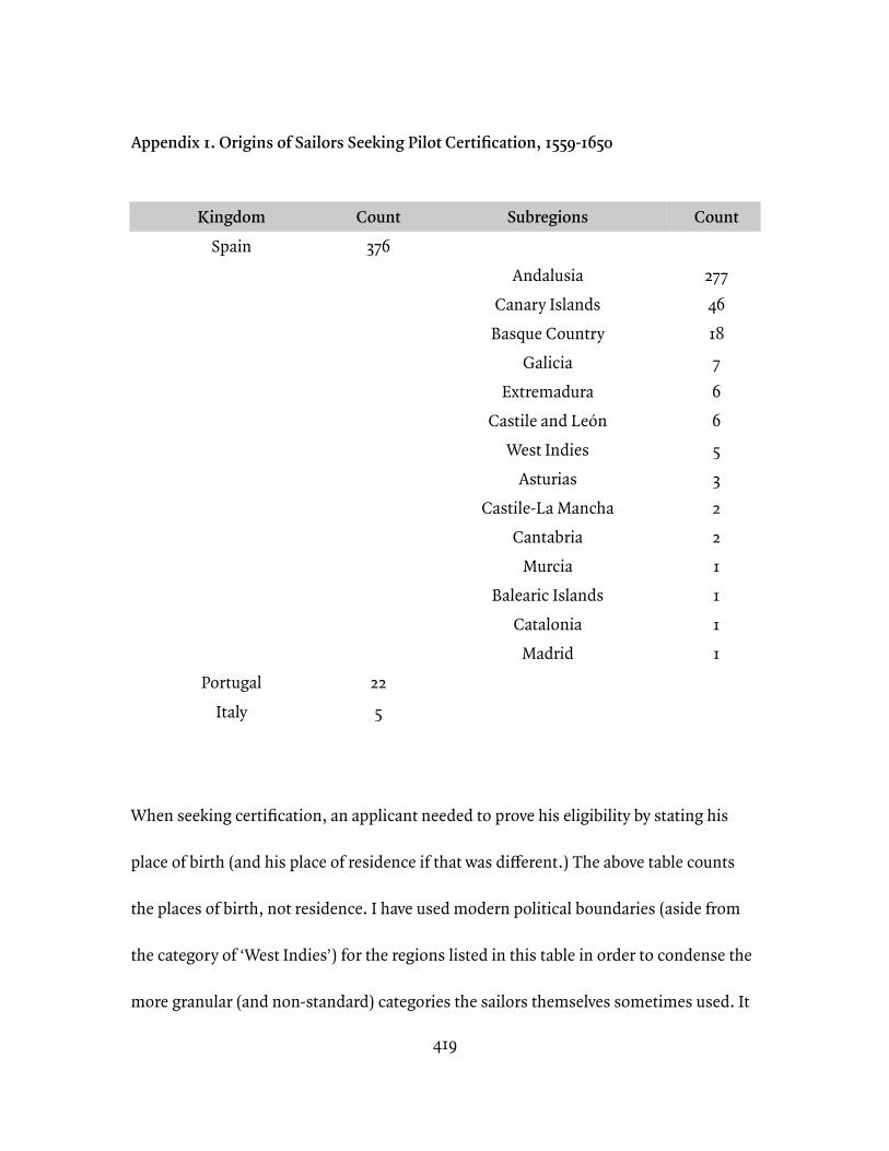
419
Appendix 1. Origins of Sailors Seeking Pilot Certification, 1559-1650
When seeking certification, an applicant needed to prove his eligibility by stating his
place of birth (and his place of residence if that was different.) The above table counts
the places of birth, not residence. I have used modern political boundaries (aside from
the category of ‘West Indies’) for the regions listed in this table in order to condense the
more granular (and non-standard) categories the sailors themselves sometimes used. It
KingdomSpain
PortugalItaly
Count376
225
Subregions
AndalusiaCanary Islands
Basque CountryGalicia
ExtremaduraCastile and León
West IndiesAsturias
Castile-La ManchaCantabria
MurciaBalearic Islands
CataloniaMadrid
Count
277461876653221111
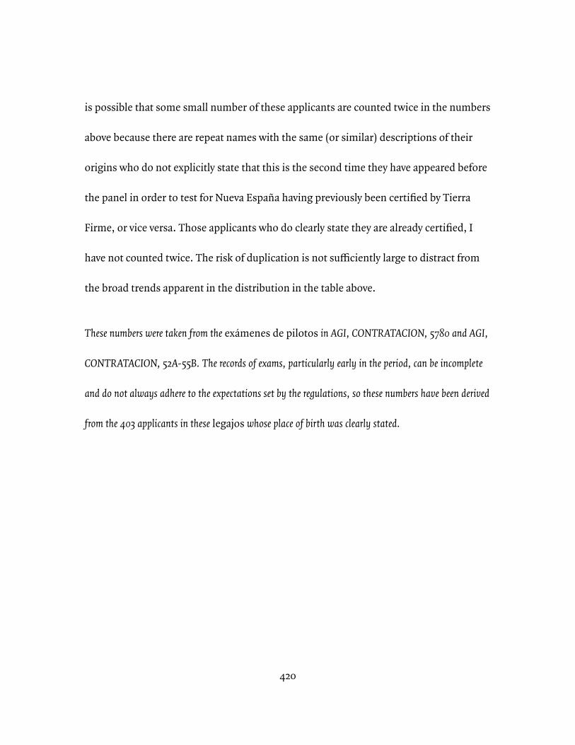
420
is possible that some small number of these applicants are counted twice in the numbers
above because there are repeat names with the same (or similar) descriptions of their
origins who do not explicitly state that this is the second time they have appeared before
the panel in order to test for Nueva España having previously been certified by Tierra
Firme, or vice versa. Those applicants who do clearly state they are already certified, I
have not counted twice. The risk of duplication is not sufficiently large to distract from
the broad trends apparent in the distribution in the table above.
These numbers were taken from the exámenes de pilotos in AGI, CONTRATACION, 5780 and AGI,
CONTRATACION, 52A-55B. The records of exams, particularly early in the period, can be incomplete
and do not always adhere to the expectations set by the regulations, so these numbers have been derived
from the 403 applicants in these legajos whose place of birth was clearly stated.
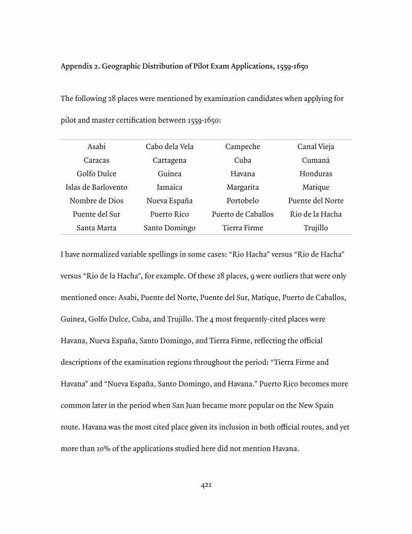
421
Appendix 2. Geographic Distribution of Pilot Exam Applications, 1559-1650
The following 28 places were mentioned by examination candidates when applying for
pilot and master certification between 1559-1650:
I have normalized variable spellings in some cases: “Rio Hacha” versus “Rio de Hacha”
versus “Rio de la Hacha”, for example. Of these 28 places, 9 were outliers that were only
mentioned once: Asabi, Puente del Norte, Puente del Sur, Matique, Puerto de Caballos,
Guinea, Golfo Dulce, Cuba, and Trujillo. The 4 most frequently-cited places were
Havana, Nueva España, Santo Domingo, and Tierra Firme, reflecting the official
descriptions of the examination regions throughout the period: “Tierra Firme and
Havana” and “Nueva España, Santo Domingo, and Havana.” Puerto Rico becomes more
common later in the period when San Juan became more popular on the New Spain
route. Havana was the most cited place given its inclusion in both official routes, and yet
more than 10% of the applications studied here did not mention Havana.
AsabiCaracas
Golfo DulceIslas de Barlovento
Nombre de DiosPuente del Sur
Santa Marta
Cabo dela VelaCartagena
GuineaJamaica
Nueva EspañaPuerto Rico
Santo Domingo
CampecheCuba
HavanaMargaritaPortobelo
Puerto de CaballosTierra Firme
Canal ViejaCumaná
HondurasMatique
Puente del NorteRio de la Hacha
Trujillo
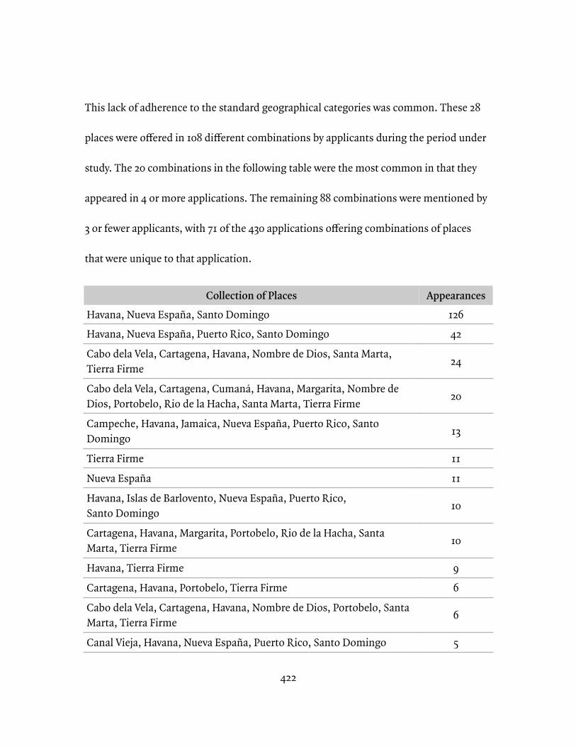
422
This lack of adherence to the standard geographical categories was common. These 28
places were offered in 108 different combinations by applicants during the period under
study. The 20 combinations in the following table were the most common in that they
appeared in 4 or more applications. The remaining 88 combinations were mentioned by
3 or fewer applicants, with 71 of the 430 applications offering combinations of places
that were unique to that application.
Collection of PlacesHavana, Nueva España, Santo DomingoHavana, Nueva España, Puerto Rico, Santo Domingo
Cabo dela Vela, Cartagena, Havana, Nombre de Dios, Santa Marta, Tierra Firme
Cabo dela Vela, Cartagena, Cumaná, Havana, Margarita, Nombre de Dios, Portobelo, Rio de la Hacha, Santa Marta, Tierra Firme
Campeche, Havana, Jamaica, Nueva España, Puerto Rico, Santo Domingo
Tierra Firme
Nueva España
Havana, Islas de Barlovento, Nueva España, Puerto Rico, Santo Domingo
Cartagena, Havana, Margarita, Portobelo, Rio de la Hacha, Santa Marta, Tierra Firme
Havana, Tierra Firme
Cartagena, Havana, Portobelo, Tierra Firme
Cabo dela Vela, Cartagena, Havana, Nombre de Dios, Portobelo, Santa Marta, Tierra Firme
Canal Vieja, Havana, Nueva España, Puerto Rico, Santo Domingo
Appearances12642
24
20
13
11
11
10
10
9
6
6
5
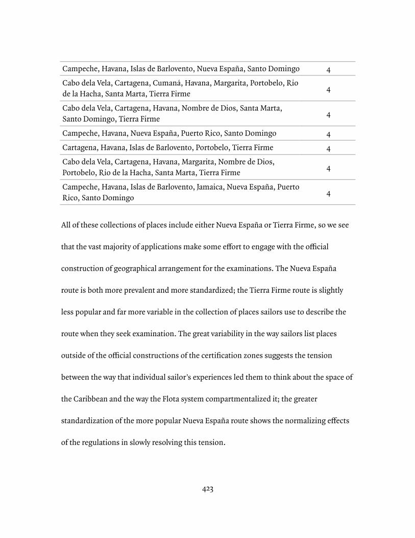
423
All of these collections of places include either Nueva España or Tierra Firme, so we see
that the vast majority of applications make some effort to engage with the official
construction of geographical arrangement for the examinations. The Nueva España
route is both more prevalent and more standardized; the Tierra Firme route is slightly
less popular and far more variable in the collection of places sailors use to describe the
route when they seek examination. The great variability in the way sailors list places
outside of the official constructions of the certification zones suggests the tension
between the way that individual sailor’s experiences led them to think about the space of
the Caribbean and the way the Flota system compartmentalized it; the greater
standardization of the more popular Nueva España route shows the normalizing effects
of the regulations in slowly resolving this tension.
Campeche, Havana, Islas de Barlovento, Nueva España, Santo Domingo
Cabo dela Vela, Cartagena, Cumaná, Havana, Margarita, Portobelo, Rio de la Hacha, Santa Marta, Tierra Firme
Cabo dela Vela, Cartagena, Havana, Nombre de Dios, Santa Marta, Santo Domingo, Tierra Firme
Campeche, Havana, Nueva España, Puerto Rico, Santo Domingo
Cartagena, Havana, Islas de Barlovento, Portobelo, Tierra Firme
Cabo dela Vela, Cartagena, Havana, Margarita, Nombre de Dios, Portobelo, Rio de la Hacha, Santa Marta, Tierra Firme
Campeche, Havana, Islas de Barlovento, Jamaica, Nueva España, Puerto Rico, Santo Domingo
4
4
4
4
4
4
4
424
These numbers were taken from the exámenes de pilotos in AGI, CONTRATACION, 5780 and AGI,
CONTRATACION, 52A-55B. The records of exams, particularly early in the period, can be incomplete
and do not always adhere to the expectations set by the regulations, so these numbers have been derived
from 430 applications for examination that clearly state both the area(s) of certification and the place of
birth and residence of the applicant of the 517 applications made in these legajos. There are 430
applications in this set of data relative to the 403 applicants in Appendix 1 because in that set
applicants who clearly stated they were making their second appearance were not counted a second
time.
425
Appendix 3. Table of Locations in the Indies from Gerónimo Girava
Tabla de las Ciudades y Villas mas señaladas de las Indias, con algunas Islas, Puertos, Cabos, y Rios, mas insignes y nombrados. La primera Columna de numeros contiene la Longitud tomada del Meridiano, que passa por la Islas de Canaria. La segunda contiene la Latitud: en la qual, donde se hallare la letra A. denota ser la Latitud Austral; donde no ser Septentrional.
—Gerónimo Girava, Dos libros de cosmographia: Compuestos nuevamente por Hieronymo Girava Tarragones, (Milan: Por Maestro Iuan Antonio Castellon, y Maestro Christoual Caron, junto à la Yglesia de Nuestra Señora de la Escala, 1556), 228-243.
***
I have taken the following table of notable places in the Indies from Gerónimo Girava’s
Dos libros de cosmographia in order to compare trends among places of sailor interest and
other places. Generally speaking, names taken from indigenous languages predominate
among land places while sailor-named places include names taken from Catholic
symbology, chosen for individual patrons or contributors, and physical descriptions.
Other things to note about this table include the calculation of longitude from the
Canary Islands and the exclusive use of longitudinal values west of that meridian, linking
the Spanish calculation of global position to the westward movement of ships from the
provisioning stations of the Canary Islands.
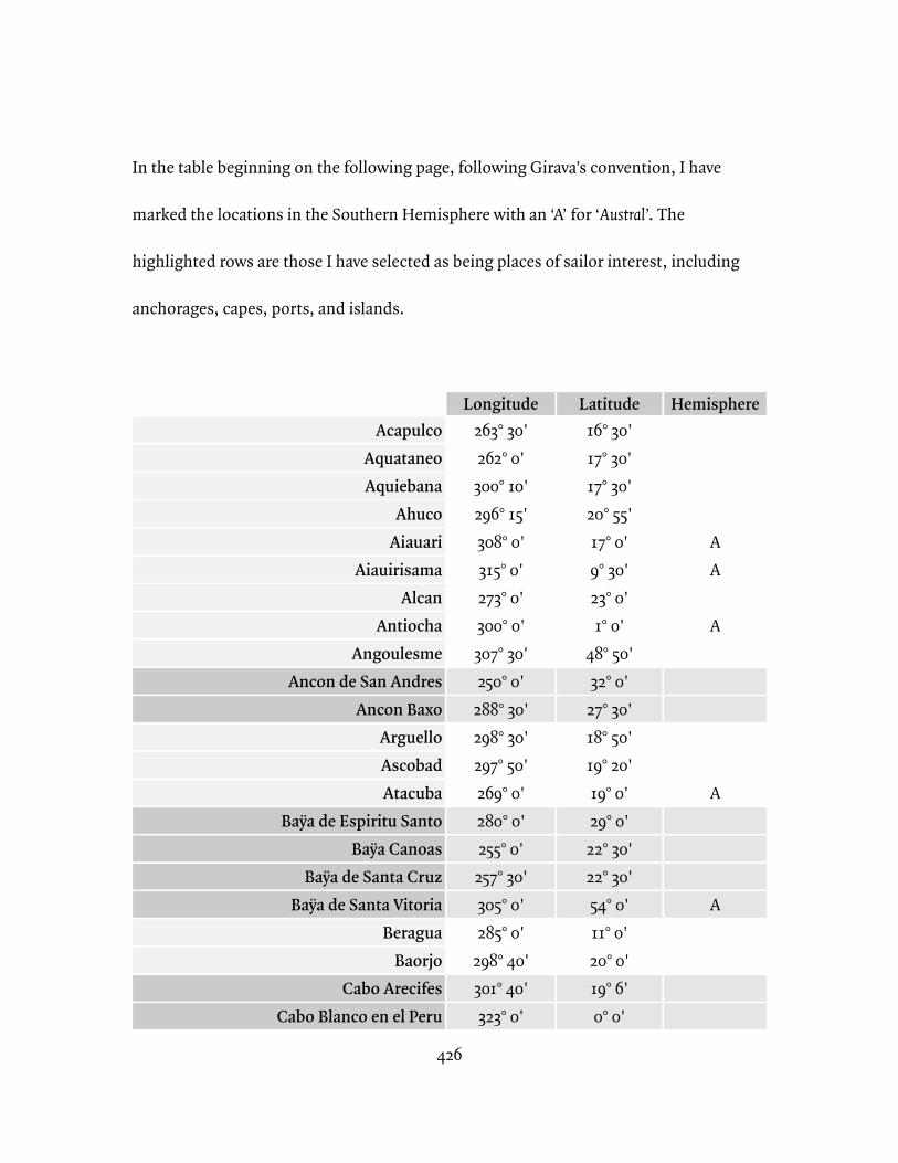
426
In the table beginning on the following page, following Girava’s convention, I have
marked the locations in the Southern Hemisphere with an ‘A’ for ‘Austral’. The
highlighted rows are those I have selected as being places of sailor interest, including
anchorages, capes, ports, and islands.
AcapulcoAquataneoAquiebana
AhucoAiauari
AiauirisamaAlcan
AntiochaAngoulesme
Ancon de San AndresAncon Baxo
ArguelloAscobadAtacuba
Baÿa de Espiritu SantoBaÿa Canoas
Baÿa de Santa CruzBaÿa de Santa Vitoria
BeraguaBaorjo
Cabo ArecifesCabo Blanco en el Peru
Longitude263° 30'262° 0'
300° 10'296° 15'308° 0'315° 0'273° 0'300° 0'307° 30'250° 0'
288° 30'298° 30'297° 50'269° 0'280° 0'255° 0'
257° 30'305° 0'285° 0'
298° 40'301° 40'323° 0'
Latitude16° 30'17° 30'17° 30'20° 55'17° 0'9° 30'23° 0'1° 0'
48° 50'32° 0'
27° 30'18° 50'19° 20'19° 0'29° 0'
22° 30'22° 30'54° 0'11° 0'20° 0'19° 6'0° 0'
Hemisphere
AA
A
A
A
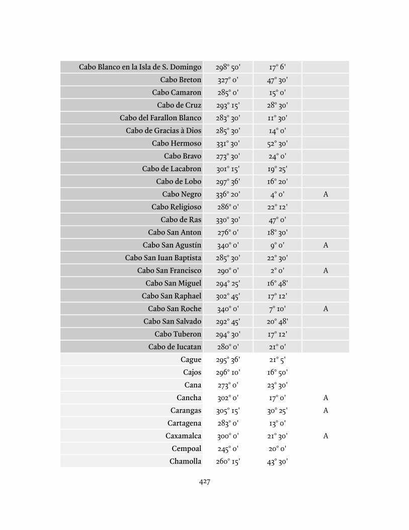
427
Cabo Blanco en la Isla de S. DomingoCabo Breton
Cabo CamaronCabo de Cruz
Cabo del Farallon BlancoCabo de Gracias à Dios
Cabo HermosoCabo Bravo
Cabo de LacabronCabo de Lobo
Cabo NegroCabo Religioso
Cabo de RasCabo San Anton
Cabo San AgustínCabo San Iuan Baptista
Cabo San FranciscoCabo San Miguel
Cabo San RaphaelCabo San Roche
Cabo San SalvadoCabo Tuberon
Cabo de IucatanCagueCajosCana
CanchaCarangas
CartagenaCaxamalca
CempoalChamolla
298° 50'327° 0'285° 0'293° 15'283° 30'285° 30'331° 30'273° 30'301° 15'297° 36'336° 20'286° 0'330° 30'276° 0'340° 0'285° 30'290° 0'294° 25'302° 45'340° 0'292° 45'294° 30'280° 0'295° 36'296° 10'273° 0'302° 0'305° 15'283° 0'300° 0'245° 0'
260° 15'
17° 6'47° 30'15° 0'
28° 30'11° 30'14° 0'
52° 30'24° 0'19° 25'16° 20'
4° 0'22° 12'47° 0'18° 30'9° 0'
22° 30'2° 0'
16° 48'17° 12'7° 10'
20° 48'17° 12'21° 0'21° 5'
16° 50'23° 30'17° 0'
30° 25'13° 0'
21° 30'20° 0'43° 30'
A
A
A
A
AA
A
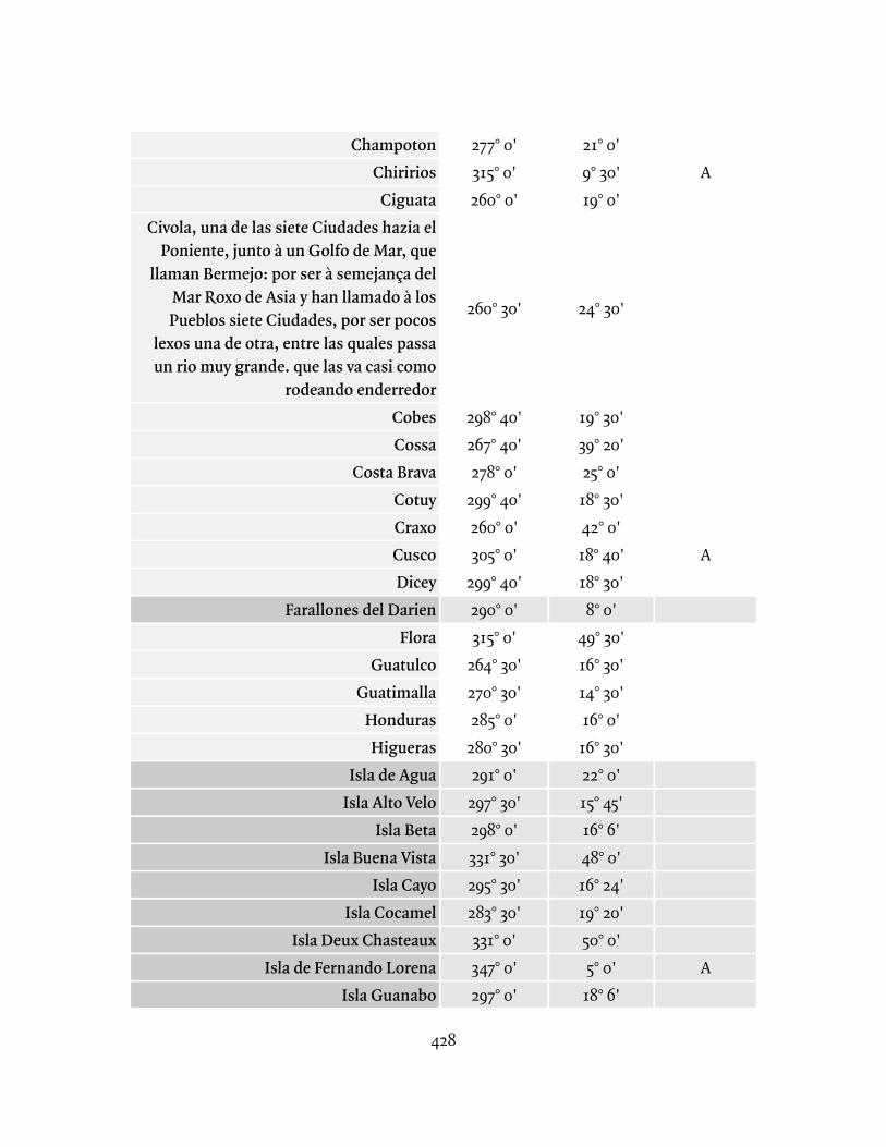
428
ChampotonChiririos
CiguataCivola, una de las siete Ciudades hazia el
Poniente, junto à un Golfo de Mar, que llaman Bermejo: por ser à semejança del
Mar Roxo de Asia y han llamado à los Pueblos siete Ciudades, por ser pocos
lexos una de otra, entre las quales passa un rio muy grande. que las va casi como
rodeando enderredorCobesCossa
Costa BravaCotuyCraxoCuscoDicey
Farallones del DarienFlora
GuatulcoGuatimalla
HondurasHigueras
Isla de AguaIsla Alto Velo
Isla BetaIsla Buena Vista
Isla CayoIsla Cocamel
Isla Deux ChasteauxIsla de Fernando Lorena
Isla Guanabo
277° 0'315° 0'260° 0'
260° 30'
298° 40'267° 40'278° 0'
299° 40'260° 0'305° 0'
299° 40'290° 0'315° 0'
264° 30'270° 30'285° 0'
280° 30'291° 0'
297° 30'298° 0'331° 30'295° 30'283° 30'331° 0'347° 0'297° 0'
21° 0'9° 30'19° 0'
24° 30'
19° 30'39° 20'25° 0'
18° 30'42° 0'18° 40'18° 30'8° 0'
49° 30'16° 30'14° 30'16° 0'
16° 30'22° 0'15° 45'16° 6'48° 0'16° 24'19° 20'50° 0'5° 0'
18° 6'
A
A
A
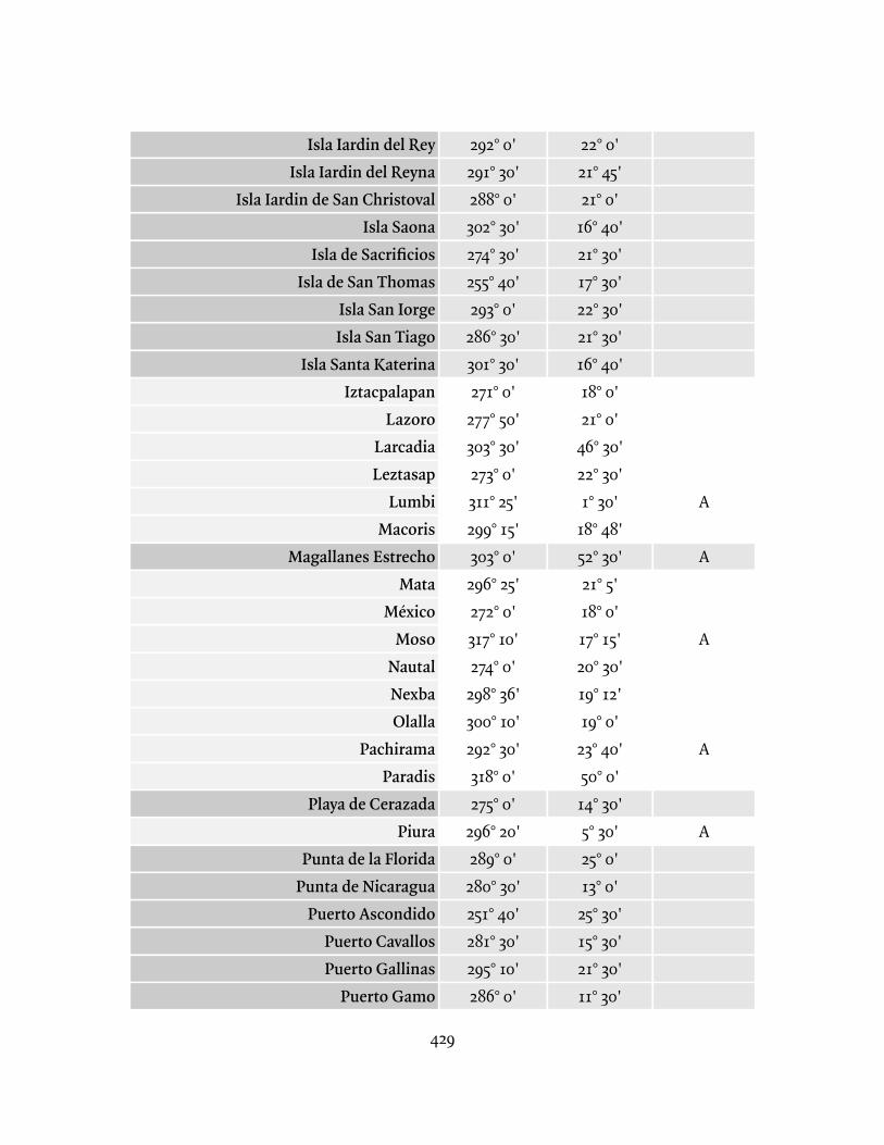
429
Isla Iardin del ReyIsla Iardin del Reyna
Isla Iardin de San ChristovalIsla Saona
Isla de SacrificiosIsla de San Thomas
Isla San IorgeIsla San Tiago
Isla Santa KaterinaIztacpalapan
LazoroLarcadiaLeztasap
LumbiMacoris
Magallanes EstrechoMata
MéxicoMoso
NautalNexbaOlalla
PachiramaParadis
Playa de CerazadaPiura
Punta de la FloridaPunta de Nicaragua
Puerto AscondidoPuerto CavallosPuerto Gallinas
Puerto Gamo
292° 0'291° 30'288° 0'302° 30'274° 30'255° 40'293° 0'
286° 30'301° 30'271° 0'
277° 50'303° 30'273° 0'311° 25'299° 15'303° 0'
296° 25'272° 0'317° 10'274° 0'
298° 36'300° 10'292° 30'318° 0'275° 0'
296° 20'289° 0'
280° 30'251° 40'281° 30'295° 10'286° 0'
22° 0'21° 45'21° 0'
16° 40'21° 30'17° 30'22° 30'21° 30'16° 40'18° 0'21° 0'
46° 30'22° 30'1° 30'
18° 48'52° 30'21° 5'18° 0'17° 15'20° 30'19° 12'19° 0'
23° 40'50° 0'14° 30'5° 30'25° 0'13° 0'
25° 30'15° 30'21° 30'11° 30'
A
A
A
A
A
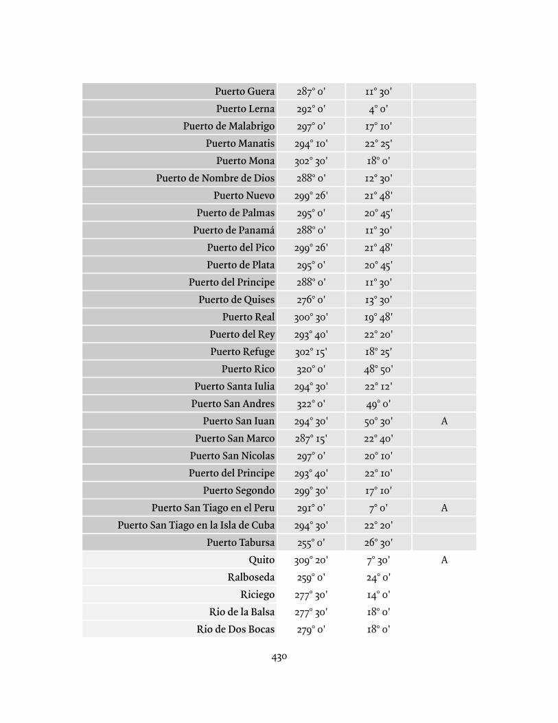
430
Puerto GueraPuerto Lerna
Puerto de MalabrigoPuerto Manatis
Puerto MonaPuerto de Nombre de Dios
Puerto NuevoPuerto de Palmas
Puerto de PanamáPuerto del PicoPuerto de Plata
Puerto del PrincipePuerto de Quises
Puerto RealPuerto del ReyPuerto Refuge
Puerto RicoPuerto Santa Iulia
Puerto San AndresPuerto San Iuan
Puerto San MarcoPuerto San NicolasPuerto del Principe
Puerto SegondoPuerto San Tiago en el Peru
Puerto San Tiago en la Isla de CubaPuerto Tabursa
QuitoRalboseda
RiciegoRio de la Balsa
Rio de Dos Bocas
287° 0'292° 0'297° 0'
294° 10'302° 30'288° 0'299° 26'295° 0'288° 0'299° 26'295° 0'288° 0'276° 0'
300° 30'293° 40'302° 15'320° 0'
294° 30'322° 0'
294° 30'287° 15'297° 0'
293° 40'299° 30'291° 0'
294° 30'255° 0'
309° 20'259° 0'
277° 30'277° 30'279° 0'
11° 30'4° 0'
17° 10'22° 25'18° 0'12° 30'21° 48'20° 45'11° 30'21° 48'20° 45'11° 30'13° 30'19° 48'22° 20'18° 25'48° 50'22° 12'49° 0'50° 30'22° 40'20° 10'22° 10'17° 10'7° 0'
22° 20'26° 30'7° 30'24° 0'14° 0'18° 0'18° 0'
A
A
A
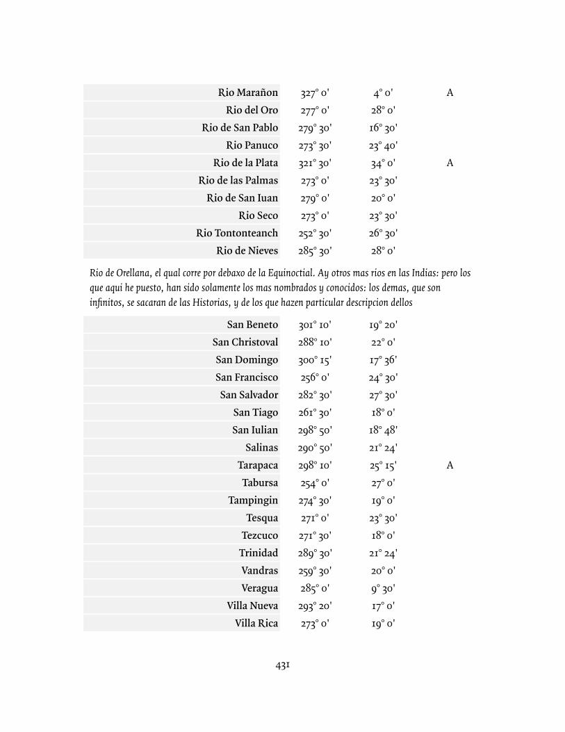
431
Rio MarañonRio del Oro
Rio de San PabloRio Panuco
Rio de la PlataRio de las Palmas
Rio de San IuanRio Seco
Rio TontonteanchRio de Nieves
Rio de Orellana, el qual corre por debaxo de la Equinoctial. Ay otros mas rios en las Indias: pero los que aqui he puesto, han sido solamente los mas nombrados y conocidos: los demas, que son infinitos, se sacaran de las Historias, y de los que hazen particular descripcion dellos
San BenetoSan ChristovalSan DomingoSan FranciscoSan Salvador
San TiagoSan Iulian
SalinasTarapacaTabursa
TampinginTesqua
TezcucoTrinidadVandrasVeragua
Villa NuevaVilla Rica
327° 0'277° 0'
279° 30'273° 30'321° 30'273° 0'279° 0'273° 0'
252° 30'285° 30'
301° 10'288° 10'300° 15'256° 0'
282° 30'261° 30'298° 50'290° 50'298° 10'254° 0'274° 30'271° 0'
271° 30'289° 30'259° 30'285° 0'
293° 20'273° 0'
4° 0'28° 0'16° 30'23° 40'34° 0'23° 30'20° 0'23° 30'26° 30'28° 0'
19° 20'22° 0'17° 36'24° 30'27° 30'18° 0'
18° 48'21° 24'25° 15'27° 0'19° 0'23° 30'18° 0'
21° 24'20° 0'9° 30'17° 0'19° 0'
A
A
A

432
VilcasXauca
303° 0'307° 0'
17° 0'17° 30'
AA
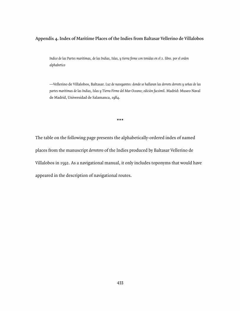
433
Appendix 4. Index of Maritime Places of the Indies from Baltasar Vellerino de Villalobos
Indice de las Partes maritimas, de las Indias, Islas, y tierra firme con tenidas en el 2. libro. por el orden alphabetico
—Vellerino de Villalobos, Baltasar. Luz de navegantes: donde se hallaran las derrots derrots y señas de las partes maritimas de las Indias, Islas y Tierra Firme del Mar Oceano; edición facsimil. Madrid: Museo Naval de Madrid, Universidad de Salamanca, 1984.
***
The table on the following page presents the alphabetically-ordered index of named
places from the manuscript derrotero of the Indies produced by Baltasar Vellerino de
Villalobos in 1592. As a navigational manual, it only includes toponyms that would have
appeared in the description of navigational routes.
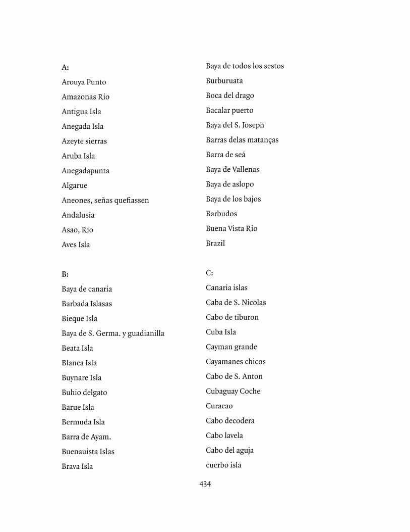
434
A:
Arouya Punto
Amazonas Rio
Antigua Isla
Anegada Isla
Azeyte sierras
Aruba Isla
Anegadapunta
Algarue
Aneones, señas quefiassen
Andalusia
Asao, Rio
Aves Isla
B:
Baya de canaria
Barbada Islasas
Bieque Isla
Baya de S. Germa. y guadianilla
Beata Isla
Blanca Isla
Buynare Isla
Buhio delgato
Barue Isla
Bermuda Isla
Barra de Ayam.
Buenauista Islas
Brava Isla
Baya de todos los sestos
Burburuata
Boca del drago
Bacalar puerto
Baya del S. Joseph
Barras delas matanças
Barra de seá
Baya de Vallenas
Baya de aslopo
Baya de los bajos
Barbudos
Buena Vista Rio
Brazil
C:
Canaria islas
Caba de S. Nicolas
Cabo de tiburon
Cuba Isla
Cayman grande
Cayamanes chicos
Cabo de S. Anton
Cubaguay Coche
Curacao
Cabo decodera
Cabo lavela
Cabo del aguja
cuerbo isla
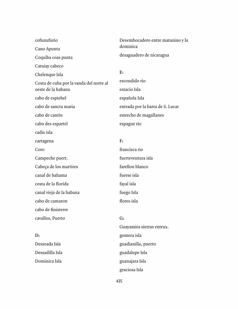
435
cofunufurio
Cano Apunta
Coquiba coas punta
Catuiay cabeco
Chelenque Isla
Costa de cuba por la vanda del norte al oeste de la habana
cabo de espiehel
cabo de sancta maria
cabo de cantin
cabo des espartel
cadix isla
cartagena
Coro
Campeche puert.
Cabeça de los martires
canal de bahama
costa de la florida
canal vieja de la habana
cabo de camaron
cabo de finisterre
cavallos, Puerto
D:
Desseada Isla
Dessadilla Isla
Dominica Isla
Desembocadero entre matanino y la dominica
desaguadero de nicaragua
E:
escondido rio
estacio Isla
española Isla
entrada por la barra de S. Lucar
estrecho de magallanes
espague rio
F:
francisca rio
fuerteventura isla
farellon blanco
fuerse isla
fayal isla
fuego Isla
flores isla
G:
Guayamira sierras entrux.
gomera isla
guadianilla, puerto
guadalupe Isla
guanajara Isla
graciosa Isla
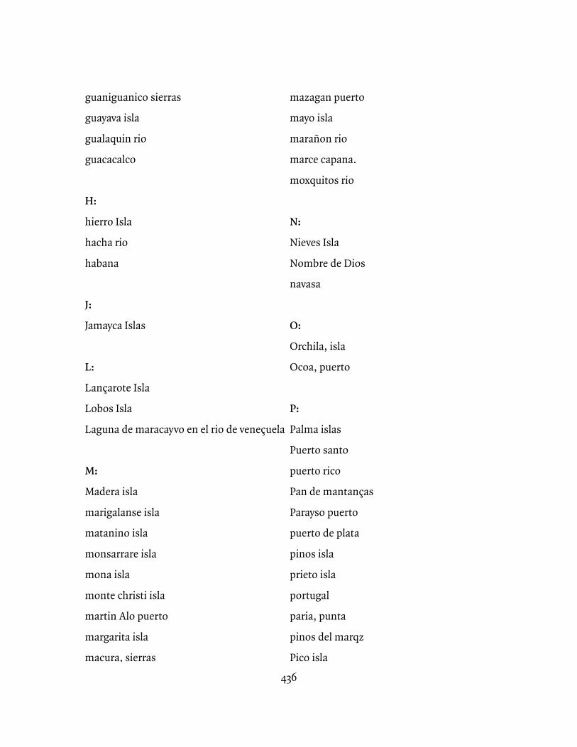
436
guaniguanico sierras
guayava isla
gualaquin rio
guacacalco
H:
hierro Isla
hacha rio
habana
J:
Jamayca Islas
L:
Lançarote Isla
Lobos Isla
Laguna de maracayvo en el rio de veneçuela
M:
Madera isla
marigalanse isla
matanino isla
monsarrare isla
mona isla
monte christi isla
martin Alo puerto
margarita isla
macura, sierras
mazagan puerto
mayo isla
marañon rio
marce capana.
moxquitos rio
N:
Nieves Isla
Nombre de Dios
navasa
O:
Orchila, isla
Ocoa, puerto
P:
Palma islas
Puerto santo
puerto rico
Pan de mantanças
Parayso puerto
puerto de plata
pinos isla
prieto isla
portugal
paria, punta
pinos del marqz
Pico isla
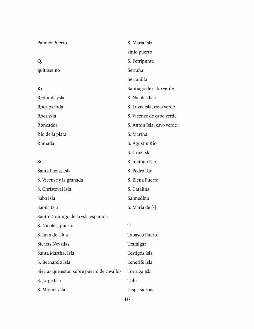
437
Panuco Puerto
Q:
quitaseuño
R:
Redonda ysla
Roca partida
Roca ysla
Roncador
Rio de la plata
Ramada
S:
Santa Luzia, Isla
S. Vicense y la granada
S. Christoval Isla
Saba Isla
Saona Isla
Santo Domingo de la ysla española
S. Nicolas, puerto
S. Juan de Ulua
Sierras Nevadas
Santa Martha, Isla
S. Bernarelo Isla
Sierras que estan sobre puerto de cavallos
S. Jorge Isla
S. Miguel ysla
S. Maria Isla
sinio puerto
S. Petripunta
Serraña
Serranilla
Santiago de cabo verde
S. Nicolas Isla
S. Luzia isla, cavo verde
S. Vicense de cabo verde
S. Anton Isla. cavo verde
S. Martha
S. Agustin Rio
S. Cruz Isla
S. matheo Rio
S. Pedro Rio
S. Elena Puerto
S. Catalina
Salmedina
S. Maria de [-]
T:
Tabasco Puerto
Trafalgar
Testigos Isla
Tenerife Isla
Tortuga Isla
Tulu
tuspa sierras
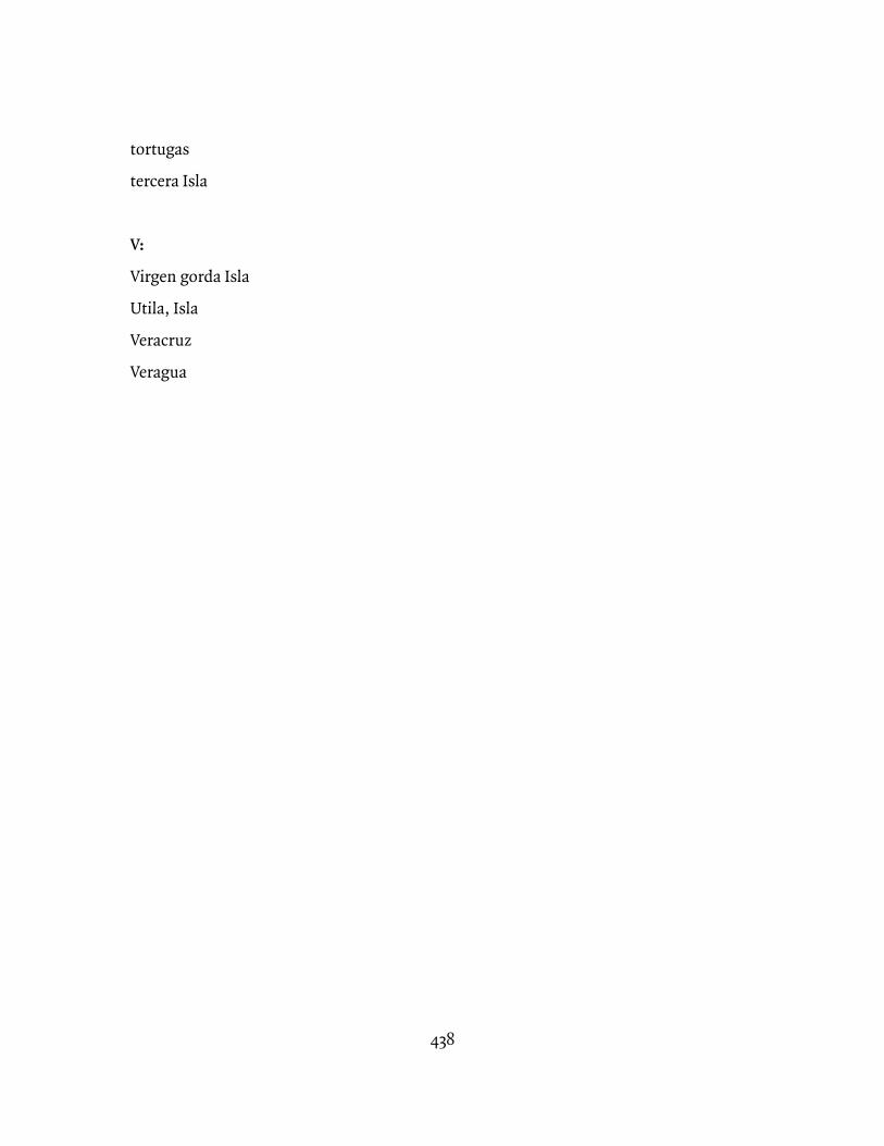
438
tortugas
tercera Isla
V:
Virgen gorda Isla
Utila, Isla
Veracruz
Veragua
439
Bibliography
Archival Collections
Archivo General de Indias (AGI)Casa de la Contratación (CONTRATACION)Gobierno
Audiencia de Filipinas (FILIPINAS)Audiencia de México (MEXICO)
Patronato Real (PATRONATO)
Published Primary Sources
Acosta, José de. Historia natural y moral de las Indias. 1590. Madrid: Ediciones de Cultura Hispánica, 1998.
_____. Natural and Moral History of the Indies. 1590. Edited by Jane E. Mangan. Translated by Frances Lopez-Morillas. Durham, NC: Duke University Press, 2002.
Artedi, Peter. Petri Artedi Sueci, medici, Icthyologia sive opera omnia de piscibus: scilicet: Bibliotecha ichthyologica. Philosophia ichthyologica. Genera piscium. Synonymia specierum. Descriptiones specierum.: Omnia in hoc genere perfectiora quam antea ulla. / Posthuma vindicavit, recognovit, coaptavit & edidit Carolus Linnæus. Lugduni Batavorum: Apud Conradum Wishoff, 1738.
Barrientos, Bartolome. Pedro Menendez de Aviles: Founder of Florida. 1567. Translated by Anthony Kerrigan. Gainesville: University of Florida Press, 1965.
Belon, Pierre. La nature & diversité des poissons, Avec leur pourtraicts, representez au plus pres deu naturel. Par Pierre Belon du Mans. A monseigneur le Reverendiss. Cardinal de Chastillon. Paris: Chez Charles Estienne, Imprimeur ordinaire du Roy, 1555.
Boccaccio, Giovanni. “De Canaria et de insulis ultra Hispaniam in Oceano noviter repertis.” In El Mar de los descubridores : documentos y relatos inéditos o poco conocidos sobre el descubrimiento y la exploración de los mares, islas y tierras del Nuevo Mundo (siglos xv-xvi), edited by Marisa Vannini de Gerulewicz, 17-26. Caracas : Comisión Organizadora de la III Conferencia de las Naciones Unidas sobre Derecho del Mar, 1974.
440
Bohun, R. A Discourse Concerning the Origine and Properties of Wind. With An Historicall Account of Hurricanes, and other Tempestuous Winds. Oxford: Printed by W. Hall for Tho. Bowman, 1671.
Cardona, Nicolás de. Geographic and Hydrographic Descriptions of Many Northern and Southern Lands and Seas in the Indies, Specifically of the Discovery of the Kingdom of California, 1632. Edited and translated by W. Michael Mathes. Los Angeles, CA: Dawson’s Book Shop, 1974.
Chaves, Jerónimo de. Chronographia ò Reportorio de los Tiempos el mas copioso y preciso que hasta agora ha salido a luz. Compuesto por Hieronymo de Chaves Cosmographo de su Magestad. y professor Real de Cosmographia en Sevilla. Sevilla: En casa de Juan Gutierrez, impressor de libros de libros en cal de Genoua, 1561.
Cuvier, Georges. Historical Portrait of the Progress of Ichthyology, from Its Origins to Our Own Time. 1801. Edited by Theodore W. Pietsch. Translated by Abby J. Simpson. Baltimore: The Johns Hopkins University Press, 1995.
Dampier, William. A New Voyage Round the World. Describing particularly, The Isthmus of America, several Coasts and Islands in the West Indies, the Isles of Cape Verd, the Passage by Terra del Fuego, the South Sea Coasts of Chili, Peru, and Mexico; the Isle of Guam one of the Ladrones, Mindanao, and other Philippine and East-India Islands near Cambodia, China, Formosa, Luconta, Celebes; &c. New Holland, Sumatra, Nicobar Isles; the Cape of Good Hope, and Santa Hellena. Their Soil, Rivers, Harbours, Plants, Fruits, Animals, and Inhabitants. Their Customs, Religion, Government, Trade, &c. London, Printed for James Knapton, at the Crown in St. Paul's Church-yard, 1697.
Escalante de Mendoza, Juan de. Itinerario de navegación de los mares y tierras occidentales. 1575. Madrid: Museo Naval, 1985.
Enciso, Martin Fernández de. Suma de geographia que trata de todas las partidas y provincias del mundo: en especial delas indias. y trata largamente del arte del marear juntamente con la espera en romance: conel regimiento del sol y del norte: agora nuevamente emendada de algunos defectos que tenia enla impression passada. Sevilla: J. Cromberger, 1530.
Fernández de Oviedo, Gonzalo. Historia general y natural de las Indias. Biblioteca de autores españoles desde la formación del lenguaje hasta nuestros días. Madrid: Ediciones Atlas, 1959.
_____. Sumario de la natural historia de las Indias. 1525. Edited by José Miranda. México: Fondo de Cultura Económica, 1996.
441
Figueiredo, Manoel de. Hidrographia, exame de pilotos, no qual se contem as regras que todo Piloto deve guardar em suas navegações, assi no Sol, variação dagulha, como no cartear, com algu[m]as Regras da navegação de Leste, Oeste, com mais o Aureo numero, Epactas, Marès, & altura da Estrella Pollar. Com os Roteiros de Portugal pera o Brasil, Rio da Prata, Guinè, S. Thomé, Angolla, & Indias de Portugal, & Castella. Composto por Manoel de Figueiredo, q[ue] servio de Cosmographo Mòr, por mandado de sua Magestade. E agora impresso por conta de Ioõ Dias, & Sebastião de Gois. Lisboa: Impresso por Vicente Alvarez, 1625.
Flores, Lazaro de. Arte de navegar. Navegación astronomica, theorica, y practica. En la qual se contienen tablas nuevas de las declinaciones de el Sol, computadas al Meridiano de la Hava. Traense nuevas declinaciones de Estrellas, y instrumentos nuevos. Compuesta por el Doct. D. Lazaro de Flores, vezino de la Ciudad de la Havana en la Isla de Cuba. Y lo consagra al Excelentisimo Señor Conde de Medillin, Presidente del Consejo Supremo de Indias, &c. Madrid: Por Iulian de Paredes, impressor de Libros, en la Plaçuela del Angel, 1673.
García de Céspedes, Andrés. Regimiento de navegación mando hazer el rei nuestro señor por orden de su conseio real de las Indias a Andres Garcia de Cespedes su cosmografo maior siendo Presidente enel dicho consejo el conde de Lemos. Madrid, En casa de I. de la Cuesta, 1606.
García de Palacio, Diego. Instrucción Nautica para navegar del Doctor Diego arcía de Palacio del Colegio de Su Majestad y Oidor en la Real Audiencia. 1587. Volume 8. Colección de Incunables Americanos. Madrid: Ediciones Cultura Hispánica, 1944.
Gesner, Conrad. Historiaee animalium liber IIII, qui est de piscium et aquatilium animantium natura. Zurich: Ch. Froschauer, 1558.
Giovio, Paolo. De Romanis Piscibus Libellus, doctus, copiosus & elegans, iam recens æditus. Antverpiæ: per Ioannem Grapheum, 1528.
Girava, Gerónimo. Dos libros de cosmographia: Compuestos nuevamente por Hieronymo Girava Tarragones. Milan: Por Maestro Iuan Antonio Castellon, y Maestro Christoual Caron, junto à la Yglesia de Nuestra Señora de la Escala, 1556.
Gomes de Brito, Bernardo. The Tragic History of the Sea. Translated and edited by C.R. Boxer. Minneapolis: University of Minnesota Press, 2001.
Herrera y Tordesillas, Antonio de. Historia general de los hechos de los castellanos en las islas i Tierra Firme del Mar Oceano. Madrid: En la Emplenta Real, 1601-1615.
_____. Description de las Indias Ocidentals de Antonio de Herrara coronista mayor de Su Magestad de las Indias, y su coronista de Castilla. 1601-1615. Madrid: Enla Oficina Real de Nicolas Rodriguez Franco, 1730.
442
León Pinelo, Antonio de. Epitome de la Biblioteca Oriental i Occidental, Nautica i Geografica. Madrid: Juan Gonzalez, 1629.
Marsili, Luigi Ferdinando. Histoire physqie de la mer. Ouvrage enrichi de figures dessinées d’après le Naturel. Amsterdam, Aux dépens de la Compagnie, 1725.
Martinez, Enrico. Reportorio de los tiempos, y historia natural desta nueva españa. Compuesto por Henrrico Martinez Cosmogrpho de su Magestad è Interprete del Sancto Officio deste Reyno. Dirigido al Excellentissimo Señor Don Iuan de Mendoça y Luna Marques de Montesclaros, Virrey, Gouernador, Presidente y Cappitan General por el Rey nuestro Señor en esta Nueua España &c. Mexico: En la Emprenta del mesmo autor año de 1606.
Mathes, W. Michael, ed. Californiana II: Documentos para la historia de la explotación comercial de California, 1611-1679. Madrid: Ediciones José Porrua Turanzas, 1952.
Medina, Pedro de. Arte de navegar en que se contienen todas las Reglas, Declaraciones, Secretos, y Avisos, que a la buena navegación son necessarios, y se deben saber, hecha por el maestro Pedro de Medina. Dirigid al serenissimo y muy esclarescido señor, don Phelipe principe de España, y delas dos Sicilias, &c. Valladolid: Francisco Fernández de Cordova, 1545.
Monardes, Nicolás. Primera y segunda y tercera partes de la historia medicinal de las cosas que se traen de nuestras Indias Occidentales que siruen en medicina : ... En Seuilla, 1574. 421pp. Sabin Americana. Gale, Cengage Learning. University of Texas at Austin. Accessed 10 May 2010 <http://galenet.galegroup.com/servlet/Sabin?af=RN&ae=CY102261579&srchtp=a&ste=14>.
Pimentel, Luis Serraõ. Arte pratica de navegar e regimento de pilotos repartio em duas partes: A primeira propositiva, em que se propoem alguns principios para melhor inteligencia das regras da navegaçaõ: A segunda operativa em que se ensinaõ as mesmas regras para a pratica. Iuantamente os roteiros das navegaçoens das conquistas de Portugal, Y Castela. Lisboa: Na impressaõ de Antonio Craesbeeck de Mello Impressor de S. Alteza, 1681.
Rochefort, Charles de. The History of the Caribby-Islands. Translated by John Davies. London: T. Dring and J. Starkey, 1666.
Rondelet, Guillaume. Libri de Piscibus Marinis, in quibus veræ Piscium effigies expressæ sunt. Quæ in tota Piscium historia contineantur, indicat Elenchus pagina non et decima. Lugduni, Apud Matthiam Bonhomme. 1554.
Salviani, Ippolito. Aquatilium animalium historiae, liber primus, cum eorumdem formis, aere excusis. Romae: Apud Hippolytum Salvianum, 1554.
443
Sarmiento de Gamboa, Pedro. História índica. 1572. Buenos Aires: Espasa-Calpe Argentina, 1942.
_____. Viaje al Estrecho de Magallanes y noticia de la expedición que después hizo para poblarlo. Colección Reservada del Museo del Fin del Mundo. Buenos Aires: Eubeda, 2005.
Seixas y Llovera, Francisco. Theatro naval hydrographico, de los fluxos, y refluxos, y de las corrientes de los mares, estrechos, archipielagos, y passages aquales del mundo, y de las diferencias de las variaciones de la aguja de marear, y efectos de la luna, con los vientos generals, y particulares que reynan en las quatro regiones maritimes del orbe. Madrid: Por Antonio de Zafra, 1688.
Sloane, Hans. A Voyage to the Islands Madera, Barbados, Nieves, S. Christophers and Jamaica, with the Natural History of the Herbs and Trees, Four-footed Beasts, Fishes, Birds, Insects, Reptiles, &c. of the last of those Islands; to which is prefix’d An Introduction Wherein is an Account of the Inhabitants, Air, Waters, Disease, Trade, &c of that Place, with some Relations concerning the Neighbouring Continent, and Islands of America. London, 1707.
Vellerino de Villalobos, Baltasar. Luz de navegantes: donde se hallaran las derrots derrots y señas de las partes maritimas de las Indias, Islas y Tierra Firme del Mar Oceano; edición facsimil. 1592. Madrid: Museo Naval de Madrid, Universidad de Salamanca, 1984.
Willughby, Francis. Francisci Willughbeii Armig. De historia piscium libri quatuor, jussu & sumptibus Societatis Regiae Londinensis editi. In quibus non tantum de piscibus in genere agitur, sed & species omnes, tum ab aliis traditae, tum novae & nondum editae bene multae, naturae ductum servante methodo dispositae, accurate describuntur. Earumque effigies, quotquot haberi potuere, vel ad vivum delineatae, vel ad optima exemplaria impressa; artifici manu elegantissime in aes incisae, ad descriptiones illustrandas exhibentur. Cum appendice historias & observationes in supplementum operis collatas complectente. Totum opus recognovit, coaptavit, supplevit, librum etiam primum & secundum integros adjecit Johannes Raius e Societate Regia. Oxonii: e Theatro Sheloniano, 1686.
Zamorano, Rodrigo de. Compendio del arte de navegar, del licenciado Rodrigo Çamorano, cosmografo y piloto mayor de Su Magestad. Catedratico de cosografia en la Casa dela Contratacion de las Indias. Sevilla : En casa de Ioan de Leon, 1588.
444
Secondary Literature
Akerman, James R., ed. The Imperial Map: Cartography and the Mastery of Empire. Chicago: The University of Chicago Press, 2009.
Almeida, Onésimo T. “Science During the Portuguese Maritime Discoveries: A Telling Case of Interfaction Between Experimenters and Theoreticians.” In Science in the Spanish and Portuguese Empires, 1500-1800, edited by Daniela Bleichmar, Paula de Vos, Kristin Huffine, and Kevin Sheehan, 78-92. Stanford, CA: Stanford University Press, 2009.
Armitage, David and Alison Bashford, eds. Pacific Histories: Ocean, Land, People. New York: Palgrave Macmillan, 2014.
Ashworth, William B. “Emblematic Natural History of the Renaissance.” In Cultures of Natural History, edited by Nicholas Jardin, J.A. Secord, and Emma C. Spary, 17-37. New York: Cambridge University Press, 1996.
Barrera-Osorio, Antonio. “Empiricism in the Spanish Atlantic World.” In Science and Empire in the Atlantic World, edited by James Delbourgo and Nicholas Dew, 177-202. New York: Routledge, 2008.
_____. Experiencing Nature: The Spanish American Empire and the Early Scientific Revolution. Austin: University of Texas Press, 2006.
_____. “Knowledge and Empiricism in the Sixteenth-Century Spanish Atlantic World.” In Science in the Spanish and Portuguese Empires, 1500-1800, edited by Daniela Bleichmar, Paula de Vos, Kristin Huffine, and Kevin Sheehan, 219-232. Stanford, CA: Stanford University Press, 2009.
Basso, Keith H. Wisdom Sits in Places: Landscape and Language Among the Western Apache. Albuquerque: University of New Mexico Press, 1996.
Benton, Lauren. A Search for Sovereignty: Law and Geography in European Empires, 1400-1900. New York: Cambridge University Press, 2010.
Bjork, Katharine. “The Link That Kept the Philippines Spanish: Mexican Merchant Interests and the Manila Trade, 1571-1815.” Journal of World History 9, no. 1 (Spring 1998): 25-50.
Blackmore, Josiah. Manifest Perdition: Shipwreck Narrative and the Disruption of Empire. Minneapolis: University of Minnesota Press, 2002.
445
Bolster, W. Jeffrey. “Putting the Ocean in Atlantic History: Maritime Communities and Marine Ecology in the Northwest Atlantic, 1500-1800.” The American Historical Review 113, no. 1 (February 2008): 19-47.
_____. The Mortal Sea: Fishing the Atlantic in the Age of Sail. Cambridge, MA: The Belknap Press of Harvard University Press, 2012.
Brading, D.A. The First America: The Spanish Monarchy, Creole Patriots, and the Liberal State, 1492-1867. New York: Cambridge University Press, 1991.
Brendecke, Arndt. Imperio e información: Funciones del saber en el dominio colonial español. Translated by Griselda Mársico. Madrid: Iberoamericana, 2012.
Brotton, Jerry. Trading Territories: Mapping the Early Modern World. 1997. London: Reaktion Books, 2004.
Buisseret, David. The Mapmaker’s Quest: Depicting New Worlds in Renaissance Europe. New York: Oxford University Press, 2003.
_____. “Spanish Military Engineers in the New World before 1750.” Mapping and Empire: Soldier-Engineers on the Southwestern Frontier, edited by Dennis Reinhartz and Gerald D. Saxon. Austin: University of Texas Press, 2005.
Buisseret, David, ed. Monarchs, Ministers, and Maps: The Emergence of Cartography as a Tool of Government in Early Modern Europe. Chicago: The University of Chicago Press, 1992.
Burg, Barry R. Sodomy and the Pirate Tradition: English Sea Rovers in the Seventeenth-Century Caribbean. 2nd ed. New York: NYU Press, 1995.
Burnett, D. Graham. “Hydrographic Discipline among the Navigators: Charting an ‘Empire of Commerce and Science’ in the Nineteenth-Century Pacific.” In The Imperial Map: Cartography and the Mastery of Empire, edited by James R. Akerman, 185-259. Chicago: The University of Chicago Press, 2009.
Buttinger, James D., Gladys M. Rivera and Amanda E. Buttinger. “Mateo Jorge, a Pilot of the Casa de la Contratación 16th Century Sevilla: a Study in the Transmission of Science and Technology as Expressed in the Graphics of a Rutter of Practical Navigation.” In La Casa de la Contratación y la navegación entre España y las Indias, edited by Antonio Acosta Rodríguez, Adolfo González Rodríguez, and Enriqueta Vila Vilar, 639-665. Sevilla: Universidad de Sevilla, Consejo Superior de Investigaciones Científicas, Fundación El Monte, 2003.
446
Cameron, Ian. Lodestone and Evening Star: The Epic Voyages of Discovery, 1493 B.C.-1896 A.D. New York: Dutton, 1966.
Camino, Mercedes Maroto. Exploring the explorers: Spaniards in Oceania, 1519-1794. New York: Manchester University Press, 2008.
_____. Producing the Pacific: Maps and Narratives of Spanish Exploration, 1567-1606. Portada Hispánica, 18. New York: Rodopi, 2005.
Cañeque, Alejandro. The King’s Living Image: The Culture and Politics of Viceregal Power in Colonial Mexico. New York: Routledge, 2004.
Cañizares-Esguerra, Jorge. “How Derivative Was Humboldt? Microcosmic Nature Narratives in Early Modern Spanish America and the (Other) Origins of Humboldt’s Ecological Sensibilities.” In Colonial Botany: Science, Commerce, and Politics in the Early Modern World, edited by Londa Schiebinger and Claudia Swan, 148-165. Philadelphia: University of Pennsylvania Press, 2005.
_____. How to Write the History of the New World: Histories, Epistemologies, and Identities in the Eighteenth-Century Atlantic World. Stanford, CA: Stanford University Press, 2001.
_____. Nature, Empire, and Nation: Explorations of the History of Science in the Iberian World. Stanford, CA: Stanford University Press, 2006.
_____. “New World, New Stars: Patriotic Astrology and the Invention of Indian and Creole Bodies in Colonial Spanish America, 1600-1650.” The American Historical Review 104, no. 1 (February 1999): 33-68.
_____. Puritan Conquistadors: Iberianizing the Atlantic, 1550-1700. Stanford, CA: Stanford University Press, 2006.
Carter, Paul. The Road to Botany Bay: An Exploration of Landscape and History. 1987. Minneapolis: University of Minnesota Press, 2010.
Cervantes, Fernando. The Devil in the New World: The Impact of Diabolism in New Spain. New Haven, CT: Yale University Press, 1994.
Chaplin, Joyce E. Chaplin. The First Scientific American: Benjamin Franklin and the Pursuit of Genius. New York: Basic Books, 2006.
_____. “Knowing the Ocean: Benjamin Franklin and the Circulation of Atlantic Knowledge.” In Science and Empire in the Atlantic World, edited by James Delbourgo and Nicholas Dew, 73-96. New York: Routledge, 2008.
447
_____. “The Pacific before Empire, c. 1500-1800.” In Pacific Histories: Ocean, Land, People, edited by David Armitage and Alison Bashford, 53-74. New York: Palgrave Macmillan, 2014.
_____. Subject Matter: Technology, the Body, and Science on the Anglo-American Frontier, 1500-1676. Cambridge, MA: Harvard University Press, 2001.
Chaudhuri, K.N. Trade and Civilisation in the Indian Ocean: An Economic History from the Rise of Islam to 1750. New York: Cambridge University Press, 1985.
Clarke, Robert. “The origin of ambergris.” Latin American Journal of Aquatic Mammals 5, no. 1 (2006): 7–21.
Clayton, Lawrence A. Caulkers and Carpenters in a New World: The Shipyards of Colonial Guayaquil. Papers in International Studies, Latin American Series no. 8. Athens: Ohio University Center for International Studies, 1980.
Collins, Edward. “Francisco Faleiro and Scientific Methodology at the Casa de la Contratación in the Sixteenth Century.” Imago Mundi: The International Journal for the History of Cartography 65, no. 1 (2013): 25-36.
_____. “Portuguese Pilots at the Casa de la Contratación and the Examenes de Pilotos.” The International Journal of Maritime History 26, no. 2 (2014): 179-192.
Cook, Harold J. Matters of Exchange: Commerce, Medicine, and Science in the Dutch Golden Age. New Haven, CT: Yale University Press, 2007.
Cook, Warren L. Flood Tide of Empire: Spain and the Pacific Northwest, 1543-1819. New Haven, CT: Yale University Press, 1973.
Cooper, Frederick. “Empire Multiplied: A Review Essay.” Comparative Studies in Society and History 46, no. 2 (April 2004): 247-272.
Cormack, Lesley B. Charting an Empire: Geography at the English Universities, 1580-1620. Chicago: The University of Chicago Press, 1997.
Cuesta Domingo, Mariano. Normativa para descubrimientos y ordenanzas del Bosque de Segovia. Madrid: Gráficas Lormo, 1994.
Cushman, Gregory T. Guano and the Opening of the Pacific World: A Global Ecological History. New York: Cambridge University Press, 2013.
Dannenfeldt, Karl H. “Ambergris: The Search for Its Origin.” Isis 73, no. 3 (September 1982): 382-397.
448
Daston, Lorraine and Katharine Park. Wonders and the Order of Nature: 1150-1750. New York: Zone Books, 2001.
Dawson, Kevin. “Enslaved Swimmers and Divers in the Atlantic World.” Journal of American History 92, no. 4 (March 2006): 1327-1355.
_____. “Swimming, Surfing, and Underwater Diving in Early Modern Atlantic Africa and the African Diaspora.” In Navigating African Maritime History, edited by Carina Ray and Jeremy Rich, 81-116. Research in Maritime History. St. John’s: Memorial University of Newfoundland Press, 2009.
Deacon, Margaret. Scientists and the Sea, 1650-1900: A Study of Marine Science. New York: Academic Press, 1971.
Delbourgo, James. A Most Amazing Scene of Wonders: Electricity and Enlightenment in Early America. Cambridge, MA: Harvard University Press, 2006.
Dening, Greg. “Deep Times, Deep Spaces: Civilizing the Sea.” In Sea Changes: Historicizing the Ocean, edited by Bernhard Klein and Gesa MacKenthun, 13-36. New York: Routledge, 2004.
Dettlebach, Michael. “Humboldtian Science.” In Cultures of Natural History, edited by Nicholas Jardin, J.A. Secord, and Emma C. Spary, 287-304. New York: Cambridge University Press, 1996.
Dowd, Gregory Evans. War under Heaven: Pontiac, the Indian Nations and the British Empire. Baltimore, MD: The Johns Hopkins University Press, 2002.
Eamon, William. Science and the Secrets of Nature: Books of Secrets in Medieval and Early Modern Culture. Princeton, NJ: Princeton University Press, 1994.
Engstrand, Iris H. Wilson. “Of Fish and Men: Spanish Marine Science during the Late Eighteenth Century.” Pacific Historical Review 69, no. 1 (February 2000): 3-30.
Enterline, J. “The Southern Continent and the False Strait of Magellan.” Imago Mundi 26 (1972): 48-58.
Estensen, Miriam. Terra Australis Incognita: The Spanish Quest for the mysterious Great South Land. Crows Nest, NSW: Allen & Unwin, 2006.
Fernández-Armesto, Felipe. Before Columbus: Exploration and Colonization from the Mediterranean to the Atlantic, 1229-1492. Philadelphia: University of Pennsylvania Press, 1987.
449
Findlen, Paula. “Courting Nature.” In Cultures of Natural History, edited by Nicholas Jardin, J.A. Secord, and Emma C. Spary, 57-74. New York: Cambridge University Press, 1996.
_____. Possessing Nature: Museums, Collecting, and Scientific Culture in Early Modern Italy. Berkeley: University of California Press, 1994.
Finney, Ben. “Nautical Cartogrpahy and Traditional Navigation in Oceania.” In The History of Cartography: Cartography in the Traditional African, American, Arctic, Australian, and Pacific Societies, edited by David Woodward and G. Malcolm Lewis. 443-493. vol. 2, bk. 3. Chicago: The University of Chicago Press, 1998.
Fonseca, Luís Adão da. “Prologue: The Discovery of Atlantic Space.” In Portugal, The Pathfinder: Journeys from the Medieval toward the Modern World, 1300-ca.1600, edited by George D. Winius, 5-18. Madison, WI: The Hispanic Seminary of Medieval Studies, 1995.
Freedberg, David. The Eye of the Lynx : Galileo, His Friends, and the Beginnings of Modern Natural History. Chicago: The University of Chicago Press, 2002.
Gilje, Paul A. Liberty on the Waterfront: American Maritime Culture in the Age of Revolution. Philadelphia: University of Pennsylvania Press, 2007.
Gillis, John R. The Human Shore: Seacoasts in History. Chicago: The University of Chicago Press, 2012.
_____. Islands of the Mind: How the Human Imagination Created the Atlantic World. New York: Palgrave MacMillan, 2004.
Glacken, Clarence J. Traces on the Rhodian Shore: Nature and Culture in Western Thought from Ancient Times to the End of the Eighteenth Century. Berkeley: University of California Press, 1967.
Gladwin, Thomas. East is a Big Bird: Navigation and Logic on Puluwat Atoll. Cambridge, MA: Harvard University Press, 1970.
Goodman, David C. Power and Penury: Government, Technology, and Science in Philip II’s Spain. New York: Cambridge University Press, 1988.
Goodman, Jennifer R. Chivalry and Exploration, 1298-1630. Rochester, NY: Boydell Press, 1998.
Greenblatt, Stephen. Marvelous Possessions: The Wonder of the New World. Chicago: The University of Chicago Press, 1991.
450
Gruzinski, Serge. What Time is It There? America and Islam at the Dawn of Modern Times. Malden, MA: Polity Press, 2010.
Haring, Clarence Henry. Trade and Navigation between Spain and the Indies in the Time of the Hapsburgs. Cambridge, MA: Harvard University Press, 1918.
Harkness, Deborah E. The Jewel House: Elizabethan London and the Scientific Revolution. New Haven, CT : Yale University Press, 2007.
Harley, J.B. “The Map and the Development of the History of Cartography.” In The History of Cartography: Cartography in Prehistoric, Ancient, and Medieval Europe and the Mediterranean, edited by J.B. Harley and David Woodward, 1-42. vol. 1. Chicago: The University of Chicago Press, 1987.
_____. The New Nature of Maps: Essays in the History of Cartography. Baltimore, MD: Johns Hopkins University Press, 2001.
Harley, J.B. and David Woodward, eds. The History of Cartography: Cartography in Prehistoric, Ancient, and Medieval Europe and the Mediterranean. vol. 1. Chicago: The University of Chicago Press, 1987.
Harris, Steven J. “Long-Distance Corporations, Big Sciences, and the Geography of Knowledge.” Configurations 6, no. 2 (1998): 269-304.
Hourani, George Fadlo. Arab Seafaring in the Indian Ocean in Ancient and Early Medieval Times. Princeton, NJ: Princeton University Press, 1951.
Igler, David. The Great Ocean: Pacific Worlds from Captain Cook to the Gold Rush. New York: Oxford University Press, 2012.
Johns, Adrian. “Natural History as Print Culture.” In Cultures of Natural History, edited by Nicholas Jardin, J.A. Secord, and Emma C. Spary, 106-126. New York: Cambridge University Press, 1996.
Kagan, Richard L. Clio and the Crown: The Politics of History in Medieval and Early Modern Spain. Baltimore, MD: The Johns Hopkins University Press, 2009.
_____. Urban Images of the Hispanic World, 1493-1793. New Haven, CT: Yale University Press, 2000.
Kamen, Henry. Empire: How Spain Became a World Power, 1492-1763. New York: HarperCollins, 2003.
451
Kelley, Donald R. “Between History and System.” In Historia: Empiricism and Erudition in Early Modern Europe, edited by Gianna Pomata and Nancy G. Siraisi, 211-238. Cambridge, MA: The MIT Press, 2005.
Kelsey, Harry. “Finding the Way Home: Spanish Exploration of the Round-Trip Route across the Pacific Ocean.” The Western Historical Quarterly 17, no. 2. (April 1986): 145-164.
Kemp, Christopher. Floating Gold: A Natural (and Unnatural) History of Ambergris. Chicago: The University of Chicago Press, 2012.
Kimmel, Seth R. “Interpreting Inaccuracy: The Fiction of Longitude in Early Modern Spain.” Journal of Medieval and Early Modern Studies 40, no. 2 (Spring 2010): 299-323.
Kuhn, Thomas S. The Structure of Scientific Revolutions. 3rd ed. Chicago: The University of Chicago Press, 1996.
Lamb, Ursula. “The cosmographies of Pedro de Medina.” In Homenaje al Profesor Rodríguez Moñino, Estudios de erudición que le ofrecen sus amigos y discípulos hispanistas Norte Americanos. Madrid: Editorial Castalia, 1966.
_____. “Cosmographers of Seville: nautical science and social experience.” In First Images of America, vol. 2, edited by F. Chiappelli, 675-686. Berkeley: University of California Press, 1976.
Landín Carrasco, Amancio. Galicia e os descubrimientos oceánicos. A Coruña: Gráfico Galaico, 1991.
Landín Carrasco, Amancio, ed. Descubrimientos españoles en el Mar del Sur. 3 vols. Madrid: Editorial Naval, 1992.
Lane, Kris E. Pillaging the Empire: Piracy in the Americas, 1500-1750. Latin American Realities. Armonk, NY: M.E. Sharpe, 1998.
Latour, Bruno. Science in Action: How to Follow Scientists and Engineers through Society. Cambridge, MA: Harvard University Press, 1987.
León-Borja, István Szászdi. “La Casa de la Contratación de Sevilla y sus hermanas indianas.” In La Casa de la Contratación y la navegación entre España y las Indias, edited by Antonio Acosta Rodríguez, Adolfo González Rodríguez, and Enriqueta Vila Vilar, 101-128. Sevilla: Universidad de Sevilla, Consejo Superior de Investigaciones Científicas, Fundación El Monte, 2003.
452
Lewis, David. We, the Navigators: The Ancient Art of Landfinding in the Pacific. Honolulu: The University Press of Hawaii, 1972.
Lewis, Martin W. “Dividing the Ocean Sea.” Geographical Review 89, no. 2 (April 1999): 188-241.
Linebaugh, Peter and Marcus Rediker. The Many-Headed Hydra: Sailors, Slaves, Commoners, and the Hidden History of the Revolutionary Atlantic. Boston: Beacon Press, 2000.
Livingstone, David N. Putting Science in its Place: Geographies of Scientific Knowledge. Chicago: The University of Chicago Press, 2003.
Long, Pamela O. Openness, Secrecy, Authorship: Technical Arts and the Culture of Knowledge from Antiquity to the Renaissance. Baltimore, MD: The Johns Hopkins University Press, 2001.
López Piñero, José María. El arte de navegar en la España del Renacimiento. 2nd ed. Barcelona: Editorial Labor, S.A., 1986.
MacCormack, Sabine. Religion in the Andes: Vision and Imagination in Early Colonial Peru. Princeton, NJ: Princeton University Press, 1991.
Mancall, Peter C. Hakluyt’s Promise: An Elizabethan's Obsession for an English America. New Haven, CT: Yale University Press, 2007.
Martín Merás, Luisa. Cartografía marítima hispana: La imagen de América. Barcelona: Lunwerg Editores, 1993.
Mathes, W. Michael. “Spanish Maritime Charting of the Gulf of Mexico and the California Coast.” In Mapping and Empire: Soldier-Engineers on the Southwestern Frontier, edited by Dennis Reinhartz and Gerald D. Saxon, 1-43. Austin: University of Texas Press, 2005.
Mathes, W. Michael, ed. Fakes, Frauds, and Fabricators: Ferrer Maldonado, de Fuca, and de Fonte: The Strait of Anian, 1542-1792. Fairfield, WA: Ye Galleon Press, 1999.
Maude, H.E. Of Islands and Men: Studies in Pacific History. Melbourne: Oxford University Press, 1968.
McNeill, J.R. “Of Rats and Men: A Synoptic Environmental History of the Island Pacific.” Journal of World History 5, no. 2 (Fall 1994): 299-349.
Mena García, María del Carmen. Sevilla y las Flotas de Indias: La Gran Armada de Castilla del Oro (1513-1514). Seville: Universidad de Sevilla, 1998.
453
Metcalf, Alida C. Go-Betweens and the Colonization of Brazil, 1500-1600. Austin: The University of Texas Press, 2005.
Mills, Eric L. The Fluid Envelope of Our Planet: How the Study of Ocean Currents Became a Science. Buffalo, NY: University of Toronto Press, 2009.
Mosk, Sanford A. “Spanish Pearl-Fishing Operations on the Pearl Coast in the Sixteenth Century.” The Hispanic American Historical Review 18, no. 3 (August 1938): 392-400.
Mukerji, Chandra. “Printing, Cartography and Conceptions of Place in Renaissance Europe.” Media Culture Society 28 (2006): 651-669.
Mundy, Barbara. The Mapping of New Spain: Indigenous Cartography and the Maps of the Relaciones Geográficas. Chicago: The University of Chicago Press, 1996.
Nava, Alex. Wonder and Exile in the New World. University Park: The Pennsylvania State University Press, 2013.
Navarro García, Luis. “La Gente de Mar en Sevilla en el Siglo XVI.” Revista de Historia de América 67/68 (January-December 1969): 1-64.
Newman, William R. and Anthony Grafton, eds. Secrets of Nature: Astrology and Alchemy in Early Modern Europe. Cambridge, MA: MIT Press, 2001.
Norton, Marcy. Sacred Gifts, Profane Pleasures: A History of Tobacco and Chocolate in the Atlantic World. Ithaca, NY: Cornell University Press, 2008.
Ogborn, Miles. Global Lives: Britain and the World, 1550-1800. New York: Cambridge University Press, 2008.
Ogilvie, Brian W. The Science of Describing: Natural History in Renaissance Europe. Chicago: The University of Chicago Press, 2006.
Padrón, Ricardo. “Charting Empire, Charting Difference: Gómara’s Historia general de las Indias and Spanish Maritime Cartography.” Colonial Latin American Review 11, no. 1 (2002): 47-64.
_____. “A Sea of Denial: The Early Modern Spanish Invention of the Pacific Rim.” Hispanic Review 77, no. 1 (Winter 2009): 1-27.
_____. The Spacious Word: Cartography, Literature, and Empire in Early Modern Spain. Chicago: The University of Chicago Press, 2004.
Pagden, Anthony. The Fall of Natural Man: The American Indian and the Origins of Comparative Ethnology. New York: Cambridge University Press, 1982.
454
_____. Spanish Imperialism and the Political Imagination: Studies in European and Spanish-American Social and Political Theory, 1513-1830. New Haven, CT: Yale University Press, 1990.
Pardo Tomás, José. El tesoro natural de América: Colonialism y ciencia en el siglo XVI. Madrid: NIVOLA, 2002.
Parker, Geoffrey. The Grand Strategy of Philip II. New Haven, CT: Yale University Press, 1998.
Parry, J.H. The Age of Reconnaissance: Discovery, Exploration and Settlement 1450 to 1650. 1963. Berkeley: University of California Press, 1981.
_____. The Discovery of the Sea. 1974. Berkeley: University of California Press, 1981.
Pazos, Oscar, Xosé Manuel Cerviño, and Juan José Losada. Galicia y el mar: Geografía e historia del mar gallego. Pontevedra: Nigratrea, 2001.
Penrose, Boies. Travel and Discovery in the Renaissance, 1420-1620. Cambridge, MA: Harvard University Press, 1952.
Pérez-Mallaína Bueno, Pablo Emilio. Spain’s Men of the Sea: Daily Life on the Indies Fleets in the Sixteenth Century. Baltimore, MD: Johns Hopkins University Press, 1998.
Pérez-Mallaína Bueno, Pablo Emilio and Bibiano Torres Ramírez. La armada del Mar del Sur. Sevilla: Escuelas de Estudios Hispano-Americanos de Sevilla, C.S.I.C., 1987.
Perri, Michael. “‘Ruined and Lost’: Spanish Destruction of the Pearl Coast in the Early Sixteenth Century.” Environment and History 15 (2009): 129-61.
Phillips, Carla Rahn. Life at Sea in the Sixteenth Century: The Landlubber’s Lament of Eugenio de Salazar. The James Ford Bell Lectures, no. 24. Minneapolis: Associates of the James Ford Bell Library, University of Minnesota, 1987.
Pimentel, Juan. Viajeros científicos: Tres grandes expediciones al nuevo mundo: Jorge Juan, Mutis, Malaspina. Novatores. Madrid: Nivola, 2001.
Pinon, Laurent. “Conrad Gessner and the Historical Depth of Renaissance Natural History.” In Historia: Empiricism and Erudition in Early Modern Europe, edited by Gianna Pomata and Nancy G. Siraisi, 241-268. Cambridge, MA: The MIT Press, 2005.
Portuondo, María M. “Cosmography at the Casa, Consejo, and Corte During the Century of Discovery.” In Science in the Spanish and Portuguese Empires, 1500-1800, edited by Daniela
455
Bleichmar, Paula De Vos, Kristin Huffine, and Kevin Sheehan, 57-77. Stanford, CA: Stanford University Press, 2009.
_____. Secret Science: Spanish Cosmography and the New World. Chicago: The University of Chicago Press, 2009.
Pratt, Mary Louise. Imperial Eyes: Travel Writing and Transculturation. 2nd ed. New York: Routledge, 2008.
Prieto, Andrés. “Alexander and the Geographer’s Eye: Allegories of Knowledge in Martín Fernández de Enciso’s Suma de geographía (1519).” Hispanic Review 78, no. 2 (Spring 2010): 169-188.
Pulido Rubio, José. El piloto mayor de la Casa de la Contratación de Sevilla: Pilotos mayores, catedráticos de cosmografia y cosmógrafos. Sevilla: Escuela de Estudios Hispano-Americanos, 1950.
Reséndez, Andrés. A Land so Strange: The Epic Journey of Cabeza de Vaca: The Extraordinary Tale of a Shipwrecked Spaniard Who Walked across America in the Sixteenth Century. New York: Basic Books, 2007.
Reinhartz, Dennis and Gerald D. Saxon, eds. Mapping and Empire: Soldier-Engineers on the Southwestern Frontier. Austin: University of Texas Press, 2005.
Revelli, Paolo. “Il trattato della Marea di Jacopo Dondi.” Rivista Geografica Italiana 19 (1912): 200-283.
Rodríguez, Acosta, Antonio, Adolfo González Rodríguez, and Enriqueta Vila Vilar, eds. La Casa de la Contratación y la navegación entre España y las Indias. Sevilla: Universidad de Sevilla, Consejo Superior de Investigaciones Científicas, Fundación El Monte, 2003.
Richardson, W.A.R. “Mercator’s Southern Continent: Its Origins, Influence and Gradual Demise.” In Science, Empire and the European Exploration of the Pacific, edited by Tony Ballantyne, 11-24. The Pacific World Series. Volume 6. Burlington, VT: Ashgate, 2004.
Rozwadowski, Helen M. Fathoming the Ocean: the Discovery and Exploration of the Deep Sea. Cambridge, MA: The Belknap Press of Harvard University Press, 2005.
_____. “Small World: Forging a Scientific Maritime Culture for Oceanography.” Isis 87, no. 3 (September 1996): 409-429.
Russell, Peter. Prince Henry “the Navigator”: A Life. New Haven, CT: Yale University Press, 2000.
456
Saavedra Vázquez, Maria del Carmen. La Coruña durante el reinado de Felipe II. A Coruña: Diputación Provincial de A Coruña, 1989.
Safier, Neil. Measuring the New World: Englightenment Science and South America. Chicago: The University of Chicago Press, 2008.
Sandman, Alison. “An Apologia for the Pilotsʼ Charts: Politics, Projections and Pilotsʼ Reports in Early Modern Spain.” Imago Mundi 56, no. 1 (January 2004): 7-22.
_____. “Controlling Knowledge: Navigation, Cartography, and Secrecy in the Early Modern Atlantic.” In Science and Empire in the Atlantic World, edited by James Delbourgo and Nicholas Dew, 31-52. New York: Routledge, 2008.
_____. “Educating Pilots: Licensing Exams, Cosmography Classes, and the ‘Universidad de Mareantes’ in 16th Century Spain.” In Fernando Oliveira e o Seu Tempo: Humanismo e Arte de Navegar no Renascimento Europeu (1450-1650), edited by Inácio Guerreiro and Francisco Contente Domingues, 99-110. Actas da IX Reunião Internacional de História da Náutica e da Hidrografia. Cascais: Patrimonia, 1999.
_____. “Mirroring the World: Sea Charts, Navigation, and Territorial Claims in Sixteenth-Century Spain.” In Merchants and Marvels: Commerce, Science, and Art in Early Modern Europe, edited by Paul Findlen and Pamela Smith, 83-108. New York: Routledge, 2001.
Sauer, Carl Ortwin. The Early Spanish Main. Berkeley: University of California Press, 1966.
_____. Northern Mists. Berkeley: University of California Press, 1968.
Scammell, G.V. The World Encompassed: The First European Maritime Empires, c.800-1650. Berkeley: University of California Press, 1981.
Schaffer, Simon, Lissa Roberts, Kapil Raj and James Delbourgo, eds. The Brokered World: Go-Betweens and Global Intelligence, 1770-1820. Sagamore Beach, MA: Science History Publications, 2009.
Schmidt, Benjamin. “Mapping an Empire: Cartographic and Colonial Rivalry in Seventeenth-Century Dutch and English North America.” The William and Mary Quarterly Third Series 54, no. 3 (July 1997): 549-578.
Secord, James A. “Knowledge in Transit.” Isis 95, no. 4 (December 2004): 654-672.
Seed, Patricia. Ceremonies of Possession in Europe's Conquest of the New World, 1492-1640. New York: Cambridge University Press, 1995.
457
Sellers-García, Sylvia. Distance and Documents at the Spanish Empire’s Periphery. Palo Alto, CA: Stanford University Press, 2013.
Shapin, Steven. The Scientific Revolution. Chicago: The University of Chicago Press, 1996.
_____. A Social History of Truth: Civility and Science in Seventeenth-Century England. Chicago: The University of Chicago Press, 1994.
Sheehan, Kevin. “Voyaging in the Spanish Baroque: Science and Patronage in the Pacific Voyage of Pedro Fernández de Quirós, 1605-1606.” In Science in the Spanish and Portuguese Empires, 1500-1800, edited by Daniela Bleichmar, Paula De Vos, Kristin Huffine, and Kevin Sheehan, 233-246. Stanford, CA: Stanford University Press, 2009.
Sloan, Kim. A New World: England’s First View of America. Chapel Hill: The University of North Carolina Press, 2007.
Smith, Pamela H. The Business of Alchemy: Science and Culture in the Holy Roman Empire. Princeton, NJ: Princeton University Press, 1994.
Smith, Roger C. Vanguard of Empire: Ships of Exploration in the Age of Columbus. New York: Oxford University Press, 1993.
Smith, Vanessa. “Costume Changes: Passing at Sea and on the Beach.” In Sea Changes: Historicizing the Ocean, edited by Bernhard Klein and Gesa MacKenthun, 37-54. New York: Routledge, 2004.
Spate, O.H.K. “‘South Sea’ to ‘Pacific Ocean’: A Note on Nomenclature.” The Journal of Pacific History 12, no. 4 (1977): 205-211.
_____. The Spanish Lake. 2nd ed. Canberra: The Australian National University E Press, 2004.
Stadelman, Bonnie S. “Flora and Fauna versus Mice and Mold.” The William And Mary Quarterly Third Series 28, no. 4 (October 1971): 595-606.
Taylor, E.G.R. The Haven-Finding Art: A History of Navigation from Odysseus to Captain Cook. New York: Abelard-Shuman Limited, 1957.
Terrall, Mary. “Heroic Narratives of Quest and Discovery.” Configurations 6, no. 2 (1998): 223-242.
Tuan, Yi-Fu. Space and Place: The Perspective of Experience. Minneapolis: University of Minnesota Press, 1977.
458
_____. Topophilia: A Study of Environmental Perception, Attitudes, and Values. 1974. New York: Columbia University Press, 1990.
Turnbull, David. “Cartography and Science in Early Modern Europe: Mapping the Construction of Knowledge Spaces.” Imago Mundi 48 (1996): 5-24.
_____. “Comparing Knowledge Systems: Pacific Navigation and Western Science.” In Science of Pacific Island Peoples: Ocean and Coastal Studies, vol. 1, edited by John Morrison, Paul Geraghty, and Linda Crowl, 129-144. Suva, Fiji: Institute of Pacific Studies, The University of the South Pacific, 1994.
_____. “(En)-Countering Knowledge Traditions: The Story of Cook and Tupaia.” Humanities Research no. 1 (2000): 55-76.
_____. “Local Knowledge and Comparative Scientific Traditions.” Knowledge & Policy 6, no. 3/4: 29-54.
Varela, Consuelo. La caída de Cristóbal Colón : el juicio de Bobadilla. Madrid : Marcial Pons Historia, 2006.
Verlinden, Charles. “European Participation in the Portuguese Discovery Era.” In Portugal, The Pathfinder: Journeys from the Medieval toward the Modern World, 1300-ca.1600, edited by George D. Winius, 71-80. Madison, WI: The Hispanic Seminary of Medieval Studies, 1995.
Vigneras, Louis-André. The Discovery of South America and the Andalusian Voyages. Studies in the History of Discoveries. Chicago: The University of Chicago Press, 1976.
Voigt, Lisa. Writing Captivity in the Early Modern Atlantic: Circulations of Knowledge and Authority in the Iberian and English Imperial Worlds. Omohundro Institute of Early American History and Culture. Chapel Hill: The University of North Carolina Press, 2009.
Walls, Laura Dassow. The Passage to Cosmos: Alexander von Humboldt and the Shaping of America. Chicago: The University of Chicago Press, 2009.
Weddle, Robert S. “Coastal Exploration and Mapping: A Concomitant of the Entradas.” In The Mapping of the Entradas into the Greater Southwest, edited by Dennis Reinhartz and Gerald D. Saxon, 107-131. Norman: University of Oklahoma Press, 1998.
_____. Spanish Sea: The Gulf of Mexico in North American Discovery, 1500-1685. College Station: Texas A&M University Press, 1985.
459
Wey-Gómez, Nicolás. The Tropics of Empire: Why Columbus Sailed South to the Indies. Cambridge, MA: The MIT Press, 2008.
White, Richard. The Middle Ground: Indians, Empires and Republics in the Great Lakes Region. 20th Anniversary Edition. New York: Cambridge University Press, 2011.
Withers, Charles W.J. “Geography, Science, and the Scientific Revolution.” In Geography and Revolution, edited by David N. Livingstone and Charles W.J. Withers, 75-105. Chicago: The University of Chicago Press, 2005.
_____. “Place and the ‘Spatial Turn’ in Geography and in History.” Journal of the History of Ideas 70, no. 4 (October 2009): 637-658.
_____. Placing the Enlightenment: Thinking Geographically about the Age of Reason. Chicago: The University of Chicago Press, 2007.
Winius, George D., ed. Portugal, The Pathfinder: Journeys from the Medieval toward the Modern World, 1300-ca.1600. Madison, WI: The Hispanic Seminary of Medieval Studies, 1995.
Woodward, David. “Medieval Mappaemundi.” In The History of Cartography: Cartography in Prehistoric, Ancient, and Medieval Europe and the Mediterranean, edited by J.B. Harley and David Woodward, vol. 1, 286-370. Chicago: The University of Chicago Press, 1987.
Woodward, Walter W. Prospero’s America: John Winthrop , Jr., Alchemy, and the Creation of New England Culture, 1606-1676. Omohundro Institute of Early American History and Culture. Chapel Hill: The University of North Carolina Press, 2010.
Zaragoza, Justo, ed. Historia del descubrimiento de las regiones austriales: Hecho por el general Pedro Fernández de Quirós. 1882. Colección Mundus Novus, 7. Madrid: Dove, 1992.