Embed Size (px)
Citation preview
The Logis t ics Clust er in Sout h Sudan maint ains a number of e-mail lis t s for t he disseminat ion of informat ion
and discuss ion on logis t ics t opics . For more informat ion about Logis t ics Clust er in Sout h Sudan, please vis it our w ebs it e at
w w w .logclust er.org/ops/ssd11a or send an email t o sout hsudan.logs@logclust er.org
Page 1 of 6
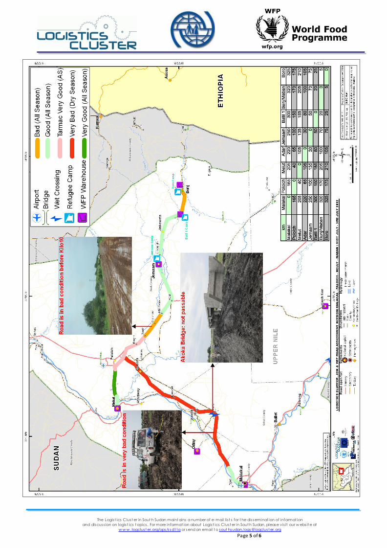
MALAKAL - PALOICH - MELUT – JEMAAM - BUNJ ROAD ASSESSMENT MISSION
Date(s): 01 July – 03 July, 2012
Location(s): Malakal-Poloich – Melut –Jemaam-Bunj
Participating Agencies Logistics Cluster Republic of South Sudan (RoSS), and WFP Ethiopia
Participant (s) Venkat Dheeravath (Logistics Cluster), Allan Busiinge (WFP), Robert Gordon (WFP), William Benjamine (IOM), and Thurbit Beil (IOM)
Security: Level 3
1 MISSION OBECTIVES 1. Assess, using GPS and SDI-T tools, Malakal – Paloich – Melut – Jemaam – Bunj road sections for humanitarian access to Maban County. This assessment aims to ensure that cri tical access corridors and constraints are identified to support humanitarian providers operating during the current emergency in Upper Nile State.
2. Identify the exact stretches of damaged roads, bridges, and culverts to repair and understand better the access for returnees ,
refugees , Common Transport Service (CTS) and for a l l of the humanitarian community.
3. Assess the poss ibi l i ty of us ing Melut – Jemaam/Bunj road corridor from Melut port.
4. Assess the river port capaci ty at Melut.
2 Brief
During the rainy season which lasts from May to December, several key road corridors to and within Upper Nile State in the Republic of South Sudan (RoSS) become severely impeded, limiting access to humanitarian emergency response. Currently, there i s an emergency operation taking place in Upper Nile State impacting the lives of over 113 thousand refugees in Upper Nile and
dozens of NGO/UN agencies responding. Overa l l, the key access corridors from Malakal-Melut are in poor condition and need rehabilitation to remain open during the
ra iny season. Additionally, the Melut to Bunj road is gravel and tarmac for approximately 70 km, however the final 30 km int o Bunj i s in very poor condition and will need constant maintenance to support humanitarian cargo movements during the ra iny season.
The mission team explored the possibility of using Melut Port for shipping. The Melut Port is accessible for small and large boats/barges, during all seasons. The challenge foreseen is the pre-positioning of heavy trucks at the port in order to proceed to Bunj following a three-day period of no ra ins (the last 30 km of road are currently in very poor condition). Finally, during the last days of the assessment mission the team visited Paloich Airport.
3 Summary of Findings/Recommendations/Observations
Malakal to Melut:
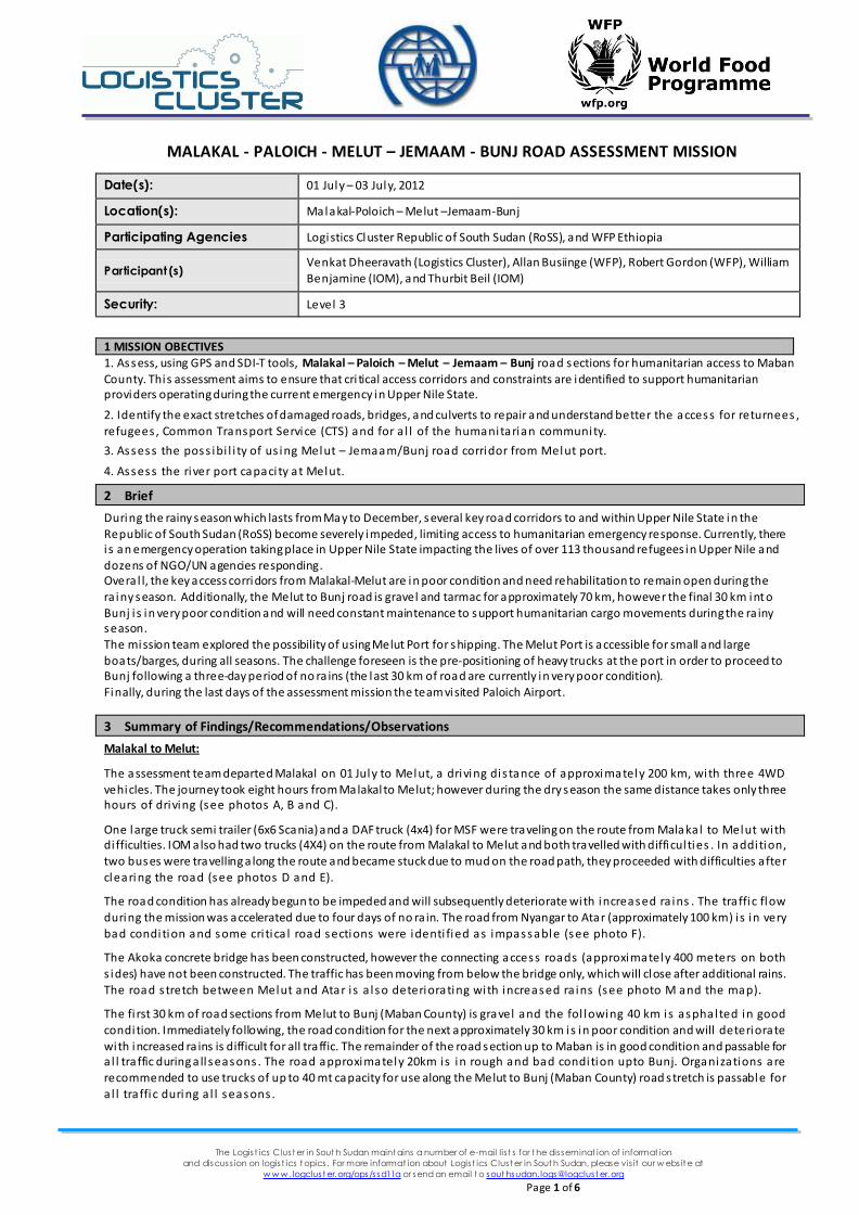
The assessment team departed Malakal on 01 July to Melut, a driving dis tance of approxi mately 200 km, with three 4WD vehicles. The journey took eight hours from Malakal to Melut; however during the dry season the same distance takes only three hours of driving (see photos A, B and C).
One large truck semi trailer (6x6 Scania) and a DAF truck (4x4) for MSF were traveling on the route from Malakal to Melut with di fficulties. IOM also had two trucks (4X4) on the route from Malakal to Melut and both travelled with difficul ties . In addition, two buses were travelling a long the route and became stuck due to mud on the road path, they proceeded with difficulties after clearing the road (see photos D and E).
The road condition has already begun to be impeded and will subsequently deteriorate with increased ra ins . The traffic flow during the mission was accelerated due to four days of no ra in. The road from Nyangar to Atar (approximately 100 km) i s in very
bad condition and some cri tica l road sections were identi fied as impassable (see photo F).
The Akoka concrete bridge has been constructed, however the connecting access roads (approximately 400 meters on both
s ides) have not been constructed. The traffic has been moving from below the bridge only, which will close after additional rains. The road s tretch between Melut and Atar i s a lso deteriorating with increased ra ins (see photo M and the map).
The fi rst 30 km of road sections from Melut to Bunj (Maban County) is gravel and the fol lowing 40 km is asphalted in good
condition. Immediately following, the road condition for the next approximately 30 km is in poor condition and will deteriorate
with increased ra ins is difficult for all traffic. The remainder of the road section up to Maban is in good condition and passable for a l l traffic during a ll seasons . The road approximately 20km is in rough and bad condition upto Bunj. Organizations are recommended to use trucks of up to 40 mt capacity for use along the Melut to Bunj (Maban County) road s tretch is passable for
a l l traffic during a l l seasons .
The Logis t ics Clust er in Sout h Sudan maint ains a number of e-mail lis t s for t he disseminat ion of informat ion
and discuss ion on logis t ics t opics . For more informat ion about Logis t ics Clust er in Sout h Sudan, please vis it our w ebs it e at
w w w .logclust er.org/ops/ssd11a or send an email t o sout hsudan.logs@logclust er.org
Page 2 of 6
A. Malakal - Akoka Road (in Bad condition) B. Malakal - Akoka Road (in Bad condition)
C. Malakal - Akoka Road (in Bad condition) D. Truck with difficulties
E. Buses struck at before Akoka F. Cars struck before Atar
The Logis t ics Clust er in Sout h Sudan maint ains a number of e-mail lis t s for t he disseminat ion of informat ion
and discuss ion on logis t ics t opics . For more informat ion about Logis t ics Clust er in Sout h Sudan, please vis it our w ebs it e at
w w w .logclust er.org/ops/ssd11a or send an email t o sout hsudan.logs@logclust er.org
Page 3 of 6
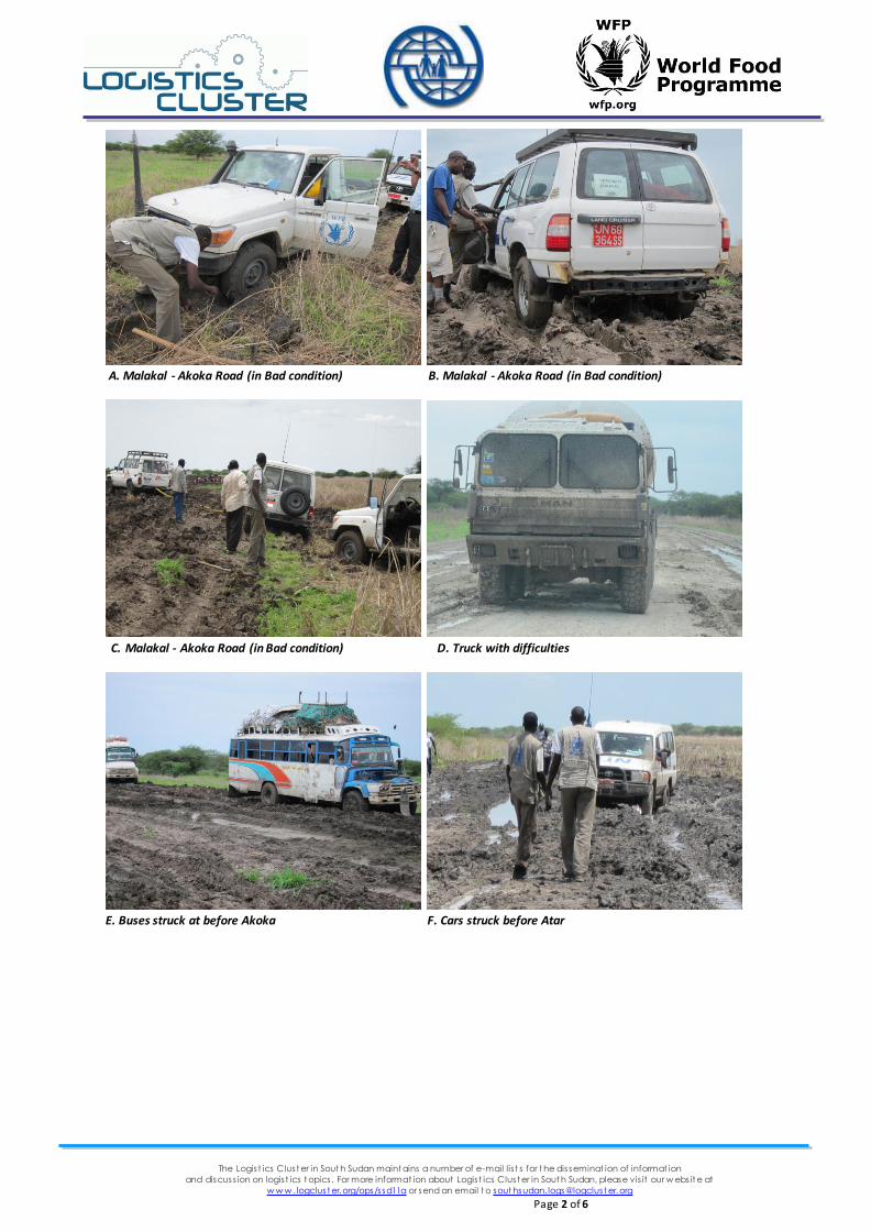
Melut Port:
There are three port locations used by barge and boat operators for off-loading goods from Malakal and Renk. The first port area i s gravel, feasible for usage of barges and boats during all seasons. The other two port locations are not usable during rains as one is inaccessible due to its proximity to a local market and the other is inaccessible during the rains due to an inadequate
access road. Melut County Commissioner indicated that the Logistics Cluster and other organisations are permitted to utilise the port for humanitarian operations (see photos F, G, H, I , J).
G. Port – Site1 location is in good condition F. Port – Site1 location is in good condition
H. Port – Site2 location not usable I. Port – Site3 location not usable
The Logis t ics Clust er in Sout h Sudan maint ains a number of e-mail lis t s for t he disseminat ion of informat ion
and discuss ion on logis t ics t opics . For more informat ion about Logis t ics Clust er in Sout h Sudan, please vis it our w ebs it e at
w w w .logclust er.org/ops/ssd11a or send an email t o sout hsudan.logs@logclust er.org
Page 4 of 6
Paloich Airport:
The Paloich airport is a ll weather (asphalt) and can be used for chartered flights. The County Commissioner of Melut advised
operators to ask for clearance from relevant Government authorities prior to landing. The Commissioner confirmed his
wi l lingness to assist organisations should there be need for use of the airport for humanitarian operations.
Recommendations:
Jemam refugee settlement is currently estimated to be holding 32,000 refugees. The site is prone to flooding thus pla ns to establ ish a l ternate camps (Yusuf Bati l 1 and 2) are being discussed.
Only s pecia l i sed trucks of 6x6 should be deployed on the route from Malakal to Melut.
With deteriorating road conditions from Malakal to Melut, truck payload capacity should be limited to 20-25 mt and passable only after four dry days , with di fficul ties .
Smal ler trucks from Malakal to Melut should not be used.
Extens ion of fl ight services to Pa loich Airport should be explored. The region does not have fuel reserves in either Melut County or Maban County. The assessment mission recommends that
fuel s tocks be pos i tioned in Melut to serve Maban ’ cri tica l urgent fuel requirements .
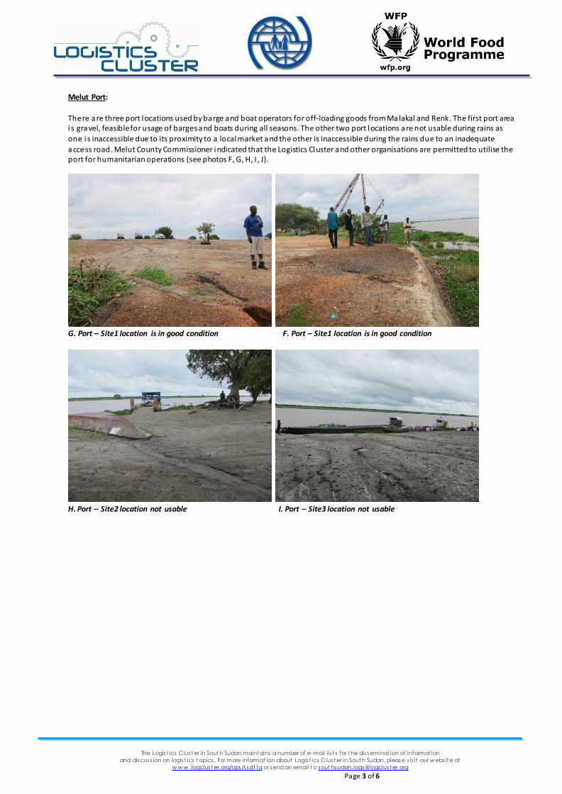
A transhipment point in Melut should be established with adequate transport capaci ty to move necessary humanitarian cargo, especially food stocks, to Maban. One Mobile Storage Unit (MSU, 500 mt capacity) belonging to UNHCR is currently located 300 m from the river bank, however i t i s not access ible by l ight vehicles (see photos K, L)
One additional MSU would be needed for handling s torage space requirements in Melut for transit cargo awaiting dry road conditions .
Upper Nile based commercial transporters have agreed to deploy trucks from Renk to Melut to provide transport capaci ty from Melut to Maban County.
The WFP Logistics Unit in Juba is deploying 12 6x6 trucks to Melut via Malakal. The trucks wil l augment transport capaci ty from Melut to Maban County.
Other Findings: Weather: heavy ra in was reported during the field miss ion in Melut on 01 July 2012.
Water and electrici ty 24 X 7 were suppl ied by PetroDAR (oi l company).
FAR, OXFARM GB, UNMISS, SIM, and IMA are currently operating in Melut. UNMISS ha s one hel i copter landing zone within their compound.
The assessment mission met with SINO HYDRO Construction Company. Embankment work has been completed included widening and raising the road approximately 345 km from Malakal to Renk. Current operations have been suspended unti l
further notice due to a lack of funds .
J. Port – Site2 location not feasible K. Port – Site3 location not feasible
L. UNHCR Rubhall access road M. Akoka Bridge Access road
The Logis t ics Clust er in Sout h Sudan maint ains a number of e-mail lis t s for t he disseminat ion of informat ion
and discuss ion on logis t ics t opics . For more informat ion about Logis t ics Clust er in Sout h Sudan, please vis it our w ebs it e at
w w w .logclust er.org/ops/ssd11a or send an email t o sout hsudan.logs@logclust er.org
Page 5 of 6
The Logis t ics Clust er in Sout h Sudan maint ains a number of e-mail lis t s for t he disseminat ion of informat ion
and discuss ion on logis t ics t opics . For more informat ion about Logis t ics Clust er in Sout h Sudan, please vis it our w ebs it e at
w w w .logclust er.org/ops/ssd11a or send an email t o sout hsudan.logs@logclust er.org
Page 6 of 6
Contacts:
Website: http://www.logcluster.org/ops/ssd11a
General Email: [email protected]
Logistics Cluster, South Sudan
Peta Barnes Katherine Ely Jeppe Andersen Venkat Dheeravath
Andrew Jackson
Logistics Cluster Coordinator Logistics Cluster Information Management Officer Logistics Officer Logistics Cluster GIS Officer
Logistics Officer
[email protected] [email protected] [email protected] [email protected]
Mission Participants
Allan Busiinge Robert Gordon William Benjamine
Logistics Officer (WFP RoSS) Logistics Officer (WFP RoSS/Malakal) Logistics Officer (IOM RoSS/Malakal)