Embed Size (px)
Citation preview

pa
rkn
ote
s
For more information call the Parks Victoria Information Centre on 13 1963 or visit our website at www.parks.vic.gov.au
Healthy Parks Healthy People
Visiting a park can improve your health, mind, body and
soul. So, with over four million hectares of parkland available to Victorians, why not escape
to a park today!
A haven for plants... Many plants common in the coastal vegetation of New South Wales have their most southerly occurrence in the eastern corner of Victoria. The small pockets of warm temperate rainforest, usually found in wet, shaded gullies, are dominated by Lillypilly, Kanooka and Sweet Pittosporum. From the canopy of these trees, the delicate flowers of the Clematis vines can be seen during spring. Orchids and ferns growing on the trunks and branches of large trees are another feature of the rainforest. The rainforest is usually surrounded by a fringe of tall Mountain Grey Gum forest which has a dense scrubby understorey of tree daisy and native grasses.
Open eucalypt forests cover most of the slopes and ridges around Mallacoota. Around the Inlet the most common trees are Bloodwood and Angophora. Farther away from the coast, Silvertop, White and Yellow Stringybarks become the dominant trees. Some of the easier to recognise shrub-layer plants include Banksia, Geebung and Wattles. The diverse ground layer species create a beautiful display during spring featuring Common Heath, Purple Flags and Chocolate Lilies.
From late winter to early summer the coastal heathlands are ablaze with colour. In this harsh environment some of the plants which dominate are the Grass Tree, Scrub She-oak, Prickly Teatree and Pink Swamp Heath. Many small but fascinating orchids can be seen in the heaths and forests from mid winter to mid spring.
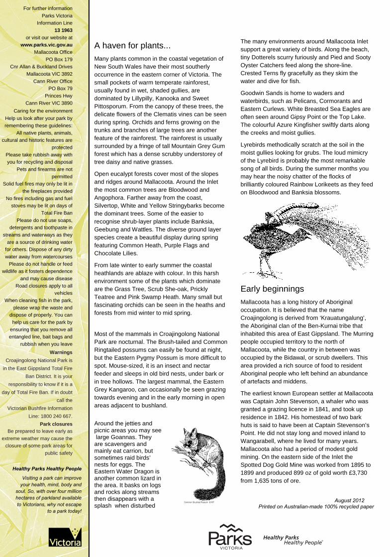
Most of the mammals in Croajingolong National Park are nocturnal. The Brush-tailed and Common Ringtailed possums can easily be found at night, but the Eastern Pygmy Possum is more difficult to spot. Mouse-sized, it is an insect and nectar feeder and sleeps in old bird nests, under bark or in tree hollows. The largest mammal, the Eastern Grey Kangaroo, can occasionally be seen grazing towards evening and in the early morning in open areas adjacent to bushland.
Around the jetties and picnic areas you may see large Goannas. They are scavengers and mainly eat carrion, but sometimes raid birds’ nests for eggs. The Eastern Water Dragon is another common lizard in the area. It basks on logs and rocks along streams then disappears with a splash when disturbed
Croajingolong National Park
Mallacoota Inlet Visitor Guide The coastal township of Mallacoota is surrounded by Croajingolong National Park, with
breathtaking views, sandy beaches, colourful heathlands, tall eucalypt forests and small
pockets of ancient rainforest. A popular holiday destination, Mallacoota Inlet provides many
opportunities for boating, fishing, walking, picnics and a variety of other outdoor activities. Location and access Mallacoota is located in Far East Gippsland and surrounded by Croajingolong National Park. You can access the town and the Inlet from the Princes Hwy at Genoa not far from the NSW border.
Things to see and do Picnicking There are picnic facilities at various locations around Mallacoota Inlet, some of which are only accessible by boat. Free gas barbeques are provided at Gravelly Point, Captain Creek and Cape Horn picnic areas. Minimal firewood is provided at other picnic sites around the Inlet. Fresh water is not available at these sites so bring as much as you will need for the day. Picnic areas are also provided on the picturesque Betka River, at Betka Beach and at Double Creek at the commencement of the nature trail. Rubbish bins are not provided at any of these locations so please take your rubbish away with you.
Snorkelling There are some fantastic opportunities to explore the underwater world around Mallacoota. The rocks off Bastion Point and Quarry Beach feature an amazing array of seaweed that is home to numerous marine creatures.
Camping Camping is not permitted around the Mallacoota Inlet, but there are campsites in Croajingolong National Park and the Mallacoota Township.
Canoeing The Mallacoota Inlet and the lower sections of the Betka, Genoa and Wallagaraugh Rivers are ideal for canoeing.
Boating There are many spectacular areas around the Mallacoota Inlet and along the Wallagaraugh and Genoa Rivers which can be explored by boat. There are launching ramps at Karbeethong, Mallacoota and Gipsy Point, with an effluent disposal facility located at the Karbeethong Public Jetty.
When boating, steer clear of sand bars, particularly in the Bottom Lake. It is generally advisable to use the main channels as detailed on the enclosed map. The islands located in the Mallacoota Inlet are utilised as nesting sites by coastal and wading birds. In order to provide safe and undisturbed nesting habitat, please do not land on the islands between October and February.
Make sure your vessel is seaworthy and you are carrying all the required safety gear. Let someone know where you are going.
Fishing Fishing is permitted within the Croajingolong National Park excluding Marine National Parks. A number of different surf and estuary fish species may be caught. Please note spear fishing is prohibited in the Mallacoota Lakes.
A Victorian Recreational Fishing Licence is required to fish in all Victorian waters.
For further information Parks Victoria
Information Line 13 1963
or visit our website at www.parks.vic.gov.au
Mallacoota Office PO Box 179
Cnr Allan & Buckland Drives Mallacoota VIC 3892
Cann River Office PO Box 79
Princes Hwy Cann River VIC 3890
Caring for the environment Help us look after your park by remembering these guidelines:
All native plants, animals, cultural and historic features are
protected Please take rubbish away with you for recycling and disposal
Pets and firearms are not permitted
Solid fuel fires may only be lit in the fireplaces provided
No fires including gas and fuel stoves may be lit on days of
Total Fire Ban Please do not use soaps,
detergents and toothpaste in streams and waterways as they
are a source of drinking water for others. Dispose of any dirty water away from watercourses
Please do not handle or feed wildlife as it fosters dependence
and may cause disease Road closures apply to all
vehicles When cleaning fish in the park,
please wrap the waste and dispose of properly. You can
help us care for the park by ensuring that you remove all entangled line, bait bags and
rubbish when you leave Warnings
Croajingolong National Park is in the East Gippsland Total Fire
Ban District. It is your responsibility to know if it is a
day of Total Fire Ban. If in doubt call the
Victorian Bushfire Information Line: 1800 240 667.
Park closures Be prepared to leave early as
extreme weather may cause the closure of some park areas for
public safety
The many environments around Mallacoota Inlet support a great variety of birds. Along the beach, tiny Dotterels scurry furiously and Pied and Sooty Oyster Catchers feed along the shore-line. Crested Terns fly gracefully as they skim the water and dive for fish.
Goodwin Sands is home to waders and waterbirds, such as Pelicans, Cormorants and Eastern Curlews. White Breasted Sea Eagles are often seen around Gipsy Point or the Top Lake. The colourful Azure Kingfisher swiftly darts along the creeks and moist gullies.
Lyrebirds methodically scratch at the soil in the moist gullies looking for grubs. The loud mimicry of the Lyrebird is probably the most remarkable song of all birds. During the summer months you may hear the noisy chatter of the flocks of brilliantly coloured Rainbow Lorikeets as they feed on Bloodwood and Banksia blossoms.
Early beginnings Mallacoota has a long history of Aboriginal occupation. It is believed that the name Croajingolong is derived from ‘Krauatungalung’, the Aboriginal clan of the Ben-Kurnai tribe that inhabited this area of East Gippsland. The Murring people occupied territory to the north of Mallacoota, while the country in between was occupied by the Bidawal, or scrub dwellers. This area provided a rich source of food to resident Aboriginal people who left behind an abundance of artefacts and middens.
The earliest known European settler at Mallacoota was Captain John Stevenson, a whaler who was granted a grazing licence in 1841, and took up residence in 1842. His homestead of two bark huts is said to have been at Captain Stevenson’s Point. He did not stay long and moved inland to Wangarabell, where he lived for many years. Mallacoota also had a period of modest gold mining. On the eastern side of the Inlet the Spotted Dog Gold Mine was worked from 1895 to 1899 and produced 899 oz of gold worth £3,730 from 1,635 tons of ore.
November 2011
Printed on Australian-made 100% recycled paper
pa
rkn
ote
s
For more information call the Parks Victoria Information Centre on 13 1963 or visit our website at www.parks.vic.gov.au
Healthy Parks Healthy People
Visiting a park can improve your health, mind, body and
soul. So, with over four million hectares of parkland available to Victorians, why not escape
to a park today!
A haven for plants... Many plants common in the coastal vegetation of New South Wales have their most southerly occurrence in the eastern corner of Victoria. The small pockets of warm temperate rainforest, usually found in wet, shaded gullies, are dominated by Lillypilly, Kanooka and Sweet Pittosporum. From the canopy of these trees, the delicate flowers of the Clematis vines can be seen during spring. Orchids and ferns growing on the trunks and branches of large trees are another feature of the rainforest. The rainforest is usually surrounded by a fringe of tall Mountain Grey Gum forest which has a dense scrubby understorey of tree daisy and native grasses.
Open eucalypt forests cover most of the slopes and ridges around Mallacoota. Around the Inlet the most common trees are Bloodwood and Angophora. Farther away from the coast, Silvertop, White and Yellow Stringybarks become the dominant trees. Some of the easier to recognise shrub-layer plants include Banksia, Geebung and Wattles. The diverse ground layer species create a beautiful display during spring featuring Common Heath, Purple Flags and Chocolate Lilies.
From late winter to early summer the coastal heathlands are ablaze with colour. In this harsh environment some of the plants which dominate are the Grass Tree, Scrub She-oak, Prickly Teatree and Pink Swamp Heath. Many small but fascinating orchids can be seen in the heaths and forests from mid winter to mid spring.
Most of the mammals in Croajingolong National Park are nocturnal. The Brush-tailed and Common Ringtailed possums can easily be found at night, but the Eastern Pygmy Possum is more difficult to spot. Mouse-sized, it is an insect and nectar feeder and sleeps in old bird nests, under bark or in tree hollows. The largest mammal, the Eastern Grey Kangaroo, can occasionally be seen grazing towards evening and in the early morning in open areas adjacent to bushland.
Around the jetties and picnic areas you may see large Goannas. They are scavengers and mainly eat carrion, but sometimes raid birds’ nests for eggs. The Eastern Water Dragon is another common lizard in the area. It basks on logs and rocks along streams then disappears with a splash when disturbed
Croajingolong National Park
Mallacoota Inlet Visitor Guide The coastal township of Mallacoota is surrounded by Croajingolong National Park, with
breathtaking views, sandy beaches, colourful heathlands, tall eucalypt forests and small
pockets of ancient rainforest. A popular holiday destination, Mallacoota Inlet provides many
opportunities for boating, fishing, walking, picnics and a variety of other outdoor activities. Location and access Mallacoota is located in Far East Gippsland and surrounded by Croajingolong National Park. You can access the town and the Inlet from the Princes Hwy at Genoa not far from the NSW border.
Things to see and do Picnicking There are picnic facilities at various locations around Mallacoota Inlet, some of which are only accessible by boat. Free gas barbeques are provided at Gravelly Point, Captain Creek and Cape Horn picnic areas. Minimal firewood is provided at other picnic sites around the Inlet. Fresh water is not available at these sites so bring as much as you will need for the day. Picnic areas are also provided on the picturesque Betka River, at Betka Beach and at Double Creek at the commencement of the nature trail. Rubbish bins are not provided at any of these locations so please take your rubbish away with you.
Snorkelling There are some fantastic opportunities to explore the underwater world around Mallacoota. The rocks off Bastion Point and Quarry Beach feature an amazing array of seaweed that is home to numerous marine creatures.
Camping Camping is not permitted around the Mallacoota Inlet, but there are campsites in Croajingolong National Park and the Mallacoota Township.
Canoeing The Mallacoota Inlet and the lower sections of the Betka, Genoa and Wallagaraugh Rivers are ideal for canoeing.
Boating There are many spectacular areas around the Mallacoota Inlet and along the Wallagaraugh and Genoa Rivers which can be explored by boat. There are launching ramps at Karbeethong, Mallacoota and Gipsy Point, with an effluent disposal facility located at the Karbeethong Public Jetty.
When boating, steer clear of sand bars, particularly in the Bottom Lake. It is generally advisable to use the main channels as detailed on the enclosed map. The islands located in the Mallacoota Inlet are utilised as nesting sites by coastal and wading birds. In order to provide safe and undisturbed nesting habitat, please do not land on the islands between October and February.
Make sure your vessel is seaworthy and you are carrying all the required safety gear. Let someone know where you are going.
Fishing Fishing is permitted within the Croajingolong National Park excluding Marine National Parks. A number of different surf and estuary fish species may be caught. Please note spear fishing is prohibited in the Mallacoota Lakes.
A Victorian Recreational Fishing Licence is required to fish in all Victorian waters.
For further information Parks Victoria
Information Line 13 1963
or visit our website at www.parks.vic.gov.au
Mallacoota Office PO Box 179
Cnr Allan & Buckland Drives Mallacoota VIC 3892
Cann River Office PO Box 79
Princes Hwy Cann River VIC 3890
Caring for the environment Help us look after your park by remembering these guidelines:
All native plants, animals, cultural and historic features are
protected Please take rubbish away with you for recycling and disposal
Pets and firearms are not permitted
Solid fuel fires may only be lit in the fireplaces provided
No fires including gas and fuel stoves may be lit on days of
Total Fire Ban Please do not use soaps,
detergents and toothpaste in streams and waterways as they
are a source of drinking water for others. Dispose of any dirty water away from watercourses
Please do not handle or feed wildlife as it fosters dependence
and may cause disease Road closures apply to all
vehicles When cleaning fish in the park,
please wrap the waste and dispose of properly. You can
help us care for the park by ensuring that you remove all entangled line, bait bags and
rubbish when you leave Warnings
Croajingolong National Park is in the East Gippsland Total Fire
Ban District. It is your responsibility to know if it is a
day of Total Fire Ban. If in doubt call the
Victorian Bushfire Information Line: 1800 240 667.
Park closures Be prepared to leave early as
extreme weather may cause the closure of some park areas for
public safety
The many environments around Mallacoota Inlet support a great variety of birds. Along the beach, tiny Dotterels scurry furiously and Pied and Sooty Oyster Catchers feed along the shore-line. Crested Terns fly gracefully as they skim the water and dive for fish.
Goodwin Sands is home to waders and waterbirds, such as Pelicans, Cormorants and Eastern Curlews. White Breasted Sea Eagles are often seen around Gipsy Point or the Top Lake. The colourful Azure Kingfisher swiftly darts along the creeks and moist gullies.
Lyrebirds methodically scratch at the soil in the moist gullies looking for grubs. The loud mimicry of the Lyrebird is probably the most remarkable song of all birds. During the summer months you may hear the noisy chatter of the flocks of brilliantly coloured Rainbow Lorikeets as they feed on Bloodwood and Banksia blossoms.
Early beginnings Mallacoota has a long history of Aboriginal occupation. It is believed that the name Croajingolong is derived from ‘Krauatungalung’, the Aboriginal clan of the Ben-Kurnai tribe that inhabited this area of East Gippsland. The Murring people occupied territory to the north of Mallacoota, while the country in between was occupied by the Bidawal, or scrub dwellers. This area provided a rich source of food to resident Aboriginal people who left behind an abundance of artefacts and middens.
The earliest known European settler at Mallacoota was Captain John Stevenson, a whaler who was granted a grazing licence in 1841, and took up residence in 1842. His homestead of two bark huts is said to have been at Captain Stevenson’s Point. He did not stay long and moved inland to Wangarabell, where he lived for many years. Mallacoota also had a period of modest gold mining. On the eastern side of the Inlet the Spotted Dog Gold Mine was worked from 1895 to 1899 and produced 899 oz of gold worth £3,730 from 1,635 tons of ore.
August 2012
Printed on Australian-made 100% recycled paper
WallagaraughRiver
ColemanInlet
FAIRHAVEN LINK ROADcAPE H ORN
TR
AC
KGipsyPoint
Genoa River
Cape Horn Bay
Cape Horn
MuddyInlet
GEN O AFT
Genoa River
Coolwater Creek
Lyrebird Point
SmelliesInlet
SOU WEST
ARM TR ACK
Sword Grass CkSANDY PT. TK.
Sou West Arm
Palmers Bank Jimmy PtGoanna Bay
McKenzieBight
Point to PointBight
Dead Finish
Gravelly Point
Campshot Point
TOP LAKE
QuambyPoint
The BigBight
Centre ShotTop Shot
Doub le
Creek
Cha
rlie
sC
reek
C
AP
TA
INC
RE
EK
TR
AC
K
GENOA TO MALLACOOTAROAD
FA
IRH
AV
ENROAD
Teal Creek
NEWB
INN
SR
OA
D
DU
KE
TR
AC
K
LA
KE
VIE
WT
RA
CK
BARRACOOTA TRACK
HOWE FLAT TRACK
KARBEETHONG
ROAD
CaptainC
k
Mullet Creek
ShadyGully
DavisCreek
Double Creek
Arm TheNarrows
Snapper Pt
BakersBight
EightFootBank
Maxwell Pt
RefugeCove
Swimming Pt
Goodwin Sands
Lakeview
Kingfish Pt
Dorron Bight
BOTTOM LAKE
BrownPoint
Allan Head
Tatum Pt
Kangaroo PtLeesBluff
Cemetery Bight
DahlBank
Spotted Dog Mine
Pioneers Cemetery
OriginalHotel Site
Howe Creek
Howe Bight
Tea Tree Pt
RobertsonBank
Stingray Pt
Rabbit Is.
Fisheries Pt.Horse Is.
Goat Is.
Cpt. Stevensons Pt
Entrance
BETKA
RD
AE
RO
DR
O
ME
TK
OLD
CO
AS
TR
D
CE
NT
RE
TR
AC
K
Bastion Pt.
Betka Beach
Quarry Beach
Secret Beach
Pebbly Beach
Mallacoota
Sandy Point
Captain Creek
TullabergaIsland
to Genoa
Double CreekNature Walkand Picnic Area
BucklandsJetty
PrivateProperty
PrivatePropertyLittle
River
KarbeethongJetty
MallacootaTown Walk
Tip Beach
Picnic Area
MallacootaAirstrip
to Shipwreck CreekCampground
The Narrows
Davis CreekBeach
Old Coast Road Walking Track
CHARLIESCREE K TK
Genoa
Mallacoota
Shipwreck Creek
Croajingolong
National
Park
PRINCES
HIG
HW
AY
Highway
Major road
Minor/unsealed road
Vehicle track
Walking track
Main boating channel
Navigation marker
Croajingolong NationalPark
Cape Howe Wilderness
Sandbank / shallow water
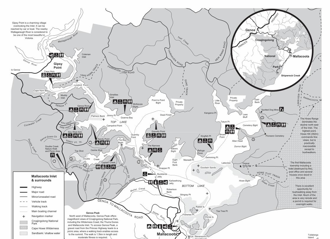
Mallacoota Inlet& surrounds
Recreational Facilities
Boatramp
Campground/caravan park
Gas BBQ
Fireplace
Jetty
Lookout
Picnic area
Self guided walk
Toilets
Walk ID number
N
0 0.5 1.0
KILOMETRES
Cartography by Nature TourismServices 10/11
MELBOURNE
Gipsy Point is a charming villageoverlooking the Inlet. It can be
reached by car or boat. The nearbyWallagaraugh River is considered to
be one of the most beautiful inVictoria.
The Howe Rangedominates the
skyline north eastof the Inlet. Thehighest point,
Howe Hill (392m)commands fine
views, but ispractically
inaccessibleexcept to
bushwalkers.
The first Mallacootatownship including a
hotel (destroyed by fire),post office and severalhouses once stood in
this area
There is excellentopportunity for
bushwalking away fromthe Inlet. Much of the
area is very remote anda permit is required for
overnight walks.
The islands in the Mallacoota Inlet and TullabergaIsland are included in Croajingolong NationalPark. The Goodwin Sands are a haven for manywaterbirds and migrating waders. The low lyingsands are also a breeding area for theendangered Little Tern. Please avoid disturbingor encroaching on these areas.
The entrance to the Inlet is very shallowand narrow and considerable care andlocal knowledge are necessary tonegotiate it by boat.
Mallacoota Inlet was formed by the drowning ofthe Genoa River valley when sea levels rose atthe end of the last ice age. It has been estimatedthat 25,000 years ago sea levels were 140 metresbelow present levels and that 7,000 years agothey were 10 metres below this level.
Mallacoota: although its permanent population isonly 1,200, Mallacoota boasts a wide range ofservices and facilities. There are restaurants,shops, garages, a hotel, airstrip and police andambulance stations. Bait and fishing gear can bepurchased and there is a boat repair service.
Boating safety: There is a 5 knot speed limit inthe channel between Captain Point and RabbitIsland and from 500m south east of Gipsy Pointupstream. There is also a 5 knot speed limitwithin 50 metres of any jetty, boat launchingramp or recognised landing place.
Waterskiing: is allowed in all areas not restricted under thespeed restriction guidelines but the preferred locations areCemetery Bight and Dead Finish (Gravelly Point). Rememberyou may not waterski within 50 metres of any jetty, vesselor people swimming. You may not approach within 100metres of a vessel or buoy showing flag ‘A’ when towing awaterskier.
Genoa PeakNorth west of Mallacoota, Genoa Peak offers
magnificent views of Croajingolong National Park,including the Wilderness Coast, the Thurra Dunesand Mallacoota Inlet. To access Genoa Peak, agravel road from the Princes Highway leads to apicnic area, where a walking track enables accessto the summit. The walk is 1.5km in length and
moderate fitness is required.
1 2
3
4
5
6
87
3
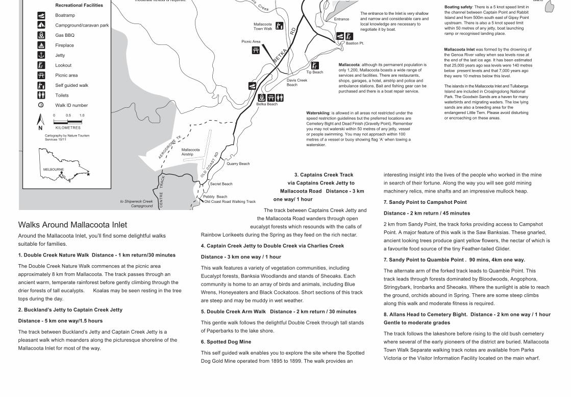
Walks Around Mallacoota Inlet Around the Mallacoota Inlet, you’ll find some delightful walks
suitable for families.
1. Double Creek Nature Walk Distance - 1 km return/30 minutes
The Double Creek Nature Walk commences at the picnic area
approximately 8 km from Mallacoota. The track passes through an
ancient warm, temperate rainforest before gently climbing through the
drier forests of tall eucalypts. Koalas may be seen resting in the tree
tops during the day.
2. Buckland’s Jetty to Captain Creek Jetty
Distance - 5 km one way/1.5 hours
The track between Buckland’s Jetty and Captain Creek Jetty is a
pleasant walk which meanders along the picturesque shoreline of the
Mallacoota Inlet for most of the way.
3. Captains Creek Track via Captains Creek Jetty to
Mallacoota Road Distance - 3 km one way/ 1 hour
The track between Captains Creek Jetty and
the Mallacoota Road wanders through open
eucalypt forests which resounds with the calls of
Rainbow Lorikeets during the Spring as they feed on the rich nectar.
4. Captain Creek Jetty to Double Creek via Charlies Creek
Distance - 3 km one way / 1 hour
This walk features a variety of vegetation communities, including
Eucalypt forests, Banksia Woodlands and stands of Sheoaks. Each
community is home to an array of birds and animals, including Blue
Wrens, Honeyeaters and Black Cockatoos. Short sections of this track
are steep and may be muddy in wet weather.
5. Double Creek Arm Walk Distance - 2 km return / 30 minutes
This gentle walk follows the delightful Double Creek through tall stands
of Paperbarks to the lake shore.
6. Spotted Dog Mine
This self guided walk enables you to explore the site where the Spotted
Dog Gold Mine operated from 1895 to 1899. The walk provides an
interesting insight into the lives of the people who worked in the mine
in search of their fortune. Along the way you will see gold mining
machinery relics, mine shafts and an impressive mullock heap.
7. Sandy Point to Campshot Point
Distance - 2 km return / 45 minutes
2 km from Sandy Point, the track forks providing access to Campshot
Point. A major feature of this walk is the Saw Banksias. These gnarled,
ancient looking trees produce giant yellow flowers, the nectar of which is
a favourite food source of the tiny Feather-tailed Glider.
7. Sandy Point to Quambie Point . 90 mins, 4km one way.
The alternate arm of the forked track leads to Quambie Point. This
track leads through forests dominated by Bloodwoods, Angophora,
Stringybark, Ironbarks and Sheoaks. Where the sunlight is able to reach
the ground, orchids abound in Spring. There are some steep climbs
along this walk and moderate fitness is required.
8. Allans Head to Cemetery Bight. Distance - 2 km one way / 1 hour Gentle to moderate grades
The track follows the lakeshore before rising to the old bush cemetery
where several of the early pioneers of the district are buried. Mallacoota
Town Walk Separate walking track notes are available from Parks
Victoria or the Visitor Information Facility located on the main wharf.
WallagaraughRiver
ColemanInlet
FAIRHAVEN LINK ROADcAPE H ORN
TR
AC
KGipsyPoint
Genoa River
Cape Horn Bay
Cape Horn
MuddyInlet
GEN O AFT
Genoa River
Coolwater Creek
Lyrebird Point
SmelliesInlet
SOU WEST
ARM TR ACK
Sword Grass CkSANDY PT. TK.
Sou West Arm
Palmers Bank Jimmy PtGoanna Bay
McKenzieBight
Point to PointBight
Dead Finish
Gravelly Point
Campshot Point
TOP LAKE
QuambyPoint
The BigBight
Centre ShotTop Shot
Doub le
Creek
Cha
rlie
sC
reek
C
AP
TA
INC
RE
EK
TR
AC
K
GENOA TO MALLACOOTAROAD
FA
IRH
AV
ENROAD
Teal Creek
NEWB
INN
SR
OA
D
DU
KE
TR
AC
K
LA
KE
VIE
WT
RA
CK
BARRACOOTA TRACK
HOWE FLAT TRACK
KARBEETHONG
ROAD
CaptainC
k
Mullet Creek
ShadyGully
DavisCreek
Double Creek
Arm TheNarrows
Snapper Pt
BakersBight
EightFootBank
Maxwell Pt
RefugeCove
Swimming Pt
Goodwin Sands
Lakeview
Kingfish Pt
Dorron Bight
BOTTOM LAKE
BrownPoint
Allan Head
Tatum Pt
Kangaroo PtLeesBluff
Cemetery Bight
DahlBank
Spotted Dog Mine
Pioneers Cemetery
OriginalHotel Site
Howe Creek
Howe Bight
Tea Tree Pt
RobertsonBank
Stingray Pt
Rabbit Is.
Fisheries Pt.Horse Is.
Goat Is.
Cpt. Stevensons Pt
Entrance
BETKA
RD
AE
RO
DR
O
ME
TK
OLD
CO
AS
TR
D
CE
NT
RE
TR
AC
K
Bastion Pt.
Betka Beach
Quarry Beach
Secret Beach
Pebbly Beach
Mallacoota
Sandy Point
Captain Creek
TullabergaIsland
to Genoa
Double CreekNature Walkand Picnic Area
BucklandsJetty
PrivateProperty
PrivatePropertyLittle
River
KarbeethongJetty
MallacootaTown Walk
Tip Beach
Picnic Area
MallacootaAirstrip
to Shipwreck CreekCampground
The Narrows
Davis CreekBeach
Old Coast Road Walking Track
CHARLIESCREE K TK
Genoa
Mallacoota
Shipwreck Creek
Croajingolong
National
Park
PRINCES
HIG
HW
AY
Highway
Major road
Minor/unsealed road
Vehicle track
Walking track
Main boating channel
Navigation marker
Croajingolong NationalPark
Cape Howe Wilderness
Sandbank / shallow water
Mallacoota Inlet& surrounds
Recreational Facilities
Boatramp
Campground/caravan park
Gas BBQ
Fireplace
Jetty
Lookout
Picnic area
Self guided walk
Toilets
Walk ID number
N
0 0.5 1.0
KILOMETRES
Cartography by Nature TourismServices 10/11
MELBOURNE
Gipsy Point is a charming villageoverlooking the Inlet. It can be
reached by car or boat. The nearbyWallagaraugh River is considered to
be one of the most beautiful inVictoria.
The Howe Rangedominates the
skyline north eastof the Inlet. Thehighest point,
Howe Hill (392m)commands fine
views, but ispractically
inaccessibleexcept to
bushwalkers.
The first Mallacootatownship including a
hotel (destroyed by fire),post office and severalhouses once stood in
this area
There is excellentopportunity for
bushwalking away fromthe Inlet. Much of the
area is very remote anda permit is required for
overnight walks.
The islands in the Mallacoota Inlet and TullabergaIsland are included in Croajingolong NationalPark. The Goodwin Sands are a haven for manywaterbirds and migrating waders. The low lyingsands are also a breeding area for theendangered Little Tern. Please avoid disturbingor encroaching on these areas.
The entrance to the Inlet is very shallowand narrow and considerable care andlocal knowledge are necessary tonegotiate it by boat.
Mallacoota Inlet was formed by the drowning ofthe Genoa River valley when sea levels rose atthe end of the last ice age. It has been estimatedthat 25,000 years ago sea levels were 140 metresbelow present levels and that 7,000 years agothey were 10 metres below this level.
Mallacoota: although its permanent population isonly 1,200, Mallacoota boasts a wide range ofservices and facilities. There are restaurants,shops, garages, a hotel, airstrip and police andambulance stations. Bait and fishing gear can bepurchased and there is a boat repair service.
Boating safety: There is a 5 knot speed limit inthe channel between Captain Point and RabbitIsland and from 500m south east of Gipsy Pointupstream. There is also a 5 knot speed limitwithin 50 metres of any jetty, boat launchingramp or recognised landing place.
Waterskiing: is allowed in all areas not restricted under thespeed restriction guidelines but the preferred locations areCemetery Bight and Dead Finish (Gravelly Point). Rememberyou may not waterski within 50 metres of any jetty, vesselor people swimming. You may not approach within 100metres of a vessel or buoy showing flag ‘A’ when towing awaterskier.
Genoa PeakNorth west of Mallacoota, Genoa Peak offers
magnificent views of Croajingolong National Park,including the Wilderness Coast, the Thurra Dunesand Mallacoota Inlet. To access Genoa Peak, agravel road from the Princes Highway leads to apicnic area, where a walking track enables accessto the summit. The walk is 1.5km in length and
moderate fitness is required.
1 2
3
4
5
6
87
3
Walks Around Mallacoota Inlet Around the Mallacoota Inlet, you’ll find some delightful walks
suitable for families.
1. Double Creek Nature Walk Distance - 1 km return/30 minutes
The Double Creek Nature Walk commences at the picnic area
approximately 8 km from Mallacoota. The track passes through an
ancient warm, temperate rainforest before gently climbing through the
drier forests of tall eucalypts. Koalas may be seen resting in the tree
tops during the day.
2. Buckland’s Jetty to Captain Creek Jetty
Distance - 5 km one way/1.5 hours
The track between Buckland’s Jetty and Captain Creek Jetty is a
pleasant walk which meanders along the picturesque shoreline of the
Mallacoota Inlet for most of the way.
3. Captains Creek Track via Captains Creek Jetty to
Mallacoota Road Distance - 3 km one way/ 1 hour
The track between Captains Creek Jetty and
the Mallacoota Road wanders through open
eucalypt forests which resounds with the calls of
Rainbow Lorikeets during the Spring as they feed on the rich nectar.
4. Captain Creek Jetty to Double Creek via Charlies Creek
Distance - 3 km one way / 1 hour
This walk features a variety of vegetation communities, including
Eucalypt forests, Banksia Woodlands and stands of Sheoaks. Each
community is home to an array of birds and animals, including Blue
Wrens, Honeyeaters and Black Cockatoos. Short sections of this track
are steep and may be muddy in wet weather.
5. Double Creek Arm Walk Distance - 2 km return / 30 minutes
This gentle walk follows the delightful Double Creek through tall stands
of Paperbarks to the lake shore.
6. Spotted Dog Mine
This self guided walk enables you to explore the site where the Spotted
Dog Gold Mine operated from 1895 to 1899. The walk provides an
interesting insight into the lives of the people who worked in the mine
in search of their fortune. Along the way you will see gold mining
machinery relics, mine shafts and an impressive mullock heap.
7. Sandy Point to Campshot Point
Distance - 2 km return / 45 minutes
2 km from Sandy Point, the track forks providing access to Campshot
Point. A major feature of this walk is the Saw Banksias. These gnarled,
ancient looking trees produce giant yellow flowers, the nectar of which is
a favourite food source of the tiny Feather-tailed Glider.
7. Sandy Point to Quambie Point . 90 mins, 4km one way.
The alternate arm of the forked track leads to Quambie Point. This
track leads through forests dominated by Bloodwoods, Angophora,
Stringybark, Ironbarks and Sheoaks. Where the sunlight is able to reach
the ground, orchids abound in Spring. There are some steep climbs
along this walk and moderate fitness is required.
8. Allans Head to Cemetery Bight. Distance - 2 km one way / 1 hour Gentle to moderate grades
The track follows the lakeshore before rising to the old bush cemetery
where several of the early pioneers of the district are buried. Mallacoota
Town Walk Separate walking track notes are available from Parks
Victoria or the Visitor Information Facility located on the main wharf.