Embed Size (px)
Citation preview
Kcpublic of lllc R'hilipl)irles El467
DEIBAIP1'R4ENT OP PUl3II ,lC WOItl<S AND I IIGIlWAY S Ce~ilr:al Office
v 9
for the
MALSEMA HIGHWAY (Mt. Dab - Bontoc SecGian)
August 2006
-- E~wironrrie~~tal and Social Services Office - - -- Ivlanila, Philippines
Pub
lic D
iscl
osur
e A
utho
rized
Pub
lic D
iscl
osur
e A
utho
rized
Pub
lic D
iscl
osur
e A
utho
rized
Pub
lic D
iscl
osur
e A
utho
rized
Pub
lic D
iscl
osur
e A
utho
rized
Pub
lic D
iscl
osur
e A
utho
rized
Pub
lic D
iscl
osur
e A
utho
rized
Pub
lic D
iscl
osur
e A
utho
rized
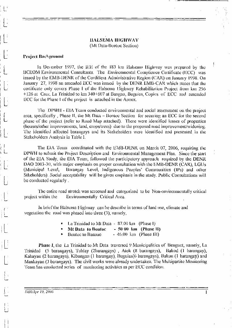
~ILILSEN~LI IlIG IIWAY (Mt Uala-Uonluc Scclio~r)
I Ju De~clllbcs 1997, tlic 1LiE of t l~c 183 1~111 l l a l s c ~ ~ ~ ; ~ Iligll\vay was p~cpa~cd by LIIC
UCEOM Envi1o111i~cnta1 Consulla~~ls. 'I'llc E~~v i ronn~c~~ ta l Conll)liar~ce Ccrlilicalc (1:CC) was issuccl by tlic IlMll-I)ENl< 01' Ihc Cordillc~a Ad~iii~iislrativc Kcgiou (('A]<) oon Januaiy 1998. 011
Jalluary 27, 1998 all a~iic~ldcd ECC was issucd by lhe DEN11 EMU-CAI< whicli :;Lalcs tlial ~ h c c c ~ ~ilicatc urily covers l'llase 1 ul' 1l1c I-lalse~~~a J ligl~way Rcllabililn~ io11 1'1 ojcct li 11111 k111 256 4-126 at CILIL, La 'Trillidad to ltm 340-1 607 a1 l3anga0, Buguias, Copies US ECC and a~ilc~~rlctl ECC for Lllc I'liasc 1 of tlic jjrc?jccl is allacl~ccl ill Lhc Anncx.
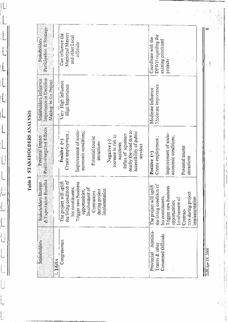
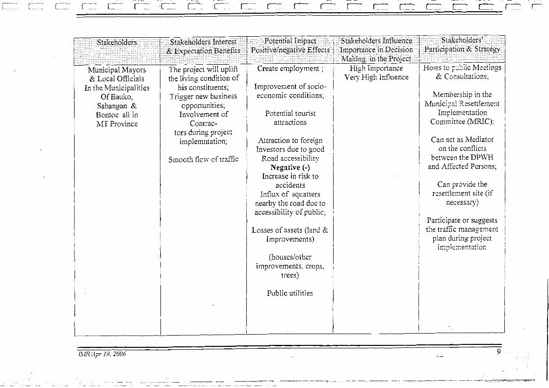
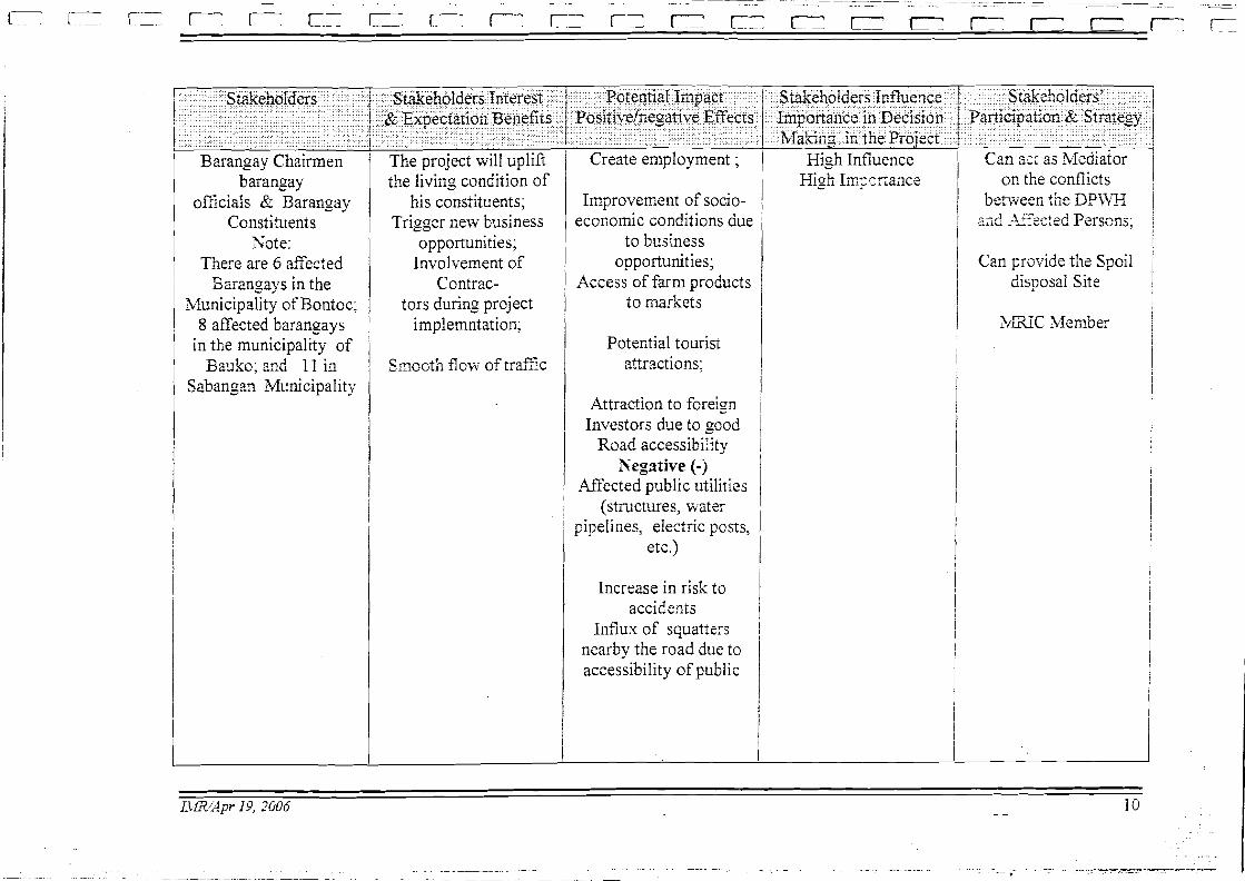
'fl~c Dl'WII - ElA '1'c;un co~lduclecl c r i v i~v~~~ i~c~ i l a l and social assess~rie~~l on tile psojccl nsca, specilically , I'liasc 11, Llle M l Uala - Uoiiloc Seclioli Tor secu~il~g i ln ECC fur Llic seco~ld pliasc of tllc 1)roject (rel'er to 11oad Map allached). 'I'l~crc wcl-e iderililicd lvsscs ol' properlies (I~ouscs/otl~c~ inlprovc~i~c~its, land, c~oys/trccs) duc to lllc proposcd road i~~il)rovc~ncntlwideairii~~g. 'l'110 ide~~tilictl arlkcted barallgays a~id its S~aliclloldc~s welc idc~ltilictl i~nd prcsctilccl ill ~ l ic SLaliclroldcrs 1111alysis il l l'ablc I .
The li1A 'l'can~ coosdinatcd will1 t l~c EnilD-D1lNI< 011 Marr:h 07, 2006, requiring ~ h c DL'WII Lo sub~ilit tlic Projecl Description and E~~v i ro l~ l l~c~~ la l Ma~lagc~llc~il I'lan. Sil~cc tile ~1at.t ol'll~e ElA Sludy, Lllc EIA ?'cam, i'ollowed Lllc j)articipnlo~y ap1)roacll rcquired by thc DENL< DAO 2003-30, will1 major c~npllasis on proper cvilsullalion with \he liMl3-DENR (CAK), LGLJs (Municipal I,cvcl, Barangay Levcl, l~idigc~lous l'coples' Cu~llr~lul~ilics (IPS) and olllcr Stlteholdcrs) Social acceptability will be give11 c~i~pliasis i l l tllc study. I'ublic Collsullatior~s will bc co~lductcd I egularly .
'I'lic cnlirc road slrctcl~ was scrce~lcd alld catcgurizecl to bc Nun-c~iviro~l~uc~it:~Ily crilical psojccl w i t l ~ i ~ ~ lllc E~lviron~nc~llally Critical Arca.
In bricrtl~c k l a l s c~~~a L-ligliway call bc dcscribc in tcrlrls of lalld I lsc, clinlatc and vcgclatiotr tlic road was pl~ascd illlo ~ 1 u . e ~ (3), ~lalnely,
I'liasc 1, tllc La 'I'ritridad to Mt Data traversed 9 Mu~~iciyalitics oC Uerrguct, namely, La 'Trinidad ( 5 barangays), Tublay (2bara11gays) , Atok (8 ba~a~~gays), Uakod (1 1mangay), 1Cabayan (2 barangays), Kibullga~~ (1 barangay), IJ~lguias(6 barangays), Ilaku~i (1 barangay) 2nd Matrkayall (3 barangays). Tllc civil works were already u~ldertakc~l. l'lrc Mullipa~'tite Monilorillg 'Team has concluctcd scries of lno~litori~~g activities as per ECC cundilio~~.
I'llasc 11, M i U:ti:~ - Uo~lioc Seciioll (50.49 k n ~ ) is a pall of' llic 182 k ~ n strelch I 1 s c 1 - 1 i v staled above (1kcli.1 to Road Map, Fig I). 'Tlic road project, Mt Ilata-Bont~jc Scclion will 11-averse tl11.c~ (3) Municipalilies ol' ML f'rovi~~ce, ~lanir:ly, Uonloc, Sabangui, a~ld llnuko. 111 1:ontoc Mu~~icipnlily, 1l1c1.c will bc seven (7) barallgays Lo bc allccted, ~ia~ncly Gonogo~i, I ialili, Alab Oric~~lc, Ila~itay, Llonloc lli a~id UonLoc I'oblacio~i. I n Salpngilri Murricipalily, tlic projcc;l will pass 1111-u lc11 ( 1 0) barat~gays, ~iariicly, Napua, Na~tiatec, Buss, Capinil;~~, (:uuiala~an, Pingad, Losad, Sabailgun I'oblaciun, Nacagas, and l 'n~nbi~~gal~. T11crc !
will be SCVL'II (7) ;~lTce~ecl barangays in Bauko hluoicipalily, lia~~lely, Mt Data, Pnctil, Mouon~on Sur, l,ukib, Sadsadar~, 13anao {uid Maba-ay.
I11 tc~.nis oT Elli~iicily and Cullu~al I-lerilagc, lllc ~csidc~il l)opulalio~i is al~iiosl cntircly Curclillcsa~i clli~lic stock, llilgao in Irugao I'~ovitlce, 13o11tolc ~ I I caslcrll k11. I'rovi~icc, I<atiltn~icy i l l 1101-tlicnstt~l-11 U C I I ~ L I C ~ i l ~ i ~ l wcsler~i Mt. J ' IOV~IICC, iltili I~iibaloi i l l J3erlgucl.
Specifically, tlicrc alc tllrcc groups ol' l~itlige~ious Culliu-a1 Co~nriiu~iilics i l l 111c pn)ject a]-ca, tllc Jlonloc 'I'i.ibcs, tlic I~:~nkitna-cy atid tl~e Appl:ti.
'l'llc I-lalscrna IIighcvay, covcring all npproxi~llatc le~~gtli oC 183.00 k~ns is the o~ily acccssiblc road to vel~iclc travcl fioni Baguio City to tlic productive agricultul.al l~iglllarids of l3c1igiict and ML. I'rovi~ice. Lt cxtc~icls furtl~cr to 1)anauc in tlie I'rovi~ice of [I'ugao, a rriajor tourisin destirlatio~l ill tlie arca. Tlle road is of c~ucial inlpol.tancc as it provide:; direct link bctwccri alitl alilollg llio provi~~ccs and cx te~~~a l ly as t l~e link lo Ma~iila a ~ ~ d tllc di~ecl liuk bctwce~l a1111 a~ilo~ig tlie provi~~ccs and exter~~ally as the link to Manila and tlie wliole of Nortlicrn Luzon. 'The highway also fu~ictions as tlic ~rlaili access or spur road ibr tlie Cordillera Atl~~lil~istralive Itegion (CAI<) aalid is classiGcd as of strategic i~nportancc in thc count~.y's i~rterial road nctwo~lc.
I
'The i~iiprove~~~e~~tlcoiist~uctio~l of tlie project road woultl e~llla~lce agricultural a~ld lourism dcvclopmc~~~ and will dcfi~iilcly illcrease transporl ~iiobility and accessibility witliiil a~ ld outsidc tlie region. Furllicr~uorc, it will alsu c~lliarice tlic ccolio~riic gowLli of tlic aRcctcd arcas as well as t l~c whole Cordillera Adnii~iislrativc Rcgio~i (CAR).
'Tl~e I'rojcct (Mt D:ltn-Dontoc Scclion)
Tecl~eicnl Ucscril~tion . The road p~oject, ML Data-Donloc Scctio~i of llalselna l-ligliway covers a total lc~~gtli of 50.49 kms. It starts at k ~ n 3414-169 at Ml Data passing tllrougli Sabangan I
and elids at Dontoc exits at k ~ n 391.660. It co~~sists, of 13.20 k~ns and 9.GO knis I'CC and AC j,avc~nc~ils., sespcclively and 27.70 k~ns gravel scclio~is will1 v a ~ y i ~ ~ g road surfice condition. Thc projccl load Ilas livc (5) b~iclgc slructu~cs with all aggregate lc~igllt 01' 21 5.5 1 L.M.
Esti~~a:rtcd 1'1-oject Cost. 'I'llc project cost ib~' tlic above-r~ic~~lionctl psol)osnl is esli~na~crl 1 I
at 1' 889.63 iblillion. Tllc pt-ojcct cost is still su1)jccl to cl~ange basecl ~ I I Lllc ~csults 01'tl1c tletailcd 1 ! ctigiliceri~ig dcsigti. I
- - --
ICco~lr~u~~ic Ev;ilta:ttioa I<csult. 'I'lic lcsult oS ccoilon~ic cvaluatiot~ ilidicaicd that o~lly Sccl io~~ 1: Lil 'l'~i~iiil:ld-ML Data section sl~uwcd a Scasiblc i~lclicator will1 an ElI<I1. ol' 23.1% wliilc Scctio~~ 2: blt Data-Uouloc (the project toad sectio11 a~ld Scc l io~~ 3 : 13otitoc - Llariaile l~avc Ell<l<s or7.2'>;, and 12.4 '%I respectively. For ttlc c~~ t i r c road a~~alysis, the I lalsc~ria 1 ligliway as a whole inclicatcd all GIIU< of 15.7%. Based oil t l~c results Sol- t l~c ctitirc road a~ialysis, it has bccn rccoliinicndctl tliat tlic wliolc llalsen~a I ligllwny bc collsidcred Sol- itrtl)lc~~~c~~talion. I;or the Mt. Data - Bontoc roatl , tlic cco~ioli~ic IC-cvaluatio~i will be u ~ l d e ~ Litkc.t~ by cunsidcsit~g ,!lie updatcd cosl cstjniatcs based on illc detailed c~~gi~iecr i~ig dcsigl~
'Xllis p~ ujcct is psoposcd Tor 2-1a11c 1'01 llatld Cc~lic~it C'o~lc~ctc l'avc~llcl~t (I'CCP) witlla car-riagcway ~v id t l~ of 6.0 tiictcr and 1.0 111 pave1 sllouldcts I t also i~lclilcles cxtet~sivc slope prolcctiot~ cvo~ Its.
St:ttus of 1)ci:lilctl FC~rgi~rccr.i~~g, l':trccll:r~-y Sr~rvcy ;led I<escttlcr~~er~t Action Itl;rn (lL41')
I
I
'l'hc p~uposcd LUI<D-NIUIVLI' 2 is ulitlcrgoil~g p~cpnratio~i activilies a t~d t11c pr-ojct;t has bee11 idc~itiiiccl as part of the Civil Works Coniyonc~~t or in particular tlic l<oad l<cliabilitatio~t alid Uygradi~q: oS Sub-Co~nl~uncnt 'The dclailcrl cngincering design tllrougli co~isi~lta~icy services incl~idil~g value cngil~ea-in:: and pnrccllary survey cillrl Rcsetl le~r~c~~t Actio~i Plau (KAI') is curic~illy u~lrler procurc~iic~~l slagc. 7'1ic iniplc~~ictil;ltio~i is targctcd 2,206 01 2007
Cultu~al Iicritagc ~iica~is "tlic presellt nianifcstatioli or tlw huliiali past" (World Uar~k 1 1994), and call iricludc sitcs, structures, alitl r c ~ n a i ~ ~ s of arcllcologicnl, historical, religious, 1 I cultural or acslIietic valuc. Livirg crtllru~trl Ilet.iftrge is liarder to rlclille, but call be c~i~bodicd in ~ l i c customs, beliefs, and organizalio~i of i~~cligt:nuus ~)eol)lc.
'I'llc p~ojcct road Iiins tlirougli an area well l(now11 Sor its cultural licritage, in 1)articular its r
cultu~al lalldscapc - alicielit upland rice terraces systc~iis and b u ~ ial practices - munimification, and stacltcd and hanging coitirls. The survey co~ilirrned botli the cxccptiollal cultural iritc~est oC the nrca aucl tl~e severity oCcurreut and ~~oteritial direct a ~ ~ d illdirect threats.
I I
'I'lic major problem areas liad bee;, idculified along tllc road are landslides, slope ~rlistablc, exccssive soil el osion. As a result tllc road is l~aznrclous, Gequently blocked, and costly to mai~ilain.
'The pi incipal causcs of lhcsc problclns wcrc i~iatlcqualc or abscncc oS poorly c ~ ~ g i ~ ~ c c r c d cood wiclcnii~g; tlie iiilierc~it ul~stable condition oS tlie hill slopes, and llicir sensitivily 10 ~nri.ioi- stornis and scisinic evel~ts.
Soil closion alld slope i~lovert~ent occurred witllir~ tlie whole project area. Rockslitlcs, rock lhlls & dcbris h r ~ s causc signilicar~l volun~es of rocks and other del~ris ~natcrials alotg ttlc , road posing a significant Iinz.ilrtl to traveling p~lblic. ,
Any altcrnativcs ol'road irnl)rovcnlcnt:; posetl c~iviron~ncntal ant1 social ilr~paets dil-rbctly or indirccily. These includes laid acquisilion and co~npcnsation to alTected assets (land, st~uclurcs, otllcr i~lrprovemctits, crops a~id trccs)
Tlie roacl ~)cc~jcct was cllaractcrizcd as low-al~gle slopcs witli nlo(lcrnle minSall ~ c g i n ~ c , side cast spoil generally remain slable and rc-vegetate rapidly. In a vcry stcep and i~ilstable environment oC tllc projcct road, spoil dumpctl dowli slope does not stabilize rapiclly, instead il stripl~cd oil' cxistii~g sllrubs and grasses, dan~ages lo trees. The spoils tnay rnove rapidly into strcaln clianr,cls wit11 conscqucnt downstrealn cfl'ccts.
Rek:abilit$tion Albe~~eaf ives
L i ~ ~ ~ i t c d widcning of road be~~ch , whcre possible iricorporati~ig two lancs with rcdiicetl ~vidtli clia~-acteristics (tlowi~ to 5 n l width pavcmcrit) on spccilic sections wllere thc cxisting sond berlcl~ is suniciently widc.
mail it ail^ sillglc lanc sections as tliey arc, but in~provc or illcrease nunibcr of passing bays to cope I~ettcr ~ v i ~ l ~ tllc forecasl trafic.
'I'llcre may be a ~otal length of up to 2% or the alignl~icllt where, for tol~ogra~~liical/gco-tecliiiical reasons, the iinal car-riagcway widtli will bc lcss than 5 m. Tliese scctio~ls might aniount to one or two hundred metcrs each ~ I I lengtli, and arc predolnina~~lly located nor-tli orMt. Data.
I<eliabilitation oftlie existing llavenient (c.g. Concrete, Asphalt Cot~crete, IIBS'T) alid provision of pavernent for existing gravel sectiotis, a11 in conformity wi tli Intcrna~iot~al Standards (TRL Overseas Road Notc 3 1 , AASI-I'TO Guidc for Dcsigt~ o r l'avcment Slruclure).
T'rovision o r two lalics w1ic1.r: 5 rn or 6 111 pavemcnt can 11e realized witllout widening tlie road bcnch.

Witlc~ii~~g LV rcduccd s~audard (pavc~lic~it 5 111 wid~ll) wllcrc a siriglc laric currc~ltly exists, i.e. Saba1iga1i-130ntoc, Talubin-13a11aue (GO k~n); as for Altcr~iativc A, short strclcllcs ofalig~imetit l l l r ~ l llavc a carriagcway widlli oi'lcss tl1a11 5 111 ]nay rc~~la i~ i .
(Ii I) flIle1~~1cz11 I V C
As lbr Altc~llative I3, tl~ougli collcrclc i~istcatl oT 1)IJS'I' bctwccli llonloc ant1 Ranaue, i.c. conct.ctc ~ I I llic wliulc alig11111c11t. 1
1 i
The ii;~nicwork of tliis SDl' is receptive of Llic rccluireriic~lts and policies of intcniatiotlal fuluuding agencies; tlic World Bank (Wll) especially tlint tlic proposed Mt Data - J3ontoc Scctioli l<oad projcct will irivolvcd relocation (tcuiporary and perniiulc~tl) of tllc project alrected fauiilies (PAF).
l'hc prc(lictcd ciivii-on~iic~ital iliil~acts ; I I I ~ ils ~ i l i l i g a ~ i ~ ~ i I I ~ C ~ S L L ~ C S arc ~)rcsc~itcd ill
E~iviron~nental M a ~ ~ a g c ~ i l c ~ ~ t I'la~l (EMp). 'Tl~c adverse i i~~pacl o11 propcrty losses, lalid takc or tllc I<ROW accluisitio~i alld coiiil)c~isatio~~ will bc settled ill tlic l~csettlcnicnt Action 1'1a111ii11g to be co~icluclctl by USSO. Son~c ilupacls like air pol lu t io~l, ~loise l)ollutiol~, solid waste disl~osal , tral'iic, slopc tlcs~i~bilizatio~l arc all ~llaliagcablc tli~u c~lginecl'ing and c~iviro~uiic~rtal ~nitigntion Ilicasures. 'l'llc ticgativc iuipacls rue all sliorl - ~ C I I I I in ~laturc atrd his outwcigtlccl by t11c lo~lg- tcrili positivc i~lll)acts.
l'lic polc~~tial develop~iictit wit11 tlie road rcliabilitatio~i is co~ljurcd up to c~ilia~lcc tlic socio- ccononiic sl~~ightli~icss witl~i~i tlle h/lou~ltai~l 1'1-ovi~icc aud its blunicipalitics, Conilbrlable
1 This clo~ior institution, as ~liucli as possible advocatc a no ~eset t lc~~ie~i t policy for
cco~io~l~ic infi-ilstructure projects. lf tlicre whc~c inevitable, reseltlc~llc~it nccded, tlic proccss will bc liiadc maiiagcable via a l<csetllement Actio~i Planning (I<N3) proccss. Tliis will talcc irito
I accou~lt of tlic prcvaili~ig policy eiivilo~l~llciii ~ociul cJ'~.sakoj)nteizl, and follows guideli~les o ~ i entitlc~nerit and co~riperisatio~i settin::, participatory, i~lvolveriie~it of lBAFs, livclillood and
I 1
inco~ne rcstol ation, institutiorral particil)ation, aud n~onitori~~g and evaluation, arnolig others.
I
I
I
I , i
Social prcparatioti, co~r~~nu~l i ty ~)articil)atio~~ atid gciidcr planning will be undc~talten as a rccluired proccss. Tlic process entails the participation 01' barangay councils, LGUs and
~ i ~ o v c ~ i i c ~ ~ t s 011 goods and serviccs, buyi~ig a~itl sclli~ig endeavors, i~itc~lsilicatio~i aiid extension 1 ol'col~i~~icrcial agricultural 111-ochrcts, a~ld otlier t:ctictic diversity of lice, ca~note, poultry raisitig, ~ilil~luhcturi~lg and otlicr finished products will lead to gc~lcral c co~~o~n ic uplill - povcrty reductiou. In addition, tourist11 can bc easily protrlotcd siricc tllcre arc existi~ig atid potcl~tial tourist spols i l l tlie provi~lcc.
I
associalcd ol'llccs, ollicr govcrn~kiclil agc~icics, no~i-govcr~i~iic~il orgn~iizaliolis (NGOs) ;uid cxistilig co~il~nuliily groups, otl~er ~ l l a ~ i tile 1'1 ojecl I'l opvnc~it, i l l iliitial consull;~ tior is a~id llic co~iduct of ~iiass i~ifurmation ca~iipaigns ill the c:onilnuliity
Social ~)~cparaliori is considcrctl lo liavr L'ULII. (4) pliascs, llic lllanlia. of adoolio11 ol'wllicli i ~ i llic l'rojecl 111ay be ;is follows:
l
a) ltlcrrl~~icalior~ cf Vrrirro~trbl~ G'/.oiips, ill lhc pcrccplion survcy these Ilavc bccli t I ( i~ul~d to bc conil>oscd o1'femitl~:-licadcd andlor low-i~ico~ric Iiouscholtls, tlic sclf- 1 c~iil~loycd, ihmims and lislicrs, llie disabled, tlic youlli alid the cldcrly. Tlicsc gl'oups arc co~isidcrcd to licnvily bcar pliysical and econo~iiic displaccnient and
1
~lius would l~avc to bc accorded spccial allclitioo i l l tlic desig~i of cnli~lctllcr~~s and otllcr assislalrcc that co~~lt i be provided by lllc I'rojcct I'lopo~ienl.
111 ~l ic easly stapx, llic 1'1oponcul could rcclucsl assisla~lcc fioni ba~a~igay lcader in l~rcpari~ig a social niap lliat would indicate tlic dislrib~~lio~i, ill tlicir rcspet:live co~isliluc~lcies, of cxlrc~iicly poor and vul~icrablc groups as way oTkriowi~lg llieir gcog~.apliic localioli a~id tlcter~iii~litig 1ogi:;lical ~iccds (e.g , rescarclr assistal~ce, vchiclcs) i l l conducti~ig visits to tlic area.
b) il4ubilizcrliu~1, a two-fold cxcrcisc ill bci~ig untlcrtaltc~i at thc l'sol~oncut lcvcl and a1 tlic co~i i~~iu~i i ly Icvcl.
At tlic l'roponc~it lcvcl, nlobi1iz;ition activilics would ilivolve prepari~ig, a l)rogra~n 011 social prcpaiatio~i that would i~~clutlc a tinrctablc, bud@ and rcspo~isibility ~iintrix ill coliducti~lg tlic ~icccssnry Illass iiihrmalion activities, a~id Socuscd group Jiscussio~ls with largclcd vulliclablc groups. A~iotlicr is tlic dcsigli of i ~ i f o ~ ~~laliori materials tlrat would liavc to be casily u~idcrslood and convcyili~ cssc~~lial fcaturcs about llic Project ant\ llic justilicalions for rclocalion. 'l'lic otllcr is deciding on tlic c~ititics llial would bc i~ivolvcd ill co~ii~riu~iily orga~~izillg aclivitics; llic rccom~iiendatio~i of wliich is to svlicil the help of basaogay councils, active comniu~iity groups, indigenous and accrcdilcd NGOs ill tlic I'rojccl areas, olliccs 01' LGUs (e.g., plalilii~lg alld dcvclol)~iienl, IJSWD alidlor Ul'AO) a~id rcp~ csc~italivcs fiolil MMDA a~id Dl'Wli.
I
At the co~nlirunily lcvcl, this would ~ircri i~iforniing barallgay leadcrs of social prcyaralion activitics, if possibl c, llie sclicdule of visits, 1 lic type oS consullalions lo bc niadc, a~id tlic fonri a~id level o r cooperalion cxpcclcd lion1 llle~ri. Comniunily lcadcrs and rcprescnlalivcs would also bc tncl lo discuss ihc proccss of social preparation.
c) O~g~zr~iz~tliorr covers co~n~riu~iily aclivilics ailnilig to i~ivolve PAPS in ~naking decisiolis crilical to the design oS relocalioli aclivities, tlieir collducl and evcl~tual conll)lction. lnilially, vulncrablc groups slid irltercstcd ~nelnbcrs or thc coni~llu~iity lilay bc orga~iizcd illto specilic co~iiniullity groups tliat would be oriclltcd of tlic Project arid the plan~ied relocaliou. It1 later slages, Sc'clcuscd group
discussions would bc u~itlcrlaI:c~i to ilivcsligalc ill-dcplli tllc co~ l cc r~~s and psoblcnis 01-l'hl's, il l parliculal , lhe sources ol' llicir app~ cl ic~isio~~ nucl licsilalio~i to j~articipalc in the p~ occss. Tllc group would also be c~icouragcd to p~ ovidc tlicir op i~~iv~is ill tlie ide~~tificatio~l a~ld scleclior~ of resc~tlel~ic~it sitcs csl)ccially theis vicws ol' an acceptable ~csclt ler~~c~il silc, dcsircd lcvel of niiui~nurii c~ititlc~i~c~its, as \veil as liveliliood ruid i~icor~lc tcstorntio~t optio~~s.
tl) I~a~il~~/io~~aliz~~fio~~, or lie So~~~\atiori of barangay-level rclocatior~ co~iin~itlces (131tC) o ~ i rclocalion hat would scnc as colilacl u ~ ~ i l s t lo i~~g platini~ig a ~ ~ d coordi~ialioli activities directly will1 tlie baraugay council, LGU or tlic 1'1 ojcct l'sol)olicnl, dcpendi~ig ou ~vllicli al-ra~igco~cl~t woultl bc foulid bctlc~ and al)plical~lc il l actual i ~ ~ ~ l ) l c ~ i ~ c ~ i t ; ~ t i o ~ ~ . 'Tile 131CCs riiay be Ihr~iied as all unibrclla group consisling of tcl)sesc~~li~livcs from active conimi~~iily organizatiuns i11
sespeclive J'loject arcas who \vould be tlic woiltir~g al.111 of ~ I I C ba~a~lgay ill
activities tllal i~icludc ~liobilizi~~!: tlic coopel alioti oC aflcclcd 1)eol)lcs ill sclocatio~i ilctivilics tlirougli tlic Sollowiiig (if'applicable):
Dissc~~ii~iatiu~i oSil if i)s~~i;~li~)~~ siicli as ilil'or~~iatio~i buJlcti~is, s1)ecial ~ioticcs, rcc~ucsls lor ~ncc t i~~gs and di;~logucs, a~id providilig clar ilicatio~i 011 niat~css wlierc licccssal y a~id i1p111 o1)1 iatc. Servir~g as tllc iri~~i~cclialc co~itacl poi1 it fol- scdr cssi~lg g~ icvanccs autl concellis. Coii~ilcrcliccking lllc invc~ilo~y of eligible liouscliolds ulidc~. tl~cir juriscliclion cviclio~i a~id Lra~isfer. Aiding in clocumcnt:~tio~~ processes by ltcel)il~g tlieir own Iiles arld ~iiairilai~iing a lccord syste~li for cloctu~lc~~(s and other 1101es related to rclocatio~l
l'l~e five lriosl i~iil)orlal~t crivirol~~~ie~i~al ma~iage~iie~it process ill this projcct arc: Environme~il f i ie~~dly des ig~~, B~iviro~~~i~enLal Sc Social Asscss~i~ctit, l t c s c ~ t l c ~ i i c ~ ~ ~ Aclic)li l'1a11 (1tA 1') and i1nl)lc11le11talio11 of coulpeosalion progralll for the 1)ropcrly losses.
Key issues w c ~ e addl r:ssctl in Lllc l~~ i t i a l E ~ i v i ~ o~uiicnLal E x a ~ ~ ~ i n a l i o ~ ~ (IElI); it ilicludes ihc di~cct Ji i~~dircct ill~pacls and projccl social acceptability of ilic LGUs, 1'0s & olller ~~takcl~oldcrs concclncd on tlie proposed road rcl~abilitatio~i during tlic Psc- Co11st1-uction I'liasc, Co~~struct io~~ J'llasc Sr. O~)cratio~ial I'liasc.
l'llc ICcsctllcii~ci~l Actio~i I'lait (RAP) will address tlic issues on larid acquisition atid couipcusation 1)sc~ceduscs guided by legal franicwork by tlic 13aak Social l'olicy Salcguartl.
-- - . -- -- - -- .- -. - . . - - . . - - . - . - - .. -.-
L . . r- CT7 C 1 I_ C-' -C c: : C_ rE- - C t I: r r r I.--. rll f-
et Local Officials In the bhnicipalities
Of Bauko, Sabangan & Bontoc all in MT Province
. - the living conditioo of
his constituents; Trigger nzw business
opporturjties; Invclvenent of
Contrac-
Stzkehofders Interest
tors during projec: implemntation;
Potenrial Impact Stakeholders Influence Strkebdders'
Improvement of socio- economic conditions;
& Expecision 6eneErs Posirirehe@tive Effects Imponance in Desision ' P&icipa;ion C. stnhgy 1 &faking in the Projecf 1 The ~roiect will uplift Create employment ; 1 High importance I Hosts to ;:)lit h4e:iings /
Potential touri t attractions
Attraction to foreign Investors due to good
Road asczssibility Negative (-)
Increase in risk to accidents
Influx cf squaiters nearby the road due to zccessibility of public;
Losses of assets (lzni! & Improvements)
(houses/oiher improvements, crops,
trees)
Very High Infiuence
Iv1ernbe:ship in the Municip~i Resetiiernent
Implernentatio~ I Committee (&fRIC); ,
Can act as Medi~tor on the conflicis
between the DPFW and Aiected Persons;
Can provide the resettlenent site (if
necessaii)
Participate or suggests tke traflic management
plan during project iir,g!e;r_eztation
etc.)
Stakeholders / Stakeholders intaresi & Es~ectztion Benefits
Increase in risk to accideats
Infiux of squatters nearby the road due to accessibility of public
Potential Impact Posiiivehegative Effects
SLkehoIders Influence 1 Stakehdders' Imp-tance in Decision P&rticipatictn & Sfrates
f
1 Makifig in the Project ;
I i
Barangay Chairmen barangay
oscials & Barangay Constituents
The project will uplifi the living condition of
his constituents; Trigger new business
Create employment ; High Infiuence I Can ac1 as hfcdiator I Hinh - 1m;cCance / on the conflicts I Improvement of socio- I between the DPWH / Note:
There are 6 affected 3arangays in the
hlunicipality of Bontoc; 8 affected barangays
in the municipality of E a ~ k o ; 2nd 1 1 in
Sabangan M~nicipality
I
economic conditions due ' and A&??c:ed Persons; 1 1
Can provide the Spoil disposal Site
/ h B C hiember 1
opportunities; to business Involvement of opponunities;
Contrac- tors during project
implemntation;
Access of farm products to markets
Potefitial tourisi S ~ c o t h f ot.- of trafic attractions; i 1
Attraction to foreign I i
Investors due to gcod I I I
Road accessibility i I 1 Negative (-j I
Affected public utilities I
I (strdctures, wzter
pipelines: e!ectric pcsrs, , 1 I
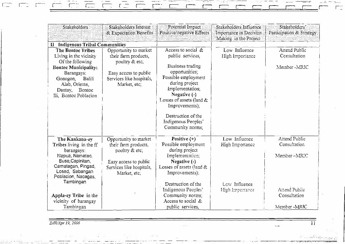
17 Indkenous Tribal Communities The Bontoc Tribes I Oppcrtunity to market
Living in the vicinity Of the following
Bontoc Municipality: Barangays:
Gonogon, Balili ..lab, Oriente,
Dantay, Bontoc Ili, Bontoc Poblacion
The Kanhna-ey Tribes living in the E
bar angays : b lap~e, Namatec: Euse,Capinitan,
Czmstagan, Pingad, Losad, Ssbangan
Pobiacion, Nscagas, Tarnbingan
Appla-ey Tribe in the vicinity of barangay
Tambicosn
&eir f x m products, poultry & etc;
Easy access to public Services like hospitals,
Market, etc;
Opportunity to narket their farm prcducts,
poultry & etc;
Easy access to public Services like hospitals,
Market, etc;
Access to social & public services,
Business trading opportunities;
Possible employment during project
Implementation; Negative (-1
Losses of assets (!and & Improvements);
Destruction of the Indigenous Peoples' Community norms;
Positive (+) Possible employment
during project Im~lernentaticz;
Negative (-1 Losses of assets (land Pr
Imprcvenents); I I Destructicn of the ,
I~digencus Peo?les' j Community norm; Access to sccial Pi
oublic services.
Low Influence I I
High Importance I i
Low influecce 1 High Imsonance I
I I I
Attend Public Ccnsultation
! i I
P~iend Public Consi!tatioii
I I i
A t ~ ~ n d Public ! Consultation j
i
hIembe: -WUC I
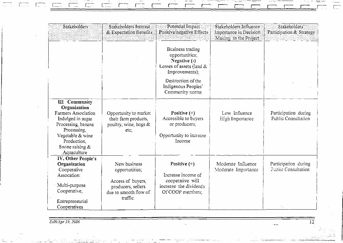
Business trading opportunities;
I Negative (-) Losses of assets (lsnd &
Improvements);
Destruction of the Indigenous Peoples' Communi-ty norms
III Community Organization
Farmers Association Indulged in sugar
Processing, banana Processing
Vegetable & wine Production,
Swine raising & Aquaculture
PV. Other People's Organization Cooperative
Assocation:
multi-purpose Cooperative;
I 1 Entrepreneurial
Opportunity to market their farm products,
poultry, wine, boss Pr etc;
New business opponurLities;
Access of buyers, producers, sellers
drre to smooth flow of traffic.
Positive (+) Accessible to buyers
or produce:^;
Opportunity to increase Income
Positive (+)
Increase income of cooperative will
increase the dividesds Of COOP menbers;
Low hfiuence High Irnpoiiance
I Participztion during 1 Fub'lic Consultati~n i
Cooperatives I
I
CONSTRUCTION PHASE
Table II Environmental Management Plan
hIODER.ZTE/ 3ITTIGXTIOS OR i T I m 1 LTSTITUTZONAL j Responsibility
i i I
Direct Effects: I I
Destabilization of slope due to widening
Slope destabilization Due tc roadside quarrying
I
Loss of forest cover and slope vegetation
Affected lar,d7 houses and other improvements.
Bio-engineering remedial measures by planting vertiver grass
Immediate Include bio- ecgineering in the
I r ~ a d design
DPl3'H-IBRD Contractor
i Enforce ban on quarrying , nearside the ~roiec: area
I I To ban quarqing activities / Identie other 1 DPIJT-IB~W
Apply bio-engineering Re-planting of the trees
sources of materials
Prepare Parcellary S]:T:=S; P!an. Parcellary Survey list of affecre:! Properties: The ESSO will prepare the Resettlement .Actior, Planning (X@)
i i I
Contrzc:ar
Mier prcject implenentation
Prior to project Irnplexefitaticr,
DPJW-ERD C cntrscror
1 Nil 1
f
DPV'X-ESSO For DTTvil-h'-Rt? DFWH-DEO DPWH-IBm Consultant
I ' DEWLOPAIENT / MODERATE/ &TITI GAITOR OR ! Tl3flSG ' l3STITUTIOSAL ) COST ; SIG'IELCAYT / EXK4ICE\IEIT BIIASLRFS I PHASE I RzsponsibiliQ
i ! I I i INPACT i I
I 1
& other infrastructures (water utilities, electric post, electric wires, barangay
Ensure continuous provision of affected services and permanent repairi'replacement of all afTected pipes & other facilities.
/ properties, etc) 1 I I I / Fire Risk due to I Ensure that \vorEorce must be 1 D ~ r i n g projest 1 Contr~cliji 1 Xil 1
negligence of workers
( facilities 1 1 Interruption to
aware of fire risk and insxitute I implementation Controls on Coctiactors 1
I Const~~ction of temporary or 1 , permanent
I the moving
goods & services due to trait
Impact on Cultural Landscapes
Minimize land take / include the necessary buildins design ali~nrnent in the detailed design
Road nust be kept open during Road implementation by opening the other lane of the road;
I Prepare T r a f c Manasement Plan By proper cccrdination with the LGUS. bfinimize widening and re- alignment through rice terraces m a s
Take additional precautions when carrying out earthworks in
During project implementation
During projecr Iniplementarion
DPJ'r/M Contiector LGUs Trafzc enf~rce:
Contractor
Nil
I / Nil
1 ) catchment areas. 1 1 1 I
DEVELOPh1EXU'T MODEIWTEl 3flTIGA4Tf ON OR TEYIIXG INSTITETIDXL%L / COST I I PEASE / SIGIIFICAYT EPEAhC631ENT MIASEKES / 1 Eesponsjbiiity f B I P A e r , i 1 / GTotvth of , Assist the LGUs in developing / Immediate during 1 DOT, DEG, 1 Xi1 1
tourism I stra-te~ies to maximize impacts on Road I tourism I imo~ernertatian
1 1 DPT,t7d Acce!e:ztited road lsrnd use regulsrtions.
1
1 Side develop And building reglations i 1 I I
Table Environmental Monitoring Plan
I Internal Monitoring
I
Process (with Bark I Social
( <.--.c , ,,A , ~y Contractor Socia! Policy 1 R i ~ e x i i l of Sm7eyor
S e c o n d q Safegxrcis And primary
R4 3974 I data. I
Policy Safeguards,
Quarterly
Child Labor Project influence area During construciicn ! I I I I I
Land acquisition
Price of food Retail outlets along During construction staples highway 1 I
I !
I I
1 Road Accidents 1 rilon_g Highway / During rcad operation 1 Road accidents 1
I
i i
I 1 1 Sub-contractor to 1 Project Manageme
And Improvements 1 Health & Safety / Around contractor's Of Workers 1 facilities, cenps
/ Unit 1 Sub-contractor to
I I
Durins conitxction t I Pie-proj ec: maintenance period I surveys
I
[ Project hfanagernt 1 LyfiiT
i Police, LGGs

ENVlRONMfiNTAL COM131AN CE CEl<TlFlCATE AMENDMENT 01: JZCC (Phasc I)
rl'l~c U c p a ~ l i ~ ~ c ~ ~ l of E ~ ~ v i r u ~ l ~ r r c ~ ~ l a~ltl Natul-ill l<csou~ccs - Co~rlillcrn Atlmiilistrativc I<cg io~~ (DEN1Z.-CAI<) I~crcby Gra~~ls this E~~viror~r~rcr~lal Co~~~ol iar lcc Ccrtilicatc ( K C ) lo lllc D c p a r l ~ ~ n c ~ ~ l uT I'ul~lic Wul~lts a~ltl lligl~ways (III'WII) fur t l ~ c ~ ) l -o~uscd IIillsc~r~n I-ligl~way (l)ag~1io-13u11toc-l3i~1ar1c Itoatl) Ilcl~abililatior~ l'rojccl, allel- c u ~ ~ ~ l ) l y i ~ r g wi1.11 t l ~ c E ~ ~ v i s o r ~ ~ n c ~ ~ t a l 1111lxlct Asscss~ncr~t (IZIA) I . C ~ ~ ~ I ~ I C I I I C I I ~ S ilS ~)~escribcd i l l lllc j~1~11111lgi1led gt~i t lcl i~~cs ~ I I I ~ ) ~ C I I I C I I I ~ I ~ ~
S c c l i u ~ ~ 3 (b) of I'D 1 12 1 and 1586.
I I ' I : I . 1-his Cc~t i f icae is valid o~lly Sor tllc llrolrored ilillsc~i~il 1-ligllway ( U n g u i o - U u ~ ~ l o c - U u i ; ~ ~ ~ ~
I , 5 Road) Kcllabilitatio~~ I'rojccl (utllc~wisc li~iowii as [lie I<cliabilit;itio~i I'rojcct), or Srollr Cluz. L:
I 1.3 -l.rir~irlatl, I l c ~ ~ g t ~ c l tu Vicwl)ui~~l, Uannuc, Il'~lg:lo, or as tlcscl-ibcd i l l 111c s u b ~ ~ ~ i ~ ~ c d t 3 tloci~inc~rls;
a) L i ~ ~ ~ i l a t i o ~ ~ of wlr lc~i i~~g allcl g c o ~ l ~ c t ~ i c ~ I I I ~ ) I O V C I I I C I I L S 10 ~ C O - L C C I I I I ~ C ~ I I I Y safe a l~d socially acccl)laLlc ;II cas;
I
I
5 . I<clatcdly, l>I'WlI sl~all duly alltl ~ ) r o p c ~ l y co11i1)ufiatc illly agg~ievctl \)ally for any damage 10 lifc and ~)rol)ci ly as a I csllt oS ~ ) ~ q j c c l i n i l ) l c~~ ic~~ t i i t i o~~ ;
6. :I'ilc Itcl~aLiIilalion I'rojcct s l~ ;~ l l bc u~rrlcr 1.11~ tigllt supcl-visioii ol' DI'WI-1 IUI<D-I'bIO to ensure llial l l ~ c rcqt~ircrrrc~rls a~ltl c o ~ ~ t ~ . o l s ol'sour~cl e ~ ~ g i l ~ c c r i ~ ~ g \~saclicc iuc slsiclly followed:
11 7. DI'WI-I sllilll S ~ ~ I I I , 1)siol. 1 0 I ) I . ~ J C C L ~ I ~ I ~ ) ~ C I I I C I I ~ ; ~ I ~ O I I , :I Multi-~al-tile blouitori~~g 'I'ciun (blM?') ~ . l~~.oul ; l~ a M c ~ l l o r a ~ ~ d u ~ ~ ~ of A g r ~ c c ~ n c ~ ~ t (bIOA) wit11 ~ l l c DENIl, Lllc LGUs co~~ccrr~cd, .a local
I:': . c ~ ~ v i r o ~ l ~ ~ l c ~ r t a l NGO arid 1l1c aTI'cclcd c o r ~ ~ l r ~ u ~ ~ i t i c s . 'l'llc bIM-I' sl~all prilnarily oversee 1 . 1 1 ~
con1pli:ulcc of tllc ~ ) r o p u ~ i c ~ ~ ~ wi1.11 ~ l l e co~iclitio~~s ol' tllc ECC, t l ~ c 1311' arid oll~cr aliplicablc
, , laws, lulcs a ~ i d rcgula~io~~s; ,
-1
ti.
I
- . . ..
I). UPWI-I sliall sct asidc ai E ~ l v i ~ o r ~ ~ ~ ~ c r ~ t a l Mol l i t o~ . i~ l~ 1;urld (Eh.lF) to suppol t tllc :~ctiviricr; o r . . v k IIIC MMT. rucb in t r i i ~ ~ i s b Lravd costs, om1 a h c r illcitlc~itvl cnpc~ius ;
9. 'Illc Envison~ncnd Iriipact Asscssl~nnt I'rojcct OfGcc (EIA-PO) of Dl'WI-I sl~all bc irivolvcd in ovcrsccir~g t11c iiiil)lcr~icntalic)~i of tlic Monito~i~ig I'rograrli. I t slrall liliewisc cnsurc rhc sub~nissior~ o r q~ia~tcr-ly uioiiitol.ilig rcpo~ts lo DEbIIt-CAI( arid to coordil~:~lc closcly wit11 die
I ! M MT; L
10. Dl1W11 sliall set u p all E~~v i~~or imc i~ ta l Guarantee i:uiid (GGI;) lo cover cx1)cllscs for dalr1n~;cs incurred by the prujcct to private arid pol)lic properties, i l ~ c l t ~ d i ~ ~ g tlie rciiebi1it;llion aildos restoratioli of arcas aRectcd by tlic project's i l i~ple~nc~r~:~tiorl. '111c al1ioitl1t :u~cl rncchonics oS t l ~ c ~ i~anagclnc~\ t of tlic EGI; sliall be tlcte~ii~il~ctl jointly by t l ~ c DGNIC-CAI< ;111d Dl'WI 1 p~ io r
I to projcct i~~ll) lclr~cl~tat iol~;
I lJ , i 1. Local ~esitlcl~ls sllall bc givt:~i p~. io~ily ill llrc l a l~or rctl~iire~i~cilts of tlic projcc~;
12. Trccs to be an'cctctl by tlrc projccl sllall be c1isl)osctl of in accoitla~lcc with existi~~l; L'o~cl;t~y laws, rulcs alld regulations; aiirl,
1 , 13. DI'WI-I sl~all fiu~iisli DENlt-CAI< with t l~c detailed c ~ i l ; i ~ ~ c c i i ~ ~ g dcsigl~ US 111c [~rojecl w I I I c I ~
slid1 includc, alllollg o~licrs, details 011 tlic sclcctctl waste tliilr~l)s for collst~ ~ r c t i o ~ ~ spoils.
Nan-co~t~pliarrcc will1 ally of llic above stil)\~latioirs will bc sulficic111 ciiusc fhs r l~c susl)clisio~i or ca~iccl lat io~~ of tliis Certificate ;inrl/or n f i~ic in t l ~ c allloont 116t to cxcccd I:ifiy Tllousand Pesos (1'111'50,000.00) for ally violiil~or~ tl~crcor at t l ~ c cliscrclion o r LlEi\II< iIs l,l;vitlcd by S c c t i o ~ ~ 9 oSI'1) 1586.
' U lssuccl this -71 tli tliiy of J ~ I I I I I ; ~ ~ ~ , N ~ I ~ C ~ C C I I 111111dle(\ :irr(1 bli~rcty I<ip,lr~. 1-
Itcgional Executive Ilireclor

. .
i .. .
! I
8 , AMZNl)&IEI.tl'l' . . . , . . ,,,, jiijci,~:(;~y$j#j~!*\~$;fi;!;,::>, :.!;jo;;:7!, ,,jl(:F; ,>,,,,,;,;
, . : ' ,*,;!t$;;$ii,!, - , , b , , , , i $~G~!,J~~:% , -?!# p , , . ~@~~,~ff~~{jy '~.~!~, i ? . ! I , . +I 1:; 1 " 7 .:* (.).,,
. , : ; . . , . I .. . ..::l::..frll~ islruductory hcutlisg of the ECC issued J ; G U ~ ~ ~ 27, 1998 is a~ncllded . ' ! I . . . . .
:. . , and shall rlow rcrtd as follows: , , 1 '
I'rojcct (otllcnvise k ~ l o w ~ l as the Rcllabiliktiorl Project) coveri~ig road scclion, froin Km 256 -1- 126 at Cruz, La Trirlidad to ICrn 310 -I- 607 at Ba~lgao, Buguins;
,.. : . . . ~. . .. . . .
1
Condiiiorl No. 1.0 is a~ilcndctl a~ld sl~all now 1 w . l as iollows: ' . i
I DPWI-1- sllall cnsurc lllal Conlr.aclorsl All Risk Ins~~ra~lcc (CAM) lo be I 1 J
' s u p p l e ~ c i i l ~ ~ ~ ~ ~ ~ ~ , a Quick I ~ e s p o ~ ~ s c Fand (QIII') slli~ll bc i,ru;idcd 10 cover ;i,,i,fd,,jj/j;.,:: , ~ ~ ~ l 4 ~ ; ~ , ~ / ~ j / j i , $ i $ ~ $ ? $ g ~ ~ & ~ 2 ~ ; ~ ~ ~ ~ , : ~ ~ ~ ~ ~ ~ $ ~ ~ l ! $ ~ $ ~ s ; !!\I fF,i:;:+pt+!:3,; ,,;, ~~.+~g,l!~~,~~+,;:~:~ i , ~ ~ I ~ n n i ~ i ~ a ~ i 0 ~ 1 ! ~ ~ ~ ~ ~ ~ ~ 1 ~ s ~ ~ i ~ 1 of dan~agc~ib:,fi fd iiind!i:il;;':':~~, , . . ,,, , . . jj: ,$& ,:'!pil"""".~.'"">' ,:, '"I:", ':!'.:,".$ /b,'li$j$ ' 1
, property tllal ,. lmy ' .bc'h;'baui&d rllc i l n p ~ c l l l c l l ~ a ~ i o l l of, ~l~~ ;:.plojcct$$:alld.i,~:'a .:,: . ::?i,i 8 ,iv<-'' I ! 1 abk~ilon~ien~decotil~r~issio~ii~~~ of i11c project facilities relatcd to tlic p~cvcrltio~l I !
of .po:;siblc ncgalivc impact and, Sor c~~~crgcncy rcp:lirs/rcstorntions of tllc j
/ I critically da~nagcd infi-astruclurc fiicili~ics al'Lcr calamity in orclcr to ~.cslorc ,
' I I i I 8 I j
'Illis A~a~c r~dr l~c~ i t Lo the Envil.on~ne~ltn) Cotiil)lia~~cc Ccrlificalc (LICC) is issucil in the irllcrcst of all colicern partics and sllall lakc cll'ccl i~nmcclialcly.
I
I'rojcct Director ll3lZl3-l'blO
I
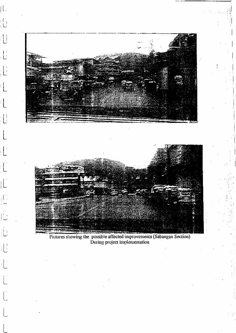
I'ictures showing the possible affected improvcnients (Saba~igan Section) During project iriiplenieritatioii
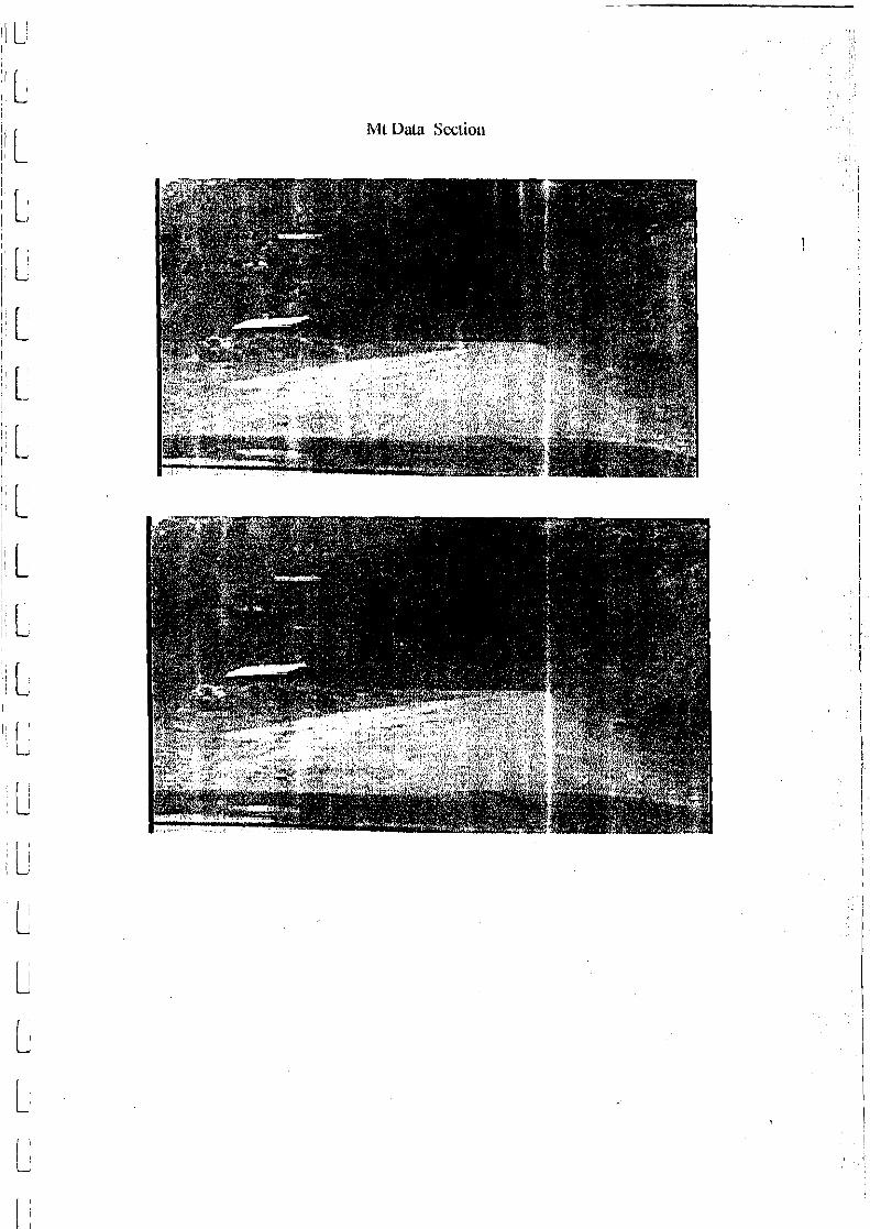
Mt Data Scclio~l