Embed Size (px)
Citation preview
MANAGEMENT DIRECTION
STATEMENT April, 2002 for Nahatlatch Provincial Park and Nahatlatch Protected Area
Ministry of Water, Land and Air Protection Environmental Stewardship Division
Lower Mainland Region
Table of Contents Page
Introduction........................................................................................................................1
Purpose of the Management Direction Statement .......................................................... 1 Setting and Context ......................................................................................................... 1
Protected Area Attributes.................................................................................................1
Conservation ................................................................................................................... 1 Recreation and Tourism.................................................................................................. 2 Cultural Heritage ............................................................................................................. 3 Significance in the Protected Areas System ................................................................... 3
Land Uses, Tenures and Interests ....................................................................................3
Access ............................................................................................................................. 3 Existing Tenures ............................................................................................................. 3 Adjacent Patterns of Land Use........................................................................................ 4 First Nations Interests ..................................................................................................... 4 Other Agency Interests.................................................................................................... 4 Private and Public Stakeholder Interests......................................................................... 4
Role of the Park and Protected Area...............................................................................5
Management Commitments and Issues ........................................................................... 6
Integration with Other Land Use Planning Processes ..................................................... 6 Longer Term Issues and Concerns .................................................................................. 6 Shorter Term Issues and Concerns ..................................................................................7
Management Direction ..................................................................................................... 7
Management Objectives and Strategies ..........................................................................7 Consultation and Future Planning .................................................................................. 9Zoning Plan .................................................................................................................... 9
Appendix I – Table of Acceptable Activities, Uses and Facilities for Nahatlatch Provincial Park/Protected Area................................ ................................ .....................10
List of Figures
Figure 1: Regional Context Map .................................................................................... 2 Figure 2: Salmon spawning area near km 42 Nahatlatch River. .................................... 2 Figure 3: Nahatlatch Provincial Park is located in the lower third of the valley. ........... 5 Figure 4: Short- term Issues Map ....................................................................................8 Figure 5: Zoning Map .................................................................................................... 9
1
NAHATLATCH PROVINCIAL PARK AND NAHATLATCH PROTECTED AREA
Management Direction Statement
Introduction Purpose of the Management Direction Statement Management Direction Statements (MDS) provide strategic management direction for all parks and protected areas that do not have a full management plan. MDS do not negate the need for future, more detailed management plans. Management Direction Statements also describe protected area values, management issues and concerns, management strategy focused on immediate priority objectives and strategies, and directional statements from other planning processes. While strategies may be identified in the MDS, the completion of all these strategies is subject to funding and funding procedures. In addition, all development associated with these strategies within the park and protected area is subject to the BC Parks’ Impact Assessment Policy. This Management Direction Statement is intended to provide direction and guidelines for managing Nahatlatch Provincial Park and Nahatlatch Protected Area for the foreseeable future. In the summer of 2001, a background report was prepared for the park. The following represents a summary of that report. Setting and Context
• Designated by Schedule C of the Protected Areas of British Columbia Amendment Act, 2001, Nahatlatch Provincial Park is one of British Columbia’s newest parks, being established on June 29, 1999.
• Nahatlatch Provincial Park covers 1695 hectares, protecting the irregularly meandering Nahatlatch River, extensive wetlands, a chain of three glacially fed lakes, and the lower forested slopes of the Nahatlatch Valley.
• Nahatlatch Protected Area, established on January 25, 2001 through order in council under the Environment and Land Use Act, covers 65 hectares with the intent to act as an access corridor for future logging operations within the Nahatlatch watershed.
• The park is located approximately 24 kilometers west of Boston Bar and may be accessed by car on the Nahatlatch Forest Service Road (Figure 1).
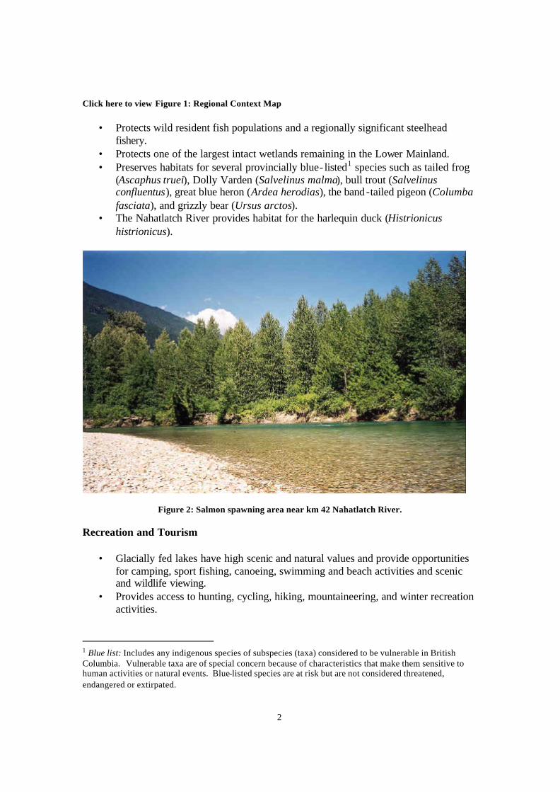
Protected Area Attributes Conservation
• Protects excellent migration, spawning and rearing habitat for salmonids throughout the river and lake system.
2
Click here to view Figure 1: Regional Context Map
• Protects wild resident fish populations and a regionally significant steelhead fishery.
• Protects one of the largest intact wetlands remaining in the Lower Mainland. • Preserves habitats for several provincially blue- listed1 species such as tailed frog
(Ascaphus truei), Dolly Varden (Salvelinus malma), bull trout (Salvelinus confluentus), great blue heron (Ardea herodias), the band-tailed pigeon (Columba fasciata), and grizzly bear (Ursus arctos).
• The Nahatlatch River provides habitat for the harlequin duck (Histrionicus histrionicus).
Figure 2: Salmon spawning area near km 42 Nahatlatch River. Recreation and Tourism
• Glacially fed lakes have high scenic and natural values and provide opportunities for camping, sport fishing, canoeing, swimming and beach activities and scenic and wildlife viewing.
• Provides access to hunting, cycling, hiking, mountaineering, and winter recreation activities.
1 Blue list: Includes any indigenous species of subspecies (taxa) considered to be vulnerable in British Columbia. Vulnerable taxa are of special concern because of characteristics that make them sensitive to human activities or natural events. Blue-listed species are at risk but are not considered threatened, endangered or extirpated.
3
Cultural Heritage
• The park and protected area are within the traditional territory of the Nlaka' pamux Nation.
Significance in the Protected Areas System Nahatlatch Provincial Park and Nahatlatch Protected Area represent the lower elevations of the Nahatlatch River drainage, supplementing Stein Valley Nlaka' pamux Heritage Provincial Park and Mehatl Creek Provincial Park with the addition of the significant river and wetland ecosystems of the Nahatlatch Valley.
• Protects significant river and lake system. • Protects traditional use and archaeological sites. • Provides excellent recreation opportunities.
Land Uses, Tenures and Interests Access The park lies west of Boston Bar off the Trans Canada Highway. Accessible by car, the park is entered near the east end of Frances Lake or at approximately 24 km on the Nahatlatch Forest Service Road. Sections of this road are narrow, hilly, rough and can be very dusty. Four-wheel drive is not necessary but caution should be exercised on the active logging road. The Nahatlatch River Forest Service Road is divided into three administrative sections; the Ministry of Transportation, the Ministry of Forests, and the road permit holder, Cattermole Timber. A road users committee, comprised of the industrial users, is responsible for general road maintenance. Existing Tenures The Park Act and Park and Recreation Area Regulation will direct the planning and management of Nahatlatch Provincial Park and Nahatlatch Protected Area. Designated by the Environment and Land Use Act, the Nahatlatch Protected Area will be managed in accordance with the Park Act with the intent to provide access to future logging operations.
4
• Park Use Permit LM0010262 to Reo Rafting Adventures Ltd. for commercial rafting
• Water Survey of Canada ma intains a guaging station. • Current guide outfitting operations have not been confirmed. • Existing trap line within the park may or may not be in use.
Adjacent Patterns of Land Use
• Nahatlatch Forest Service Road adjacent to the northern boundary of the park. • Private lands adjacent to park boundary on shoreline of Hannah Lake. • The park and protected area is surrounded by the Dewdney Provincial Forest.
First Nations Interests
• Continuation of traditional activities including hunting, fishing, gathering recreation, and spiritual.
• Future involvement of the Boothroyd Band on behalf of the Nlaka’pamux Nation regarding direction and management of the park and protected area.
Other Agency Interests The park and protected area will be managed in close coordination with various resource agencies, particularly the Fish and Wildlife Recreation and Allocation Branch, the federal Department of Fisheries and Oceans, and Ministry of Forests.
• Salmonid species managed by the federal Department of Fisheries and Oceans. • Fish stocking provided by Fish and Wildlife Recreation and Allocation Branch. • Adjacent forest land managed by Ministry of Forests. • Responsibility of vegetation management in the park and along the Nahatlatch
Forest Service Road by the Environmental Stewardship Division’s Regional Operations.
• Future access corridor through Nahatlatch Protected Area co-determined by Environmental Stewardship Division and the Ministry of Forests.
• Water Survey of Canada operates gauging station 08MF065, located below the confluence of Tachewana Creek and the Nahatlatch River.
Private and Public Stakeholder Interests
• Reo Rafting Adventures Ltd. holds Park Use Permit LM0010262 to conduct commercial rafting activities on the Nahatlatch River/Lake system.
• Adjacent private cabin owners have interest and wish involvement in park management issues.
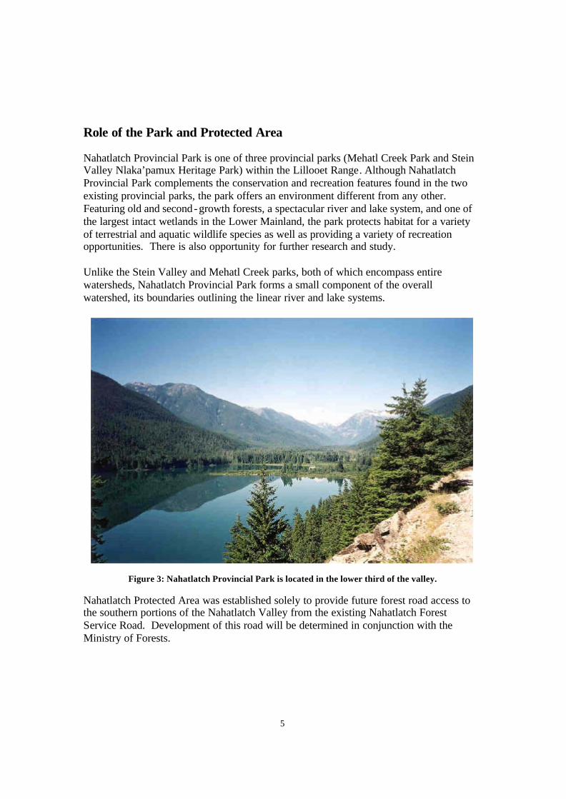
5
Role of the Park and Protected Area Nahatlatch Provincial Park is one of three provincial parks (Mehatl Creek Park and Stein Valley Nlaka’pamux Heritage Park) within the Lillooet Range. Although Nahatlatch Provincial Park complements the conservation and recreation features found in the two existing provincial parks, the park offers an environment different from any other. Featuring old and second-growth forests, a spectacular river and lake system, and one of the largest intact wetlands in the Lower Mainland, the park protects habitat for a variety of terrestrial and aquatic wildlife species as well as providing a variety of recreation opportunities. There is also opportunity for further research and study. Unlike the Stein Valley and Mehatl Creek parks, both of which encompass entire watersheds, Nahatlatch Provincial Park forms a small component of the overall watershed, its boundaries outlining the linear river and lake systems.
Figure 3: Nahatlatch Provincial Park is located in the lower third of the valley.
Nahatlatch Protected Area was established solely to provide future forest road access to the southern portions of the Nahatlatch Valley from the existing Nahatlatch Forest Service Road. Development of this road will be determined in conjunction with the Ministry of Forests.
6
Management Commitments and Issues Integration with Other Land Use Planning Processes Resource planning in the Nahatlatch River watershed has been conducted with the aid of the Nahatlatch Integrated Resource Management Plan (IRMP). This plan was initiated in August 1992 as a result of discussions between the Ministry of Forests, the Boothroyd Indian Band, and the Nlaka’pamux Nation Tribal Council rega rding the need for a cooperative approach to resource planning within the Nahatlatch watershed. The Nahatlatch IRMP, considering the views and interests of all stakeholders and interested parties, will be used to help guide future resource development and other activities within the Nahatlatch drainage. The IRMP planning team has established a process to review and monitor the plan, and to make adjustments where necessary. With the establishment of Nahatlatch Provincial Park, the Environmental Stewardship Division has become involved with the Nahatlatch IRMP as a member of the Recreation Sub Committee. The Division will continue to support the IRMP process while focusing on the interests of the newly designated Nahatlatch Provincial Park and Nahatlatch Protected Area through the completion of the Management Direction Statement and future management plans. Longer Term Issues and Concerns Specific issues were identified in the 2001 Background Report and can be highlighted under the following topics: Adjacent Land Use
• Effects of forest harvesting on the park and protected area’s wildlife, its wildlife habitat, and visual quality.
• Pine mushroom staging operations occurring within the park and protected area. • Contact with adjacent private cabin owners rega rding park management issues. • Inventory of vegetation, wildlife, visitor statistics, and fish species. • Planning for forest road access in the Nahatlatch Protected Area.
Cultural History
• Consultation with Boothroyd Band with respect to management of identified sites of significance to the Nlaka’pamux First Nation and archaeological and heritage inventory, particularly on the south shore of the lakes and river.
Recreation
• Carrying capacity of Nahatlatch River for rafting activities. • Assessment of current and projected visitor use to determine appropriate balance
between recreation and conservation objectives. • Impacts of recreational activities on the park and protected area’s wildlife,
vegetation, and wildlife habitat.
7
Shorter Term Issues and Concerns Specific issues that will be considered in the short term are as follows:
• Addressing the lack of park awareness. • Stabilization of existing recreational activities. • Protection of park wildlife and wildlife habitat. • Balancing park conservation and recreation objectives. • Addressing adjacent land use concerns.
Management Direction Management Objectives and Strategies Park management will be directed towards conserving the natural and cultural values found within the park and the protected area, while providing a variety of compatible outdoor recreation activities. As such, the principles of conservation management in Nahatlatch Provincial Park and Nahatlatch Protected Area will emphasize managing human impacts to prevent or minimize degradation of natural ecological processes and cultural features. The following objectives will direct the short and long-term management of the park and protected area:
• To protect and maintain the diversity of wildlife species and habitats. • To conserve the forest and wetland ecosystems. • To protect the landscape aesthetics available from within the park and protected
area. • To maintain the natural conditions and quality of the river and lakes for aquatic
species, habitat, landscape aesthetics, and health considerations. • To develop recreation use to levels appropriate with projected regional demands
subject to environmental assessment. • To conserve the cultural features. • To encourage non-consumptive research of the natural and cultural heritage
resources so as to better understand and manage the park and protected area. Specific objectives and strategies to address short-term issues are as follows (Figure 4):
Objectives Strategies Increase park awareness • Introduce informational brochures into local establishments
• Identify the park at ground level through signing and boundary markers
Stabilize recreational activities • Identify and establish designated camping areas, day use areas, and information centers
• Develop Mehatl Falls Trail as a type III trail with staging area and sanitary facilities
Protect park and protected area wildlife And wildlife habitat
• Protect sensitive salmon spawning areas through increased research and access road closures
• Initiate conservation studies for wildlife inventories
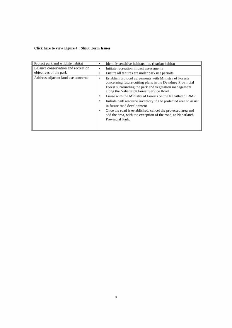
8
Click here to view Figure 4 : Short Term Issues Protect park and wildlife habitat • Identify sensitive habitats, i.e. riparian habitat Balance conservation and recreation objectives of the park
• Initiate recreation impact assessments • Ensure all tenures are under park use permits
Address adjacent land use concerns • Establish protocol agreements with Ministry of Forests concerning future cutting plans in the Dewdney Provincial Forest surrounding the park and vegetation management along the Nahatlatch Forest Service Road.
• Liaise with the Ministry of Forests on the Nahatlatch IRMP • Initiate park resource inventory in the protected area to assist
in future road development • Once the road is established, cancel the protected area and
add the area, with the exception of the road, to Nahatlatch Provincial Park.
9
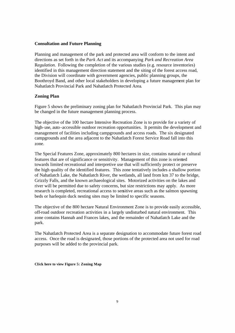
Consultation and Future Planning Planning and management of the park and protected area will conform to the intent and directions as set forth in the Park Act and its accompanying Park and Recreation Area Regulation. Following the completion of the various studies (e.g. resource inventories) identified in this management direction statement and the siting of the forest access road, the Division will coordinate with government agencies, public planning groups, the Boothroyd Band, and other local stakeholders in developing a future management plan for Nahatlatch Provincial Park and Nahatlatch Protected Area. Zoning Plan Figure 5 shows the preliminary zoning plan for Nahatlatch Provincial Park. This plan may be changed in the future management planning process. The objective of the 100 hectare Intensive Recreation Zone is to provide for a variety of high-use, auto-accessible outdoor recreation opportunities. It permits the development and management of facilities including campgrounds and access roads. The six designated campgrounds and the area adjacent to the Nahatlatch Forest Service Road fall into this zone. The Special Features Zone, approximately 800 hectares in size, contains natural or cultural features that are of significance or sensitivity. Management of this zone is oriented towards limited recreational and interpretive use that will sufficiently protect or preserve the high quality of the identified features. This zone tentatively includes a shallow portion of Nahatlatch Lake, the Nahatlatch River, the wetlands, all land from km 37 to the bridge, Grizzly Falls, and the known archaeological sites. Motorized activities on the lakes and river will be permitted due to safety concerns, but size restrictions may apply. As more research is completed, recreational access to sensitive areas such as the salmon spawning beds or harlequin duck nesting sites may be limited to specific seasons. The objective of the 800 hectare Natural Environment Zone is to provide easily accessible, off-road outdoor recreation activities in a largely undisturbed natural environment. This zone contains Hannah and Frances lakes, and the remainder of Nahatlatch Lake and the park. The Nahatlatch Protected Area is a separate designation to accommodate future forest road access. Once the road is designated, those portions of the protected area not used for road purposes will be added to the provincial park.
Click here to view Figure 5: Zoning Map
10
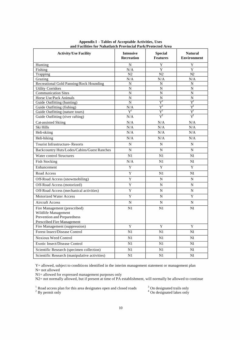
Appendix I - Tables of Acceptable Activities, Uses and Facilities for Nahatlatch Provincial Park/Protected Area
Activity/Use Facility Intensive Recreation
Special Features
Natural Environment
Hunting N Y Y Fishing N/A Y Y Trapping N2 N2 N2 Grazing N/A N/A N/A Recreational Gold Panning/Rock Hounding N N N Utility Corridors N N N Communication Sites N N N Horse Use/Pack Animals N N N Guide Outfitting (hunting) N Y2 Y2 Guide Outfitting (fishing) N/A Y2 Y2 Guide Outfitting (nature tours) Y2 Y2 Y2 Guide Outfitting (river rafting) N/A Y2 Y2 Cat-assisted Skiing N/A N/A N/A Ski Hills N/A N/A N/A Heli-skiing N/A N/A N/A Heli-hiking N/A N/A N/A
Tourist Infrastructure- Resorts N N N Backcountry Huts/Lodes/Cabins/Guest Ranches N N N Water control Structures N1 N1 N1 Fish Stocking N/A N1 N1 Enhancement Y Y Y
Road Access Y N1 N1 Off-Road Access (snowmobiling) Y N N Off-Road Access (motorized) Y N N Off-Road Access (mechanical activities) Y N N Motorized Water Access Y N Y
Aircraft Access N N N Fire Management (prescribed) Wildlife Management Prevention and Preparedness Prescribed Fire Management
N1 N1 N1
Fire Management (suppression) Y Y Y Forest Insect/Disease Control N1 N1 N1
Noxious Weed Control N1 N1 N1 Exotic Insect/Disease Control N1 N1 N1
Scientific Research (specimen collection) N1 N1 N1 Scientific Research (manipulative activities) N1 N1 N1 Y= allowed, subject to conditions identified in the interim management statement or management plan N= not allowed N1= allowed for expressed management purposes only N2= not normally allowed, but if present at time of PA establishment, will normally be allowed to continue 1 Road access plan for this area designates open and closed roads 3 On designated trails only
2 By permit only 4 On designated lakes only


![International Human Resource Management: - [email protected]](https://img.pdfslide.net/doc/110x75/6203a3c3da24ad121e4bbee7/international-human-resource-management-emailprotected.jpg)


![Appendix D: Flood Management - [email protected]](https://img.pdfslide.net/doc/110x75/620652e68c2f7b173006a8ab/appendix-d-flood-management-emailprotected.jpg)