Embed Size (px)
Citation preview

1
Wallaga Lake Aboriginal CemeteryMANAGEMENT PLAN 2015 – 2020
CARING FOR THE ANCESTORS

2

3
© 2015. Eurobodalla Shire Council hold the copyright to any publicly
available information. Without written permission information may not
be used for purposes other than those permitted by Australian Copyright
laws.
INDIGENOUS CULTURAL AND INTELLECTUAL PROPERTY RIGHTS: Eurobodalla Shire Council acknowledges the cultural and intellectual
property rights of Aboriginal people whose cultural knowledge has been
used to guide the management of the Wallaga Lake Aboriginal Cemetery.
AUTHORSHIP: This plan was written by Susan Dale Donaldson and Sue
Feary in consultation with the Merrimans LALC, members of the Aboriginal
community and Eurobodalla Shire Council.
FUNDING SOURCE: The Caring for our Ancestors – Wallaga Lake
Cemetery Indigenous Heritage Project is supported through funding from
the Australian Government’s Indigenous Heritage Protection Program.
Merrimans Local Aboriginal Land Council and the Eurobodalla Shire
Council have also assisted with funding and providing ‘in kind’ support,
advice and resources for onsite cemetery work.
DISCLAIMER: The authors have made every effort to ensure that the plan
and the associated documents are as correct and as comprehensive as
possible. We apologise for any omissions or errors.
ISBN: 978-0-646-94439-5
FRONT COVER IMAGE: William Murdoch caring for the grave of his great
aunt, Florence Picalla, who was buried at Wallaga Lake as a baby in 1955.
Her grave was rediscovered through oral history, archival research and
Ground Penetrating Radar [GPR] survey, undertaken as part of this project.
Florence’s sisters saw her grave for the first time in their lives, soon after the
GPR results were pegged onto the ground in December 2014, more than
half a century later.
ACKNOWLEDGEMENTS: The authors would like to thank David and
Shannon Hunter, John Healey, Les Gould, Dawn Sims, Cienan Muir,
Linda Albertson, Lisa Videion, Shane Doherty, Glenda Veitch, Doreen
Walker, Susan Gillies, Kim Bush, Jesse White, Zoe Morgan, Shane Davison,
Cheryl Davison, Jackie Grant, Michelle Wrethman, Laurelle Pacey, Mary
Twyford, Pat Raymond, Pam O’Brian, Trevor Robinson, Jackie Taylor, Paul
House, Barina South, Rod Wellington, Justin Hands, Lorraine Naylor, Dean
Freeman, Harold Harrison, Ken Campbell, Shirley Foster, Jack Hampton,
Leonie Cameron, Anne Greenaway, the Merrimans LALC board and the
many Aboriginal people who persisted in bettering the cemetery. Mick
Darcy, Vikki Parsley and Sonya Naylor have done a great job working as
Aboriginal Project Officers marking graves and supporting the community
in developing this management plan. Thank you.
CULTURAL WARNING: This plan contains reference to deceased people.

4
Introduction ...................................................................................................................6
PART ONE: Understanding the cemetery ................................................ 10
1 Management planning ....................................................................................... 101.1. Why have a management plan? .....................................................................................................10
1.2. Background to the plan ........................................................................................................................10
2. Preparing the plan ................................................................................................ 122.1 Steps in developing the plan ..............................................................................................................12
2.2 Community participation ......................................................................................................................13
3. About the Wallaga Lake Aboriginal Cemetery ........................................... 153.1 Location ............................................................................................................................................................15
3.2 History ..............................................................................................................................................................17
3.3 Cultural context ...........................................................................................................................................22
4 The cemetery today ............................................................................................. 244.1 Current management .............................................................................................................................24
4.2 Who is buried in the cemetery? ........................................................................................................26
4.3 Graves ...............................................................................................................................................................27
4.4 Memorial Wall ...............................................................................................................................................29
4.5 Geology and vegetation .......................................................................................................................31
4.6. Fences ...............................................................................................................................................................32
4.7. Access and roads .......................................................................................................................................32
5. Legal framework ................................................................................................... 345.1 NSW Aboriginal Land Rights Act 1983 ..........................................................................................34
5.2 Eurobodalla Local Environmental Plan (LEP) .............................................................................34
5.3 Heritage registers ........................................................................................................................................34
5.5 Cemeteries and Crematorium Act 2013 .....................................................................................35
PART TWO: Management Plan for the Wallaga Lake Cemetery .......... 38
1 Vision for the future ............................................................................................. 38
2 Values of the cemetery to Aboriginal people .............................................. 40
3 Threats to the values ............................................................................................ 41
4 Objectives for achieving vision ......................................................................... 44Objective 1: Maintain cemetery grounds and infrastructure in good condition .....44
Objective 2: Individual graves are maintained and cared for ...............................................44
Objective 3: Establish workable systems for updating, storing and accessing cemetery records ................................................................................................................................................44
Objective 4: The cemetery is managed as a peaceful, spiritual and historical place, connected to the surrounding environment....................................................................................45
Objective 5: All existing known graves and possible graves (identified by GPR) are protected and acknowledged .....................................................................................................................45
Objective 6: Cemetery is managed sustainably by the community for ongoing use as a cemetery .......................................................................................................................................................45
Objective 7: Continue to improve knowledge about the history of the cemetery and who is buried there .................................................................................................................................45
Objective 8: Cemetery is managed according to all legal requirements ........................45
Objective 9: Cemetery approach and entrance area is redesigned and upgraded .45
5. Actions ..................................................................................................................... 46
6. Review of plan ....................................................................................................... 53
References .................................................................................................................... 55
Appendix 1: Burial and death registration check lists .................................. 56

5
Figure 1 Cemetery Point, Wallaga Lake, NSW ...................................................................7
Figure 2 David Hunter undertaking the Ground Penetration Radar Survey
November 2014 ......................................................................................................................... 11
Figure 3 Steps in developing the plan .............................................................................. 12
Figure 4 Community involvement .................................................................................... 13
Figure 5 Location of Wallaga Lake Aboriginal cemetery ............................................ 15
Figure 6 Cemetery Point showing Wallaga Lake Cemetery ...................................... 15
Figure 7 Overlay of cemetery on aerial photo. Black dots are visible graves;
yellow dotted areas are GPR graves. ................................................................................. 16
Figure 8 Portion of survey plan showing location of midden material in
cemetery ...................................................................................................................................... 17
Figure 9 Extract of parish map #1034901 showing reserve gazettals ................... 19
Figure 10: Community submission to NSW government 1978 ............................... 20
Figure 11 ’Queen Narelle’s funeral ca 1895’ William Corkhill Collection NLA #
2511328 ........................................................................................................................................ 20
Figure 12 ’Queen Narelle’s funeral ca 1895’ William Corkhill Collection NLA #
2462264 ........................................................................................................................................ 20
Figure 13 Cemetery Point, Wallaga Lake and Gulaga Mountain ............................. 22
Figure 14 Graves decorated with local shells ................................................................. 23
Figure 15 Umbarra - the black duck totem ..................................................................... 24
Figure 16 Grave numbering system .................................................................................. 25
Figure 17 Extract from the Wallaga Lake Aboriginal Cemetery Burial Register
2015 ................................................................................................................................................ 26
Figure 18 Typical grave outlined with rocks ................................................................... 27
Figure 19 Graves marked with concrete slabs and wooden crosses 2012 .......... 28
Figure 20 Unmarked graves covered with grass 2012 ................................................ 28
Figure 21 Permanent markers for the graves where oral history and GPR results
matched ........................................................................................................................................ 29
Figure 22 Memorial wall - built 2014 ................................................................................ 29
Figure 23 Cemetery survey plan showing all graves and possible graves Source:
Healey (2015) [MAP INSERT] .................................................................................................. 30
Figure 24 Vegetated headland, Cemetery Point ........................................................... 31
Figure 25 Native Blue Bell across cemetery .................................................................... 31
Figure 26 Northern fence line.............................................................................................. 32
Figure 27 Western fence line................................................................................................ 32
Figure 28 Extract from survey plan showing western side of cemetery with
tracks and extent of midden ................................................................................................. 33
Figure 29 Excerpt from Eurobodalla Shire LEP 2012 ................................................... 34
Figure 30 Caring for the Ancestors .................................................................................... 39
Figure 31 Fallen tree limb 2014 ........................................................................................... 41
Figure 32 Burial sites affected by an escaped fire 2014 ............................................. 41
Figure 33 Long grass across cemetery grounds 2012 ................................................ 41
Figure 34 Rotten fallen crosses 2013 ................................................................................ 41
Figure 35 Old unmarked graves get forgotten over time if not recorded and
marked .......................................................................................................................................... 42
Figure 36 Cemetery car park on midden material 2015 ............................................ 43

6
Wallaga Lake Aboriginal cemetery on the NSW far south coast is one of the
oldest and largest of its type in NSW and is still in operation. This culturally
significant cemetery is located on Cemetery Point, Wallaga Lake, and is
privately owned by Merrimans Local Aboriginal Land Council [MLALC].
It was part of the original Wallaga Lake Aboriginal Reserve. Some graves
are marked in some way and in some cases there is a name on the grave.
Many graves are noticeable by ground disturbance such as a mound,
depression or a planted tree, while others have become invisible over
time, covered by grass or earth and not known to the current Aboriginal
community.
Uncertainty over exactly where people have been buried and the
possibility of disturbance from digging new graves has concerned the
Merrimans LALC and the wider Aboriginal community for decades. It was
this, together with a general concern about the poor condition of the
cemetery and lack of records that prompted the Merrimans LALC and
Eurobodalla Shire Council [ESC] to seek funding for a project.
Extensive historical, archival and oral history research since 2011 has
identified the names of 182 people buried in the Wallaga Lake Cemetery
between 1895 and 2015. We know the grave location of 96 of these
named people. Therefore there are 86 named people who are buried in
the cemetery but we don’t know where. The Ground Penetrating Radar
(GPR) and field surveys identified a total of 240 graves and possible graves
inside and outside the current fenced cemetery. Given we know where
96 named people are buried, there remains 144 unnamed graves/possible
graves. Over time it is hoped that the remaining 86 named ancestors can
be matched to some of the 144 unnamed graves.
The project has involved a large number of Aboriginal people who have
a strong wish for the cemetery to be more actively managed to ensure
that their ancestors are given the respect and care that they are due. This
management plan has been prepared for the Wallaga Lake cemetery
to set out a clear pathway for achieving the twin goals of caring for the
ancestors and managing the cemetery for present and future generations
of Aboriginal people.
This plan is set out in two parts. Part one provides relevant background
and contextual information. Part two is the plan itself – the vision for the
future and how it will be achieved. A number of critical management
actions outlined in the plan have already commenced, including
permanently numbering all the graves in the cemetery. Family marking
of graves is occurring on an ongoing basis.
Introduction

7
Figure 1 Cemetery Point, Wallaga Lake, NSW

8
9
PART ONE
Understanding the cemetery

10
1 Management planning
1.1. WHY HAVE A MANAGEMENT PLAN? A management plan is a written document that gives guidance and
direction for looking after something that is valuable to a society or a part
of society. The management plan for Wallaga Lake Aboriginal Cemetery
describes what is important about the cemetery and identifies what
things may threaten these values. It states a long-term vision and sets out
a rational process for reaching the vision, through forming objectives and
priorities. Having a management plan can be helpful when applying for
funding from external agencies. It also explains to people what you are
doing and why you are doing it.
1.2. BACKGROUND TO THE PLAN This management plan for Wallaga Lake Aboriginal Cemetery had its
beginnings in Stage 1 of an Aboriginal heritage study undertaken in the
Eurobodalla Shire in 2005. This study recommended research into the
locations of Aboriginal burials in the Eurobodalla Shire as a high priority
(Goulding & Waters, 2005). The cultural and historical significance of the
Wallaga Lake Aboriginal reserve and surrounding areas was identified
during Stage 2 of the project, when a number of Aboriginal people voiced
concerns about the possibility of accidental damage to unmarked graves
in the cemetery (Donaldson, 2006).
One of the recommendations arising from Stage 3 of the same study
was ‘mapping of places in Eurobodalla Aboriginal heritage study
through the DECC AHIMS database/ESC heritage protocols’ (Donaldson,
2007). Commonwealth Indigenous Heritage Programme (IHP) funding
was obtained for this project, called ‘Connecting with Country’,
which identified 36 places for further recording and assessment
(Feary & Donaldson, 2011). One of these places was the Wallaga Lake
Aboriginal Cemetery.
A community meeting held in 2011 revealed the depth of community
concern about unmarked graves and cemetery management more
generally, and the possibility of doing a Ground Penetrating Radar (GPR)
survey to identify unmarked graves was discussed.
The Eurobodalla Shire Council reallocated project funding to enable a
GPR survey of the cemetery, as well as extensive research into the history
of the cemetery, including a search of Births, Deaths and Marriage records
(BDM) and additional oral history research (Donaldson & Feary, 2012a).
This component of the project identified 102 possible graves through the
GPR survey and developed a burial register containing 187 names sought
through detailed oral history and archival research (Donaldson & Feary,
2012a).
PART ONE: Understanding the cemetery
11
Donaldson and Feary made a number of recommendations including -
• additional GPR survey over proposed cemetery extension areas to the
north and west of the current cemetery;
• preparation of a management plan to guide long term management
of the cemetery and its records;
• continued research into naming and locating burials and;
• developing a comprehensive register of burials that could be
maintained and updated;
• prepare an accurate survey plan showing all graves, including the GPR
results with allocated numbers and other features such as trees, tracks
and fence lines.
More Indigenous Heritage Program (IHP) funding received in 2014, and
additional funds from the Eurobodalla Shire Council and Merrimans LALC
made it possible to carry out these recommendations.
Considerable background research was carried out in developing the
plan. This included looking at management plans prepared for other
cemeteries, eg, the Waikumete Cemetery in Auckland, NZ (Waitakere City
Council, 2001) and various guidelines for managing cemeteries produced
by heritage agencies , eg, National Trust [The National Trust of Australia
(NSW), 2009] and the Victorian government [Department of Health,
Victorian Government, 2014].
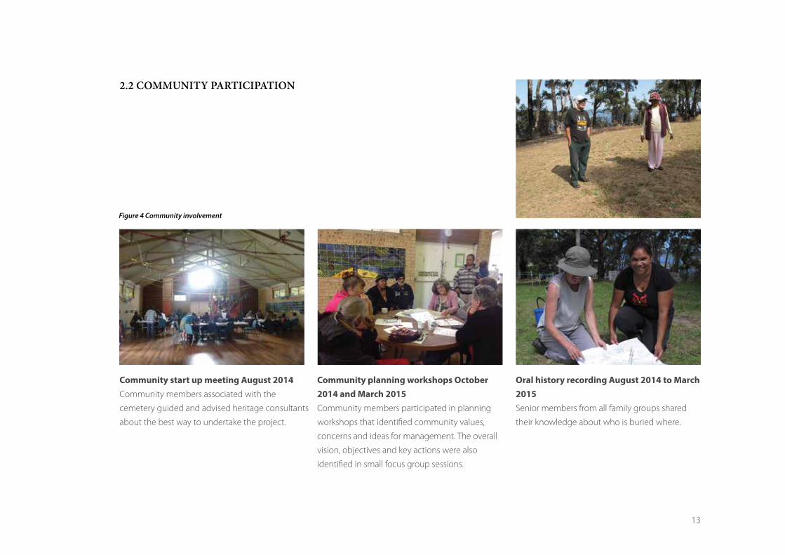
The Aboriginal community participated in all aspects of the planning
process [figures 3 and 4]. A valuable insight into local cemetery
management was provided by Lisa Videion, the Eurobodalla Shire Council
officer overseeing the management of cemeteries. She shared her
knowledge about how cemetery records are updated and maintained at
a community workshop at Wallaga Lake in 2014.
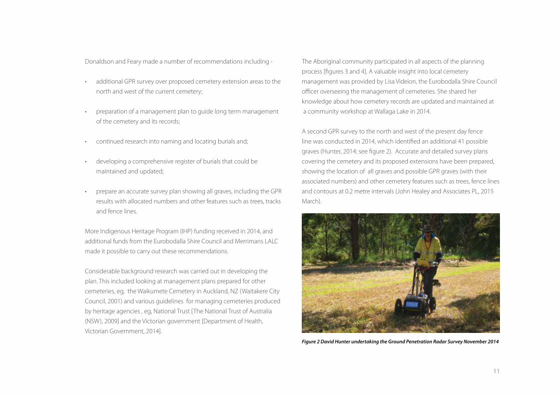
A second GPR survey to the north and west of the present day fence
line was conducted in 2014, which identified an additional 41 possible
graves (Hunter, 2014; see figure 2). Accurate and detailed survey plans
covering the cemetery and its proposed extensions have been prepared,
showing the location of all graves and possible GPR graves (with their
associated numbers) and other cemetery features such as trees, fence lines
and contours at 0.2 metre intervals (John Healey and Associates PL, 2015
March).
Figure 2 David Hunter undertaking the Ground Penetration Radar Survey November 2014
12
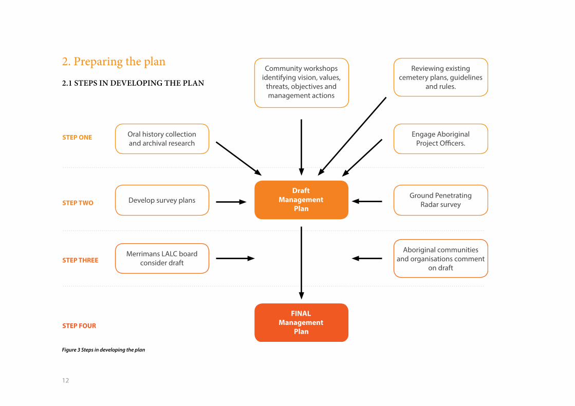
2. Preparing the plan
2.1 STEPS IN DEVELOPING THE PLAN
Community workshops identifying vision, values,
threats, objectives and management actions
DraftManagement
Plan
FINALManagement
Plan
Reviewing existing cemetery plans, guidelines
and rules.
Engage Aboriginal Project Offi cers.
Ground Penetrating Radar survey
Aboriginal communities and organisations comment
on draft
Oral history collection and archival research
Develop survey plans
Merrimans LALC board consider draft
STEP ONE
STEP TWO
STEP THREE
STEP FOUR
Figure 3 Steps in developing the plan
13
2.2 COMMUNITY PARTICIPATION
Community start up meeting August 2014
Community members associated with the
cemetery guided and advised heritage consultants
about the best way to undertake the project.
Community planning workshops October 2014 and March 2015
Community members participated in planning
workshops that identified community values,
concerns and ideas for management. The overall
vision, objectives and key actions were also
identified in small focus group sessions.
Oral history recording August 2014 to March 2015 Senior members from all family groups shared
their knowledge about who is buried where.
Figure 4 Community involvement
14
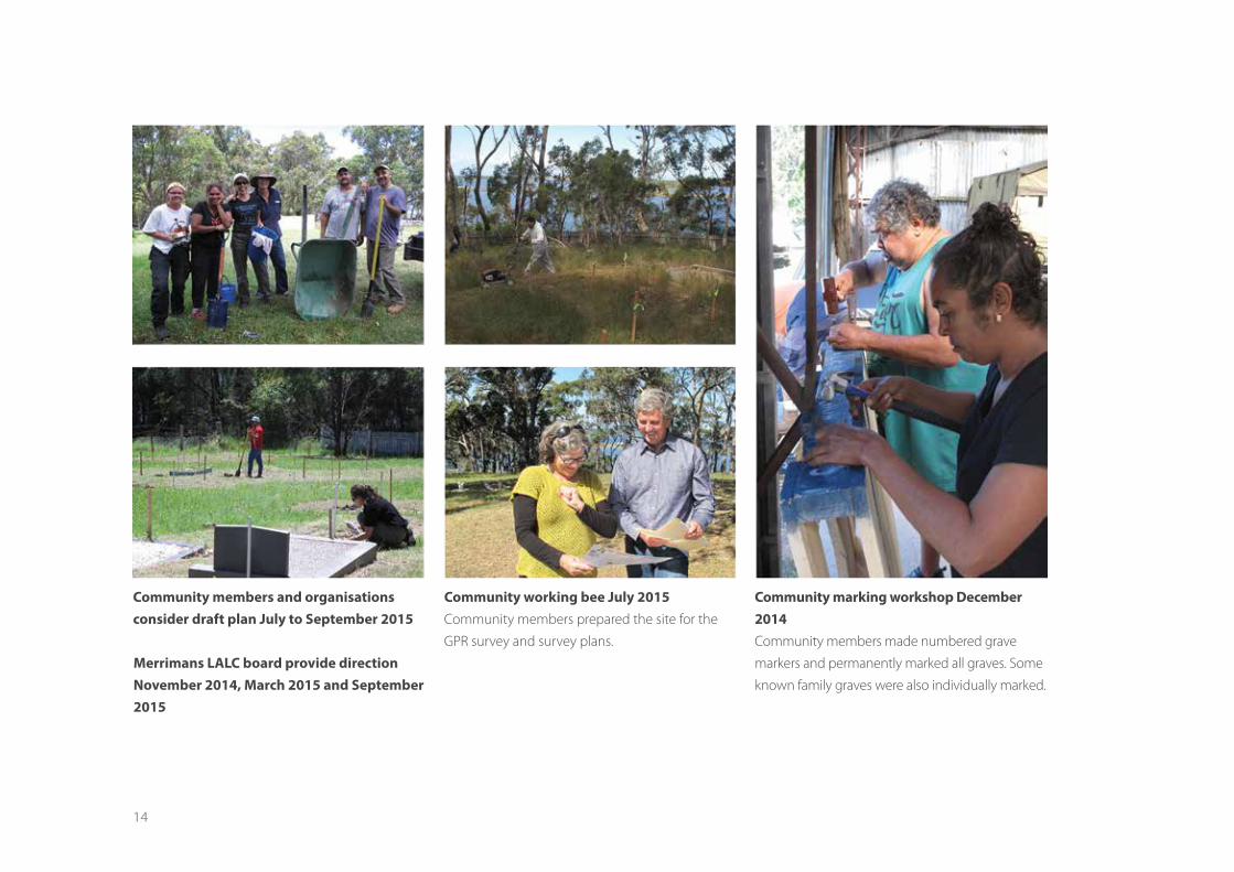
Merrimans LALC board provide direction November 2014, March 2015 and September 2015
Community working bee July 2015 Community members prepared the site for the
GPR survey and survey plans.
Community members and organisations consider draft plan July to September 2015
Community marking workshop December 2014
Community members made numbered grave
markers and permanently marked all graves. Some
known family graves were also individually marked.
15
3. About the Wallaga Lake Aboriginal
Cemetery
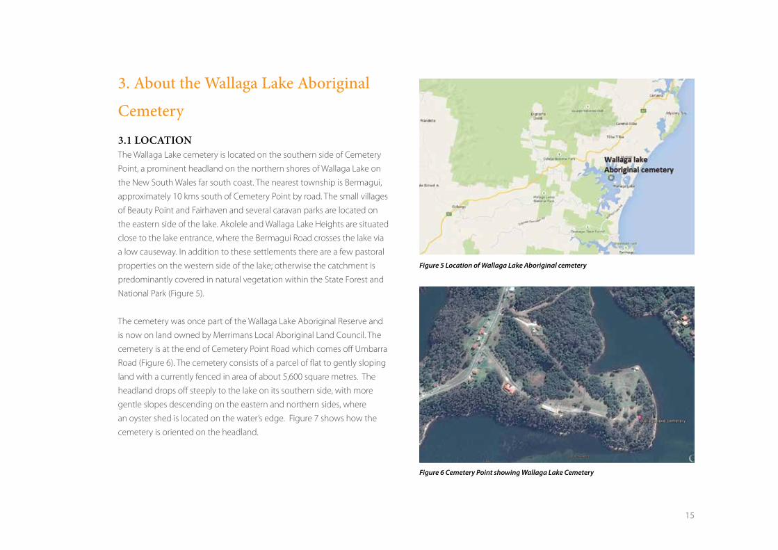
3.1 LOCATIONThe Wallaga Lake cemetery is located on the southern side of Cemetery
Point, a prominent headland on the northern shores of Wallaga Lake on
the New South Wales far south coast. The nearest township is Bermagui,
approximately 10 kms south of Cemetery Point by road. The small villages
of Beauty Point and Fairhaven and several caravan parks are located on
the eastern side of the lake. Akolele and Wallaga Lake Heights are situated
close to the lake entrance, where the Bermagui Road crosses the lake via
a low causeway. In addition to these settlements there are a few pastoral
properties on the western side of the lake; otherwise the catchment is
predominantly covered in natural vegetation within the State Forest and
National Park (Figure 5).
The cemetery was once part of the Wallaga Lake Aboriginal Reserve and
is now on land owned by Merrimans Local Aboriginal Land Council. The
cemetery is at the end of Cemetery Point Road which comes off Umbarra
Road (Figure 6). The cemetery consists of a parcel of flat to gently sloping
land with a currently fenced in area of about 5,600 square metres. The
headland drops off steeply to the lake on its southern side, with more
gentle slopes descending on the eastern and northern sides, where
an oyster shed is located on the water’s edge. Figure 7 shows how the
cemetery is oriented on the headland.
Figure 5 Location of Wallaga Lake Aboriginal cemetery
Figure 6 Cemetery Point showing Wallaga Lake Cemetery
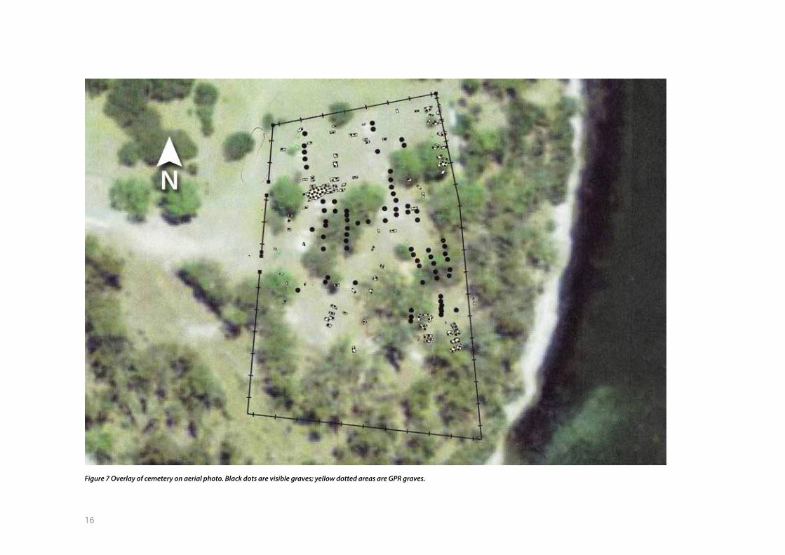
16
Figure 7 Overlay of cemetery on aerial photo. Black dots are visible graves; yellow dotted areas are GPR graves.
17
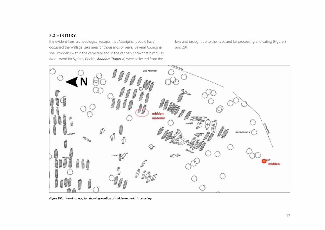
3.2 HISTORY It is evident from archaeological records that Aboriginal people have
occupied the Wallaga Lake area for thousands of years. Several Aboriginal
shell middens within the cemetery and in the car park show that bimbulas
(Koori word for Sydney Cockle, Anadara Trapezia) were collected from the
lake and brought up to the headland for processing and eating (Figure 8
and 28).
Figure 8 Portion of survey plan showing location of midden material in cemetery
18
People would have lived on the headland in long before first European
contact and they may have buried people there, although no evidence
has been found. There is a burial at Murunna Point, on the headland above
where the lake opens to the sea (Feary, 2009). In the 1870s groups of
Aboriginal people, including Umbarra (Merriman) lived around the shores
of Wallaga Lake and on Merrimans Island. Tobin describes Wallaga Lake at
this time as ‘ a large camp for the old people’. They lived along the beach
where there was plenty of thick shelter and down by the water near ‘five
different feeding grounds’ (Tobin n.d.) Aboriginal people were fishing
and doing a small amount of farming and ‘by the help of their boats they
manage to earn money punting goods across the lake’ (Goulding and
Waters 2005).
Merriman and others worked on the property of Henry Jefferson Bate
who took up residence at Tilba Tilba in 1869 and took a great interest
in the culture and living conditions of the local Aboriginal community.
In return for their labour, he apparently gave land to the Aboriginal
community, which was eventually to become part of the Wallaga Lake
Aboriginal Reserve. Mr Bate was later to be a key member of the local
committee of the Aborigines Protection Board (APB) in the Tilba Tilba area,
who advocated for improved living standards on the Reserve. Aboriginal
people quickly saw the value of a European education for their children.
However, while Aboriginal children were eligible to attend the public
schools established in the 1880s, in practice they rarely went because of
opposition from non-Aboriginal families. In response, Aboriginal schools
were established on reserves throughout New South Wales. Wives of
local white farmers urged the establishment of an Aboriginal school at
Wallaga Lake in 1887, four years prior to establishment of the Wallaga Lake
Aboriginal reserve and the first Aboriginal school in NSW, (Donaldson and
Feary 2012b).
The presence of the school and later the Reserve attracted Aboriginal
people to reside close by or in the Reserve. The first school inspector at
Wallaga Lake School observed that the influx of people could be partly
attributed to the ‘attraction of schooling and the school rations’ (Cameron
1987: 87). However, families continued to live in huts and gunyahs on
farms in the district where some of the adults worked, which gave them
more freedom to move around than the stringent conditions of the
Reserve.
The APB established the Wallaga Lake Reserve over 330 acres of land on 13
June 1891 (Reserve #13939) (Figure 9). It was the first station established
by the APB in New South Wales and because it had a white manager it
was classified as a ‘station’. The Crown retained title over the land. In 1892
the Moruya Land Board leased the station reserve to the neighbouring
Hobbes family as pasture for sheep. This move angered many in Tilba Tilba
Progress Committee because of the disruption it caused to Aboriginal
residents. Some members resigned in protest. An article in the Sydney
Morning Herald objected to this ‘incursion’ by the neighbour. These
objections resulted in another gazettal over the same area on the 28th
May 1892 (Reserve #15718) [Figure 9].
A further 75 acres was gazetted on the 16 September 1949 (Reserve
#73304) adding Portions 17 and 361 to the north east side of the reserve.
On the 22 December 1963, these portions (21 acres) were revoked to
make land available for non-Aboriginal people’s holiday cottages (now
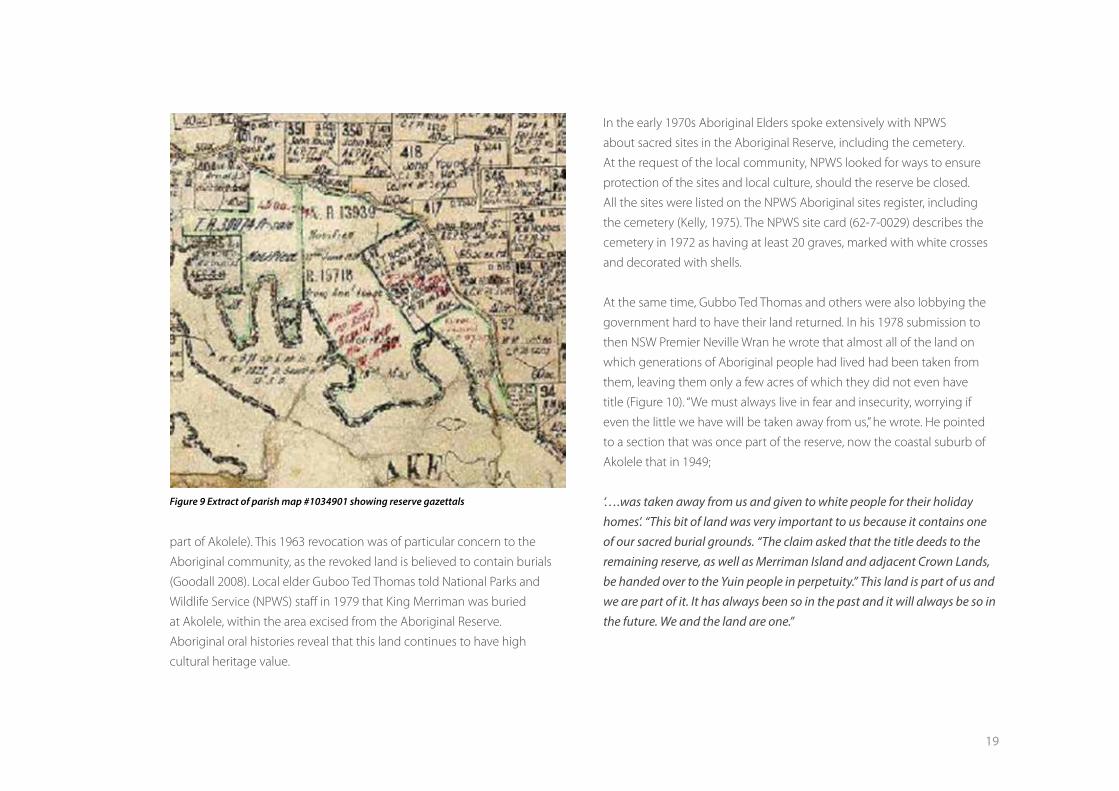
19
part of Akolele). This 1963 revocation was of particular concern to the
Aboriginal community, as the revoked land is believed to contain burials
(Goodall 2008). Local elder Guboo Ted Thomas told National Parks and
Wildlife Service (NPWS) staff in 1979 that King Merriman was buried
at Akolele, within the area excised from the Aboriginal Reserve.
Aboriginal oral histories reveal that this land continues to have high
cultural heritage value.
In the early 1970s Aboriginal Elders spoke extensively with NPWS
about sacred sites in the Aboriginal Reserve, including the cemetery.
At the request of the local community, NPWS looked for ways to ensure
protection of the sites and local culture, should the reserve be closed.
All the sites were listed on the NPWS Aboriginal sites register, including
the cemetery (Kelly, 1975). The NPWS site card (62-7-0029) describes the
cemetery in 1972 as having at least 20 graves, marked with white crosses
and decorated with shells.
At the same time, Gubbo Ted Thomas and others were also lobbying the
government hard to have their land returned. In his 1978 submission to
then NSW Premier Neville Wran he wrote that almost all of the land on
which generations of Aboriginal people had lived had been taken from
them, leaving them only a few acres of which they did not even have
title (Figure 10). “We must always live in fear and insecurity, worrying if
even the little we have will be taken away from us,” he wrote. He pointed
to a section that was once part of the reserve, now the coastal suburb of
Akolele that in 1949;
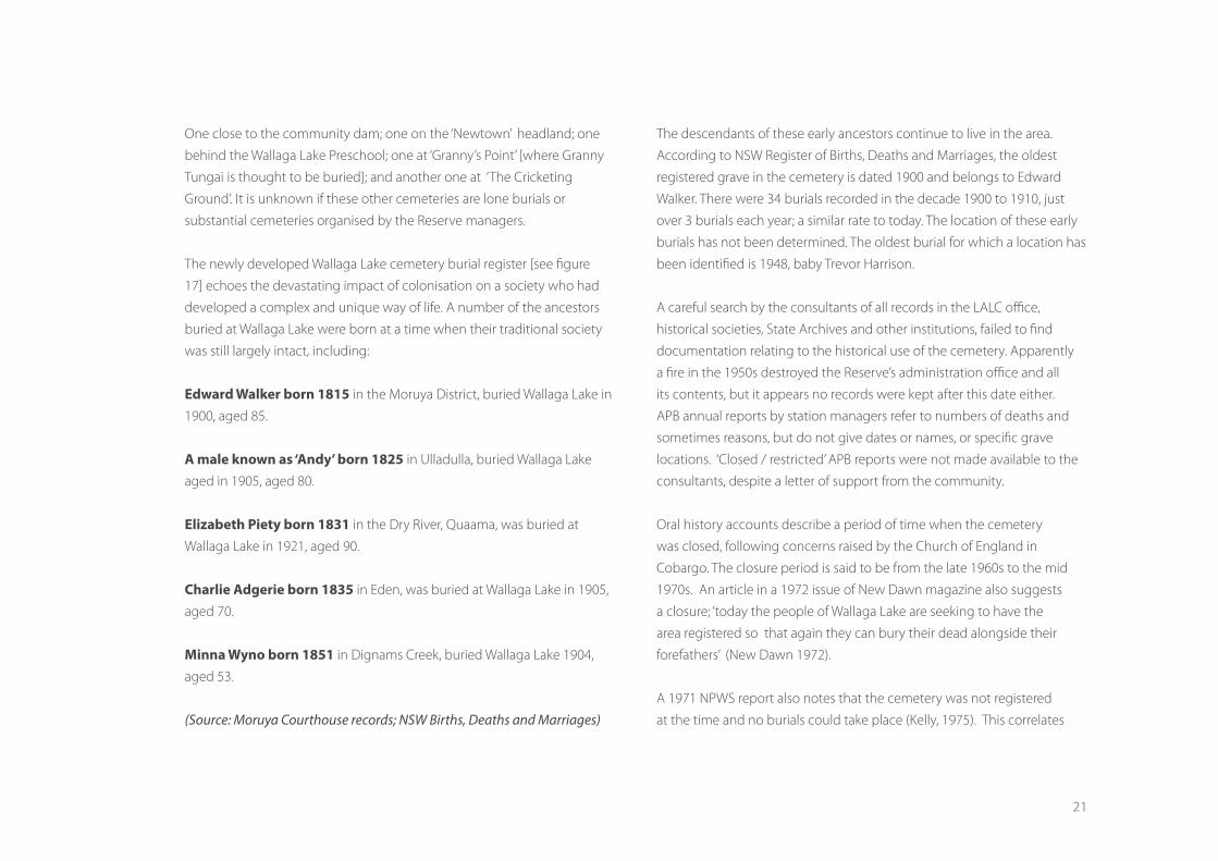
‘….was taken away from us and given to white people for their holiday homes’. “This bit of land was very important to us because it contains one of our sacred burial grounds. “The claim asked that the title deeds to the remaining reserve, as well as Merriman Island and adjacent Crown Lands, be handed over to the Yuin people in perpetuity.” This land is part of us and we are part of it. It has always been so in the past and it will always be so in the future. We and the land are one.”
Figure 9 Extract of parish map #1034901 showing reserve gazettals
20
Passing of the NSW Aboriginal
Land Rights Act in 1983 opened
the way for the land title to what
was left of the old reserve to be
handed back to the Merrimans
LALC, including the cemetery.
The date that the cemetery was
first established is not known; it
may have been used from 1887
when the school started. No
burial records have been found
for the first decade of the station,
although there is one birth, that of
Mary Carpenter in 1894. The oldest
recorded ‘Christian’ burial at Wallaga Lake is that of Sarah Carter or ‘Queen
Narelle’ around 1895, although she may not have been buried within the
confines of the current cemetery and her death is not registered with the
NSW Department of Births, Deaths and Marriages.
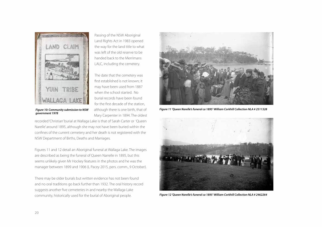
Figures 11 and 12 detail an Aboriginal funeral at Wallaga Lake. The images
are described as being the funeral of Queen Narrelle in 1895, but this
seems unlikely given Mr Hockey features in the photos and he was the
manager between 1899 and 1906 (L Pacey 2015, pers. comm., 9 October).
There may be older burials but written evidence has not been found
and no oral traditions go back further than 1932. The oral history record
suggests another five cemeteries in and nearby the Wallaga Lake
community, historically used for the burial of Aboriginal people.
Figure 10: Community submission to NSW government 1978
Figure 11 ’Queen Narelle’s funeral ca 1895’ William Corkhill Collection NLA # 2511328
Figure 12 ’Queen Narelle’s funeral ca 1895’ William Corkhill Collection NLA # 2462264
21
One close to the community dam; one on the ‘Newtown’ headland; one
behind the Wallaga Lake Preschool; one at ‘Granny’s Point’ [where Granny
Tungai is thought to be buried]; and another one at ‘The Cricketing
Ground’. It is unknown if these other cemeteries are lone burials or
substantial cemeteries organised by the Reserve managers.
The newly developed Wallaga Lake cemetery burial register [see figure
17] echoes the devastating impact of colonisation on a society who had
developed a complex and unique way of life. A number of the ancestors
buried at Wallaga Lake were born at a time when their traditional society
was still largely intact, including:
Edward Walker born 1815 in the Moruya District, buried Wallaga Lake in
1900, aged 85.
A male known as ‘Andy’ born 1825 in Ulladulla, buried Wallaga Lake
aged in 1905, aged 80.
Elizabeth Piety born 1831 in the Dry River, Quaama, was buried at
Wallaga Lake in 1921, aged 90.
Charlie Adgerie born 1835 in Eden, was buried at Wallaga Lake in 1905,
aged 70.
Minna Wyno born 1851 in Dignams Creek, buried Wallaga Lake 1904,
aged 53.
(Source: Moruya Courthouse records; NSW Births, Deaths and Marriages)
The descendants of these early ancestors continue to live in the area.
According to NSW Register of Births, Deaths and Marriages, the oldest
registered grave in the cemetery is dated 1900 and belongs to Edward
Walker. There were 34 burials recorded in the decade 1900 to 1910, just
over 3 burials each year; a similar rate to today. The location of these early
burials has not been determined. The oldest burial for which a location has
been identified is 1948, baby Trevor Harrison.
A careful search by the consultants of all records in the LALC office,
historical societies, State Archives and other institutions, failed to find
documentation relating to the historical use of the cemetery. Apparently
a fire in the 1950s destroyed the Reserve’s administration office and all
its contents, but it appears no records were kept after this date either.
APB annual reports by station managers refer to numbers of deaths and
sometimes reasons, but do not give dates or names, or specific grave
locations. ‘Closed / restricted’ APB reports were not made available to the
consultants, despite a letter of support from the community.
Oral history accounts describe a period of time when the cemetery
was closed, following concerns raised by the Church of England in
Cobargo. The closure period is said to be from the late 1960s to the mid
1970s. An article in a 1972 issue of New Dawn magazine also suggests
a closure; ‘today the people of Wallaga Lake are seeking to have the
area registered so that again they can bury their dead alongside their
forefathers’ (New Dawn 1972).
A 1971 NPWS report also notes that the cemetery was not registered
at the time and no burials could take place (Kelly, 1975). This correlates

22
with an absence of burial records between 1965 and 1976, when burials
were most likely to have taken place in Bega. The mechanisms by which
the cemetery was closed/deregistered is uncertain, as most Aboriginal
cemeteries were never gazetted in the first place, possibly because the
APB thought the Aboriginal people to be a ‘dying race’ with nobody left to
care for the cemeteries in the future (NPWS, 1998).
Whilst the Wallaga Lake cemetery contains the graves of Aboriginal
people who have died after white contact and have been given a Christian
burial, the burial and mourning rituals are interwoven with Aboriginal
cultural traditions. The cemetery is clearly arranged according to family
groupings; the Andy family area, the Thomas family area, the Walker family
area, the Campbell family area, the Penrith family area and so on. Multiple
generations of kin are grouped together in clustered rows predominantly
facing the rising sun and ocean. Successive generations of family
members share the same name, forming bonds that stretch from the past
to the present. References to religious denomination in Births, Deaths
and Marriages records suggest there are sections designated for people
affiliated with the Roman Catholic and Church of England denominations.
While there is some correlation between religious affiliation and areas
within the cemetery, it is not consistent.
3.3 CULTURAL CONTEXTAccording to Yuin religious belief Daramulan gave form and meaning
to the waterways, landforms, plants, birds and animals. He then created
people, the first two being Toonku and Ngardi, the spiritual ancestors of
the present day Aboriginal Owners, whose enduring spiritual presence
remains at Gulaga Mountain. Toonku and Ngardi were given languages,
totems, tribal boundaries and special powers. They designed the
overarching law about how people are to relate to and care for each
other and their surroundings. Events which occur on and around the
Mountain, including at the nearby Wallaga Lake Cemetery, are understood
as Daramulan’s continuing force in the world, whilst the sustenance of life
in the forests, creeks and rainfall is understood as being the continuing
activity of Gulaga’s spirit (Rose 1990).
Religious practices continue today reinforcing and sustaining the
sacredness of Gulaga and the surrounding landscape. The spiritual
connection between the Mountain and people is maintained throughout
the cycle of one’s life. When approaching death local Yuin people feel
Figure 13 Cemetery Point, Wallaga Lake and Gulaga Mountain
23
drawn to the Mountain their spiritual resting place and return to Wallaga
Lake to be buried. If they happen to die in a distant country, it is common
for family to bring their body back to Wallaga to be buried, so that their
spirit can easily return to Gulaga, entering the land, the trees, the wind,
forever being part of the Mountain. Accordingly, Gulaga and Wallaga Lake
Cemetery are integral to local cultural identity and concepts of the past,
the present and the future. The often quoted sentiment ‘the mountain
calls me back’, is an expression of their cultural connections in life and in
nearing death.
The Wallaga Lake Cemetery is embedded in a broader cultural landscape
of significant places that includes Wallaga Lake and Gulaga [Mount
Dromedary] (Figure 13), as well as Najanuka [Little Dromedary Mountain],
Biamanga [Mumbulla Mountain], Baranguba [Montague Island], Umbarra
[Merrimans Island], Mystery Bay and ‘The Cricketing Ground’, an Aboriginal
camping place at Wallaga Beach. Cultural links to these places are
maintained by the local community and are highly valued.
Wallaga Lake is the largest and most southerly of numerous coastal lakes
in the region. Three low islands occur within the lake; Honeysuckle Island,
Merrimans Island and Snake Island on the western shores. The lake opens
intermittently to the ocean during high seas and/or high rainfall in the
catchment. It is also opened artificially from time to time, in accordance
with an estuary management plan, to prevent flooding of adjacent low
lying properties. The lake is high in species diversity including birds
(over 60 species), several commercially important fish species, molluscs
and crustaceans (Bega Valley Shire Council and Eurobodalla Shire Council
2000).
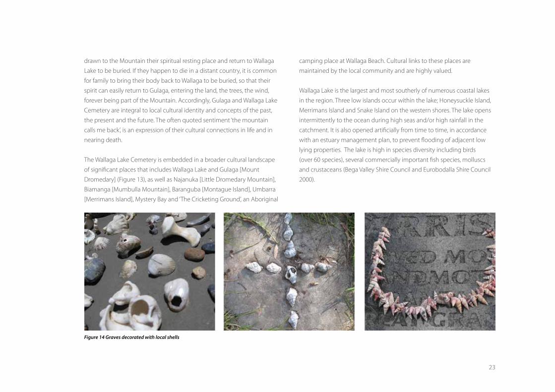
Figure 14 Graves decorated with local shells
24
Ongoing consumption of natural resources collected in and around
Wallaga Lake and Wallaga Beach is another way the local community
maintain cultural connections to the area. In many cases shells collected
from Wallaga Lake and Beach are used to decorate graves within the
cemetery (Figure 14).
Aboriginal people’s links to the region, in the past as well as in the present,
have also been described according to tribes, sub-tribes, clans, languages
and totems. The Yuin tribal area was recorded by Howitt as extending
from the Shoalhaven River in the north to Cape Howe in the south and
west into the Great Dividing Range (Howitt, 1904). Yuin tribal subgroups
with traditional links to the Wallaga Lake area include the Walbanga and
Djiringanj. Howitt recorded another division within the Yuin tribal area;
the Guyangal [guya = south] and Kurial [kuru = north] coastal subtribes,
together known as Katungal [Katung = sea].
Aboriginal clan groups and or place names recorded in the early settlement
period include Bowdally [Bodalla], Wondeller [Wandella], Wokoonga
[Wagonga], Noorama [Narooma], Tolbedilbo [Tilba Tilba], Wallurga
[Wallaga], Mogareka [Mogareeka], Windilla [Wandella], and Biggah [Bega].
On a linguistic level, the Wallaga Lake area is primarily affiliated with the
Jeringan [Dyirringan] language with Dhurga [Thoorga] influences from the
north and Thauaira [Thawa] from the south (Wesson 2000).
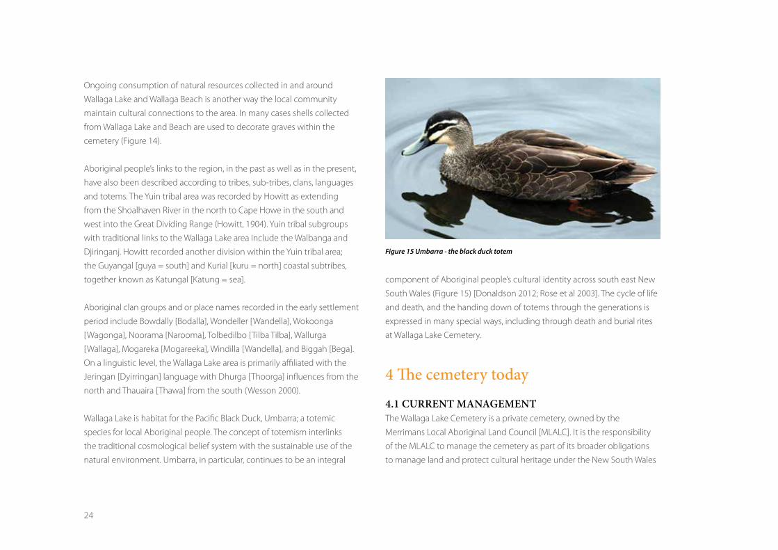
Wallaga Lake is habitat for the Pacific Black Duck, Umbarra; a totemic
species for local Aboriginal people. The concept of totemism interlinks
the traditional cosmological belief system with the sustainable use of the
natural environment. Umbarra, in particular, continues to be an integral
component of Aboriginal people’s cultural identity across south east New
South Wales (Figure 15) [Donaldson 2012; Rose et al 2003]. The cycle of life
and death, and the handing down of totems through the generations is
expressed in many special ways, including through death and burial rites
at Wallaga Lake Cemetery.
4 The cemetery today
4.1 CURRENT MANAGEMENT The Wallaga Lake Cemetery is a private cemetery, owned by the
Merrimans Local Aboriginal Land Council [MLALC]. It is the responsibility
of the MLALC to manage the cemetery as part of its broader obligations
to manage land and protect cultural heritage under the New South Wales
Figure 15 Umbarra - the black duck totem
25
Aboriginal Land Rights Act 1983. While managing the cemetery grounds
falls to the MLALC, family members and relatives are responsible for the
care and maintenance of the graves of their loved ones. The cemetery is
not consecrated or registered in New South Wales.
Today, the cemetery has an average of three new burials each year. When
someone passes away, family members point out the proposed burial
location to the excavator driver who digs the grave in accordance with
regulations of the Public Health Act. Usually, the hearse pulls up at the
cemetery entrance and the coffin is carried by pall bearers to the burial
location. As a rule, vehicles do not go into the cemetery unless family
members are infirm and need to be transported. After the funeral, family
members manually cover the grave. The recently completed survey map
can also be used to identify a suitable burial site that will not impact on
any existing graves/possible graves. Up until now, the MLALC has not kept
a record of burials in the cemetery.
The MLALC does not receive any specific funding for the cemetery
and does not charge burial fees. In previous years the Commonwealth
Development Employment Program [CDEP] provided funds to enable
regular cemetery maintenance, such as grass cutting and fence repair.
Once CDEP ended, cemetery maintenance has been irregular due to lack
of funds, tools or an identified caretaker. Over time the grass has got long,
tree branches have fallen down, crosses have rotted, fences have collapsed
and the cemetery looked neglected. Whilst lack of maintenance is a dis-
incentive for some people to attend to the graves of their relatives, many
families continue to maintain and visit their relative’s graves.
Figure 16 Grave numbering system
26
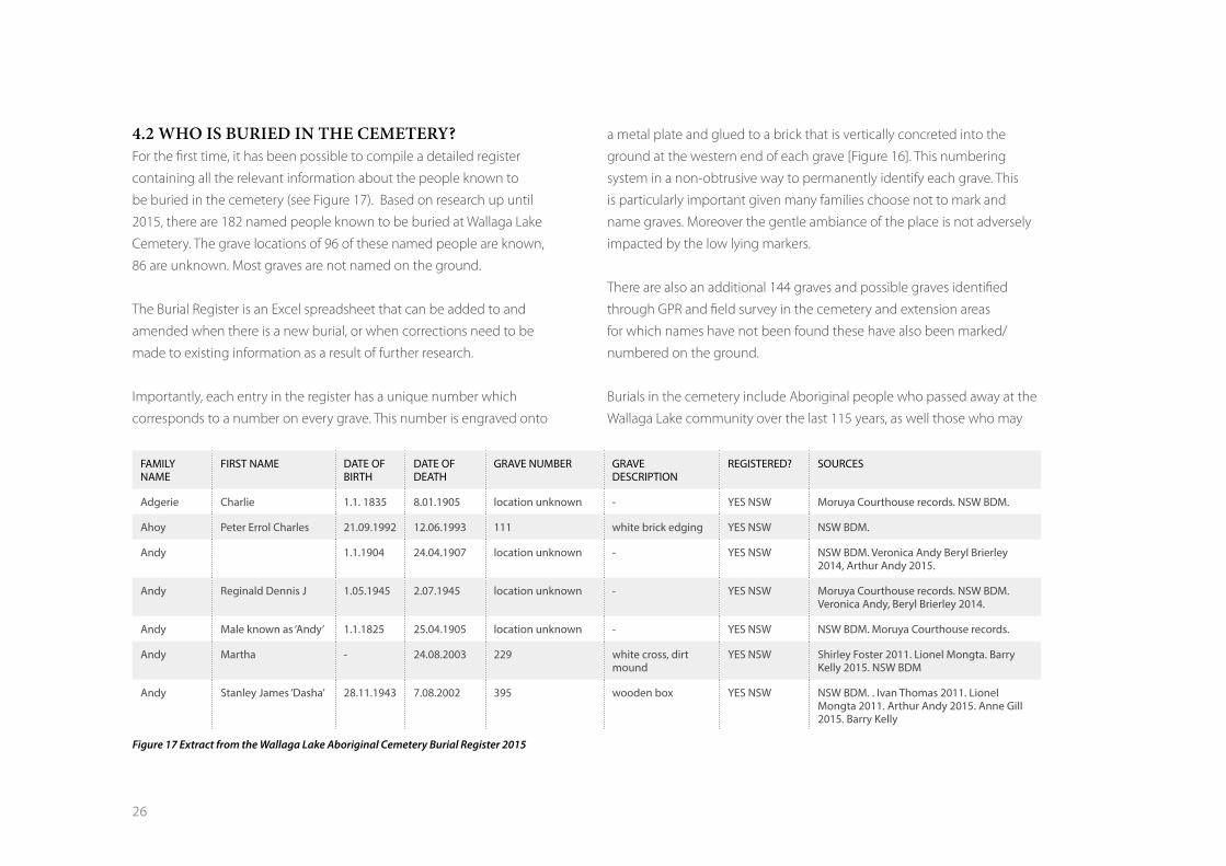
4.2 WHO IS BURIED IN THE CEMETERY?For the first time, it has been possible to compile a detailed register
containing all the relevant information about the people known to
be buried in the cemetery (see Figure 17). Based on research up until
2015, there are 182 named people known to be buried at Wallaga Lake
Cemetery. The grave locations of 96 of these named people are known,
86 are unknown. Most graves are not named on the ground.
The Burial Register is an Excel spreadsheet that can be added to and
amended when there is a new burial, or when corrections need to be
made to existing information as a result of further research.
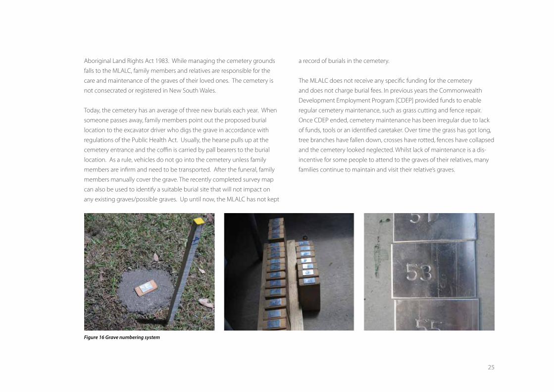
Importantly, each entry in the register has a unique number which
corresponds to a number on every grave. This number is engraved onto
a metal plate and glued to a brick that is vertically concreted into the
ground at the western end of each grave [Figure 16]. This numbering
system in a non-obtrusive way to permanently identify each grave. This
is particularly important given many families choose not to mark and
name graves. Moreover the gentle ambiance of the place is not adversely
impacted by the low lying markers.
There are also an additional 144 graves and possible graves identified
through GPR and field survey in the cemetery and extension areas
for which names have not been found these have also been marked/
numbered on the ground.
Burials in the cemetery include Aboriginal people who passed away at the
Wallaga Lake community over the last 115 years, as well those who may
FAMILY NAME
FIRST NAME DATE OF BIRTH
DATE OF DEATH
GRAVE NUMBER GRAVE DESCRIPTION
REGISTERED? SOURCES
Adgerie Charlie 1.1. 1835 8.01.1905 location unknown - YES NSW Moruya Courthouse records. NSW BDM.
Ahoy Peter Errol Charles 21.09.1992 12.06.1993 111 white brick edging YES NSW NSW BDM.
Andy 1.1.1904 24.04.1907 location unknown - YES NSW NSW BDM. Veronica Andy Beryl Brierley 2014, Arthur Andy 2015.
Andy Reginald Dennis J 1.05.1945 2.07.1945 location unknown - YES NSW Moruya Courthouse records. NSW BDM. Veronica Andy, Beryl Brierley 2014.
Andy Male known as ‘Andy’ 1.1.1825 25.04.1905 location unknown - YES NSW NSW BDM. Moruya Courthouse records.
Andy Martha - 24.08.2003 229 white cross, dirt mound
YES NSW Shirley Foster 2011. Lionel Mongta. Barry Kelly 2015. NSW BDM
Andy Stanley James ‘Dasha’ 28.11.1943 7.08.2002 395 wooden box YES NSW NSW BDM. . Ivan Thomas 2011. Lionel Mongta 2011. Arthur Andy 2015. Anne Gill 2015. Barry Kelly
Figure 17 Extract from the Wallaga Lake Aboriginal Cemetery Burial Register 2015

27
have died elsewhere in Australia and been brought back home to Wallaga
Lake to be buried.
Whilst Wallaga Lake cemetery is known as an ‘Aboriginal’ cemetery, there
are several non-Aboriginal burials in the cemetery; a Maori man and
woman, two non-Aboriginal babies, and one non-Aboriginal man.
4.3 GRAVES There are 240 graves and possible graves in the Wallaga Lake Cemetery. As
noted above, we know the names of 182 people buried in the cemetery
between 1895 and 2015. As at 2015, we know where 96 of these named
people are buried. Over time it is hoped that the remaining 86 named
ancestors can be matched to some of the 144 unnamed graves.
Across the cemetery there are distinct groupings of graves based on
kinship associations. Family grave plots tend to occur in lines, reflecting a
wish to be buried close to a relative, sometimes a specific relative. Whilst
most of the more recent graves are orientated east west, said to be facing
the ocean and rising sun, the older unnamed graves seem randomly
placed. Some graves are well tended and cared for, while others are
neglected and have deteriorated. Most graves are not named. Some of
the graves are very visible, being marked with crosses, a tree, a cement
slab and/or various types of monuments, some elaborate, some simple
(Figures 18, 19). Other graves are less obvious, being just depressions or
mounds. Whilst it is mainly the less obvious graves that remain unnamed,
the identity of the people buried in 11 of the more obvious graves [ie,
concrete slab] remains unknown.
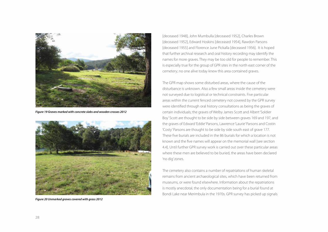
Most of the graves in Wallaga Lake Cemetery became invisible over time,
now appearing as even, grassed slopes [figure 20]. With the use of GPR
technology, these graves have been rediscovered. The GPR surveys have
been valuable for detecting possible graves beneath the surface without
having to dig and disturb the burials. 143 graves and possible graves were
detected with the use of the GPR across the current cemetery and the
proposed extensions. It is not possible to be 100% certain that the GPR
signal represents a grave but a rectangular shape appearing on the graphs
is a good indicator that a grave is present.
So far, only 6 of the 143 GPR graves correspond with people’s memories
of where people were buried. These graves have now been permanently
marked and numbered (Figure 21) and belong to Trevor Gregory Harrison
Figure 18 Typical grave outlined with rocks
28
[deceased 1948], John Mumbulla [deceased 1952], Charles Brown
[deceased 1952], Edward Hoskins [deceased 1954], Rawdon Parsons
[deceased 1955] and Florence June Pickalla [deceased 1956]. It is hoped
that further archival research and oral history recording may identify the
names for more graves. They may be too old for people to remember. This
is especially true for the group of GPR sites in the north east corner of the
cemetery; no one alive today knew this area contained graves.
The GPR map shows some disturbed areas, where the cause of the
disturbance is unknown. Also a few small areas inside the cemetery were
not surveyed due to logistical or technical constraints. Five particular
areas within the current fenced cemetery not covered by the GPR survey
were identified through oral history consultations as being the graves of
certain individuals; the graves of Welby James Scott and Albert ‘Soldier
Boy’ Scott are thought to be side by side between graves 169 and 197, and
the graves of Edward ‘Eddie’ Parsons, Lawrence ‘Laurie’ Parsons and Costin
‘Costy’ Parsons are thought to be side by side south east of grave 177.
These five burials are included in the 86 burials for which a location is not
known and the five names will appear on the memorial wall [see section
4.4]. Until further GPR survey work is carried out over these particular areas
where these men are believed to be buried, the areas have been declared
‘no dig’ zones.
The cemetery also contains a number of repatriations of human skeletal
remains from ancient archaeological sites, which have been returned from
museums, or were found elsewhere. Information about the repatriations
is mostly anecdotal, the only documentation being for a burial found at
Bondi Lake near Merimbula in the 1970s. GPR survey has picked up signals
Figure 19 Graves marked with concrete slabs and wooden crosses 2012
Figure 20 Unmarked graves covered with grass 2012

29
inside and outside the current entrance which may represent repatriations
which would correlate with the anecdotal information.
Figure 23 [see map insert] is the survey plan of the existing cemetery
and proposed extensions, showing the locations of the 240 graves and
possible graves. Each grave has been allocated two consecutive numbers
that mark each end of the grave and show its orientation. The odd
number of the pair is inscribed on the metal plate marking the grave on
the ground, typically at the western end.
4.4 MEMORIAL WALLThe memorial wall is seen by the community as very important for
acknowledging ancestors whose whereabouts in the cemetery is
unknown (Figure 22). The intention of the memorial wall is to display the
names of the 86 people buried in the cemetery between 1895 and 1993,
for which a grave location has not been identified. Also included on the
wall are the names of people whose grave locations are uncertain or the
subject of dispute.
Figure 21 Permanent markers for the graves where oral history and GPR results matched Figure 22 Memorial wall - built 2014

31
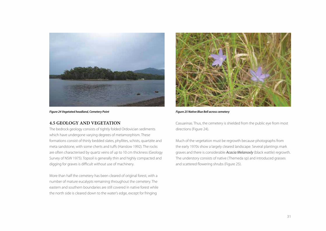
4.5 GEOLOGY AND VEGETATION The bedrock geology consists of tightly folded Ordovician sediments
which have undergone varying degrees of metamorphism. These
formations consist of thinly bedded slates, phyllites, schists, quartzite and
meta sandstone, with some cherts and tuffs (Hanslow 1992). The rocks
are often characterised by quartz veins of up to 10 cm thickness (Geology
Survey of NSW 1975). Topsoil is generally thin and highly compacted and
digging for graves is difficult without use of machinery.
More than half the cemetery has been cleared of original forest, with a
number of mature eucalypts remaining throughout the cemetery. The
eastern and southern boundaries are still covered in native forest while
the north side is cleared down to the water’s edge, except for fringing
Casuarinas. Thus, the cemetery is shielded from the public eye from most
directions (Figure 24).
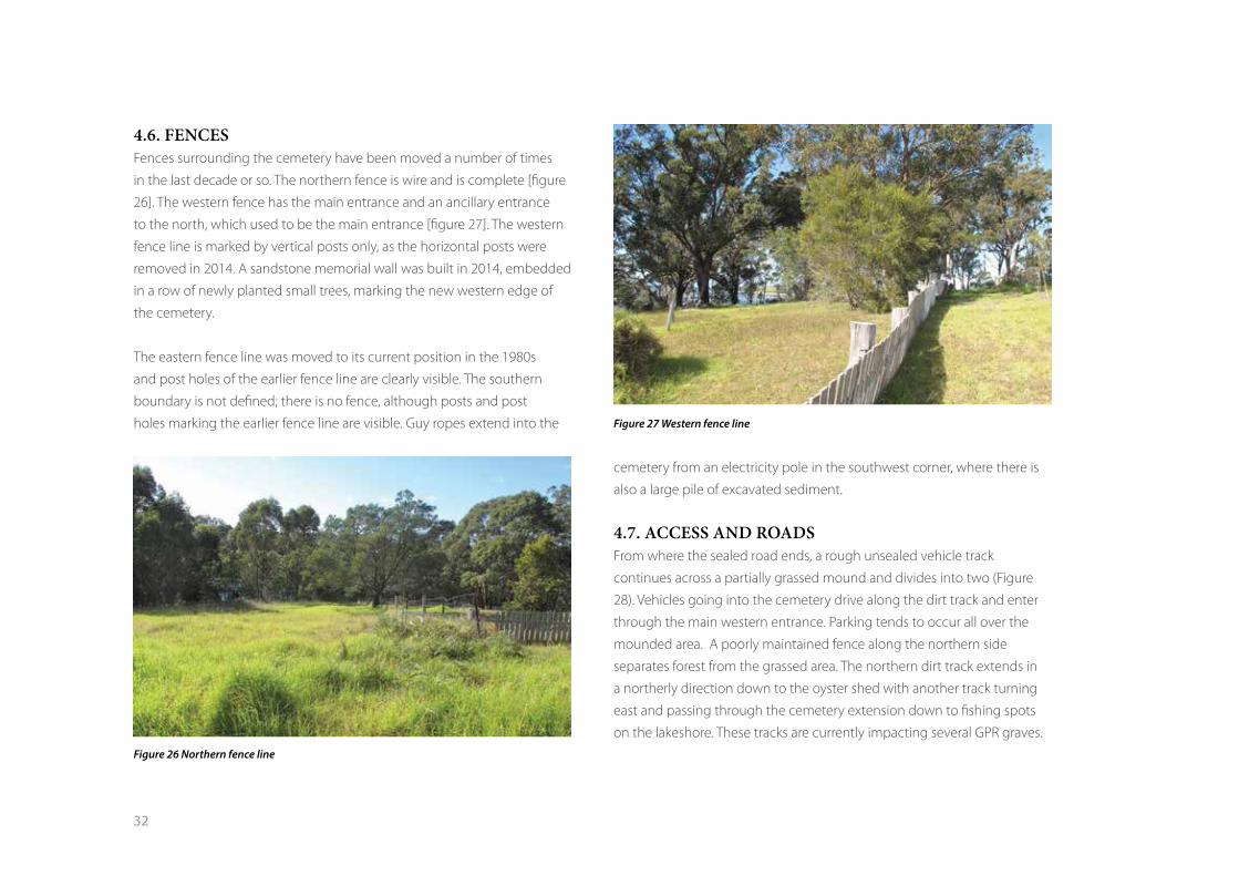
Much of the vegetation must be regrowth because photographs from
the early 1970s show a largely cleared landscape. Several plantings mark
graves and there is considerable Acacia Melanoxly (black wattle) regrowth.
The understory consists of native (Themeda sp) and introduced grasses
and scattered flowering shrubs (Figure 25).
Figure 24 Vegetated headland, Cemetery Point Figure 25 Native Blue Bell across cemetery
32
4.6. FENCESFences surrounding the cemetery have been moved a number of times
in the last decade or so. The northern fence is wire and is complete [figure
26]. The western fence has the main entrance and an ancillary entrance
to the north, which used to be the main entrance [figure 27]. The western
fence line is marked by vertical posts only, as the horizontal posts were
removed in 2014. A sandstone memorial wall was built in 2014, embedded
in a row of newly planted small trees, marking the new western edge of
the cemetery.
The eastern fence line was moved to its current position in the 1980s
and post holes of the earlier fence line are clearly visible. The southern
boundary is not defined; there is no fence, although posts and post
holes marking the earlier fence line are visible. Guy ropes extend into the
cemetery from an electricity pole in the southwest corner, where there is
also a large pile of excavated sediment.
4.7. ACCESS AND ROADSFrom where the sealed road ends, a rough unsealed vehicle track
continues across a partially grassed mound and divides into two (Figure
28). Vehicles going into the cemetery drive along the dirt track and enter
through the main western entrance. Parking tends to occur all over the
mounded area. A poorly maintained fence along the northern side
separates forest from the grassed area. The northern dirt track extends in
a northerly direction down to the oyster shed with another track turning
east and passing through the cemetery extension down to fishing spots
on the lakeshore. These tracks are currently impacting several GPR graves.
Figure 26 Northern fence line
Figure 27 Western fence line

33
Highly disturbed and fragmented shell midden material can be seen in
patches on the dirt tracks. These exposures and the possible extent of the
midden is shown in Figure 28. Anecdotal evidence from community elders
indicates that when the sealed road was being built, it was terminated at
its current location to avoid this midden.
Figure 28 Extract from survey plan showing western side of cemetery with tracks and extent of midden

34
5. Legal framework
Several pieces of NSW legislation are relevant to the Wallaga Lake
cemetery.
5.1 NSW ABORIGINAL LAND RIGHTS ACT 1983The passing of the NSW Aboriginal Land Rights Act in 1983 enabled a
portion of the former Wallaga Lake Aboriginal Reserve, including the
cemetery, to be transferred to the newly formed Merrimans LALC in 1984.
Under this Act, the MLALC has a legal responsibility for managing the
property and its associated Aboriginal cultural heritage, with funding
allocations from the State Aboriginal Land Council.
5.2 EUROBODALLA LOCAL ENVIRONMENTAL PLAN (LEP) The zoning on the Eurobodalla LEP determines what is and is not
permissible on lands owned by the Merrimans LALC, such as certain
activities or certain types of buildings or structures. It also determines
which developments require a permit. The land, including the cemetery is
currently zoned 1(a) – Rural, under the Eurobodalla Rural LEP 1987 (Figure
29). The cemetery does not have a separate listing as a heritage item
under the Eurobodalla LEP 2012.
5.3 HERITAGE REGISTERSThe cemetery in not listed on any State or National heritage registers.
Figure 29 Excerpt from Eurobodalla Shire LEP 2012
35
5.4 NATIONAL PARKS AND WILDLIFE ACT 1974 This Act is currently administered by the New South Wales Office of
Environment and Heritage. It gives legal protection to all Aboriginal
objects in New South Wales, relating to past Aboriginal occupation and
use of the land, through to the contact period. The cemetery was first
recorded by NPWS in the early 1970s and is listed on the OEH database of
sites [Aboriginal Heritage Information System (AHIMS)] .
The cemetery also contains Aboriginal shell midden material which has
been disturbed by the digging of graves over many decades and more
recently by digging holes to put in grave numbers. Technically this is an
offence under the NPW Act and advice is required from OEH in relation to
ongoing use of the cemetery.
The community is considering seeking a listing of the cemetery as an
Aboriginal Place under Section 86 of the NPW Act. An Aboriginal Place is
normally used to recognise places of spiritual or cultural significance that
don’t necessarily show physical evidence of Aboriginal use or occupation.
It is uncertain what constraints an Aboriginal Place declaration would have
on continuing use of the area as a cemetery.
5.5 CEMETERIES AND CREMATORIUM ACT 2013 This is the main legislation governing cemetery management in NSW and
regulates all three areas of the internment sector – Crown, private and
local, through establishment of Cemeteries and Crematoria NSW (CCNSW),
a government agency with regulatory oversight of the industry and
responsibility for administering the Cemeteries and Crematoria Act 2013.
The CCNSW maintains a register of all cemeteries in NSW; the Wallaga Lake
cemetery is not listed, but neither are most Aboriginal cemeteries.
A “Cemetery” as defined by the Act includes the following places:
(a) a reserve or part of a reserve dedicated or reserved as a
public cemetery under the Crown Lands Act 1989
(b) a private cemetery or other place approved for that purpose by a local
government authority, subject to the requirements of the Public Health
Regulation 2012, which arises from the Public Health (Disposal of Bodies) Regulation 2002. The regulation covers such matters as how deep the
grave must be, forms that must be completed at death, and the keeping
of a register of burials. It is the legal responsibility of the Funeral Director
to register each death. Local funeral directors liaise with the family and
arrange for each death to be registered with the New South Wales or
Victoria Office of Births, Deaths and Marriages.
The Wallaga Lake Cemetery does not appear to comply with this new
legislation. It also appears that local government can have an involvement
as an approving authority for the cemetery.

36
37
PART TWO
Management Plan for the Wallaga Lake Cemetery
38
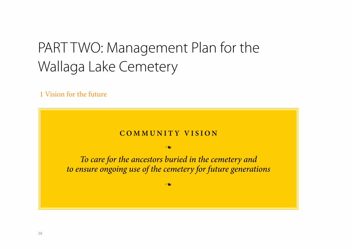
1 Vision for the future
C O M M U N I T Y V I S I O N
n
To care for the ancestors buried in the cemetery andto ensure ongoing use of the cemetery for future generations
n
PART TWO: Management Plan for the Wallaga Lake Cemetery
39
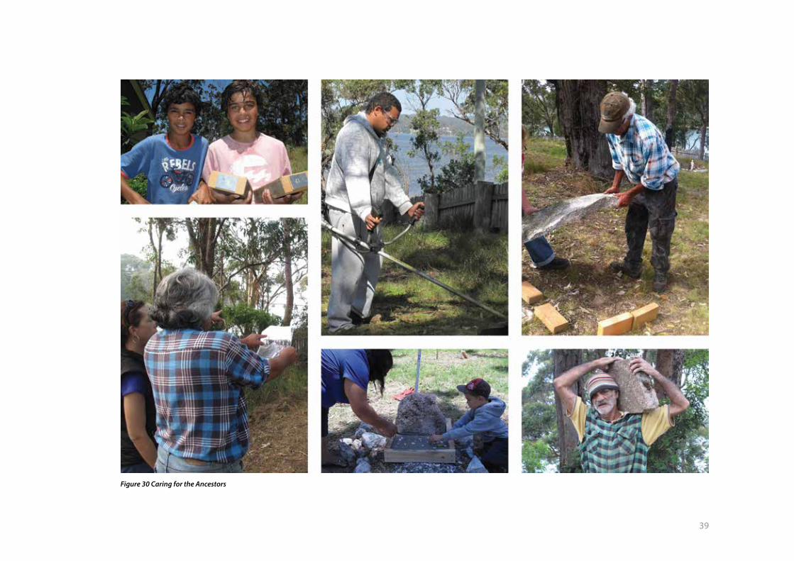
Figure 30 Caring for the Ancestors

40
2 Values of the cemetery to Aboriginal
people
Discussions at the planning workshops have shown that the Wallaga Lake
Aboriginal Cemetery is very important for the following reasons.
Aboriginal ownership – it is important for the Wallaga Lake Aboriginal
community that they hold the freehold title to the land on which the
cemetery is located. It is also important that they retain community based
management of the site, on behalf of Aboriginal families across the region.
Ancestors’ resting place – the cemetery is valued and respected as the
resting place for all burials over the past 120 years regardless of whether
or not they are known. The oldest graves are associated with the original
inhabitants of the region born into a traditional lifestyle. The cemetery is
also valued as a safe place to repatriate the remains of people who were
associated with the south coast region in pre-contact times.
A place to remember – the cemetery is associated with stories about
family members, community people and past events. The very existence
of the place is associated with the history of segregation when Aboriginal
people weren’t allowed to live or be buried in nearby town cemeteries.
Land was first set aside in 1880 and the Aboriginal Reserve was gazetted in
1891; many early deaths and burials were recorded just one decade later,
from 1901. The memorial wall is a community initiative giving recognition
to those buried at unknown locations within the cemetery.
Spiritual connections – the cemetery is seen as a place where people
return to the spiritual realm, return to country, return to the Dreaming,
return to Gulaga. Nearing death people are known to return to the region
to ensure their burial at Wallaga Lake and more specifically close to Gulaga
Mountain.
Family connections – the cemetery is an important place for family
groups to express their genealogical identity and cultural connectedness
with their country. Families who have moved or were forcibly moved off
their traditional lands and onto the reserve also value the cemetery as a
place to bury their kin and retain their historical familial connections to
the area.
On-going use as a cemetery – it is vitally important for the members of
the Wallaga Lake Community and the broader Aboriginal community to
continue to bury loved ones at Wallaga Lake, rather than in nearby public
cemeteries. The Wallaga Lake Cemetery is intertwined with Aboriginal
cultural identity and is a key element of the broader cultural landscape.
Archaeological sites – it is important that the shell middens recorded in
the cemetery and in the car park area are properly recorded and protected.
41
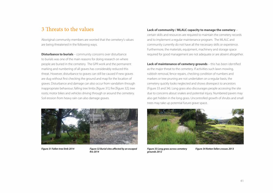
3 Threats to the values
Aboriginal community members are worried that the cemetery’s values
are being threatened in the following ways.
Disturbance to burials – community concerns over disturbance
to burials was one of the main reasons for doing research on where
people are buried in the cemetery. The GPR work and the permanent
marking and numbering of all graves has considerably reduced this
threat. However, disturbance to graves can still be caused if new graves
are dug without first checking the ground and map for the location of
graves. Disturbance and damage can also occur from vandalism through
inappropriate behaviour; falling tree limbs [figure 31]; fire [figure 32]; tree
roots; motor bikes and vehicles driving through or around the cemetery.
Soil erosion from heavy rain can also damage graves.
Lack of community / MLALC capacity to manage the cemetery –
certain skills and resources are required to maintain the cemetery records
and to implement a regular maintenance program. The MLALC and
community currently do not have all the necessary skills or experience.
Furthermore, the materials, equipment, machinery and storage space
required for good management are not adequate or are absent altogether.
Lack of maintenance of cemetery grounds – this has been identified
as the major threat to the cemetery. If activities such lawn mowing,
rubbish removal, fence repairs, checking condition of numbers and
markers or tree pruning are not undertaken on a regular basis, the
cemetery quickly looks neglected and shows disrespect to ancestors
(Figure 33 and 34). Long grass also discourages people accessing the site
due to concerns about snakes and potential injury. Numbered pavers may
also get hidden in the long grass. Uncontrolled growth of shrubs and small
trees may take up potential future grave space.
Figure 31 Fallen tree limb 2014 Figure 33 Long grass across cemetery grounds 2012
Figure 32 Burial sites affected by an escaped fire 2014
Figure 34 Rotten fallen crosses 2013
42
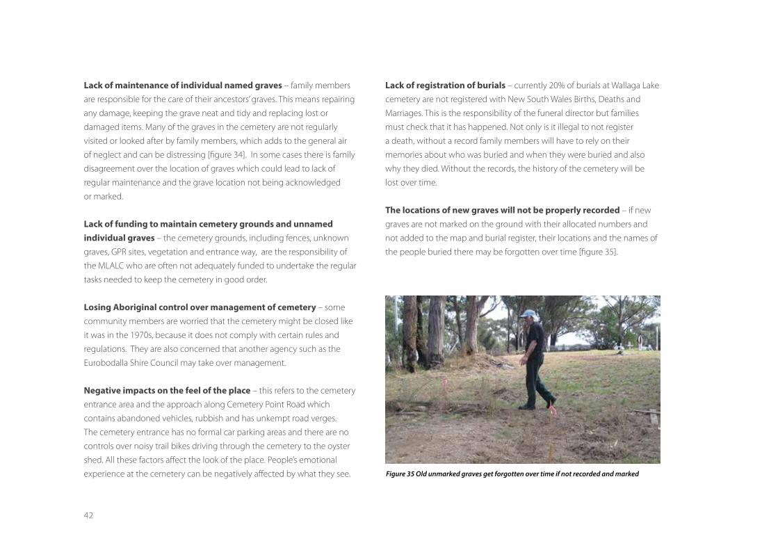
Lack of maintenance of individual named graves – family members
are responsible for the care of their ancestors’ graves. This means repairing
any damage, keeping the grave neat and tidy and replacing lost or
damaged items. Many of the graves in the cemetery are not regularly
visited or looked after by family members, which adds to the general air
of neglect and can be distressing [figure 34]. In some cases there is family
disagreement over the location of graves which could lead to lack of
regular maintenance and the grave location not being acknowledged
or marked.
Lack of funding to maintain cemetery grounds and unnamed individual graves – the cemetery grounds, including fences, unknown
graves, GPR sites, vegetation and entrance way, are the responsibility of
the MLALC who are often not adequately funded to undertake the regular
tasks needed to keep the cemetery in good order.
Losing Aboriginal control over management of cemetery – some
community members are worried that the cemetery might be closed like
it was in the 1970s, because it does not comply with certain rules and
regulations. They are also concerned that another agency such as the
Eurobodalla Shire Council may take over management.
Negative impacts on the feel of the place – this refers to the cemetery
entrance area and the approach along Cemetery Point Road which
contains abandoned vehicles, rubbish and has unkempt road verges.
The cemetery entrance has no formal car parking areas and there are no
controls over noisy trail bikes driving through the cemetery to the oyster
shed. All these factors affect the look of the place. People’s emotional
experience at the cemetery can be negatively affected by what they see.
Lack of registration of burials – currently 20% of burials at Wallaga Lake
cemetery are not registered with New South Wales Births, Deaths and
Marriages. This is the responsibility of the funeral director but families
must check that it has happened. Not only is it illegal to not register
a death, without a record family members will have to rely on their
memories about who was buried and when they were buried and also
why they died. Without the records, the history of the cemetery will be
lost over time.
The locations of new graves will not be properly recorded – if new
graves are not marked on the ground with their allocated numbers and
not added to the map and burial register, their locations and the names of
the people buried there may be forgotten over time [figure 35].
Figure 35 Old unmarked graves get forgotten over time if not recorded and marked

43
Lack of records associated with repatriations – generally there is
poor documentation of repatriations at the cemetery and as a result, there
is uncertainty about the location of repatriated remains, making them
vulnerable to disturbance.
Lack of information about unnamed graves – the 144 unnamed
graves are not currently linked to any particular family, and are therefore
vulnerable to neglect. As GPR did not cover 100% of the cemetery, there
may still be graves to be found.
Disturbance to archaeological sites – digging graves has disturbed
middens in the past and the midden in the car park is very disturbed by
vehicles and erosion [figure 36]. Other unrecorded archaeological sites
may be disturbed in the future.
Figure 36 Cemetery car park on midden material 2015

44
4 Objectives for achieving vision
The values and threats identified by the community have been analysed
in terms of what is needed to minimise the threats and ensure protection
of the values. A series of objectives and associated actions have been
generated to capture all the values and threats. The two overriding values
of the cemetery are as a historical place of great cultural significance
and as a resting place for current and future generations. Many of the
threats arise from the community’s current limited capacity to protect
these values. These two major values and the desire of the community to
improve their capacity to protect these values provide the framework for
the objectives.
OBJECTIVE 1: Maintain cemetery grounds and infrastructure in good condition• To facilitate access by family.
• For the continuing function as a cemetery.
• To show respect to ancestors and express community pride.
OBJECTIVE 2: Individual graves are maintained and cared for• As a source of family pride.
• To show respect to family members who have passed away.
• To contribute to the overall appearance of the cemetery and therefore
community pride.
OBJECTIVE 3: Establish workable systems for updating, storing and accessing cemetery records• There is currently no mechanism for updating and storing records
including for repatriations.
• Accessing records is important for families seeking information about
their loved ones who have passed away.
• Marking the position of graves on maps and on the ground will
prevent accidental disturbance to existing graves.
• Keeping records will minimise any future uncertainty about where or
when people were buried.

45
OBJECTIVE 4: The cemetery is managed as a peaceful, spiritual and historical place, connected to the surrounding environment• As the ancestors’ resting place.
• As an important part of the broader Aboriginal history of the area.
• As a place where Aboriginal people can reflect on the past.
• As a place for appropriate community activities.
OBJECTIVE 5: All existing known graves and possible graves (identified by GPR) are protected and acknowledged• Graves are part of individual and community cultural heritage.
• Disturbance is distressing to the community.
• Further research may identify unnamed graves.
OBJECTIVE 6: Cemetery is managed sustainably by the community for ongoing use as a cemetery • One of only a few functioning Aboriginal cemeteries on NSW south
coast/far south coast.
• Family members want to bury relatives close to those already in the
cemetery.
• Important resting place for Aboriginal people from a wide area.
• Enables people to be buried at a place that is significant to them –
part of country and/or historical associations.
• Important to keep community control over management.
OBJECTIVE 7: Continue to improve knowledge about the history of the cemetery and who is buried there• There are still 144 unnamed graves and 86 named people buried in
the cemetery for which a grave location is not known.
• Information on the history of the cemetery is still lacking.
• Information about repatriations is still very incomplete.
OBJECTIVE 8: Cemetery is managed according to all legal requirements• Protect archaeological sites such as shell middens, scarred trees and
stone artefacts.
• Protect endangered plant species.
• Register all deaths with NSW Births, Deaths and Marriages.
• Comply with Cemeteries and Crematoria Act 2013.
OBJECTIVE 9: Cemetery approach and entrance area is redesigned and upgraded• To improve the feel and appearance of the cemetery approach.
• To regulate car parking.
• To cater for elders with a toilet and shelter area.
• To protect the midden in the car park.
• To protect GPR graves in northern and western cemetery extension
areas by preventing vehicle access.

46
5. Actions
WALLAGA LAKE ABORIGINAL CEMETERY MANAGEMENT ACTIONS 2015 – 2020
NO OBJECTIVE ACTION PRIORITY1 Maintain cemetery
grounds and infrastructure in good condition
New cemetery committee to draw up and implement a regular maintenance program (see Objective 5). Allocate tasks and seek volunteers or identify paid positions. Identify machinery, tools and labour required for rubbish removal, lawn mowing, whipper snipping, trimming vegetation and checking condition of graves.
VERY HIGH
Identify suitable location for, and erect, a storage shed. HIGH
Build new fences to define the extended cemetery on the northern and western sides, in accordance with landscape plan (see Objective 3)
HIGH
Identify and remove any problem trees. Trim trees and lop branches in accordance with the landscape plan (see Objective 3).
MEDIUM
Purchase machinery, tools and equipment, as required. MEDIUM
Repair or replace existing fences in accordance with landscape plan (see Objective 3). LOW
Protection of the cemetery from fire (wild or lit) is to be included in any future fire management plan for the village or surrounding region.
ONGOING
47
WALLAGA LAKE ABORIGINAL CEMETERY MANAGEMENT ACTIONS 2015 – 2020
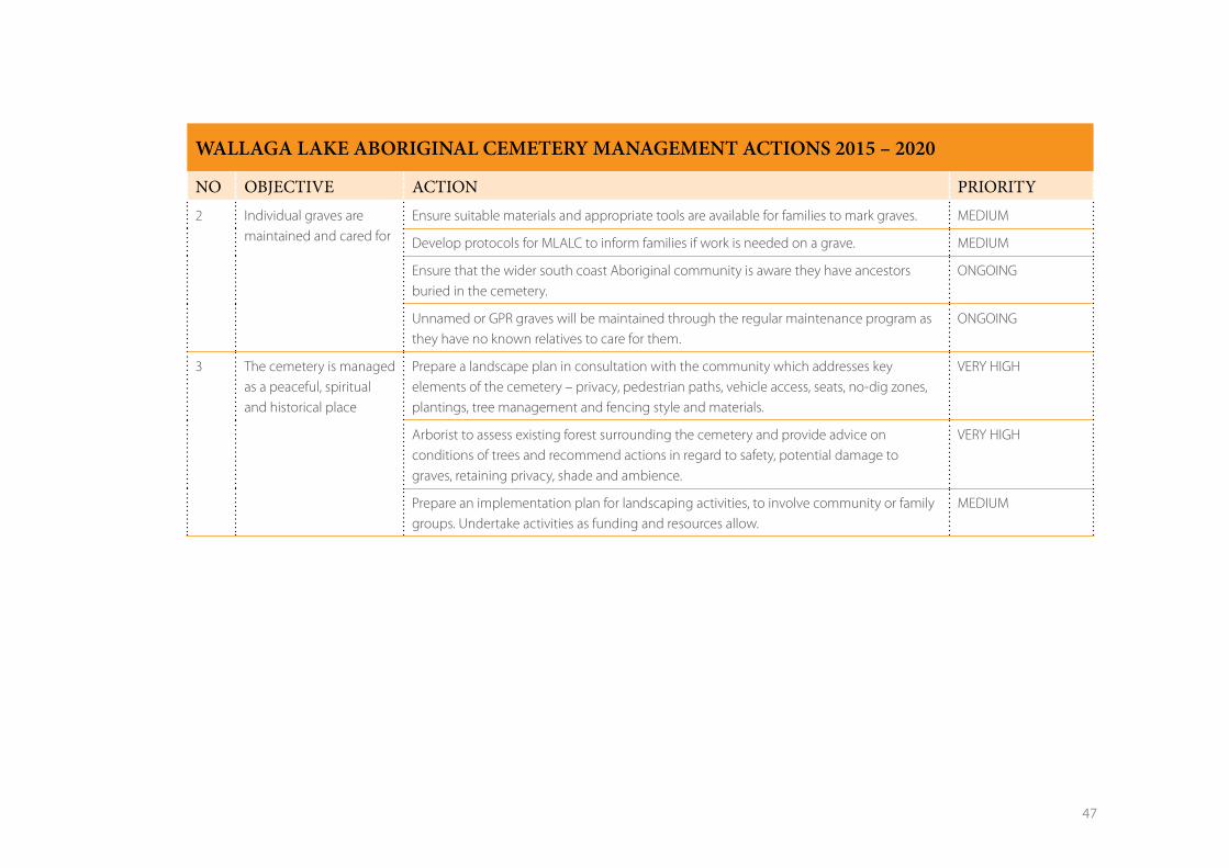
NO OBJECTIVE ACTION PRIORITY2 Individual graves are
maintained and cared forEnsure suitable materials and appropriate tools are available for families to mark graves. MEDIUM
Develop protocols for MLALC to inform families if work is needed on a grave. MEDIUM
Ensure that the wider south coast Aboriginal community is aware they have ancestors buried in the cemetery.
ONGOING
Unnamed or GPR graves will be maintained through the regular maintenance program as they have no known relatives to care for them.
ONGOING
3 The cemetery is managed as a peaceful, spiritual and historical place
Prepare a landscape plan in consultation with the community which addresses key elements of the cemetery – privacy, pedestrian paths, vehicle access, seats, no-dig zones, plantings, tree management and fencing style and materials.
VERY HIGH
Arborist to assess existing forest surrounding the cemetery and provide advice on conditions of trees and recommend actions in regard to safety, potential damage to graves, retaining privacy, shade and ambience.
VERY HIGH
Prepare an implementation plan for landscaping activities, to involve community or family groups. Undertake activities as funding and resources allow.
MEDIUM
48
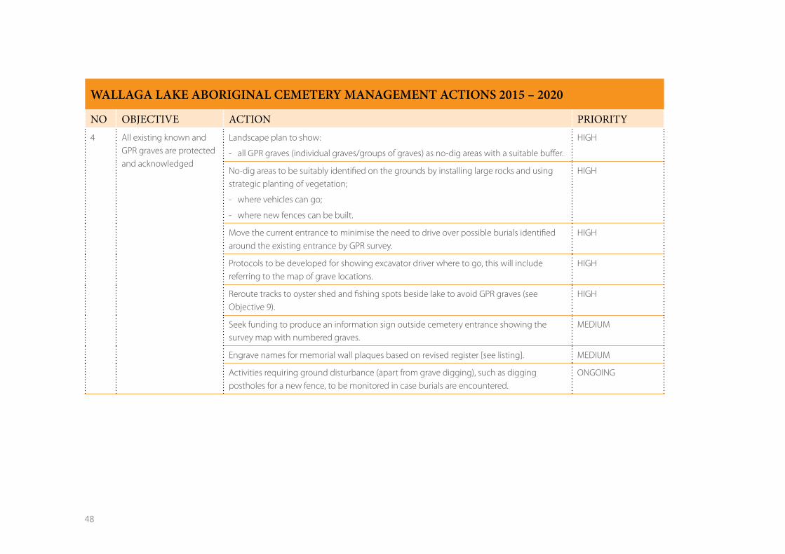
WALLAGA LAKE ABORIGINAL CEMETERY MANAGEMENT ACTIONS 2015 – 2020
NO OBJECTIVE ACTION PRIORITY4 All existing known and
GPR graves are protected and acknowledged
Landscape plan to show:
- all GPR graves (individual graves/groups of graves) as no-dig areas with a suitable buffer.
HIGH
No-dig areas to be suitably identified on the grounds by installing large rocks and using strategic planting of vegetation;
- where vehicles can go;
- where new fences can be built.
HIGH
Move the current entrance to minimise the need to drive over possible burials identified around the existing entrance by GPR survey.
HIGH
Protocols to be developed for showing excavator driver where to go, this will include referring to the map of grave locations.
HIGH
Reroute tracks to oyster shed and fishing spots beside lake to avoid GPR graves (see Objective 9).
HIGH
Seek funding to produce an information sign outside cemetery entrance showing the survey map with numbered graves.
MEDIUM
Engrave names for memorial wall plaques based on revised register [see listing]. MEDIUM
Activities requiring ground disturbance (apart from grave digging), such as digging postholes for a new fence, to be monitored in case burials are encountered.
ONGOING
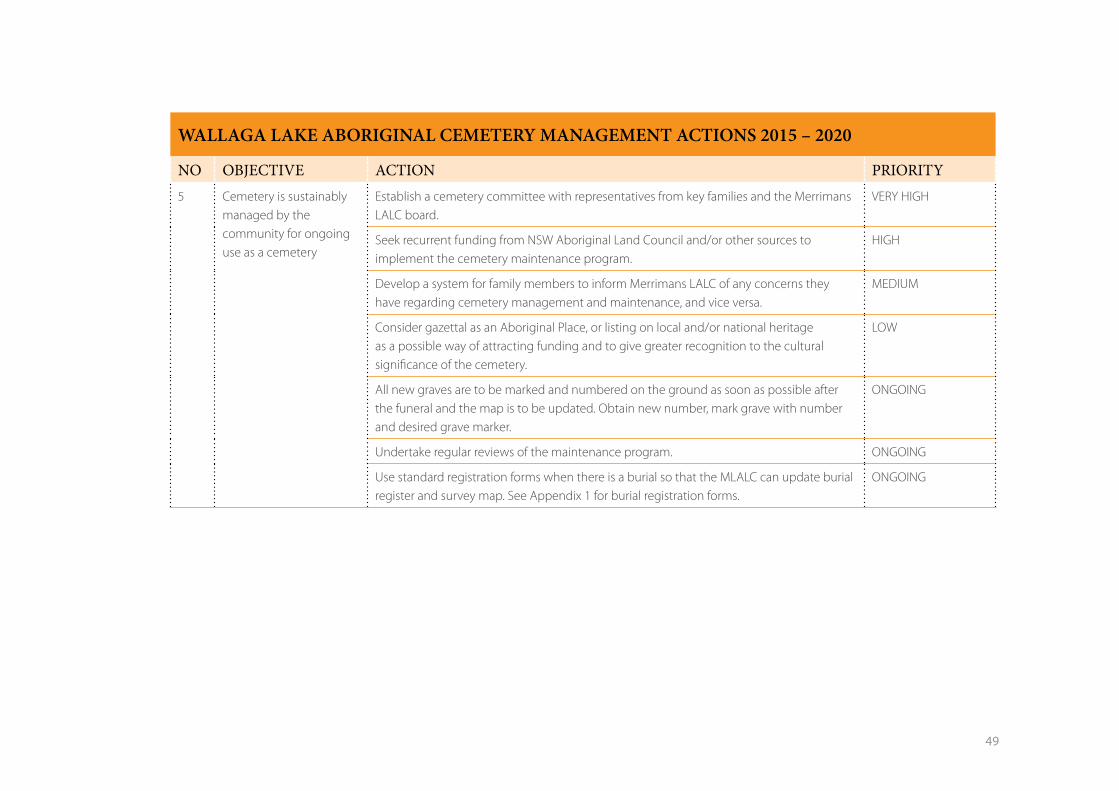
49
WALLAGA LAKE ABORIGINAL CEMETERY MANAGEMENT ACTIONS 2015 – 2020
NO OBJECTIVE ACTION PRIORITY5 Cemetery is sustainably
managed by the community for ongoing use as a cemetery
Establish a cemetery committee with representatives from key families and the Merrimans LALC board.
VERY HIGH
Seek recurrent funding from NSW Aboriginal Land Council and/or other sources to implement the cemetery maintenance program.
HIGH
Develop a system for family members to inform Merrimans LALC of any concerns they have regarding cemetery management and maintenance, and vice versa.
MEDIUM
Consider gazettal as an Aboriginal Place, or listing on local and/or national heritage as a possible way of attracting funding and to give greater recognition to the cultural significance of the cemetery.
LOW
All new graves are to be marked and numbered on the ground as soon as possible after the funeral and the map is to be updated. Obtain new number, mark grave with number and desired grave marker.
ONGOING
Undertake regular reviews of the maintenance program. ONGOING
Use standard registration forms when there is a burial so that the MLALC can update burial register and survey map. See Appendix 1 for burial registration forms.
ONGOING
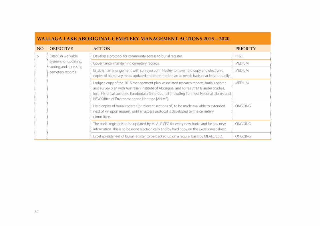
50
WALLAGA LAKE ABORIGINAL CEMETERY MANAGEMENT ACTIONS 2015 – 2020
NO OBJECTIVE ACTION PRIORITY6 Establish workable
systems for updating, storing and accessing cemetery records
Develop a protocol for community access to burial register. HIGH
Governance, maintaining cemetery records. MEDIUM
Establish an arrangement with surveyor John Healey to have hard copy and electronic copies of his survey maps updated and re-printed on an as needs basis or at least annually.
MEDIUM
Lodge a copy of the 2015 management plan, associated research reports, burial register and survey plan with Australian Institute of Aboriginal and Torres Strait Islander Studies, local historical societies, Eurobodalla Shire Council [including libraries], National Library and NSW Office of Environment and Heritage [AHIMS].
MEDIUM
Hard copies of burial register [or relevant sections of ] to be made available to extended next of kin upon request, until an access protocol is developed by the cemetery committee.
ONGOING
The burial register is to be updated by MLALC CEO for every new burial and for any new information. This is to be done electronically and by hard copy on the Excel spreadsheet.
ONGOING
Excel spreadsheet of burial register to be backed up on a regular basis by MLALC CEO. ONGOING
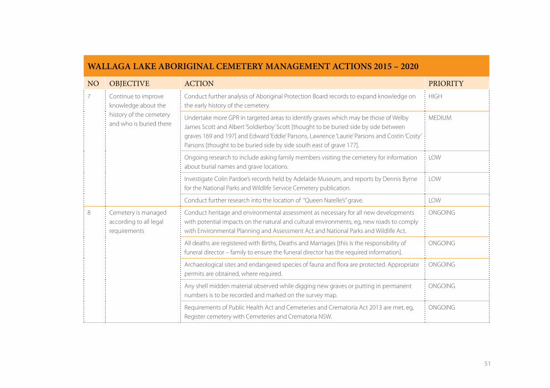
51
WALLAGA LAKE ABORIGINAL CEMETERY MANAGEMENT ACTIONS 2015 – 2020
NO OBJECTIVE ACTION PRIORITY7 Continue to improve
knowledge about the history of the cemetery and who is buried there
Conduct further analysis of Aboriginal Protection Board records to expand knowledge on the early history of the cemetery.
HIGH
Undertake more GPR in targeted areas to identify graves which may be those of Welby James Scott and Albert ‘Soldierboy’ Scott [thought to be buried side by side between graves 169 and 197] and Edward ‘Eddie’ Parsons, Lawrence ‘Laurie’ Parsons and Costin ‘Costy’ Parsons [thought to be buried side by side south east of grave 177].
MEDIUM
Ongoing research to include asking family members visiting the cemetery for information about burial names and grave locations.
LOW
Investigate Colin Pardoe’s records held by Adelaide Museum, and reports by Dennis Byrne for the National Parks and Wildlife Service Cemetery publication.
LOW
Conduct further research into the location of “Queen Narelle’s” grave. LOW
8 Cemetery is managed according to all legal requirements
Conduct heritage and environmental assessment as necessary for all new developments with potential impacts on the natural and cultural environments, eg, new roads to comply with Environmental Planning and Assessment Act and National Parks and Wildlife Act.
ONGOING
All deaths are registered with Births, Deaths and Marriages [this is the responsibility of funeral director – family to ensure the funeral director has the required information].
ONGOING
Archaeological sites and endangered species of fauna and flora are protected. Appropriate permits are obtained, where required.
ONGOING
Any shell midden material observed while digging new graves or putting in permanent numbers is to be recorded and marked on the survey map.
ONGOING
Requirements of Public Health Act and Cemeteries and Crematoria Act 2013 are met, eg, Register cemetery with Cemeteries and Crematoria NSW.
ONGOING
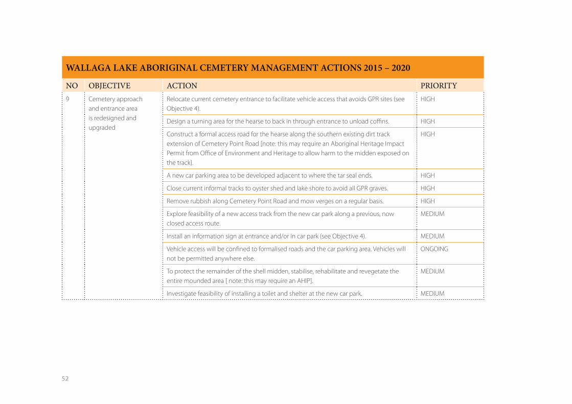
52
WALLAGA LAKE ABORIGINAL CEMETERY MANAGEMENT ACTIONS 2015 – 2020
NO OBJECTIVE ACTION PRIORITY9 Cemetery approach
and entrance area is redesigned and upgraded
Relocate current cemetery entrance to facilitate vehicle access that avoids GPR sites (see Objective 4).
HIGH
Design a turning area for the hearse to back in through entrance to unload coffins. HIGH
Construct a formal access road for the hearse along the southern existing dirt track extension of Cemetery Point Road [note: this may require an Aboriginal Heritage Impact Permit from Office of Environment and Heritage to allow harm to the midden exposed on the track].
HIGH
A new car parking area to be developed adjacent to where the tar seal ends. HIGH
Close current informal tracks to oyster shed and lake shore to avoid all GPR graves. HIGH
Remove rubbish along Cemetery Point Road and mow verges on a regular basis. HIGH
Explore feasibility of a new access track from the new car park along a previous, now closed access route.
MEDIUM
Install an information sign at entrance and/or in car park (see Objective 4). MEDIUM
Vehicle access will be confined to formalised roads and the car parking area. Vehicles will not be permitted anywhere else.
ONGOING
To protect the remainder of the shell midden, stabilise, rehabilitate and revegetate the entire mounded area [ note: this may require an AHIP].
MEDIUM
Investigate feasibility of installing a toilet and shelter at the new car park. MEDIUM
53
6. Review of plan
This plan is to be reviewed by the cemetery committee every five years, to
check whether objectives are still appropriate and to assess the effects of
any legislation changes etc.
The implementation of the plan should be reviewed annually to
determine which actions have been carried out.
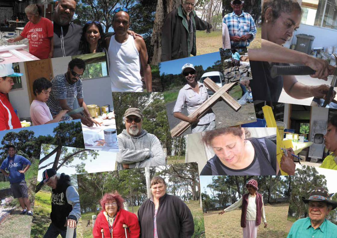
54
55
References
Bega Valley Shire and Eurobodalla Shire 2000 Wallaga Lake Estuary
Management Plan. Bega Valley Shire, Eurobodalla Shire: Bega, Moruya.
Cameron S 1987 An investigation of the history of the Aborigines of the far
south coast of New South Wales in the 19th century. B. Letters, ANU.
Donaldson S 2006 Eurobodalla Aboriginal Cultural Heritage Study
(Stage 2): Stories about the Eurobodalla by Aboriginal people., Moruya:
Eurobodalla Shire Council.
Donaldson S 2007 Eurobodalla Aboriginal Cultural Heritage Study (Stage
3): Understanding and Managing Aboriginal Cultural Heritage., Moruya:
Eurobodalla Shire Council.
Donaldson S 2012 Exploring ways of knowing, protecting and
acknowledging Aboriginal totems across the Eurobodalla Shire ,NSW.
Donaldson S & Feary S 2012a Caring for the ancestors., Moruya:
Eurobodalla Shire Council.
Donaldson S & Feary S 2012b Invisible Places - Historical Reserves in the
Eurobodalla. A report to the ESC, Moruya, NSW.
Feary S 2009 An Aboriginal burial at Murunna Point, NSW far south coast,
Queanbeyan: DECCW.
Feary S & Donaldson S 2011 Connecting with Country in the Eurobodalla,
south coast, NSW, Moruya: Eurobodalla Shire Council.
Goodall H 2008 Invasion to Embassy. Sydney University Press: Sydney.
Goulding M & Waters K 2005 Eurobodalla Aboriginal Cultural Heritage
Study, south coast New South Wales, Moruya: Eurobodalla Shire Council.
Howitt 1904 The Native Tribes of South –East Australia, Macmillan & Co
London.
Hunter D 2014 Geophysical survey report. Wallaga Lake Aboriginal
cemetery, Melbourne: Hunter Geophysics.
John Healey and Associates PL, 2015 (March). Plan of Wallaga Lake
cemetery. Narooma: John Healey and Associates PL.
Kelly R 1975 Investigations of Aboriginal sites in the Wallaga Lakes area of
New South Wales, Sydney: NPWS.
NPWS, 1998 In sad but loving memory. Aboriginal burials and cemeteries
of the last 200 years in NSW. Sydney: NPWS.
Rose D 1990 Gulaga. A report of the cultural significance of Mount
Dromedary to Aboriginal people. Report to NSW Forestry Commission and
NSW National Parks and Wildlife Service.
Rose D, James D and Watson C 2003 Indigenous Kinship with the Natural
World in NSW. National Parks and Wildlife service: Sydney.
Wesson S 2000 An Historical Atlas of the Aborigines of Eastern Victoria and
Far South-eastern New South Wales, Monash Publications, Melbourne.
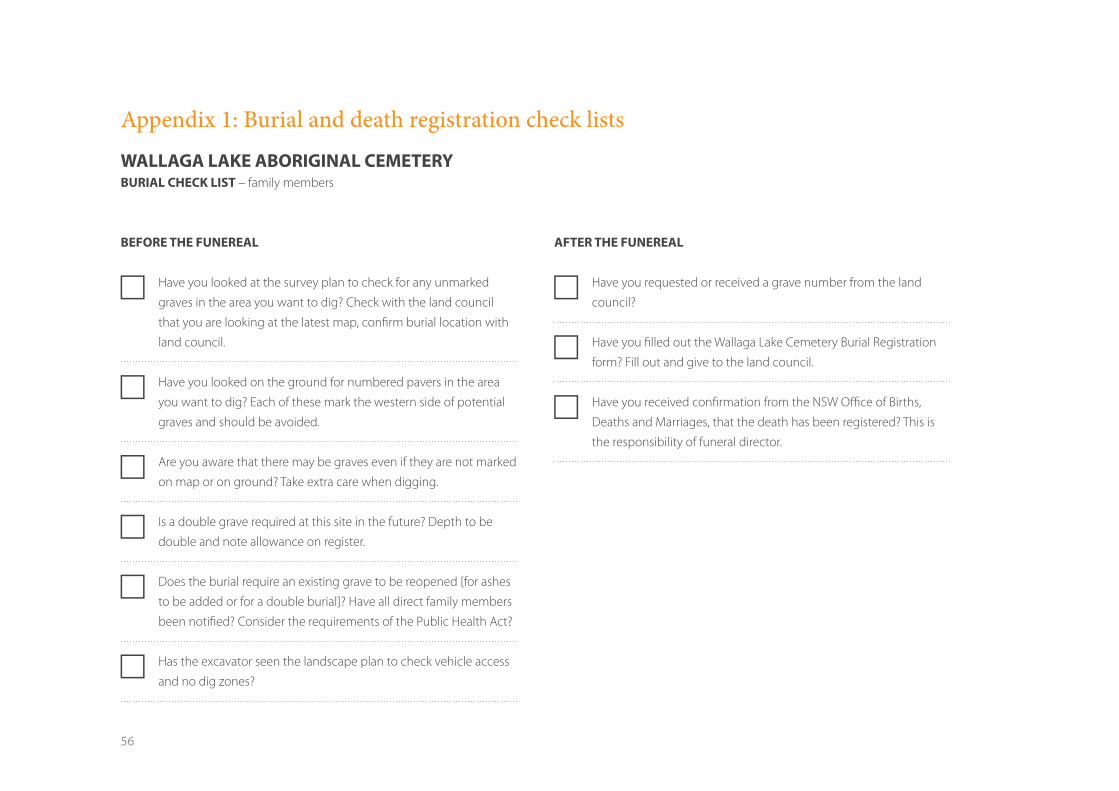
56
Appendix 1: Burial and death registration check lists
WALLAGA LAKE ABORIGINAL CEMETERY BURIAL CHECK LIST – family members
BEFORE THE FUNEREAL
FF Have you looked at the survey plan to check for any unmarked
graves in the area you want to dig? Check with the land council
that you are looking at the latest map, confirm burial location with
land council.
FF Have you looked on the ground for numbered pavers in the area
you want to dig? Each of these mark the western side of potential
graves and should be avoided.
FF Are you aware that there may be graves even if they are not marked
on map or on ground? Take extra care when digging.
FF Is a double grave required at this site in the future? Depth to be
double and note allowance on register.
FF Does the burial require an existing grave to be reopened [for ashes
to be added or for a double burial]? Have all direct family members
been notified? Consider the requirements of the Public Health Act?
FF Has the excavator seen the landscape plan to check vehicle access
and no dig zones?
AFTER THE FUNEREAL
FF Have you requested or received a grave number from the land
council?
FF Have you filled out the Wallaga Lake Cemetery Burial Registration
form? Fill out and give to the land council.
FF Have you received confirmation from the NSW Office of Births,
Deaths and Marriages, that the death has been registered? This is
the responsibility of funeral director.
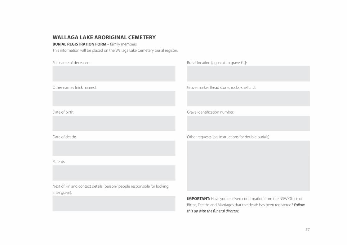
57
WALLAGA LAKE ABORIGINAL CEMETERY BURIAL REGISTRATION FORM – family members
This information will be placed on the Wallaga Lake Cemetery burial register.
Full name of deceased:
Other names [nick names]:
Date of birth:
Date of death:
Parents:
Next of kin and contact details [person/ people responsible for looking
after grave]:
Burial location [eg, next to grave #...]:
Grave marker [head stone, rocks, shells…]:
Grave identification number:
Other requests [eg, instructions for double burials]
IMPORTANT: Have you received confirmation from the NSW Office of
Births, Deaths and Marriages that the death has been registered? Follow this up with the funeral director.
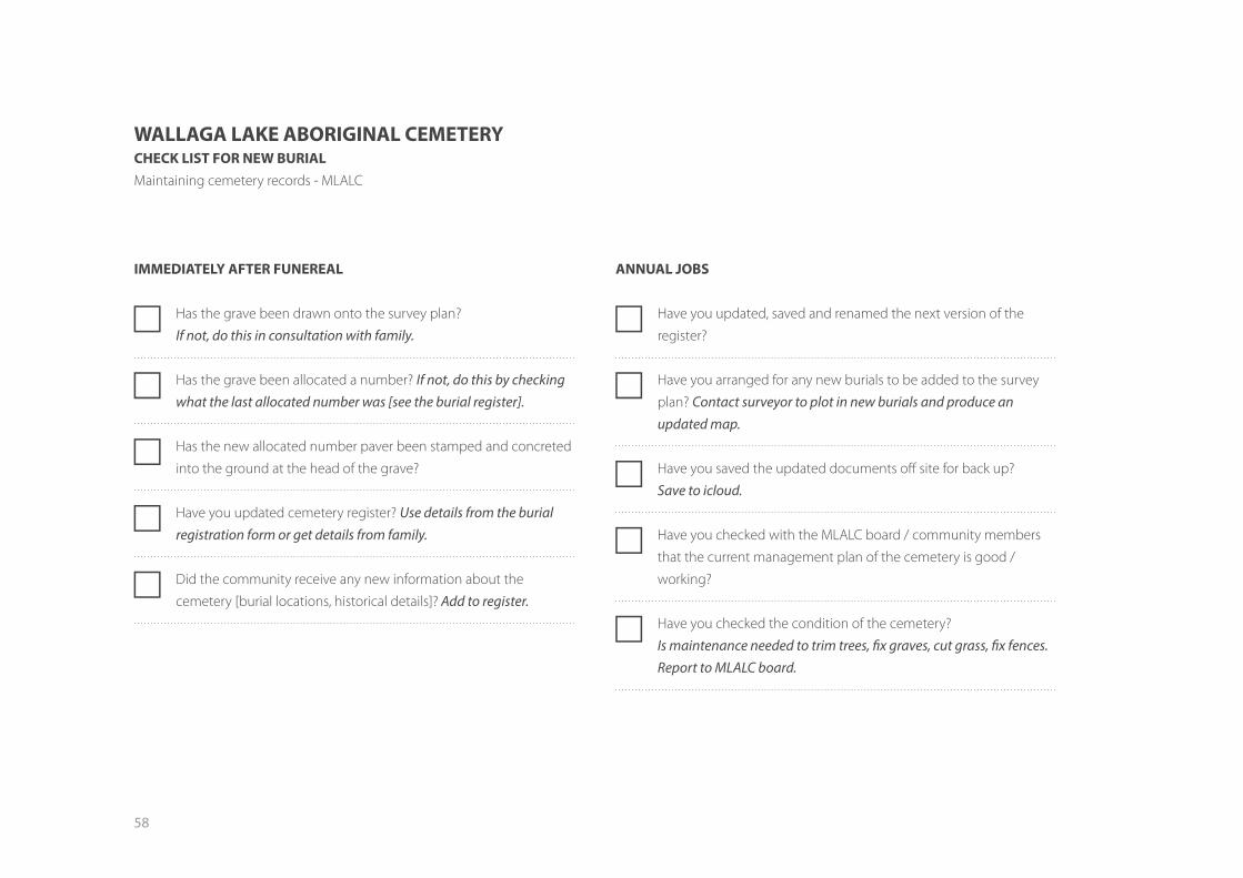
58
WALLAGA LAKE ABORIGINAL CEMETERY CHECK LIST FOR NEW BURIAL Maintaining cemetery records - MLALC
IMMEDIATELY AFTER FUNEREAL
FF Has the grave been drawn onto the survey plan?
If not, do this in consultation with family.
FF Has the grave been allocated a number? If not, do this by checking what the last allocated number was [see the burial register].
FF Has the new allocated number paver been stamped and concreted
into the ground at the head of the grave?
FF Have you updated cemetery register? Use details from the burial registration form or get details from family.
FF Did the community receive any new information about the
cemetery [burial locations, historical details]? Add to register.
ANNUAL JOBS
FF Have you updated, saved and renamed the next version of the
register?
FF Have you arranged for any new burials to be added to the survey
plan? Contact surveyor to plot in new burials and produce an updated map.
FF Have you saved the updated documents off site for back up?
Save to icloud.
FF Have you checked with the MLALC board / community members
that the current management plan of the cemetery is good /
working?
FF Have you checked the condition of the cemetery?
Is maintenance needed to trim trees, fix graves, cut grass, fix fences. Report to MLALC board.

59

60
This project is funded by the Australian Government in partnership with Eurobodalla Shire Council and Merrimans Local Aboriginal Land Council.