Embed Size (px)
Citation preview

MANAGING ROAD INFRASTRUCTURE AT ASFINAG BY USING GIS
ASFINAG, Peter AubrechtAustria, Salzburg, 15th October 2015European GIS User Conference

2
The ASFINAG Group Overview GIS Objectives
Asset Management Operational Activities Road Works and Construction Site Management Tolling
Quite new Summary
Content

3
ASFINAGService GmbH
ASFINAGAlpenstraßen
GmbH
ASFINAG Bau Management
GmbH
ASFINAGCommercial
Services GmbH
ASFINAGMaut Service
GmbH
ASFINAGAutobahnen- und Schnellstraßen-Finanzierungs-Aktiengesellschaft
(Motorway and Expressway Financing plc)
ASFINAGEuropean Toll
ServiceGmbH
ROADNETWORKplanning
The ASFINAG Group

4
ASFINAG is an efficiently operating user-financedbuilder and operator of motorways and expressways.
We provide a road network that meets our customers’ requirements, is well-serviced and developed with a special focus on road safety and optimal availability as well as user-friendly tolling systems.
All our activities are directed towards fulfilling our economic, environmental and social responsibilities whilst strengthening Austria’s position as a business location.
The ASFINAG GroupMission

5
ASFINAG is one of Europe’s leading motorway network operators with a special focus on
• availability• traffic management• traffic information• road safety and• technological innovations
We act internationally and interlink with public transport.
The ASFINAG GroupVision

6
New constructions &expansion
Structural maintenance
Investment
327483
801 809 865 802 732
341
459
460 404 364338
269
36
67
5245 68
81
15
0
200
400
600
800
1000
1200
1400
2013Ist / Plan
2014Plan
2015Plan
2016Plan
2017Plan
2018Plan
2019Plan
The ASFINAG GroupConstruction Program (EUR mil.)

7
The ASFINAG GroupTransEuropean Network (TEN), Corridors

8
The ASFINAG Group Facilities and Employees

9
The ASFINAG Group Toll Revenues

10
OVERVIEW GISDepartment Road Network Planning
The Road Network Planning department is responsible for:
• Generating long – term programs for predefined road sections
• Establishing Concepts and studies for mid – term activities
• Executing specific projects, e.g. opening safety lane for traffic
• Coordinating the construction site program and short – term construction site activities for the ASFINAG road network
• Supporting ASFINAG with the Geographic Information System (GIS)

11
• Supplying a modern, state-of-the-art GIS system architecture
• Geographic Platform with high performance and reliable data
• Cartographic visualisation in a self explanatory and pleasant way
• Interfaces to databases and harmonising data: Integration of several information of different units; avoiding redundancy
• GIS as service provider for all employees and contractors of ASFINAG
• Providing geodata, surveying data, infrastructure objects, condition information, construction site program, planning issues
• Supporting several projects with spatial analysis of geodata
OVERVIEW GISGIS Team

12
© basemap.at
OVERVIEW GIS The ASFINAG Road Network

13
Number of motorways
19
Number of expressways
14
Length 2.183 kmTotal lane length 11.700 kmReference Road name, kilometres,
infrastructure objects,Specific sections
OVERVIEW GIS The ASFINAG Road Network

14
• ASFINAG road network is part of GIP (Graph Integration Platform)• GIP is a joint project of the Austrian Federal States, ASFINAG, ÖBB
Infrastructure, the Austrian Federal Ministry of Transport, Innovation and Technology, ITS Vienna Region, (the Austrian Association of Cities and Towns is an associated partner)
• GIP - the basis for a modern administration of Austria’s transport routes• A nationwide transport graph, which will provide a digital map of Austria's
transport network available to all authorities• the common “official” reference graph to which all the different systems of the
administrative units can now relate and link up• GIP covers all modes of transport (passenger car traffic, public transport,
cycling, walking)
Headed by: [email protected]
OVERVIEW GIS The ASFINAG Road Network

15
Traffic Information Service (VAO) basemap.at
• a collaborative traffic information service
• covers all traffic developments (for cyclists, pedestrians, public transport, motor vehicles, Park&Ride)
• The Graph Integration Platform (GIP) serves as digital map, which is more up to date and more detailed than all conventional graphs
• basemap.at is a cartographic product based on the administrative data
• It is updated bi-monthly • The cartography as well as the
underlying data are constantly updated and improvedHeaded by: [email protected]
Headed by: [email protected]
OVERVIEW GIS The ASFINAG Road Network – GIP Products

162003
Software
ASFINAGGIS
Road Network
WebGISBasic
Hardware OrthophotosGeodata
Inventory Data
PLaDOK (Surveying
Data)
DB
o Responsibility along the roado noise protection cadastreo surveying datao infrastructure objectso construction site programo toll informationo rest areaso traffic signso . . . . . . .
Guideline for Surveying
Data
201520102006
OVERVIEW GIS GIS since 2003

17
GIS
SAP
Construction site programEmployees: Responsibility,Contact information, address …
SHAREPOINT
Rest areasTunnel tubes informationSalt sitesConstruction site projectsMaintenance projects
DMS
Reports, photos, notes,Correspondence, contractsOfficial notifications, audit documentation
IMT
Database information aboutbridges, pavement condition,noise protection . . .
OVERVIEW GIS Geodata and Infrastructure

18
GIS - DATAEXTERNAL GEODATA
INTERFACES
nois
e pr
otec
tion
inve
ntor
y
. . .
. . .
org
man
agem
ent
tech
nica
l
basi
c
INHOUSE GEODATA
GIS expert
Non GIS expert
SP AS
SAP DMS
GIS CLIENT ARC GIS SERVER WEB GISSYNERGIS WEBOFFICE
ARC GIS ONLINE
OVERVIEW GIS GIS System Architecture

19
construction site planning
data preparation for
contractor
surveying data processing by
contractor
- ASFINAG guideline
surveying data- geochecker
Acceptance by ASFINAG and
import into geodatabase
OVERVIEW GIS Guideline PLaDOK and Surveying Data

20
ASSET MANAGEMENT

21
• Project development: Focus to project management and coordination
• Engineering: Focus to strategy, reporting and controlling
• Structure Maintenance Management:o condition detection and assessmento project requirements and definitiono take over of structures and routes (new
/ after refurbishment)o strategic long-term corridor planningo Incident managemento take care of infrastructure databaseo technical assessment of special
transports
ASSET MANAGEMENT

22
ASSET MANAGEMENTBridges

23
ASSET MANAGEMENTDilatation

24
ASSET MANAGEMENTRetaining Walls

25
ASSET MANAGEMENTNoise Protection Walls - Maintenance

26
ROAD OPERATION

27
• Users are customers
• Highest road availability and safety
• Highest economic efficiency
• Operation of the motorway and expressway network
• Maintenance of the necessary existing infrastructure
• Traffic management and customer information
ROAD OPERATIONOperational Activities – Principles, Core Tasks
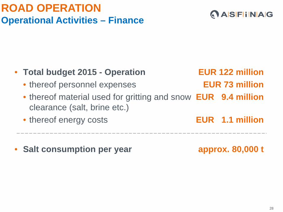
28
• Total budget 2015 - Operation EUR 122 million• thereof personnel expenses EUR 73 million• thereof material used for gritting and snow EUR 9.4 million
clearance (salt, brine etc.) • thereof energy costs EUR 1.1 million
• Salt consumption per year approx. 80,000 t
ROAD OPERATIONOperational Activities – Finance

29
• Refurbishment, upgrading & renewal works
• Road control service
• Traffic Manager
• Safeguarding road work, accident, e.g.
• Structural monitoring
ROAD OPERATIONOperational Tasks

30
• Cleaning rest areas & parking areas
• Reviewing and checking tunnel safety equipment and facilities
• Tunnel cleaning
ROAD OPERATIONOperational Tasks

31
• GIS is one of the most important tools
• All important information available on an easy way
ROAD OPERATIONOperational Tasks

32
• Activities related to gritting and snow clearance services actually start in summer: fixing snow poles, re-filling salt storage facilities and adapting duty rosters
• In wintertime 1,100 employees are available for gritting and snow clearance services
• Ongoing monitoring of current and forecasted weather conditions
• Increased control and clearance of sensitive road sections
• Consideration of economic and environmental aspects
ROAD OPERATIONWinter Services

33
• Salt Silo:
• Salt is the most important commodity
• Position of the Silos
• Coordinates for the suppliers
• Snow Clearance Routes
• Visualisation of the routes
• One Snow Clearance Convoy have to clear one route
• Time of circulation 90 to 120 minutes
ROAD OPERATIONWinter Services

34
• Cutting grass:• Mowing machine convoys are used to minimise the impact on the flow
of traffic • Which area must be cut, how often and in which kind
ROAD OPERATIONGreen Space Care

35
• Position of the facility• Interface to DMS• List of sites for referring documents (e.g. law regulations, official
notifications)
WebGIS
Document Management System
ROAD OPERATIONWater Protection Sites

36
• Position of pipes, ditches, ponds, etc.• Flow direction• Road drainage areas• Outfall Point• Described with picture and text• List of sites for referring documents (e.g. law regulations, official notifications)
ROAD OPERATIONDrainage Infrastructure

37
• Position of Hazard Spots.• Described with Picture, Text and hazard classification
• Position of Natural Hazard Protection Structure• Described with Picture, Text and protection classification
ROAD OPERATIONNatural Hazards

38
ROAD WORKS & CONSTRUCTION SITE MANAGEMENT

39
• Bundling of all planning and construction responsibilities and expertise for the effective and efficient handling of projects
• Provision of a safe network that is extended to meet customers requirements
PlanningAuthority approval
procedures
Land purchase
Construction activities
ROAD WORKS & CONSTRUCTION SITE MANAGEMENTExpertise I

40
Project planning & structural implementation of …• New motorways & expressways• Junctions, rest areas & traffic control points, truck parking spaces• Capacity increasing measures (including additional lanes, second tunnel tubes) • Maintenance works (overall refurbishment, renewal, structural refurbishment, upgrading
and expansion of the safety-related systems and elements) • Activities to reduce the impact of traffic on the environment / noise protection activities• Structural engineering activities (building motorway operation and maintenance facilities) • Activities to increase traffic and tunnel safety (like traffic control systems, renewal and
upgrading of the electrical engineering equipment in tunnels)
ROAD WORKS & CONSTRUCTION SITE MANAGEMENTExpertise II

41
ROAD WORKS & CONSTRUCTION SITE MANAGEMENTRequirements – Sharepoint - GIS

42
ROAD WORKS & CONSTRUCTION SITE MANAGEMENTConstruction Site Program – Sharepoint - GIS

43
Motorway Service Stations Rest Areas Parking Areas
sanitary facilities, parking spaces, seating areas, beverage vending machines, emergency telephones, video monitored, some with shop and playground
Basic facilities (restroom, partially lighting)
with petrol stations and shopping area, some with regular or fast food restaurants, hotel and truck service centre
ROAD WORKS & CONSTRUCTION SITE MANAGEMENTRest Area Concept

44
ROAD WORKS & CONSTRUCTION SITE MANAGEMENTRest Area Concept – Sharepoint - GIS

45
ROAD WORKS & CONSTRUCTION SITE MANAGEMENTFacility Management

46
ROAD WORKS & CONSTRUCTION SITE MANAGEMENTFacility Management

47
Rural area: EUR 10-25 million / km
ROAD WORKS & CONSTRUCTION SITE MANAGEMENTCosts of building motorways and expressways

48
In and around cities: EUR 60-80 million / km
ROAD WORKS & CONSTRUCTION SITE MANAGEMENTCosts of building motorways and expressways

49
TOLLING

TOLLINGCustomer Service CenterGeneral Information
• 24-hour service
• Information on all topics relating tothe motorway and expresswaynetwork
• Fast, professional and reliableinformation in 6 languages

• Telephoneswitchboard
• Situation of traffic• Winter services• resting facility• Road works• App Unterwegs• ASFINAG Maps• Emergency corricor• Noise protection• ….
• GO-Box • Means of payment• Datachange• Substitude toll• Retroactive payment• EEK (EURO-
Emissionclass)• Toll2GO• Easy GO+• SelfCare Portal• ….
• Vignette• Special Toll• Substitude toll • ….
67%
18%15%
Non toll topics Toll Topics Vehicle of up to 3.5 t
Toll Topics Vehicle more than 3.5 t
*Distribution by topic and input channels (telephonic / written) in 2014
TOLLINGCustomer Service CenterTopics*
• About 520.000 contacts
• telephonic: 56%• written: 44%
52
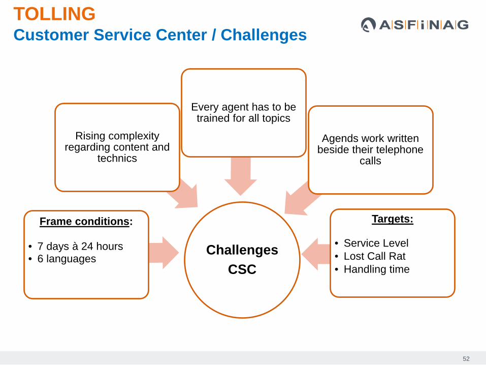
ChallengesCSC
Rising complexityregarding content and
technics
Frame conditions:
• 7 days à 24 hours• 6 languages
Every agent has to betrained for all topics
Agends work writtenbeside their telephone
calls
Targets:
• Service Level• Lost Call Rat• Handling time
TOLLINGCustomer Service Center / Challenges

53
Up
to 3
.5t m
pgw
Mor
e th
an3.
5t m
pgw
*) net revenue 2013, rounded
Toll sticker Special toll
Fully electronic toll payment by GO-Box
Revenue*) of EUR 406 million Revenue*) of EUR 147 million
Revenue*) of EUR 1,135 million
TOLLINGTolling – Toll System in Austria

54
TOLLING Toll Sign Database

55
TOLLING Points of Sale for Toll Sticker and GO Box

56
TOLLING Technical equipment

57
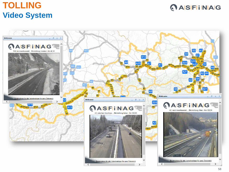
• 5,100 video cameras• Tunnels• Service areas• Outdoor areas
• 85 video operator stations• Traffic management centres• Motorway maintenance areas• Emergency services• Co-operations with: Ö3, TW1, Puls 4
• Approx. 25 million connections per month• 550 webcams (as at March 2014)
TOLLING Video System
58
TOLLING Video System

59
QUITE NEW

60
NETWORK COORDINATION
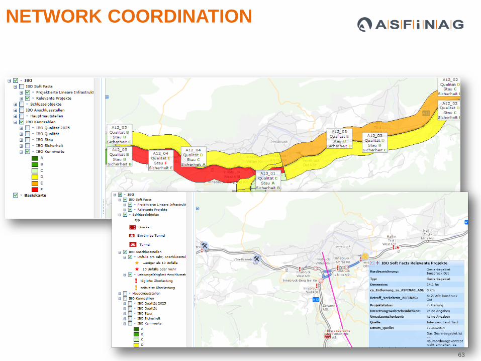
• Strip Maps – Alignment Sheets: Visualization of infrastructure objects (junctions, bridges, number of lanes, water pollution sites . . .), condition information about surface and buildings, construction site program etc.
• Business concepts is about road network capacity and efficiency: availability and flowing traffic, maintaining und increasing road safety
• Prediction and future trends 2030 / 2035: calculation is based on the traffic model 2025

61
NETWORK COORDINATION

62
NETWORK COORDINATION
63
NETWORK COORDINATION

64
NOISE PROTECTION DATABASE Information about Noise Sections and Walls

65
Coordination Projects Trainings
Data management Surveying Data Database
Software Database WebGIS
DATA*
USER
IT
* ASG: 1 expert
GIS Team: 3 expertsEmployees: 2.800
SUMMARYGIS Facts and Figures

66
SUMMARYGIS Facts and Figures
Map Requests per Month
Unique Users per Day