Embed Size (px)
Citation preview
Manx Marine Environmental Assessment
Ecology/ Biodiversity
Marine and coastal
conservation
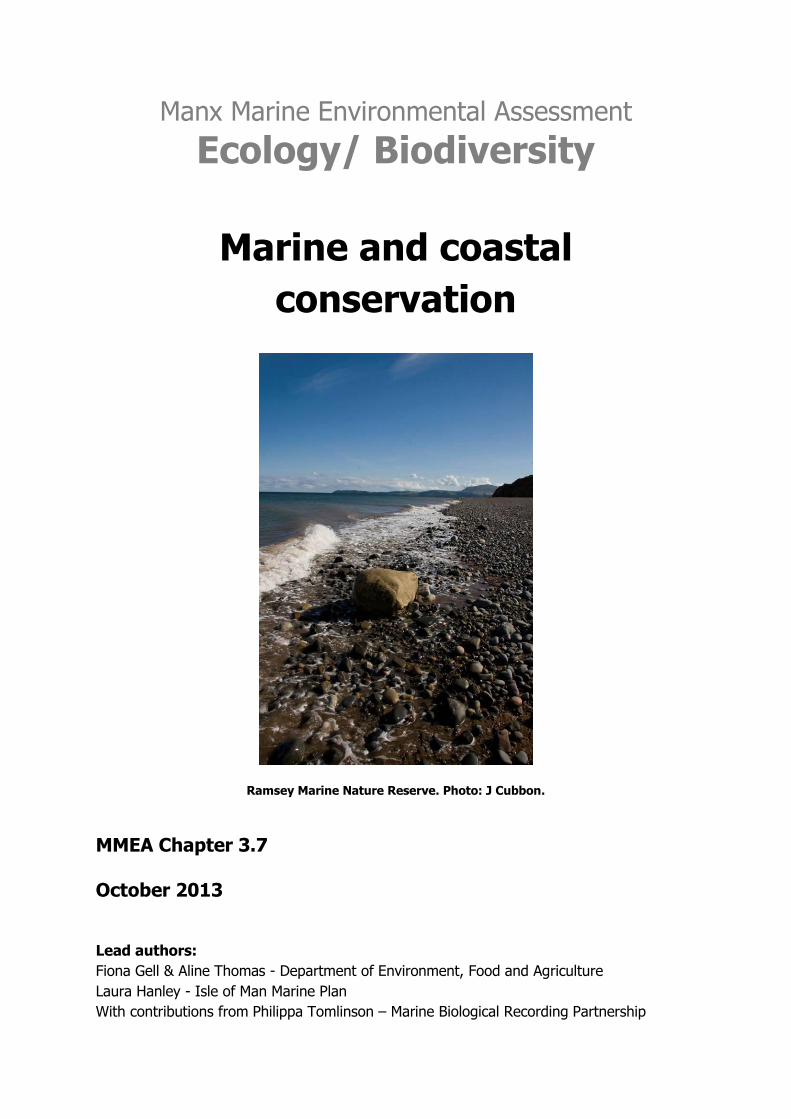
Ramsey Marine Nature Reserve. Photo: J Cubbon.
MMEA Chapter 3.7 October 2013
Lead authors:
Fiona Gell & Aline Thomas - Department of Environment, Food and Agriculture
Laura Hanley - Isle of Man Marine Plan
With contributions from Philippa Tomlinson – Marine Biological Recording Partnership
MMEA Chapter 3.7 – Ecology/ Biodiversity
2 Manx Marine Environmental Assessment – October 2013
Manx Marine Environmental Assessment
Version: November 2013
© Isle of Man Government, all rights reserved
This document was produced as part of the Isle of Man Marine Plan Project, a cross Government Department project funded and facilitated by the Department of Infrastructure, Department of
Economic Development and Department of Environment, Food and Agriculture.
This document is downloadable from the Department of Infrastructure website at:
http://www.gov.im/categories/planning-and-building-control/marine-planning/manx-marine-environmental-assessment/
For information about the Isle of Man Marine Plan Project please see:
http://www.gov.im/categories/planning-and-building-control/marine-planning/
Contact:
Manx Marine Environmental Assessment
Isle of Man Marine Plan Project
Planning & Building Control Division
Department of Infrastructure
Murray House, Mount Havelock
Douglas, IM1 2SF
Suggested Citations
Chapter
Gell, F.G., Thomas, A., Hanley, L., Tomlinson, P. 2013. Marine and Coastal Conservation. In Hanley et al., (eds.), Manx Marine Environmental Assessment. Isle of Man Marine Plan. Isle of Man Government, pp. 47
MMEA
Hanley, L.J., Gell, F.G., Kennington, K., Stone, E., Rowan, E., McEvoy, P., Brew, M., Milne, K.,
Charter, L., Gallagher, M., Hemsley, K., Duncan, P.F. (eds.) 2013. Manx Marine Environmental
Assessment. Isle of Man Marine Plan. Isle of Man Government.
MMEA Chapter 3.7 – Ecology/ Biodiversity
3 Manx Marine Environmental Assessment – October 2013
Disclaimer:
The Isle of Man Government has facilitated the compilation of this document, to provide baseline
information towards the Isle of Man Marine Plan Project. Information has been provided by various
Government Officers, marine experts, local organisations and industry, often in a voluntary capacity
or outside their usual work remit. Advice should always be sought from relevant contacts where
queries arise.
The editors have taken every care to ensure the accuracy of the information contained but accept
that errors, omissions or changes may be present which may be identified in future. The editors
accept no responsibility for the accuracy or currency of information provided on external sites.
All MMEA chapters may be amended and improved upon in light of new information or comments
received. As such, all chapters should be considered as working documents.
Any initial guidelines or recommendations within the document are provided to help facilitate future
discussions between stakeholders, Government Departments, future developers and the general
public, and should be read only in the context of the document as a whole. This document does not
provide legal or policy advice but rather a statement of known information about Manx territorial
waters.
The mapping detail contained in this document is subject to the limitations of scale and depiction of
any feature, does not denote or infer right of way and no claim is made for the definitive nature of
any feature shown on the mapping. New marine datasets created for the project have not been
subject to formal verification.
Copyright:
Unless stated otherwise, all mapping, overlay data and intellectual property in this publication are
subject to the following copyright:
Charts: © Crown Copyright, Department of Infrastructure, Isle of Man. 2012.
United Kingdom Hydrographic Office admiralty charts: © SeaZone Solutions Ltd. Licence no. 2005,
[GDDI/10 & 012011.006]. © British Crown Copyright, 2005.
NOT TO BE USED FOR NAVIGATION
Reproduction of the maps in any form is prohibited without prior permission from the publishers.
MMEA Chapter 3.7 – Ecology/ Biodiversity
4 Manx Marine Environmental Assessment – October 2013
Marine and coastal
conservation Summary
Marine biodiversity is an important resource to the Isle of Man, providing a wide range of
services and making an important contribution to the biodiversity of the wider Irish Sea.
Over 2300 marine animal species had been recorded in the Isle of Man up to 1963 (Bruce et
al 1963) and many more have been recorded since. At least 225 species of algae have been
recorded in Manx waters. A full, up to date marine species list has not been compiled for the
Isle of Man but should soon be possible.
The Department and Environment, Food and Agriculture is responsible for nature
conservation designations in the Isle of Man. Manx Natural Heritage also play an important
role in conservation. The work of these government entities is supported by a number of
active conservation Non-Governmental Organisations (NGOs).
Marine Nature Reserves (MNRs) can be designated for subtidal sites and can also include
intertidal areas (to the high water mark). Ramsey Marine Nature Reserve is the Isle of Man’s
first MNR and was designated in 2011. Approximately 2.6% of Manx territorial waters are
designated as Marine Nature Reserve or protected from scallop dredging as part of the
network of Fisheries Closed Areas and Restricted Areas.
The EU Habitats Directive does not extend to the Isle of Man but the Isle of Man is signed
up (via the UK) to a number of Conventions identifying priority species and habitats for
conservation, including:
The Convention for the Protection of the Marine Environment of the North-East Atlantic
Convention on the Conservation of Migratory Species of Wild Animals Convention on the
International Trade in Endangered Species of Flora and Fauna
Convention on the Conservation of European Wildlife and Natural Habitats Convention on
Wetlands of International Importance
Convention on Biological Diversity
Marine Nature Reserves (MNRs) are the main conservation designation available for subtidal
sites. A range of conservation priority habitats are protected within Ramsey MNR, including
horse mussel reef, eelgrass meadows and maerl beds. Other priority species and habitats
including areas of eelgrass and the ocean quahog, Arctic islandica, are protected within the
Fisheries Closed Areas and Restricted Areas.
MMEA Chapter 3.7 – Ecology/ Biodiversity
5 Manx Marine Environmental Assessment – October 2013
Some important areas of subtidal habitat of conservation priority are not currently protected.
It is therefore essential that appropriate habitat survey work is carried out as part of the
Environmental Impact Assessment for offshore developments.
Areas of Special Scientific Interest are the most widely used terrestrial conservation
designation and can include intertidal areas (to the low water mark). A significant proportion
of Manx intertidal habitats are now designated as Areas of Special Scientific Interest. A
range of other statutory and voluntary site designations are possible for coastal areas and
these are presented in this chapter.
Marine invasive species are monitored in Manx waters to a limited extent, mainly by
volunteers. Wireweed (Sargassum muticum) became established in Manx waters in 2005
and has since become widespread. The Pacific oyster (Crassotrea gigas) was first recorded
in Manx waters in 2005 and has recently become established in Ramsey, while Darwin’s
barnacle (Elminius modestus) has been recorded from there since the mid 1950s. The
carpet seasquirt (Didemnum vexillum) and the slipper limpet (Crepidula fornicata) have not
yet been recorded in Manx waters.
MMEA Chapter 3.7 – Ecology/ Biodiversity
6 Manx Marine Environmental Assessment – October 2013
Baseline
The Isle of Man has a great diversity of marine and coastal habitats and high biodiversity in
terms of species and ecosystems. Some aspects of Manx marine biodiversity are extremely
well studied, mainly as a result of research carried out at Port Erin Marine Laboratory for
over 114 years. The intertidal species and habitats of the south of the Isle of Man were
particularly well studied in the past. Other aspects remain less well understood, particularly
subtidal habitats, with the exception of the southern coast and the Calf, and the inshore
environment. This chapter gives a brief overview of Manx marine biodiversity (aspects of
subtidal ecology, coastal habitats and protected marine species are covered in dedicated
chapters) and marine and coastal conservation in the Isle of Man.
Statutory marine and coastal conservation in the Isle of Man is the responsibility of the
Department and Environment, Food and Agriculture (DEFA) of the Isle of Man Government.
The main legislation available for protected species and habitats is the Wildlife Act 1990.
The Wildlife Act provides for the conservation of marine and coastal habitats through site
protection and species protection.
The main coastal site designation in use is the Area of Special Scientific Interest (ASSI)
which can extend to the low water mark. The main subtidal conservation designation in use
is the Marine Nature Reserve.
Species protection is offered to a range of marine and coastal plants and animals.
The Isle of Man is also signatory to a number of international Conventions with obligations
and guidance on the protection and management of other priority species and habitats.
Manx National Heritage also plays an important role in conservation, supporting biological
recording and informing the public, for example through the Natural History Gallery in the
Manx Museum and collections of marine specimens and historic and scientific resources.
Government agencies are supported in conservation action and research by a wide array of
Non-Governmental Organisations, including the Manx Wildlife Trust, Manx Birdlife, Manx
Whale and Dolphin Watch and many others.
Garrad (1990) produced a comprehensive overview of the development of Manx
conservation and the organisations involved which will be useful for those interested in the
history of Manx conservation prior to 1972. The Manx Museum and National Trust and the
Manx Nature Conservation Trust (now the Manx Wildlife Trust) played important roles in the
development of conservation in the Isle of Man.
MMEA Chapter 3.7 – Ecology/ Biodiversity
7 Manx Marine Environmental Assessment – October 2013
Wildlife Committee
The Wildlife Committee of the Department of Environment, Food and Agriculture has a duty
under the Wildlife Act 1990 to advise the Department on the administration of the Wildlife
Act and in connection with the protection of birds or other animals or plants.
Plans to designate protected areas are put to the Wildlife Committee. The Wildlife
Committee is made up of senior officers in the Department of Environment, Food and
Agriculture and conservation specialists from DEFA and other organisations. Special
scientists can be invited to join to Committee to consider particular issues. For example a
number of marine scientists joined the Committee to advice on the work to designate the
Ramsey Marine Nature Reserve.
Manx Nature Conservation Forum
The Manx Nature Conservation Forum was formally launched in 2009. The Forum is chaired
by the DEFA Minister and meets at least twice a year. The purpose of the Forum is outlined
in the Terms of Reference, agreed in 2009:
1. A regular opportunity for dialogue between DEFA and other organisations
2. An opportunity to promote partnerships between Government and Non-Government
Organisations and to extend joint working
3. A focus for the promotion and publicity of biodiversity conservation
4. Encouraging the dissemination of conservation research, assessing conservation status of
Manx species and habitats, setting targets and monitoring progress.
The following conservation NGOs and countryside users’ groups were invited to be members
of the Conservation Forum and most attend meetings:
Beach Watch
Centre for Manx Studies (Liverpool University)
IOM Beekeepers Federation
IOM Farming and Wildlife Group
IOM Friends of the Earth
IOM Natural History and Antiquarian Society
IOM Woodland Trust
Mammal Society
Manx Basking Shark Watch affiliated to Manx Wildlife Trust
Manx Bat Group
Manx BirdLife
Manx Butterfly Conservation
Manx Fish Producers’ Organisation
Manx Footpaths Conservation Group
MMEA Chapter 3.7 – Ecology/ Biodiversity
8 Manx Marine Environmental Assessment – October 2013
Manx Game Preservation Society
Manx Heritage Foundation
Manx National Farmers Union
Manx Rivers Improvement Association
Manx Sea Matters
Manx Society for the Prevention of Cruelty to Animals
Manx Whale and Dolphin Watch
Manx Wildlife Trust
Native Oak Group
Manx Ornithological Society
Seasearch
Society for the Preservation of the Manx Countryside and Environment
Wildflowers of Mann Project a Government Partnership Project operated by Manx Wildlife
Trust
For more information about the Manx Nature Conservation Forum see:
http://www.gov.im/about-the-government/departments/environment,-food-
and-agriculture/forestry,-amenity-and-lands-directorate/wildlife-and-
biodiversity/manx-nature-conservation-forum/
Manx Biodiversity Strategy
The Convention on Biological Diversity (CBD) was extended to the Isle of Man in August
2012. In preparation for this, in 2011 DEFA began working with partner organisations to
develop a Manx Biodiversity Strategy which was completed in draft form for public
consultation in 2013.

MMEA Chapter 3.7 – Ecology/ Biodiversity
9 Manx Marine Environmental Assessment – October 2013
International Agreements and Conventions
The Isle of Man is signed up to a wide variety of international conservation conventions.
Since 1950, such conventions have not been automatically applied to the Isle of Man as a
UK Crown Dependency, but have required the Isle of Man to decide whether they wish the
convention to be extended to the jurisdiction.
The following Multinational Environmental Agreements (MEAs) on nature conservation have
been extended to the Isle of Man by the UK:
Convention on the Conservation of Migratory Species of Wild Animals (CMS or Bonn
Convention) and the following agreements under the CMS:
Agreement on the Conservation of African-Eurasian Migratory Waterbirds
Agreement on the Conservation of Populations of European Bats
Agreement on the Conservation of Albatrosses and Petrels
Agreement on the Conservation of Small Cetaceans of the Baltic, North East
Atlantic, Irish and North Seas ASCOBANS
Memorandum of Understanding on Migratory Shark Species (Bonn) (applies
to basking shark, porbeagle and spurdog). For more information about this:
http://www.cms.int/species/sharks/sharks_bkrd.htm.
Convention on the Conservation of European Wildlife and Natural Habitats (Bern(e)
Convention)
Convention on Wetlands of International Importance (Ramsar Convention)
Convention on the International Trade in Endangered Species of Flora and Fauna
(CITES)
Convention for the Protection of the Marine Environment of the North East Atlantic
(OSPAR)
Convention on Biological Diversity (CBD or Rio convention, extended to the Isle of
Man in August 2012)
The Isle of Man is not a member of the European Union and is not subjective to the EU
Habitats Directive. However, other conventions which do apply to the Isle of Man such as
OSPAR, the CMS and the CBD require good marine habitat protection.
MMEA Chapter 3.7 – Ecology/ Biodiversity
10 Manx Marine Environmental Assessment – October 2013
Marine Biodiversity
Despite many decades of marine research in Manx waters, we cannot currently put give a
total number of marine species recorded in the Isle of Man. At the time of the publication of
the Fauna of the Isle of Man (Bruce et al 1963) over 2300 marine animals had been
recorded. In addition to this, 224 species of had been recorded at the time of the publication
of the most recent Seaweed Atlas for the British Isles (Hardy and Guiry 2003), 128 red
seaweeds, 69 brown seaweeds and 26 green seaweeds. In 2005 an additional species of
brown seaweed, the invasive Wireweed (Sargassum muticum) was first recorded and has
since become established, bringing the total number of species formally recorded to 70
brown seaweeds and 225 species in total (see Appendix 1 for seaweed species recorded in
Manx waters). Some sites have been particularly well studied. For example, in dive surveys
up to 1993 a total of 449 species of marine animals and plants had been recorded around
the Calf of Man (Morrow et al 1993) and more species will have been recorded from the site
since then. Between 1946 and 1950 Jones (1951) carried out 134 grab samples and 111
hauls within 15 miles of Port St Mary and identified more than 527 species, 75 of which
were new species records. Just 10 grab samples in Ramsey Marine Nature Reserve in 2011
resulted in 260 different species being identified (Kennington 2011).
There has been a recent intensification in marine biological surveys, with the benthic
surveys carried out by Bangor University, new work by DEFA and regular dive surveys by
Seasearch Isle of Man.
Recent progress in biological recording, led by the Marine Biological Recording Partnership,
will hopefully facilitate better marine recording and dissemination of marine survey data. It
is hope that this will eventually all the compilation of a complete species list for Manx
waters, and of rare, threatened and declining species.
The Subtidal Ecology Chapter (MMEA Chapter 3.3) gives a detailed account of our current
knowledge of Manx marine habitats and some information on historical recording.
Information about cetacean and bird diversity is also presented in the relevant chapters.
MMEA Chapter 3.7 – Ecology/ Biodiversity
11 Manx Marine Environmental Assessment – October 2013
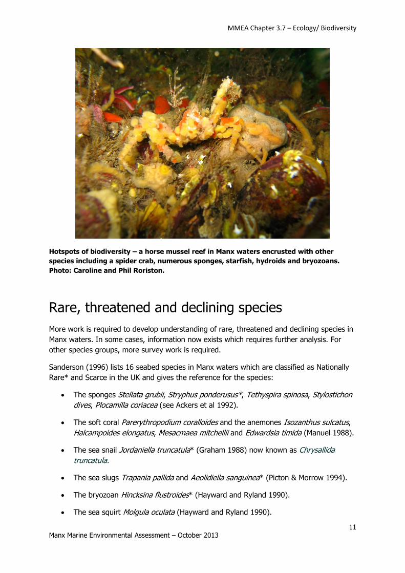
Hotspots of biodiversity – a horse mussel reef in Manx waters encrusted with other
species including a spider crab, numerous sponges, starfish, hydroids and bryozoans.
Photo: Caroline and Phil Roriston.
Rare, threatened and declining species
More work is required to develop understanding of rare, threatened and declining species in
Manx waters. In some cases, information now exists which requires further analysis. For
other species groups, more survey work is required.
Sanderson (1996) lists 16 seabed species in Manx waters which are classified as Nationally
Rare* and Scarce in the UK and gives the reference for the species:
The sponges Stellata grubii, Stryphus ponderusus*, Tethyspira spinosa, Stylostichon
dives, Plocamilla coriacea (see Ackers et al 1992).
The soft coral Parerythropodium coralloides and the anemones Isozanthus sulcatus,
Halcampoides elongatus, Mesacmaea mitchellii and Edwardsia timida (Manuel 1988).
The sea snail Jordaniella truncatula* (Graham 1988) now known as Chrysallida
truncatula.
The sea slugs Trapania pallida and Aeolidiella sanguinea* (Picton & Morrow 1994).
The bryozoan Hincksina flustroides* (Hayward and Ryland 1990).
The sea squirt Molgula oculata (Hayward and Ryland 1990).
MMEA Chapter 3.7 – Ecology/ Biodiversity
12 Manx Marine Environmental Assessment – October 2013
The seaweeds Callophyllis cristata (Irvine 1983)and Cruoria cruoriaeformis (Maggs
and Guiry 1989).
All of the species above were identified around the south west of the Isle of Man.
The rare anemone Edwardsia timida was recorded from a number of new sites during the
2008 benthic survey in Manx waters (see Hinz et al 2010 and MMEA Chapter 3.3 ‘Subtidal
Ecology’).
Many other species lists and resources exist linked to rare species in Manx waters. For
example, a field report by Killeen (1995) in the Porcupine Society Newsletter lists 101
mollusc species identified from one day of sampling around the south west of the Isle of
Man, including the sea snail Jordaniella truncatula.
The OSPAR lists of Threatened or Declining Habitats and Species is a useful starting point to
assess the status of threatened and declining species in Manx waters. Table 1 below gives
an initial assessment of the status of some of the OSPAR Threatened and Declining Habitats
in Manx waters. Table 2 gives an initial assessment of the status of some of the OSPAR
Threatened or Declining Species in Manx waters.
More research and analysis of existing data would enable us to provide full assessments of
each of the habitats. For information, the Isle of Man is in OSPAR Region III, the Celtic Seas
(an area bounded by, on the east, longitude 5°W and the west coast of Great Britain and on
the west by the 200 metre isobath (depth contour) to the west of 6°W along the west
coasts of Scotland and Ireland).
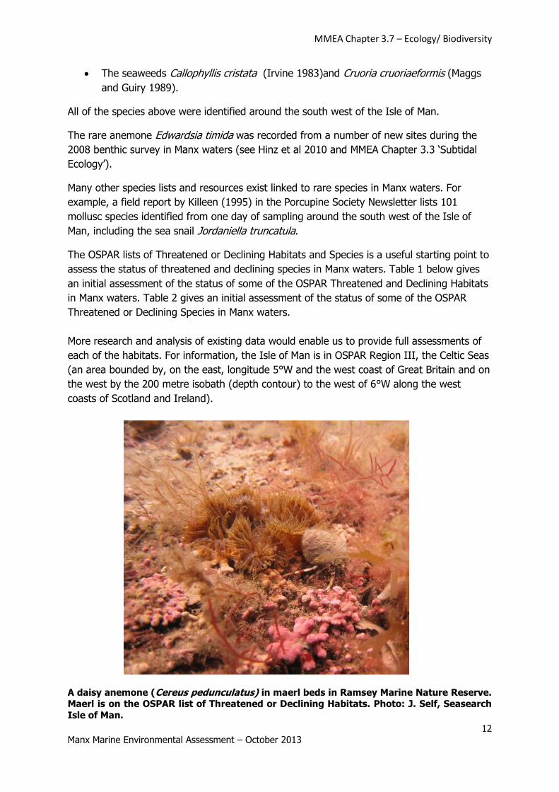
A daisy anemone (Cereus pedunculatus) in maerl beds in Ramsey Marine Nature Reserve. Maerl is on the OSPAR list of Threatened or Declining Habitats. Photo: J. Self, Seasearch
Isle of Man.
MMEA Chapter 3.7 – Ecology/ Biodiversity
13 Manx Marine Environmental Assessment – October 2013
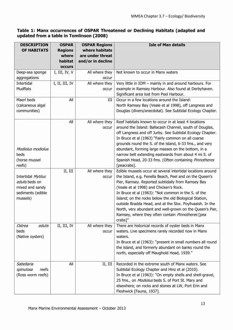
Table 1: Manx occurrences of OSPAR Threatened or Declining Habitats (adapted and updated from a table in Tomlinson (2008)
DESCRIPTION
OF HABITATS
OSPAR
Regions
where
habitat
occurs
OSPAR Regions
where habitats
are under threat
and/or in decline
Isle of Man details
Deep-sea sponge
aggregations
I, III, IV, V All where they
occur
Not known to occur in Manx waters
Intertidal
Mudflats
I, II, III, IV All where they
occur
Very little in IOM – mainly in and around harbours. For
example in Ramsey Harbour. Also found at Derbyhaven.
Significant area lost from Peel Harbour.
Maerl beds
(calcareous algal
communities)
All III Occur in a few locations around the Island:
North Ramsey Bay (Veale et al 1998), off Langness and
Douglas (divers/anecdotal). See Subtidal Ecology Chapter.
Modiolus modiolus
beds
(horse mussel
reefs)
All All where they
occur
Reef habitats known to occur in at least 4 locations
around the Island: Ballacash Channel, south of Douglas,
off Langness and off Jurby. See Subtidal Ecology Chapter.
In Bruce et al (1963) “Fairly common on all coarse
grounds round the S. of the island, 6-33 fms., and very
abundant, forming large masses on the bottom, in a
narrow belt extending eastwards from about 4 mi S. of
Spanish Head, 20-33 fms. (Often containing Pinnotheres
[peacrabs].
Intertidal Mytilus
edulis beds on
mixed and sandy
sediments (edible
mussels)
II, III All where they
occur
Edible mussels occur at several intertidal locations around
the Island, e.g. Fenella Beach, Peel and on the Queen’s
Pier, Ramsey. Reported subtidally from Ramsey Bay
(Veale et al 1998) and Chicken’s Rock.
In Bruce et al (1963): “Not common in the S. of the
Island; on the rocks below the old Biological Station,
outside Bradda Head, and at the Sloc. Poyllvaaish. In the
North, very abundant and well-grown on the Queen’s Pier,
Ramsey, where they often contain Pinnotheres [pea
crabs]”
Ostrea edulis
beds
(Native oysters)
II, III, IV All where they
occur
There are historical records of oyster beds in Manx
waters. Live specimens rarely recorded now in Manx
waters.
In Bruce et al (1963): “present in small numbers all round
the island, and formerly abundant on banks round the
north, especially off Maughold Head, 1939.”
Sabellaria
spinulosa reefs
(Ross worm reefs)
All II, III Recorded in the extreme south of Manx waters. See
Subtidal Ecology Chapter and Hinz et al (2010).
In Bruce et al (1963): “On empty shells and shell-gravel,
25 fms., on Modiolus beds S. of Port St. Mary and
elsewhere; on rocks and stones at LW, Port Erin and
Fleshwick [Fauna, 1937].
MMEA Chapter 3.7 – Ecology/ Biodiversity
14 Manx Marine Environmental Assessment – October 2013
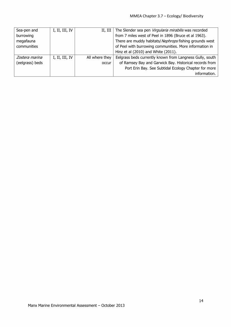
Sea-pen and
burrowing
megafauna
communities
I, II, III, IV II, III The Slender sea pen Virgularia mirabilis was recorded
from 7 miles west of Peel in 1896 (Bruce et al 1963).
There are muddy habitats/Nephrops fishing grounds west
of Peel with burrowing communities. More information in
Hinz et al (2010) and White (2011).
Zostera marina
(eelgrass) beds
I, II, III, IV All where they
occur
Eelgrass beds currently known from Langness Gully, south
of Ramsey Bay and Garwick Bay. Historical records from
Port Erin Bay. See Subtidal Ecology Chapter for more
information.
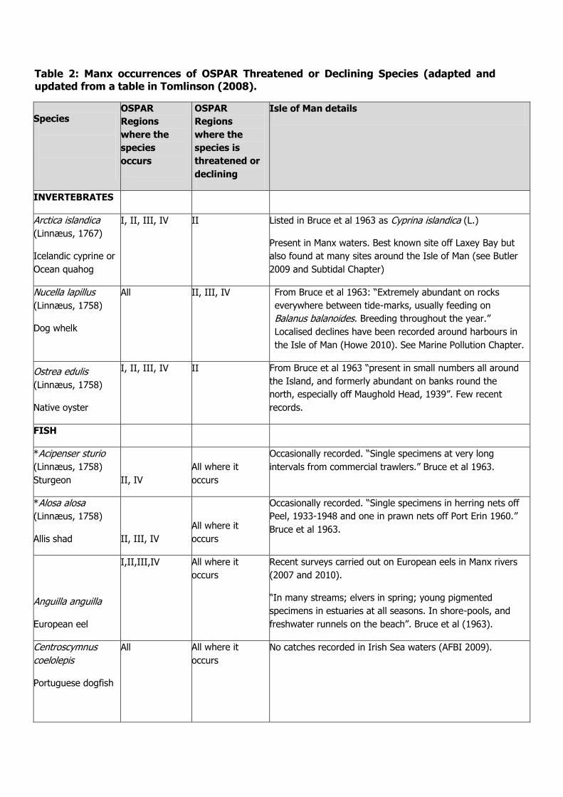
Table 2: Manx occurrences of OSPAR Threatened or Declining Species (adapted and updated from a table in Tomlinson (2008).
Species
OSPAR
Regions
where the
species
occurs
OSPAR
Regions
where the
species is
threatened or
declining
Isle of Man details
INVERTEBRATES
Arctica islandica
(Linnæus, 1767)
Icelandic cyprine or
Ocean quahog
I, II, III, IV II Listed in Bruce et al 1963 as Cyprina islandica (L.)
Present in Manx waters. Best known site off Laxey Bay but
also found at many sites around the Isle of Man (see Butler
2009 and Subtidal Chapter)
Nucella lapillus
(Linnæus, 1758)
Dog whelk
All II, III, IV From Bruce et al 1963: “Extremely abundant on rocks
everywhere between tide-marks, usually feeding on
Balanus balanoides. Breeding throughout the year.”
Localised declines have been recorded around harbours in
the Isle of Man (Howe 2010). See Marine Pollution Chapter.
Ostrea edulis
(Linnæus, 1758)
Native oyster
I, II, III, IV II From Bruce et al 1963 “present in small numbers all around
the Island, and formerly abundant on banks round the
north, especially off Maughold Head, 1939”. Few recent
records.
FISH
*Acipenser sturio
(Linnæus, 1758)
Sturgeon II, IV
All where it
occurs
Occasionally recorded. “Single specimens at very long
intervals from commercial trawlers.” Bruce et al 1963.
*Alosa alosa
(Linnæus, 1758)
Allis shad II, III, IV
All where it
occurs
Occasionally recorded. “Single specimens in herring nets off
Peel, 1933-1948 and one in prawn nets off Port Erin 1960.”
Bruce et al 1963.
Anguilla anguilla
European eel
I,II,III,IV All where it
occurs
Recent surveys carried out on European eels in Manx rivers
(2007 and 2010).
“In many streams; elvers in spring; young pigmented
specimens in estuaries at all seasons. In shore-pools, and
freshwater runnels on the beach”. Bruce et al (1963).
Centroscymnus
coelolepis
Portuguese dogfish
All All where it
occurs
No catches recorded in Irish Sea waters (AFBI 2009).
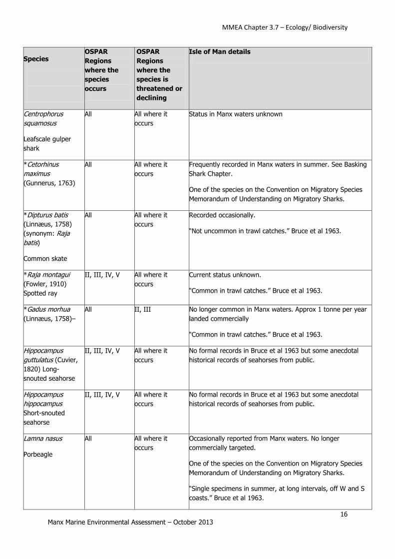
MMEA Chapter 3.7 – Ecology/ Biodiversity
16 Manx Marine Environmental Assessment – October 2013
Species
OSPAR
Regions
where the
species
occurs
OSPAR
Regions
where the
species is
threatened or
declining
Isle of Man details
Centrophorus
squamosus
Leafscale gulper
shark
All All where it
occurs
Status in Manx waters unknown
*Cetorhinus
maximus
(Gunnerus, 1763)
All All where it
occurs
Frequently recorded in Manx waters in summer. See Basking
Shark Chapter.
One of the species on the Convention on Migratory Species
Memorandum of Understanding on Migratory Sharks.
*Dipturus batis
(Linnæus, 1758)
(synonym: Raja
batis)
Common skate
All All where it
occurs
Recorded occasionally.
“Not uncommon in trawl catches.” Bruce et al 1963.
*Raja montagui
(Fowler, 1910)
Spotted ray
II, III, IV, V All where it
occurs
Current status unknown.
“Common in trawl catches.” Bruce et al 1963.
*Gadus morhua
(Linnæus, 1758)–
All II, III No longer common in Manx waters. Approx 1 tonne per year
landed commercially
“Common in trawl catches.” Bruce et al 1963.
Hippocampus
guttulatus (Cuvier,
1820) Long-
snouted seahorse
II, III, IV, V All where it
occurs
No formal records in Bruce et al 1963 but some anecdotal
historical records of seahorses from public.
Hippocampus
hippocampus
Short-snouted
seahorse
II, III, IV, V All where it
occurs
No formal records in Bruce et al 1963 but some anecdotal
historical records of seahorses from public.
Lamna nasus
Porbeagle
All All where it
occurs
Occasionally reported from Manx waters. No longer
commercially targeted.
One of the species on the Convention on Migratory Species
Memorandum of Understanding on Migratory Sharks.
“Single specimens in summer, at long intervals, off W and S
coasts.” Bruce et al 1963.
MMEA Chapter 3.7 – Ecology/ Biodiversity
17 Manx Marine Environmental Assessment – October 2013
Species
OSPAR
Regions
where the
species
occurs
OSPAR
Regions
where the
species is
threatened or
declining
Isle of Man details
Petromyzon
marinus
(Linnæus, 1758)
Sea lamprey
I, II, III, IV All where it
occurs
One recorded attached to mackerel in 2005.
Lamprey are common on basking sharks in Manx waters but
the species hasn’t been confirmed.
“One 1919, one in herring nets off Niarbyl, 1955.” Bruce et
al 1963.
Raja clavata
Thornback ray
I,II,III,IV,V II Occasionally caught as bycatch in queen scallop fishery
(Duncan 2009).
“Common in trawl catches.” Bruce et al 1963.
Rostroraja alba
White skate
II,III,IV All where it
occurs
“Formerly taken in local target fisheries in the western Channel and Irish Sea (Isle of Man). Now extirpated from the Irish Sea.” OSPAR Commission (2010).
*Salmo
salar(Linnæus,
1758)
I, II, III, IV All where it
occurs
Salmon populations in Manx rivers are regularly monitored
by DEFA Inland Fisheries staff. Main salmon rivers the Ned,
the Douglas and the Sulby.
“Runs up the Sulby, Santon and Douglas rivers in autumn,
net fishery Ramsey Bay and occasional fish netted in all bays
of the island.” Bruce et al 1963.
Squalus acanthias
Northeast Atlantic
spurdog
All All where it
occurs
No longer taken commercially in Manx waters. Small
numbers taken as bycatch in queen scallop fishery (Duncan
2009).
One of the species on the Convention on Migratory Species
Memorandum of Understanding on Migratory Sharks.
“Common; occasionally taken in very large numbers by trawl
or in herring nets.” Bruce et al (1963)
Squatina squatina
Angel shark
II,III,IV All where it
occurs
Current status in Manx waters unknown.
“Single specimens at long intervals in trawl catches.” Bruce
et al 1963.
REPTILES
Dermochelys
coriacea (Vandelli,
1761). Leatherback
turtle
All All where it
occurs
Between 2001 and 2011, 16 leatherback turtles were
recorded in Manx waters and an additional 4 unidentified turtles. See Sea Turtles Chapter.
MMEA Chapter 3.7 – Ecology/ Biodiversity
18 Manx Marine Environmental Assessment – October 2013
Species
OSPAR
Regions
where the
species
occurs
OSPAR
Regions
where the
species is
threatened or
declining
Isle of Man details
MAMMALS
Balaenoptera
musculus
(Linnæus, 1758)
Blue whale
All All where it
occurs
Not known to occur in Manx waters.
Eubalaena glacialis
(Müller, 1776)
Northern right
whale
All All where it
occurs
One recorded to the south of the Isle of Man (Reid et al
2003).
Phocoena
phocoena
(Linnæus, 1758)
Harbour porpoise
All II, III The most common cetacean in Manx waters. See Marine
Mammals – Cetaceans Chapter.
“Numerous in Manx waters esp. in summer months.” Bruce
et al 1963.
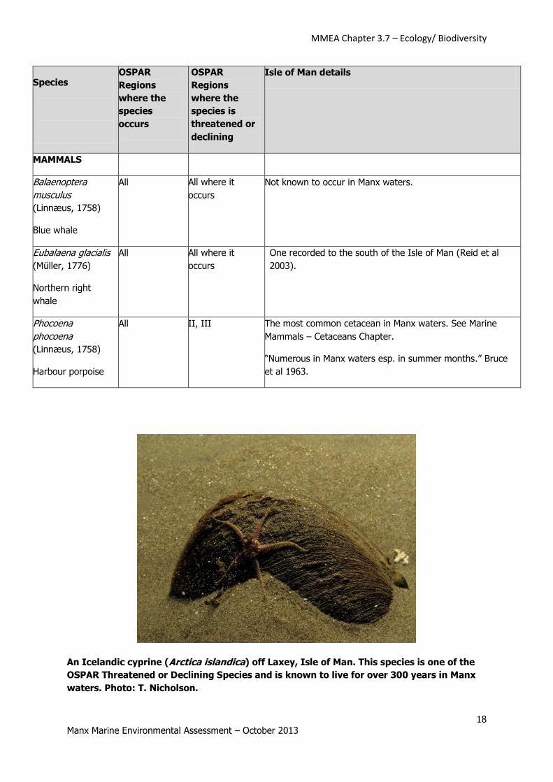
An Icelandic cyprine (Arctica islandica) off Laxey, Isle of Man. This species is one of the
OSPAR Threatened or Declining Species and is known to live for over 300 years in Manx
waters. Photo: T. Nicholson.
MMEA Chapter 3.7 – Ecology/ Biodiversity
19 Manx Marine Environmental Assessment – October 2013
Species Protection
The Wildlife Act 1990 is the legal basis for species protection in the Isle of Man. Many of the
species on the schedules for protection have been protected since 1990 but there have been
amendments over the years to add and remove species where appropriate.
The full list of species currently protected under the Wildlife Act 1990 can be found at:
http://www.gov.im/categories/the-environment-and-greener-living/wildlife/protected-
species/
The marine species protected by the Act are relatively limited. Under Schedule 5 “Animals
which are protected”, the following species are protected:
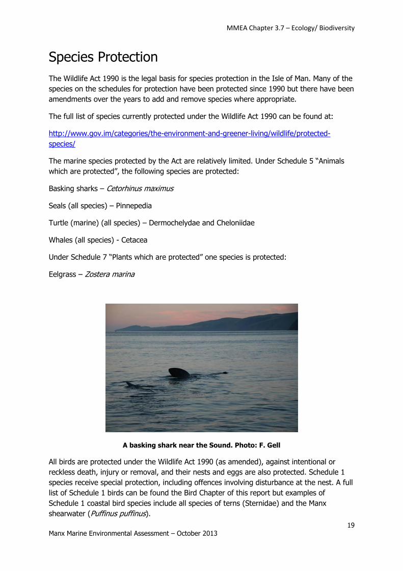
Basking sharks – Cetorhinus maximus
Seals (all species) – Pinnepedia
Turtle (marine) (all species) – Dermochelydae and Cheloniidae
Whales (all species) - Cetacea
Under Schedule 7 “Plants which are protected” one species is protected:
Eelgrass – Zostera marina
A basking shark near the Sound. Photo: F. Gell
All birds are protected under the Wildlife Act 1990 (as amended), against intentional or
reckless death, injury or removal, and their nests and eggs are also protected. Schedule 1
species receive special protection, including offences involving disturbance at the nest. A full
list of Schedule 1 birds can be found the Bird Chapter of this report but examples of
Schedule 1 coastal bird species include all species of terns (Sternidae) and the Manx
shearwater (Puffinus puffinus).
MMEA Chapter 3.7 – Ecology/ Biodiversity
20 Manx Marine Environmental Assessment – October 2013
Detailed information about the status of basking shark, turtles, seals, cetaceans and birds in
the Isle of Man are provided in separate chapters of this report and the status of eelgrass is
addressed in the Subtidal Ecology chapter.
Under some circumstances, e.g. for research or educational purposes, licences can be issued
for activities that will disturb protected species or otherwise impact on them. For example,
DEFA Fisheries Directorate issues licences for basking shark research, including tagging work
and for filming basking sharks in the water. These licences are issued with clear conditions
for the work to minimise the impact on the protected species and a requirement to provide a
report on the work.
DEFA Biodiversity Officers are supported in their enforcement of the Wildlife Act by the Isle
of Man Constabulary Wildlife Crime Officers who take an active role in investigating wildlife
crime incidents. A number of prosecutions have been made under the Wildlife Act,
particularly related to birds. As of August 2012 no prosecutions have been made in relation
to marine protected species crime. Education and awareness raising are key to reducing the
risk of marine wildlife crime. See also: http://www.gov.im/dha/police/wildlife.xml.
MMEA Chapter 3.7 – Ecology/ Biodiversity
21 Manx Marine Environmental Assessment – October 2013
Marine Site Protection
In addition to species protection, the Wildlife Act also provides a wide range of tools for site
protection.
Section 27 of the Wildlife Act includes the following provision:
(1) Where the Department, after consultation with the Wildlife Committee is of the
opinion that any area of land is of special interest by reason of any of its flora, fauna, or
geological or physiographical features, it may notify that fact to-
(a) the Department of Local Government and the Environment; and
(b) to every owner and occupier of any of that land.
Such areas include Areas of Special Scientific Interest (ASSIs), Areas of Special Protection,
National Nature Reserves and Marine Nature Reserves. There are a variety of other non-
statutory designations applicable to the Isle of Man, including locally important Wildlife Sites
and internationally recognised Ramsar Sites.
Marine Nature Reserves
The Isle of Man has had legislation for Marine Nature Reserves (MNRs) since the Wildlife Act
was introduced in 1990. In the Wildlife Act it states that:
“(1) Where, in the case of any land covered (continuously or intermittently) by tidal waters
or parts of the sea in or adjacent to the Island up to the seaward limits of territorial waters
it appears to the Department expedient, on an application made by the Wildlife Committee
that the land and waters covering it should be managed by the Department for the purpose
of-
(a) Conserving marine flora or fauna or geological or physiographical features of special
interest in the area; or
(b) Providing, under suitable conditions and control, special opportunities for the study
of, and research into, matters relating to marine flora and fauna and the physical conditions
in which they live, or for the study of geological and physiographical features of special
interest in the area, the Department may, subject to section 37(3), by order designate the
area comprising the land and those waters as a marine nature reserve; and the Department
shall manage any area so designated for either or both of those purposes.”
There was an initial attempt to designate a Marine Nature Reserve in 1992 (DAFF 1992).
The Calf Marine Trust put forward a detailed proposal for an extensive MNR around the Calf
of Man, based on a high level of scientific information from the Port Erin Marine Laboratory.
A misunderstanding at the consultation stage, whereby stakeholders believed that decisions
had already been made without their input, led to a group being formed to oppose the
MMEA Chapter 3.7 – Ecology/ Biodiversity
22 Manx Marine Environmental Assessment – October 2013
proposal. The proposal was eventually abandoned and although conservation organisations
like Manx Wildlife Trust have continued to support the idea of MNRs, no further attempt was
made to establish the Calf of Man or any other site as an MPA for many years.
Public consultation on Marine Nature Reserves
From 2004 onwards the Department of Agriculture, Fisheries and Forestry began to consider
the best approach to conserving important marine sites. The department hosted public
lectures, courses and other opportunities for stakeholders to learn more about marine
conservation and Marine Protected Areas. New research and surveys were also carried out
by local students, visiting scientists and in partnership with other organisations. The new
research included ecological aspects of Manx waters and also social and economic issues.
For example, in 2007 a Manx BSc student at Aberdeen University (Halsall 2008), working
with DAFF, carried out a postal survey of a random sample of Manx residents to gauge
public support for marine conservation and Marine Protected Areas. Out of a total of 2000
questionnaires sent out, 741 responses were received, an extremely high response for a
random postal survey. The majority of respondents (91%) valued the health of the marine
environment very highly and were aware of its importance to habitats and wildlife and 95%
of the respondents considered Marine Protected Areas to be a good idea. A large proportion
(85%) of the respondents also believed that there should be a percentage of the Manx seas
protected from all harmful practices (known as a No Take Zone).
In 2008, a new process to designate a Marine Nature Reserve in Manx waters was launched
with the intention of involving stakeholders from the outset to achieve good community
support for the site eventually selected. The main aim of the Manx Marine Nature Reserve
Project was to establish the Isle of Man’s first Marine Nature Reserve by the end of 2011,
effectively protecting important marine habitats and species with the involvement and
support of stakeholders.
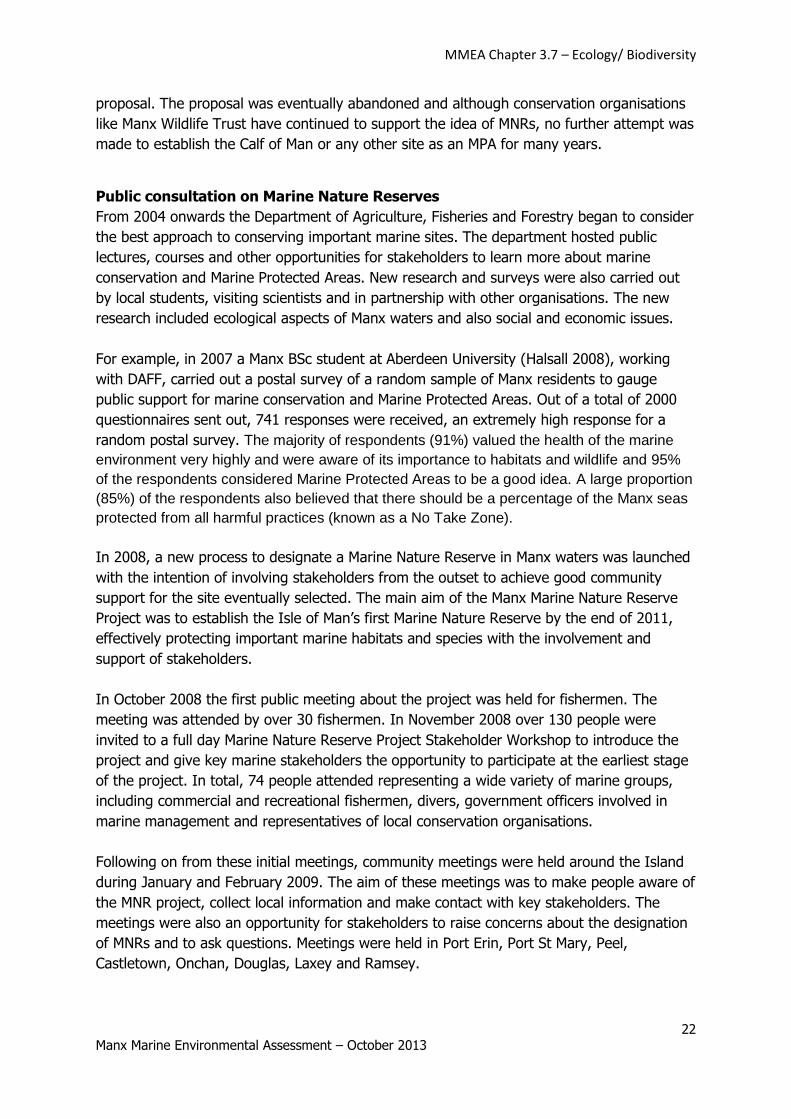
In October 2008 the first public meeting about the project was held for fishermen. The
meeting was attended by over 30 fishermen. In November 2008 over 130 people were
invited to a full day Marine Nature Reserve Project Stakeholder Workshop to introduce the
project and give key marine stakeholders the opportunity to participate at the earliest stage
of the project. In total, 74 people attended representing a wide variety of marine groups,
including commercial and recreational fishermen, divers, government officers involved in
marine management and representatives of local conservation organisations.
Following on from these initial meetings, community meetings were held around the Island
during January and February 2009. The aim of these meetings was to make people aware of
the MNR project, collect local information and make contact with key stakeholders. The
meetings were also an opportunity for stakeholders to raise concerns about the designation
of MNRs and to ask questions. Meetings were held in Port Erin, Port St Mary, Peel,
Castletown, Onchan, Douglas, Laxey and Ramsey.
MMEA Chapter 3.7 – Ecology/ Biodiversity
23 Manx Marine Environmental Assessment – October 2013
In April 2009 the Wildlife Committee of DEFA approved selection criteria for Manx Marine
Nature Reserves based on the OSPAR “Guidelines for the Identification and Selection of
Marine Protected Areas in the OSPAR Maritime Area” which include Ecological
Criteria/Considerations and Practical Criteria/Considerations (including socio-economic
aspects). DEFA made an assessment of sites meeting the OSPAR Marine Protected Area
selection criteria and the intention was to use a further round of stakeholder consultation to
arrive at the best possible site to take forward for designation. The sites identified as
candidate Marine Nature Reserves in the initial assessment against the OSPAR criteria are
given in the Subtidal Ecology chapter (MMEA Chapter 3.3). See Gell and Hanley (2010) for
more details.
Marine Nature Reserve Project Stakeholder Workshop November 2008. Photo: L Hanley.
Background to the designation of Ramsey Marine Nature Reserve
The original intention of the Manx Marine Nature Reserve Project was to use the list of sites
meeting OSPAR criteria as a basis for further stakeholder consultation to identify the most
suitable site for the Marine Nature Reserve. However, this plan was overtaken by events and the
identification of the site happened much earlier than expected.
In June 2010 the Manx Fish Producers’ Organisation, which represents most of the Manx scallop
industry, proposed Ramsey Bay as the Island’s first MNR. At that time Ramsey Bay was already
closed to scallop fishing as an Emergency Closure and the fishermen were willing to see some of
the bay closed permanently. The MFPO made some initial suggestions about combining a Marine
Nature Reserve with a Fisheries Ranching Area. Further negotiation between DEFA and the MFPO
resulted in a proposal for protecting part of Ramsey Bay, to include part of the maerl habitat and
the eelgrass beds, and also protecting the horse mussel reef in the Ballacash Channel.
MMEA Chapter 3.7 – Ecology/ Biodiversity
24 Manx Marine Environmental Assessment – October 2013
The two sites which made up the proposed Ramsey Marine Nature Reserve, Ramsey Bay and the
Ballacash Channel, had already been assessed as meeting OSPAR criteria and had been
suggested as candidate sites through the initial stakeholder consultation. Additional information
was put together for the whole site and in August 2010 a paper went to the Fisheries Directorate
Committee of DEFA where the change in process was approved from a political and management
perspective. In October 2010, a paper was submitted to the Wildlife Committee of DEFA and to
additional marine scientists for their technical advice. The Wildlife Committee approved the
proposal from a scientific perspective. DEFA and the Manx Fish Producers’ Organisation issued a
joint press release in 2010 announcing the intention to work together to develop the Marine
Nature Reserve (“Fisherman lead the way in Marine Nature Reserve Selection”).
In December 2010 a formal consultation process was launched to get specific stakeholder input
on the options for designating Ramsey Bay as a Marine Nature Reserve. The consultation closed
in February 2011 and over 200 people responded formally, with many more attending drop in
sessions in Ramsey to ask questions and provide information. The majority of respondents (86%)
were users of Ramsey Bay, representing a wide range of commercial, recreational and interest
groups. The majority of respondents (86%) supported the designation of the MNR (42%
supported and 43% strongly supported). Only 1.5% of respondents said that they were opposed
the MNR.
Based on the input from the consultation and the available science a zoning plan of Ramsey
Marine Nature Reserve was developed. This plan was released to stakeholders in July 2011.
Additional marine survey was carried out in Ramsey Bay, improving the scientific baseline for the
area. The proposed zones (shown in Figure 1) were approved in October 2011 and went into
immediate operation. Following input from a small group of recreational anglers, changes were
proposed to the Marine Nature Reserve byelaws and these were incorporated in the final version
of the Marine Nature Reserve byelaws which were approved by Tynwald in January 2012.
MMEA Chapter 3.7 – Ecology/ Biodiversity
25 Manx Marine Environmental Assessment – October 2013
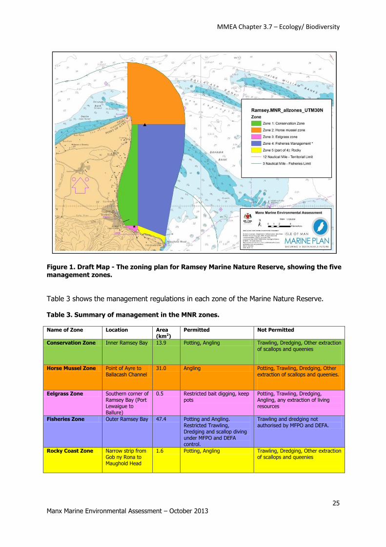
Figure 1. Draft Map - The zoning plan for Ramsey Marine Nature Reserve, showing the five
management zones.
Table 3 shows the management regulations in each zone of the Marine Nature Reserve.
Table 3. Summary of management in the MNR zones. Name of Zone Location Area
(km2) Permitted Not Permitted
Conservation Zone Inner Ramsey Bay 13.9 Potting, Angling Trawling, Dredging, Other extraction of scallops and queenies
Horse Mussel Zone Point of Ayre to Ballacash Channel
31.0 Angling Potting, Trawling, Dredging, Other extraction of scallops and queenies.
Eelgrass Zone Southern corner of Ramsey Bay (Port Lewaigue to Ballure)
0.5 Restricted bait digging, keep pots
Potting, Trawling, Dredging, Angling, any extraction of living resources
Fisheries Zone Outer Ramsey Bay 47.4 Potting and Angling. Restricted Trawling, Dredging and scallop diving under MFPO and DEFA control.
Trawling and dredging not authorised by MFPO and DEFA.
Rocky Coast Zone Narrow strip from Gob ny Rona to Maughold Head
1.6 Potting, Angling Trawling, Dredging, Other extraction of scallops and queenies
MMEA Chapter 3.7 – Ecology/ Biodiversity
26 Manx Marine Environmental Assessment – October 2013
Management in all zones
Some regulations apply to all zones in the Marine Nature Reserve. Gill-netting, long-lining,
aggregate extraction, dumping of dredged material, littering, construction (unless licensed
by DEFA) are not permitted anywhere in the Marine Nature Reserve.
Conservation Zone (green in Figure 1, Table 1)
Trawling and dredging and any other extraction of scallops and queenies are not permitted
in the Conservation Zone. Potting, angling and many other activities are permitted in this
area. This provides protection to maerl beds, kelp forests and other important marine
habitats.
Horse Mussel Zones (orange in Figure 1, Table 1)
Trawling, dredging and potting are not permitted in the Horse Mussel Zone, primarily
protecting the extensive horse mussel reef in the Ballacash Channel and other important
habitats.
Eelgrass Zone (pink in Figure 1, Table 1)
The eelgrass zone has an area of 0.5km2 and is the most highly protected zone in Ramsey
Marine Nature Reserve. It is protected from all extractive activities with the exception of bait
collection for lugworms and razorshells from 1 October to 31 March. This concession to bait
collectors will be reviewed in 2014. The Eelgrass Zone is also protected from anchoring
which can damage eelgrass habitats. (The anglers were concerned about losing the
opportunity to dig for bait in the highly protected Eelgrass Zone so the new byelaw permits
winter digging for razorshells and lugworms, as requested by the anglers until 2014 when
this byelaw will be reviewed.)
Rocky Shore Zone (yellow in Figure 1, Table 1)
The rocky shore zone is an area which is protected voluntarily from trawling and dredging.
This was offered by the Manx Fish Producers Organisation as part of their proposed
responsible management of the Fisheries Management Zone. The area was negotiated with
the MFPO after survey dives in July 2012 showed that eelgrass beds extend from Carrick
Bay to Cor Stack.
Fisheries Management Zone (purple in Figure 1, Table 1)
The Fisheries Management Zone is currently (July 2012) closed to scallop fishing. In future
the intention is that it will be managed by the Manx Fish Producers’ Organisation who will
lease the seabed within the area.
ArcView shapefiles of Ramsey Marine Nature Reserve and the management zones are
available from the Fisheries Directorate of DEFA.
MMEA Chapter 3.7 – Ecology/ Biodiversity
27 Manx Marine Environmental Assessment – October 2013
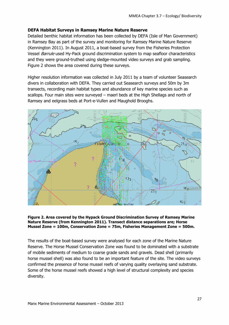
DEFA Habitat Surveys in Ramsey Marine Nature Reserve
Detailed benthic habitat information has been collected by DEFA (Isle of Man Government)
in Ramsey Bay as part of the survey and monitoring for Ramsey Marine Nature Reserve
(Kennington 2011). In August 2011, a boat-based survey from the Fisheries Protection
Vessel Barrule used Hy-Pack ground discrimination system to map seafloor characteristics
and they were ground-truthed using sledge-mounted video surveys and grab sampling.
Figure 2 shows the area covered during these surveys.
Higher resolution information was collected in July 2011 by a team of volunteer Seasearch
divers in collaboration with DEFA. They carried out Seasearch surveys and 50m by 3m
transects, recording main habitat types and abundance of key marine species such as
scallops. Four main sites were surveyed – maerl beds at the High Shellags and north of
Ramsey and eelgrass beds at Port-e-Vullen and Maughold Brooghs.
Figure 2. Area covered by the Hypack Ground Discrimination Survey of Ramsey Marine
Nature Reserve (from Kennington 2011). Transect distance separations are; Horse Mussel Zone = 100m, Conservation Zone = 75m, Fisheries Management Zone = 500m.
The results of the boat-based survey were analysed for each zone of the Marine Nature
Reserve. The Horse Mussel Conservation Zone was found to be dominated with a substrate
of mobile sediments of medium to coarse grade sands and gravels. Dead shell (primarily
horse mussel shell) was also found to be an important feature of the site. The video surveys
confirmed the presence of horse mussel reefs of varying quality overlaying sand substrate.
Some of the horse mussel reefs showed a high level of structural complexity and species
diversity.
MMEA Chapter 3.7 – Ecology/ Biodiversity
28 Manx Marine Environmental Assessment – October 2013
The Conservation Zone (inner Ramsey Bay) was found to be primarily composed of mobile
sediment, varying in grade from fine sand to small stones. Around the Shellags there are
also occasional rocky outcrops. Boulder clay deposits were also identified, overlain by coarse
sands. Areas of kelp were common within this area. The grab samples also confirmed the
presence of live maerl over significant areas. The rocky outcrops were colonised by kelp
forest. Additional dive surveys revealed a high level of biodiversity in the live maerl sites.
The Fisheries Zone, in the middle of Ramsey Bay was found to be dominated by mixed
sandy substrate from very fine sands to coarse sands and small stones. Occasional rocky
outcrops were also identified. The associated communities included abundant soft corals
(Alcyonium digitatum) and occasional clumps of horse mussel. Cobbles and boulders in this
area were often found to be colonised by large numbers of plumose anemones (Metridium
senile). The Rocky Shore Zone, the stretch of subtidal habitat off the Maughold Brooghs,
had a mixture of rocky shore habitat dominated by kelp and sandy substrate. Video surveys
and additional dive surveys revealed a substantial area of eelgrass Zostera marina in a
narrow band on the 5-7m contour along the coast. Additional surveys revealed deeper
eelgrass beds further offshore in 10-12m.
To calibrate the sediment information obtained from the ground discrimination, ten Van
Veen grab samples were taken across the Marine Nature Reserve, samples of the sediment
were analysed in more detail and the infauna species identified by a taxonomic expert
(Salma Shalla at CMACS). In total, 260 species were identified including 82 species of
worms, 59 species of crustacea, 23 species of bryozoans, 14 species of cnidaria and 11
species of echinoderms. This demonstrates a high level of diversity, considering the small
volume of samples used in this study. For more information and a full species list see
Kennington (2011).
Annual dive surveys are planned in Ramsey Marine Nature Reserve to monitor changes in
habitat quality and abundances of scallops and other marine species.
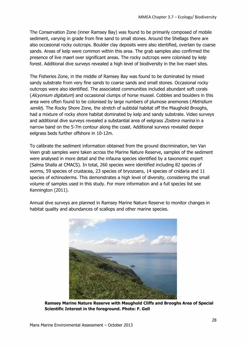
Ramsey Marine Nature Reserve with Maughold Cliffs and Brooghs Area of Special
Scientific Interest in the foreground. Photo: F. Gell
MMEA Chapter 3.7 – Ecology/ Biodiversity
29 Manx Marine Environmental Assessment – October 2013
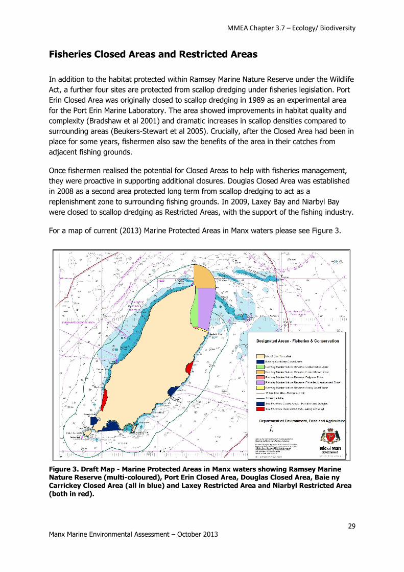
Fisheries Closed Areas and Restricted Areas
In addition to the habitat protected within Ramsey Marine Nature Reserve under the Wildlife
Act, a further four sites are protected from scallop dredging under fisheries legislation. Port
Erin Closed Area was originally closed to scallop dredging in 1989 as an experimental area
for the Port Erin Marine Laboratory. The area showed improvements in habitat quality and
complexity (Bradshaw et al 2001) and dramatic increases in scallop densities compared to
surrounding areas (Beukers-Stewart et al 2005). Crucially, after the Closed Area had been in
place for some years, fishermen also saw the benefits of the area in their catches from
adjacent fishing grounds.
Once fishermen realised the potential for Closed Areas to help with fisheries management,
they were proactive in supporting additional closures. Douglas Closed Area was established
in 2008 as a second area protected long term from scallop dredging to act as a
replenishment zone to surrounding fishing grounds. In 2009, Laxey Bay and Niarbyl Bay
were closed to scallop dredging as Restricted Areas, with the support of the fishing industry.
For a map of current (2013) Marine Protected Areas in Manx waters please see Figure 3.
Figure 3. Draft Map - Marine Protected Areas in Manx waters showing Ramsey Marine Nature Reserve (multi-coloured), Port Erin Closed Area, Douglas Closed Area, Baie ny
Carrickey Closed Area (all in blue) and Laxey Restricted Area and Niarbyl Restricted Area
(both in red).
MMEA Chapter 3.7 – Ecology/ Biodiversity
30 Manx Marine Environmental Assessment – October 2013
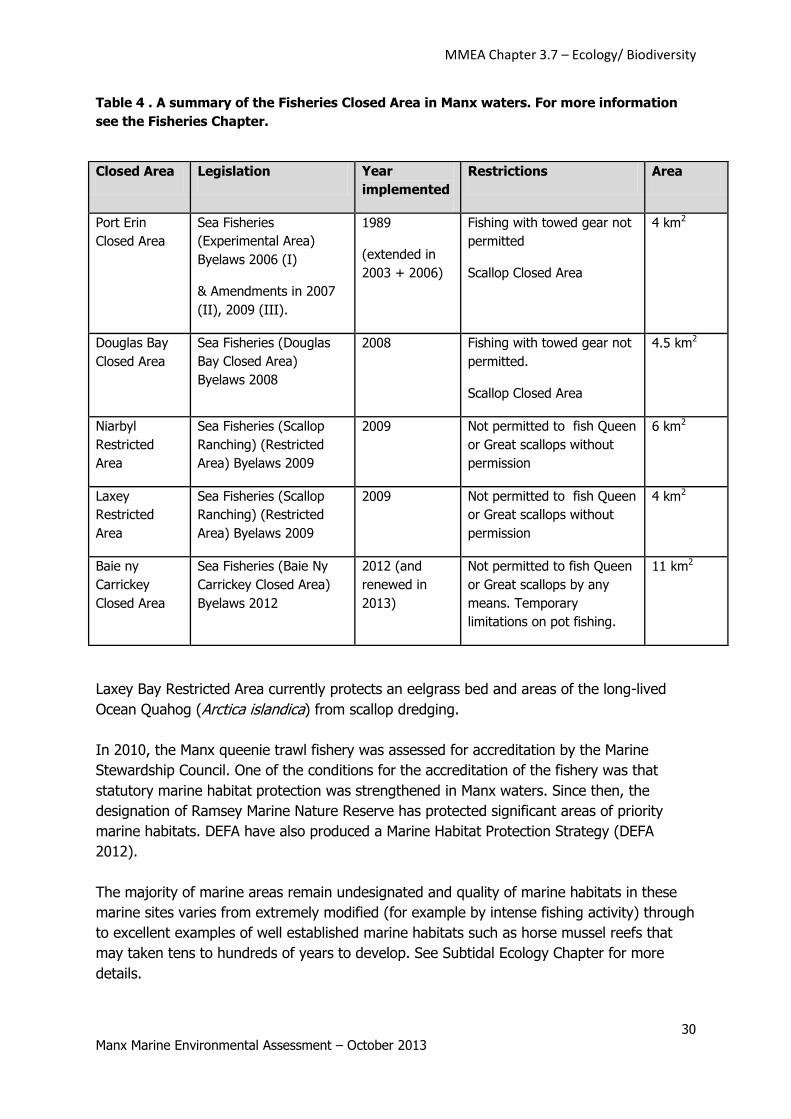
Table 4 . A summary of the Fisheries Closed Area in Manx waters. For more information
see the Fisheries Chapter.
Laxey Bay Restricted Area currently protects an eelgrass bed and areas of the long-lived
Ocean Quahog (Arctica islandica) from scallop dredging.
In 2010, the Manx queenie trawl fishery was assessed for accreditation by the Marine
Stewardship Council. One of the conditions for the accreditation of the fishery was that
statutory marine habitat protection was strengthened in Manx waters. Since then, the
designation of Ramsey Marine Nature Reserve has protected significant areas of priority
marine habitats. DEFA have also produced a Marine Habitat Protection Strategy (DEFA
2012).
The majority of marine areas remain undesignated and quality of marine habitats in these
marine sites varies from extremely modified (for example by intense fishing activity) through
to excellent examples of well established marine habitats such as horse mussel reefs that
may taken tens to hundreds of years to develop. See Subtidal Ecology Chapter for more
details.
Closed Area Legislation Year
implemented
Restrictions Area
Port Erin
Closed Area
Sea Fisheries
(Experimental Area)
Byelaws 2006 (I)
& Amendments in 2007
(II), 2009 (III).
1989
(extended in
2003 + 2006)
Fishing with towed gear not
permitted
Scallop Closed Area
4 km2
Douglas Bay
Closed Area
Sea Fisheries (Douglas
Bay Closed Area)
Byelaws 2008
2008 Fishing with towed gear not
permitted.
Scallop Closed Area
4.5 km2
Niarbyl
Restricted
Area
Sea Fisheries (Scallop
Ranching) (Restricted
Area) Byelaws 2009
2009 Not permitted to fish Queen
or Great scallops without
permission
6 km2
Laxey
Restricted
Area
Sea Fisheries (Scallop
Ranching) (Restricted
Area) Byelaws 2009
2009 Not permitted to fish Queen
or Great scallops without
permission
4 km2
Baie ny
Carrickey
Closed Area
Sea Fisheries (Baie Ny
Carrickey Closed Area)
Byelaws 2012
2012 (and
renewed in
2013)
Not permitted to fish Queen
or Great scallops by any
means. Temporary
limitations on pot fishing.
11 km2
MMEA Chapter 3.7 – Ecology/ Biodiversity
31 Manx Marine Environmental Assessment – October 2013
See also MMEA Chapter 4.1 (Commercial Fisheries and Sea Angling) and MMEA Chapter 3.3
(Subtidal Ecology).
Coastal Site Protection
A range of protective measures are available for conservation of terrestrial coastal sites,
based on the level of importance of the site, as shown in Table 5.
Table 5: Summary of nature conservation site protection measures on the Isle of Man
(with an emphasis on terrestrial designations).
Scale of priority for protection
Greater priority Lesser priority
Ramsar Sites
Emerald Network Sites
National Nature
Reserves (NNRs)
Areas of Special
Scientific Interest
(ASSIs)
Marine Nature
Reserves (MNRs)
Areas of Special
Protection (ASPs)
Bird Sanctuaries
Wildlife Sites
Habitats in
farmland and wider
countryside
Improved
farmland
Manx National Trust land – could apply to any of the above.
Undesignated areas
The abundance of improved farmland habitats in the wider countryside, whilst important for
some species, makes it usually the lowest priority for designation as a protected area.
Likewise, semi-improved habitats along the coast and in the wider countryside which don’t
meet the criteria for designation as a Wildlife Site are unlikely to receive special protection
on the grounds of nature conservation. However, these habitats may occasionally fall within
areas under the protection of Manx National Heritage (see below), and are all protected to a
certain extent by agricultural codes of practice and planning regulations. It should also be
remembered that some important wildlife species, such as Chough, depend on productive
farmland which is subject to ordinary farming practices. These species would not normally
be protected through designating their habitat but by conservation management
agreements (under Section 30 of the Wildlife Act 1990). In the intertidal environment tends
to be less heavily impacted than the terrestrial environment, so more examples of
unmodified or lightly modified sites can be found.
MMEA Chapter 3.7 – Ecology/ Biodiversity
32 Manx Marine Environmental Assessment – October 2013
Wildlife Sites
This is a non-statutory designation, used widely throughout the British Isles as a site
protection system which is generally operated by local planning authorities and/or the
Wildlife Trusts. On the Isle of Man, Wildlife Sites are a voluntary designation, selected using
criteria designed by the Manx Wildlife Trust and agreed amongst relevant organisations.
Wildlife Sites can include intertidal and subtidal areas.
For further information about Manx Wildlife Sites see the Manx Wildlife Sites Handbook
(Manx Wildlife Trust 2008) available at:
http://manxwt.org.uk/index.php?option=com_content&task=view&id=26&Itemid=42
Bird Sanctuaries
These sites were designated under the Protection of Birds Acts 1932 & 1955, and remain
protected although this legislation has now been superseded by the Wildlife Act 1990.
The Bird Sanctuaries designated in the Isle of Man are:
Langness, Derbyhaven & Fort Island, Malew – which includes a significant coastal
area
Ballamoar Reservoir, Patrick
Renscault and East Baldwin
The Willows, Ballamodha
Tynwald Park and Arboretum, St Johns
Areas of Special Protection
Areas of special protection may be designated under Section 13 of the Wildlife Act 1990 in
order to extend the provision of the Wildlife Act for certain species in certain areas. The only
current Area of Special Protection for Birds is the Ayres Gravel Pit.
National Nature Reserves (NNRs)
Designated under Section 31 of the Wildlife Act 1990, may be on private or public land, and
may be subject to protective byelaws. NNRs are likely to be of ASSI quality or higher, i.e. of
national importance.
There is one National Nature Reserve in the Isle of Man, the Ayres National Nature Reserve,
which includes a long stretch of coast, and important coastal and intertidal habitats. For
detailed information about the Ayres National Nature Reserve see:
http://www.gov.im/categories/the-environment-and-greener-living/protected-sites/the-
ayres/
Annual reports on species and habitat monitoring and management measures are produced
for the Ayres National Nature Reserve, including numbers and breeding success of Arctic
terns, little terns and sandwich terns in the area (e.g. Spencer 2010).
MMEA Chapter 3.7 – Ecology/ Biodiversity
33 Manx Marine Environmental Assessment – October 2013
Land in the ownership of the Manx National Trust (administered as Manx National
Heritage).
This land is protected under the Manx Museum and National Trust Act (1959-1982), which
provides for the protection of places ‘of natural interest or beauty’ and places of historic
interest. This includes wildlife, historic buildings and also the landscape setting and physical
features within it. Whilst land owned by Manx National Heritage will not always be acquired
on the basis of its wildlife interest alone (since cultural heritage and landscape setting may
also be important factors), the fauna and flora of that land is protected by byelaws whether
they are of local, Manx national, or international value.
Manx Wildlife Trust Reserves
The Manx Wildlife Trust own a number of important wildlife sites which they manage as
Reserves. Manx Wildlife Trust Reserves may meet the criteria for ASSI designation while
other areas may meet Wildlife Site selection criteria. Information about Manx Wildlife Trust
Reserves can be found at:
http://manxwt.org.uk/index.php?option=com_content&task=view&id=57&Itemid=64
Ramsar Sites
Ramsar Sites are internationally important wetland sites chosen according to criteria agreed
by parties to the Ramsar Convention on Wetlands (1971). The Isle of Man is a signatory to
this convention, and thus has an obligation to investigate potential Ramsar Sites on the
Island. Such sites will be of ASSI or higher status.
The only Ramsar Site in the Isle of Man at present is a wetland (curragh) area in the north
of the Island, the Ballaugh Curragh Ramsar Site. There are no coastal Ramsar Sites in the
Isle of Man.
Prior to the designation of Ballaugh Curraghs Ramsar Site in 2006, Pienkowski (2005)
carried out an assessment of potential Ramsar sites in the Isle of Man for Defra and
identified a number of coastal and marine sites that meet Ramsar criteria.
Emerald Network
Emerald Network sites are internationally important wildlife areas comparable with the
European Union’s Natura 2000 network. Sites consist of Areas of Special Conservation
Interest designated under a recommendation of the Bern Convention (to which the Isle of
Man is signatory). Thus, although not part of the EU and its Natura 2000 network (which
includes Special Areas of Conservation in the UK), the Island may still designate
internationally important sites at the same level. No Emerald Sites have yet been identified
in the Isle of Man but if designated, these sites are likely to include the most important
ASSIs on the Island, but MNRs have the potential too. In terms of UK equivalents they
would be like Special Protection Areas (SPAs) as well as SACs.
MMEA Chapter 3.7 – Ecology/ Biodiversity
34 Manx Marine Environmental Assessment – October 2013
Areas of Special Scientific Interest (ASSI)
ASSIs are the main terrestrial conservation designations in the Isle of Man and are
established as part of a system, or network of sites. Through the ASSI network DEFA aims
to:
ensure the survival of the full diversity of Manx plants and animals by protecting a
network of sites which are important for the survival of Manx species both now and into
the future;
protect the full range of semi-natural habitats in existence today for the future use and
enjoyment of succeeding generations by protecting the best examples of each habitat
type; and
maintain the selected areas in favourable conservation status.
DEFA Forestry Directorate is responsible for ASSI designation.
As part of the notification of designation pack for each ASSI there is a list of potentially
damaging operations (sometimes called ‘Activities requiring DEFA’s consent’ or ‘Operations
likely to damage the special interest of the site’). This is a list of the activities that the
owners/occupiers of a site must apply to DEFA for consent to carry out whether it is to be
carried out by them or a third party such as a developer. Applications are made on a Notice
Form which is signed by the owner/occupier and returned to the Forestry, Amenity and
Lands Directorate of DEFA. DEFA then has four months to consider the effect of the
proposed activity on the special interest of the ASSI before deciding whether to issue a
consent. If consent is refused then DEFA is obliged to offer a Management Agreement
(under Section 27 of the Wildlife Act) for positive management of the land.
An Island-based approach
The Selection Criteria have been written to fulfil the needs of wildlife conservation in the
context of the Isle of Man as a Crown Dependency, with its own Wildlife Act. Sites will be
selected based on what is important for the Island as a nation rather than as if it were a
county of the UK.
The reasons for an Island-based approach, rather than simply using the JNCC criteria for
Sites of Special Scientific Interest in the UK, are:
the need to retain areas of habitat and populations of species that are rare on the
Island, even if they are commoner elsewhere, to maintain the biodiversity of the Island;
the isolation of the Island, resulting in limited prospects for natural re-colonisation from
surrounding land masses if species are lost and become extinct here;
because small populations are more vulnerable to extinction, therefore wider habitat
protection may be needed in order to maintain a viable population;
to ensure the protection of any species or habitats which show a distinctly Manx
characteristic not found elsewhere.
MMEA Chapter 3.7 – Ecology/ Biodiversity
35 Manx Marine Environmental Assessment – October 2013
The objective is to maximise the conservation of species biodiversity through protection of
their habitats. Sites will therefore be considered on the basis of their Island-wide/national,
British Isles or international/European importance. The aim is for the ASSI series to include
at least one good example of each main semi-natural habitat type and assemblage. For very
scarce and important habitats, such as saltmarsh, the majority of examples will require
protection.
ASSIs can be designated on land and on inter-tidal areas down as far as Lowest
Astronomical Tide Mark.
Current ASSI list (as at August 2012)
Table 6. Areas of Special Scientific Interest (ASSI)
Note: *indicates a coastal site
ASSI No. ASSI name Area (hectares)
1 Central Ayres* 358.34
2 Langness, Derbyhaven & Sandwick* 310
3 Jurby Airfield 63.04
4 Ballaugh Curragh 0.55
5 Ballacrye Meadow 193.4
6 Rosehill Quarry 1.37
7 Ramsey Mooragh Shore* 2.65
8 Cronk y Bing* 17.71
9 Dhoon Glen* 20.92
10 Eary Vane 3.96
11 Glen Rushen 12.27
12 Poyll Vaaish Coast* 44.76
13 Glen Maye* 15.92
14 Greeba Mountain & Central Hills 1080.95
15 Dalby Coast* 62.1
16 Ballachurry Meadows 11.9
17 Port St Mary Ledges & Kallow Point* 15.17
18 Maughold Cliffs & Brooghs* 53.63
Baseline environmental data
Baseline data for the terrestrial environment is provided by Phase 1 and Phase 2 Habitat
Surveys. The data is beneficial, but somewhat out of date, since the surveys were carried
out 1991-94. DEFA is working towards a repeat survey or sample survey of the Island.
Potential effects of developments on ASSIs and other designated sites
Potential adverse effects of development on protected sites should be assessed. For ASSIs,
any activity that is listed as a Potentially Damaging Operation (see Appendix 2 of the
designation documents for the particular site) requires consent from DEFA in advance of the
work. This covers activities carried out by the owner or occupier but there is not currently
any control over third party damage to sites. Any development or activity that is planned on
MMEA Chapter 3.7 – Ecology/ Biodiversity
36 Manx Marine Environmental Assessment – October 2013
or within a protected site will require an Environment Impact Assessment and consultation
with DEFA.
Further information on ASSIs and other designated sites
Designation documents for ASSIs are available from DEFA Forestry, Amenity and Lands
Directorate and further information about ASSIs is available on the DEFA website
http://www.gov.im/categories/the-environment-and-greener-living/protected-sites/
An ArcView shape file is available from the Forestry Directorate of DEFA for confirmed
ASSIs, Ramsar Sites, Areas of Special Protection and Bird Sanctuaries.
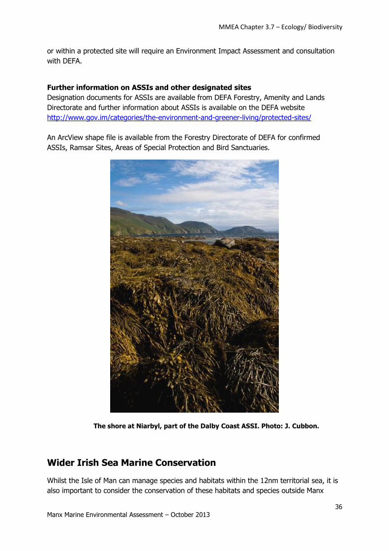
The shore at Niarbyl, part of the Dalby Coast ASSI. Photo: J. Cubbon.
Wider Irish Sea Marine Conservation
Whilst the Isle of Man can manage species and habitats within the 12nm territorial sea, it is
also important to consider the conservation of these habitats and species outside Manx
MMEA Chapter 3.7 – Ecology/ Biodiversity
37 Manx Marine Environmental Assessment – October 2013
waters. The Department of Environment, Food and Agriculture works with partner
organisations in surrounding jurisdictions on a variety of conservation initiatives, to ensure
the wider conservation of priority species and habitats.
The Irish Sea Conservation Zones Project 2009-2011
The Irish Sea Conservation Zones Project was one of the four UK regional projects set up to
develop recommendations for a network of Marine Conservation Zones around the UK
(outside of Manx territorial waters). The recommendations were formulated by a Regional
Stakeholder Group made up of representatives of different sectors in the project area. The
Isle of Man was represented on the project group by the Chief Executive of the Manx Fish
Producers’ Organisation and the Senior Marine Biodiversity Officer, Department of
Environment, Food and Agriculture, Isle of Man Government.
The proposed Marine Conservation Zones and more highly protected Reference Areas have
been put forward to the UK’s Department of Environment, Food and Rural Affairs for further
consideration.
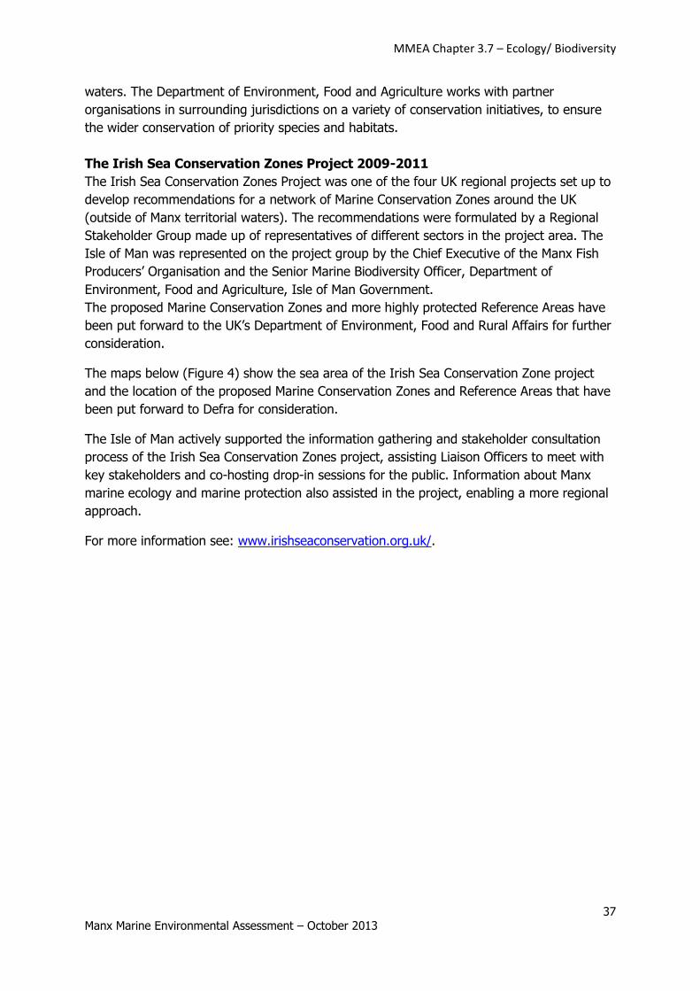
The maps below (Figure 4) show the sea area of the Irish Sea Conservation Zone project
and the location of the proposed Marine Conservation Zones and Reference Areas that have
been put forward to Defra for consideration.
The Isle of Man actively supported the information gathering and stakeholder consultation
process of the Irish Sea Conservation Zones project, assisting Liaison Officers to meet with
key stakeholders and co-hosting drop-in sessions for the public. Information about Manx
marine ecology and marine protection also assisted in the project, enabling a more regional
approach.
For more information see: www.irishseaconservation.org.uk/.
MMEA Chapter 3.7 – Ecology/ Biodiversity
38 Manx Marine Environmental Assessment – October 2013
Figure 4: Irish Sea Conservation Zone Project Area and recommended Marine
Conservation Zones, reproduced from Irish Sea Conservation Zones (2011).
In preparation for their Marine Conservation Zones work, Defra had a project to bring
together relevant data: “Marine Protected Areas - gathering/developing and accessing the
data for the planning of a network of Marine Conservation Zones - MB0102”. The Isle of
Man Government contributed funding and data to this project to ensure that Manx waters
were included in the assessment of the Irish Sea. The outputs of this project are available
at:
http://randd.defra.gov.uk/Default.aspx?Menu=Menu&Module=More&Location=None&Compl
eted=0&ProjectID=16368
Marine Invasive species
Over the past few years DEFA have worked with local stakeholders to improve reporting and
recording of marine invasive species. Non-native and invasive intertidal species are recorded
as part of the work of Steve Hawkins and his team at Southampton University (see Climate
Change in Manx Waters chapter). Volunteer Seasearch divers also record any invasive
species observed. In 2012 marine invasive species expert Dr Elizabeth Cook, from the
Scottish Association of Marine Sciences, visited the Isle of Man and carried out some rapid
assessments of invasive species in harbours at Douglas and Peel but did not detect any new
species.
MMEA Chapter 3.7 – Ecology/ Biodiversity
39 Manx Marine Environmental Assessment – October 2013
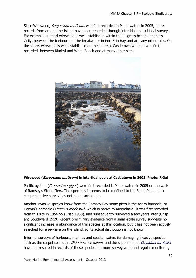
Since Wireweed, Sargassum muticum, was first recorded in Manx waters in 2005, more
records from around the Island have been recorded through intertidal and subtidal surveys.
For example, subtidal wireweed is well established within the eelgrass bed in Langness
Gully, between the harbour and the breakwater in Port Erin Bay and at many other sites. On
the shore, wireweed is well established on the shore at Castletown where it was first
recorded, between Niarbyl and White Beach and at many other sites.
Wireweed (Sargassum muticum) in intertidal pools at Castletown in 2005. Photo: F.Gell
Pacific oysters (Crassostrea gigas) were first recorded in Manx waters in 2005 on the walls
of Ramsey’s Stone Piers. The species still seems to be confined to the Stone Piers but a
comprehensive survey has not been carried out.
Another invasive species know from the Ramsey Bay stone piers is the Acorn barnacle, or
Darwin’s barnacle (Elminius modestus) which is native to Australasia. It was first recorded
from this site in 1954-55 (Crisp 1958), and subsequently surveyed a few years later (Crisp
and Southward 1959).Recent preliminary evidence from a small-scale survey suggests no
significant increase in abundance of this species at this location, but it has not been actively
searched for elsewhere on the island, so its actual distribution is not known.
Informal surveys of harbours, marinas and coastal waters for damaging invasive species
such as the carpet sea squirt Didemnum vexillum and the slipper limpet Crepidula fornicata
have not resulted in records of these species but more survey work and regular monitoring
MMEA Chapter 3.7 – Ecology/ Biodiversity
40 Manx Marine Environmental Assessment – October 2013
is needed. The carpet seasquirt has been a major issue in Holyhead Marina in Anglesey and
subject to an expensive eradication programme. The nearest record of the slipper limpet to
the Isle of Man is probably the recent recording in Belfast Lough in 2008 (Guy et al 2011).
Improved biological recording as part of the Manx Biological Reporting Partnership will
improve reporting of invasive and non-native marine species and will also facilitate improve
dissemination to the NBN and other UK and international databases.
MMEA Chapter 3.7 – Ecology/ Biodiversity
41 Manx Marine Environmental Assessment – October 2013
References
Ackers, R.G., Moss, D. and Picton, B.E. (1992) Sponges of the British Isles (Sponge V) – a colour guide and working document. 5th Edition. Marine Conservation Society, Ross-on-Wye.
Agri-Food & Biosciences Institute (2009) Position statement on sharks, skates and rays in Northern
Ireland waters. Northern Ireland Environment Agency Research and Development Series No. 09/03.
Bradshaw, C., Veale, L.O., Hill, A.S., Brand, A.R. (2001) The effect of scallop dredging on Irish Sea
benthos: experiments using a closed area. Hydrobiology 465:129–138.
Beukers-Stewart, B.D., Vause, B.J., Mosley, M.W.J., Rossetti, H.L., Brand, A.R. (2005) Benefits of
closed area protection for a population of scallops. Marine Ecology Progress Series 298:189–204.
Butler, P.G. (2009) Establishing the Arctica islandica archive: Development of the definitive shell-based proxy for the North Atlantic shelf seas. PhD Thesis, School of Ocean Sciences, Bangor
University.
Crisp, D.J. (1958) The Spread of Elminius modestus Darwin in North-West Europe. J. Mar. Biol. Ass.
UK 37, 483-520.
Crisp, D.J. & Southward, E.C. (1959) The Further Spread of Elminius modestus in the British Isles to 1959. Mar. Biol. Ass. UK 38, 429-437.
DAFF (1992) The Calf of Man: A proposed Marine Nature Reserve. Consultation Document.
DAFF (2009) Draft scientific and socio-economic criteria and guidelines for the selection of Marine
Nature Reserves in Manx waters and an initial list of candidate sites. Department of Agriculture,
Fisheries and Forestry, Isle of Man Government.
DEFA (2012) A Marine Habitat Protection Strategy for Manx Territorial Waters. Fisheries Directorate,
Department of Environment, Food and Agriculture, Isle of Man Government.
Duncan, P.F. (2009) An Assessment of Bycatch in the Isle of Man Queen Scallop Trawl Fishery.
Report Prepared for the Isle of Man Government Department of Agriculture, Fisheries and Forestry as part of the application for fishery certification under the Marine Stewardship Council. 54pp. Garrad, L. (1990) Nature Conservation. In: V Robinson & D McCarroll (eds) The Isle of Man:
Celebrating a Sense of Place. Liverpool University Press.
Gell, F.R. & Hanley, L. (2010) Developing a Marine Nature Reserve for Ramsey. Full Consultation
Document. Department of Environment, Food and Agriculture, Isle of Man Government. 38pp.
Graham, A. (1988) Molluscs: Prosobranch and pyramellid gastropods. Keys and notes for the
identification of the species. 2nd Ed. Leiden: E.J. Brill/Dr W. Backhuys. Synopses of the British Fauna
No. 2.
Guy, C., Roberts, D. & Reid, N. (2011) Ageing slipper limpet (Crepidula fornicata) shells from Belfast
Lough. Report prepared by the Natural Heritage Research Partnership, Quercus for the Northern
Ireland Environment Agency, Northern Ireland, UK. Northern Ireland Environment Agency Research
and Development Series No. 11/14.
MMEA Chapter 3.7 – Ecology/ Biodiversity
42 Manx Marine Environmental Assessment – October 2013
Halsall, S. (2008) An Investigation into the Awareness and Opinions of the Isle of Man Public
Concerning the Management of the Manx Marine Environment, for its Future Protection and
Conservation. BSc Thesis, Aberdeen University.
Hardy, F.G. & Guiry, M.D. (2003) A check-list and atlas of the seaweeds of Britain and Ireland. pp. [i]-
x, 1-435. London: British Phycological Society.
Hayward, P.J. and Ryland, J.S. (1990) The Marine Fauna of the British Isles and North-West Europe. Clarendon Press, Oxford.
Hinz, H., Murray, L.G., Gell, F.R., Hanley, L., Horton, N., Whiteley, H. & Kaiser, M.J. (2010) Seabed
habitats around the Isle of Man. Fisheries & Conservation report No. 12, Bangor University. pp.29.
Howe, V.L. (2010) Marine Pollution in the Isle of Man: Impact and Recovery. Ph.D. Thesis. University
of Liverpool. 153pp.
Irish Sea Conservation Zones (2011) Final Recommendations Summary. http://media.irishseaconservation.org.uk/sites/default/files/ISCZ%20recommendations%20summary.
Irvine, L.M. (1983) Seaweeds of the British Isles. Vol 1. Rhodophyta. Part 2A. Cryptonemiales,
Palmariales, Rhodymeniales. British Museum (Natural History), London.
Kennington, K. (2011) Ramsey Bay Marine Nature Reserve Base-Line Survey (August 2011).
Preliminary Report. DEFA, Isle of Man.
Killeen, I. 1995. 1993 Autumn Meeting to the Isle of Man – Mollusca recorded on the dredging trip. Porcupine Newsletter 5(10), pp 252-255.
http://pmnhs.co.uk/wp-content/uploads/2011/11/050-PNV5N10JAN95.pdf
Maggs, C.A. & Guiry, M.D. 1989. A re-evaluation of the crustose red algal genus Cruoria and the
family Cruoriaceae. British Phycological Journal 24: 253-269.
Manx Wildlife Trust (2008) The Manx Wildlife Sites Handbook. http://www.manxwt.org.uk/
OSPAR Commission (2010) Background document on White Skate Rostroraja alba. Publication
476/2010. London.
Penrose, R.S. and Gander, L.R. (2012) British Isles and Republic of Ireland Marine Turtle Strandings
and Sightings. Annual Report 2011. Report compiled by Marine Environmental Monitoring, Wales, UK, 24 pp.
http://www.strandings.com/Graphics%20active/2011%20Turtle%20Strandings%20Report.pdf
Picton, B.E. and Morrow, C.C. (1994) A field guide to the nudibranchs of the British Isles. London,
Immel Publishing.
Pienkowski, M.W. (2005) Review of Ramsar sites in UK Overseas Territories and Crown
Dependencies. UK Overseas Territories Conservation Forum report to DEFRA. http://jncc.defra.gov.uk/page-3511
Reid, J.B., Evans, P.G.H., & Northridge, S.P., (2003), Atlas of Cetacean distribution in north-west
European waters, 76 pages, colour photos, maps. Paperback, ISBN 1 86107 550 2
MMEA Chapter 3.7 – Ecology/ Biodiversity
43 Manx Marine Environmental Assessment – October 2013
Sanderson, W.G. (1996) Rare sea-bed species. In Coasts and seas of the United Kingdom. Region 13
Northern Irish Sea: Colwyn Bay to Stranraer, including the Isle of Man, ed. Barne J.H., Robson C.F.,
Kaznowska S.S., Doody J.P. & Davidson N.C. Joint Nature Conservation Committee.
Sharpe, C.M., Bishop, J.P., Cullen, J.P., Giovannini, P.G., Thorpe J.P. & Weaver P. (2007) Manx Bird
Atlas. Liverpool University Press.
Spencer, E. (2010) Ayres National Nature Reserve. Annual Report 2010. Manx Wildlife Trust report to
Department of Environment, Food and Agriculture.
Tomlinson, P.R. (2008) Manx Marine Biology User Guide. Report produced for Wildlife and
Conservation Division, DAFF.
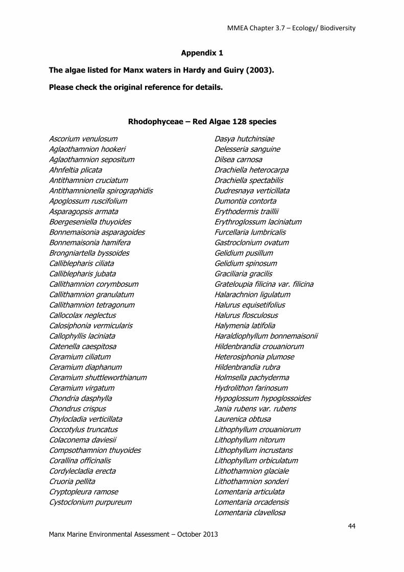
MMEA Chapter 3.7 – Ecology/ Biodiversity
44 Manx Marine Environmental Assessment – October 2013
Appendix 1
The algae listed for Manx waters in Hardy and Guiry (2003).
Please check the original reference for details.
Rhodophyceae – Red Algae 128 species
Ascorium venulosum
Aglaothamnion hookeri
Aglaothamnion sepositum
Ahnfeltia plicata
Antithamnion cruciatum
Antithamnionella spirographidis
Apoglossum ruscifolium
Asparagopsis armata
Boergeseniella thuyoides
Bonnemaisonia asparagoides
Bonnemaisonia hamifera
Brongniartella byssoides
Calliblepharis ciliata
Calliblepharis jubata
Callithamnion corymbosum
Callithamnion granulatum
Callithamnion tetragonum
Callocolax neglectus
Calosiphonia vermicularis
Callophyllis laciniata
Catenella caespitosa
Ceramium ciliatum
Ceramium diaphanum
Ceramium shuttleworthianum
Ceramium virgatum
Chondria dasphylla
Chondrus crispus
Chylocladia verticillata
Coccotylus truncatus
Colaconema daviesii
Compsothamnion thuyoides
Corallina officinalis
Cordylecladia erecta
Cruoria pellita
Cryptopleura ramose
Cystoclonium purpureum
Dasya hutchinsiae
Delesseria sanguine
Dilsea carnosa
Drachiella heterocarpa
Drachiella spectabilis
Dudresnaya verticillata
Dumontia contorta
Erythodermis traillii
Erythroglossum laciniatum
Furcellaria lumbricalis
Gastroclonium ovatum
Gelidium pusillum
Gelidium spinosum
Graciliaria gracilis
Grateloupia filicina var. filicina
Halarachnion ligulatum
Halurus equisetifolius
Halurus flosculosus
Halymenia latifolia
Haraldiophyllum bonnemaisonii
Hildenbrandia crouaniorum
Heterosiphonia plumose
Hildenbrandia rubra
Holmsella pachyderma
Hydrolithon farinosum
Hypoglossum hypoglossoides
Jania rubens var. rubens
Laurenica obtusa
Lithophyllum crouaniorum
Lithophyllum nitorum
Lithophyllum incrustans
Lithophyllum orbiculatum
Lithothamnion glaciale
Lithothamnion sonderi
Lomentaria articulata
Lomentaria orcadensis
Lomentaria clavellosa
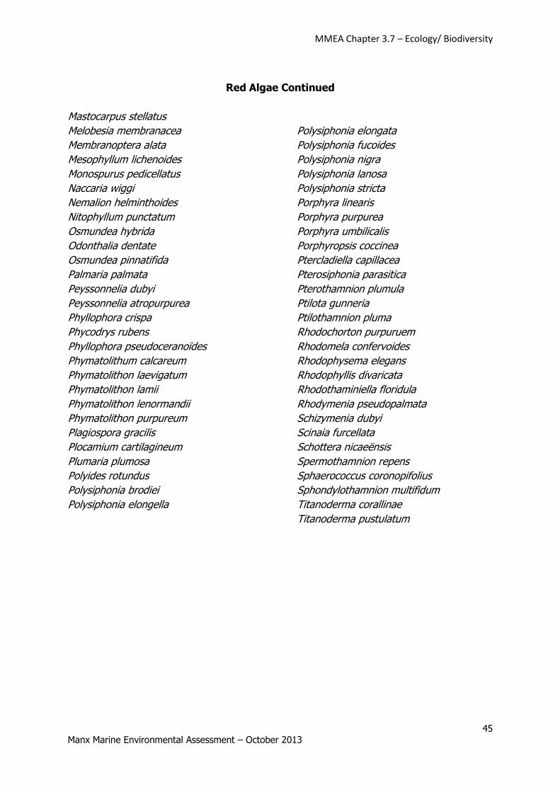
MMEA Chapter 3.7 – Ecology/ Biodiversity
45 Manx Marine Environmental Assessment – October 2013
Red Algae Continued
Mastocarpus stellatus
Melobesia membranacea
Membranoptera alata
Mesophyllum lichenoides
Monospurus pedicellatus
Naccaria wiggi
Nemalion helminthoides
Nitophyllum punctatum
Osmundea hybrida
Odonthalia dentate
Osmundea pinnatifida
Palmaria palmata
Peyssonnelia dubyi
Peyssonnelia atropurpurea
Phyllophora crispa
Phycodrys rubens
Phyllophora pseudoceranoïdes
Phymatolithum calcareum
Phymatolithon laevigatum
Phymatolithon lamii
Phymatolithon lenormandii
Phymatolithon purpureum
Plagiospora gracilis
Plocamium cartilagineum
Plumaria plumosa
Polyides rotundus
Polysiphonia brodiei
Polysiphonia elongella
Polysiphonia elongata
Polysiphonia fucoides
Polysiphonia nigra
Polysiphonia lanosa
Polysiphonia stricta
Porphyra linearis
Porphyra purpurea
Porphyra umbilicalis
Porphyropsis coccinea
Ptercladiella capillacea
Pterosiphonia parasitica
Pterothamnion plumula
Ptilota gunneria
Ptilothamnion pluma
Rhodochorton purpuruem
Rhodomela confervoides
Rhodophysema elegans
Rhodophyllis divaricata
Rhodothaminiella floridula
Rhodymenia pseudopalmata
Schizymenia dubyi
Scinaia furcellata
Schottera nicaeënsis
Spermothamnion repens
Sphaerococcus coronopifolius
Sphondylothamnion multifidum
Titanoderma corallinae
Titanoderma pustulatum
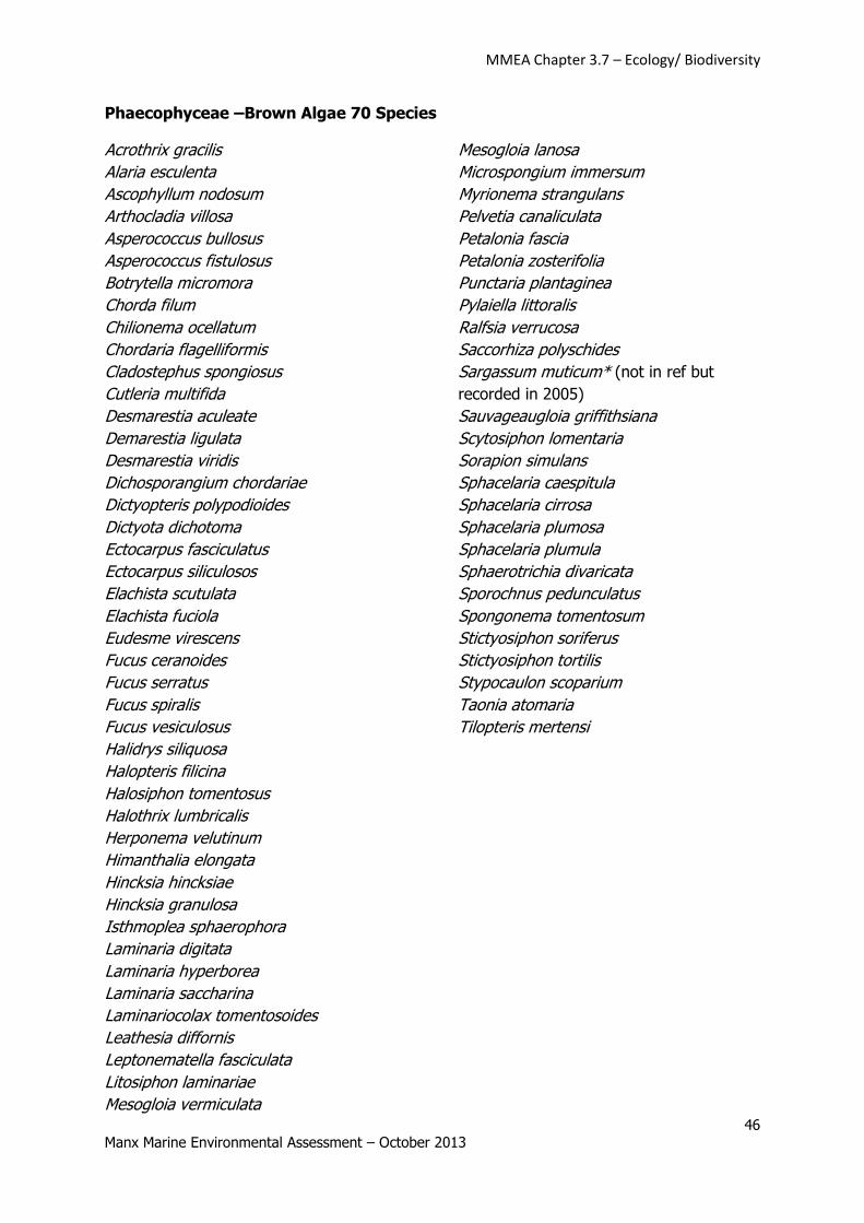
MMEA Chapter 3.7 – Ecology/ Biodiversity
46 Manx Marine Environmental Assessment – October 2013
Phaecophyceae –Brown Algae 70 Species
Acrothrix gracilis
Alaria esculenta
Ascophyllum nodosum
Arthocladia villosa
Asperococcus bullosus
Asperococcus fistulosus
Botrytella micromora
Chorda filum
Chilionema ocellatum
Chordaria flagelliformis
Cladostephus spongiosus
Cutleria multifida
Desmarestia aculeate
Demarestia ligulata
Desmarestia viridis
Dichosporangium chordariae
Dictyopteris polypodioides
Dictyota dichotoma
Ectocarpus fasciculatus
Ectocarpus siliculosos
Elachista scutulata
Elachista fuciola
Eudesme virescens
Fucus ceranoides
Fucus serratus
Fucus spiralis
Fucus vesiculosus
Halidrys siliquosa
Halopteris filicina
Halosiphon tomentosus
Halothrix lumbricalis
Herponema velutinum
Himanthalia elongata
Hincksia hincksiae
Hincksia granulosa
Isthmoplea sphaerophora
Laminaria digitata
Laminaria hyperborea
Laminaria saccharina
Laminariocolax tomentosoides
Leathesia diffornis
Leptonematella fasciculata
Litosiphon laminariae
Mesogloia vermiculata
Mesogloia lanosa
Microspongium immersum
Myrionema strangulans
Pelvetia canaliculata
Petalonia fascia
Petalonia zosterifolia
Punctaria plantaginea
Pylaiella littoralis
Ralfsia verrucosa
Saccorhiza polyschides
Sargassum muticum* (not in ref but
recorded in 2005)
Sauvageaugloia griffithsiana
Scytosiphon lomentaria
Sorapion simulans
Sphacelaria caespitula
Sphacelaria cirrosa
Sphacelaria plumosa
Sphacelaria plumula
Sphaerotrichia divaricata
Sporochnus pedunculatus
Spongonema tomentosum
Stictyosiphon soriferus
Stictyosiphon tortilis
Stypocaulon scoparium
Taonia atomaria
Tilopteris mertensi
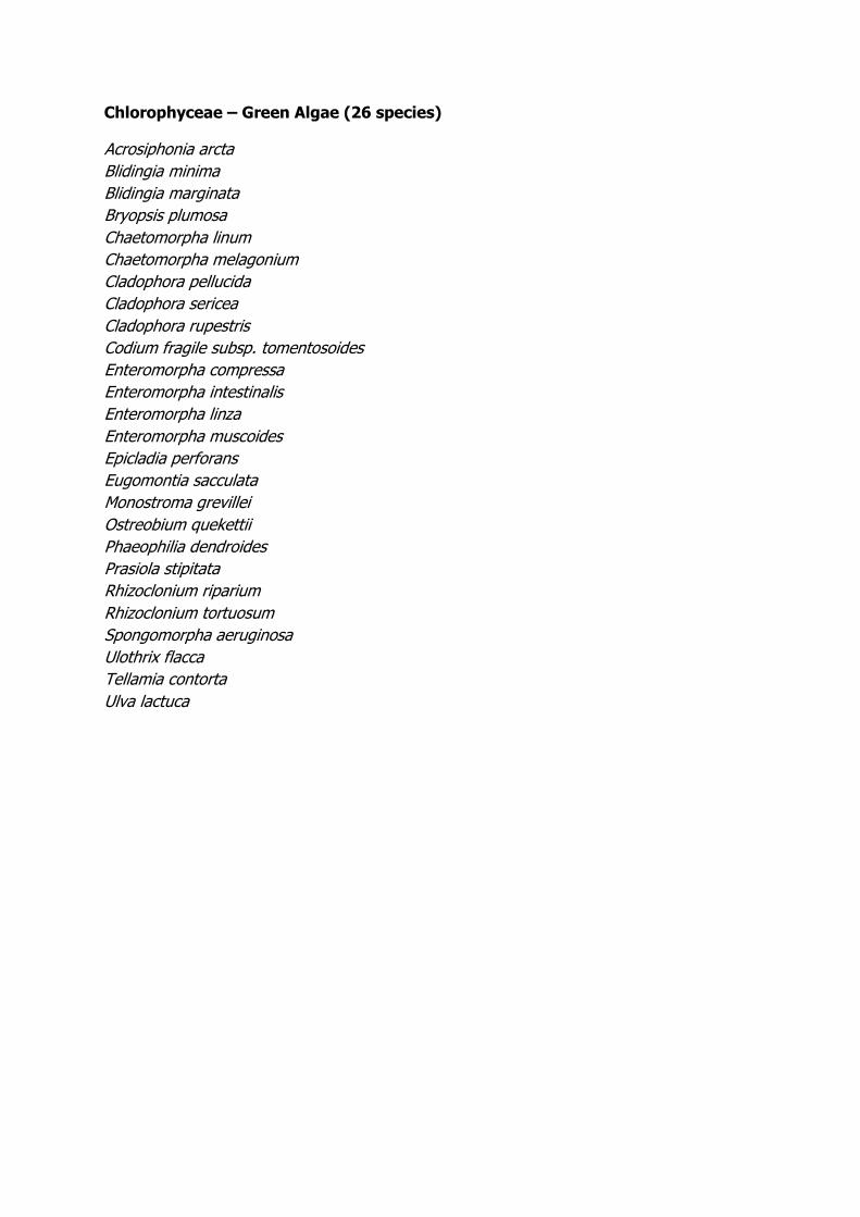
Chlorophyceae – Green Algae (26 species)
Acrosiphonia arcta
Blidingia minima
Blidingia marginata
Bryopsis plumosa
Chaetomorpha linum
Chaetomorpha melagonium
Cladophora pellucida
Cladophora sericea
Cladophora rupestris
Codium fragile subsp. tomentosoides
Enteromorpha compressa
Enteromorpha intestinalis
Enteromorpha linza
Enteromorpha muscoides
Epicladia perforans
Eugomontia sacculata
Monostroma grevillei
Ostreobium quekettii
Phaeophilia dendroides
Prasiola stipitata
Rhizoclonium riparium
Rhizoclonium tortuosum
Spongomorpha aeruginosa
Ulothrix flacca
Tellamia contorta
Ulva lactuca