Embed Size (px)
Citation preview

13 MILE RD
RICHMOND ST
SALISBURY DR
GWENDOLYN ST
;
;
;
;
;
;
;
;
;;
;
;
;
;
;
;;
;
;
;;
;
;;
;;;
;
;
13 MILE RD
RICHMOND ST
SALISBURY DR
GWENDOLYN ST
13 MILE RD
RICHMOND ST
SALISBURY DR
GWENDOLYN ST
Wellhead Protection AreaWHPA-AWHPA-BWHPA-CWHPA-D
; Municipal Well LocationGroundwater Vulnerability
Low
Birr
VulnScore2
4
6
10
200 0 200100 m
20 0 2010 km
LegendMunicipal BoundariesUpper Thames River Source Protection AreaApproximate Location of WHPA
HuronPerth Waterloo
Norfolk
Wellington
BrantOxfordMiddlesex
Elgin
Lamb
ton
London
Lake Huron
Map 4-1-1Birr
Wellhead Protection Area(WHPA)
.
Upper Thames RiverSource Protection Area
Assessment Report
190 0 19095 m
200 0 200100 m
Thames-Sydenham and Region
Map created by UTRCA, June 4, 2010.Base mapping produced under license with the OntarioMinistry of Natural Resources. © 2010.Vulnerable Areas and Wellhead Protection Areas -Thames-Sydenham and Region Source ProtectionRegion, Sept. 2009 and as per Part V and VII of theTechnical Rules: Assessment Report (MOE, proposedamendments August 2009).Groundwater Vulnerability - London, Middlesex Centre& Thames Centre Wellfield Source Protection StudyVulnerability Assessment Report. Thorndale andDorchester Final Draft Report - DiIlon ConsultingLimited, March 29, 2010.

GLENDON DR
OXBOW DR
GIDEON DR
KOMOKA RD
VANNECK RD
QUEEN STCOLDSTREAM RD
ELVIAGE DR
OLD RIVER RD
RAILWAY AVE
JEFFERIES RD
WESTBROOK DR
HURON AVESIMCOE AVE TUNKS LINE
BIRCHCREST DR
THODY LANE
PIONEER DR
BEECHNUT ST
STEPHEN MOORE DR
BLACKBURN CRES
;
;
;
;
;;;
;
;
;
;
;;;;
;;
;
;;
;;
;
;
;;
;
;;
;;;;
;
GLENDON DR
OXBOW DR
GIDEON DR
VANNECK RD
KOMOKA RDQUEEN ST
COLDSTREAM RD
OLD RIVER RD
ELVIAGE DR
RAILWAY AVE
JEFFERIES RD
WESTBROOK DR
HURON AVESIMCOE AVE TUNKS LINE
BIRCHCREST DR
THODY LANE
PIONEER DR
BEECHNUT ST
STEPHEN MOORE DR
SIMCOE CRES
BLACKBURN CRES
GLENDON DR
OXBOW DR
GIDEON DR
VANNECK RD
KOMOKA RDQUEEN ST
COLDSTREAM RD
OLD RIVER RD
RAILWAY AVE
JEFFERIES RD
WESTBROOK DR
ELVIAGE DR
HURON AVE
TUNKS LINESIMCOE AVE
BIRCHCREST DR
THODY LANE
PIONEER DR
BEECHNUT ST
STEPHEN MOORE DR
SIMCOE CRES
BLACKBURN CRES
Wellhead Protection AreaWHPA-AWHPA-BWHPA-CWHPA-D
; Municipal Well LocationGroundwater Vulnerability
Low
Medium
High
Komoka-KilworthVulnScore
2
4
6
8
1020 0 2010 km
LegendMunicipal BoundariesUpper Thames River Source Protection AreaApproximate Location of WHPA
HuronPerth Waterloo
Norfolk
Wellington
BrantOxfordMiddlesex
Elgin
Lamb
ton
London
Lake Huron
Map 4-1-3Komoka - Kilworth
Wellhead Protection Area(WHPA)
.
Upper Thames RiverSource Protection Area
Assessment Report
DRAFT
Thames-Sydenham and Region
510 0 510255 m 525 0 525262.5 m
510 0 510255 m
Map created by UTRCA, May 20, 2010.Base mapping produced under license with the Ontario Ministry ofNatural Resources. © 2010.Vulnerable Areas and Wellhead Protection Areas - Thames-Sydenham and Region Source Protection Region, Sept. 2009 andas per Part V and VII of the Technical Rules: Assessment Report(MOE, proposed amendments August 2009).Groundwater Vulnerability - London, Middlesex Centre & ThamesCentre Wellfield Source Protection Study VulnerabilityAssessment Report. Thorndale and Dorchester Final Draft Report- DiIlon Consulting Limited, March 29, 2010.
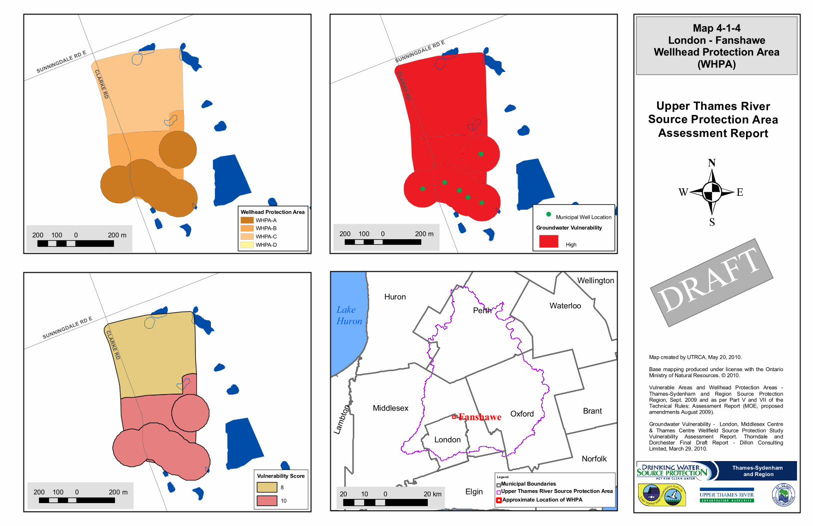
CLARKE RD
SUNNINGDALE RD E
;
;
;
;
;
;
;
;
;;
;
;
;
;
;
;;
;
;
;;
;
;;
;;;
;
;
CLARKE RD
SUNNINGDALE RD E
CLARKE RD
SUNNINGDALE RD E
Wellhead Protection AreaWHPA-AWHPA-BWHPA-CWHPA-D
; Municipal Well LocationGroundwater Vulnerability
High
Fanshawe
Vulnerability Score8
10
200 0 200100 m
20 0 2010 km
LegendMunicipal BoundariesUpper Thames River Source Protection AreaApproximate Location of WHPA
HuronPerth Waterloo
Norfolk
Wellington
BrantOxfordMiddlesex
Elgin
Lamb
ton
London
Lake Huron
Map 4-1-4London - Fanshawe
Wellhead Protection Area(WHPA)
.
Upper Thames RiverSource Protection Area
Assessment Report
DRAFT200 0 200100 m
200 0 200100 m
Thames-Sydenham and Region
Map created by UTRCA, May 20, 2010.Base mapping produced under license with the OntarioMinistry of Natural Resources. © 2010.Vulnerable Areas and Wellhead Protection Areas -Thames-Sydenham and Region Source ProtectionRegion, Sept. 2009 and as per Part V and VII of theTechnical Rules: Assessment Report (MOE, proposedamendments August 2009).Groundwater Vulnerability - London, Middlesex Centre& Thames Centre Wellfield Source Protection StudyVulnerability Assessment Report. Thorndale andDorchester Final Draft Report - DiIlon ConsultingLimited, March 29, 2010.
VANNECK RD
EGREMONT DR
GOLD CREEK DR
MELROSE DR
SUNNINGDALE RD W
MEDWAY RD
BOSTON DR
WYNFIELD LANE
;
;
;
;
;
;
;
;
;;
;
;
;
;
;
;;
;
;
;;
;
;;
;;;;
;
VANNECK RD
EGREMONT DR
GOLD CREEK DR
SUNNINGDALE RD W
MELROSE DR
MEDWAY RD
WYNFIELD LANE
VANNECK RD
EGREMONT DR
GOLD CREEK DR
MELROSE DR
SUNNINGDALE RD W
NAIRN RD
MEDWAY RD
WYNFIELD LANE
Wellhead Protection AreaWHPA-AWHPA-BWHPA-CWHPA-D
; Municipal Well LocationGroundwater Vulnerability
Low
Medium
High
MelroseVulnScore
2
4
6
8
1020 0 2010 km
LegendMunicipal BoundariesUpper Thames River Source Protection AreaApproximate Location of WHPA
HuronPerth Waterloo
Norfolk
Wellington
BrantOxfordMiddlesex
Elgin
Lamb
ton
London
Lake Huron
Map 4-1-6Melrose
Wellhead Protection Area(WHPA)
.
Upper Thames RiverSource Protection Area
Assessment Report
DRAFT
Thames-Sydenham and Region
300 0 300150 m 300 0 300150 m
300 0 300150 m
Map created by UTRCA, June 4, 2010.Base mapping produced under license with the OntarioMinistry of Natural Resources. © 2010.Vulnerable Areas and Wellhead Protection Areas - Thames-Sydenham and Region Source Protection Region, Sept.2009 and as per Part V and VII of the Technical Rules:Assessment Report (MOE, proposed amendments August2009).Groundwater Vulnerability - London, Middlesex Centre &Thames Centre Wellfield Source Protection StudyVulnerability Assessment Report. Thorndale and DorchesterFinal Draft Report - Dillon Consulting Limited, March 29,2010.

HWY 59
11TH LINE
13TH LINE
OXFORD ROAD 8
10TH LINE
LOVEYS ST E
JOHN ST
;
;
;;;
;
;;
;
;
;
;
;
;;
;
;
;
;
;
;
;
;
;
;
;
;
;
HWY 59
11TH LINE
13TH LINE
OXFORD ROAD 8
10TH LINE
LOVEYS ST E
JOHN ST
HWY 59
11TH LINE
13TH LINE
OXFORD ROAD 8
10TH LINE
LOVEYS ST E
JOHN ST
Wellhead Protection AreaWHPA-AWHPA-BWHPA-CWHPA-D
; Municipal Well LocationGroundwater Vulnerability
Low
Medium
High
Well Protection AreaTransport Pathway Adjustment
Low to Medium
Hickson
Vulnerability Score2
4
8
1020 0 2010 km
LegendMunicipal BoundariesUpper Thames River Source Protection AreaApproximate Location of WHPA
HuronPerth Waterloo
Norfolk
Wellington
BrantOxfordMiddlesex
Elgin
Lamb
ton
London
Lake Huron
Map 4-1-10Hickson
Wellhead Protection Area(WHPA)
.
Upper Thames RiverSource Protection Area
Assessment Report
Thames-Sydenham and Region
1,000 0 1,000500 m 990 0 990495 m
990 0 990495 m
Map created by UTRCA, June 4, 2010.Base mapping produced under license with the OntarioMinistry of Natural Resources. © 2010.Vulnerable Areas and Wellhead Protection Areas -Thames-Sydenham and Region Source ProtectionRegion, Sept. 2009 and as per Part V and VII of theTechnical Rules: Assessment Report (MOE, proposedamendments August 2009).Groundwater Vulnerability - Upper Thames RiverSource Protection Area, Beachville, Hickson, Innerkipand Thamesford Well Systems Threats Assessment,County of Oxford, Prepared by the County of Oxford,Community and Strategic Planning Office, April 27,

HWY 59 14TH LINE
13TH LINE
15TH LINE
16TH LINE
BLANDFORD RD
11TH LINE
OXFORD ROAD 33
OXFORD RD 5
OXFORD RD 8
TOWNSHIP RD 10
CASSEL SIDERD
OXFORD ROAD 8
10TH LINE
HWY 401
TOWNSHIP RD 9
TOWNSHIP ROAD 4
TOWNSHIP RD 12
18TH LINE
OXFORD ROAD 29
OXFO
RD RO
AD 4
TOWNSHIP ROAD 8
TOWNSHIP ROAD 5
TOWNSHIP ROAD 6
OXFORD ROAD 22
17TH LINE
OXFORD ROAD 17
BRAEMAR SIDERD
QUEE
N ST
LOVEYS ST E
BAIRD ST SOXFO
RD R
D 5
BRAEMAR SIDERD
HWY 401
BRAEMAR SIDERD
;
;
;;;
;
;;
;
;
;
;
;
;;
;
;
;
;
;
;
;
;
;
;
;
;
;
HWY 59 14TH LINE
13TH LINE
15TH LINE
16TH LINE
BLANDFORD RD
11TH LINE
OXFORD ROAD 33
OXFORD RD 5
OXFORD RD 8
TOWNSHIP RD 10
HWY 4
01
OXFORD ROAD 8
CASSEL SIDERD
TOWNSHIP RD 9
TOWNSHIP ROAD 4
TOWNSHIP RD 12
10TH LINE
OXFORD ROAD 22
OXFORD ROAD 29
18TH LINE
TOWNSHIP ROAD 8
OXFO
RD RO
AD 4
TOWNSHIP ROAD 5
TOWNSHIP ROAD 6
17TH LINE
OXFORD ROAD 17
BRAEMAR SIDERD
QUEE
N ST
LOVEYS ST E
BAIRD ST SOXFO
RD R
D 5
BRAEMAR SIDERD
HWY 401
BRAEMAR SIDERD
HWY 59 14TH LINE
13TH LINE
15TH LINE
16TH LINE
BLANDFORD RD
11TH LINE
OXFORD ROAD 33
OXFORD RD 5
OXFORD RD 8
TOWNSHIP RD 10
CASSEL SIDERDHW
Y 401
OXFORD ROAD 8
TOWNSHIP RD 9
TOWNSHIP RD 12
TOWNSHIP ROAD 4
10TH LINE
OXFORD ROAD 22
OXFORD ROAD 29
18TH LINE
OXFO
RD RO
AD 4
TOWNSHIP ROAD 8
TOWNSHIP ROAD 5
TOWNSHIP ROAD 6
17TH LINE
BRAEMAR SIDERD
QUEE
N ST
LOVEYS ST E
BAIRD ST SOXFO
RD R
D 5
BRAEMAR SIDERD
HWY 401
BRAEMAR SIDERD
Wellhead Protection AreaWHPA-AWHPA-BWHPA-CWHPA-D
; Municipal Well LocationGroundwater Vulnerability
Low
Medium
High
Innerkip
Vulnerability Score2
4
6
8
1020 0 2010 km
LegendMunicipal BoundariesUpper Thames River Source Protection AreaApproximate Location of WHPA
HuronPerth Waterloo
Norfolk
Wellington
BrantOxfordMiddlesex
Elgin
Lamb
ton
London
Lake Huron
Map 4-1-12Innerkip
Wellhead Protection Area(WHPA)
Map created by UTRCA, June 4, 2010.Base mapping produced under license with the OntarioMinistry of Natural Resources. © 2010.Vulnerable Areas and Wellhead Protection Areas -Thames-Sydenham and Region Source ProtectionRegion, Sept. 2009 and as per Part V and VII of theTechnical Rules: Assessment Report (MOE, proposedamendments August 2009).Groundwater Vulnerability - Upper Thames RiverSource Protection Area, Beachville, Hickson, Innerkipand Thamesford Well Systems Threats Assessment,County of Oxford, Prepared by the County of Oxford,Community and Strategic Planning Office, April 27,
.
Upper Thames RiverSource Protection Area
Assessment Report
Thames-Sydenham and Region
2,000 0 2,0001,000 m 2,000 0 2,0001,000 m
2,000 0 2,0001,000 m
Innerkip
*Hickson
*Hickson Note: see map 4-1-10 for complete coverage ofWHPA

HWY 8BOYCE ST
STAT
ION RD
AVONT
ON RD
134 R
D
PERT
H 130
RD
JEAN
ST
HAMMOND ST
STEF
FEN
RD
;
;
;
;
;
;
;
HWY 8BOYCE ST
STAT
ION RD
AVONT
ON RD13
4 RD
PERT
H 130
RD
JEAN
ST
HURON RDHAMMOND ST
STEF
FEN
RD
HWY 8BOYCE ST
STAT
ION RD
AVONT
ON RD13
4 RD
PERT
H 130
RD
HURON RD
JEAN
ST
HAMMOND ST
STEF
FEN
RD
Wellhead Protection AreaWHPA-AWHPA-CWHPA-D
; Municipal Well LocationGroundwater Vulnerability
Medium
LowTransport Pathway Adjustment
Low to Medium
Sebringville
Vulnerability Score2
4
6
10
200 0 200100 m
20 0 2010 km
LegendMunicipal BoundariesUpper Thames River Source Protection AreaApproximate Location of WHPA
HuronPerth Waterloo
Norfolk
Wellington
BrantOxfordMiddlesex
Elgin
Lamb
ton
London
Lake Huron
Map 4-1-19Sebringville
Wellhead Protection Area(WHPA)
Map created by UTRCA, May 20, 2010.Base mapping produced under license with the OntarioMinistry of Natural Resources. © 2010.Wellhead Protection Areas and Vulnerability Assessment- as per Part V and VII of the Technical Rules:Assessment Report (MOE, proposed amendmentsAugust 2009).Wellhead Protection Areas and Vulnerability defined by -Vulnerability Assessment-Perth County MunicipalDrinking Water Systems, Project 7-265-1, SchlumbergerWater Services (Canada) Inc. March, 2010.
.
Upper Thames RiverSource Protection Area
Assessment Report
200 0 200100 m
200 0 200100 m
Thames-Sydenham and Region

34 LINE
WILLIAM ST
PERT
H 10
7 RD
N HI
LL D
RMILLER AVE
BELL
ST
LINDNER CRTFIS
HER
RD
CHURCH ST
;
;;;;
;
;
;
34 LINE
WILLIAM ST
PERT
H 10
7 RD
N HI
LL D
R
MILLER AVE
BELL
ST
LINDNER CRT
FISHE
R RD
CHURCH ST
34 LINE
WILLIAM ST
PERT
H 10
7 RD
N HI
LL D
R
MILLER AVE
BELL
ST
LINDNER CRT
FISHE
R RD
CHURCH ST
Wellhead Protection AreaWHPA-AWHPA-BWHPA-CWHPA-D
; Municipal Well Location
Low
Shakespeare
Vulnerability Score2
4
6
1020 0 2010 km
LegendMunicipal BoundariesUpper Thames River Source Protection AreaApproximate Location of WHPA
HuronPerth Waterloo
Norfolk
Wellington
BrantOxfordMiddlesex
Elgin
Lamb
ton
London
Lake Huron
Map 4-1-20Shakespeare
Wellhead Protection Area(WHPA)
Map created by UTRCA, May 27, 2010.Base mapping produced under license with the OntarioMinistry of Natural Resources. © 2010.Wellhead Protection Areas and Vulnerability Assessment- as per Part V and VII of the Technical Rules:Assessment Report (MOE, proposed amendmentsAugust 2009).Wellhead Protection Areas and Vulnerability defined by -Vulnerability Assessment-Perth County MunicipalDrinking Water Systems, Project 7-265-1, SchlumbergerWater Services (Canada) Inc. March, 2010.
.
Upper Thames RiverSource Protection Area
Assessment Report
200 0 200100 m
Thames-Sydenham and Region
200 0 200100 m
200 0 200100 m

122 RD
PERTH 20 LINE
;
;
;
;
;
;
;
;
;;
;
;
;
;
;
;;
;
;
;;
;
;;
;;;;
;
122 RD
PERTH 20 LINE
122 RD
PERTH 20 LINE
Wellhead Protection AreaWHPA-AWHPA-BWHPA-CWHPA-D
; Municipal Well Location
Low
St. Pauls
Vulnerability Score2
4
6
1020 0 2010 km
LegendMunicipal BoundariesUpper Thames River Source Protection AreaApproximate Location of WHPA
HuronPerth Waterloo
Norfolk
Wellington
BrantOxfordMiddlesex
Elgin
Lamb
ton
London
Lake Huron
Map 4-1-22St. Pauls
Wellhead Protection Area(WHPA)
Map created by UTRCA, May 20, 2010.Base mapping produced under license with the OntarioMinistry of Natural Resources. © 2010.Wellhead Protection Areas and Vulnerability Assessment- as per Part V and VII of the Technical Rules:Assessment Report (MOE, proposed amendmentsAugust 2009).Wellhead Protection Areas and Vulnerability defined by -Vulnerability Assessment-Perth County MunicipalDrinking Water Systems, Project 7-265-1, SchlumbergerWater Services (Canada) Inc. March, 2010.
.
Upper Thames RiverSource Protection Area
Assessment Report
300 0 300150 m
Thames-Sydenham and Region
300 0 300150 m
300 0 300150 m

111 R
D
ERIE
ST
HWY 8
ONTARIO ST
DOURO ST
OLOAN
E AVE
LORNE AVE ERO
MEO
ST S
DOWNIE ST
HURON ST
W GORE ST
122 RD
125 RD
MORNING
TON S
T
QUINLAN RD
NILE
ST
PERTH 37 LINE
PERTH 33 LINE
WILLIAM ST
LORNE AVE W
HIBERNIA ST
34 LINEDEVON ST
HOME ST
BRUNSWICK ST
DOUGLAS ST WATER STCH
URCH
ST
MATILD
A ST
MAPLE AVERO
MEO
ST N
DUFF
ERIN
STWILLOW ST
VIVIAN ST
GRIFFITH RDPACKHAM RD
WOODS ST
DELAMERE AVE
WRIGHT
BLVD
LOUISE ST
GIBB RD
GRAF
F AVE
MONTEITH AVE
BRITANNIA ST
FREDERICK ST
CENTRE ST
BRUCE ST
FREELAND DR
EARL
ST
CRANE AVE
E GORE ST
WARWICK RD
122 R
D
;
;
;
;
;
;
;
;
;
;
;
;;
;
;
;;;;; ;
;;;
;
;;;;;;;
;;
;
;
;
;
;
;;
;
;;
;
;
;
;
;
;
;;
;
;;
;
;
;
;
;
;
;
;
;
;
;
;
;;;;
;
111 R
D
ERIE
ST
HWY 8
ONTARIO ST
DOURO ST
OLOAN
E AVE
LORNE AVE E
ROME
O ST
S
DOWNIE ST
HURON ST
125 RD
122 RD
W GORE ST
MORNING
TON S
T
QUINLAN RD
NILE
ST
WILLIAM ST
LORNE AVE W
PERTH 37 LINE
PERTH 33 LINE
HIBERNIA ST
DEVON ST
34 LINE
HOME ST
BRUNSWICK ST
DOUGLAS ST WATER ST
CHUR
CH ST
MATILD
A ST
MAPLE AVE
ROME
O ST
N
DUFF
ERIN
ST
WILLOW ST
VIVIAN ST
GRIFFITH RDPACKHAM RD
WOODS ST
DELAMERE AVE
WRIGHT
BLVD
LOUISE ST
GRAF
F AVE
MONTEITH AVE
BRITANNIA ST
FREDERICK ST
CENTRE ST
BRUCE ST
FREELAND DR
EARL
ST
CRANE AVE
E GORE ST
WARWICK RD
122 R
D
111 R
D
ERIE
ST
HWY 8
ONTARIO ST
DOURO ST
OLOAN
E AVE
LORNE AVE E
ROME
O ST
S
122 RD
DOWNIE ST
125 RD
HURON ST
W GORE ST
MORNING
TON S
T
QUINLAN RD
NILE
ST
WILLIAM ST
LORNE AVE W
PERTH 37 LINE
PERTH 33 LINE
HIBERNIA ST
DEVON ST
HOME ST
BRUNSWICK ST34 LINE
DOUGLAS ST WATER ST
CHUR
CH ST
MATILD
A ST
MAPLE AVE
ROME
O ST
N
DUFF
ERIN
ST
WILLOW ST
VIVIAN ST
GIBB RD
GRIFFITH RDPACKHAM RD
WOODS ST
DELAMERE AVE
WRIGHT
BLVD
LOUISE ST
GRAF
F AVE
MONTEITH AVE
BRITANNIA ST
FREDERICK ST
CENTRE ST
BRUCE ST
FREELAND DR
EARL
ST
CRANE AVE
E GORE ST
WARWICK RD
122 R
D
Wellhead Protection AreaWHPA-AWHPA-BWHPA-CWHPA-D
; Municipal Well LocationGroundwater Vulnerability
High
Medium
LowTransport Pathway Adjustment
Low to Medium
Stratford
Vulnerability Score2
4
6
8
1020 0 2010 km
LegendMunicipal BoundariesUpper Thames River Source Protection AreaApproximate Location of WHPA
HuronPerth Waterloo
Norfolk
Wellington
BrantOxfordMiddlesex
Elgin
Lamb
ton
London
Lake Huron
Map 4-1-23Stratford
Wellhead Protection Area(WHPA)
Map created by UTRCA, May 20, 2010.Base mapping produced under license with the OntarioMinistry of Natural Resources. © 2010.Wellhead Protection Areas and Vulnerability Assessment- as per Part V and VII of the Technical Rules:Assessment Report (MOE, proposed amendmentsAugust 2009).Wellhead Protection Areas and Vulnerability defined by -Vulnerability Assessment-Perth County MunicipalDrinking Water Systems, Project 7-265-1, SchlumbergerWater Services (Canada) Inc. March, 2010.
.
Upper Thames RiverSource Protection Area
Assessment Report
Thames-Sydenham and Region
1,000 0 1,000500 m
O` Loane
Romeo
Chestnut
Mornington
Lorne
Dunn
1,000 0 1,000500 m
1,000 0 1,000500 m
![Surah Al Baqarah: Memorization + Tafseer [Al- Birr/As-Sidq ......Tafseer Al Baqarah Ayat 2/177 (cont Jan 29, 2013) Surah Al Baqarah: Memorization + Tafseer [Al-Birr/As-Sidq] (#16)](https://img.pdfslide.net/doc/110x75/608ef2a7d4ab171a8c0f953b/surah-al-baqarah-memorization-tafseer-al-birras-sidq-tafseer-al-baqarah.jpg)


![BIRR Guidebook - The Way Forward [English]](https://img.pdfslide.net/doc/110x75/577cb4161a28aba7118c4b4a/birr-guidebook-the-way-forward-english.jpg)