Embed Size (px)
Citation preview
7/28/2019 Map Nisene Marks
http://slidepdf.com/reader/full/map-nisene-marks 1/5
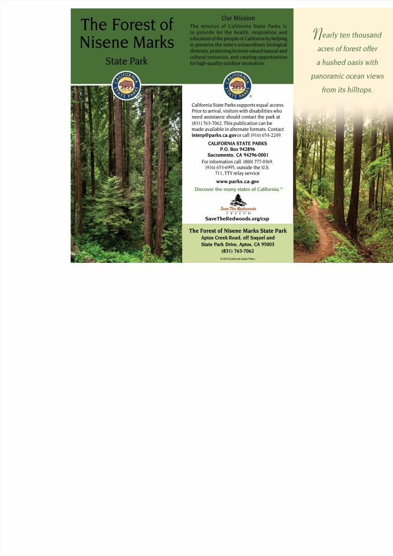
Near
acres
a hus
panora
rom
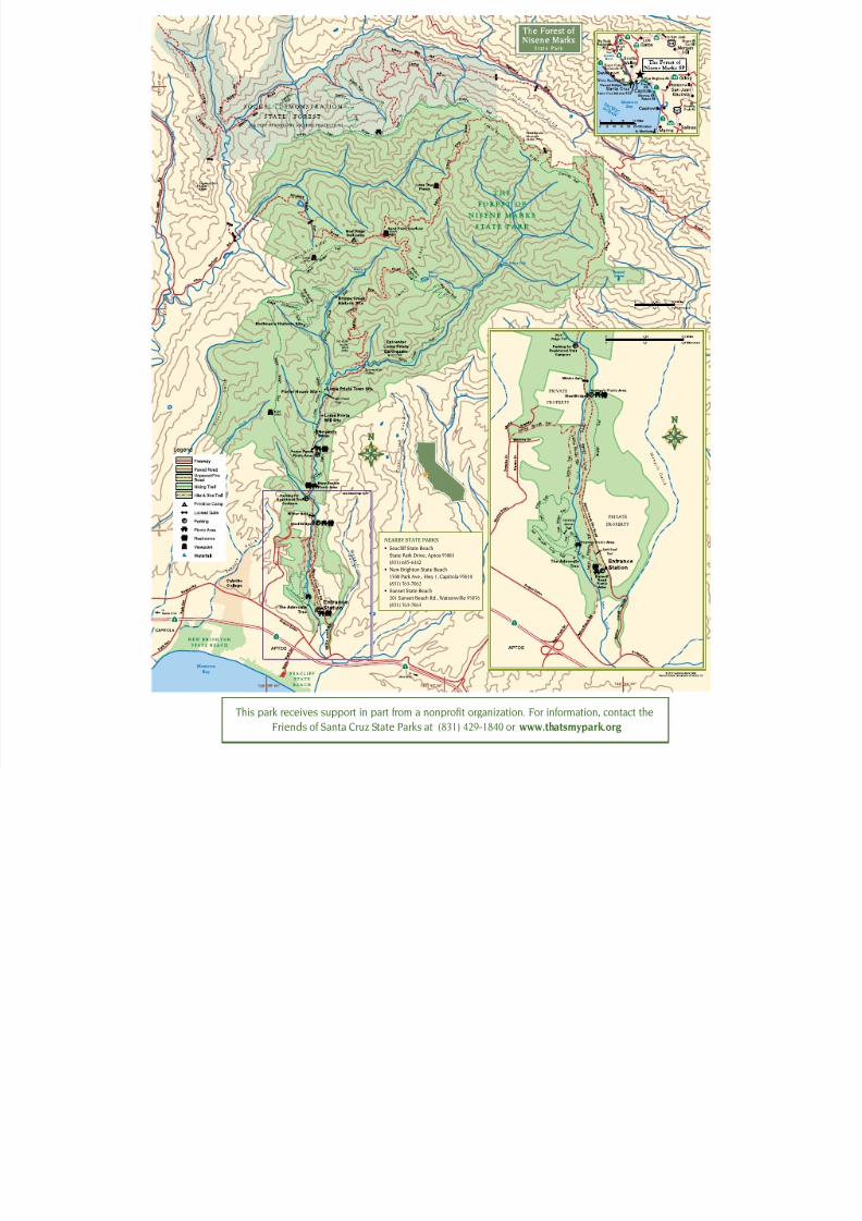
The Forest o Nisene Marks
State Park
The Forest of Nisene Marks State Park Aptos Creek Road, off Soquel and
State Park Drive, Aptos, CA 95003(831) 763-7062
Our MissionThe mission o Caliornia State Parks isto provide or the health, inspiration andeducation o the people o Caliornia by helpingto preserve the state’s extraordinary biologicaldiversity, protecting its most valued natural andcultural resources, and creating opportunities
or high-quality outdoor recreation.
© 2012 California State Parks
Caliornia State Parks supports equal access.Prior to arrival, visitors with disabilities whoneed assistance should contact the park at
(831) 763-7062. This publication can bemade available in alternate ormats. [email protected] or call (916) 654-2249.
CALIFORNIA STATE PARKSP.O. Box 942896
Sacramento, CA 94296-0001
For inormation call: (800) 777-0369.(916) 653-6995, outside the U.S.
711, TTY relay service
www.parks.ca.gov
Discover the many states of California.™
SaveTheRedwoods.org/csp
7/28/2019 Map Nisene Marks
http://slidepdf.com/reader/full/map-nisene-marks 2/5
PARK HISTORY
The local rst people were the Costanoans
(now known as Ohlone). The native people
harvested resources on
the edges o the orest,
but little evidence exists
that they ever lived amongthese deep redwoods. Two
Mexican land grants to the
Castro amily in 1833 and
1844 partially orm the
boundaries o today’s park.
Shortly ater Caliornia
became a state in 1850,
loggers built wooden skids and used oxen
teams to drag smaller harvested trees
or “split stu” and tanbark. The orest’s
more reachable redwoods were milled
during the Gold Rush building boom, but
lumber interests ound the steep canyons
impenetrable or
logging giant redwoods.
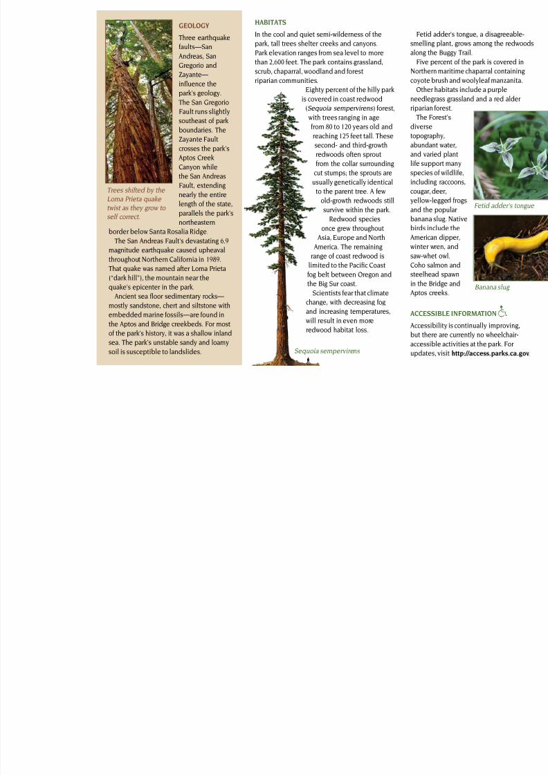
In 1880, however, the
Southern Pacic Railway
(SP) arrived in nearby
Monterey. SP nanced
the purchase o tree-
lled Upper Aptos
Canyon, the Loma
Prieta Lumber Company
and the Loma Prieta
Railway. Chinese laborers cut and graded the
rail line seven miles up the canyon. By 1883,
standard-gauge railway tracks had been builtto haul the huge redwood logs to mills.
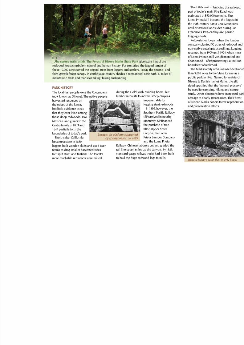
he serene trails within The Forest of Nisene Marks State Park give scant hint o the
redwood orest’s turbulent natural and human history. For centuries, the jagged terrain o
these 10,000 acres saved the original trees rom loggers and settlers. Today the second- and
third-growth orest canopy in earthquake country shades a recreational oasis with 30 miles o
maintained trails and roads or hiking, biking and running.
T
Historic logger’s
The 1880s co
part o today’s
estimated at $
Loma Prieta M
the 19th-centu
until disastrou
Francisco’s 190
logging eorts
Reorestation
company plan
non-native eu
resumed rom
o Loma Prieta
abandoned—
board eet o r
The Marks a
than 9,000 acre
public park in Nisene (a Dan
deed specied
be used or ca
study. Other d
acreage to nea
o Nisene Mar
and preservat
Loggers on platorm supported by springboards, ca. 1895
P h o t o
c o u r t e s y o f t h e S a n t a C r u z M u s e u m o
f A r t a n d H i s t
o r y
7/28/2019 Map Nisene Marks
http://slidepdf.com/reader/full/map-nisene-marks 3/5
Fetid adder’s ton
smelling plant, gro
along the Buggy Tr
Five percent o t
Northern maritime
coyote brush and w
Other habitats in
needlegrass grassl
riparian orest.
The Forest’s
diverse
topography,
abundant water,
and varied plant
lie support many
species o wildlieincluding raccoons
cougar, deer,
yellow-legged rog
and the popular
banana slug. Nativ
birds include the
American dipper,
winter wren, and
saw-whet owl.Coho salmon and
steelhead spawn
in the Bridge and
Aptos creeks.
HABITATS
In the cool and quiet semi-wilderness o the
park, tall trees shelter creeks and canyons.
Park elevation ranges rom sea level to more
than 2,600 eet. The park contains grassland,
scrub, chaparral, woodland and orest
riparian communities.
Eighty percent o the hilly park
is covered in coast redwood
(Sequoia sempervirens ) orest,
with trees ranging in age
rom 80 to 120 years old and
reaching 125 eet tall. These
second- and third-growth
redwoods oten sprout
rom the collar surrounding
cut stumps; the sprouts areusually genetically identical
to the parent tree. A ew
old-growth redwoods still
survive within the park.
Redwood species
once grew throughout
Asia, Europe and North
America. The remaining
range o coast redwood islimited to the Pacic Coast
og belt between Oregon and
the Big Sur coast.
Scientists ear that climate
change, with decreasing og
and increasing temperatures,
will result in even more
redwood habitat loss.
Sequoia sempervirens
ACCESSIBLE INFO
Accessibility is con
but there are curre
accessible activitieupdates, visit http
gEOLOgY
Three earthquake
aults—San
Andreas, San
Gregorio and
Zayante—
infuence thepark’s geology.
The San Gregorio
Fault runs slightly
southeast o park
boundaries. The
Zayante Fault
crosses the park’s
Aptos Creek
Canyon while
the San Andreas
Fault, extending
nearly the entire
length o the state,
parallels the park’s
northeastern
border below Santa Rosalia Ridge.
The San Andreas Fault’s devastating 6.9
magnitude earthquake caused upheaval
throughout Northern Caliornia in 1989.That quake was named ater Loma Prieta
(“dark hill”), the mountain near the
quake’s epicenter in the park.
Ancient sea foor sedimentary rocks—
mostly sandstone, chert and siltstone with
embedded marine ossils—are ound in
the Aptos and Bridge creekbeds. For most
o the park’s history, it was a shallow inland
sea. The park’s unstable sandy and loamysoil is susceptible to landslides.
Trees shited by the
Loma Prieta quake
twist as they grow to
sel correct.
7/28/2019 Map Nisene Marks
http://slidepdf.com/reader/full/map-nisene-marks 4/5
Th
De
no
by
o
Ad
ridor
Tra
Cre
RECREATION
The park lies north o
Aptos Village on Aptos
Creek Road in Santa Cruz
County. Weather can be
changeable year round.
Picnic tables andbarbecue pits are
available. Trail campsites
are located six miles rom
the trail camp parking
lot at the West Ridge
Trailhead. The trail camp
has no water, and res are prohibited. To
reserve, call the Sunset State Beach kiosk
at (831) 763-7063.
Trails
Loma Prieta Grade Trail ollows a steam
railway bed rom the mill to Homan’s
Historic Site, named ater a logging
superintendent. This site was a camp that
once housed 100 loggers and mill workers.
PLEASE REMEMBER
• All natural and cultural eatures are
protected by law and may not be
disturbed or removed.
• To prevent erosion o the slopes, stay on
marked trails; observe all trail postings.
• By law, bicycling and mountain biking are
allowed only on the Aptos Creek Fire Road
and our single-track trails below its steelbridge. Cyclists may use the Aptos Rancho
Trail, the S
Trail and t
• Except or
allowed o
and our s
above) be
are prohib
Porter pic
must be a
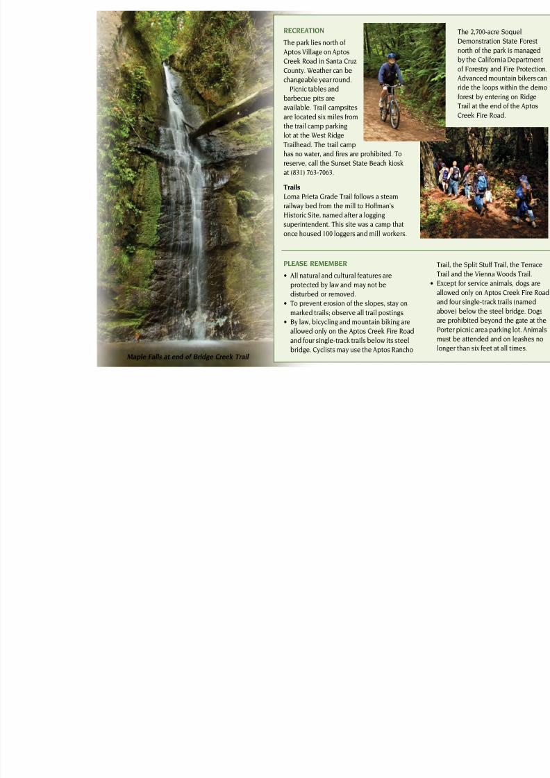
longer thaMaple Falls at end of Bridge Creek Trail
7/28/2019 Map Nisene Marks
http://slidepdf.com/reader/full/map-nisene-marks 5/5
NEARBY STATE PARKS• Seacli State Beach
State Park Drive, Aptos 95001
(831) 685-6442
• New Brighton State Beach
1500 Park Ave., Hwy 1, Capitola 95010
(831) 763-7062
• Sunset State Beach
201 Sunset Beach Rd., Watsonville 95076
(831) 763-7063
This park receives support in part rom a nonprot organization. For inormation, contact the
Friends o Santa Cruz State Parks at (831) 429-1840 or www.thatsmypark.or