Embed Size (px)
Citation preview
2021-2022 Ocean Sport Fishing Regulations Updates Summarizes changes to ocean sport fishing regulations since March 1, 2021 publication of the Ocean
Sport Fishing Regulations booklet. Check the following page prior to each fishing trip:
https://wildlife.ca.gov/Fishing/Ocean/Regulations/Inseason#summary
Map of Ocean Sportfishing Regulations (mobile-friendly)
WHAT’S NEW SINCE MARCH 2021?
Recreational Ocean Salmon regulations • Sections 27.80 and 28.65 – Summary of Ocean Salmon changes, effective May 16, 2021
See https://wildlife.ca.gov/Fishing/Ocean/Regulations/Salmon#recreational for the latest info;
Ocean Salmon Regulations Hotline (707) 576-3429
Recreational Pacific Halibut regulations
• Section 28.20 – Due to new 2021 catch information, CDFW estimates that 20,964 net pounds of
the 39,260 net pound quota remain for anglers to catch. The recreational Pacific halibut fishery
will reopen September 3 at 12:00 a.m. and remain open until November 15 or until the quota
is reached, whichever is earlier. See https://wildlife.ca.gov/Conservation/Marine/Pacific-Halibut
for the latest info.
Rockfish Conservation Area (RCA) maps
• A new series of 38 detailed regional maps depict the coastal, island and offshore areas that are
open (or closed) to groundfish fishing in 2021. See
https://wildlife.ca.gov/Conservation/Marine/Groundfish#28720314-recreational to view or
download the maps.
Recreational Clam, Sand Crab, and Shrimp regulations (emergency action)
• Section 29.20 and 29.80 – effective March 8, 2021 - prohibits the use of hydraulic hand pumps for take of clams, sand crab, or shrimp, or any other method to liquefy sand in any area where clams may be taken. Also requires each person to keep clams they harvested in a separate container from clams harvested by others. View the regulations at: https://wildlife.ca.gov/Fishing/Ocean/Regulations/Sport-Fishing/Invertebrate-Fishing-Regs
Anglers are advised to check the CDFW website at https://wildlife.ca.gov/Regulations for a summary of the changes as well as the most up-to-date regulations prior to each fishing trip.
Regulation Change Now Effective
Recreational Crab Trap Fishery Marine Life Protection Measures
Changes to sections 29.80, 29.85 and 701, Title 14 CCR in December 2020 affecting the recreational crab trap fishery went into effect on November 1, 2021. Changes affect individual crabbers and CPFV operators, with new marker buoy requirements, a maximum service interval of 9 days, a trap limit of 10 traps per operator (the CPFV trap limit remains at 60), Director’s authority for delay or closure, and a new Recreational Crab Trap Validation ($2.42) for each fishery participant, which is available for sale from Online License Sales.
CALIFORNIA
OCEANSPORT FISHING REGULATIONS
2021-2022Effective March 1, 2021 through February 28, 2022
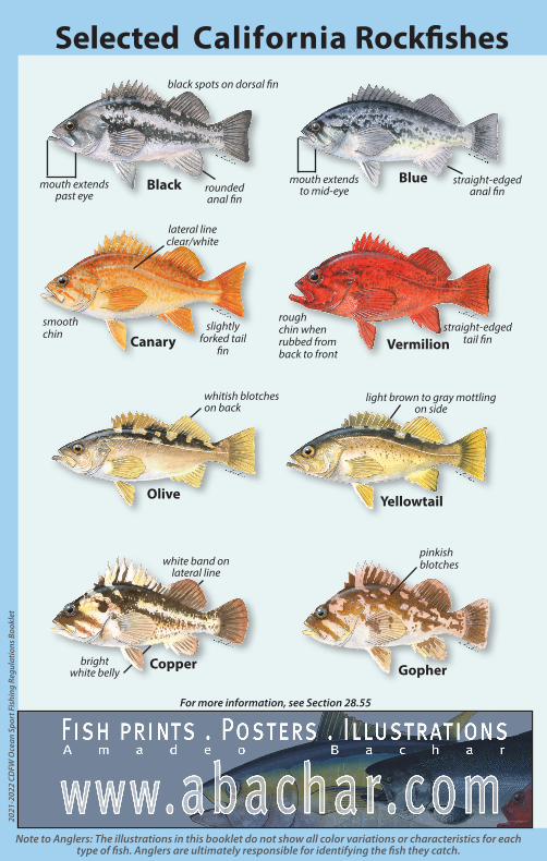
Copper
Black mouth extends past eye
rounded anal fin
black spots on dorsal fin
Yellowtail
light brown to gray mottling on side
bright white belly
white band on lateral line
straight-edgedanal fin
Blue mouth extendsto mid-eye
Olive
whitish blotches on back
Vermilionstraight-edged
tail fin
rough chin when rubbed from back to front
Selected California Rockfishes
lateral lineclear/white
Canarysmooth chin
slightly forked tail
fin
2021
-202
2 C
DFW
Oce
an S
port
Fis
hing
Reg
ulat
ions
Boo
klet
Gopher
pinkishblotches
For more information, see Section 28.55
Note to Anglers: The illustrations in this booklet do not show all color variations or characteristics for each type of fish. Anglers are ultimately responsible for identifying the fish they catch.
1
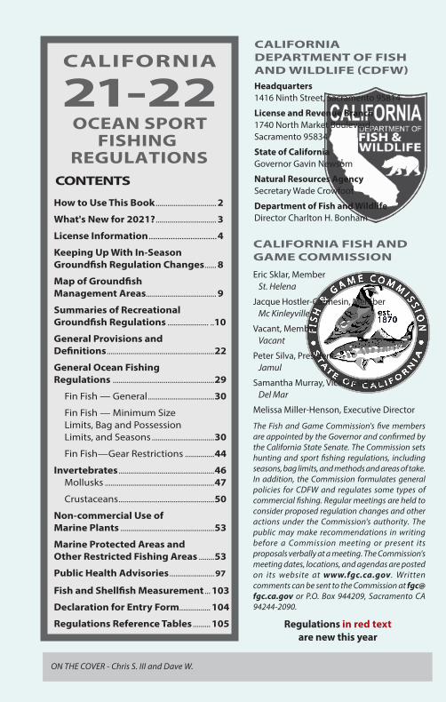
CALIFORNIA
21-22
OCEAN SPORTFISHING
REGULATIONSCONTENTS
How to Use This Book ............................... 2
What's New for 2021? ............................... 3
License Information ...............................4
Keeping Up With In-Season Groundfish Regulation Changes ...... 8
Map of Groundfish Management Areas.................................... 9
Summaries of Recreational Groundfish Regulations ..................... ..10
General Provisions and Definitions .......................................................22
General Ocean Fishing Regulations ....................................................29
Fin Fish — General ..................................30
Fin Fish — Minimum Size Limits, Bag and Possession Limits, and Seasons ................................30
Fin Fish—Gear Restrictions ...............44
Invertebrates .................................................46Mollusks ........................................................47
Crustaceans .................................................50
Non-commercial Use of Marine Plants ................................................53
Marine Protected Areas and Other Restricted Fishing Areas ........53
Public Health Advisories .......................97
Fish and Shellfish Measurement ... 103
Declaration for Entry Form................ 104
Regulations Reference Tables ......... 105
CALIFORNIA DEPARTMENT OF FISH AND WILDLIFE (CDFW)Headquarters1416 Ninth Street, Sacramento 95814
License and Revenue Branch1740 North Market Boulevard, Sacramento 95834
State of California Governor Gavin Newsom
Natural Resources Agency Secretary Wade Crowfoot
Department of Fish and Wildlife Director Charlton H. Bonham
CALIFORNIA FISH AND GAME COMMISSION
Eric Sklar, MemberSt. Helena
Jacque Hostler-Carmesin, MemberMc Kinleyville
Vacant, MemberVacant
Peter Silva, PresidentJamul
Samantha Murray, Vice PresidentDel Mar
Melissa Miller-Henson, Executive Director
The Fish and Game Commission's five members are appointed by the Governor and confirmed by the California State Senate. The Commission sets hunting and sport fishing regulations, including seasons, bag limits, and methods and areas of take. In addition, the Commission formulates general policies for CDFW and regulates some types of commercial fishing. Regular meetings are held to consider proposed regulation changes and other actions under the Commission's authority. The public may make recommendations in writing before a Commission meeting or present its proposals verbally at a meeting. The Commission's meeting dates, locations, and agendas are posted on its website at www.fgc.ca.gov. Written comments can be sent to the Commission at [email protected] or P.O. Box 944209, Sacramento CA 94244-2090.
Regulations in red text are new this year
ON THE COVER - Chris S. III and Dave W.
2021-2022 California Ocean Sport Fishing Regulations
2
How To Use This Book
Start by reading through the Contents on page 1: find and refer to the topic and page that interests you. License information and definitions are found in the front of the book. If you need further information about the regulations, or have general questions, contact the CDFW.
CDFW Regional Offices & Contact InformationMarine RegionServing the entire California coastline from border to border and three nautical miles out to sea
Marine Region Headquarters20 Lower Ragsdale Drive, Suite 100 Monterey 93940(831) [email protected]
Marine Region Field Offices619 2nd Street, Eureka 95501(707) 445-6493
32330 N. Harbor Drive Fort Bragg 95437(Licenses are not sold at this office)(707) 964-9078
3637 Westwind BoulevardSanta Rosa 95403(Licenses are not sold at this office)(707) 576-2882
1933 Cliff Drive, Suite 9Santa Barbara 93109(Licenses are not sold at this office)(805) 568-1231
4665 Lampson Avenue, Suite C Los Alamitos 90720(562) 342-7100
3883 Ruffin RoadSan Diego 92123(858) 467-4201
Bay Delta RegionServing Alameda, Contra Costa, Marin, Napa, Sacramento, San Mateo, Santa Clara, Santa Cruz, San Francisco, Solano, and Sonoma counties, Yolo County south of I-80 and San Joaquin County west of I-5.2825 Cordelia Road, Suite 100Fairfield 94534(707) [email protected]
Northern RegionServing Del Norte, Humboldt, Lassen, Mendocino, Modoc, Shasta, Siskiyou, Tehama, and Trinity counties601 Locust Street, Redding 96001(530) [email protected]
North Central RegionServing Alpine, Amador, Butte, Calaveras, Colusa, El Dorado, Glenn, Lake, Nevada, Placer, Sierra, Sutter, Yuba, and Plumas counties, Sacramento and San Joaquin counties east of I-5, and Yolo County north of I-80.1701 Nimbus Road Rancho Cordova 95670(916) [email protected]
Central RegionServing Fresno, Kern, Kings, Madera, Mariposa, Merced, Monterey, San Benito, San Luis Obispo, Stanislaus, Tulare, and Tuolumne counties1234 East Shaw Avenue, Fresno 93710(559) 243-4005 x [email protected]
South Coast RegionServing Los Angeles, Orange, San Diego, Santa Barbara, and Ventura counties3883 Ruffin Road, San Diego 92123(858) [email protected] inquiries for this region should be directed to the Ontario office (below)
Inland Deserts RegionServing Imperial, Inyo, Mono, Riverside, and San Bernardino counties3602 Inland Empire Boulevard, Suite C220Ontario 91764(Licenses are not sold at this office)(909) 484-0167 [email protected]
Visit the CDFW website at:
wildlife.ca.govLearn more about CDFW’s Marine Region at:
wildlife.ca.gov/regions/marine
CDFW HeadquartersP.O. Box 944209Sacramento 94244-2090(916) 653-7664wildlife.ca.gov/contact
License and Revenue Branch1740 N. Market BoulevardSacramento 95834(916) [email protected]

3
What’s New for 2021?
Groundfish (Effective January 1, 2021)The California Fish and Game Commission approved changes to recreational groundfish regulations on October 14, 2020 to conform to changes in federal rules for 2021 and 2022. Changes included new fishing depths in some groundfish management areas, a new vermilion rockfish sub-bag limit of 5 fish within the RCG Complex bag limit of 10 fish, and removal of the canary rockfish, black rockfish, and cabezon sub-bag limits within the RCG Complex bag limit. Depth limit changes apply only to the following management areas:• Mendocino Management Area – depth limit increased from 20 fathoms to 30 fathoms. The depth limit
is now defined by a series of connected waypoints in federal regulations.• San Francisco Management Area – depth limit increased from 40 fathoms to 50 fathoms.• Southern Management Area – depth limit increased from 75 fathoms to 100 fathoms.See pg. 8 for ways to stay informed of in-season regulation changes. Anglers are advised to call the CDFW Groundfish Hotline at (831) 649-2801, or check the CDFW website at wildlife.ca.gov/Fishing/Ocean/Regulations/Groundfish-Summary for the most up-to-date groundfish regulations.
Crab Regulation Changes (anticipated to take effect during the 2021-2022 season)On December 9, 2020, the Fish and Game Commission adopted new regulations related to the take of recreational crab in California waters. They include new gear marking requirements, gear servicing, trap limits, license validation, and season modifications to minimize entanglement risk. Amendments to sections 29.80, 29.85, and 701 are anticipated to take effect on November 1, 2021. Please check the Fish and Game Commission website (https://fgc.ca.gov/Regulations/2020- New-and-Proposed#29_80) for more information and to view final regulatory text.
Recreational Clam, Sand Crab and Shrimp Emergency Regulations (anticipated to take effect in March 2021) On February 10, 2021, the Fish and Game Commission adopted emergency regulations related to the take of recreational clam, sand crab and shrimp. The regulation specifies the gear permitted to be used to harvest clams and prohibits the use of hydraulic hand pumps. Amendments to subsections 29.20(c) and (d), and 29.80(h) are anticipated to take effect in March 2021. Please check the Fish and Game Commission website (https://fgc.ca.gov/Regulations/2021-New-and-Proposed#29_20e) for more information and to view the final regulatory text.
CDFW Transitioning to Electronic Hunting and Fishing Regulations Booklets in 2021As part of a broader effort to go paperless, the California Department of Fish and Wildlife (CDFW) is transitioning to a digital format for its 2021 hunting and fishing regulations booklets. Booklets will no longer be printed and shipped to license agents or customers, but electronic versions of the booklets will continue to be available online.
The transition to paperless regulations booklets follows a two-year effort to reduce the number of hard copy booklets printed and shipped to license agents and is consistent with the governor’s directive to reduce paper usage.
As in previous years, digital booklets are available at https://wildlife.ca.gov/Regulations and can be downloaded as PDFs to your computer, cellular phone, or other electronic device. Hunters and anglers are encouraged to download the digital booklets to their mobile devices and familiarize themselves with the digital format prior to hunting and/or fishing trips.
2021-2022 California Ocean Sport Fishing Regulations
4
🐟
🐟
🐟
🐟
🐟
🐟
🐟
License Information
PURCHASE SPORT FISHING LICENSES AND SUBMIT HARVEST INFORMATION ONLINE!You can now purchase California sport fishing licenses and validations and submit report card information online. For more information, visit CDFW's license sales website at:
wildl i fe.ca.gov/l icensing/onl ine -saleswildl i fe.ca.gov/l icensing/onl ine -salesRESIDENCY
A resident is defined as any person who has resided continuously in California for six months or more immediately before the date of application for a license, or any person on active military duty with the armed forces of the United States or an auxiliary branch, or a Job Corps enrollee (FGC, Section 70).Identification Required for License Purchase (CCR T-14, Section 700.4)Any person applying for any license, tag, permit, reservation or other entitlement issued via the Automated License Data System (ALDS) shall provide valid identification. Acceptable forms of identification include:
1. Any license document or GO ID number previously issued via ALDS2. A valid driver’s license or identification card issued to him or her by the Department ofMotor Vehicles or by the entity issuing driver’s licenses from the licensee’s state of domicile3. U.S. Birth Certificate4. U.S. Certificate or Report of Birth Abroad5. A Tribal ldentification Card, issued by a sovereign tribal nation6. Birth Certificate or Passport issued from a U.S. Territory7. U.S. Passport8. U.S. Military ldentification9. Certificate of Naturalization or Citizenship10. A foreign government-issued photo identification. Applicants less than 18 years of age may provide any form of identification described above, or a parent or legal guardian’s identificationas described above.
TELEPHONE NUMBER REQUIRED FOR ANGLER SURVEYSAnglers are required to provide their telephone number when purchasing a sport fishing license. Collection of telephone numbers and the use of those numbers to preform angler surveys allows California to conform with a federal mandate for purposes of establishing a National Saltwater Angler Registry and will prevent California anglers from having to pay an additional registration fee each year to the federal government (CCR-T14, Section 700.3). In 2019 the annual registration fee was $29 per angler.
LICENSE FORMATLicenses issued through the ALDS are printed on durable thermal paper. They are waterproof, stainproof and tear resistant. All licenses are imprinted with your permanent ID number (GO ID). Your GO ID can be used to retrieve your customer information in the future. Report cards issued through ALDS have a different look and size. All the information is printed on one side of the paper, so report cards can be quitelong. They can be folded to fit in your wallet. You must use indelible ink to make entries on your report card(s).
PROTECT YOUR LICENSE FROM HEATLicenses subjected to extreme or prolonged heat may darken and become difficult to read. To protectyour license, keep it away from heat sources.
PURCHASING A LICENSE FOR ANOTHER PERSONRegulations provide that a person may purchase a hunting or sport fishing license, tags, or validationsfor another person, as long as the licensee’s customer identification number issued from the ALDS and date of birth are provided. If a person wishes to purchase a sport fishing license for another person but does not have the required information, a gift voucher may be purchased for that person that may be redeemed for a resident sport fishing license. Gift vouchers are non-refundable and valid only for the year specified (CCR T-14, Section 700.3).
LICENSE PROVISIONS, PUBLIC PIERAny person who is 16 years of age or older must have a sport fishing license to take any kind of fish,mollusk, invertebrate, amphibian or crustacean in California, except when fishing from a public pierin ocean or bay waters. A sport fishing license is required to take reptiles, except for rattlesnakes.
REPORT CARD REQUIREMENTSAnglers who are not required to have a sport fishing license, such as anglers who are under 16 years ofage and anglers who will be fishing on Free Fishing Days, are required to have report cards to fish for
5
spiny lobster and sturgeon. The recreational red abalone fishery is closed until April 1, 2026.🐟 IMPORTANT REMINDER - RETURN OF REPORT CARDS IS MANDATORYReport cards must be reported online at wildlife.ca.gov/reportcards or returned to the CDFW at the address specified on the report card by January 31 of the following year (except Spiny Lobster Report Cards, which must be reported or returned by April 30, following the close of lobster season). Any person who fails to report online or return his or her report card to the CDFW by the deadline may be restricted from obtaining the same card in a subsequent license year or may be subject to anadditional fee for the issuance of the same card in a subsequent license year (CCR T-14, Section 1.74). A $21.60 non-return fee will be charged when purchasing a spiny lobster report card if the previousyear’s report card is not returned or reported by the April 30 deadline. To avoid the fee, you may either return or report your card by the deadline, or skip one lobster fishing season. After skipping one season, you can purchase a spiny lobster report card the following season at no extra cost.🐟 POSSESSION OF LICENSEEvery person, while engaged in taking any fish, amphibian or reptile, shall have a valid sport fishinglicense on their person in their immediate possession except when diving as provided in FGC Section 7145 and CCR T-14, Section 700. Persons diving from a boat or shore may have their license on the boat or within 500 yards of shore, respectively (FGC, Section 7145).🐟 DUPLICATE SPORT FISHING LICENSESIf you lose your sport fishing license and validations, visit any license agent or CDFW license sales office, or log in to the license sales service at wildlife.ca.gov/licensing/online-sales to obtain a low-cost duplicate and validations. Duplicate Sturgeon Report Cards may only be purchased at CDFW license sales offices.🐟 REFUND POLICYRefunds will not be issued for sport fishing licenses, vouchers, validations, or report cards. These items are considered in use from the date issued, and therefore are non-refundable.🐟 FREE AND REDUCED-FEE SPORT FISHING LICENSESCDFW offers reduced-fee sport fishing licenses to honorably-discharged veterans with a service-connected disability rating of at least 50 percent, to recovering service members, and to resident low-income seniors who are at least 65 years of age. The term ‘‘recovering service member’’ means a member of the Armed Forces, including a member of the National Guard or a Reserve, who is undergoing medical treatment, recuperation, or therapy and is in an outpatient status while recovering from a serious injury or illness related to the member’s military service (FGC, Section 7150). Disabled veterans and recovering service members can prequalify for reduced-fee sport fishing licenses via fax or by secure document upload. To pre-qualify, submit a copy of your personal identification, GO ID and documentation of eligibility by fax to (916) 419-7585 or by secure document upload. To upload documentation, please send an email request to [email protected] and follow the link provided in the response. After your customer record has been updated, you will be able to purchase a reduced-fee fishing license anywhere licenses are sold. Free sport fishing licenses are available to eligible persons who are blind, low-income American Indians, developmentally disabled persons, and residents who are so severely physically disabled that they are permanently unable to move from place to place without the use of a wheelchair, walker, forearm crutches, or a comparable mobility-related device. Eligibility for free and reduced-fee sport fishing licenses will be verified. Applications and additionalinformation are available online at wildlife.ca.gov/licensing/fishing.🐟 LICENSE SALES BY TELEPHONESport fishing licenses, validations, and report cards may be purchased via telephone from ActiveNetwork’s telephone license sales line at (800) 565-1458. Items purchased by telephone sales willbe delivered by mail within 15 days of purchase.🐟 STAY CONNECTED TO CDFWGiving CDFW your e-mail address and mobile number will enable us to send you information you can use, such as license renewal and courtesy report card deadline reminders, and California fishing information. When purchasing a license from a license agent or when you log in to the Online License Service, update your communication preferences and provide your e-mail address and mobile number. Fish and Game Code Section 1050.6 and California Government Code Section 11015.5 prohibit CDFW from selling or sharing your personal information with any third party.
License Information
2021-2022 California Ocean Sport Fishing Regulations
6
Ocean Sport Fishing License Fees
Interstate Wildlife Violator CompactThe Interstate Wildlife Violator Compact (IWVC) is an agreement between 48 states which allows for the reciprocal recognition of hunting, fishing, and trapping license suspensions. If your license privileges have been suspended by another state, the suspension may be recognized here in California. For example, if your sport fishing, hunting, or trapping privileges have been suspended in Colorado for five years, your privileges may also be suspended for five years in California or any of the states participating in the IWVC.
The purchase of licenses or tags during the term of the suspension is a violation of the law and may result in prosecution. Licenses or tags purchased prior to or during a suspension are not refundable.
For further information contact the CDFW Law Enforcement Division at 1416 Ninth Street, Sacramento, CA 95814, or (916) 653-4094.
Most fees include a 5 percent license agent handling fee and 3 percent ALDS application fee.Lifetime licenses are available only at Department of Fish and Wildlife license sales offices.
Validation is not required when fishing under the authority of a One or Two-Day Sport Fishing License.*Required to fish in ocean waters south of Point Arguello (Santa Barbara County). An Ocean EnhancementValidation and several freshwater privileges)...................................................... $391.50Additional Lifetime Fishing Privileges (includes Sport Ocean EnhancementAge 62 years or older ................................................................................................. $579.25Age 40 to 61 years ...................................................................................................... $853.00Age 10 to 39 years ...................................................................................................... $946.75Age 9 years or younger ............................................................................................. $579.25
Lifetime Sport Fishing Licenses
Sturgeon Fishing Replacement Card (CDFW license sales offices only) ...........$16.48Sport Ocean Enhancement Validation*..................................................................... $3.24Sport Fishing License (Annual)...................................................................................$11.62Duplicate Fees
Declaration for Multi-day Fishing Trip ........................................................................$6.95Other Permits
Sturgeon Fishing Report Card ......................................................................................$9.21Spiny Lobster Report Card Non-Reporting Fee ..................................................... $21.60Spiny Lobster Report Card...........................................................................................$10.54Sport Ocean Enhancement Validation*.......................................................................$5.97Report Cards and Validations
**Valid for ten consecutive calendar days. *Valid for two consecutive calendar days.
Ten-Day Non-Resident Sport Fishing License** .....................................................$52.66Two-Day Sport Fishing License* (resident or non-resident) ...............................$26.49One-Day Sport Fishing License (resident or non-resident) .................................$17.02Short-Term Licenses
Reduced-Fee Sport Fishing License ............................................................................$8.38Non-Resident Sport Fishing License ...................................................................... $142.05Resident Sport Fishing License...................................................................................$52.66
Annual Licenses
near you at www.ca.wildlifelicense.com/InternetSales/OutletSearch/FindOutlet.transactions are available for all items sold at authorized local sales agents. Search for a license agentmoney orders, or any debit or credit card with the Visa or Mastercard logo are accepted. Cash CDFW does not accept cash at the License and Revenue Branch or regional license offices. Checks, CDFW Offices No Longer Accept Cash
7
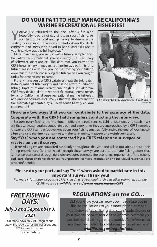
Ocean Sport Fishing License Fees DO YOUR PART TO HELP MANAGE CALIFORNIA’S MARINE RECREATIONAL FISHERIES!
CRFS sampler Gabby Reta examines a Chinook salmonCDFW photo
You’ve just returned to the dock after a fun (and hopefully rewarding) day of ocean sport fishing. As you tie up the boat and get ready to disembark, a
smiling person in a CDFW uniform strolls down the dock, clipboard and measuring board in hand, and asks about your trip. How was the fishing today?
More than likely, you’ve just met a fishery sampler from the California Recreational Fisheries Survey (CRFS), a survey of saltwater sport anglers. The data that you provide to CRFS helps fishery managers set size limits, bag limits, and fishing seasons with the goal of maximizing your fishing opportunities while conserving the fish species you caught today for generations to come.
Fishery managers use CRFS data to estimate the total catch (total number of fish caught) and fishing effort (number of fishing trips) of marine recreational anglers in California. CRFS was designed to meet specific management needs for all of California’s diverse recreational marine fisheries, and provide accurate and timely estimates. The accuracy of the estimates generated by CRFS depends heavily on your cooperation!
There are two ways that you can contribute to the accuracy of the data: Cooperate with the CRFS field samplers conducting the interview.
Because every fishing trip is unique – different target species, fishing locations, and catch – we ask that saltwater anglers cooperate each and every time they are approached by a CRFS sampler. Answer the CRFS sampler’s questions about your fishing trip truthfully and to the best of your knowl-edge, and take the time to allow the sampler to examine, measure, and weigh your catch.Say “Yes” when you are contacted by a CRFS telephone surveyor or receive an email survey.
Licensed anglers are contacted randomly throughout the year and asked questions about their fishing experiences. Data collected through these surveys are used to estimate fishing effort that cannot be estimated through field observations, estimate the economic importance of the fishery, and learn about angler preferences. Your personal contact information and individual responses are kept confidential.
Please do your part and say “Yes” when asked to participate in this important survey. Thank you!
For more information about the CRFS, including recreational catch and effort estimates, visit the CDFW website at wildlife.ca.gov/conservation/marine/CRFS.
FREE FISHING FREE FISHING DAYS!DAYS!
July 3 and September 3, July 3 and September 3, 20212021
On these days only, ALL regulations On these days only, ALL regulations apply and report cards are required, but apply and report cards are required, but
NO license is required NO license is required for sport fishing.for sport fishing.
REGULATIONS on the GO...Did you know you can now download state ocean fishing regulations to your smart phone or other
mobile device? By utilizing iBooks on Apple devices or your favorite book reader on the Android platform you can download the regulations booklet for reference at any time. Regulation booklets can be found online at
wildlife.ca.gov/regulations.
2021-2022 California Ocean Sport Fishing Regulations
8
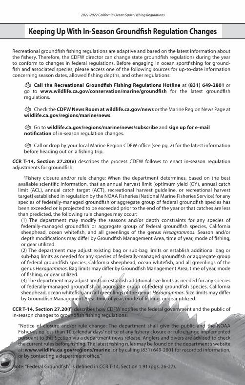
Keeping Up With In-Season Regulation ChangesKeeping Up With In-Season Regulation Changes
Recreational groundfish fishing regulations are adaptive and based on the latest information about the fishery. Therefore, the CDFW director can change state groundfish regulations during the year to conform to changes in federal regulations. Before engaging in ocean sportfishing for ground- fish and associated species, please access one of the following sources for up-to-date information concerning season dates, allowed fishing depths, and other regulations:
🐟 Call the Recreational Groundfish Fishing Regulations Hotline at (831) 649-2801 or go to www.wildlife.ca.gov/conservation/marine/groundfish for the latest groundfish regulations.
🐟 Check the CDFW News Room at wildlife.ca.gov/news or the Marine Region News Page at wildlife.ca.gov/regions/marine/news.
🐟 Go to wildlife.ca.gov/regions/marine/news/subscribe and sign up for e-mail notification of in-season regulation changes.
🐟 Call or drop by your local Marine Region CDFW office (see pg. 2) for the latest information before heading out on a fishing trip.
CCR T-14, Section 27.20(e) describes the process CDFW follows to enact in-season regulation adjustments for groundfish:
“Fishery closure and/or rule change: When the department determines, based on the best available scientific information, that an annual harvest limit [optimum yield (OY), annual catch limit (ACL), annual catch target (ACT), recreational harvest guideline, or recreational harvest target] established in regulation by the NOAA Fisheries (National Marine Fisheries Service) for any species of federally-managed groundfish or aggregate group of federal groundfish species has been exceeded or is projected to be exceeded prior to the end of the year or that catches are less than predicted, the following rule changes may occur:
(1) The department may modify the seasons and/or depth constraints for any species of federally-managed groundfish or aggregate group of federal groundfish species, California sheephead, ocean whitefish, and all greenlings of the genus Hexagrammos. Season and/or depth modifications may differ by Groundfish Management Area, time of year, mode of fishing, or gear utilized.(2) The department may adjust existing bag or sub-bag limits or establish additional bag or sub-bag limits as needed for any species of federally-managed groundfish or aggregate group of federal groundfish species, California sheephead, ocean whitefish, and all greenlings of the genus Hexagrammos. Bag limits may differ by Groundfish Management Area, time of year, mode of fishing, or gear utilized.(3) The department may adjust limits or establish additional size limits as needed for any species of federally-managed groundfish or aggregate group of federal groundfish species, California sheephead, ocean whitefish, and all greenlings of the genus Hexagrammos. Size limits may differ by Groundfish Management Area, time of year, mode of fishing, or gear utilized.
CCR T-14, Section 27.20(f) describes how CDFW notifies the federal government and the public of in-season changes to groundfish fishing regulations:
“Notice of closure and/or rule change: The department shall give the public and the NOAA Fisheries no less than 10 calendar days’ notice of any fishery closure or rule change implemented pursuant to this Section via a department news release. Anglers and divers are advised to check the current rules before fishing. The latest fishing rules may be found on the department’s website at: www.wildlife.ca.gov/regions/marine, or by calling (831) 649-2801 for recorded information, or by contacting a department office.”
Note: “Federal Groundfish” is defined in CCR T-14, Section 1.91 (pgs. 26-27).
Keeping Up With In-Season Groundfish Regulation Changes
9
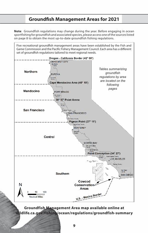
Groundfish Management Areas for 2021
Note: Groundfish regulations may change during the year. Before engaging in ocean sportfishing for groundfish and associated species, please access one of the sources listed on page 8 to obtain the most up-to-date groundfish fishing regulations.
Five recreational groundfish management areas have been established by the Fish and Game Commission and the Pacific Fishery Management Council. Each area has a different set of groundfish regulations tailored to meet regional needs.
Tables summarizinggroundfish
regulations by area are located on the
followingpages
Groundfish Management Area map available online at wildlife.ca.gov/fishing/ocean/regulations/groundfish-summary
2021-2022 California Ocean Sport Fishing Regulations
10
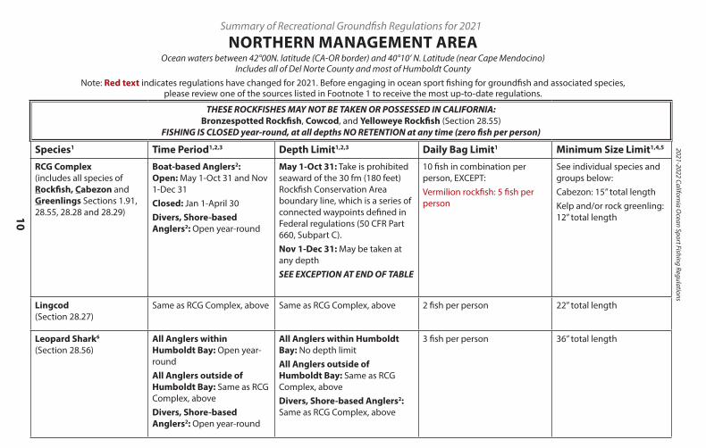
Summary of Recreational Groundfish Regulations for 2021
NORTHERN MANAGEMENT AREAOcean waters between 42°00N. latitude (CA-OR border) and 40°10’ N. Latitude (near Cape Mendocino)
Includes all of Del Norte County and most of Humboldt CountyNote: Red text indicates regulations have changed for 2021. Before engaging in ocean sport fishing for groundfish and associated species,
please review one of the sources listed in Footnote 1 to receive the most up-to-date regulations.
THESE ROCKFISHES MAY NOT BE TAKEN OR POSSESSED IN CALIFORNIA: Bronzespotted Rockfish, Cowcod, and Yelloweye Rockfish (Section 28.55)
FISHING IS CLOSED year-round, at all depths NO RETENTION at any time (zero fish per person)
Species1 Time Period1,2,3 Depth Limit1,2,3 Daily Bag Limit1 Minimum Size Limit1,4,5
RCG Complex (includes all species of Rockfish, Cabezon and Greenlings Sections 1.91, 28.55, 28.28 and 28.29)
Boat-based Anglers2: Open: May 1-Oct 31 and Nov 1-Dec 31Closed: Jan 1-April 30Divers, Shore-based Anglers2: Open year-round
May 1-Oct 31: Take is prohibited seaward of the 30 fm (180 feet) Rockfish Conservation Area boundary line, which is a series of connected waypoints defined in Federal regulations (50 CFR Part 660, Subpart C).Nov 1-Dec 31: May be taken at any depthSEE EXCEPTION AT END OF TABLE
10 fish in combination per person, EXCEPT:Vermilion rockfish: 5 fish per person
See individual species and groups below:Cabezon: 15” total lengthKelp and/or rock greenling: 12” total length
Lingcod (Section 28.27)
Same as RCG Complex, above Same as RCG Complex, above 2 fish per person 22” total length
Leopard Shark6 (Section 28.56)
All Anglers within Humboldt Bay: Open year-roundAll Anglers outside of Humboldt Bay: Same as RCG Complex, aboveDivers, Shore-based Anglers2: Open year-round
All Anglers within Humboldt Bay: No depth limitAll Anglers outside of Humboldt Bay: Same as RCG Complex, aboveDivers, Shore-based Anglers2: Same as RCG Complex, above
3 fish per person 36” total length
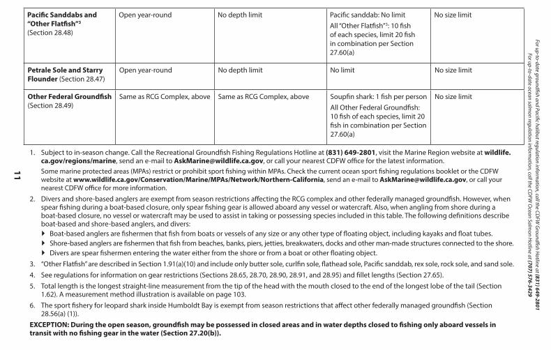
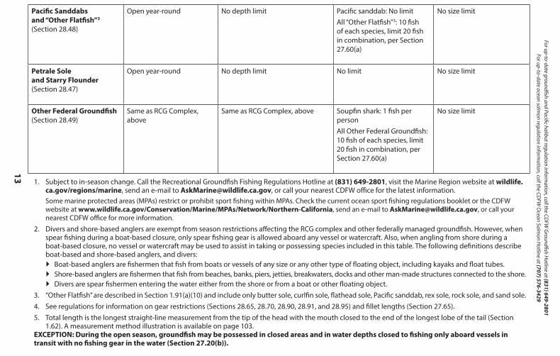
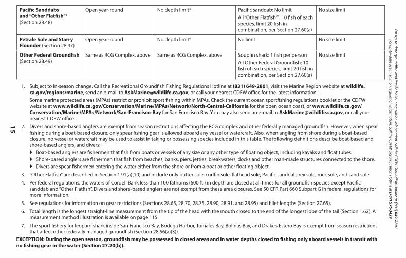
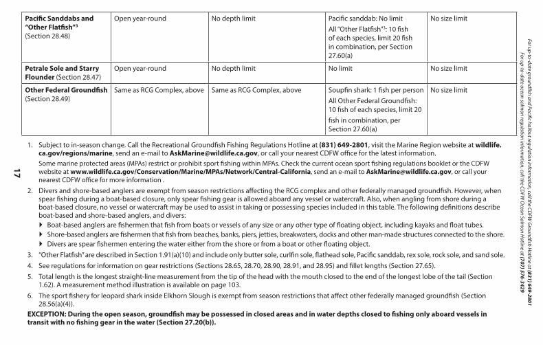
Pacific Sanddabs and “Other Flatfish”3 (Section 28.48)
Open year-round No depth limit Pacific sanddab: No limit All “Other Flatfish”3: 10 fish of each species, limit 20 fish in combination per Section 27.60(a)
No size limit
Petrale Sole and Starry Flounder (Section 28.47)
Open year-round No depth limit No limit No size limit
Other Federal Groundfish (Section 28.49)
Same as RCG Complex, above Same as RCG Complex, above Soupfin shark: 1 fish per personAll Other Federal Groundfish: 10 fish of each species, limit 20 fish in combination per Section 27.60(a)
No size limit
1. Subject to in-season change. Call the Recreational Groundfish Fishing Regulations Hotline at (831) 649-2801, visit the Marine Region website at wildlife. ca.gov/regions/marine, send an e-mail to [email protected], or call your nearest CDFW office for the latest information. Some marine protected areas (MPAs) restrict or prohibit sport fishing within MPAs. Check the current ocean sport fishing regulations booklet or the CDFW website at www.wildlife.ca.gov/Conservation/Marine/MPAs/Network/Northern-California, send an e-mail to [email protected], or call your nearest CDFW office for more information.
2. Divers and shore-based anglers are exempt from season restrictions affecting the RCG complex and other federally managed groundfish. However, when spear fishing during a boat-based closure, only spear fishing gear is allowed aboard any vessel or watercraft. Also, when angling from shore during a boat-based closure, no vessel or watercraft may be used to assist in taking or possessing species included in this table. The following definitions describe boat-based and shore-based anglers, and divers:
` Boat-based anglers are fishermen that fish from boats or vessels of any size or any other type of floating object, including kayaks and float tubes. ` Shore-based anglers are fishermen that fish from beaches, banks, piers, jetties, breakwaters, docks and other man-made structures connected to the shore. ` Divers are spear fishermen entering the water either from the shore or from a boat or other floating object.
3. “Other Flatfish” are described in Section 1.91(a)(10) and include only butter sole, curlfin sole, flathead sole, Pacific sanddab, rex sole, rock sole, and sand sole.4. See regulations for information on gear restrictions (Sections 28.65, 28.70, 28.90, 28.91, and 28.95) and fillet lengths (Section 27.65).5. Total length is the longest straight-line measurement from the tip of the head with the mouth closed to the end of the longest lobe of the tail (Section
1.62). A measurement method illustration is available on page 103.6. The sport fishery for leopard shark inside Humboldt Bay is exempt from season restrictions that affect other federally managed groundfish (Section
28.56(a) (1)).EXCEPTION: During the open season, groundfish may be possessed in closed areas and in water depths closed to fishing only aboard vessels in transit with no fishing gear in the water (Section 27.20(b)).
11
For up-to-date groundfish and Pacific halibut regulation information, call the CD
FW G
roundfish Hotline at (831) 649-2801
For up-to-date ocean salmon regulation inform
ation, call the CDFW
Ocean Salm
on Hotline at (707) 576-3429
THESE ROCKFISHES MAY NOT BE TAKEN OR POSSESSED IN CALIFORNIA: Bronzespotted Rockfish, Cowcod, and Yelloweye Rockfish (Section 28.55)
FISHING IS CLOSED year-round, at all depths NO RETENTION at any time (zero fish per person)
Species1 Time Period1,2,3 Depth Limit1,2,3 Daily Bag Limit1 Minimum Size Limit1,4,5
RCG Complex (includes all species of Rockfish, Cabezon and Greenlings Sections 1.91, 28.55, 28.28 and 28.29)
Boat-based Anglers2: Open: May 1-Oct 31 and Nov 1-Dec 31Closed: Jan 1-April 30Divers, Shore-based Anglers2: Open year-round
May 1-Oct 31: Take is prohibited seaward of the 30 fm (180 feet) Rockfish Conservation Area boundary line, which is a series of connected waypoints defined in Federal regulations (50 CFR Part 660, Subpart C).Nov 1-Dec 31: May be taken at any depthSEE EXCEPTION AT END OF TABLE
10 fish in combination per person, EXCEPT:Vermilion rockfish: 5 fish per person
See individual species and groups below:Cabezon: 15” total lengthKelp and/or rock greenling: 12” total length
Lingcod (Section 28.27)
Same as RCG Complex, above Same as RCG Complex, above 2 fish per person 22” total length
Leopard Shark6 (Section 28.56)
All Anglers within Humboldt Bay: Open year-roundAll Anglers outside of Humboldt Bay: Same as RCG Complex, aboveDivers, Shore-based Anglers2: Open year-round
All Anglers within Humboldt Bay: No depth limitAll Anglers outside of Humboldt Bay: Same as RCG Complex, aboveDivers, Shore-based Anglers2: Same as RCG Complex, above
3 fish per person 36” total length
Pacific Sanddabs and “Other Flatfish”3 (Section 28.48)
Open year-round No depth limit Pacific sanddab: No limit All “Other Flatfish”3: 10 fish of each species, limit 20 fish in combination per Section 27.60(a)
No size limit
Petrale Sole and Starry Flounder (Section 28.47)
Open year-round No depth limit No limit No size limit
Other Federal Groundfish (Section 28.49)
Same as RCG Complex, above Same as RCG Complex, above Soupfin shark: 1 fish per personAll Other Federal Groundfish: 10 fish of each species, limit 20 fish in combination per Section 27.60(a)
No size limit
1. Subject to in-season change. Call the Recreational Groundfish Fishing Regulations Hotline at (831) 649-2801, visit the Marine Region website at wildlife. ca.gov/regions/marine, send an e-mail to [email protected], or call your nearest CDFW office for the latest information. Some marine protected areas (MPAs) restrict or prohibit sport fishing within MPAs. Check the current ocean sport fishing regulations booklet or the CDFW website at www.wildlife.ca.gov/Conservation/Marine/MPAs/Network/Northern-California, send an e-mail to [email protected], or call your nearest CDFW office for more information.
2. Divers and shore-based anglers are exempt from season restrictions affecting the RCG complex and other federally managed groundfish. However, when spear fishing during a boat-based closure, only spear fishing gear is allowed aboard any vessel or watercraft. Also, when angling from shore during a boat-based closure, no vessel or watercraft may be used to assist in taking or possessing species included in this table. The following definitions describe boat-based and shore-based anglers, and divers:` Boat-based anglers are fishermen that fish from boats or vessels of any size or any other type of floating object, including kayaks and float tubes.` Shore-based anglers are fishermen that fish from beaches, banks, piers, jetties, breakwaters, docks and other man-made structures connected to the shore.` Divers are spear fishermen entering the water either from the shore or from a boat or other floating object.
3. “Other Flatfish” are described in Section 1.91(a)(10) and include only butter sole, curlfin sole, flathead sole, Pacific sanddab, rex sole, rock sole, and sand sole.4. See regulations for information on gear restrictions (Sections 28.65, 28.70, 28.90, 28.91, and 28.95) and fillet lengths (Section 27.65).5. Total length is the longest straight-line measurement from the tip of the head with the mouth closed to the end of the longest lobe of the tail (Section
1.62). A measurement method illustration is available on page 103.6. The sport fishery for leopard shark inside Humboldt Bay is exempt from season restrictions that affect other federally managed groundfish (Section
28.56(a) (1)).EXCEPTION: During the open season, groundfish may be possessed in closed areas and in water depths closed to fishing only aboard vessels in transit with no fishing gear in the water (Section 27.20(b)).
2021-2022 California Ocean Sport Fishing Regulations
12
Summary of Recreational Groundfish Regulations for 2021
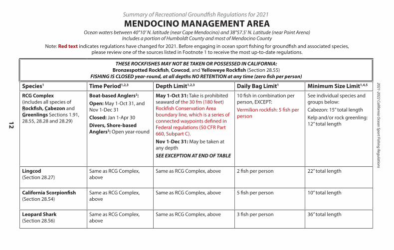
MENDOCINO MANAGEMENT AREAOcean waters between 40°10’ N. latitude (near Cape Mendocino) and 38°57.5’ N. Latitude (near Point Arena)
Includes a portion of Humboldt County and most of Mendocino CountyNote: Red text indicates regulations have changed for 2021. Before engaging in ocean sport fishing for groundfish and associated species,
please review one of the sources listed in Footnote 1 to receive the most up-to-date regulations.
THESE ROCKFISHES MAY NOT BE TAKEN OR POSSESSED IN CALIFORNIA: Bronzespotted Rockfish, Cowcod, and Yelloweye Rockfish (Section 28.55)
FISHING IS CLOSED year-round, at all depths NO RETENTION at any time (zero fish per person)
Species1 Time Period1,2,3 Depth Limit1,2,3 Daily Bag Limit1 Minimum Size Limit1,4,5
RCG Complex (includes all species of Rockfish, Cabezon and Greenlings Sections 1.91, 28.55, 28.28 and 28.29)
Boat-based Anglers2:Open: May 1-Oct 31, and Nov 1-Dec 31Closed: Jan 1-Apr 30Divers, Shore-based Anglers2: Open year-round
May 1-Oct 31: Take is prohibited seaward of the 30 fm (180 feet) Rockfish Conservation Area boundary line, which is a series of connected waypoints defined in Federal regulations (50 CFR Part 660, Subpart C).Nov 1-Dec 31: May be taken at any depthSEE EXCEPTION AT END OF TABLE
10 fish in combination per person, EXCEPT:Vermilion rockfish: 5 fish per person
See individual species and groups below:Cabezon: 15” total lengthKelp and/or rock greenling: 12” total length
Lingcod (Section 28.27)
Same as RCG Complex, above
Same as RCG Complex, above 2 fish per person 22” total length
California Scorpionfish (Section 28.54)
Same as RCG Complex, above
Same as RCG Complex, above 5 fish per person 10” total length
Leopard Shark (Section 28.56)
Same as RCG Complex, above
Same as RCG Complex, above 3 fish per person 36” total length
Pacific Sanddabs and “Other Flatfish”3 (Section 28.48)
Open year-round No depth limit Pacific sanddab: No limitAll “Other Flatfish”3: 10 fish of each species, limit 20 fish in combination, per Section 27.60(a)
No size limit
Petrale Sole and Starry Flounder (Section 28.47)
Open year-round No depth limit No limit No size limit
Other Federal Groundfish (Section 28.49)
Same as RCG Complex, above
Same as RCG Complex, above Soupfin shark: 1 fish per personAll Other Federal Groundfish: 10 fish of each species, limit 20 fish in combination, per Section 27.60(a)
No size limit
1. Subject to in-season change. Call the Recreational Groundfish Fishing Regulations Hotline at (831) 649-2801, visit the Marine Region website at wildlife. ca.gov/regions/marine, send an e-mail to [email protected], or call your nearest CDFW office for the latest information.Some marine protected areas (MPAs) restrict or prohibit sport fishing within MPAs. Check the current ocean sport fishing regulations booklet or the CDFW website at www.wildlife.ca.gov/Conservation/Marine/MPAs/Network/Northern-California, send an e-mail to [email protected], or call your nearest CDFW office for more information.
2. Divers and shore-based anglers are exempt from season restrictions affecting the RCG complex and other federally managed groundfish. However, when spear fishing during a boat-based closure, only spear fishing gear is allowed aboard any vessel or watercraft. Also, when angling from shore during a boat-based closure, no vessel or watercraft may be used to assist in taking or possessing species included in this table. The following definitions describe boat-based and shore-based anglers, and divers:
` Boat-based anglers are fishermen that fish from boats or vessels of any size or any other type of floating object, including kayaks and float tubes. ` Shore-based anglers are fishermen that fish from beaches, banks, piers, jetties, breakwaters, docks and other man-made structures connected to the shore. ` Divers are spear fishermen entering the water either from the shore or from a boat or other floating object.
3. “Other Flatfish” are described in Section 1.91(a)(10) and include only butter sole, curlfin sole, flathead sole, Pacific sanddab, rex sole, rock sole, and sand sole.4. See regulations for information on gear restrictions (Sections 28.65, 28.70, 28.90, 28.91, and 28.95) and fillet lengths (Section 27.65).5. Total length is the longest straight-line measurement from the tip of the head with the mouth closed to the end of the longest lobe of the tail (Section
1.62). A measurement method illustration is available on page 103.EXCEPTION: During the open season, groundfish may be possessed in closed areas and in water depths closed to fishing only aboard vessels in transit with no fishing gear in the water (Section 27.20(b)).
13
For up-to-date groundfish and Pacific halibut regulation information, call the CD
FW G
roundfish Hotline at (831) 649-2801
For up-to-date ocean salmon regulation inform
ation, call the CDFW
Ocean Salm
on Hotline at (707) 576-3429
THESE ROCKFISHES MAY NOT BE TAKEN OR POSSESSED IN CALIFORNIA: Bronzespotted Rockfish, Cowcod, and Yelloweye Rockfish (Section 28.55)
FISHING IS CLOSED year-round, at all depths NO RETENTION at any time (zero fish per person)
Species1 Time Period1,2,3 Depth Limit1,2,3 Daily Bag Limit1 Minimum Size Limit1,4,5
RCG Complex (includes all species of Rockfish, Cabezon and Greenlings Sections 1.91, 28.55, 28.28 and 28.29)
Boat-based Anglers2:Open: May 1-Oct 31, and Nov 1-Dec 31Closed: Jan 1-Apr 30Divers, Shore-based Anglers2: Open year-round
May 1-Oct 31: Take is prohibited seaward of the 30 fm (180 feet) Rockfish Conservation Area boundary line, which is a series of connected waypoints defined in Federal regulations (50 CFR Part 660, Subpart C).Nov 1-Dec 31: May be taken at any depthSEE EXCEPTION AT END OF TABLE
10 fish in combination per person, EXCEPT:Vermilion rockfish: 5 fish per person
See individual species and groups below:Cabezon: 15” total lengthKelp and/or rock greenling: 12” total length
Lingcod (Section 28.27)
Same as RCG Complex, above
Same as RCG Complex, above 2 fish per person 22” total length
California Scorpionfish (Section 28.54)
Same as RCG Complex, above
Same as RCG Complex, above 5 fish per person 10” total length
Leopard Shark (Section 28.56)
Same as RCG Complex, above
Same as RCG Complex, above 3 fish per person 36” total length
Pacific Sanddabs and “Other Flatfish”3 (Section 28.48)
Open year-round No depth limit Pacific sanddab: No limitAll “Other Flatfish”3: 10 fish of each species, limit 20 fish in combination, per Section 27.60(a)
No size limit
Petrale Sole and Starry Flounder (Section 28.47)
Open year-round No depth limit No limit No size limit
Other Federal Groundfish (Section 28.49)
Same as RCG Complex, above
Same as RCG Complex, above Soupfin shark: 1 fish per personAll Other Federal Groundfish: 10 fish of each species, limit 20 fish in combination, per Section 27.60(a)
No size limit
1. Subject to in-season change. Call the Recreational Groundfish Fishing Regulations Hotline at (831) 649-2801, visit the Marine Region website at wildlife. ca.gov/regions/marine, send an e-mail to [email protected], or call your nearest CDFW office for the latest information.Some marine protected areas (MPAs) restrict or prohibit sport fishing within MPAs. Check the current ocean sport fishing regulations booklet or the CDFW website at www.wildlife.ca.gov/Conservation/Marine/MPAs/Network/Northern-California, send an e-mail to [email protected], or call your nearest CDFW office for more information.
2. Divers and shore-based anglers are exempt from season restrictions affecting the RCG complex and other federally managed groundfish. However, when spear fishing during a boat-based closure, only spear fishing gear is allowed aboard any vessel or watercraft. Also, when angling from shore during a boat-based closure, no vessel or watercraft may be used to assist in taking or possessing species included in this table. The following definitions describe boat-based and shore-based anglers, and divers:
` Boat-based anglers are fishermen that fish from boats or vessels of any size or any other type of floating object, including kayaks and float tubes. ` Shore-based anglers are fishermen that fish from beaches, banks, piers, jetties, breakwaters, docks and other man-made structures connected to the shore. ` Divers are spear fishermen entering the water either from the shore or from a boat or other floating object.
3. “Other Flatfish” are described in Section 1.91(a)(10) and include only butter sole, curlfin sole, flathead sole, Pacific sanddab, rex sole, rock sole, and sand sole.4. See regulations for information on gear restrictions (Sections 28.65, 28.70, 28.90, 28.91, and 28.95) and fillet lengths (Section 27.65).5. Total length is the longest straight-line measurement from the tip of the head with the mouth closed to the end of the longest lobe of the tail (Section
1.62). A measurement method illustration is available on page 103.EXCEPTION: During the open season, groundfish may be possessed in closed areas and in water depths closed to fishing only aboard vessels in transit with no fishing gear in the water (Section 27.20(b)).
2021-2022 California Ocean Sport Fishing Regulations
14
Summary of Recreational Groundfish Regulations for 2021
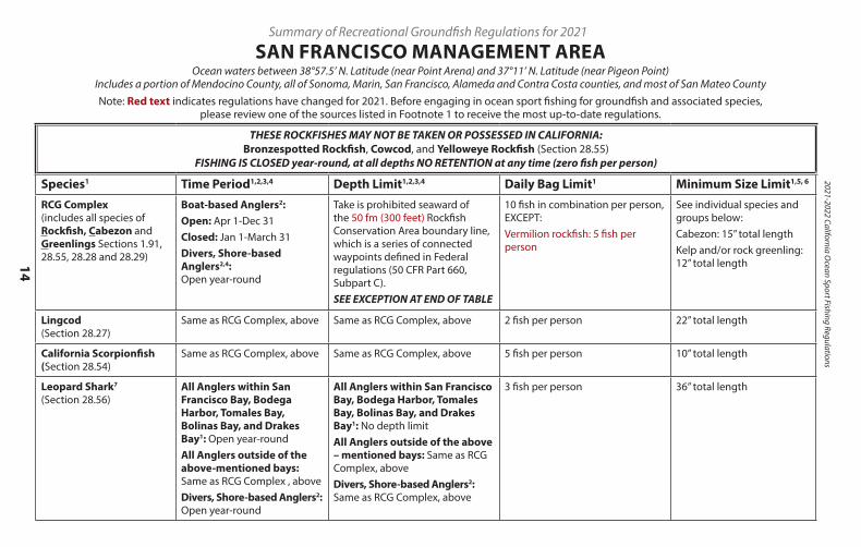
SAN FRANCISCO MANAGEMENT AREAOcean waters between 38°57.5’ N. Latitude (near Point Arena) and 37°11’ N. Latitude (near Pigeon Point)
Includes a portion of Mendocino County, all of Sonoma, Marin, San Francisco, Alameda and Contra Costa counties, and most of San Mateo CountyNote: Red text indicates regulations have changed for 2021. Before engaging in ocean sport fishing for groundfish and associated species,
please review one of the sources listed in Footnote 1 to receive the most up-to-date regulations.
THESE ROCKFISHES MAY NOT BE TAKEN OR POSSESSED IN CALIFORNIA: Bronzespotted Rockfish, Cowcod, and Yelloweye Rockfish (Section 28.55)
FISHING IS CLOSED year-round, at all depths NO RETENTION at any time (zero fish per person)
Species1 Time Period1,2,3,4 Depth Limit1,2,3,4 Daily Bag Limit1 Minimum Size Limit1,5, 6
RCG Complex (includes all species of Rockfish, Cabezon and Greenlings Sections 1.91, 28.55, 28.28 and 28.29)
Boat-based Anglers2:Open: Apr 1-Dec 31Closed: Jan 1-March 31Divers, Shore-based Anglers2,4: Open year-round
Take is prohibited seaward of the 50 fm (300 feet) Rockfish Conservation Area boundary line, which is a series of connected waypoints defined in Federal regulations (50 CFR Part 660, Subpart C).SEE EXCEPTION AT END OF TABLE
10 fish in combination per person, EXCEPT:Vermilion rockfish: 5 fish per person
See individual species and groups below:Cabezon: 15” total lengthKelp and/or rock greenling: 12” total length
Lingcod (Section 28.27)
Same as RCG Complex, above Same as RCG Complex, above 2 fish per person 22” total length
California Scorpionfish (Section 28.54)
Same as RCG Complex, above Same as RCG Complex, above 5 fish per person 10” total length
Leopard Shark7 (Section 28.56)
All Anglers within San Francisco Bay, Bodega Harbor, Tomales Bay, Bolinas Bay, and Drakes Bay1: Open year-roundAll Anglers outside of the above-mentioned bays: Same as RCG Complex , aboveDivers, Shore-based Anglers2: Open year-round
All Anglers within San Francisco Bay, Bodega Harbor, Tomales Bay, Bolinas Bay, and Drakes Bay1: No depth limitAll Anglers outside of the above – mentioned bays: Same as RCG Complex, aboveDivers, Shore-based Anglers2: Same as RCG Complex, above
3 fish per person 36” total length
Pacific Sanddabs and “Other Flatfish”3 (Section 28.48)
Open year-round No depth limit4 Pacific sanddab: No limitAll “Other Flatfish”3: 10 fish of each species, limit 20 fish in combination, per Section 27.60(a)
No size limit
Petrale Sole and Starry Flounder (Section 28.47)
Open year-round No depth limit4 No limit No size limit
Other Federal Groundfish (Section 28.49)
Same as RCG Complex, above Same as RCG Complex, above Soupfin shark: 1 fish per personAll Other Federal Groundfish: 10 fish of each species, limit 20 fish in combination, per Section 27.60(a)
No size limit
1. Subject to in-season change. Call the Recreational Groundfish Fishing Regulations Hotline at (831) 649-2801, visit the Marine Region website at wildlife.ca.gov/regions/marine, send an e-mail to [email protected], or call your nearest CDFW office for the latest information.Some marine protected areas (MPAs) restrict or prohibit sport fishing within MPAs. Check the current ocean sportfishing regulations booklet or the CDFW website at www.wildlife.ca.gov/Conservation/Marine/MPAs/Network/North-Central-California for the open ocean coast, or www.wildlife.ca.gov/Conservation/Marine/MPAs/Network/San-Francisco-Bay for San Francisco Bay. You may also send an e-mail to [email protected], or call your nearest CDFW office.
2. Divers and shore-based anglers are exempt from season restrictions affecting the RCG complex and other federally managed groundfish. However, when spear fishing during a boat-based closure, only spear fishing gear is allowed aboard any vessel or watercraft. Also, when angling from shore during a boat-based closure, no vessel or watercraft may be used to assist in taking or possessing species included in this table. The following definitions describe boat-based and shore-based anglers, and divers:
` Boat-based anglers are fishermen that fish from boats or vessels of any size or any other type of floating object, including kayaks and float tubes. ` Shore-based anglers are fishermen that fish from beaches, banks, piers, jetties, breakwaters, docks and other man-made structures connected to the shore. ` Divers are spear fishermen entering the water either from the shore or from a boat or other floating object.
3. “Other Flatfish” are described in Section 1.91(a)(10) and include only butter sole, curlfin sole, flathead sole, Pacific sanddab, rex sole, rock sole, and sand sole.
4. Per federal regulations, the waters of Cordell Bank less than 100 fathoms (600 ft.) in depth are closed at all times for all groundfish species except Pacific sanddab and “Other Flatfish”. Divers and shore-based anglers are not exempt from these area closures. See 50 CFR Part 660 Subpart G in federal regulations for more information.
5. See regulations for information on gear restrictions (Sections 28.65, 28.70, 28.75, 28.90, 28.91, and 28.95) and fillet lengths (Section 27.65).
6. Total length is the longest straight-line measurement from the tip of the head with the mouth closed to the end of the longest lobe of the tail (Section 1.62). A measurement method illustration is available on page 115.
7. The sport fishery for leopard shark inside San Francisco Bay, Bodega Harbor, Tomales Bay, Bolinas Bay, and Drake’s Estero Bay is exempt from season restrictions that affect other federally managed groundfish (Section 28.56(a)(3)).
EXCEPTION: During the open season, groundfish may be possessed in closed areas and in water depths closed to fishing only aboard vessels in transit with no fishing gear in the water (Section 27.20(b)).
15
For up-to-date groundfish and Pacific halibut regulation information, call the CD
FW G
roundfish Hotline at (831) 649-2801
For up-to-date ocean salmon regulation inform
ation, call the CDFW
Ocean Salm
on Hotline at (707) 576-3429
THESE ROCKFISHES MAY NOT BE TAKEN OR POSSESSED IN CALIFORNIA: Bronzespotted Rockfish, Cowcod, and Yelloweye Rockfish (Section 28.55)
FISHING IS CLOSED year-round, at all depths NO RETENTION at any time (zero fish per person)
Species1 Time Period1,2,3,4 Depth Limit1,2,3,4 Daily Bag Limit1 Minimum Size Limit1,5, 6
RCG Complex (includes all species of Rockfish, Cabezon and Greenlings Sections 1.91, 28.55, 28.28 and 28.29)
Boat-based Anglers2:Open: Apr 1-Dec 31Closed: Jan 1-March 31Divers, Shore-based Anglers2,4: Open year-round
Take is prohibited seaward of the 50 fm (300 feet) Rockfish Conservation Area boundary line, which is a series of connected waypoints defined in Federal regulations (50 CFR Part 660, Subpart C).SEE EXCEPTION AT END OF TABLE
10 fish in combination per person, EXCEPT:Vermilion rockfish: 5 fish per person
See individual species and groups below:Cabezon: 15” total lengthKelp and/or rock greenling: 12” total length
Lingcod (Section 28.27)
Same as RCG Complex, above Same as RCG Complex, above 2 fish per person 22” total length
California Scorpionfish (Section 28.54)
Same as RCG Complex, above Same as RCG Complex, above 5 fish per person 10” total length
Leopard Shark7 (Section 28.56)
All Anglers within San Francisco Bay, Bodega Harbor, Tomales Bay, Bolinas Bay, and Drakes Bay1: Open year-roundAll Anglers outside of the above-mentioned bays: Same as RCG Complex , aboveDivers, Shore-based Anglers2: Open year-round
All Anglers within San Francisco Bay, Bodega Harbor, Tomales Bay, Bolinas Bay, and Drakes Bay1: No depth limitAll Anglers outside of the above – mentioned bays: Same as RCG Complex, aboveDivers, Shore-based Anglers2: Same as RCG Complex, above
3 fish per person 36” total length
Pacific Sanddabs and “Other Flatfish”3 (Section 28.48)
Open year-round No depth limit4 Pacific sanddab: No limitAll “Other Flatfish”3: 10 fish of each species, limit 20 fish in combination, per Section 27.60(a)
No size limit
Petrale Sole and Starry Flounder (Section 28.47)
Open year-round No depth limit4 No limit No size limit
Other Federal Groundfish (Section 28.49)
Same as RCG Complex, above Same as RCG Complex, above Soupfin shark: 1 fish per personAll Other Federal Groundfish: 10 fish of each species, limit 20 fish in combination, per Section 27.60(a)
No size limit
1. Subject to in-season change. Call the Recreational Groundfish Fishing Regulations Hotline at (831) 649-2801, visit the Marine Region website at wildlife.ca.gov/regions/marine, send an e-mail to [email protected], or call your nearest CDFW office for the latest information.Some marine protected areas (MPAs) restrict or prohibit sport fishing within MPAs. Check the current ocean sportfishing regulations booklet or the CDFW website at www.wildlife.ca.gov/Conservation/Marine/MPAs/Network/North-Central-California for the open ocean coast, or www.wildlife.ca.gov/Conservation/Marine/MPAs/Network/San-Francisco-Bay for San Francisco Bay. You may also send an e-mail to [email protected], or call your nearest CDFW office.
2. Divers and shore-based anglers are exempt from season restrictions affecting the RCG complex and other federally managed groundfish. However, when spear fishing during a boat-based closure, only spear fishing gear is allowed aboard any vessel or watercraft. Also, when angling from shore during a boat-based closure, no vessel or watercraft may be used to assist in taking or possessing species included in this table. The following definitions describe boat-based and shore-based anglers, and divers:
` Boat-based anglers are fishermen that fish from boats or vessels of any size or any other type of floating object, including kayaks and float tubes. ` Shore-based anglers are fishermen that fish from beaches, banks, piers, jetties, breakwaters, docks and other man-made structures connected to the shore. ` Divers are spear fishermen entering the water either from the shore or from a boat or other floating object.
3. “Other Flatfish” are described in Section 1.91(a)(10) and include only butter sole, curlfin sole, flathead sole, Pacific sanddab, rex sole, rock sole, and sand sole.
4. Per federal regulations, the waters of Cordell Bank less than 100 fathoms (600 ft.) in depth are closed at all times for all groundfish species except Pacific sanddab and “Other Flatfish”. Divers and shore-based anglers are not exempt from these area closures. See 50 CFR Part 660 Subpart G in federal regulations for more information.
5. See regulations for information on gear restrictions (Sections 28.65, 28.70, 28.75, 28.90, 28.91, and 28.95) and fillet lengths (Section 27.65).
6. Total length is the longest straight-line measurement from the tip of the head with the mouth closed to the end of the longest lobe of the tail (Section 1.62). A measurement method illustration is available on page 115.
7. The sport fishery for leopard shark inside San Francisco Bay, Bodega Harbor, Tomales Bay, Bolinas Bay, and Drake’s Estero Bay is exempt from season restrictions that affect other federally managed groundfish (Section 28.56(a)(3)).
EXCEPTION: During the open season, groundfish may be possessed in closed areas and in water depths closed to fishing only aboard vessels in transit with no fishing gear in the water (Section 27.20(b)).
2021-2022 California Ocean Sport Fishing Regulations
16
Summary of Recreational Groundfish Regulations for 2021
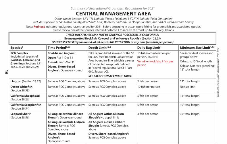
CENTRAL MANAGEMENT AREAOcean waters between 37°11’ N. Latitude (Pigeon Point) and 34°27’ ’N. latitude (Point Conception)
Includes a portion of San Mateo County, all of Santa Cruz, Monterey and San Luis Obispo counties, and part of Santa Barbara CountyNote: Red text indicates regulations have changed for 2021. Before engaging in ocean sport fishing for groundfish and associated species,
please review one of the sources listed in Footnote 1 to receive the most up-to-date regulations.
THESE ROCKFISHES MAY NOT BE TAKEN OR POSSESSED IN CALIFORNIA: Bronzespotted Rockfish, Cowcod, and Yelloweye Rockfish (Section 28.55)
FISHING IS CLOSED year-round, at all depths NO RETENTION at any time (zero fish per person)
Species1 Time Period1,2,3 Depth Limit1,2,3 Daily Bag Limit1 Minimum Size Limit1,4,5
RCG Complex (includes all species of Rockfish, Cabezon and Greenlings Sections 1.91, 28.55, 28.28 and 28.29)
Boat-based Anglers2:Open: Apr 1-Dec 31Closed: Jan 1-Mar 31Divers, Shore-based Anglers2: Open year-round
Take is prohibited seaward of the 50 fm (300 feet) Rockfish Conservation Area boundary line, which is a series of connected waypoints defined in Federal regulations (50 CFR Part 660, Subpart C).SEE EXCEPTION AT END OF TABLE
10 fish in combination per person, EXCEPT:Vermilion rockfish: 5 fish per person
See individual species and groups below:Cabezon: 15” total lengthKelp and/or rock greenling: 12” total length
Lingcod (Section 28.27) Same as RCG Complex, above Same as RCG Complex, above 2 fish per person 22” total length
Ocean Whitefish (Section 28.58)
Same as RCG Complex, above Same as RCG Complex, above 10 fish per person No size limit
California Sheephead (Section 28.26)
Same as RCG Complex, above Same as RCG Complex, above 5 fish per person 12” total length
California Scorpionfish (Section 28.54)
Same as RCG Complex, above Same as RCG Complex, above 5 fish per person 10” total length
Leopard Shark6 (Section 28.56)
All Anglers within Elkhorn Slough1: Open year-roundAll Anglers outside Elkhorn Slough: Same as RCG Complex, aboveDivers, Shore-based Anglers2: Open year-round
All Anglers within Elkhorn Slough1: No depth limitAll Anglers outside Elkhorn Slough: Same as RCG Complex, aboveDivers, Shore-based Anglers2: Same as RCG Complex, above
3 fish per person 36” total length
Pacific Sanddabs and “Other Flatfish”3 (Section 28.48)
Open year-round No depth limit Pacific sanddab: No limitAll “Other Flatfish”3: 10 fish of each species, limit 20 fish in combination, per Section 27.60(a)
No size limit
Petrale Sole and Starry Flounder (Section 28.47)
Open year-round No depth limit No limit No size limit
Other Federal Groundfish (Section 28.49)
Same as RCG Complex, above Same as RCG Complex, above Soupfin shark: 1 fish per personAll Other Federal Groundfish: 10 fish of each species, limit 20fish in combination, per Section 27.60(a)
No size limit
1. Subject to in-season change. Call the Recreational Groundfish Fishing Regulations Hotline at (831) 649-2801, visit the Marine Region website at wildlife.ca.gov/regions/marine, send an e-mail to [email protected], or call your nearest CDFW office for the latest information.Some marine protected areas (MPAs) restrict or prohibit sport fishing within MPAs. Check the current ocean sport fishing regulations booklet or the CDFW website at www.wildlife.ca.gov/Conservation/Marine/MPAs/Network/Central-California, send an e-mail to [email protected], or call your nearest CDFW office for more information .
2. Divers and shore-based anglers are exempt from season restrictions affecting the RCG complex and other federally managed groundfish. However, when spear fishing during a boat-based closure, only spear fishing gear is allowed aboard any vessel or watercraft. Also, when angling from shore during a boat-based closure, no vessel or watercraft may be used to assist in taking or possessing species included in this table. The following definitions describe boat-based and shore-based anglers, and divers:
` Boat-based anglers are fishermen that fish from boats or vessels of any size or any other type of floating object, including kayaks and float tubes. ` Shore-based anglers are fishermen that fish from beaches, banks, piers, jetties, breakwaters, docks and other man-made structures connected to the shore. ` Divers are spear fishermen entering the water either from the shore or from a boat or other floating object.
3. “Other Flatfish” are described in Section 1.91(a)(10) and include only butter sole, curlfin sole, flathead sole, Pacific sanddab, rex sole, rock sole, and sand sole.4. See regulations for information on gear restrictions (Sections 28.65, 28.70, 28.90, 28.91, and 28.95) and fillet lengths (Section 27.65).5. Total length is the longest straight-line measurement from the tip of the head with the mouth closed to the end of the longest lobe of the tail (Section
1.62). A measurement method illustration is available on page 103.6. The sport fishery for leopard shark inside Elkhorn Slough is exempt from season restrictions that affect other federally managed groundfish (Section
28.56(a)(4)).EXCEPTION: During the open season, groundfish may be possessed in closed areas and in water depths closed to fishing only aboard vessels in transit with no fishing gear in the water (Section 27.20(b)).
17
For up-to-date groundfish and Pacific halibut regulation information, call the CD
FW G
roundfish Hotline at (831) 649-2801
For up-to-date ocean salmon regulation inform
ation, call the CDFW
Ocean Salm
on Hotline at (707) 576-3429
THESE ROCKFISHES MAY NOT BE TAKEN OR POSSESSED IN CALIFORNIA: Bronzespotted Rockfish, Cowcod, and Yelloweye Rockfish (Section 28.55)
FISHING IS CLOSED year-round, at all depths NO RETENTION at any time (zero fish per person)
Species1 Time Period1,2,3 Depth Limit1,2,3 Daily Bag Limit1 Minimum Size Limit1,4,5
RCG Complex (includes all species of Rockfish, Cabezon and Greenlings Sections 1.91, 28.55, 28.28 and 28.29)
Boat-based Anglers2:Open: Apr 1-Dec 31Closed: Jan 1-Mar 31Divers, Shore-based Anglers2: Open year-round
Take is prohibited seaward of the 50 fm (300 feet) Rockfish Conservation Area boundary line, which is a series of connected waypoints defined in Federal regulations (50 CFR Part 660, Subpart C).SEE EXCEPTION AT END OF TABLE
10 fish in combination per person, EXCEPT:Vermilion rockfish: 5 fish per person
See individual species and groups below:Cabezon: 15” total lengthKelp and/or rock greenling: 12” total length
Lingcod (Section 28.27) Same as RCG Complex, above Same as RCG Complex, above 2 fish per person 22” total length
Ocean Whitefish (Section 28.58)
Same as RCG Complex, above Same as RCG Complex, above 10 fish per person No size limit
California Sheephead (Section 28.26)
Same as RCG Complex, above Same as RCG Complex, above 5 fish per person 12” total length
California Scorpionfish (Section 28.54)
Same as RCG Complex, above Same as RCG Complex, above 5 fish per person 10” total length
Leopard Shark6 (Section 28.56)
All Anglers within Elkhorn Slough1: Open year-roundAll Anglers outside Elkhorn Slough: Same as RCG Complex, aboveDivers, Shore-based Anglers2: Open year-round
All Anglers within Elkhorn Slough1: No depth limitAll Anglers outside Elkhorn Slough: Same as RCG Complex, aboveDivers, Shore-based Anglers2: Same as RCG Complex, above
3 fish per person 36” total length
Pacific Sanddabs and “Other Flatfish”3 (Section 28.48)
Open year-round No depth limit Pacific sanddab: No limitAll “Other Flatfish”3: 10 fish of each species, limit 20 fish in combination, per Section 27.60(a)
No size limit
Petrale Sole and Starry Flounder (Section 28.47)
Open year-round No depth limit No limit No size limit
Other Federal Groundfish (Section 28.49)
Same as RCG Complex, above Same as RCG Complex, above Soupfin shark: 1 fish per personAll Other Federal Groundfish: 10 fish of each species, limit 20fish in combination, per Section 27.60(a)
No size limit
1. Subject to in-season change. Call the Recreational Groundfish Fishing Regulations Hotline at (831) 649-2801, visit the Marine Region website at wildlife.ca.gov/regions/marine, send an e-mail to [email protected], or call your nearest CDFW office for the latest information.Some marine protected areas (MPAs) restrict or prohibit sport fishing within MPAs. Check the current ocean sport fishing regulations booklet or the CDFW website at www.wildlife.ca.gov/Conservation/Marine/MPAs/Network/Central-California, send an e-mail to [email protected], or call your nearest CDFW office for more information .
2. Divers and shore-based anglers are exempt from season restrictions affecting the RCG complex and other federally managed groundfish. However, when spear fishing during a boat-based closure, only spear fishing gear is allowed aboard any vessel or watercraft. Also, when angling from shore during a boat-based closure, no vessel or watercraft may be used to assist in taking or possessing species included in this table. The following definitions describe boat-based and shore-based anglers, and divers:
` Boat-based anglers are fishermen that fish from boats or vessels of any size or any other type of floating object, including kayaks and float tubes. ` Shore-based anglers are fishermen that fish from beaches, banks, piers, jetties, breakwaters, docks and other man-made structures connected to the shore. ` Divers are spear fishermen entering the water either from the shore or from a boat or other floating object.
3. “Other Flatfish” are described in Section 1.91(a)(10) and include only butter sole, curlfin sole, flathead sole, Pacific sanddab, rex sole, rock sole, and sand sole.4. See regulations for information on gear restrictions (Sections 28.65, 28.70, 28.90, 28.91, and 28.95) and fillet lengths (Section 27.65).5. Total length is the longest straight-line measurement from the tip of the head with the mouth closed to the end of the longest lobe of the tail (Section
1.62). A measurement method illustration is available on page 103.6. The sport fishery for leopard shark inside Elkhorn Slough is exempt from season restrictions that affect other federally managed groundfish (Section
28.56(a)(4)).EXCEPTION: During the open season, groundfish may be possessed in closed areas and in water depths closed to fishing only aboard vessels in transit with no fishing gear in the water (Section 27.20(b)).
2021-2022 California Ocean Sport Fishing Regulations
18
Summary of Recreational Groundfish Regulations for 2021
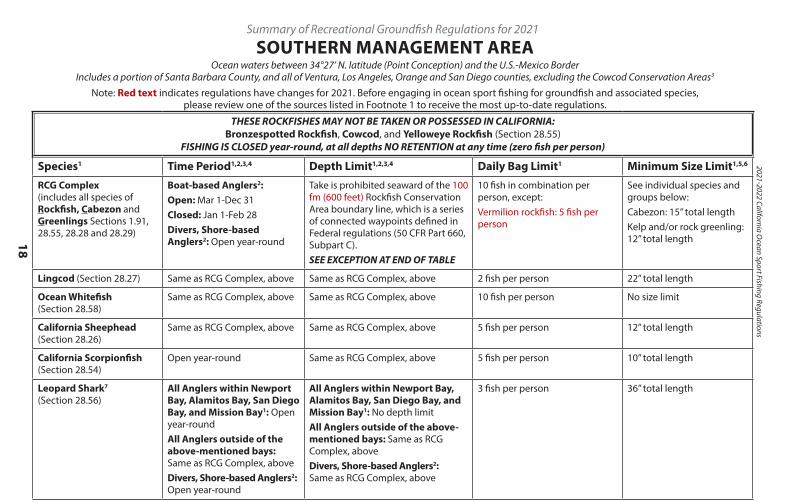
SOUTHERN MANAGEMENT AREAOcean waters between 34°27’ N. latitude (Point Conception) and the U.S.-Mexico Border
Includes a portion of Santa Barbara County, and all of Ventura, Los Angeles, Orange and San Diego counties, excluding the Cowcod Conservation Areas3
Note: Red text indicates regulations have changes for 2021. Before engaging in ocean sport fishing for groundfish and associated species, please review one of the sources listed in Footnote 1 to receive the most up-to-date regulations.
THESE ROCKFISHES MAY NOT BE TAKEN OR POSSESSED IN CALIFORNIA: Bronzespotted Rockfish, Cowcod, and Yelloweye Rockfish (Section 28.55)
FISHING IS CLOSED year-round, at all depths NO RETENTION at any time (zero fish per person)
Species1 Time Period1,2,3,4 Depth Limit1,2,3,4 Daily Bag Limit1 Minimum Size Limit1,5,6
RCG Complex (includes all species of Rockfish, Cabezon and Greenlings Sections 1.91, 28.55, 28.28 and 28.29)
Boat-based Anglers2:Open: Mar 1-Dec 31Closed: Jan 1-Feb 28Divers, Shore-based Anglers2: Open year-round
Take is prohibited seaward of the 100 fm (600 feet) Rockfish Conservation Area boundary line, which is a series of connected waypoints defined in Federal regulations (50 CFR Part 660, Subpart C).SEE EXCEPTION AT END OF TABLE
10 fish in combination per person, except:Vermilion rockfish: 5 fish per person
See individual species and groups below:Cabezon: 15” total lengthKelp and/or rock greenling: 12” total length
Lingcod (Section 28.27) Same as RCG Complex, above Same as RCG Complex, above 2 fish per person 22” total length
Ocean Whitefish (Section 28.58)
Same as RCG Complex, above Same as RCG Complex, above 10 fish per person No size limit
California Sheephead (Section 28.26)
Same as RCG Complex, above Same as RCG Complex, above 5 fish per person 12” total length
California Scorpionfish (Section 28.54)
Open year-round Same as RCG Complex, above 5 fish per person 10” total length
Leopard Shark7 (Section 28.56)
All Anglers within Newport Bay, Alamitos Bay, San Diego Bay, and Mission Bay1: Open year-roundAll Anglers outside of the above-mentioned bays: Same as RCG Complex, aboveDivers, Shore-based Anglers2: Open year-round
All Anglers within Newport Bay, Alamitos Bay, San Diego Bay, and Mission Bay1: No depth limitAll Anglers outside of the above-mentioned bays: Same as RCG Complex, aboveDivers, Shore-based Anglers2: Same as RCG Complex, above
3 fish per person 36” total length
Pacific Sanddabs and “Other Flatfish”4 (Section 28.48)
Open year-round No depth limit Pacific sanddab: No limitAll “Other Flatfish”4: 10 fish of each species, limit 20 fish in combination, per Section 27.60(a)
No size limit
Petrale Sole and Starry Flounder (Section 28.47)
Open year-round No depth limit No limit No size limit
Other Federal Groundfish (Section 28.49)
Same as RCG Complex, above Same as RCG Complex, above Soupfin shark: 1 fish per personAll Other Federal Groundfish: 10 fish of each species, limit 20 fish in combination, per Section 27.60(a)
No size limit
1. Subject to in-season change. Call the Recreational Groundfish Fishing Regulations Hotline at (831) 649-2801, visit the Marine Region Web site at wildlife.ca.gov/regions/marine, send an e-mail to [email protected], or call your nearest CDFW office for the latest information.Some marine protected areas (MPAs) restrict or prohibit sport fishing within MPAs. Check the current ocean sport fishing regulations booklet or the CDFW website at www.wildlife.ca.gov/Conservation/Marine/MPAs/Network/Southern-California, send an e-mail to [email protected], or call your nearest CDFW office for more information.
2. Divers and shore-based anglers are exempt from season restrictions affecting the RCG complex and other federally managed groundfish. However, when spear fishing during a boat-based closure, only spear fishing gear is allowed aboard any vessel or watercraft. Also, when angling from shore during a boat-based closure, no vessel or watercraft may be used to assist in taking or possessing species included in this table. The following definitions describe boat-based and shore-based anglers, and divers:
` Boat-based anglers are fishermen that fish from boats or vessels of any size or any other type of floating object, including kayaks and float tubes. ` Shore-based anglers are fishermen that fish from beaches, banks, piers, jetties, breakwaters, docks and other man-made structures connected to the shore. ` Divers are spear fishermen entering the water either from the shore or from a boat or other floating object.
3. See Section 27.50 for further information on fishing regulations in the Cowcod Conservation Areas.
4. “Other Flatfish” are described in Section 1.91(a)(10) and include only butter sole, curlfin sole, flathead sole, Pacific sanddab, rex sole, rock sole, and sand sole.
5. See regulations for information on gear restrictions (Sections 28.65, 28.70, 28.90, 28.91, and 28.95) and fillet lengths (Section 27.65).
6. Total length is the longest straight-line measurement from the tip of the head with the mouth closed to the end of the longest lobe of the tail (Section 1.62). A measurement method illustration is available on page 103.
7. The sport fishery for leopard shark inside Newport Bay, Alamitos Bay, Mission Bay, and San Diego Bay is exempt from season restrictions that affect other federally managed groundfish (Section 28.56(a)(5)).
EXCEPTION: During the open season, groundfish may be possessed in closed areas and in water depths closed to fishing only aboard vessels in transit with no fishing gear in the water (Section 27.20(b)).
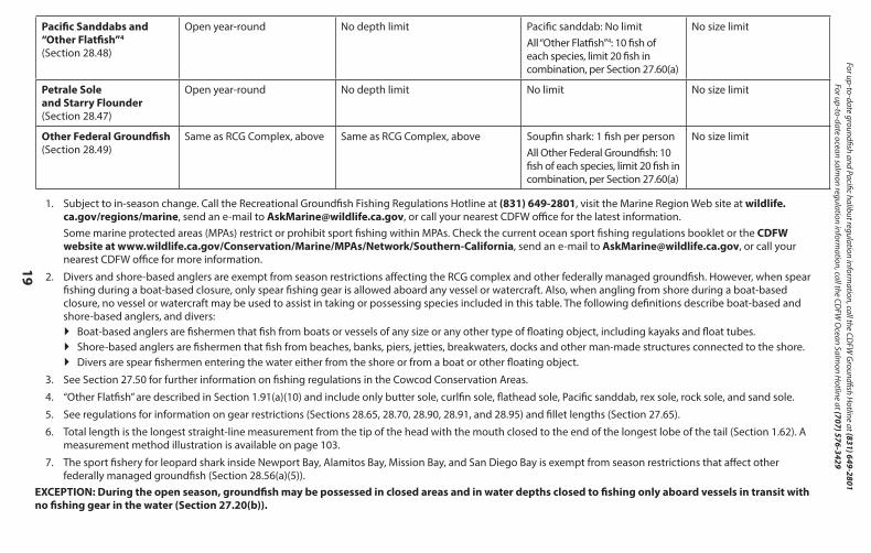
19
For up-to-date groundfish and Pacific halibut regulation information, call the CD
FW G
roundfish Hotline at (831) 649-2801
For up-to-date ocean salmon regulation inform
ation, call the CDFW
Ocean Salm
on Hotline at (707) 576-3429
THESE ROCKFISHES MAY NOT BE TAKEN OR POSSESSED IN CALIFORNIA: Bronzespotted Rockfish, Cowcod, and Yelloweye Rockfish (Section 28.55)
FISHING IS CLOSED year-round, at all depths NO RETENTION at any time (zero fish per person)
Species1 Time Period1,2,3,4 Depth Limit1,2,3,4 Daily Bag Limit1 Minimum Size Limit1,5,6
RCG Complex (includes all species of Rockfish, Cabezon and Greenlings Sections 1.91, 28.55, 28.28 and 28.29)
Boat-based Anglers2:Open: Mar 1-Dec 31Closed: Jan 1-Feb 28Divers, Shore-based Anglers2: Open year-round
Take is prohibited seaward of the 100 fm (600 feet) Rockfish Conservation Area boundary line, which is a series of connected waypoints defined in Federal regulations (50 CFR Part 660, Subpart C).SEE EXCEPTION AT END OF TABLE
10 fish in combination per person, except:Vermilion rockfish: 5 fish per person
See individual species and groups below:Cabezon: 15” total lengthKelp and/or rock greenling: 12” total length
Lingcod (Section 28.27) Same as RCG Complex, above Same as RCG Complex, above 2 fish per person 22” total length
Ocean Whitefish (Section 28.58)
Same as RCG Complex, above Same as RCG Complex, above 10 fish per person No size limit
California Sheephead (Section 28.26)
Same as RCG Complex, above Same as RCG Complex, above 5 fish per person 12” total length
California Scorpionfish (Section 28.54)
Open year-round Same as RCG Complex, above 5 fish per person 10” total length
Leopard Shark7 (Section 28.56)
All Anglers within Newport Bay, Alamitos Bay, San Diego Bay, and Mission Bay1: Open year-roundAll Anglers outside of the above-mentioned bays: Same as RCG Complex, aboveDivers, Shore-based Anglers2: Open year-round
All Anglers within Newport Bay, Alamitos Bay, San Diego Bay, and Mission Bay1: No depth limitAll Anglers outside of the above-mentioned bays: Same as RCG Complex, aboveDivers, Shore-based Anglers2: Same as RCG Complex, above
3 fish per person 36” total length
Pacific Sanddabs and “Other Flatfish”4 (Section 28.48)
Open year-round No depth limit Pacific sanddab: No limitAll “Other Flatfish”4: 10 fish of each species, limit 20 fish in combination, per Section 27.60(a)
No size limit
Petrale Sole and Starry Flounder (Section 28.47)
Open year-round No depth limit No limit No size limit
Other Federal Groundfish (Section 28.49)
Same as RCG Complex, above Same as RCG Complex, above Soupfin shark: 1 fish per personAll Other Federal Groundfish: 10 fish of each species, limit 20 fish in combination, per Section 27.60(a)
No size limit
1. Subject to in-season change. Call the Recreational Groundfish Fishing Regulations Hotline at (831) 649-2801, visit the Marine Region Web site at wildlife.ca.gov/regions/marine, send an e-mail to [email protected], or call your nearest CDFW office for the latest information.Some marine protected areas (MPAs) restrict or prohibit sport fishing within MPAs. Check the current ocean sport fishing regulations booklet or the CDFW website at www.wildlife.ca.gov/Conservation/Marine/MPAs/Network/Southern-California, send an e-mail to [email protected], or call your nearest CDFW office for more information.
2. Divers and shore-based anglers are exempt from season restrictions affecting the RCG complex and other federally managed groundfish. However, when spear fishing during a boat-based closure, only spear fishing gear is allowed aboard any vessel or watercraft. Also, when angling from shore during a boat-based closure, no vessel or watercraft may be used to assist in taking or possessing species included in this table. The following definitions describe boat-based and shore-based anglers, and divers:
` Boat-based anglers are fishermen that fish from boats or vessels of any size or any other type of floating object, including kayaks and float tubes. ` Shore-based anglers are fishermen that fish from beaches, banks, piers, jetties, breakwaters, docks and other man-made structures connected to the shore. ` Divers are spear fishermen entering the water either from the shore or from a boat or other floating object.
3. See Section 27.50 for further information on fishing regulations in the Cowcod Conservation Areas.
4. “Other Flatfish” are described in Section 1.91(a)(10) and include only butter sole, curlfin sole, flathead sole, Pacific sanddab, rex sole, rock sole, and sand sole.
5. See regulations for information on gear restrictions (Sections 28.65, 28.70, 28.90, 28.91, and 28.95) and fillet lengths (Section 27.65).
6. Total length is the longest straight-line measurement from the tip of the head with the mouth closed to the end of the longest lobe of the tail (Section 1.62). A measurement method illustration is available on page 103.
7. The sport fishery for leopard shark inside Newport Bay, Alamitos Bay, Mission Bay, and San Diego Bay is exempt from season restrictions that affect other federally managed groundfish (Section 28.56(a)(5)).
EXCEPTION: During the open season, groundfish may be possessed in closed areas and in water depths closed to fishing only aboard vessels in transit with no fishing gear in the water (Section 27.20(b)).
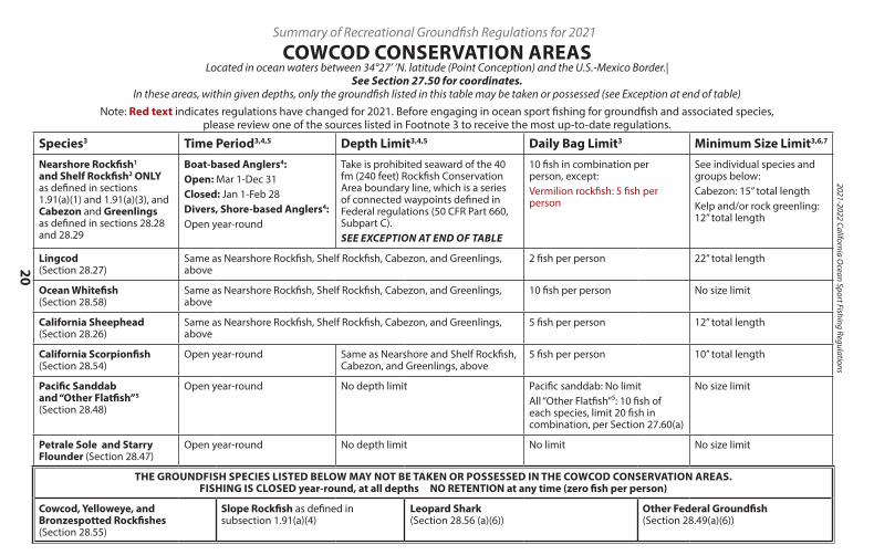
2021-2022 California Ocean Sport Fishing Regulations
20
Summary of Recreational Groundfish Regulations for 2021
COWCOD CONSERVATION AREASLocated in ocean waters between 34°27’ ’N. latitude (Point Conception) and the U.S.-Mexico Border.|
See Section 27.50 for coordinates. In these areas, within given depths, only the groundfish listed in this table may be taken or possessed (see Exception at end of table)
Note: Red text indicates regulations have changed for 2021. Before engaging in ocean sport fishing for groundfish and associated species, please review one of the sources listed in Footnote 3 to receive the most up-to-date regulations.
Species3 Time Period3,4,5 Depth Limit3,4,5 Daily Bag Limit3 Minimum Size Limit3,6,7
Nearshore Rockfish1
and Shelf Rockfish2 ONLY as defined in sections 1.91(a)(1) and 1.91(a)(3), and Cabezon and Greenlings as defined in sections 28.28 and 28.29
Boat-based Anglers4:Open: Mar 1-Dec 31Closed: Jan 1-Feb 28Divers, Shore-based Anglers4:Open year-round
Take is prohibited seaward of the 40 fm (240 feet) Rockfish Conservation Area boundary line, which is a series of connected waypoints defined in Federal regulations (50 CFR Part 660, Subpart C).SEE EXCEPTION AT END OF TABLE
10 fish in combination per person, except:Vermilion rockfish: 5 fish per person
See individual species and groups below:Cabezon: 15” total lengthKelp and/or rock greenling: 12” total length
Lingcod (Section 28.27)
Same as Nearshore Rockfish, Shelf Rockfish, Cabezon, and Greenlings, above
2 fish per person 22” total length
Ocean Whitefish (Section 28.58)
Same as Nearshore Rockfish, Shelf Rockfish, Cabezon, and Greenlings, above
10 fish per person No size limit
California Sheephead (Section 28.26)
Same as Nearshore Rockfish, Shelf Rockfish, Cabezon, and Greenlings, above
5 fish per person 12” total length
California Scorpionfish (Section 28.54)
Open year-round Same as Nearshore and Shelf Rockfish, Cabezon, and Greenlings, above
5 fish per person 10” total length
Pacific Sanddab and “Other Flatfish”5 (Section 28.48)
Open year-round No depth limit Pacific sanddab: No limitAll “Other Flatfish”⁵: 10 fish of each species, limit 20 fish in combination, per Section 27.60(a)
No size limit
Petrale Sole and Starry Flounder (Section 28.47)
Open year-round No depth limit No limit No size limit
THE GROUNDFISH SPECIES LISTED BELOW MAY NOT BE TAKEN OR POSSESSED IN THE COWCOD CONSERVATION AREAS. FISHING IS CLOSED year-round, at all depths NO RETENTION at any time (zero fish per person)
Cowcod, Yelloweye, and Bronzespotted Rockfishes (Section 28.55)
Slope Rockfish as defined in subsection 1.91(a)(4)
Leopard Shark (Section 28.56 (a)(6))
Other Federal Groundfish (Section 28.49(a)(6))
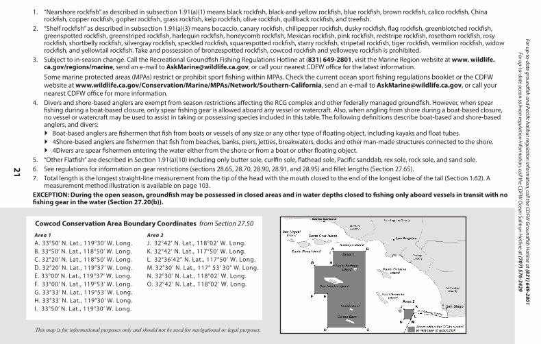
21
For up-to-date groundfish and Pacific halibut regulation information, call the CD
FW G
roundfish Hotline at (831) 649-2801
For up-to-date ocean salmon regulation inform
ation, call the CDFW
Ocean Salm
on Hotline at (707) 576-3429
This map is for informational purposes only and should not be used for navigational or legal purposes.
1. “Nearshore rockfish” as described in subsection 1.91(a)(1) means black rockfish, black-and-yellow rockfish, blue rockfish, brown rockfish, calico rockfish, China rockfish, copper rockfish, gopher rockfish, grass rockfish, kelp rockfish, olive rockfish, quillback rockfish, and treefish.
2. “Shelf rockfish” as described in subsection 1.91(a)(3) means bocaccio, canary rockfish, chilipepper rockfish, dusky rockfish, flag rockfish, greenblotched rockfish, greenspotted rockfish, greenstriped rockfish, harlequin rockfish, honeycomb rockfish, Mexican rockfish, pink rockfish, redstripe rockfish, rosethorn rockfish, rosy rockfish, shortbelly rockfish, silvergray rockfish, speckled rockfish, squarespotted rockfish, starry rockfish, stripetail rockfish, tiger rockfish, vermilion rockfish, widow rockfish, and yellowtail rockfish. Take and possession of bronzespotted rockfish, cowcod rockfish and yelloweye rockfish is prohibited.
3. Subject to in-season change. Call the Recreational Groundfish Fishing Regulations Hotline at (831) 649-2801, visit the Marine Region website at www. wildlife.ca.gov/regions/marine, send an e-mail to [email protected], or call your nearest CDFW office for the latest information.Some marine protected areas (MPAs) restrict or prohibit sport fishing within MPAs. Check the current ocean sport fishing regulations booklet or the CDFW website at www.wildlife.ca.gov/Conservation/Marine/MPAs/Network/Southern-California, send an e-mail to [email protected], or call your nearest CDFW office for more information.
4. Divers and shore-based anglers are exempt from season restrictions affecting the RCG complex and other federally managed groundfish. However, when spear fishing during a boat-based closure, only spear fishing gear is allowed aboard any vessel or watercraft. Also, when angling from shore during a boat-based closure, no vessel or watercraft may be used to assist in taking or possessing species included in this table. The following definitions describe boat-based and shore-based anglers, and divers:
` Boat-based anglers are fishermen that fish from boats or vessels of any size or any other type of floating object, including kayaks and float tubes. ` 4Shore-based anglers are fishermen that fish from beaches, banks, piers, jetties, breakwaters, docks and other man-made structures connected to the shore. ` 4Divers are spear fishermen entering the water either from the shore or from a boat or other floating object.
5. “Other Flatfish” are described in Section 1.91(a)(10) including only butter sole, curlfin sole, flathead sole, Pacific sanddab, rex sole, rock sole, and sand sole.6. See regulations for information on gear restrictions (sections 28.65, 28.70, 28.90, 28.91, and 28.95) and fillet lengths (Section 27.65).7. Total length is the longest straight-line measurement from the tip of the head with the mouth closed to the end of the longest lobe of the tail (Section 1.62). A
measurement method illustration is available on page 103.EXCEPTION: During the open season, groundfish may be possessed in closed areas and in water depths closed to fishing only aboard vessels in transit with no fishing gear in the water (Section 27.20(b)).
Species3 Time Period3,4,5 Depth Limit3,4,5 Daily Bag Limit3 Minimum Size Limit3,6,7
Nearshore Rockfish1
and Shelf Rockfish2 ONLY as defined in sections 1.91(a)(1) and 1.91(a)(3), and Cabezon and Greenlings as defined in sections 28.28 and 28.29
Boat-based Anglers4:Open: Mar 1-Dec 31Closed: Jan 1-Feb 28Divers, Shore-based Anglers4:Open year-round
Take is prohibited seaward of the 40 fm (240 feet) Rockfish Conservation Area boundary line, which is a series of connected waypoints defined in Federal regulations (50 CFR Part 660, Subpart C).SEE EXCEPTION AT END OF TABLE
10 fish in combination per person, except:Vermilion rockfish: 5 fish per person
See individual species and groups below:Cabezon: 15” total lengthKelp and/or rock greenling: 12” total length
Lingcod (Section 28.27)
Same as Nearshore Rockfish, Shelf Rockfish, Cabezon, and Greenlings, above
2 fish per person 22” total length
Ocean Whitefish (Section 28.58)
Same as Nearshore Rockfish, Shelf Rockfish, Cabezon, and Greenlings, above
10 fish per person No size limit
California Sheephead (Section 28.26)
Same as Nearshore Rockfish, Shelf Rockfish, Cabezon, and Greenlings, above
5 fish per person 12” total length
California Scorpionfish (Section 28.54)
Open year-round Same as Nearshore and Shelf Rockfish, Cabezon, and Greenlings, above
5 fish per person 10” total length
Pacific Sanddab and “Other Flatfish”5 (Section 28.48)
Open year-round No depth limit Pacific sanddab: No limitAll “Other Flatfish”⁵: 10 fish of each species, limit 20 fish in combination, per Section 27.60(a)
No size limit
Petrale Sole and Starry Flounder (Section 28.47)
Open year-round No depth limit No limit No size limit
THE GROUNDFISH SPECIES LISTED BELOW MAY NOT BE TAKEN OR POSSESSED IN THE COWCOD CONSERVATION AREAS. FISHING IS CLOSED year-round, at all depths NO RETENTION at any time (zero fish per person)
Cowcod, Yelloweye, and Bronzespotted Rockfishes (Section 28.55)
Slope Rockfish as defined in subsection 1.91(a)(4)
Leopard Shark (Section 28.56 (a)(6))
Other Federal Groundfish (Section 28.49(a)(6))
Cowcod Conservation Area Boundary Coordinates from Section 27.50
Area 1A. 33°50’ N. Lat., 119°30’ W. Long.B. 33°50’ N. Lat., 118°50’ W. Long.C. 32°20’ N. Lat., 118°50’ W. Long.D. 32°20’ N. Lat., 119°37’ W. Long.E. 33°00’ N. Lat., 119°37’ W. Long.F. 33°00’ N. Lat., 119°53’ W. Long.G. 33°33’ N. Lat., 119°53’ W. Long.H. 33°33’ N. Lat., 119°30’ W. Long.I. 33°50’ N. Lat., 119°30’ W. Long.
Area 2 J. 32°42’ N. Lat., 118°02’ W. Long. K. 32°42’ N. Lat., 117°50’ W. Long. L. 32°36’42” N. Lat., 117°50’ W. Long.M. 32°30’ N. Lat., 117° 53’ 30" W. Long.N. 32°30’ N. Lat., 118°02’ W. Long. O. 32°42’ N. Lat., 118°02’ W. Long.
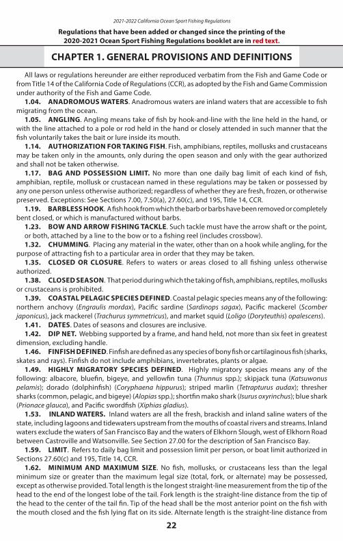
2021-2022 California Ocean Sport Fishing Regulations
22
Regulations that have been added or changed since the printing of the 2020-2021 Ocean Sport Fishing Regulations booklet are in red text.
CHAPTER 1. GENERAL PROVISIONS AND DEFINITIONS
All laws or regulations hereunder are either reproduced verbatim from the Fish and Game Code or from Title 14 of the California Code of Regulations (CCR), as adopted by the Fish and Game Commission under authority of the Fish and Game Code.
1.04. ANADROMOUS WATERS. Anadromous waters are inland waters that are accessible to fish migrating from the ocean.
1.05. ANGLING. Angling means take of fish by hook-and-line with the line held in the hand, or with the line attached to a pole or rod held in the hand or closely attended in such manner that the fish voluntarily takes the bait or lure inside its mouth.
1.14. AUTHORIZATION FOR TAKING FISH. Fish, amphibians, reptiles, mollusks and crustaceans may be taken only in the amounts, only during the open season and only with the gear authorized and shall not be taken otherwise.
1.17. BAG AND POSSESSION LIMIT. No more than one daily bag limit of each kind of fish, amphibian, reptile, mollusk or crustacean named in these regulations may be taken or possessed by any one person unless otherwise authorized; regardless of whether they are fresh, frozen, or otherwise preserved. Exceptions: See Sections 7.00, 7.50(a), 27.60(c), and 195, Title 14, CCR.
1.19. BARBLESS HOOK. A fish hook from which the barb or barbs have been removed or completely bent closed, or which is manufactured without barbs.
1.23. BOW AND ARROW FISHING TACKLE. Such tackle must have the arrow shaft or the point,or both, attached by a line to the bow or to a fishing reel (includes crossbow).1.32. CHUMMING. Placing any material in the water, other than on a hook while angling, for the
purpose of attracting fish to a particular area in order that they may be taken.1.35. CLOSED OR CLOSURE. Refers to waters or areas closed to all fishing unless otherwise
authorized.1.38. CLOSED SEASON. That period during which the taking of fish, amphibians, reptiles, mollusks
or crustaceans is prohibited.1.39. COASTAL PELAGIC SPECIES DEFINED. Coastal pelagic species means any of the following:
northern anchovy (Engraulis mordax), Pacific sardine (Sardinops sagax), Pacific mackerel (Scomber japonicus), jack mackerel (Trachurus symmetricus), and market squid (Loligo (Doryteuthis) opalescens).
1.41. DATES. Dates of seasons and closures are inclusive.1.42. DIP NET. Webbing supported by a frame, and hand held, not more than six feet in greatest
dimension, excluding handle.1.46. FINFISH DEFINED. Finfish are defined as any species of bony fish or cartilaginous fish (sharks,
skates and rays). Finfish do not include amphibians, invertebrates, plants or algae. 1.49. HIGHLY MIGRATORY SPECIES DEFINED. Highly migratory species means any of the
following: albacore, bluefin, bigeye, and yellowfin tuna (Thunnus spp.); skipjack tuna (Katsuwonus pelamis); dorado (dolphinfish) (Coryphaena hippurus); striped marlin (Tetrapturus audax); thresher sharks (common, pelagic, and bigeye) (Alopias spp.); shortfin mako shark (Isurus oxyrinchus); blue shark (Prionace glauca), and Pacific swordfish (Xiphias gladius).
1.53. INLAND WATERS. Inland waters are all the fresh, brackish and inland saline waters of the state, including lagoons and tidewaters upstream from the mouths of coastal rivers and streams. Inland waters exclude the waters of San Francisco Bay and the waters of Elkhorn Slough, west of Elkhorn Road between Castroville and Watsonville. See Section 27.00 for the description of San Francisco Bay.
1.59. LIMIT. Refers to daily bag limit and possession limit per person, or boat limit authorized in Sections 27.60(c) and 195, Title 14, CCR.
1.62. MINIMUM AND MAXIMUM SIZE. No fish, mollusks, or crustaceans less than the legal minimum size or greater than the maximum legal size (total, fork, or alternate) may be possessed, except as otherwise provided. Total length is the longest straight-line measurement from the tip of the head to the end of the longest lobe of the tail. Fork length is the straight-line distance from the tip of the head to the center of the tail fin. Tip of the head shall be the most anterior point on the fish with the mouth closed and the fish lying flat on its side. Alternate length is the straight-line distance from
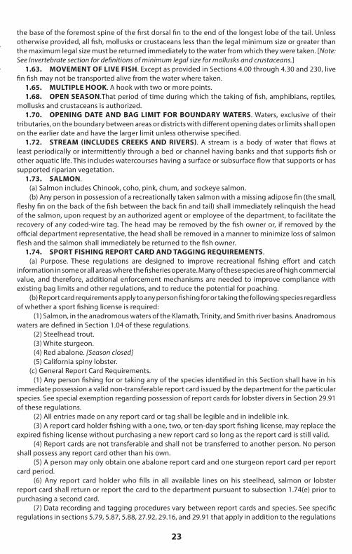
23
the base of the foremost spine of the first dorsal fin to the end of the longest lobe of the tail. Unless otherwise provided, all fish, mollusks or crustaceans less than the legal minimum size or greater than the maximum legal size must be returned immediately to the water from which they were taken. [Note: See Invertebrate section for definitions of minimum legal size for mollusks and crustaceans.]
1.63. MOVEMENT OF LIVE FISH. Except as provided in Sections 4.00 through 4.30 and 230, live fin fish may not be transported alive from the water where taken.
1.65. MULTIPLE HOOK. A hook with two or more points.1.68. OPEN SEASON.That period of time during which the taking of fish, amphibians, reptiles,
mollusks and crustaceans is authorized.1.70. OPENING DATE AND BAG LIMIT FOR BOUNDARY WATERS. Waters, exclusive of their
tributaries, on the boundary between areas or districts with different opening dates or limits shall open on the earlier date and have the larger limit unless otherwise specified.
1.72. STREAM (INCLUDES CREEKS AND RIVERS). A stream is a body of water that flows at least periodically or intermittently through a bed or channel having banks and that supports fish or other aquatic life. This includes watercourses having a surface or subsurface flow that supports or has supported riparian vegetation.
1.73. SALMON. (a) Salmon includes Chinook, coho, pink, chum, and sockeye salmon.(b) Any person in possession of a recreationally taken salmon with a missing adipose fin (the small,
fleshy fin on the back of the fish between the back fin and tail) shall immediately relinquish the head of the salmon, upon request by an authorized agent or employee of the department, to facilitate the recovery of any coded-wire tag. The head may be removed by the fish owner or, if removed by the official department representative, the head shall be removed in a manner to minimize loss of salmon flesh and the salmon shall immediately be returned to the fish owner.
1.74. SPORT FISHING REPORT CARD AND TAGGING REQUIREMENTS.(a) Purpose. These regulations are designed to improve recreational fishing effort and catch
information in some or all areas where the fisheries operate. Many of these species are of high commercial value, and therefore, additional enforcement mechanisms are needed to improve compliance with existing bag limits and other regulations, and to reduce the potential for poaching.
(b) Report card requirements apply to any person fishing for or taking the following species regardless of whether a sport fishing license is required:
(1) Salmon, in the anadromous waters of the Klamath, Trinity, and Smith river basins. Anadromous waters are defined in Section 1.04 of these regulations.
(2) Steelhead trout.(3) White sturgeon.(4) Red abalone. [Season closed](5) California spiny lobster.
(c) General Report Card Requirements.(1) Any person fishing for or taking any of the species identified in this Section shall have in his
immediate possession a valid non-transferable report card issued by the department for the particular species. See special exemption regarding possession of report cards for lobster divers in Section 29.91 of these regulations.
(2) All entries made on any report card or tag shall be legible and in indelible ink.(3) A report card holder fishing with a one, two, or ten-day sport fishing license, may replace the
expired fishing license without purchasing a new report card so long as the report card is still valid.(4) Report cards are not transferable and shall not be transferred to another person. No person
shall possess any report card other than his own.(5) A person may only obtain one abalone report card and one sturgeon report card per report
card period.(6) Any report card holder who fills in all available lines on his steelhead, salmon or lobster
report card shall return or report the card to the department pursuant to subsection 1.74(e) prior to purchasing a second card.
(7) Data recording and tagging procedures vary between report cards and species. See specific regulations in sections 5.79, 5.87, 5.88, 27.92, 29.16, and 29.91 that apply in addition to the regulations
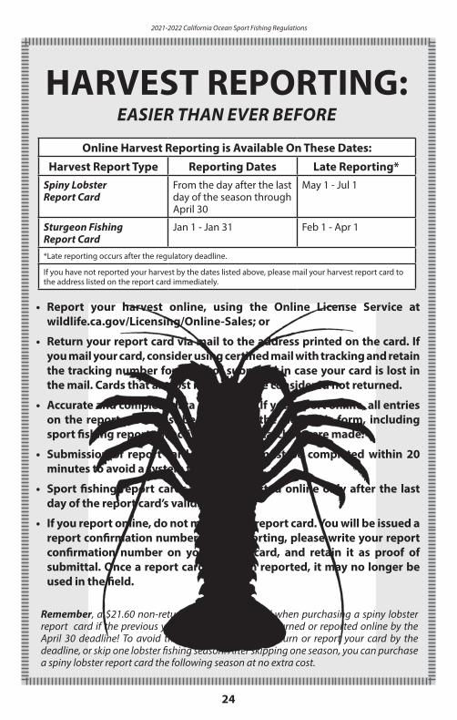
2021-2022 California Ocean Sport Fishing Regulations
24
HARVEST REPORTING:EASIER THAN EVER BEFORE
Online Harvest Reporting is Available On These Dates:
Harvest Report Type Reporting Dates Late Reporting*Spiny Lobster Report Card
From the day after the last day of the season through April 30
May 1 - Jul 1
Sturgeon Fishing Report Card
Jan 1 - Jan 31 Feb 1 - Apr 1
*Late reporting occurs after the regulatory deadline.
If you have not reported your harvest by the dates listed above, please mail your harvest report card to the address listed on the report card immediately.
• Report your harvest online, using the Online License Service at wildlife.ca.gov/Licensing/Online-Sales; or
• Return your report card via mail to the address printed on the card. If you mail your card, consider using certified mail with tracking and retain the tracking number for proof of submittal in case your card is lost in the mail. Cards that are lost in the mail are considered not returned.
• Accurate and complete data is required. If you report online, all entries on the report card must be entered in the electronic form, including sport fishing reports of activity when no catches were made.
• Submission of report card data online must be completed within 20 minutes to avoid a system time out.
• Sport fishing report cards may be reported online only after the last day of the report card’s validity.
• If you report online, do not mail in your report card. You will be issued a report confirmation number. After reporting, please write your report confirmation number on your report card, and retain it as proof of submittal. Once a report card has been reported, it may no longer be used in the field.
Remember, a $21.60 non-return fee will be charged when purchasing a spiny lobster report card if the previous year’s report card is not returned or reported online by the April 30 deadline! To avoid the fee, you may either return or report your card by the deadline, or skip one lobster fishing season. After skipping one season, you can purchase a spiny lobster report card the following season at no extra cost.
25
of this Section.(d) Report Card Return and Reporting Requirements
(1) Report card holders shall return or report their salmon, steelhead, sturgeon, or abalone report cards to the department pursuant to subsection 1.74(e) by January 31 of the following year.
(A) Any report card holder who fails to return or report his salmon, steelhead, sturgeon, or abalone report card to the department by the deadline may be restricted from obtaining the same card in a subsequent license year or may be subject to an additional fee for the issuance of the same card in a subsequent license year.
(2) Report card holders shall return or report their lobster report cards pursuant to subsection 1.74(e) by April 30 following the close of the lobster season for which the card was issued.
(A) Any report card holder who fails to return or report his or her lobster report card by April 30 following the close of the lobster season specified on the card shall be subject to a nonrefundable non-return fee specified in Section 701, in addition to the annual report card fee, for the issuance of a lobster report card in the subsequent fishing season.
(e) Report Card Return and Reporting Mechanisms:(1) By mail or in person at the address specified on the card. A report card returned by mail shall
be postmarked by the date applicable to that card as specified in subsection 1.74(d)(1) or 1.74(d)(2).(2) Online through the department’s license sales service website by the date applicable to that
card as specified in subsection 1.74(d)(1) or 1.74(d)(2).(3) If a report card is submitted by mail and not received by the department, it is considered not
returned unless the report card holder reports his or her report card as lost pursuant to subsection 1.74(f ).(f ) Lost report cards.
(1) Any report card holder who loses his report card shall submit an affidavit, signed under penalty of perjury, in person to a department license sales office containing all of the following information:
(A) A statement containing the report card holder’s full name confirming that the originally issued report card cannot be recovered.
(B) A statement containing the report card holder’s best recollection of the prior catch records that were entered on the report card that was lost.
(C) A statement describing the factual circumstances surrounding the loss of the card.(2) An affidavit for a lost report card shall be presented at a department license sales office, by the
date applicable to that card specified in subsection 1.74(d)(1) or 1.74(d)(2) to be considered returned.(3) Notwithstanding subsection 1.74(c)(5), any report card holder who loses his report card during
the period for which it is valid may replace the lost report card by submitting an affidavit as described in subsection 1.74(f )(1) and payment of the report card fee and replacement processing fee specified in Section 701.
(A) Based on the information provided in the written affidavit for abalone and sturgeon report cards, the department shall issue only the number of tags that were reported unused on the previously issued report card.
1.76. SPEARFISHING. The taking of fish by spear or hand by persons who are in the water and may be using underwater goggles, face plates, breathing tubes, SCUBA or other artificial underwater breathing device.
1.80. TAKE. Hunt, pursue, catch, capture or kill fish, amphibians, reptiles, mollusks, crustaceans or invertebrates or attempting to do so.
1.84. TITLES AND SECTION NUMBERS. All titles and headings used in these regulations are a part thereof. All section numbers cited refer to these regulations unless otherwise specified.
1.87. WASTE OF FISH. It is unlawful to cause or permit any deterioration or waste of any fish taken in the waters of this state.
1.88. PUBLIC PIER. A public pier is a publicly owned man-made structure that has the following characteristics: is connected, above the mean high tide, to the main coastline or to the landmass of a named and charted natural island; has unrestricted free access for the general public; and has been built or currently functions for the primary purpose of allowing angling access to ocean waters.
Additionally, publicly owned jetties or breakwaters that are connected to land, as described above, that have free unrestricted access for the general public and whose purpose it is to form the most seaward protective boundary of an ocean harbor are public piers. Jetties, breakwaters, promenades,
2021-2022 California Ocean Sport Fishing Regulations
26
sea walls, moles, docks, linings, barriers and other structures that are not the most seaward protective boundary of an ocean harbor, are not public piers.
1.90. NEARSHORE FISH STOCKS, NEARSHORE FISHERIES, NEARSHORE WATERS, AND SHALLOW NEARSHORE ROCKFISH DEFINED.
(a) Under the authority of Section 8587.1 of the Fish and Game Code, Section 8586 of the Fish and Game Code is made inoperative.
(b) “Nearshore fish stocks” means any of the following:(1) black rockfish (Sebastes melanops),(2) black-and-yellow rockfish (Sebastes chrysomelas),(3) blue rockfish (Sebastes mystinus),(4) brown rockfish (Sebastes auriculatus),(5) cabezon (Scorpaenichthys marmoratus),(6) calico rockfish (Sebastes dallii),(7) California scorpionfish (sculpin) (Scorpaena guttata),(8) California sheephead (Semicossyphus pulcher), (9) China rockfish (Sebastes nebulosus),(10) copper rockfish (Sebastes caurinus),(11) gopher rockfish (Sebastes carnatus),(12) grass rockfish (Sebastes rastrelliger),(13) greenlings of the genus Hexagrammos,(14) kelp rockfish (Sebastes atrovirens),(15) monkeyface eel (Cebidichthys violaceus),(16) olive rockfish (Sebastes serranoides),(17) quillback rockfish (Sebastes maliger), and(18) treefish (Sebastes serriceps).
(c) “Nearshore fisheries” means the commercial or recreational taking, possession, or landing of any species of nearshore fish stocks.
(d) “Nearshore waters” means ocean waters including around offshore rocks and islands extending from the shore to a depth of 20 fathoms.
(e) “Shallow nearshore rockfish” means a subgroup of rockfishes (genus Sebastes) including only black-and-yellow rockfish, China rockfish, gopher rockfish, grass rockfish, and kelp rockfish.
1.91. FEDERAL GROUNDFISH AND ROCKFISH, CABEZON AND GREENLING (RCG) COMPLEX.
Before engaging in ocean sport fishing for groundfish
and associated species please access one of the sources listed on page 8 for up-to-date information
concerning season dates, allowed fishing
depths, and other regulations.
(a) The species or species groups listed in subsections 1.91(a)(1) through 1.91(a)(12) constitute “federal groundfish” and are managed under the Federal Pacific Coast Groundfish Fishery Management Plan:
(1) “Nearshore Rockfish,” which means the following species of rockfish: black rockfish (Sebastes melanops), black and yellow rockfish (S. chrysomelas), blue rockfish (S. mystinus), brown rockfish (S. auriculatus), calico rockfish (S. dalli), China rockfish (S. nebulosus), copper rockfish (S. caurinus), gopher rockfish (S. carnatus), grass rockfish (S. rastrelliger), kelp rockfish (S. atrovirens), olive rockfish (S. serranoides), quillback rockfish (S. maliger), treefish (S. serriceps)
(2) “California Scorpionfish” (Scorpaena guttata)(3) “Shelf Rockfish” which means the following species of rockfish: bocaccio (Sebastes paucispinis),
bronzespotted rockfish (S. gilli), canary rockfish (S. pinniger), chilipepper (S. goodei), cowcod (S. levis), dusky rockfish (S. ciliatus), flag rockfish (S. rubrivinctus), greenblotched rockfish (S. rosenblatti), greenspotted rockfish (S. chlorostictus), greenstriped rockfish (S. elongatus), harlequin rockfish (S. variegatus), honeycomb rockfish (S. umbrosus), Mexican rockfish (S. macdonaldi), pink rockfish (S. eos), redstripe rockfish (S. proriger), rosethorn rockfish (S. helvomaculatus), rosy rockfish (S. rosaceus), shortbelly rockfish (S. jordani), silvergray rockfish (S. brevispinis), speckled rockfish (S. ovalis), squarespot rockfish (S. hopkinsi), starry rockfish (S. constellatus), stripetail rockfish (S. saxicola), tiger rockfish (S. nigrocinctus), vermilion rockfish (S. miniatus), widow rockfish (S. entomelas), yelloweye rockfish (S. ruberrimus), yellowtail rockfish (S. flavidus)
(4) “Slope Rockfish” which means the following species of rockfish: aurora rockfish (Sebastes aurora), bank rockfish (S. rufus), blackgill rockfish (S. melanostomus), darkblotched rockfish (S. rameri), Pacific ocean perch (S. alutus), redbanded rockfish (S. babcocki), rougheye rockfish (S. aleutianus), sharpchin
27
rockfish (S. zacentrus), shortraker rockfish (S. borealis), splitnose rockfish (S. diploproa), yellowmouth rockfish (S. reedi)
(5) “Sharks”, including only leopard shark (Triakis semifasciata), soupfin shark (Galeorhinus galeus), and spiny dogfish (Squalus acanthias)
(6) “Skates”, which means big skate (Raja binoculata), California skate (R. inornata), and longnose skate (R. rhina), roughtail/black skate (Bathyraja trachura), Aleutian skate (B. aleutica), Bering/sandpaper skate (R. interrupta) and all other genera and species of skates in the families Arhynchobatidae and Rajidae that occur off California
(7) “Roundfish”, including only cabezon (Scorpaenichthys marmoratus), kelp greenling (Hexagrammos decagrammus), lingcod (Ophiodon elongatus), Pacific cod (Gadus macrocephalus), Pacific whiting (Merluccius productus), and sablefish (Anoplopoma fimbria)
(8) “Thornyheads”, which means longspine thornyhead (Sebastolobus altivelis), and shortspine thornyhead (Sebastolobus alascanus)
(9) “Federally Managed Flatfish”, including only arrowtooth flounder (arrowtooth turbot) (Atheresthes stomias), Dover sole (Microstomus pacificus), English sole (Parophrys vetulus), petrale sole (Eopsetta jordani), and starry flounder (Platichthys stellatus)
(10) “Other Flatfish”, including only butter sole (Isopsetta isolepis), curlfin sole (Pleuronichthys decurrens), flathead sole (Hippoglossoides elassodon), Pacific sanddab (Citharichthys sordidus), rex sole (Glyptocephalus zachirus), rock sole (Lepidopsetta bilineata), and sand sole (Psettichthys melanostictus)
(11) “Other fish”, including only ratfish (Hydrolagus colliei), finescale codling (Antimora microlepis), Pacific grenadier (rattail) (Coryphaenoides acrolepis) and all other genera and species of grenadiers in the family Macrouridae that occur off California
(12) All genera and species of the family Scorpaenidae that occur off California and not specifically listed in (a)(1) through (a)(4) or (a)(8) above
(b) "RCG Complex" means all species of rockfish (Sebastes), cabezon (Scorpaenichthys marmoratus),and kelp and rock greenlings (genus Hexagrammos).
190. FISHING ACTIVITY RECORDS.(a) Pursuant to sections 7923 and 8026, Fish and Game Code, the owner and operator of a commercial
fishing vessel or the holder of a commercial fishing license or permit participating in specified fisheries, and the owner and license holder of a commercial passenger fishing vessel shall keep and submit a complete and accurate record of fishing activities.
(b) Fishing activity records shall be kept on paper forms provided by the department or on the electronic version on the department web site at https://apps.wildlife.ca.gov/marinelogs, hereafter referred to as logbook(s) for purposes of this section.
(c) Logbooks shall be kept on the vessel while it is engaged in, or returning from, fishing operations and shall be immediately surrendered upon demand to a peace officer of the department. Unless otherwise specified in Title 14, CCR, logbooks shall be completed immediately with all available information when any of the following first occurs:
(1) prior to passengers or crew disembarking from the vessel, or (2) at the time of receipt, purchase, or transfer of fish, or(3) at the end of the calendar day (24-hour clock) during fishing activity through the night.
(d) If the logbook is kept on paper it shall be delivered to the department at 4665 Lampson Avenue, Suite C, Los Alamitos, CA 90720, or such other department office as may be specified in regulation on or before the 10th day of each month following the month to which the records pertain. Logbooks that are mailed shall be postmarked on or before the 10th day of each month following the month to which the records pertain.
(e) Failure to keep and submit required logbooks may result in revocation or suspension (including non-renewal) of the license or permit for the taking of all fish or for the particular species for which the records are required, by the department, for a period not to exceed one year. Any revocation, suspension or nonrenewal may be appealed to the commission.
195. REPORT OF FISH TAKEN TO BE MADE BY OWNER OF BARGE OR VESSEL FOR HIRE AND BOAT LIMITS.
(a) Pursuant to Section 190 the owner/operator of a commercial passenger fishing vessel shall keepa logbook of fishing activities.
2021-2022 California Ocean Sport Fishing Regulations
28
REMINDERS FOR PARTY/CHARTER BOAT OWNERS, OPERATORS, and ANGLERS
The cooperation of owners and operators of party/charter boats, also known as commercial passenger fishing vessels (CPFVs) has been critical to the success of the California Recreational Fisheries Survey (CRFS) since its inception in 2004. The data collected by CRFS is used to estimate the catch (total number of fish by species) and effort (total number of fishing trips) of saltwater recreational anglers, and to assist in the establishment of regulations aimed to maximize fishing opportunities while conserving fisheries for future use. CRFS samplers interview anglers and crew, and examine catch onboard CPFVs both at sea and dockside. CPFV owners and operators are reminded that accurate catch and effort estimates depend on access to both kept and discarded catch information by CRFS samplers. In addition, CRFS samplers must observe both open party and chartered trips, and must gather effort data frequently to ensure the best possible estimates. By law (California Code of Regulations T-14, Section 105.5), owners or operators of CPFVs must carry and accommodate CRFS samplers on fishing trips when asked. If sampler coverage of a trip is denied by the owner or operator of the vessel, the CDFW may request a written explanation for the denial, and CPFV owners or operators who deny sampler coverage of a trip may have their fishing permits or licenses revoked. Anglers are encouraged to answer CRFS samplers’ questions; however, angler participation in the survey is voluntary. CRFS samplers will ask anglers aboard CPFVs about the species they kept and discarded, how often they fish, and their zip code. CRFS samplers will also ask the crew about fishing target(s), descending device usage, and bottom depth. Onboard the vessel, while anglers are fishing, CRFS samplers will collect data on catch rates, species composition, fishing locations, and length of fish that the anglers do not keep. After anglers have completed fishing for the day, CRFS samplers will record the lengths and weights of fish that were kept. Further information about CRFS, and a link to recreational catch and effort estimates, is available on the CDFW website at www.wildlife.ca.gov/conservation/marine/CRFS.
(1) The form entitled Commercial Passenger Fishing Vessel Log, Central and Northern California, DFW 195A (Rev 01/16), incorporated by reference herein, shall be used when the vessel is engaged in fishing north of Point Conception.
(2) The form entitled Commercial Passenger Fishing Vessel Log, Southern California, DFW 195B (Rev 01/16), incorporated by reference herein, shall be used when the vessel is engaged in fishing south of Point Conception.
(b) The owner(s) and/or operator(s) of each vessel required to obtain a license under Section 7920 of the Fish and Game Code shall post a notice in a prominent place on the vessel giving information to fishermen on license requirements, bag limits, and other pertinent information. This notice shall be furnished by the department.
(c) Both the vessel owner(s) and/or operator(s) shall be responsible for keeping accurate records and insuring the vessel is in compliance with sub-sections (a) and (b) above.
(d) All fishing activity records are confidential pursuant to Fish and Game Code Sections 7923 and 8022 and Government Code Sections 6276 and 6276.10.
(e) Boat Limits: When two or more persons licensed or otherwise authorized to sport fish in ocean waters off California or in the San Francisco Bay District, as defined in Section 27.00, are angling for finfish in these waters aboard a vessel licensed under Section 7920, fishing by these persons (to include vessel operator(s) and crew members where licensed to sportfish under their own individual limits) may continue until the passenger’s boat limits of those finfish are taken and possessed aboard the vessel as authorized under this section.
(1) For purposes of this section, the vessel operator(s) and crew members are not passengers and may not take fish towards obtaining boat limits for passengers except for casting, setting trolling gear, gaffing or netting fish, but may take fish during a fishing trip for their personal use only. Vessel operator(s) and crew members may assist passengers in other activities including, but not limited to, obtaining bait, chumming, baiting and untangling hooks and lines, identifying, dispatching, filleting, counting, bagging and otherwise handling fish taken by passengers. Upon completion of a fishing trip, the vessel operator(s) and crew members may only possess fish that are part of their own personal bag limit not to exceed authorized sportfishing daily bag and possession limits.
(2) Fish taken by operator(s) and crew members for personal use pursuant to (e)(1) above must
29
be separated from fish taken under a boat limit and labeled in a manner that they can be identified as an individual operator’s or crew members fish. Operator(s) and crew members are also prohibited from giving all or part of their individual limit to any passenger during or after a trip.
(3) The authorization for boat limits aboard a vessel does not apply to fishing trips originating in California where fish are taken in other jurisdictions.
(4) A boat limit for a species or species group is equal to the number of passengers aboard the vessel that are licensed or otherwise authorized to sport fish in ocean waters off California or in the San Francisco Bay District multiplied by the individual daily bag limit authorized for a species or species group. For purposes of this section, the number of passengers shall not include the vessel operator(s) and crew members. It is unlawful to exceed the boat limit at any time.
(5) Prior to the departure on a fishing trip of a vessel that is licensed under Fish and Game Code Section 7920, the number of fishers, to include passengers, guests, operators and crew who will be fishing, shall be recorded under “number of fishers” on the logbook for that trip. In addition, the number of vessel operator(s) and crew members who will fish for that trip shall be recorded in the space to the right of the operator’s signature on the logbook.
(6) Upon completion of a sport fishing trip aboard a vessel reporting under this section, each licensed or otherwise authorized angler may not possess more than the daily bag and possession limits. For the purposes of this section, a fishing trip is completed at the time a person disembarks from the vessel and individual possession limits apply.
(7) Species for which no daily bag limit exists are not included in the boat limit.(f ) Where boat limits are provided for in this section, the vessel operator(s) and crew members may be
cited for violations occurring aboard the vessel, including but not limited to violations of the following:(1) Overlimits(2) Possession of prohibited species(3) Minimum size limits(4) Fish taken out of season or in closed areas
(g) Boat limits are not authorized for sturgeon fishing and shall not apply to the take, possession or retention of sturgeon.
CHAPTER 4. OCEAN FISHING
27.00 DEFINITION. The Ocean and San Francisco Bay District consists of the Ocean and San Francisco Bay, as described herein. The Ocean is the open seas adjacent to the coast and islands and the waters of open or enclosed bays contiguous to the ocean, including the waters of Elkhorn Slough, west of Elkhorn Road between Castroville and Watsonville. San Francisco Bay is the waters of San Francisco and San Pablo bays plus all their tidal bays, sloughs, estuaries, and tidal portions of their rivers and streams between the Golden Gate Bridge and the west Carquinez Bridge. For purposes of this section, waters downstream of the Trancas Bridge on the Napa River, downstream of the Highway 121 Bridge on Sonoma Creek, and downstream of the Payran Street Bridge on the Petaluma River are tidal portions of the Napa River, Sonoma Creek, and Petaluma River, respectively. Also see Section 1.53.
27.05. CHUMMING. Chumming, including chumming with live bait, is permitted.27.10. LIVE BAIT RESTRICTIONS. Tilapia may not be used or possessed for use as bait in ocean waters.27.15. MULTI-DAY FISHING TRIPS. The following provisions apply to anglers and to boat owners
and operators when a Declaration for a Multi-Day Fishing Trip has been filed with the department.(a) Provisions related to the angler: Up to three daily bag and possession limits of saltwater fin fish,
lobster and rock scallops and up to two daily bag and possession limits of abalone are allowed for a person fishing during a multiday trip in ocean waters from a boat whose owner or operator has filed a Declaration for Multi-Day Fishing Trip, pursuant to the provisions of sub-section (b) below.
(1) The provisions of this section do not authorize any person to take more than one daily bag limit of fish during one calendar day.
(2) The provisions of this section do not apply to the taking and possession of salmon, steelhead, striped bass and sturgeon.
(b) Provisions related to the boat owner or operator who has filed for a Declaration for a Multi-Day Fishing Trip:
2021-2022 California Ocean Sport Fishing Regulations
30
(1) The owner or operator of a boat shall submit to the nearest department office a Declaration for Multi-Day Fishing Trip and payment as specified in Section 701. The Declaration for Multi-Day Fishing Trip shall include the following information:
(A) Place, date and time of departure of the boat.(B) Place, date and estimated time of return of the boat.(C) Name of the boat.(D) Date and hour Declaration mailed or delivered to the department.(E) Additional requirements for Commercial Passenger Fishing Vessels:
1. The Commercial Boat Registration Number issued pursuant to Fish and Game Code Section 7880.2. Copy of passenger manifest if fishing within 10 miles of the mainland shore of California.
(2) The Declaration for Multi-Day Fishing Trip must be submitted to the nearest department office in order for any person aboard such boat to possess more than one bag limit of saltwater fin fish, abalone, lobster and rock scallops. If mailed, the Declaration for Multi-Day Fishing Trip must be received at least 48 hours prior to the date of the boat’s departure. If the 48-hours advance notice is not met, the original copy of the form signed by an authorized department representative must be aboard the vessel during the trip. Forms will be accepted for authorization only during business hours of 8:00 a.m. to 5:00 p.m.
(3) A Declaration for Multi-Day Fishing Trip may not be filed for a trip unless the trip is continuous and extends for a period of 12 hours or more on the first and last days of the trip and no berthing or docking is permitted within five miles of the mainland shore.
(4) The owner or operator of a boat filing a Declaration for Multi-Day Fishing Trip shall prepare such form in duplicate, and shall require the duplicate to be posted in full view of the passengers aboard the boat.
(5) All passengers must disembark at place of return as stated on the Declaration for Multi-Day Fishing Trip.
Fin Fish — General
27.56. TAKE GENERAL. Except as otherwise provided, there are no closed seasons, closed hours or minimum size limits on fin fish in the Pacific Ocean including all saltwater bays except that in San Francisco Bay between the Golden Gate Bridge and the Carquinez Bridge and in saltwater tributaries to the bay within the area bounded by Interstate 80 and Highways 17, 101 and 37 finfish may not be taken between one hour after sunset to one hour before sunrise except from shore or piers.
Fin Fish — Minimum Size Limits, Bag and Possession Limits, and Seasons
27.20. GROUNDFISH MANAGEMENT AREAS, SEASONS, DEPTHS, EXCEPTIONS, AND FISHERY CLOSURE/RULE CHANGE PROCESS DESCRIBED. Regulations that follow in sections 27.25 through 27.50 define fishing seasons and depth constraints that are effective within each Groundfish Management Area. These sections apply to take and possession of federally-managed groundfish species as defined in Section 1.91 and California sheephead, ocean whitefish, and all greenlings of the genus Hexagrammos, which are state-managed species known to associate with federal groundfish.
(a) Depth Constraints: A depth constraint means that during the open season, the aforementioned species may not be taken or possessed in water depths deeper than the specified depth. Two specific definitions of “depth” apply off California. In waters shallower than 30 fathoms, “depth” is defined by general depth contour lines. In waters equal to or deeper than 30 fathoms, “depth” is defined by approximating a particular depth contour by connecting the appropriate set of waypoints adopted in Federal regulations (50 CFR Part 660, Subpart C).
(b) General Provisions.(1) Take and Possession: During any open season in any Groundfish Management Area, in waters
deeper than where fishing is authorized or within special closure areas established within a Groundfish Management Area, it is unlawful to take or possess the aforementioned species except as provided in subsections (b)(1) (A) through (b)(1)(D) below and sections 27.25 through 27.50 of these regulations.
(A) Transit: The aforementioned species may be possessed aboard a vessel in transit through a closed area with no fishing gear deployed in the water.
(B) “Other Flatfish” as defined in subsection 1.91(a)(10), petrale sole and starry flounder may be
31
taken or possessed in all depths year-round.(C) Shore Based Angling: When angling from shore (includes beaches, banks, piers, jetties,
breakwaters, docks, and other man-made structures connected to the shore), all species may be taken or possessed year-round (See 27.50(b)(1) for exceptions in the Cowcod Conservation Areas). No vessel or watercraft (motorized or non-motorized) may be used to assist in taking or possessing these species while angling from shore under this provision.
(D) Diving or Spearfishing: When diving or spearfishing, as authorized in Section 28.90, all species may be taken or possessed year-round (See 27.50(b)(2)) for exceptions in the Cowcod Conservation Areas). When boat-based groundfish fishing is closed, all types of fishing gear, except spearfishing gear, are prohibited to be aboard the vessel or watercraft (motorized or non-motorized) while spearfishing for the purpose of taking or possessing these species under this provision.
(c) Closed Season: During any closed season in any Groundfish Management Area, it is unlawful to take or possess the aforementioned species regardless of depth, except as provided in subsections (b)(1)(A) through (b)(1)(D) above and sections 27.25 through 27.50 of these regulations.
(d) California Rockfish Conservation Area: Within any Groundfish Management Area, waters that are closed for these species during specified times and/or closed in specified depths shall be known as the California Rockfish Conservation Area. See Section 27.51.
(e) Fishery closure and/or rule change: When the department determines, based on the best available scientific information, that an annual harvest limit [optimum yield (OY), annual catch limit (ACL), annual catch target (ACT), recreational harvest guideline, or recreational harvest target] established in regulation by the NOAA Fisheries (National Marine Fisheries Service) for any species of federally-managed groundfish or aggregate group of federal groundfish species has been exceeded or is projected to be exceeded prior to the end of the year or that catches are less than predicted, the following rule changes may occur:
(1) The department may modify the seasons and/or depth constraints for any species of federally-managed groundfish or aggregate group of federal groundfish species, California sheephead, ocean whitefish, and all greenlings of the genus Hexagrammos. Season and/or depth modifications may differ by Groundfish Management Area, time of year, mode of fishing, or gear utilized.
(2) The department may adjust existing bag or sub-bag limits or establish additional bag or sub-bag limits as needed for any species of federally-managed groundfish or aggregate group of federal groundfish species, California sheephead, ocean whitefish, and all greenlings of the genus Hexagrammos. Bag limits may differ by Groundfish Management Area, time of year, mode of fishing, or gear utilized.
(3) The department may adjust existing size limits or establish additional size limits as needed for any species of federally-managed groundfish or aggregate group of federal groundfish species, California sheephead, ocean whitefish, and all greenlings of the genus Hexagrammos. Size limits may differ by Groundfish Management Area, time of year, mode of fishing, or gear utilized.
(f ) Notice of closure and/or rule change: The department shall give the public and the NOAA Fisheries no less than 10 calendar days’ notice of any fishery closure or rule change implemented pursuant to this Section via a department news release. Anglers and divers are advised to check the current rules before fishing. The latest fishing rules may be found on the department’s website at: www.wildlife.ca.gov/regions/marine or by calling (831) 649-2801 for recorded information, or by contacting a department office.
27.25. NORTHERN GROUNDFISH MANAGEMENT AREA. This Section applies to take and possession of federally-managed groundfish species as defined in Section 1.91, California sheephead, ocean whitefish, and all greenlings of the genus Hexagrammos. For specific definitions, applicability, and procedures, see sections 1.91 and 27.20. For size limits, possession limits, and other regulations that apply to individual species, see specific sections beginning with Section 27.60.
(a) The Northern Groundfish Management Area means ocean waters between 42° 00’ N. lat. (the Oregon/California border) and 40° 10’ N. lat. (near Cape Mendocino, Humboldt County).
(b) Seasons and depth constraints (except as provided in subsection (c) below):(1) January 1 through April 30: Closed.(2) May 1 through October 31: Take of all species is prohibited seaward of a line approximating
the 30-fathom depth contour along the mainland coast and along islands and offshore seamounts.
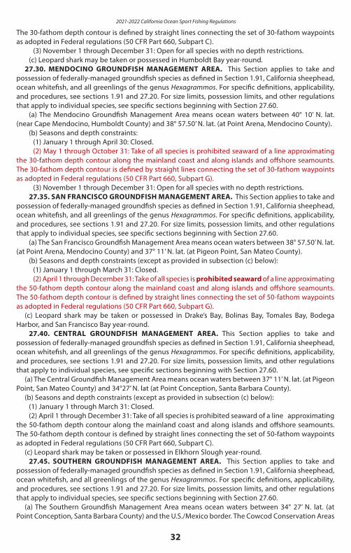
2021-2022 California Ocean Sport Fishing Regulations
32
The 30-fathom depth contour is defined by straight lines connecting the set of 30-fathom waypoints as adopted in Federal regulations (50 CFR Part 660, Subpart C).
(3) November 1 through December 31: Open for all species with no depth restrictions.(c) Leopard shark may be taken or possessed in Humboldt Bay year-round.
27.30. MENDOCINO GROUNDFISH MANAGEMENT AREA. This Section applies to take and possession of federally-managed groundfish species as defined in Section 1.91, California sheephead, ocean whitefish, and all greenlings of the genus Hexagrammos. For specific definitions, applicability, and procedures, see sections 1.91 and 27.20. For size limits, possession limits, and other regulations that apply to individual species, see specific sections beginning with Section 27.60.
(a) The Mendocino Groundfish Management Area means ocean waters between 40° 10’ N. lat. (near Cape Mendocino, Humboldt County) and 38° 57.50’ N. lat. (at Point Arena, Mendocino County).
(b) Seasons and depth constraints:(1) January 1 through April 30: Closed.(2) May 1 through October 31: Take of all species is prohibited seaward of a line approximating
the 30-fathom depth contour along the mainland coast and along islands and offshore seamounts. The 30-fathom depth contour is defined by straight lines connecting the set of 30-fathom waypoints as adopted in Federal regulations (50 CFR Part 660, Subpart G).
(3) November 1 through December 31: Open for all species with no depth restrictions.27.35. SAN FRANCISCO GROUNDFISH MANAGEMENT AREA. This Section applies to take and
possession of federally-managed groundfish species as defined in Section 1.91, California sheephead, ocean whitefish, and all greenlings of the genus Hexagrammos. For specific definitions, applicability, and procedures, see sections 1.91 and 27.20. For size limits, possession limits, and other regulations that apply to individual species, see specific sections beginning with Section 27.60.
(a) The San Francisco Groundfish Management Area means ocean waters between 38° 57.50’ N. lat. (at Point Arena, Mendocino County) and 37° 11’ N. lat. (at Pigeon Point, San Mateo County).
(b) Seasons and depth constraints (except as provided in subsection (c) below):(1) January 1 through March 31: Closed. (2) April 1 through December 31: Take of all species is prohibited seaward of a line approximating
the 50-fathom depth contour along the mainland coast and along islands and offshore seamounts. The 50-fathom depth contour is defined by straight lines connecting the set of 50-fathom waypoints as adopted in Federal regulations (50 CFR Part 660, Subpart G).
(c) Leopard shark may be taken or possessed in Drake’s Bay, Bolinas Bay, Tomales Bay, Bodega Harbor, and San Francisco Bay year-round.
27.40. CENTRAL GROUNDFISH MANAGEMENT AREA. This Section applies to take and possession of federally-managed groundfish species as defined in Section 1.91, California sheephead, ocean whitefish, and all greenlings of the genus Hexagrammos. For specific definitions, applicability, and procedures, see sections 1.91 and 27.20. For size limits, possession limits, and other regulations that apply to individual species, see specific sections beginning with Section 27.60.
(a) The Central Groundfish Management Area means ocean waters between 37° 11’ N. lat. (at Pigeon Point, San Mateo County) and 34°27’ N. lat (at Point Conception, Santa Barbara County).
(b) Seasons and depth constraints (except as provided in subsection (c) below):(1) January 1 through March 31: Closed.(2) April 1 through December 31: Take of all species is prohibited seaward of a line approximating
the 50-fathom depth contour along the mainland coast and along islands and offshore seamounts. The 50-fathom depth contour is defined by straight lines connecting the set of 50-fathom waypoints as adopted in Federal regulations (50 CFR Part 660, Subpart C).
(c) Leopard shark may be taken or possessed in Elkhorn Slough year-round.27.45. SOUTHERN GROUNDFISH MANAGEMENT AREA. This Section applies to take and
possession of federally-managed groundfish species as defined in Section 1.91, California sheephead, ocean whitefish, and all greenlings of the genus Hexagrammos. For specific definitions, applicability, and procedures, see sections 1.91 and 27.20. For size limits, possession limits, and other regulations that apply to individual species, see specific sections beginning with Section 27.60.
(a) The Southern Groundfish Management Area means ocean waters between 34° 27’ N. lat. (at Point Conception, Santa Barbara County) and the U.S./Mexico border. The Cowcod Conservation Areas
33
are special closure areas within the Southern Groundfish Management Area.(b) Seasons and depth constraints (except as provided in subsection (c) below)
(1) January 1 through the last day in February: Closed, except take of California scorpionfish is prohibited seaward of a line approximating the 100-fathom depth contour, defined by connecting the appropriate waypoints adopted in Federal regulations (50 CFR Part 660, Subpart C).
(2) March 1 through December 31: Take of all species is prohibited seaward of a line approximating the 100-fathom depth contour along the mainland coast and along islands and offshore seamounts. The 100-fathom depth contour is defined by straight lines connecting the set of 100-fathom waypoints as adopted in federal regulations (50 CFR Part 660, Subpart G).
(c) Special exceptions to subsection (b) above:(1) Regulations that apply to the Cowcod Conservation Areas are specified in Section 27.50.(2) Leopard shark may be taken or possessed in Newport Bay, Alamitos Bay, Mission Bay, and San
Diego Bay year-round.27.50. COWCOD CONSERVATION AREAS. This Section applies to take and possession of
federally-managed groundfish species as defined in Section 1.91, California sheephead, ocean whitefish, and all greenlings of the genus Hexagrammos. For specific definitions, applicability, and procedures, see sections 1.91 and 27.20. For size limits, possession limits, and other regulations that apply to individual species, see specific sections beginning with Section 27.60.
(a) The Cowcod Conservation Areas are defined as ocean waters off southern California within each of the following two areas:
Area 1 is an area south of Point Conception that is bound by straight lines connecting the following points in the order listed:
33° 50’ N. lat., 119° 30’ W. long.;33° 50’ N. lat., 118° 50’ W. long.;32° 20’ N. lat., 118° 50’ W. long.;32° 20’ N. lat., 119° 37’ W. long.;33° 00’ N. lat., 119° 37’ W. long.;33° 00’ N. lat., 119° 53’ W. long.;33° 33’ N. lat., 119° 53’ W. long.;33° 33’ N. lat., 119° 30’ W. long.; and33° 50’ N. lat., 119° 30’ W. long.
Area 2 is a smaller area west of San Diego that is bound by straight lines connecting the following points in the order listed:
32° 42’ N. lat., 118° 02’ W. long.;32° 42’ N. lat., 117° 50’ W. long.;32° 36’ 42" N. lat., 117° 50’ W. long.;32° 30’ N. lat., 117° 53’ 30" W. long.;32° 30’ N. lat., 118° 02’ W. long.; and32° 42’ N. lat., 118° 02’ W. long.
(b) Seasons and depth constraints (except as provided in subsection (c) below):(1) January 1 through the last day in February: Closed, except take of California scorpionfish is
prohibited seaward of a line approximating the 40-fathom depth contour along islands and offshore seamounts, defined by connecting the appropriate waypoints adopted in Federal regulations (50 CFR Part 660, Subpart C).
(2) March 1 through December 31: Take of species or species groups listed in (A) through (G) below is prohibited seaward of a line approximating the 40 fathom depth contour along islands and offshore seamounts. The 40 fathom depth contour is defined by straight lines connecting the set of 40 fathom waypoints as adopted in Federal regulations (50 CFR Part 660, Subpart C).
(A) Nearshore rockfish, as defined in subsection 1.91(a)(1)(B) Cabezon(C) Greenlings of the genus Hexagrammos(D) California sheephead
2021-2022 California Ocean Sport Fishing Regulations
34
(E) Ocean whitefish(F) Lingcod(G) Shelf rockfish, as defined in subsection 1.91(a)(3), except bronzespotted rockfish, cowcod,
and yelloweye rockfish which may not be taken or possessed within the Cowcod Conservation Area.(c) Special exceptions to subsection (b) above:
(1) Notwithstanding subsection 27.20(b)(1)(C), when angling from shore (includes beaches, banks, piers, jetties, breakwaters, docks, and other man-made structures connected to the shore), only the species identified in (b)(2) above and California scorpionfish may be taken or possessed year-round. No vessel or watercraft (motorized or non-motorized) may be used to assist in taking or possessing these species while angling from shore under this provision.
(2) Notwithstanding subsection 27.20(b) (1)(D), when diving or spearfishing, as authorized in Section 28.90, only the species identified in (b)(2) above and California scorpionfish may be taken or possessed year-round. Except for spearfishing gear, all other types of fishing gear are prohibited to be aboard the vessel or watercraft (motorized or non-motorized) while spearfishing for the purpose of taking or possessing these species under this provision.
27.51. CALIFORNIA ROCKFISH CONSERVATION AREA. California Rockfish Conservation Area (CRCA) means the ocean waters that are closed to recreational groundfish fishing at specified times, or closed in specified depths or areas. CRCAs serve to minimize interaction with particular species of overfished groundfish that cannot be selectively avoided and thus must be protected from overharvest by closing times, depths or areas to recreational fishing for federal groundfish and associated species managed by California. See Section 27.20.
(a) In the CRCA, take and possession is prohibited for federally-managed groundfish species as defined in Section 1.91, California sheephead, ocean whitefish, and all greenlings of the genus Hexagrammos.
(b) This regulation does not apply in cases where these species are possessed aboard a vessel in transit with no fishing gear deployed in the water.
27.60. LIMIT. (a) General. No more than 20 finfish in combination of all species with not more than 10 of any one
species, may be taken or possessed by any one person except as otherwise provided or as defined in sub-section (c) below or in Section 195. See sections 27.70 through 28.62 for special bag limits, minimum size limits and poundage restrictions for certain species that apply in addition to the general bag limit.
(b) There is no limit on the following species: anchovy, grunion, jacksmelt, topsmelt, Pacific butterfish (pompano), queenfish, sanddabs, skipjack, jack mackerel, Pacific mackerel, Pacific staghorn sculpin, round herring, Pacific sardine, petrale sole and starry flounder.
(c) Boat limit. When two or more persons that are licensed or otherwise authorized to sport fish in ocean waters off California or in the San Francisco Bay District, defined in Section 27.00, are angling for finfish aboard a vessel in these waters, fishing by all authorized persons aboard may continue until boat limits of finfish are taken and possessed aboard the vessel as authorized under this section or Section 195, Title 14, CCR.
(1) The authorization for boat limits aboard a vessel does not apply to fishing trips originating in California where fish are taken in other jurisdictions.
(2) A boat limit for a species or species group is the number of persons aboard a vessel that are licensed or otherwise authorized to sport fish in ocean waters off California, or in waters of the San Francisco Bay District, (see special conditions of Section 195, Title 14, CCR, applicable to operator and crew members of vessels licensed pursuant to Fish and Game Code 7920) multiplied by the individual daily bag limit authorized for a species or species group in those waters. With the exception of species listed in sub-section (b) above, the total fish aboard a boat may not exceed the aggregate per-person daily bag limit of 20 finfish in combination of all species times the number of anglers licensed or otherwise authorized to sport fish aboard the vessel. It is unlawful to exceed the boat limit at any time.
(3) All persons aboard a vessel may be cited where violations involving boat limits are found, including, but not limited to the following violations:
(A) Over limits(B) Possession of prohibited species(C) Violation of size limits
35
(D) Fish taken out of season or in closed areas.(4) Upon completion of a fishing trip aboard a vessel, each licensed angler or person otherwise
authorized to sport fish may not possess more than the individual daily bag and possession limits. For purposes of this section, a trip is completed at the time a person disembarks from a vessel and individual possession limits apply. Special boat limit provisions apply to persons fishing aboard commercial passenger fishing vessels reporting pursuant to Section 195, Title 14, CCR.
(5) Species for which no daily bag limit exists are not counted as part of a boat limit.(6) Boat limits are not authorized for sturgeon fishing and shall not apply to the take, possession
or retention of sturgeon.27.65. FILLETING OF FISH ON VESSELS. (a) Definition of Fillet: For the purpose of this section a fillet is the flesh from one side of a fish
extending from the head to the tail which has been removed from the body (head, tail and backbone) in a single continuous piece.
(b) Fish That May be Filleted: No person shall fillet on any boat or bring ashore as fillets any fish, except in accordance with the following requirements:
(1) Kelp bass, barred sand bass, and spotted sand bass: All fillets shall be a minimum of seven and one half inches in length. Each fillet shall bear intact a one-inch square patch of skin.
(2) Barracuda: Fillets must be a minimum of 17 inches in length. Each fillet shall bear intact a one-inch square patch of silver skin.
(3) Lingcod. Lingcod fillets must be a minimum of 14 inches in length. Each fillet shall bear intact a one-inch square patch of skin. The minimum size and minimum fillet size for lingcod may be changed during the year or in-season by the department under the authority of subsection 27.20(e). See sub-section 27.20(f ) for additional information.
(4) White sea bass: Fillets must be a minimum of 19 inches in length. Each fillet shall bear intact a one-inch square patch of silver skin.
(5) Pacific bonito: No more than 10 fillets of any length may be possessed. All bonito fillets possessed shall be considered a part of the allowable undersized tolerance of five bonito per day less than 24 inches fork length or weighing less than five pounds as provided in Section 28.32 of these regulations. All fillets shall bear intact a one-inch square patch of skin.
(6) California halibut taken from or possessed aboard a vessel south of Point Arena (Mendocino County): Fillets must be a minimum of 16 and three-quarter inches in length and shall bear the entire skin intact. A fillet from a California halibut (flesh from one entire side of the fish with the entire skin intact) may not be cut in half fillets. However, a fillet may be cut lengthwise in a straight line along the midline of the fillet where the fillet was attached to the vertebra (backbone) of the fish only if the two pieces of a fillet remain joined along their midline for a length of at least two inches at one end of the fillet.
(7) Yellowtail: Fillets must be a minimum of 17 inches in length, except not more than 10 fillets may be less than 17 inches. Each fillet shall bear intact a one-inch square patch of skin.
(8) Rockfish: Fillets must have the entire skin attached. The minimum size and minimum fillet size for rockfish may be changed during the year or in-season by the department under the authority of subsection 27.20(e). See sub- section 27.20(f ) for additional information.
(9) California scorpionfish (commonly termed “sculpin”): Fillets must be a minimum of 5 inches. Each fillet shall bear intact a one-inch square patch of skin. The minimum size and minimum fillet size for California scorpionfish may be changed during the year or in-season by the department under the authority of sub- section 27.20(e). See subsection 27.20(f ) for additional information.
(10) Ocean whitefish: Fillets must be a minimum of 6 and one half inches in length and shall bear the entire skin intact.
(11) For all species of tuna filleted on any boat or brought ashore as fillets south of a line running due west true from Point Conception, Santa Barbara County (34°27’ N. lat.) each fish must be individually bagged as follows:
(A) The bag must be marked with the species’ common name.(B) The fish must be cut into six pieces with all skin attached. These pieces are the four loins, the
collar removed as one piece with both pectoral fins attached and intact, and the belly fillet cut to include the vent and with both pelvic fins attached and intact.
(12) California sheephead: Fillets must be a minimum of 6 and three-quarter inches in length and
2021-2022 California Ocean Sport Fishing Regulations
36
shall bear the entire skin intact.(13) All other species except those listed in subsection (c) of this section: Each fillet shall bear intact
a one-inch square patch of skin. The fillets may be of any size.(c) Fish That May Not be Filleted, Steaked or Chunked: No person shall fillet, steak or cut into chunks
on any boat or bring ashore as fillets, steaks or chunks the following: any species with a size limit unless a fillet size is otherwise specified in these regulations. California halibut may be filleted or brought ashore as fillets south of Point Arena (Mendocino County).
27.70. TROUT IN THE OCEAN.(a) Methods of take: The trout must voluntarily take the bait or lure in its mouth.(b) Limit: Three, except the take of steelhead rainbow trout in the ocean is prohibited.
27.75. SALMON CLOSURES. (a) No salmon may be taken at any time in ocean waters at the Smith River mouth bounded on the
north by 41°59’36” N. lat. (approximately 3 nautical miles north of the Smith River mouth), on the west by 124°16’24” W. long. (approximately 3 nautical miles offshore), and on the south by 41°53’30” N. lat. (approximately 3 nautical miles south of the Smith River mouth).
(b) No salmon may be taken at any time in ocean waters at the Klamath River mouth bounded on the north by 41°35’30” N. lat. (approximately 3 nautical miles north of the Klamath River mouth), on the west by 124°08’54” W. long. (approximately 3 nautical miles offshore), and on the south by 41°29’24” N. lat. (approximately 3 nautical miles south of the Klamath River mouth). In August, the ocean salmon closure expands into the “Klamath Control Zone.” The Klamath Control Zone is defined in federal regulations as the ocean area at the Klamath River mouth bounded on the north by 41°38’48” N. lat. (approximately 6 nautical miles north of the Klamath River mouth), on the west by 124°23’00” W. long. (approximately 12 nautical miles offshore), and on the south by 41°26’48” N. lat. (approximately 6 nautical miles south of the Klamath River mouth).
(c) No salmon may be taken during the months of August and September in ocean waters at the Eel River mouth bounded on the north by 40°40’24” N. lat. (approximately 2 nautical miles north of the Eel River mouth), on the west by 124°21’24” W. long. (approximately 2 nautical miles offshore), and on the south by 40°36’24” N. lat. (approximately 2 nautical miles south of the Eel River mouth).
Oce
an
Sa
lmo
n In
form
ati
on
al N
ote
The 2021 ocean salmon fishing regulations have yet to be determined, and are not printed in this booklet. Pending review of 2020 spawning escapements, 2021 ocean abundance forecasts, annual management objectives, or other relevant issues, the Pacific Fishery Management Council (PFMC) may take action in March 2021 to modify regulations for the period of April 1 through May 15, 2021. The remaining 2021 ocean salmon season, effective on or after May 16, 2021, for all ocean waters between the California-Oregon border and the U.S.-Mexico border and in Humboldt Bay will be decided by the PFMC in April 2021.
For the most up-to-date information, anglers are advised to call the National Marine Fisheries Service hotline at (800) 662-9825 or the CDFW Ocean Salmon hotline at (707) 576-3429 or visit the CDFW website for ocean salmon regulations at wildlife.ca.gov/oceansalmon. Anglers who wish to participate in the federal regulation development process should visit the Pacific Fishery Management Council’s website (www.pcouncil.org) for more information on how to get involved. Final regulations will be posted on the CDFW website at www.wildlife.ca.gov/oceansalmon.
27.80. SALMON.(a) Methods of take:
(1) General Provisions. Only by angling as defined in Section 1.05. No sinkers or weights exceeding four pounds may be used, except that a fishing line may be attached to a sinker or weight of any size if such sinker or weight is suspended by a separate line and the fishing line is released automatically by a mechanical device from the sinker or weight when any fish is hooked. See sections 28.65 and 28.70.
(2) Barbless Hooks. No more than two (2) single point, single shank barbless hooks shall be used in the ocean north of Point Conception (34° 27’00” N. lat.) when salmon fishing or fishing from any boat or floating device with salmon on board.
(3) Other Hook Restrictions. When fishing with bait in the ocean between Horse Mountain (40°05’00” N. lat.) and Point Conception, if angling by any means other than trolling, then no more than two (2)
37
single point, single shank, barbless circle hooks shall be used. The distance between the two hooks must not exceed five inches when measured from the top of the eye of the top hook to the inner base of the curve of the lower hook, and both hooks must be permanently tied in place (hard tied). A circle hook is defined as a hook with a generally circular shape, and a point which turns inwards, pointing directly to the shank at a 90-degree angle. Trolling is defined as angling from a boat or floating device that is making way by means of a source of power, other than drifting by means of the prevailing water current or weather conditions. See Section 28.65(g).
(4) One Rod Restriction north of Point Conception. Salmon may be taken by angling with no more than one rod in ocean waters north of Point Conception. See Section 28.65(e).
(b) Statewide coho (silver) salmon restrictions: No coho (silver) salmon may be retained....(e) Ocean salmon possession limit: No more than two daily bag limits may be possessed when on
land. On a vessel in ocean waters, no person shall possess or bring ashore more than one daily bag limit. See Section 1.17 and 27.60(c) of these regulations.
27.85 STRIPED BASS.(a) Open season: All year.(b) Limit: Two.(c) Minimum size:
(1) North of Pt. Conception, 18 inches total length.(2) South of Pt. Conception, no minimum size limit.
(d) Methods of take: No striped bass may be taken while using a sinker weighing over four pounds, or while using any power-driven gurdy or winch. Striped bass may only be taken by angling as defined by Section 1.05, Title 14, CCR , spearfishing pursuant to Section 1.76, and bow and arrow fishing tackle; snagging is an illegal method of take.
27.90. WHITE STURGEON.(a) Open season: All year.(b) Daily and annual bag limit: One fish per day. Three fish per year statewide.(c) Size limit: No fish less than 40 inches fork length or greater than 60 inches fork length may be
taken or possessed.(d) Methods of take: Only one single point, single shank, barbless hook may be used on a line
when taking sturgeon. The sturgeon must voluntarily take the bait or lure in its mouth. No sturgeon may be taken by trolling, snagging or by the use of firearms. Sturgeon may not be gaffed, nor shall any person use any type of firearm or snare to take any sturgeon. For the purposes of this section, a snare is a flexible loop made from any material that can be tightened like a noose around any part of the fish.
(e) Removal from water. Any sturgeon greater than 68 inches fork length may not be removed from the water and shall be released immediately.
(f ) Report card required: Any person fishing for or taking sturgeon shall have in their possession a non-transferable Sturgeon Fishing Report Card issued by the department and shall adhere to all reporting and tagging requirements for sturgeon defined in Sections 1.74 and 27.92, Title 14, CCR.
(g) For regulations on take and possession of sturgeon in inland waters as defined in Section 1.53, see Section 5.80 and Section 5.81.
(h) Boat limits, as defined in sub-section 27.60(e) and Section 195, are not authorized for sturgeon fishing and shall not apply to the take, possession or retention of white sturgeon.
27.91. GREEN STURGEON. (a) Green sturgeon may not be taken or possessed.(b) Green sturgeon may not be removed from the water and shall be released immediately.(c) Green sturgeon taken and released incidentally to white sturgeon fishing shall be reported on
a Sturgeon Fishing Report Card issued by the department, in accordance with procedures defined in Sections 1.74 and 27.92, Title 14, CCR.
27.92. WHITE STURGEON REPORT CARD AND TAGGING REQUIREMENTS FOR OCEAN WATERS. (a) Sturgeon Fishing Report Card Required. All anglers must have a valid Sturgeon Fishing Report
Card in their possession while fishing for or taking white sturgeon. Cardholders must complete and return the card pursuant to regulations in this Section and in Section 1.74 of these regulations.
(b) Tagging and Recording Requirements for Retained Fish. A Sturgeon Fishing Report Card includes detachable tags that shall be used to tag any white sturgeon that is taken and retained in the sport
2021-2022 California Ocean Sport Fishing Regulations
38
fishery. Any white sturgeon possessed by any person shall be tagged.(1) Upon taking and retaining a white sturgeon, the cardholder shall immediately record the
following information:(A) The fishing location, time of catch and length of the fish shall be recorded legibly and
permanently in the appropriate spaces on the tag. The cardholder shall immediately and completely punch out the date of catch (month and day) on the sturgeon tag. Tags shall be used in sequential order.
(B) The month, day, fishing location and length of the fish shall be recorded in the appropriate spaces on the Sturgeon Fishing Report Card which corresponds to the number on the tag.
(2) Immediately after recording the information above, the cardholder shall remove and completely detach the tag from the card and affix it to the white sturgeon. Cardholders shall not wait until completion of fishing activity to tag any white sturgeon in possession.
(3) The tag shall be securely fastened to the fish. To affix the tag, a “zip tie”, string, line or other suitable material shall be passed through the tag at the location specified on the sturgeon tag and attached to the fish.
(4) Tags shall not be removed from the report card until immediately prior to affixing to a white sturgeon. Any tags detached from the report card and not affixed to a white sturgeon shall be considered used and therefore invalid. No person shall possess any used or otherwise invalid sturgeon tags.
(5) Records of Prior Activity. All tags must be accounted for at all times by entry of a record on the Sturgeon Fishing Report Card corresponding to all tags that are not in the cardholder’s possession. Any tag that was lost or destroyed shall be recorded as such on the corresponding line on the Sturgeon Fishing Report Card.
(6) If the sturgeon has a department reward disk attached, write the reward disk number in the space provided on the report card.
(c) Reporting Requirements for Released Fish.(1) Whenever the cardholder catches and releases a sturgeon, the cardholder shall immediately
record the month, day, location code, and species of sturgeon.(2) If all lines in the “sturgeon released” field of the report card are filled, any additional sturgeon
caught and released need not be recorded on the card.(3) If the sturgeon has a department reward disk attached, write the reward disk number in the
space provided on the report card.(d) Sturgeon tags must be left affixed to the fish in place, including while stored at a residence or
non-transient location, until the fish is processed for immediate consumption.(e) The annual fee for the Sturgeon Fishing Report Card is specified in Section 701 of these regulations27.95. STURGEON CLOSURE. Green sturgeon and white sturgeon may not be taken in the following
described area between January 1 and March 15: That portion of San Francisco Bay included within the following boundaries: A direct line between Pt. Chauncey (National Marine Fisheries Laboratory) and Pt. Richmond, the San Francisco-Oakland Bay Bridge and a direct line between Pt. Lobos and Pt. Bonita.
28.00. GRUNION, CALIFORNIA. May be taken June 1 through March 31.28.05. GARIBALDI. May not be taken or possessed.28.06. WHITE SHARK. White shark may not be taken, except under permit issued by the department
pursuant to Section 1002 of the Fish and Game Code for scientific or educational purposes.28.10. GIANT (BLACK) SEA BASS.
(a) May not be taken off California. All fish taken incidental to other fishing activity shall be immediately returned to the water where taken.
(b) Limit: Two per angler per trip when fishing south of United States-Mexico border. A valid fishing permit or license from the Mexican government constitutes proof that fish were taken legally.
28.12. GULF GROUPER AND BROOMTAIL GROUPER. May not be taken or possessed.28.15. HALIBUT, CALIFORNIA.
(a) Limit: Five in waters south of a line extending due west magnetic from Point Sur, Monterey County, and three in waters north of a line extending due west magnetic from Point Sur, Monterey County.
(b) Minimum size: Twenty-two inches total length.28.20 HALIBUT, PACIFIC.
(a) Season: [Note: The season for Pacific halibut has not been set as of the printing of this booklet, and is not included in here. See additional information about the Pacific halibut season
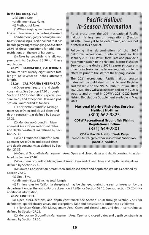
39
in the box on pg. 39.]...(b) Limit: One.(c) Minimum size: None.(d) Methods of Take:
(1) When angling, no more than one line with two hooks attached may be used.
(2) A harpoon, gaff, or net may be used to assist in taking a Pacific halibut that has been legally caught by angling. See Section 28.95 of these regulations for additional restrictions on the use of harpoons.
(3) Take by spearfishing is allowed pursuant to Section 28.90 of these regulations.
Pacific Halibut In-Season Information
As of press time, the 2021 recreational Pacific halibut fishing season regulations (Section 28.20(a)) have yet to be determined, and are not printed in this booklet.
Following the determination of the 2021 California recreational quota amount in late January 2021, CDFW will formulate and provide a recommendation to the National Marine Fisheries Service on the desired 2021 season structure in time for inclusion in the federal regulations, to be effective prior to the start of the fishing season.
The 2021 recreational Pacific halibut season dates will be published in the Federal Register and available on the NMFS Halibut Hotline: (800) 662-9825. They will also be provided on the CDFW website and printed in CDFW’s 2021-2022 Sport Fishing Regulations Supplement available in May, 2021.
National Marine Fisheries Service Halibut Hotline
(800) 662-9825CDFW Recreational Groundfish Fishing
Regulations Hotline(831) 649-2801
CDFW Pacific Halibut Web Page wildlife.ca.gov/conservation/marine/
pacific-halibut
28.25. BARRACUDA, CALIFORNIA. Minimum size: Twenty-eight inches total length or seventeen inches alternate length.
28.26. CALIFORNIA SHEEPHEAD.(a) Open areas, seasons, and depth
constraints: See Section 27.20 through Section 27.50 for definitions, special clo-sure areas, and exceptions. Take and pos-session is authorized as follows:
(1) Northern Groundfish Manage-ment Area: Open and closed dates and depth constraints as defined by Section 27.25.
(2) Mendocino Groundfish Man-agement Area: Open and closed dates and depth constraints as defined by Sec-tion 27.30.
(3) San Francisco Groundfish Man-agement Area: Open and closed dates and depth constraints as defined by Sec-tion 27.35.
(4) Central Groundfish Management Area: Open and closed dates and depth constraints as de-fined by Section 27.40.
(5) Southern Groundfish Management Area: Open and closed dates and depth constraints as defined by Section 27.45.
(6) Cowcod Conservation Areas: Open and closed dates and depth constraints as defined by Section 27.50.
(b) Limit: Five.(c) Minimum size: 12 inches total length.(d) Fishing rules for California sheephead may be changed during the year or in-season by the
department under the authority of subsection 27.20(e) or Section 52.10. See subsection 27.20(f ) for additional information.
28.27. LINGCOD.(a) Open areas, seasons, and depth constraints: See Section 27.20 through Section 27.50 for
definitions, special closure areas, and exceptions. Take and possession is authorized as follows:(1) Northern Groundfish Management Area: Open and closed dates and depth constraints as
defined by Section 27.25.(2) Mendocino Groundfish Management Area: Open and closed dates and depth constraints as
defined by Section 27.30.
2021-2022 California Ocean Sport Fishing Regulations
40
(3) San Francisco Groundfish Management Area: Open and closed dates and depth constraints as defined by Section 27.35.
(4) Central Groundfish Management Area: Open and closed dates and depth constraints as defined by Section 27.40.
(5) Southern Groundfish Management Area: Open and closed dates and depth constraints as defined by Section 27.45.
(6) Cowcod Conservation Areas: Open and closed dates and depth constraints as defined by Section 27.50.
(b) Limit: Two(c) Minimum size: 22 inches total length.(d) Method of take: When angling, gear is restricted to not more than two hooks and one line.
For purposes of this section, a hook is a single hook, or double or treble hook with multiple points connected to a common shank.
(e) Fishing rules for lingcod may be changed during the year or in-season by the department under the authority of subsection 27.20(e). See subsection 27.20(f ) for additional information.
28.28. CABEZON.(a) Open areas, seasons, and depth constraints: See Section 27.20 through Section 27.50 for
definitions, special closure areas, and exceptions. Take and possession is authorized as follows:(1) Northern Groundfish Management Area: Open and closed dates and depth constraintsas defined by Section 27.25.(2) Mendocino Groundfish Management Area: Open and closed dates and depth constraints as
defined by Section 27.30.(3) San Francisco Groundfish Management Area: Open and closed dates and depth constraints
as defined by Section 27.35.(4) Central Groundfish Management Area: Open and closed dates and depth constraints as
defined by Section 27.40.(5) Southern Groundfish Management Area: Open and closed dates and depth constraints as
defined by Section 27.45.(6) Cowcod Conservation Areas: Open and closed dates and depth constraints as defined by
Section 27.50.(b) Limit: Ten fish, within a Rockfish, Cabezon, and Greenling complex (RCG complex, as defined
in Section 1.91) bag limit of 10 fish.(c) Minimum size: 15 inches total length.(d) Method of take: When angling, gear is restricted to not more than two hooks and one line.
For purposes of this section, a hook is a single hook, or double or treble hook with multiple points connected to a common shank.
(e) Fishing rules for cabezon may be changed during the year or in-season by the department under the authority of subsection 27.20(e) or Section 52.10. See subsection 27.20(f ) for additional information.
28.29. KELP GREENLING. ROCK GREENLING. (a) Open areas, seasons, and depth constraints for greenlings of the genus Hexagrammos
(including kelp and rock greenlings): See Section 27.20 through Section 27.50 for definitions, special closure areas, and exceptions. Take and possession is authorized as follows:
(1) Northern Groundfish Management Area: Open and closed dates and depth constraints as defined by Section 27.25.
(2) Mendocino Groundfish Management Area: Open and closed dates and depth constraints as defined by Section 27.30.
(3) San Francisco Groundfish Management Area: Open and closed dates and depth constraints as defined by Section 27.35.
(4) Central Groundfish Management Area: Open and closed dates and depth constraints as defined by Section 27.40.
(5) Southern Groundfish Management Area: Open and closed dates and depth constraints as defined by Section 27.45.
(6) Cowcod Conservation Areas: Open and closed dates and depth constraints as defined by
41
Section 27.50.(b) Limit: For greenlings of the genus Hexagrammos, ten fish within a Rockfish, Cabezon, and
Greenling complex (RCG complex, as defined in Section 1.91) bag limit of 10 fish.(c) Minimum size: 12 inches total length.(d) Method of take: When angling, gear is restricted to not more than two hooks and one line.
For purposes of this section, a hook is a single hook, or double or treble hook with multiple points connected to a common shank.
(e) Fishing rules for greenlings of the genus Hexagrammos may be changed during the year or in-season by the department under the authority of subsection 27.20(e) or Section 52.10. See subsection 27.20(f ) for additional information.
28.30. KELP BASS, BARRED SAND BASS AND SPOTTED SAND BASS.(a) Minimum size: Fourteen inches total length or ten inches alternate length.(b) Limit: Five in any combination of species.
28.32. PACIFIC BONITO. (a) Limit: Ten.(b) Minimum size: Twenty-four inches fork length or five pounds except that: Five fish less than
twenty-four inches fork length or weighing less than five pounds may be taken and possessed.28.35. WHITE SEABASS.
(a) Minimum size: Twenty-eight inches total length or twenty and one-half inches alternate length.(b) Season: Open all year.(c) Limit: Three, except that only one fish may be taken in waters south of Pt. Conception between
March 15 and June 15.28.37. YELLOWTAIL.
(a) Limit: Ten(b) Minimum size: Twenty-four inches fork length except that: Five fish less than twenty-four inches
fork length may be taken or possessed.28.38. TUNAS. The following daily bag limits apply:
(a) Albacore:(1) South of a line running due west true from 34°27’N. lat. (at Point Conception, Santa Barbara
County) – The special limit for albacore is 10, which may be taken or possessed in addition to the overall general daily bag limit of 20 finfish specified in sub-section 27.60(a).
(2) North of a line running due west true from 34°27’N. lat. (at Point Conception, Santa Barbara County) – The special limit for albacore is 25, which may be taken or possessed in addition to the overall general daily bag limit of 20 finfish specified in sub-section 27.60(a).
(b) Bluefin tuna - The special limit for bluefin tuna is 2, which may be taken or possessed in addition to the overall general daily bag limit of 20 finfish specified in subsection 27.60(a). This limit applies to all bluefin tuna possessed, regardless of where taken.
(c) There is no limit on skipjack tuna.(d) For yellowfin tuna, bigeye tuna, and other tunas not listed above, the limit is 10. Unlike albacore
and bluefin tuna, fish taken under this limit shall apply toward the overall general daily bag limit of 20 finfish specified in sub-section 27.60(a).
28.40. BROADBILL SWORDFISH. (a) Limit: Two.
28.41. SIXGILL SHARK, SEVENGILL SHARK. Limit: One of each species. 28.42. SHORTFIN MAKO SHARK, THRESHER SHARK, AND BLUE SHARK. Limit: Two of each
species. 28.45. SURF SMELT (Night Smelt, Day Fish, Whitebait Smelt).
(a) Limit: Twenty-five pounds in combination.28.47. PETRALE SOLE AND STARRY FLOUNDER. Petrale sole and starry flounder are federal
groundfish, as defined in subsection 1.91(a), and are subject to special regulations as follows. Regulations of this Section do not apply to other species of flounders or sole.
(a) Open year-round (b) There is no limit on petrale sole or starry flounder.(c) Petrale sole and starry flounder may be taken in all depths.

2021-2022 California Ocean Sport Fishing Regulations
42
(d) Fishing rule for petrale sole and starry flounder may be changed during the year or in-season by the department under the authority of subsection 27.20(e). See subsection 27.20(f ) for additional information.
28.48. PACIFIC SANDDAB, ROCK SOLE, SAND SOLE, BUTTER SOLE, CURLFIN SOLE, REX SOLE, AND FLATHEAD SOLE. Pacific sanddab, rock sole, sand sole, butter sole, curlfin sole, rex sole, and flathead sole are federal groundfish, also known in the aggregate as “other flatfish” pursuant to subsection 1.91(a)(10) and are subject to special regulations as follows. Regulations of this Section do not apply to other species of sanddabs, flounders, or sole.
(a) Open year-round.(b) Limit: There is no limit on Pacific sanddab. The general bag limit of not more than 20 finfish in
combination of all species with not more than 10 of any one species applies to rock sole, sand sole, butter sole, curlfin sole, rex sole, and flathead sole.
(c) Fishing rules for Pacific sanddab, rock sole, sand sole, butter sole, curlfin sole, rex sole, and flathead sole may be changed during the year or in-season by the department under the authority of subsection 27.20(e). See subsection 27.20(f ) for additional information.
28.49. SOUPFIN SHARK, DOVER SOLE, ENGLISH SOLE, ARROWTOOTH FLOUNDER, SPINY DOGFISH, SKATES, RATFISH, GRENADIERS, FINESCALE CODLING, PACIFIC COD, PACIFIC WHITING, SABLEFISH AND THORNYHEADS. Soupfin shark, Dover sole, English sole, arrowtooth flounder, spiny dogfish, all skates, ratfish, all grenadiers, finescale codling, Pacific cod, Pacific whiting, sablefish, longspine thornyhead, and shortspine thornyhead are federal groundfish, as defined in subsection 1.91(a), and are subject to special regulations as follows. Regulations of this Section do not apply to other species of flounders, sole, sharks, or codlings unless otherwise specified.
(a) Open areas, seasons, and depth constraints: See Section 27.20 through Section 27.50 for definitions, special closure areas, and exceptions. Take and possession is authorized as follows:
(1) Northern Groundfish Management Area: Open and closed dates and depth constraints as defined by Section 27.25.
(2) Mendocino Groundfish Management Area: Open and closed dates and depth constraints as defined by Section 27.30.
(3) San Francisco Groundfish Management Area: Open and closed dates and depth constraints as defined by Section 27.35.
(4) Central Groundfish Management Area: Open and closed dates and depth constraints as defined by Section 27.40.
(5) Southern Groundfish Management Area: Open and closed dates and depth constraints as defined by Section 27.45.
(6) Cowcod Conservation Areas: Closed.(b) Limit:
(1) The limit on soupfin shark is one fish.(2) The general bag limit of not more than 20 finfish in combination of all species with not more
than 10 of any one species applies to Dover sole, English sole, arrowtooth flounder, spiny dogfish, all skates, ratfish, all grenadiers, finescale codling, Pacific cod, Pacific whiting, sablefish, longspine thornyhead and shortspine thornyhead.
(c) Fishing rules for soupfin shark, Dover sole, English sole, arrowtooth flounder, spiny dogfish, all skates, ratfish, all grenadiers, finescale codling, Pacific cod, Pacific whiting, sablefish, longspine thornyhead and shortspine thornyhead may be changed during the year or in-season by the department under the authority of subsection 27.20(e). See subsection 27.20(f ) for additional information.
28.50. MARLIN. (a) Limit: One.
28.54. CALIFORNIA SCORPIONFISH (Sculpin).(a) Open areas, seasons, and depth constraints: See Section 27.20 through Section 27.50 for
definitions, special closure areas, and exceptions. Take and possession is authorized as follows:(1) Northern Groundfish Management Area: Open and closed dates and depth constraints as
defined by Section 27.25.(2) Mendocino Groundfish Management Area: Open and closed dates and depth constraints as
43as defined by Section 27.35, except that take and possession is authorized year-round in Drake’s Bay,
(3) San Francisco Groundfish Management Area: Open and closed dates and depth constraints defined by Section 27.30.
(2) Mendocino Groundfish Management Area: Open and closed dates and depth constraints as defined by Section 27.25, except that take and possession is authorized year-round in Humboldt Bay.
(1) Northern Groundfish Management Area: Open and closed dates and depth constraints as definitions, special closure areas, and exceptions. Take and possession is authorized as follows:
(a) Open areas, seasons, and depth constraints: See Section 27.20 through Section 27.50 for 28.56. LEOPARD SHARK.
under the authority of subsection 27.20(e). See subsection 27.20(f ) for additional information. (e) Fishing rules for rockfish may be changed during the year or in-season by the department
connected to a common shank.For purposes of this section, a hook is a single hook, or a double or treble hook with multiple points
(d) Method of take: When angling, gear is restricted to not more than two hooks and one line. (c) Size limit: None.
in the Cowcod Conservation Areas.in subsection 1.91(a)(4), is zero. These species shall not be taken or possessed as part of the RCG limit
(3) In the Cowcod Conservation Areas (see Section 27.50), the limit on slope rockfish, as defined (2) The limit on vermilion rockfish is five fish, within the RCG bag limit.
shall not be taken or possessed as part of the RCG limit. (1) The limit on bronzespotted rockfish, cowcod, and yelloweye rockfish is zero. These species
Section 1.91) limit of 10 fish, in any combination of species, except as provided below. b) Limit: Ten, within the Rockfish, Cabezon, and Greenling complex (RCG complex, as defined in
1.91(a)(3), may be taken and possessed, except as provided below in subsection (b)(1).Section 27.50. Only Nearshore Rockfish, and Shelf Rockfish, as defined in subsections 1.91(a)(1) and
(6) Cowcod Conservation Areas: Open and closed dates and depths constraints as defined by defined by Section 27.45.
(5) Southern Groundfish Management Area: Open and closed dates and depth constraints as defined by Section 27.40.
(4) Central Groundfish Management Area: Open and closed dates and depth constraints as as defined by Section 27.35.
(3) San Francisco Groundfish Management Area: Open and closed dates and depth constraints defined by Section 27.30.
(2) Mendocino Groundfish Management Area: Open and closed dates and depth constraints as defined by Section 27.25.
(1) Northern Groundfish Management Area: Open and closed dates and depth constraints as definitions, special closure areas, and exceptions. Take and possession is authorized as follows:
(a) Open areas, seasons, and depth constraints: See Section 27.20 through Section 27.50 for 28.55. ROCKFISH (Sebastes).
information.the department under the authority of subsection 27.20(e). See subsection 27.20(f ) for additional
(e) Fishing rules for California scorpionfish may be changed during the year or in-season by connected to a common shank.For purposes of this section, a hook is a single hook, or double or treble hook with multiple points
(d) Method of take: When angling, gear is restricted to not more than two hooks and one line. (c) Minimum size: 10 inches total length.
(b) Limit: Five.Section 27.50.
(6) Cowcod Conservation Areas: Open and closed dates and depth constraints as defined bydefined by Section 27.45.
(5) Southern Groundfish Management Area: Open and closed dates and depth constraints as defined by Section 27.40.
(4) Central Groundfish Management Area: Open and closed dates and depth constraints as as defined by Section 27.35.
(3) San Francisco Groundfish Management Area: Open and closed dates and depth constraints
For up-to-date ocean salmon regulation information, call the CDFW Ocean Salmon Hotline at (707) 576-3429For up-to-date groundfish and Pacific halibut regulation information, call the CDFW Groundfish Hotline at (831) 649-2801
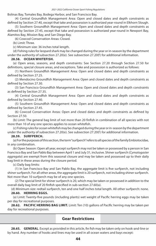
2021-2022 California Ocean Sport Fishing Regulations
44
Bolinas Bay, Tomales Bay, Bodega Harbor, and San Francisco Bay.(4) Central Groundfish Management Area: Open and closed dates and depth constraints as
defined by Section 27.40, except that take and possession is authorized year-round in Elkhorn Slough.(5) Southern Groundfish Management Area: Open and closed dates and depth constraints as
defined by Section 27.45, except that take and possession is authorized year-round in Newport Bay, Alamitos Bay, Mission Bay, and San Diego Bay.
(6) Cowcod Conservation Areas: Closed.(b) Limit: Three.(c) Minimum size: 36 inches total length.(d) Fishing rules for leopard shark may be changed during the year or in-season by the department
under the authority of subsection 27.20(e). See subsection 27.20(f ) for additional information.28.58. OCEAN WHITEFISH.
(a) Open areas, seasons, and depth constraints: See Section 27.20 through Section 27.50 for definitions, special closure areas, and exceptions. Take and possession is authorized as follows:
(1) Northern Groundfish Management Area: Open and closed dates and depth constraints as defined by Section 27.25.
(2) Mendocino Groundfish Management Area: Open and closed dates and depth constraints as defined by Section 27.30.
(3) San Francisco Groundfish Management Area: Open and closed dates and depth constraints as defined by Section 27.35.
(4) Central Groundfish Management Area: Open and closed dates and depth constraints as defined by Section 27.40.
(5) Southern Groundfish Management Area: Open and closed dates and depth constraints as defined by Section 27.45.
(6) Cowcod Conservation Areas: Open and closed dates and depth constraints as defined by Section 27.50.
(b) Limit: The general bag limit of not more than 20 finfish in combination of all species with not more than 10 of any one species applies to ocean whitefish.
(c) Fishing rules for ocean whitefish may be changed during the year or in-season by the department under the authority of subsection 27.20(e). See subsection 27.20(f ) for additional information.
28.59. SURFPERCH.(a) For the purposes of this section, the term “surfperch” refers to all species of the family Embiotocidae,
in any combination.(b) Open Season: Open all year, except surfperch may not be taken or possessed by a person in San
Francisco Bay and San Pablo Bay between April 1 and July 31, inclusive. Shiner surfperch (Cymatogaster aggregata) are exempt from this seasonal closure and may be taken and possessed up to their daily bag limit in these areas during the closure period.
(c) Daily bag limits:(1) In San Francisco Bay and San Pablo Bay, the aggregate limit is five surfperch, not including
shiner surfperch. For all other areas, the aggregate limit is 20 surfperch, not including shiner surfperch. Not more than 10 surfperch may be of any one species.
(2) The special limit for shiner surfperch is 20, which may be taken or possessed in addition to the overall daily bag limit of 20 finfish specified in sub-section 27.60(a).
(d) Minimum size: redtail surfperch, ten and one half inches total length. All other surfperch: none.28.60. HERRING EGGS.
(a) Limit: Twenty-five pounds (including plants) wet weight of Pacific herring eggs may be taken per day for recreational purposes.
28.62. PACIFIC HERRING BAG LIMIT. Limit: Ten (10) gallons of Pacific herring may be taken per day for recreational purposes.
Gear Restrictions
28.65. GENERAL. Except as provided in this article, fin fish may be taken only on hook-and-line or by hand. Any number of hooks and lines may be used in all ocean waters and bays except:
45
(a) San Francisco Bay, as described in Section 27.00, where only one line with not more than three hooks may be used.
(b) On public piers, no person shall use more than two rods and lines, two hand lines, or two nets, traps or other appliances used to take crabs.
(c) When rockfish (genus Sebastes), California scorpionfish (Scorpaena guttata), lingcod (Ophiodon elongatus), cabezon (Scorpaenichthys marmoratus), or kelp or rock greenlings (Hexagrammos decagrammus and Hexagrammos lagocephalus) are aboard or in possession, where only one line with not more than two hooks may be used pursuant to Sections 28.55, 28.27, 28.28 or 28.29, respectively.
(d) No gaff hook shall be used to take or assist in landing any finfish shorter than the minimum size limit. For the purpose of this section a gaff hook is any hook with or without a handle used to assist in landing fish or to take fish in such a manner that the fish does not take the hook voluntarily in its mouth. No person shall take finfish from any boat or other floating device in ocean waters without having a landing net in possession or available for immediate use to assist in landing undersize fish of species having minimum size limits; the opening of any such landing net shall be not less than eighteen inches in diameter.
(e) North of Point Conception (34°27’00” N. lat.), where only one rod and line may be used by each angler fishing for salmon, or fishing from any boat or floating device with salmon on board.
(f ) Mousetrap gear prohibited: It is unlawful to use, assist in using, or to possess aboard any vessel, hook-and-line gear commonly termed “mouse traps” constructed of a hook(s) or lure(s), attached to one end of a line that is attached to a float, or floats at the other end, and that when fished, is not attached directly to a person or vessel. Possession of such gear aboard a vessel shall be prima facie evidence that the gear is being used in violation of this regulation.
(g) North of Point Conception to Horse Mountain, Section 27.80(a)(3) applies to each angler fishing for salmon or fishing from any boat or floating device with salmon on board.
28.70. WEIGHT, POWER DRIVEN GURDIES OR POWER DRIVEN WINCHES. (a) No sinker or weight weighing more than four pounds, nor any power-driven gurdy or power-
driven winch, may be used in any ocean waters or saltwater bays north of Point Arguello. This regulation does not apply to:
(1) Power gurdies or power winches used solely for handling crab nets or traps;(2) The use of downriggers where the downrigger line is not used as a fishing line but is attached
to the fishing line by a breakaway line; or(3) The use of electric fishing reels manufactured for sport fishing use.
28.75. BAITED TRAPS FOR SHINER SURFPERCH, PACIFIC STAGHORN SCULPIN AND LONGJAW MUD SUCKERS. In San Francisco and San Pablo bays and their saltwater tributaries, and in the open ocean and the contiguous bays of Mendocino, Sonoma and Marin counties, traps not over three feet in greatest dimension may be used to take shiner surfperch, Pacific staghorn sculpin and longjaw mudsuckers. Any other species taken shall be returned to the water immediately.
28.80. DIP NETS AND HAWAIIAN TYPE THROW NETS. Dip nets of any size and baited hoop nets not greater than 36 inches in diameter may be used to take herring, Pacific staghorn sculpin, shiner surfperch, surf smelt, topsmelt, anchovies, shrimp and squid. Hawaiian type throw nets may be used north of Point Conception to take such species.
28.85. BEACH NETS. Beach nets not over 20 feet in length with meshes at least 7/8 of an inch in length may be used to take surf smelt north of Point Conception.
28.90. DIVING, SPEARFISHING. Persons who are floating or swimming in the water may use spearfishing gear and skin or SCUBA diving equipment to take fin fish other than giant (black) sea bass, garibaldi, gulf grouper, broomtail grouper, trout, salmon, or broadbill [swordfish], except that:
(a) No person may possess or use a spear within 100 yards of the mouth of any stream in any ocean waters north of Ventura County.
(b) When spearfishing for or in possession of federal groundfish species or associated species as authorized pursuant to subsection 27.20(b) (1)(D), in an area or during a season closed to the take of these species, no fishing gear except spearfishing gear may be aboard the vessel or watercraft.
28.91. SLURP GUNS. Slurp guns may be used to take finfish except that bag and possession limits shall not be exceeded wherever they apply and no species of finfish may be taken for which a minimum
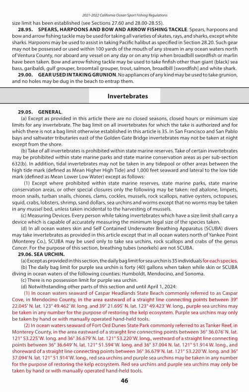
2021-2022 California Ocean Sport Fishing Regulations
46
size limit has been established (see Sections 27.60 and 28.00-28.55).28.95. SPEARS, HARPOONS AND BOW AND ARROW FISHING TACKLE. Spears, harpoons and
bow and arrow fishing tackle may be used for taking all varieties of skates, rays, and sharks, except white sharks. Harpoons may be used to assist in taking Pacific halibut as specified in Section 28.20. Such gear may not be possessed or used within 100 yards of the mouth of any stream in any ocean waters north of Ventura County, nor aboard any vessel on any day or on any trip when broadbill swordfish or marlin have been taken. Bow and arrow fishing tackle may be used to take finfish other than giant (black) sea bass, garibaldi, gulf grouper, broomtail grouper, trout, salmon, broadbill [swordfish] and white shark.
29.00. GEAR USED IN TAKING GRUNION. No appliances of any kind may be used to take grunion, and no holes may be dug in the beach to entrap them.
Invertebrates
29.05. GENERAL. (a) Except as provided in this article there are no closed seasons, closed hours or minimum size
limits for any invertebrate. The bag limit on all invertebrates for which the take is authorized and for which there is not a bag limit otherwise established in this article is 35. In San Francisco and San Pablo bays and saltwater tributaries east of the Golden Gate Bridge invertebrates may not be taken at night except from the shore.
(b) Take of all invertebrates is prohibited within state marine reserves. Take of certain invertebrates may be prohibited within state marine parks and state marine conservation areas as per sub-section 632(b). In addition, tidal invertebrates may not be taken in any tidepool or other areas between the high tide mark (defined as Mean Higher High Tide) and 1,000 feet seaward and lateral to the low tide mark (defined as Mean Lower Low Water) except as follows:
(1) Except where prohibited within state marine reserves, state marine parks, state marine conservation areas, or other special closures only the following may be taken: red abalone, limpets, moon snails, turban snails, chiones, clams, cockles, mussels, rock scallops, native oysters, octopuses, squid, crabs, lobsters, shrimp, sand dollars, sea urchins and worms except that no worms may be taken in any mussel bed, unless taken incidental to the harvesting of mussels.
(c) Measuring Devices. Every person while taking invertebrates which have a size limit shall carry a device which is capable of accurately measuring the minimum legal size of the species taken.
(d) In all ocean waters skin and Self Contained Underwater Breathing Apparatus (SCUBA) divers may take invertebrates as provided in this article except that in all ocean waters north of Yankee Point (Monterey Co.), SCUBA may be used only to take sea urchins, rock scallops and crabs of the genus Cancer. For the purpose of this section, breathing tubes (snorkels) are not SCUBA.
29.06. SEA URCHIN.(a) Except as provided in this section, the daily bag limit for sea urchin is 35 individuals for each species.(b) The daily bag limit for purple sea urchin is forty (40) gallons when taken while skin or SCUBA
diving in ocean waters of the following counties: Humboldt, Mendocino, and Sonoma.(c) There is no possession limit for purple sea urchin.(d) Notwithstanding other parts of this section and until April 1, 2024:
(1) In ocean waters seaward of Caspar Headlands State Beach commonly referred to as Caspar Cove, in Mendocino County, in the area eastward of a straight line connecting points between 39° 22.045' N. lat. 123° 49.462' W. long. and 39° 21.695' N. lat. 123° 49.423' W. long., purple sea urchins may be taken in any number for the purpose of restoring the kelp ecosystem. Purple sea urchins may only be taken by hand or with manually operated hand-held tools.
(2) In ocean waters seaward of Fort Ord Dunes State Park commonly referred to as Tanker Reef, in Monterey County, in the area eastward of a straight line connecting points between 36° 36.076’ N. lat. 121° 53.225’ W. long. and 36° 36.679’ N. lat. 121° 53.220’ W. long., westward of a straight line connecting points between 36° 36.649’ N. lat. 121° 51.594’ W. long. and 36° 37.094 N. lat. 121° 51.914 W. long., and shoreward of a straight line connecting points between 36° 36.679’ N. lat. 121° 53.220’ W. long. and 36° 37.094’ N. lat. 121° 51.914’ W. long., red sea urchins and purple sea urchins may be taken in any number for the purpose of restoring the kelp ecosystem. Red sea urchins and purple sea urchins may only be taken by hand or with manually operated hand-held tools.
47
Mollusks
29.10. GENERAL. (a) Except as otherwise provided in this article, saltwater mollusks, including octopus, may be taken
only on hook-and-line or with the hands.(b) The size of a mollusk is measured in greatest shell diameter.
29.15. ABALONE.(a) All ocean waters are closed to the take of abalone. Abalone may not be taken or possessed. (b) This subsection and subsection (a) shall remain in effect only until April 1, 2026, and as of that
date are repealed, unless a later enacted amendment deletes or extends that date.(c) Notwithstanding subsection (a), subsections (c)(1) and (c)(2) are applicable for abalone in
possession prior to April 1, 2018:(1) Minimum Abalone Size: All red abalone must be seven inches or greater measured along the
longest shell diameter.(2) Abalone Possession and Transportation: It shall be unlawful to possess any untagged abalone
or any abalone that have been removed from their shell, except when they are being prepared for immediate consumption.
(d) Minimum Abalone Size: All red abalone must be seven inches or greater measured along the longest shell diameter. No undersized abalone may be brought ashore or aboard any boat, placed in any type of receiver, kept on the person, or retained in any person's possession or under their control. Undersize abalone must be replaced immediately to the same surface of the rock from which detached. Abalones brought ashore shall be in such a condition that the size can be determined.
(e) Special Gear Provisions: The use of SCUBA gear or surface supplied air to take abalone is prohibited. Abalone may not be taken or possessed aboard any boat, vessel, or floating device in the water containing SCUBA or surface supplied air. Abalone may be taken only by hand or by devices commonly known as abalone irons. Abalone irons must be less than 36 inches long, straight or with a curve having a radius of not less than 18 inches, and must not be less than 3/4 inch wide nor less than 1/16 inch thick. All edges must be rounded and free of sharp edges. Knives, screwdrivers, and sharp instruments are prohibited.
(f ) Measuring Device. Every person while taking abalone shall carry a fixed caliper measuring gauge capable of accurately measuring seven inches. The measuring device shall have fixed opposing arms of sufficient length to measure the abalone by placing the gauge over the shell.
(g) Abalone Possession and Transportation:Abalones shall not be removed from their shell, except when being prepared for immediate
consumption.(1) Individuals taking abalone shall maintain separate possession of their abalone. Abalone may
not be commingled in a float tube, dive board, dive bag, or any other container or device, until properly tagged. Only after abalones are properly tagged, as described in Section 29.16(b), Title 14, CCR, may they be commingled with other abalone taken by another person.
(h) Report Card Required: Any person fishing for or taking abalone shall have in their possession a nontransferable Abalone Report Card issued by the department and shall adhere to all reporting and tagging requirements for abalone defined in Sections 1.74 and 29.16, Title 14, CCR.
ABALONE CLOSURE EXTENDED UNTIL APRIL 1, 2026Because of continued poor environmental conditions and severely depleted northern red abalone populations, the red abalone fishery closure has been extended to 2026. The California Fish and Game Commission is in the process of developing a new Red Abalone Fishery Management Plan that will take into consideration our changing environment. Visit www.fgc.ca.gov for the latest information concerning the plan and recreational abalone regulations/seasons.
(i) Effective April 1, 2026: Bag Limit and Yearly Trip Limit: Three red abalone, Haliotis rufescens,
2021-2022 California Ocean Sport Fishing Regulations
48
may be taken per day. No more than three abalone may be possessed at any time. No other species of abalone may be taken or possessed. Each person taking abalone shall stop detaching abalone when the limit of three is reached. No person shall take more than 18 abalone during a calendar year. In the Open Area as defined in subsections 29.15(j) and 29.15(j)(1), not more than 9 abalone of the yearly trip limit may be taken south of the boundary between Sonoma and Mendocino Counties.
(j) Effective April 1, 2026: Open Area: Except in the area described in subsection (j)(1) below, abalone may only be taken north
of a line drawn due west magnetic from the center of the mouth of San Francisco Bay. No abalone may be taken, landed, or possessed if landed south of this line.
(1) No abalone may be taken in the Fort Ross area bounded by the mean high tide line and a line drawn due south true from 38º30.63' N, 123º14.98' W (the northern point of Fort Ross Cove) and a line drawn due west true from 38º29.45' N, 123º11.72' W (Jewel Gulch, south boundary Fort Ross State Park).
(k) Effective April 1, 2026: Open Season and Hours:(1) Open Season: Abalone may be taken only during the months of April, May, June, August,
September, October, and November.(2) Open Hours: Abalone may be taken only from 8:00 AM to one-half hour after sunset.
FOR HEALTH ADVISORIES RELATED to DOMOIC ACID in CALIFORNIA CRAB and ANY OTHER ADVISORIES for
CRUSTACEANS, FINFISH, and SHELLFISH
CALL CDPH at 1-800-553-4133When circumstances arise, warnings, quarantineinformation and health advisories generated bythe California Department of Public Health (CDPH) concerning consumption of California’s ocean finfish, shellfish and crustaceans will also be posted online at:
www.wildlife.ca.gov/fishing/ocean/health-advisories
29.16. Abalone Report Card and Tagging Requirements.[Season closed until April 1, 2026. See Section 29.15]
(a) Abalone Report Card Required. All individuals including divers must have an Abalone Report Card in their immediate possession while fishing for or taking red abalone. Individuals must complete and return the card pursuant to regulations in this Section and in Section 1.74.
(b) Tagging Requirements. An Abalone Report Card includes detachable tags that shall be used to tag any abalone that is taken and retained in the sport fishery. Any red abalone possessed by any person shall be tagged.
(1) Cardholders shall tag any red abalone either immediately upon exiting the water or immediately upon boarding a vessel, whichever occurs first. For the purposes of this section a vessel is defined as any watercraft used or capable of being used as a means of transportation on water (reference Section 9840(a) CVC). Cardholders shall not wait to return to their vehicle, beach site or other location to tag any abalone in possession. Exception: Cardholders who dive from a non-motorized vessel such as a kayak that is in the water may wait until immediately after disembarking from the non-motorized vessel totag and record any abalone in possession, but shall not transfer any abalone from his or her immediate possession unless they are first tagged and recorded on the report card.
(2) The cardholder shall fill in the month, day, time of catch, and fishing location on the abalone tag, remove and completely detach the tag from the card, and affix it to the shell of the abalone.
(3) The tag shall be securely fastened to the shell of the abalone. To affix the tag, a “zip tie”, string, line or other suitable material shall be passed through a siphon hole on the abalone shell and through the tag at the location specified on the abalone tag.
(4) Tags shall be used in sequential order, and shall not be removed from the report card until immediately prior to affixing to an abalone. Any tags detached from the report card and not affixed to an abalone shall be considered used and therefore invalid.
(5) No person shall possess any used or otherwise invalid abalone tags not attached to an abalone shell.
(c) Reporting Requirements. Immediately upon tagging all abalone in possession, the cardholder shall record the month, day, time of catch, and fishing location in the appropriate spaces on the numbered line on the Abalone Report Card which corresponds to the number on the tag attached to the abalone.
(d) Records of Prior Activity. All tags must be accounted for at all times by entry of a record on
49
the Abalone Report Card corresponding to all tags that are not in possession. Any tag that was lost or destroyed shall be recorded as such on the corresponding line on the Abalone Report Card. Any tag that was inadvertently removed and is still in possession shall be recorded as void on both the tag and the corresponding line on the Abalone Report Card.
(e) Abalone tags must be left affixed to the shell, including while stored at a residence or non- transient location, until the abalone is processed for immediate consumption.
(f ) The annual fee for the Abalone Report Card is specified in Section 7149.8 of the Fish and Game Code.29.17. KELLET’S WHELK
(a) Open Season: From July 1 through the first Wednesday after the 15th of March. 29.20. CLAMS GENERAL.
See What’s New in 2021 page for an update on emergency regulations affecting harvest of clam anticipated to take effect in March 2021.
(a) Except as provided in this article, there are no closed seasons, bag limits or size limits on saltwater clams.
(b) Fishing hours: One-half hour before sunrise to one-half hour after sunset.(c) Special gear provisions: Spades, shovels, hoes, rakes or other appliances operated by hand,
except spears or gaff hooks, may be used to take clams. No instrument capable of being used to dig clams may be possessed between one-half hour after sunset and one-half hour before sunrise, on any beach of this state, except tools and implements used in the work of cleaning, repairing or maintaining such beach when possessed by a person authorized by appropriate authority to perform such work.
(d) Clams ashore: Clams which have a size limit when being taken must be brought ashore above the high-water mark in such a condition that the size can be determined. Such clams not in the shell may not be transported or possessed, except when being prepared for immediate consumption. Clams which have a size limit and are not retained shall be immediately reburied in the area from which dug.
29.25. GAPER CLAMS (HORSE CLAMS AND HORSENECK CLAMS) AND WASHINGTON CLAMS.Limit: Ten of each species, except in Humboldt Bay the limit is fifty in combination; however, no more
than 25 gaper clams may be taken or possessed. In Elkhorn Slough the limit is twelve in combination. All gaper clams and Washington clams dug, regardless of size or broken condition, must be retained until the bag limit is reached. For purposes of this section, clams commonly termed horse clams or horseneck clams are gaper clams, not geoduck clams regulated pursuant to Section 29.30.
29.30. GEODUCK CLAMS. Limit: Three. The first three geoduck clams dug must be retained as the bag limit regardless of size or broken condition. For purposes of this section, clams commonly termed horse clams or horseneck clams are not geoduck clams.
29.35. LITTLENECK CLAMS, SOFT-SHELL CLAMS, CHIONES, NORTHERN QUAHOGS, AND COCKLES. (a) Limit: Fifty in combination.(b) Minimum size: One and one-half inches in greatest diameter, except there is no size limit for
soft-shell clams. All soft-shell clams dug, regardless of size or broken condition, must be retained until the bag limit is reached.
29.40. PISMO CLAMS. (a) Open season: May be taken in Santa Cruz and Monterey counties September 1 through April 30.
In all other counties, except in state marine reserves or other marine protected areas which prohibit the take of clams (see Section 632), Pismo clams may be taken at any time of the year.
(b) Limit: Ten.(c) Minimum size: Five inches in greatest shell diameter north of the boundary between San Luis
Obispo and Monterey counties; four and one-half inches in greatest shell diameter south of the boundary, between San Luis Obispo and Monterey counties.
ATTENTION CLAMMERS!The razor clam season has been closed in Del Norte and Humboldt counties since April 26, 2016 because of high levels of domoic acid in razor clams. As of February 1, 2021, the season remains closed. Check the CDFW Domoic Acid Fishery Closure Information Line at (831) 649-2883 to determine whether the season has been reopened, and the CDPH Biotoxin Information Line at 1 (800) 553-4133 to determine whether the domoic acid warning has been lifted before harvesting.
2021-2022 California Ocean Sport Fishing Regulations
50
(d) Clam preserves: No clams shall be taken within state marine reserves or other marine protected areas which prohibit the take of clams (see Section 632).
29.45. RAZOR CLAMS. (a) Open season:
(1) Clam Beach (also known as Little River Beach) in Humboldt County: Between Mad River and south of the boundary line due west from the Clam Beach south parking lot trailhead (40° 59.67’ N. lat.) open only during even-numbered years; between Moonstone Beach and north of the boundary line due west from the Clam Beach south parking lot trailhead (40° 59.67’ N. lat.) open only during odd-numbered years.
(2) In Del Norte County: North of Battery Point open only during odd-numbered years; south of Battery Point open only during even-numbered years.
(3) All other areas: Open all year. (b) Limit: Twenty. The first twenty clams dug must be retained as the bag limit regardless of size or
broken condition.29.55. MUSSELS. Limit: Ten pounds (in the shell) of California sea mussels and bay mussels in
combination.29.60. ROCK SCALLOPS.
(a) Limit: Ten.(b) Methods of take: Rock scallops may be taken only by hand, by the use of dive knives, or by devices
commonly known as abalone irons in compliance with provisions of Section 29.15(e) of these regulations.29.65. SPECKLED (BAY) SCALLOPS. May not be taken or possessed.29.70. MARKET SQUID, JUMBO SQUID. Squid may be taken with hand-held dip nets. There is
no limit.29.71. MOON SNAILS.
(a) Limit: Five.(b) Open season: All year except that moon snails may not be taken north of the Golden Gate Bridge.
Crustaceans
29.80. GEAR RESTRICTIONS. (a) General Provisions:
(1) Saltwater crustaceans may be taken by hand.(2) Nets, traps or other appliances may not be used except as provided in this Section.(3) It is unlawful to disturb, move, or damage any trap; or remove any saltwater crustacean from
a trap, that belongs to another person without written permission, including permission transmitted electronically, in possession from the owner of the trap. Any person with written permission from the owner of a crab trap will be in compliance with subsection (c)(3) if the written permission contains the owner’s GO ID number that matches the GO ID number on the buoy of the crab trap being fished.
(b) Hoop nets may be used to take spiny lobsters and all species of crabs. Between Point Arguello, Santa Barbara County, and the United States-Mexico border, not more than five hoop nets, as defined in (b)(1)(A) or (b)(1)(B), shall be possessed by a person when taking spiny lobster or crab, not to exceed a total of 10 hoop nets possessed when taking spiny lobster or crab, per vessel. The owner of the hoop net or person who placed the hoop net into the water shall raise the hoop net to the surface and inspect the contents of the hoop net at intervals not to exceed 2 hours.
(1) Hoop Net Defined: There are two types of hoop nets allowed for use. They shall be defined as:(A) Type A: Fishing gear that is comprised of one to three rigid ring(s), with each ring measuring
no greater than 36 inches in inside diameter nor less than 10 inches in inside diameter, which is/are connected to soft mesh thereby forming a circular-shaped net with an enclosed bottom. Lift lines shall be attached only to the top ring. A second and third rigid ring(s) may be connected by soft mesh to the top ring; however, each ring must be equal in size to or smaller than the ring above it. When the net is being raised the top ring shall be above and parallel to all other rings, with the enclosed bottom portion of the soft mesh even with or hanging below all other rings. All parts of the hoop net shall collapse and lie flat when resting on the ocean floor in such a manner that the gear does not entrap or restrict the free movement of crustaceans until lifted. When suspended from lift lines, the entire hoop net shall
51
measure no taller than 36 inches. The ring material shall not be thicker than one inch in any dimension.
CRAB REGULATION CHANGESOn December 9, 2020, the Fish and Game Commission adopted new regulations related to the take of recreational crab in California waters. They include new gear marking requirements, gear servicing, trap limits, license validation, and season modifications to minimize entanglement risk. Amendments to sections 29.80, 29.85, and 701 are anticipated to take effect on November 1, 2021. Please check the Fish and Game Commission website (https://fgc.ca.gov/Regulations/2020-New-and- Proposed#29_80) for more information and to view final regulatory text.
(B) Type B: Fishing gear that is comprised of two to three rigid rings (not including the bait ring), with each ring measuring no greater than 36 inches in inside diameter and the top ring measuring no less than 15 inches in inside diameter. The upper ring or rings shall be connected to the bottom ring and supported by no more than six rigid support arms, and the assembled frame shall measure no more than 10 inches tall. The rings and support material shall not be thicker than one inch in any dimension. All rings shall be connected by soft mesh, thereby forming a net with an enclosed bottom, and lift lines shall be attached only to the top ring. When suspended from lift lines the enclosed bottom portion of the net shall be even with or hanging below all other rings, and the entire net shall measure no taller than 30 inches. A bait ring may be attached to the net as long as the ring is not part of the rigid frame.
(2) Any hoop net abandoned or left unchecked for more than 2 hours shall be considered abandoned and may be seized by any person authorized to enforce these regulations.
(3) Hoop nets used south of Point Arguello, Santa Barbara County, shall be marked with a surface buoy. Except as provided in subsections (b)(3)(A) and (b)(3)(B), the surface buoy shall be legibly marked to identify the operator’s GO ID number as stated on the operator’s sport fishing license or lobster report card. This section does not apply to hoop nets deployed by persons on shore or manmade structures connected to the shore.
(A) The surface buoy of hoop nets deployed from commercial passenger fishing vessels shall be legibly marked to identify the commercial boat registration number of the vessel.
(B) The surface buoy of hoop nets provided by a licensed guide to clients for use on guided trips shall be legibly marked to identify the guide license number of the accompanying guide.
c) Crab traps:(1) Crab traps shall have at least two rigid circular openings of not less than four and one-quarter
inches inside diameter so constructed that the lowest portion of each opening is no lower than five inches from the top of the trap.
(2) Crab traps shall contain at least one destruct device of a single strand of untreated cotton twine size No. 120 or less that creates an unobstructed escape opening in the top or upper half of the trap of at least five inches in diameter when the destruct attachment material corrodes or fails.
(3) Every crab trap except those used under authority of subsection 29.85(a)(5) of these regulations shall be marked with a buoy. Each buoy shall be legibly marked to identify the operator’s GO ID number as stated on his/her sport fishing license.
(4) Crab traps shall not be deployed and used in ocean waters seven days prior to the opening of the Dungeness crab season.
(d) Crab loop traps may have up to six loops.(e) Crab trap areas: Crab traps, including crab loop traps, may be used north of Point Arguello, Santa
Barbara County to take all species of crabs (see regulations for take of Dungeness crabs in traps from commercial passenger fishing vessels in Section 29.85, Title 14, CCR).
(f ) Shrimp and prawn traps may be used to take shrimp and prawns only. Trap openings may not exceed ½ inch in any dimension on traps used south of Point Conception nor five inches in any dimension on traps used north of Point Conception.
(g) Diving for crustaceans: In all ocean waters, except as provided in Section 29.05, skin and scuba divers may take crustaceans by the use of the hands only. Divers may not possess any hooked device while diving or attempting to dive. Divers may be in possession of spearfishing equipment so long as possession of such equipment is otherwise lawful and is not being used to aid in the take of crustaceans.
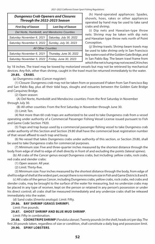
2021-2022 California Ocean Sport Fishing Regulations
52
(h) Hand-operated appliances: Spades, shovels, hoes, rakes or other appliances operated by hand may be used to take sand crabs and shrimp.
(i) Dip nets and Hawaiian-type throw nets: Shrimp may be taken with dip nets and Hawaiian type throw nets north of Point Conception.
(j) Shrimp trawls: Shrimp beam trawls may be used to take shrimp only in San Francisco Bay waters east of the Golden Gate Bridge, and in San Pablo Bay. The beam trawl frame from which the net is hung may not exceed 24 inches
by 18 inches. The trawl may be towed by motorized vessels but may not be retrieved by mechanical devices. Any fish, other than shrimp, caught in the trawl must be returned immediately to the water.
Dungeness Crab Openers and ClosuresThrough the 2022-2023 Season
First Day of Season Last Day of Season
Del Norte, Humboldt, and Mendocino Counties
Saturday November 6, 2021 Saturday, July 30, 2022
Saturday November 5, 2022 Sunday, July 30, 2023
All Other Counties
Saturday November 6, 2021 Thursday, June 30, 2022
Saturday November 5, 2022 Friday, June 30, 2023
29.85. CRABS.(a) Dungeness crabs (Cancer magister):
(1) Closure: Dungeness crab may not be taken from or possessed if taken from San Francisco Bay and San Pablo Bay, plus all their tidal bays, sloughs and estuaries between the Golden Gate Bridge and Carquinez Bridge.
(2) Open season:(A) Del Norte, Humboldt and Mendocino counties: From the first Saturday in November
through July 30.(B) All other counties: From the first Saturday in November through June 30.
(3) Limit: Ten.(4) Not more than 60 crab traps are authorized to be used to take Dungeness crab from a vessel
operating under authority of a Commercial Passenger Fishing Vessel License issued pursuant to Fish and Game Code Section 7920.
(5) Traps and trap buoys used by a commercial passenger fishing vessel to take Dungeness crab under authority of this Section and Section 29.80 shall have the commercial boat registration number of that vessel affixed to each trap and buoy.
(6) No vessel that takes Dungeness crabs under authority of this section, or Section 29.80, shall be used to take Dungeness crabs for commercial purposes.
(7) Minimum size: Five and three-quarter inches measured by the shortest distance through the body from edge of shell to edge of shell directly in front of and excluding the points (lateral spines).
(b) All crabs of the Cancer genus except Dungeness crabs, but including: yellow crabs, rock crabs, red crabs and slender crabs:
(1) Open season: All year. (2) Limit: Thirty-five.(3) Minimum size: Four inches measured by the shortest distance through the body, from edge of
shell to edge of shell at the widest part, except there is no minimum size in Fish and Game Districts 8 and 9.(c) All crabs of the genus Cancer, including Dungeness crabs, yellow crabs, rock crabs, red crabs and
slender crabs, may be brought to the surface of the water for measuring, but no undersize crabs may be placed in any type of receiver, kept on the person or retained in any person’s possession or under his direct control; all crabs shall be measured immediately and any undersize crabs shall be released immediately into the water.
(d) Sand crabs (Emerita analoga): Limit: Fifty.29.86. BAY SHRIMP (GRASS SHRIMP).
Limit: Five pounds.29.87. GHOST SHRIMP AND BLUE MUD SHRIMP.
Limit: Fifty in combination. 29.88. COONSTRIPE SHRIMP (Pandalus danae). Twenty pounds (in the shell, heads on) per day. The
first 20 pounds taken, regardless of size or condition, shall constitute a daily bag and possession limit.29.90. SPINY LOBSTERS.
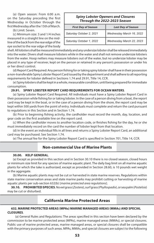
53
(a) Open season: From 6:00 a.m. on the Saturday preceding the first Wednesday in October through the first Wednesday after the 15th of March.
(b) Limit: Seven.(c) Minimum size: 3 and 1/4 inches
measured in a straight line on the mid-line of the back from the rear edge of the eye socket to the rear edge of the body shell. All lobsters shall be measured immediately and any undersize lobster shall be released immediately into the water. Divers shall measure lobsters while in the water and shall not remove undersize lobsters from the water. Hoop netters may measure lobsters out of the water, but no undersize lobster may be placed in any type of receiver, kept on the person or retained in any person’s possession or under his or her direct control.
(d) Report Card Required: Any person fishing for or taking spiny lobster shall have in their possession a non-transferable Spiny Lobster Report Card issued by the department and shall adhere to all reporting requirements for lobster defined in Sections 1.74 and 29.91, Title 14, CCR.
(e) Spiny lobsters shall be kept in a whole, measurable condition, until being prepared for immediate consumption.
Spiny Lobster Openers and ClosuresThrough the 2022-2023 Season
First Day of Season Last Day of Season
Saturday October 2, 2021 Wednesday March 16, 2022
Saturday October 1, 2022 Wednesday March 22, 2023
29.91. SPINY LOBSTER REPORT CARD REQUIREMENTS FOR OCEAN WATERS. (a) Spiny Lobster Report Card Required. All individuals must have a Spiny Lobster Report Card in
their possession while fishing for or taking lobster. In the case of a person diving from a boat, the report card may be kept in the boat, or in the case of a person diving from the shore, the report card may be kept within 500 yards from the point of entry. Individuals must complete and return the card pursuant to regulations in this Section and in Section 1.74.
(b) Prior to beginning fishing activity, the cardholder must record the month, day, location, and gear code on the first available line on the report card.
(c) When the cardholder moves to another location code, or finishes fishing for the day, he or she must immediately record on the card the number of lobster kept from that location.
(d) In the event an individual fills in all lines and returns a Spiny Lobster Report Card, an additional card may be purchased. See Section 1.74.
(e) The annual fee for the Spiny Lobster Report Card is specified in Section 701, Title 14, CCR.
Non-commercial Use of Marine Plants
30.00. KELP GENERAL. (a) Except as provided in this section and in Section 30.10 there is no closed season, closed hours
or minimum size limit for any species of marine aquatic plant. The daily bag limit on all marine aquatic plants for which the take is authorized, except as provided in Section 28.60, is 10 pounds wet weight in the aggregate.
(b) Marine aquatic plants may not be cut or harvested in state marine reserves. Regulations within state marine conservation areas and state marine parks may prohibit cutting or harvesting of marine aquatic plants per sub-section 632(b) [marine protected area regulations].
30.10. PROHIBITED SPECIES. No eel grass (Zostera), surf grass (Phyllospadix), or sea palm (Postelsia) may be cut or disturbed.
California Marine Protected Areas
632. MARINE PROTECTED AREAS (MPAs) MARINE MANAGED AREAS (MMAs) AND SPECIAL CLOSURES.
(a) General Rules and Regulations: The areas specified in this section have been declared by the commission to be marine protected areas (MPAs), marine managed areas (MMAs), or special closures. Public use of marine protected areas, marine managed areas, or special closures shall be compatible with the primary purposes of such areas. MPAs, MMAs, and special closures are subject to the following
2021-2022 California Ocean Sport Fishing Regulations
54
general rules and regulations in addition to existing Fish and Game Code statutes and regulations of the commission, except as otherwise provided for in sub-section 632(b), areas and special regulations for use. Nothing in this section expressly or implicitly precludes, restricts or requires modification of current or future uses of the waters identified as marine protected areas, special closures, or the lands or waters adjacent to these designated areas by the Department of Defense, its allies or agents.
(1) Protection of Resources in MPAs and MMAs, as defined in Public Resources Code Section 36710: (A) State Marine Reserves: In a state marine reserve, it is unlawful to injure, damage, take, or
possess any living, geological, or cultural marine resource, except under a scientific collecting permit issued by the department pursuant to Section 650 or specific authorization from the commission for research, restoration, or monitoring purposes.
(B) State Marine Parks: In a state marine park, it is unlawful to injure, damage, take, or possess any living or nonliving marine resource for commercial purposes. Any human use that would compromise protection of the species of interest, natural community or habitat, or geological, cultural, or recreational features, may be restricted by the commission as specified in sub-section 632(b), areas and special regulations for use. The department may issue scientific collecting permits pursuant to Section 650. The commission may authorize research, monitoring, and educational activities and certain recreational harvest in a manner consistent with protecting resource values.
(C) State Marine Conservation Areas: In a state marine conservation area, it is unlawful to injure, damage, take, or possess any living, geological, or cultural marine resource for commercial or recreational purposes, or a combination of commercial and recreational purposes except as specified in sub-section 632(b), areas and special regulations for use. The department may issue scientific collecting permits pursuant to Section 650. The commission may authorize research, education, and recreational activities, and certain commercial and recreational harvest of marine resources, provided that these uses do not compromise protection of the species of interest, natural community, habitat, or geological features.
(D) State Marine Recreational Management Areas: In a state marine recreational management area, it is unlawful to perform any activity that would compromise the recreational values for which the area may be designated. Recreational opportunities may be protected, enhanced, or restricted, while preserving basic resource values of the area. No other use is restricted unless specified in sub-section 632(b), areas and special regulations for use.
(2) Finfish. Finfish, for the purpose of this section, are defined as any species of bony fish or cartilaginous fish (sharks, skates and rays). Finfish do not include amphibians, invertebrates, plants or algae. The definition of finfish provided in Section 159 does not apply to this Section.
(3) Pelagic Finfish. Pelagic finfish, for the purpose of this section, are a subset of finfish defined as: northern anchovy (Engraulis mordax), barracudas (Sphyraena spp.), billfishes* (family Istiophoridae), dolphinfish (Coryphaena hippurus), Pacific herring (Clupea pallasii), jack mackerel (Trachurus symmetricus), Pacific mackerel (Scomber japonicus), salmon (Oncorhynchus spp.), Pacific sardine (Sardinops sagax), blue shark (Prionace glauca), salmon shark (Lamna ditropis), shortfin mako shark (Isurus oxyrinchus), thresher sharks (Alopias spp.), swordfish (Xiphias gladius), tunas (family Scombridae) including Pacific bonito (Sarda chiliensis), and yellowtail (Seriola lalandi). *Marlin is not allowed for commercial take.
(4) Access. Access into marine protected areas or marine managed areas for non-consumptive uses including but not limited to swimming, surfing, diving, boating, hiking and walking is allowed unless otherwise specified in sub-section 632(b), areas and special regulations for use.
(5) Introduction of Species. Unless authorized by the commission or as a result of authorized fishing activities, the release of any fish or wildlife species, including domestic or domesticated species, or the introduction of any plant species, is prohibited. The department may reintroduce endemic species to marine protected areas or marine managed areas for management purposes.
(6) Feeding of Fish and Wildlife. The feeding of fish and wildlife is prohibited except permitted scientific collection pursuant to Section 650 or as a result of authorized fishing within state marine conservation areas, state marine parks, and state marine recreational management areas, or unless feeding of fish is specifically authorized in sub-section 632(b) for purposes of marine life viewing.
(7) Anchoring. Vessels shall be allowed to anchor in any marine protected area or marine managed area with catch onboard unless otherwise specified in sub-section 632(b), areas and special regulations for use. Fishing gear shall not be deployed in the water while anchored in a state marine reserve. Fishing gear, except legal fishing gear used to take species identified as allowed for take in sub-section 632(b),
55
Are You In aAre You In a Marine Protected Area? Marine Protected Area? Find Out Fast! Go to the Ocean Sport Fishing Interactive Web Map.
w w w.wildlife.ca.gov/OceanSpor tfishMapw w w.wildlife.ca.gov/OceanSpor tfishMap
shall not be deployed in the water while anchored in a state marine recreational management area, state marine park or state marine conservation area. Anchoring regulations shall be consistent with federal law and allowances made for anchoring required by emergency or severe weather.
(8) Transit or Drifting.(A) Vessels shall be allowed to transit through MPAs and MMAs with catch onboard. Fishing gear
shall not be deployed in the water while transiting through a state marine reserve. Fishing gear, except legal fishing gear used to take species identified as allowed for take in sub-section 632(b), shall not be deployed in the water while transiting through a state marine recreational management area, state marine park or state marine conservation area.
(B) Spearfishermen with or without catch shall be allowed to transit through MPAs and MMAs. While transiting MPAs and MMAs that prohibit spearfishing or while in possession of species not identified as allowed for take in the MPA or MMA being transited, spearfishing gear shall be in an unloaded condition, not carried in hand, and the diver shall remain at the surface.
(9) Water Quality Monitoring. Sampling of water, sediment and marine life, for water quality monitoring or pollution research, or as required in a Monitoring and Reporting Program of a National Pollutant Discharge Elimination System (NPDES) Permit and Waste Discharge Requirements issued by the State or Regional Water Boards pursuant to the United States Clean Water Act and the California Water Code, is allowed within state marine reserves, state marine conservation areas, state marine parks, and state marine recreational management areas pursuant to a valid scientific collecting permit issued by the department.
(10) Public Safety. Public safety activities, including installation, maintenance and/or seasonal placement and removal of safety related artificial structures, including but not limited to lifeguard towers, are allowed within any MPA classification pursuant to any required federal, state and local permits, or as otherwise authorized by the department.
(11) Tribal Take. For purposes of this regulation, “federally recognized tribe” means any tribe on the List of Indian Entities Recognized and Eligible to Receive Services from the United States Bureau of Indian Affairs, published annually in the Federal Register. Any member of a federally recognized tribe authorized to take living marine resources from an area with area-specific take restrictions in sub-section 632(b), when engaging in take within an authorized area shall possess on his person, in his immediate possession, or where otherwise specifically required by law to be kept, any valid license, report card, tag, stamp, validation, permit, or any other entitlement that is required in the Fish and Game Code, or required by other state, federal, or local entities, in order to take living marine resources. Members shall possess a valid photo identification card issued by a federally recognized tribe that contains expiration date, tribal name, tribal member number, name, signature, date of birth, height, color of eyes, color of hair, weight, and sex; and display any of the items listed above upon demand to any peace officer. Members taking living marine resources under this provision are subject to current seasonal, bag, possession, gear and size limits in existing Fish and Game Code statutes and regulations of the commission, except as otherwise provided for in sub-section 632(b). No member, while taking living marine resources pursuant to this section, may be assisted by any person who does not possess a valid tribal identification card and is not properly licensed to take living marine resources. Nothing in the regulation is intended to conflict with, or supersede, any state or federal law regarding the take of protected, threatened or endangered species.
(12) Shore Fishing. Take from shore, or shore fishing, for purposes of this section, means take of living marine resources from shore, including beaches, banks, piers, jetties, breakwaters, docks, and other man-made structures connected to the shore. Unless specifically authorized in sub-section 632(b), no vessel, watercraft (motorized or non-motorized), or floating device may be used to assist in the take, transport or possession of species taken while shore fishing, except that a float tube or similar flotation device may be used when taking abalone only. [note that the abalone season is currently closed]
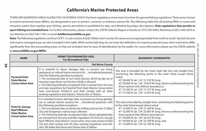
2021-2022 California Ocean Sport Fishing Regulations
56
California’s Marine Protected AreasTHERE ARE NUMEROUS AREAS ALONG THE CALIFORNIA COAST that have regulations more restrictive than the general fishing regulations. These areas, known as marine protected areas (MPAs), are designated in part to protect, conserve, or enhance marine life. The following table lists all existing MPAs in ocean and estuarine waters that regulate sport fishing, species permitted or prohibited for take, and detailed boundary descriptions. Only regulations that pertain to sport fishing are included here. For further information, please contact the CDFW’s Marine Region in Eureka at (707) 445-6493, Monterey at (831) 649-2870 or Los Alamitos at (562) 342-7100, or email [email protected]: The following regulations are from CCR T-14, sub-section 632(b). Within each county, the areas are arranged generally from north to south. Special closures and marine managed areas are also included in this table. While technically they do not meet the definition of a marine protected area, their restrictions differ significantly from the surrounding areas, so they are included here for ease of identification by the public. For more information please see the CDFW website at www.wildlife.ca.gov/MPAs.
NAME PERMITTED/PROHIBITED USESFor Recreational Take BOUNDARY COORDINATES
Del Norte County
Pyramid PointState Marine Conservation Area
It is unlawful to injure, damage, take, or possess any living, geological, or cultural marine resource for… recreational purposes,with the following specified exceptions:1. The recreational take of surf smelt [Section 28.45] by dip net or Hawaiian-type throw net [Section 28.80] is allowed.2. The following federally recognized tribe is exempt from the area and take regulations for Pyramid Point State Marine Conservation Area [sub-section 632(b)(1)] and shall comply with all other existing regulations and statutes: Tolowa Dee-ni’ Nation.
This area is bounded by the mean high tide line and straight lines connecting the following points in the order listed except where noted:
42° 00.000’ N. lat. 124° 12.735’ W. long.;42° 00.000’ N. lat. 124° 19.814’ W. long.; thence southward along the three nautical mile offshore boundary to41° 57.500’ N. lat. 124° 17.101’ W. long.; and41° 57.500’ N. lat. 124° 12.423’ W. long.
Point St. George Reef OffshoreState Marine Conservation Area
It is unlawful to injure, damage, take, or possess any living, geologi-cal, or cultural marine resource for… recreational purposes, with the following specified exceptions:1. The recreational take of salmon by trolling [sub-section 27.80(a)(3)]; and Dungeness crab by trap is allowed.2. The following federally recognized tribes (listed alphabetically) are exempt from the area and take regulations for Point St. George Reef Offshore State Marine Conservation Area [sub-section 632(b)(2)] and shall comply with all other existing regulations and stat-utes: Elk Valley Rancheria and Tolowa Dee-ni’ Nation.
This area is bounded by straight lines connecting the following points in the order listed except where noted:
41° 52.000’ N. lat. 124° 23.189’ W. long.;41° 52.000’ N. lat. 124° 25.805’ W. long.; thence southward along the three nautical mile offshore boundary to41° 49.000’ N. lat. 124° 26.252’ W. long.;41° 49.000’ N. lat. 124° 23.189’ W. long.; and41° 52.000’ N. lat. 124° 23.189’ W. long.
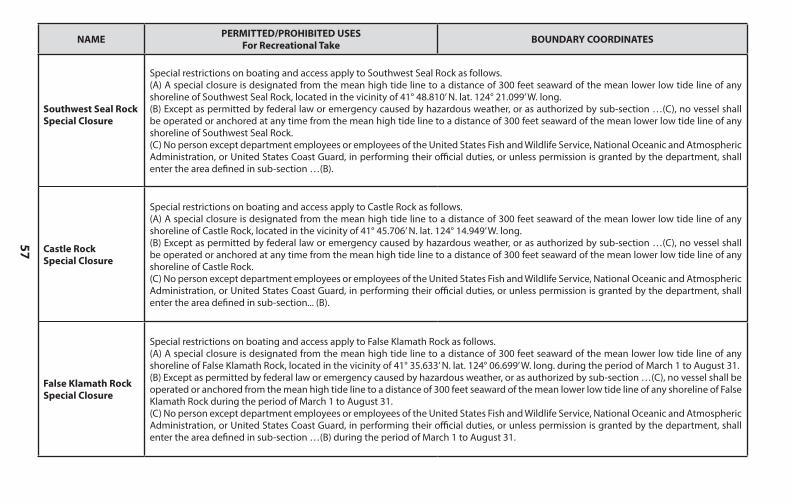
57
NAME PERMITTED/PROHIBITED USESFor Recreational Take BOUNDARY COORDINATES
Del Norte County
Pyramid PointState Marine Conservation Area
It is unlawful to injure, damage, take, or possess any living, geological, or cultural marine resource for… recreational purposes,with the following specified exceptions:1. The recreational take of surf smelt [Section 28.45] by dip net or Hawaiian-type throw net [Section 28.80] is allowed.2. The following federally recognized tribe is exempt from the area and take regulations for Pyramid Point State Marine Conservation Area [sub-section 632(b)(1)] and shall comply with all other existing regulations and statutes: Tolowa Dee-ni’ Nation.
This area is bounded by the mean high tide line and straight lines connecting the following points in the order listed except where noted:
42° 00.000’ N. lat. 124° 12.735’ W. long.;42° 00.000’ N. lat. 124° 19.814’ W. long.; thence southward along the three nautical mile offshore boundary to41° 57.500’ N. lat. 124° 17.101’ W. long.; and41° 57.500’ N. lat. 124° 12.423’ W. long.
Point St. George Reef OffshoreState Marine Conservation Area
It is unlawful to injure, damage, take, or possess any living, geologi-cal, or cultural marine resource for… recreational purposes, with the following specified exceptions:1. The recreational take of salmon by trolling [sub-section 27.80(a)(3)]; and Dungeness crab by trap is allowed.2. The following federally recognized tribes (listed alphabetically) are exempt from the area and take regulations for Point St. George Reef Offshore State Marine Conservation Area [sub-section 632(b)(2)] and shall comply with all other existing regulations and stat-utes: Elk Valley Rancheria and Tolowa Dee-ni’ Nation.
This area is bounded by straight lines connecting the following points in the order listed except where noted:
41° 52.000’ N. lat. 124° 23.189’ W. long.;41° 52.000’ N. lat. 124° 25.805’ W. long.; thence southward along the three nautical mile offshore boundary to41° 49.000’ N. lat. 124° 26.252’ W. long.;41° 49.000’ N. lat. 124° 23.189’ W. long.; and41° 52.000’ N. lat. 124° 23.189’ W. long.
NAME PERMITTED/PROHIBITED USESFor Recreational Take BOUNDARY COORDINATES
Southwest Seal RockSpecial Closure
Special restrictions on boating and access apply to Southwest Seal Rock as follows.(A) A special closure is designated from the mean high tide line to a distance of 300 feet seaward of the mean lower low tide line of any shoreline of Southwest Seal Rock, located in the vicinity of 41° 48.810’ N. lat. 124° 21.099’ W. long.(B) Except as permitted by federal law or emergency caused by hazardous weather, or as authorized by sub-section …(C), no vessel shall be operated or anchored at any time from the mean high tide line to a distance of 300 feet seaward of the mean lower low tide line of any shoreline of Southwest Seal Rock.(C) No person except department employees or employees of the United States Fish and Wildlife Service, National Oceanic and Atmospheric Administration, or United States Coast Guard, in performing their official duties, or unless permission is granted by the department, shall enter the area defined in sub-section …(B).
Castle RockSpecial Closure
Special restrictions on boating and access apply to Castle Rock as follows.(A) A special closure is designated from the mean high tide line to a distance of 300 feet seaward of the mean lower low tide line of any shoreline of Castle Rock, located in the vicinity of 41° 45.706’ N. lat. 124° 14.949’ W. long.(B) Except as permitted by federal law or emergency caused by hazardous weather, or as authorized by sub-section …(C), no vessel shall be operated or anchored at any time from the mean high tide line to a distance of 300 feet seaward of the mean lower low tide line of any shoreline of Castle Rock.(C) No person except department employees or employees of the United States Fish and Wildlife Service, National Oceanic and Atmospheric Administration, or United States Coast Guard, in performing their official duties, or unless permission is granted by the department, shall enter the area defined in sub-section... (B).
False Klamath Rock Special Closure
Special restrictions on boating and access apply to False Klamath Rock as follows.(A) A special closure is designated from the mean high tide line to a distance of 300 feet seaward of the mean lower low tide line of any shoreline of False Klamath Rock, located in the vicinity of 41° 35.633’ N. lat. 124° 06.699’ W. long. during the period of March 1 to August 31.(B) Except as permitted by federal law or emergency caused by hazardous weather, or as authorized by sub-section …(C), no vessel shall be operated or anchored from the mean high tide line to a distance of 300 feet seaward of the mean lower low tide line of any shoreline of False Klamath Rock during the period of March 1 to August 31.(C) No person except department employees or employees of the United States Fish and Wildlife Service, National Oceanic and Atmospheric Administration, or United States Coast Guard, in performing their official duties, or unless permission is granted by the department, shall enter the area defined in sub-section …(B) during the period of March 1 to August 31.
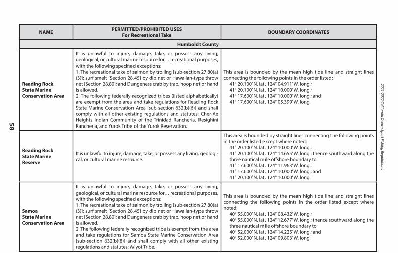
2021-2022 California Ocean Sport Fishing Regulations
58
NAME PERMITTED/PROHIBITED USESFor Recreational Take BOUNDARY COORDINATES
Humboldt County
Reading Rock State Marine Conservation Area
It is unlawful to injure, damage, take, or possess any living, geological, or cultural marine resource for… recreational purposes,with the following specified exceptions:1. The recreational take of salmon by trolling [sub-section 27.80(a)(3)]; surf smelt [Section 28.45] by dip net or Hawaiian-type throw net [Section 28.80]; and Dungeness crab by trap, hoop net or hand is allowed.2. The following federally recognized tribes (listed alphabetically) are exempt from the area and take regulations for Reading Rock State Marine Conservation Area [sub-section 632(b)(6)] and shall comply with all other existing regulations and statutes: Cher-Ae Heights Indian Community of the Trinidad Rancheria, Resighini Rancheria, and Yurok Tribe of the Yurok Reservation.
This area is bounded by the mean high tide line and straight lines connecting the following points in the order listed:
41° 20.100’ N. lat. 124° 04.911’ W. long.;41° 20.100’ N. lat. 124° 10.000’ W. long.;41° 17.600’ N. lat. 124° 10.000’ W. long.; and41° 17.600’ N. lat. 124° 05.399’ W. long.
Reading RockState Marine Reserve
It is unlawful to injure, damage, take, or possess any living, geologi-cal, or cultural marine resource.
This area is bounded by straight lines connecting the following points in the order listed except where noted:
41° 20.100’ N. lat. 124° 10.000’ W. long.;41° 20.100’ N. lat. 124° 14.655’ W. long.; thence southward along the three nautical mile offshore boundary to41° 17.600’ N. lat. 124° 11.963’ W. long.;41° 17.600’ N. lat. 124° 10.000’ W. long.; and41° 20.100’ N. lat. 124° 10.000’ W. long.
SamoaState Marine Conservation Area
It is unlawful to injure, damage, take, or possess any living, geological, or cultural marine resource for… recreational purposes,with the following specified exceptions:1. The recreational take of salmon by trolling [sub-section 27.80(a)(3)]; surf smelt [Section 28.45] by dip net or Hawaiian-type throw net [Section 28.80]; and Dungeness crab by trap, hoop net or hand is allowed.2. The following federally recognized tribe is exempt from the area and take regulations for Samoa State Marine Conservation Area [sub-section 632(b)(8)] and shall comply with all other existing regulations and statutes: Wiyot Tribe.
This area is bounded by the mean high tide line and straight lines connecting the following points in the order listed except where noted:
40° 55.000’ N. lat. 124° 08.432’ W. long.;40° 55.000’ N. lat. 124° 12.677’ W. long.; thence southward along the three nautical mile offshore boundary to40° 52.000’ N. lat. 124° 14.225’ W. long.; and40° 52.000’ N. lat. 124° 09.803’ W. long.
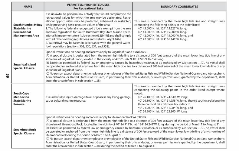
59
NAME PERMITTED/PROHIBITED USESFor Recreational Take BOUNDARY COORDINATES
Humboldt County
Reading Rock State Marine Conservation Area
It is unlawful to injure, damage, take, or possess any living, geological, or cultural marine resource for… recreational purposes,with the following specified exceptions:1. The recreational take of salmon by trolling [sub-section 27.80(a)(3)]; surf smelt [Section 28.45] by dip net or Hawaiian-type throw net [Section 28.80]; and Dungeness crab by trap, hoop net or hand is allowed.2. The following federally recognized tribes (listed alphabetically) are exempt from the area and take regulations for Reading Rock State Marine Conservation Area [sub-section 632(b)(6)] and shall comply with all other existing regulations and statutes: Cher-Ae Heights Indian Community of the Trinidad Rancheria, Resighini Rancheria, and Yurok Tribe of the Yurok Reservation.
This area is bounded by the mean high tide line and straight lines connecting the following points in the order listed:
41° 20.100’ N. lat. 124° 04.911’ W. long.;41° 20.100’ N. lat. 124° 10.000’ W. long.;41° 17.600’ N. lat. 124° 10.000’ W. long.; and41° 17.600’ N. lat. 124° 05.399’ W. long.
Reading RockState Marine Reserve
It is unlawful to injure, damage, take, or possess any living, geologi-cal, or cultural marine resource.
This area is bounded by straight lines connecting the following points in the order listed except where noted:
41° 20.100’ N. lat. 124° 10.000’ W. long.;41° 20.100’ N. lat. 124° 14.655’ W. long.; thence southward along the three nautical mile offshore boundary to41° 17.600’ N. lat. 124° 11.963’ W. long.;41° 17.600’ N. lat. 124° 10.000’ W. long.; and41° 20.100’ N. lat. 124° 10.000’ W. long.
SamoaState Marine Conservation Area
It is unlawful to injure, damage, take, or possess any living, geological, or cultural marine resource for… recreational purposes,with the following specified exceptions:1. The recreational take of salmon by trolling [sub-section 27.80(a)(3)]; surf smelt [Section 28.45] by dip net or Hawaiian-type throw net [Section 28.80]; and Dungeness crab by trap, hoop net or hand is allowed.2. The following federally recognized tribe is exempt from the area and take regulations for Samoa State Marine Conservation Area [sub-section 632(b)(8)] and shall comply with all other existing regulations and statutes: Wiyot Tribe.
This area is bounded by the mean high tide line and straight lines connecting the following points in the order listed except where noted:
40° 55.000’ N. lat. 124° 08.432’ W. long.;40° 55.000’ N. lat. 124° 12.677’ W. long.; thence southward along the three nautical mile offshore boundary to40° 52.000’ N. lat. 124° 14.225’ W. long.; and40° 52.000’ N. lat. 124° 09.803’ W. long.
NAME PERMITTED/PROHIBITED USESFor Recreational Take BOUNDARY COORDINATES
South Humboldt Bay State Marine Recreational Management Area
It is unlawful to perform any activity that would compromise the recreational values for which the area may be designated. Recre-ational opportunities may be protected, enhanced, or restricted, while preserving basic resource values of the area.1. The following federally recognized tribe is exempt from the area and take regulations for South Humboldt Bay State Marine Recre-ational Management Area [sub-section 632(b)(9)] and shall comply with all other existing regulations and statutes: Wiyot Tribe.2. Waterfowl may be taken in accordance with the general water-fowl regulations [sections 502, 550, 551, and 552].
This area is bounded by the mean high tide line and straight lines connecting the following points in the order listed:
40° 43.000’ N. lat. 124° 15.527’ W. long.;40° 43.000’ N. lat. 124° 15.000’ W. long.;40° 42.000’ N. lat. 124° 15.000’ W. long.; and40° 42.000’ N. lat. 124° 16.141’ W. long.
Sugarloaf Island Special Closure
Special restrictions on boating and access apply to Sugarloaf Island as follows.(A) A special closure is designated from the mean high tide line to a distance of 300 feet seaward of the mean lower low tide line of any shoreline of Sugarloaf Island, located in the vicinity of 40° 26.326’ N. lat. 124° 24.827’ W. long.(B) Except as permitted by federal law or emergency caused by hazardous weather, or as authorized by sub-section …(C), no vessel shall be operated or anchored at any time from the mean high tide line to a distance of 300 feet seaward of the mean lower low tide line of any shoreline of Sugarloaf Island.(C) No person except department employees or employees of the United States Fish and Wildlife Service, National Oceanic and Atmospheric Administration, or United States Coast Guard, in performing their official duties, or unless permission is granted by the department, shall enter the area defined in sub-section …(B).
South Cape MendocinoState Marine Reserve
It is unlawful to injure, damage, take, or possess any living, geologi-cal, or cultural marine resource.
This area is bounded by the mean high tide line and straight lines connecting the following points in the order listed except where noted:
40° 26.100’ N. lat. 124° 24.340’ W. long.;40° 26.100’ N. lat. 124° 31.958’ W. long.; thence southward along the three nautical mile offshore boundary to40° 24.900’ N. lat. 124° 31.084’ W. long.; and40° 24.900’ N. lat. 124° 23.800’ W. long.
Steamboat Rock Special Closure
Special restrictions on boating and access apply to Steamboat Rock as follows.(A) A special closure is designated from the mean high tide line to a distance of 300 feet seaward of the mean lower low tide line of any shoreline of Steamboat Rock, located in the vicinity of 40° 24.919’ N. lat. 124° 24.241’ W. long. during the period of March 1 to August 31.(B) Except as permitted by federal law or emergency caused by hazardous weather, or as authorized by sub-section …(C), no vessel shall be operated or anchored from the mean high tide line to a distance of 300 feet seaward of the mean lower low tide line of any shoreline of Steamboat Rock during the period of March 1 to August 31.(C) No person except department employees or employees of the United States Fish and Wildlife Service, National Oceanic and Atmospheric Administration, or United States Coast Guard, in performing their official duties, or unless permission is granted by the department, shall enter the area defined in sub-section …(B) during the period of March 1 to August 31.
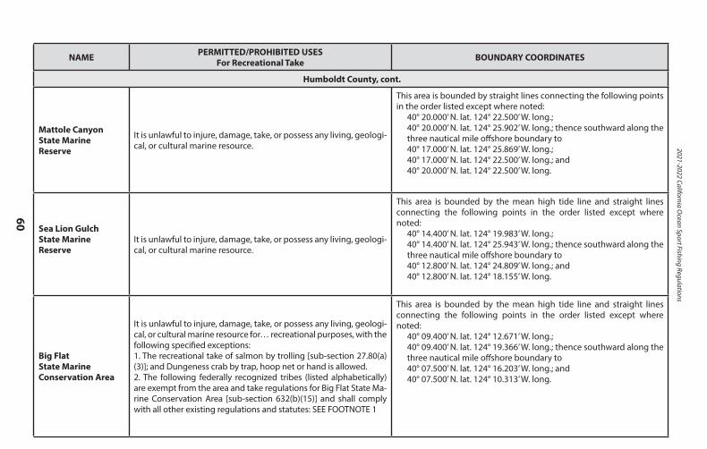
2021-2022 California Ocean Sport Fishing Regulations
60
NAME PERMITTED/PROHIBITED USESFor Recreational Take BOUNDARY COORDINATES
Humboldt County, cont.
Mattole CanyonState Marine Reserve
It is unlawful to injure, damage, take, or possess any living, geologi-cal, or cultural marine resource.
This area is bounded by straight lines connecting the following points in the order listed except where noted:
40° 20.000’ N. lat. 124° 22.500’ W. long.;40° 20.000’ N. lat. 124° 25.902’ W. long.; thence southward along the three nautical mile offshore boundary to40° 17.000’ N. lat. 124° 25.869’ W. long.;40° 17.000’ N. lat. 124° 22.500’ W. long.; and40° 20.000’ N. lat. 124° 22.500’ W. long.
Sea Lion GulchState Marine Reserve
It is unlawful to injure, damage, take, or possess any living, geologi-cal, or cultural marine resource.
This area is bounded by the mean high tide line and straight lines connecting the following points in the order listed except where noted:
40° 14.400’ N. lat. 124° 19.983’ W. long.;40° 14.400’ N. lat. 124° 25.943’ W. long.; thence southward along the three nautical mile offshore boundary to40° 12.800’ N. lat. 124° 24.809’ W. long.; and40° 12.800’ N. lat. 124° 18.155’ W. long.
Big FlatState Marine Conservation Area
It is unlawful to injure, damage, take, or possess any living, geologi-cal, or cultural marine resource for… recreational purposes, with the following specified exceptions:1. The recreational take of salmon by trolling [sub-section 27.80(a)(3)]; and Dungeness crab by trap, hoop net or hand is allowed.2. The following federally recognized tribes (listed alphabetically) are exempt from the area and take regulations for Big Flat State Ma-rine Conservation Area [sub-section 632(b)(15)] and shall comply with all other existing regulations and statutes: SEE FOOTNOTE 1
This area is bounded by the mean high tide line and straight lines connecting the following points in the order listed except where noted:
40° 09.400’ N. lat. 124° 12.671’ W. long.;40° 09.400’ N. lat. 124° 19.366’ W. long.; thence southward along the three nautical mile offshore boundary to40° 07.500’ N. lat. 124° 16.203’ W. long.; and40° 07.500’ N. lat. 124° 10.313’ W. long.
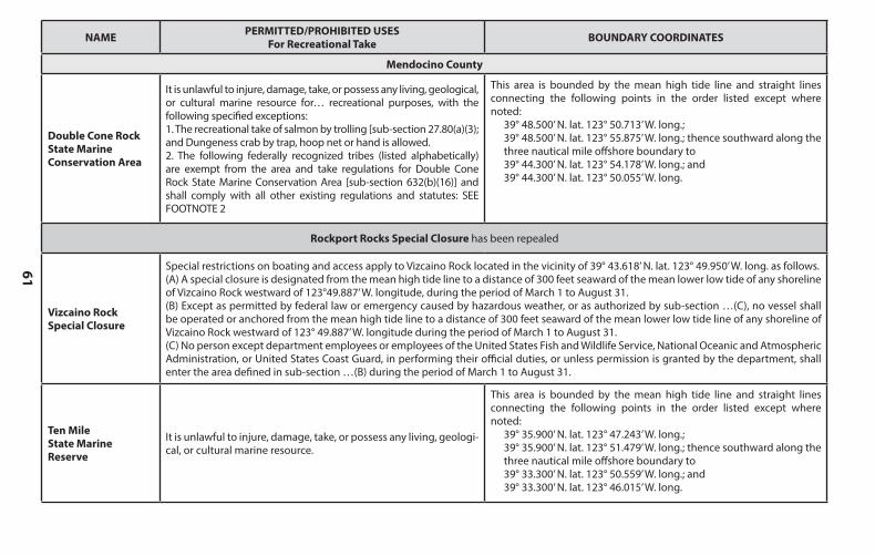
61
NAME PERMITTED/PROHIBITED USESFor Recreational Take BOUNDARY COORDINATES
Humboldt County, cont.
Mattole CanyonState Marine Reserve
It is unlawful to injure, damage, take, or possess any living, geologi-cal, or cultural marine resource.
This area is bounded by straight lines connecting the following points in the order listed except where noted:
40° 20.000’ N. lat. 124° 22.500’ W. long.;40° 20.000’ N. lat. 124° 25.902’ W. long.; thence southward along the three nautical mile offshore boundary to40° 17.000’ N. lat. 124° 25.869’ W. long.;40° 17.000’ N. lat. 124° 22.500’ W. long.; and40° 20.000’ N. lat. 124° 22.500’ W. long.
Sea Lion GulchState Marine Reserve
It is unlawful to injure, damage, take, or possess any living, geologi-cal, or cultural marine resource.
This area is bounded by the mean high tide line and straight lines connecting the following points in the order listed except where noted:
40° 14.400’ N. lat. 124° 19.983’ W. long.;40° 14.400’ N. lat. 124° 25.943’ W. long.; thence southward along the three nautical mile offshore boundary to40° 12.800’ N. lat. 124° 24.809’ W. long.; and40° 12.800’ N. lat. 124° 18.155’ W. long.
Big FlatState Marine Conservation Area
It is unlawful to injure, damage, take, or possess any living, geologi-cal, or cultural marine resource for… recreational purposes, with the following specified exceptions:1. The recreational take of salmon by trolling [sub-section 27.80(a)(3)]; and Dungeness crab by trap, hoop net or hand is allowed.2. The following federally recognized tribes (listed alphabetically) are exempt from the area and take regulations for Big Flat State Ma-rine Conservation Area [sub-section 632(b)(15)] and shall comply with all other existing regulations and statutes: SEE FOOTNOTE 1
This area is bounded by the mean high tide line and straight lines connecting the following points in the order listed except where noted:
40° 09.400’ N. lat. 124° 12.671’ W. long.;40° 09.400’ N. lat. 124° 19.366’ W. long.; thence southward along the three nautical mile offshore boundary to40° 07.500’ N. lat. 124° 16.203’ W. long.; and40° 07.500’ N. lat. 124° 10.313’ W. long.
NAME PERMITTED/PROHIBITED USESFor Recreational Take BOUNDARY COORDINATES
Mendocino County
Double Cone Rock State Marine Conservation Area
It is unlawful to injure, damage, take, or possess any living, geological, or cultural marine resource for… recreational purposes, with the following specified exceptions:1. The recreational take of salmon by trolling [sub-section 27.80(a)(3); and Dungeness crab by trap, hoop net or hand is allowed.2. The following federally recognized tribes (listed alphabetically) are exempt from the area and take regulations for Double Cone Rock State Marine Conservation Area [sub-section 632(b)(16)] and shall comply with all other existing regulations and statutes: SEE FOOTNOTE 2
This area is bounded by the mean high tide line and straight lines connecting the following points in the order listed except where noted:
39° 48.500’ N. lat. 123° 50.713’ W. long.;39° 48.500’ N. lat. 123° 55.875’ W. long.; thence southward along the three nautical mile offshore boundary to39° 44.300’ N. lat. 123° 54.178’ W. long.; and39° 44.300’ N. lat. 123° 50.055’ W. long.
Rockport Rocks Special Closure has been repealed
Vizcaino RockSpecial Closure
Special restrictions on boating and access apply to Vizcaino Rock located in the vicinity of 39° 43.618’ N. lat. 123° 49.950’ W. long. as follows.(A) A special closure is designated from the mean high tide line to a distance of 300 feet seaward of the mean lower low tide of any shoreline of Vizcaino Rock westward of 123°49.887’ W. longitude, during the period of March 1 to August 31.(B) Except as permitted by federal law or emergency caused by hazardous weather, or as authorized by sub-section …(C), no vessel shall be operated or anchored from the mean high tide line to a distance of 300 feet seaward of the mean lower low tide line of any shoreline of Vizcaino Rock westward of 123° 49.887’ W. longitude during the period of March 1 to August 31.(C) No person except department employees or employees of the United States Fish and Wildlife Service, National Oceanic and Atmospheric Administration, or United States Coast Guard, in performing their official duties, or unless permission is granted by the department, shall enter the area defined in sub-section …(B) during the period of March 1 to August 31.
Ten MileState Marine Reserve
It is unlawful to injure, damage, take, or possess any living, geologi-cal, or cultural marine resource.
This area is bounded by the mean high tide line and straight lines connecting the following points in the order listed except where noted:
39° 35.900’ N. lat. 123° 47.243’ W. long.;39° 35.900’ N. lat. 123° 51.479’ W. long.; thence southward along the three nautical mile offshore boundary to39° 33.300’ N. lat. 123° 50.559’ W. long.; and39° 33.300’ N. lat. 123° 46.015’ W. long.
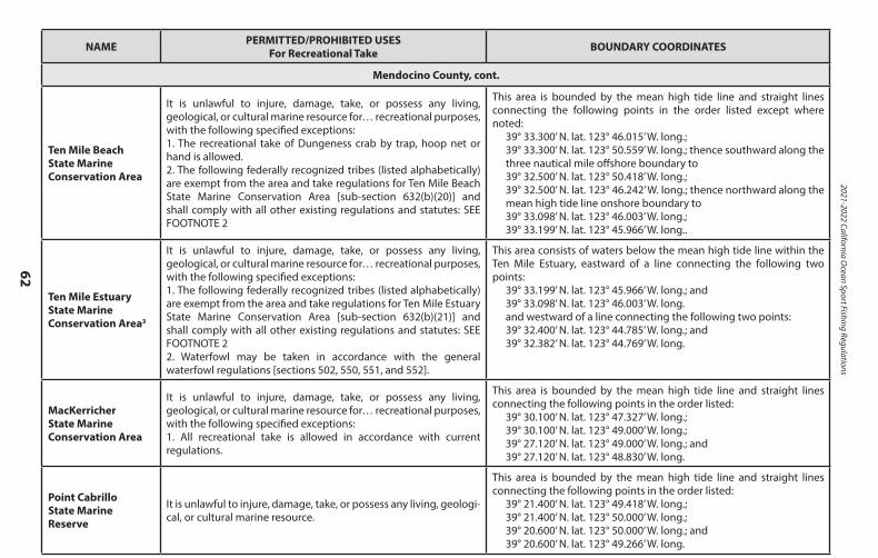
2021-2022 California Ocean Sport Fishing Regulations
62
NAME PERMITTED/PROHIBITED USESFor Recreational Take BOUNDARY COORDINATES
Mendocino County, cont.
Ten Mile BeachState Marine Conservation Area
It is unlawful to injure, damage, take, or possess any living, geological, or cultural marine resource for… recreational purposes, with the following specified exceptions:1. The recreational take of Dungeness crab by trap, hoop net or hand is allowed.2. The following federally recognized tribes (listed alphabetically) are exempt from the area and take regulations for Ten Mile Beach State Marine Conservation Area [sub-section 632(b)(20)] and shall comply with all other existing regulations and statutes: SEE FOOTNOTE 2
This area is bounded by the mean high tide line and straight lines connecting the following points in the order listed except where noted:
39° 33.300’ N. lat. 123° 46.015’ W. long.;39° 33.300’ N. lat. 123° 50.559’ W. long.; thence southward along the three nautical mile offshore boundary to39° 32.500’ N. lat. 123° 50.418’ W. long.;39° 32.500’ N. lat. 123° 46.242’ W. long.; thence northward along the mean high tide line onshore boundary to39° 33.098’ N. lat. 123° 46.003’ W. long.;39° 33.199’ N. lat. 123° 45.966’ W. long..
Ten Mile Estuary State Marine Conservation Area3
It is unlawful to injure, damage, take, or possess any living, geological, or cultural marine resource for… recreational purposes,with the following specified exceptions:1. The following federally recognized tribes (listed alphabetically) are exempt from the area and take regulations for Ten Mile Estuary State Marine Conservation Area [sub-section 632(b)(21)] and shall comply with all other existing regulations and statutes: SEE FOOTNOTE 22. Waterfowl may be taken in accordance with the general waterfowl regulations [sections 502, 550, 551, and 552].
This area consists of waters below the mean high tide line within the Ten Mile Estuary, eastward of a line connecting the following two points:
39° 33.199’ N. lat. 123° 45.966’ W. long.; and39° 33.098’ N. lat. 123° 46.003’ W. long.and westward of a line connecting the following two points:39° 32.400’ N. lat. 123° 44.785’ W. long.; and39° 32.382’ N. lat. 123° 44.769’ W. long.
MacKerricher State Marine Conservation Area
It is unlawful to injure, damage, take, or possess any living, geological, or cultural marine resource for… recreational purposes,with the following specified exceptions:1. All recreational take is allowed in accordance with current regulations.
This area is bounded by the mean high tide line and straight lines connecting the following points in the order listed:
39° 30.100’ N. lat. 123° 47.327’ W. long.;39° 30.100’ N. lat. 123° 49.000’ W. long.;39° 27.120’ N. lat. 123° 49.000’ W. long.; and39° 27.120’ N. lat. 123° 48.830’ W. long.
Point Cabrillo State Marine Reserve
It is unlawful to injure, damage, take, or possess any living, geologi-cal, or cultural marine resource.
This area is bounded by the mean high tide line and straight lines connecting the following points in the order listed:
39° 21.400’ N. lat. 123° 49.418’ W. long.;39° 21.400’ N. lat. 123° 50.000’ W. long.;39° 20.600’ N. lat. 123° 50.000’ W. long.; and39° 20.600’ N. lat. 123° 49.266’ W. long.
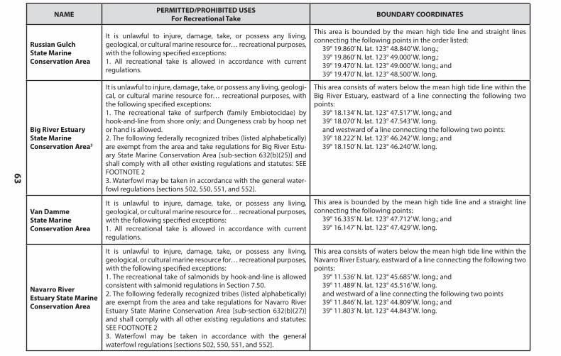
63
NAME PERMITTED/PROHIBITED USESFor Recreational Take BOUNDARY COORDINATES
Mendocino County, cont.
Ten Mile BeachState Marine Conservation Area
It is unlawful to injure, damage, take, or possess any living, geological, or cultural marine resource for… recreational purposes, with the following specified exceptions:1. The recreational take of Dungeness crab by trap, hoop net or hand is allowed.2. The following federally recognized tribes (listed alphabetically) are exempt from the area and take regulations for Ten Mile Beach State Marine Conservation Area [sub-section 632(b)(20)] and shall comply with all other existing regulations and statutes: SEE FOOTNOTE 2
This area is bounded by the mean high tide line and straight lines connecting the following points in the order listed except where noted:
39° 33.300’ N. lat. 123° 46.015’ W. long.;39° 33.300’ N. lat. 123° 50.559’ W. long.; thence southward along the three nautical mile offshore boundary to39° 32.500’ N. lat. 123° 50.418’ W. long.;39° 32.500’ N. lat. 123° 46.242’ W. long.; thence northward along the mean high tide line onshore boundary to39° 33.098’ N. lat. 123° 46.003’ W. long.;39° 33.199’ N. lat. 123° 45.966’ W. long..
Ten Mile Estuary State Marine Conservation Area3
It is unlawful to injure, damage, take, or possess any living, geological, or cultural marine resource for… recreational purposes,with the following specified exceptions:1. The following federally recognized tribes (listed alphabetically) are exempt from the area and take regulations for Ten Mile Estuary State Marine Conservation Area [sub-section 632(b)(21)] and shall comply with all other existing regulations and statutes: SEE FOOTNOTE 22. Waterfowl may be taken in accordance with the general waterfowl regulations [sections 502, 550, 551, and 552].
This area consists of waters below the mean high tide line within the Ten Mile Estuary, eastward of a line connecting the following two points:
39° 33.199’ N. lat. 123° 45.966’ W. long.; and39° 33.098’ N. lat. 123° 46.003’ W. long.and westward of a line connecting the following two points:39° 32.400’ N. lat. 123° 44.785’ W. long.; and39° 32.382’ N. lat. 123° 44.769’ W. long.
MacKerricher State Marine Conservation Area
It is unlawful to injure, damage, take, or possess any living, geological, or cultural marine resource for… recreational purposes,with the following specified exceptions:1. All recreational take is allowed in accordance with current regulations.
This area is bounded by the mean high tide line and straight lines connecting the following points in the order listed:
39° 30.100’ N. lat. 123° 47.327’ W. long.;39° 30.100’ N. lat. 123° 49.000’ W. long.;39° 27.120’ N. lat. 123° 49.000’ W. long.; and39° 27.120’ N. lat. 123° 48.830’ W. long.
Point Cabrillo State Marine Reserve
It is unlawful to injure, damage, take, or possess any living, geologi-cal, or cultural marine resource.
This area is bounded by the mean high tide line and straight lines connecting the following points in the order listed:
39° 21.400’ N. lat. 123° 49.418’ W. long.;39° 21.400’ N. lat. 123° 50.000’ W. long.;39° 20.600’ N. lat. 123° 50.000’ W. long.; and39° 20.600’ N. lat. 123° 49.266’ W. long.
NAME PERMITTED/PROHIBITED USESFor Recreational Take BOUNDARY COORDINATES
Russian Gulch State Marine Conservation Area
It is unlawful to injure, damage, take, or possess any living, geological, or cultural marine resource for… recreational purposes,with the following specified exceptions:1. All recreational take is allowed in accordance with current regulations.
This area is bounded by the mean high tide line and straight lines connecting the following points in the order listed:
39° 19.860’ N. lat. 123° 48.840’ W. long.;39° 19.860’ N. lat. 123° 49.000’ W. long.;39° 19.470’ N. lat. 123° 49.000’ W. long.; and39° 19.470’ N. lat. 123° 48.500’ W. long.
Big River Estuary State Marine Conservation Area3
It is unlawful to injure, damage, take, or possess any living, geologi-cal, or cultural marine resource for… recreational purposes, with the following specified exceptions:1. The recreational take of surfperch (family Embiotocidae) by hook-and-line from shore only; and Dungeness crab by hoop net or hand is allowed.2. The following federally recognized tribes (listed alphabetically) are exempt from the area and take regulations for Big River Estu-ary State Marine Conservation Area [sub-section 632(b)(25)] and shall comply with all other existing regulations and statutes: SEE FOOTNOTE 23. Waterfowl may be taken in accordance with the general water-fowl regulations [sections 502, 550, 551, and 552].
This area consists of waters below the mean high tide line within the Big River Estuary, eastward of a line connecting the following two points:
39° 18.134’ N. lat. 123° 47.517’ W. long.; and39° 18.070’ N. lat. 123° 47.543’ W. long.and westward of a line connecting the following two points:39° 18.222’ N. lat. 123° 46.242’ W. long.; and39° 18.150’ N. lat. 123° 46.240’ W. long.
Van Damme State Marine Conservation Area
It is unlawful to injure, damage, take, or possess any living, geological, or cultural marine resource for… recreational purposes,with the following specified exceptions:1. All recreational take is allowed in accordance with current regulations.
This area is bounded by the mean high tide line and a straight line connecting the following points:
39° 16.335’ N. lat. 123° 47.712’ W. long.; and39° 16.147’ N. lat. 123° 47.429’ W. long.
Navarro River Estuary State Marine Conservation Area
It is unlawful to injure, damage, take, or possess any living, geological, or cultural marine resource for… recreational purposes,with the following specified exceptions:1. The recreational take of salmonids by hook-and-line is allowed consistent with salmonid regulations in Section 7.50.2. The following federally recognized tribes (listed alphabetically) are exempt from the area and take regulations for Navarro River Estuary State Marine Conservation Area [sub-section 632(b)(27)] and shall comply with all other existing regulations and statutes: SEE FOOTNOTE 23. Waterfowl may be taken in accordance with the general waterfowl regulations [sections 502, 550, 551, and 552].
This area consists of waters below the mean high tide line within the Navarro River Estuary, eastward of a line connecting the following two points:
39° 11.536’ N. lat. 123° 45.685’ W. long.; and39° 11.489’ N. lat. 123° 45.516’ W. long.and westward of a line connecting the following two points39° 11.846’ N. lat. 123° 44.809’ W. long.; and39° 11.803’ N. lat. 123° 44.843’ W. long.
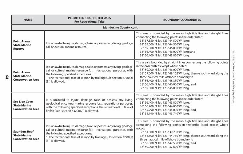
2021-2022 California Ocean Sport Fishing Regulations
64
NAME PERMITTED/PROHIBITED USESFor Recreational Take BOUNDARY COORDINATES
Mendocino County, cont.
Point Arena State Marine Reserve
It is unlawful to injure, damage, take, or possess any living, geologi-cal, or cultural marine resource.
This area is bounded by the mean high tide line and straight lines connecting the following points in the order listed:
38° 57.350’ N. lat. 123° 44.500’ W. long;38° 59.000’ N. lat. 123° 44.500’ W. long;38° 59.000’ N. lat. 123° 46.000’ W. long;38° 56.400’ N. lat. 123° 46.000’ W. long; and38° 56.400’ N. lat. 123° 43.820’ W. long.
Point ArenaState Marine Conservation Area
It is unlawful to injure, damage, take, or possess any living, geologi-cal, or cultural marine resource for… recreational purposes, with the following specified exceptions1. The recreational take of salmon by trolling [sub-section 27.80(a)(3)] is allowed.
This area is bounded by straight lines connecting the following points in the order listed except where noted:
38° 59.000’ N. lat. 123° 46.000’ W. long.;38° 59.000’ N. lat. 123° 48.162’ W. long.; thence southward along the three nautical mile offshore boundary to38° 56.400’ N. lat. 123° 48.350’ W. long.;38° 56.400’ N. lat. 123° 46.000’ W. long.; and38° 59.000’ N. lat. 123° 46.000’ W. long.
Sea Lion Cove State Marine Conservation Area
It is unlawful to injure, damage, take, or possess any living, geological, or cultural marine resource for… recreational purposes,with the following specified exceptions: the recreational… take of finfish [sub-section 632(a)(2)] is allowed.
This area is bounded by the mean high tide line and straight lines connecting the following points in the order listed:
38° 56.400’ N. lat. 123° 43.820’ W. long.;38° 56.400’ N. lat. 123° 44.000’ W. long.;38° 55.790’ N. lat. 123° 44.000’ W. long.; and38° 55.790’ N. lat. 123° 43.740’ W. long.
Saunders ReefState Marine Conservation Area
It is unlawful to injure, damage, take, or possess any living, geologi-cal, or cultural marine resource for… recreational purposes, with the following specified exceptions:1. The recreational take of salmon by trolling [sub-section 27.80(a)(3)] is allowed.
This area is bounded by the mean high tide line and straight lines connecting the following points in the order listed except where noted:
38° 51.800’ N. lat. 123° 39.230’ W. long.;38° 51.800’ N. lat. 123° 44.780’ W. long.; thence southward along the three nautical mile offshore boundary to38° 50.000’ N. lat. 123° 42.580’ W. long.; and38° 50.000’ N. lat. 123° 37.600’ W. long.

65
NAME PERMITTED/PROHIBITED USESFor Recreational Take BOUNDARY COORDINATES
Sonoma County
Del Mar LandingState Marine Reserve
It is unlawful to injure, damage, take, or possess any living, geologi-cal, or cultural marine resource.
This area is bounded by the mean high tide line and straight lines connecting the following points in the order listed:
38° 44.706’ N. lat. 123° 31.000’ W. long.;38° 44.200’ N. lat. 123° 31.000’ W. long.;38° 44.200’ N. lat. 123° 30.300’ W. long.; and38° 44.430’ N. lat. 123° 30.300’ W. long.
Stewarts PointState MarineConservation Area
It is unlawful to injure, damage, take, or possess any living, geological, or cultural marine resource for… recreational purposes,with the following specified exceptions: the following may be taken recreationally from shore only: marine aquatic plants other than sea palm, marine invertebrates, finfish [sub-section 632(a)(2)] by hook-and-line, surf smelt by beach net, and species authorized in Section 28.80 of these regulations by hand-held dip net.
This area is bounded by the mean high tide line and straight lines connecting the following points in the order listed:
38° 39.527’ N. lat. 123° 24.483' W. long.; 38° 39.527’ N. lat. 123° 24.851’ W. long.; 38° 36.958’ N. lat. 123° 23.139' W. long.; 38° 36.958’ N. lat. 123° 22.468’ W. long.
Stewarts PointState Marine Reserve
It is unlawful to injure, damage, take, or possess any living, geologi-cal, or cultural marine resource.
This area is bounded by the mean high tide line and straight lines connecting the following points in the order listed except where noted:
38° 40.500’ N. lat. 123° 25.345’ W. long. and38° 40.500’ N. lat. 123° 30.243’ W. long.; thence southward along the three nautical mile offshore boundary to 38° 35.600’ N. lat. 123° 26.018’ W. long.; and38° 35.600’ N. lat. 123° 20.800’ W. long. except that Stewarts Point State Marine Conservation Area as described in sub-section 632(b)(33)(A) [above] is excluded.
Salt Point State Marine Conservation Area4
It is unlawful to injure, damage, take, or possess any living, geological, or cultural marine resource for… recreational purposes,with the following specified exceptions: the recreational take ofabalone and finfish [sub-section 632(a)(2)] is allowed. [note that abalone season is currently closed]
This area is bounded by the mean high tide line and straight lines connecting the following points in the order listed:
38° 35.600’ N. lat. 123° 20.800’ W. long.;38° 35.600’ N. lat. 123° 21.000’ W. long.;38° 33.500’ N. lat. 123° 21.000’ W. long.;38° 33.500’ N. lat. 123° 18.910’ W. long., except that Gerstle Cove as described in sub-section 632(b)(36)(A) is excluded.
NAME PERMITTED/PROHIBITED USESFor Recreational Take BOUNDARY COORDINATES
Mendocino County, cont.
Point Arena State Marine Reserve
It is unlawful to injure, damage, take, or possess any living, geologi-cal, or cultural marine resource.
This area is bounded by the mean high tide line and straight lines connecting the following points in the order listed:
38° 57.350’ N. lat. 123° 44.500’ W. long;38° 59.000’ N. lat. 123° 44.500’ W. long;38° 59.000’ N. lat. 123° 46.000’ W. long;38° 56.400’ N. lat. 123° 46.000’ W. long; and38° 56.400’ N. lat. 123° 43.820’ W. long.
Point ArenaState Marine Conservation Area
It is unlawful to injure, damage, take, or possess any living, geologi-cal, or cultural marine resource for… recreational purposes, with the following specified exceptions1. The recreational take of salmon by trolling [sub-section 27.80(a)(3)] is allowed.
This area is bounded by straight lines connecting the following points in the order listed except where noted:
38° 59.000’ N. lat. 123° 46.000’ W. long.;38° 59.000’ N. lat. 123° 48.162’ W. long.; thence southward along the three nautical mile offshore boundary to38° 56.400’ N. lat. 123° 48.350’ W. long.;38° 56.400’ N. lat. 123° 46.000’ W. long.; and38° 59.000’ N. lat. 123° 46.000’ W. long.
Sea Lion Cove State Marine Conservation Area
It is unlawful to injure, damage, take, or possess any living, geological, or cultural marine resource for… recreational purposes,with the following specified exceptions: the recreational… take of finfish [sub-section 632(a)(2)] is allowed.
This area is bounded by the mean high tide line and straight lines connecting the following points in the order listed:
38° 56.400’ N. lat. 123° 43.820’ W. long.;38° 56.400’ N. lat. 123° 44.000’ W. long.;38° 55.790’ N. lat. 123° 44.000’ W. long.; and38° 55.790’ N. lat. 123° 43.740’ W. long.
Saunders ReefState Marine Conservation Area
It is unlawful to injure, damage, take, or possess any living, geologi-cal, or cultural marine resource for… recreational purposes, with the following specified exceptions:1. The recreational take of salmon by trolling [sub-section 27.80(a)(3)] is allowed.
This area is bounded by the mean high tide line and straight lines connecting the following points in the order listed except where noted:
38° 51.800’ N. lat. 123° 39.230’ W. long.;38° 51.800’ N. lat. 123° 44.780’ W. long.; thence southward along the three nautical mile offshore boundary to38° 50.000’ N. lat. 123° 42.580’ W. long.; and38° 50.000’ N. lat. 123° 37.600’ W. long.
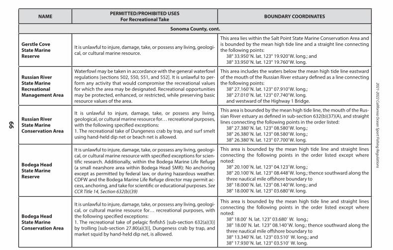
2021-2022 California Ocean Sport Fishing Regulations
66
NAME PERMITTED/PROHIBITED USESFor Recreational Take BOUNDARY COORDINATES
Sonoma County, cont.
Gerstle CoveState Marine Reserve
It is unlawful to injure, damage, take, or possess any living, geologi-cal, or cultural marine resource.
This area lies within the Salt Point State Marine Conservation Area and is bounded by the mean high tide line and a straight line connecting the following points:
38° 33.950’ N. lat. 123° 19.920’ W. long.; and38° 33.950’ N. lat. 123° 19.760’ W. long.
Russian River State Marine RecreationalManagement Area
Waterfowl may be taken in accordance with the general waterfowlregulations [sections 502, 550, 551, and 552]. It is unlawful to per-form any activity that would compromise the recreational values for which the area may be designated. Recreational opportunities may be protected, enhanced, or restricted, while preserving basic resource values of the area.
This area includes the waters below the mean high tide line eastward of the mouth of the Russian River estuary defined as a line connecting the following points:
38° 27.160’ N. lat. 123° 07.910’ W. long.;38° 27.010’ N. lat. 123° 07.740’ W. long.and westward of the Highway 1 Bridge.
Russian RiverState Marine Conservation Area
It is unlawful to injure, damage, take, or possess any living, geological, or cultural marine resource for… recreational purposes,with the following specified exceptions:1. The recreational take of Dungeness crab by trap, and surf smelt using hand-held dip net or beach net is allowed.
This area is bounded by the mean high tide line, the mouth of the Rus-sian River estuary as defined in sub-section 632(b)(37)(A), and straight lines connecting the following points in the order listed:
38° 27.380’ N. lat. 123° 08.580’ W. long.;38° 26.380’ N. lat. 123° 08.580’ W. long.;38° 26.380’ N. lat. 123° 07.700’ W. long.
Bodega HeadState Marine Reserve
It is unlawful to injure, damage, take, or possess any living, geologi-cal, or cultural marine resource with specified exceptions for scien-tific research. Additionally, within the Bodega Marine Life Refuge (a small nearshore area within Bodega Head SMR): No anchoring except as permitted by federal law, or during hazardous weather. CDFW and the Bodega Marine Life Refuge director may permit ac-cess, anchoring, and take for scientific or educational purposes. See CCR Title 14, Section 632(b)(39)
This area is bounded by the mean high tide line and straight lines connecting the following points in the order listed except where noted:
38° 20.100’ N. lat. 123° 04.123’ W. long.;38° 20.100’ N. lat. 123° 08.448’ W. long.; thence southward along the three nautical mile offshore boundary to38° 18.000’ N. lat. 123° 08.140’ W. long.; and38° 18.000’ N. lat. 123° 03.680’ W. long.
Bodega HeadState Marine Conservation Area
It is unlawful to injure, damage, take, or possess any living, geologi-cal, or cultural marine resource for… recreational purposes, with the following specified exceptions:1. The recreational take of pelagic finfish5 [sub-section 632(a)(3)] by trolling [sub-section 27.80(a)(3)], Dungeness crab by trap, and market squid by hand-held dip net, is allowed.
This area is bounded by the mean high tide line and straight lines connecting the following points in the order listed except where noted:
38° 18.00’ N. lat. 123° 03.680’ W. long.;38° 18.00’ N. lat. 123° 08.140’ W. long.; thence southward along the three nautical mile offshore boundary to38° 13.340’ N. lat. 123° 03.510’ W. long.; and38° 17.930’ N. lat. 123° 03.510’ W. long.
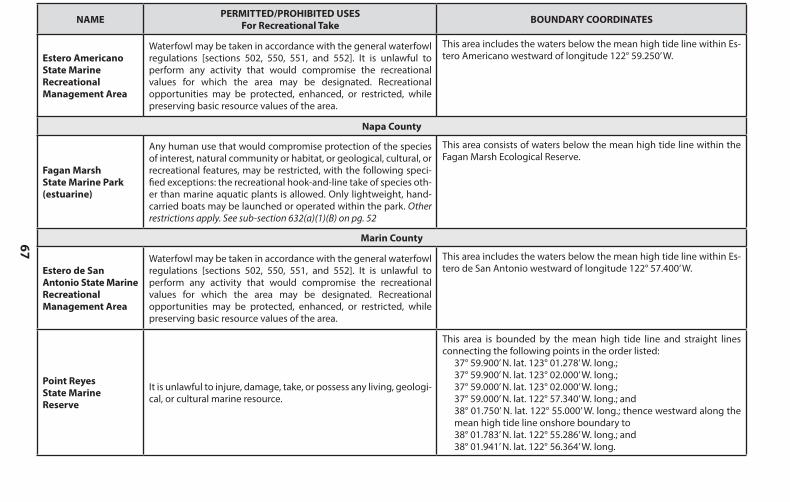
67
NAME PERMITTED/PROHIBITED USESFor Recreational Take BOUNDARY COORDINATES
Sonoma County, cont.
Gerstle CoveState Marine Reserve
It is unlawful to injure, damage, take, or possess any living, geologi-cal, or cultural marine resource.
This area lies within the Salt Point State Marine Conservation Area and is bounded by the mean high tide line and a straight line connecting the following points:
38° 33.950’ N. lat. 123° 19.920’ W. long.; and38° 33.950’ N. lat. 123° 19.760’ W. long.
Russian River State Marine RecreationalManagement Area
Waterfowl may be taken in accordance with the general waterfowlregulations [sections 502, 550, 551, and 552]. It is unlawful to per-form any activity that would compromise the recreational values for which the area may be designated. Recreational opportunities may be protected, enhanced, or restricted, while preserving basic resource values of the area.
This area includes the waters below the mean high tide line eastward of the mouth of the Russian River estuary defined as a line connecting the following points:
38° 27.160’ N. lat. 123° 07.910’ W. long.;38° 27.010’ N. lat. 123° 07.740’ W. long.and westward of the Highway 1 Bridge.
Russian RiverState Marine Conservation Area
It is unlawful to injure, damage, take, or possess any living, geological, or cultural marine resource for… recreational purposes,with the following specified exceptions:1. The recreational take of Dungeness crab by trap, and surf smelt using hand-held dip net or beach net is allowed.
This area is bounded by the mean high tide line, the mouth of the Rus-sian River estuary as defined in sub-section 632(b)(37)(A), and straight lines connecting the following points in the order listed:
38° 27.380’ N. lat. 123° 08.580’ W. long.;38° 26.380’ N. lat. 123° 08.580’ W. long.;38° 26.380’ N. lat. 123° 07.700’ W. long.
Bodega HeadState Marine Reserve
It is unlawful to injure, damage, take, or possess any living, geologi-cal, or cultural marine resource with specified exceptions for scien-tific research. Additionally, within the Bodega Marine Life Refuge (a small nearshore area within Bodega Head SMR): No anchoring except as permitted by federal law, or during hazardous weather. CDFW and the Bodega Marine Life Refuge director may permit ac-cess, anchoring, and take for scientific or educational purposes. See CCR Title 14, Section 632(b)(39)
This area is bounded by the mean high tide line and straight lines connecting the following points in the order listed except where noted:
38° 20.100’ N. lat. 123° 04.123’ W. long.;38° 20.100’ N. lat. 123° 08.448’ W. long.; thence southward along the three nautical mile offshore boundary to38° 18.000’ N. lat. 123° 08.140’ W. long.; and38° 18.000’ N. lat. 123° 03.680’ W. long.
Bodega HeadState Marine Conservation Area
It is unlawful to injure, damage, take, or possess any living, geologi-cal, or cultural marine resource for… recreational purposes, with the following specified exceptions:1. The recreational take of pelagic finfish5 [sub-section 632(a)(3)] by trolling [sub-section 27.80(a)(3)], Dungeness crab by trap, and market squid by hand-held dip net, is allowed.
This area is bounded by the mean high tide line and straight lines connecting the following points in the order listed except where noted:
38° 18.00’ N. lat. 123° 03.680’ W. long.;38° 18.00’ N. lat. 123° 08.140’ W. long.; thence southward along the three nautical mile offshore boundary to38° 13.340’ N. lat. 123° 03.510’ W. long.; and38° 17.930’ N. lat. 123° 03.510’ W. long.
NAME PERMITTED/PROHIBITED USESFor Recreational Take BOUNDARY COORDINATES
Estero AmericanoState Marine RecreationalManagement Area
Waterfowl may be taken in accordance with the general waterfowl regulations [sections 502, 550, 551, and 552]. It is unlawful to perform any activity that would compromise the recreational values for which the area may be designated. Recreational opportunities may be protected, enhanced, or restricted, while preserving basic resource values of the area.
This area includes the waters below the mean high tide line within Es-tero Americano westward of longitude 122° 59.250’ W.
Napa County
Fagan Marsh State Marine Park (estuarine)
Any human use that would compromise protection of the species of interest, natural community or habitat, or geological, cultural, or recreational features, may be restricted, with the following speci-fied exceptions: the recreational hook-and-line take of species oth-er than marine aquatic plants is allowed. Only lightweight, hand-carried boats may be launched or operated within the park. Other restrictions apply. See sub-section 632(a)(1)(B) on pg. 52
This area consists of waters below the mean high tide line within the Fagan Marsh Ecological Reserve.
Marin County
Estero de San Antonio State Marine RecreationalManagement Area
Waterfowl may be taken in accordance with the general waterfowl regulations [sections 502, 550, 551, and 552]. It is unlawful to perform any activity that would compromise the recreational values for which the area may be designated. Recreational opportunities may be protected, enhanced, or restricted, while preserving basic resource values of the area.
This area includes the waters below the mean high tide line within Es-tero de San Antonio westward of longitude 122° 57.400’ W.
Point ReyesState Marine Reserve
It is unlawful to injure, damage, take, or possess any living, geologi-cal, or cultural marine resource.
This area is bounded by the mean high tide line and straight lines connecting the following points in the order listed:
37° 59.900’ N. lat. 123° 01.278’ W. long.;37° 59.900’ N. lat. 123° 02.000’ W. long.;37° 59.000’ N. lat. 123° 02.000’ W. long.;37° 59.000’ N. lat. 122° 57.340’ W. long.; and 38° 01.750’ N. lat. 122° 55.000’ W. long.; thence westward along the mean high tide line onshore boundary to38° 01.783’ N. lat. 122° 55.286’ W. long.; and38° 01.941’ N. lat. 122° 56.364’ W. long.
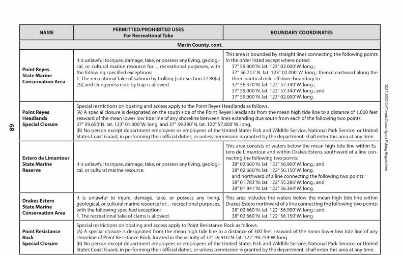
2021-2022 California Ocean Sport Fishing Regulations
68
NAME PERMITTED/PROHIBITED USESFor Recreational Take BOUNDARY COORDINATES
Marin County, cont.
Point ReyesState Marine Conservation Area
It is unlawful to injure, damage, take, or possess any living, geologi-cal, or cultural marine resource for… recreational purposes, with the following specified exceptions:1. The recreational take of salmon by trolling [sub-section 27.80(a)(3)] and Dungeness crab by trap is allowed.
This area is bounded by straight lines connecting the following points in the order listed except where noted:
37° 59.000’ N. lat. 123° 02.000’ W. long.;37° 56.712’ N. lat. 123° 02.000’ W. long.; thence eastward along the three nautical mile offshore boundary to37° 56.370’ N. lat. 122° 57.340’ W. long.;37° 59.000’ N. lat. 122° 57.340’ W. long.; and37° 59.000’ N. lat. 123° 02.000’ W. long.
Point Reyes Headlands Special Closure
Special restrictions on boating and access apply to the Point Reyes Headlands as follows.(A) A special closure is designated on the south side of the Point Reyes Headlands from the mean high tide line to a distance of 1,000 feet seaward of the mean lower low tide line of any shoreline between lines extending due south from each of the following two points: 37° 59.650’ N. lat. 123° 01.000’ W. long; and 37° 59.390’ N. lat. 122° 57.800’ W. long.(B) No person except department employees or employees of the United States Fish and Wildlife Service, National Park Service, or United States Coast Guard, in performing their official duties, or unless permission is granted by the department, shall enter this area at any time.
Estero de Limantour State Marine Reserve
It is unlawful to injure, damage, take, or possess any living, geologi-cal, or cultural marine resource.
This area consists of waters below the mean high tide line within Es-tero de Limantour and within Drakes Estero, southward of a line con-necting the following two points:
38° 02.660’ N. lat. 122° 56.900’ W. long.; and38° 02.660’ N. lat. 122° 56.150’ W. long.and northward of a line connecting the following two points:38° 01.783’ N. lat. 122° 55.286’ W. long.; and38° 01.941’ N. lat. 122° 56.364’ W. long.
Drakes Estero State Marine Conservation Area
It is unlawful to injure, damage, take, or possess any living, geological, or cultural marine resource for… recreational purposes, with the following specified exception:1. The recreational take of clams is allowed.
This area includes the waters below the mean high tide line within Drakes Estero northward of a line connecting the following two points:
38° 02.660’ N. lat. 122° 56.900’ W. long.; and38° 02.660’ N. lat. 122° 56.150’ W. long.
Point Resistance Rock Special Closure
Special restrictions on boating and access apply to Point Resistance Rock as follows.(A) A special closure is designated from the mean high tide line to a distance of 300 feet seaward of the mean lower low tide line of any shoreline of Point Resistance Rock, located in the vicinity of 37° 59.916’ N. lat. 122° 49.759’ W. long.(B) No person except department employees or employees of the United States Fish and Wildlife Service, National Park Service, or United States Coast Guard, in performing their official duties, or unless permission is granted by the department, shall enter this area at any time.
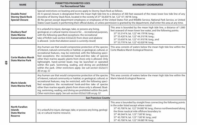
69
NAME PERMITTED/PROHIBITED USESFor Recreational Take BOUNDARY COORDINATES
Marin County, cont.
Point ReyesState Marine Conservation Area
It is unlawful to injure, damage, take, or possess any living, geologi-cal, or cultural marine resource for… recreational purposes, with the following specified exceptions:1. The recreational take of salmon by trolling [sub-section 27.80(a)(3)] and Dungeness crab by trap is allowed.
This area is bounded by straight lines connecting the following points in the order listed except where noted:
37° 59.000’ N. lat. 123° 02.000’ W. long.;37° 56.712’ N. lat. 123° 02.000’ W. long.; thence eastward along the three nautical mile offshore boundary to37° 56.370’ N. lat. 122° 57.340’ W. long.;37° 59.000’ N. lat. 122° 57.340’ W. long.; and37° 59.000’ N. lat. 123° 02.000’ W. long.
Point Reyes Headlands Special Closure
Special restrictions on boating and access apply to the Point Reyes Headlands as follows.(A) A special closure is designated on the south side of the Point Reyes Headlands from the mean high tide line to a distance of 1,000 feet seaward of the mean lower low tide line of any shoreline between lines extending due south from each of the following two points: 37° 59.650’ N. lat. 123° 01.000’ W. long; and 37° 59.390’ N. lat. 122° 57.800’ W. long.(B) No person except department employees or employees of the United States Fish and Wildlife Service, National Park Service, or United States Coast Guard, in performing their official duties, or unless permission is granted by the department, shall enter this area at any time.
Estero de Limantour State Marine Reserve
It is unlawful to injure, damage, take, or possess any living, geologi-cal, or cultural marine resource.
This area consists of waters below the mean high tide line within Es-tero de Limantour and within Drakes Estero, southward of a line con-necting the following two points:
38° 02.660’ N. lat. 122° 56.900’ W. long.; and38° 02.660’ N. lat. 122° 56.150’ W. long.and northward of a line connecting the following two points:38° 01.783’ N. lat. 122° 55.286’ W. long.; and38° 01.941’ N. lat. 122° 56.364’ W. long.
Drakes Estero State Marine Conservation Area
It is unlawful to injure, damage, take, or possess any living, geological, or cultural marine resource for… recreational purposes, with the following specified exception:1. The recreational take of clams is allowed.
This area includes the waters below the mean high tide line within Drakes Estero northward of a line connecting the following two points:
38° 02.660’ N. lat. 122° 56.900’ W. long.; and38° 02.660’ N. lat. 122° 56.150’ W. long.
Point Resistance Rock Special Closure
Special restrictions on boating and access apply to Point Resistance Rock as follows.(A) A special closure is designated from the mean high tide line to a distance of 300 feet seaward of the mean lower low tide line of any shoreline of Point Resistance Rock, located in the vicinity of 37° 59.916’ N. lat. 122° 49.759’ W. long.(B) No person except department employees or employees of the United States Fish and Wildlife Service, National Park Service, or United States Coast Guard, in performing their official duties, or unless permission is granted by the department, shall enter this area at any time.
NAME PERMITTED/PROHIBITED USESFor Recreational Take BOUNDARY COORDINATES
Double Point/Stormy Stack Rock Special Closure
Special restrictions on boating and access apply to Stormy Stack Rock as follows.(A) A special closure is designated from the mean high tide line to a distance of 300 feet seaward of the mean lower low tide line of any shoreline of Stormy Stack Rock, located in the vicinity of 37° 56.830’ N. lat. 122° 47.140’ W. long.(B) No person except department employees or employees of the United States Fish and Wildlife Service, National Park Service, or United States Coast Guard, in performing their official duties, or unless permission is granted by the department, shall enter this area at any time.
Duxbury ReefState MarineConservation Area4
It is unlawful to injure, damage, take, or possess any living,geological, or cultural marine resource for… recreational purposes,with the following specified exceptions: the recreationaltake of finfish [sub-section 632(a)(2)] from shore and abaloneis allowed. [note that abalone season is currently closed]
This area is bounded by the mean high tide line, a distance of 1,000 feet seaward of mean lower low water, and the following points:
37° 55.514’ N. lat. 122° 44.179’ W. long.;37° 55.420’ N. lat. 122° 44.310’ W. long.;37° 53.650’ N. lat. 122° 41.910’ W. long.; and37° 53.770’ N. lat. 122° 42.020’ W. long.
Corte Madera MarshState Marine Park
Any human use that would compromise protection of the species of interest, natural community or habitat, or geological, cultural, or recreational features, may be restricted, with the following speci-fied exceptions: the recreational hook-and-line take of species other than marine aquatic plants from shore only is allowed. Only lightweight, hand-carried boats may be launched or operated within the park. Swimming, wading, and diving are prohibited within the park. Other restrictions apply. See sub-section 632(a)(1)(B) on pg. 52
This area consists of waters below the mean high tide line within the Corte Madera Marsh Ecological Reserve.
Marin IslandsState Marine Park
Any human use that would compromise protection of the species of interest, natural community or habitat, or geological, cultural, or recreational features, may be restricted, with the following speci-fied exceptions: the recreational hook-and-line take of species other than marine aquatic plants from shore only is allowed. Boat-ing, swimming, wading, and diving are prohibited within the park. Other restrictions apply. See sub-section 632(a)(1)(B) on pg. 52
This area consists of waters below the mean high tide line within the Marin Islands Ecological Reserve.
San Francisco County
North Farallon Islands State Marine Reserve
It is unlawful to injure, damage, take, or possess any living, geologi-cal, or cultural marine resource.
This area is bounded by straight lines connecting the following points in the order listed except where noted:
37° 45.700’ N. lat. 122° 59.085’ W. long.; thence northwestward along the three nautical mile offshore boundary to 37° 49.344’ N. lat. 123° 7.00’ W. long.; 37° 45.700’ N. lat. 123° 7.00’ W. long.; and 37° 45.700’ N. lat. 122° 59.085’ W. long.
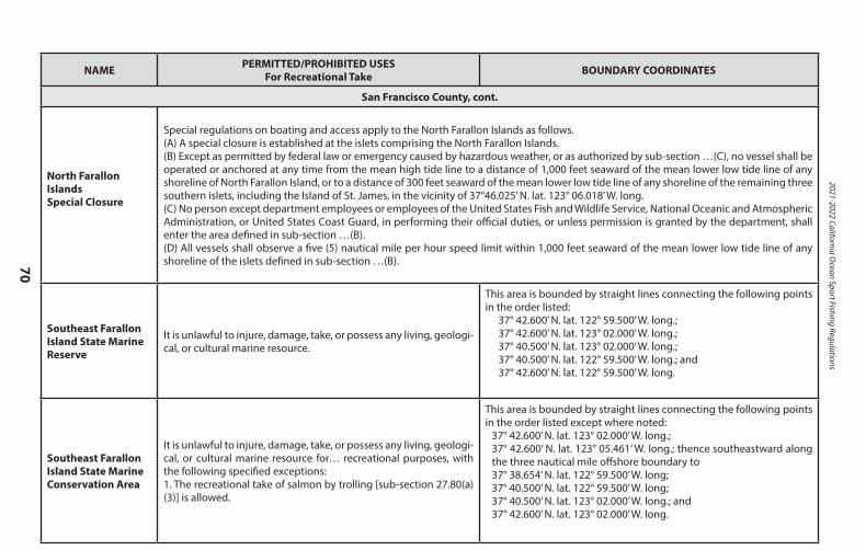
2021-2022 California Ocean Sport Fishing Regulations
70
NAME PERMITTED/PROHIBITED USESFor Recreational Take BOUNDARY COORDINATES
San Francisco County, cont.
North Farallon IslandsSpecial Closure
Special regulations on boating and access apply to the North Farallon Islands as follows.(A) A special closure is established at the islets comprising the North Farallon Islands.(B) Except as permitted by federal law or emergency caused by hazardous weather, or as authorized by sub-section …(C), no vessel shall be operated or anchored at any time from the mean high tide line to a distance of 1,000 feet seaward of the mean lower low tide line of any shoreline of North Farallon Island, or to a distance of 300 feet seaward of the mean lower low tide line of any shoreline of the remaining three southern islets, including the Island of St. James, in the vicinity of 37°46.025’ N. lat. 123° 06.018’ W. long.(C) No person except department employees or employees of the United States Fish and Wildlife Service, National Oceanic and Atmospheric Administration, or United States Coast Guard, in performing their official duties, or unless permission is granted by the department, shall enter the area defined in sub-section …(B).(D) All vessels shall observe a five (5) nautical mile per hour speed limit within 1,000 feet seaward of the mean lower low tide line of any shoreline of the islets defined in sub-section …(B).
Southeast Farallon Island State Marine Reserve
It is unlawful to injure, damage, take, or possess any living, geologi-cal, or cultural marine resource.
This area is bounded by straight lines connecting the following points in the order listed:
37° 42.600’ N. lat. 122° 59.500’ W. long.; 37° 42.600’ N. lat. 123° 02.000’ W. long.; 37° 40.500’ N. lat. 123° 02.000’ W. long.; 37° 40.500’ N. lat. 122° 59.500’ W. long.; and 37° 42.600’ N. lat. 122° 59.500’ W. long.
Southeast Farallon Island State Marine Conservation Area
It is unlawful to injure, damage, take, or possess any living, geologi-cal, or cultural marine resource for… recreational purposes, with the following specified exceptions:1. The recreational take of salmon by trolling [sub-section 27.80(a)(3)] is allowed.
This area is bounded by straight lines connecting the following points in the order listed except where noted:
37° 42.600’ N. lat. 123° 02.000’ W. long.; 37° 42.600’ N. lat. 123° 05.461’ W. long.; thence southeastward along the three nautical mile offshore boundary to 37° 38.654’ N. lat. 122° 59.500’ W. long; 37° 40.500’ N. lat. 122° 59.500’ W. long; 37° 40.500’ N. lat. 123° 02.000’ W. long.; and 37° 42.600’ N. lat. 123° 02.000’ W. long.
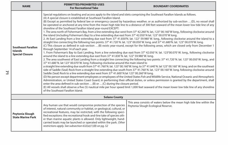
71
NAME PERMITTED/PROHIBITED USESFor Recreational Take BOUNDARY COORDINATES
San Francisco County, cont.
North Farallon IslandsSpecial Closure
Special regulations on boating and access apply to the North Farallon Islands as follows.(A) A special closure is established at the islets comprising the North Farallon Islands.(B) Except as permitted by federal law or emergency caused by hazardous weather, or as authorized by sub-section …(C), no vessel shall be operated or anchored at any time from the mean high tide line to a distance of 1,000 feet seaward of the mean lower low tide line of any shoreline of North Farallon Island, or to a distance of 300 feet seaward of the mean lower low tide line of any shoreline of the remaining three southern islets, including the Island of St. James, in the vicinity of 37°46.025’ N. lat. 123° 06.018’ W. long.(C) No person except department employees or employees of the United States Fish and Wildlife Service, National Oceanic and Atmospheric Administration, or United States Coast Guard, in performing their official duties, or unless permission is granted by the department, shall enter the area defined in sub-section …(B).(D) All vessels shall observe a five (5) nautical mile per hour speed limit within 1,000 feet seaward of the mean lower low tide line of any shoreline of the islets defined in sub-section …(B).
Southeast Farallon Island State Marine Reserve
It is unlawful to injure, damage, take, or possess any living, geologi-cal, or cultural marine resource.
This area is bounded by straight lines connecting the following points in the order listed:
37° 42.600’ N. lat. 122° 59.500’ W. long.; 37° 42.600’ N. lat. 123° 02.000’ W. long.; 37° 40.500’ N. lat. 123° 02.000’ W. long.; 37° 40.500’ N. lat. 122° 59.500’ W. long.; and 37° 42.600’ N. lat. 122° 59.500’ W. long.
Southeast Farallon Island State Marine Conservation Area
It is unlawful to injure, damage, take, or possess any living, geologi-cal, or cultural marine resource for… recreational purposes, with the following specified exceptions:1. The recreational take of salmon by trolling [sub-section 27.80(a)(3)] is allowed.
This area is bounded by straight lines connecting the following points in the order listed except where noted:
37° 42.600’ N. lat. 123° 02.000’ W. long.; 37° 42.600’ N. lat. 123° 05.461’ W. long.; thence southeastward along the three nautical mile offshore boundary to 37° 38.654’ N. lat. 122° 59.500’ W. long; 37° 40.500’ N. lat. 122° 59.500’ W. long; 37° 40.500’ N. lat. 123° 02.000’ W. long.; and 37° 42.600’ N. lat. 123° 02.000’ W. long.
NAME PERMITTED/PROHIBITED USESFor Recreational Take BOUNDARY COORDINATES
Southeast Farallon IslandsSpecial Closure
Special regulations on boating and access apply to the island and islets comprising the Southeast Farallon Islands as follows.(A) A special closure is established at Southeast Farallon Island.(B) Except as permitted by federal law or emergency caused by hazardous weather, or as authorized by sub-section …(D), no vessel shall be operated or anchored at any time from the mean high tide line to a distance of 300 feet seaward of the mean lower low tide line of any shoreline of the Southeast Farallon Island year-round EXCEPT:1. The area north of Fisherman’s Bay, from a line extending due west from 37° 42.260’ N. lat.; 123° 00.160’ W long., following clockwise around the island (including Fisherman’s Bay) to a line extending due east from 37° 42.050’ N lat. 123° 00.070’ W long.2. At East Landing from a line extending due east from 37° 41.830’N. lat. 122° 59.980’ W. long., following clockwise around the island to a straight line connecting the following two points: 37° 41.720’ N. lat. 123° 00.050’ W. long. and 37° 41.680’N. lat. 123° 00.070’W. long.(C) This closure as defined in sub-section …(B) exists year-round, except for the following areas, which are closed only from December 1 through September 14 of each year.1. From Fisherman’s Bay to East Landing, from a line extending due east from 37° 42.050’ N. lat. 123°00.070’ W. long., following clockwise around the island to a line extending due east from 37° 41.830’ N. lat. 122° 59.980’ W. long.2. The area southwest of East Landing from a straight line connecting the following two points: 37° 41.720’ N. lat. 123° 00.050’ W. long., and 37° 41.680’ N. lat 123° 00.070’ W. long. Following clockwise around the main island toa straight line extending due south from 37° 41.760’ N. lat. 123° 00.160’ W. long. to 37° 41.640’ N. lat 123° 00.160’ W. long. and on the southeast side of Saddle (Seal) Rock from a straight line extending due south from 37° 41.760’ N. lat. 123° 00.160’ W. long. following clockwise around Saddle (Seal) Rock to a line extending due west from 37° 41.600’ N.lat 123° 00.260’ W long.(D) No person except department employees or employees of the United States Fish and Wildlife Service, National Oceanic and Atmospheric Administration, or United States Coast Guard, in performing their official duties, or unless permission is granted by the department, shall enter the area defined in sub-section …(B) or …(C) during the closure period.(E) All vessels shall observe a five (5) nautical mile per hour speed limit 1,000 feet seaward of the mean lower low tide line of any shoreline of the Southeast Farallon Island.
Solano County
Peytonia SloughState Marine Park
Any human use that would compromise protection of the species of interest, natural community or habitat, or geological, cultural, or recreational features, may be restricted, with the following speci-fied exceptions: the recreational hook-and-line take of species oth-er than marine aquatic plants is allowed. Only lightweight, hand-carried boats may be launched or operated within the park. Other restrictions apply. See subsection 632(a)(1)(B) on pg. 52
This area consists of waters below the mean high tide line within the Peytonia Slough Ecological Reserve.
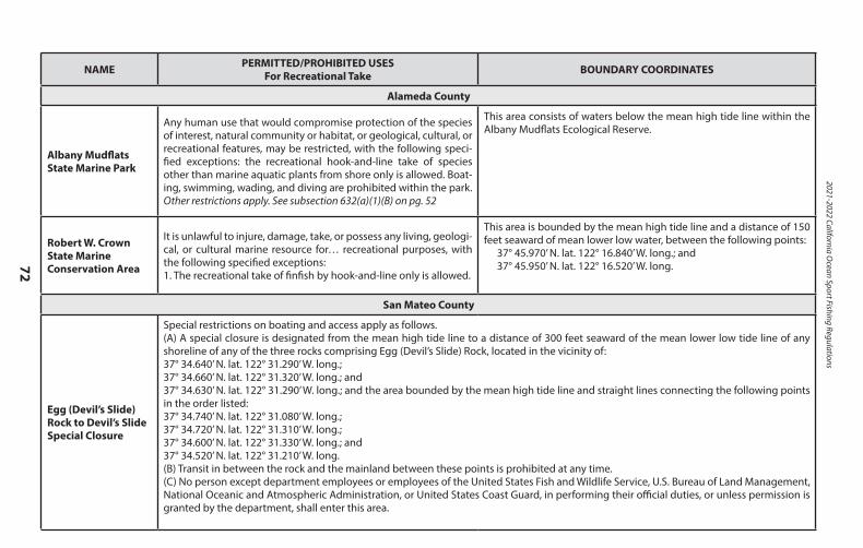
2021-2022 California Ocean Sport Fishing Regulations
72
NAME PERMITTED/PROHIBITED USESFor Recreational Take BOUNDARY COORDINATES
Alameda County
Albany MudflatsState Marine Park
Any human use that would compromise protection of the species of interest, natural community or habitat, or geological, cultural, or recreational features, may be restricted, with the following speci-fied exceptions: the recreational hook-and-line take of species other than marine aquatic plants from shore only is allowed. Boat-ing, swimming, wading, and diving are prohibited within the park. Other restrictions apply. See subsection 632(a)(1)(B) on pg. 52
This area consists of waters below the mean high tide line within the Albany Mudflats Ecological Reserve.
Robert W. Crown State Marine Conservation Area
It is unlawful to injure, damage, take, or possess any living, geologi-cal, or cultural marine resource for… recreational purposes, with the following specified exceptions:1. The recreational take of finfish by hook-and-line only is allowed.
This area is bounded by the mean high tide line and a distance of 150 feet seaward of mean lower low water, between the following points:
37° 45.970’ N. lat. 122° 16.840’ W. long.; and 37° 45.950’ N. lat. 122° 16.520’ W. long.
San Mateo County
Egg (Devil’s Slide) Rock to Devil’s Slide Special Closure
Special restrictions on boating and access apply as follows.(A) A special closure is designated from the mean high tide line to a distance of 300 feet seaward of the mean lower low tide line of any shoreline of any of the three rocks comprising Egg (Devil’s Slide) Rock, located in the vicinity of:37° 34.640’ N. lat. 122° 31.290’ W. long.;37° 34.660’ N. lat. 122° 31.320’ W. long.; and37° 34.630’ N. lat. 122° 31.290’ W. long.; and the area bounded by the mean high tide line and straight lines connecting the following points in the order listed:37° 34.740’ N. lat. 122° 31.080’ W. long.;37° 34.720’ N. lat. 122° 31.310’ W. long.;37° 34.600’ N. lat. 122° 31.330’ W. long.; and37° 34.520’ N. lat. 122° 31.210’ W. long.(B) Transit in between the rock and the mainland between these points is prohibited at any time.(C) No person except department employees or employees of the United States Fish and Wildlife Service, U.S. Bureau of Land Management, National Oceanic and Atmospheric Administration, or United States Coast Guard, in performing their official duties, or unless permission is granted by the department, shall enter this area.
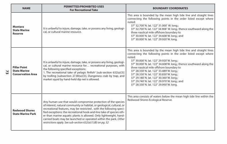
73
NAME PERMITTED/PROHIBITED USESFor Recreational Take BOUNDARY COORDINATES
Alameda County
Albany MudflatsState Marine Park
Any human use that would compromise protection of the species of interest, natural community or habitat, or geological, cultural, or recreational features, may be restricted, with the following speci-fied exceptions: the recreational hook-and-line take of species other than marine aquatic plants from shore only is allowed. Boat-ing, swimming, wading, and diving are prohibited within the park. Other restrictions apply. See subsection 632(a)(1)(B) on pg. 52
This area consists of waters below the mean high tide line within the Albany Mudflats Ecological Reserve.
Robert W. Crown State Marine Conservation Area
It is unlawful to injure, damage, take, or possess any living, geologi-cal, or cultural marine resource for… recreational purposes, with the following specified exceptions:1. The recreational take of finfish by hook-and-line only is allowed.
This area is bounded by the mean high tide line and a distance of 150 feet seaward of mean lower low water, between the following points:
37° 45.970’ N. lat. 122° 16.840’ W. long.; and 37° 45.950’ N. lat. 122° 16.520’ W. long.
San Mateo County
Egg (Devil’s Slide) Rock to Devil’s Slide Special Closure
Special restrictions on boating and access apply as follows.(A) A special closure is designated from the mean high tide line to a distance of 300 feet seaward of the mean lower low tide line of any shoreline of any of the three rocks comprising Egg (Devil’s Slide) Rock, located in the vicinity of:37° 34.640’ N. lat. 122° 31.290’ W. long.;37° 34.660’ N. lat. 122° 31.320’ W. long.; and37° 34.630’ N. lat. 122° 31.290’ W. long.; and the area bounded by the mean high tide line and straight lines connecting the following points in the order listed:37° 34.740’ N. lat. 122° 31.080’ W. long.;37° 34.720’ N. lat. 122° 31.310’ W. long.;37° 34.600’ N. lat. 122° 31.330’ W. long.; and37° 34.520’ N. lat. 122° 31.210’ W. long.(B) Transit in between the rock and the mainland between these points is prohibited at any time.(C) No person except department employees or employees of the United States Fish and Wildlife Service, U.S. Bureau of Land Management, National Oceanic and Atmospheric Administration, or United States Coast Guard, in performing their official duties, or unless permission is granted by the department, shall enter this area.
NAME PERMITTED/PROHIBITED USESFor Recreational Take BOUNDARY COORDINATES
Montara State Marine Reserve
It is unlawful to injure, damage, take, or possess any living, geologi-cal, or cultural marine resource.
This area is bounded by the mean high tide line and straight lines connecting the following points in the order listed except where noted:
37° 32.700’ N. lat. 122° 31.000’ W. long.;37° 32.700’ N. lat. 122° 34.908’ W. long.; thence southward along the three nautical mile offshore boundary to37° 30.000’ N. lat. 122° 34.608’ W. long.; and37° 30.000’ N. lat. 122° 29.920’ W. long.
Pillar PointState Marine Conservation Area
It is unlawful to injure, damage, take, or possess any living, geologi-cal, or cultural marine resource for… recreational purposes, with the following specified exceptions:1. The recreational take of pelagic finfish5 [sub-section 632(a)(3)] by trolling [subsection 27.80(a)(3)], Dungeness crab by trap, and market squid by hand-held dip net is allowed.
This area is bounded by the mean high tide line and straight lines connecting the following points in the order listed except where noted:
37° 30.000’ N. lat. 122° 29.920’ W. long.;37° 30.000’ N. lat. 122° 34.608’W. long.; thence southward along the three nautical mile offshore boundary to37° 28.330’ N. lat. 122° 33.489’ W. long.;37° 28.330’ N. lat. 122° 30.830’ W. long.;37° 29.180’ N. lat. 122° 30.360’ W. long.; 37° 29.740’ N. lat. 122° 29.970’ W. long.; and 37° 28.330’ N. lat. 122° 29.950’ W. long.
Redwood ShoresState Marine Park
Any human use that would compromise protection of the species of interest, natural community or habitat, or geological, cultural, or recreational features, may be restricted , with the following speci-fied exceptions: the recreational hook-and-line take of species oth-er than marine aquatic plants is allowed. Only lightweight, hand-carried boats may be launched or operated within the park. Other restrictions apply. See sub-section 632(a)(1)(B) on pg. 52
This area consists of waters below the mean high tide line within the Redwood Shores Ecological Reserve.
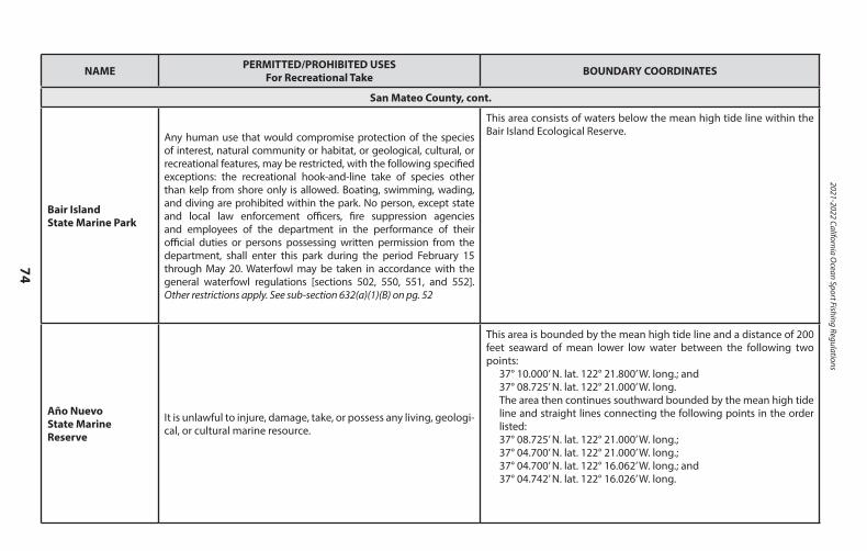
2021-2022 California Ocean Sport Fishing Regulations
74
NAME PERMITTED/PROHIBITED USESFor Recreational Take BOUNDARY COORDINATES
San Mateo County, cont.
Bair IslandState Marine Park
Any human use that would compromise protection of the species of interest, natural community or habitat, or geological, cultural, or recreational features, may be restricted, with the following specified exceptions: the recreational hook-and-line take of species other than kelp from shore only is allowed. Boating, swimming, wading, and diving are prohibited within the park. No person, except state and local law enforcement officers, fire suppression agencies and employees of the department in the performance of their official duties or persons possessing written permission from the department, shall enter this park during the period February 15 through May 20. Waterfowl may be taken in accordance with the general waterfowl regulations [sections 502, 550, 551, and 552]. Other restrictions apply. See sub-section 632(a)(1)(B) on pg. 52
This area consists of waters below the mean high tide line within the Bair Island Ecological Reserve.
Año Nuevo State Marine Reserve
It is unlawful to injure, damage, take, or possess any living, geologi-cal, or cultural marine resource.
This area is bounded by the mean high tide line and a distance of 200 feet seaward of mean lower low water between the following two points:
37° 10.000’ N. lat. 122° 21.800’ W. long.; and37° 08.725’ N. lat. 122° 21.000’ W. long.The area then continues southward bounded by the mean high tide line and straight lines connecting the following points in the order listed:37° 08.725’ N. lat. 122° 21.000’ W. long.;37° 04.700’ N. lat. 122° 21.000’ W. long.; 37° 04.700’ N. lat. 122° 16.062’ W. long.; and37° 04.742’ N. lat. 122° 16.026’ W. long.
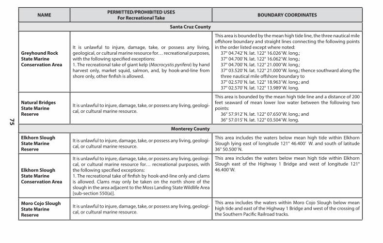
75
NAME PERMITTED/PROHIBITED USESFor Recreational Take BOUNDARY COORDINATES
Santa Cruz County
Greyhound RockState Marine Conservation Area
It is unlawful to injure, damage, take, or possess any living, geological, or cultural marine resource for… recreational purposes,with the following specified exceptions:1. The recreational take of giant kelp (Macrocystis pyrifera) by hand harvest only, market squid, salmon, and, by hook-and-line from shore only, other finfish is allowed.
This area is bounded by the mean high tide line, the three nautical mile offshore boundary and straight lines connecting the following points in the order listed except where noted:
37° 04.742’ N. lat. 122° 16.026’ W. long.;37° 04.700’ N. lat. 122° 16.062’ W. long.;37° 04.700’ N. lat. 122° 21.000’ W. long.;37° 03.520’ N. lat. 122° 21.000’ W. long.; thence southward along the three nautical mile offshore boundary to37° 02.570’ N. lat. 122° 18.963’ W. long.; and37° 02.570’ N. lat. 122° 13.989’ W. long.
Natural BridgesState Marine Reserve
It is unlawful to injure, damage, take, or possess any living, geologi-cal, or cultural marine resource.
This area is bounded by the mean high tide line and a distance of 200 feet seaward of mean lower low water between the following two points:
36° 57.912’ N. lat. 122° 07.650’ W. long.; and36° 57.015’ N. lat. 122° 03.504’ W. long.
Monterey County
Elkhorn SloughState Marine Reserve
It is unlawful to injure, damage, take, or possess any living, geologi-cal, or cultural marine resource.
This area includes the waters below mean high tide within Elkhorn Slough lying east of longitude 121° 46.400’ W. and south of latitude 36° 50.500’ N.
Elkhorn Slough State Marine Conservation Area
It is unlawful to injure, damage, take, or possess any living, geologi-cal, or cultural marine resource for… recreational purposes, with the following specified exceptions:1. The recreational take of finfish by hook-and-line only and clams is allowed. Clams may only be taken on the north shore of the slough in the area adjacent to the Moss Landing State Wildlife Area [sub-section 550(a)].
This area includes the waters below mean high tide within Elkhorn Slough east of the Highway 1 Bridge and west of longitude 121° 46.400’ W.
Moro Cojo SloughState Marine Reserve
It is unlawful to injure, damage, take, or possess any living, geologi-cal, or cultural marine resource.
This area includes the waters within Moro Cojo Slough below mean high tide and east of the Highway 1 Bridge and west of the crossing of the Southern Pacific Railroad tracks.
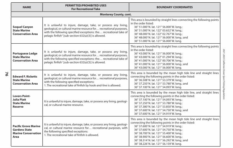
2021-2022 California Ocean Sport Fishing Regulations
76
NAME PERMITTED/PROHIBITED USESFor Recreational Take BOUNDARY COORDINATES
Monterey County, cont.
Soquel CanyonState Marine Conservation Area
It is unlawful to injure, damage, take, or possess any living, geological, or cultural marine resource for… recreational purposes,with the following specified exceptions: the… recreational take of pelagic finfish5 [sub-section 632(a)(3)] is allowed.
This area is bounded by straight lines connecting the following points in the order listed:
36° 51.000’ N. lat. 121° 56.000’ W. long.;36° 51.000’ N. lat. 122° 03.652’ W. long.;36° 48.000’ N. lat. 122° 02.767’ W. long.;36° 48.000’ N. lat. 121° 56.000’ W. long.; and36° 51.000’ N. lat. 121° 56.000’ W. long.
Portuguese LedgeState Marine Conservation Area
It is unlawful to injure, damage, take, or possess any living, geological, or cultural marine resource for… recreational purposes,with the following specified exceptions: the… recreational take of pelagic finfish5 [sub-section 632(a)(3)] is allowed.
This area is bounded by straight lines connecting the following points in the order listed:
36° 43.000’ N. lat. 121° 56.000’ W. long.;36° 43.000’ N. lat. 122° 01.294’ W. long.;36° 41.000’ N. lat. 122° 00.706’ W. long.;36° 41.000’ N. lat. 121° 56.000’ W. long.; and36° 43.000’ N. lat. 121° 56.000’ W. long.
Edward F. RickettsState Marine Conservation Area
It is unlawful to injure, damage, take, or possess any living, geological, or cultural marine resource for… recreational purposes,with the following specified exceptions:1. The recreational take of finfish by hook-and-line is allowed.
This area is bounded by the mean high tide line and straight lines connecting the following points in the order listed:
36° 36.508’ N. lat. 121° 53.379’ W. long.;36° 37.250’ N. lat. 121° 53.780’ W. long.; and36° 37.100’ N. lat. 121° 54.093’ W. long.
Lovers Point-Julia PlattState Marine Reserve
It is unlawful to injure, damage, take, or possess any living, geologi-cal, or cultural marine resource.
This area is bounded by the mean high tide line, and straight lines connecting the following points in the order listed:
36° 37.100’ N. lat. 121° 54.093’ W. long.;36° 37.250’ N. lat. 121° 53.780’ W. long.;36° 37.380’ N. lat. 121° 53.850’ W. long.;36° 37.600’ N. lat. 121° 54.750’ W. long.; and36° 37.600’ N. lat. 121° 54.919’ W. long.
Pacific Grove Marine Gardens State Marine Conservation Area
It is unlawful to injure, damage, take, or possess any living, geologi-cal, or cultural marine resource for… recreational purposes, with the following specified exceptions:1. The recreational take of finfish is allowed.
This area is bounded by the mean high tide line and straight lines connecting the following points in the order listed:
36° 37.600’ N. lat. 121° 54.919’ W. long.;36° 37.600’ N. lat. 121° 54.750’ W. long.;36° 38.700’ N. lat. 121° 55.400’ W. long.;36° 38.900’ N. lat. 121° 56.600’ W. long.;36° 38.314’ N. lat. 121° 56.292’ W. long.; and36° 38.226’ N. lat. 121° 56.159’ W. long.
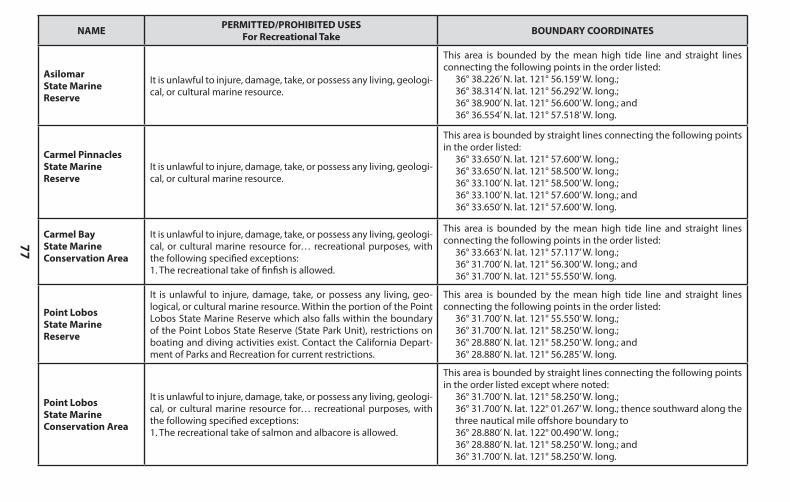
77
NAME PERMITTED/PROHIBITED USESFor Recreational Take BOUNDARY COORDINATES
Monterey County, cont.
Soquel CanyonState Marine Conservation Area
It is unlawful to injure, damage, take, or possess any living, geological, or cultural marine resource for… recreational purposes,with the following specified exceptions: the… recreational take of pelagic finfish5 [sub-section 632(a)(3)] is allowed.
This area is bounded by straight lines connecting the following points in the order listed:
36° 51.000’ N. lat. 121° 56.000’ W. long.;36° 51.000’ N. lat. 122° 03.652’ W. long.;36° 48.000’ N. lat. 122° 02.767’ W. long.;36° 48.000’ N. lat. 121° 56.000’ W. long.; and36° 51.000’ N. lat. 121° 56.000’ W. long.
Portuguese LedgeState Marine Conservation Area
It is unlawful to injure, damage, take, or possess any living, geological, or cultural marine resource for… recreational purposes,with the following specified exceptions: the… recreational take of pelagic finfish5 [sub-section 632(a)(3)] is allowed.
This area is bounded by straight lines connecting the following points in the order listed:
36° 43.000’ N. lat. 121° 56.000’ W. long.;36° 43.000’ N. lat. 122° 01.294’ W. long.;36° 41.000’ N. lat. 122° 00.706’ W. long.;36° 41.000’ N. lat. 121° 56.000’ W. long.; and36° 43.000’ N. lat. 121° 56.000’ W. long.
Edward F. RickettsState Marine Conservation Area
It is unlawful to injure, damage, take, or possess any living, geological, or cultural marine resource for… recreational purposes,with the following specified exceptions:1. The recreational take of finfish by hook-and-line is allowed.
This area is bounded by the mean high tide line and straight lines connecting the following points in the order listed:
36° 36.508’ N. lat. 121° 53.379’ W. long.;36° 37.250’ N. lat. 121° 53.780’ W. long.; and36° 37.100’ N. lat. 121° 54.093’ W. long.
Lovers Point-Julia PlattState Marine Reserve
It is unlawful to injure, damage, take, or possess any living, geologi-cal, or cultural marine resource.
This area is bounded by the mean high tide line, and straight lines connecting the following points in the order listed:
36° 37.100’ N. lat. 121° 54.093’ W. long.;36° 37.250’ N. lat. 121° 53.780’ W. long.;36° 37.380’ N. lat. 121° 53.850’ W. long.;36° 37.600’ N. lat. 121° 54.750’ W. long.; and36° 37.600’ N. lat. 121° 54.919’ W. long.
Pacific Grove Marine Gardens State Marine Conservation Area
It is unlawful to injure, damage, take, or possess any living, geologi-cal, or cultural marine resource for… recreational purposes, with the following specified exceptions:1. The recreational take of finfish is allowed.
This area is bounded by the mean high tide line and straight lines connecting the following points in the order listed:
36° 37.600’ N. lat. 121° 54.919’ W. long.;36° 37.600’ N. lat. 121° 54.750’ W. long.;36° 38.700’ N. lat. 121° 55.400’ W. long.;36° 38.900’ N. lat. 121° 56.600’ W. long.;36° 38.314’ N. lat. 121° 56.292’ W. long.; and36° 38.226’ N. lat. 121° 56.159’ W. long.
NAME PERMITTED/PROHIBITED USESFor Recreational Take BOUNDARY COORDINATES
Asilomar State Marine Reserve
It is unlawful to injure, damage, take, or possess any living, geologi-cal, or cultural marine resource.
This area is bounded by the mean high tide line and straight lines connecting the following points in the order listed:
36° 38.226’ N. lat. 121° 56.159’ W. long.;36° 38.314’ N. lat. 121° 56.292’ W. long.;36° 38.900’ N. lat. 121° 56.600’ W. long.; and36° 36.554’ N. lat. 121° 57.518’ W. long.
Carmel PinnaclesState Marine Reserve
It is unlawful to injure, damage, take, or possess any living, geologi-cal, or cultural marine resource.
This area is bounded by straight lines connecting the following points in the order listed:
36° 33.650’ N. lat. 121° 57.600’ W. long.;36° 33.650’ N. lat. 121° 58.500’ W. long.;36° 33.100’ N. lat. 121° 58.500’ W. long.;36° 33.100’ N. lat. 121° 57.600’ W. long.; and36° 33.650’ N. lat. 121° 57.600’ W. long.
Carmel BayState Marine Conservation Area
It is unlawful to injure, damage, take, or possess any living, geologi-cal, or cultural marine resource for… recreational purposes, with the following specified exceptions:1. The recreational take of finfish is allowed.
This area is bounded by the mean high tide line and straight lines connecting the following points in the order listed:
36° 33.663’ N. lat. 121° 57.117’ W. long.;36° 31.700’ N. lat. 121° 56.300’ W. long.; and36° 31.700’ N. lat. 121° 55.550’ W. long.
Point LobosState Marine Reserve
It is unlawful to injure, damage, take, or possess any living, geo-logical, or cultural marine resource. Within the portion of the Point Lobos State Marine Reserve which also falls within the boundary of the Point Lobos State Reserve (State Park Unit), restrictions on boating and diving activities exist. Contact the California Depart-ment of Parks and Recreation for current restrictions.
This area is bounded by the mean high tide line and straight lines connecting the following points in the order listed:
36° 31.700’ N. lat. 121° 55.550’ W. long.;36° 31.700’ N. lat. 121° 58.250’ W. long.;36° 28.880’ N. lat. 121° 58.250’ W. long.; and36° 28.880’ N. lat. 121° 56.285’ W. long.
Point Lobos State Marine Conservation Area
It is unlawful to injure, damage, take, or possess any living, geologi-cal, or cultural marine resource for… recreational purposes, with the following specified exceptions:1. The recreational take of salmon and albacore is allowed.
This area is bounded by straight lines connecting the following points in the order listed except where noted:
36° 31.700’ N. lat. 121° 58.250’ W. long.;36° 31.700’ N. lat. 122° 01.267’ W. long.; thence southward along the three nautical mile offshore boundary to36° 28.880’ N. lat. 122° 00.490’ W. long.;36° 28.880’ N. lat. 121° 58.250’ W. long.; and36° 31.700’ N. lat. 121° 58.250’ W. long.
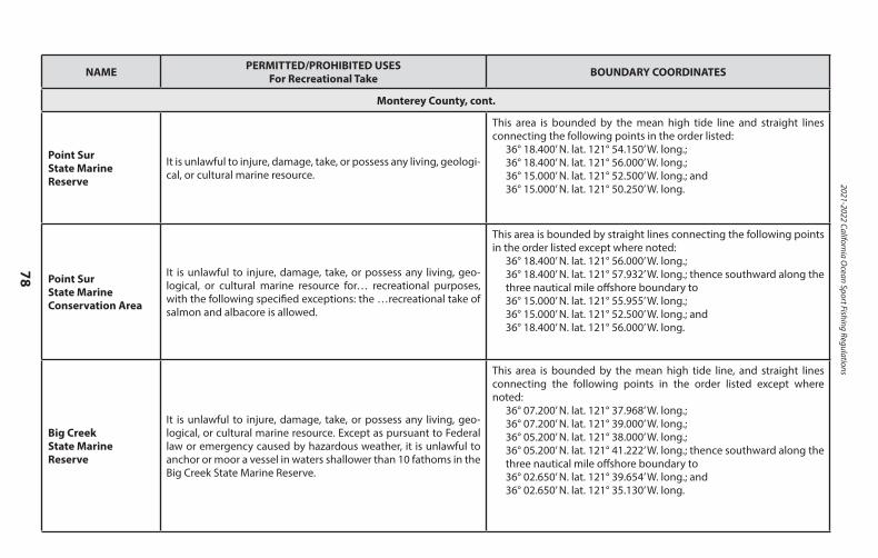
2021-2022 California Ocean Sport Fishing Regulations
78
NAME PERMITTED/PROHIBITED USESFor Recreational Take BOUNDARY COORDINATES
Monterey County, cont.
Point SurState Marine Reserve
It is unlawful to injure, damage, take, or possess any living, geologi-cal, or cultural marine resource.
This area is bounded by the mean high tide line and straight lines connecting the following points in the order listed:
36° 18.400’ N. lat. 121° 54.150’ W. long.;36° 18.400’ N. lat. 121° 56.000’ W. long.;36° 15.000’ N. lat. 121° 52.500’ W. long.; and36° 15.000’ N. lat. 121° 50.250’ W. long.
Point SurState Marine Conservation Area
It is unlawful to injure, damage, take, or possess any living, geo-logical, or cultural marine resource for… recreational purposes, with the following specified exceptions: the …recreational take of salmon and albacore is allowed.
This area is bounded by straight lines connecting the following points in the order listed except where noted:
36° 18.400’ N. lat. 121° 56.000’ W. long.;36° 18.400’ N. lat. 121° 57.932’ W. long.; thence southward along the three nautical mile offshore boundary to36° 15.000’ N. lat. 121° 55.955’ W. long.;36° 15.000’ N. lat. 121° 52.500’ W. long.; and36° 18.400’ N. lat. 121° 56.000’ W. long.
Big CreekState Marine Reserve
It is unlawful to injure, damage, take, or possess any living, geo-logical, or cultural marine resource. Except as pursuant to Federal law or emergency caused by hazardous weather, it is unlawful to anchor or moor a vessel in waters shallower than 10 fathoms in the Big Creek State Marine Reserve.
This area is bounded by the mean high tide line, and straight lines connecting the following points in the order listed except where noted:
36° 07.200’ N. lat. 121° 37.968’ W. long.;36° 07.200’ N. lat. 121° 39.000’ W. long.;36° 05.200’ N. lat. 121° 38.000’ W. long.;36° 05.200’ N. lat. 121° 41.222’ W. long.; thence southward along the three nautical mile offshore boundary to36° 02.650’ N. lat. 121° 39.654’ W. long.; and36° 02.650’ N. lat. 121° 35.130’ W. long.
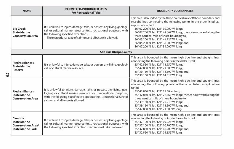
79
NAME PERMITTED/PROHIBITED USESFor Recreational Take BOUNDARY COORDINATES
Big Creek State Marine Conservation Area
It is unlawful to injure, damage, take, or possess any living, geologi-cal, or cultural marine resource for… recreational purposes, with the following specified exceptions:1. The recreational take of salmon and albacore is allowed.
This area is bounded by the three nautical mile offshore boundary and straight lines connecting the following points in the order listed ex-cept where noted:
36° 07.200’ N. lat. 121° 39.000’ W. long.;36° 07.200’ N. lat. 121° 42.869’ W. long.; thence southward along the three nautical mile offshore boundary to36° 05.200’ N. lat. 121° 41.222’ W. long.;36° 05.200’ N. lat. 121° 38.000’ W. long.; and36° 07.200’ N. lat. 121° 39.000’ W. long.
San Luis Obispo County
Piedras Blancas State Marine Reserve
It is unlawful to injure, damage, take, or possess any living, geologi-cal, or cultural marine resource.
This area is bounded by the mean high tide line and straight lines connecting the following points in the order listed:
35° 42.850’ N. lat. 121° 18.950’ W. long.;35° 42.850’ N. lat. 121° 21.000’ W. long.;35° 39.150’ N. lat. 121° 18.500’ W. long.; and35° 39.150’ N. lat. 121° 14.519’ W. long.
Piedras BlancasState Marine Conservation Area
It is unlawful to injure, damage, take, or possess any living, geo-logical, or cultural marine resource for… recreational purposes, with the following specified exceptions: the… recreational take of salmon and albacore is allowed.
This area is bounded by the mean high tide line and straight lines connecting the following points in the order listed except where noted:
35° 42.850’ N. lat. 121° 21.00’ W. long.;35° 42.850’ N. lat. 121° 22.763’ W. long.; thence southward along the three nautical mile offshore boundary to35° 39.150’ N. lat. 121° 20.913’ W. long.;35° 39.150’ N. lat. 121° 18.500’ W. long.; and35° 42.850’ N. lat. 121° 21.000’W. long.
CambriaState Marine Conservation Area/State Marine Park
It is unlawful to injure, damage, take, or possess any living, geologi-cal, or cultural marine resource for… recreational purposes, with the following specified exceptions: recreational take is allowed.
This area is bounded by the mean high tide line and straight lines connecting the following points in the order listed:
35° 37.100’ N. lat. 121° 09.225’ W. long.;35° 37.100’ N. lat. 121° 10.700’ W. long.;35° 32.850’ N. lat. 121° 06.700’ W. long.; and35° 32.850’ N. lat. 121° 05.855’ W. long.
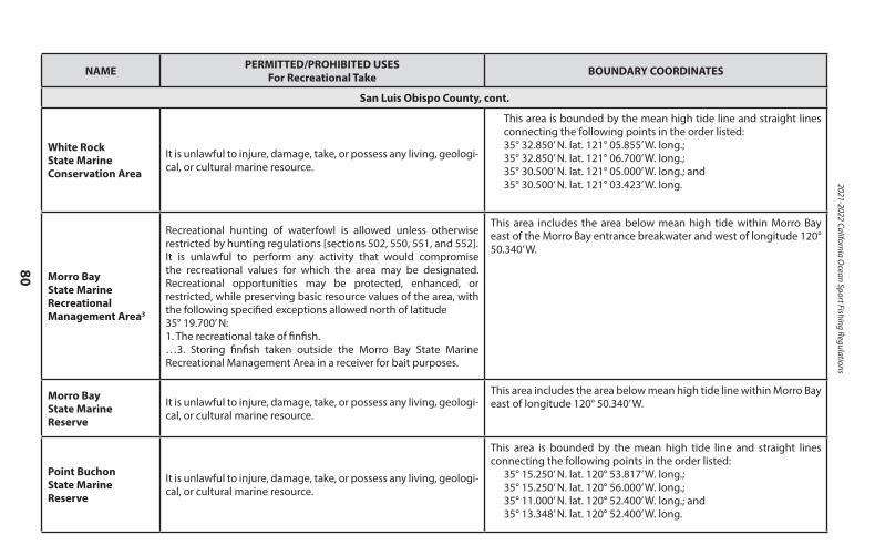
2021-2022 California Ocean Sport Fishing Regulations
80
NAME PERMITTED/PROHIBITED USESFor Recreational Take BOUNDARY COORDINATES
San Luis Obispo County, cont.
White Rock State MarineConservation Area
It is unlawful to injure, damage, take, or possess any living, geologi-cal, or cultural marine resource.
This area is bounded by the mean high tide line and straight lines connecting the following points in the order listed: 35° 32.850’ N. lat. 121° 05.855’ W. long.; 35° 32.850’ N. lat. 121° 06.700’ W. long.; 35° 30.500’ N. lat. 121° 05.000’ W. long.; and 35° 30.500’ N. lat. 121° 03.423’ W. long.
Morro Bay State Marine Recreational Management Area3
Recreational hunting of waterfowl is allowed unless otherwise restricted by hunting regulations [sections 502, 550, 551, and 552].It is unlawful to perform any activity that would compromise the recreational values for which the area may be designated. Recreational opportunities may be protected, enhanced, or restricted, while preserving basic resource values of the area, with the following specified exceptions allowed north of latitude 35° 19.700’ N:1. The recreational take of finfish.…3. Storing finfish taken outside the Morro Bay State Marine Recreational Management Area in a receiver for bait purposes.
This area includes the area below mean high tide within Morro Bay east of the Morro Bay entrance breakwater and west of longitude 120° 50.340’ W.
Morro Bay State Marine Reserve
It is unlawful to injure, damage, take, or possess any living, geologi-cal, or cultural marine resource.
This area includes the area below mean high tide line within Morro Bay east of longitude 120° 50.340’ W.
Point BuchonState Marine Reserve
It is unlawful to injure, damage, take, or possess any living, geologi-cal, or cultural marine resource.
This area is bounded by the mean high tide line and straight lines connecting the following points in the order listed:
35° 15.250’ N. lat. 120° 53.817’ W. long.;35° 15.250’ N. lat. 120° 56.000’ W. long.;35° 11.000’ N. lat. 120° 52.400’ W. long.; and35° 13.348’ N. lat. 120° 52.400’ W. long.
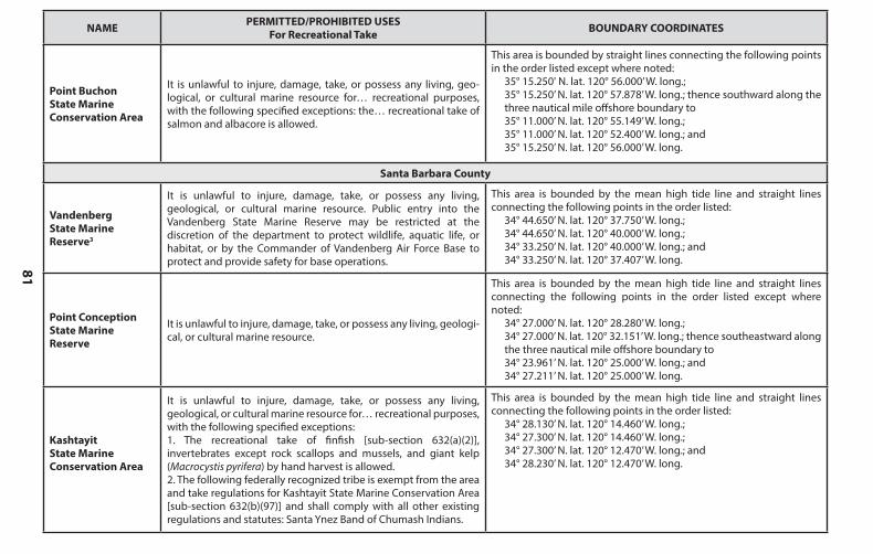
81
NAME PERMITTED/PROHIBITED USESFor Recreational Take BOUNDARY COORDINATES
San Luis Obispo County, cont.
White Rock State MarineConservation Area
It is unlawful to injure, damage, take, or possess any living, geologi-cal, or cultural marine resource.
This area is bounded by the mean high tide line and straight lines connecting the following points in the order listed: 35° 32.850’ N. lat. 121° 05.855’ W. long.; 35° 32.850’ N. lat. 121° 06.700’ W. long.; 35° 30.500’ N. lat. 121° 05.000’ W. long.; and 35° 30.500’ N. lat. 121° 03.423’ W. long.
Morro Bay State Marine Recreational Management Area3
Recreational hunting of waterfowl is allowed unless otherwise restricted by hunting regulations [sections 502, 550, 551, and 552].It is unlawful to perform any activity that would compromise the recreational values for which the area may be designated. Recreational opportunities may be protected, enhanced, or restricted, while preserving basic resource values of the area, with the following specified exceptions allowed north of latitude 35° 19.700’ N:1. The recreational take of finfish.…3. Storing finfish taken outside the Morro Bay State Marine Recreational Management Area in a receiver for bait purposes.
This area includes the area below mean high tide within Morro Bay east of the Morro Bay entrance breakwater and west of longitude 120° 50.340’ W.
Morro Bay State Marine Reserve
It is unlawful to injure, damage, take, or possess any living, geologi-cal, or cultural marine resource.
This area includes the area below mean high tide line within Morro Bay east of longitude 120° 50.340’ W.
Point BuchonState Marine Reserve
It is unlawful to injure, damage, take, or possess any living, geologi-cal, or cultural marine resource.
This area is bounded by the mean high tide line and straight lines connecting the following points in the order listed:
35° 15.250’ N. lat. 120° 53.817’ W. long.;35° 15.250’ N. lat. 120° 56.000’ W. long.;35° 11.000’ N. lat. 120° 52.400’ W. long.; and35° 13.348’ N. lat. 120° 52.400’ W. long.
NAME PERMITTED/PROHIBITED USESFor Recreational Take BOUNDARY COORDINATES
Point BuchonState Marine Conservation Area
It is unlawful to injure, damage, take, or possess any living, geo-logical, or cultural marine resource for… recreational purposes, with the following specified exceptions: the… recreational take of salmon and albacore is allowed.
This area is bounded by straight lines connecting the following points in the order listed except where noted:
35° 15.250' N. lat. 120° 56.000’ W. long.;35° 15.250’ N. lat. 120° 57.878’ W. long.; thence southward along the three nautical mile offshore boundary to35° 11.000’ N. lat. 120° 55.149’ W. long.;35° 11.000’ N. lat. 120° 52.400’ W. long.; and35° 15.250’ N. lat. 120° 56.000’ W. long.
Santa Barbara County
Vandenberg State Marine Reserve3
It is unlawful to injure, damage, take, or possess any living, geological, or cultural marine resource. Public entry into the Vandenberg State Marine Reserve may be restricted at the discretion of the department to protect wildlife, aquatic life, or habitat, or by the Commander of Vandenberg Air Force Base to protect and provide safety for base operations.
This area is bounded by the mean high tide line and straight lines connecting the following points in the order listed:
34° 44.650’ N. lat. 120° 37.750’ W. long.;34° 44.650’ N. lat. 120° 40.000’ W. long.;34° 33.250’ N. lat. 120° 40.000’ W. long.; and34° 33.250’ N. lat. 120° 37.407’ W. long.
Point Conception State Marine Reserve
It is unlawful to injure, damage, take, or possess any living, geologi-cal, or cultural marine resource.
This area is bounded by the mean high tide line and straight lines connecting the following points in the order listed except where noted:
34° 27.000’ N. lat. 120° 28.280’ W. long.;34° 27.000’ N. lat. 120° 32.151’ W. long.; thence southeastward along the three nautical mile offshore boundary to34° 23.961’ N. lat. 120° 25.000’ W. long.; and34° 27.211’ N. lat. 120° 25.000’ W. long.
Kashtayit State Marine Conservation Area
It is unlawful to injure, damage, take, or possess any living, geological, or cultural marine resource for… recreational purposes,with the following specified exceptions:1. The recreational take of finfish [sub-section 632(a)(2)], invertebrates except rock scallops and mussels, and giant kelp (Macrocystis pyrifera) by hand harvest is allowed.2. The following federally recognized tribe is exempt from the area and take regulations for Kashtayit State Marine Conservation Area [sub-section 632(b)(97)] and shall comply with all other existing regulations and statutes: Santa Ynez Band of Chumash Indians.
This area is bounded by the mean high tide line and straight lines connecting the following points in the order listed:
34° 28.130’ N. lat. 120° 14.460’ W. long.;34° 27.300’ N. lat. 120° 14.460’ W. long.;34° 27.300’ N. lat. 120° 12.470’ W. long.; and34° 28.230’ N. lat. 120° 12.470’ W. long.
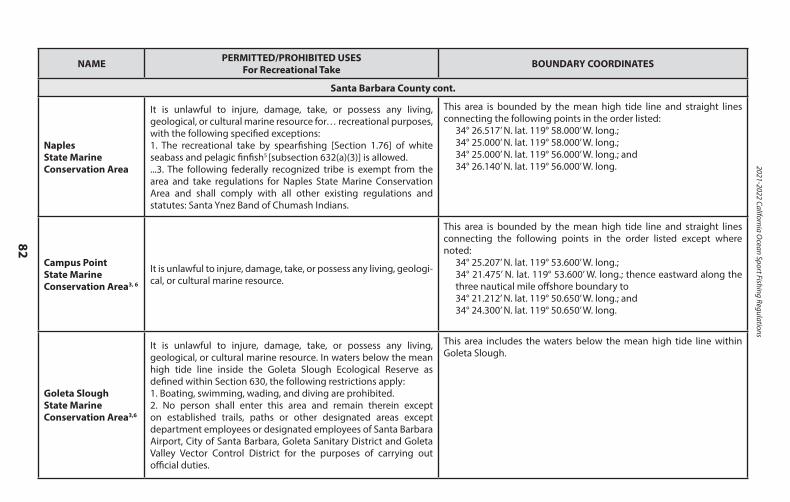
2021-2022 California Ocean Sport Fishing Regulations
82
NAME PERMITTED/PROHIBITED USESFor Recreational Take BOUNDARY COORDINATES
Santa Barbara County cont.
Naples State Marine Conservation Area
It is unlawful to injure, damage, take, or possess any living, geological, or cultural marine resource for… recreational purposes,with the following specified exceptions:1. The recreational take by spearfishing [Section 1.76] of white seabass and pelagic finfish5 [subsection 632(a)(3)] is allowed....3. The following federally recognized tribe is exempt from the area and take regulations for Naples State Marine Conservation Area and shall comply with all other existing regulations and statutes: Santa Ynez Band of Chumash Indians.
This area is bounded by the mean high tide line and straight lines connecting the following points in the order listed:
34° 26.517’ N. lat. 119° 58.000’ W. long.;34° 25.000’ N. lat. 119° 58.000’ W. long.;34° 25.000’ N. lat. 119° 56.000’ W. long.; and34° 26.140’ N. lat. 119° 56.000’ W. long.
Campus Point State Marine Conservation Area3, 6
It is unlawful to injure, damage, take, or possess any living, geologi-cal, or cultural marine resource.
This area is bounded by the mean high tide line and straight lines connecting the following points in the order listed except where noted:
34° 25.207’ N. lat. 119° 53.600’ W. long.;34° 21.475’ N. lat. 119° 53.600’ W. long.; thence eastward along the three nautical mile offshore boundary to34° 21.212’ N. lat. 119° 50.650’ W. long.; and34° 24.300’ N. lat. 119° 50.650’ W. long.
Goleta Slough State Marine Conservation Area3,6
It is unlawful to injure, damage, take, or possess any living, geological, or cultural marine resource. In waters below the mean high tide line inside the Goleta Slough Ecological Reserve as defined within Section 630, the following restrictions apply:1. Boating, swimming, wading, and diving are prohibited.2. No person shall enter this area and remain therein except on established trails, paths or other designated areas except department employees or designated employees of Santa Barbara Airport, City of Santa Barbara, Goleta Sanitary District and Goleta Valley Vector Control District for the purposes of carrying out official duties.
This area includes the waters below the mean high tide line within Goleta Slough.
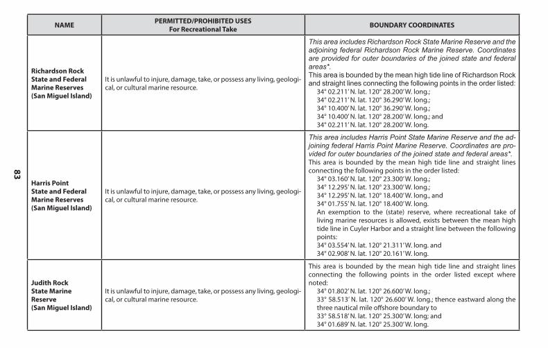
83
NAME PERMITTED/PROHIBITED USESFor Recreational Take BOUNDARY COORDINATES
Richardson Rock State and Federal Marine Reserves (San Miguel Island)
It is unlawful to injure, damage, take, or possess any living, geologi-cal, or cultural marine resource.
This area includes Richardson Rock State Marine Reserve and the adjoining federal Richardson Rock Marine Reserve. Coordinates are provided for outer boundaries of the joined state and federal areas*.This area is bounded by the mean high tide line of Richardson Rock and straight lines connecting the following points in the order listed:
34° 02.211’ N. lat. 120° 28.200’ W. long.;34° 02.211’ N. lat. 120° 36.290’ W. long.;34° 10.400’ N. lat. 120° 36.290’ W. long.;34° 10.400’ N. lat. 120° 28.200’ W. long.; and34° 02.211’ N. lat. 120° 28.200’ W. long.
Harris Point State and Federal Marine Reserves (San Miguel Island)
It is unlawful to injure, damage, take, or possess any living, geologi-cal, or cultural marine resource.
This area includes Harris Point State Marine Reserve and the ad-joining federal Harris Point Marine Reserve. Coordinates are pro-vided for outer boundaries of the joined state and federal areas*. This area is bounded by the mean high tide line and straight lines connecting the following points in the order listed:
34° 03.160’ N. lat. 120° 23.300’ W. long.;34° 12.295’ N. lat. 120° 23.300’ W. long.;34° 12.295’ N. lat. 120° 18.400’ W. long., and34° 01.755’ N. lat. 120° 18.400’ W. long. An exemption to the (state) reserve, where recreational take of living marine resources is allowed, exists between the mean high tide line in Cuyler Harbor and a straight line between the following points:34° 03.554’ N. lat. 120° 21.311’ W. long. and34° 02.908’ N. lat. 120° 20.161’ W. long.
Judith Rock State Marine Reserve(San Miguel Island)
It is unlawful to injure, damage, take, or possess any living, geologi-cal, or cultural marine resource.
This area is bounded by the mean high tide line and straight lines connecting the following points in the order listed except where noted:
34° 01.802’ N. lat. 120° 26.600’ W. long.;33° 58.513’ N. lat. 120° 26.600’ W. long.; thence eastward along the three nautical mile offshore boundary to33° 58.518’ N. lat. 120° 25.300’ W. long; and34° 01.689’ N. lat. 120° 25.300’ W. long.
NAME PERMITTED/PROHIBITED USESFor Recreational Take BOUNDARY COORDINATES
Santa Barbara County cont.
Naples State Marine Conservation Area
It is unlawful to injure, damage, take, or possess any living, geological, or cultural marine resource for… recreational purposes,with the following specified exceptions:1. The recreational take by spearfishing [Section 1.76] of white seabass and pelagic finfish5 [subsection 632(a)(3)] is allowed....3. The following federally recognized tribe is exempt from the area and take regulations for Naples State Marine Conservation Area and shall comply with all other existing regulations and statutes: Santa Ynez Band of Chumash Indians.
This area is bounded by the mean high tide line and straight lines connecting the following points in the order listed:
34° 26.517’ N. lat. 119° 58.000’ W. long.;34° 25.000’ N. lat. 119° 58.000’ W. long.;34° 25.000’ N. lat. 119° 56.000’ W. long.; and34° 26.140’ N. lat. 119° 56.000’ W. long.
Campus Point State Marine Conservation Area3, 6
It is unlawful to injure, damage, take, or possess any living, geologi-cal, or cultural marine resource.
This area is bounded by the mean high tide line and straight lines connecting the following points in the order listed except where noted:
34° 25.207’ N. lat. 119° 53.600’ W. long.;34° 21.475’ N. lat. 119° 53.600’ W. long.; thence eastward along the three nautical mile offshore boundary to34° 21.212’ N. lat. 119° 50.650’ W. long.; and34° 24.300’ N. lat. 119° 50.650’ W. long.
Goleta Slough State Marine Conservation Area3,6
It is unlawful to injure, damage, take, or possess any living, geological, or cultural marine resource. In waters below the mean high tide line inside the Goleta Slough Ecological Reserve as defined within Section 630, the following restrictions apply:1. Boating, swimming, wading, and diving are prohibited.2. No person shall enter this area and remain therein except on established trails, paths or other designated areas except department employees or designated employees of Santa Barbara Airport, City of Santa Barbara, Goleta Sanitary District and Goleta Valley Vector Control District for the purposes of carrying out official duties.
This area includes the waters below the mean high tide line within Goleta Slough.
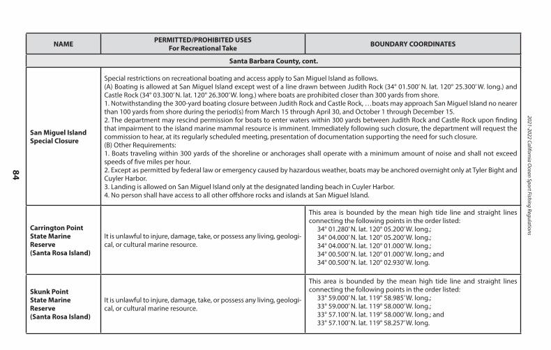
2021-2022 California Ocean Sport Fishing Regulations
84
NAME PERMITTED/PROHIBITED USESFor Recreational Take BOUNDARY COORDINATES
Santa Barbara County, cont.
San Miguel Island Special Closure
Special restrictions on recreational boating and access apply to San Miguel Island as follows.(A) Boating is allowed at San Miguel Island except west of a line drawn between Judith Rock (34° 01.500’ N. lat. 120° 25.300’ W. long.) and Castle Rock (34° 03.300’ N. lat. 120° 26.300’ W. long.) where boats are prohibited closer than 300 yards from shore.1. Notwithstanding the 300-yard boating closure between Judith Rock and Castle Rock, …boats may approach San Miguel Island no nearer than 100 yards from shore during the period(s) from March 15 through April 30, and October 1 through December 15.2. The department may rescind permission for boats to enter waters within 300 yards between Judith Rock and Castle Rock upon finding that impairment to the island marine mammal resource is imminent. Immediately following such closure, the department will request the commission to hear, at its regularly scheduled meeting, presentation of documentation supporting the need for such closure.(B) Other Requirements:1. Boats traveling within 300 yards of the shoreline or anchorages shall operate with a minimum amount of noise and shall not exceed speeds of five miles per hour.2. Except as permitted by federal law or emergency caused by hazardous weather, boats may be anchored overnight only at Tyler Bight and Cuyler Harbor.3. Landing is allowed on San Miguel Island only at the designated landing beach in Cuyler Harbor.4. No person shall have access to all other offshore rocks and islands at San Miguel Island.
Carrington Point State Marine Reserve(Santa Rosa Island)
It is unlawful to injure, damage, take, or possess any living, geologi-cal, or cultural marine resource.
This area is bounded by the mean high tide line and straight lines connecting the following points in the order listed:
34° 01.280’ N. lat. 120° 05.200’ W. long.;34° 04.000’ N. lat. 120° 05.200’ W. long.;34° 04.000’ N. lat. 120° 01.000’ W. long.;34° 00.500’ N. lat. 120° 01.000’ W. long.; and34° 00.500’ N. lat. 120° 02.930’ W. long.
Skunk Point State Marine Reserve(Santa Rosa Island)
It is unlawful to injure, damage, take, or possess any living, geologi-cal, or cultural marine resource.
This area is bounded by the mean high tide line and straight lines connecting the following points in the order listed:
33° 59.000’ N. lat. 119° 58.985’ W. long.;33° 59.000’ N. lat. 119° 58.000’ W. long.;33° 57.100’ N. lat. 119° 58.000’ W. long.; and33° 57.100’ N. lat. 119° 58.257’ W. long.
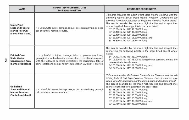
85
NAME PERMITTED/PROHIBITED USESFor Recreational Take BOUNDARY COORDINATES
South Point State and Federal Marine Reserves(Santa Rosa Island)
It is unlawful to injure, damage, take, or possess any living, geologi-cal, or cultural marine resource.
This area includes the South Point State Marine Reserve and the adjoining federal South Point Marine Reserve. Coordinates are provided for outer boundaries of the joined state and federal areas*.This area is bounded by the mean high tide line and straight lines connecting the following points in the order listed:
33° 55.014’ N. lat. 120° 10.000’ W. long.;33° 50.400’ N. lat. 120° 10.000’ W. long.;33° 50.400’ N. lat. 120° 06.500’ W. long.;33° 53.800’ N. lat. 120° 06.500’ W. long.; and33° 53.800’ N. lat. 120° 06.544’ W. long.
Painted Cave State Marine Conservation Area (Santa Cruz Island)
It is unlawful to injure, damage, take, or possess any living, geological, or cultural marine resource for… recreational purposes,with the following specified exceptions: the recreational take of spiny lobster and pelagic finfish5 [sub-section 632(a)(3)] is allowed.
This area is bounded by the mean high tide line and straight lines connecting the following points in the order listed except where noted:
34° 04.492’ N. lat. 119° 53.000’ W. long.;34° 05.200’ N. lat. 119° 53.000’ W. long.; thence eastward along a line one nautical mile offshore to34° 05.000’ N. lat. 119° 51.000’ W. long.; and34° 04.034’ N. lat. 119° 51.000’ W. long.
Gull Island State and Federal Marine Reserves (Santa Cruz Island)
It is unlawful to injure, damage, take, or possess any living, geologi-cal, or cultural marine resource.
This area includes Gull Island State Marine Reserve and the ad-joining federal Gull Island Marine Reserve. Coordinates are pro-vided for outer boundaries of the joined state and federal areas*.This area is bounded by the mean high tide line and straight lines connecting the following points in the order listed:
33° 58.065’ N. lat. 119° 50.967’ W. long.;33° 58.000’ N. lat. 119° 51.000’ W. long.;33° 58.000’ N. lat. 119° 53.000’ W. long.;33° 51.717’ N. lat. 119° 53.000’ W. long.;33° 51.717’ N. lat. 119° 48.000’ W. long.; and33° 57.769’ N. lat. 119° 48.000’ W. long.
NAME PERMITTED/PROHIBITED USESFor Recreational Take BOUNDARY COORDINATES
Santa Barbara County, cont.
San Miguel Island Special Closure
Special restrictions on recreational boating and access apply to San Miguel Island as follows.(A) Boating is allowed at San Miguel Island except west of a line drawn between Judith Rock (34° 01.500’ N. lat. 120° 25.300’ W. long.) and Castle Rock (34° 03.300’ N. lat. 120° 26.300’ W. long.) where boats are prohibited closer than 300 yards from shore.1. Notwithstanding the 300-yard boating closure between Judith Rock and Castle Rock, …boats may approach San Miguel Island no nearer than 100 yards from shore during the period(s) from March 15 through April 30, and October 1 through December 15.2. The department may rescind permission for boats to enter waters within 300 yards between Judith Rock and Castle Rock upon finding that impairment to the island marine mammal resource is imminent. Immediately following such closure, the department will request the commission to hear, at its regularly scheduled meeting, presentation of documentation supporting the need for such closure.(B) Other Requirements:1. Boats traveling within 300 yards of the shoreline or anchorages shall operate with a minimum amount of noise and shall not exceed speeds of five miles per hour.2. Except as permitted by federal law or emergency caused by hazardous weather, boats may be anchored overnight only at Tyler Bight and Cuyler Harbor.3. Landing is allowed on San Miguel Island only at the designated landing beach in Cuyler Harbor.4. No person shall have access to all other offshore rocks and islands at San Miguel Island.
Carrington Point State Marine Reserve(Santa Rosa Island)
It is unlawful to injure, damage, take, or possess any living, geologi-cal, or cultural marine resource.
This area is bounded by the mean high tide line and straight lines connecting the following points in the order listed:
34° 01.280’ N. lat. 120° 05.200’ W. long.;34° 04.000’ N. lat. 120° 05.200’ W. long.;34° 04.000’ N. lat. 120° 01.000’ W. long.;34° 00.500’ N. lat. 120° 01.000’ W. long.; and34° 00.500’ N. lat. 120° 02.930’ W. long.
Skunk Point State Marine Reserve(Santa Rosa Island)
It is unlawful to injure, damage, take, or possess any living, geologi-cal, or cultural marine resource.
This area is bounded by the mean high tide line and straight lines connecting the following points in the order listed:
33° 59.000’ N. lat. 119° 58.985’ W. long.;33° 59.000’ N. lat. 119° 58.000’ W. long.;33° 57.100’ N. lat. 119° 58.000’ W. long.; and33° 57.100’ N. lat. 119° 58.257’ W. long.
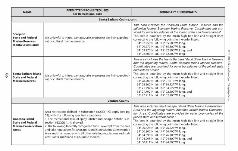
2021-2022 California Ocean Sport Fishing Regulations
86
NAME PERMITTED/PROHIBITED USESFor Recreational Take BOUNDARY COORDINATES
Santa Barbara County, cont.
Scorpion State and Federal Marine Reserves(Santa Cruz Island)
It is unlawful to injure, damage, take, or possess any living, geologi-cal, or cultural marine resource.
This area includes the Scorpion State Marine Reserve and the adjoining federal Scorpion Marine Reserve. Coordinates are pro-vided for outer boundaries of the joined state and federal areas*.This area is bounded by the mean high tide line and straight lines connecting the following points in the order listed:
34° 02.958’ N. lat. 119° 35.500’ W. long.;34° 09.270’ N. lat. 119° 35.500’ W. long.;34° 09.270’ N. lat. 119° 32.800’ W. long.; and34° 02.700’ N. lat. 119° 32.800’ W. long.
Santa Barbara Island State and Federal Marine Reserves
It is unlawful to injure, damage, take, or possess any living, geologi-cal, or cultural marine resource.
This area includes the Santa Barbara Island State Marine Reserve and the adjoining federal Santa Barbara Island Marine Reserve. Coordinates are provided for outer boundaries of the joined state and federal areas*. This area is bounded by the mean high tide line and straight lines connecting the following points in the order listed:
33° 28.500’ N. lat. 119° 01.813’ W. long.;33° 28.500’ N. lat. 118° 54.527’ W. long.;33° 21.792’ N. lat. 118° 54.527’ W. long.;33° 21.792’ N. lat. 119° 02.200’ W. long.; and33° 27.911’ N. lat. 119° 02.200’ W. long.
Ventura County
Anacapa Island State and Federal Marine Conservation Areas
Area restrictions defined in subsection 632(a)(1)(C) apply (see pg. 52), with the following specified exceptions: 1. The recreational take of spiny lobster and pelagic finfish5 [sub-section 632(a)(3)]... is allowed.2. The following federally recognized tribe is exempt from the area and take regulations for Anacapa Island State Marine Conservation Area and shall comply with all other existing regulations and stat-utes: Santa Ynez Band of Chumash Indians.
This area includes the Anacapa Island State Marine Conservation Area and the adjoining federal Anacapa Island Marine Conserva-tion Area. Coordinates are provided for outer boundaries of the joined state and federal areas*. This area is bounded by the mean high tide line and straight lines connecting the following points in the order listed:
34° 00.828’ N. lat. 119° 26.623’ W. long.;34° 00.800’ N. lat. 119° 26.700’ W. long.;34° 04.998’ N. lat. 119° 26.700’ W. long.;34° 04.998’ N. lat. 119° 24.600’ W. long.; and34° 00.411’ N. lat. 119° 24.600’ W. long.
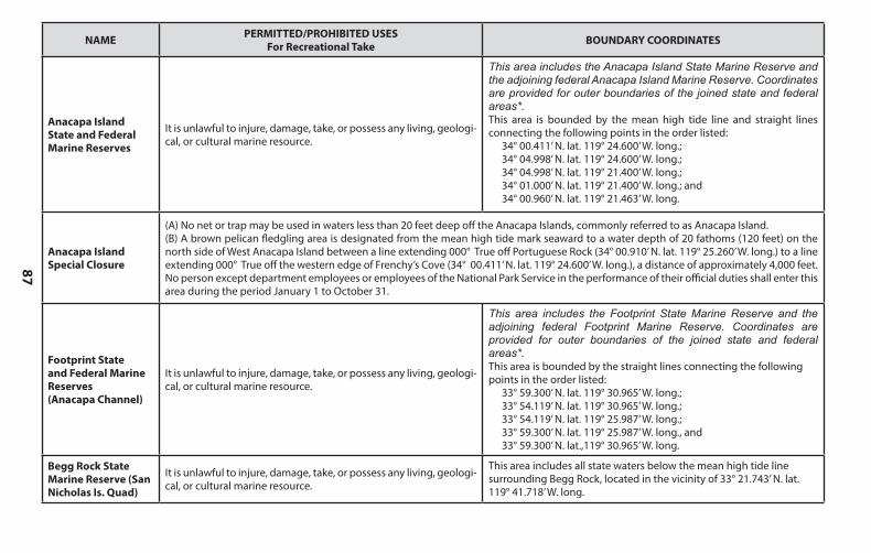
87
NAME PERMITTED/PROHIBITED USESFor Recreational Take BOUNDARY COORDINATES
Anacapa Island State and Federal Marine Reserves
It is unlawful to injure, damage, take, or possess any living, geologi-cal, or cultural marine resource.
This area includes the Anacapa Island State Marine Reserve and the adjoining federal Anacapa Island Marine Reserve. Coordinates are provided for outer boundaries of the joined state and federal areas*. This area is bounded by the mean high tide line and straight lines connecting the following points in the order listed:
34° 00.411’ N. lat. 119° 24.600’ W. long.;34° 04.998’ N. lat. 119° 24.600’ W. long.;34° 04.998’ N. lat. 119° 21.400’ W. long.;34° 01.000’ N. lat. 119° 21.400’ W. long.; and34° 00.960’ N. lat. 119° 21.463’ W. long.
Anacapa Island Special Closure
(A) No net or trap may be used in waters less than 20 feet deep off the Anacapa Islands, commonly referred to as Anacapa Island. (B) A brown pelican fledgling area is designated from the mean high tide mark seaward to a water depth of 20 fathoms (120 feet) on the north side of West Anacapa Island between a line extending 000° True off Portuguese Rock (34° 00.910’ N. lat. 119° 25.260’ W. long.) to a line extending 000° True off the western edge of Frenchy’s Cove (34° 00.411’ N. lat. 119° 24.600’ W. long.), a distance of approximately 4,000 feet. No person except department employees or employees of the National Park Service in the performance of their official duties shall enter this area during the period January 1 to October 31.
Footprint State and Federal Marine Reserves (Anacapa Channel)
It is unlawful to injure, damage, take, or possess any living, geologi-cal, or cultural marine resource.
This area includes the Footprint State Marine Reserve and the adjoining federal Footprint Marine Reserve. Coordinates are provided for outer boundaries of the joined state and federal areas*. This area is bounded by the straight lines connecting the following points in the order listed:
33° 59.300’ N. lat. 119° 30.965’ W. long.;33° 54.119’ N. lat. 119° 30.965’ W. long.;33° 54.119’ N. lat. 119° 25.987’ W. long.;33° 59.300’ N. lat. 119° 25.987’ W. long., and33° 59.300’ N. lat.,119° 30.965’ W. long.
Begg Rock State Marine Reserve (San Nicholas Is. Quad)
It is unlawful to injure, damage, take, or possess any living, geologi-cal, or cultural marine resource.
This area includes all state waters below the mean high tide line surrounding Begg Rock, located in the vicinity of 33° 21.743’ N. lat. 119° 41.718’ W. long.
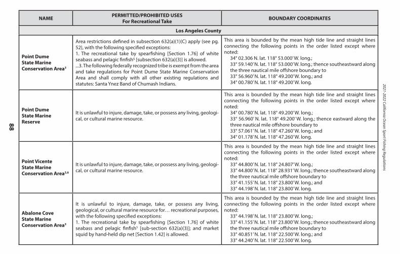
2021-2022 California Ocean Sport Fishing Regulations
88
NAME PERMITTED/PROHIBITED USESFor Recreational Take BOUNDARY COORDINATES
Los Angeles County
Point Dume State Marine Conservation Area3
Area restrictions defined in subsection 632(a)(1)(C) apply (see pg. 52), with the following specified exceptions:1. The recreational take by spearfishing [Section 1.76] of white seabass and pelagic finfish5 [subsection 632(a)(3)] is allowed....3. The following federally recognized tribe is exempt from the area and take regulations for Point Dume State Marine Conservation Area and shall comply with all other existing regulations and statutes: Santa Ynez Band of Chumash Indians.
This area is bounded by the mean high tide line and straight lines connecting the following points in the order listed except where noted:
34° 02.306 N. lat. 118° 53.000’ W. long.;33° 59.140’ N. lat. 118° 53.000’ W. long.; thence southeastward along the three nautical mile offshore boundary to33° 56.960’ N. lat. 118° 49.200’ W. long.; and34° 00.780’ N. lat. 118° 49.200’ W. long.
Point Dume State Marine Reserve
It is unlawful to injure, damage, take, or possess any living, geologi-cal, or cultural marine resource.
This area is bounded by the mean high tide line and straight lines connecting the following points in the order listed except where noted:
34° 00.780’ N. lat. 118° 49.200’ W. long.;33° 56.960’ N. lat. 118° 49.200’ W. long.; thence eastward along the three nautical mile offshore boundary to33° 57.061’ N. lat. 118° 47.260’ W. long.; and34° 01.178’ N. lat. 118° 47.260’ W. long.
Point Vicente State Marine Conservation Area3,6
It is unlawful to injure, damage, take, or possess any living, geologi-cal, or cultural marine resource.
This area is bounded by the mean high tide line and straight lines connecting the following points in the order listed except where noted:
33° 44.800’ N. lat. 118° 24.807’ W. long.;33° 44.800’ N. lat. 118° 28.931’ W. long.; thence southeastward along the three nautical mile offshore boundary to33° 41.155’ N. lat. 118° 23.800’ W. long.; and33° 44.198’ N. lat. 118° 23.800’ W. long.
Abalone Cove State Marine Conservation Area3
It is unlawful to injure, damage, take, or possess any living, geological, or cultural marine resource for… recreational purposes,with the following specified exceptions:1. The recreational take by spearfishing [Section 1.76] of white seabass and pelagic finfish5 [sub-section 632(a)(3)]; and market squid by hand-held dip net [Section 1.42] is allowed.
This area is bounded by the mean high tide line and straight lines connecting the following points in the order listed except where noted:
33° 44.198’ N. lat. 118° 23.800’ W. long.;33° 41.155’ N. lat. 118° 23.800’ W. long.; thence southeastward along the three nautical mile offshore boundary to33° 40.851’ N. lat. 118° 22.500’ W. long.; and33° 44.240’ N. lat. 118° 22.500’ W. long.
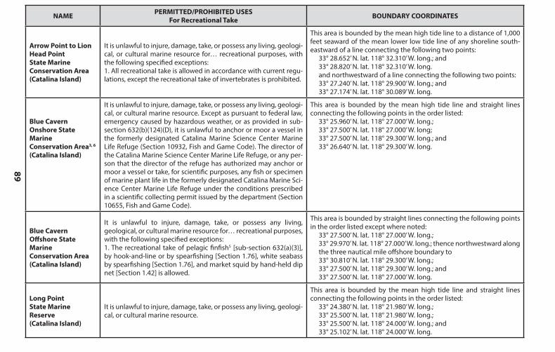
89
NAME PERMITTED/PROHIBITED USESFor Recreational Take BOUNDARY COORDINATES
Arrow Point to Lion Head Point State MarineConservation Area (Catalina Island)
It is unlawful to injure, damage, take, or possess any living, geologi-cal, or cultural marine resource for… recreational purposes, with the following specified exceptions:1. All recreational take is allowed in accordance with current regu-lations, except the recreational take of invertebrates is prohibited.
This area is bounded by the mean high tide line to a distance of 1,000 feet seaward of the mean lower low tide line of any shoreline south-eastward of a line connecting the following two points:
33° 28.652’ N. lat. 118° 32.310’ W. long.; and33° 28.820’ N. lat. 118° 32.310’ W. long.and northwestward of a line connecting the following two points:33° 27.240’ N. lat. 118° 29.900’ W. long.; and33° 27.174’ N. lat. 118° 30.089’ W. long.
Blue Cavern Onshore State Marine Conservation Area3, 6 (Catalina Island)
It is unlawful to injure, damage, take, or possess any living, geologi-cal, or cultural marine resource. Except as pursuant to federal law, emergency caused by hazardous weather, or as provided in sub-section 632(b)(124)(D), it is unlawful to anchor or moor a vessel in the formerly designated Catalina Marine Science Center Marine Life Refuge (Section 10932, Fish and Game Code). The director of the Catalina Marine Science Center Marine Life Refuge, or any per-son that the director of the refuge has authorized may anchor or moor a vessel or take, for scientific purposes, any fish or specimen of marine plant life in the formerly designated Catalina Marine Sci-ence Center Marine Life Refuge under the conditions prescribed in a scientific collecting permit issued by the department (Section 10655, Fish and Game Code).
This area is bounded by the mean high tide line and straight lines connecting the following points in the order listed:
33° 25.960’ N. lat. 118° 27.000’ W. long.; 33° 27.500’ N. lat. 118° 27.000’ W. long; 33° 27.500’ N. lat. 118° 29.300’ W. long.; and 33° 26.640’ N. lat. 118° 29.300’ W. long.
Blue Cavern Offshore State Marine Conservation Area(Catalina Island)
It is unlawful to injure, damage, take, or possess any living, geological, or cultural marine resource for… recreational purposes,with the following specified exceptions:1. The recreational take of pelagic finfish5 [sub-section 632(a)(3)], by hook-and-line or by spearfishing [Section 1.76], white seabass by spearfishing [Section 1.76], and market squid by hand-held dip net [Section 1.42] is allowed.
This area is bounded by straight lines connecting the following points in the order listed except where noted:
33° 27.500’ N. lat. 118° 27.000’ W. long.; 33° 29.970’ N. lat. 118° 27.000’ W. long.; thence northwestward along the three nautical mile offshore boundary to 33° 30.810’ N. lat. 118° 29.300’ W. long.; 33° 27.500’ N. lat. 118° 29.300’ W. long.; and 33° 27.500’ N. lat. 118° 27.000’ W. long.
Long Point State Marine Reserve (Catalina Island)
It is unlawful to injure, damage, take, or possess any living, geologi-cal, or cultural marine resource.
This area is bounded by the mean high tide line and straight lines connecting the following points in the order listed:
33° 24.380’ N. lat. 118° 21.980’ W. long.;33° 25.500’ N. lat. 118° 21.980’ W. long.;33° 25.500’ N. lat. 118° 24.000’ W. long.; and33° 25.102’ N. lat. 118° 24.000’ W. long.
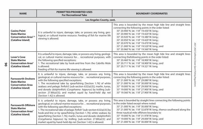
2021-2022 California Ocean Sport Fishing Regulations
90
NAME PERMITTED/PROHIBITED USESFor Recreational Take BOUNDARY COORDINATES
Los Angeles County, cont.
Casino Point State Marine Conservation Area3, 6 (Catalina Island)
It is unlawful to injure, damage, take, or possess any living, geo-logical, or cultural marine resource. Feeding of fish for marine life viewing is allowed.
This area is bounded by the mean high tide line and straight lines connecting the following points in the order listed:
33° 20.900’ N. lat. 118° 19.430’ W. long.;33° 20.900’ N. lat. 118° 19.420’ W. long.;33° 20.920’ N. lat. 118° 19.380’ W. long.;33° 20.950’ N. lat. 118° 19.420’ W. long.;33° 20.970’ N. lat. 118° 19.470’ W. long.;33° 21.000’ N. lat. 118° 19.520’ W. long.; and33° 20.960’ N. lat. 118° 19.560’ W. long.
Lover’s Cove State Marine Conservation Area3
(Catalina Island)
It is unlawful to injure, damage, take, or possess any living, geologi-cal, or cultural marine resource for… recreational purposes, with the following specified exceptions:1. The recreational take by hook-and-line from the Cabrillo Mole is allowed.Feeding of fish for marine life viewing is allowed.
This area is bounded by the mean high tide line and straight lines connecting thefollowing points in the order listed:
33° 20.460’ N. lat. 118° 18.900’ W. long.;33° 20.711’ N. lat. 118° 18.900’ W. long.; and 33° 20.711’ N. lat. 118° 19.321’ W. long.
Farnsworth Onshore State Marine Conservation Area
(Catalina Island)
It is unlawful to injure, damage, take, or possess any living, geological, or cultural marine resource for… recreational purposes,with the following specified exceptions:1. The recreational take by spearfishing [Section 1.76] of white seabass and pelagic finfish5 [sub-section 632(a)(3)]; marlin, tunas, and dorado (dolphinfish) (Coryphaena hippurus) by trolling [sub-section 27.80(a)(3)]; and market squid by hand-held dip net [Section 1.42] is allowed.
This area is bounded by the mean high tide line and straight lines connecting the following points in the order listed:
33° 21.000’ N. lat. 118° 29.080’ W. long.;33° 21.000’ N. lat. 118° 30.000’ W. long.;33° 19.000’ N. lat. 118° 29.000’ W. long.;33° 19.000’ N. lat. 118° 27.900’ W. long.; and33° 19.560’ N. lat. 118° 27.900’ W. long.
Farnsworth Offshore State Marine Conservation Area7 (Catalina Island)
It is unlawful to injure, damage, take, or possess any living, geological, or cultural marine resource for… recreational purposes,with the following specified exceptions:1. The recreational take of pelagic finfish5 [sub-section 632(a)(3)] by hook-and-line or by spearfishing [Section 1.76]; white seabass by spearfishing [Section 1.76]; marlin, tunas and dorado (dolphinfish) (Coryphaena hippurus) by trolling [sub-section 27.80(a)(3)] and market squid by hand-held dip net [Section 1.42] is allowed.
This area is bounded by straight lines connecting the following points in the order listed except where noted:
33° 21.000’ N. lat. 118° 30.000’ W. long.; 33° 21.000’ N. lat. 118° 32.878’ W. long.; thence southward along the three nautical mile offshore boundary to 33° 19.000’ N. lat. 118° 31.978’ W. long.; 33° 19.000’ N. lat. 118° 29.000’ W. long.; and 33° 21.000’ N. lat. 118° 30.000’ W. long.
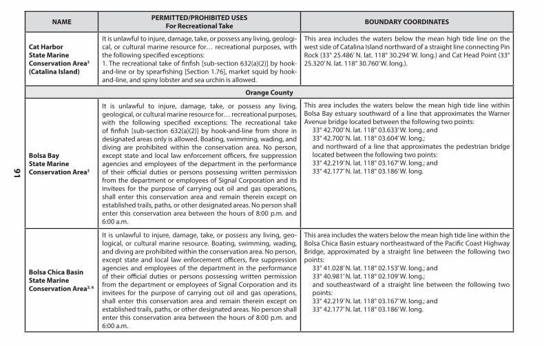
91
NAME PERMITTED/PROHIBITED USESFor Recreational Take BOUNDARY COORDINATES
Los Angeles County, cont.
Casino Point State Marine Conservation Area3, 6 (Catalina Island)
It is unlawful to injure, damage, take, or possess any living, geo-logical, or cultural marine resource. Feeding of fish for marine life viewing is allowed.
This area is bounded by the mean high tide line and straight lines connecting the following points in the order listed:
33° 20.900’ N. lat. 118° 19.430’ W. long.;33° 20.900’ N. lat. 118° 19.420’ W. long.;33° 20.920’ N. lat. 118° 19.380’ W. long.;33° 20.950’ N. lat. 118° 19.420’ W. long.;33° 20.970’ N. lat. 118° 19.470’ W. long.;33° 21.000’ N. lat. 118° 19.520’ W. long.; and33° 20.960’ N. lat. 118° 19.560’ W. long.
Lover’s Cove State Marine Conservation Area3
(Catalina Island)
It is unlawful to injure, damage, take, or possess any living, geologi-cal, or cultural marine resource for… recreational purposes, with the following specified exceptions:1. The recreational take by hook-and-line from the Cabrillo Mole is allowed.Feeding of fish for marine life viewing is allowed.
This area is bounded by the mean high tide line and straight lines connecting thefollowing points in the order listed:
33° 20.460’ N. lat. 118° 18.900’ W. long.;33° 20.711’ N. lat. 118° 18.900’ W. long.; and 33° 20.711’ N. lat. 118° 19.321’ W. long.
Farnsworth Onshore State Marine Conservation Area
(Catalina Island)
It is unlawful to injure, damage, take, or possess any living, geological, or cultural marine resource for… recreational purposes,with the following specified exceptions:1. The recreational take by spearfishing [Section 1.76] of white seabass and pelagic finfish5 [sub-section 632(a)(3)]; marlin, tunas, and dorado (dolphinfish) (Coryphaena hippurus) by trolling [sub-section 27.80(a)(3)]; and market squid by hand-held dip net [Section 1.42] is allowed.
This area is bounded by the mean high tide line and straight lines connecting the following points in the order listed:
33° 21.000’ N. lat. 118° 29.080’ W. long.;33° 21.000’ N. lat. 118° 30.000’ W. long.;33° 19.000’ N. lat. 118° 29.000’ W. long.;33° 19.000’ N. lat. 118° 27.900’ W. long.; and33° 19.560’ N. lat. 118° 27.900’ W. long.
Farnsworth Offshore State Marine Conservation Area7 (Catalina Island)
It is unlawful to injure, damage, take, or possess any living, geological, or cultural marine resource for… recreational purposes,with the following specified exceptions:1. The recreational take of pelagic finfish5 [sub-section 632(a)(3)] by hook-and-line or by spearfishing [Section 1.76]; white seabass by spearfishing [Section 1.76]; marlin, tunas and dorado (dolphinfish) (Coryphaena hippurus) by trolling [sub-section 27.80(a)(3)] and market squid by hand-held dip net [Section 1.42] is allowed.
This area is bounded by straight lines connecting the following points in the order listed except where noted:
33° 21.000’ N. lat. 118° 30.000’ W. long.; 33° 21.000’ N. lat. 118° 32.878’ W. long.; thence southward along the three nautical mile offshore boundary to 33° 19.000’ N. lat. 118° 31.978’ W. long.; 33° 19.000’ N. lat. 118° 29.000’ W. long.; and 33° 21.000’ N. lat. 118° 30.000’ W. long.
NAME PERMITTED/PROHIBITED USESFor Recreational Take BOUNDARY COORDINATES
Cat Harbor State Marine Conservation Area3 (Catalina Island)
It is unlawful to injure, damage, take, or possess any living, geologi-cal, or cultural marine resource for… recreational purposes, with the following specified exceptions:1. The recreational take of finfish [sub-section 632(a)(2)] by hook-and-line or by spearfishing [Section 1.76], market squid by hook-and-line, and spiny lobster and sea urchin is allowed.
This area includes the waters below the mean high tide line on the west side of Catalina Island northward of a straight line connecting Pin Rock (33° 25.486’ N. lat. 118° 30.294’ W. long.) and Cat Head Point (33° 25.320’ N. lat. 118° 30.760’ W. long.).
Orange County
Bolsa Bay State Marine Conservation Area3
It is unlawful to injure, damage, take, or possess any living, geological, or cultural marine resource for… recreational purposes,with the following specified exceptions: The recreational take of finfish [sub-section 632(a)(2)] by hook-and-line from shore in designated areas only is allowed. Boating, swimming, wading, and diving are prohibited within the conservation area. No person, except state and local law enforcement officers, fire suppression agencies and employees of the department in the performance of their official duties or persons possessing written permission from the department or employees of Signal Corporation and its invitees for the purpose of carrying out oil and gas operations, shall enter this conservation area and remain therein except on established trails, paths, or other designated areas. No person shall enter this conservation area between the hours of 8:00 p.m. and 6:00 a.m.
This area includes the waters below the mean high tide line within Bolsa Bay estuary southward of a line that approximates the Warner Avenue bridge located between the following two points:
33° 42.700’ N. lat. 118° 03.633’ W. long.; and33° 42.700’ N. lat. 118° 03.604’ W. long.;and northward of a line that approximates the pedestrian bridge located between the following two points:33° 42.219’ N. lat. 118° 03.167’ W. long.; and33° 42.177’ N. lat. 118° 03.186’ W. long.
Bolsa Chica Basin State Marine Conservation Area3, 6
It is unlawful to injure, damage, take, or possess any living, geo-logical, or cultural marine resource. Boating, swimming, wading, and diving are prohibited within the conservation area. No person, except state and local law enforcement officers, fire suppression agencies and employees of the department in the performance of their official duties or persons possessing written permission from the department or employees of Signal Corporation and its invitees for the purpose of carrying out oil and gas operations, shall enter this conservation area and remain therein except on established trails, paths, or other designated areas. No person shall enter this conservation area between the hours of 8:00 p.m. and 6:00 a.m.
This area includes the waters below the mean high tide line within the Bolsa Chica Basin estuary northeastward of the Pacific Coast Highway Bridge, approximated by a straight line between the following two points:
33° 41.028’ N. lat. 118° 02.153’ W. long.; and33° 40.981’ N. lat. 118° 02.109’ W. long.;and southeastward of a straight line between the following two points:33° 42.219’ N. lat. 118° 03.167’ W. long.; and33° 42.177’ N. lat. 118° 03.186’ W. long.
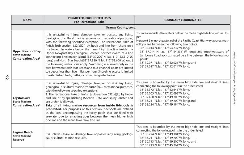
2021-2022 California Ocean Sport Fishing Regulations
92
NAME PERMITTED/PROHIBITED USESFor Recreational Take BOUNDARY COORDINATES
Orange County, cont.
Upper Newport Bay State Marine Conservation Area3
It is unlawful to injure, damage, take, or possess any living, geological, or cultural marine resource for… recreational purposes,with the following specified exception: The recreational take of finfish [sub-section 632(a)(2)] by hook-and-line from shore only is allowed. In waters below the mean high tide line inside the Upper Newport Bay Ecological Reserve, northeastward of a line connecting Shellmaker Island (33° 37.200’ N. lat. 117° 53.510’ W. long.) and North Star Beach (33° 37.380’ N. lat. 117° 53.600’ W. long.) the following restrictions apply: Swimming is allowed only in the area between North Star Beach and mid-channel. Boats are limited to speeds less than five miles per hour. Shoreline access is limited to established trails, paths, or other designated areas.
This area includes the waters below the mean high tide line within Up-perNewport Bay northeastward of the Pacific Coast Highway approximat-ed by a line between the following two points:
33° 37.014’ N. lat. 117° 54.237’ W. long.;33° 37.014’ N. lat. 117° 54.336’ W. long.; and southwestward of Jamboree Road approximated by a line between the following two points:33° 39.071’ N. lat. 117° 52.021’ W. long.; and33° 39.027’ N. lat. 117° 52.014’ W. long.
Crystal Cove State Marine Conservation Area3
It is unlawful to injure, damage, take, or possess any living, geological, or cultural marine resource for… recreational purposes, with the following specified exceptions:1. The recreational take of finfish [sub-section 632(a)(2)] by hook-and-line or by spearfishing [Section 1.76], and spiny lobster and sea urchin is allowed.Take of all living marine resources from inside tidepools is prohibited. For purposes of this section, tidepools are defined as the area encompassing the rocky pools that are filled with seawater due to retracting tides between the mean higher high tide line and the mean lower low tide line.
This area is bounded by the mean high tide line and straight lines connecting the following points in the order listed:
33° 35.372’ N. lat. 117° 52.645’ W. long.;33° 35.065’ N. lat. 117° 52.692’ W. long.;33° 32.400’ N. lat. 117° 49.200’ W. long.; 33° 33.211’ N. lat. 117° 49.200’ W. long; and33° 33.224’ N. lat. 117° 49.184’ W. long.
Laguna Beach State Marine Reserve
It is unlawful to injure, damage, take, or possess any living, geologi-cal, or cultural marine resource.
This area is bounded by the mean high tide line and straight lines connecting the following points in the order listed:
33° 33.224’ N. lat. 117° 49.184’ W. long.;33° 33.211’ N. lat. 117° 49.200’ W. long.;33° 30.713’ N. lat. 117° 49.200’ W. long.; and33° 30.713’ N. lat. 117° 45.264’ W. long.
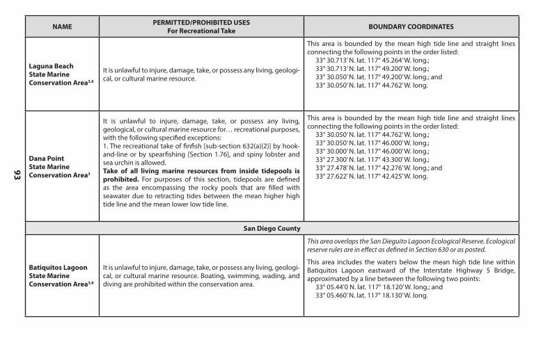
93
NAME PERMITTED/PROHIBITED USESFor Recreational Take BOUNDARY COORDINATES
Orange County, cont.
Upper Newport Bay State Marine Conservation Area3
It is unlawful to injure, damage, take, or possess any living, geological, or cultural marine resource for… recreational purposes,with the following specified exception: The recreational take of finfish [sub-section 632(a)(2)] by hook-and-line from shore only is allowed. In waters below the mean high tide line inside the Upper Newport Bay Ecological Reserve, northeastward of a line connecting Shellmaker Island (33° 37.200’ N. lat. 117° 53.510’ W. long.) and North Star Beach (33° 37.380’ N. lat. 117° 53.600’ W. long.) the following restrictions apply: Swimming is allowed only in the area between North Star Beach and mid-channel. Boats are limited to speeds less than five miles per hour. Shoreline access is limited to established trails, paths, or other designated areas.
This area includes the waters below the mean high tide line within Up-perNewport Bay northeastward of the Pacific Coast Highway approximat-ed by a line between the following two points:
33° 37.014’ N. lat. 117° 54.237’ W. long.;33° 37.014’ N. lat. 117° 54.336’ W. long.; and southwestward of Jamboree Road approximated by a line between the following two points:33° 39.071’ N. lat. 117° 52.021’ W. long.; and33° 39.027’ N. lat. 117° 52.014’ W. long.
Crystal Cove State Marine Conservation Area3
It is unlawful to injure, damage, take, or possess any living, geological, or cultural marine resource for… recreational purposes, with the following specified exceptions:1. The recreational take of finfish [sub-section 632(a)(2)] by hook-and-line or by spearfishing [Section 1.76], and spiny lobster and sea urchin is allowed.Take of all living marine resources from inside tidepools is prohibited. For purposes of this section, tidepools are defined as the area encompassing the rocky pools that are filled with seawater due to retracting tides between the mean higher high tide line and the mean lower low tide line.
This area is bounded by the mean high tide line and straight lines connecting the following points in the order listed:
33° 35.372’ N. lat. 117° 52.645’ W. long.;33° 35.065’ N. lat. 117° 52.692’ W. long.;33° 32.400’ N. lat. 117° 49.200’ W. long.; 33° 33.211’ N. lat. 117° 49.200’ W. long; and33° 33.224’ N. lat. 117° 49.184’ W. long.
Laguna Beach State Marine Reserve
It is unlawful to injure, damage, take, or possess any living, geologi-cal, or cultural marine resource.
This area is bounded by the mean high tide line and straight lines connecting the following points in the order listed:
33° 33.224’ N. lat. 117° 49.184’ W. long.;33° 33.211’ N. lat. 117° 49.200’ W. long.;33° 30.713’ N. lat. 117° 49.200’ W. long.; and33° 30.713’ N. lat. 117° 45.264’ W. long.
NAME PERMITTED/PROHIBITED USESFor Recreational Take BOUNDARY COORDINATES
Laguna BeachState Marine Conservation Area3,6
It is unlawful to injure, damage, take, or possess any living, geologi-cal, or cultural marine resource.
This area is bounded by the mean high tide line and straight lines connecting the following points in the order listed:
33° 30.713’ N. lat. 117° 45.264’ W. long.;33° 30.713’ N. lat. 117° 49.200’ W. long.;33° 30.050’ N. lat. 117° 49.200’ W. long.; and33° 30.050’ N. lat. 117° 44.762’ W. long.
Dana Point State Marine Conservation Area3
It is unlawful to injure, damage, take, or possess any living, geological, or cultural marine resource for… recreational purposes,with the following specified exceptions:1. The recreational take of finfish [sub-section 632(a)(2)] by hook-and-line or by spearfishing [Section 1.76], and spiny lobster and sea urchin is allowed.Take of all living marine resources from inside tidepools is prohibited. For purposes of this section, tidepools are defined as the area encompassing the rocky pools that are filled with seawater due to retracting tides between the mean higher high tide line and the mean lower low tide line.
This area is bounded by the mean high tide line and straight lines connecting the following points in the order listed:
33° 30.050’ N. lat. 117° 44.762’ W. long.; 33° 30.050’ N. lat. 117° 46.000’ W. long.; 33° 30.000’ N. lat. 117° 46.000’ W. long.; 33° 27.300’ N. lat. 117° 43.300’ W. long.; 33° 27.478’ N. lat. 117° 42.276’ W. long.; and 33° 27.622’ N. lat. 117° 42.425’ W. long.
San Diego County
Batiquitos Lagoon State Marine Conservation Area3,6
It is unlawful to injure, damage, take, or possess any living, geologi-cal, or cultural marine resource. Boating, swimming, wading, and diving are prohibited within the conservation area.
This area overlaps the San Dieguito Lagoon Ecological Reserve. Ecological reserve rules are in effect as defined in Section 630 or as posted.
This area includes the waters below the mean high tide line within Batiquitos Lagoon eastward of the Interstate Highway 5 Bridge, approximated by a line between the following two points:
33° 05.44’0 N. lat. 117° 18.120’ W. long.; and33° 05.460’ N. lat. 117° 18.130’ W. long.
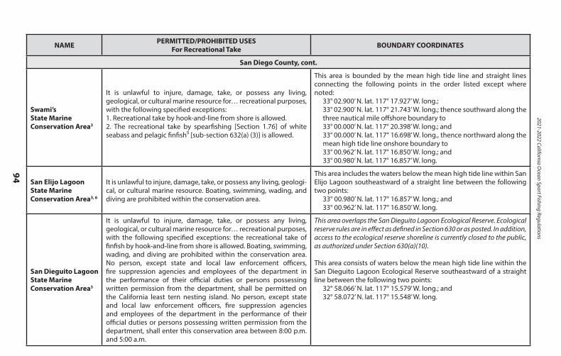
2021-2022 California Ocean Sport Fishing Regulations
94
NAME PERMITTED/PROHIBITED USESFor Recreational Take BOUNDARY COORDINATES
San Diego County, cont.
Swami’s State MarineConservation Area3
It is unlawful to injure, damage, take, or possess any living, geological, or cultural marine resource for… recreational purposes,with the following specified exceptions:1. Recreational take by hook-and-line from shore is allowed.2. The recreational take by spearfishing [Section 1.76] of white seabass and pelagic finfish⁵ [sub-section 632(a) (3)] is allowed.
This area is bounded by the mean high tide line and straight lines connecting the following points in the order listed except where noted:
33° 02.900’ N. lat. 117° 17.927’ W. long.;33° 02.900’ N. lat. 117° 21.743’ W. long.; thence southward along the three nautical mile offshore boundary to33° 00.000’ N. lat. 117° 20.398’ W. long.; and33° 00.000’ N. lat. 117° 16.698’ W. long., thence northward along the mean high tide line onshore boundary to33° 00.962’ N. lat. 117° 16.850’ W. long.; and33° 00.980’ N. lat. 117° 16.857’ W. long.
San Elijo Lagoon State Marine Conservation Area3, 6
It is unlawful to injure, damage, take, or possess any living, geologi-cal, or cultural marine resource. Boating, swimming, wading, and diving are prohibited within the conservation area.
This area includes the waters below the mean high tide line within San Elijo Lagoon southeastward of a straight line between the following two points:
33° 00.980’ N. lat. 117° 16.857’ W. long.; and33° 00.962’ N. lat. 117° 16.850’ W. long.
San Dieguito Lagoon State Marine Conservation Area3
It is unlawful to injure, damage, take, or possess any living, geological, or cultural marine resource for… recreational purposes, with the following specified exceptions: the recreational take of finfish by hook-and-line from shore is allowed. Boating, swimming, wading, and diving are prohibited within the conservation area. No person, except state and local law enforcement officers, fire suppression agencies and employees of the department in the performance of their official duties or persons possessing written permission from the department, shall be permitted on the California least tern nesting island. No person, except state and local law enforcement officers, fire suppression agencies and employees of the department in the performance of their official duties or persons possessing written permission from the department, shall enter this conservation area between 8:00 p.m. and 5:00 a.m.
This area overlaps the San Dieguito Lagoon Ecological Reserve. Ecological reserve rules are in effect as defined in Section 630 or as posted. In addition, access to the ecological reserve shoreline is currently closed to the public, as authorized under Section 630(a)(10).
This area consists of waters below the mean high tide line within the San Dieguito Lagoon Ecological Reserve southeastward of a straight line between the following two points:
32° 58.066’ N. lat. 117° 15.579’ W. long.; and 32° 58.072’ N. lat. 117° 15.548’ W. long.
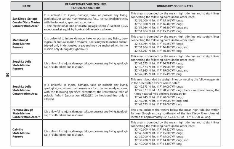
95
NAME PERMITTED/PROHIBITED USESFor Recreational Take BOUNDARY COORDINATES
San Diego County, cont.
Swami’s State MarineConservation Area3
It is unlawful to injure, damage, take, or possess any living, geological, or cultural marine resource for… recreational purposes,with the following specified exceptions:1. Recreational take by hook-and-line from shore is allowed.2. The recreational take by spearfishing [Section 1.76] of white seabass and pelagic finfish⁵ [sub-section 632(a) (3)] is allowed.
This area is bounded by the mean high tide line and straight lines connecting the following points in the order listed except where noted:
33° 02.900’ N. lat. 117° 17.927’ W. long.;33° 02.900’ N. lat. 117° 21.743’ W. long.; thence southward along the three nautical mile offshore boundary to33° 00.000’ N. lat. 117° 20.398’ W. long.; and33° 00.000’ N. lat. 117° 16.698’ W. long., thence northward along the mean high tide line onshore boundary to33° 00.962’ N. lat. 117° 16.850’ W. long.; and33° 00.980’ N. lat. 117° 16.857’ W. long.
San Elijo Lagoon State Marine Conservation Area3, 6
It is unlawful to injure, damage, take, or possess any living, geologi-cal, or cultural marine resource. Boating, swimming, wading, and diving are prohibited within the conservation area.
This area includes the waters below the mean high tide line within San Elijo Lagoon southeastward of a straight line between the following two points:
33° 00.980’ N. lat. 117° 16.857’ W. long.; and33° 00.962’ N. lat. 117° 16.850’ W. long.
San Dieguito Lagoon State Marine Conservation Area3
It is unlawful to injure, damage, take, or possess any living, geological, or cultural marine resource for… recreational purposes, with the following specified exceptions: the recreational take of finfish by hook-and-line from shore is allowed. Boating, swimming, wading, and diving are prohibited within the conservation area. No person, except state and local law enforcement officers, fire suppression agencies and employees of the department in the performance of their official duties or persons possessing written permission from the department, shall be permitted on the California least tern nesting island. No person, except state and local law enforcement officers, fire suppression agencies and employees of the department in the performance of their official duties or persons possessing written permission from the department, shall enter this conservation area between 8:00 p.m. and 5:00 a.m.
This area overlaps the San Dieguito Lagoon Ecological Reserve. Ecological reserve rules are in effect as defined in Section 630 or as posted. In addition, access to the ecological reserve shoreline is currently closed to the public, as authorized under Section 630(a)(10).
This area consists of waters below the mean high tide line within the San Dieguito Lagoon Ecological Reserve southeastward of a straight line between the following two points:
32° 58.066’ N. lat. 117° 15.579’ W. long.; and 32° 58.072’ N. lat. 117° 15.548’ W. long.
NAME PERMITTED/PROHIBITED USESFor Recreational Take BOUNDARY COORDINATES
San Diego-Scripps Coastal State Marine Conservation Area3
It is unlawful to injure, damage, take, or possess any living, geological, or cultural marine resource for… recreational purposes,with the following specified exceptions:1. The recreational take of coastal pelagic species⁸ [Section 1.39], except market squid, by hook-and-line only is allowed.
This area is bounded by the mean high tide line and straight lines connecting the following points in the order listed:
32° 53.000’ N. lat. 117° 15.166’ W. long.;32° 53.000’ N. lat. 117° 16.400’ W. long.;32° 51.964’ N. lat. 117° 16.400’ W. long.; and32° 51.964’ N. lat. 117° 15.252’ W. long.
Matlahuayl State Marine Reserve
It is unlawful to injure, damage, take, or possess any living, geo-logical, or cultural marine resource. Boats may be launched and re-trieved only in designated areas and may be anchored within the reserve only during daylight hours.
This area is bounded by the mean high tide line and straight lines connecting the following points in the order listed:
32° 51.964’ N. lat. 117° 15.252’ W. long.;32° 51.964’ N. lat. 117° 16.400’ W. long.; and32° 51.067’ N. lat. 117° 16.400’ W. long.
South La Jolla State Marine Reserve
It is unlawful to injure, damage, take, or possess any living, geologi-cal, or cultural marine resource.
This area is bounded by the mean high tide line and straight lines connecting the following points in the order listed:
32° 49.573’ N. lat. 117° 16.781’ W. long.;32° 49.573’ N. lat. 117° 19.000’ W. long.;32° 47.945’ N. lat. 117° 19.000’ W. long.; and32° 47.945’ N. lat. 117° 15.495’ W. long.
South La Jolla State Marine Conservation Area
It is unlawful to injure, damage, take, or possess any living, geological, or cultural marine resource for… recreational purposes,with the following specified exceptions: the recreational take of pelagic finfish5 [subsection 632(a)(3)] by hook-and-line only is allowed.
This area is bounded by straight lines connecting the following points in the order listed except where noted:
32° 49.573’ N. lat. 117° 19.000’ W. long.;32° 49.573’ N. lat. 117° 20.528’ W. long.; thence southward along the three nautical mile offshore boundary to32° 47.945’ N. lat. 117° 20.068’ W. long.; 32° 47.945’ N. lat. 117° 19.000’ W. long; and 32° 49.573’ N. lat. 117° 19.000’ W. long.
Famosa Slough State Marine Conservation Area3, 6
It is unlawful to injure, damage, take, or possess any living, geologi-cal, or cultural marine resource.
This area includes the waters below the mean high tide line within Famosa Slough estuary southward of the San Diego River channel, located at approximately 32° 45.430’ N. lat. 117° 13.750’ W. long.
Cabrillo State Marine Reserve
It is unlawful to injure, damage, take, or possess any living, geologi-cal, or cultural marine resource.
This area is bounded by the mean high tide line and straight lines connecting the following points in the order listed:
32° 40.600’ N. lat. 117° 14.820’ W. long.;32° 40.600’ N. lat. 117° 15.000’ W. long.;32° 39.700’ N. lat. 117° 15.000’ W. long.;32° 39.700’ N. lat. 117° 14.300’ W. long.; and32° 40.000’ N. lat. 117° 14.300’ W. long.
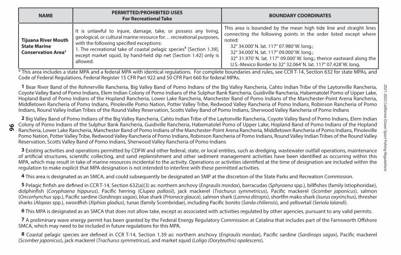
2021-2022 California Ocean Sport Fishing Regulations
96
NAME PERMITTED/PROHIBITED USESFor Recreational Take BOUNDARY COORDINATES
Tijuana River Mouth State Marine Conservation Area3
It is unlawful to injure, damage, take, or possess any living, geological, or cultural marine resource for… recreational purposes,with the following specified exceptions:1. The recreational take of coastal pelagic species⁸ [Section 1.39], except market squid, by hand-held dip net [Section 1.42] only is allowed.
This area is bounded by the mean high tide line and straight lines connecting the following points in the order listed except where noted:
32° 34.000’ N. lat. 117° 07.980’ W. long.;32° 34.000’ N. lat. 117° 09.000’ W. long.;32° 31.970’ N. lat. 117° 09.000’ W. long.; thence eastward along the U.S.-Mexico Border to 32° 32.064’ N. lat. 117° 07.428’ W. long.
* This area includes a state MPA and a federal MPA with identical regulations. For complete boundaries and rules, see CCR T-14, Section 632 for state MPAs, and Code of Federal Regulations, Federal Register 15 CFR Part 922 and 50 CFR Part 660 for federal MPAs.
1 Bear River Band of the Rohnerville Rancheria, Big Valley Band of Pomo Indians of the Big Valley Rancheria, Cahto Indian Tribe of the Laytonville Rancheria, Coyote Valley Band of Pomo Indians, Elem Indian Colony of Pomo Indians of the Sulphur Bank Rancheria, Guidiville Rancheria, Habematolel Pomo of Upper Lake, Hopland Band of Pomo Indians of the Hopland Rancheria, Lower Lake Rancheria, Manchester Band of Pomo Indians of the Manchester-Point Arena Rancheria, Middletown Rancheria of Pomo Indians, Pinoleville Pomo Nation, Potter Valley Tribe, Redwood Valley Rancheria of Pomo Indians, Robinson Rancheria of Pomo Indians, Round Valley Indian Tribes of the Round Valley Reservation, Scotts Valley Band of Pomo Indians, Sherwood Valley Rancheria of Pomo Indians
2 Big Valley Band of Pomo Indians of the Big Valley Rancheria, Cahto Indian Tribe of the Laytonville Rancheria, Coyote Valley Band of Pomo Indians, Elem Indian Colony of Pomo Indians of the Sulphur Bank Rancheria, Guidiville Rancheria, Habematolel Pomo of Upper Lake, Hopland Band of Pomo Indians of the Hopland Rancheria, Lower Lake Rancheria, Manchester Band of Pomo Indians of the Manchester-Point Arena Rancheria, Middletown Rancheria of Pomo Indians, Pinoleville Pomo Nation, Potter Valley Tribe, Redwood Valley Rancheria of Pomo Indians, Robinson Rancheria of Pomo Indians, Round Valley Indian Tribes of the Round Valley Reservation, Scotts Valley Band of Pomo Indians, Sherwood Valley Rancheria of Pomo Indians
3 Existing activities and operations permitted by CDFW and other federal, state, or local entities, such as dredging, wastewater outfall operations, maintenance of artificial structures, scientific collecting, and sand replenishment and other sediment management activities have been identified as occurring within this MPA, which may result in take of marine resources incidental to the activity. Operations or activities identified at the time of designation are included within the regulation to make explicit that MPA designation is not intended to interfere with these permitted activities.
4 This area is designated as an SMCA, and could subsequently be designated an SMP at the discretion of the State Parks and Recreation Commission.5 Pelagic finfish are defined in CCR T-14, Section 632(a)(3) as: northern anchovy (Engraulis mordax), barracudas (Sphyraena spp.), billfishes (family Istiophoridae),
dolphinfish (Coryphaena hippurus), Pacific herring (Clupea pallasii), jack mackerel (Trachurus symmetricus), Pacific mackerel (Scomber japonicus), salmon (Oncorhynchus spp.), Pacific sardine (Sardinops sagax), blue shark (Prionace glauca), salmon shark (Lamna ditropis), shortfin mako shark (Isurus oxyrinchus), thresher sharks (Alopias spp.), swordfish (Xiphias gladius), tunas (family Scombridae), including Pacific bonito (Sarda chiliensis), and yellowtail (Seriola lalandi).
6 This MPA is designated as an SMCA that does not allow take, except as associated with activities regulated by other agencies, pursuant to any valid permits.7 A preliminary wave energy permit has been granted by the Federal Energy Regulatory Commission at Catalina that includes part of the Farnsworth Offshore
SMCA, which may need to be included in future regulations for this MPA.8 Coastal pelagic species are defined in CCR T-14, Section 1.39 as: northern anchovy (Engraulis mordax), Pacific sardine (Sardinops sagax), Pacific mackerel
(Scomber japonicus), jack mackerel (Trachurus symmetricus), and market squid (Loligo (Doryteuthis) opalescens).
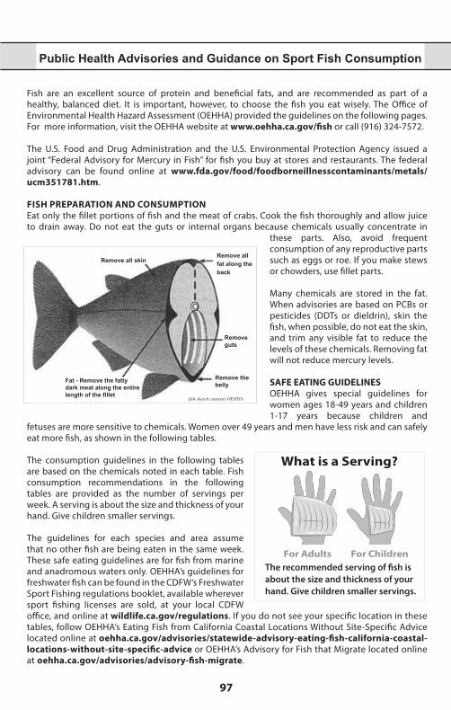
97
* Th
is a
rea
incl
udes
a s
tate
MPA
and
a fe
dera
l MPA
with
iden
tical
regu
latio
ns.
For c
ompl
ete
boun
darie
s an
d ru
les,
see
CCR
T-14
, Sec
tion
632
for s
tate
MPA
s, an
d Co
de o
f Fed
eral
Reg
ulat
ions
, Fed
eral
Reg
iste
r 15
CFR
Part
922
and
50
CFR
Part
660
for f
eder
al M
PAs.
1 Be
ar R
iver
Ban
d of
the
Roh
nerv
ille
Ranc
heria
, Big
Val
ley
Band
of P
omo
Indi
ans
of t
he B
ig V
alle
y Ra
nche
ria, C
ahto
Indi
an T
ribe
of t
he L
ayto
nvill
e Ra
nche
ria,
Coyo
te V
alle
y Ba
nd o
f Pom
o In
dian
s, El
em In
dian
Col
ony
of P
omo
Indi
ans
of th
e Su
lphu
r Ban
k Ra
nche
ria, G
uidi
ville
Ran
cher
ia, H
abem
atol
el P
omo
of U
pper
Lak
e,
Hop
land
Ban
d of
Pom
o In
dian
s of
the
Hop
land
Ran
cher
ia, L
ower
Lak
e Ra
nche
ria, M
anch
este
r Ban
d of
Pom
o In
dian
s of
the
Man
ches
ter-
Poin
t Are
na R
anch
eria
, M
iddl
etow
n Ra
nche
ria o
f Pom
o In
dian
s, Pi
nole
ville
Pom
o N
atio
n, P
otte
r Val
ley
Trib
e, R
edw
ood
Valle
y Ra
nche
ria o
f Pom
o In
dian
s, Ro
bins
on R
anch
eria
of P
omo
Indi
ans,
Roun
d Va
lley
Indi
an T
ribes
of t
he R
ound
Val
ley
Rese
rvat
ion,
Sco
tts V
alle
y Ba
nd o
f Pom
o In
dian
s, Sh
erw
ood
Valle
y Ra
nche
ria o
f Pom
o In
dian
s2
Big
Valle
y Ba
nd o
f Pom
o In
dian
s of
the
Big
Valle
y Ra
nche
ria, C
ahto
Indi
an T
ribe
of th
e La
yton
ville
Ran
cher
ia, C
oyot
e Va
lley
Band
of P
omo
Indi
ans,
Elem
Indi
an
Colo
ny o
f Pom
o In
dian
s of
the
Sulp
hur B
ank
Ranc
heria
, Gui
divi
lle R
anch
eria
, Hab
emat
olel
Pom
o of
Upp
er L
ake,
Hop
land
Ban
d of
Pom
o In
dian
s of
the
Hop
land
Ra
nche
ria, L
ower
Lak
e Ra
nche
ria, M
anch
este
r Ban
d of
Pom
o In
dian
s of t
he M
anch
este
r-Po
int A
rena
Ran
cher
ia, M
iddl
etow
n Ra
nche
ria o
f Pom
o In
dian
s, Pi
nole
ville
Po
mo
Nat
ion,
Pot
ter V
alle
y Tr
ibe,
Red
woo
d Va
lley
Ranc
heria
of P
omo
Indi
ans,
Robi
nson
Ran
cher
ia o
f Pom
o In
dian
s, Ro
und
Valle
y In
dian
Trib
es o
f the
Rou
nd V
alle
y Re
serv
atio
n, S
cott
s Val
ley
Band
of P
omo
Indi
ans,
Sher
woo
d Va
lley
Ranc
heria
of P
omo
Indi
ans
3 Ex
istin
g ac
tiviti
es a
nd o
pera
tions
per
mitt
ed b
y CD
FW a
nd o
ther
fede
ral,
stat
e, o
r loc
al e
ntiti
es, s
uch
as d
redg
ing,
was
tew
ater
out
fall
oper
atio
ns, m
aint
enan
ce
of a
rtifi
cial
str
uctu
res,
scie
ntifi
c co
llect
ing,
and
san
d re
plen
ishm
ent
and
othe
r se
dim
ent
man
agem
ent
activ
ities
hav
e be
en id
entifi
ed a
s oc
curr
ing
with
in t
his
MPA
, whi
ch m
ay re
sult
in ta
ke o
f mar
ine
reso
urce
s in
cide
ntal
to th
e ac
tivity
. Ope
ratio
ns o
r act
iviti
es id
entifi
ed a
t the
tim
e of
des
igna
tion
are
incl
uded
with
in th
e re
gula
tion
to m
ake
expl
icit
that
MPA
des
igna
tion
is n
ot in
tend
ed to
inte
rfer
e w
ith th
ese
perm
itted
act
iviti
es.
4 Th
is a
rea
is d
esig
nate
d as
an
SMCA
, and
cou
ld s
ubse
quen
tly b
e de
sign
ated
an
SMP
at th
e di
scre
tion
of th
e St
ate
Park
s an
d Re
crea
tion
Com
mis
sion
.5
Pela
gic
finfis
h ar
e de
fined
in C
CR T
-14,
Sec
tion
632(
a)(3
) as:
nor
ther
n an
chov
y (E
ngra
ulis
mor
dax)
, bar
racu
das
(Sph
yrae
na sp
p.),
billfi
shes
(fam
ily Is
tioph
orid
ae),
dolp
hinfi
sh (
Cory
phae
na h
ippu
rus)
, Pa
cific
her
ring
(Clu
pea
palla
sii),
jac
k m
acke
rel
(Tra
chur
us s
ymm
etric
us),
Paci
fic m
acke
rel
(Sco
mbe
r ja
poni
cus)
, sa
lmon
(O
ncor
hync
hus s
pp.),
Pac
ific
sard
ine
(Sar
dino
ps sa
gax)
, blu
e sh
ark
(Prio
nace
gla
uca)
, sal
mon
shar
k (L
amna
ditr
opis
), sh
ortfi
n m
ako
shar
k (Is
urus
oxy
rinch
us),
thre
sher
sh
arks
(Alo
pias
spp
.), s
wor
dfish
(Xip
hias
gla
dius
), tu
nas
(fam
ily S
com
brid
ae),
incl
udin
g Pa
cific
bon
ito (S
arda
chi
liens
is),
and
yello
wta
il (S
erio
la la
land
i).
6 Th
is M
PA is
des
igna
ted
as a
n SM
CA th
at d
oes
not a
llow
take
, exc
ept a
s as
soci
ated
with
act
iviti
es re
gula
ted
by o
ther
age
ncie
s, pu
rsua
nt to
any
val
id p
erm
its.
7 A
pre
limin
ary
wav
e en
ergy
per
mit
has
been
gra
nted
by
the
Fede
ral E
nerg
y Re
gula
tory
Com
mis
sion
at C
atal
ina
that
incl
udes
par
t of t
he F
arns
wor
th O
ffsho
re
SMCA
, whi
ch m
ay n
eed
to b
e in
clud
ed in
futu
re re
gula
tions
for t
his
MPA
.8
Coas
tal p
elag
ic s
peci
es a
re d
efine
d in
CCR
T-1
4, S
ectio
n 1.
39 a
s: n
orth
ern
anch
ovy
(Eng
raul
is m
orda
x), P
acifi
c sa
rdin
e (S
ardi
nops
sag
ax),
Paci
fic m
acke
rel
(Sco
mbe
r jap
onic
us),
jack
mac
kere
l (Tr
achu
rus s
ymm
etric
us),
and
mar
ket s
quid
(Lol
igo
(Dor
yteu
this
) opa
lesc
ens)
.
Public Health Advisories and Guidance on Sport Fish Consumption
Fish are an excellent source of protein and beneficial fats, and are recommended as part of a healthy, balanced diet. It is important, however, to choose the fish you eat wisely. The Office of Environmental Health Hazard Assessment (OEHHA) provided the guidelines on the following pages. For more information, visit the OEHHA website at www.oehha.ca.gov/fish or call (916) 324-7572.
The U.S. Food and Drug Administration and the U.S. Environmental Protection Agency issued a joint “Federal Advisory for Mercury in Fish” for fish you buy at stores and restaurants. The federal advisory can be found online at www.fda.gov/food/foodborneillnesscontaminants/metals/ucm351781.htm.
FISH PREPARATION AND CONSUMPTIONEat only the fillet portions of fish and the meat of crabs. Cook the fish thoroughly and allow juice to drain away. Do not eat the guts or internal organs because chemicals usually concentrate in
these parts. Also, avoid frequent consumption of any reproductive parts such as eggs or roe. If you make stews or chowders, use fillet parts.
Many chemicals are stored in the fat. When advisories are based on PCBs or pesticides (DDTs or dieldrin), skin the fish, when possible, do not eat the skin, and trim any visible fat to reduce the levels of these chemicals. Removing fat will not reduce mercury levels.
Remove all skin
Fat - Remove the fatty dark meat along the entire length of the fillet
Remove all fat along the back
Remove guts
Remove the belly
fish sketch courtesy OEHHA
SAFE EATING GUIDELINESOEHHA gives special guidelines for women ages 18-49 years and children 1-17 years because children and
fetuses are more sensitive to chemicals. Women over 49 years and men have less risk and can safely eat more fish, as shown in the following tables.
The consumption guidelines in the following tables are based on the chemicals noted in each table. Fish consumption recommendations in the following tables are provided as the number of servings per week. A serving is about the size and thickness of your hand. Give children smaller servings.
What is a Serving?
The recommended serving of fish is about the size and thickness of your hand. Give children smaller servings.
For Adults For Children
The guidelines for each species and area assume that no other fish are being eaten in the same week. These safe eating guidelines are for fish from marine and anadromous waters only. OEHHA’s guidelines for freshwater fish can be found in the CDFW’s Freshwater Sport Fishing regulations booklet, available wherever sport fishing licenses are sold, at your local CDFW office, and online at wildlife.ca.gov/regulations. If you do not see your specific location in these tables, follow OEHHA’s Eating Fish from California Coastal Locations Without Site-Specific Advice located online at oehha.ca.gov/advisories/statewide-advisory-eating-fish-california-coastal-locations-without-site-specific-advice or OEHHA’s Advisory for Fish that Migrate located online at oehha.ca.gov/advisories/advisory-fish-migrate.
2021-2022 California Ocean Sport Fishing Regulations
98
ANADROMOUS FISH*
Adv
ice
base
d on
PCB
s or
m
ercu
rySERVINGS PER WEEK
Women ages 18-49 and children 1-17 years
Women 50 years and older, and men 18 years and older
American shad or 3 7
Chinook (king) salmon or steelhead trout or 2 7
Striped bass or Do Not Eat 2
White sturgeon Do Not Eat 1This advice does not apply to these fish when caught in lakes or reservoirs.*Fish that migrate between ocean and fresh water
TOMALES BAY (Marin County)
Adv
ice
base
d on
mer
cury
SERVINGS PER WEEK
Women ages 18-49 and children1-17 years
Women 50 years and older, and men 18 years and older
Brown smoothhound shark Do Not Eat Do Not Eat
Leopard shark or Do Not Eat 1
Pacific angel shark or Do Not Eat 1
Bat rays or Do Not Eat 1
California halibut or 1 3
Red rock crab or 1 3
Surfperches or 2 7
Jacksmelt 2 7This advisory does not apply to commercially grown Tomales Bay oysters, clams, and mussels, which do not contain high levels of mercury.
MISSION BAY
Adv
ice
base
d on
PCB
s or
mer
cury
SERVINGS PER WEEK
Women ages 18-49and children 1-17 years
Women 50 years and older, and men 18 years and older
Diamond or spotted turbot, opaleye or 7 7
Topsmelt or 6 7
Black perch, white or rainbow seaperch or 3 7
Shiner perch or striped mullet or 3 3
Yellowfin croaker or 2 5
Spotted sand bass, brown smoothhound shark 1 3Do not combine recommendations. For example, if you eat three servings of striped mullet, do not eat any more fish until the following week.
SAN DIEGO BAY
Adv
ice
base
d on
PCB
s or
m
ercu
ry
SERVINGS PER WEEK
Women ages 18-49and children 1-17 years
Women 50 years and older, and men 18 years and older
Pile perch or rainbow seaperch or 2 7
Diamond or spotted turbot or 2 2
Black perch, California spiny lobster, round stingray, shovelnose guitarfish or 1 2
Barred sand bass, spotted sand bass, gray smoothhound shark, leopard shark, Pacific chub mackerel, yellowfin croaker or
Do Not Eat 1
Topsmelt, shiner perch Do Not Eat Do Not Eat
Do not combine recommendations. For example, if you eat two servings of diamond turbot, do not eat any more fish until the following week.
99
SAN FRANCISCO BAY
Adv
ice
base
d on
PCB
s or
mer
cury
SERVINGS PER WEEK
Women ages 18-49 and children 1-17 years
Women 50 years and older, and men 18 years and older
Chinook (king) salmon or 2 7
Brown rockfish or 2 5
Red rock crab or 2 5
Jacksmelt or 2 2
California halibut or 1 2
Striped bass or Do Not Eat 2
White croaker, skinless fillet only, or 1 1
Sharks or Do Not Eat 1
White sturgeon Do Not Eat 1
Surfperches Do Not Eat Do Not EatBecause of high concentrations of dieldrin or DDTs or both, OEHHA recommends that no one eat fish from the Lauritzen Channel in Richmond Inner Harbor.
VENTURA HARBOR TO SANTA MONICA PIER and SOUTH OF SEAL BEACH PIER TO SAN MATEO POINT
Adv
ice
base
d on
PCB
s or
m
ercu
ry
SERVINGS PER WEEK
Women ages 18-49
and children1-17 years
Women 50 years and older,
and men 18 years and older
Jacksmelt or 4 7
Pacific chub mackerel or 2 4
Corbina, yellowfin croaker, queenfish, surfperches, opaleye, topsmelt or 2 2
California halibut, rockfishes, barred sand bass, white croaker, shovelnose guitarfish or 1 2
Sargo, kelp bass, sardines, California scorpionfish (sculpin) or 1 1
Barracuda, black croaker Do Not Eat 1
Do not combine recommendations. For example, if you eat one serving of kelp bass, do not eat any more fish until the following week.
SANTA MONICA BEACH south of SANTA MONICA PIER to SEAL BEACH PIER
Adv
ice
base
d on
PCB
s or
mer
cury
SERVINGS PER WEEK
Women ages 18-49
and children1-17 years
Women 50 years and older,and men
18 years and older
Jacksmelt or 4 7
Pacific chub mackerel or 2 4
Corbina, yellowfin croaker, queenfish, surfperches, opaleye or 2 2
California halibut, rockfishes, shovelnose guitarfish or 1 2
Sargo, kelp bass, sardines, California scorpionfish (sculpin), or 1 1
Barracuda, black croaker Do Not Eat 1
Topsmelt, barred sand bass, white croaker Do Not Eat Do Not Eat
Do not combine recommendations. For example, if you eat one serving of kelp bass, do not eat any more fish until the following week. Topsmelt is now in 2 servings category for both columns; barred sand bass and white croaker is now 2servings for women 50+.
2021-2022 California Ocean Sport Fishing Regulations
100
ELKHORN SLOUGH
Adv
ice
base
d on
PCB
s or
m
ercu
rySERVINGS PER WEEK
Women ages 18-49
and children1-17 years
Women 50 years and older,and men
18 years and older
Asian clam (Corbicula), speckled sanddab or 7 7
Surfperches or 3 4
Bat ray under 24 in. wide or 1 4
Bat ray 24 in. wide or more, leopard shark Do Not Eat 1
Do not combine recommendations. For example, if you eat one serving of bat ray under 24 in. wide, do not eat any more fish until the following week.
HUMBOLDT BAY
Adv
ice
base
d on
PCB
s or
mer
cury
SERVINGS PER WEEK
Women ages 18-49
and children1-17 years
Women 50 years and older,and men
18 years and older
Speckled sanddab or 7 7
Shiner perch, white seaperch or 2 5
Red rock crab or 2 4
Pile perch, walleye surfperch or 1 3
Lingcod or 1 2
Leopard shark Do Not Eat Do Not Eat
Do not combine recommendations.
Healthy Seabirds, Healthy OceansHealthy Seabirds, Healthy OceansSpecial Closures protect seabirds and marine mammals from close-approaching watercraft.
Know Before You Go! Special Closures are closed to all watercraft.
Please review the table beginning on pg. 54 for Special Closures in your area.
Follow these tips to minimize your impact:
• Stay at least 1,000 feet from cliffs, rocks, and islands• Dispose of fishing line, hooks, lures, and extra bait properly
Do not throw anything overboard• Steer around, not through, floating flocks of seabirds• If birds begin to flutter wings, move away, you are too close• Avoid shining bright lights at cliffs and islands where
seabirds nest Why? The productive marine environment off the California coast is a feeding, breeding, and
resting area for hundreds of thousands of seabirds. Seabirds nest on offshore rocks, islands,and steep mainland cliffs in order to avoid predators. Many seabirds lay only one egg a year, orevery other year. This low reproductive rate makes seabirds extremelyvulnerable. Getting too close to seabirds in a boat or on foot may disrupt breeding and feeding or harm seabirds and their chicks.
Find out more information at www.SeabirdProtectionNetwork.org notice courtesy of the National Oceanic and Atmospheric Administration
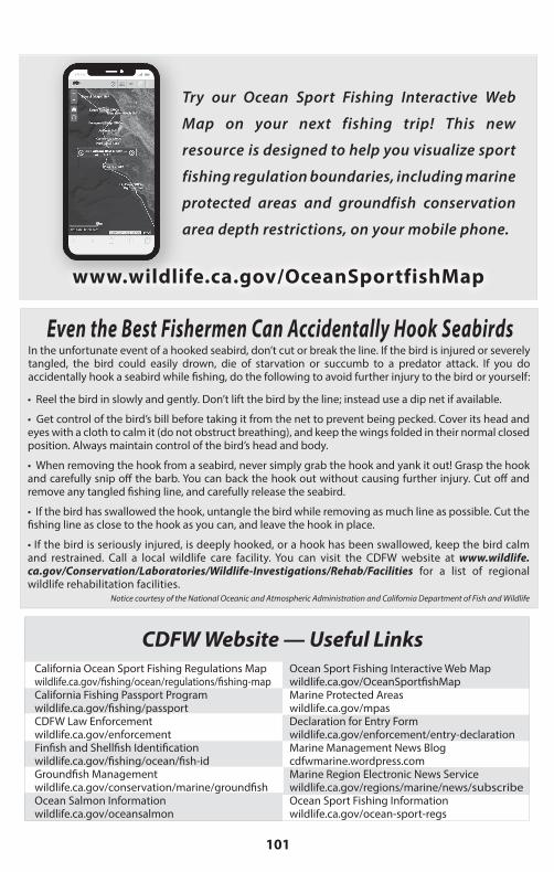
101
Try our Ocean Sport Fishing Interactive Web
Map on your next fishing trip! This new
resource is designed to help you visualize sport
fishing regulation boundaries, including marine
protected areas and groundfish conservation
area depth restrictions, on your mobile phone.
www.wildlife.ca.gov/OceanSportfishMap
Even the Best Fishermen Can Accidentally Hook SeabirdsIn the unfortunate event of a hooked seabird, don’t cut or break the line. If the bird is injured or severely tangled, the bird could easily drown, die of starvation or succumb to a predator attack. If you do accidentally hook a seabird while fishing, do the following to avoid further injury to the bird or yourself:
• Reel the bird in slowly and gently. Don’t lift the bird by the line; instead use a dip net if available.
• Get control of the bird’s bill before taking it from the net to prevent being pecked. Cover its head and eyes with a cloth to calm it (do not obstruct breathing), and keep the wings folded in their normal closed position. Always maintain control of the bird’s head and body.
• When removing the hook from a seabird, never simply grab the hook and yank it out! Grasp the hook and carefully snip off the barb. You can back the hook out without causing further injury. Cut off andremove any tangled fishing line, and carefully release the seabird.
• If the bird has swallowed the hook, untangle the bird while removing as much line as possible. Cut the fishing line as close to the hook as you can, and leave the hook in place.
• If the bird is seriously injured, is deeply hooked, or a hook has been swallowed, keep the bird calmand restrained. Call a local wildlife care facility. You can visit the CDFW website at www.wildlife.ca.gov/Conservation/Laboratories/Wildlife-Investigations/Rehab/Facilities for a list of regionalwildlife rehabilitation facilities.
Notice courtesy of the National Oceanic and Atmospheric Administration and California Department of Fish and Wildlife
CDFW Website — Useful LinksCalifornia Ocean Sport Fishing Regulations Mapwildlife.ca.gov/fishing/ocean/regulations/fishing-mapCalifornia Fishing Passport Programwildlife.ca.gov/fishing/passportCDFW Law Enforcementwildlife.ca.gov/enforcementFinfish and Shellfish Identification wildlife.ca.gov/fishing/ocean/fish-idGroundfish Managementwildlife.ca.gov/conservation/marine/groundfishOcean Salmon Information wildlife.ca.gov/oceansalmon
Ocean Sport Fishing Interactive Web Mapwildlife.ca.gov/OceanSportfishMapMarine Protected Areaswildlife.ca.gov/mpasDeclaration for Entry Form wildlife.ca.gov/enforcement/entry-declarationMarine Management News Blogcdfwmarine.wordpress.comMarine Region Electronic News Servicewildlife.ca.gov/regions/marine/news/subscribeOcean Sport Fishing Information wildlife.ca.gov/ocean-sport-regs
2021-2022 California Ocean Sport Fishing Regulations
102
SPORT FISHING SPECIAL ALERT FOR CALIFORNIA SALMON FISHERIES
T he California coast coho (silver) salmon has been designated as an endangered species under the federal Endangered
Species Act (ESA). It is unlawful to fish for, capture, keep, or possess under any circumstances any (marked or unmarked) coho salmon. Violation of the ESA may result in civil or criminal penalties. Large numbers of coho salmon have been contacted in California’s ocean waters. Although it is likely that many of these salmon originated from hatcheries in the Northwest, some of the fish are California coast coho salmon which are protected under the ESA. Thus, the retention of any coho salmon is PROHIBITED in all California
ocean fisheries. Please take the time to correctly identify each salmon caught before removing it from the water.
Coho (silver) salmon, above right, have white gums around the teeth, while the inside of a Chinook (king) salmon’s mouth is all dark. photo by CDFW Warden Bob Aldrich
To Avoid ConTACT WiTh Coho sAlmon:• Fish near shore for Chinook– coho are usually more offshore.
• Use larger lures that select for large Chinook and reduce the coho catch.
IT IS UNLAWFUL TO DO THE FOLLOWING:IT IS UNLAWFUL TO DO THE FOLLOWING:• Fish without a valid fishing license if you are 16 years of age or older. (FGC, Section 7145)• Fail to return a report card by the deadline printed on the report card. Reporting harvest
online at wildlife.ca.gov/licensing/online-sales satisfies the return requirement. (CCR T-14, Section 1.74)
• Use a sport fishing license that is not signed by the licensee. (CCR T-14, Section 705)• Transfer any license, tag, validation, stamp, permit, application or reservation to another per-
son. (FGC, Section 1052)• Use or possess any license, validation, tag, stamp, permit, application or reservation that was
not lawfully issued to the user. (FGC, Section 1052)• Alter, mutilate, deface, duplicate or counterfeit any license, tag, validation, stamp, permit, ap-
plication or reservation. (FGC, Section 1052)• Fail to exhibit on demand all licenses, validations, tags, stamps, permits, applications or reser-
vations to any peace officer or authorized CDFW employee. (FGC, Section 2012)• Fish without the required report card on a free fishing day. (CCR T-14, Section 1.74)• Disturb the legal traps of another person. (CCR T-14, Section 29.80)• Sell fish taken under the authority of a sport fishing license. (FGC, Section 7121)• Cause the deterioration or waste of any fish taken in the waters of this state. (CCR T-14, Sec-
tion 1.87)• Use explosives in state waters inhabited by fish. (FGC, Section 5500)• Not allow the inspection, by a warden, of any boat, market, or receptacle, where fish or wild-
life may be found. (FGC, Section 1006)• Litter into or within 150 feet of state waters. (FGC, Section 5652)• Possess fish in a condition that the size or species cannot be determined. (FGC, sections 5508
and 5509)• Use or possess any net in state waters except as is authorized. (FGC, Section 8603)• Possess fish or wildlife taken unlawfully. (FGC, Section 2002)• Take fish or wildlife in violation of any section of law. (FGC, Section 2000)
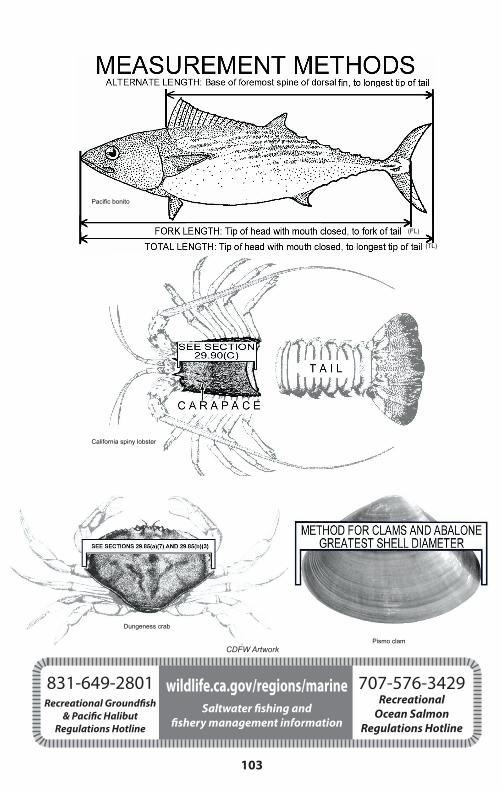
103
Pacific bonito
(FL)
(TL)
California spiny lobster
Dungeness crab
Pismo clam CDFG Artwork
831-649-2801Recreational Groundfish
& Pacific Halibut Regulations Hotline
wildlife.ca.gov/regions/marineSaltwater fishing and
fishery management information
CDFW Artwork
707-576-3429Recreational
Ocean Salmon Regulations Hotline
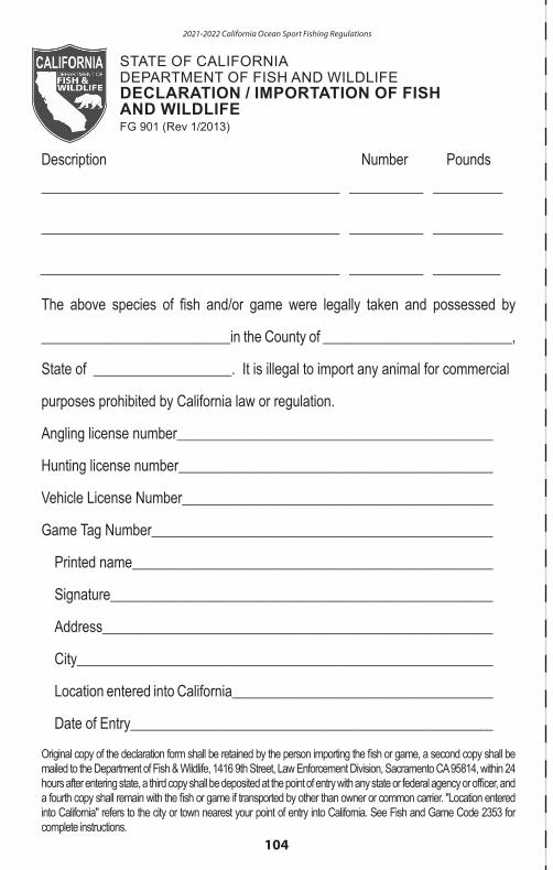
2021-2022 California Ocean Sport Fishing Regulations
104
STATE OF CALIFORNIADEPARTMENT OF FISH AND WILDLIFEDECLARATION / IMPORTATION OF FISH AND WILDLIFEFG 901 (Rev 1/2013)
Description Number Pounds
The above species of fish and/or game were legally taken and possessed by __________________________in the County of __________________________, State of ___________________. It is illegal to import any animal for commercial
purposes prohibited by California law or regulation.
Angling license number____________________________________________
Hunting license number____________________________________________
Vehicle License Number_____________________________________________ Game Tag Number_______________________________________________
Printed name____________________________________________________
Signature_______________________________________________________
Address________________________________________________________
City____________________________________________________________
Location entered into California_______________________________________
Date of Entry_____________________________________________________
Original copy of the declaration form shall be retained by the person importing the fish or game, a second copy shall be mailed to the Department of Fish & Wildlife, 1416 9th Street, Law Enforcement Division, Sacramento CA 95814, within 24 hours after entering state, a third copy shall be deposited at the point of entry with any state or federal agency or officer, and a fourth copy shall remain with the fish or game if transported by other than owner or common carrier. "Location entered into California" refers to the city or town nearest your point of entry into California. See Fish and Game Code 2353 for complete instructions.
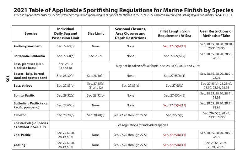
105
2021 Table of Applicable Sportfishing Regulations for Marine Finfish by SpeciesListed in alphabetical order by species; references regulations pertaining to all species mentioned in the 2021-2022 California Ocean Sport Fishing Regulations booklet and CCR T-14.
SpeciesIndividual
Daily Bag and Possession Limit
Size LimitSeasonal Closures, Area Closures and Depth Restrictions
Fillet Length, Skin Requirement At Sea
Gear Restrictions or Methods of Take
Anchovy, northern Sec. 27.60(b) None None Sec. 27.65(b)(13) Sec. 28.65, 28.80, 28.90, 28.91, 28.95
Barracuda, California Sec. 27.60(a) Sec. 28.25 None Sec. 27.65(b)(2) Sec. 28.65, 28.90, 28.91, 28.95
Bass, giant sea (a.k.a. black sea bass)
Sec. 28.10 (a and b) May not be taken off California; Sec. 28.10(a), 28.90 and 28.95
Basses - kelp, barred sand and spotted sand Sec. 28.30(b) Sec. 28.30(a) None Sec. 27.65(b)(1) Sec. 28.65, 28.90, 28.91,
28.95
Bass, striped Sec. 27.85(b) Sec. 27.85(c)(1) and (2) Sec. 27.85(a) Sec. 27.65(c) Sec. 27.85(d), 28.28(d),
28.90, 28.91, 28.95
Bonito, Pacific Sec. 28.32(a) Sec. 28.32(b) None Sec. 27.65(b)(5) Sec. 28.65, 28.90, 28.91, 28.95
Butterfish, Pacific (a.k.a. Pacific pompano) Sec. 27.60(b) None None Sec. 27.65(b)(13) Sec. 28.65, 28.90, 28.91,
28.95
Cabezon1 Sec. 28.28(b) Sec. 28.28(c) Sec. 27.20 through 27.51 Sec. 27.65(c) Sec. 28.65(c), 28.90, 28.91, 28.95
Coastal Pelagic Species as defined in Sec. 1.39 See regulations for individual species
Cod, Pacific1 Sec. 27.60(a),28.49(b)(3) None Sec. 27.20 through 27.51 Sec. 27.65(b)(13) Sec. 28.65, 28.90, 28.91,
28.95
Codling1 Sec. 27.60(a),28.49(b)(3) None Sec. 27.20 through 27.51 Sec. 27.65(b)(13) Sec. 28.65, 28.90,
28.91, 28.95.
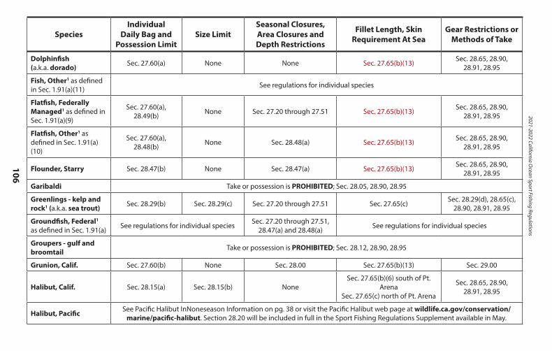
2021-2022 California Ocean Sport Fishing Regulations
106
SpeciesIndividual
Daily Bag and Possession Limit
Size LimitSeasonal Closures, Area Closures and Depth Restrictions
Fillet Length, Skin Requirement At Sea
Gear Restrictions or Methods of Take
Dolphinfish(a.k.a. dorado) Sec. 27.60(a) None None Sec. 27.65(b)(13) Sec. 28.65, 28.90,
28.91, 28.95
Fish, Other1 as defined in Sec. 1.91(a)(11) See regulations for individual species
Flatfish, Federally Managed1 as defined in Sec. 1.91(a)(9)
Sec. 27.60(a), 28.49(b) None Sec. 27.20 through 27.51 Sec. 27.65(b)(13) Sec. 28.65, 28.90,
28.91, 28.95
Flatfish, Other1 as defined in Sec. 1.91(a)(10)
Sec. 27.60(a), 28.48(b) None Sec. 28.48(a) Sec. 27.65(b)(13) Sec. 28.65, 28.90,
28.91, 28.95
Flounder, Starry Sec. 28.47(b) None Sec. 28.47(a) Sec. 27.65(b)(13) Sec. 28.65, 28.90,28.91, 28.95
Garibaldi Take or possession is PROHIBITED; Sec. 28.05, 28.90, 28.95
Greenlings - kelp and rock1 (a.k.a. sea trout) Sec. 28.29(b) Sec. 28.29(c) Sec. 27.20 through 27.51 Sec. 27.65(c) Sec. 28.29(d), 28.65(c),
28.90, 28.91, 28.95
Groundfish, Federal1
as defined in Sec. 1.91(a) See regulations for individual species Sec. 27.20 through 27.51, 28.47(a) and 28.48(a) See regulations for individual species
Groupers - gulf and broomtail Take or possession is PROHIBITED; Sec. 28.12, 28.90, 28.95
Grunion, Calif. Sec. 27.60(b) None Sec. 28.00 Sec. 27.65(b)(13) Sec. 29.00
Halibut, Calif. Sec. 28.15(a) Sec. 28.15(b) NoneSec. 27.65(b)(6) south of Pt.
ArenaSec. 27.65(c) north of Pt. Arena
Sec. 28.65, 28.90,28.91, 28.95
Halibut, Pacific See Pacific Halibut InNoneseason Information on pg. 38 or visit the Pacific Halibut web page at wildlife.ca.gov/conservation/marine/pacific-halibut. Section 28.20 will be included in full in the Sport Fishing Regulations Supplement available in May.
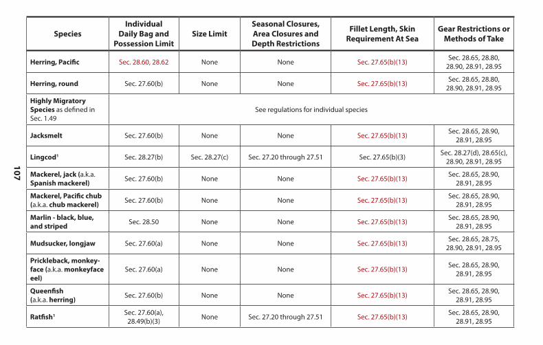
107
SpeciesIndividual
Daily Bag and Possession Limit
Size LimitSeasonal Closures, Area Closures and Depth Restrictions
Fillet Length, Skin Requirement At Sea
Gear Restrictions or Methods of Take
Herring, Pacific Sec. 28.60, 28.62 None None Sec. 27.65(b)(13) Sec. 28.65, 28.80,28.90, 28.91, 28.95
Herring, round Sec. 27.60(b) None None Sec. 27.65(b)(13) Sec. 28.65, 28.80,28.90, 28.91, 28.95
Highly Migratory Species as defined in Sec. 1.49
See regulations for individual species
Jacksmelt Sec. 27.60(b) None None Sec. 27.65(b)(13) Sec. 28.65, 28.90,28.91, 28.95
Lingcod1 Sec. 28.27(b) Sec. 28.27(c) Sec. 27.20 through 27.51 Sec. 27.65(b)(3) Sec. 28.27(d), 28.65(c), 28.90, 28.91, 28.95
Mackerel, jack (a.k.a.Spanish mackerel) Sec. 27.60(b) None None Sec. 27.65(b)(13) Sec. 28.65, 28.90,
28.91, 28.95
Mackerel, Pacific chub(a.k.a. chub mackerel) Sec. 27.60(b) None None Sec. 27.65(b)(13) Sec. 28.65, 28.90,
28.91, 28.95
Marlin - black, blue, and striped Sec. 28.50 None None Sec. 27.65(b)(13) Sec. 28.65, 28.90,
28.91, 28.95
Mudsucker, longjaw Sec. 27.60(a) None None Sec. 27.65(b)(13) Sec. 28.65, 28.75,28.90, 28.91, 28.95
Prickleback, monkey- face (a.k.a. monkeyface eel)
Sec. 27.60(a) None None Sec. 27.65(b)(13) Sec. 28.65, 28.90,28.91, 28.95
Queenfish(a.k.a. herring) Sec. 27.60(b) None None Sec. 27.65(b)(13) Sec. 28.65, 28.90,
28.91, 28.95
Ratfish1 Sec. 27.60(a),28.49(b)(3) None Sec. 27.20 through 27.51 Sec. 27.65(b)(13) Sec. 28.65, 28.90,
28.91, 28.95
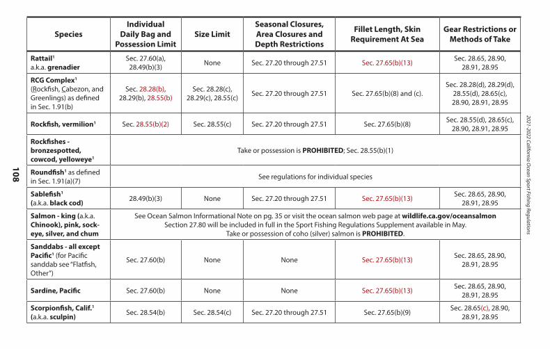
2021-2022 California Ocean Sport Fishing Regulations
108
SpeciesIndividual
Daily Bag and Possession Limit
Size LimitSeasonal Closures, Area Closures and Depth Restrictions
Fillet Length, Skin Requirement At Sea
Gear Restrictions or Methods of Take
Rattail1
a.k.a. grenadierSec. 27.60(a),
28.49(b)(3) None Sec. 27.20 through 27.51 Sec. 27.65(b)(13) Sec. 28.65, 28.90,28.91, 28.95
RCG Complex1 (Rockfish, Cabezon, and Greenlings) as defined in Sec. 1.91(b)
Sec. 28.28(b),28.29(b), 28.55(b)
Sec. 28.28(c),28.29(c), 28.55(c) Sec. 27.20 through 27.51 Sec. 27.65(b)(8) and (c).
Sec. 28.28(d), 28.29(d),28.55(d), 28.65(c),28.90, 28.91, 28.95
Rockfish, vermilion1 Sec. 28.55(b)(2) Sec. 28.55(c) Sec. 27.20 through 27.51 Sec. 27.65(b)(8) Sec. 28.55(d), 28.65(c), 28.90, 28.91, 28.95
Rockfishes - bronzespotted, cowcod, yelloweye1
Take or possession is PROHIBITED; Sec. 28.55(b)(1)
Roundfish1 as defined in Sec. 1.91(a)(7) See regulations for individual species
Sablefish1
(a.k.a. black cod) 28.49(b)(3) None Sec. 27.20 through 27.51 Sec. 27.65(b)(13) Sec. 28.65, 28.90,28.91, 28.95
Salmon - king (a.k.a. Chinook), pink, sock- eye, silver, and chum
See Ocean Salmon Informational Note on pg. 35 or visit the ocean salmon web page at wildlife.ca.gov/oceansalmonSection 27.80 will be included in full in the Sport Fishing Regulations Supplement available in May.
Take or possession of coho (silver) salmon is PROHIBITED.
Sanddabs - all except Pacific1 (for Pacific sanddab see “Flatfish, Other”)
Sec. 27.60(b) None None Sec. 27.65(b)(13) Sec. 28.65, 28.90,28.91, 28.95
Sardine, Pacific Sec. 27.60(b) None None Sec. 27.65(b)(13) Sec. 28.65, 28.90,28.91, 28.95
Scorpionfish, Calif.1
(a.k.a. sculpin) Sec. 28.54(b) Sec. 28.54(c) Sec. 27.20 through 27.51 Sec. 27.65(b)(9) Sec. 28.65(c), 28.90,28.91, 28.95
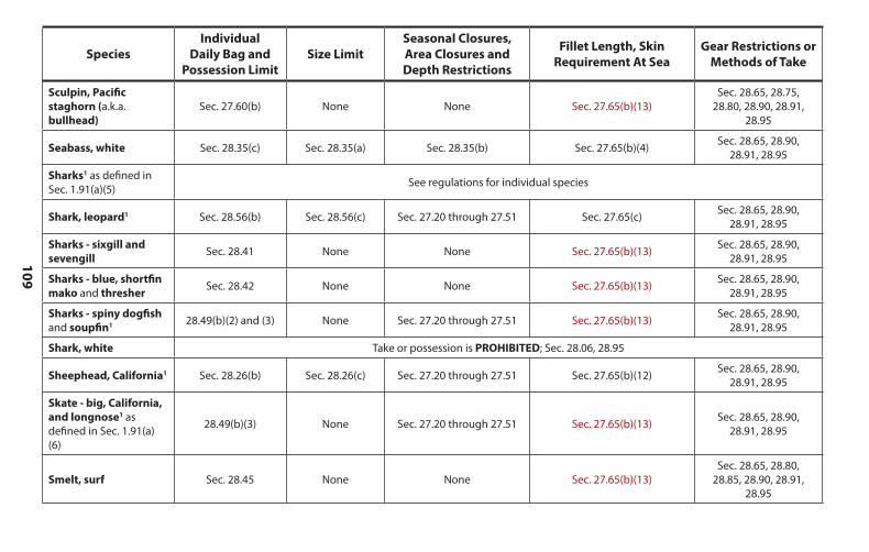
109
SpeciesIndividual
Daily Bag and Possession Limit
Size LimitSeasonal Closures, Area Closures and Depth Restrictions
Fillet Length, Skin Requirement At Sea
Gear Restrictions or Methods of Take
Sculpin, Pacific staghorn (a.k.a. bullhead)
Sec. 27.60(b) None None Sec. 27.65(b)(13)Sec. 28.65, 28.75,
28.80, 28.90, 28.91,28.95
Seabass, white Sec. 28.35(c) Sec. 28.35(a) Sec. 28.35(b) Sec. 27.65(b)(4) Sec. 28.65, 28.90,28.91, 28.95
Sharks1 as defined in Sec. 1.91(a)(5) See regulations for individual species
Shark, leopard1 Sec. 28.56(b) Sec. 28.56(c) Sec. 27.20 through 27.51 Sec. 27.65(c) Sec. 28.65, 28.90,28.91, 28.95
Sharks - sixgill and sevengill Sec. 28.41 None None Sec. 27.65(b)(13) Sec. 28.65, 28.90,
28.91, 28.95
Sharks - blue, shortfin mako and thresher Sec. 28.42 None None Sec. 27.65(b)(13) Sec. 28.65, 28.90,
28.91, 28.95
Sharks - spiny dogfishand soupfin1 28.49(b)(2) and (3) None Sec. 27.20 through 27.51 Sec. 27.65(b)(13) Sec. 28.65, 28.90,
28.91, 28.95
Shark, white Take or possession is PROHIBITED; Sec. 28.06, 28.95
Sheephead, California1 Sec. 28.26(b) Sec. 28.26(c) Sec. 27.20 through 27.51 Sec. 27.65(b)(12) Sec. 28.65, 28.90,28.91, 28.95
Skate - big, California, and longnose1 as defined in Sec. 1.91(a) (6)
28.49(b)(3) None Sec. 27.20 through 27.51 Sec. 27.65(b)(13) Sec. 28.65, 28.90,28.91, 28.95
Smelt, surf Sec. 28.45 None None Sec. 27.65(b)(13)Sec. 28.65, 28.80,
28.85, 28.90, 28.91,28.95
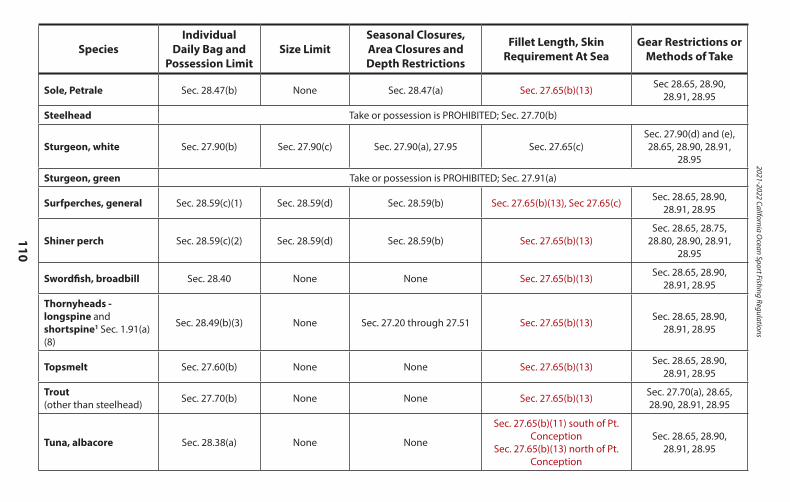
2021-2022 California Ocean Sport Fishing Regulations
110
SpeciesIndividual
Daily Bag and Possession Limit
Size LimitSeasonal Closures, Area Closures and Depth Restrictions
Fillet Length, Skin Requirement At Sea
Gear Restrictions or Methods of Take
Sole, Petrale Sec. 28.47(b) None Sec. 28.47(a) Sec. 27.65(b)(13) Sec 28.65, 28.90,28.91, 28.95
Steelhead Take or possession is PROHIBITED; Sec. 27.70(b)
Sturgeon, white Sec. 27.90(b) Sec. 27.90(c) Sec. 27.90(a), 27.95 Sec. 27.65(c)Sec. 27.90(d) and (e),28.65, 28.90, 28.91,
28.95
Sturgeon, green Take or possession is PROHIBITED; Sec. 27.91(a)
Surfperches, general Sec. 28.59(c)(1) Sec. 28.59(d) Sec. 28.59(b) Sec. 27.65(b)(13), Sec 27.65(c) Sec. 28.65, 28.90,28.91, 28.95
Shiner perch Sec. 28.59(c)(2) Sec. 28.59(d) Sec. 28.59(b) Sec. 27.65(b)(13)Sec. 28.65, 28.75,
28.80, 28.90, 28.91,28.95
Swordfish, broadbill Sec. 28.40 None None Sec. 27.65(b)(13) Sec. 28.65, 28.90,28.91, 28.95
Thornyheads - longspine and shortspine1 Sec. 1.91(a)(8)
Sec. 28.49(b)(3) None Sec. 27.20 through 27.51 Sec. 27.65(b)(13) Sec. 28.65, 28.90,28.91, 28.95
Topsmelt Sec. 27.60(b) None None Sec. 27.65(b)(13) Sec. 28.65, 28.90,28.91, 28.95
Trout(other than steelhead) Sec. 27.70(b) None None Sec. 27.65(b)(13) Sec. 27.70(a), 28.65,
28.90, 28.91, 28.95
Tuna, albacore Sec. 28.38(a) None None
Sec. 27.65(b)(11) south of Pt. Conception
Sec. 27.65(b)(13) north of Pt. Conception
Sec. 28.65, 28.90,28.91, 28.95
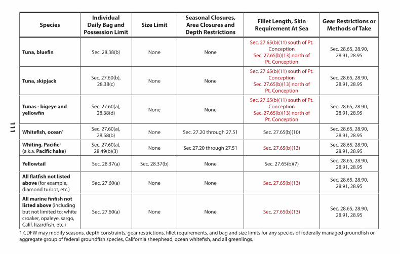
111
SpeciesIndividual
Daily Bag and Possession Limit
Size LimitSeasonal Closures, Area Closures and Depth Restrictions
Fillet Length, Skin Requirement At Sea
Gear Restrictions or Methods of Take
Tuna, bluefin Sec. 28.38(b) None None
Sec. 27.65(b)(11) south of Pt. Conception
Sec. 27.65(b)(13) north ofPt. Conception
Sec. 28.65, 28.90,28.91, 28.95
Tuna, skipjack Sec. 27.60(b), 28.38(c) None None
Sec. 27.65(b)(11) south of Pt. Conception
Sec. 27.65(b)(13) north ofPt. Conception
Sec. 28.65, 28.90,28.91, 28.95
Tunas - bigeye andyellowfin
Sec. 27.60(a), 28.38(d) None None
Sec. 27.65(b)(11) south of Pt. Conception
Sec. 27.65(b)(13) north ofPt. Conception
Sec. 28.65, 28.90,28.91, 28.95
Whitefish, ocean1 Sec. 27.60(a), 28.58(b) None Sec. 27.20 through 27.51 Sec. 27.65(b)(10) Sec. 28.65, 28.90,
28.91, 28.95
Whiting, Pacific1
(a.k.a. Pacific hake)Sec. 27.60(a),
28.49(b)(3) None Sec 27.20 through 27.51 Sec. 27.65(b)(13) Sec. 28.65, 28.90,28.91, 28.95
Yellowtail Sec. 28.37(a) Sec. 28.37(b) None Sec. 27.65(b)(7) Sec. 28.65, 28.90,28.91, 28.95
All flatfish not listed above (for example, diamond turbot, etc.)
Sec. 27.60(a) None None Sec. 27.65(b)(13) Sec. 28.65, 28.90,28.91, 28.95
All marine finfish not listed above (including but not limited to: white croaker, opaleye, sargo, Calif. lizardfish, etc.)
Sec. 27.60(a) None None Sec. 27.65(b)(13) Sec. 28.65, 28.90,28.91, 28.95
1 CDFW may modify seasons, depth constraints, gear restrictions, fillet requirements, and bag and size limits for any species of federally managed groundfish or aggregate group of federal groundfish species, California sheephead, ocean whitefish, and all greenlings.
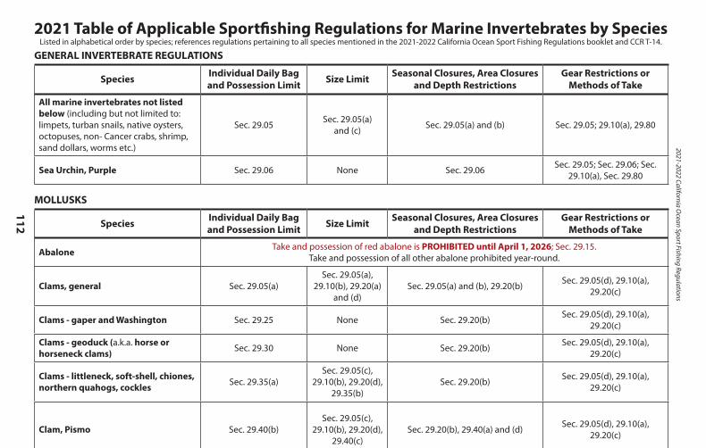
2021-2022 California Ocean Sport Fishing Regulations
112
2021 Table of Applicable Sportfishing Regulations for Marine Invertebrates by SpeciesListed in alphabetical order by species; references regulations pertaining to all species mentioned in the 2021-2022 California Ocean Sport Fishing Regulations booklet and CCR T-14.
GENERAL INVERTEBRATE REGULATIONS
Species Individual Daily Bag and Possession Limit Size Limit Seasonal Closures, Area Closures
and Depth RestrictionsGear Restrictions or
Methods of Take
All marine invertebrates not listed below (including but not limited to: limpets, turban snails, native oysters, octopuses, non- Cancer crabs, shrimp, sand dollars, worms etc.)
Sec. 29.05 Sec. 29.05(a) and (c) Sec. 29.05(a) and (b) Sec. 29.05; 29.10(a), 29.80
Sea Urchin, Purple Sec. 29.06 None Sec. 29.06 Sec. 29.05; Sec. 29.06; Sec. 29.10(a), Sec. 29.80
MOLLUSKS
Species Individual Daily Bag and Possession Limit Size Limit Seasonal Closures, Area Closures
and Depth RestrictionsGear Restrictions or
Methods of Take
Abalone Take and possession of red abalone is PROHIBITED until April 1, 2026; Sec. 29.15.Take and possession of all other abalone prohibited year-round.
Clams, general Sec. 29.05(a)Sec. 29.05(a),
29.10(b), 29.20(a) and (d)
Sec. 29.05(a) and (b), 29.20(b) Sec. 29.05(d), 29.10(a), 29.20(c)
Clams - gaper and Washington Sec. 29.25 None Sec. 29.20(b) Sec. 29.05(d), 29.10(a), 29.20(c)
Clams - geoduck (a.k.a. horse or horseneck clams) Sec. 29.30 None Sec. 29.20(b) Sec. 29.05(d), 29.10(a),
29.20(c)
Clams - littleneck, soft-shell, chiones, northern quahogs, cockles Sec. 29.35(a)
Sec. 29.05(c), 29.10(b), 29.20(d),
29.35(b)Sec. 29.20(b) Sec. 29.05(d), 29.10(a),
29.20(c)
Clam, Pismo Sec. 29.40(b)Sec. 29.05(c),
29.10(b), 29.20(d), 29.40(c)
Sec. 29.20(b), 29.40(a) and (d) Sec. 29.05(d), 29.10(a), 29.20(c)
Clam, razor Sec. 29.45(b) None Sec. 29.20(b), 29.45(a) Sec. 29.05(d), 29.10(a), 29.20(c)
Mussels Sec. 29.55 NoneAnnual quarantine issued by CDPH.
CDPH Biotoxin Information Line: 1-800-553-4133
Sec. 29.05(d), 29.10(a)
Scallop, rock Sec. 29.60(a) None None Sec. 29.05(d), 29.60(b)
Scallop, speckled (bay) Take and possession is PROHIBITED; Sec. 29.65
Squid - market and jumbo Sec. 29.70 None None Sec. 29.05(d), 29.10(a), and 29.70
Snail, moon Sec. 29.71(a) None Sec. 29.71(b) Sec. 29.05(d), 29.10(a)
CRUSTACEANS
Species Individual Daily Bag and Possession Limit Size Limit Seasonal Closures, Area Closures
and Depth RestrictionsGear Restrictions or
Methods of Take
Barnacles Take or possession in the intertidal zone is PROHIBITED. See note at end of table and Sec. 29.05(b)(1)
Crab, DungenessMetacarcinus magisterLook for regulation changes later in 2021.
Sec. 29.85(a)(3) 29.85(a)(7) and (c) Sec. 29.85(a)(1) and (2)(A) and (B)Sec. 29.05(c) and (d); 29.85(a)
(4), (5), and (6),29.80(a) through (e) and (g)
Crabs other than Dungeness crab (rock crab, etc.) Sec. 29.85(b)(2) Sec. 29.85(b)(3),
and(c) Sec. 29.85(b)(1) Sec. 29.05(c) and (d); Sec. 29.80(a) through (e) and (g)
Crab, sand a.k.a. mole crab Sec. 29.85(d) None Sec. 29.05(a) Sec. 29.80(h)
Lobster, spiny Sec. 29.90(b) 29.90(c) and (e) Sec. 29.90(a) Sec. 29.05(c) and (d); Sec. 29.80(a), (b) and (g), 29.90(d)
Shrimp, bay a.k.a. grass shrimp Sec. 29.86 None Sec. 29.05(a) and (b) Sec. 29.80(a), (f ) through (j)
Shrimp - ghost and blue mud Sec. 29.87 None Sec. 29.05(a) and (b) Sec. 29.80(a), (f ) through (j)
Shrimp, coonstripe Sec. 29.88(b) None Sec. 29.05(a) Sec. 29.80(a), (f ) through (j)
Note: Except for the species listed above, “tidal invertebrates may not be taken in any tidepool or other areas between the high tide mark (defined as Mean Higher High Tide) and 1,000 ft. seawards and lateral to the low tide mark (defined as Mean Lower Low Water).” per Section 29.05(b).
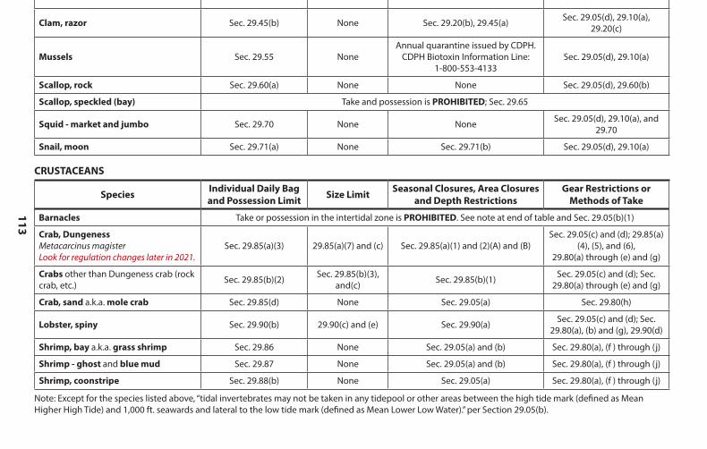
113
GENERAL INVERTEBRATE REGULATIONS
Species Individual Daily Bag and Possession Limit Size Limit Seasonal Closures, Area Closures
and Depth RestrictionsGear Restrictions or
Methods of Take
All marine invertebrates not listed below (including but not limited to: limpets, turban snails, native oysters, octopuses, non- Cancer crabs, shrimp, sand dollars, worms etc.)
Sec. 29.05 Sec. 29.05(a) and (c) Sec. 29.05(a) and (b) Sec. 29.05; 29.10(a), 29.80
Sea Urchin, Purple Sec. 29.06 None Sec. 29.06 Sec. 29.05; Sec. 29.06; Sec. 29.10(a), Sec. 29.80
MOLLUSKS
Species Individual Daily Bag and Possession Limit Size Limit Seasonal Closures, Area Closures
and Depth RestrictionsGear Restrictions or
Methods of Take
Abalone Take and possession of red abalone is PROHIBITED until April 1, 2026; Sec. 29.15.Take and possession of all other abalone prohibited year-round.
Clams, general Sec. 29.05(a)Sec. 29.05(a),
29.10(b), 29.20(a) and (d)
Sec. 29.05(a) and (b), 29.20(b) Sec. 29.05(d), 29.10(a), 29.20(c)
Clams - gaper and Washington Sec. 29.25 None Sec. 29.20(b) Sec. 29.05(d), 29.10(a), 29.20(c)
Clams - geoduck (a.k.a. horse or horseneck clams) Sec. 29.30 None Sec. 29.20(b) Sec. 29.05(d), 29.10(a),
29.20(c)
Clams - littleneck, soft-shell, chiones, northern quahogs, cockles Sec. 29.35(a)
Sec. 29.05(c), 29.10(b), 29.20(d),
29.35(b)Sec. 29.20(b) Sec. 29.05(d), 29.10(a),
29.20(c)
Clam, Pismo Sec. 29.40(b)Sec. 29.05(c),
29.10(b), 29.20(d), 29.40(c)
Sec. 29.20(b), 29.40(a) and (d) Sec. 29.05(d), 29.10(a), 29.20(c)
Clam, razor Sec. 29.45(b) None Sec. 29.20(b), 29.45(a) Sec. 29.05(d), 29.10(a), 29.20(c)
Mussels Sec. 29.55 NoneAnnual quarantine issued by CDPH.
CDPH Biotoxin Information Line: 1-800-553-4133
Sec. 29.05(d), 29.10(a)
Scallop, rock Sec. 29.60(a) None None Sec. 29.05(d), 29.60(b)
Scallop, speckled (bay) Take and possession is PROHIBITED; Sec. 29.65
Squid - market and jumbo Sec. 29.70 None None Sec. 29.05(d), 29.10(a), and 29.70
Snail, moon Sec. 29.71(a) None Sec. 29.71(b) Sec. 29.05(d), 29.10(a)
CRUSTACEANS
Species Individual Daily Bag and Possession Limit Size Limit Seasonal Closures, Area Closures
and Depth RestrictionsGear Restrictions or
Methods of Take
Barnacles Take or possession in the intertidal zone is PROHIBITED. See note at end of table and Sec. 29.05(b)(1)
Crab, DungenessMetacarcinus magisterLook for regulation changes later in 2021.
Sec. 29.85(a)(3) 29.85(a)(7) and (c) Sec. 29.85(a)(1) and (2)(A) and (B)Sec. 29.05(c) and (d); 29.85(a)
(4), (5), and (6),29.80(a) through (e) and (g)
Crabs other than Dungeness crab (rock crab, etc.) Sec. 29.85(b)(2) Sec. 29.85(b)(3),
and(c) Sec. 29.85(b)(1) Sec. 29.05(c) and (d); Sec. 29.80(a) through (e) and (g)
Crab, sand a.k.a. mole crab Sec. 29.85(d) None Sec. 29.05(a) Sec. 29.80(h)
Lobster, spiny Sec. 29.90(b) 29.90(c) and (e) Sec. 29.90(a) Sec. 29.05(c) and (d); Sec. 29.80(a), (b) and (g), 29.90(d)
Shrimp, bay a.k.a. grass shrimp Sec. 29.86 None Sec. 29.05(a) and (b) Sec. 29.80(a), (f ) through (j)
Shrimp - ghost and blue mud Sec. 29.87 None Sec. 29.05(a) and (b) Sec. 29.80(a), (f ) through (j)
Shrimp, coonstripe Sec. 29.88(b) None Sec. 29.05(a) Sec. 29.80(a), (f ) through (j)
Note: Except for the species listed above, “tidal invertebrates may not be taken in any tidepool or other areas between the high tide mark (defined as Mean Higher High Tide) and 1,000 ft. seawards and lateral to the low tide mark (defined as Mean Lower Low Water).” per Section 29.05(b).
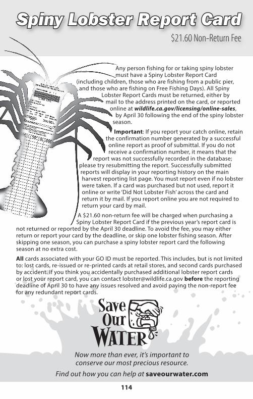
2021-2022 California Ocean Sport Fishing Regulations
114
Spiny Lobster Report CardSpiny Lobster Report Card$21.60 Non-Return Fee
Any person fishing for or taking spiny lobster must have a Spiny Lobster Report Card
(including children, those who are fishing from a public pier, and those who are fishing on Free Fishing Days). All Spiny
Lobster Report Cards must be returned, either by mail to the address printed on the card, or reported
online at wildlife.ca.gov/licensing/online-sales, by April 30 following the end of the spiny lobster season.
Important: If you report your catch online, retain the confirmation number generated by a successful
online report as proof of submittal. If you do not receive a confirmation number, it means that the
report was not successfully recorded in the database; please try resubmitting the report. Successfully submitted reports will display in your reporting history on the main harvest reporting list page. You must report even if no lobster were taken. If a card was purchased but not used, report it online or write ‘Did Not Lobster Fish’ across the card and return it by mail. If you report online you are not required to return your card by mail.
A $21.60 non-return fee will be charged when purchasing a Spiny Lobster Report Card if the previous year’s report card is
not returned or reported by the April 30 deadline. To avoid the fee, you may either return or report your card by the deadline, or skip one lobster fishing season. After skipping one season, you can purchase a spiny lobster report card the following season at no extra cost.
All cards associated with your GO ID must be reported. This includes, but is not limited to: lost cards, re-issued or re-printed cards at retail stores, and second cards purchased by accident. If you think you accidentally purchased additional lobster report cards or lost your report card, you can contact [email protected] before the reporting deadline of April 30 to have any issues resolved and avoid paying the non-report fee for any redundant report cards.
Now more than ever, it’s important to conserve our most precious resource.
Find out how you can help at saveourwater.com
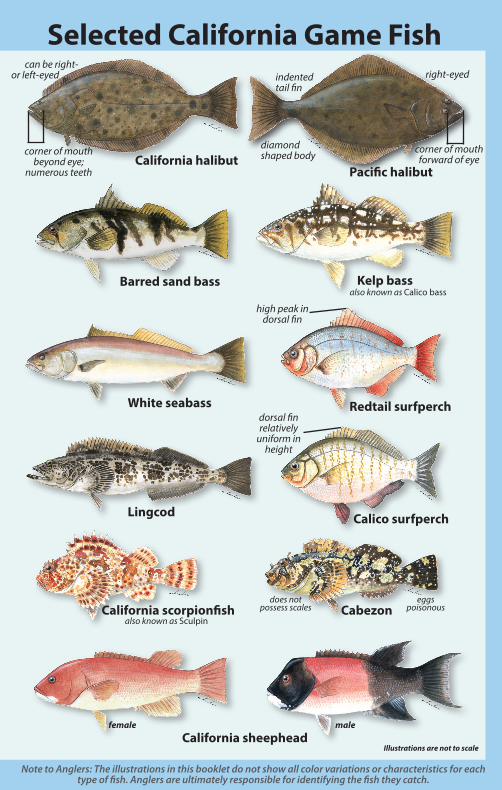
Illustrations are not to scale
Selected California Game Fish
California halibutPacific halibut
high peak in dorsal fin
dorsal fin relatively
uniform in height
does not possess scales
male female
corner of mouth forward of eye
corner of mouth beyond eye;
numerous teeth
diamond shaped body
indented tail fin
right-eyed can be right- or left-eyed
Barred sand bass Kelp bass also known as Calico bass
eggs poisonous
White seabass Redtail surfperch
Lingcod Calico surfperch
California scorpionfish also known as Sculpin
Cabezon
California sheephead
Note to Anglers: The illustrations in this booklet do not show all color variations or characteristics for each type of fish. Anglers are ultimately responsible for identifying the fish they catch.
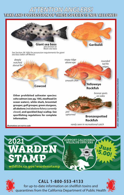
2021
-202
2 C
DFW
Oce
an S
port
Fis
hing
Reg
ulat
ions
Boo
klet
also known as Black sea bass
raspy ridge above eye
smooth chin
rounded tail fin edges
bronze spots on sides
jawupturned
CDFW file photo
deeply notched
dorsal fin
ATTENTION ANGLERS!ATTENTION ANGLERS!TAKE AND POSSESSION OF THESE SPECIES TAKE AND POSSESSION OF THESE SPECIES IS NOT ALLOWEDIS NOT ALLOWED
Giant sea bass
See Section 28.10(b) for possession requirements for giant sea bass taken off Mexico
Garibaldi
Cowcod YelloweyeRockfish
BronzespottedRockfish
rarely seen in recreational catch
Other prohibited saltwater species: coho salmon (see pg. 100), steelhead (in ocean waters), white shark, broomtail grouper, gulf grouper, green sturgeon, all abalone [red abalone fishery currently closed], and speckled (bay) scallop. See sportfishing regulations for complete information.
Illustrations are not to scale
WARDEN STAMP
20212021WARDEN STAMPwildlife.ca.gov/wardenstamp
Just$5.00!
C ALL 1-800-553-4133 for up-to-date information on shellfish toxins and
quarantines from the California Department of Public Health