Embed Size (px)
DESCRIPTION
Mapping the Spread of Islam In Indonesia: Problems with Points and Polygons. Caverlee Cary GIS Center, UC Berkeley “E-culture and Intellectual Property in the Global Community” Pacific Neighborhood Consortium Annual Conference University of Hawaii, Manoa November 2, 2005. - PowerPoint PPT Presentation
Citation preview

Mapping the Spread of Mapping the Spread of Islam In Indonesia:Islam In Indonesia:
Problems with Points and PolygonsProblems with Points and Polygons
Caverlee CaryGIS Center, UC BerkeleyBerkeley
“E-culture and Intellectual Property in the Global Community”Pacific Neighborhood Consortium Annual Conference
University of Hawaii, ManoaNovember 2, 2005

Constructing and Constructing and De-constructing VisualizationsDe-constructing Visualizations
Issues in contemporary and historic contexts of Issues in contemporary and historic contexts of relation between data, its representation, and the relation between data, its representation, and the reality of peoples’ livesreality of peoples’ lives
Use available or contributed data to make mapsUse available or contributed data to make mapsQuestionable completeness: no data contributed, or Questionable completeness: no data contributed, or
no data survivesno data survivesValidity: Can we judge the documentation of history? Validity: Can we judge the documentation of history? Can we avoid bringing our own biases to bear in Can we avoid bringing our own biases to bear in
interpreting what we work with, intentionally or interpreting what we work with, intentionally or unintentionally filling in gaps?unintentionally filling in gaps?


Robert Cribb’s Robert Cribb’s Historical Atlas of Historical Atlas of
Indonesia Indonesia (University of Hawaii, (University of Hawaii,
2000)2000)
Spatial data assistance by Spatial data assistance by Lawrence CrissmanLawrence Crissman

Original GoalsOriginal Goals
Provide support for development of data for Provide support for development of data for ECAI Southeast AsiaECAI Southeast Asia
Opportunity to begin mapping Indonesia dataOpportunity to begin mapping Indonesia data
Suggest the shift from Buddhism to Islam in Suggest the shift from Buddhism to Islam in Indonesia (primarily Java and Sumatra)Indonesia (primarily Java and Sumatra)
An opportunity to further the mapping of An opportunity to further the mapping of trade routes, as trade routes are regarded trade routes, as trade routes are regarded as critical to the spread of Islamas critical to the spread of Islam

Space, Time, Attribute dataSpace, Time, Attribute data

Collaborators:Collaborators:
Spatial data (real-time satellite data retrieval): Spatial data (real-time satellite data retrieval): Howard Foster, CalmapHoward Foster, Calmap
Temporal data (animation of Cribb’s polygons Temporal data (animation of Cribb’s polygons over time): Andrew Wilson and Tessa Boer-over time): Andrew Wilson and Tessa Boer-Mah, University of SydneyMah, University of Sydney
Attribute data: culled from secondary sources Attribute data: culled from secondary sources on Indonesia, displayed in TimeMapon Indonesia, displayed in TimeMap

Points, Polygons, and Points, Polygons, and UncertaintyUncertainty
Secondary sources use spatial shorthand, including citing a city for an area that may be larger than a city alone, or only a few individuals within that city
Secondary sources may cite a contemporary geographic name that may or may not represent the same spatial unit in different understandings (i. e. “trade with China”)

Evidence and UncertaintyEvidence and Uncertainty
Early period: extreme uncertaintyArtifacts: graves in central Java with Islamic inscriptions
Chronicles: Ma-Huan, traveling with Zheng He to passisir coast, north Java
Later: clearer indications, such as rulers inviting Islamic scholars from middle East to teach, and presence of Islamic manuscripts

Points, Polygons, and Points, Polygons, and UncertaintyUncertainty
At best:At best:
Some regions have a wealth of documents, which even Some regions have a wealth of documents, which even then may still have gaps or other irregularitiesthen may still have gaps or other irregularities
Example: Ming shih-lu (China)Example: Ming shih-lu (China)
These chronicles have information relevant to trade with These chronicles have information relevant to trade with Indonesia, but are compiled outside IndonesiaIndonesia, but are compiled outside Indonesia

On-line Ming Shih-luOn-line Ming Shih-lu

Points, Polygons, and Points, Polygons, and UncertaintyUncertainty
At worst:
Important cultural and political entities that leave little record
Example: Srivijaya, a major trading entrepot, site of large monasteries, exporter of culture that left its mark in inscription and art objects across western Indonesia, Malaysia, and peninsular Thailand
Capital possibly near Palembang in Sumatra
Likely to have been built of largely perishable materials, perhaps much of it over water, so little survives


Temporal data: AnimationTemporal data: Animation

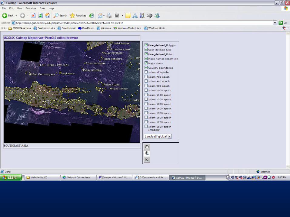
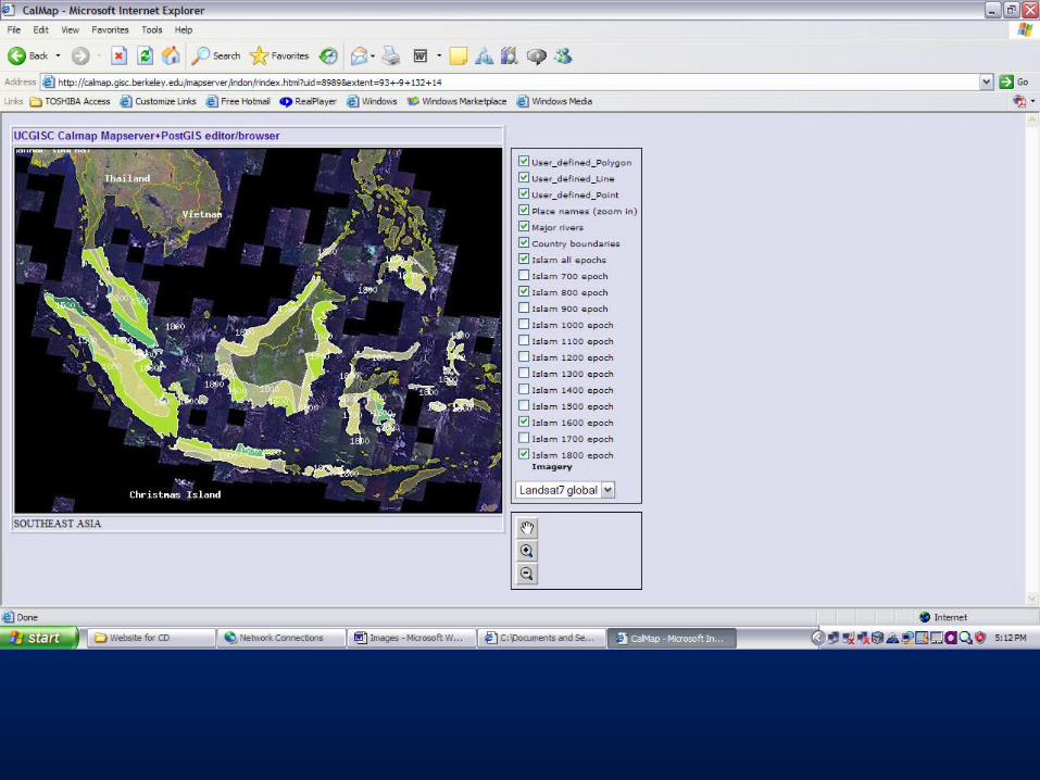
Spatial data using “CalMap”Spatial data using “CalMap”

CalMap input interfaceCalMap input interface


Website includes an interface for internet access in real Website includes an interface for internet access in real time global spatial datatime global spatial data
The spatial data is at present an IMAGE ONLY. Work is The spatial data is at present an IMAGE ONLY. Work is underway to geo-reference individual polygons in order underway to geo-reference individual polygons in order to conduct spatial analysis.to conduct spatial analysis.


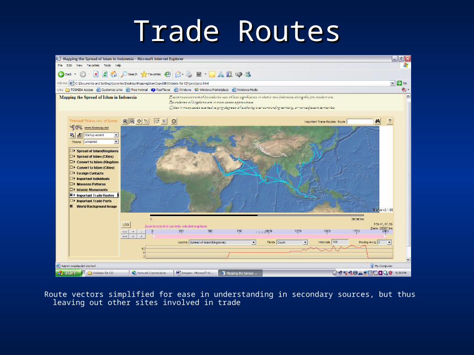
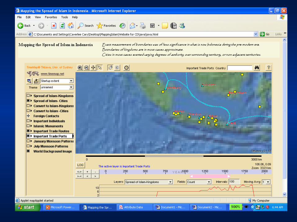
Trade RoutesTrade Routes
Route vectors simplified for ease in understanding in secondary sources, but thus leaving out other sites involved in trade
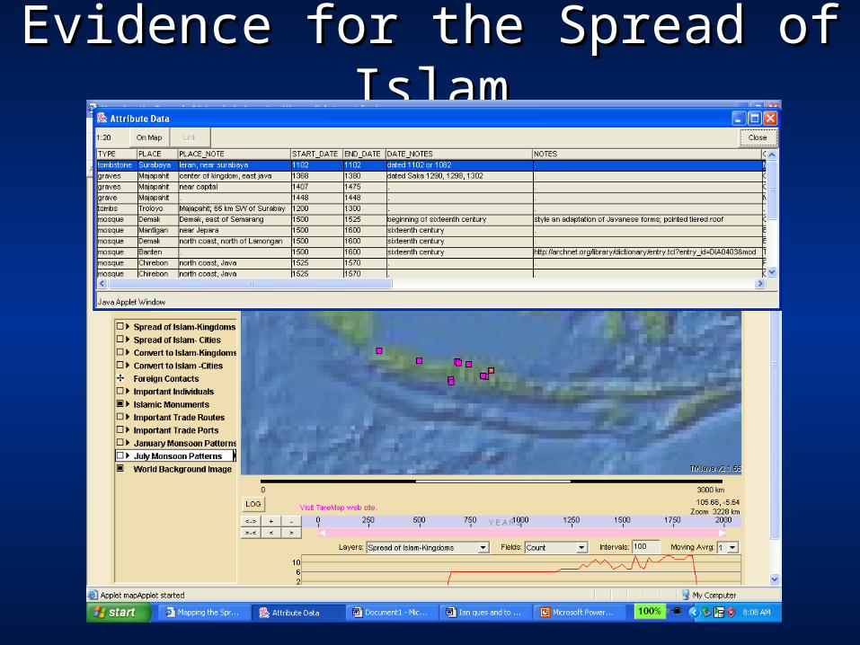
Evidence for the Spread of IslamEvidence for the Spread of Islam

Spread of Islam: Cities

Conversion to Islam

““Conversions” polygonsConversions” polygonsWhat does “conversion” to Islam mean? What does “conversion” to Islam mean? Historians within the Muslim tradition: is their vision Historians within the Muslim tradition: is their vision
different?different?Trading partners: assumed to be combination of Trading partners: assumed to be combination of
convenience and conviction in varying proportions?convenience and conviction in varying proportions?Aggrandize position by adoption of the accoutrements of Aggrandize position by adoption of the accoutrements of
“sultan”“sultan”What relation is there between conversion at the “top” What relation is there between conversion at the “top”
and change in way of life for the rest of the population?and change in way of life for the rest of the population?Records of “conversion” moments may or may not Records of “conversion” moments may or may not
survivesurviveOverallOverall: suggest a general pattern of conversion, but : suggest a general pattern of conversion, but
multiple levels of uncertainty in meaningmultiple levels of uncertainty in meaning

Wali SongoWali Songo
Local and national mythology: critical figures in the spread of IslamLocal and national mythology: critical figures in the spread of Islam

The Wali Songo and the The Wali Songo and the Spread of IslamSpread of Islam
The wali songo The wali songo legacy is part of legacy is part of national mythologynational mythology
Their graves are sites Their graves are sites of pilgrimage and of pilgrimage and spiritual spiritual mobilizationmobilization

Wali Songo: Peoples’ LivesWali Songo: Peoples’ Lives
Their lives have multiple possible spatial Their lives have multiple possible spatial identification: identification:
where were they born?where were they born?
where did they study? Where did their where did they study? Where did their teachers come from?teachers come from?
where did they practice? (multiple sites, and where did they practice? (multiple sites, and multiple sites in different ways?)multiple sites in different ways?)
where are their graves?where are their graves?

Wali SongoWali Songo
Multiple kinds of spatial information about a life: Sunan Ampel


Creating Imagined [Digital] Creating Imagined [Digital] Communities: Communities:
Historical data: sensitivities of data access and Historical data: sensitivities of data access and distribution different from that of data relating distribution different from that of data relating to living persons, but still potentially sensitive to living persons, but still potentially sensitive issuesissues
Intellectual property rights of communities to Intellectual property rights of communities to knowledge: writing the story of Islam in knowledge: writing the story of Islam in IndonesiaIndonesia

Creating Imagined [Digital] Creating Imagined [Digital] Communities: Communities:
Who has the capacity to speak? Who has the capacity to speak?Participation in communicationsParticipation in communications
Technical accessTechnical access
Who has the right to speak?Who has the right to speak?LegitimacyLegitimacy
Different spheres of establishing credentialsDifferent spheres of establishing credentialsDoes the dynamic change once there are multiple Does the dynamic change once there are multiple
empowered voices?empowered voices?

Project Collaborators, UC GIS Center:
Xing LiuHoward FosterArnold Clobes
Freesia PearsonJohn Radke
Caverlee Cary