Embed Size (px)
Citation preview
MAR 19980003: OBED Received date: Mar 13, 1998 Public release date: Mar 14, 1999 DISCLAIMER By accessing and using the Alberta Energy website to download or otherwise obtain a scanned mineral assessment report, you (“User”) agree to be bound by the following terms and conditions: a) Each scanned mineral assessment report that is downloaded or otherwise obtained from Alberta
Energy is provided “AS IS”, with no warranties or representations of any kind whatsoever from Her Majesty the Queen in Right of Alberta, as represented by the Minister of Energy (“Minister”), expressed or implied, including, but not limited to, no warranties or other representations from the Minister, regarding the content, accuracy, reliability, use or results from the use of or the integrity, completeness, quality or legibility of each such scanned mineral assessment report;
b) To the fullest extent permitted by applicable laws, the Minister hereby expressly disclaims, and is released from, liability and responsibility for all warranties and conditions, expressed or implied, in relation to each scanned mineral assessment report shown or displayed on the Alberta Energy website including but not limited to warranties as to the satisfactory quality of or the fitness of the scanned mineral assessment report for a particular purpose and warranties as to the non-infringement or other non-violation of the proprietary rights held by any third party in respect of the scanned mineral assessment report;
c) To the fullest extent permitted by applicable law, the Minister, and the Minister’s employees and agents, exclude and disclaim liability to the User for losses and damages of whatsoever nature and howsoever arising including, without limitation, any direct, indirect, special, consequential, punitive or incidental damages, loss of use, loss of data, loss caused by a virus, loss of income or profit, claims of third parties, even if Alberta Energy have been advised of the possibility of such damages or losses, arising out of or in connection with the use of the Alberta Energy website, including the accessing or downloading of the scanned mineral assessment report and the use for any purpose of the scanned mineral assessment report so downloaded or retrieved.
d) User agrees to indemnify and hold harmless the Minister, and the Minister’s employees and agents against and from any and all third party claims, losses, liabilities, demands, actions or proceedings related to the downloading, distribution, transmissions, storage, redistribution, reproduction or exploitation of each scanned mineral assessment report obtained by the User from Alberta Energy.
Alberta Mineral Assessment Reporting System

February, 1998
/'196? 0003
fY/JnJ 9903
NTS 83F/6, 83F/11
EXPLORATION - 1997
OBED PROPERTY, ALBERTA (CLAIM NUMBERS
9395120001 and 9395120002) (APEX Project 97210)
prepared for
Sharata Resources Ltd.
APEX Geoscience Ltd.
L. Chin RA.Olson

EXPLORATION - 1997
OBED PROPERTY, ALBERTA {CLAIM NUMBERS
9395120001 and 9395120002)
TABLE OF CONTENTS
PAGE
SUMMARY .......................................................... 1
INTRODUCTION ..................................................... 3
Location, Physiography and Climate . . . . . . . . . . . . . . . . . . . . . . . . . . . . . . . . . 3
Access and Infrastructure ......................................... 3
Previous Exploration and Geoscientific Studies . . . . . . . . . . . . . . . . . . . . . . . . 5
Mineral Claim Status . . . . . . . . . . . . . . . . . . . . . . . . . . . . . . . . . . . . . . . . . . . . . 6
1997 Exploration . . . . . . . . . . . . . . . . . . . . . . . . . . . . . . . . . . . . . . . . . . . . . . . . 7
REGIONAL GEOLOGY ................................................ 7
Precambrian Basement . . . . . . . . . . . . . . . . . . . . . . . . . . . . . . . . . . . . . . . . . . . 8
Paleozoic to Cenozoic Strata . . . . . . . . . . . . . . . . . . . . . . . . . . . . . . . . . . . . . . 1 O
GEOLOGY OF THE OBED PROPERTY . . . . . . . . . . . . . . . . . . . . . . . . . . . . . . . . . . 11
Surficial Geology . . . . . . . . . . . . . . . . . . . . . . . . . . . . . . . . . . . . . . . . . . . . . . . 11
Bedrock Geology ............................................... 12
EXPLORATION RESULTS ............................................. 13
Stream Silt Samples . . . . . . . . . . . . . . . . . . . . . . . . . . . . . . . . . . . . . . . . . . . . 13
Rock Grab Samples . . . . . . . . . . . . . . . . . . . . . . . . . . . . . . . . . . . . . . . . . . . . . 14
Superpanned Gold Count in Stream Sediment and Till Samples . . . . . . . . . . 15
Heavy Mineral Stream Sediment Samples . . . . . . . . . . . . . . . . . . . . . . 15
Till Samples . . . . . . . . . . . . . . . . . . . . . . . . . . . . . . . . . . . . . . . . . . . . . . 15
Diamond Indicator Minerals in Stream Sediment and Till Samples . . . . . . . . . 15
Heavy Mineral Stream Sediment Samples . . . . . . . . . . . . . . . . . . . . . . 15
Till Samples . . . . . . . . . . . . . . . . . . . . . . . . . . . . . . . . . . . . . . . . . . . . . . 17

ii.
TABLE OF CONTENTS (cont.)
PAGE
CONCLUSIONS . . . . . . . . . . . . . . . . . . . . . . . . . . . . . . . . . . . . . . . . . . . . . . . . . . . . . 19
Gold and Other Metallic Mineral Anomalies . . . . . . . . . . . . . . . . . . . . . . . . . . . 19
Diamond Indicator Mineral Anomalies ............................... 20
RECOMMENDATIONS .................. , ............................. 20
REFERENCES . . . . . . . . . . . . . . . . . . . . . . . . . . . . . . . . . . . . . . . . . . . . . . . . . . . . . . 23
CERTIFICATION .................................................... 27
TABLES
TABLE PAGE
OBED PROPERTY MINERAL CLAIM STATUS ................... 6
II STRATIGRAPHY OF THE HINTON AREA ....................... 9
Ill STREAM SILT SAMPLE GEOCHEMICAL HIGHLIGHTS ........... 14
IV ROCK GRAB SAMPLE GEOCHEMICAL HIGHLIGHTS . . . . . . . . . . . . 14
FIGURES
FIGURE PAGE
1 LOCATION . . . . . . . . . . . . . . . . . . . . . . . . . . . . . . . . . . . . . . . . . . . . . . . 4
2 GOLD ANOMALIES IN THE EDSON MAP AREA (NTS 83F) ... AT END
3 DIAMOND INDICATOR MINERAL OCCURRENCES IN
4
5
THE EDSON MAP AREA (NTS 83F) ...................... AT END
SAMPLE LOCATIONS ................................. AT END
REGIONAL GEOLOGY OF THE HINTON AREA ............. AT END
6 QUATERNARY GEOLOGY ............................. AT END
7 BEDROCK GEOLOGY .............................. AT END
8 GOLD ANOMALY HIGHLIGHTS, OBED PROPERTY ......... AT END
9 DIAMOND INDICATOR MINERAL ANOMALY HIGHLIGHTS,
OBED PROPERTY .................................... AT END
I '------
i '----
I l_
\
L
L l L

'~
APPENDIX
TABLE OF CONTENTS (cont.)
APPENDICES
iii.
PAGE
FIELD PERSONNEL - 1997 EXPLORATION ................ AT END
11 SAMPLE PREPARATION AND ANALYTICAL METHODOLOGY, AND
DIAMOND MINERAL INDICATOR GRAIN INTERPRETATION . AT END
111 SAMPLE SUMMARIES ................................. AT END
Ill.A ROCK GRAB SAMPLES .......................... AT END
111.B STREAM SILT SAMPLES ......................... AT END
111.C HEAW MINERAL STREAM SEDIMENT SAMPLES ..... AT END
111.D TILL SAMPLES ................................. AT END
IV SAMPLE CARDS . . . . . . . . . . . . . . . . . . . . . . . . . . . . . . . . . . . . AT END
IV.A STREAM SILT SAMPLES ......................... AT END
IV.B ROCK GRAB SAMPLES .......................... AT END
IV.C HEAW MINERAL STREAM SEDIMENT SAMPLES ..... AT END
IV.D TILL SAMPLES ................................. AT END
V GEOCHEMICAL LAB REPORTS ......................... AT END
VI SUMMARY OF DIAMOND INDICATOR MINERAL AND GOLD
GRAIN COUNTS ...................................... AT END
VI.A HEAW MINERAL STREAM SEDIMENT SAMPLES ..... AT END
Vl.B TILL SAMPLES ................................. AT END
VII UNIVERSITY OF SASKATCHEWAN MICROPROBE ANALYSES
AND MIN-ID CLASSIFICATIONS OF PICKED OXIDE
MINERAL GRAINS ................................... AT END
VII.A HEAW MINERAL STREAM SEDIMENT SAMPLES ..... AT END
VILB TILL SAMPLES ................................. AT END
VIII UNIVERSITY OF SASKATCHEWAN MICROPROBE ANALYSES
AND MIN-ID CLASSIFICATION OF PICKED SILICATE
MINERAL GRAINS ................................... AT END
VII.A HEAW MINERAL STREAM SEDIMENT SAMPLES ..... AT END
Vll.B TILL SAMPLES ................................. AT END
IX GOLD GRAIN DESCRIPTION REPORTS .................. AT END

iv.
TABLE OF CONTENTS (cont.)
X X-Y SCATTER PLOTS AND TERNARY PLOTS OF SELECTED
STREAM SEDIMENT DIAMOND INDICATOR MINERAL DATA
PAGE
'
FROM HEAVY MINERAL STEAM SEDIMENT SAMPLES ..... AT END L X-1 CaO vs Cr203 For Peridotitic Cr-Diopsides ............. AT END
X-2 MgO vs Total Fe as FeO For Picroilmenites ............ AT END
X-3 MgO vs Cr203 for Picroilmenites ..................... AT END
X-4 FeO vs Cr20 3 For Picroilmenites .................... AT END
X-5 Al20 3 vs Ti02 For Chromites ........................ AT END
X-6 MgO vs Cr20 3 For Chromites ....................... AT END
X-7 Ti02 vs Cr20 3 For Chromites ....................... AT END
X-8 Zn vs Ni For Chromites ............................ AT END L
X-9 Al20 3 vs Cr20 3 For Chromites ....................... AT END
X-1 O MgO vs FeO For Eclogitic Garnets ................... AT END L
X-11 Na20 vs Ti02 For Eclogitic Garnets .................. AT END
X-12 Cao VS Ti02 For Eclogitic Garnets ................... AT END
X-13 Ternary Plot of Cao vs MgO vs F eO as Total Fe
For Eclogitic Garnets ............................. AT END L
XI X-Y SCATTER PLOTS OF SELECTED DIAMOND INDICATOR
MINERAL DATA FROM TILL SAMPLES ................... AT END
Xl-1 MgO vs Total Fe as FeO For Peridotitic Garnets ........ AT END
Xl-2 MgO vs Total Fe as FeO For Picroilmenites ............ AT END
Xl-3 MgO vs Cr203 for Picroilmenites ..................... AT END
Xl-4 FeO vs Cr20 3 For Picroilmenites .................... AT END
Xl-5 Al20 3 vs Ti02 For Chromites ........................ AT END
Xl-6 MgO vs Cr20 3 For Chromites ....................... AT END
Xl-7 Ti02 vs Cr20 3 For Chromites ....................... AT END
Xl-8 Ni vs Zn For Chromites ............................ AT END
Xl-9 Al20 3 vs Cr20 3 For Chromites ....................... AT END
TABLE OF CONTENTS (cont.)
XII INTERPRETATION OF DIAMOND INDICATOR MINERAL
DATA FROM HEAVY MINERAL STREAM SEDIMENT
v.
PAGE
AND TILL SAMPLES .................................. AT END
XII.A Interpretation of Oxide Mineral Grain Chemistries
From Heavy Mineral Stream Sediment Samples ........ AT END
Xll.B Interpretation of Oxide Mineral Grain Chemistries
From Till Samples ............................... AT END
Xll.C Interpretation of Silicate Mineral Grain Chemistries
From Heavy Mineral Stream Sediment Samples ........ AT END
Xll.D Interpretation of Silicate Mineral Grain Chemistries
From Till Samples ............................... AT END
Xll.E Interpretation of Diamond Indicator Mineral Sample Sites
From Heavy Mineral Stream Sediment and Till Samples .. AT END

SUMMARY
EXPLORATION - 1997
OBED PROPERTY, ALBERT A (CLAIM NUMBERS
9395120001 and 9395120002)
Sharata Resources Limited's (Sharata) 'Obed' mineral property (claim numbers 939512001 and 939512002) is about 260 km west of Edmonton, and about 20 km east of the town of Hinton, Alberta. During the1997 exploration program, APEX Geoscience Ltd. collected a total of 35 heavy mineral stream sediment samples, 38 stream silt samples, 11 heavy mineral till samples and 5 rock grab samples from within the Obed property. The stream silt samples contain up to: 132 parts per billion (ppb) gold, 1.0 parts per million (ppm) cadmium, 3, 123 ppm manganese, 13 ppm copper, 2.0 ppm silver and 563 ppm strontium. Rock grab samples from the Obed property contain up to 1.0 gram silver per tonne, 398 ppm lead, 603 ppm zinc, 6.3 ppm cadmium and 154 ppm chromium.
The 35 heavy mineral stream sediment and the 11 heavy mineral till samples were processed for their 'diamond indicator minerals, (ie. specifically pyrope and eclogite
, garnets, diopsides, purple spinels, chromites and ilmenite), and also were superpanned in order to identify the number of placer gold grains in each sample. Electron microprobe analysis of selected diamond indicator mineral grains identified one or more anomalous chromite grains from many of the 35 heavy mineral stream sediment samples and 11 till samples. That is, several chromites contain very high magnesium and chrome contents. In some cases chromite grains contain up to 61.88 weight per cent (wt%) Cr20 3, with 22 grains having anomalous chemistries, including 4 grains with chemistries that are a definite indicator of a peridotite mantle source and 2 other grains with chemistries that are a definite indicator of a kimberlite or lamproite diatreme source. As well, 9 of the 35 heavy mineral stream sediment samples and 3 of the 11 till samples produced silicate grains with a definitely anomalous diamond indicator chemistry. These silicate grains include: (a) several eclogitic garnet grains from several sample sites that are definite indicators of diamondiferous eclogitic mantle, (b) three chrome-rich pyropic garnet grains that are possible indicators of diamondiferous peridotitic mantle, (c) a single grain of chrome-rich diopside that is a definite indicator of diamondiferous peridotitic mantle, and (d) several grains of high titanium and high chromium grossular garnets which may be indicative of a mantle source. In short, the diamond indicator results show that several grains from the
. Obed property samples have anomalous diamond indicator mineral chemistry indicative of possible deep-seated mantle origin, and also indicate the possibility that kimberlite or lamproite diatremes may exist in subcrop. Thus there is a reasonable possibility that an intrusive kimberlitic or lamproitic body with diamondiferous mantle xenoliths may exist within or in close proximity to Sharata's Obed property.

2.
With respect to the superpanned results for gold grains in the heavy mineral stream sediment samples and till samples, the 35 heavy mineral sediment samples produced a total of 258 gold grains, with a maximum number of 26 gold grains occurring in a single stream sediment sample. The size of the individual gold grains in the stream sediment samples ranges from 20 to 1,000 µmin longest dimension. For the 11 till samples, a total of 66 gold grains were identified, with up to 15 gold grains occurring in a single till sample. The size of the individual gold grains in the till samples ranges from 20 to 300 µm in longest dimension. In general, the anomalous gold grains in the superpanned stream sediment and till samples, and the anomalous gold content of the stream silt samples, tend to cluster near the central and easternmost parts of the Obed property. Therefore, the existence of anomalous gold-bearing samples within the Obed property may indicate that a gold-bearing zone in bedrock exists within or in proximity to the Obed property.
A three phase follow-up exploration program is recommended to evaluate the potential for the presence of diamondiferous kimberlites or related intrusions and gold bearing sources within the Obed property of Sharata Resource Ltd. Phase 1 should comprise a pre-field office compilation and interpretation of Landsat satellite imagery and aerial photographs to search for 'circular' features or possible fault-related lineaments that may have been important to either diatreme emplacement or deposition of gold-bearing zones. As well, the amount, cost and usefulness of any prior aeromagnetic, seismic or drilling data should be investigated. Phase 2 should consist of conducting a detailed airborne geophysical survey of the Obed property. This survey should preferably be helicopter-supported, and should capture magnetic, very low frequency electromagnetic (VLF-EM) and, if possible, multi-channel, multi-frequency electromagnetic data, be flown at a mean terrain clearance of about 30 m and with a line-spacing of about 100 m. If possible, the recommended Phase 1 and Phase 2 work should be completed during spring 1998, or at least prior to the initiation of Phase 3. Phase 3 should comprise fieldwork to follow-up the positive results of the 1997 field program, and also any positive results obtained from the recommended Phase 1 office study and Phase 2 airborne geophysical survey. The Phase 3 fieldwork should comprise detailed follow-up stream silt and heavy mineral stream sediment sampling at intervals of about 500 m along selected anomalous creeks identified by the 1997 exploration, and systematic till sampling throughout the Obed property. Assuming the results of the Phases 1 to 3 work are positive, then a Phase 4 drill testing of selected targets will be needed.
The estimated costs for the recommended phased office and field work are: Phase 1, about $10,000; Phase 2, about $75 000 for a helicopter-supported airborne geophysical survey, or about $25,000 for a fixed-wing airborne geological survey; and for the Phase 3 follow-up fieldwork, including reporting thereon, about $90,000. The recommended Phase 3 fieldwork will require a four man geological crew for approximately four field weeks, with the crew using two four-wheel drive trucks and four all-terrain-vehicles for daily crew deployment. In short, the total estimated budget for the recommended Phases 1 to 3 office and field programs at the Obed property is $175,000 if the Phase 2 airborne geophysical survey is performed by helicopter, versus about $125,000 if the airborne geophysical survey is performed by fixed-wing, which is lower cost, but technically less effective.
' L_
' '--
' '--

3.
INTRODUCTION
Location, Physiography and Climate
The 'Obed property' (claim numbers 939512001 and 939512002) of Sharata Resources Limited (Sharata) is in west-central Alberta, approximately 260 km west of the province's capital, Edmonton, and 20 km east of the town of Hinton (Figure 1 ). The property is geographically centered at about latitude 53°30'N, longitude 117°15'W, and is encompassed by 1 :50,000 National Topographic System map areas 83F/6 and 83F/11.
The Obed property lies at the eastern margin of the Rocky Mountain Foothills of the Canadian Cordillera and is drained by numerous smaller creeks which flow either west or north into the Athabasca River, or east into the Mcleod River. Topographic relief within the property ranges from about 975 m above sea level (asl) (3,200 feet) along the Athabasca River at the northwest corner of the property, to a maximum elevation of about 1 ,340 m asl (4,400 feet) at the Obed Mountain summit which is just north of the central portion of the Obed property.
Summers in west-central Alberta are moderate, with temperatures ranging up to 25°+C in July, whereas winters are typically cold, with temperatures at times reaching -40°C. Snow typically can fall as early as September, but in most years comes in late October or November, with abundant snow cover that can last into late April or early May.
Access and Infrastructure
Access to and within the Obed property is provided by a well-maintained network of: (a) primary, paved all-weather roads; (b) secondary, loose surface (gravel) roads; and (c) numerous seismic cut lines, which diagonally cross most of the Obed property at line spacings of 4 km (trending northeasterly) and 2.5 to 5.5 km (trending northwesterly). The Yellowhead Highway (Highway 16 West) runs southwesterly across the northwest corner of the property enroute to Hinton (Figure 2). Within the Obed property there are three gravel, dry weather roads that provide access to the central and eastern portions of the property. Two of these roads are accessible from the Yellowhead Highway just west of the Hargwen railway junction. The third road is accessible from Highway 47 just southwest of the Embarrass railway junction. An old cart trail parallels the Yellowhead Highway and the Canadian National Railway (CNR) lines and could be used for access in a few places. Four-wheel all-terrain-vehicles ('Quads') were used to provide access to more remote parts of the property along the cut seismic lines.
Accommodation, gas and food are available from the town of Hinton, about 20 km southwest of the property, or from Edson, about 55 km northeast of the property; both of which are situated along the Yellowhead Highway. Accommodation, but not meals, is also available at the Hunt Creek Motel, which is on the Yellowhead Highway about 1 kilometre west of the Obed property.

4.
12ro_·--------~1~a_· ______ -21~1s~·--______ 211~4~·--------1~1~2,· ______ __,11~0•
M N 0 p
.) .... ,,,,J __ _
L K j
74 58"
M Grande Prairie
E
0
r--L
N
K
G
~ · StaveLake i
····-1····· -----
j
E ~~ F G
H
p
E
Fort McMurray
D
M
E
Oeeo Pr~~' 8rty~". 83-································--·-···
- - 1- - -- -·········-···········--··········-··-······-········ -·-···--··-·~····-···
D
D A
SHARATA RESOURCES LIMITED
OBED PROPERlY
LOCATION
APEX Geosdence Ltd.
EDMONTON, ALBERTA JANUARY, 1998
Figure 1
·~
'i._

5.
Previous Exploration and Geoscientific Studies
In the Hinton and Obed Mountain region, industrial minerals, such as sand, gravel, clay, marl, limestone, gypsum and sulphur have been locally exploited by local municipalities, individuals and companies.
Placer gold has been panned from many of the major rivers in Alberta since the turn of the century, including selected portions of the Peace, Smoky, Little Smoky, Athabasca and North Saskatchewan rivers. As well, some of the tributary rivers, such as the Mcleod River, in the vicinity of the Obed property are known to contain placer gold. (Figure 2) In most cases, the sources of the gold is unknown, but generally is believed to be upstream from localities nearer to the Rocky Mountains or be derived from earlier paleoplacers which exist in pre-glacial gravels. Near Edson and Hinton, prior exploration for placer gold has been focused along the Mcleod River and in the High Divide Ridge area, which is southwest of the Obed property. For example, from 1989 to 1991 Fox Geological Consultants Ltd. conducted gold exploration in the High Divide Ridge area on behalf of Placer Dome Inc.; positive gold results from this work included: (a) 14 soil samples that assay up to 78 parts per billion (ppb) gold, (b) 30 stream silt samples that assay up to 1,510 parts per billion (ppb) gold, and (c) 6 large ('bulk') stream sediment samples which were sent to the Saskatchewan Research Council (SRC) and that returned results of up to 11 gold grains per sample (Fox, 1991 ).
With respect to diamonds in Alberta, in 1958 an independent prospector, Mr. Einar Opdahl, is reported to have found the first diamond in Alberta in fluvial gravels near Evansburg, Alberta, which is near, but east of Edson, Alberta (Edmonton Journal, 1992a). Subsequently, several areas in northern and southern Alberta with anomalous diamond indicator minerals, including in a few places, microdiamonds, have been reported as a result of either regional surficial sediments surveys conducted by government or exploration work conducted by companies (summarized in Dufresne et al., 1996; and Fenton and Pawlowicz, 1997). As well, kimberlitic or ultramafic diatremes of possible mantle origin have been reported. These include the Mountain Lake kimberlite near Peace River, Alberta, which was discovered in the early 1990's by Monopros Ltd. (Wood and Williams, 1994 ), and at least 17 kimberlitic diatremes in the Buffalo Head Hills region of north-central Alberta. The Buffalo Head Hills kimberlites were discovered during 1997 by the 'Ashton joint venture (Ashton Mining of Canada Ltd., Pure Gold Resources Ltd. and Alberta Energy Company Ltd.) who have recently reported that at least 13 of the 17 kimberlite pipes which have been discovered to date on their Buffalo Head Hills property, are diamondiferous (Canadian Corporate News, 1997; Edmonton Journal, 1997a,c).
Closer to Sharata's Obed property, at least 23 diamond were discovered in 1995 in stream sediment in a tributary to the Wildhay River, about 65 km northerly of Hinton (Dufresne et al., 1996; Balzer and Olson, 1977). The diamonds occur on the 'ARich property' which was initially staked by New Claymore Resources Ltd., Montello Resources and Troymin Resources, and the diamondiferous locale was reportedly discovered during follow-up stream sediment sampling for diamond indicator minerals of several high priority geophysical magnetic anomaly targets (Gilmour, 1995; Northern Miner, 1996). Kennecott

6.
Canada Explorations, in a joint venture with the property owners, is reported to have recently finished follow-up ground magnetic surveying and the initial drilling of eight targets on the joint venture properties north of Hinton (Northern Miner, 1997). Results from this drilling are reported to have been negative, but Kennecott is expected to continue with its exploration and drilling program on another 13 targets later this month (Edmonton Journal, 1997b). Somewhat earlier, between 1993 and 1995, southerly of Hinton, Cameco Corp. (Drever and Matthews, 1995) and Western Diamex Ltd. (Bryant and Cantin, 1993) are reported to have conducted extensive diamond indicator sampling programs on their respective properties with at least some positive results (Figure 3). More recently, RIO Nevada Mine Corp. has recently acquired more permits around their Hinton-Nordegg properties after they discovered micro-diamonds during initial prospecting and sampling (Alberta Stock Exchange, 1997). The company is currently developing a follow-up program of airborne geophysics and till sampling to help delineate possible drill targets for this year. Information about prior diamond exploration in western and northwestern Alberta are contained in the report by Freeman (1994), Hawkins (1995), Morton et. al. (1993), and Balzer and Olson (1997).
Mineral Claim Status
The location, size and current expiry dates of the two mineral permits ('claims') owned by Sharata Resources Limited.,are summarized in Table I.
TABLE I
OBED PROPERTY MINERAL CLAIM TABULATION
Claim Number Location Hectares Recorded Expiry (Tw-Rg-Sc) Date1
9395120001 5-22-052; 1-18 4,608 Dec. 15, 1995 Dec. 15, 1997
9395120002 5-23-052; 1-19; 20SE; 5,952 Dec. 15, 1995 Dec. 15, 21-24 1997
Totals 10,560 ..
1Current expiry date, prior to filing of any assessment credits or payments of any work deposits in heu, plus an add1t1onal 90 days as permitted by the Alberta Mining Recorder (Mr. B. Hudson, Alberta Energy, pers. communication, Dec. 1997)
Based on the hectarage for the two claims in Table I, the assessment expenditures required to December 15, 1997 are $5.00 per hectare, or a total of $52,800.00, and for the next two year period to December15, 1999 are $10.00 per hectare, or a total of $105,600.00 for the second two year assessment period.
' L
L
'--
'--

7.
1997 Exploration
A three man crew, consisting of Dr. R. A. Olson (senior supervision), Mr. R. Ryziuk (prospector - field party leader) and Mr. L. Chin (field geologist) from APEX Geoscience Ltd. (APEX), drove to the property on June 2, 1997 (Appendix I). The following three days were spent evaluating access routes within the property, geologically examining selected outcrops, and establishing the procedures for stream sediment, till and rock grab sampling. Dr. Olson demobilized from the property on June 5, and Mr. Ryziuk and Mr. Chin demobilized to Edmonton on June 20. The crew was accommodated during the fieldwork at the Hunt Creek Motel which is just west of the Obed property.
From June 6 until June 20, Ryziuk and Chin continued sampling, prospecting and reconnaissance geological mapping. Daily crew deployment was by four-wheel drive quads or by foot. A total of 35 heavy mineral stream sediment samples, 38 stream silt samples, 11 heavy mineral till samples and 5 rock grab samples, were collected from within the Obed property (Figure 4). Approximately 120 km of cut seismic line were prospected using the Quads for crew deployment, and about 30 km of road were driven by truck. These totals represent 100 per cent(%) of the existing roads within the property, and about 90+% of the readily accessible seismic cut lines.
The Obed property was systematically prospected along road cuts, cut lines and drainages. In general, outcrop is scarce and, where present, mainly occur in road cuts or along cut lines, riverbanks and steep drainages. A total of 46 outcrops were discovered in or near the Obed property; all were prospected and geologically examined; rock grab samples were collected from five outcrops.
A seismic survey for Amoco Canada Petroleum Company Ltd. (AMOCO) was being conducted within parts of the Obed property at the same time as the APEX field crew were working. The APEX field crew benefitted from the improvements that had been made by AMOCO to some of the seismic cut lines, which included cutting of dead falls and the building of bridges over creeks. As well, in the western portion of the Obed property, AMOCO were drilling a series of percussion holes about 20 m (60 feet) deep approximately every 160 m (1/10 of a mile) along the northwest trending cut seismic lines for seismic charges. Drill cuttings for 232 of these holes, in 145 drilling areas were geologically logged by the APEX crew and classified into major lithologies.
REGIONAL GEOLOGY
The Obed property is near the western edge of the Western Canadian Sedimentary Basin (WCSB), a little easterly of the believed easternmost margins of the Rocky Mountain Foothills belt which exists between the Rocky Mountain Front Ranges of the Cordillera and the WCSB (Figure 5). Other regional structures in the vicinity include: (a) the northwesterly

8.
trending axis of the Western Alberta Arch (WAA) which passes near Hinton, (b) the northwesterly trending axis of the Alberta Syncline which exists to the east, and (c) and the northeasterly trending extension of the Snowbird Tectonic Zone which lies to the north of Hinton. '--
?
The stratigraphy of the Mesozoic and Cenozoic strata in the Hinton region is summarized in Table II. The existing government geological mapping forthe Hinton region indicates that the Obed property is underlain only by sedimentary rocks of early Tertiary (Paleocene) Paskapoo Formation (Price et al., 1973). However, the following text summarizes the geology from the Precambrian Basement to the Tertiary.
Precambrian Basement
The Precambrian Basement exists at an approximate depth of about 5 km beneath the current topographic surface in the Hinton region (NTS 83F) and is comprised of two distinct magnetic terranes: the Chinchaga Terrane of lower magnetic relief to the north, and the more magnetically diverse Wabamum Terrane to the south. The age of these two terranes is inferred by Ross et al. (1991, 1994) to be mainly Proterozoic (2.4 to 2.0 Ga, but some others (e.g., Burwash et al., 1994), have suggested there is a significant Archean component.
The Chinchaga Terrane underlies the northern third of the map area, and is interpreted to be subducted oceanic lithosphere that was accreted to the North American continent between 2.19 and 2.09 billion years before present (Ross et al., 1991 ). The Wabamun Terrane is interpreted to be a magmatic belt about 2.32 billion years old which has largely escaped deformation (Villeneuve et al., 1993). The boundary between these two terranes is believed to be a splay of the Snowbird Tectonic Zone, a major cratonic lineament that, further to the northeast, divides the Rae and Hearne Structural Subprovinces of the Churchill Province of the Precambrian Shield.
The 1250,000 scale regional aeromagnetic coverage for the Edson map area (Geological Survey of Canada, 1996), shows there are numerous magnetic anomalies throughout the Hinton region, including a positive magnetic high which is centered approximately within the Obed property. The geological reason for this aeromagnetic high is uncertain, but it is probably related to a deep-seated feature in the underlying Wabamum T errane in the Precambrian Basement.
I I \_,
L

r
TABLE II
STRATIGRAPHY OF THE HINTON AREA
Era Period Age Group Formation Member Thickness
Cenozoic Quaternary Glacial Drfit
Tertiary 2 to 74.5 Saunders Paskapoo 1,500 m Ma
Upper Coalspur 600 m
Mesozoic Cretaceous Lower Coalspur (Entrance (12 m) Conglomerate at base)
Brazeau 1,200 m
74.5 to 87 Alberta Wapiabi Nomad 600 m Ma
Chungo
Hanson
Thistle
Dowling
Marshybank
Muskiki
87 to 89 Ma Cardi um 80 m
89 to 96 Ma Blackstone 500 m
96 to Lu scar Gates Mountain Park 400 m 106Ma
Grande Cache
Torrens
Moose bar 75 m
Gladstone 125 m
Cadomin 10 m
Nikanassin
Jurassic Fernie co

10.
Paleozoic to Cenozoic Strata
The Precambrian Basement in the Hinton region is overlain by a sequence of carbonate and elastic rocks, up to 5,000 m thick, that range in age from Middle Cambrian to Tertiary (Wright, 1984). However, the bedrock within and immediately adjacent to the Obed property is reported to be underlain predominantly, if not entirely, by Paleocene Paskapoo Formation (Figure 5). To the southwest, within the Foothills, various Mesozoic strata exist.
Farthest southwest is the Jurassic Fernie formation, which is dominated by marine shale. This rock unit is overlain latest Jurassic to early Cretaceous Nikanassin Formation, which consists of marine and non-marine sandstone and shale.
The other Mesozoic strata present within the Edson map area comprise, from base to top, the Lu scar Group, Alberta Group and the lower part of the Saunders Group (Table II). The Luscar Group was deposited during the Aptian to Albian (about 119 to 96 Ma), unconformably overlies the Nikanassin Formation, is about 600 m thick, is stratigraphically equivalent to the Mannville Group in central and northeastern Alberta, and is composed of both marine and non-marine sediment. From base to top, the Luscar Group consists of four formations: Cadomin, Gladstone, Moosebear and Gates.
Overlying the Luscar Group is the middle to Late Cretaceous Alberta Group (or stratigraphically equivalent Smoky Group), which is composed of the Blackstone, Cardium and Wapiabi Formations. The Blackstone Formation was deposited between about 96 to 89 Ma, is about 500 m thick, and consists primarily of dark marine shale and siltstone, with lesser amounts of sandstone and, in places, a few bentonite beds. Cardium Formation '-was deposited between about 89 to 87 Ma, is about 80 m thick, and consists of marine sandstone, siltstone and shale. The sandstones are typically more resistant with hummocky crossbeds and trace fossils. Lastly, the Wapiabi Formation was deposited about 87 to 74.5 Ma, is about 600 m thick, and is composed of dark grey marine shale and siltstone, and red-brown weathering sandstone with minor amounts of siltstone.
The Late Cretaceous to Tertiary (about 74.5 to 58 Ma) Saunders Group is comprised of the Brazeau, Coalspur and Paskapoo Formations, conformably overlies the Luscar Group and is predominantly of continental origin. The 1,200 m thick Brazeau Formation is composed almost solely of sandstone. The Brazeau Formation is overlain by the latest Cretaceous to Paleocene Lower and Upper Coalspur Formation which comprises an interbedded succession of sandstone, mudstone and thick coal seams that total about 600 m thick. In the Foothills, the Entrance Conglomerate exists at the base of the Lower Coalspur. The uppermost rock unit exposed in the Hinton region is Paleocene Paskapoo Formation, which consists of cycles of thick, tabular, buff-coloured sandstone layers interbedded with siltstone and mudstone. The sandstone beds range from a few metres thick, up to stacked successions greaterthan 60 m thick. Nearthe Rocky Mountain Foothills, the Paskapoo Formation can exceed 800 m in total thickness.
i '--

11.
Lastly, overlying these bedrock units in the Hinton region there are extensive, thin to locally thick, surficial deposits of late Tertiary, Quaternary and Recent age. The surficial deposits include till, glaciofluvial, glaciolacustrine and aeolian sediments, alluvium, colluvium and organics (Roed, 1970, 1975). The oldest deposits are preglacial (late Tertiary) and are restricted primarily to old paleochannels and valleys, such as the one that underlies the present day Athabasca River. The oldest deposits comprise unconsolidated gravels up to tens of metres thick, with up to boulder-sized clasts. Lithologically, the gravels contain well-rounded clasts of Cordilleran origin, such as metaquartzite, carbonate and chert (Roed, 1975).
Pleistocene till of Wisconsinan age are widespread over the entire Hinton region. Till thickness may locally exceed 50 m, particularly near the Athabasca River, where drift thickness has been estimated to range from 50 m to 150 m (Fenton et al., 1994 ). Seven tills have been identified in the Hinton to Edson region, two of which exist within the Obed property (Figure 6). These two tills are the Obed and the Marlboro, both of which are Cordilleran in origin, hence glacial transport generally was from the Rocky Mountain valleys north-easterly onto the Interior Plains.
GEOLOGY OF THE OBED PROPERTY
Surficial Geology
During May 1997, Ms. S. Balzer, a Quaternary geologist in the employ of APEX, performed an interpretation of the surficial geology within the Obed property using 1: 40 000 scale aerial photographs. The results of this interpretation are shown in Figure 6. Balzer postulated that the Obed property is underlain by the Marlboro and Obed Tills, by glaciofluvial and alluvial sediments, and by Recent soils and, in a few places, by peaty bogs.
The Marlboro Till is the older of the two tills, and is moderately stony with a silty, sandy-clay matrix and moderate carbonate content. The clasts are composed mainly of quartzite, limestone and sandstone, with minor granite which are possible Canadian Shield origin. Numerous flutes and drumlins in the area underlain by the Marlboro Till indicate ice movement was from the west to the east, then gradually curves towards the southeast, east of the Obed property.
The overlying Obed Till has associated extensive peat deposits, particularly in lower lying regions, is very stony and has a sandy-clay matrix with a high carbonate content. The clasts in the Obed Till are composed primarily of quartzite, limestone and sandstone. The Obed Till flanks the Athabasca River and contains glacial erratics from the Athabasca Erratics Train (Roed et al., 1967). Drumlins, flutes and grooves in the Obed Till indicate that ice movement was from the southwest to the northeast, following the Athabasca River

12.
valley to just north of the community of Obed, where ice movement abruptly changed course to a more southeasterly direction.
Glaciofluvial deposits, such as kames, kame moraines, eskers, meltwater channel deposits and outwash, are restricted to regions underlain by the Obed Till and, in particular, to the area adjacent to the Athabasca River. Recent alluvial river sediments exist along and near major drainages, such as the Athabasca and Mcleod Rivers, and minor stream tributaries. Finally, poorly developed soils and, in places, peat bogs mantle the older surficial sediments.
Bedrock Geology
The Paskapoo Formation bedrock lithologies that underlie the Obed property are not known with certainty due to the extensive mantling by surficial sediments. In general, bedrock exposure is less than 1 areal percent of the property. Where exposed, the bedrock is predominantly sandstone, with subordinate lithologies (in decreasing order of abundance) including: calcareous siltstone, limestone, coal and conglomerate. The bedrock geology within the Obed property is shown on Figure 7. On this figure, the bedrock outcrops are supplement by APEX's geological logging of the percussion chips from the AMOCO drilling which existed along selected seismic cut lines.
The Paskapoo Formation sandstones which exist in outcrop within the Obed property, generally comprise pale grey-brown weathering, medium grained, well sorted, calcareously cemented, moderate to well rounded grains, with a bulk composition of lithic arenite to quartz arenite. The sandstones are primarily massive bedded or planar tabular crossbedded, but along the road cut of Highway 16 West, some other prominent sedimentary structures include trough crossbedding, foreset bedding and graded bedding. Other features present in the sandstones include large (up to 2 m) siliceously cemented concretions, rusty weathering oxidized horizons and, in a few places, channel-lag conglomerate deposits. Little alteration, other than local silicification, is present.
The siltstones are predominantly calcareous and massive, with occasional planar tabular bedding, and range in colour from pale yellowish-brown to dark black-brown depending upon the organic content. Conglomerate occurs in only a few locations within the Obed property. Coal seams were discovered at four sites (Figure 7), but it is doubtful if the coal seams' thickness ever exceeds 0.5 m; the lateral extent of these seams is currently unknown. The limestones in the Obed property are not exposed at surface, but were identified in some of the cuttings from the percussion drilling (Figure 7). These limestones are probably of freshwater origin and are laterally extensive in the southwest part of the Obed property.

13.
EXPLORATION RESULTS
A detailed description of the methodology used in the preparation and analyzing of the stream silt, rock grab, heavy mineral stream sediment and till samples, is given in Appendix II. Appendices Ill to XI provide further information and data about the 1997 exploration samples and analytical results. Specifically: (a) Appendix Ill provides a summary of the location and descriptive characteristics for each of the samples taken during 1997 exploration; (b)Appendix IV comprises copies of the APEX proprietary sample cards for each sample; (c) Appendix V comprises the Geochemical Lab Reports that list the assay data for gold and 34 other elements; (d) Appendices VI to VIII are tables which summarize the diamond indicator and gold grain counts for each heavy mineral stream sediment and till sample, and the electron microprobe analytical data for the diamond indicator mineral grains; and (e) the various selected X-Y scatter plots and ternary plot in Appendices X and XI present chemical composition data from Appendices VII and VIII in comparison to the 'kimberlitic/lamproitic' or 'diamond inclusion fields' of eclogitic and peridotitic xenoliths which have been defined by data from diamond producing regions of southern Africa, Australia and elsewhere in the World. Finally, Appendices II and XII provide a summary of the methodology used to interpret the oxide and silicate diamond indicator mineral grain chemistries.
Stream Silt Samples
Stream silt samples from the Obed property contain up to 132 parts per billion (ppb) gold (Au), with four samples (7BRA020, 7BRA028, 7BRA029 and 7BRA033) containing 6 ppb Au or greater (Figure 8; Table Ill). The other 32 silt samples all contain 5 ppb Au or less. As well, some other stream silt samples contain up to 1.0 parts per million (ppm) cadmium (sample 7BRA003), 3, 123 ppm manganese (sample 7BRA011 ), 13 ppm copper (sample 7BRA013), 2.0 ppm silver and 563 ppm strontium (sample 7BRA023). In total, 4 of the 38 stream silt samples which were submitted for analysis, are considered anomalous, while 4 others are considered possibly anomalous.
As result of the anomalous gold content in samples 7BRA020, 7BRA028, 7BRA029 and 7BRA033, APEX requested a subsequent re-assay of the pulp for each sample from Bandar Clegg. The results of this second set of fire assay analyses were received on July 16, 1997 and are tabulated in Table Ill under "Replicates". Although the replicate results are much lower than the initial assays, three of the four samples produced an assay greater than the background of< 5ppb Au. Sample 7BRA029 however, now assays less than 5 ppb Au. None the less, the gold content of these four samples is still deemed to be anomalous or possible anomalous, and the variation in the assays may be due to 'nugget effect' in each sample.

14.
TABLE Ill
STREAM SILT SAMPLE GEOCHEMICAL HIGHLIGHTS
Sample Identifier Anomalous gold results Other possibly anomalous loarts per billion)* elements**
Initial Replicates 7BRA003 < 5 ppb < 5 ppb 1.0 oom Cd 7BRA011 < 5 ppb < 5 ppb 3,123 ppm Mn 7BRA013 < 5 ppb < 5 ppb 13ppm Cu 7BRA020 6 ppb Au 6 ppb Au None
7BRA023 < 5 ppb < 5 ppb 2.0 ppm Ag, 563 ppm Sr 7BRA028 49 ppb Au 12 ppb Au None
7BRA029 132 oob Au < 5 ppb None
7BRA033 88 ppb Au 6 ppb Au None
* Values greater than 5 ppb Au in stream silt sediment are considered to be anomalous.
** Based on APEX's experience with similar silt samples in Alberta.
< denotes "less than"
Rock Grab Samples
Rock grab samples from the Obed property contain up to 1.0 gram silver per ton (g Ag/t), 398 ppm lead, 603 ppm zinc, 6.3 ppm cadmium and 154 ppm chromium (Figure 8; Table IV). In total, two of the five rock samples which were submitted for analysis are --considered to be possibly anomalous (samples 7BRP002 and 7BRP004).
TABLE IV
ROCK GRAB SAMPLE GEOCHEMICAL HIGHLIGHTS
Sam le Identifier 7BRP002 m Cd, 154 m Cr 7BRP004
* Based on APEX's experience with similar rock samples in Alberta
In addition to the five rock samples which were collected for geochemical analysis, 24 specimens were collected from selected outcrops for reference purposes. These 24 specimens currently are stored at the APEX warehouse in Edmonton, Alberta.

15.
Superpanned Gold Count in Stream Sediment and Till Samples
Heavy Mineral Stream Sediment Samples
The superpanned gold grain count results for the 35 heavy mineral stream sediment samples include a total of 258 gold grains in 34 of the samples (Figure 8; Appendix VI). Nineteen of the 35 heavy mineral stream sediment samples contain more than 5 gold grains, with up to 26 grains in heavy mineral stream sample 7BRH004. The individual gold grains range in size from 20 to 560 µm in length and 20 to 300 µm in width (Appendix IX). Some of the anomalous superpan gold grain results coincide with sites that produced a stream silt with an anomalous gold content (e.g., site 7BRH030, 7BRA033 ).
In general, those stream sediment samples with the higher gold grain counts tend to cluster along drainages in the central part of the Obed property, or on two drainages that drain into the Mcleod River near the east edge of the property (Figure 8).
Till Samples
The superpan gold grain count results for the 11 till samples comprise a total of 66 gold grains in 8 of the samples (Figure 8; Appendix VI). Five of the 11 till samples contain more than 5 gold grains, with up to 14 grains in till sample 7BRH003. The individual gold grains range in size from 40 to 300 µm in length and 20 to 280 µm in width (Appendix IX).
In general, as is the situation for the heavy mineral stream sediment samples, the five till sample sites with higher gold grain counts tend to cluster in the central part of the Obed property, or east of the Mcleod River near the east edge of the property (Figure 8). Thus, the elevated gold grain counts in tills at these two locales may be the reason for the elevated concentrations of gold in the heavy mineral sediments in nearby stream drainages.
Diamond Indicator Minerals in Stream Sediment and Till Samples
Heavy Mineral Stream Sediment Samples
Diamond indicator mineral result highlights from the picked 35 heavy mineral stream sediment samples, include: (a) 4 probable chrome diopsides, (b) 10 possible diopsides, (c) 24 possible eclogitic garnets, (c) 5 possible uvarovite garnets, (d) 106 purple spinels, some of which may be pyrope garnets, and (e) 540 opaque oxide mineral grains (possible chromites, chrome-magnetites or ilmenites) (Appendix VI).

16.
All the silicate and oxide definite and possible indicator mineral grains from the heavy mineral stream sediment samples (Appendix VI), were subjected to a partial Electron Microprobe (EM) analysis (as described in Appendix II) to identify those grains with chemistries of possible interest as kimberlitic or diamond indicators. As a result of the initial EM screen, 172 oxide grains and 35 silicate grains were then subjected to full EM analysis (Appendices VII and VIII). From the final full EM results, 12 of the 35 heavy mineral stream sediment samples and 1 of the till samples produced "Definite" or "Probably" anomalous diamond indicator minerals grains (Figure 9). As well, several other sites produced "Possibly (Questionably)" anomalous indicator grains. The criteria for ranking of the various diamond indicator mineral grains and sample sites into anomalous categories is summarized in Appendices II, and Appendices XII.A to Xll.E tabulate the interpretation for each mineral grain and sample site. The highlights from the interpretation of the diamond indicator mineral data follow.
1. With respect to the oxide grains from the heavy mineral stream sediment (HMSS) samples:
(a) The EM analysis shows that the majority of the 540 opaque grains are chromites, with one or more chromites being found in all 35 heavy mineral stream sediment samples. The X-Y plots (e.g., Appendices X-5 to X-9, inclusive) show that many of the HMSS chromites plot within either the diamond inclusion (DI) field for diamondiferous peridotite xenoliths in southern Africa kimberlites, or within the DI field for the Argyle Australia diamondiferous lamproite.
(b) Some of the chromites contain very high magnesium (greater than about 10 wt% MgO), elevated chrome (greater than about 40 wt% Cr20 3) and low titanium contents (less than about 1.0 wt% Ti02). Chromite grains with these MgO and Cr20 3 contents, and with low titanium contents, are probable to definite indicators of being derived from a peridotitic mantle source, and those chromites with greater than about 57 wt% Cr20 3, and more preferably greater than about 60 wt% Cr20 3, are indicators of diamondiferous peridotite mantle. There are 11 chromite grains having more than 57 wt% Cr20 3 , up to 61.88 wt% Cr20 3 , and 4 grains (numbers 18, 165, 127 and 132) from three sample sites (7BRH004, 7BRH008 and 7BRH028) that have more than 60 wt% Cr20 3 (Appendix XII.A; Figure 9)
(c) In contrast, those chromite grains with elevated chrome (greater than about 40 wt% Cr20 3) and high titanium contents (greater than about 2.0 wt% Ti02),
are definite to possible indicators of being derived from either kimberlitic or lamproitic diatremes. There are 5 chromite grains (numbers 56, 78, 90, 93 and 140) from five sample sites (7BRH010, 7BRH015, 7BRH018, 7BRH019 and 7BRH030) that have above or very close to 40 wt% Cr20 3 , but also contain up to 2.57 wt% Ti02 (Appendix XII.A).
I
'---

17.
(d) Finally, a picro ilmenite grain (number 172) was recovered from HMSS sample 7BRH017. This grain has low iron (less than 45 wt% FeO), high magnesium (12.10 wt% MgO) and elevated chromium (0.32 wt% Cr20 3)
contents. Picro chromites with these elemental concentrations, particularly those with chromium above 1.0 wt% Cr20 3 , are also indicators of being derived from either kimberlitic or lamproitic diatremes (X-Y plots in Appendices X-2 to X-4).
2.. With respect to the silicate grains from the heavy mineral stream sediment (HMSS) samples:
(a) Appendix Xll.C shows there are 30 grains from 15 HMSS sample sites with definitely to possibly anomalous chemistries (Figure 9). This total includes 13 grains from 10 sites that have definitely or probably anomalous chemistries.
(b) Most of the anomalous silicate grains comprise almandine garnets with low total iron (less than about 20 wt% FeO), high magnesium (greater than about 6.5 wt% MgO) and low manganese (less than about 1.5 wt% Mn) contents. Garnets with these chemistries are indicators of being derived from diamondiferous eclogitic mantle which may have existed as xenoliths in kimberlitic or lamproitic diatremes, because they fall within the Diamond Inclusion Field (X-Y plots in Appendices X-10 to X-12, inclusive). There are a total of 12 such garnet grains, although because 2 of these grains (grain 9 from sample site 7BRH007, and grain 25 from sample site 7BRH023) also have an elevated MnO content above or near 1.5 wt%Mn0, these two grains may be derived from a crustal rather than a eclogitic mantle source. Nonetheless, the other 1 O eclogitic garnet grains (numbers 1, 8, 11, 13, 14, 15, 18, 19, 28 and 30) have definitely anomalous chemistries because they all plot within the DI Field on the CaO-MgO-FeO ternary diagram (Appendix X-13). These 10 definitely anomalous eclogitic garnet grains are from eight HMSS sample sites (7BRH002, 7BRH004, 7BRH009, 7BRH011, 7BRH015, 7BRH017, 7BRH028 and 7BRH030) (Figure 9).
(c) Lastly, also from HMSS sample site 7BRH009, there is a single chrome diopside grain (number 12) with chemistries that plot within the DI Field on a Cr20 3 - CaO X-Y plot (Appendix X-1).
Till Samples
Diamond indicator mineral result highlights from the picked 11 till samples include: (a) 2 probable pyrope garnets, (b) 3 possible pyrope garnets, (c) 3 possible eclogitic garnets, (c) 2 possible olivines, (d) 5 possible chrome diopsides and (e) 203 opaque oxide mineral grains (possible chromites, chrome-magnetites or ilmenites) (Appendix IV).
18.
The EM analysis returned encouraging results for selected diamond indicator minerals from 7 of the 11 till sample sites (Figures 9).
1. With respect to the oxide grains from the till samples:
(a) Due to budgetary limitations only 55 (five random grains per sample) of the 203 picked oxide grains underwent the full EM analysis. The EM analysis showed that the majority of the opaque grains are chromites, with one or more chromites being found in all 11 till samples (Appendix Vll.8). The various X-Y plots (Appendices Xl-5 to Xl-9, inclusive) show that many of the chromites have chemistries that fall within the Diamond Inclusion Field for southern Africa kimberlites, or within the DI Field for the Argyle lamproite.
(b) As well, there are four chromite grains (numbers 17, 18, 47 and 53) from three till samples sites (78RT003, 78RT009 and 78RT011) that have chemistries that are possible indicators of being derived from either diamondiferous peridotite mantle (grains 17, 47 and 43) or from a kimberlite or lamproite source (grain 18) (Appendix Xll.B; Figure 9).
(c) Finally, there is one picro ilmenite grain (number 5) from till sample 78RT001 that has low iron (29.73 wt% Fe), high magnesium (14.06 wt% MgO) and high chrome (1.61 wt% Cr20 3) contents, which indicate this ilmenite definitely may be derived from a kimberlitic or lamproitic diatreme source (X-Y plots Appendices X-2 to X-4, inclusive; Appendix Xll.8).
2. With respect to the silicate grains from the till samples:
(a) There are four silicate grains (numbers 2 to 5, inclusive) with possibly anomalous chemistries. These include three grains (numbers 2 to 4, inclusive) from two till samples (78RT005 and 78RT007) which are chromerich G9 pyropic garnets that have Cr20 3 and CaO contents (Appendix Xll.D). These chemistries, although they do not fall to the left of the "85% line" for G10 garnets of Fipke et al. (1995), nonetheless are such that these three grains all still are within the confines of the DI Field for many garnets found in diamondiferous peridotitic mantle xenoliths (X-Y plot in Appendix Xl-1 ).
(b) Lastly, there is a single grossular garnet grain (number 5) from till sample 78RT004 with high chromium (6.44 wt% Cr20 3) and elevated titanium (0.86wt% Ti02) contents, which may indicate this grain was derived from a mantle source (Appendix Xll.D).
The interpreted oxide and silicate diamond indicator mineral data in Appendices XII.A to Xll.D, inclusive, were then used to classify "Definitely", "Probably" and "Possibly"
I
L-

19.
anomalous heavy mineral stream sediment and till sample sites as described in Appendix Xll.E, and shown on Figure 9. This figure shows there are: (a) 4 Definitely Anomalous HMSS sample sites; (b) 8 Probably Anomalous HMSS and 1 Probably Anomalous till sample sites; and (c) several Possibly Anomalous HMSS and till sample sites. In general, the 13 Definitely and Probably anomalous samples sites are either from creeks draining the northeast trending highland in the central part of the Obed Property (11 HMSS sites), or from the eastern part of the Obed Property east of the Mcleod River (I HMSS and 1 till sample sites). In general, the diamond indicator mineral data from the HMSS and till samples show there is a reasonable probability that kimberlitic or lamproitic diatremes exist within or proximal to the Obed Property, and further that these diatremes contain xenoliths of potentially diamondiferous peridotitic or eclogitic mantle (Appendices XII).
Lastly, after a review of the Obed property diamond indicator mineral data by Mr. M. Dufresne (pers. communication, 1998, who is a partner in APEX with extensive experience in diamond indicator results in Alberta; e.g. Dufresne et al., 1996), he advises that the abundance of high MgO, high Cr20 3 chromites, coupled with the existence of several anomalous silicate indicator mineral grains, including at least 10 eclogitic garnets and a chrome diopside with excellent DI Field chemistry, are atypical in comparison with many other sample sites in the western and northern parts of Alberta. Hence, the existence of several such anomalous sites within the Obed property are equivalent to "the better preliminary reconnaissance sampling results that have been found at some other definitely anomalous diamond indicator mineral sample sites in Alberta" (Ibid).
CONCLUSIONS
Gold and Other Metallic Mineral Anomalies
Within the Obed property, there exist 22 stream sample sites which have produced a gold anomaly in either stream silts (from 6 up to 132 ppb Au at 4 sites) or superpanned heavy mineral stream sediments (from 6 up to 26 gold grains at 19 sites, with 1 site coincident with a stream silt sample) (Figure 8). As well, there are 5 superpanned till sample that have produced a gold anomaly (from 6 up to 15 gold grains). The anomalous gold-bearing stream sediment and till samples exist throughout the Obed property, but the highest gold concentrations tend to be clustered near the central part of the property, or just east of the Mcleod River near the eastern margins of the Obed property. The reasons for these anomalous gold concentrations in the surficial sediments within the Obed property are uncertain, but one explanation is that the gold may be derived from one or more gold-bearing zones in bedrock. Alternatively, because some of the steam drainages with the higher gold anomalies are spatially related to till samples which also contain high gold contents (e.g., east of Mcleod River and along Corral Creek), it is possible that the anomalous gold in creeks within the Obed property it derived from gold anomalies in the tills. Therefore, because outcrop is sparse, there is relatively wide spacing between most of the stream silt and heavy mineral stream sediment sample sites, and there are relatively

20.
few till sample sites, further detailed follow-up sampling will be required in order better to evaluate the source of the anomalous gold that exists in surficial materials within the Obed property.
Outcrop within the Obed property primarily comprises Paskapoo Formation sandstone, with a few other minor lithologies, including locally coal. In most places, the sedimentary rocks are either not altered or are weakly silicified. In total, five rock grab samples were collected from outcrop. Two rock samples are possibly anomalous: one contains 1.0 g Ag/t, and the other contains elevated levels of lead, zinc, cadmium and, possibly, chromium (Figure 8). Neither rock sample is considered highly anomalous, but if further field work is done within the Obed property, then a small amount of follow-up exploration of these two rock samples sites may be warranted.
Diamond Indicator Mineral Anomalies
At least 13 of the total 46 heavy mineral stream sediment and till samples from the Obed property, have produced indicator oxide or silicate grains with Definitely Anomalous chemistries that indicate they may be derived from possible deep-seated, peridotitic or eclogitic mantle origins, or are from minerals crystallized in kimberlitic or lamproitic magmatic diatremes. In short, for these indicator grains of diamondiferous peridotitic and eclogitic mantle to be at surface, they would have required upward transport, most likely in a kimberlitic or lamproitic intrusion of deep-seated origin, and emplacement in the bedrock strata which underlie or exist proximal to the Obed property. The favourable geochemical evidence from the indicator grains derived from the 35 heavy mineral stream sediment and 11 till samples are summarized in Appendix XII, and the anomalous sites are identified on Figure 9.
Further exploration is required to determine if the anomalous oxide and silicate indicator grains with favourable chemistries are derived from diamondiferous kimberlitic or other ultramafic diatremes that occur within or proximal to the Obed property.
RECOMMENDATIONS
A three phase follow-up exploration program is recommended at the Obed property in order to evaluate the positive diamond indicator mineral grain results which indicate the possible presence of diamondiferous kimberlites or related intrusions, and to explore for possible bedrock source(s) of the anomalous gold contents in stream silt, heavy mineral stream sediment and till samples. The recommended follow-up exploration specifically should comprise:
Phase 1 should comprise a pre-field office compilation of selected data, including an interpretation of Land Sat satellite imagery and aerial photographs to search for 'circular'
I I
I l._
i L--
21.
features which may indicate kimberlitic diatremes. As well, this interpretation should seek to identify possible lineaments that may indicate faults which could have been important in the emplacement of diatremes, or could have controlled the possible deposition of any gold-bearing zones which exist in bedrock. As well, the extent and acquisition cost for any prior aeromagnetic, seismic or oil, gas or water well data which exist within or immediately proximal to the Obed property, should be investigated to evaluate whether such data, if available at a cost effective price, could assist in guiding further follow-up field work.
The estimated cost of the Phase 1 pre-field office studies is about $10,000.
Phase 2 should consist of conducting a detailed airborne geophysical survey of the Obed property. This survey should preferably be helicopter-supported, should capture magnetic, very low frequency electromagnetic (VLF-EM) and, if possible, multi-channel -multi-frequency electromagnetic (AEM) data, and should be flown at a mean terrain clearance of about 30 m and with a line-spacing of about 100 m. In total, about 1,200 linekm, including a provision for two tie-lines, would need to be flown at the recommended line spacing of 100 m intervals.
The intent of this detailed airborne geophysical survey would be twofold: ( 1) to seek to identify 'circular' geophysical anomalies that may be indicative of kimberlitic diatremes, and (2) to search for possible faulted-related lineaments or other such geologically favourable features. If possible, the recommended Phase 1 and Phase 2 work should be completed during spring 1998, or at least prior to the initiation of the Phase 3 follow-up fieldwork.
The estimated cost for the Phase 2 airborne geophysical survey, assuming about 1,200 line-km are flown, would be about $75,000 for a helicopter-supported survey, or about $25,000 if only a fixed-wing supported aeromagnetic survey is flown. The fixed-wing survey, although lower cost, is technically less effective for exploration because typically the fixed-wing airborne geophysical surveys comprise only magnetics and, possibly, VLFEM, and are flown at mean terrain clearances of about 100±10 m, which is triple or at least double the mean terrain clearance for helicopter-supported airborne geophysical surveys. Such elevated mean terrain clearances act to sigpifi9(3n~lY, r~glJce. the. ge.ophysi9al signatures, and this is important in the search for;, kimberJitic diatreriies because the magnetic signatures from known Alberta kimberlites 'typically is only a few-nanoteslas up to perhaps 1 Oto 20 nanoteslas (Dufresne, persona':comrnunication, 1~98).
Phase 3 should comprise fieldwork to follow-up the positive results of the 1997 field program, and also any positive results obtained frorji the recommended Phase 1 office study and Phase 2· airborne geophysical survey. The Phase 3 fieldwor~.shoulq incl1Jde detailed follow-up stream silt and heavy mineral stream sedimerifsampling at intervals of about 500 m or less along selected anomalous creeks which were identified by the 1997 exploration, and systematic till sampling throughout the Obed property. In total, it is estimated that about 110 stream silt samples, 60 heavy mineral stream sediment samples,
22.
and, if possible, 60 till samples will be collected during the Phase 3 fieldwork. In addition, the Phase 3 fieldwork will or may include one or more of the following: (a) systematic prospecting and rock sampling of any anomalous outcrops, (b) gridding and geological mapping, and (c) detailed geochemical surficial sampling surveys and, possibly, (d) ground geophysical surveys at selected targets identified by the Phase 1 and Phase 2 programs, or during the follow-up fieldwork. As well, consideration should be given to having a Quaternary geologist specialist attached to the crew for about 1 field week at the beginning of the Phase 3 fieldwork in order to 'ground truth' the Quaternary geological interpretation of Ms. Balzer (Figure 6), and to initially assist in establishing procedures for the recommended till sampling.
The proposed Phase 3 program will require a four man geological crew for about four field weeks, with the crew using two four-wheel drive trucks and four all-terrainvehicles for daily crew deployment. To be efficient and effective, the Phase 3 fieldwork should be conducted during the snow-free period from about early May to late September. It is assumed that the crew could be accommodated at the Hunt Creek Motel which is just west of the west boundary of the Obed property, or another motel in Hinton. The estimated cost of the recommended Phase 3 program, including final reporting of the Phase 1 to Phase 3 results, is about $90,000. Finally, assuming the results of the Phases 1to3 work are positive, then drill testing of selected targets will be needed, but the cost for any such drilling is not included herein, nor can possible drill targets be identified until the results of the Phases 1 to 3 work are available, compiled and interpreted.
In summary, the total estimated budget for the recommended Phase 1 to 3 office and field program at the Obed property is $175,000 if the Phase 2 airborne geophysical survey is performed by helicopter, versus about $125,000 if the airborne geophysical survey is performed by fixed-wing.
ICE
Sin
Data fff"f311AR:1 \Ii l'f!1S PERMIT NUMBER: P 5824 ni~ Association of Professional Engineers,
Geologists and Geophysicists of Alberta
Edmonton, Alberta February 6, 1998
APEX Geoscience Ltd.
I '---
L

'~
23.
REFERENCES
Alberta Stock Exchange (1997). Alberta diamond prospect acquired; RIO Nevada Mine Corp. press release dated Mar. 10, 1997.
Balzer, S. and Olson, R.A. (1997). Summary Report, Mineral Compilation, 'Obed Property', Alberta, (Claim Numbers 9395120001 and 9395120002); unpublished report prepared for Sharata Resources Ltd. by APEX Geoscience Ltd.
Bryant, T. and Cantin, B. (1993). Project Pembina Field Report; assessment report prepared for Western Diamex Ltd.
Burwash, R.A., McGregor, C.R. and Wilson, J. (1994) Precambrian Basement Beneath the Western Canada Sedimentary Basin; in G. Mossop and I. Shetsen (1994), ed's., Geological Atlas of the Western Canada Sedimentary Basin, publ. jointly by the Canadian Society of Petroleum Geologists and the Alberta Research Council, pp. 49-56.
Canadian Corporate News (1997). Ashton Finds Diamonds in Alberta Kimberlites; Ashton Mining of Canada Inc. News Release, April 25, 1997.
Drever, G. and Matthews, R. (1995). Alberta diamond project, Hinton Area, Central Alberta, 1992-94 Exploration Activities; assessment report prepared for Cameco Corp.
Dufresne, M. B., Eccles, D. R., McKinstry, B., Schmitt, D. R., Fenton, M.M., Pawlowicz, J.G. and Edwards, W.A.D. (1996). The diamond potential of Alberta; Alberta Geological Survey, Alberta Energy, Bulletin No. 63.
Dunne, K.P.E., and Grant, B. (1993). Mid-Continent Diamonds; Geological Association of Canada, Mineral Deposits Division, GAC-MAC Symposium Volume, Edmonton, Alberta, May 17 - 18, 1993.
Edmonton Journal (1992a). Loners find the stuff of lore; newspaper clipping dated Dec. 26, 1992.
Edmonton Journal (1997a). Sparkles in winter drilling; newspaper clipping dated Mar. 5, 1997.
Edmonton Journal (1997b). No diamonds in gem search near Hinton; newspaper clipping dated Apr. 8, 1997.

24.
Edmonton Journal (1997c). Pipe diamonds a first here; newspaper clipping dated Apr. 29, 1997.
Fenton, M.M., Schreiner, B.T., Nielson, E. and Pawlowicz, J.G. (1994). Chapter 26, Quaternary Geology of the Western Plains; in Geological Atlas of the Western Canada Sedimentary Basin, compiled by G. Mossop and I. Shetson, Alberta Geological Survey, Alberta Research Council.
Fenton, M.M. and Pawlowicz, J.G. (1997). Diamond indicator mineral anomaly from till sample site NAT95-134; Alberta Geological Survey, Alberta Energy Utilities Board, Geo-note 1997-1.
Fipke, C.E., Gurney, J.J. and Moore, R. (1995). Diamond Exploration Techniques Emphasising Indicator Mineral Geochemistry and Canadian Examples; Geological Survey of Canada, Bulletin 423.
Fox, P.E. (1991). Assessment report on metallic mineral exploration permits 6889090002 and 68890900036, High divide Ridge area, Alberta; assessment report prepared for Placer Dome Inc. by Fox Geological Consultants Ltd.
Freeman, M.E. (1994). Exploration 1993, Edson Mineral Claim Block, Alberta; confidential report prepared for Maymac Petroleum Corporation by R.A. Olson Consulting Ltd.
Geological Survey of Canada (1996). Aeromagnetic Total Field, Edson, Alberta; Geological Survey of Canada, Open file 3235, scale 1 :250,000.
Gilmour, W.R. (1995). Report on the Hinton Property, Alberta; assessment report prepared for Montello Resources Ltd. by Discovery Consultants.
Hawkins, P.A. (1995). 1994 exploration report on Consolidated Carina Resources Corp. and Currie Rose Resources Ltd. Peace River Diamond Project, Peace River, Alberta; prepared for Consolidated Carina Resources Corp. by Paul A. Hawkins & Associates Ltd.
LeCheminant, A.N., Richardson, D.G., Dilabio, R.N.W., and Richardson, K.A. (1996). Searching for Diamonds in Canada; Geological Survey of Canada, Open File 3228.
Morton, R.D., Stewart, J.P., Bale, W.C. and Day, R.C. (1993). A review of diamond occurrences and potentials in Alberta, Canada; In Mid-Continent Diamonds, Edited byK.P.E. Dunne and B. Grant, GAC-MAC Symposium, Edmonton, Alberta, May 17 -18, 1993, p. 101-104.
I
' '-
' '-
' '--
I
'-
' '--

25.
Northern Miner (1997). Ashton and Pure Gold drill for diamonds in Alberta; newspaper clipping dated Jan. 27, 1997.
Price, R.A., Stott, D.F., Campbell, R.B., Mountjoy, E.W. and Ollerenshaw, N.C. (1979). Geology of Athabasca River, Alberta - British Columbia, Geological Survey of Canada, Map 1339A, Sheet 83, 1 :1,000,000 scale.
Reed, M.A. (1970). Surficial geology, Edson, NTS 83F; Alberta Research Council, Map 33, scale 1 :250,000.
Reed, M.A. (1975). Cordilleran and Laurentide multiple glaciation, West-central Alberta, Canada; Canadian Journal of Earth Sciences, v.12, pp. 1493-1515.
Reed, M.A., Mountjoy, E.W. and Rutter, N.W. (1967). The Athabasca valley erratics train, Alberta and Pleistocene ice movements across the Continental Divide; Canadian Journal of Earth Sciences, v.4, pp. 625-632.
Ross, G.M., Broome, J. and Miles, J. (1994) Potential Fields and Basement Structure -Western Canada Sedimentary Basin; in G. Mossop and I. Shetsen (1994), ed's., Geological Atlas of the Western Canada Sedimentary Basin, publ. jointly by the Canadian Society of Petroleum Geologists and the Alberta Research Council, pp. 41-47.
Ross, G.M., Parrish, R.R., Villeneuve, M.E. and Bowring, S.A. (1991). Geophysics and geochronology of the crystalline basement of the Alberta Basin, Western Canada; Canadian Journal of Earth Sciences, v.28, pp. 512-522.
Sraega, D.I., 1994. Legend Block, Metallic and Industrial Mineral Permits 9393030557 to 9393030564 and 9393030675 to 9393030680; assessment report prepared for Monopros Ltd.
Thorliefson, L.H. and Garrett, R.G. (1997) Kimberlite indicator mineral and geochemical reconnaissance of southern Alberta; in R.W. Macqueen, Exploring for Minerals in Alberta: Geological Survey of Canada Geoscience Contributions, Canada - Alberta Agreement on Mineral Development (1992 - 1995); Geological Survey of Canada, Bulletin 500, pp. 209-234.
Villeneuve, M.E., Ross, G.M., Theriault, R.J., Miles, W., Parrish, R.R. and Broome, J. (1993). Tectonic subdivision and U-PB geochronology of the crystalline basement of the Alberta Basin, Western Canada; Geological Survey of Canada, Bulletin 447.

26.
Wood, B.D. and Williams, A.C. (1994). Mountain Lake Prospect, Metallic and Industrial Mineral Permits 9390080014, 9390080019 and 9390080020; assessment report prepared for Monopros Ltd.
Wright, G.N. (1984). The Western Sedimentary Basin - A series of geological sections illustrating basin stratigraphy and structure; published jointly by the Canadian Society of Petroleum Geologists and the Geological Association of Canada.
L

27.
CERTIFICATION
I, R. A. OLSON OF EDMONTON, ALBERTA, CERTIFY AND DECLARE THAT I AM A GRADUATE OF THE UNIVERSITY OF BRITISH COLUMBIA WITH A B.SC. DEGREE IN GEOLOGY (1968), A GRADUATE OF THE UNIVERSITY OF WESTERN ONTARIO WITH A M.SC. DEGREE IN GEOLOGY (1971) AND A GRADUATE OF THE UNIVERSITY OF BRITISH COLUMBIA WITH A PH.D. DEGREE IN GEOLOGY (1977). I AM REGISTERED AS A PROFESSIONAL ENGINEER WITH THE ASSOCIATION OF PROFESSIONAL ENGINEERS OF BRITISH COLUMBIA, AND AS A PROFESSIONAL GEOLOGIST WITH THE ASSOCIATION OF PROFESSIONAL ENGINEERS, GEOLOGISTS AND GEOPHYSICISTS OF ALBERTA AND WITH THE NORTHWEST TERRITORIES ASSOCIATION OF PROFESSIONAL ENGINEERS, GEOLOGISTS AND GEOPHYSICISTS.
MY EXPERIENCE INCLUDES SERVICE AS AN EXPLORATION GEOLOGIST WITH TEXASGULF INC., VANCOUVER, BRITISH COLUMBIA. BETWEEN 1969 AND 1991 I HAVE CONDUCTED AND DIRECTED PROPERTY EXAMINATIONS, PROPERTY EVALUATIONS AND EXPLORATION PROGRAMS ON BEHALF OF COMPANIES AS A GEOLOGIST IN THE EMPLOY OF TRIGG, WOOLLETT & ASSOCIATES LTD., AND AS A PARTNER IN THE FIRM OF TRIGG, WOOLLETT CONSUL TING LTD. AND TRIGG, WOOLLETT, OLSON CONSULTING LTD., EDMONTON, ALBERTA. SINCE 19921 HAVE BEEN A PRINCIPAL IN THE FIRM OF R.A. OLSON CONSUL TING LTD., AND SINCE 1994 IN THE FIRM OF APEX GEOSCIENCE LTD.
I HAVE NO DIRECT OR INDIRECT INTEREST IN ANY OF THE ALBERTA MINERAL PROPERTIES DESCRIBED IN THIS REPORT, NOR DO I EXPECT TO RECEIVE SUCH INTEREST.
THIS REPORT ENTITLED "EXPLORATION-1997, OBED PROPERTY, ALBERTA (CLAIM NUMBERS 9395120001 AND 9395120002)" IS BASED UPON FIELD EXAMINATIONS, AND UPON THE STUDY OF PUBLISHED AND UNPUBLISHED DATA, AND WAS PREPARED UNDER MY DIRECT SUPERVISION OF THE FIELD AND OFFICE WORK.
FEBRUARY 6, 1998 EDMONTON, ALBERTA

APPENDIX I
FIELD PERSONNEL - 1997 EXPLORATION

APPENDIX I
FIELD PERSONNEL 1997-EXPLORATION
NAME ADDRESS POSITION DAYS
R.A. Olson 756 Wyandi Road, Supervisor 4 Edmonton, AB (June 2 to June 5)
B. Ryziuk 2401, 8920-1 OOst, Prospector - Field 19 Edmonton, AB Party Leader (June 2 to June 20)
L. Chin 10452-27 Ave, Geologist 19 Edmonton, AB (June 2 to June 20)
TOTAL MANDAYS 42

APPENDIX II
SAMPLE PREPARATION AND ANALYTICAL METHODOLOGY,
AND DIAMOND MINERAL INDICATOR GRAIN INTERPRETATION
APPENDIX II
SAMPLE PREPARATION AND ANALYTICAL METHODOLOGY,
AND DIAMOND MINERAL INDICATOR GRAIN INTERPRETATION
A. SAMPLE PREPARATION AND ANALYTICAL METHODOLOGY
Stream Silt and Rock Grab Samples
The stream silt and rock grab samples which were collected by APEX Geoscience Ltd. (APEX), were sent to Bandar Clegg & Company Ltd. (Bandar Clegg) of North Vancouver, British Columbia for assay for gold and a suite of 34 other elements by Induction Coupled Plasma Spectrometry (ICP) using Bandar Clegg's standard "Gold+ 34" analytical package. This package consists of determining the gold content by fire assay using the standard one-assay ton method with an Atomic Absorption finish, and determining the other 34 elements by ICP. The rock grab samples were crushed and pulverized to a minus 150 mesh size fraction prior to being analysed. All stream silt samples were analysed after being dry sieved through a standard minus 80 mesh screen.
The analytical results are presented in the Geochemical Lab Reports included in Appendix V.
Heavy Mineral Stream Sediment and Till Samples
The 35 heavy mineral stream sediment and 11 till samples were sent to the Saskatchewan Research Council, Saskatoon, Saskatchewan, for diamond indicator mineral separation. The heavy mineral stream sediment samples are initially separated into various fractions based upon their magnetic properties and specific gravity. Once each sample has been separated into various fractions, a 'Middle Fraction' with a specific gravity greater than 3.0 and less than 4.1, and a 'Heavy Fraction' with a specific gravity greater than 4.1, are retained for diamond indicator mineral picking. Probable diamond indicator minerals are then manually picked from these selected fractions using a binocular microscope and forceps. That is, the 'Middle Fraction' is picked for possible pyropic garnets and chrome diopsides, and the 'Heavy Fraction' is picked for possible chromites and picro ilmenites. Once the prospective grains were picked from both the Middle and the Heavy Fractions, they were stored in labelled vials and returned to APEX for their review and tabulation, as shown in Appendix VI.
The possible diamond indicator mineral grains were then sent to the University of Saskatchewan, Department of Geological Sciences, Saskatoon, Saskatchewan for analysis by Electron Microprobe (EM). This method provides accurate and detailed information about the chemical composition of each grain that is probed. Following is the procedures used for the EM analysis of the silicate, purple spinels and oxide mineral grains.

2.
3.
4.
2.
With respect to the 43 definite and possible silicate indicator grains from the 35 stream sediment samples, and the 15 definite and possible silicate indicator grains from the 11 till samples, all underwent a full EM analysis. However, 8 of the 43 grains from the heavy mineral stream sediment samples and 7 of the 15 grains from the till samples, either were too small to probe with the EM, or their chemical composition showed they were not silicates. In short, 35 of 43 silicate grains from the heavy mineral stream sediment samples and 8 of 15 silicate grains from the till samples, were confirmed as silicates by the full EM analysis, and the results for these 43 silicate grains are summarized in Appendix VIII.
With respect to the 106 purple spinels, some of which could be pyropic garnets, which were picked from the 35 heavy mineral stream sediment samples (there were no purple spinels picked from the 11 till samples), all 106 grains were subjected to at least a preliminary EM analysis. The result of this preliminary EM analysis showed that none of the 106 purple grains were possible pyropic garnets, hence a full EM analysis was not done.
With respect to the 540 oxide indicator grains which were picked from the 35 stream sediment samples, and the 203 oxide indicator grains which were picked from the 11 till samples, all these grains initially underwent a preliminary EM screening to identify those grains with compositions containing equal to or greater than 3.0% chromium (Cr20 3) and 5.0 % magnesium (MgO). As a result, 172 of 540 oxide grains from the heavy mineral stream sediment samples and 57 of 203 grains from the till samples exceeded or equalled these minimum composition levels. All these 229 selected oxide grains then underwent full EM analysis, and the results for these 229 grains are summarized in Appendix VII.
5. During the diamond indicator mineral separation which was initially done by the SRC, macroscopic gold grains were noted in several of the 35 heavy mineral stream sediment samples. In order better to assess the gold content, APEX requested that the various fractions from the 35 heavy mineral stream sediment samples be recombined, superpanned and undergo a gold grain count, once the diamond indicator mineral picking was completed. The 11 till samples were also superpanned and underwent a gold grain count. However, the till samples were superpanned prior to subdivision into various specific gravity fractions due to their later processing date.
A description of the gold grains found in the heavy mineral stream sediment and till samples, are included in Appendix IX.
'--

3.
B. DIAMOND MINERAL INDICATOR GRAIN INTERPRETATION
The full EM data for the silicate and oxide grains derived from the 35 heavy mineral stream sediment and 11 till samples, were returned to APEX in both paper and digital format (Appendices VII and VIII). The digital results were then processed using the computer programs: MIN-ID, GARCLASS and Microsoft Excel. The intent of this data manipulation is to identify and classify those grains with geochemical compositions that are (a) similar to grains from known kimberlitic intrusions or their extrusive equivalents, (b) similar to grains from either an eclogitic or peridotitic mantle source, and, especially, (c) to identify those grains which may have formed within the 'diamond inclusion field' in the mantle. To facilitate the interpretation of the chemistries forthe various diamond indicator mineral grains, a series of selected X-Y plots and one Ternary diagram were prepared for the oxide and silicate grains (Appendices X and XI).
With respect to the interpretation of the various diamond indicator grain chemistries, several criteria were used. These criteria are from a variety of sources, including Dufresne et al. (1996), Fipke et al. (1995), Thorliefson and Garret (1997), Dunne and Grant (1993), LeCheminant et al. (1996), and Dufresne (personal communications, January, 1998). In general, the intent with the interpretation of diamond indicator mineral chemistries is to: (a) identify those grains that are or may be derived from a kimberlitic or lamproitic diatreme source, which is the mechanism for moving diamonds from the mantle to the Earth's surface; (b) identify those grains which may be derived from eclogitic or peridotitic mantle sources, which occur as xenoliths in the kimberlitic or lamproitic diatremes; and, most importantly, (c) identify those grains which indicate they are derived from a diamondiferous source. At present, the determination of whether certain chemistries for the various diamond indicator minerals are "anomalous" or "not anomalous" is qualitative, and largely is based on empirical comparison of individual grain chemistries to the chemistries of oxide and silicate minerals that are derived from important diamondiferous deposits in South Africa, Australia, or elsewhere. Typically this is done by the use of X-Y plots or Ternary diagrams, on which grain chemistries from Alberta mineral properties can be compared to the "Diamond Indicator Fields" which have been defined empirically from known diamondiferous deposits. Thus, whether a particular grain's chemistry is "within", "near" or "substantively removed' from the "Diamond Inclusion Field" on the various plots, allows one to subjectively evaluate the "anomalousness" of the indicator grain of interest.
With respect to the interpretation of the diamond indicator mineral grains derived from within the Obed property, the following criteria were used for the identification of " Anomalous" Diamond Indicator oxide and silicate mineral grains.
Direct Indicators of Kimberlite or Lamproite Diatremes
That is, those minerals that were deposited in the kimberlite or lamproite magmas, and did not result from xenoliths or xenocrysts from the mantle which have been brought up to the Earth's surface. The important indicators include:
4.
1. Silicates:
Olivine - High MgO (~4.0%); ±Elevated Cr20 3
G1 & G2 Pyrope garnets -High Ti02 (~0.2%); ±Low to Moderate amounts of Cr20 3 (0% to 4%)
2. Oxides:
3.
Chromites - High Cr20 3 (~40%); High Ti02 (~2.0%)
Picro llmenites - High MgO (~8%); Low FeO (~45%); High Cr203 (~1.0%)
Indirect Indicators of Kimberlite and Lamproites
In addition to the above direct indicators of kimberlite or lamproite diatremes, some other minerals that only occur in mantle xenoliths may be indirect indicators because they could only, or mainly, have been transported to the Earth's surface by such magmatic activity. These indirect indicators of kimberlite or lamproite included, for example, all the silicate and oxide minerals that indicate diamondiferous eclogite or peridotite as discussed below.
Direct Indicators of Eclogitic or Peridotitic Mantle Xenoliths or Xenocrysts
The kimberlite magma, at depth, has potentially passed through diamondiferous mantle, which can be either peridotitic or eclogitic in composition. Following are the indicators minerals which are indicative of: (a) each of these two mantle rock types, and (b) particularly those that are diamondiferous.
1. Silicate Minerals Indicative of Peridotitic Mantle:
G9, G10, G11 and G12 Pyrope Garnets - High Cr20 3 (~2.0%); Variable CaO (0% to about 30%, but typically up to maximum of about 7 to 8% in G10 pyrope garnets)
Chrome Diopsides - High Cr203 (~1.2%); chrome diopsides with less than 1.2% Cr20 3 can come from many sources. Regional work indicates chrome diopsides with 0.5 to <1.2% Cr20 3 are common, but those with ~ 1.2% are rare.
L

5.
2. Silicate Minerals Indicative of Diamondiferous Peridotitic Mantle:
G10 Pyrope Garnets - High Cr20 3 (22.0%), but subcalcic. That is, Cao preferably falls below Gurney's 85% line on a Cr20 3 - Cao X-Y plot, or generally have about s:7% CaO)
3. Oxide Minerals Indicative of Peridotitic Mantle:
Chromites - High Cr20 3 (240%); High MgO (210%); Low Ti02 (s:1.0%)
4. Oxide Minerals Indicative of Diamondiferous Peridotitic Mantle:
Chromites - those chromites that are in or very near the Diamond Inclusion Field typically have High Cr20 3 (257-58% Cr20 3 , but preferably 260% Cr20 3); with High MgO (211% to about s:17%); and with LowTi02 (s:1.0%)
1. Silicate Minerals Indicative of Eclogitic Mantle:
GJ, G4, G6 and to a lesser extend GS Eclogitic Garnets - These eclogitic garnets typically must have low iron (<20% total Fe as FeO) and high magnesium (>6.5% MgO). However, High MnO (21.5%) typically is considered to indicate a crustal source for these garnets.
Omphacitic Pyroxenes (are a Low Chromium, High Sodium and High Aluminum Augitic monoclinic pyroxene)- High NaO (22.0%), and High Al20 3
(26%) are positive indications of an eclogitic source for these garnets.
2. Minerals Indicative of Diamondiferous Eclogitic Mantle:
GJ, G4, GS and G6 Eclogitic Garnets - Must use the CaO-MgO-Feo Ternary Diagram to ensure the grain composition falls precisely within the currently defined Diamond Inclusion Field. In general, this means: Cao between about 10 to 55%; MgO between about 20 to 70%; and FeO between about 20 to 70%.
Omphacitic Pyroxenes - Similarly, use the NaO-Al20 3 X-Y Plot to ensure the grain composition falls precisely within the currently defined Diamond Inclusion Field.

6.
The above criteria were used to rank the oxide and silicate mineral grains into "Definite", "Probable" or "Possible (Questionable)" anomalousness, as shown in Appendices XII.A to Xll.D, inclusive. Finally, the ranking of anomalous diamond indicator mineral sites in Figure 9 is based on the following criteria:
A. Definitely anomalous diamond indicator mineral site
Requires at least two or more silicate or oxide grains of "Definite" inclusion chemistry (Appendix XII) that indicate either (a) the grains were derived from a kimberlite or lamproite diatreme source, or (b) the grains were derived from diamondiferous peridotitic or diamondiferous eclogitic origins, or both.
B. Probably anomalous diamond indicator mineral site
Requires at least one or more silicate or oxide grains of "Definite" inclusion chemistry (Appendix XII) exist in the sample.
C. Possibly anomalous diamond indicator mineral site
Requires at least one or more silicate or oxide grains of "Possible" inclusion chemistry (Appendix XII) exist in the sample.
Lastly, an "Excellent" diamond indicator mineral site would be one at which there exists: (a) at least one or more grains that are a definite indicator of diamondiferous eclogitic or peridotitic mantle, and (b) at least one or more grains that are definite indicators they were derived from a kimberlite or lamproite diatreme.

APPENDIX Ill
SAMPLE SUMMARIES
Ill.A - ROCK GRAB SAMPLES
111.B. - STREAM SILT SAMPLES
111.C - HEAVY MINERAL STREAM SEDIMENT SAMPLES
111.D - TILL SAMPLES

UTM
APPENDIX Ill.A - SAMPLE SUMMARIES ROCK GRAB SAMPLES
lsample l.D. Easting Northing Rock Type Sample Description
7BRP001 Conglomerate
7BRP002 Sandstone
7BRP003 Sandstone
7BRP004 Conglomerate 7LCP006 * Conglomerate
Channel conglomerate in Paskapoo Sandstone, 15 m wide and up to 0.5 m in depth; surrounding sandstone exhibits trough crossbedding; cherty clasts with a sandstone matrix; large 2 to 3 m long and up to 1 m tall calcareous concretions in the sandstone. Conglomerate with greenish grey matrix and limonitic staining; clasts average 2 mm in diameter. Conglomerate with clasts averaging 2 mm in diameter; fine grained greenish matrix with quartz veins 0.1 to 4 mm wide and limonitic staining. Conglomerate with clasts ranging from 0.5 cm to 12 cm in diameter, in a fine to medium grained matrix. Limonitic stained conglomerate in a medium grained, sandstone matrix.
*Sample Identifiers 7LCP001 to 7LCP005 were not used on this project.
File: APX Ill.A - Rock Grab Sample Summary Page 1 of 1

UTM !sample l.D. Easting Northing
7BRA035 474900 5927210
7BRA036 474950 5927250
7BRA037 480400 5921700
File: APX 111.B - Stream Silt Sample Sumary
STRE.AM SILT SAMPLES
Sediment Sample Composition Coarse Sand Fines Org Sample Description
2 1 1
1 1 2
Taken on Sandstone Creek, 1 km north of Highway 16. Also site of 7BRH032. Taken on Sandstone Creek, 1 km north of Highway 16. Also site of 7BRH033 Taken 250 m north of the south property boundary, 1 km west of the Coal Road. Also the site of 7BRH034.
Page 3 of 3
r

APPENDIX 111.C - SAMPLE SUMMARIES HEAVY MINERAL STREAM SEDIMENT SAMPLES
UTM Sediment Sample Composition lsample l.D. Easting Northing Coarse Sand Fines Org Sample Description
7BRH001 474975 5926150 Trace 3 1 Sandstone Creek, 40 m south from Hi9hwa~ 16. Also site of 7BRA001 From small tributary creek to the east of the Mcleod River. Also site of
7BRH002 492030 5924410 1 2 1 7BRA003. From small tributary creek to the east of the Mcleod River. Also site of
7BRH003 491180 5925320 2 7BRA004. Taken north of a series of beaver dams south of Highway 16 on Beaver
7BRH004 479760 5928400 2 2 Creek (between Sandstone and Ponoka Creek). Also site of 7BRA005. 7BRH005 480405 5928430 2 1 250 m south of Hi9hwa~ 16 on Ponoka Creek. Also site of 7BRA006.
Near north property boundary on east tributary of Ponoka Creek. Also site 7BRH006 480980 5928820 2 of 7BRA007.
Near north property boundary on the east tributary of Ponoka Creekk. Also 7BRH007 481783 5928832 2 2 site of 7BRA008.
On Beaver Creek north of Highway 16 and south of railway tracks. Also 7BRH008 478192 5928645 2 site of 7BRA009
Small, slow moving swampy creek near north boundary of property. Also 7BRH009 488540 5926820 1 1 2 site of 7BRA010. 7BRH010 487260 5927150 1 2 1 1.3 km up stream from 7BRH009. Also site of 7BRA011.
Small, slow moving creek near north boundary and 500 m west of Coal 7BRH011 485120 5927370 2 2 Road. Also site of 7BRA012.
East of Coal Road near the west end of Corral Creek. Also site of 7BRH012 485120 5925220 1 2 1 7BRA013
Taken on Sandstone Creek approximately 3 km south of Highway 16. Also 7BRH013 475900 5924120 2 2 site of 7BRA014
Small eastern tributary to Sandstone Creek. Also site of 7BRA015 and 7BRH014 475900 5924150 2 2 7BRP002 and 7BRP003.
Small western tributary to Sandstone Creek near the headwaters. Also site 7BRH015 476360 5923410 2 of 7BRA016.
Small eastern tributary to Sandstone Creek near headwaters. Also site of 7BRH016 476400 5923420 2 2 7BRA017.
File: APX 111.C- Heavy Mineral Stream Sediment Sample Summary Page 1 of 3
HEAVY MINERAL STREAM SEDIMENT SAMPLES
UTM Sediment Sample Composition lsample l.D. Easting Northing Coarse Sand Fines Org Sample Description
Taken on Sandstone Creek approximately 2 km south of Highway 16. Also 7BRH017 475470 5924920 2 1 site of 7BRA018.
Taken on Beaver Creek approximately 1.5 km south of Highway 16 and 7BRH018 478030 5926920 1 2 north of tributaries. Also site of 7BRA019.
Taken on Beaver Creek approximately 1.5 km south of Highway 16 on west 7BRH019 478010 5926660 2 2 tributary. Also site of 7BRA020.
Taken on Beaver Creek approximately 1.5 km south of Highway 16 on east 7BRH020 478140 5926666 1 2 1 tributary. Also site of 7BRA021.
Taken near headwaters of Beaver Creek approximately 4 km south of 7BRH021 478690 5925170 2 1 1 Highway 16 on east tributary. Also site of 7BRA022.
Taken on Ponoka Creek approximately 1.8 km south of Highway 16 on a 7BRH022 480110 5926870 2 1 small west tributary. Also site of 7BRA024.
Taken on Ponoka Creek approximately 3.3 km south of Highway 16 on a 7BRH023 480850 5926290 2 1 1 west tributary. Also site of 7BRA026.
Taken on Ponoka Creek approximately 3.3 km south of Highway 16 on a 7BRH024 ·480110 5926870 2 1 west tributary. Also site of 7BRA025.
Taken near headwaters of Ponoka Creek approximately 3.3 km south of 7BRH025 480870 5926290 1 2 1 Highway 16. Also site of 7BRA027
On the east tributary of Ponoka Creek. 1.2 km south of north property 7BRH026 481290 5927670 1 2 1 boundary. Also site of 7BRA029.
500 m north of the south property boundary on a tributary of the Mcleod 7BRH027 484610 5922850 1 2 1 River. Also site of 7BRA030.
100 m north of the south property boundary on a tributary of the Mcleod 7BRH028 483300 5922650 1 2 1 River. Also site of 7BRA031.
On Corral Creek 1.8 km south of north property boundary and 4 km west of 7BRH029 486900 5925300 2 1 1 the Mcleod River. Also site of 7BRA032.
On Corral Creek 2.3 km south of north property boundary and 2.3 km west 7BRH030 488530 5924550 2 1 of the Mcleod River. Also site of 7BRA033.
File: APX 111.C- Heavy Mineral Stream Sediment Sample Summary Page 2 of 3
r r ... r - r r r - -
(sample l.D.
7BRH031 7BRH032 7BRH033
7BRH034
7BRH035
r . (
HEAVY MINERAL STREAM SEDIMENT SAMPLES
UTM Sediment Sample Composition Easting Northing Coarse Sand Fines Org Sample Description
487200 5923130 474900 5927210 474950 5927250
487440 5921700
487440 5923380
2 2 1 1 2
2
Taken 1.0 km north of the south property boundary and 3 km west of the Mcleod River on a small secondary tributary to the Mcleod River. Also site of 7BRA034. Taken on Sandstone Creek 1 km north of Highway 16. Also site of 7BRA035 Taken on Sandstone Creek 1 km north of Highway 16. Also site of 7BRA036 Taken 250 m north of the south property boundary, 1 km west of the Coal Road. Also the site of 7BRA037.
Taken 1.0 km north of the south property boundary and 2.8 km west of the Mcleod River on a tributary to the Mcleod River. Also site of 7BRA038.
File: APX 111.C- Heavy Mineral Stream Sediment Sample Summary Page 3 of 3

UTM !sample l.D. Easting Northing
7BRT001 493200 5926509
7BRT002 493722 5924793
7BRT003 492525 5923635 7BRT004 482570 5928510
7BRT005 482750 5924600 7BRT006 483240 5924300 7BRT007 483500 5924630 7BRT008 484410 5925400 7BRT009 476120 5926680 7BRT010 477570 5928830
7BRT011 478110 5928000
File: APX 111.D - Till Sample Summary
r --· r - - r -
APPENDIX 111.B - SAMPLE SUMMARIES TILL SAMPLES
Bedrock Type Sample Description
Basal till sample from Petro-Can borrow pit wall, not far above bedrock. Largest clasts in Sandstone sample interval are 0.2 to 0.25 m in long axis.
Till sample taken 0.3 to 0.4 m above bedrock; cobbles in sample interval up to 0.1 m in Sandstone long axis.
Sandstone Till taken from the base of a 6 m high road cut; cobbles range from 5 to 8 cm in diameter. Sandstone Rounded pebbles up to 3 cm in diameter, poor casting, probably not a basal till.
Taken from the center of a circular low about 100 m in diameter, 500 m northwest of Coal Sandstone road. Sandstone Taken from the eastern edge of a small swamp near 7BRT005 Sandstone Taken from the eastern edge of a small swamp. Sandstone Taken from the eastern edge of a small swamp. Sandstone Along Hi9hwa~ 16 in north-west corner of proeert~ 2.0 km east of Sandstone Creek. Sandstone Taken 0.75 km north of Hi9hwa~ 16 just north of railwa~ tracks.
Sandstone Taken on Beaver Creek near campground approximately 4.5 km east of Sandstone Creek.
Page 1 of 1
r --- - r - - r --- -

APPENDIX IV
SAMPLE CARDS
IV.A - ROCK GRAB SAMPLES IV.B. - STREAM SILT SAMPLES IV.C -HEAVY MINERAL STREAM SEDIMENT SAMPLES
IV.D - TILL SAMPLES
NOTE: The original sample cards are on file with APEX Geoscience Ltd. at their Edmonton, Alberta office.

APPENDIX IV.A
ROCK GRAB SAMPLES

I \: o l Y{ 0 r d-h ....J ' ' "" CLIENT &
,~ - /)B £J AREA & ot' pllefo: e
LOCA TICJ.l (Grid Coord. °" UlM
I Zoo. UN
-ROCK SAMPLE CARD APEX GeosciencP 1 +-l
5AMPL.E TYPES: M - Drill Core or Percussion chip, N - Chip or Chonnel, P - Greb, 0, Q - Other (define)
AREA & or PHOTO:
FROM
SURVEY m>E: ~ l _ f 1.rr.. ·~ - -
CLIENT & G7J 0 AREA &/or PHOTO: ogFo t~R DATE: _J h~ <,{, q PROJECT: COl.lECTOR(S):
NTS YEAR INIT.
~ e>Toi:s Larr 4i7 I~~ quo ) ~ ,f;'l,~!IJ.:MiliJijt'\~~ i<t·V. ~.f- 1 " WTHR I RDJEF CONTAMINATION i
~ 13l l=16 qj1I RIR DI Sl&a Ill~ I l l~f o ~I Cldv '11' ~ Gosnlmo renln100dl rJOI~ jaywj COMPOSITION ( ~ 51ZE-.~ Cl.AST SIZE '' MAGNEllSM ' TRl7 q <1 DIP('~·-·:·':.' ! ~ Feld l t.t.m.JP\fo.I Gor Corti.I R.r.1 Ace lsuloh lo.;.., u.o. lother
'-"I ~~ .1::: ~2-4 4-81S-1616-32l2-6< >64 ~}.jfvJs~ Flne I er. ..:.!.., IYncllao ·''
i0
I ...... , .... TO .•.
WIDlH .. 'MA'IERlAL'SAMPLED ' .. Al fN INlENSITY :c;,:Aj.l'ERATICJI ... ORIGINAL SAMPLE NO. '!if. I I I ··; ··~.· . ; II V; ~~ii'f., i'.\.' ', f'~ Minor Mod Int
"'·'. "'·:.,; '\.. , .. 11£?,
O/C rt1o T...,. Bldr CO.. Sol lo.-n 0th« Cb. ._
Prtm. SI K ANALYTICAL RESIJL TS
7
lo_L,J I ' I. ,::. ~t _: :, h·+ ·1;, ;!· . : ~ ..... ~-'
lead (%) Z''1C (%) SiV<f lo/I ·1.11\ Uj)5 l:rl . ' .. Cold
REMARKS:
.--:i. '"-" r.flr1 ,,.,., r1 r;/) I /)Af1 A JI j" /Yr_ t;. I N b1 I ('IJf ,-, I .f. IJ 1/Y"V\ - I - - ·~ . ;r . ('\ ' ./..,.... LI~ -- - ~ ~ 1 , r D ru • JI. "( 0 /'V"I I' ]V"!I. f fl IY71ir,
' - - - I - - ' I
'
I!
ROCK SAMPLE CARD APEX Geoscience Ltd. I '--
SAMPLE m>ES: M - Drill Core or Percussion chip, N - Chip or Channel, P - Grob, 0, 0 - Other (define)
SURVEY TYPE: 'j),.. Jr (,.,..rJn ~&'let G7 ;).JO AREA &/or PHOTO: 0AE t1 COLLECTOR(S): RR DATE: J. lr iHlf' IJ,c, "7 NTS qr; I BTR k:l oT~i 4 \1:rr 4T~l°Z.ql3lci WTHR RELIEF COiJ AMINATION ~
¥lYIFlb Slu91ll ~SINQJO J'v LJ Med H"h Cosn L,.," Trend nr;i1 I Rood I r ... I Olk"' ~
ROC< TIPl vi' ~ COMPOSITION GRAIN SIZE CLAST SIZE MAGNEllSM rlKr DIP .
'~· 'Med ' ~·Ip~ <1 IH 4-818~6~~~ >64 None L .. J Mod I Str J ... I o•L~ c~"l" Otz '~ ~,,. I AmoJ P,..., I Gor cert.I RS. I Ace lsu10Ja,;d., u.o. I Other
i 0I TO WID1H MAlERIAL SAMPLED ALfN INlENSITY ALTERATION ORIGINAL SAMPLE NO. ~r I I D\,P.
I REP. OIC ,,~ Tolut 91.r Coln Sol '"'-n 0th• f"resh Minor ~od Int Cb. Aro. Prtm, SI K
ANALYTICAL RESULTS I
1---~ 111 I I Leod ('1 Z'mt l:rl SJV<f l"/t Cold In/ti Uj)a l:rl
Cc"'°'r fe...,,rN> M h. . - I - .,.- I REMARKS:
0111~ .11f" •/11 11 r.~ (:.... .. 1~-- /).1A tl ! r -- '/) ,,...~ l'A ,,-= ..-~- : """""-;::}A,:_ .....r-..... ·- I
I I I
I
!
i I
I
I I I
L
I
I
APEX Geoscience Ltd.
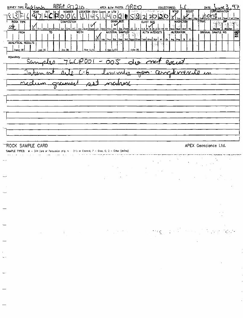
'---ROCK SAMPLE CARD ':>AMPLE TYPES: ~ - Drill Core or Percussion chip, N - Chio or Channel, P - Grab, 0, Q - Other (define)
. ' . ,
APEX Geoscience Ltd.
.. ~ ' ..
APPENDIX IV.B
STREAM SILT SAMPLES

GEOCHEMICAL SEDIMENT AND WATER SAMPLE CARD APEX Geoscience Ltd. SAMPLE TYPES: A/B - Stream sed./woter; C/D - Lake sed./woter; E/F - Bog sed./woter; G - Gosson; H - Hvy mnr1 cone.; l/J - Spring sed./woter; K,L - 0th~ (define)

·r
GEOCHEMICAL SEDIMENT AND WATER SAMPLE CARD APEX Geoscience~t{1. SAMPI.£ TYPES: A/B - Stream sed./woter; C/D - Lake sed./woter; E/F - Bog sed./woter; C - Casson; H - Hvy mnr1 cone.; l/J - Spring se<f./woter; K,L - Othv (define)

I
ORIG. DIP. REP.
~REMARK~~~~~~~~~~~~~~~~~~~~~~~~~~~~~~~~~~~~~~~~~~~~~~~~~~~~-4
GEOCHEMICAL SEDIMENT AND WATER SAMPLE CARD APEX Geoscience Ltd. SAMPI.£ T'l?ES: A/B - Stream sed./woter; C/D - Lake sed./waler; E/F - Bog sed./water; C - Gosson; H - Hvy mnr1 cone.; l/J - Spring sed./water; K,L - 0th~ (def1t1e}
' L ~

Low Mid High Work C«np Rood eo,., Rode Sand Oar °" <I 1-5 >5 Or Yol Sm Hvy LiWll "'1t Yel Cm Rod Bm Blk Ctw Sand f"'119 °'1 Col
U. llod Hi911 Work Ccmp Rood Cosn Roct Sand Oay Org <I 1-5 >5 Or Yol Bm Hvy Light "'1t Yol Cm Red Bm BJk 0.. Sand ~ 1)-g Col
C1' IF Con Dec Crw .,_
Olil::.I CUP. RD'.
~1 IU'.I RD'.
GEOCHEMICAL SEDIMENT AND WATER SAMPLE CARD APEX Geoscience Ltd. SAMPLE T'l'PES: A/B - Stream sed./woler; C/D - Lake sed./waler; E/F - Bog sed./woler; G - Gosson; H - Hvy mnrl cone.; l/J - Spring sed./woter; K,L - Olhl;I' (define)

ll ·"·' :, ~s; .?.
:Art,~ :;;'.i ::':t I.Dir lltd High
GEOCHEMICAL SEDIMENT AND WATER SAMPLE CARD APEX Geoscience Ltd. SAMPLE l'l'PES: A/B - Slreom sed./water; C/D - Lake sed./water; E/F - Bog sed./woter; G - Gosson; H - Hvy mnrt cone.; l/J - Spring sed./water; K,L - Othv (define)
,.,.
lm lied H~ W°"' Camp Road Goon Roel< Sarld Ccy 0.9 <1 1-5 >5 Cir Yol Bm '11111 Yol Gm Red Bm Bit
ORI:. DUP.' REP.:

GEOCHEMICAL SEDIMENT AND WATER SAMPLE CARD APEX Geoscience Ltd. SAMPI.£ TIPES: A/8 - Stream sed./water; C/D - Lalce sed./water; E/F - Bog sed./woter; C - Cosscli; H - Hvy mnr1 cone.; l/J - Sprln9 sed./water; K,l - 0th"' (define)
'L....;

Cir
I.all llod High Wort Cqnp Road eo.,, Rock Sand Oay Orq <1 t-5 >5 Cr Yol Sm HVJ ~I Mil Yel Cm Red Sm Slk C1le Sand ;.._ Or9 C11
lM llod H~ Worll Comp Road Co111 Rock Sand Oay Or9 <1 1-5 >5 Cir Yel Srn H¥J lljllt Mil Ya Cm Red Sm Slk C1le Sand ..... Orq Cll
CRIC. DUP •. RD'.,
eon 0ec en -
GEOCHEMICAL SEDIMENT AND WATER SAMPLE CARD APEX Geoscience Ltd. SAMPLE T'IPES: A/B - Stream sed./woter; C/D - Lake sed./woter; E/F - 809 sed./woter; G - Gosson; H - Hvy mnrl cane.; l/J - Spring sed./water; K,L - Othl'f (define)

:.''
... ,,
-~~ ~~:-~;~:. ~:'· l~~ :;~_~: Wark Cwnp Road Co., Rode Sand Claf .°" <1 1-5 >5
GEOCHEMICAL SEDIMENT AND WATER SAMPLE CARD APEX Geoscience Ltd. SAMPU: 1'IPES: A/8 - Stream sed./woler, C/D - Laite sed./woter, E/F - Bog sed./woler, G - Gosson; H - Hvy mnr1 cone.; l/J - Spring sed./woler, K,L - 0th~ (define)
~?·~~.. :'~::· ;.·;.;.~~ ' '';!. llod ~ Wark Camp Road Co., Rode Sand Cay Cit Yol Bm 11111 Yol Cm Red Bm Blk
IR!l. DU'. REP.

APPENDIX IV.C
HEAVY MINERAL STREAM SEDIMENT SAMPLES

I.ow llod lfigh Wori< Cmnp Road eo.., Rock Sand Clay Orv <1 1-5 >5 Cir Vol Bm HyY Lqtl "'1t Vel Cm Red Bm Blk Cne Scrid f"na Or9 Gel
Cir
C.. Dec Cro lloss
OR1C. CUP. REP.
loll llod Hlgl Work C<lmp ROOd Coan Rodi Scrid Clay °'9 <1 1-5 >5 C~ Vei Bm HyY LllJlll "'1t Vol Cm Red Bm Bl< Cloe Sand f"na Orv Gel ii(P.•
GEOCHEMICAL SEDIMENT AND WATER SAMPLE CARD APEX Geoscience Ltd. SAMPLr TYPES: A/B - Stream sed./water, C/O - Lake sed./water; E/F - Boq sed./water; G - Gosson; H - Hvy mnrl cone.; l/J - Sprinq sed./water; K,L - Oth~r (define)
SURVEY TYPE: y. (!(; I/ii ~~lcf: °J 7 ~ID AREA &/111" PHOTO: OBcJ) COl.l.ECTOR{S): &R )lL DATE: ~/l~//, f; NTS ~
IE1
~lM101u3~ rrr ~ (Grid Coord. OI" Un.I) I ' ' '' .. . LUI WTHR WTR SURF. 't'ECiETA1100
l~3IF~ q,i 4'1K f-111 ~ O . .$C'ZL213131&D v or~ c:t:I Cro w: !J:' Cldy Gs/SI Rp /~I Ch
IELIEF CONTAMINATION BOTIOM AREA DiTH ..AATER SU~I SEDIMENT COLOUR
ll0
~l00
I 1
ORrAL, SiPLE ,N0.
1
~ J Wedi~ w~~~eo.., R!lali.I~ !? Y,,DlH
' .2 OLOUR
H-. l~t ~ Vel I Cm I Red I Im I l. J.. J Or; Gel <1 I 1-s I >5 Cr I v• l Bm REP.
REMARKS; ~ ~~ A ,..l"L • ,L.;,,...".r~ 4:,,.r ,· 4 /;Ad/ - /'-ka $' ,'.,t-_ tr? 7 ;gJ(IJ Q 38 j , I
'2 ~ Cir Cldv Gs/S Rn/IA Cn/F Con Dec Cro Moss OR1C. IXJP. REP.
I.ow Mod """' Wori< Camp Rood Cosn Rodi Sand Clay Orv <1 1-5 >5 Cir Vii Bm HyY I t.Jaht "'1t Vel Cm Red Bm B~ Cloe Scrid rn.. Orv Gel
REMARKS:
~ ~ ~ ~ C\ .., ~ R rl 3 ~ l \ L1 i c q s C) ?. l 1 0 0 ~ s ~ v (..... •v Iv
Q 0 CJ Cir Cldv Ga/S Rp/11 Cn/F Con Dec Cro lloss
v n ()v1 ~d wr. REP.
I.ow Wed High Wcri Camp Co.., Rodi Sand Clay Orv <1 1-5 >5 Cir Vel Brn Hvy Lqlt "'1t Vei Cm Rod Bm B~ Cne Sand f"neo Or9 Gel
Poe'.>-1 ~ •. 1 ,. - n I (A I I k ,._ho,._ r-~ LL,,~ r-. i ~ -j - 7.£3 i? (, 03 7 . ? 0 IA . REMARKS:
\)
Cir Cldv Gs/S Ro/I! Ch/F c.. Dee er. "'°" CRIC. DUI'. REP.
loll ..... H9' Work C<>mo Rood Cosn Rock Sand Clay Org <1 1-5 >5 C• Vel Bm Hvy Ll;ht WM Vel Cm Red Bm Blk Cloe Sand ..... Org Gel
REMARKS: I

DBEP SURVEY TYPE: PROJECT: AREA &/or PHOTO: - COU.ECTOR(S}: DATE: '-
sTS?J i=tri1 r.31
~1;r~, LOCATIC ~ (Grid Coord. or UTM) .l'"-'*ff~i'''"1'(';,'i;;ti 1 ,~+,;;_.;,,
ROC< TYPE ti :W ~I WTR ~· k&:.11 I 412 4-lq ll s 1.$ u l'il' I/ t~O :51 ltf sl . I~ c.; Fl Ch Zone
I :ELIE 'I ;r:;.~ntE BOTTOM AREA DEPlH
~~ SJ~ V SEDIMENT COLOUR COMPOSITION i ~rAL1 iPLE (o. , ('i-II v ~ILlaa.I~ or~ o-1, I ~t I Yel I Cm I Rod I tJ ~ :Cl~ILl~t~ <1 L 5 >5
R Low Mod ...... a em H.., t
REMARKS: $nt<I.; f'~ Ar 4-0 JVl f.//J ~rt::' n'1 r o a_. tt/ / J/,_,I_, v Sa. m iP s,/ _, 7 R!R ,/) o f"J/
, I
/J <;" 'j-
l Or ,..... Gs/S Ro/II Ch/F Can Dec Crs ....
: ,>
~ Low Mod ..... Work Camp Rood eo .. Rode Sand Ooy Ortj <1 1-5 >5 ar Yel Bm HYy Llgllt ~t Yel Cm Rod Bm B~ c.... SClld F'ila Ortj Col .
·.
REMARKS:
I J
Or Qdv Gs/S Ro/II Chlr Can Dec Crs ....
Low Mod H'igh Wen Camp Rood Cosn Rode Sand Ooy Ortj <1 1-5 >5 ar Yel Bm H'Y 1411 ~t Yel Crn Rod Bm Blk c.... Sand ,.,. Ortj Col ~ RCP.
I
REMARKS:
T I
•I .
" Or 1"'4v Cs/S Ro/II Chlr Can Dec Crs llol
Low llod Hll)h Wen Comp Rood Coon Rode Sand Ooy OrQ <1 1-S >5 c~ Yel Brn HYy Lll)hl ~I Yel Cm Red Bm i:r Blk c.... Sand ·- Ortj Gel .
REMARKS: I
1 GEOCHEMICAL SEDIMENT AND WATER SAMPLE CARD APEX Geoscience Ltd.
SAMPLE TYPES: A/B - Stream sed./wcter, C/D - Lake sed./woter, E/F - Bog sed./woter, G - Gosson; H - Hvy mnrl cone.; l/J - Spring sed./woter; K,L - Oth~r (define)
SURVEY TYPE:µf'il r o l.)\V.ff \ V'I Cl.JENT &: °'1110 AREA &/or PHOTO: OBE\"1 ff),..., l'f.oJ COU.ECTOR(S}: gg, I,..(. o&/031 q7;__ PROJECT: DATE:
NTS TtN! i 1:r1u1;r;Ll1rr N (Grid Coord. Qt" UTM) I , '.i ,;{} : .. ' .... ~ . ROC< TYPE wrHd WTR SURF. \'EGETATI<JI I Zl_s IF 6 411;> ~~ ;21o ~I tJ ~~ il2l5"l~1~hh J"dl I ~ d Gs/::R~:/r 6 d'er. ~
RELIEF CONTAMlkATION BOTTOM AREA b~ WATER SUSP. SEDIMENT COLOUR COMPOSITION
1 ORrAL, SiPLE (o.
1 , !r Lowl3~~ Wen ,Cam.I ~JiL~ IR0d'aa.1~ J'l'MDTH
,0 JPLOUR HJ~ it I Yel I Cm I lod I ii Blk J.. l~IL..I OrQ I Gel I <1 I 1-s I >S a. I Yo1 _I_ em
REMARKS: ~ .5/i_e ~ 7.J'~lf_ 00 J..
/.. v ,/ v I/ i,, I
<6 3 F b q 3 s Ri \.-\ 0 0 3 l I L..f q I I 1i 0 ~q l t.t '1 l 0 :;. s '-' Cir Odv Cs/S Ro/II Ch/F Con Dec Crs Mosi
v '1J br'\ ~ood ~ L I II v ". l .1 v ii I f I ~ I ~ Low Mod ...... Wen Camp eo .. Rode Ooy Ortj <1 1-5 >5 ar Yli Bm HYy Lll)hl ~I Yel Cm Rod Bm B~ c.... Sand F'ila Ortj Gel .
REMARKS: Fro.Ck::i r~r'Y\c...,t I L-(tL,k. '
Ot± SCil'Yle., sr e. Q!J 7 13 1~ /too '-I . '
I ar Qdy Cats Ro/M Ch/F c ... Dec Cro w ...
~ Or Ye! Bm HYy 1411 ~I Rod Bm Blk c.... Sand ,., .. Or9 Col .
Low Mod HicJh wen CC>TIP Rood Cosn Rode Sand Ooy Ortj <1 1-5 >5 Yel Crn
REMARKS:
I
Or Cldv Cs/S Ro/M C>i/F Con Dec er. llosi
~~r [)UP, REP •
Low llod H"qt won. Comp Rood Co•• RDCll Sond Cay Or9 <1 1-5 >5 Cir Ye< B'n HYy LiQhl 'll!lt Yol Cm Red Bm Blk c.... Sand ...... OrQ Get
REMARKS:
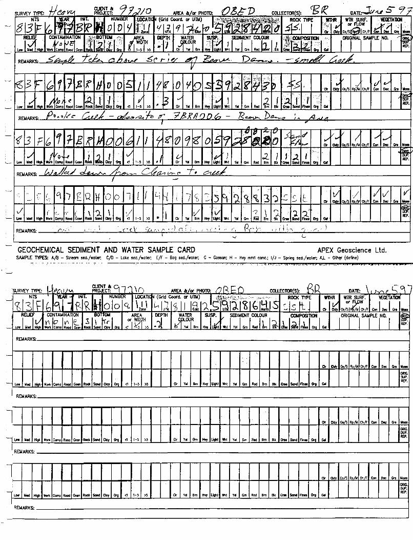
\-:- (: q J ~ Q ~ 0 0 . 1 [ f
AREA & or PHOTO: (Grid Coore!. or Unt)
'7 I Yel Cm ir.cl Bm Orv Col
R£P. ./ ( G ,. ( \ ')_ \ V i.. llod ~ won Camp ~ Cosn Rodi Saod Oay Org <1 1-5 >5 •
c·' p .., I ~. I J
, j 1,, r: ' .(,' .\
..., I_
GEOCHEMICAL SEDIMENT AND WATER SAMPLE CARD APEX Geoscience ltd. SAMPLE TYPES: A/B - Stream sed./water; C/D - Loke sed./woter; E/F - Bog sed./woter; G - Gosson; H - Hvy mnrl cone.; l/J - Spring sed./woter; K,L - 0th~ (define)
.f.n. ____ Ji :; .. st11z:•.J4f_J.il.<CllJDSJ] SJtPt.JOAASP
SURVEY TYPE: L /J/"1 i /V a.JENT & ~ 1 ,... \ PROJECT: () AREA &/or PHOTO: ('} R J; 0 COUECTOR(S): ~p DATE: \ r JV', f' c: 9 l
~ NTS 'tEAR - INll. NUMBtR LOCATIC N (Grid Coord. or Unt) I lI~~~ .. ·:<.;~:,:,.,.; ..• ", .... ROC< TYPE wi:~ WTR SURF. \'ECETATION
ilsl \= h !qi I \<~Holoq, \ I \ ::Is tt J or W
Con I Dec I Gtt ..... t..;,lu~ ~II lfolt 'A.S~lllilbl!ilS Cir Cd Cs/s;Zi'Ch/F Zone
I RELIEF CONT AMINA TlON BOTTOM AREA
0
0.;rTH WATER :L(. V SEDIMENT COLOUR ,~,osi°NI I ORrAL1 IPL£ r0· 1
!~ 'LowlwJ~ Y\ I~ .IV\ le._ R~,sL~~I~ or~ V,ivOUR ~t I Yel l Cm I Red I lm I ~ J.. $, ~ Ora Col II I Bm
R[P. Woril Camo Rood Co'" <1 I 1-5 I >5
REMARKS:
~
.·
Cir Cldv Cs/s Rn Al Ch/F Con Dec er. w ... Ol!IC. CUP.
~ LO'IJ Wed Hioh Woril Camp Rood eo .. Ract -Clay Oni (1 1-5 >5 Cir Yet Bm Hw lloht ~t Yol Cm Red Bm Blk er. -F1nlo Oni Col REP.
REMARKS:
l Cir Cldv C.!S Ro/M Ch./F Con Dec Gro -' ORJc. I OUP.
I.aw Wed tigll Woril Comp Rood eo,., Ract -Clay Oni (1 1-5 >5 Cir Yel Bm H"J li#lt ~t Yel Cm Red Bm REP.
Bill er. Sand F"11e1 Oni Col
I REMARKS: i
1 Cir Cid• Cs/S Rn Al Ch/r Con Dec Gro .....
' CJ!JG. OUP.
u.. llod H~ won Comp Road Cosn Roell -Oay Org (1 1-5 >5 Cir Yel Bm HvJ ~t ~t Yel Cm Red Bm Blk Cno Sand F"rm Oni Col R£P.
I REMARKS:

SURVEY T'l'PE: ~ linv" ~£tlcf: C\ 11 \ 0 AREA &IOI' PHOTO: (') e i= o COl.lECTOR(S}: r:s R DAlE: )uw 06. NTS 'YE i7
INll. '• NUMat.R ~~ ~ (Grid Coord. fll' UTM) 1 ,,:'~'-'-:'il\jpfi,'<!."•·'-)~4-'~'i.;i~+, ROCK fl'PE Wll 11! WTR SURF. \'EGETA~ ~ -il3h- b c{ B RHolo g JJ;! .. : qlu<i C6 I Sl!:t 0 .~ ~F~lbl~l~iG .s Is It- I ~ ,)"_FLOW
Cl<lv Gs/SIR~IMICh/F ~-r~· Gn ·" RELIEF .·. CO,TAMINA TION ··BOTTOM ·. AREA ·DEPlli. WATER .32 SEDIMENT COLOUR COMPOSITION I ORTALI SiPLE ro· 1 ~ VI J !J. 2.lnleo~ ~1111.r~ J'j'Y1101H ''if 'i'. clou1'V Jt I J Cm I Rod I a I e\ rn. IJJ.LI i. I c. low lled , ...... <:1 11-51 >S • . Cir Yel 9m
REMARKS: Slo'l:!. L Q'.lQk'.i ::i~ .Sl,j LQl ::::Yl~~ c.t.cef ~ I - '
I
·i· .; ·. tf f6 7 s 1 :J l I
... I i :s ~ 6 °t 7 (3 I< ~ 0\ 0 f ·1 :2 b 0 ~ D 5 s c ~ v v L/ Cldv Gs/S Ro/M Ch/F COl o.c en Mo
v v' ... :.
J .. v ill ~ h D YI ~ RL ~ J.. .... 'J. ".l I ?.. L Crv .. ,
Low ..... HIQh Wor1c Camp Rood <I 1-5 >5 ,· Cir Yol em Hw hw.t ""t Yol Cm Rod 9m B~ Clle Send Crv c.
I '2, Ir /"\.... lJ()~. !' f /'1 ""' p...{'C)I'() gig f2 WOt'J°1. I REMARKS: \
I
s 3 F 6 'I r 'fj R H 0 I I // 1/- B IS I ,;z. '() l5 CJ ~ 11 I~ !]- 515 ..... ,/ I ct. . .,,,, I {}
Cir Cid• Gs!< Rollo Ch/F Dec C'n WO
./ '.:~ i .' ,/ v
lwL il(J, rt ~ I ./ . vi L :2 I ~ -~ )... I REP. low lled Hf9h Ccrnp Rood Coon Sand Oay Crv <I 1-5 >5 , Cr Yel em Hvy Uo11t ""t I Ysi Cm Bm Blk ICne ..... Org c. I
<,,..~,,;,, ,f"f.e_ ,,.y/· 1i, ... J'-. ~ r:.~Li.-·- A/.n;.- - .L t-.. ~ (/:fc ,(! 1CR..t Or1 I
REMARKS: -, Ill , ....., I I I .. r ,
'---
8" 3 F {:, 1 1 'R II 0 i / L\ ~ s ~ :a: 5 q 1. 5 ~ ) 0 s led ~, 1$..f'" ,,,.. ..,., I '$ I I ~ ~. If h- II
.,., ,., ~ Cir Cid• Gs/S R""' Ch/f Con Doc en Mei
/ t Vg,. (. J.. sL L v' ' l ,/ ,,/ l 1-a. ~ I .i J. (~I
'. i REP. ..... lied Hf9h Comp Road Coln Rod< Crv <1 1-~ >5 Cit Yel 9m "" ~· ""t Yol Cm Rid Clle Sand Crv c.
S1:.J-L q. 1ZRA 013 CuJ_ I . c,.,,,"'" REMARKS: ta-
'--r
GEOCHEMICAL SEDIMENT AND WATER SAMPLE CARD APEX Geoscience Ltd. SAMPLE T'l'PES: A/8 - Stream sed./water; C/D - Lake sed./water, E/r - Bog sed./water, G - Gosson; H - Hvy mnrl cone.; l/J - Spring sed./woter; K,L - Oth~r (define)
------------------------------------------------------------------------------------------:'---,
o\ ~ l I 41Sctoo ·'1ls0 s.s \::. \ ~ \ l 2. Rod 8m Bil< Clle Send ""100 Crv C.
- Si .f.c ~ r3'RAOI?

~l-eo V"1 CLIENT & '1 1-.,J AREA &/ar PHOTO: f JJ\c:]) ccil..ECTOR(S): 1?1<1 .... [.!. DATEJ V>AJ (/ '/ "1· SURVEY m>E: PROJECT: NTS f11f i 1
RYAI ciu7~ iii ~(Grid Coord UTM) 1~"1,~·!,'~,('¥ ··y · 1~;uE
WIHR WTR SURF. \'EGETA 1ICJj
~13 p ~ 'I Ii SI ¥1li o .~'i1·~91~~l~:r~ or~ ~'1'en =:· Cir Cid Gs/SI RD7W I th
·:1d~ CONTAMINATION BOTTOM AREA DEP1H !fvTER ·,~~ II' SEDIMENT COLOUR . COMPOSITION I orurAL1 IPLE INO. , ' ~ .:,-:.':•,"-'- . ; l&k<ooi:'sn dlsLIJ.I~ ar 1(f ·''~-
OUR
'Mil I v.I ~ I ! I~ lk ~LILI Oro I Cel :;: ... ·.
<1 I , >5 .1 Bm R£P.
I.ft """' ~-u.;..,
_,,,.-~ A, __
~~.J: A/:, • .L - t-;..J JbJ d(iL .h• r ro ..,, .a.,.;/ 111 /'__:;I. / : - .., REMARKS:
' It l~'Q ~)-ht ~1 ?R:P .LO ft/i I
' If " i _:'; . .
>. i~;i: .. ; 1'::;: . ' . ' ;;; ., .. :.~~· .. · 1· .. '•· :··.· . . , , . ._,_ Cir CldY Gs/S Rn A< Ch/r Con Doc er.
.. _ ;;; '.·:' ORlC.
~I CUP.
High Wortc Ccmp Rood Goan Rodi Scrld ClaY Oro <1 1-5 >5 Clr Yrl Bm Hw 'Mlt Yol ~ Red Bm Smid R£P. ...... lied 811< er. ..... °'1 Cel
REMARKS:
"·~
-': :_; ''· ·• :;-' .; '
' ' Cir r.ldv Cs/S Rn A< Ch/r Con Doc en Woa
: OR1C. • 1: CUP. '·
...... llod High Wort< Canp Rood eo.., Rodi Scrld Cloy °'1 <1 1-5 >5 Clr Ys Bm Hvy ~I 'Mil Yel ~ Red Bm Blk c... Scrld .... RU', °'1 Cel
REMARKS:
'
Cir Cldy Cs/S Ro/M Ch/F Con Doc en ..... ~c.
'· DU'.
Im lild Hlgh Wot11 Comp Rood eo.,, Nook Sand Cloy °'1 <1 1-5 >5 Cir Yel Bm Hvy LIQlll 'Mlt Ys ~ Red Sm illk Ctlll Smid ,.,.. RIJ'. °'1 Got
REMARKS:
GEOCHEMICAL SEDIMENT AND WATER SAMPLE CARD APEX Geoscience Ltd. SAMPLE m>ES: A/B - Stream sed./woter; C/D - Lake sed,/woter; E/F - Bog sed./woter; C - Gosson; H - Hvy mnrl cone.; l/J - Spring sed./woter; K,L - Olhflf (define)
. II P. REP.
Im lild

- ...-
GEOCHEMICAL SEDIMENT AND WATER SAMPLE CARD APEX Geoscience ltd. SAMPLE T"IPES: A/8 - Stream sed./woter, C/D - Lake sed./woter, E/F - Bog sed./woter; G - Gosson; H - Hvy mnrl cone.; l/J - Spring sed./woter; K,L - Othi:< (define)
SURVEY TYPE: Jt e OVv aJENT & C/7-:i.Jo AREA &/~ PHOTO: OEFh COUEcrOR<s): f3 ff'/ Lr oAm:Jv,,,~Ja/9, : PROJECT:
~31F~ ;r~ B1
~~ azb L[/ N ~~)d., ;1:z O~J;~;tk: 12tt: ROO< T"IPE , WTHR WTR SURF. ~GETA1Jctj -1-~I ( Od Cs/~R~ rl0eel Cra ~
RELIEF CONTAMINATION BO TI OM /AREA
~13 WATER SJi. v SEDIMENT COLOUR COMPOSITION
I OR'rALI iPLE ro· 1 .;:: l!.rl low I if~ ~ 'l'c£. ~ R€.l ~., l~JJ I ~DTH 0~0UR Hw II~ ~J J Cm I J.Jl Ilk IJ.liJJ .. I er. I ca Rocle a Clay Oro <1 11-51 >5 al-, Bm
. I
7"1?.'l?Ao~ I REMARKS: s /TC! J'i ;
I Or Odv Cs/5 Ro/\A Chi!" Con Dec er. MO!
CJ!l'
I.ow Med lfoah Wor1l Ccrno Rood ~sn Rocle Sood Cloy Or9 <1 1-5 >5 Or Yel Bm Hw low.1 11111 Yal Cm Red Bm Blk Clll Said ·- °'9 Gel ~ I
REMARKS:
I C1r Odv C.15 R•"' Chi!" Con Dec er. lloi
Low Med High Wor1l Ccrno Road ~., Rocle Sond Oay °'9 <1 1-5 >5 Or Yel Bm HY)' L.qil Wht Yel Grn Red Bm Blk en. S..d ..... Or9 Gel 'er I
REMARKS:
'-,-
I ar Od• Cs/5 RollO C!i/F eon Doi: er. lb
I.ow lied H;qi won. Como Rood ~ .. Rodi Smid Oay Or9 <1 1-5 >5 Cir Yel Brn HY)' Light Wht Yel Cm Red Bm Blk en. Sond ..... °'9 Gel !Sr REMARKS: :
'-r

GEOCHEMICAL SEDIMENT AND WATER SAMPLE CARD APEX Geoscience ltd. SAMPLE n'PES: A/8 - Stream sed,/water, C/D - Lake sed./water, E/F - 809 sed./water; G - Gosson; H - Hvy mnrl cane.; l/J - Spring sed,/water; K,L - Olhf1' (define)
SURVEY n'PE: fl ('h \ h, a.JENT & PROJECT: q J;;1-u AREA &/Oir PHOTO: oee:-D COUECTOR(S): Bf: DATE:_,h...._ /I.// tf r
NTS YEARi.< e1rilt ol3ER' LOCATIC
1411
iCo1.~ I~() !sr~JJ3111N.3I o ROCK n'PE WTHR WTR SURF. ~r~ gl3IF& qi, lzLJ ~~-ff v or~ ,,.,,, t Od• cs/SIR0/wl01 con Dec I en 11<m
REU" l£ZfATION
BOITOM AREA DEPTH WATER SUSP. " SEDIMENT COLOUR COMPOSITION I OR'rALI sjPLE to. I .. "
P ~~Goon lelsLILI Oro
Olr ~TH .13 liLou1
R H..I~ "'1t I Ym I ~ I L I ~B,/ J l~rhll er. I Gel Law L .. d tftafi "'I i-sl >5 REP.
Yti Bm
REMARKS: ...,.O..~ ,?,- ,,_ mt:JI I\;~ 1 -4 -JtJ,.l ... <:"of'f'~...,_ "~..,. 7L, '~ /'..:I- L ... :,e . f > /~ 4"1 '? .B PAt:; ?~) , '/
Clr nm. Gs/S Rp/\I Chlr Con Dec Grs Moss
OR1C. CUP. REP.
Low Med tfoqn Worl< Como Rood Gosn Rock Sand Cloy Crq <1 1-5 >5 Cr Yti Bm H'I)' lllgllt "'1t y~ ~ Red Sm B~ Ct1e Sand me. Or9 Cet
REMARKS:
Clr nm. C./S Ro Ai Ch.Ir Con Dec c;,. Moss
ORIC. OUP. REP.
low Wed tfoqn Worl< Comp Rood Gosn Rock Sand Cloy Crq <1 1-5 >5 Cr Yti Bm H'I\' Light "'1t Ye/ ~ Red Sm Blk Ct1e Sand ..... Crq Cet
REMARKS:
°' Qdy Cs/S Ro/II Ch.Ir Con Dec Cn Moss
ORIG. D\!P. REP.
low Med lf'1' Wont Comp Rooo Gosn Roel< Sand Coy Or9 <1 1-5 >5 Cir y~ Bm H'I)' light 11111 Yti ~ Red Bm !Ilk Ct1e Sand ..... Or<J Cet
REMARKS:

APPENDIX IV.D
TILL SAMPLES

SURVEY rtPE: ---- - -
I I .r~ AREA &/-x PHOTO: .ntTE:' • , ; PROJECT: COUECTOR(S): ,
8TS3lf
'!'EAR B1Rf Jrik>N1~ER/ ~~ ~ (Grid Coord. °' 2 b;~.;~;,~~~mi1!t~1~~i;~. ROO< TYPE ~vJ ~GETATION n ~.7 I E:l uf; {151 csf ( :fii'J'.1,, ., . ,,, T"/ IL~ ~ Qdv 6~1MOSI :,:~~ \; •. · . n.t . ~ ..:' :\: ·~--*-1 ·f, Marth ,,
~~. ': T.
~li~~ E r;:.J~~l), DEPlH lHKNS H~r~ ._asn
' SEDIMENT COLOUR •:·,. COMPOSllON , I orurAL1 IPLE 'NO. , <&!f. '· ~' l?JJ7T; .. Goin -+11 rr1 "? oJ-a ·i:f•ut Ji I v.lil Rod I~ I /r. J. l~l J1l!y fin v. - Ti ( Wot or;· °"
llJ':
Hv ... / .,...,;, rl e 0., h1 A h 0 /-'- /;//, - fi {tf) r r ,,,.,..; ~,{ /") ,,,.-,_.. --;;, Pl~ REMARKS: f-rDh-... la.'r a. /., ,., 1/ ~ J. !,,/rf'!J/~ ' Lo..rr1.1' (I tP 6 '/,,, ,$ lo """ o. ~ ! ~- -:i. l A1 /o,,,., I 4.~fS
s IF 'i r7 e r<. (-J t~ lo~ 5 ~j IJ 4t .( /. ,_~ ~ G, ·~ . , ' 11), ,_, 1,, I/ , .. Y-; T 0 0 2 i>.; ). I.'-.;:, 7 I L I" ,,. if -~
c. I , ):;, '- ~ :-.:..-·
··.) :t..j Or G<s Mo .. ~- P11111
._. ~;~ '.v
'I v ii' v !
I~-:(. &I ·.• I" I 2 I I • N' 111n b • 2. Ti"I ·"""' I I Spro llacl w.r. Med Hie;. -Camp Rood Futl Caon Wot .1111 Dry Mlt Yet Cm Rod Bm elk cru Sand Sit Doy Qrg REP.
REMARKS: r,11 A/ o~ '3- o-~ IY7 a.£~~" h,J,e1~1'. 5 &:J Jll"lt" roe::Jfs- -(!_ft) ~til". ""'\r' o, I ~
" Ji:~:· •. r , . ~·-8 3 F 1 7 B /( 17 0 0 3 4- 1 --~ "'5 't 2.. ' 3 !/!; "ct " v ~-
2. 6 .5 T I L L Or "" rt: G<s MoS9 <-. p'"" -.I v / 1· e> LO ;.. :~· v ~ l
.. ~~ .....
~ ~ "" o. '2. . . ..... I l: J. l Ii J, .... S-• REP. Spto t:r. Low Mod High Rood Futl c- ·w.1 Ila! Dry Mlt Y• Cm Rod Bm- Orv
REMARKS· rroNI ./-,// /11"'111or bA.e# ,,/" N' L m. At~~ r·-~/ /* vf-. (
1o"hk.:s (!';). s- - 0- 8 ,,., -....,, •· j . :~ . ~
'·''·I I· • ,,,, ," ';
. " 1; :~ ·., :·,· ' :.~·- -- . ~ .o;~
.. ,: Or Cid• Con Dec G<s Moss .,_
p..,,. h-·~.
·~ !. !RC. ~--. .. . ;:. ,, . ~; DIJ' • ,,._
~ llod WF. Low Mod Hie;. -Comp Rood Fuel c- mot 1111 Dry 11111 Yet Cm Red em Sand SI( aa, o9 REP. Ilk Clio
REMARKS:
<"-Kl
GEOCHEMICAL SOIL AND TILL SAMPLE CARD - SAMPLE TYPES: S - Son; T,U,V - Glacial : tnt, undifferentiated, esker; W - Frost boil; X. Y,Z - Other (define)
APEX Geoscience Ltd.
SURVEY TYPE:/; I I CLIENT a: 97;(/0 AREA &/-x PHOTO: 01]t;I1} COUECTOR(S): I'? p DAlE:.X~. (//il PROJECT: NTS '!'EAR
;1~1~ 1JT;0
ER7' iJt ~ (Grid Coord. °' UTM) I . ' .· . . ..... ROO< JPE WTHR ~GETATION
.J::·n-ci ~ Ir- ti 'J. 7 41~ .;LIS E1P !.S u~.:zl8 ISN/.hlo .s :.JJ:J rf Qdv 'I :1 G<s I Mon ~G. INT. RELIEF CONTAMINATION
J~h THiS HiZ Mi'1RE SEDIMENT COLOUR
~f:?i: , ClrurAL, SiPLE ,NO. , _ ~D ' Spto l ~ I WI. Low,~H</' ~g,.~oodl Fuel IC- )lht I !J Cm I R~-'"' I e11< REP.
""' llal Dry cru Orv
REMARKS: -f:J/"~ ~,..,,.,,,~JU /J/h.I fat>J //).o,,.AJ AJ.L;,r~ ~ <:c_.-,j /lt10rCv_c:I',',,,<'.;; - / '- " / ~
' Or ,,... Con Dec G<s Moss wan p..,,. -ORIC. DCJP.
I Spto llacl WI. ~- Med Hi'1' \llotk Camp Rood Futl ~ Wot llal Dry Mlt Yet Cm Rod em elk cru Send Sit eta, Org REP.
REMARKS:
/
Or Qilv Con Doc G<s McS9 1;...,,, Perm la.-
ORIG. CUP.
Spto llod WI. Low Med High -Comp Rood Fuel Caon Wot 1111 Dry Mlt Yel Cm Rod em 811< Clio Scrld Sit Cl6y Orv REP.
REMARKS:
Or Qdv Con Dec Gn Woss s ..... Perm 0-
ORIG. DIJ'.
Spn llod WI. Low Wod >fgh \llotk Comp Rood Full c- ""' llot Dry llht Yo! Cm Red Brn Blk REP. er.. Sand Sit Qoy Org
REMARKS:
GEOCHEMICAL SOIL .A.ND TILL SAMPLE CARD APEX Geoscience Ltd.

GEOCHEMICAL SOIL AND TILL SAMPLE CARD APEX Geoscience Ltd. SAMPLE T't'PES: S - Soil; T,U,Y - Glacial : till, undifferentiated, esker; W - Frost boil; X. Y,Z - Other (define)
·::--;--:--:;-:-:-::-~;;;.~ 1:z:;::11.• .. ...,oc;:ozL ... 1.::u ... • .. :::s.JJJ'.lt .. J!!.- .... :z .. Z_£aIJ!UA1 .. !lJl .. 2\ .}l.)J!C4J.1Jrmt&ll!R. 5%4S SDI• WWW &&a.{,
5'>ts Mod w.r.
L.\l((l 5. RD'.'
Or
Sptt Mod w.r. Lo• Med H;gti Wo.-k Camp Rood r ... CoS'I Wet Mil Dry "'l Yfl Cm Red Brn Blk Crte Sand Sit Ooi Org

APPENDIXV
GEOCHEMICAL LAB REPORTS

( t r r l t r
.ITS Intertek Testing Services Bondar Clegg
REPORT: V97-01474.0 ( CeJ.lPLETE )
...........................................
CLIENT: APEX GEOSCIENCE LTD. PROJECT: 97210
DATE NUMBER OF LOWER APPROVED ELEMENT ANALYSES DETECTION EXTRACTION METHOD
970702 1 Au30 Gold 43 5 PPB Fire Assay of 30g 30g Fire Assay - AA 970702 2 Au Gold - Units convert 43 0.005 GMT CALCULATION 970702 3 Ag Silver 43 0.2 PPM HCL:HN03 (3:1) INDUC. COUP. PLASMA 970702 4 Cu Copper 43 1 PPM HCL:HN03 (3:1) INDUC. COUP. PLASMA 970702 5 Pb Lead 43 2 PPM HCL:HN03 (3:1) INDUC. COUP. PLASMA 970702 6 Zn Zinc 43 1 PPM HCL:HN03 (3:1) INDUC. COUP. PLASMA
970702 7 Mo Molybdenun 43 1 PPM HCL:HN03 (3:1) INDUC. COUP. PLASMA 970702 8 Ni Nickel 43 1 PPM HCL:HN03 (3:1) INDUC. COUP. PLASMA 970702 9 Co Cobalt 43 1 PPM HCL: HN03 (3: 1) INDUC. COUP. PLASMA 970702 10 Cd Cadni l.111 43 0.2 PPM HCL: HN03 (3: 1) INDUC. COUP. PLASMA 970702 11 Bi Bi srruth 43 5 PPM HCL:HN03 (3:1) INDUC. COUP. PLASMA 970702 12 As Arsenic 43 5 PPM HCL:HN03 (3:1) INDUC. COUP. PLASMA
970702 13 Sb Antimony 43 5 PPM HCL:HN03 (3:1) INDUC. COUP. PLASMA 970702 14 Fe Iron 43 0.01 PCT HCL:HN03 (3:1) INDUC. COUP. PLASMA 970702 15 Mn Manganese 43 1 PPM HCL:HN03 (3:1) INDUC. COUP. PLASMA 970702 16 Te Tel luri l.111 43 10 PPM HCL:HN03 (3:1) INDUC. COUP. PLASMA 970702 17 Ba Baril.111 43 1 PPM HCL:HN03 (3: 1) INDUC. COUP. PLASMA 970702 18 Cr Chranil.111 43 1 PPM HCL:HN03 (3:1) INDUC. COUP. PLASMA
970702 19 v Vanadil.111 43 1 PPM HCL:HN03 (3:1) !NDUC. COUP. PLASMA 970702 20 Sn Tin 43 20 PPM HCL:HN03 (3:1) llJDUC. COUP. PLASMA 970702 21 w Tungsten 43 20 PPM HCL: HN03 (3: 1) INDUC. COUP. PLASMA 970702 22 La Lanthanl.111 43 1 PPM HCL: HN03 (3: 1) INDUC. COUP. PLASMA 970702 23 Al Al L111i nl.111 43 0.01 PCT HCL : HN03 ( 3: 1 ) INDUC. COUP. PLASMA 970702 24 Mg Magnesil.111 43 0.01 PCT HCL:HN03 (3:1) INDUC. COUP. PLASMA
970702 25 Ca Calcil.111 43 0.01 PCT HCL: HN03 (3: 1) INDUC. COUP. PLASMA 970702 26 Na Sodil.111 43 0.01 PCT HCL: HN03 (3: 1) INDUC. COUP. PLASM.I\ 970702 27 K Potassil.111 43 0.01 PCT HCL:HN03 (3:1) INDUC. COUP. PLASMA 970702 28 Sr Strontil.111 43 1 PPM HCL:HN03 (3:1) INDUC. COUP. PLASMA 970702 29 y Ytt ri L111 43 1 PPM HCL:HN03 (3:1) INDUC. COUP. PLASM.ii 970702 30 Ga Gall il.111 43 2 PPM HCL: HN03 (3: 1) INDUC. COUP. PLASMA
970702 31 Li Li thil.111 43 1 PPM HCL:HN03 (3:1) INDUC. COUP. PLASM.ii 970702 32 Nb Niobil.111 43 1 PPM HCL:HN03 (3:1) INDUC. COUP. PLASMA 970702 33 Sc Scandi l.111 43 5 PPM HCL:HN03 (3:1) INDUC. COUP. PLASMA 970702 34 Ta Tantall.111 43 10 PPM HCL:HN03 (3:1) INDUC. COUP. PLASM.ii 970702 35 Ti Titanil.111 43 0.01 PCT HCL:HN03 (3:1) INDUC. COUP. PLASMA 970702 36 Zr Zirconil.111 43 1 PPM HCL:HN03 (3:1) INDUC. COUP. PLASMA
r r Geochemical
REFERENCE:
SUBMITTED BY: 8. RYZIUK DATE RECEIVED: 24-JUN-97 DATE PRINTED: 14-JUL-97
Lab Report
SAMPLE TYPES NUMBER SIZE FRACTIONS NlMBER SAMPLE PREPARATIONS NUMBEI ------------------------------ ------------------------------ --------------------------T STREAM SED, SILT R ROCK
38 5
REPORT COPIES TO: DR. REG OLSON
1 -80 2 -150
MR. MIKE DUFRESNE
38 5
CRUSH/SPLIT & PULV. DRY, SIEVE -80
INVOICE TO: DR. REG OLSON
******************************************************************************** This report rrust not be produced except in full. The data presented in this report is specific to those sa11ples identified under 11Sa11ple Nl.111ber" and is aRJlicable only to the sa11ples as received expressed on a dry basis unless otherwise indicated
********************************************************************************
5 38
Bandar-Clegg & Company Ltd., 130 Pemberton Avenue, North Vancouve• "2R5, (604) 985-0681

.ITS lntertek Testing Services Bondar Clegg
Geochemical Lab Report
LIENT: APEX GEOSCIENCE LTD. EPORT: V97·01474.0 ( CDIPLETE ) DATE RECEIVED: 24-JUN-97
PROJECT: 97210 DATE PRINTED: 14-JUL-97 PAGE 1 OF 5
»AMPLE I UMBER
'BRA001 'BRA002 13RA003 JRA004 BRA005
'BRA006 'BRA007 'BRA008 'BRA009 'BRA010
'BRA011 'BRA012 1RA013 ~A014
'BRA015
'BRA016 'BRA017 'BRA018 'BRA019 'BRA020
'ilRA021 ''3RA022 3RA023 'BRA024 'BRA025
'BRA026 'BRA027 'BRA028 'BRA029 'BRA030
I) r
ELEMENT Au30 Au Ag Cu Pb Zn Mo Ni Co Cd Bi As Sb Fe Mn Te Ba Cr V Sn Y La Al Mg UNITS PPB GMT PPM PPM PPM PPM PPM PPM PPM PPM PPM PPM PPM PCT PPM PPM PPM PPM PPM PPM PPM PPM PCT PCT
Ca Na K Sr Y Ga Li Nb Sc Ta Ti Zr PCT PCT PCT PPM PPM PPM PPM PPM PPM PPM PCT PPM
r
<5 <.005 <.2 4 <5 <.005 <.2 4 <5 <.005 <.2 11
4 28 <1 10 2 30 <1 11 6 37 <1 19
<5 <.005 <.2 7 3 39 <1 13 <5 <.005 <.2 4 3 34 <1 11
<5 <.005 <.2 4 3 32 <1 12 <5 <.005 <.2 4 4 34 <1 11 <5 <.005 <.2 4 2 24 <1 9 <5 <.005 <.2 3 3 84 <1 9 <5 <.005 <.2 3 3 30 <1 11
<5 <.005 <.2 3 2 29 <1 10 <5 <.005 <.2 4 3 30 <1 10 <5 <.005 <.2 13 4 52 <1 23 <5 <.005 <.2 3 3 31 <1 10 <5 <.005 <.2 3 2 36 <1 9
<5 <.005 <.2 <5 <.005 <.2 <5 <.005 <.2 <5 <.005 <.2 6 0.006 <.2
2 3 28 <1 8 3 3 34 <1 11 5 4 32 <1 12 3 2 33 <1 12 2 2 28 <1 8
4 <.2 <5 <5 <5 1.25 400 <10 107 9 14 <20 <20 4 <.2 <5 <5 <5 1.63 670 <10 135 8 14 <20 <20 6 1.0 <5 <5 <5 1.50 378 <10 74 13 17 <20 <20
9 0.79 0.60 8 0.67 0.58 9 0.94 0.75
2.08 <.01 0.05 52 2.46 0.01 0.06 67 5.79 0.02 0.07 157
5 0.2 <5 <5 <5 1.63 735 <10 126 11 15 <20 <20 7 0.79 0.62 5.13 0.02 0.07 164 4 <.2 <5 <5 <5 1.34 642 <10 130 11 14 <20 <20 8 0.84 0.46 1.00 0.01 0.06 53
4 <.2 <5 <5 <5 1.23 295 <10 87 11 16 <20 <20 10 0.79 0.76 4 <.2 <5 <5 <5 1.27 480 <10 116 12 14 <20 <20 8 0.82 0.54 3 <.2 <5 <5 <5 1.02 458 <10 119 7 11 <20 <20 7 0.64 0.39 4 <.2 <5 <5 <5 1.94 1221 <10 148 8 12 <20 <20 9 0.67 0.68 6 0.2 <5 <5 <5 1.62 1442 <10 136 12 18 <20 <20 11 0.88 0.35
5 0.2 <5 <5 <5 2.00 3123 <10 232 8 15 <20 <20 8 0.74 0.28 5 <.2 <5 5 <5 1.77 1011 <10 152 10 17 <20 <20 10 0.85 0.29 7 0.3 <5 <5 <5 2.09 395 <10 125 22 30 <20 <20 11 1.34 0.71 4 <.2 <5 <5 <5 1.42 444 <10 123 9 14 <20 <20 10 0.79 0.42 4 <.2 <5 5 <5 3.76 1660 <10 222 7 11 <20 <20 7 0.59 0.72
3 <.2 <5 <5 <5 1.49 549 <10 130 6 10 <20 <20 7 0.60 0.57 5 <.2 <5 <5 <5 2.00 1216 <10 151 11 15 <20 <20 12 0.88 0.48 5 <.2 <5 <5 <5 1.44 510 <10 127 10 16 <20 <20 9 0.90 0.60 5 <.2 <5 <5 <5 1.56 573 <10 106 11 18 <20 <20 11 0.92 0.51 4 <.2 <5 <5 <5 1.73 829 <10 124 7 12 <20 <20 8 0.61 0.49
2.69 <.01 0.06 47 1.79 <.01 0.05 36
2.35 <.01 0.05 48 2.56 0.01 0.05 53 0.70 <.01 0.06 22
1.16 <.01 0.04 40 1.01 <.01 0.05 25 3.09 <.01 0.08 43 0.97 <.01 0.05 41 2.28 <.01 0.04 83
1.37 <.01 0.04 38
0.95 <.01 0.06 42 2.37 0.01 0.06 60 0.94 <.01 0.05 31 1.07 0.01 0.04 39
<5 <.005 <.2 <5 <.005 <.2 <5 <.005 2.0 <5 <.005 0.6 <5 <.005 0.4
<2 20 <1 7 3 <.2 <5 <5 <5 1.07 361 <10 92 5 8 <20 <20 6 0.44 0.58 2.76 <.01 0.03 46 6 4 39 <1 14 5 0.2 <5 <5 <5 1.52 270 <10 86 15 22 <20 <20 14 1.06 0.54 0.77 <.01 0.06 21 1 11 15 <1 2 <1 <.2 <5 <5 <5 0.14 59 <10 179 3 1 <20 <20 <1 0.08 0.39 >10.00 0.01 0.01 563 2 <2 17 <1 7 2 <.2 <5 <5 <5 1.23 715 <10 156 4 7 <20 <20 2 0.36 0.49 7.35 <.01 0.03 92 7 3 34 <1 14 5 <.2 <5 <5 <5 1.48 493 <10 102 11 18 <20 <20 10 0.90 1.02 4.72 0.01 0.07 75
4 <2 8 <1 <5 <10 0.01 4 <2 7 <1 <5 <10 0.01 5 <2 11 2 <5 <10 0.01 5 <2 8 3 <5 <10 <.01 4 <2 10 <1 <5 <10 0.01
5 <2 9 2 <5 <10 0.02 4 <2 4 <2 4 <2
9 <5 <10 0.01 8 <1 <5 <10 <.01 7 <1 <5 <lo 0.01
4 <2 10 <1 <5 <10 0.01
3 <2 9 <1 <5 <10 0.01 4 <2 9 <1 <5 <10 <.01 6 2 11 1 <5 <10 0.02 4 <2 9 <1 <5 <10 0.01 4 <2 7 <1 <5 <10 <.01
4 <2 8 <1 <5 <10 <.01 4 <2 10 <1 <5 <10 0.01 5 <2 9 <1 <5 <10 0.01 4 <2 9 <1 <5 <10 0.02 3 <2 8 <1 <5 <10 <.01
3
2
2
3
1 2
3 <2 5 <2 1 <2 3 <2 6 <2
6 <1 <5 <10 <.01 <1 9 <1 <5 <10 0.02 2 2 <1 <5 <10 <.01 <1 5 <1 <5 <10 <.01 9 <1 <5 <10 0.01 2
<5 <.005 <.2 <5 <.005 <.2 49 0.049 <.2
132 0.132 <.2
4 4 28 <1 10 4 3 29 <1 10 3 9 26 <1 8
4 3 34 <1 10 5 4 39 <1 11
4 <.2 <5 <5 <5 1.20 367 <10 88 9 14 <20 <20 4 <.2 <5 <5 <5 1.45 627 <10 129 9 13 <20 <20 4 <.2 <5 <5 <5 1.35 691 <10 141 7 11 <20 <20
9 0.74 0.74 2.98 <.01 0.06 47 5 <2 8 <1 <5 <10 0.01 8 0.78 0.57 1.85 <.01 0.06 35 4 <2 9 <1 <5 <10 <.01 6 0.61 0.39 2.99 <.01 0.04 37 3 <2 8 <1 <5 <10 <.01
<5 <.005 <.2
r
4 <.2 <5 <5 <5 1.34 466 <10 120 9 14 <20 <20 9 0.77 0.51 5 0.2 <5 <5 <5 1.62 736 <10 177 10 16 <20 <20 8 0.96 0.32
2.08 <.01 0.06 37 4 <2 9 <1 <5 <10 <.01 0.91 <.01 0.05 29 4 <2 11 <1 <5 <10 <.01
604) r 81 r
2
r -

[ (
.ITS Intertek Testing Services Bandar Clegg
Geochemical Lab Report
CLIENT: APEX GEOSCIENCE LTD. REPORT: V97-01474.0 ( CCJolPLETE ) DATE RECEIVED: 24-JUN-97
PROJECT: 97210 DATE PRINTED: 14-JUL-97 PAGE 2 OF 5
SAMPLE NUMBER
7BRA031 7BRA032 7BRA033 7BRA034 7BRA035
7BRA036 7BRA037 7BRA038 7BRP001 7BRP002
7BRP003 7BRP004 7LCP006
ELEMENT Au30 Au Ag Cu Pb Zn Mo Ni Co Cd Bi As Sb Fe Mn Te Ba Cr V Sn IJ La Al Mg UNITS PPB GMT PPM PPM PPM PPM PPM PPM PPM PPM PPM PPM PPM PCT PPM PPM PPM PPM PPM PPM PPM PPM PCT PCT
Ca Na K Sr Y Ga Li Nb Sc Ta Ti Zr PCT PCT PCT PPM PPM PPM PPM PPM PPM PPM PCT PPM
<5 <.005 0.3 <5 <.005 <.2 88 0.088 <.2
4
6 6
7 26 <1 10 4 37 <1 17 6 39 <1 17
3 0.3 <5 <5 <5 1.30 623 <10 190 8 11 <20 <20 4 0.73 0.29 6 <.2 <5 <5 <5 1.64 326 <10 89 18 25 <20 <20 16 1.04 0.49 7 <.2 <5 <5 <5 1.94 2480 <10 179 16 22 <20 <20 12 1.11 0.45
4.16 <.01 0.04 104 0.77 <.01 0.06 25 0.94 <.01 0.05 39
3 <2 10 <1 <5 <10 <.01 5 <2 9 1 <5 <10 0.03 5 <2 11 <1 <5 <10 0.01
2
2
2 <5 <.005 <.2 2 2 25 <1 8 4 <.2 <5 <5 <5 i.38 1209 <10 169 <5 <.005 <.2 5 4 40 <1 12 4 <.2 <5 <5 <5 1.47 404 <10 113
7 12 <20 <20 9 0.74 0.27 0.74 <.01 0.04 36 3 <2 9 <1 <5 <10 <.01 9 14 <20 <20 8 0.78 0.83 3.33 0.01 0.06 70 5 <2 9 <1 <5 <10 <.01 2
<5 <.005 0.3 3 3 25 <1 <5 <.005 <.2 <5 <.005 0.6
2 <2 30 <1 4 3 24 <1
<5 <.005 <.2 13 6 47 <5 <.005 <.2 4 398 603
9
7
8
28 8
<5 <.005 <.2 <5 <.005 1.0
4 47 58 <1 12 3 <2 8 9
<5 <.005 <.2 12 2 34 <1 18
3 <.2 <5 <5 <5 1.29 685 <10 89 6 9 <20 <20 7 0.51 0.87 3 <.2 <5 <5 <5 1.32 867 <10 148 7 11 <20 <20 7 0.69 0.21 3 <.2 <5 <5 <5 1.02 326 <10 123 6 9 <20 <20 6 0.62 0.67 9 0.5 <5 5 <5 3.51 261 <10 117 58 36 <20 <20 16 1.91 0.99 3 6.3 <5 <5 <5 1.73 573 <10 71 154 6 <20 <20 11 0.64 0.22
4.83 0.02 0.04 67 . 4 <2 7 <1 <5 <10 <.01
5 <.2 <5 <5 <5 3.~5 1925 <10 98 94 14 <20 <20 2 <.2 <5 <5 6 0.3 <5
<5 u.60 165 <10 44 85 7 <20 <20 i <5 ~-62 277 <10 158 79 76 <20 <20
0.80 <.01 0.04 22 7.14 0.01 0.04 91 2.88 0.02 0.19 48
3 <2 8 <1 <5 <10 <.01 <1 4 <2 8 <1 <5 <10 <.01 2 8 4 21 <5 <10 0.02 9
1.81 0.04 0.25 129 3 <2 7 <1 <5 <10 <.01 2
5 1.60 0.64 1. 78 0.03 0. 14 81 3 0.37 0.31 >10.00 0.01 0.07 65 9 2.06 0.87 3.27 0.01 0.13 56
7 <2 47 <1 <5 <10 <.01 3 <2 3 <1 <5 <10 <.01 5 5 16 2 <5 <10 0.03
2
3 9
Bomlar-Clegg & Company Ltd., 130 l'cmhcnon Avenue, North Vann" r· .. V71' 2l<:'i, ((104) •JH~ 0<1HI

.ITS Intertek Testing Services Bondar Clegg
Geochemical Lab Report
LIENT: APEX GEOSCIENCE LTD. ?ORT: V97-01474.0 ( cnlPLETE ) DATE RECEIVED: 24-JUN-97
PROJECT: 97210 DATE PRINTED: 14-JUL-97 PAGE 3 OF 5
TANDARD ~E
ELEMENT Au30 Au Ag Cu Pb Zn Mo Ni Co Cd Bi As Sb Fe Mn Te Ba Cr V Sn IJ La Al Mg UNITS PPB GMT PPM PPM PPM PPM PPM PPM.PPM PPM PPM PPM PPM PCT PPM PPM PPM PPM PPM PPM PPM PPM PCT PCT
~ALYTICAL BLANK <5 - <.2 <1 <2 <1 <1 <1 <1 <.2 <5 <5 <5 <.01 <1 <10 <1 <1 <1 <20 <20 <1 <.01 <.01
~ALYTICAL BLANK <5 - <.2 <1 <2 <1 <1 <1 <1 <.2 <5 <5 <5 <.01 <1 <10 <1 <1 <1 <20 <20 <1 <.01 <.01
~ALYTICAL BLANK <5 UJber of Analyses 3 2 2 2 2 2 2 2 2 2 2 2 2 2 2 2 2 2 2 2 2 2 2
ean Value 3 - 0.1 0.5 1 0.5 0.5 0.5 0.5 0.1 3 3 3 .005 0.5 5 0.5 0.5 0.5 10 10 0.5 .005 .005
tandard Deviation ccepted Value 5 0.005 0.2 2
annet Standard 376 UJber of Analyses 1 ean Value 376 tandard Deviation ccepted Value 394
CC GEOCHEM STD 6
Jrber of Analyses ean Value
- <.2 135 13 127 1 1 1 1
- 0. 1 135 13 127
0.1 2 5 5 0.05 .01
2 124 29 0.7 <5 126 <5 7.23 1313 <10 1 1 1 1 1 1 1 2 124 29 0.7 3 126 3 7.23 1313 5
.01 .01 .01 .01 <.01 <.01
7 168 45 <20 <20 <1 1.93 2.55 1 1 1 1 1 7 168 45 10 10 0.5 1.93 2.55
Ca Na K Sr Y Ga Li Nb Sc Ta Ti Zr PCT PCT PCT PPM PPM PPM PPM PPM PPM PPM PCT PPM
<0.01 <.01 <.01 <1 <1 <2 <1 <1 <0.01 <.01 <.01 <1 <1 <2 <1 <1
2 2 2 2 2 2 2 2 0.005 .005 .005 0.5 0.5 1 0.5 0.5
<.0001 <.01 <.01 .01 .01 .01 .01 .01
3.51 0.01 0.05 76 3 <2 19 <1 1 1 1 1 1
3.51 0.01 0.05 76 3 19 0.5
<5 <10 <.01 <1 <5 <10 <.01 <1
2 2 2 2 3 5 .005 0.5
.01 .01 <.01
8 <10 <.01
8 5 .005
.01
7
1
7
tandard Deviation ccepted Value - 0.2 140 18 140 4 135 35 0.2 1 145 1 6.50 1450 6 170 50 5 12 - 1.80 2.70 4.00 0.01 0.04 70 3 - 24 2 6 .003 5
annet Standard 2420 UJber of Analyses 1 ean Value 2420 tandard Deviation ccepted Value 2450
annet Standard 1037 UJber of Analyses ean Value 1037 tandard Deviation ccepted Value 1050
·. r Bm[- - egg~-·- - ~any [- -· 30 Ptf - -- >II J\-{ - -Norll( V71'[ 604) r · 81 r

.ITS [
Intertek Testing Services Bondar Clegg
( (
Geochemical Lab Report
CLIENT: APEX GEOSCIENCE LTD. REPORT: V97-01474.0 ( ca-IPLETE ) DATE RECEIVED: 24-JUN-97
PROJECT: 97210 DATE PRINTED: 14-JUL-97 PAGE 4 OF 5
STANDARD AME
ELEMENT Au30 Au Ag Cu Pb Zn Mo Ni Co Cd Bi As Sb Fe Mn Te Ba Cr v Sn I.I La Al Mg UNITS PPB GMT PPM PPM PPM PPM PPM PPM PPM PPM PPM PPM PPM PCT PPM PPM PPM PPM PPM PPM PPM PPM PCT PCT
BCC GEOCHEM STD 5 - 0.6 83 5 72 <1 34 20 0.2 <5 6 <5 4.83 693 <10 191 44 122 <20 <20 6 3.32 1.67 Nlllber of Analyses 1 1 1 1 1 1 1 1 1 1 1 1 1 1 1 1 Mean Value - 0.6 83 5 72 0.5 34 20 0.2 3 6 3 4.83 693 5 191 44 122 10 10 6 3.32 1.67 Standard Deviation Accepted Value - 0.7 90 11 80 2 40 18 0. 1 8 1 4.74 720 0.2 200 54 133 4 2 5 3.09 1.83
Ca Na K Sr Y Ga Li Nb Sc Ta Ti Zr PCT PCT PCT PPM PPM PPM PPM PPM PPM PPM PCT PPM
1.04 0.06 0.31 39 8 5 24 4 10 <10 0.20 13 1 1 1 1 1 1 1 1
1.04 0.06 0.31 39 8 5 24 4 10 5 0.20 13
1.08 0.06 0.32 39 9 4 18 9
Bondar-Clegg & Company Ltd., 130 Pemberton Avenue, North Vancouver, B.C., V7P 2R5, (604) 985-0681

~ITS lntertek Testing Services Bondar Clegg
Geochemical Lab Report
LIENT: APEX GEOSCIENCE LTD. EPORT: V97-01474.0 ( CCJ-IPLETE DATE RECEIVED: 24-JUN-97
PROJECT: 97210 DATE PRINTED: 14-JUL-97 PAGE 5 OF 5
AMPLE ELEMENT Au30 Au Ag Cu Pb Zn Mo Ni Co Cd Bi As Sb Fe Mn Te Ba Cr v Sn w La Al Mg Ca Na K Sr y Ga Li Nb Sc Ta Ti Zr UMBER UNITS PPB GMT PPM PPM PPM PPM PPM PPM _PPM PPM PPM PPM PPM PCT PPM PPM PPM PPM PPM PPM PPM PPM PCT PCT PCT PCT PCT PPM PPM PPM PPM PPM PPM PPM PCT PPM
"IA005 <5 <.005 <.2 4 3 34 <1 11 4 <.2 <5 <5 <5 1.34 642 <10 130 11 14 <20 <20 8 0.84 0.46 1.00 0.01 0.06 53 4 <2 10 <1 <5 <10 0.01 Jpl i cate <5 <.2 4 3 35 <1 11 4 <.2 <5 <5 <5 1.40 685 <10 141 11 15 <20 <20 8 0.88 0.49 1.08 0.01 0.06 57 4 <2 11 <5 <10 0.01
BRA022 <5 <.005 <.2 6 4 39 <1 14 5 0.2 <5 <5 <5 1. 52 270 <10 86 15 22 <20 <20 14 1.06 0.54 0.77 <.01 0.06 21 5 <2 9 <1 <5 <10 0.02 2 upl icate <.2 6 4 37 <1 14 5 <.2 <5 <5 <5 1.46 267 <10 84 15 21 <20 <20 12 1.04 0.51 0.73 <.01 0.06 20 5 <2 9 <1 <5 <10 0.02 2
BRP004 <5 <.005 1.0 3 <2 8 9 2 <.2 <5 <5 <5 0.60 165 <10 44 85 7 <20 <20 3 0.37 0.31 >10.00 0.01 0.07 65 3 <2 3 <1 <5 <10 <.01 3 upl icate <5 1.0 3 <2 8 9 2 <.2 <5 <5 <5 0.62 167 <10 45 87 8 <20 <20 3 0.39 0.32 >10.00 0.01 0.08 67 4 <2 3 <1 <5 <10 <.01 3
Norrlf lllVCI r V71 [ •. fJ.1 > r

APPENDIX VI
SUMMARY OF DIAMOND INDICATOR MINERAL
AND GOLD GRAIN COUNTS
VI.A - HEAVY MINERAL STREAM SEDIMENT SAMPLES
Vl.B - TILL SAMPLES

Sample Number
7BRH001 7BRH002 7BRH003 7BRH004 7BRH005 7BRH006 7BRH007 7BRH008 7BRH009 7BRH010 7BRH011 7BRH012 7BRH013 7BRH014 7BRH015 7BRH016 7BRH017 7BRH018 7BRH019 7BRH020 7BRH021 7BRH022 7BRH023 7BRH024 7BRH025 7BRH026 7BRH027 7BRH028 7BRH029 7BRH030 7BRH031 7BRH032 7BRH033 7BRH034 7BRH035
Totals
Definite Py rope Chrome
APPENDIX VI.A
SUMMARY OF DIAMOND INDICATOR MINERAL AND GOLD GRAIN COUNTS FROM HEAVY MINERAL STREAM SEDIMENT SAMPLES
TAKEN FROM THE OBED PROPERTY OF SHARATA RESOURCES LTD. (APEX Project 97210)
Possible Silicates Opaques Total Grains Eclogitic Uvarovite* Diopside** Purple Possible Chromite- Ilmenite (Incl. Au)
Diooside Garnet Spinel*** Chromite Maqnetite 5 7 5 17
1 5 15 5 26 3 5 15 5 29 1 3 5 15 5 2 31
3 15 5 24 15 5 20
2 5 15 5 27 6 5 11
2 1 5 15 5 29 1 1 11 5 18
2 1 15 5 26 5 12 5 22
2 15 5 22 2 3 9 5 2 21 1 5 15 5 26
5 9 5 19 2 1 5 6 5 1 20
2 5 10 5 23 1 5 2 4 12
2 5 11 5 23 1 5 15 5 26
3 3 5 11 2 1 10 5 18 1 5 8 5 19
5 8 5 18 3 7 5 15 3 15 5 23
8 5 13 1 1 6 13 5 26
12 5 17 1 9 5 15
7 5 12 2 2 4
1 1 5 5 12 1 1 1 4 9 5 21
0 4 24 5 10 106 364 171 5 696 NOTE: *Uvarovite includes some grains listed as "possible uvarovite/chrome diopside".
**Diopside includes some grains listed as possible "chrome diopside/augite" or a "green mineral". ***Sample 7BRH029 includes 1 grain listed as "possible spinel/pyrope".
File: APX VI.A ·Obed DIM and Gold Grain Counts for HMSS Page 1 of 1
Gold Initial Superpan
Exam in. Au Grains 8
11 1 21
26 1 7
2 7 4
1 13 12
3 14 8 5 1 2 8 7
1 7 0 5 6 3 5 2 4 4 8 0 13 9 10 4 2 1
19
7 258
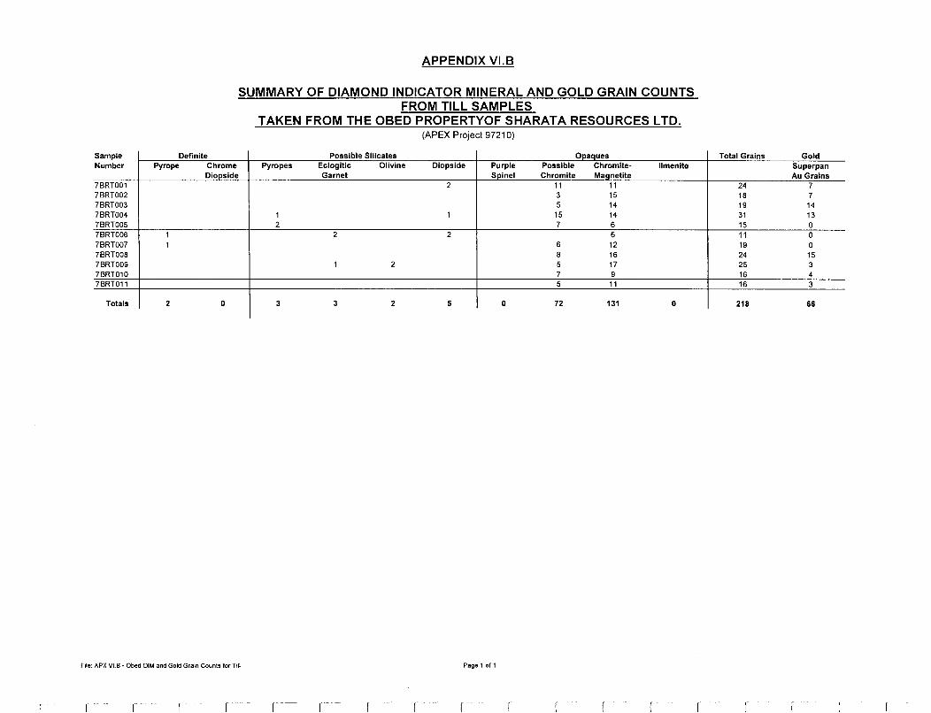
Sample Number
7BRT001 7BRT002 7BRT003 7BRT004 7BRT005 7BRT006 7BRT007 7BRT008 7BRT009 7BRT010 7BRT011
Totals
Definite Py rope Chrome
APPENDIX Vl.B
SUMMARY OF DIAMOND INDICATOR MINERAL AND GOLD GRAIN COUNTS FROM TILL SAMPLES
TAKEN FROM THE OBED PROPERTYOF SHARATA RESOURCES LTD. (APEX Project 97210)
Possible Silicates Opaques Pyropes Eclogitic Olivine Diopside Purple Possible Chromite- Ilmenite
Diopside Garnet Spin el Chromite Maanetite 2 11 11
3 15 5 14
1 1 15 14 2 7 6
1 2 2 6 1 6 12
8 16 1 2 5 17
7 9 5 11
2 D 3 3 2 5 D 72 131 D
File: APX Vl.B - Obed DIM and Gold Grain Counts for Till Page 1of1
r r f -- (
Total Grains Gold Superpan Au Grains
24 7 18 7 19 14 31 13 15 0 11 0 19 0 24 15 25 3 16 4 16 3
218 66
r r

APPENDIX VII
UNIVERSITY OF SASKATCHEWAN MICROPROBE ANALYSES AND
MIN-ID CLASSIFICATION OF PICKED OXIDE MINERAL GRAINS
VII.A - HEAVY MINERAL STREAM SEDIMENT SAMPLES
Vll.B - TILL SAMPLES


Sample Number I Grain I Mineral
File: APX Vll.A - HMSS OXIDE DIM CHEM
r
APPENDIX VII.A
UNIVERSITY OF SASKATCHEWAN MICROPROBE ANALYSES AND MIN-ID CLASSIFICATION OF PICKED OXIDE MINERAL GRAINS
FROM HEAVY MINERAL STREAM SEDIMENT SAMPLES (APEX Project 97210)
I Ti02 I Cr203 I FeO I MgO I CaO I Si02 I Al203 I MnO I NiO I Ni I ZnO I Zn I Total
Page 2 of 5
r - - r r

Sample Number I Grain I Mineral
File: APX VII.A - HMSS OXIDE DIM CHEM
APPENDIX VII.A
UNIVERSITY OF SASKATCHEWAN MICROPROBE ANALYSES AND MIN-ID CLASSIFICATION OF PICKED OXIDE MINERAL GRAINS
FROM HEAVY MINERAL STREAM SEDIMENT SAMPLES (APEX Project 97210)
wt% wt% wt% wt% wt% wt% wt% wt%
I Ti02 I Cr203 I FeO I MgO I Cao I Si02 I Al203 I MnO I
Page 3 of 5
wt% ppm wt% ppm
NiO I Ni I ZnO I Zn I Total

Sample Number I Grain I Mineral
File: APX VllA -HMSS OXIDE DIM CHEM
r - --
APPENDIX VII.A
UNIVERSITY OF SASKATCHEWAN MICROPROBE ANALYSES AND MIN-ID CLASSIFICATION OF PICKED OXIDE MINERAL GRAINS
FROM HEAVY MINERAL STREAM SEDIMENT SAMPLES (APEX Project 97210)
I Ti02 I Cr203 I FeO I MgO I CaO I Si02 I Al203 I MnO I NiO I Ni I ZnO I Zn I Total
Page 4 ofS
r r -
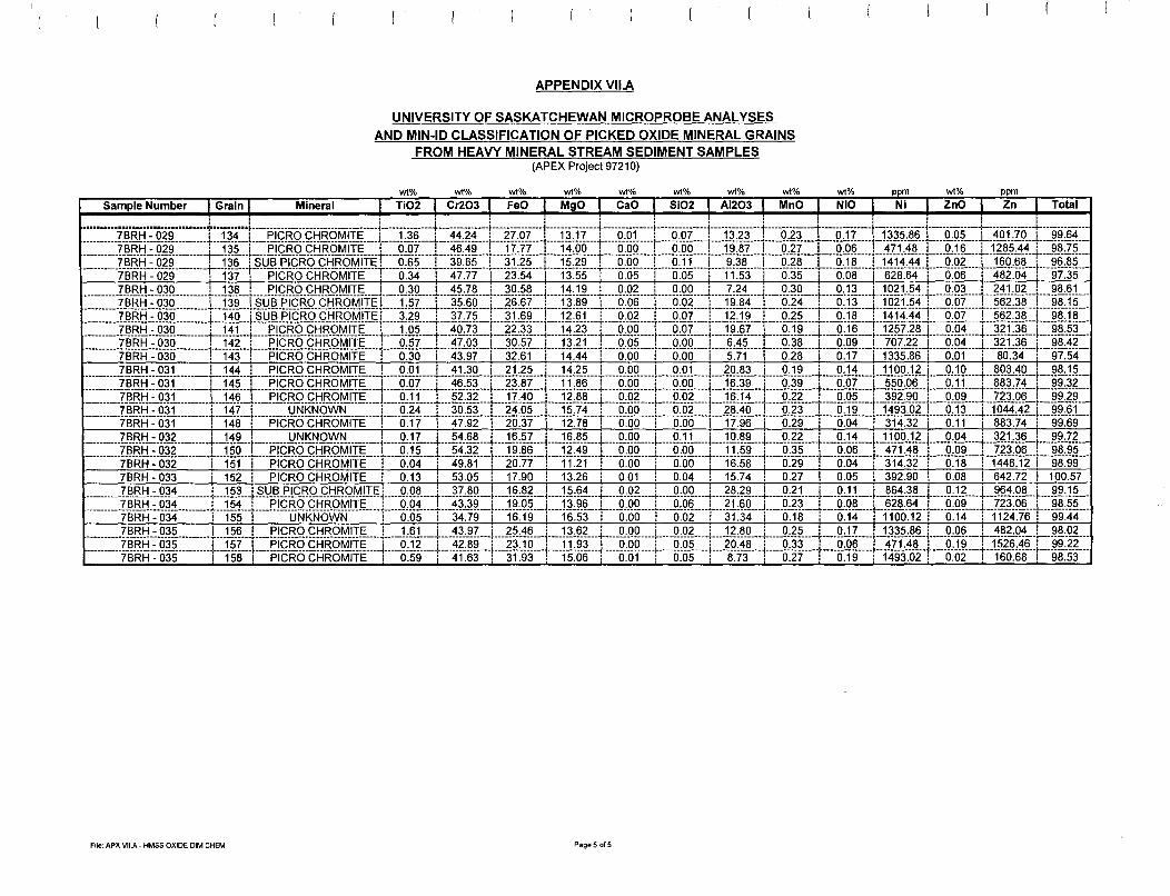
Sample Number I Grain I Mineral
File: APX VllA - HMSS OXIDE DIM CHEM
APPENDIX VII.A
UNIVERSITY OF SASKATCHEWAN MICROPROBE ANALYSES AND MIN-ID CLASSIFICATION OF PICKED OXIDE MINERAL GRAINS
FROM HEAVY MINERAL STREAM SEDIMENT SAMPLES (APEX Project 97210)
wt% wt% wt% wt% wt% wt% wt% wt%
I Ti02 I Cr203 I FeO I MgO I CaO I Si02 I Al203 I MnO I
Page5of5
wt% ppm wt% ppm
NiO I Ni I ZnO I Zn I Total
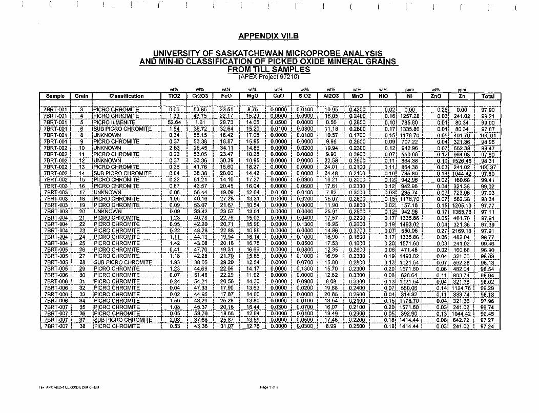
Sample I Grain I
File: APX Vll.B-TILL OXIDE DIM CHEM
APPENDIX Vll.B
UNIVERSITY OF SASKATCHEWAN MICROPROBE ANALYSIS AND MIN-ID CLASSIFICATION OF PICKED OXIDE MINERAL GRAINS
FROM TILL SAMPLES (APEX Project 97210)
Classification I Ti02 I Cr203 I FeO I MgO I Cao I Si02 I Al203 I MnO I NiO I Ni I ZnO I Zn I Total
Page 1 of 2

Sample I Grain I
File: APX Vll.B-TILL OXIDE DIM CHEM
APPENDIX Vll.B
UNIVERSITY OF SASKATCHEWAN MICROPROBE ANALYSIS AND MIN-ID CLASSIFICATION OF PICKED OXIDE MINERAL GRAINS
FROM TILL SAMPLES (APEX Project 97210)
~% ~% ~% ~% ~% ~% ~% ~% M% ppm ~% ppm
Classification I Ti02 I Cr203 I FeO I MgO I Cao I Si02 I Al203 I MnO I NiO I Ni I ZnO I Zn I Total
Page 2 of 2
r - r r r

APPENDIX VIII
UNIVERSITY OF SASKATCHEWAN MICROPROBE ANALYSES AND
MIN-ID CLASSIFICATION OF PICKED SILICATE MINERAL GRAINS
VIII.A - HEAVY MINERAL STREAM SEDIMENT SAMPLES
Vlll.B - TILL SAMPLES

File: APX VIII.A - HMSS SILICATE DIM CHEM
APPENDIX VIII.A
UNIVERSITY OF SASKATCHEWAN MICROPROBE ANALYSES AND AND MIN-ID CLASSIFICATION OF PICKED SILICATE MINERAL GRAINS
FROM HEAVY MINERAL STREAM SEDIMENT SAMPLES (APEX Project 97210)
Page 1 of 1

Sample Number I Grain I
APPENDIX Vlll.B
UNIVERSITY OF SASKATCHEWAN MICROPROBE ANALYSIS AND MIN-ID CLASSIFICATION OF PICKED SILICATE MINERAL GRAINS
FROM TILL SAMPLES (APEX Project 97210)
wt% wt% wt% wt% wt% wt% wt% wt% wt% wt% wt%
Mineral I Ti02 I Cr203 I FeO I MgO I CaO I Si02 I Al203 I Na20 I MnO I K20 I Total
-----------------------------------i------------i-------------------------------------------------------------------------i--------------+--------------l---------------i--------------1---------------i--------------j---------------i--------------+--------------1---------------i--------------7BRT004 : 5 :GROSSULAR : 0.86: 6.44: 3.14: 0.08: 35.01: 37.55: 14.51: 0.00: 0.27: 0.00: 97.85 7BRT005 : 3 :G 09 CHROME PYROPE : 0.32: 3.94: 7.53: 19.95: 5.04: 41.34: 20.90: 0.04: 0.35: 0.00: 99.43 7BRTOOS----------------------r-----4-----1G-cfri-ci=fROME-PYR-OPE-------------------------------------i--------0:1-5t--------5.-551--------T1oi-------19:4-51---------5~73t------4-rs-1r-----1-9~-23\·--------o:ost·-------o.-451 _________ o:oo-t ______ 99.-53 7BRT007 2 :G09CHROMEPYROPE 0.17: 5.74: 7.29: 19.36: 5.46: 41.35: 19.20: 0.06: 0.46: 0.00: 99.10 7BRT009 : 6 :UNKNOWN : 0.18: 0.02: 13.20: 0.02: 27.01: 37.87: 18.90: 0.01: 1.19: 0.00: 98.41 1-B"Rriio-s----------------------r-----r--1G"-os-f'ER._R_o_M".AGiiiE-~.-1A"r'fGR.ossu-CAR.--------------1--------a:aat ________ o~-aai-------12:1-a-r--------o-041-------22:s4t ______ 37:a-41 _______ 2i3st _______ a:a·1r-------o--s-11--------a:oal·----95:55 7-BRTiio-s----------------------r-----5-----1G-OS-FERRO-M-AGN_E_S_IAN-GR-OSSULAR--------------r--------o:oat ________ o~o2t-------13:;-.,-r-------·o-021-------2-2:s2r-------35:2-5r-----21~79t-------·a:a1t·-------o.-121--------o:ool-----94:00 7-BRT00-9----------------------r-----9·----1G-OS-FERR-O-MAGN_E_S_IAN-GROSSULAR--------------r--------0:02t--------o~-osi-------i2:6ii ________ o_o_i1-------2-2:93t-------35:9-3t------2rsai--------0:02t"-------o.-231"-------o:oot·---·-94.-53
File: APX Vlll.B -TILL SILICATE DIM CHEM Page 1of1
r r

APPENDIX IX
GOLD GRAIN DESCRIPTION REPORTS

Saskatchewan Research Council Geoanalytical Services 125-15 Innovation Blvd., Saskatoon, SK., S7N 2X8 Phone:306-933-5426 Fax:306-933-5656
47.11= ESTIMATED WEIGHT OF Au IN MICROGRAMS
M697 CHIN APEX NOVEMBER 21/97 (11) 1 GOLD GRAIN 2 GOLD GRAIN 3 GOLD GRAIN 4 GOLD GRAIN 5 GOLD GRAIN 6 GOLD GRAIN 7 GOLD GRAIN 8 GOLD GRAIN 9 GOLD GRAIN
WIDTH IN MICRONS LENGTH IN MICRONS DESCRIPTION WIDTH IN MICRONS LENGTH IN MICRONS DESCRIPTION WIDTH IN MICRONS LENGTH IN MICRONS DESCRIPTION
w L
40 80 80 140 80 100
120 120 120 120 120 200 280 300
D
A I I A A A A
[AU GRAIN COUNT] (7)7BRT 1

Saskatchewan Research Council Geoanalytical Services 125-15 Innovation Blvd., Saskatoon, SK., S7N 2X8 Phone:306-933-5426 Fax:306-933-5656
14.29= ESTIMATED WEIGHT OF Au IN MICROGRAMS
M697 CHIN APEX NOVEMBER 21/97 (11) [AU GRAIN COUNT] (7)7BRT 2 1 GOLD GRAIN WIDTH IN MICRONS 2 GOLD GRAIN LENGTH IN MICRONS 3 GOLD GRAIN DESCRIPTION 4 GOLD GRAIN WIDTH IN MICRONS 5 GOLD GRAIN LENGTH IN MICRONS 6 GOLD GRAIN DESCRIPTION 7 GOLD GRAIN WIDTH IN MICRONS 8 GOLD GRAIN LENGTH IN MICRONS 9 GOLD GRAIN DESCRIPTION
w L D
40 60 I 60 140 A/I 60 200 A/I 80 120 A
100 160 A
100 100 A 120 140 A
i L-
i L-
L
L
'~
' ~
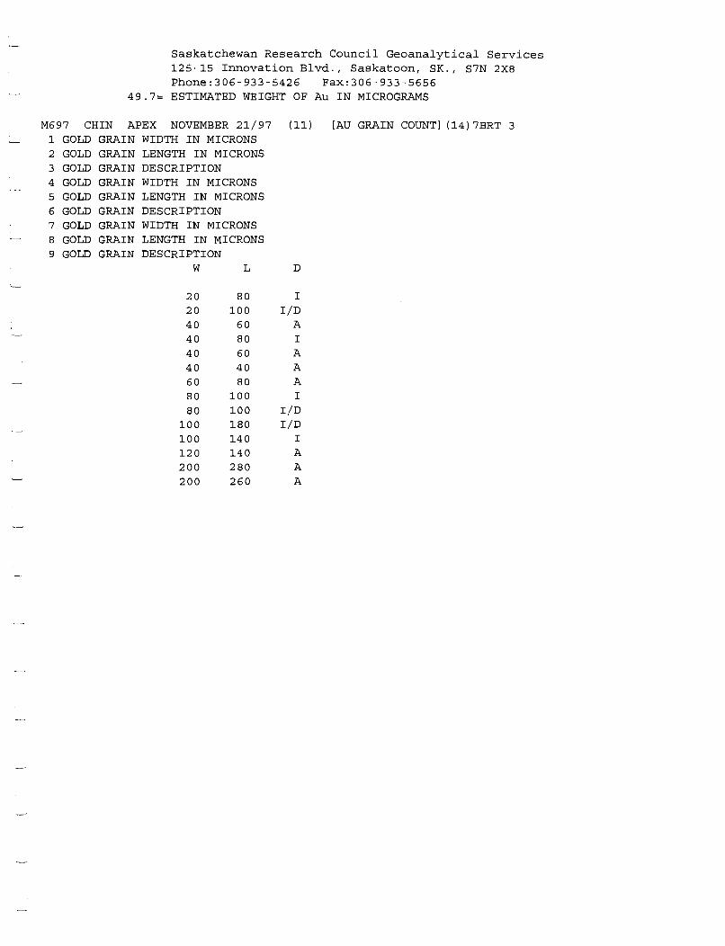
Saskatchewan Research Council Geoanalytical Services 125-15 Innovation Blvd., Saskatoon, SK., S7N 2X8 Phone:306-933-5426 Fax:306-933-5656
49.7= ESTIMATED WEIGHT OF Au IN MICROGRAMS
M697 CHIN APEX NOVEMBER 21/97 (11) [AU GRAIN COUNT] (14)7BRT 3 1 GOLD GRAIN 2 3 4 5 6 7 8 9
GOLD GOLD GOLD GOLD GOLD GOLD GOLD GOLD
GRAIN GRAIN GRAIN GRAIN GRAIN GRAIN GRAIN GRAIN
WIDTH IN MICRONS LENGTH IN MICRONS DESCRIPTION WIDTH IN MICRONS LENGTH IN MICRONS DESCRIPTION WIDTH IN MICRONS LENGTH IN MICRONS DESCRIPTION
w L D
20 80 I 20 100 I/D 40 60 A 40 80 I 40 60 A 40 40 A 60 80 A 80 100 I 80 100 I/D
100 180 I/D 100 140 I 120 140 A 200 280 A 200 260 A

Saskatchewan Research Council Geoanalytical Services 125-15 Innovation Blvd., Saskatoon, SK., S7N 2X8 Phone:306-933-5426 Fax:306-933-5656
12.87= ESTIMATED WEIGHT OF Au IN MICROGRAMS
M697 CHIN APEX NOVEMBER 21/97 (11) 1 GOLD GRAIN WIDTH IN MICRONS 2 GOLD GRAIN LENGTH IN MICRONS 3 GOLD GRAIN 4 GOLD GRAIN 5 GOLD GRAIN 6 GOLD GRAIN 7 GOLD GRAIN 8 GOLD GRAIN 9 GOLD GRAIN
DESCRIPTION WIDTH IN MICRONS LENGTH IN MICRONS DESCRIPTION WIDTH IN MICRONS LENGTH IN MICRONS DESCRIPTION
w L
20 60 20 80 20 60 20 20 40 120 40 40 40 40 60 60 60 140 80 100 80 80
100 120 160 160
D
I I
I/D D
I/D A A A
A/I A A A A
[AU GRAIN COUNT] (13)7BRT 4
L
L
I I '--
L
L
I
I
L
L
L

Saskatchewan Research Council Geoanalytical Services 125-15 Innovation Blvd., Saskatoon, SK., S7N 2X8 Phone:306-933-5426 Fax:306-933-5656
46.85= ESTIMATED WEIGHT OF Au IN MICROGRAMS
M697 CHIN APEX NOVEMBER 21/97 (11) [AU GRAIN COUNT] (15)7BRT 8 1 GOLD GRAIN WIDTH IN MICRONS 2 GOLD GRAIN LENGTH IN MICRONS 3 GOLD GRAIN DESCRIPTION 4 GOLD GRAIN WIDTH IN MICRONS 5 GOLD GRAIN LENGTH IN MICRONS 6 GOLD GRAIN DESCRIPTION 7 GOLD GRAIN WIDTH IN MICRONS 8 GOLD GRAIN LENGTH IN MICRONS 9 GOLD GRAIN DESCRIPTION
w L D
20 40 A 40 80 A 40 80 A 40 40 A 60 80 A 60 80 A 60 120 A 80 180 A/I 80 180 A 80 80 A/I
120 220 A/I 120 140 A 140 160 A 160 200 A 160 260 A

Saskatchewan Research Council Geoanalytical Services 125-15 Innovation Blvd., Saskatoon, SK., S7N 2X8 Phone:306-933-5426 Fax:306-933-5656
12.28= ESTIMATED WEIGHT OF Au IN MICROGRAMS
M697 CHIN APEX NOVEMBER 21/97 (11) [AU GRAIN COUNT] {3)7BRT 9 1 GOLD GRAIN WIDTH IN MICRONS 2 GOLD GRAIN LENGTH IN MICRONS 3 GOLD GRAIN DESCRIPTION 4 GOLD GRAIN WIDTH IN MICRONS 5 GOLD GRAIN LENGTH IN MICRONS 6 GOLD GRAIN DESCRIPTION 7 GOLD GRAIN WIDTH IN MICRONS 8 GOLD GRAIN LENGTH IN MICRONS 9 GOLD GRAIN DESCRIPTION
w L D
60 60 A 100 220 A 100 220 A
L
'~
' '-
L
L

Saskatchewan Research Council Geoanalytical Services 125-15 Innovation Blvd., Saskatoon, SK., S7N 2X8 Phone:306-933-5426 Fax:306-933-5656
5.7= ESTIMATED WEIGHT OF Au IN MICROGRAMS
M697 CHIN APEX NOVEMBER 21/97 (11) [AU GRAIN COUNT] (4)7BRT 10 1 GOLD GRAIN WIDTH IN MICRONS 2 GOLD GRAIN LENGTH IN MICRONS 3 GOLD GRAIN DESCRIPTION 4 GOLD GRAIN WIDTH IN MICRONS 5 GOLD GRAIN LENGTH IN MICRONS 6 GOLD GRAIN DESCRIPTION 7 GOLD GRAIN WIDTH IN MICRONS 8 GOLD GRAIN LENGTH IN MICRONS 9 GOLD GRAIN DESCRIPTION
w L D
60 60 A 60 100 A
100 160 A/I 100 100 A

Saskatchewan Research Council Geoanalytical Services 125-15 Innovation Blvd., Saskatoon, SK., S7N 2X8 Phone:306-933-5426 Fax:306-933-5656
5.35= ESTIMATED WEIGHT OF Au IN MICROGRAMS
M697 CHIN APEX NOVEMBER 21/97 (11) [AU GRAIN COUNT] (3)7BRT 11 1 GOLD GRAIN WIDTH IN MICRONS 2 GOLD GRAIN LENGTH IN MICRONS 3 GOLD GRAIN DESCRIPTION 4 GOLD GRAIN WIDTH IN MICRONS 5 GOLD GRAIN LENGTH IN MICRONS 6 GOLD GRAIN DESCRIPTION 7 GOLD GRAIN WIDTH IN MICRONS 8 GOLD GRAIN LENGTH IN MICRONS 9 GOLD GRAIN DESCRIPTION
w L D
40 40 A 40 80 A
100 200 A/I
\ '-
I
'~
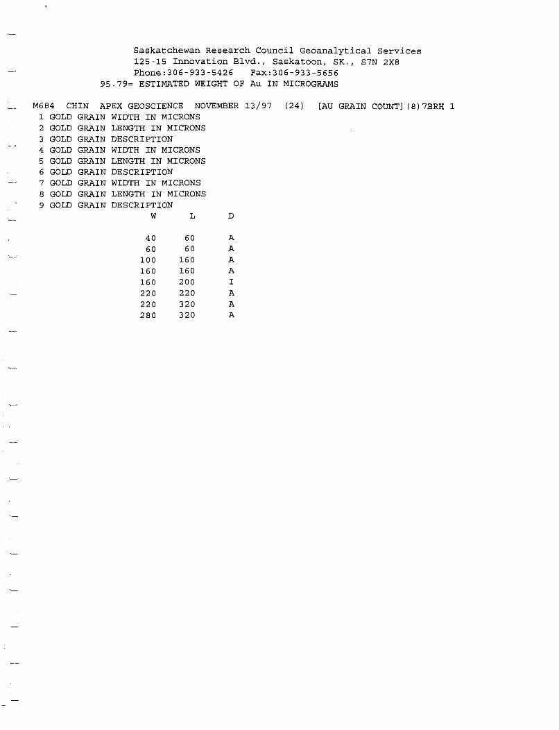
Saskatchewan Research Council Geoanalytical Services 125-15 Innovation Blvd., Saskatoon, SK., S7N 2X8 Phone:306-933-5426 Fax:306-933-5656
95.79= ESTIMATED WEIGHT OF Au IN MICROGRAMS
M684 CHIN APEX GEOSCIENCE NOVEMBER 13/97 (24) 1 GOLD GRAIN 2
3 4
5 6 7
8
9
GOLD GOLD GOLD GOLD GOLD GOLD GOLD GOLD
GRAIN GRAIN GRAIN GRAIN GRAIN GRAIN GRAIN GRAIN
WIDTH IN MICRONS LENGTH IN MICRONS DESCRIPTION WIDTH IN MICRONS LENGTH IN MICRONS DESCRIPTION WIDTH IN MICRONS LENGTH IN MICRONS DESCRIPTION
w L D
40 60 A 60 60 A
100 160 A 160 160 A 160 200 I 220 220 A 220 320 A 280 320 A
[AU GRAIN COUNT] (8)7BRH 1
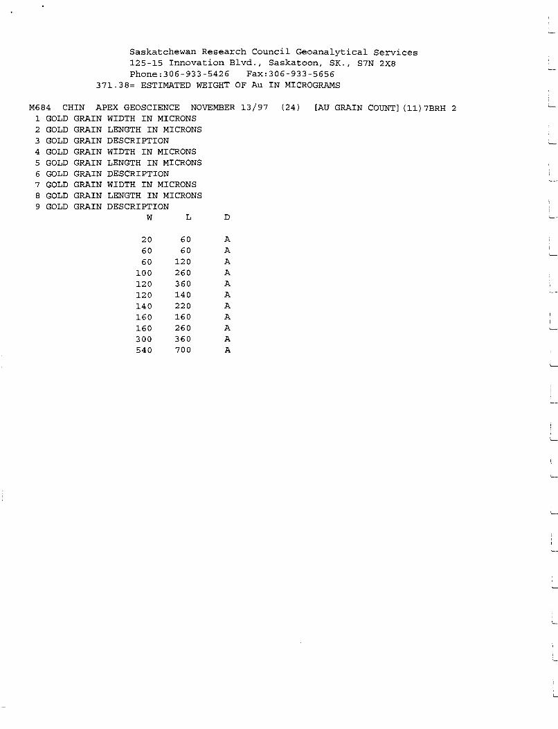
Saskatchewan Research Council Geoanalytical Services 125-15 Innovation Blvd., Saskatoon, SK., S7N 2X8 Phone:306-933-5426 Fax:306-933-5656
371.38= ESTIMATED WEIGHT OF Au IN MICROGRAMS
M684 CHIN APEX GEOSCIENCE NOVEMBER 13/97 (24) [AU GRAIN COUNT] (11)7BRH 2 1 GOLD GRAIN WIDTH IN MICRONS 2 GOLD GRAIN LENGTH IN MICRONS 3 GOLD GRAIN DESCRIPTION 4 GOLD GRAIN WIDTH IN MICRONS 5 GOLD GRAIN LENGTH IN MICRONS 6 GOLD GRAIN DESCRIPTION 7 GOLD GRAIN WIDTH IN MICRONS 8 GOLD GRAIN LENGTH IN MICRONS 9 GOLD GRAIN DESCRIPTION
w L D
20 60 A 60 60 A 60 120 A
100 260 A 120 360 A 120 140 A 140 220 A 160 160 A 160 260 A 300 360 A 540 700 A
I L-
I I
L-
L-
L

Saskatchewan Research Council Geoanalytical Services 125-15 Innovation Blvd., Saskatoon, SK., S7N 2X8 Phone:306-933-5426 Fax:306-933-5656
821.24= ESTIMATED WEIGHT OF Au IN MICROGRAMS
M684 CHIN APEX GEOSCIENCE NOVEMBER 13/97 (24) [AU GRAIN COUNT] (21)7BRH 3 1 GOLD GRAIN WIDTH IN MICRONS 2 GOLD GRAIN LENGTH IN MICRONS 3 GOLD GRAIN DESCRIPTION 4 GOLD GRAIN WIDTH IN MICRONS 5 GOLD GRAIN LENGTH IN MICRONS 6 GOLD GRAIN DESCRIPTION 7 GOLD GRAIN WIDTH IN MICRONS 8 GOLD GRAIN LENGTH IN MICRONS 9 GOLD GRAIN DESCRIPTION
w L D
40 140 A 60 120 A
100 100 A 120 140 A 120 140 A 120 160 A 140 160 A 160 200 A/I 160 240 A 200 200 A/I 200 300 A 200 220 A/I 200 260 A 220 260 A 240 240 A 240 380 A 240 240 A 300 400 A 300 400 A 300 460 A 520 1000 A

Saskatchewan Research Council Geoanalytical Services 125-15 Innovation Blvd., Saskatoon, SK., S7N 2X8 Phone:306-933-5426 Fax:306-933-5656
312.46= ESTIMATED WEIGHT OF Au IN MICROGRAMS
M684 CHIN APEX GEOSCIENCE NOVEMBER 13/97 (24) [AU GRAIN COUNT] (26)7BRH 4 1 GOLD GRAIN WIDTH IN MICRONS 2 GOLD GRAIN LENGTH IN MICRONS 3 GOLD GRAIN DESCRIPTION 4 GOLD GRAIN WIDTH IN MICRONS 5 GOLD GRAIN LENGTH IN MICRONS 6 GOLD GRAIN DESCRIPTION 7 GOLD GRAIN WIDTH IN MICRONS 8 GOLD GRAIN LENGTH IN MICRONS 9 GOLD GRAIN DESCRIPTION
w L D
40 80 A 40 100 A 40 60 A 60 60 A 80 120 A 80 140 A
100 140 A 100 140 A 100 220 A 120 200 A 120 200 A 120 120 A 120 220 A 120 160 A 140 220 A 140 140 A 140 160 A 160 300 A 160 300 A 160 180 A 160 220 A 160 340 A 200 280 A 200 300 A 300 480 A 340 400 A/I
I I
I L

>"~-..
Saskatchewan Research Council Geoanalytical Services 125-15 Innovation Blvd., Saskatoon, SK., S7N 2X8 Phone:306-933-5426 Fax:306-933-5656
134.6= ESTIMATED WEIGHT OF Au IN MICROGRAMS
M684 CHIN APEX GEOSCIENCE NOVEMBER 13/97 (24) [AU GRAIN COUNT] {7)7BRH 5 1 GOLD GRAIN WIDTH IN MICRONS 2 GOLD GRAIN LENGTH IN MICRONS 3 GOLD GRAIN DESCRIPTION 4 GOLD GRAIN WIDTH IN MICRONS 5 GOLD GRAIN LENGTH IN MICRONS 6 GOLD GRAIN DESCRIPTION 7 GOLD GRAIN WIDTH IN MICRONS 8 GOLD GRAIN LENGTH IN MICRONS 9 GOLD GRAIN DESCRIPTION
w L D
100 100 A 120 120 A 180 180 A 220 280 A 240 260 A 280 360 A 300 300 A

REPORT
78.11= ESTIMATED WEIGHT OF Au IN MICROGRAMS
M482 DUFRESNE APEX GEOSCIENCE AUG. 14/97 (11) [AU GRAIN COUNT] (2)7BRH 6 1 GOLD GRAIN WIDTH IN MICRONS 2 GOLD GRAIN LENGTH IN MICRONS 3 GOLD GRAIN DESCRIPTION 4 GOLD GRAIN WIDTH IN MICRONS 5 GOLD GRAIN LENGTH IN MICRONS 6 GOLD GRAIN DESCRIPTION 7 GOLD GRAIN WIDTH IN MICRONS 8 GOLD GRAIN LENGTH IN MICRONS 9 GOLD GRAIN DESCRIPTION
w L D
140 280 A 280 460 A
·--

REPORT
12.78= ESTIMATED WEIGHT OF Au IN MICROGRAMS
M482 DUFRESNE APEX GEOSCIENCE AUG. 14/97 (11) [AU GRAIN COUNT] (5)7BRH 7 1 GOLD GRAIN WIDTH IN MICRONS 2 GOLD GRAIN LENGTH IN MICRONS 3 GOLD GRAIN DESCRIPTION 4 GOLD GRAIN WIDTH IN MICRONS 5 GOLD GRAIN LENGTH IN MICRONS 6 GOLD GRAIN DESCRIPTION 7 GOLD GRAIN WIDTH IN MICRONS 8 GOLD GRAIN LENGTH IN MICRONS 9 GOLD GRAIN DESCRIPTION
w L D
60 180 A 60 180 I/A 60 120 I 80 200 A/I
100 140 A/I

REPORT
6.61= ESTIMATED WEIGHT OF Au IN MICROGRAMS
M482 DUFRESNE 1 GOLD GRAIN 2 GOLD GRAIN 3 GOLD GRAIN 4 GOLD GRAIN 5 GOLD GRAIN 6 GOLD GRAIN 7 GOLD GRAIN 8 GOLD GRAIN 9 GOLD GRAIN
APEX GEOSCIENCE WIDTH IN MICRONS LENGTH IN MICRONS DESCRIPTION WIDTH IN MICRONS LENGTH IN MICRONS DESCRIPTION WIDTH IN MICRONS LENGTH IN MICRONS DESCRIPTION
w
20 40 60
100
L
20 100 160 180
AUG.
D
A
A
I/A A/I
14/97 (11) [AU GRAIN COUNT] (4)7BRH 8
'~
l
L
I \...__

Saskatchewan Research Council Geoanalytical Services 125-15 Innovation Blvd., Saskatoon, SK., S7N 2X8 Phone:306-933-5426 Fax:306-933-5656
150.3= ESTIMATED WEIGHT OF Au IN MICROGRAMS
M684 CHIN APEX GEOSCIENCE NOVEMBER 13/97 (24) [AU GRAIN COUNT] (13)7BRH 9 1 GOLD GRAIN WIDTH IN MICRONS 2 GOLD GRAIN LENGTH IN MICRONS 3 GOLD GRAIN DESCRIPTION 4 GOLD GRAIN WIDTH IN MICRONS 5 GOLD GRAIN LENGTH IN MICRONS 6 GOLD GRAIN DESCRIPTION 7 GOLD GRAIN WIDTH IN MICRONS 8 GOLD GRAIN LENGTH IN MICRONS 9 GOLD GRAIN DESCRIPTION
w L D
20 20 I 40 60 A/I 80 100 A 80 100 I
100 280 A 120 220 A 120 260 I 120 220 A 140 300 A/I 140 140 A 180 200 I 200 240 A 300 460 I

Saskatchewan Research Council Geoanalytical Services 125-15 Innovation Blvd., Saskatoon, SK., S7N 2X8 Phone:306-933-5426 Fax:306-933-5656
59.23= ESTIMATED WEIGHT OF Au IN MICROGRAMS
M684 CHIN APEX GEOSCIENCE NOVEMBER 13/97 (24) 1 GOLD GRAIN WIDTH IN MICRONS
[AU GRAIN COUNT] (12)7BRH 10
2 GOLD GRAIN LENGTH IN MICRONS 3 GOLD GRAIN DESCRIPTION 4 GOLD GRAIN WIDTH IN MICRONS 5 GOLD GRAIN LENGTH IN MICRONS 6 GOLD GRAIN DESCRIPTION 7 GOLD GRAIN WIDTH IN MICRONS 8 GOLD GRAIN LENGTH IN MICRONS 9 GOLD GRAIN DESCRIPTION
w L D
40 40 A 40 40 A 40 80 A 60 80 A
100 140 A 100 180 A 100 120 A 100 140 A 100 200 I 120 160 A 140 260 A 220 320 A
I
'-
L

'-.___,
Saskatchewan Research Council Geoanalytical Services 125-15 Innovation Blvd., Saskatoon, SK., S7N 2X8 Phone:306-933-5426 Fax:306-933-5656
604.46= ESTIMATED WEIGHT OF Au IN MICROGRAMS
M684 CHIN APEX GEOSCIENCE NOVEMBER 13/97 (24) [AU GRAIN COUNT] (14)7BRH 11 1 GOLD GRAIN WIDTH IN MICRONS 2 GOLD GRAIN LENGTH IN MICRONS 3 GOLD GRAIN DESCRIPTION 4 GOLD GRAIN WIDTH IN MICRONS 5 GOLD GRAIN LENGTH IN MICRONS 6 GOLD GRAIN DESCRIPTION 7 GOLD GRAIN WIDTH IN MICRONS 8 GOLD GRAIN LENGTH IN MICRONS 9 GOLD GRAIN DESCRIPTION
w L D
20 20 A 40 40 A 60 120 I
120 160 A 120 120 A 120 180 A/I 120 160 A 240 240 A 280 280 A 300 400 A 300 480 A 360 520 I 400 540 A 460 600 A
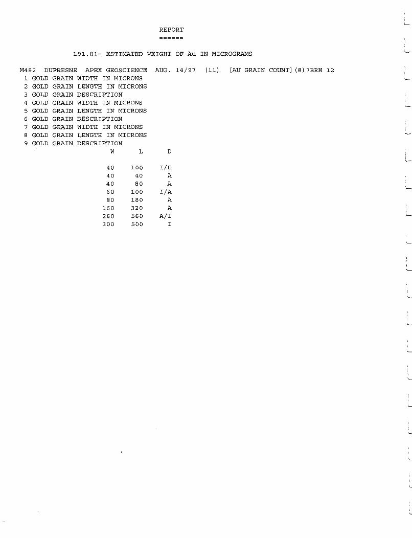
REPORT
======
191.81= ESTIMATED WEIGHT OF Au IN MICROGRAMS
M482 DUFRESNE APEX GEOSCIENCE AUG. 14/97 (11) [AU GRAIN COUNT] (8)7BRH 12 1 GOLD GRAIN WIDTH IN MICRONS 2 GOLD GRAIN LENGTH IN MICRONS 3 GOLD GRAIN DESCRIPTION 4 GOLD GRAIN WIDTH IN MICRONS 5 GOLD GRAIN LENGTH IN MICRONS 6 GOLD GRAIN DESCRIPTION 7 GOLD GRAIN WIDTH IN MICRONS 8 GOLD GRAIN LENGTH IN MICRONS 9 GOLD GRAIN DESCRIPTION
w L D
40 100 I/D 40 40 A 40 80 A 60 100 I/A 80 180 A
160 320 A 260 560 A/I 300 500 I

Saskatchewan Research Council Geoanalytical Services 125-15 Innovation Blvd., Saskatoon, SK., S7N 2X8 Phone:306-933-5426 Fax:306-933-5656
83.88= ESTIMATED WEIGHT OF Au IN MICROGRAMS
M684 CHIN APEX GEOSCIENCE NOVEMBER 13/97 (24) [AU GRAIN COUNT] (5)7BRH 13 1 GOLD GRAIN WIDTH IN MICRONS 2 GOLD GRAIN LENGTH IN MICRONS 3 GOLD GRAIN DESCRIPTION 4 GOLD GRAIN WIDTH IN MICRONS 5 GOLD GRAIN LENGTH IN MICRONS 6 GOLD GRAIN DESCRIPTION 7 GOLD GRAIN WIDTH IN MICRONS 8 GOLD GRAIN LENGTH IN MICRONS 9 GOLD GRAIN DESCRIPTION
w L D
20 20 A 80 120 A
120 220 A 140 300 A/I 300 420 A

Saskatchewan Research Council Geoanalytical Services 125-15 Innovation Blvd., Saskatoon, SK., S7N 2X8 Phone:306-933-5426 Fax:306-933-5656
.28= ESTIMATED WEIGHT OF Au IN MICROGRAMS
M684 CHIN APEX GEOSCIENCE NOVEMBER 13/97 (24) [AU GRAIN COUNT] {1)7BRH 14 1 GOLD GRAIN WIDTH IN MICRONS 2 GOLD GRAIN LENGTH IN MICRONS 3 GOLD GRAIN DESCRIPTION 4 GOLD GRAIN WIDTH IN MICRONS 5 GOLD GRAIN LENGTH IN MICRONS 6 GOLD GRAIN DESCRIPTION 7 GOLD GRAIN WIDTH IN MICRONS 8 GOLD GRAIN LENGTH IN MICRONS 9 GOLD GRAIN DESCRIPTION
w L D
40 80 A
I l-
i I l-

Saskatchewan Research Council Geoanalytical Services 125-15 Innovation Blvd., Saskatoon, SK., S7N 2X8 Phone:306-933-5426 Fax:306-933-5656
2.84= ESTIMATED WEIGHT OF Au IN MICROGRAMS
M684 CHIN APEX GEOSCIENCE NOVEMBER 13/97 (24) [AU GRAIN COUNT] (2)7BRH 15 1 GOLD GRAIN WIDTH IN MICRONS 2 GOLD GRAIN LENGTH IN MICRONS 3 GOLD GRAIN DESCRIPTION 4 GOLD GRAIN WIDTH IN MICRONS 5 GOLD GRAIN LENGTH IN MICRONS 6 GOLD GRAIN DESCRIPTION 7 GOLD GRAIN WIDTH IN MICRONS 8 GOLD GRAIN LENGTH IN MICRONS 9 GOLD GRAIN DESCRIPTION
w L D
60 60 A 100 140 A

Saskatchewan Research Council Geoanalytical Services 125-15 Innovation Blvd., Saskatoon, SK., S7N 2X8 Phone:306-933-5426 Fax:306-933-5656
57.14= ESTIMATED WEIGHT OF Au IN MICROGRAMS
M684 CHIN APEX GEOSCIENCE NOVEMBER 13/97 (24) [AU GRAIN COUNT] (8)7BRH 16 1 GOLD GRAIN WIDTH IN MICRONS 2 GOLD GRAIN LENGTH IN MICRONS 3 GOLD GRAIN DESCRIPTION 4 GOLD GRAIN WIDTH IN MICRONS 5 GOLD GRAIN LENGTH IN MICRONS 6 GOLD GRAIN DESCRIPTION 7 GOLD GRAIN WIDTH IN MICRONS 8 GOLD GRAIN LENGTH IN MICRONS 9 GOLD GRAIN DESCRIPTION
w L D
60 100 A 60 80 A 80 220 A/I 80 140 A/I
100 220 A 140 220 A 160 260 A 240 260 A
L
i I
L_

Saskatchewan Research Council Geoanalytical Services 125-15 Innovation Blvd., Saskatoon, SK., S7N 2X8 Phone:306-933-5426 Fax:306-933-5656
95.90= ESTIMATED WEIGHT OF Au IN MICROGRAMS
M684 CHIN APEX GEOSCIENCE NOVEMBER 13/97 (24) [AU GRAIN COUNT] (7)7BRH 17 1 GOLD GRAIN WIDTH IN MICRONS 2 GOLD GRAIN LENGTH IN MICRONS 3 GOLD GRAIN DESCRIPTION 4 GOLD GRAIN WIDTH IN MICRONS 5 GOLD GRAIN LENGTH IN MICRONS 6 GOLD GRAIN DESCRIPTION 7 GOLD GRAIN WIDTH IN MICRONS 8 GOLD GRAIN LENGTH IN MICRONS 9 GOLD GRAIN DESCRIPTION
w L D
40 60 A 60 80 A
100 140 A 140 200 I 160 200 A 220 240 A 320 400 I

REPORT
58.26= ESTIMATED WEIGHT OF Au IN MICROGRAMS
M482 DUFRESNE APEX GEOSCIENCE AUG. 14/97 (11) [AU GRAIN 1 GOLD GRAIN WIDTH IN MICRONS 2 GOLD GRAIN LENGTH IN MICRONS 3 GOLD GRAIN DESCRIPTION 4 GOLD GRAIN WIDTH IN MICRONS 5 GOLD GRAIN LENGTH IN MICRONS 6 GOLD GRAIN DESCRIPTION 7 GOLD GRAIN WIDTH IN MICRONS 8 GOLD GRAIN LENGTH IN MICRONS 9 GOLD GRAIN DESCRIPTION
w L D
20 20 A 20 40 A 60 140 I/A 80 120 I
100 100 I/A 180 340 I/A 180 380 A/I
COUNT] (7)7BRH 18 i ~
I ~
i L
I L-
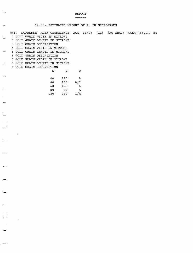
REPORT
12.78= ESTIMATED WEIGHT OF Au IN MICROGRAMS
M482 DUFRESNE APEX GEOSCIENCE AUG. 14/97 (11) [AU GRAIN COUNT] (5)7BRH 20 1 GOLD GRAIN WIDTH IN MICRONS 2 GOLD GRAIN LENGTH IN MICRONS 3 GOLD GRAIN DESCRIPTION 4 GOLD GRAIN WIDTH IN MICRONS 5 GOLD GRAIN LENGTH IN MICRONS 6 GOLD GRAIN DESCRIPTION 7 GOLD GRAIN WIDTH IN MICRONS 8 GOLD GRAIN LENGTH IN MICRONS 9 GOLD GRAIN DESCRIPTION
w L D
·-· 40 120 A 40 100 A/I 60 120 A 80 80 A
120 260 I/A
·~
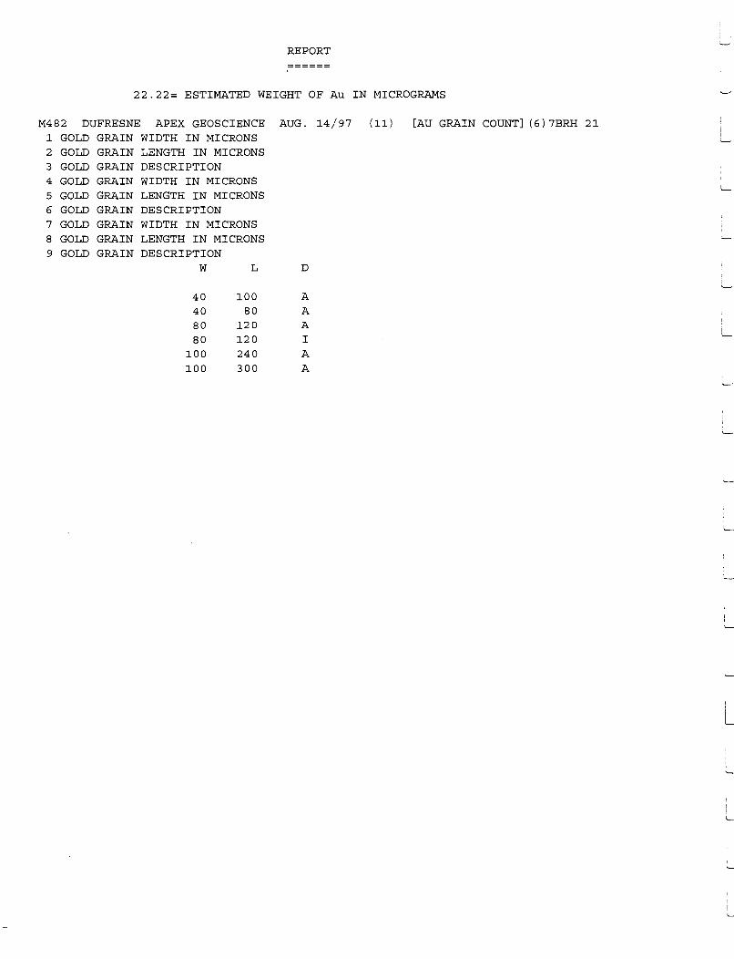
REPORT
22.22= ESTIMATED WEIGHT OF Au IN MICROGRAMS
M482 DUFRESNE APEX GEOSCIENCE AUG. 14/97 (11) [AU GRAIN COUNT] (6)7BRH 21 1 GOLD GRAIN WIDTH IN MICRONS 2 GOLD GRAIN LENGTH IN MICRONS 3 GOLD GRAIN DESCRIPTION 4 GOLD GRAIN WIDTH IN MICRONS 5 GOLD GRAIN LENGTH IN MICRONS 6 GOLD GRAIN DESCRIPTION 7 GOLD GRAIN WIDTH IN MICRONS 8 GOLD GRAIN LENGTH IN MICRONS 9 GOLD GRAIN DESCRIPTION
w L D
40 100 A 40 80 A 80 120 A i
'
80 120 I l__
100 240 A 100 300 A
,_
I L.
I '--

Saskatchewan Research Council Geoanalytical Services 125-15 Innovation Blvd., Saskatoon, SK., S7N 2X8 Phone:306-933-5426 Fax:306-933-5656
61.39= ESTIMATED WEIGHT OF Au IN MICROGRAMS
M684 CHIN APEX GEOSCIENCE NOVEMBER 13/97 (24) 1 GOLD GRAIN 2 GOLD GRAIN 3 GOLD GRAIN 4 GOLD GRAIN 5 GOLD GRAIN 6 GOLD GRAIN 7 GOLD GRAIN 8 GOLD GRAIN 9 GOLD GRAIN
WIDTH IN MICRONS LENGTH IN MICRONS DESCRIPTION WIDTH IN MICRONS LENGTH IN MICRONS DESCRIPTION WIDTH IN MICRONS LENGTH IN MICRONS DESCRIPTION
w L
100 120 220 320 240 340
D
A A A
[AU GRAIN COUNT] (3)7BRH 22

Saskatchewan Research Council Geoanalytical Services 125-15 Innovation Blvd., Saskatoon, SK., S7N 2X8 Phone:306-933-5426 Fax:306-933-5656
9.68= ESTIMATED WEIGHT OF Au IN MICROGRAMS
M684 CHIN APEX GEOSCIENCE NOVEMBER 13/97 (24) [AU GRAIN COUNT] (5)7BRH 23 1 GOLD GRAIN WIDTH IN MICRONS 2 GOLD GRAIN LENGTH IN MICRONS 3 GOLD GRAIN DESCRIPTION 4 GOLD GRAIN WIDTH IN MICRONS 5 GOLD GRAIN LENGTH IN MICRONS 6 GOLD GRAIN DESCRIPTION 7 GOLD GRAIN WIDTH IN MICRONS 8 GOLD GRAIN LENGTH IN MICRONS 9 GOLD GRAIN DESCRIPTION
w L D
40 40 A 40 40 A/I 60 80 A/I
120 160 A 140 160 A
L
L
I
L
i L...
I
I L
I l.__
i L

REPORT
======
67.26= ESTIMATED WEIGHT OF Au IN MICROGRAMS
M482 DUFRESNE APEX GEOSCIENCE AUG. 14/97 (11) [AU GRAIN COUNT] (13) 7BRH 29 1 GOLD GRAIN WIDTH IN MICRONS 2 GOLD GRAIN LENGTH IN MICRONS 3 GOLD GRAIN DESCRIPTION 4 GOLD GRAIN WIDTH IN MICRONS 5 GOLD GRAIN LENGTH IN MICRONS 6 GOLD GRAIN DESCRIPTION 7 GOLD GRAIN WIDTH IN MICRONS 8 GOLD GRAIN LENGTH IN MICRONS 9 GOLD GRAIN DESCRIPTION
w L D
40 80 A 60 100 A/I 60 100 A 60 120 A 60 80 I/A 80 140 A 80 200 A
100 180 A/I 100 260 I 100 220 A 120 180 A 120 180 I/A 220 340 A/I

Saskatchewan Research Council Geoanalytical Services 125-15 Innovation Blvd., Saskatoon, SK., S7N 2X8 Phone:306-933-5426 Fax:306-933-5656
66.98= ESTIMATED WEIGHT OF Au IN MICROGRAMS
M684 CHIN APEX GEOSCIENCE NOVEMBER 13/97 (24) [AU GRAIN COUNT] (2)7BRH 24 1 GOLD GRAIN WIDTH IN MICRONS 2 GOLD GRAIN LENGTH IN MICRONS 3 GOLD GRAIN DESCRIPTION 4 GOLD GRAIN WIDTH IN MICRONS 5 GOLD GRAIN LENGTH IN MICRONS 6 GOLD GRAIN DESCRIPTION 7 GOLD GRAIN WIDTH IN MICRONS 8 GOLD GRAIN LENGTH IN MICRONS 9 GOLD GRAIN DESCRIPTION
w L D
200 200 A 300 400 A
I
L
i I
L
i L...
L
L
I I
L
1
'---
I
L

Saskatchewan Research Council Geoanalytical Services 125-15 Innovation Blvd., Saskatoon, SK., S7N 2X8 Phone:306-933-5426 Fax:306-933-5656
351.11= ESTIMATED WEIGHT OF Au IN MICROGRAMS
M684 CHIN APEX GEOSCIENCE NOVEMBER 13/97 (24) [AU GRAIN COUNT] (4)7BRH 25 1 GOLD GRAIN WIDTH IN MICRONS 2 GOLD GRAIN LENGTH IN MICRONS 3 GOLD GRAIN DESCRIPTION 4 GOLD GRAIN WIDTH IN MICRONS 5 GOLD GRAIN LENGTH IN MICRONS 6 GOLD GRAIN DESCRIPTION 7 GOLD GRAIN WIDTH IN MICRONS 8 GOLD GRAIN LENGTH IN MICRONS 9 GOLD GRAIN DESCRIPTION
w L D
80 140 A 140 200 A 140 200 A 500 860 I
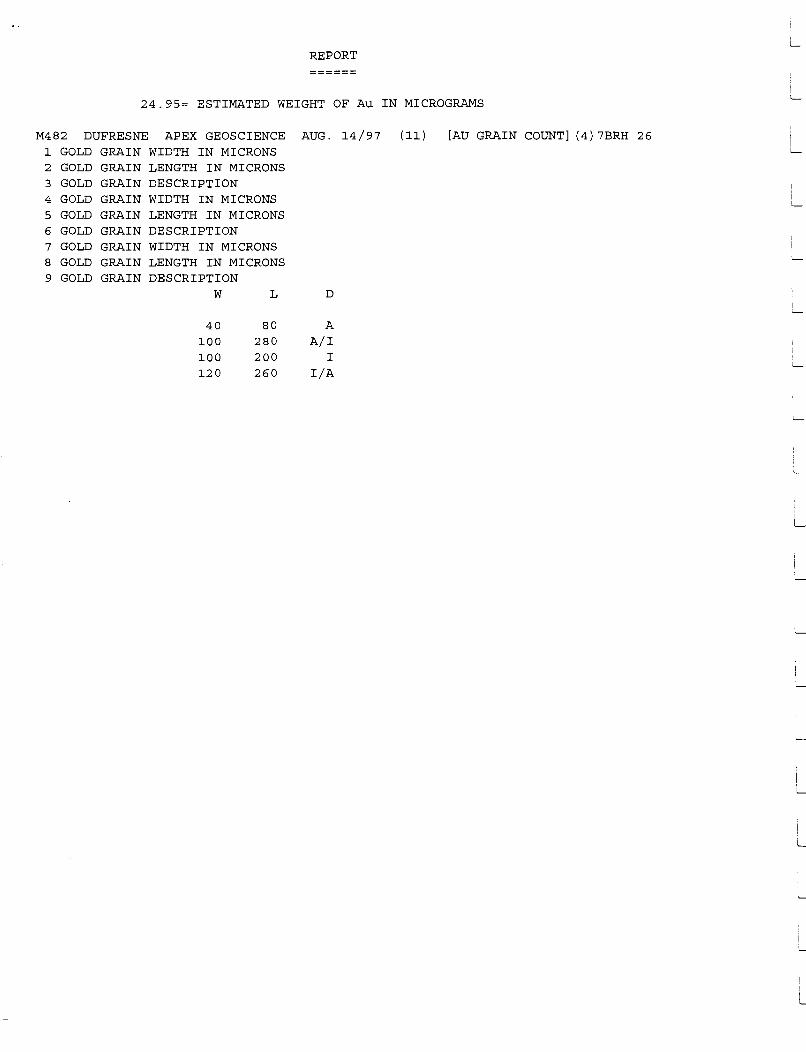
REPORT
======
24.95= ESTIMATED WEIGHT OF Au IN MICROGRAMS
M482 DUFRESNE 1 GOLD GRAIN 2 GOLD GRAIN 3 GOLD GRAIN 4 GOLD GRAIN 5 GOLD GRAIN 6 GOLD GRAIN 7 GOLD GRAIN 8 GOLD GRAIN 9 GOLD GRAIN
APEX GEOSCIENCE WIDTH IN MICRONS LENGTH IN MICRONS DESCRIPTION WIDTH IN MICRONS LENGTH IN MICRONS DESCRIPTION WIDTH IN MICRONS LENGTH IN MICRONS DESCRIPTION
w
40 100 100 120
L
80 280 200 260
AUG.
D
A
A/I I
I/A
14/97 (11) [AU GRAIN COUNT] (4) 7BRH 26
L
I L_
L
i L
! I L
L
L
L

Saskatchewan Research Council Geoanalytical Services 125-15 Innovation Blvd., Saskatoon, SK., S7N 2X8 Phone:306-933-5426 Fax:306-933-5656
136.2= ESTIMATED WEIGHT OF Au IN MICROGRAMS
M684 CHIN APEX GEOSCIENCE NOVEMBER 13/97 (24) [AU GRAIN COUNT] (8)7BRH 27 1 GOLD GRAIN WIDTH IN MICRONS 2 GOLD GRAIN LENGTH IN MICRONS 3 GOLD GRAIN DESCRIPTION 4 GOLD GRAIN WIDTH IN MICRONS 5 GOLD GRAIN LENGTH IN MICRONS 6 GOLD GRAIN DESCRIPTION 7 GOLD GRAIN WIDTH IN MICRONS 8 GOLD GRAIN LENGTH IN MICRONS 9 GOLD GRAIN DESCRIPTION
w L D
60 60 A/I 100 160 A 120 240 A 140 280 A/I 140 140 A 200 320 A 240 360 A 260 400 A

REPORT
======
67.26= ESTIMATED WEIGHT OF Au IN MICROGRAMS
M482 DUFRESNE APEX GEOSCIENCE AUG. 14/97 (11) [AU GRAIN 1 GOLD GRAIN WIDTH IN MICRONS 2 GOLD GRAIN LENGTH IN MICRONS 3 GOLD GRAIN DESCRIPTION 4 GOLD GRAIN WIDTH IN MICRONS 5 GOLD GRAIN LENGTH IN MICRONS 6 GOLD GRAIN DESCRIPTION 7 GOLD GRAIN WIDTH IN MICRONS 8 GOLD GRAIN LENGTH IN MICRONS 9 GOLD GRAIN DESCRIPTION
w L D
40 80 A 60 100 A/I 60 100 A 60 120 A 60 80 I/A 80 140 A 80 200 A
100 180 A/I 100 260 I 100 220 A 120 180 A 120 180 I/A 220 340 A/I
COUNT] (13)7BRH 29
I I._
L
L
L
I I I I L
i L

REPORT
41.8= ESTIMATED WEIGHT OF Au IN MICROGRAMS
M482 DUFRESNE APEX GEOSCIENCE AUG. 14/97 (11) [AU GRAIN COUNT] ( 9) 7BRH 3 0 1 GOLD GRAIN WIDTH IN MICRONS 2 GOLD GRAIN LENGTH IN MICRONS 3 GOLD GRAIN DESCRIPTION 4 GOLD GRAIN WIDTH IN MICRONS 5 GOLD GRAIN LENGTH IN MICRONS 6 GOLD GRAIN DESCRIPTION 7 GOLD GRAIN WIDTH IN MICRONS 8 GOLD GRAIN LENGTH IN MICRONS 9 GOLD GRAIN DESCRIPTION
w L D
40 160 A/I 40 140 A 60 140 I/A 80 200 A/I 80 160 I
100 160 A 100 140 A 120 240 A 140 320 I/A

Saskatchewan Research Council Geoanalytical Services 125-15 Innovation Blvd., Saskatoon, SK., S7N 2XB Phone:306-933-5426 Fax:306-933-5656
109.02= ESTIMATED WEIGHT OF Au IN MICROGRAMS
M684 CHIN APEX GEOSCIENCE NOVEMBER 13/97 (24) [AU GRAIN COUNT] (10)7BRH 31 1 GOLD GRAIN WIDTH IN MICRONS 2 GOLD GRAIN LENGTH IN MICRONS 3 GOLD GRAIN DESCRIPTION 4 GOLD GRAIN WIDTH IN MICRONS 5 GOLD GRAIN LENGTH IN MICRONS 6 GOLD GRAIN DESCRIPTION 7 GOLD GRAIN WIDTH IN MICRONS 8 GOLD GRAIN LENGTH IN MICRONS 9 GOLD GRAIN DESCRIPTION
w L D
100 100 A 100 120 A/I 100 140 A 120 220 A 120 120 A 140 240 A 160 160 A/I 200 320 A 220 320 A 220 320 A
i I
'-
I
L
L

Saskatchewan Research Council Geoanalytical Services 125-15 Innovation Blvd., Saskatoon, SK., S7N 2XB Phone:306-933-5426 Fax:306-933-5656
61.83= ESTIMATED WEIGHT OF Au IN MICROGRAMS
M684 CHIN APEX GEOSCIENCE NOVEMBER 13/97 (24) [AU GRAIN COUNT] (4)7BRH 32 1 GOLD GRAIN WIDTH IN MICRONS 2 GOLD GRAIN LENGTH IN MICRONS 3 GOLD GRAIN DESCRIPTION 4 GOLD GRAIN WIDTH IN MICRONS 5 GOLD GRAIN LENGTH IN MICRONS 6 GOLD GRAIN DESCRIPTION 7 GOLD GRAIN WIDTH IN MICRONS 8 GOLD GRAIN LENGTH IN MICRONS 9 GOLD GRAIN DESCRIPTION
w L D
60 160 A BO 100 A
120 140 A 300 400 A

Saskatchewan Research Council Geoanalytical Services 125-15 Innovation Blvd., Saskatoon, SK., S7N 2X8 Phone:306-933-5426 Fax:306-933-5656
2.67= ESTIMATED WEIGHT OF Au IN MICROGRAMS
M684 CHIN APEX GEOSCIENCE NOVEMBER 13/97 (24) [AU GRAIN COUNT] (2)7BRH 33 1 GOLD GRAIN WIDTH IN MICRONS 2 GOLD GRAIN LENGTH IN MICRONS 3 GOLD GRAIN DESCRIPTION 4 GOLD GRAIN WIDTH IN MICRONS 5 GOLD GRAIN LENGTH IN MICRONS 6 GOLD GRAIN DESCRIPTION 7 GOLD GRAIN WIDTH IN MICRONS 8 GOLD GRAIN LENGTH IN MICRONS 9 GOLD GRAIN DESCRIPTION
w L D
80 80 A 80 140 A
i L
i '--
1
i '--
L

Saskatchewan Research Council Geoanalytical Services 125-15 Innovation Blvd., Saskatoon, SK., S7N 2X8 Phone:306-933-5426 Fax:306-933-5656
1.46= ESTIMATED WEIGHT OF Au IN MICROGRAMS
M684 CHIN APEX GEOSCIENCE NOVEMBER 13/97 (24) [AU GRAIN COUNT] (1)7BRH 34 1 GOLD GRAIN WIDTH IN MICRONS 2 GOLD GRAIN LENGTH IN MICRONS 3 GOLD GRAIN DESCRIPTION 4 GOLD GRAIN WIDTH IN MICRONS 5 GOLD GRAIN LENGTH IN MICRONS 6 GOLD GRAIN DESCRIPTION 7 GOLD GRAIN WIDTH IN MICRONS 8 GOLD GRAIN LENGTH IN MICRONS 9 GOLD GRAIN DESCRIPTION
w L D
100 100 A
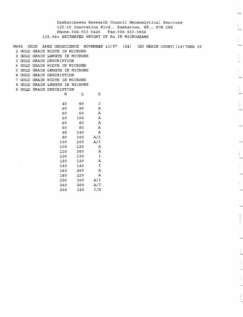
Saskatchewan Research Council Geoanalytical Services 125-15 Innovation Blvd., Saskatoon, SK., S7N 2X8 Phone:306-933-5426 Fax:306-933-5656
135.56= ESTIMATED WEIGHT OF Au IN MICROGRAMS
M684 CHIN APEX GEOSCIENCE NOVEMBER 13/97 (24) [AU GRAIN COUNT] (19)7BRH 35 1 GOLD GRAIN WIDTH IN MICRONS 2 GOLD GRAIN LENGTH IN MICRONS 3 GOLD GRAIN DESCRIPTION 4 GOLD GRAIN WIDTH IN MICRONS 5 GOLD GRAIN LENGTH IN MICRONS 6 GOLD GRAIN DESCRIPTION 7 GOLD GRAIN WIDTH IN MICRONS 8 GOLD GRAIN LENGTH IN MICRONS 9 GOLD GRAIN DESCRIPTION
w L D
40 60 I 60 80 A 60 60 A 60 100 A 60 60 A 60 80 A 80 140 A 80 160 A/I
100 200 A/I 100 120 A 120 260 A 120 120 I 120 120 A 140 140 I 160 260 A 180 220 A 220 300 A/I 240 260 A/I 260 320 I/D
I._
i__
'---
'---
' '--

APPENDIXX
X-Y SCATTER PLOTS AND TERNARY PLOTS OF SELECTED DIAMOND INDICATOR MINERAL DATA FROM HEAVY MINERA STREAM SEDIMENT SAMPLES
Abbreviations used in X-Y Plots:
AGS - Alberta Geological Survey
Cr - Chrome
DI - Diamond Inclusion Field
NOTE: Data from Argyle diamondiferous lamproite, Australia; Jack kimberlite diatremes, British Columbia; and Diamond Inclusion Field information from South Africa, are derived from Dufresne et al. (1996).

[
CaO vs Cr203 For Peridotitic Cr- Diopsides From The Obed Property -1997 (Figure X-1)
8
7 +-----·-!---------
6
f.!l DI Peridotitic Cr-Diopsides
+Obed Property Cr-Diopsides ~~~~d.__ __ __j_. ______ _j_ ______ .. f·--
5 +-----+-----+---------1---------+-------+---· ----+--------1----------+-----· ···- ---··----· --- .
I ' I ',
~ ~ \ ! ,/ \, C") 4 -1------1-----+------+------t-------J--,,r-'----+---'' ~\--+------ ---t----
0 Diamond I 1clusion Field ./ \ C;::! m ' 0 ,-- ---~----"" !!! \,
I
\ m \ 3 --l------+------l----------1~----'-,--+-·-----+-----+-·-·------'--+-,------I--------' \ I \ I \
: Ill! \ I ii!! \ I ~ I TI/ -----2 -+------ ------+--------+-------1,+--j--------1----- ----------+-----~-<=-=-,----- -----·
I 11!1 i\! , I \
/I la !!! !ii !':'.!! \
,,,.,,,/~ RI • \
_... m n --------- ---.... Ill \ -+--------- ----------- ---f+------1"'--------l--- ',, 111 ·-- _ __. ________ -m~----------\--
'" -----"' \...., wm m '
0 ..... --.-----,--
6 8
--- ----~---------~- ~ ~ ) - I ----
-----r---.~ ---··1·----------.-----..--- --.--.--------------,---- ---,-------.-----r---- ~,----·r------,---- ---r- -----,--------,- - - · --,----,----- -,---· - ---,----- ---.--- ---, ----
10 12 14 16
Cao (wt%)
18 20 22 24 26

c
..
MgO vs Total Fe as FeO For Picroilmenites From The Obed Property -1997 (Figure X-2)
60
• 55 ·---l-------~ +Argyle Picroilmenites ---------
• Jack Picroilmenites + •Obed Picroilmenites
t-'-- • ..,.. --1---------'---- ----·--
~r 50
-~ 45 .. 1
~ • , ... .... -
• • • -1-
0 l Ill IL
40 Ill nl Ill IL
> ~
• -11'+ ••
• •. ~ .. nl ...
35 0 I-
~. 6+ ... .~ ~ r
• • + + • •• •••• ++ • :· ••
·~ ~ • 30
• +
• + • 25
20
0 2 4 6 8 10 12 14 16 18
MgO (wt%)

[ [ .
MgO vs Cr203 For Picroilmenites From The Obed Property - 1997 (Figure X-3)
6.00
--i - -1 +Argyle Picroilmenites
-- ------- Jack Picroilmenites -- --
•Obed Picroilmenites --~·--
5.00
4.00 -· ------· ------~------~-
-~ c
'i - 3.00 C')
0 N ... 0
+
2.00 + + ·-
+ +
- -------· 1.00
I
... ·• 0.00 < J.Ht--t ,-. - - I +
0 2 4 6 8 10 12 14 16 18
MgO (wt%)

[
FeO vs Cr203 For Picroilmenites From The Obed Property - 1997 (Figure X-4)
6.00
r ---1-+ Argyle Picroilmenites ~ Jack Picroilmenites ---
•Obed Picroilmentites
5.00
4.00 --- - -- ---------
~ 0
! 3.00 C') -· --r---~-·-- ---
0 N .. 0
+ 2.00 + + ---·--
+ +
1.00 ------- --
I
·• :l~ + -rf-- T". ' - • +- --....±. -.. - .. 0.00
20 25 30 35 40 45 50 55 60
Total Fe as FeO (wt%)
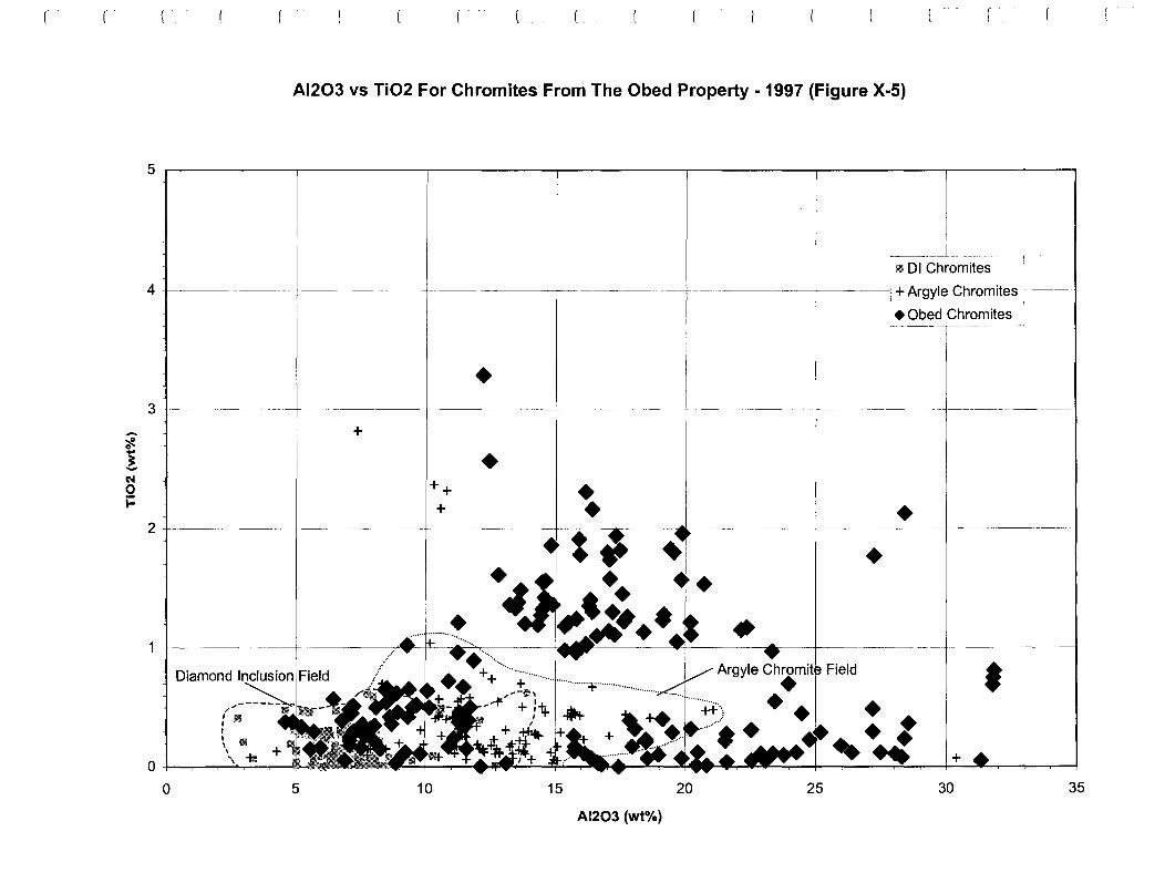
c
~ c
! Cll 0 j:
Al203 vs Ti02 For Chromites From The Obed Property - 1997 (Figure X-5)
Chron~ites ·--
4 .l-------·--+-----·---- -------+------------- -- gyle Chromites
3
+
2
1 -1-----
0 5
bed Chromites ----- --- ----
• ___ .____ ____ -+-----~--- -- ______ __J_ _____ - - ---- ---- - --- -
• ++ +
10 15 20
Al203 (wt%)
25
• •
• •t .. .. +
30 35

L
MgO vs Cr203 For Chromites From The Obed Property - 1997 (Figure X-6)
Diamo d Inclusion Fiel
60 - - -- - ------+------------'------'~--
~
1 4')
0 ~ 0
40
30
20 -
4
Argyle Chromit
111 DI Chromites
+ Argyle Chromites
•Obed Chromites
6 8 10
•t --+-----~ • + •
• --+-----~--,-----· ---- -----+• • • •
• • • 12 14 16 18
MgO (wt%)
20

30
0.0
Ti02 vs Cr203 For Chromites From The Obed Property - 1997 (Figure X-7)
0.5
----- -----------+------+-------~-----.
+ + gyle Chromite Fi Id +
----+-------+-----------
• •
-----· -· -· ------+------
• 1.0 1.5
• • 2.0
Ti02 (wt%)
•
2.5
--~----- --- -----l rM DI Chromites
+Argyle Chromites
•Obed Chromites __ _ -· ------
+ ---+------------- ------- - --
•
3.0 3.5 4.0
r
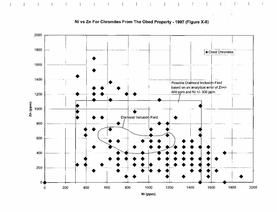
1800 - ------
1400 -1--
1200 +----
'E
Ni vs Zn For Chromites From The Obed Property - 1997 (Figure X-8)
•
------------j------ - .
• --------------------t-------+--- -- -----j------- --- -------t-------
• ---1-c------• • • •
-----··---·---- --- -- --------- ------------ ----
Possible Dia and lnclusi n Field based on an analytical err r of Zn+/-
--+----w~---1---w~----r---~- --+·---+-----1---4_00 __ p'+-m_a_n-+-Ni +/- 300 p m. ____ _
~ 1000+------+--+----+-----+-----+- • -c N •• Dia and lnclusio Field
800 +------+---!---+---
600 ----- • • • • 400 ----------1---+----+--------------j--·------=-...+-~•
• • • • • •• 200 ------------ -----1-------+---------- -----· --------- - --------• • ••• 0 200 400 600
• 800 1000
Ni (ppm)
•
1200 1400
• --· -----·---+------•• • •• •
1600
• 1800 2000

Al203 vs Cr203 For Chromites From The Obed Property - 1997 (Figure X-9)
Diamond Incl sion Field -··-·----- -- l oo DI Chromites
+Argyle Chromites
•Obed Chro~ites _ ---- -
• 50 -----~- -------- ----- --------
--~ 0
! M .. 0 N .. () • 40
• ~ •• • •• + •• • • • • • • • • 30 ·-~
_.__ -----•- ·--~---~- ---- --- -------
• • • • • •
20 ' 0 5 10 15 20 25 30 35 40
Al203 (wt%)

~ 0
i -0 GI
LI.
35
30
25
20
15
MgO vs FeO For Eclogitic Garnets From The Obed Property -1997 {Figure X-10)
•-• -· -------!------"-------+- ---Iii i
•• •
•
I I
I I , ,
I I
I I
I I
I
.,,,...,,,..-- -------,.
-~---- -------
' -----1 ', ,......- Diambnd lnclusi ......
.................
' ' ' '
n Field
DI Eclogitic Garnets
•Obed Eclogitic Garnets
', ' \
' ' \ \
\
10
I I I I
I-------+-----"\ -, J!__ -- i- -~'-----------------~------t---~ -- --·--- ~------,,.,,, ,.
• .. .... _... ~ ml ..... ___ _ ---
5 - -·----1-------t-- -------!------- ---- --
Q ------.- ·--,- - r -- ---r·----,-------,----- ----; -----,------, · ------, -- 1· T
0 2 4 6 8
-- --------- _______ ,
,,,,./"' ,.,.
------------------1------
Ill! • -- T - ,--- T - -----,----T---,---
10 12
MgO (wt%)
14
• 16 18 20 22 24

-~ 0 ... ~ -N 0 j::
Na20 vs Ti02 For Eclogitic Garnets From The Obed Property - 1997 (Figure X-11)
2
1.8 -------!---- --·--·- --·--------!------+------- --·-.
1.6
1.4
1.2
1
0.8
0.6 -
0.4
0.2
0
0.00
----+------- --------+~----+--~---"--------+---------+---
--Diamond I clusion Field __ _ .. • l---------- -,, _____ _ ----t-- ~ ------- ---~-~-------\ a J
---- -----n- ::u wi m: wi ,!:~ 1111 m , '
I I
I I
I I I
-. -------
,-, ---- - m
1m
0.10 0.20
----_,,,,.,,,,,.--
!Ill
m .. 111t11 mim I / ... 1111 Mt ii.11... /
m Imm 11 n•1111m /
1111111111!1 !!Iii /----
Iii Ill 1111 1.111 llJI 1111 : -+---1111~-----+-1111_111 __ ,m m Ill! / +------+--------·
1111 !1!!--
__ ,,..,..--------- ------111 ,--,
I 1111 I
,,,.,,.--If..-"' ,
0.30 0.40
Na20 (wt%)
0.50
-- -1 m DI Eclogitic Garnets -
•Obed Eclogitic Garnets --- ---------
0.60 0.70 0.80

.-.. ~ 0
! N 0 j::
l
CaO vs Ti02 For Eclogitic Garnets From The Obed Property -1997 (Figure X-12)
1.6 -------- -----~
1.4
1.2 -----+--------+----+-----+-
0.8
0.6 I I I Ill I
I I I
I !1111 I I I I
Ill I I I
0 +------+-
0 2 4
I
-" -" /'
I Iii
11'1
6
----/',..
llil .~
If!! 9m !Ill • • .~~l-_.
8 10
---·--· --------
' ft '
I I I I
---- ----· -
"'-+---~-1--~' __ _,__ ___ _____, w DI Eclogitic Garnets
•Obed Eclogitic Garnets
ond lnclu ion Field
!!I! 11111111
!!II • • Ill
___ $! I
!Ill I I 11!1
li!l I I ,
------------------- ---- ----·---
12 14 16 18 20 22 24
cao (wt%)

r r
Ternary Plot of Cao vs. MgO vs FeO as Total Fe For Eclogitic Garnets From The Obed Property -1997 (Figure X-13)
---------------------------------------------------------------------------------------------------------------------------------
MgO (wt%)
•
Cao (wt%)
,,,.-----------, I ' I I I ,--------"" I I I I
I I I I I I I I , ,
I I
,"""'I ' ,. I I I
I ',,,-·-------,,
I .A • ', __ _ '-----, ... .... ....... Diamond Inclusion Field ) \ • - , ,: ~,._,--- . :
\ ____ ' . ,' . •, __ ,,./ . \ ·" . ',, ___ ,,,. 1
•--------------- I
\.--------------- .... ____ _ -------- ----· -----
I
./
• I
• Obed Eclogitic Garnets
Total Fe as FeO (wt%)

APPENDIX XI
X-Y SCATTER PLOTS OF SELECTED DIAMOND INDICATOR MINERAL DATA FROM TILL SAMPLES
Abbreviations used in X-Y Plots:
AGS - Alberta Geological Survey
Cr - Chrome
DI - Diamond Inclusion Field
NOTE: Data from Argyle diamondiferous lamproite, Australia; Jack kimberlite diatremes, British Columbia; and Diamond Inclusion Field information from South Africa, are derived from Dufresne et al. (1996).

16
:c
14 ";' ~
12 , __ ,
:;,' >
t] Iii'. mi I,,
10 ;-:. :-:· y: - 1"
~ , .. ! ,>!
c·, 8 f"
M ai 1:'. 0 ~ '.t{; 1;r 0
6 .. ,
,,,
4 ----w
0
17' '1'1 n
!R
~-~'"
¥!
1 JJJ
111
~ tm ¥! ., .
2
MgO vs Total Fe as FeO For Peridotitic Garnets From The Obed Property Till Samples - 1997 (Figure Xl-1)
3 4 5 6
G10/ G9,G11,C 12
7
Cao (wt%)
8 9
DI Peridotitic Garnets
.. AGS Peridotitic Garnets (Till)
----+---Obed Peridotitc Garnets (Till) _
10 11 12 13 14

MgO vs Total Fe as FeO For Picroilmenites From The Obed Property Till Samples -1997 (Figure Xl-2)
• 55 ---------- - -
• + 50 -~-,.----- --- -
++
• -- --- --------+- ---------- -- ~------------------------+-----~~::~~~~~~~:~!~ I
-· -·--------'---------1--------------------t------------ ----------+------------ --- ---------- -
·~ - '.. . '?ft. 45 i ----·-·-~--- - ---~ ~ . . .!. ' .., ----!--------+----------- f------------+---- -----'-----·----- ---- ~---- ----
0 Cl) ' > ~ 40 -------1--- -----1---------1---------j-----·----+-1---------------·----+--------~------~----- --------'
Cll Cl) II..
• s 0 35 +-----...
+
30
• ~t+·· .. ~ .. •. '* • • • • ••
+ •••• •• ++ •• • • •• ---------1------------ --------------+---------- ----'------ - - --..----+ --• +
• 25 ------------ ---~~-----l-----------+---- --- ---------------- - - - ______________ __,_ _____ ---- ____ L___ ________ _
0 2 4 6 8 10 12 14
MgO (wt%)
• +
16 18
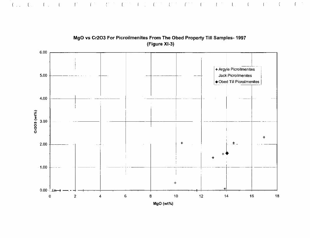
-~
MgO vs Cr203 For Picroilmenites From The Obed Property Till Samples-1997 (Figure Xl-3)
6.00 ~-------------.,..----------------------------.
5.00 -------+----- --------- ~---- ---------+----------~--- -- ~ ------- -- ·------ -----------. ---- - -
+Argyle Picroilmenites
-- Jack Picroilmenites ---
•Obed Till Picroilmenites -·--1 -4.00 ------------+------------- ------------ ------------------------- ---··· --------
1 "' 3.00 - ------- -------f-------- ------+--------1-----------+--------
o (II ... 0
+ 2.00 ---------+--- --------+-------- +--------1-------f--~+ ___ _ ------ _ _±_ _______________ _
+
1.00 - -----~ --------- ~----- -- - -_______ __, ____ ----- ---------- - f--------- - -------- -- --- --- - -- ---- ---
-f
0.00 ·: J,ift--t .-. - - I +
0 2 4 6 8 10 12 14 16 18
MgO (wt%)

~
5.00 -
FeO vs Cr203 For Picroilmenites From The Obed Property Till Samples-1997 (Figure Xl-4)
4.00 - ------- - ----------------------- ----- - - ------+---------+--------- - - -------
1 C') 3.00 --------------------·----------- ---------------------t--------------- -----· -·· ----·---- ---- -------r-------·
0 N ... 0
+ 2.00 -----------'f------+~---+-------·-·----±------------+---------~ -------- ----- - ------------ -- -------
• + +
1.00 ~----- ------ ----~--------- --- -----· -------+------------------- --- -·----------~------ -----------
0.00 1--..--..--.,.---.,...-+--.---r---.----.---+---.----.--+..:.i,r--....-+-+--.,.--.,...-.,.-:_l ~ .,+- - • ' - ' +- ~ -~=~ .. - !.---........-........--+---+-- -.......-....---l
20 25 30 35 40 45 50 55 60
Total Fe as FeO (wt%)

4
Al203 vs Ti02 For Chromites From The Obed Property Till Samples-1997 (Figure Xl-5)
- ---------------t---·--------·--------- ----- ~- - -----~ " DI Chromites
- +Argyle Chromites · ·- - --
•Obed Till Chromites - -- - --- --- ------ - ----
3 -----·------- -- ---------+---~------ ---- -- --------------+--~· 1-------· -- --+
• • ----------- -1- ------ ---------------2 --- - -----------+--------
• •
1 ••
Field
• + +
0 5 10 15 20 25 30 35
Al203 (wt%)
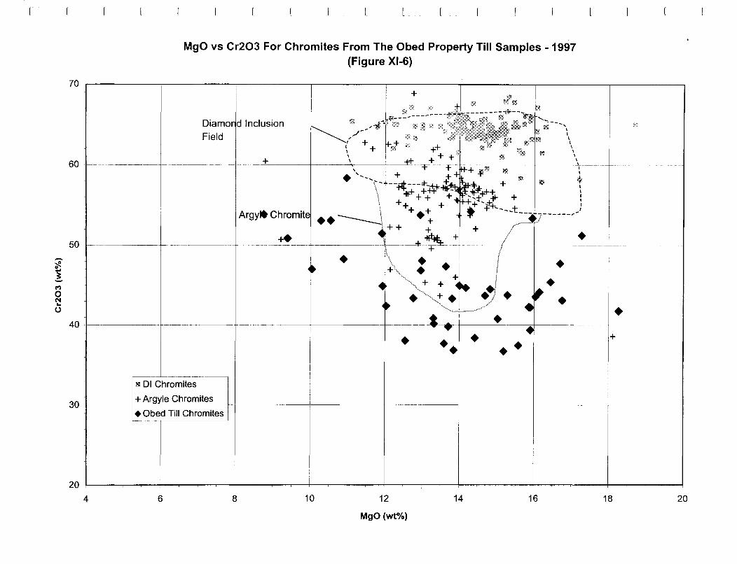
~
! !")
0 N .. 0
60
50 ----
40
MgO vs Cr203 For Chromites From The Obed Property Till Samples - 1997 (Figure Xl-6)
Diamo d Inclusion Field
Argylt Chromite
+
• •• • ••
30 ---- --~\1'11-~:~~~:~:i::::::l . -------+---
.Obed Till Chro~J ~-- --------
--~-·-----------t--------
• +
20 1--~~~-.--~'--~--.,....--.----1~-.----.~-.----1~-.----..,.~-,----+~-,------,.~-,----!-~..,..-----r~-r--+~..,..---....~..,..--+~.....-----,-~.....-~
4 6 8 10 12
MgO (wt%)
14 16 18 20

(
C')
0 <.::! ()
+ .................................................
Ti02 vs Cr203 For Chromites From The Obed Property Till Samples-1997 (Figure Xl-7)
.:;, .......... ······· • -.... . ~ ••
-- ------- - -- --- ;I q: DI Chromites
+Argyle Chromites _____________ ---~---- _ r: obed Tm chromites _ ~----- - -------·-
+ + +
+ - ------ ------+ --- -- ------·----
• • 40 +------- ---------------+------------+~.~---·~·~----------- -·--+----------... . . . . . 30 -----------··-
0.0 0.5 1.0 1.5 2.0
Ti02 (wto/o)
2.5 3.0 3.5 4.0

E
1800
1600 ---·
1400 ---- --
Ni vs Zn For Chromites From The Obed Property Till Samples - 1997 (Figure Xl-8)
-- - - ------!---------· -
[•Obed ChromitesJ - -
---!-----~·--·-- --- --- ----
• • • ----·- ----- ---·-- - .. - J -- --- ·--··- ··--
Possible Dia ond lnclusi n Field based on an analytical err r of Zn+/-
1200 ----- - ·- -------- -··-·----'-400 p ITI~ _Ni _+!~Q_O p m. _________________ _
! 1000 ---- ---c N •
800 - -- --·--+------<
• 600 -- - -- -+---+-
400 --------
200
0 200
• •
400 600
• • • ~-===--!---=----+ - -· -
800
• • • •
1000
Ni (ppm)
• • • • • •
1200 1400
+--- -- --- --
• •
1600 1800 2000

-~ ! M 0 N ... 0
50 ------
Al203 vs Cr203 For Chromites From The Obed Property Till Samples - 1997 (Figure Xl-9)
Diamond Incl sion Field
• •
r
40 -----·---+-- .---4-----.---+------- +-----·--
••• • • 30 ------------- ----·------ -------- ----~-- - ------
0 5 10 15 20 Al203 (wt%)
25 30 35 40

APPENDIX XII
INTERPRETATION OF DIAMOND INDICATOR MINERAL DATA
FROM HEAVY MINERAL STREAM SEDIMENT AND TILL SAMPLES
XII.A INTERPRETATION OF OXIDE MINERAL GRAIN CHEMISTRIES FROM HEAVY MINERAL STREAM SEDIMENT SAMPLES
Xll.B INTERPRETATION OF OXIDE MINERAL GRAIN CHEMISTRIES FROM TILL SAMPLES
Xll.C INTERPRETATION OF SILICATE MINERAL GRAIN CHEMISTRIES
FROM HEAVY MINERAL STREAM SEDIMENT SAMPLES
Xll.D INTERPRETATION OF SILICATE MINERAL GRAIN CHEMISTRIES FROM TILL SAMPLES
Xll.E INTERPRETATION OF DIAMOND INDICATOR MINERAL SAMPLE SITES FROM HEAVY MINERAL STREAM SEDIMENT AND TILL SAMPLES


Sample Number I Grain I
APPENDIX Xll.B
INTERPRETATION OF OXIDE MINERAL GRAIN CHEMISTRIES FROM TILL SAMPLES
(APEX Project 97210)
wt% wt% wt% wt% wt% ppm ppm
Classification I Ti02 I Cr203 I FeO I MgO I Al203 I Ni I Zn I I I I I I I I I l I I I I I I I I I I I
Interpretation
--------1·--s·--R--r---~o---o--1----------r------s--------r--------p1cR_a_icM"E"NirE"-------r-·-52-.64--·r---1-·a1·----r-·29·73·-r-·14·os--1----a~s-o----1---7s5.sa·-1----saj4---1-o-Ei=-iN-iTE"-iii-Ciic-ato-r-0Ti<illit>e-rffte-or ________ _ l I I I • I • I • I I I I
! ! \ ! ! ! i i i i Lamproite diatreme source for grain 7BRT-003 i 17 i PICRO CHROMITE i 0.06 i 58.44 i 19.09 i 12.04 i 7.82 i 235.74 i 723.06 !POSSIBLE indicator ofDiamondiferous Peridotite Mantle
-----------------------------------l--------------l---------------------------------------l--------------l----.................... i .. _____________ f ______________ l ______________ l ______________ j ______________ J.§.9_l:l!~_f.Q[ .. 9! .. ~lD _______________________________________________________ _ 7BRT-003 ! 18 i PICROCHROMITE i 1.95 i 40.16 i 27.28 i 13.31 i 15.07 i 1178.70 i 562.38 !POSSIBLEindicatorofKimberliteorLamproitediatreme
i i i i i i i i i isourcefororain 7BRT-009 47 PICRO CHROMITE 0.18 57.12 15.99 15.87 6.10 785.80 321.36 : POSSIBLE indicator ofDiamondiferous Peridotite Mantle
! source for Qrain 7BRT-011 53 PICRO CHROMITE 0.05 58.38 19.07 10.97 8. 70 314.32 1124. 76 ! POSSIBLE indicator ofDiamondiferous Peridotite Mantle
i source for orain
File: APX Xll.B-INTERP TILL OXIDE DIM CHEM Page 1 of 1

APPENDIX Xll.C
INTERPRETATION OF SILICATE MINERAL GRAIN CHEMISTRIES
FROM HEAVY MINERAL STREAM SEDIMENT SAMPLES (APEX Project 97210)
Sample Number I Grain I Mineral Name I Ti02 I Cr203 I FeO I MgO I Cao I Na20 I MnO I Interpretation
7BRH007 9 iECLOGITIC GARNET - GS 0.31 o.oo 28.39 3.53 5.52 0.07 2.03 i DEFINITE indicator of Diamondiferous Eclogitic Mantle !MAGNESIAN ALMANDINE !source for grain on Figures X-10, X-11 and X-12, but high MnO may ________________________________ J ______________ j___ ____________________________________________________ j ___________ J ___________ J ___________ _j _____________ _[__ ___________ _[__ ___________ _[__ __________ __[!!!~!C:_'!~_c:!.IJ_!!!!!!_!!~.l!!E!_~!..S_f!!!! __________________________________________________ _
7BRH007 i 10 iECLOGITICGARNET-ALMANDINE i 0.42 i 0.00 i 30.73 ! 2.47 i 5.99 ! 0.00 i 1.47 jQuestionablelndicatorofDiamondiferousEclogtticMantleduetoCaO i i i i i i i i i !versus MgO and elevated Ti20, but MnO near 1.5% indicates crustal ! ! l ! ! ! ! i ! !source '
78RH009 11 jECLOGITICGARNET-G3 CALCIC 0.06 0.01 18.99 i 6.69 12.15 j 0.02 0.02 !DEFINITE indicatorofDiamondiferousEclogiticMantle ________________________________ J _____________ _J!'.'_~~~~:--~~~~~~-l-~~-----------------------1-------------1-----------_j ___________ _j _____________ _[__ ___________ _[__ ___________ _[__ __________ __[~~~~-~-f2!_9!!!!!.1 __ C?_~_!:!9.IJ_~-~:!;! ___________________________________________________ _
7BRH009 i 12 iCLINOPYROXENE - i 0.33 i 1.43 i 2.97 i 1s.17 i 19.69 i 1.48 i 0.16 !DEFINITE indicator of Diamondiferous Peridotitic
________________________________ j ____________ __j_Qtt_~_Q_~~--Q!Q~~-!!?.~ ______________ j ___________ j ___________ j _____________ _[__ ____________ l_ ____________ _L_ ___________ _L_ ___________ _L~-~~!!~-~-~y-~~!! __ f~-~-.9.~~-~!"!-~~--1'.:!9_~!:.~-~:1___ ______________________ _ 7BRH009 i 13 jECLOGITICGARNET-G3 CALCIC i 0.25 i o.oo i 16.83 i 8.90 i 10.90 i 0.06 i 0.36 !DEFINITE indicatorofDiamondiferousEclogiticMantle
i !PYROPEALMANDINE i i i i i i i isourceforarainonFiaureX-13
7BRH011 i 14 !ECLOGITICGARNET-G6 PYROPE i 0.22 i 0.05 i 15.09 i 8.13 i 13.60 i 0.03 i 0.22 !DEFINITE indicatorofDiamondiferousEclogiticMantle ________________________________ _j ______________ j_~~~-~-~-~~~-~-:~~~~~~-: _______________ _j ____________ j ___________ _j ____________ _l__ ___________ _L_ ___________ _l__ ___________ _l__ __________ __[~~~~~J~!-9!!!!!.1 __ «?_~_!:!9.IJ!.~-~=-~;! ___________________________________________________ _
7BRH011 i 15 !ECLOGITICGARNET-G3 CALCIC i 0.37 j 0.00 j 18.03 i 10.69 i 8.18 j 0.00 j 0.81 !DEFINITE indicatorofDiamondiferousEclogiticMantle i iPYROPE ALMANDINE j j j j j j j !source forarain on Fiaure X-13
7BRH014 17 i ECLOGITIC GARNET - ALMAN DINE 0.08 0.00 33.30 !, 1.90 i 3.81 0.04 1.35 i Questionable Indicator of Diamondiferous Eclogitic Mantle due to Cao i 1 ::: !versus MgO, and slightly elevated Ti20, but MnO near 1.5% indicates i : i crustal source
7BRH015 18 iECLOGITICGARNET-G3 CALCIC 0.11 0.03 17.38 J 11.73 J 7.63 0.03 0.83 !DEFINITE indicatorofDiamondiferousEclogiticMantle !PYROPE ALMANDINE : : !source forarain on Fiaure X-13
File: APX Xll.C ~ INTERP HMSS SILICATE DIM Page 1 of2

APPENDIX Xll.C
INTERPRETATION OF SILICATE MINERAL GRAIN CHEMISTRIES
FROM HEAVY MINERAL STREAM SEDIMENT SAMPLES (APEX Project 97210)
Sample Number I Grain I Mineral Name I Ti02 I Cr203 I FeO I MgO I Cao I Na20 I MnO I Interpretation
::::::::~:~:~:~:~~~:::::::::l:::::~~:::::i:~~~~~~~~~;~~;;~y~~~~~~~~::::r::::~~~~:::r::::~:~~:::r:~~::~~:r::~:~~::r~~::~:~:r::~:~~:::r::~:~:~::::i~~~~~!~~~~:~~~~~~~~:~~~=::~~~~~~~::~~~:~~:~~:~~~:::::::::: 7BRH017 i 31 i GARNET - GROSSULAR i 0.16 i 9.37 i 2.31 i 0.07 i 32.78 i 0.00 i 1.54 !Questionable indicator of mantle source due to elevated Ti02 and
________________________________ _j ______________ j___ ____________________________________________________ j ___________ _j ____________ j ___________ _j ___________ _j ____________ _J ___________ _j ___________ _jgr£Q_~,-~_Y!.!'!J~y_~j~cj__lll!~_Q~JY/.~J!l.'1J£~.!..~~-Er~-~!~.l.§.9.Yf£!'l ____________________ _ 7BRH017 i 32 iGARNET - GROSSULAR i 0.16 6.84 i 5.09 i 0.09 i 31.46 i 0.00 i 1.95 :Questionable indicator of mantle source due to elevated Ti02 and
1----------;i ___ -;i ________________________________________________________ i i i i i i igr£Q.~,-~_Y!.!'!J~Y-~!~'1_N!n.Q_::-_t~'.7'.o_J!l.'1J~.!..~~-gr~-~!~l§.9.Yf£!'! ____________________ _ 7BRH018 20 iECLOGITIC GARNET - GS 0.10 0.03 29.43 1.25 8.15 0.01 1.77 !Questionable indicator of mantle source because falls within DI field on
!MAGNESIAN ALMANDINE !Ti02 versus CaO plot, but elevated MnO >1.5% indicates crustal source ! !
7BRH020 22 ! ECLOGITIC GARNET - GS 0.09 0.05 28.27 1.03 6.84 0.01 4.32 i Questionable indicator of mantle source because falls within DI field on ! MAGNESIAN ALMAN DINE \ Ti02 versus CaO plot, but elevated MnO >1.5% indicates crustal source
----------------------------------+--------------~--------------------------------------------------------1-------------- --------------~--------------~--------------t--------------t--------------t--------------t--------------------------------------------------------------------------------------------------7BRH020 i 23 /ECLOGITIC GARNET - GS ! 0.15 ! 0.00 i 28.25 i 1.62 i 9.95 i 0.00 i 0.62 :Questionable indicator of mantle source because falls within DI field on
i iMAGNESIAN ALMANDINE i i i i i i i iTi02 versus CaO plot; low MnO <1.5% and elevated MgO may support i i i i i i i i i i mantle oriain for a rain
7BRH023 i 24 !UNKNOWN (Possible Low Fe-Mg i 0.89 i 1.35 i 0.70 i 0.20 i 36.00 i 0.00 i 0.07 :Questionable indicator of mantle source due to elevated Ti02 and _________________________________ j _____________ _j_<_,;_r9_~~11!~r:l. ________________________________________ __i ____________ j ____________ j ____________ j ____________ j _____________ j__ ___________ _L_ __________ __[_g_@_~;_L<>~-~.!]_Q_m.§Y_~ll.Pf>2.i::t.!!!~1]J!E!_grt9J!1. ______________________________________ _
7BRH023 i 25 !ECLOGITICGARNET-G5 i 0.08 i 0.03 i 29.86 i 1.72 i 8.03 i 0.06 i 1.19 !PROBABLEindicatorofeclogiticmantlesource i i MAGNESIAN ALMANDINE i i i i i i i i because falls within DI field on Ti02 versus NaO, and Ti02 versus
___________________________________ l_ _____________ j___ ___________________________________________________ j ___________ j ___________ j _____________ _[__ ___________ _[__ ___________ _L_ ___________ _L_ _________ ___[~-~9 . .P!2.~·--~!:!!.e:!E!_'!'.§!E!.~.1'!1D9 __ rn.§Y_!l]_~!~!E!.£!11.~!!!L~9.11!£E! ___________________ _ 7BRH023 i 26 /ECLOGITIC GARNET -ALMANDINE i 0.04 i 0.05 i 33.17 i 2.54 i 4.32 i o.oo i 0.69 /Questionable indicator of mantle source because falls within DI field on
! ! ! ! ! ! ! ! ! !Ti02 versus CaO plot; low MnO <1.5% and elevated MgO may support i i i i i i i i i i mantle orioin for a rain
27 i UNKNOWN (Possible Low Fe-Mg 0.35 0.00 8.82 0.30 31.93 0.07 0.57 i Questionable indicator of mantle source due to elevated Cr203 and i Grossular\ , i ~.§;2.Q;_lq~_Ml].Q_m.§Y_§.~.Pf>2.i::t __ II!~l]j!!'l.grtgj!l. _______________________________________ _
, 28 jECLOGITICGARNET-G6 PYROPE , 0.38 , 0.09 , 15.00 ! 7.70 , 13.85, 0.15 , 0.37 !DEFINITE indicatorofDiamondiferousEclogiticMantle i JGROSSULARALMANDINE i i i ! i i i isourceforarainonFiaureX-13
----------·79R-H629·---------;---·-29··---rGARNEf:-GTFe:-M9TivAROViTE-------;----ii~41----;---1·5~95·-;----3.59·---;----o.-:2o----;--·31~-85---;---·a:a4·---;----o.-73 ____ "'iQ'°'u~e~st~io~n~a~bl~e~in=d~ic~a~to~r~o~f m~an~t~le~s-o-ur_c_e--:d-ue-....,-to-e-,-le_v_a-te--:dc::Ti=-10=-2=--an-d.,---; ! ! GROSSULAR ! ! ! ! ! ! ! i Cr203· low MnO mav suooort mantle orioin
7BRH029
7BRH024
7BRH034 33 iGARNET- GROSSULAR 0.05 6.61 3.38 0.00 !: 34.78 .!, 0.05 0.70 !Questionable indicator of mantle source due to elevated Cr203; low i iMnO mav suooort mantle oriain
78RH035 ! 30 !ECLOGITICGARNET-G3 CALCIC i 0.51 ! 0.00 ! 18.58 ! 7.29 i 11.45 i 0.07 i 0.46 !DEFINITE indicatorofDiamondiferousEclogiticMantle ________________________________ j ______________ J~_'._~~~=--~~~~~-~-1-~_: ______________________ _l ___________ j ___________ j _____________ _[__ ___________ _[__ ___________ _L_ ___________ _l__ _________ ___[~2.!:!~~-11.f2.r.nr!!!l]_!?_~_!:!a11_r:11_~:.!'3. ___________________________________________________ _
7BRH035 i 34 i UNKNOWN (Possible Low Fe-Mg i 0.41 i 2.57 i 0.37 i 0.1 S i 35.33 i 0.00 i 0.26 !Questionable indicator of mantle source due to elevated Ti02 and ---------------------------------_l ______________ j_~[2.~§.~J~d_ _______________________________________ _l ____________ _l ______________ l_ _____________ l_ ____________ _L_ ___________ _L_ ___________ _l__ ___________ _iggQ_Llq~_Ml]_Q_m.§Y.~~.Pf>2.i:t.!!!~O.\!~_qfigj!l. ______________________________________ _
7BRH035 i 35 i UNKNOWN (Possible Low Fe-Mg i 0.35 i 2.67 i 0.42 i 0.15 i 35.04 i 0.00 i 0.26 i Questionable indicator of mantle source due to elevated Ti02 and ! !Grossular\ ! ! ! ! ! ! ! !Cr203· low MnO mav suooort mantle oriain
File: APX Xll.C- lNTERP HMSS SILICATE DIM Page2of2


f
APPENDIX Xll.E
INTERPRETATION OF DIAMOND INDICATOR MINERAL SAMPLE SITES FOR HEAVY MINERAL STREAM SEDIMENT AND TILL SAMPLES
(APEX Project 97210)
Sample Number I SITE ANOMALOUSNESS I ' ' ' ' HEAVY MINERAL STREAM SEDIMENT SAMPLES i
REASONS FOR INTERPRETATION
7BRH - 001 ! NOT Anomalous !No anomalous grains -------78'Ri=i-:-ooi------1·--p;~o8.A8l.v-/.\n-oma-ioli$---r1c-ec-1"0~-itiC:-.~a;:~-0t-oeffriite-iiiaicaior-ar<:iiarrioiicilferous-0cfo9ific-rnaiitie:-a"Pr:rc-hrahiiies _________ _
----------"·---------------: _______ j__ _________ . _____________________________________ jE9..~~i_~!~-1~-~~9J~!gr~_:9f£~r!9.<2EtEE_!Il_~n!lEE _________________________________ _;~------------------------------------·----7BRH - 003 i NOT Anomalous i No anomalous grains
-------7,EiRifi~:-oo4~-----r-o-Ei=TNtT-EiY-Anoma-1ous--n~·0c-109itic9ar?~i-oef!~riite-iiiaicaior-arciiamaiiciiferou-5Eicia9iti~-maiifle:·s-a·4estior1atife-9~rnE!fs ·· ··· · i · !indicative of mantle source, and 1 chromite Definite indicator·of giafl'\ondiferous peridotite
---------------~---------------~:--L----------------------------------------------~--lm~n11~------------------------------------------------"--"-C---""-------~----------~"---------------------------------------1BRH - 005 i NOT Anomalous i No anomalous grains ----------.,8-Rj:r=-oos---------r·-----------Nc5fAiiariialous _____________ TNo_a_rioriiaio-li5-9i-airis--------------------------------------------------------------------------------------------------
-------78Rii-4ioof·-----r·wR08AEfCv-;~~n-oma-fi>li$---r1·ec-109iti29ari1~ffieiinite-111a1e:0tor-ot-cfiarrioiiciitetous~ecf~~ifi~-ni~riti~:-an<:t-fa-uesiioriat>re ____ _
-------~------~-,.----:-----7 ____ _j _____ c~-~----c---~-------------------------------~L9..~!n~tln9J~!1Y~-:9f l!!§!!)!!@._~:9~!f~,J~9.L".!:9.<?~lg~~L~f!l~~!<?!!§. ___ ,, ___ ,"--·-c·---------------------------------7 BRf'I "" 00$ ·· i FPROBABL Y Anomalous !No silicates indicative of mantle source, but 1 chrorl'iite.!~:efinite indic13tor and 1 chromite
--------.-~-------~------------~:;;.i"ci•·---------------"-------------------------~~---~~Q.~§iJQ!~_l~!£llfE!:9t<?L9.L~m<?DQ~-~r2!:l_~_El~!J9.9!!!~--l!!§!Q!!~-------"-":----·---"--------""----------~--------------7BRH - 009 ! .• DEFINITELY AnomalOl!!S . i2 ecl9gitic1,garnets Definite indicators· of diamond,iferous ~glogitiqima11t1e, and 1 Cp~ome
----------.:--~~------------------J~~------""-C--•-----------------------------~---j~!9R§iJ~gJ~9J~_tjY._~_Qf_gJ§!!IIQ!:l_9Jf~_r<?_l!§i~.Q~[t9Q@~~ct:i.@rr!l~L~l!!_~g-~~19-EE.l!:1"91~-~!Q~--1------------.:-----7BRH - 010 i POSSIBLY Anomalous i No silicates indicative of mantle source, but 1 chromite Possible indicator of peridotite mantle
--------------~------------------c~j_"c·-~--~--~--------------------------------------~9..Q.9J_f~-~<?.!!!Lt~.e-~~~j~L~.!r:i_g!~.@!9I...<?!_~j!Il_t>_~r!!t~_9I..J~rriR!:9Lt~-9-i~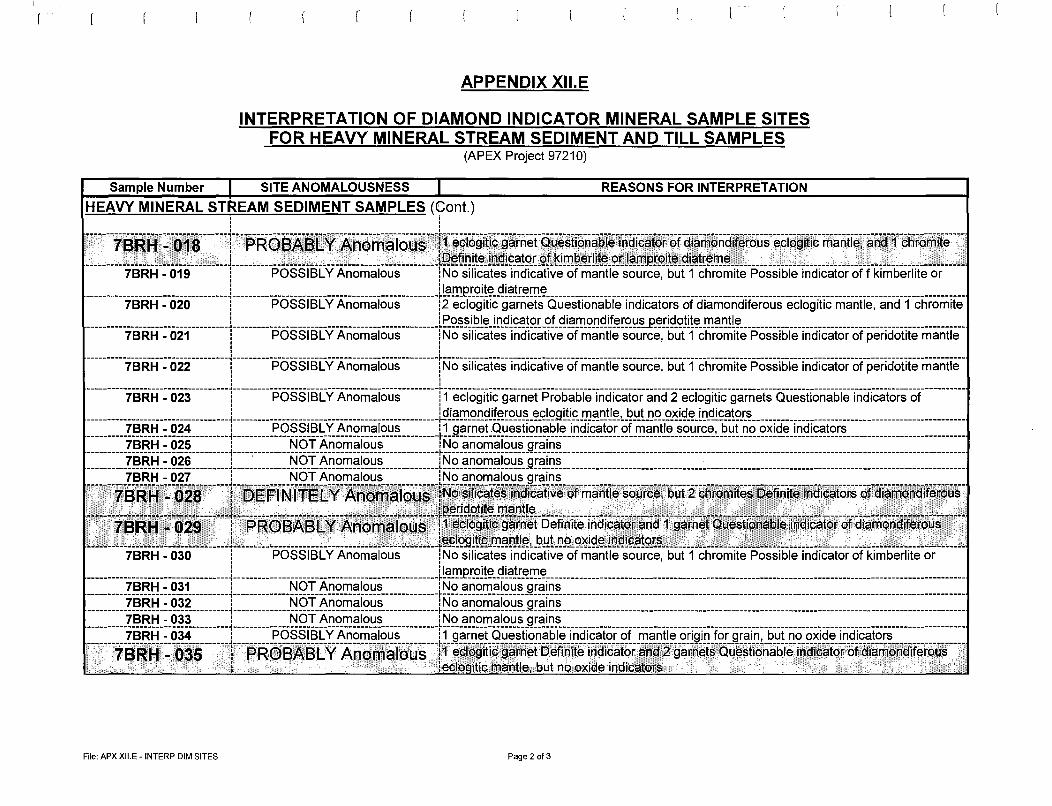
APPENDIX Xll.E
INTERPRETATION OF DIAMOND INDICATOR MINERAL SAMPLE SITES FOR HEAVY MINERAL STREAM SEDIMENT AND TILL SAMPLES
(APEX Project 97210)
Sample Number I SITE ANOMALOUSNESS I REASONS FOR INTERPRETATION
HEAVY MINERAL STREAM SEDIMENT SAMPLES (tont.) i i ' ' ' ' ' '
-------78ati-:7o1"8-------r-F>R68.A:8LY-Atioma_1_oiis--l1-0~109itic9ariiet-auestici-riabie-fricii9a"for--e>faia-maii-aH0-rous-0ac;9-itic-rria-riii0~-aii-a-1--cilrt>riiife ___ _ --------------~~---------------~ ___ j ________________________________________________ JQ~fi_Qlt~~l!:l_gl9_":!!Q.LQf_~J!!!.9_~r!lt~_Q.~J§rti.PF~lt~_9.L":!!r§.i:D~--------------~-----------------------~------------------
7BRH - 019 l POSSIBLY Anomalous lNo silicates indicative of mantle source, but 1 chromite Possible indicator off kimberlite or ___________________________________ j_ ________________________________________________ JLc::!.!!lJ?!..<2l!t?_f!l9!r~rri-~------------------------------------------------------------------------------------------------------
7BRH - 020 i POSSIBLY Anomalous i2 eclogitic garnets Questionable indicators of diamondiferous eclogitic mantle, and 1 chromite ___________________________________ j__ ______________________________________________ JE9_~~J2!~_l!:l_9l9_":!!Q.rgf_Q.i_":!!!!.Q_QQ~~!Q.~-~-P-~!l~_q!l!t?_!!!.9f-l!!t? ______________________________________________________ _
7BRH - 021 i POSSIBLY Anomalous i No silicates indicative of mantle source, but 1 chromite Possible indicator of peridotite mantle ' ' ' ' ' ' ' '
-----------;0-R:H-~-022---------1----------F>-ossisCvA-riarriaiO-us _________ rNo-si~cates-inciicaiiv-0-e>i-riiaiiile-sou-rce.-"biif-1-c-111-0rri-ite-P"o-ssit>10-1n-aicaior-af P"ericiaiifemariiie--. ' ' ' ' '
-----------;0-R:H-~-023---------r--------F>-ossisL.vA-riamai0-us---------n-0c-109iiic-9ariiei-P"rotiat>10-iriciiC:afo-ranci-2-0-cia9ific-9arnets-aue-stianatile-indicafors-at __________ _ -----------------------------------L------------------------------------------------l~J§ITJ_Q!}~_if~rQ_l_!~-~S:!Qgltj£DJ§!:l_~~L-~!!LIJQ_Q_lSl9_~_l!:lf!l9§!Q!..~----------------------------------------------------
7BRH - 024 : POSSIBLY Anomalous : 1 garnet.Questionable indicator of mantle source, but no oxide indicators -----------------------------------~--------------------------------------------------~-------------------------------------------------------------------------------------------------------------------------------
7BRH - 025 : NOT Anomalous : No anomalous grains
::::::::::~~:~~:~:~~~:::::::::1::::~:::::::::~§~:~~~~~~~~F::::::::::::~~~:~~~~~~~~~~t~~~~::::::::::::::::::::::::::::::::::~::::::::::::::::::::::::::::::::::::::::::::::::::::::::::::::: -------7BRH-:-028-------y--13-E~;fN~fr-6L.v'Anoiflaioµs--tN~~srficai~§iricii2a1ive-e>friiaii"ilesa~Yce:5uf-fcl1ramites-oefi~iieinciicaia~af"cfiam-a~ciff~r9us--------"--"~--~-~------------------t---------------7-----------7------~---~~---,--.-~R~~19.C?!lt~-.!!!€lf-l!!t? ______________ ~--------~-~---·--""---~,,-c"------~~--,----~----~,,-----------------~-----7--~----:"-------' 7BIRH • 129 i PROB~BL Y Arnomal~U11$ i1.•~¢1qgitio'garnet Definite indicato~'~nd'1 g~rn.~tQues~j~nabl.~.,i.:~aicator ofdi!;lmon(lifer6us --C----·--·-~-----·--·~------------L ___________________________________ . _____ c ____ JE3f!Q.9itiQ_i:.t)§r1_tj~L-~~!_1J_q_925i~-~-1D.9!~.fl!Q.rn ____________________ ~---'-~---"--------------·------------------·----~·--"~
7BRH - 030 i POSSIBLY Anomalous i No silicates indicative of mantle source, but 1 chromite Possible indicator of kimberlite or ___________________________________ j_ ________________________________________________ JL":!!!!.P!..Q!!t?_f!l9!!~IT1-~------------------------------------------------------------------------------------------------------
7BRH - 031 ! NOT Anomalous : No anomalous grains -----------------------------------,--------------------------------------------------~-------------------------------------------------------------------------------------------------------------------------------
7BRH - 032 : NOT Anomalous : No anomalous grains -----------------------------------i-------------------------------------------------+-------------------------------------------------------------------------------------------------------------------------------7BRH - 033 : NOT Anomalous : No anomalous grains -----------;0-R:H-:-034---------1----------P-ossisCvA-riomaio-us---------11-9a-rii-eraiiesiia-riab-1e_i_ricii-cafor-of-riiaii11e;01-i9-in-ia-r-9rai-n:-b-ut_ii_a_oxicie-inciicaiors _________________ _
------~78Ri=i-:-o35------r-F>Rei3AEfl.v-Aiiomaf&us---r1-~¢109i1i¢'9arii~~fi5eti-riite-iriciicator-anci2-9a-r-r1efs_a_4~stioriat>10-iiiciiC:afa-i=ot:iaiamanditer~~r---: ·. .... iecloeitic mantle, but no oxic!e indic::iti:>rs .. ·
File: APX Xll.E - INTERP DIM SITES Page 2 of3
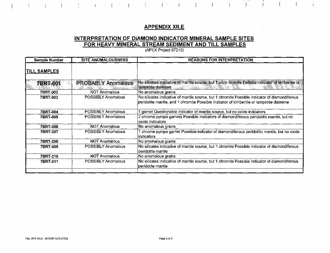
Sample Number I
APPENDIX Xll.E
INTERPRETATION OF DIAMOND INDICATOR MINERAL SAMPLE SITES FOR HEAVY MINERAL STREAM SEDIMENT AND TILL SAMPLES
(APEX Project 97210)
SITE ANOMALOUSNESS I ' ' ' '
REASONS FOR INTERPRETATION
TILL SAMPLES l ' ' ' '
r
l
--------~;-9~~i~(io1--------r--F>Ro6isl.v7\noinaTo~s---n:~c;-5ificates~1rieiicative-offiiaiitie-sourc0:"bu-fTP"i"tro-iim-0nifirilleiir1ite-1h"aic-a1e>r oHTiritiei-iif e-or-----"------------~---"--------------L-----------~--------------------c-"-----------Jt~.!!i.P_i::<?J!~-~!~Jr~!Il-~-----------------------·"---C~C-~-C"-------~-----"------------------------~--L-"-------~-"----~---.l
7BRT-002 i NOT Anomalous i No anomalous grains -----------7sRr:oo3----------1----------F>-osslsL"vft.-rion1-a10-us---------rNo-silicates-inciicative-ofrliaiitie-sou-rce,--i;u-1-fc-tiramite-P"ossible-iii-aic-aiar-oTCi-iam-onci-iferalis __ _ 1 !peridotite mantle, and 1 chromite Possible indicator of kimberlite or lamproite diatreme ' ' ' ' ' ' -----------7sRr:oo4----------r--------F>-oss1scvA"riam-alaus---------n--9a-rii-0t-au0stio-riati-1e_i_riciicator-of rliaii-tie-sou-rce:-i;1.Jrr;0-o-xicie-iii-ciicatars ____________________________ _
-----------7sRr:oos----------r--------F>-oss1scvft.-rian1-a10-us---------r2--cti-rome-iJY-rope-9arnets-P"ossib1-0-rr;-arcaiars-ofciiarlioii-ciiie-roiis-pericioiitic--ma-ritie~-buTna _______ _ ! !oxide indicators
:::::::::::?~:~f Q~~:::::::::I~:::~~:~:::~:~9I~~~~~[~~~:::::~:~:::::I~9-~~:69-~~[~~~:~!~[6~::::~~~::~:::::~~~:::::::~~~:::::::::~::::::::~:::~:~~:::~~:::~~~~::::~~~:::::::~~~:::::::~~:::::~ 7BRT-007 i POSSIBLY Anomalous i 1 chrome pyrope garnet Possible indicator of diamondiferous peridotitic mantle, but no oxide
i i indicators ------------;0-Rr:oos----------r------------No"T-:Ana-rlia1-Ciiis--------------rtJ0-anamalous-9rairis--------------------------------------------------------------------------------------------------------------;-0-Rr:oos----------r--------F>-oss1scvft.-rion1-alo-us ________ TtJo-silica-tesinciicative-afrliaiitie-sou-rc0:-i;u-rf ctiromite-P"ossible-iii-ciicaiar-CiTCi-iam-onci-iteralis __ _ ___________________________________ j_ _________________________________________________ lP_~.rJ9_9!!!~_.!!!~~!!~---------------------------------------------------------------------------------------------------------
7BRT-010 i NOT Anomalous iNo anomalous grains -----------10"R1:a-11-----------1----------F>-osslsL"vft.-rion1-a10-us _________ itJo-silicatesii1Ciicative-afrliaiitie-sou-rce.--i;u-rfc-tirom-ite-P"ossible-iiiciicaiar-oTCi-iam-onciiTeralis __ _ ___________________________________ j_ ________________________________________________ _lp_~.!19-9!!!~_.!!!~D!!~---------------------------------------------------------------------------------------------------------
, ' ' '
File: APX Xll.E - INTERP DIM SITES Page 3 of 3
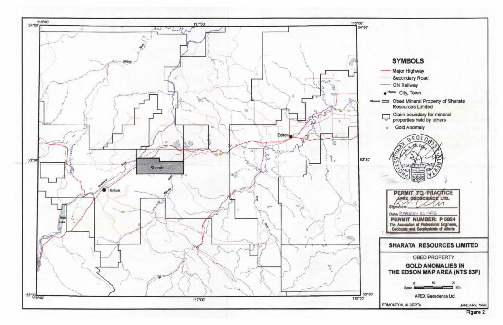
53'30
Q :
/ t:_ /
\
I~ \ JI
\
{
'""\ ) ~\ ~-/ 0 \'----~,~
...._ r·1-~--'----.. .. ~
Ii
~-~-~ .----'Pl! e
:O!I \. &""
..... '-
~-·~ . \,
\
•
1.
SYMBOLS - Major Highway - Secondary Roao - CN Railway
• ......., City, Town
- c:::i Obed Mineral Property of Sharata Resources Limited
53•30-
r-i Claim boundary for mineral '-v-' properties held by others
• Gola Anomaiy
l~ ·.
SHARATA RESOURCES LIMITED
OBED PROPERlY
GOLD ANOMALIES IN THE EDSON MAP AREA (NTS 83F)
10 0 Scale ----
APEX Geoeden<:e Lid.
EDMONTON. ALBERTA JANUARY, 1998
Figure 2

I
(
\
>
• ( (
f(. I ' •
(
•
.t: sbai:ata
' . . , .
...
l. 53'30'
SYMBOLS
--Major Highway - Secondary Road - CN Railway
e - City, Town
Sh•""" c::::i Obed Mineral Property of Shc:rata Resources Limited
11 Claim boundary for mineral Lu-' properties held by others
+ Diamond Occurrence in Fluvial Sediment
• Diamond Indicator Mineral Ocx:urrence FIOll'I aSSO$Slllti11 repcrts (oft., Boller olld Olson. 1997)
SHARATA RESOURCES LIMITED
OBED PROPERTY
DIAMOND INDICATOR MINERAL OCCURENCES IN THE EDSON
MAP AREA (NTS 83F)
Scale
10 2ll Km - - - -
APEX Geoscience Ltd
EDMONTON, ALBERTA JANUARY 1998
Figure 3

/~~ .
I ,
/ ' /
Cir,; /
:0 -. , -~~
,,
I/ I '
'\,
-)(
.X SY'vlBOLS
1llAlm1 •
78RAO<>I X
7BRl'001 •
7Blm01 ..
HNvy mineral stream sediment sample; ldenlifter
Stream silt sample; Identifier
Rock grab sample; Identifier
Heavy mineral till sample; Identifier
Property boundary
-=- Akeather road
//
I
(To pographic contour iniertlGl ZOO ftet)
--\
/
-
I [ \
Oats Ff8a!A&i 10 , 1'¥li PERMIT NU:'JlCI:fl: P !i(;'!t;
The ksoQ~i of P;':,:·l('·..J L • :;, GeobgQ and Georr.r........s ct i-. -A
) /
I
-- - ~-,. I /. ~-
\, <
SHARATA RESOURCES LIMITED
OBED PROPERTY
SAMPLE LOCATIONS
N"'$; t >f/ 4,11 l """ ... __ ..... _______ .. ...
Figure 4

s3·ocr na·w
I _/
Geology after Price et. al., 1973
~
117'00'
Western ~nada S dimentary
\ 'B~ '\ ~ \ -
\ {, ~ , I '') •
~~ ~ •
• • - ~ ~ '
53'30'
J '· ,) \ "1 \ ~ ~~
,,_../ •
53°00' 11e·oo·
Legend and Symbols
D Paskapoo Formation
• Brai:eau Formation
• Smoky and Alberta Groups
• Blairmore and Bullhead Groups
• Jurassic and Older
~Thrust, Reverse Fault (teeth on hanging wall)
• Hin1on City, Town
~ Obed Mineral Property of Sharata Resources Limited
TO PRACTICE .,. .. :iuu1EOSCIENCE LTD.
Data ft:'>8 '9"" K>. loffj PERMIT NUMBER: P 5824
The Assoclaecn or ~lcn.al Engilleell, GClologlsta ltlld Geophyslcsls at Alletbt
SHARATA RESOURCES LIMITED
OBED PROPERTY
REGIONAL GEOLOGY OF THE EDSON MAP AREA (NTS 83F)
10 -----APO< Geo$clence Ltd.
EDMONTON, ALBERTA JANUARY, 1996
Figure 5

.-~----
\ v
3b
\
I
'"' "i ~ "(':
\ \
~- __ ...; ,
__.,
r;:/
'f f~ .\-
I \1
./ ....:;:....__ . - -
SYMBOLS
OJ ARuvlal oedlmenta (prlm1rty 11nd •nd grevel. &OIM fl<o<I pl1ln rnoto~•il
[}] G'aclol\lvlal sedlmlnl& (kaN'-""""· 8'kers, etc.)
I 4bl Al for4a; Ull latlid<er (>2m~ drumllrw leuobvlous
1 ) llfllmin (b now dlracflon knOWn.)
-
===--"'# ~. __ _..
- --
---- Geological boundary
r.i:l Obed Til: YOIY A:lney, ~y .. llllc.1-og,--'"'11: ~ clstlncllnear-... w!llcli ... mawy--- °""""" (lea ftow dlracllcn L111cnown.) ~
l3bl "'fllr 3a. bu1 l9w M1unc: -
r:;:i Motlboto lil:- ....-..y than.,. Obed 111: roomy malrU<. .-~ c:ort>onr.a contant: mey ooraln Shle4d c:tasts (grllllila~ anunNM obv1ool
)()(
~ (Topogro.ph1t oonlour inte1'1'<>1 200 }Ht)
r---...J
Creek -4b
-
----
a:rzs.85'
.&" I ,--
-
~...:.:_7__,c._ _ ___ .._ _ _ ____ .:____ .,,._.___ _ _
SHARATA RESOURCES LIMITED
OBED PROPERTY
QUATERNARY GEOLOGY
'"""° APEX-Lid
JANUARY 1998
Figure 6

\ x
SYMBOLS + Drilr111g area which did not penetrate overburden
e Drilling area with limestone lithology In bedrocic
0 Drilling area with sandstone lithology In bedrock
• Drilling area with slltstone lithology In bedrod<
e Driling area with abundant ooel In badrocic
J -
'
) I \
--
X C6 Area of outaop and outcrop Identifier
- - Property boundary
~ - All-weather road
Notes: Some drilling areas contain multiple drill holes.
Outcrops C8 and C9 are located outside of the Obed Property map area.
(1opolfTGpMc conlo'UT '"'~ 200 Jll•I)
gna - ' Osle fEBf!UA!!H !O, 1lf\'t. F:::i:::.ur NU~.'\BER: p 5624 ~ A::scdl:.on of~ EngineeB,
Geoiogis:a Ind GaophysDlls of MW
~-
x coo x 0)1
) '· c1f~
c1f< '
I
l 1?<'I C4•
I ~CtO '11
~I
SHARATA RESOURCES LIMITED
Ol!EO PROPERTY
BEDROCK GEOLOGY
0 int IJf',lt..tt : ..... ........ =----=""'
I J
'
Figure T

?-)
I
--*1 ~/ _,
"
--<
,(-15 /"
::;{\ ~~
\
--
-
{-.....
- _ _,_ '- ( 0 ti"'"ooo 0 Cree~..,s-
)
•
-26 SYMBOLS
Gold grain count In grains, 11 +, sample Identifier, superpanned stream sediment samplo
Gold grain count In grains. 6-10. sample identifier
Gold grain count In Grains, 0-5, sample identifier 88 Au.
-- ..i uold In perts per bllllon, sample ldentfier, anomalous stream sediment sample
- .A 3~ement In parts per billion, sample idenllfler
/
15
- -Au -10 19
~~
Gold in grains, 11+, sample Identifier, superpanned till sample
Gold In grains, 6-10, sample identifier
Gold in gra ns, 0-5, sample Identifier
Element in parts per billion, sample klentlfler, rock grab sample
All-weather Road
Property Boundary (Topogro:ph1C contour interual ZOO ft«tl )
TO PRACTICE GEOSCIENCE LTD.
S~nstu:w -------Oa\9 fEeRXAA:-1 IQ , 1Cf!<g F::-'~.11T NUMBER: P 5824
Tl'~ A:;:.Gla~ci ~;' Engr-.. ~IN! ol~
-rh -~ f S:rztl.85
~- - · z~ 1
11 - ~ I , ~~
SHARATA RESOURCES LIMITED
OBED PROPERlY
GOLD ANO GEOCHEMICAL
ANOMALY HIGH.JGHTS
0 ltf'tJ W/ '-1 ' 2 .... ........ _ .......... _ ... .... ,,.._
""'1Hr.JllR(, ' toa
Figure 8

• -• -• -0 -
I ./
-., ~ .-
11Atm1 'J
(l l>V
' ( \;
SYMBOLS Oefinkely Anomalous Diamond Indicator Mineral Sample Site which has at least 2 grains (slllcata In red and oxide In black, or both) that are •oefinlte Indicators" ( SAA Appendix XII): sample Identifier.
Probably Anom8lotJs Diamond Indicator Mineral Sample Site which has at least 1 grain (sUJcate In red or oJdde In black) lhal Is a 'Oellnite lncf1C811:11'" (see Appendix XII); safT4>1e identller.
Possibly Anomalous Diamond Indicator Mineral Sample SKe which has at least 1 grain (sNlcata In red or oxide In black) thal Is a 'Possible (or Questionable) Indicator" (see Appendix Xn): sample ldent1ner.
Sample slte that produced no anomalous Indicator mineral grains; sample ldantlfter.
~/ / I \
) -_./ ~ [\
(;) -\.. .. ~
( ~-_..i:,:oO
.---~
_v -c; "--.
1 ~ '); 7 --. '
_:z:::_ . ;._'"t,J -~ --~
/ I
- - Prq)eny IXltlndary
~ All-weather road
r
'P IT TO PRA~TICE EX GGOSCIENCt;/LTD.
Slgr~\>.J~ __ __.::::._.:.../ __ _
c-·· fEeB1~ 10, t'Rf, r _ ~~.~:r NU;:,DER: P 5024
T1 .• A;.;~ ~ P10teu1Gn.al Ellgl._.._, 6,~o._tsla I Geoplly$iCG!S d ~
I 611'tU5'
SHARATA RESOURCES LIMITED
08ED PROPERTI
DIAMOND INDICATOR MINERAL ANOMALY HIGHLIGHTS
H1'$: IJl'/ 1.11 -·-------..""""" "" l!I0.000
APEX C , w lid.
.J/JHJNft. t9te
Figure 9