Embed Size (px)
Citation preview

Maranoa Regional Council: Representations about proposed call in Roma flood levee development application 26 September 2016
113944:7143059_1

Maranoa Regional Council: Representations about proposed call in
Roma flood levee development application
Table of contents. Table of contents. ---------------------------------------------------------------------------------------------------- 3
1 Overview. ----------------------------------------------------------------------------------------------------- 4
2 Reasons for calling in Application. ---------------------------------------------------------------------- 4
3 Merit assessment supported. ---------------------------------------------------------------------------- 5
4 Integrated Development Assessment System. ------------------------------------------------------ 6
5 Points of clarification. -------------------------------------------------------------------------------------- 6
6 Conclusion. -------------------------------------------------------------------------------------------------- 7
Annexures ------------------------------------------------------------------------------------------------------------- 7
Page 3
113944:7143059_1

Maranoa Regional Council: Representations about proposed call in
Roma flood levee development application
1 Overview. 1.1 Maranoa Regional Council (Council) makes the following representations in response to
the proposed call in notice issued by the Deputy Premier, Minister for Infrastructure, Local Government and Planning and Minister for Trade and Investment dated 31 August 2016.
1.2 These representations should be read in conjunction with Council’s request to call in the flood levee development application (Application) dated 22 August 2016, which is included as Annexure A to this document.
1.3 Council has advanced the project and obtained some updated supporting material since the request to call in the Application was made. Annexure B contains a plan which shows the location of the proposed Western Levee, the Eastern Diversion Drain (which form part of the Stage 2 flood mitigation works), and the existing Stage 1 levee. Annexure C contains cross section drawings of the Western Levee.
2 Reasons for calling in Application. 2.1 Council agrees with and strongly supports the reasons that have been identified for
proposing to call in the Application outlined in page 4 of the proposed call in notice.
2.2 Council has identified the following additional reasons which support a decision to call in the Application.
Improved flood immunity
2.3 As identified in the proposed call in notice, the Western Levee will improve flood immunity in Roma.
2.4 Council confirms that Stage 2 of the Roma flood levee project will not cause any worsening of flood impacts on any dwellings in Roma.
Construction program
2.5 The construction program for the Western Levee works and Eastern Diversion Drain has been prepared on the basis that all works will be carried out at the same time.
2.6 One of the main reasons for this is that excavated material from the Eastern Diversion Drain is required to construct the Western Levee. If the works cannot be carried out at the same time, then excavated material will need to be stored at another location which is not susceptible to flooding then, at a later stage, transported back to the Western Levee site.
2.7 This ‘double handling’ would:
(a) substantially increase project costs, to such an extent that the project would not be economically viable for Council; and
Page 4
113944:7143059_1

Maranoa Regional Council: Representations about proposed call in
Roma flood levee development application
(b) introduce new adverse impacts on the community, including:
(i) significant construction traffic;
(ii) adverse impacts on residential amenity, and on the town generally; and
(iii) increased rate of deterioration of local roads due to substantially increased use by heavy vehicles, bringing forward maintenance requirements and increasing costs.
Community confidence
2.8 A prompt assessment and decision on the Application through the call in process will facilitate certainty and confidence in the community, particularly for:
(a) the owners and occupiers of flood affected dwellings who will directly benefit from completion of the flood levee through increased flood immunity;
(b) the owners and occupiers of land directly affected by construction of Stage 2 as:
(i) a final decision on the Application will provide certainty about property impacts, and facilitate the conclusion of the land acquisition process; and
(ii) compensation can be finalised, and any requirement for a second review of compensation (for example, if a decision is not made until the Court appeal is decided) can be avoided; and
(c) local employees and business owners who will be able to submit tenders for construction contracts for the works.
Funding
2.9 The appeal may impact on Council’s ability to achieve the construction milestones contained in the State and Federal funding agreements. Accordingly, any further delays in approval of the Western Levee may jeopardise State and Federal funding for the project.
2.10 Construction of the Western Levee and Eastern Diversion Drain is dependent on State and Federal funding remaining available.
3 Merit assessment supported. 3.1 If the Application is called in, Council supports the Deputy Premier assessing and
deciding all aspects of the Application as opposed to only deciding state interests. This is reinforced by the fact that it is difficult, if not impossible, to separate state interests from other interests relating to the project.
3.2 If only state interests were assessed, the Application would then be referred back to Council as the assessment manager for a final decision. This additional step is unnecessary and would further delay any approval of the Western Levee. There would also be an opportunity for a fresh appeal to be made to the Planning and Environment Court which:
Page 5
113944:7143059_1

Maranoa Regional Council: Representations about proposed call in
Roma flood levee development application
(a) has the potential to delay this important community project even further; and
(b) would mean that there is no utility in the proposed call-in of the Application.
4 Integrated Development Assessment System. 4.1 Council supports the Deputy Premier calling in and returning the Application to the start
of the decision stage of the Integrated Development Assessment System (IDAS) process. Significant information has been provided about the development, it has been publically notified and submissions received. All aspects of the Application are ready to be decided.
4.2 The Application should be promptly decided and, if approved, the benefits of the levee delivered to the community as quickly as possible.
5 Points of clarification. 5.1 Council provides the following clarification on the funding arrangements mentioned in the
request for a call in for both stages 1 and 2 of the Roma flood mitigation project.
5.2 Council estimates the total cost for the project is approximately $28 million. Broadly speaking, the cost of Stage 1 of the project is $19 million and the cost of Stage 2 is $9 million.
5.3 Council also clarifies the following funding arrangements:
(a) for Stage 2, the Federal Government has made a financial contribution of $4,980,000 under the ‘National Insurance Affordability Initiative’, which is administered by the Department of Infrastructure, Local Government and Planning;
(b) Council’s business case for the ‘Regional Development Australia Funding’ for about $6,800,000 was unsuccessful, however adequate funding for the project is in place (provided the allocated funding is not adversely impacted by the subject delays to project approval and commencement);
(c) for Stage 1, Council made a financial contribution of approximately $4,570,000; and
(d) for Stage 2, Council will make a financial contribution of up to $665,000 due to an additional funding allowance of $416,000 being approved by Council on 14 September 2016.
Page 6
113944:7143059_1

Maranoa Regional Council: Representations about proposed call in
Roma flood levee development application
6 Conclusion. 6.1 Council supports the Deputy Premier calling in and deciding the Application. The
following matters are important:
(a) the Application relates to many state interests;
(b) there are compelling reasons to call in the Application;
(c) all aspects of the Application should be assessed and decided; and
(d) the IDAS process should restart from the start of the decision stage.
6.2 Council is available to assist the Deputy Premier to any extent required during the assessment process.
Annexures Annexure A: Council request to call-in flood levee application (Page 1)
Annexure B: Western Levee location plan (Page 60)
Annexure C: Western Levee cross sections (Page 61)
Page 7
113944:7143059_1

Roma Flood Mitigation Project: Stage 2 Request to call-in development application: Western Levee
22 August 2016
Annexure A

Roma Flood Mitigation Project: Stage 2
Request to call in development application: Western Levee
Page 3
Table of contents. Table of contents. ---------------------------------------------------------------------------------------------------- 3
1 Executive Summary. --------------------------------------------------------------------------------------- 4
2 Overview of development application. ----------------------------------------------------------------- 7
3 Submitter appeal by Stevens. --------------------------------------------------------------------------- 8
4 State interest. ------------------------------------------------------------------------------------------------ 9
5 Conclusion. ------------------------------------------------------------------------------------------------ 12

Roma Flood Mitigation Project: Stage 2
Request to call in development application: Western Levee
Page 4
1 Executive Summary. 1.1 Maranoa Regional Council (Council) requests that The Deputy Premier and Minster
administering the Sustainable Planning Act 2009 (Qld), The Honourable Jackie Trad MP call in a development application for operational work for the construction of a flood levee in Roma which forms an important part of the broader Roma Flood Mitigation Project: Stage 2. The remaining parts of Stage 2 of the project are exempt development in the adopted Roma Town Planning Scheme 2006 and do not require a development permit from Council.
1.2 The land directly impacted by the Western Levee is generally described as an area 1 kilometre in length, bound by the Stage 1 levee bank to the north, Edwardes Street to the east, Bungil Creek to the west and Bungil Street to the south.
1.3 The development application for the Western Levee was approved by Council at its General Meeting on 22 June 2016. On 22 July 2016, a submitter appeal was commenced against the approval, and a refusal of the application is sought by the submitters.
1.4 The State, through the Department of Infrastructure, Local Government and Planning has been named as a party to the appeal.
1.5 The construction and location of the Western Levee has been the subject of extensive scrutiny from experienced consultants and there has been appropriate community consultation. The proposed levee location is in an area where the levee will provide the greatest flood immunity with the least impact on the residents of Roma.
1.6 Council, the Queensland Government and the Commonwealth Government have invested significant funds and resources in Roma’s flood mitigation project to date. Stage 1 of the project is complete and it is important that Stage 2 is also completed to ensure the full benefits of the project, including the part already constructed, are realised.
1.7 If a proposed notice to call in the development application is issued, Council commits to preparing a detailed submission in support of the application and providing all other assistance that it can to the Deputy Premier.
1.8 Based on our calculations, the last date for the proposed call in notice to be issued is 5 September 2016, being 50 business days after notice of the development approval was given to submitters.
1.9 A copy of an earlier letter sent to the Deputy Premier is included in Annexure A for completeness.

Roma Flood Mitigation Project: Stage 2
Request to call in development application: Western Levee
Page 5
2 Flooding in Roma: the need for a flood levee. Flooding history
2.1 Roma has a long history of suffering significant adverse impacts from flooding. For example, there have been 18 moderate and 8 major flooding events in Roma over the last 50 years (i.e. there is a flood event which causes damage to private and public property about every 2 years on average).
2.2 During 2010 and 2011 significant flood events impacted Roma and in 2012, an unprecedented storm event occurred. The 2012 flood resulted in one fatality and approximately 1,028 properties experienced flood inundation, with about 580 of those properties being flooded above the floor level of the building.
2.3 These frequent flood events have also caused significant damage to public (State and local government) infrastructure, requiring constant repair at significant expense to the local and broader community.
Roma flood mitigation project
2.4 Due to recent flood events, and an increasing frequency of extreme flood events, Council commissioned flood studies of the Bungil Creek floodplain in and around Roma. The flood studies informed a flood mitigation strategy that recommends, amongst other things, the construction of flood levees and associated infrastructure to protect Roma from future flood risks and hazards.
2.5 In implementing the recommendations Council has undertaken extensive community consultation and implemented a two stage levee construction program known as the Roma Flood Mitigation Project.
2.6 Selecting the location and alignment of the flood levee and associated infrastructure has been based on the principle that the levee should provide optimum hydraulic performance, be placed in a location that provides the greatest level of flood immunity to as many properties as possible, and have the lowest impact on private property.
2.7 The Roma Flood Mitigation Project is being delivered in two stages, discussed briefly below.
Stage 1
2.8 Stage 1 of the Roma Flood Mitigation Project (Stage 1 Levee) included the construction of an earthen levee which was completed in early 2015. The Stage 1 Levee is about 5.2km long and follows Bungil Creek from just north of the Roma Airport towards the east, then turning south towards the location of the ‘Western Levee’ proposed as part of Stage 2 of the Roma Flood Mitigation Project (Stage 2).
2.9 The Stage 1 Levee provides some protection to Roma from flood events and is designed to reduce above floor flooding in significant flood events like that experienced in 2012 from about 590 affected properties to about 100 private and commercial properties in Roma.

Roma Flood Mitigation Project: Stage 2
Request to call in development application: Western Levee
Page 6
2.10 Delivery of the Stage 1 Levee cost about $15.6 million and was funded by Council, (approximately $1.25 million) the State (approximately $12.4 million) and the Federal Government (approximately $2 million).
Stage 2
2.11 Stage 2 of the Roma Flood Mitigation Project includes:
(a) an earthen levee bank with sections of reinforced concrete structure approximately 1km long (Western Levee) which complements the effect of and benefits provided by Stage 1;
(b) the diversion of part of Bungil Creek to the east, away from Roma (Eastern Diversion Drain); and
(c) upgrading and improving existing stormwater drainage infrastructure within Roma.
2.12 The concept plan for Stage 2 appears below. A larger plan is included in Annexure B for convenience.
2.13 At least 55 additional buildings will be protected from above floor flooding in extreme flood events if Stage 2 is fully implemented. Additional protection above this level will apply to lower level flood hazards.

Roma Flood Mitigation Project: Stage 2
Request to call in development application: Western Levee
Page 7
3 State assistance. 3.1 The Queensland Government has provided significant financial and other support to
Council following recent flood events in Roma (and in other towns within the Maranoa Region). Without this support the Roma Flood Mitigation Project could not happen, and the benefits to Roma and the broader community would not be realised. This assistance is greatly appreciated by the Council and residents of Roma. Similar projects are currently being investigated in other towns in the Maranoa Region, including Mitchell.
3.2 The State has made the following financial contributions to the Roma Flood Mitigation Project to date:
(a) for Stage 1, about $12.4 million including:
(i) $4.7 million from the South Western Queensland Flood Mitigation Fund;
(ii) $2.72 million from the Local Government Grants & Subsidies Program;
(iii) $5 million from the Royalties for the Regions program; and
(b) for Stage 2, between $3 and $4 million, secured by a funding agreement made under the Building our Regions fund. Federal funding is also being secured by an extension to the existing funding agreement made under the National Insurance Affordability Initiative.
4 The Western Levee. 4.1 The Western Levee is a critical part of the overall Roma Flood Mitigation Project. It
provides further flood immunity for Roma and complements the eastern diversion drain also included as part of Stage 2.
4.2 The Western Levee is assessable development under the Sustainable Planning Act 2009 (Qld) because it will impact 3 or more people who do not live on the levee land. The proposed levee is considered a Category 3 Levee and is subject to impact assessment. This means a development permit for the Western Levee must be obtained before construction can commence.
4.3 The other parts of Stage 2 do not require a development approval to be obtained from Council before works can commence as they are exempt development in the Roma Town Planning Scheme 2006.
4.4 A plan of the Western Levee appears below. A larger plan is included in Annexure C for convenience.

Roma Flood Mitigation Project: Stage 2
Request to call in development application: Western Levee
Page 8
4.5 The Western Levee is proposed to be constructed from a combination of earth mounds and reinforced concrete structures.
4.6 A development application for the Western Levee (Application) was lodged in February 2016 and was approved by Council by decision notice dated 24 June 2016. The Application was publicly notified (5 submissions were received) and was referred to the State Assessment and Referral Agency (SARA) for concurrence agency assessment.
4.7 The SARA’s requirements for approval of the Western Levee are included in the Council’s decision notice which approved the Western Levee. A copy of the development approval for the Western Levee is included at Annexure D.
5 Submitter appeal. 5.1 On 22 July 2016, Paul and Mary (Molly) Stevens filed a submitter appeal in the Planning
and Environment Court which seeks orders that the Western Levee be refused (Appeal). A copy of the Notice of Appeal is included in Annexure E and a copy of the submissions about the Application made by Paul and Molly are included in Annexure F.
5.2 Both Council and the State (through the Chief Executive, Department of Infrastructure, Local Government and Planning) have been named as a party to the Appeal.
5.3 Molly Stevens owns land at 236 Edwardes Street, Roma. The Western Levee is proposed to be constructed on part of that property, and on other adjoining land.

Roma Flood Mitigation Project: Stage 2
Request to call in development application: Western Levee
Page 9
5.4 If the Stevens’ are successful in the appeal, the Western Levee cannot be constructed, and the broader community benefits which it provides will not be achieved.
5.5 It is noted that if the Minister decides to call-in and decide all aspects of the Application there will be no adverse impacts on the Stevens’ ability to claim compensation or on the determination of the amount of compensation to be paid, as that is a separate process regulated by the Acquisition of Land Act 1967 (Qld) and is not affected by the SPA.
6 State interests. 6.1 The SPA gives the Minister power to call-in, assess and decide a development
application involving a State interest.
6.2 A State interest is defined as:
‘(a) an interest that the Minister considers affects an economic or environmental interest of the State or a part of the State, including sustainable development; or
(b) an interest that the Minister considers affects the interest of ensuring there is an efficient, effective and accountable planning and development assessment system’.
6.3 The construction of the Western Levee is for the benefit of the broader Roma community (as part of the State) and involves a number of State interests. In an effort to assist the Minister, Council has given some consideration to the State interests that are impacted by the Western Levee, and its function as an important part of the broader Roma flood levy system for the provision of increased flood immunity, community resilience and improved post-disaster recovery and management.
6.4 In considering the below it is noted that a State Planning Policy advances the purpose of SPA by stating the State’s policy about a matter of State interest and that a designated region’s regional plan is also taken to be a State interest.
Natural Hazards, Risk and Resilience
6.5 The State Planning Policy identifies State interest – Natural Hazards, Risk and Resilience to be a relevant State interest for a flood levee.
6.6 The Western Levee meets this State interest by:
(a) significantly mitigating flood impacts within Roma, including a reduction of flood water levels, flood water velocities and the duration and frequency of flood water inundation in Roma;
(b) reducing the risks of a flood event, being a natural hazard, in Roma to provide additional protection of people and property from flood hazards in and around Roma;
(c) enhancing Roma’s long-term resilience to flooding;

Roma Flood Mitigation Project: Stage 2
Request to call in development application: Western Levee
Page 10
(d) reducing the cost and time of flood recovery work, repair of impacted infrastructure and the like;
(e) lowering demand for State and volunteer emergency services during flood events as a consequence of reduced impacts, which will ensure that these very important and finite community resources can respond to and deal with incidents as quickly and as effectively as possible, and assist similar services in other affected localities as required;
(f) providing a long-term and sustainable response to disaster management through the provision of permanent, resilient and low maintenance infrastructure;
(g) reducing the extent and magnitude of major flood events experienced within Roma, ultimately providing increased protection to persons and property, and minimising the adverse impacts of flooding within the town; and
(h) increasing community resilience to flood risks in Roma through the completion of a well designed and effective levee system.
Economic interests
6.7 The Western Levee affects the economic interests of the State through:
(a) ensuring the value and benefit of State (and other) funds applied to Stage 1 of the Roma Flood Mitigation Project is fully realised and provides the most effective flood immunity available through completion of Stage 2;
(b) ensuring that existing funding commitments from the Federal and State governments can be efficiently utilised to ensure the ultimate configuration of the Roma Flood Mitigation Project, and the benefits it provides, are realised;
(c) reducing demand for, and therefore the cost of, providing emergency services during flood events or related natural hazards;
(d) providing long-term flood mitigation infrastructure that is low maintenance, sustainable and proven, and that will protect other State and local government infrastructure within the benefitted area from damage frequently experienced in recurring flood events;
(e) there will be substantial savings in the cost of repairing damage to private residential and commercial property and public infrastructure following flood events;
(f) there will be reduced productivity losses from disruption to services and businesses in Roma; and
(g) there is expected to be a further increase in available flood insurance and a corresponding reduction in insurance premiums for property within the benefitted area which will provide individuals and businesses with greater resources in the event of future flood damage, and reduce reliance on the public purse during disaster recovery and for property repairs.

Roma Flood Mitigation Project: Stage 2
Request to call in development application: Western Levee
Page 11
Environmental interests
6.8 Approval of the Western Levee will affect the environmental interests of the State on the basis that:
(a) the selection of the most appropriate Stage 2 flood mitigation option and alignment was informed by an environmental assessment of the Stage 2 flood mitigation investigation area together with the upstream and downstream reaches of Bungil Creek;
(b) the Western Levee provides for the mitigation of adverse impacts on the majority of the built environment in Roma when major flood hazards arise; and
(c) the Western Levee provides an additional refuge from flood water for wildlife and stock.
Disaster management
6.9 The Roma Flood Mitigation Project ensures that the State’s emergency services and disaster response resources are not unduly burdened by flood events which could be avoided or mitigated.
6.10 The Roma Flood Mitigation Project provides for increased immunity for people, property and livestock from the risk of a flood event.
6.11 Long-term protection of critical public infrastructure will mean that recovery and reconstruction costs are reduced in the long term.
Darling Downs Regional Plan
6.12 The flood levee project is consistent with the infrastructure initiatives of the Darling Downs Regional Plan 2013 (Regional Plan), which provides for new and improved community infrastructure, roads and flood mitigation projects across the region.
6.13 The proposal meets the Hazards and Safety State Interest within the Regional Plan which seeks to protect areas (in particular Roma) for reasons already mentioned above.
6.14 The Regional Plan identifies a number of opportunities that exist in the Darling Downs area to mitigate the impact of flood events on people, property, the economy, the environment and infrastructure, including:
‘(a) the ability to improve the long-term flood resilience of the region by rebuilding to a higher standard of flood immunity with options such as redesigning, upgrading and/or relocating infrastructure and communities.’
6.15 The Regional Plan specifically acknowledges that natural hazards create an array of challenges for the Darling Downs region affecting the liveability, productivity and communities of the region and notes that the impact of flood events can isolate towns, cause significant damage to agriculture and resource commodities, for example, property (fences, sheds and machinery) and infrastructure such as key transport networks (Warrego Highway and Western rail network), utilities and bridges. This affects the productivity and supply chains on which the regional economy relies subsequently impacting the region’s retail trade, services manufacturing and tourism sectors.

Roma Flood Mitigation Project: Stage 2
Request to call in development application: Western Levee
Page 12
Finalisation of the Roma Flood Mitigation Project, including construction of the Western Levee, will contribute to addressing the hazard and supporting these objectives.
Timing
6.16 To ensure the benefits of the flood levee are maximised, it is important that the Western Levee be constructed before the upcoming storm season.
6.17 The current Appeal before the Court has the potential to substantially delay the commencement of construction of the Western Levee and delays the realisation of the broad and important community benefits that the Western Levee and the broader Roma Flood Mitigation Project provides.
6.18 A decision by the Minister to call in and decide all aspects of the Application would activate the State interest of ensuring an efficient, effective and accountable planning and development assessment system.
7 Conclusion. 7.1 We trust that this information will be useful in assisting the Deputy Premier make a
decision about whether to give a proposed call-in notice and decide the Application.
7.2 Council is committed to providing any and all support necessary. Please do not hesitate to contact Robert Hayward, Director – Development, Facilities & Environmental Services on 07 4624 0627 or 0427 229 214 or by email at [email protected] to discuss further.

Roma Flood Mitigation Project: Stage 2
Request to call in development application: Western Levee
Page 13
Annexures A copy of the annexures are enclosed.
Annexure A commences at page 1
Annexure B commences at page 3
Annexure C commences at page 4
Annexure D commences at pages 5
Annexure E commences at page 21
Annexure F commences at page 37

Annexure A
1

2

!
!
!
!
!
!
!
!
!
School
Hospital
The Big Rig
Stage 1 Levee
Western Levee
Cultural Centre
Railway Dam Extension
Eastern Diversion Drain
Long Drain Improvements
Bowen Street
Mcdowall Street
Clay
ton R
oad
Warrego Highway
Miscamble StreetQu
intin
Stree
t
East Miscamble Street
Northern Road
Lovell Street
Ashb
urn R
oad
Beaumont Drive
Ashb
urn R
oad
DEAD HORSE CREEK
BUNGIL CREEK
Roma Flood Mitigation Project - Stage 2 CONCEPT
o
Date created: 21.06.2016. Refer to separate document for data disclaimers.
LEGENDLandmark Watercourse Stage 1 Levee Stage 2A Mitigation Works
Stage 2B Mitigation Works
3

Annexure C
4

5

6

7

8

9

10

11

12

13

14

15
16

17

18

19
20

In the Planning and Environment Court No:
Held at: Brisbane, Queensland
Between: Mary (Molly) Stevens Appellant 1
Paul Stevens Appellant 2
And: Maranoa Regional Council as Assessment Manager (and Applicant)
Respondent
Chief Executive, Department of infrastructure Local Government and Planning, Queensland Government and as Referral Agency and Concurrence Agency
Co-Respondent
NOTICE OF APPEAL
Filed on 22nd day of July in 2016 Filed by: Paul Stevens
Service address: Unit 13/136 Macquarie Street, St Lucia QLD 4067
Phone: 0407 741 225
Fax:
Email: [email protected]
DX:
Mary (Molly) Stevens of 236 Edwardes Street, Roma Qld 4455 and Paul Stevens of 136 Macquarie Street, St Lucia Qld 4067 appeal to the Planning and Environment Court at Brisbane against the decision – made under the Sustainable Planning Act 2009 - by the Maranoa Regional Council as Assessment Manager to approve in full with conditions on 22 June 2016 the Development Permit Application Number 2015/19384 for Operational Works – Construction of a Category 3 Levee – On land situated at 216-228 Edwardes Street, 230 Edwardes Street, 234 Edwardes Street, 236 Edwardes Street, 238-256 Edwardes Street, 258-262 Edwardes Street, Roma QLD described as Lot 22 R863, Lot 2 SP110498, Lot 2 RP 4380, Lot 1 RP 4380, Lot 1 R8684 and Lot 1 WV1882 and seek the following orders or other relief:
Annexure E
21

a. that the appeal be allowed;
b. an order that the decision of the assessment manager to give development approval to Development Permit Application No: 2015/19384 be set aside;
c. notwithstanding the above, an order that the conditions of approval imposed by the assessment manager to Development Permit Application No: 2015/19384 be modified as noted below by the appellants, and;
d. notwithstanding the above, any further orders or relief that the Court may deem fit.
Primary facts to appeal by submitters under s. 462 (SPA 2009)
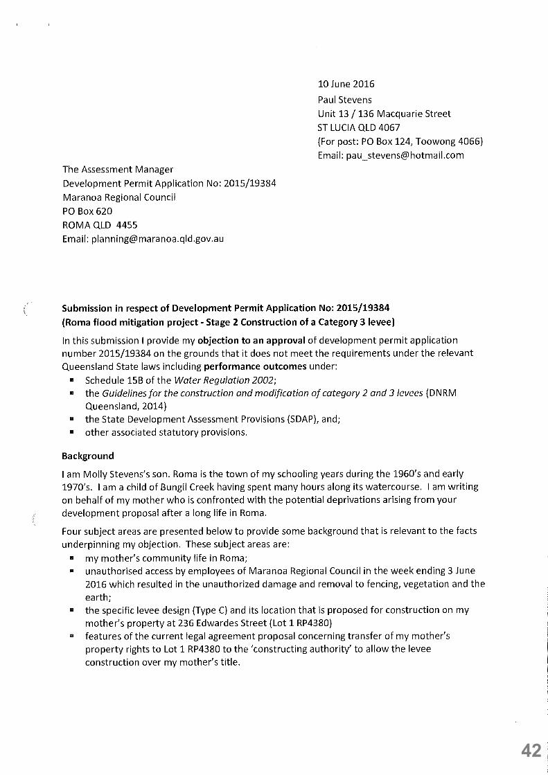
1. On 10 June 2016, Appellant 1 and Appellant 2 each separately lodged properly made submissions with the assessment manager, being the Maranoa Regional Council and the Respondent, for Development Permit Application 2015/19384.
2. The Respondent, being the Maranoa Regional Council’s assessment manager for Development Permit Application 2015/19384, advised by letter dated 24 June 2014 that the development application was approved in full with conditions.
3. Appellant 1 received the development application approval letter dated 24 June 2016 on the following 27 June 2016 and Appellant 2 received the development application approval letter dated 24 June 2016 on the following 29 June 2016.
4. The Co-Respondent is the Chief Executive of the Department of Infrastructure Local Government and Planning and the concurrence agency and referral agency for Development Permit Application 2015/19384 who has imposed various concurrence agency conditions by letter dated 10 May 2016.
The grounds of appeal are:
Preliminary legal issues
A. Assessment manager conflicts of interest
5. The Court should note that the Maranoa Regional Council (MRC) represents the conflicting roles of both applicant and assessment manager for the development application.
6. Secondly in the period immediately prior to the assessment manager’s decision to approve the development, the MRC initiated separate processes to arrange for legal agreements with land titleholders whose real property interests are directly impacted by the proposed construction works. These events are not noted in the development application.
22

7. These intended legal agreements seek to bind the land titleholders to allow the MRC: a. to take a Grant of an Easement Area under powers available with the Acquisition of
Land Act 1967 (ALA 1967) over unsurveyed and unspecified areas of the existing freehold land titles, and;
b. to grant the MRC irrevocable and enduring rights over the land titleholders freehold land: i. to enter the whole of the land title for the purposes of carrying out the construction
works and subsequent ongoing maintenance, including the use of any part of land title for storage of equipment and materials;
ii. to remove improvements and vegetation; iii. to restrict landholder access to any part of the title, and;
c. other unfettered rights.
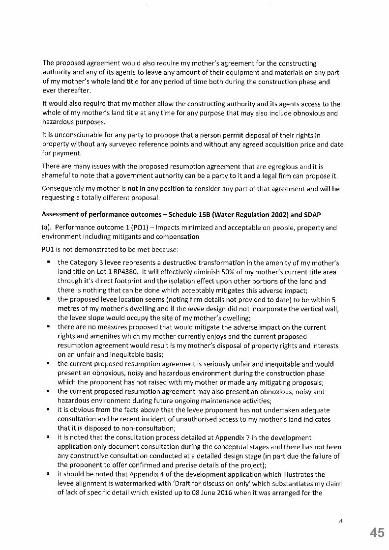
8. The MRC as the applicant is seeking the above legal arrangements and enduring, irrevocable rights that will result in a substantial diminishment of normal freehold rights currently enjoyed, the financial value of the land title and the amenity value of the land:
a. prior to the easement area being surveyed;
b. prior to the provision of any detailed design plans showing the levee footprint (which will determine the intended easement area) and the levee design;
c. prior to adequate detail and consideration being provided in regards to impacts from construction activity and ongoing operations and maintenance, and;
d. prior to any compensation or adequate dispute arrangement being agreed with the land titleholders.
9. The potential conflict with the assessment manager’s decision is that it can be handled in a way that maximises the MRC’s rights to use of the freehold land to the financial, amenity and other forms of detriment of the land titleholders whilst minimising its costs for fair compensation to the land titleholders and for costs of construction and subsequent operations and maintenance.
10. The Sustainable Planning Act 2009 (SPA 2009) in authorising the local government as the assessment manager in this instance does not provide for any frameworks in which the conflicts of interest may be disclosed and avoided or managed.
11. The referral agency fulfills a supplementary role only with limited oversight. The referral agency does not undertake on overall supervisory or oversight role over the full scope of the assessment manager’s decision in a way that can provide an effective check on whether conflicts have been appropriately avoided, managed and/or disclosed.
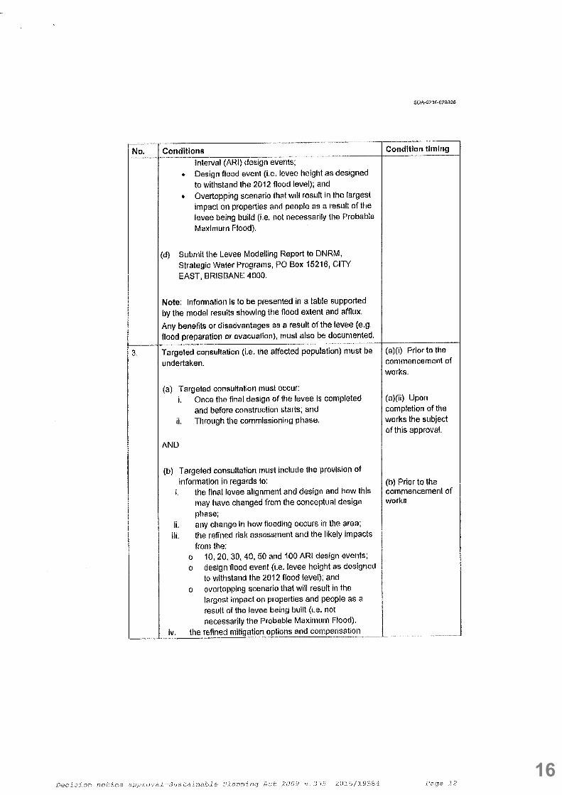
12. For example, the concurrence agency conditions imposed do not require substantiation that the targeted consultation conditions have been met and it remains a sole determination of the MRC. Similarly conditions related to the levee modeling reports and the professional engineer certification in relation to those reports and the levee resilience during and after flood events are not required to be provided to the concurrence agency until 20 days after
23

works have commenced.
13. Land titleholders whose freehold interests are directly impacted and who are required to make decisions that will result in the diminishment of the financial and amenity value of their freehold title have seriously diminished rights and capacity to protect their interests. There are no rights to stop development work where it is defective in some way and there is insufficient detailed information available upon which land titleholders can reliably make decisions regarding transfers of their rights and interests.
14. For the purposes of demonstrating that it is dealing with this conflict of interest is reasonable to expect that the MRC demonstrates full transparency and openness with the assessment processes for this development application and that it is also fulfilling its public role to benefit and protect the interests and well-being of its residents.
15. The standard of proof that the assessment requirements applying to this development permit application should be based upon includes adequately detailed information which demonstrates the development work to be fully sound, clearly fair to the impacted residents and leave little scope for uncertainty in regards to levee’s safety, capacity to achieve its objective and the impact on land titleholders.
16. Additionally where there is evidence that the assessment manager had failed to demonstrate a fully competent assessment process or has omitted to consider a required element without proper reason, then the onus is upon the assessment manager to demonstrate that requirements (including the specified performance outcomes) have been met should be increased and tested with more rigour.
17. The onus of proof under s. 493 (SPA 2009) is with the MRC, as the development applicant, to establish that the appeal should be dismissed. In order to do this, it must prove that it has properly assessed the development application in accordance with requirements of the SPA 2009 which includes having provided sufficient detailed information to the impacted landholders, in particular those whose rights, interests and amenity benefits in freehold land title will be diminished.
Preliminary legal issues
B. Failure to include intended easement areas or alternative legal access rights held by the applicant into the assessment
18. At the time of the development application approval the MRC, as applicant, had no legal rights to access the land titles to construct the proposed Category 3 levee. This fact of no legal access rights to land has not been fully considered or acknowledged by either the applicant or the assessment manager. The MRC still has no legal access rights and until the MRC acquires appropriate legal access rights, the Category 3 levee construction works cannot proceed.
19. Until the nature of the applicant’s legal access rights to the land is known with certainty, an unreliable basis exists for assessing the nature of impacts from the Category 3 levee on the people, property and environment and identifying appropriate mitigants, minimising unacceptable outcomes and determining suitable compensation or other measures. The
24

nature and consequences of this unreliable basis for assessment become apparent in later points.
20. The actual nature of the legal access right to land which MRC does acquire could likely result in design features and mitigants which were assessed as appropriate becoming either inappropriate or not feasible or possible to apply, including if the MRC has to resort to the compulsory provisions of the ALA 1967. The current unknown nature and timing of the MRC’s legal access rights gives additional support to the argument that the timing of the development permit application approval was premature and based on an incomplete understanding of the reality of the site characteristics.
21. The MRC, as applicant, has noted at Appendix 1 to the development application that:
“This application does not propose the creation of any easements. Further development application/s may be submitted to facilitate the creation of easements in order to maintain access to the levee for operational and maintenance purposes.”
without providing information on how it intends to acquire these easement rights post-construction. More significantly the applicant omits to provide any information on how it will obtain legal access for the purposes of constructing the Category 3 levee.
22. It is appropriate to put the question that if the MRC was the assessment manager for a development application from an unrelated applicant (i.e. other than itself) who had no legal access rights to land title upon which the proposed development was to occur or had not provided feasible, reliable and certain arrangement by which it would acquire those rights, it is highly likely the assessment manager would refuse to grant approval.
23. The fact is that the assessment manager, being the same person as the applicant, is aware of the applicant’s intended arrangements to acquire the legal access rights to land title and consequently overlooks the omission of these arrangements in the development application. The consequence with omitting details of the intended easement areas and MRC’s intended legal access rights is that the impacts upon the rights, interests and amenity benefits of landholders cannot be properly identified and therefore would not have the benefit of being protected by development approval conditions that have been imposed through and open and transparent process of consultation and assessment.
24. In contrast to the development permit application process where appropriate conditions relating to rights, interests and amenity benefits may be identified and imposed through a transparent, open and informed development approval process, the conditions that arise from any intended legal agreements which are being negotiated in private, non-transparent circumstances would be based on significant information asymmetry between unequal parties with the impacted landholders being the disadvantaged party.
25. It should be noted that land titleholders who are in a poor relative position of expertise and informational capacity and standing are being asked to enter into legal agreements with the MRC at a time when the design features and alignment of the Category 3 levee with its consequential impacts have not been fully detailed and evaluated at a detailed stage.
26. Furthermore irreconcilable conflicts are highly likely to arise in MRC’s rights and obligations established in the separate legal agreements with the land titleholders and those contained
25

in the approval conditions, final design and construction plans and in essential and required documents including MRC’s Disaster Management Response Plan or the Operations and Maintenance Manual for the Category 3 levee or with other laws including those covering OHS, storage of hazardous materials and building requirements.
Preliminary legal issues
C. Misrepresentation of the site features and characteristics
27. The site features and characteristics of the land titles upon which the Category 3 levee is proposed to be constructed have not been accurately represented by MRC. The applicant and the assessment manager have omitted to properly consider the application in the context of actual nature of the features and characteristics of the site.
28. Whilst acknowledging that the site includes two lots that are zoned residential under the planning scheme for the town of Roma, the development application describes the remaining four lots as “zoned rural and accommodate dwellings at a rural residential scale. The site is flat, being close to the creek and building density is low, allowing sufficient room for construction of a levee without the need to move structures.”
29. The reality is that in order to minimize the levee height by locating the levee as far as possible from the watercourse outer bank, the alignment of the levee is located as close as feasible - with levee design modifications - to the dwellings on a number of lots which includes Lot 1 RP 4380 where the levee alignment appears to be within 5 metres of the dwelling (at the time of writing this notice of appeal, detailed reliable surveying information on the levee alignment is not available).
30. Without the proposed non-earthen modifications to the levee design that are identified in conceptual drawings as Type C and Type D levee designs, dwellings on both Lot 1 RP4380 and Lot 1 WV1882 respectively would need to be moved to accommodate a standard compliant levee design with a 3 metres crest and a landward slope flatter than 1 Vertical : 4 Horizontal.
31. Additionally the location of the Type C and Type D levee designs are at vulnerable points in the Bungil Creek watercourse alignment, in particular Lot 1 RP4380 which is located at the outer part of a substantial change in alignment (creek bend) where flow velocities and other hydraulic actions from flood waters may increase the vulnerability to levee failure. Furthermore the transitions between the Type A and Type B earthen levees and the Type C and Type D composite levees which occur on these lots also increase the vulnerability to levee failure according to the statutory guidelines.
32. This failure to identify and acknowledge the close proximity of the levee to occupied residential dwellings has resulted in the development approval being provided on an unsound basis. The approval has been made prior to completion of detailed design phase and it is based on the assumption that suitable levee designs are available for use without any compromise to safety from levee failure or overtopping. This assumption excludes the scenario where no suitable levee design is available with the proposed alignment and dwellings would need to be moved to ensure safety.
33. With the failure to include details of the intended easement areas (or any alternative
26

mechanisms to secure legal access rights for the construction and operational maintenance of the Category 3 levee), the assessment manager has also failed to consider the impact upon the amenity and financial value of the lots impacted. Although zoned rural, the lots are not large and the physical impact is substantial and diminishes the amenity and financial value in significant ways. In the case of Lot 1 RP4380 which is 4,047 square metres, more than 2,000 square metres is diminished by the impact of the levee through both the levee footprint and isolation from the dwelling.
34. The assessment manager has also failed to consider the suitability of easement areas as the most appropriate arrangement to provide the applicant with legal access to the land titles. Freehold land titleholders will have highly restricted rights (if not nil rights) of usage over the easement areas due to the maintenance and usage requirements that will have to be imposed by the requirements in the Disaster Management Response Plan or the Operations and Maintenance Manual, which MRC will have to implement.
Core legal grounds for appeal
A. Omission of assessment step required by Clause 1(2) of Schedule 15B - IDAS code (WR 2002)
35. The assessment manager and the applicant have failed to properly undertake the assessment of the Performance Outcomes and Acceptable Outcomes in the manner required by the Sustainable Planning Regulation 2009 (SPR 2009) at Schedule 5 – Applicable codes, laws, policies and prescribed matters for particular development, Part 1 – Assessable development, Table 4 – Operational works, Column 2, Item 14(a) for Category 3 levees which prescribes the IDAS code at Schedule 15B of the Water Regulation 2002 (WR 2002).
36. The IDAS code Schedule 15B of the WR 2002 specifies, at Clause 4, three separate groups of performance outcomes and acceptable outcomes for code compliance and the manner in which they must be complied with.
37. Whilst the performance outcomes and acceptable outcomes at Clause 4 of Schedule 15B of the WR 2002 for IDAS code compliance requirements have been considered in the development application, they have been assessed in a cursory and incomplete manner, in part because the MRC, as both the applicant and the assessment manger, has omitted to complete the requirement at Clause 1(2) of Schedule 15B which states:
“The code should be read together with the document called ‘Guidelines for the construction of category 2 and 3 levees’ published by the department.
Editor’s note –
A copy of the document called ‘Guidelines for the construction of category 2 and 3 levees’ is
available on the department’s website.”
38. By failing to undertake the requirements at Clause 1(2) of Schedule 15B, the assessment of the performance outcome and acceptable outcome in relation to the development application completely omits consideration of the content required for assessment as detailed in the ‘Guidelines for the construction of category 2 and 3 levees’ (Guidelines for …
27

category 3 levees).
39. For example in relation to performance outcome 1 (PO1) at Clause 4 of Schedule 15B in WR 2002, the Guidelines for … category 3 levees states:
“To meet the performance outcome (PO1), the levee proponent will need to provide information on the following:
• the benefits that the levee will provide to the landholder and the community • the impacts of the levee on people, property and the environment, including any cross-jurisdictional impacts • any mitigation measures to minimise or prevent the potential impacts of the levee to land outside the boundaries of the property • any compensation measures that have been agreed to between the landholder and impacted parties • the extent of consultation with impacted parties • the process undertaken to identify and test levee options, risk identification and minimisation and why the preferred option was selected.
This performance outcome is about justifying why the levee is where it is, why the benefits outweigh the costs, and what measures have been taken to ensure impacts are minimised. The levee proponent should document if and how the levee design changed in response to community concerns and how the community concerns were determined.”
40. Consideration of the similar expanded requirements detailed in the Guidelines for … category 3 levees for performance outcomes 2 and 3 at Clause 4 of Schedule 15B in WR 2002 have also been omitted and not referenced in the development application documentation or considered in the assessment.
41. The omission of this content in the Guidelines for … category 3 levees makes both the development permit application and the assessment manager approval improperly made under the SPA 2009 because the prescribed codes, laws and policies prescribed for the assessment have not been fully complied with.
42. This omission provides grounds on which the appellants seek an order of the Court that the development application approval be set aside.
43. In contrast to the omission for considering the Guidelines for … category 3 levees in relation to the performance outcomes at Clause 4 of Schedule 15B in WR 2002, the applicant and assessment manager have referred to and considered and assessed the content extensively in relation to the community resilience performance outcome 1 at Table 7.3.1 – Operational work for a category 3 levee in Module 7 – Water resources as required under the State Development Assessment Provisions (SDAP).
44. Each of the ten questions presented at section 6.8 – Step 6b. Community resilience in the Guidelines … category 3 levees has been addressed extensively. Notably the community resilience matters do not specifically address and largely overlook the issues relevant to specific land titleholders whose real property interests are directly impacted as the focus is
28

only applied upon the community as a whole.
45. It would appear the applicant and assessment manager has applied the Guidelines for … category 3 levees in way that is convenient for omitting a proper assessment of the impact upon those land titleholders whose real property interests are directly impacted.
Core legal grounds for appeal
B. Omission of assessment step required by the SPA 2009 – the State Development Assessment Provisions – Module 8. Native vegetation clearing
46. The MRC, as the applicant, notes in the development application that at a meeting on 02 September 2015 with the Department of Infrastructure Local Government and Planning (DILGP) and the Department of Natural Resources and Minerals (DNRM), they were informed that:
“if PMAV (property map of assessable vegetation) shows that assessable vegetation is to be cleared, an assessment against Module 8 Table 8.1.3 PO 2& PO 3 and Table 8.1.4 PO 1 to PO 10 of the SDAP will be required.”
47. An accurate analysis of the Vegetation Management Globe and other images (which includes photographic images of the area as at 22 December 2015) and other information layers available through Queensland Globe (implemented inside the Google EarthTM application) reveals that the land title lots directly impacted by the proposed category 3 levee construction work contain areas mapped as Category B (Remnant vegetation) in the class ‘of concern regional ecosystem’ as described in the Vegetation Management Act 1999 (VMA 1999). Further analysis indicates that there is overlap of the Category B (Remnant vegetation) area containing the ‘of concern regional ecosystem’ with the conceptual drawings showing the category 3 levee alignment and also that currently existing native vegetation would need to be removed if the construction proceeded.
48. It is noted that the MRC, as applicant, incorrectly states in the development application:
“The subject lots are mapped as containing wildlife habitat and regulated vegetation (matters of state environmental significance) however this mapping is only within the most extreme eastern areas of the lots (within Bungil Creek) and will be unaffected by the construction of the proposed levee as the footprint of the levee will be wholly outside the mapped areas.”
The above statement in the development application in regards to the levee footprint impact is demonstrably incorrect.
49. It appears that MRC has only referred to the Matters of State Environmental Significance (MSES) mapping in relation to regulated vegetation that was introduced through the State Planning Policy (SPP) - state Interest guideline – Biodiversity requirements rather than the primary legislative source of Vegetation Management Globe under the VMA 1999. It has been careless and reckless with its conclusions in relation to the physical impact upon the Category B (Remnant vegetation) area containing the ‘of concern regional ecosystem’ for both mapping sources show similar boundaries for this class of regulated vegetation in the development locality.
29

50. The SPR 2009 at Schedule 5 – Applicable codes, laws, policies and prescribed matters for particular development, Part 1 – Assessable development, Table 4 – Operational works, Column 2, Item 1 requires that the relevant provisions of the State Development Assessment provisions (SDAP) apply.
51. The relevant requirements of the SDAP are contained in Module 8 – Native vegetation clearing which specifies assessment against performance outcome PO2 and PO3 in Table 8.1.3 – General and performance outcomes PO1 to PO10 in Table 8.1. 4 – Public safety, relevant infrastructure and coordinated projects.
52. It should also be noted that in the week ending 03 June 2016, employees of MRC accessed Lot 1 RP 4380 without seeking authorisation from the land title holder (and occupant) and removed native vegetation (being Category B – Remnant vegetation of a class ‘of concern regional ecosystem’ classification in the PMAV) without also obtaining the appropriate regulatory approval in respect of the regulated vegetation. Additionally the MRC employees removed existing fencing and disturbed the earth, again without authorisation from the land titleholder (and occupant).
53. Furthermore it is noted that the MRC as assessment manger imposed a condition that the regulated vegetation not be removed without proper regulatory approvals however it has breached this approval condition before the development application was approved on 24 June 2016. The MRC assessment manager’s condition at Item (iii). of Attachment 1, Part 1 – Conditions of approval states:
“(iii). The proponent must obtain approval from the Department of Natural Resources and Mines prior to removal of any vegetation from the site pursuant to the Vegetation Management Act 1999.”
54. The MRC’s deficiencies and carelessness in regards to complying with Chapter 5, Part 2 of the Local Government Act 2009 (LGA 2009) concerning obtaining suitable authorisation for accessing private property and also complying with the requirements of the VMA 1999 are reflected in the reckless manner of its undertakings with the development permit application and approval processes.
55. The MRC, as development applicant and assessment manager, has omitted to undertake the appropriate assessments in regards to native vegetation as required by the SPR 2009 at Schedule 5 – Applicable codes, laws, policies and prescribed matters for particular development, Part 1 – Assessable development, Table 4 – Operational works, Column 2, Item 1 and by Module 8. Native vegetation clearing of the SDAP which makes the application and approval process improperly made and provides further grounds on which the appellants seek an order of the Court that the development application approval be set aside.
30

Core legal grounds of appeal
C. Defective assessment against the IDAS code – Schedule 15B of WR 2002 and the ‘Guidelines for …. Category 3 levees’
56. Schedule 15B of the WR 2002 states that the IDAS code is only complied with if each of the clause 4 performances outcomes is demonstrated to be met. In dealing with matters relevant to the performance outcomes, the assessment manager has dismissed matters raised by submitters on the grounds that further work specified in the approval conditions for plans, designs, hydraulic modelling and various guidelines demonstrates that the performance outcomes have been met.
57. The approval is subsequently based on an assumption that the performance outcomes will be met rather than actual demonstration that they have been met. The requirements of Schedule 15B do not give scope to allowing an approval based upon assumptions that the performance outcomes will be shown to be complied after completion of further work specified in conditions of approval.
58. The ‘Guidelines for …. Category 3 levees’ amplifies this approach where it does not consider the performance outcomes to be met until the completion of various steps at the detailed design phase as described by the following subsections:
- Subsection 6.5 Step 4. Detailed design phase: hydrological/hydraulic assessment - Subsection 6.6 Step 5. Detailed design phase: levee categorisation and impact
acceptability - Subsection 6.7 Step 6(a). Detailed design phase: design specification and operations
and maintenance
59. The development approval has been made before a number of critical elements of the detailed design phase are in place including: a. detailed design and construction plans that show the levee alignment, elevation and
levee wall features b. post-levee flood modelling including modelling the safety and stability of the Type C and
Type D composite levee designs at their locations on the watercourse alignment; c. the nature of MRC’s legal rights to access and construct upon the current freehold land
titles; d. details of any compensation measures agreed between the levee proponent and
impacted land titleholders, and; e. completion of effective consultation with land titleholders and an acknowledgement and
consideration of the concerns raised.
60. The following guidance statements in the ‘Guidelines for …. Category 3 levees’ for performance outcomes P01 and P02 are noted in respect of the specific assessment deficiencies detailed below:
“This performance outcome (PO1) is about justifying why the levee is where it is, why the benefits outweigh the costs, and what measures have been taken to ensure impacts are minimised. The levee proponent should document if and how the levee design changed
31

in response to community concerns and how the community concerns were determined.” “The response to this performance outcome (PO2) requires a demonstration that the proposed levee is able to provide an appropriate resistance against failure during construction, during flood events up to the design level and during the period immediately after the flood event.”
61. Specific assessment deficiencies by the assessment manager in relation to performance outcome PO1 include: a. none of the information provided during the various consultation phases before the
public notification period and in the content of the MRC’s development application (see the lack of adequate details in Appendix 4 – Western levee indicative alignment, section and details – which is noted as DRAFT FOR DISCUSSION ONLY and has now been incorporated in the approval conditions as an approved plan as Western Levee Arrangement Plan dated December 2015) has provided sufficient information of the specific alignment of the levee to indicate that the levee would be sited within 5 metres of the dwelling on Lot 1 RP 4380 or that the design would incorporate a vertical wall on the landward side rather than a standard slope to maximise the levee location away from watercourse;
b. in its consideration of the fact of the close proximity noted in the submission, the MRC omitted the words noting the fact that the proximity was ‘within 5 metres’ in the report presented at the MRC meeting on 22 June 2016 whilst failing to mitigate the issue of concern;
c. by failing to have regard to the ‘within 5 metre proximity”, the MRC has completely failed to comprehend and make arrangements that the private dwelling location will become a construction site during the construction phase with the hazards of heavy vehicles, excessive noise, contaminants and other obnoxious and dangerous hazards such that it is inconceivable a person may remain in the dwelling and noting that any person present in the construction locality would be subject to a range of comprehensive workplace safety requirements. The assessment manager approval conditions number 14, 15 and 16 relating to amenity are completely inadequate and reflect poorly on the MRC’s capacity to assess the impacts both during construction and operational and maintenance stages;
d. further substantiation of a lack of adequate and effective detail is contained in a letter dated 06 July 2016 from the MRC’s lawyers which states that the levee height immediately behind the dwelling on Lot 1 RP4380 will be 0.8 metres in height with freeboard of 0.8 metres above 2012 flood levels which assumes that the 2012 flood encroachment was to the levee site whereas in fact the 2012 flood encroachment was in excess of 0.5 metres above this assumed encroachment point. The implied unreliability of the flood modelling from this statement has been identified prior to undertaking any flood modelling on a post-levee basis which may put relevant flood level design requirements higher;
e. in MRC’s assessment against performance outcome PO1 that is documented in the report presented at the MRC meeting on 22 June 2016, it omits any reference to an
32

assessment of the impacts on people, as opposed to property and environment, undertaken by its consultant, GHD Pty Ltd, (see omission from first dot point) and refers only to the making of future conditions that are assumed to minimise the impacts on people, property and environment to acceptable levels which is well-short of demonstrating that impacts have been minimised and acceptable;
f. until the intended legal arrangements through which the MRC acquires legal rights to construct and maintain the levee, there is an inadequate basis to assess the impact on people and property as the facts of those legal arrangements are not known with certainty;
g. the impact of the levee alignment on a number of lots will be substantial such as the impact on Lot 1 RP4380 where over 2,000 square meters of the 4,047 square metres will be lost to the levee footprint and become isolated from the dwelling because of the levee;
h. it is noted that the MRC has proposed some minor form of pedestrian access of an unspecific design at a discrete location on the levee without taking into consideration that the occupant is 87 years of age and would have to negotiate scaling the levee height or otherwise consider other forms of compensation for the loss of amenity;
i. the MRC development assessment deliberately excludes the requirement for any mitigants in respect of the loss of amenity to land titleholders on the basis that it is being negotiated separately through the legal agreements being proposed with each of the impacted land titleholders whereas this is a consideration that cannot be excluded from the assessment against PO1 and substantiates the argument that the development approval has been given defectively because the facts are not available to undertake the assessment;
j. the development assessment doesn’t consider the appropriateness of the proposed easement arrangement – if that is the outcome of the resumption proposal under the ALA 1967 which may also result in acquisition of the freehold land area rather than creation of an easement - on account of the substantial restrictions imposed upon land titleholders to use and benefit from the easement area by the requirements of the Disaster Management Response Plan and the Operations and Maintenance Manual for the Category 3 levee;
k. as the financial interests, rights and amenity benefits of freehold titleholders are also being impacted, it is a deficiency in the assessment to omit consideration of these important matters, and;
l. the apparent deficiencies in the consultation processes detailed above are complemented by the MRC’s miscomprehension of the genuine nature of consultation where MRC makes the claim that the development application public notification period also forms part of the consultation process that is relevant to assessing against PO1.
62. Specific assessment deficiencies by the assessment manager in relation to performance outcome PO2 include: a. the safety and stability of the Type C and Type D composite levee designs (which have
33

not been documented as final construction plans) have not been modeled and tested against the 2012 flood levels including the post-levee flood modelling scenarios, which also includes testing and modelling at the transition points between the Types A and C designs and Types B and D designs;
b. if the levee design types such as the Type C and Type D designs, which utilise the vertical wall on the landward side, are not suitable and have to be replaced with a landward levee slope of at least 1 Vertical : 1 Horizontal, then removal of dwellings would be required – which is a scenario that has not been considered in the assessment
c. the issues arising from the statement made at 61(d) indicates a cause for concern with the reliability of the modelling, and;
d. the safety and stability of the whole levee arrangement has not been modelled on a post-levee basis for the probability of overtopping or structural failure or, given the close proximity of a number of dwellings, factored in a margin of safety to accommodate any increase in the severity of flood events due to climate change as the modelling to date has only included the previous 100 year rainfall history with the data available.
63. Specific assessment deficiencies by the assessment manager in relation to performance outcome PO3 include: a. the lack of confirmed details in relation to legal rights and access to the impacted land
and the levee alignment, elevation and design is likely to result in the Disaster Management Plan being defective in relation to community safety with overtopping and levee failure events.
64. On account of the defectiveness of the assessment in respect of IDAS code compliance with the performance outcomes required by Schedule 15B of the WR 2002 and in particular the complete omission to incorporate the considerations in the ‘Guidelines for …. Category 3 levees’ makes the application and approval process improperly made and provides further grounds on which the appellants seek an order of the Court that the development application approval be set aside.
Core legal grounds of appeal
D. Defectiveness in the assessment conditions of approval
65. The conditions of approval allow for the preparation of the detailed design plans (conditions 5 and 6), the Disaster Management Plan (conditions 7, 8 and 9) and the Operations and Maintenance Manual (conditions 11 and 12) to be prepared after development approval is given but prior to commencement of works and these documents are subject only to approval by the MRC. The current unavailability of these documents which contain important details relating to the Category 3 levee development proposal is a significant element in the deficiency of the assessment against the Schedule 15B IDAS code.
66. It is inappropriate that the conditions of approval allow for the development approval to be given prior to the availability of documentation that is critical for the assessment process and furthermore there are no substantive checks, other than the MRC, that the levee proponent will meet the required performance outcomes after preparation of those documents.
34

67. The conditions of approval that relate to landscaping (condition 10), sediment and erosion control (condition 13), amenity (conditions 14, 15 and 16), lighting (conditions 17 and 18), damage to properties (conditions 19 and 20), pollution and amenity impacts (conditions 21 and 22), dust (condition 23), noise (conditions 24 and 25) and stockpile of material (condition 26) are devoid of: a. any reference to suitable standards by which impacts and matters may be measured
and provide suitable assurance of their adequacy; b. a dispute resolution process for impacted parties that is not onerous to apply, and c. suitable compensation measures including how these may be arbitrated where adverse
impacts and damage arise.
68. The inadequacy of the conditions of approval results in the approval process being improperly made and provides further grounds on which the appellants seek an order of the Court that the development application approval be set aside and otherwise, notwithstanding the above order sought, the appellants seek an order of the Court that the conditions of approval be modified as noted above.
Signature ………………………….. Signature …………………………..
Name: Mary (Molly) Stevens Name: Paul Stevens
Date: July 2016 Date: July 2016
Appellant 1 Appellant 2
If you are named as a respondent in this notice of appeal and wish to be heard in this appeal you must:
(a) within 10 business days after being served with a copy of this Notice of
Appeal, file an Entry of Appearance in the Registry where this notice of appeal was filed or where the court file is kept; and
35

(b) serve a copy of the Entry of Appearance on each other party.
The Entry of Appearance should be in Form PEC – 5 for the Planning and Environment Court.
If you are entitled to elect to be a party to this appeal and you wish to be heard in this appeal you must:
(a) within 10 business days of receipt of this Notice of Appeal, file a Notice of
Election in the Registry where this Notice of Appeal was filed or where the court file is kept; and
(b) serve a copy of the Notice of Election on each other party.
The Notice of Election should be in Form PEC – 6 for the Planning and Environment Court.
36

Annexure F
37

38

39

40

41
42

43

44
45

46

47

TYPE A
TY
PE
B
TYPE D
TYPE
C
EXISTING LEVEE -
LEVEE STAGE 1
BHR201
BHR202
BHR203
BHR204
BHR205
BHR206
TPR202
TPR201
PEDESTRIAN CROSSING
REFER TO DRAWING C112 FOR DETAILS
LOVELL STREET
ED
WA
RD
ES
ST
RE
ET
FELICITY ST
GEORGE STREET
BUNGIL STREET
GEORGE STREET EAST
CH
AR
LES
ST
RE
ET
BU
NG
IL C
RE
EK
BUNGIL CREEK
PROPOSED STAGE 2 WORKS
WESTERN LEVEE
DRAINAGE STRUCTURE 4
LANDSCAPING AT THE END OF
CONCRETE WALL (TRANSITION)
0.00
851.792
50
100
150
200
250
300
350
400
450
500
550
600
650
700
750
800
850
0.00
26.444
20
0.0
0
15.
935
10
EASTERN DIVERSION
DRAIN - STAGE 2 WORKS
CHANNEL 1
DRAINAGE STRUCTURE 1
DRAINAGE STRUCTURE 2
CHANNEL 2
VEHICLE CROSSING
DRAINAGE STRUCTURE 3
VEHICLE ACCESS
VEHICLE ACCESS
FIELD INLET PIT
REFER TO CMDG DRAWING
CMDG-D-022 FOR DETAILS
AUTHORISEDREVISIONDATECODE
P.O BOX 42, MITCHELL QLD 4465
Phone 1300 007 662
Fax (07) 4624 6690Email: [email protected]
©
1 CARTWRIGHT STREET
Web: www.maranoa.qld.gov.au
15201 378C
N
NOTE:1. REFER TO DRG 2016-378C-G102 AND 2016-378C-G103 FOR GENERAL NOTES.
LEGEND:
BOREHOLE LOCATION (GHD 2015)
TEST PIT LOCATION (GHD 2015)
2015 INVESTIGATION BOREHOLES
BOREHOLE EASTING NORTHING RL DEPTH
BHR201 679092.000 7060550.000 297.500 7.34m
BHR202 679060.000 7060490.000 297.500 9.00m
BHR203 678903.000 7060330.000 297.500 6.45m
BHR204 678899.000 7060240.000 297.500 5.45m
BHR205 678953.000 7060150.000 298.250 10.45m
BHR206 678841.000 7060060.000 298.250 8.45m
2015 INVESTIGATION TEST PITS
POINT EASTING NORTHING ELEVATION COMMENTS
TPR201 679069.000 7060520.000 297.500 3.40m
TPR202 678929.000 7060180.000 297.500 3.20m
WESTERN LEVEESCALE 1:1500
0 4530
SCALE 1:1500 AT ORIGINAL SIZE
15 60 75m
Annexure B

4.00
2.00 2.00
0.80
FR
EE
BO
AR
D
TY
PIC
AL
LEV
EE
CO
NT
RO
L LI
NE
ZONE 1
DESIGN FLOOD LEVEL
(RL VARIES ALONG CONTROL LINE)
EXISTING SURFACE
VA
RIE
S3.
00m
MA
X.
11
11
3.00 CUTOFF TRENCH MINIMUM
1.0 DEPTH
FOUNDATION TREATMENT
AS PER SPECIFICATION.
UNSUITABLE MATERIAL TO BE REMOVED
AS DIRECTED BY THE SUPERINTENDENT
0.50
MIN
.1
41
4
TOPSOIL AND
HYDROMULCH
REFER SPECIFICATION
REFER TO DRG. No. 41
FOR SETOUT DETAILS
CREST 150mm THICK
TYPE 2.2 ROADBASE
GRAVEL
3.00
1.50 1.50
LEV
EE
CO
NT
RO
L LI
NE
ZONE 1
DESIGN FLOOD LEVEL
(RL VARIES ALONG CONTROL LINE)
0.80
FR
EE
BO
AR
D
TY
PIC
AL
EXISTING SURFACE
VA
RIE
S1.
20m
MA
X.
FOUNDATION TREATMENT
AS PER SPECIFICATION.
UNSUITABLE MATERIAL TO BE REMOVED
AS DIRECTED BY THE SUPERINTENDENT
14
TOPSOIL AND
HYDROMULCH
REFER SPECIFICATION
REFER TO DRG. No. 41
FOR SETOUT DETAILSCREST 150mm THICK
TYPE 2.2 ROADBASE
GRAVEL
LEV
EE
CO
NT
RO
L LI
NE
14
1.50
3.00
1.50
4
ZONE 1
DESIGN FLOOD LEVEL
(RL VARIES ALONG CONTROL LINE)
0.80
FR
EE
BO
AR
D
TY
PIC
AL
1
VA
RIE
S
1.00
m M
AX
.
FOUNDATION TREATMENT
AS PER SPECIFICATION.
UNSUITABLE MATERIAL TO BE REMOVED
AS DIRECTED BY THE SUPERINTENDENT
CREST 150mm THICK
TYPE 2.2 ROADBASE
GRAVEL
111
0.30
MIN
.
1
11
11
GEOFABRIC BIDIM A29
OR APPROVED EQUIVALENT
0.50m MIN.
0.30
MIN
.
STANDARD KEYSTONE
BLOCKS (315 x 455 x 200mm)
COLOUR "TUSCAN"
SET BACK 1 IN 8
AS PER MANUFACTURER
INSTALLATIONTOPSOIL AND
HYDROMULCH
REFER SPECIFICATION
200mm THICK CONCRETE PAD
SLAB SL81 MESH CENTRALLY
PLACED
11
ZONE 2B MATERIAL
FOR BACKFILL
11
INSTALL POLY IRRIGATION
LINE AND SPRINKLERS AT
10 m CENTRES ALONG
TOP OF BATTER
INSTALL POLY
IRRIGATION LINE
AND SPRINKLERS
AT 10 m CENTRES
ALONG TOP OF
BATTER
INSTALL POLY
IRRIGATION LINE
AND SPRINKLERS AT
10 m CENTRES
ALONG TOP OF
BATTER
LEVEE - TYPICAL SECTION - TYPE A
CH 0.00 - 318.50SCALE 1:100
LEVEE - TYPICAL SECTION - TYPE B
CH 388.50 - 620SCALE 1:100
LEVEE - TYPICAL SECTION - TYPE C
CH 318.50 - 389.50SCALE 1:100
2%
2%
2%
INSTALL POLY IRRIGATION
LINE AND SPRINKLERS AT
10 m CENTRES ALONG TOP
OF BATTER
INSTALL POLY IRRIGATION
LINE AND SPRINKLERS AT 10
m CENTRES ALONG TOP OF
BATTER DRY SIDE WET SIDE
LEVEE - TYPICAL SECTION - TYPE D
CH 620 - 784.84SCALE 1:50
VA
RIE
S
1.50
MA
X
4.00
CONCRETE WALL
0.35
MIN
.
CO
NT
RO
L LI
NE
CH
AN
NE
L
EXISTING SURFACE
2.50
1
4
1
4
CO
NT
RO
L LI
NE
CH
AN
NE
L
EXISTING SURFACE
2.00
1
4
1
4
5.30 MIN.
CHANNEL 1
DRY SIDE CHANNELSCALE 1:25
CHANNEL 1 AND CHANNEL 2
WET SIDE CHANNELSCALE 1:25
TOPSOIL AND HYDROMULCH.
REFER SPECIFICATION
TOPSOIL AND HYDROMULCH.
REFER SPECIFICATION
AUTHORISEDREVISIONDATECODE
P.O BOX 42, MITCHELL QLD 4465
Phone 1300 007 662
Fax (07) 4624 6690Email: [email protected]
©
1 CARTWRIGHT STREET
Web: www.maranoa.qld.gov.au
15201 378C
0 1 4 5m32
SCALE 1:100 AT ORIGINAL SIZE
0
SCALE 1:50 AT ORIGINAL SIZE
0.5 2.0 2.5m1.51.0
NOTE:1. REFER TO DRG 2016-378C-S101 FOR LEVEE - TYPE D DETAILS AND SETOUT.
0
SCALE 1:25 AT ORIGINAL SIZE
0.25 1.0 1.25m0.750.5
Annexure C