Embed Size (px)
Citation preview
December 2011
The National Agency of Hydrocarbons
Plays and New Hydrocarbon
Potential in the Marañon Basin

The National Agency of Hydrocarbons
INDEX
1. Introduction
2. West Marañon Basin
3. Central Marañon Basin
4. East Marañon Basin

Peru is located within one of the most prolific
hydrocarbon mega trends in South America:
“The Sub Andean Megatrend”
4. Camisea and Adjacent gas and
condensate fields
2. Heavy oil areas in Eastern Marañon
Basin
3. Hydrocarbons Occurrence in Ucayali
Basin
1 Light oil areas in Western Marañon
Basin
5. Light oil areas in Tumbes and Talara
Basins
Hydrocarbons producing areas with nearly
150 years of production history
2
3
4
1
5
HIDROCARBON OCCURRENCE IN PERU
The National Agency of Hydrocarbons

The National Agency of Hydrocarbons
UCAYALI BASIN
Cummulative: 31MMBO
130 MMBC
0.8 TCFG
Daily: 600 BOD
82,000 BCD
1,000 MMCFGD
TALARA BASIN
Cummulative: 1,500 MMBO
Daily: 40,000 BOD
30 MMCFGD
MARAÑON BASIN
Cummulative: 1,000 MMBO
Daily: 30,000 BOD
HYDROCARBONS PRODUCING AREAS

• 9 Forearc, along the coast.
• 7 Foreland, on the jungle
and the folded & thrusted belt.
• 2 intermountain
• 83 MM ha (320.4 M sq miles):
- 42 MM ha (162.1 M sq miles) Under exploration
- 2.5 MM ha (9.6 M sq miles) Under exploitation
- 23.2 MM ha (89.5 M sq miles) Available
- 0.8 MM ha (3.0 M sq miles) Under TEA
- 8.3 MM ha (32.0 M sq miles) Intangible
- 5.8 MM ha (22.3 M sq miles) Blocks suspended
18 SEDIMENTARY BASINS The National Agency of Hydrocarbons
Océano
Pacifico

LAST YEARS HC DISCOVERIES The National Agency of Hydrocarbons
Situche
Lote 64 - Talisman
San Pedro
L Z2B - Savia
Buenavista
L 39 - Repsol
Raya 3X
L 39 - Repsol
Delfín 2X
L 39 - Repsol
Kinteroni
L57 - Repsol
Esperanza
L Z 6 - Savia
San Francisco
L Z2B -Savia
Urubamba
L58 - Petrobras
Santa Rosa
L 31 E - Maple
Picha - L 58
L58 - Petrobras
Taini - L 58
L58 - Petrobras
Mipaya
L 56 - Pluspetrol
1. 2005 Light oil
2. 2005 Light oil
3. 2005 Heavy oil
4. 2006 Heavy oil
5. 2006 Heavy oil
6. 2007 Gas/condensates
7. 2007 Light oil
8. 2008 Gas
9. 2005 Gas/condensates
13. 20111st. Gas/condensates in
limestones
11. 2010 Gas/condensates
12. 2011 Gas/condensates
10. 2009 None convencional gas
3
8
3
8 1
7
8
6
4
5 3
2
9
10
11 12
13 9
250Km
(155millas)
4 None conventional Gas 1
3
6
3
1.
2.
3.
Light Oil
Heavy Oil
Gas / Condensate

3 IMPORTANT CONCEPTS IN MARAÑON BASIN The National Agency of Hydrocarbons
1. Light Oil Trend and
deep targets in
West Marañon
2. Gentle structures
and production in
Central Marañon
3. Heavy Oil and
Subsurface series
of uplifts in East
Marañon BRASIL
Available areas
Light
Oil
Trend
ECUADOR COLOMBIA
Heavy
Oil Trend
ITT
Medium Oil
Production
Blocks 1AB & 8
100Km
62.1millas

The National Agency of Hydrocarbons
INDEX
1. Introduction
2. West Marañon Basin
3. Central Marañon Basin
4. East Marañon Basin

PRODUCTIVE AREAS IN MARAÑON BASIN The National Agency of Hydrocarbons
SITUCHE CENTRAL 2X
TANGUINTZA
SHANUSI
Available areas
Light Oil
Trend
ECUADOR COLOMBIA
BRASIL
Heavy Oil
Trend ITT
Medium Oil
Production
Blocks 1AB & 8
100Km
62.1millas
AREAS
Available Areas MM ha M sq Miles
West Marañon 2.0 7.7
Central Marañon 4.8 10.5
East Marañon 0.1 35.1
TOTAL 15.9 61.3
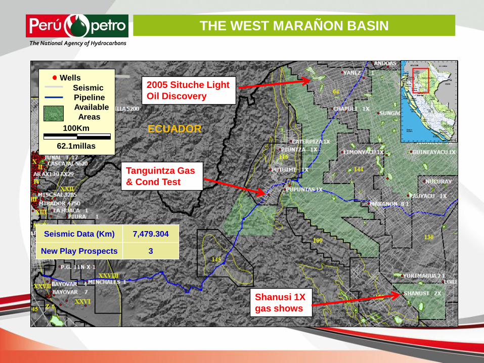
Seismic Data (Km) 7,479.304
New Play Prospects 3
2005 Situche Light
Oil Discovery
Shanusi 1X
gas shows
Tanguintza Gas
& Cond Test
ECUADOR
THE WEST MARAÑON BASIN The National Agency of Hydrocarbons
Wells
Seismic
Pipeline
Available
Areas
100Km
62.1millas

Heavy Oil Trend
REGIONAL CROSS SECTION IN MARAÑON BASIN The National Agency of Hydrocarbons
Medium Oil
Trend Light Oil Trend
Santiago Basin Marañon Basin Iquitos Arch Guyana Field

Marañon Basin
OIL GAS SOURCE ROCK
Tectonic
Events
Callanayacu
Eolian ss
Three
Untested Plays
New Play 2
New Play 1
Triass-Jurassic Pucará
Jurassic Sarayaquillo
New Play 3
Tertiary Pozo Basal
Historic Play
Cretaceous Vivian
CHONTA
PUCARA
Cretaceous Chonta
GENERALIZED STRATIGRAPHIC COLUMN The National Agency of Hydrocarbons

The Situche Complex is a series of roll-over anticlines formed in a
hemigraben, extensional setting, developed along listric normal
faults during the late Cretaceous.
THE SITUCHE COMPLEX STRUCUTRE The National Agency of Hydrocarbons
Situche Complex
ECUADOR
MARAÑON
60 Km

THE SITUCHE COMPLEX STRUCTURE The National Agency of Hydrocarbons
TERTIARY
CRETACEOUS
CRETACEOUS
LOWER
VIVIAN

Oil Discovery in 2005
Situche Central 2X well
2,400 BOPD, restricted rate,
35° Api to 4,500 BOPD fluent
to surface, Vivian Fm.
Situche Central 3X well
5,200 Bpd, restricted rate,
36° Api to 7,600 BOPD fluent
to surface, Lower Vivian Fm.,
with 6,860 psi reservoir
pressure.
Shanusi 1X well (4487 m)
17 m Gas & Condensate
shows, top Jurassic Pucará
(scPS)
THE WEST MARAÑON BASIN The National Agency of Hydrocarbons
ECUADOR
Wells
Seismic
Pipeline
Undrilled
structure
Available
Areas
100Km
62.1millas

Seismic line PK-2005 shows a lead in the Cretaceous
and Pre-Cretaceous sections.
THE WEST MARAÑON, SEISMIC AND LEADS
ECUADOR
Wells
Seismic
Pipeline
Undrilled
structure
Available
Areas
100Km
62.1millas
The National Agency of Hydrocarbons
PK-2005W Pucara
Play
Pozo Sand (Tertiary)
Base K
Pucara (Pre K)
Conventional
Cretaceous Play
WSW ENE
PK2012 PK2010 PK2002

The National Agency of Hydrocarbons
INDEX
1. Introduction
2. West Marañon Basin
3. Central Marañon Basin
4. East Marañon Basin

Seismic data (Km) 19,815
Nª of Exploratory Wells 22
Magnetometry-Gravimetry (Km) 34,654
THE CENTRAL MARAÑON BASIN The National Agency of Hydrocarbons
Wells
Seismic
Pipeline
Undrilled
structure
Available
Areas
50Km
31.5millas
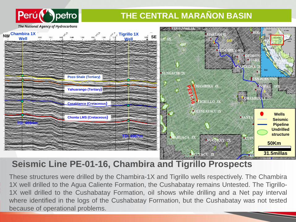
These structures were drilled by the Chambira-1X and Tigrillo wells respectively. The Chambira
1X well drilled to the Agua Caliente Formation, the Cushabatay remains Untested. The Tigrillo-
1X well drilled to the Cushabatay Formation, oil shows while drilling and a Net pay interval
where identified in the logs of the Cushabatay Formation, but the Cushabatay was not tested
because of operational problems.
Seismic Line PE-01-16, Chambira and Tigrillo Prospects
Chambira 1X
Well Tigrillo 1X
Well
Pozo Shale (Tertiary)
Yahuarango (Tertiary)
Casablanca (Cretaceous)
NW SE
TD: 4694m
TD: 4967m
THE CENTRAL MARAÑON BASIN The National Agency of Hydrocarbons
Wells
Seismic
Pipeline
Undrilled
structure
50Km
31.5millas
Chonta LMS (Cretaceous)
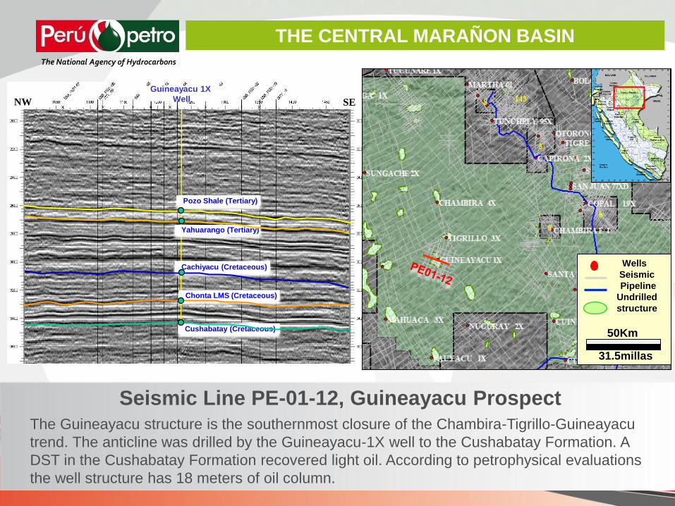
Seismic Line PE-01-12, Guineayacu Prospect
The Guineayacu structure is the southernmost closure of the Chambira-Tigrillo-Guineayacu
trend. The anticline was drilled by the Guineayacu-1X well to the Cushabatay Formation. A
DST in the Cushabatay Formation recovered light oil. According to petrophysical evaluations
the well structure has 18 meters of oil column.
Guineayacu 1X
Well
Pozo Shale (Tertiary)
Yahuarango (Tertiary)
Cachiyacu (Cretaceous)
Chonta LMS (Cretaceous)
Cushabatay (Cretaceous)
NW SE
THE CENTRAL MARAÑON BASIN
The National Agency of Hydrocarbons
100Km
62.1millas
Wells
Seismic
Pipeline
Undrilled
structure
50Km
31.5millas

Seismic Line GTY-D
Urituyacu Prospect
The Urituyacu structure is a 10 kilometers long
anticline partially defined by five 2D seismic lines. It
has an area of more than 50 km2 and a vertical
closure of more than 24 meters. The Uritoyacu is
downdip to the oil bearing Guineayacu structure.
THE CENTRAL MARAÑON BASIN The National Agency of Hydrocarbons
Wells
Seismic
Pipeline
Undrilled
structure
50Km
31.5millas 2 Km

The Ungumayo structure has been mapped with 8 2D seismic lines. Ungumayo is located along the migration
pathway from the Marañon Basin depocenter kitchen to the Tigrillo closure. The structure, seem to have been
formed before Pliocene times.
Pozo Sand
(Tertiary)
Chonta
(Cretaceous)
Vivian
(Cretaceous)
Ungumayo 1X (Projected)
NNW SSE
Seismic Line GT-V, Ungumayo Prospect
THE CENTRAL MARAÑON BASIN The National Agency of Hydrocarbons
Wells
Seismic
Pipeline
Undrilled
structure
50Km
31.5millas
2 Km

Wells
Seismic
Pipeline
Undrilled
structure
50Km
31.5millas
• “A” structure: 14.8 KM2 4-way dip closure in the Chonta
• “B” structure: 16.5 KM2 4-way dip closure in the Chonta
• Regional seals proven (Pozo, Yahuarango)
• Excellent reservoir quality proven in the area (Corrientes,
Chambira, Pavayacu Fields)
Seismic Line PHI-19
the Cuinico North Prospect
A B
Cuinico North (Projected)
Pozo Sand
(Tertiary)
Base K
THE CENTRAL MARAÑON BASIN The National Agency of Hydrocarbons

Wells
Seismic
Pipeline
Undrilled
structure
50Km
31.5millas
Seismic Line SU-89-07, showing
the Sungaruyacu Prospect
Pozo
(Tertiary) Vivian
(Cretaceous) Chonta
(Cretaceous) Agua Cal.
(Cretaceous)
Base K
NNW SSE
Sungaruyacu
Prospect
THE CENTRAL MARAÑON BASIN The National Agency of Hydrocarbons

4.1 km2 of 4-way dip closure in the Chonta; minor 4-way in the
Vivian. Regional seal proven (Pozo)
Excellent reservoir quality proven in the area (Corrientes,
Chambira, Pavayacu Fields)
Diana Mae Prospect in the
Seismic Line PP10608-37
SW NE
Base K
Pozo (Tertiary)
THE CENTRAL MARAÑON BASIN The National Agency of Hydrocarbons
Wells
Seismic
Pipeline
Undrilled
structure
50Km
31.5millas
The National Agency of Hydrocarbons
INDEX
1. Introduction
2. West Marañon Basin
3. Central Marañon Basin
4. East Marañon Basin

Fluvial 2D Seismic Data
(Km)
596,9
Aerogravimetry,
Gradiometry &
Magnetometry (Km)
16578,7
COLOMBIA ECUADOR
BRASIL
THE EAST MARAÑON BASIN The National Agency of Hydrocarbons
Wells
Seismic
Pipeline
Undrilled
structure
Available
Areas
100Km
62.1millas

Satellite Gravimetric map (Source: SAGP).
THE EAST MARAÑON BASIN The National Agency of Hydrocarbons
High Lows
2000 Km.
COLOMBIA
BRASIL
PERU
ECUADOR

Aerogradiometry Map (Aero Gravimetry - Source Petrobras). Note the best
resolution than in the Regional Bouguer Gravimetric map to define the
structural grain
ECUADOR
BRASIL
COLOMBIA
THE EAST MARAÑON BASIN The National Agency of Hydrocarbons
100 Km.

Bouger Gravity Map (gD). In red color (dash lines) possible intrusive from magnetic
map. In green color (continue lines) alignment interpreted from gravity maps.
THE EAST MARAÑON BASIN The National Agency of Hydrocarbons

THE EAST MARAÑON BASIN The National Agency of Hydrocarbons
BLOCK 39 - REPSOL
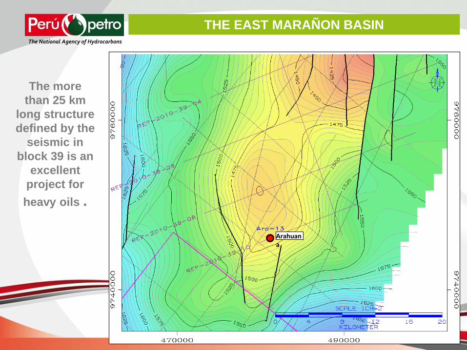
THE EAST MARAÑON BASIN The National Agency of Hydrocarbons
Arahuana
The more
than 25 km
long structure
defined by the
seismic in
block 39 is an
excellent
project for
heavy oils .

The National Agency of Hydrocarbons

THE DATA BANK The National Agency of Hydrocarbons
1. All seismic, well
data and logs and
technical reports
available
2. To de downloaded
immediately
3. Information and
data free of cost
http://www.perupetro.com.pe/wps/wcm/connect/perupetro/site/Inicio/Portal+Espanol+-+Prueba

Thank you
very much
www.perupetro.com.pe
The National Agency of Hydrocarbons