Embed Size (px)
Citation preview
Marine Geoscience Digital Seismic Data System
Access for education and research
Field Data Center (LDEO)Marine Seismic Data Center (UTIG)

October 2007
Scope and Goals
• Preserve U.S. academic digital seismic reflection data and supporting information
• Help investigators share project data and products• Help define and unify seismic-related metadata• Promote improvements in comprehensive seismic data discovery
October 2007
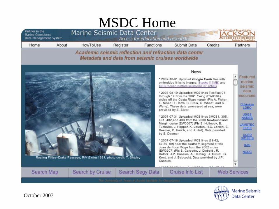
MSDC Home
October 2007
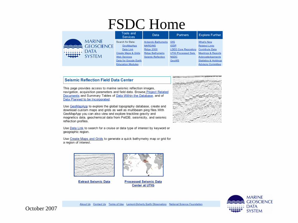
FSDC Home
October 2007
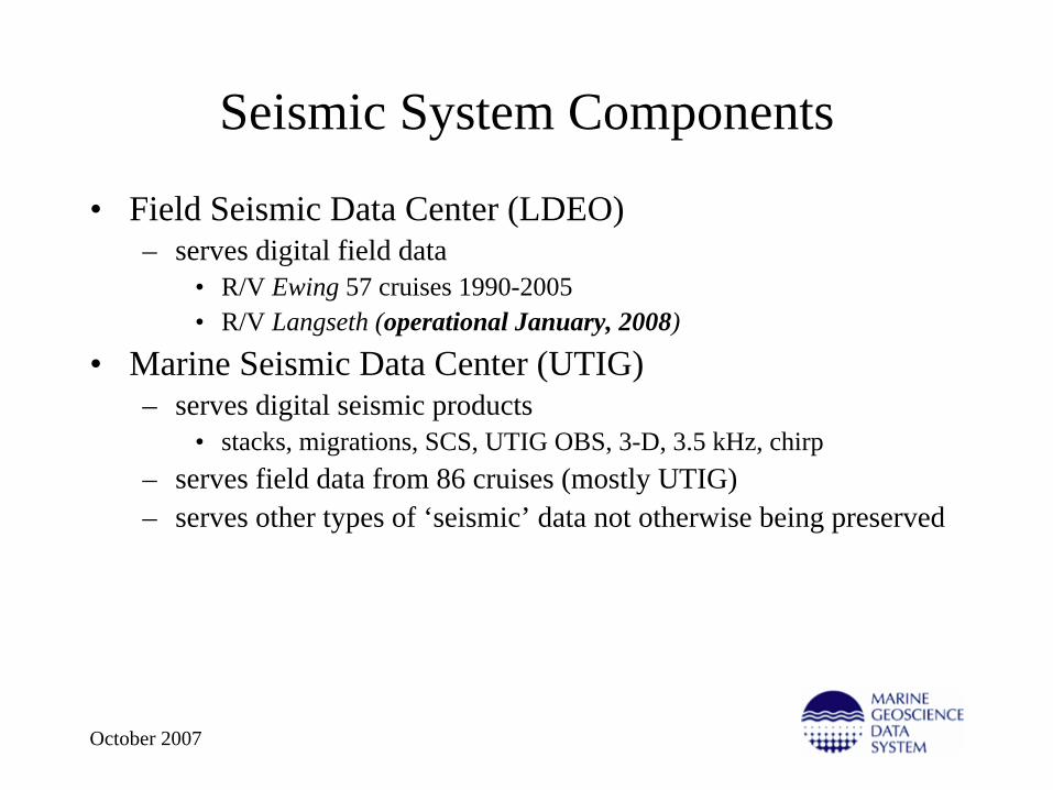
Seismic System Components
• Field Seismic Data Center (LDEO)– serves digital field data
• R/V Ewing 57 cruises 1990-2005• R/V Langseth (operational January, 2008)
• Marine Seismic Data Center (UTIG)– serves digital seismic products
• stacks, migrations, SCS, UTIG OBS, 3-D, 3.5 kHz, chirp– serves field data from 86 cruises (mostly UTIG)– serves other types of ‘seismic’ data not otherwise being preserved
October 2007
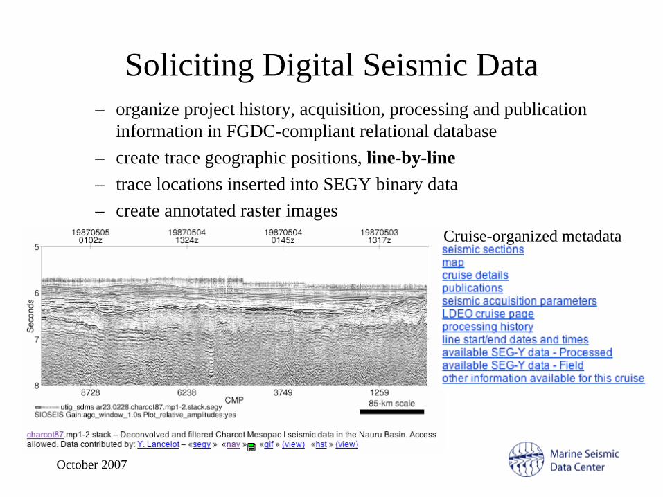
Soliciting Digital Seismic Data– organize project history, acquisition, processing and publication
information in FGDC-compliant relational database– create trace geographic positions, line-by-line– trace locations inserted into SEGY binary data– create annotated raster images
Cruise-organized metadata

October 2007
User Interaction• View and select SEGY, images, navigation
- map-based search- metadata-based search- Google Earth files with image links
• External access to metadata- xml metadata evaluation with Lamont- web map service support (www.ig.utexas.edu:8080/geoserver/wms)- GeoMapApp links
• Custom seismic images• Automated download cart

October 2007
Custom Images
• create custom images with window selection, aspect ratio, filtering and amplitude control.
• produces gif and pdf files.
October 2007
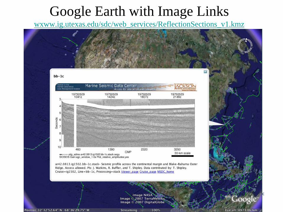
Google Earth with Image Links wxww.ig.utexas.edu/sdc/web_services/ReflectionSections_v1.kmz
October 2007
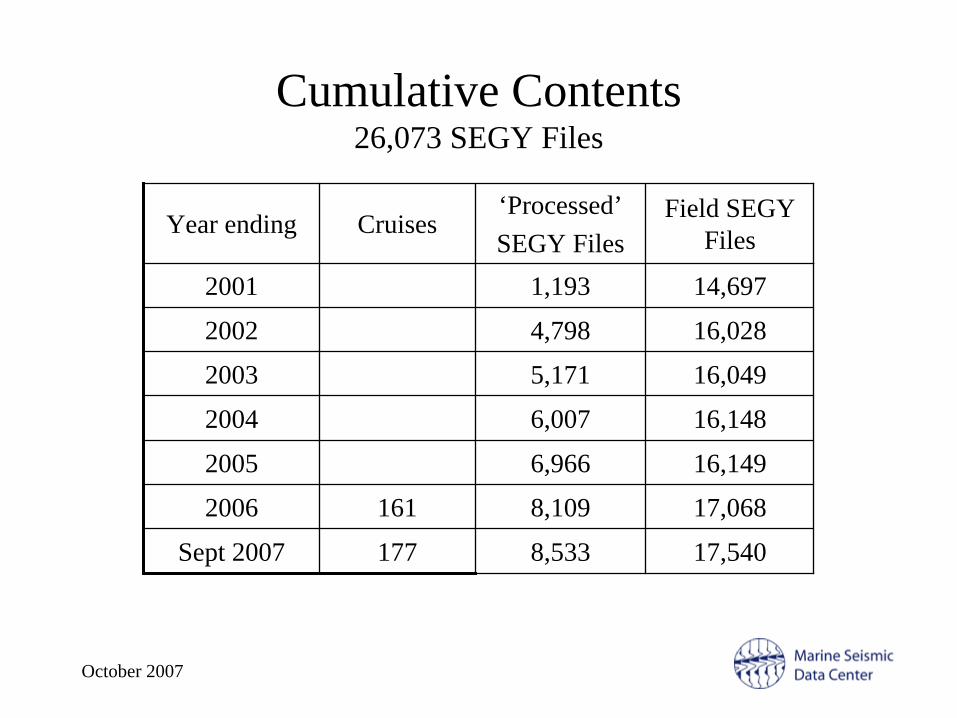
Cumulative Contents 26,073 SEGY Files
Year ending Cruises‘Processed’SEGY Files
Field SEGY Files
2001 1,193 14,697
2002 4,798 16,028
2003 5,171 16,049
2004 6,007 16,148
2005 6,966 16,149
2006 161 8,109 17,068
Sept 2007 177 8,533 17,540

October 2007
User Activity 795 Registered Users
Year ending New registered users
File transfers*
Total Download
(GB)
2001 25+
2002 65+
2003 130 1,116 29
2004 116 1,969 60
2005 138 8,362 283
2006 160 11,341 443
Sept 2007 161 16,275 439
*”small” image downloads not monitored +estimated before start of cart system

October 2007
Downloads by Data Types 37,946 files, 1.224 TB (since July 2004)
Type Files Volume (GB)
Large images+ 6,253 9
Trace locations (nav) 16,182 8
SEGY:
Shot 5,315 515
Stacks & Migrations 6,684 540
3-D migrations 87 60
OBS 1,236 77
Total SEGY 13,363 1,131+ not all image downloads monitored
October 2007
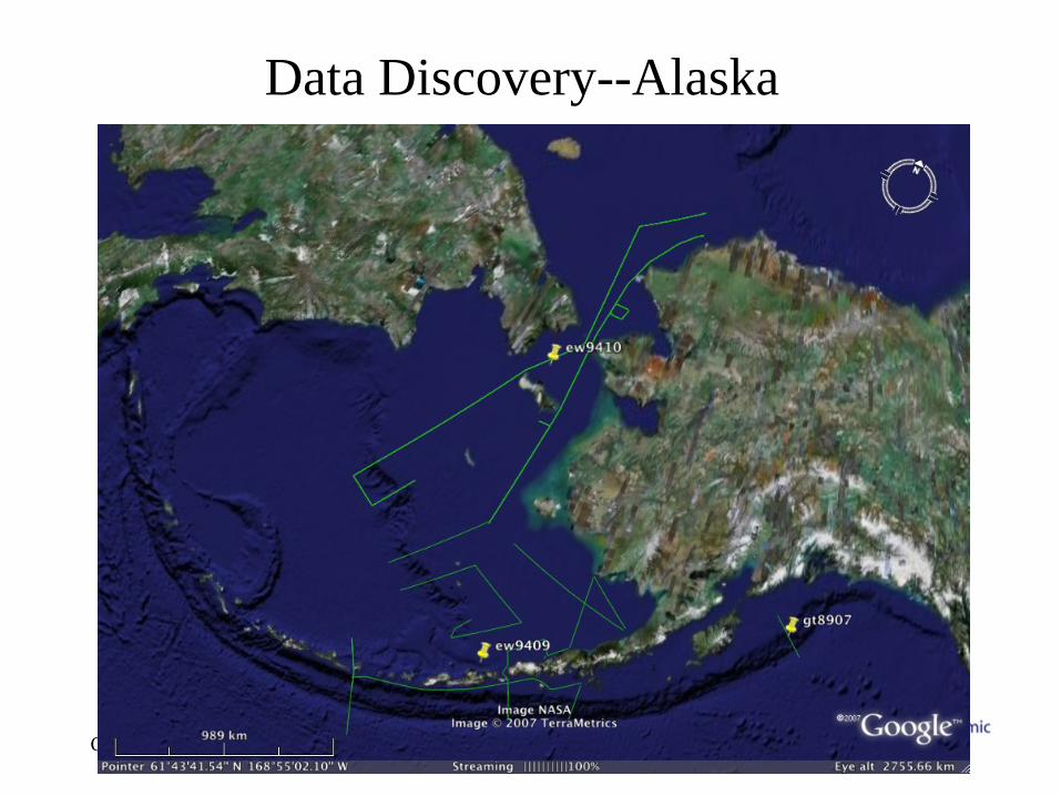
Data Discovery--Alaska
October 2007
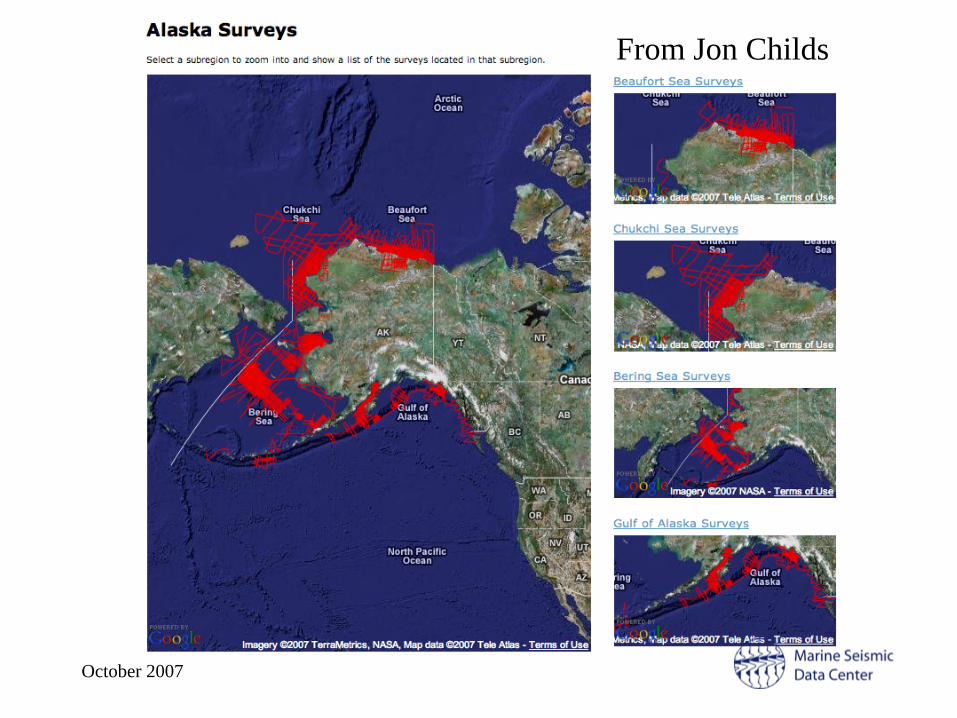
From Jon Childs

October 2007
Challenges to Comprehensive Seismic Discovery
• Differing institutional priorities– just for U.S. seismic data
• at least 6 institutions with seismic data, plus Antarctic Data Library• funding, individual priorities and institutional priorities vary widely,
and some will never participate• Differing ‘metadata’ inhibits discovery
– for example, navigation not specific to each line but instead for the entire cruise, whether seismic collected or not
• Differing tools/methods for discovery among centers• WMS/WFS large files (slow unless windowed or decimated)• Google Earth virtual globe (commercial product limitations)
– well-known educational and cross-generational browser– data center controls information in the placemark, has complete
‘ownership’ control
October 2007
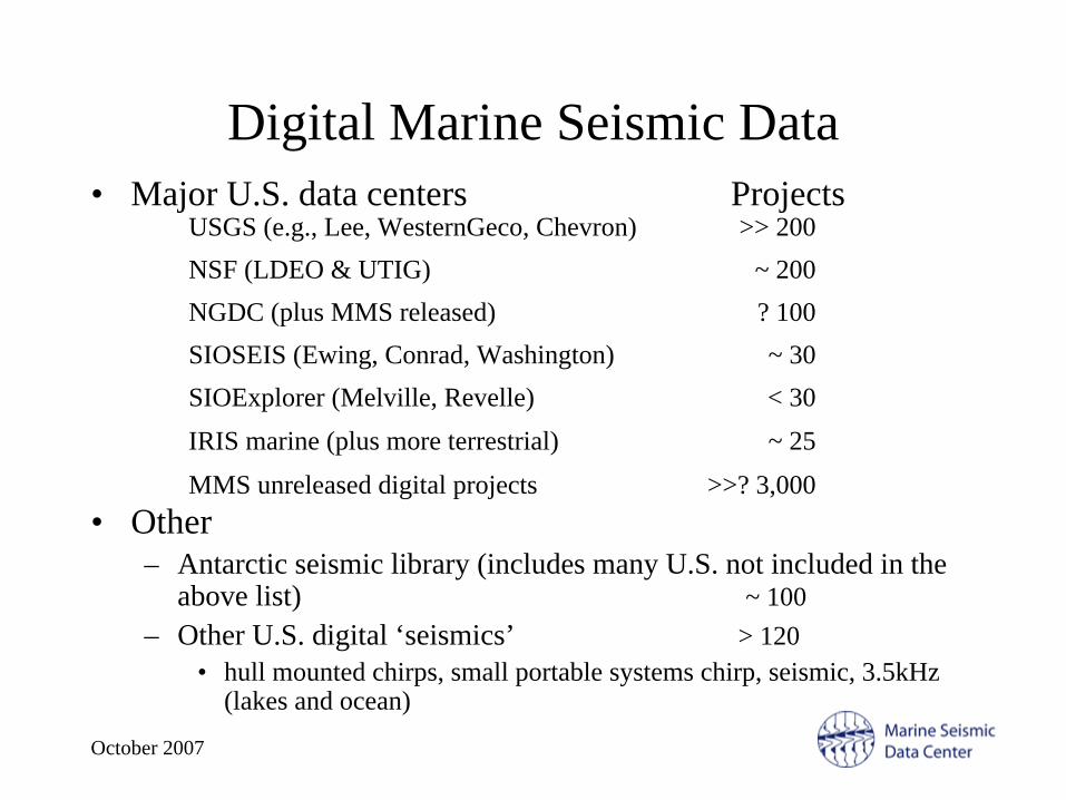
Digital Marine Seismic Data• Major U.S. data centers Projects
• Other– Antarctic seismic library (includes many U.S. not included in the
above list) ~ 100– Other U.S. digital ‘seismics’ > 120
• hull mounted chirps, small portable systems chirp, seismic, 3.5kHz (lakes and ocean)
USGS (e.g., Lee, WesternGeco, Chevron) >> 200NSF (LDEO & UTIG) ~ 200NGDC (plus MMS released) ? 100SIOSEIS (Ewing, Conrad, Washington) ~ 30SIOExplorer (Melville, Revelle) < 30IRIS marine (plus more terrestrial) ~ 25
MMS unreleased digital projects >>? 3,000

October 2007
Challenges to Seismic Data Centers• Soliciting contributions post-cruise (‘processed data’)
– requires connection between contributor-data center and contributor-user, including proper acknowledgment of PI investments by end-users
• which is at odds with higher-purpose science tools, which to be effective, sever connection to contributors
• Funding model– must assume limited 3-5 year life– careful monitoring of use activities a necessity for refunding
• which is at odds with sharing data• for example, wholesale incorporation of data into other science tools
that don’t have monitoring for contributor connections (like GMA, LOS, regional data bases)
• But tremendous progress from 1999 and 2001 workshops