Embed Size (px)
Citation preview

1 Honor Frost Foundation honorfrostfoundation.org
Maritime Archaeology Graduate Symposium 2019
29th – 31st March 2019 Short Report Series.
doi: https://doi.org/10.33583/mags2019.08
© 2020 The Author
Maritime Spatial Planning and Maritime Archaeology Conservation:
Protecting yesterday’s legacy by planning for tomorrow, cases from
Northern Lebanon
Vera Noon
Beirut; [email protected]
Abstract
Maritime Cultural Heritage (MCH) today stands as a witness of early human naval endeavours. Jeopardized by
modern days’ maritime activities, MCH requires a holistic planning approach for conservation management,
taking into consideration the future dimension of humankind’s maritime aspirations. This need could be
incorporated within a Maritime Spatial Planning (MSP) framework, an emerging multidisciplinary process that
seeks to prevent conflicts among maritime activities, whilst promoting environmental conservation and
sustainable economic development.
This paper identifies main issues related to MCH, and addresses the role that MSP can play in the conservation
of MCH, illustrated by two examples from Lebanon.
Key words
Maritime Spatial Planning - Maritime Archaeology – Cultural Heritage - Blue Growth – Multi-scalar approach
– Lebanon
Introduction

2 Honor Frost Foundation honorfrostfoundation.org
Since the dawn of time, humans used the marine environment and its resources for subsistence as the first
civilisations thrived on the interface between land and the sea (Yesner et al., 1980). Survival turned into trade,
and little by little, humankind’s relationship to the sea has shifted. Connecting continents, the Mediterranean
trade was a driver for growth since Predynastic times (Mark, 1997), and the Levantine sea basin particularly is
a witness of what was always a platform for connectivity, among both cultural and commercial networks
(Ashtor, 1983).
Many chronological indicators allow tracing back these ancient civilisations and tracking their expansion
throughout time and space, namely archaeological evidence found in situ as well as items found across
continents and below the oceans. Shipwrecks in particular have always been a gold mine for archaeologists
since studying them allowed connecting the dots between the origin and the destination of the products they
carry (Villano, 2009). However, other manmade structures that are not necessarily submerged are equally
valuable. For this reason, several definitions related to maritime archaeology have been explored to define the
paper’s scope of work.
The proposed scope of work for the purpose of this paper is based on interpretations from UNESCO’s 2001
Convention on Underwater Cultural Heritage, and based on definitions of marine and maritime archaeology
(Cottrell, 1993; Ford et al., 2012; Maritime Archaeology Trust, n.d.; AIMA, n.d.). Thus, Maritime Cultural
Heritage (MCH) encompasses tangible and intangible heritage, including coastal, foreshore and submerged
remains, possessing a historic, cultural, or archaeological value. (Fig. 1)
While seafaring, trade, and fishing dominated the oceans in the past, today’s reality is slightly different. A
myriad of maritime activities is taking place in the oceans, all the way to the deep sea, leading to spatial and
environmental conflicts (Ehler, 2017). As a result, Maritime Spatial Planning (MSP) emerged, and is
increasingly gaining momentum. MSP is a multidisciplinary planning tool, supporting maritime economic
development and environmental conservation, while seeking to resolve and prevent conflicts among maritime
activities or with the ecosystem. It is both a public and political process, combining bottom-up and top-down
approaches (Ehler and Douvere, 2009). A byproduct of the European Integrated Maritime Policy’s Blue Growth
strategy1, MSP is expected to provide knowledge and ensure a sustainable management of activities at sea, while
promoting new maritime economic sectors (European Commission, n.d.).
What effects will an increase in maritime activities have on MCH? Can MSP play a role in the mitigation of
potential MCH damage and in producing synergies?
To answer these questions, an assessment of various maritime activities’ impacts on MCH is conducted,
followed by a compilation of MSP interventions that can support MCH conservation. Finally, two case studies
from Lebanon are used to illustrate the findings, providing case-specific recommendations for MCH
conservation.
Methodology
1 Blue growth is the long term strategy to support sustainable growth in the marine and maritime sectors.

3 Honor Frost Foundation honorfrostfoundation.org
This paper is built on three main steps (Fig. 2): Identification of issues related to MCH conservation; compilation
of MSP interventions related to MCH conservation; and finally, examination of two Lebanese case studies.
To identify issues related to MCH conservation, different elements are taken into consideration: the source of
the impact (related to human activity); the nature of the impact (direct, indirect); and the location of the MCH
(coastal, foreshore or marine).
As for the different MSP interventions, the compilation is based on nested-approach thinking (Fanning et. al,
2013), a common planning methodology adopted in MSP, recommended particularly for small sea spaces (EU
MSP platform, n.d. a). As a result, the MSP tools, collected from multiple examples, follow a multi-scalar logic
ranging from global to local scales.
The two selected case studies differ in scale, in socio-political context, and in the nature of the MCH. This
allows us to explore the different tools MSP has to offer.
Results
The first section displays the negative impacts caused by different maritime activities and fragmented
institutional frameworks. It is followed by a compilation of the potential MSP interventions that can tackle these
MCH issues.
Identifying issues
In the contextual aspect, among the first obstacles impeding further MCH knowledge acquisition is the
accessibility to the site itself. A large share of UCH remains undiscovered, where deeply layered artefacts cannot
be easily predicted, especially in the deep sea and areas beyond national jurisdiction (UNESCO, 2011).
Moreover, the spatial distribution of MCH is heterogeneous where MCH is encountered in spots and not in
areas (Altvater, 2016). These two conditions render locating and hence protecting MCH difficult.
Direct impacts that may damage MCH mainly stem from the growth of maritime activities such as maritime
transport, fishing, energy production, resource extraction, and military activities.
Ports and harbour activities related to commercial and/or recreational maritime transport pose threats during
their construction phase as well as during their operational phase (Helcom, 2018). Infrastructural works such as
dredging and land reclamation directly damage coastal and foreshore archaeological sites, and may change the
course of currents exposing previously buried UCH (UNESCO, 2017 a). Other activities such as vessel
manoeuvers, anchoring, and ground tackle proved to be harmful to both the seabed as well as the water quality,
therefore to archaeological vestiges lying on the sea bottom (Dizon et al., 2013: 269).
As for the fishing sector, not all fishing techniques are necessarily harmful to UCH. Near coastal areas,
aquaculture may result in the alteration of the water’s chemical composition, hence influencing the preservation
conditions of certain sites (Haponiuk, 2015). Deeper in the water column, dynamite fishing (or blast fishing) is
a destructive practice, often illegal yet still widespread, and it has proved to cause an increase in the corrosion
of shipwrecks (MacLeod et. al, 2011). In coastal and deep sea areas, bottom trawlers’ activities often result in
the damage of submerged artefacts and disturbance of assemblages (Dizon et al., 2013: 269).

4 Honor Frost Foundation honorfrostfoundation.org
Somewhat comparable to the maritime transport sector is the energy sector, where activities that take place in
the deeper seas are also supported by coastal infrastructure. However energy production requires connections
such as oil/gas pipelines and the routing of electrical/telecommunication cables to substations (UNESCO, 2017
b; Karlikowska et. al, 2018). In the oil and gas industry, the construction and operation of industrial facilities
can damage coastal and foreshore MCH, whereas drilling for oil wells can directly damage UCH sites (Faulk,
2010). Likewise, offshore wind farm (OWF) structures for wind turbines require the installation of deep
foundations affecting UCH directly, and may also alter current dynamics (Defingou et. al, 2019: 121, 163).
Extractive industries such as deep-sea mining and sand extraction similarly affect seabed archaeology
(UNESCO, 2017 a). Another direct impact to MCH is caused by explosives used during violent conflicts, and
unexploded ordinance dumped in the sea (Dizon et al., 2013: 71). The impact of conflicts on terrestrial cultural
heritage has been widely explored, particularly in terms of looting and illicit trade in archaeological assets. Yet
the case of MCH is often overlooked, probably due to inaccessibility, and thus to monitoring difficulties.
In contrast, several threats to MCH arise from socio-political systems and are harder to tackle. For instance,
awareness of the importance of MCH conservation is still lagging: the definition of MCH remains blurry, and
the lack of publicly accessible databases and mapping tools further exacerbates this insensitivity. Moreover,
there is still a misconception by which MCH is considered an obstacle to economic development, as opposed to
an economic opportunity (EU MSP Platform, n.d.b).
On a global level, discussions about climate change impacts are growing. It has been proven that climate change
can lead to the deterioration of many coastal and marine archaeological sites due to sea level rise, erosion,
alterations in conservation environment patterns, and even the spread of new animal species and harmful worms
(marine borers) (UNESCO, 2017 c). Climate related flooding of buried sites and severe erosion have been
documented in three different archaeological sites in the United States (Reeder Myers, 2015).
Pinpointing solutions
MSP is rather a top-down exercise, and was proven to be a catalyst for administrative and institutional
procedures. However, the top-down and bottom-up processes still need to engage with each other. In fact, MSP
can also support the planning process by organising participatory and stakeholder engagement in the decision-
making process (Morf. et. al, 2019).
The first step towards global awareness began in 1982 through the UN Convention on the Law of the Sea
(UNCLOS), which defined maritime boundaries and sovereign rights over the sea bed (UNCLOS, 1982). As
far as MCH is concerned, the convention imposed a general duty on states to protect archaeological and
historical objects found at sea. It also promoted collaboration between states: coastal states were given
jurisdiction over the Territorial Seas (24 nm) to control traffic in UCH objects, but this does not cover the
remaining Exclusive Economic Zone (EEZ) and continental shelf (European Communities, 2009).
Complementing the UNCLOS, the 2001 UNESCO Convention on the Protection of Underwater Cultural
Heritage prioritizes in situ preservation of UCH, and it also defines exclusive rights and responsibilities of state
parties over UCH in internal waters, archipelagic waters, and Contiguous Zone (articles 7 & 8). The protection
of UCH as well as the reporting and notification measures were addressed in regards to the EEZ and Continental

5 Honor Frost Foundation honorfrostfoundation.org
Shelf (art. 9 & 10) but also beyond those zones, in what is referred to as “the Area”2 (art. 11 & 12). Coordinating
and consulting states collaborate over issuing authorisations for maritime activities and for conducting research
related to UCH. This is done with the consent of the flag states and of the states to which the objects pertain by
virtue of their cultural/historical or archaeological origin (UNESCO, 2001). (Fig. 3)
MSP is complementary to the above-mentioned principles through two of its main pillars: transboundary MSP
(TMSP) and cross border cooperation. Findings have shown that TMSP can be beneficial to cultural heritage
management as it encompasses several state countries, and collaborating might bridge the gaps in their
fragmented institutional governance (Soininen and Hassan, 2015). In fact, in 2017, UNESCO’s
Intergovernmental Oceanographic Commission (IOC) and the EU adopted a joint road map to accelerate MSP
processes worldwide and promote, among other priority actions, TMSP and sustainable Blue Economy. Two
pilot projects are ongoing in the western Mediterranean and southeast Pacific, promoting capacity building and
spreading awareness about ocean governance matters. Cultural heritage could be one of the topics of future pilot
projects (MSPGlobal, 2019).
An example of regional collaboration is BalticRIM, a project focusing on the relationship between MSP and
MCH in the Baltic Sea. It aims to improve the capacity of regional MCH planning agencies through innovative
public participation methods (submariner network, n.d. a). It also developed three pilot projects on different
scales, serving as concrete exercises for planners and stakeholders (submariner network, n.d. b).
A different regional (or even national) tool, complying with the in situ preservation principle, is related to
Marine Protected Areas (MPA) establishment. MSP and MPAs have a special bond since initially, parties were
interested in developing MPAs as a response to the degradation of marine areas due to human activities (Olsson
et. al, 2008). With time, MPAs became more specialised, and began adapting their legal instruments to
protection needs. Papageorgiou (2018) listed forms of MPAs recognising not only environmental value of
marine sites, but also their cultural and aesthetic values: the International Maritime Organisation’s Particularly
Sensitive Sea Areas (PSSAs) define maritime transport routing measures to protect ecologically and culturally
sensitive areas (IMO, 2019). The UN Environment’s Mediterranean Action Plan SPA/BD Protocol promotes
the establishment of Specially Protected Areas of Mediterranean Importance (SPAMI) for the conservation of
areas of cultural, aesthetic, archaeological, historical, and educational interest (RAC-SPA, n.d. a). Such MPAs
are important from a strategic planning point of view as they create synergies between environmental protection
and MCH conservation. It has been proven that common interests were established among archaeologists and
environmental protection agencies (Zwick, 2019) despite occasional clashes recorded due to intrusive
excavation techniques (UNESCO, 2012).
From synergies to collocation and multiuse, these two planning strategies are applicable on regional and national
scales. Identifying opportunities between MCH sites and new sectors can prove to be beneficial for both sides:
activities such as diving trails in UCH sites or virtual UCH tours can provide sources of funding for MCH by
diversifying tourism offerings (Przedrzymirska et al. 2018). In the Netherlands, the ban on ship passages within
2 The Area, according to the UNCLOS, is the seabed, ocean floor, and subsoil beyond the limits of national jurisdiction.

6 Honor Frost Foundation honorfrostfoundation.org
a natural protected marine park has helped preserve wreck locations (EU MSP Platform, n.d. b). Likewise, the
protection of submarine cables requires bans on activities like bottom trawling and dredging, which can help
protect UCH in return (Haponiuk, 2015: 11).
On a national level, marine licensing and legislative measures can play a major part in the reduction of harmful
marine activities, and thus in the regulation process. For instance, some activities used in the process of
archaeological exploration require a marine license or a special permission system (Historic England, 2015;
Gdansk Maritime Institute, 2016).
Considering land-sea interaction in the planning approach involved integrating MCH protection policies in land
planning processes and Integrated Coastal Zone Management (ICZM) (Khakzad et. al, 2015), such as the case
of Scotland (Legislation.gov.uk, 2014).
A global issue, several programs have been designed to mitigate climate change damage to archaeological sites
at the national scale (Reeder-Myers, 2015). As far as MSP is concerned, climate change adaptation remains
among its top priorities, and several projects introduced it in their planning processes (Santos et al., 2016).
National scale planning sets the stage for a more advanced analysis. However, implementation proves to be
more efficient on a local level, particularly through pilot projects. For this reason, place-based planning is the
next step in the process.
Zoning is one of the main tools that help resolving spatial conflicts among maritime uses by reducing or
prohibiting certain activities. Just like in land-use planning, conflicts can be mitigated by developing a marine
cadastral register coupled with zoning regulations as a first step to avoid future overlaps in highly anticipated
maritime uses, and a step towards better marine space governance (Suárez de Vivero et. al, 2009). It assigns
rights, responsibilities, and restrictions in the marine environment on a sub-national level (Balla and Wouters,
2017). Another form of zoning is the archaeological protected zone or cultural zone, such as in Cyprus (Republic
of Cyprus MFA, 2019). Establishing buffer zones near and around offshore structures can generate a similar
effect (Defingou et al., 2019).
Vertical zoning is currently being tested, whereby certain activities are restricted near the seabed while allowing
others in the water column or on the surface. This can be of particular interest for MCH as most of the vestiges
lie on the seabed (Carr, 2019).
On a local level, most of the MSP tools aim to build bridges between the scientific community and the public.
Technological advances in digital modelling and 3D visualisation shed the light on a world otherwise unknown,
helping in sharing knowledge and raising awareness about MCH importance (Dizon et al., 2013: 80). The next
step after producing this data is sharing it: open data portals and web-GIS services generate interactive maps
representing different maritime themes, putting MCH into perspective by overlaying it with all sorts of
information (Fowler et. al, 2010). Cyprus’ MSP portal offers thematic maps, conflict maps, and cumulative
impacts, allowing for a multidisciplinary view of the marine space (mspcygr, 2014). To take it further, these
portals can be participatory, where stakeholders can upload their own data, and it can be used as a platform to
exchange ideas and innovative solutions (Eythorsson and Thuestad, 2015). Interactive communication tools and

7 Honor Frost Foundation honorfrostfoundation.org
visual arts can be even applied in storytelling, such as the example of the Barra Sea (mappingthsea. n.d.). In
summary, with proper planning and the right tools, several conflicts can be mitigated.
Discussion
Lebanon’s maritime history stretches back across millennia, with a legacy dating from the Bronze Age. Its
seaports were renowned across the Mediterranean and beyond, with moles, forts, and shipwrecks standing as
reminders of the maritime journey of its people (Semaan, 2014). Although Lebanon ratified the UNESCO 2001
convention in 2007 (UNESCO, n.d.), it still lacks a national strategy for the conservation of MCH. Existing
maritime policies are sectorial, with outdated and poorly implemented frameworks. On an institutional level,
the ministries lack cooperation mechanisms with other stakeholders, leading to overlaps or gaps in
responsibilities (IMP-MED, 2018).
More specifically, the north of Lebanon has been under the microscope throughout the past decades as it has
been subject to several armed conflicts, such as the 2007 Nahr al-Bared war. Tensions began even prior to the
Syrian crisis, as the region has been socially and economically marginalised for a long time (Van Der Molen
and Stel, 2015: 13). However, the neighbouring Syrian war ignited further violent events around Tripoli,
exacerbated by socioeconomic tensions (Lefevre, 2014). Today, as the Syrian conflict nears its end, Tripoli is
back in the headlines: this time, it is expected to receive a share of the post-war reconstruction maritime traffic
of Syria (RoL/OEPT/DAH, 2017).
How did these conflicts affect the MCH? Will the surge in maritime traffic impact MCH? For the purpose of
this paper, it is not necessary to dive in the archaeological details of the sites, but it is, rather, sufficient to
understand their protection status and their spatial extent, as well as the current and future maritime activities
of both study areas, in order to scan potential conflicts and plan for solution. (Fig. 4)
Nahr al-Bared and Orthosia
The first case study is a coastal site straddling between the Akkar and North Lebanon Governorates. The Akkar
plain stretches seawards to form the widest continental shelf in the country (Sachi and Dimech, 2011: 12;
GoL/CDR, 2004). (Fig. 5)
The context of this case is quite peculiar, yet not uncommon in a country such as Lebanon. In 2007, deadly
clashes erupted in the Nahr al-Bared Palestinian refugee camp (International Crisis Group, 2012). Later in 2009,
as military bulldozers were clearing rubble from the camp, they came across some granite columns. These are
now believed to be evidence for the location of the ancient city of Orthosia, which probably dates to the 3rd
millennium BC (Farchakh Bajjaly, 2011). The speculated maritime town might have been an established local
or even regional landing site. There is also evidence of coastal quarries slightly southwards (Safadi, 2014;
Carayon, 2008 cited in Semaan, 2014: 86). For these reasons, the debate on whether to rebuild the refugees’
homes or to protect the valuable archaeology became a controversial issue (Farchakh Bajjaly, 2011). Eventually,
the Lebanese Directorate General of Antiquities (DGA) undertook salvage excavations prior to the
reconstruction of the camp (Semaan, 2014: 84).

8 Honor Frost Foundation honorfrostfoundation.org
Today, life in the camp is almost back to normal. Other activities in this region mainly revolve around the fishing
sector. Slightly northwards, the Aabde fishing port is one of the largest in the region. It is even reported that an
aquaculture facility used to be active in the port (European Commission, 2011; Doumani, 2007: 49). On another
note, cases of dynamite fishing have been reported in this area, with little to no law enforcement (S. Annous
2018, personal communication, 24 February).
The fragmentation of responsibilities in such a small marine space render monitoring illegal activities quite
difficult. First of all, the site is lying on the banks of the river that separates the Northern Governorate from the
Akkar Governorate, resulting in major obstacles on an institutional level. In Lebanon, there is a myriad of
ministries responsible for different aspects of the same maritime activities, and other local authorities in charge
of implementation. As a result, governance-related conflicts often arise (MRCZM-IOE-UOB, 2014). In similar
cases, MSP can provide a communication platform joining the different stakeholders over a common goal, to
set policies through an integrative approach, where authorities, scientists, residents, and marine users can raise
issues and negotiate potential solutions together.
An outlook towards the future requires addressing the sensitive political context where the outcome of the
Palestinian camp, which is governed by the Palestinian Liberation Organisation3, is linked to the Palestinian-
Israeli conflict (International Crisis Group, 2012). In such cases, where MSP has little authority, scenario-
building tools may be applied to support the decision making process (Mc Gowan et. al, 2019).
Akkar’s wide continental shelf suggests easy accessibility, so it can be assumed that there is a high probability
of finding objects with archaeological value off coastal sites (Gdansk Maritime Institute, 2016). In this case, the
land-sea interaction dimension in the planning process is key. Proposing a marine buffer area extending from
the coastal site to the sea, or defining an Archaeological Protection Zone with the help of professionals, can help
protect the area from future activities, and can also be used as an exploration lab for scientists to conduct research
and develop their knowledge.
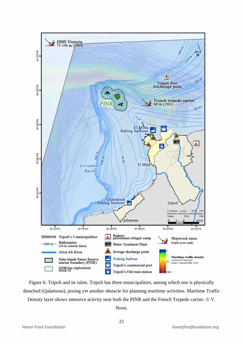
Tripoli
Tripoli, the second largest city in Lebanon, has a rich and diverse terrestrial, insular, and marine cultural heritage
(Semaan, 2014: 104-120). Late Bronze Age and Iron Age artefacts are revealed within El Mina’s harbour in
1973. Unfortunately the expansion of the port has damaged the remains (Amadouny, 1973). The presence of a
submerged mole was also noted, marking the location of the ancient port (Viret, 1999-2000 cited in Semaan,
2014: 104). In fact, and throughout history, Tripoli had one of the major ports of the Levant, but the dislocation
of the Ottoman Empire in the dawn of the 20th century marked the beginning of a new chapter (UNESCO, 1954).
Tripoli yielded its historic trade centre role to the capital Beirut, but this might soon change (IDAL, 2017). (Fig.
6)
The city’s surrounding waters are dotted with a series of islets, stretching over 5 km seawards. These islets were
thought to be used as anchorage spots in antiquity as they protected against dominant winds and currents.
Additionally, two shipwrecks are currently lying on the seabed: the HMS Victoria vertically standing between
3 Lebanese Army and security forces do not have legitimate power within the Palestinian camps.

9 Honor Frost Foundation honorfrostfoundation.org
75 and 146 meters, sunk in 1893 and the French torpedo carrier sitting some 60 meters below water, sunk in
1941 (Noshie, 2006). Although the latter hasn’t been submerged over than 100 years, it can still be considered
as a valuable WWII ‘heritage assets’ (Firth, 2018: 8).
Three of these offshore islands were declared a Marine Protected Area in 19924, called the Palm Islands Nature
Reserve (PINR), also classified as a Ramsar site of International Significance (Ramsar, 2016), and are on the
SPAMI list (RAC-SPA, n.d. b). Besides their environmental importance, the islands are known for their several
cultural heritage sites (MoE/UNDP/LU, 2004). The Palm Island hosts late Roman and medieval period vestiges,
as well as crusader structures re-using Roman architectural elements (Salame-Sarkis, 1980 cited in Semaan,
2014: 112). Ramkin Island is also referred to as Fanar Island due to its abandoned lighthouse built circa
1864 (Russ Rowlett and University of North Carolina , 2019). Finally, Bakar Island5, the nearest to the coast,
possesses traces of stone quarries and two sea walls (Viret 1999-2000 cited in Semaan, 2014: 110-111). Today
it is more commonly referred to as Abd el Wahab Island, named after the family that has been practicing
traditional boat construction for years (Kayyal et. al, 2014: 50). (Fig. 7)
Shipping activity has had its toll on the marine environment: the Health and Environment Department of the
port authority identified high levels of air and water pollution due to ship emissions, sewage discharge, and
cargo transport (namely coal transport and combustion) likely due to the inauguration of new coal storage areas
in 2011 (Merhaby et. al, 2015; Tamer, 2013: 117). Another major source of marine pollution near the harbour
is the open dump bordering the Abou Ali River estuary (MoE/EU/UNDP, 2014: 39; Lavaill and Clamagirand,
2010: 42). As previously stated, these pollutants may lead to MCH degradation.
Future trends point towards increased maritime traffic linked to the post-conflict reconstruction of Syria, with
Tripoli’s port expected to receive 20% of the reconstruction traffic (RoL/OEPT/DAH, 2017: 30). As a result,
investments for the port’s expansion are pouring in from China, the EU, the Islamic Bank and United States
Agency for International Development (USAID) (A. Tamer, 2017, personal communication, 24 August). This
will increase maritime traffic near the islands (MarineTraffic, 2019).
Interventions should include urban planning considerations for port construction, to make sure land reclamation
and dredging activities are not affecting existing or potential heritage resources. Land use planning needs to also
consider marine pollution impacts resulting from waste management failure and sewage discharge. In regards
to the sea space, anchoring points need to be reviewed by underwater archaeologists to make sure activity is not
affecting valuable assets on the seabed. Concerning navigation activities, specific guidelines need to be set by
the port authority, in collaboration with the army. To push it even further, a PSSA can be set to protect both the
MPA and the seabed around it.
Moreover, a study of Tripoli municipalities showed that amelioration of the political situation will bring about
demographic growth (Lavaill and Clamagirand, 2010: 44) likely coupled with tourism growth. In fact, diving
and recreational boating activities near the islands have increased during the past few years: guided tours, diving
trails, and boat trips are on the rise (G. Jaradi 2018, personal communication, 11 November). In this case, human
4 The three islands are: The Palm Island, Ramkin Island and Sanani Island. 5 Bakar Island is not part of the PINR

10 Honor Frost Foundation honorfrostfoundation.org
pressure causing increased impacts on the MPA must be mitigated, as trampling proved to have detrimental
effects on heritage especially in protected areas (Davenport and Davenport, 2016: 243). Fuel emissions and
anchoring need to be monitored as well.
For this purpose, an integrated tourism management plan can help organise marine activities by enforcing
boating, fishing, and even research licences. Such an integrated plan can also reduce harmful activities by using
vertical zoning. It can alleviate pressures by setting a carrying capacity limit, and minimise overall negative
impacts in the long run by keeping a regular monitoring record. Repurposing the existing lighthouse on Ramkin
Island can be a potential for Blue Growth, offering educational/recreational services for visitors, as well as a
space for monitoring stations: synergies are thus achieved between cultural and economic goals.
Throughout the whole process, the municipality’s responsibility is to supplement these policies by organising
regular community meetings to spread awareness and inform the locals about new measures through online
portals, signage, local gazettes, etc.
Although the fishing sector remains limited to small scale and artisanal fisheries (Kayyal et. al, 2014: 103),
MSP must address the potential for fishing to occur in deeper waters using more advanced fishing gear such as
trawlers (Firth, 2018: 14). For this reason, while MSP must seek to preserve traditional boat building practices
and fishing techniques, it should also aim to enforce existing regulations and develop policies to prevent illegal
activities stemming from future spatial competition. In fact, and despite the 500 m buffer zone around PINR
where access and fishing should be restricted for nine months per year (European Commission, 2011), laws and
regulations are still not respected, and the islands suffer from dynamite fishing and other forms of illegal
activities (S. Annous 2018, personal communication, 24 February), among which is looting (Semaan, 2014).
Lastly, the oil and gas strategy planning in Lebanon is currently underway (LPA, 2018). Although drilling won’t
take place before years to come, spatial conflicts deriving from the activities can be predicted, and hence
prevented. For instance, a shipwreck is located within the boundaries of one of the exploration blocks. A buffer
zone can be set around that shipwreck, to be registered and disseminated to relevant authorities. Using data from
oil and gas expeditions to explore UCH location can be a synergy where resources are shared among different
users of the sea.
Conclusion
MSP is a multi-step future oriented process. Planning priorities vary according to each case’s specific context
as there is no ‘one size fits all’ strategy. However, the planning process must include defining stakeholders,
analysing current and future maritime activities, and identifying conflicts and synergies in order to set priorities
for the final plan.
Concerning MCH, activities that damage coasts and seabed by direct mechanical action can be managed, along
with activities altering the chemical and physical context of the sites. Main solutions revolve around either
protecting the site itself from surrounding activities, or managing maritime activities around the site.

11 Honor Frost Foundation honorfrostfoundation.org
In the case of Nahr el-Bared, threats stem from the absence of protection mechanisms and the sensitive and
volatile political context, therefore scenario analysis coupled with precautionary protection measures was the
go-to strategy.
In the case of Tripoli, where multiple activities are taking place near a protected area, interventions are rather
sectorial where behaviour of marine space users can be monitored, and where existing environmental protection
measures and tourism activities can be combined with cultural heritage site protection.
Recommendations provided are indicative and future research is required to develop a concrete maritime spatial
plan. However, the structural aspect of the paper sets the stage for other case studies that share common
issues: one can draw parallels between the Nahr el-Bared camp case in the north and the Rachidie camp in the
south of Tyre, where archaeological artefacts have also been unveiled below the coastal refugee camp (Doumet
Serhal, 1982). Likewise, Sidon’s historic port, its islets, and the impact of its expansion on its cultural heritage
are comparable to the case of Tripoli (Marriner et. al, 2008).
The challenge today is using valuation techniques to prioritise the topic of MCH for both the public and the
private sectors, in order to later incorporate it in the growing regional Blue Growth trends (Claesson, 2011).
With the wide array of planning tools MSP can offer, along with technological advances, the remaining obstacle
is to achieve political will.
Acknowledgements
I would like to thank the Honor Frost Foundation for funding my participation in MAGS 2019, particularly Dr.
Lucy Blue and Dr. Lucy Semaan. Special regards go to the organisers from Southampton and Oxford
universities for their hard work and support. Final thoughts go to friends and colleagues who kindly helped me
in the writing process.
References
AIMA (n.d.), What is Maritime Archaeology? Australian Institute for Maritime Archeology. [Online] Available
at: http://www.aima-underwater.org.au/what-is-maritime-archaeology/
Amadouny, Z. E., 1973, Le site archéologique sub-aquatique d’el Mina Tripoli-Liban, Beirut: TransPress.
Amadouny, Z. E., 1999, Plongée archéologique sur le littoral libanais, Beirut.
Ashtor, E., 1983, Levant trade in the Middle Ages. Princeton University Press.
Bailey, G., 2011, ‘The Significance of Underwater Cultural Heritage’, Department of Archaeology, University
of York, United Kingdom. In: UNESCO Scientific Colloquium on Factors impacting the Underwater Cultural
Heritage. Royal Library of Belgium, Brussels, Belgium.
Carr, S., 2019, Should we be conserving and managing (MEA) marine ecosystems in 3D? The latest thinking on
vertical zoning in Marine Ecosystems and Management, February 9. Available at:
https://meam.openchannels.org/news/skimmer-marine-ecosystems-and-management/should-we-be-
conserving-and-managing-marine-ecosystems

12 Honor Frost Foundation honorfrostfoundation.org
Claesso, S., 2011, ‘The Value and Valuation of Maritime Cultural Heritage’. International Journal of Cultural
Property 18.1, 61–80.
Dizon, E., Egger, B., Elkin, D., Erreguerena, P. L., Grenier, R., Gribble, J., Guerin, U., Khalil, E., Manders, M.,
Maarleveld, T., Memet, J. B., Mesic, J., Nieto Prieto, X., Nutley, D., Pomian, I., Scott-Iretom, D., Trakadas, A.,
and Veccell, R., 2013, Manual for Activities directed at Underwater Cultural Heritage, Guidelines to the Annex
of the UNESCO 2001 Convention, in Arabic. Available at: www.unesco.org/en/underwater-cultural-heritage.
Defingou, M., Bils, F., Horchler, B., Liesenjohann T., and Nehls G., 2019, PHAROS4MPAS- A review of
solutions to avoid and mitigate environmental impacts of offshore windfarms. BioConsult SH on behalf of WWF
France, 269.
Doumani, F., 2007, Integrated Management of East Mediterranean Coastlines : Northern Lebanon.
Doumet-Serhal, C., 1982, ‘Les tombes IV et V de Rachidiyeh’ Annales d'histoire et d'archéologie de l'USJ. vol
1, 89-148.
Ehler, C. and Douvere, F., 2009, Marine Spatial Planning: a step-by-step approach toward ecosystem-based
management. Intergovernmental Oceanographic Commission and Man and the Biosphere Programme. IOC
Manual and Guides No. 53. UNESCO, Paris.
Ehler, C., 2017, World-Wide Status and Trends of Maritime/Marine Spatial Planning. Presented at the 2nd
International Conference on Marine/Maritime Spatial Planning, UNESCO, Paris.
European Commission (n.d.) Blue Growth – Maritime Affairs – Integrated Maritime Policy [online] Available
at: https://ec.europa.eu/maritimeaffairs/policy/blue_growth_en
European Commission, 2011, Exploring the potential of Maritime Spatial Planning in the Mediterranean.
European Communities, 2009, Legal aspects of maritime spatial planning Summary report.
EU MSP Platform (n.d. a) Multi-scalar approach to MSP [online] Available at: https://www.msp-
platform.eu/faq/multi-scalar-approach-msp
EU MSP Platform (n.d. b) Marine Cultural Heritage (MCH) and MSP [online] Available at: https://www.msp-
platform.eu/faq/marine-cultural-heritage-mch-and-msp
European Parliament and Council (EPC), 2014, Directive 2014/89/EU of the European Parliament and of the
council of 23 July 2014 establishing a framework for maritime spatial planning, Off. J. Eur. Union L 257 135–
145. Available at: https://eur-lex.europa.eu/legal-content/EN/TXT/?uri=celex%3A32014L0089
Eythorsson E. and Thuestad A., 2015, ‘Incorporating Traditional Knowledge in Environmental Impact
Assessment—How Can It Be Done?’, Arctic Review on Law and Politics, Vol 6 no. 2.
Fanning, L., Mahon, R., and McConney, P., 2013, Applying the large marine ecosystem (LME) governance
framework in the Wider Caribbean Region. Marine Policy 42.
Farchakh-Bajjaly, J., 2011, ‘Politicians: Assassins of Lebanese heritage, Archaeology in Lebanon in times of
armed conflict’, in P. Stone (ed.), Cultural Heritage, Ethics and the Military, Heritage Matters 4, Boydell Press:
Woodbridge, 189-191.

13 Honor Frost Foundation honorfrostfoundation.org
Faulk, K., 2010, Deepwater Archaeology in Oil and Gas – The Underwater Blogger; The Museum of
Underwater Archaeology [online] Available at: https://muablog.wordpress.com/2010/12/14/deepwater-
archaeology-in-oil-and-gas-by-kimberly-l-faulk-nee-eslinger/
Firth, A., 2018, Managing shipwrecks. Fjordr Limited for Honor Frost Foundation.
Fowler, C., Smith, B. and Stein, D., 2010, ‘Building a Marine Spatial Data Infrastructure to support Marine
Spatial Planning in U.S. waters’. Geographic Technologies applied to Marine Spatial Planning and Integrated
Coastal Zone Management, 1, 46–60.
Gdansk Maritime Institute, 2016, Study of Conditions of Spatial Development of Polish Sea Areas.
Government of Lebanon (GoL)/CDR, 2004, Schéma d’Aménagement du Territoire Libanais Rapport Final.
Beirut, Lebanon.
Haponiuk, R., 2015, Underwater Cultural Heritage in the context of Marine Spatial Planning: An integration
approach, EMMCMSP.
Helcom, 2018, ‘Maritime activities in the Baltic Sea’, Doktorarbeit, pp. 1–40.
Historic England, 2015, Accessing England’s Protected Wreck Sites: Guidance Notes for Divers and
Archaeologists. Available at: https://www.historicengland.org.uk/advice/planning/consents/protected-
wreck-sites/
IDAL, 2017, Investment opportunities in North Lebanon 2017.
International Crisis Group, 2012, Lebanon’s palestinian dilemma: the struggle over Nahr al-Bared. Middle East
Report n 117.
International Maritime Organisation, 2019, ‘Particularly Sensitive Sea Areas’. [online] available at:
http://www.imo.org/en/OurWork/Environment/PSSAs/Pages/Default.aspx
Karlikowska, M., Makowska, J., Marczak, A., Stryjecki, M., Trzaska, M., Wojcik, M., Przedrzymirska, J., 2018,
Impact Mitigation Strategy of the Baltic Offshore Grid, Baltic InteGrid project.
Kayyal, M., Haydar, M., Touma, J. 2014, البحر وحضره في ثقافة مدينة: (. 2014در، د. جان توما )د. مها كيال، د. مارلين حي
اللجنة الوطنية اللبنانية لليونسكو دراسة في ثقافة عيش مجتمع مدينة الميناء
Khakzad, S., Pieters, M. and Van Balen, K., 2015, ‘Coastal cultural heritage: A resource to be included in
integrated coastal zone management’. Ocean and Coastal Management. Elsevier Ltd 118, 110–128.
Lavaill, J. P. and Clamagirand, E., 2010, Sustainable development program of the coastal zone Urban
Community of Al Fayhaa.
Lebanese Petroleum Administration, 2018, Road map. Available at: https://www.lpa.gov.lb/road%20map.php
Lefevre, R., 2014, The roots of crisis in Northern Lebanon, Carnegie Endowment for International Peace.
Legislation.gov.uk, 2014, Historic Environment Scotland Act. [online] Available at:
http://www.legislation.gov.uk/asp/2014/19/schedule/4/enacted
MacLeod, I. D., Richards, Z. T. and Beger, M., 2011, ‘The effects of human and biological interactions on the
corrosion of WWII iron shipwrecks in Chuuk Lagoon’, 18th International Corrosion Congress 2011, 1
(February 2016), 298–309.
Mappingthesea, (n.d.), Barra [online] Available at: http://www.mappingthesea.net/barra/
14 Honor Frost Foundation honorfrostfoundation.org
Marine Traffic, 2019, Global Ship Tracking Intelligence, AIS Marine Traffic. Available at:
https://www.marinetraffic.com/en/ais/home/centerx:35.8/centery:34.5/zoom:11
Maritimearchaeologytrust, (n.d.), What is maritime archaeology? Maritime Archaeology Trust. [online]
Available at: https://www.maritimearchaeologytrust.org/whatismaritimearchaeology
Mark, S., 1997, From Egypt to Mesopotamia, Texas A&M University Press.
MCR/IOE/UOB, 2012, Artificial reef of Aabde, Northern Lebanon, July 2012.
Merhaby, D., Net, S., Halwani, J., and Ouddane, B., 2015, ‘Organic pollution in surficial sediments of Tripoli
harbour, Lebanon’, Marine Pollution Bulletin. Elsevier Ltd, 93.1–2, 284–293.
Millenium Ecosystem Assessment, 2005, Ecosystems and human well-being: Synthesis. Island Press (Vol. 5),
New York.
MoE/UNDP/LU 2004, Final Report: Biodiversity Assessment and Monitoring in the Protected Areas. Palm
Islands Nature Reserve.
MoE/EU/UNDP 2014, Lebanon Environmental Assessment of the Syrian Conflict and Priority Interventions.
Available at: http://www.undp.org/content/dam/lebanon/docs/Energy and Environment/Publications/EASC-
WEB.pdf
Morf, A., Kull, M., Piwowarczyk, J. and Gee, K., 2019, ‘Towards a ladder of Marine/Maritime Spatial Planning
participation’ in K. Gee and J. Zaucha (eds.) Maritime spatial planning: past, present, future. Palgrave
Macmillan, 210-244.
MRCZM-IOE-UOB, 2014, Legal assessment and recommendations report. National Consultancy for the
Identification of Legal, Policy and Institutional Gaps and Policy Reforms Drafted for Marine and Coastal
Biodiversity Protection.
Mspcygr, 2014, Conflict maps [online] Available at:
http://www.mspcygr.info/%CF%87%CE%AC%CF%81%CF%84%CE%B5%CF%82-
%CF%83%CF%85%CE%B3%CE%BA%CF%81%CE%BF%CF%8D%CF%83%CE%B5%CF%89%CE%B
D/
MSPGlobal, 2019, Marine Spatial Planning global [online] Available at: http://www.mspglobal2030.org/
Noshie, W., 2006, Tales and Dives in Lebanon [online] National Institute for Scuba Diving (NISD), 15 October
2006. Available at: http://www.nisd-online.com/article-101506-talesanddivesinlebanon.htm
Olsson, P., Folke, C. and Hughes, T. P, 2008, ‘Navigating the transition to ecosystem-based management of the
Great Barrier Reef’, Australia. Proceedings of the National Academy of Sciences 105.28, 9489–9494.
Przedrzymirska, J. and Zaucha, J., 2018, Multi-use Concept in European Sea- basins, Edinburgh: MUSES
Project.
RAC-SPA (n.d) SPAMIs. [online] Available at: http://www.rac-spa.org/spami
RAC-SPA (n.d. a) SPA/BD Protocol. [online] Available at: http://www.rac-spa.org/protocol
Ramsar, 2016, The List of Wetlands of International Importance. Ramsar, 14, 1–48.

15 Honor Frost Foundation honorfrostfoundation.org
Reeder-Myers, L. A., 2015, ‘Cultural Heritage at Risk in the Twenty-First Century: A Vulnerability Assessment
of Coastal Archaeological Sites in the United States’. Journal of Island and Coastal Archaeology, 10.3, 436–
445.
Republic of Cyprus, Ministry of Public Affairs, 2019, Underwater Cultural Heritage [Online] Available at:
http://www.mfa.gov.cy/mfa/mfa2016.nsf/mfa87_en/mfa87_en?OpenDocument
RoL/OEPT/DAH, 2017, Update of Tripoli port long term development scheme – Draft final feasibility report –
August 2017.
Russ, R. and the University of North Carolina, 2019, Lighthouses of Lebanon. [online] Available at:
http://www.ibiblio.org/lighthouse/lbn.htm
Sacchi, J. and Dimech, M., 2011, Report of the FAO EastMed Assessment of the Fishing Gears in Lebanon,
(July), 55.
Santos, C. F., Agardy, T., Andrade, F., Barange, M., Crowder, L. B., Ehler, C. N., Orbach, M. K. and Rosa, R.,
2016, ‘Ocean planning in a changing climate’. Nature Geoscience, 730.
Semaan, L., 2014, Desk based assessment of maritime archaeological sites on the Lebanese coast.
Soininen, N. and Hassan, D., 2015, ‘Marine spatial planning as an instrument of sustainable ocean governance’.
Transboundary Marine Spatial Planning and International Law, 3–20.
Suárez de Vivero, J. L., Rodríguez Mateos, J. C. and Florido del Corral, D., 2009, ‘Geopolitical factors of
maritime policies and marine spatial planning: State, regions, and geographical planning scope’. Marine Policy
33.4, 624–634.
SubmarinerNetwork (n.d. a), Baltic Sea Region Integrated Maritime Cultural Heritage Management [Online]
Available at: https://www.submariner-network.eu/projects/balticrim/about-balticrim
SubmarinerNetwork (n.d. b), BalticRIM cases [Online] Available at: https://www.submariner-
network.eu/projects/balticrim/balticrim-cases
Submariner-network.eu., 2019, About - SUBMARINER Network. [online] Available at:
https://www.submariner-network.eu/projects/balticrim/about-balticrim
Tamer, A., 2013, ( الرؤية المستقبلية لميناء طرابلس حتى العام ٢٠١٣تامر، أحمد ،)لألكاديمية العربية للعلوم رسالة مقدمة ، ٢٠٢٨
في تكنولوجيا النقل البحري )النقل الدولي واللوجستيات الدكتوراه درجةللحصول على والنقل البحري كنولوجياوالت ).
UNESCO (n.d.) ‘States Parties’ In: 2001 Convention - Underwater Cultural Heritage. [Online] Available at:
http://www.unesco.org/eri/la/convention.asp?KO=13520&language=E&order=alpha
UNESCO, 1954, Lebanon suggestions for the plan of tripoli and for the surroundings of the Baalbek acropolis.
UNESCO, 2001, About the Convention on the Protection of the Underwater Cultural Heritage. [Online]
Available at: http://www.unesco.org/new/en/culture/themes/underwater-cultural-heritage/2001-convention/
UNESCO, 2001, Convention on the Protection of the Underwater Cultural Heritage. Paris, 2 November 2001
[online] Available at: http://www.unesco.org/eri/la/convention.asp?KO=13520&language=E&order=alpha
UNESCO, 2012, ‘Unit 10: Intrusive Techniques in Underwater Archaeology’ in Training Manual for the
UNESCO Foundation Course on the Protection and Management of Underwater Cultural Heritage in Asia and
the Pacific.

16 Honor Frost Foundation honorfrostfoundation.org
UNESCO, 2017, ‘Threats’ Underwater Cultural Heritage. Available at:
http://www.unesco.org/new/en/culture/themes/underwater-cultural-heritage/about-the-
heritage/protection/threats/
UNESCO, 2017, Underwater Cultural Heritage. [Online] Available at:
http://www.unesco.org/new/en/culture/themes/underwater-cultural-heritage/
UNESCO, 2017b, ‘Developing the seabed: resource extraction and energy development at sea’ Underwater
Cultural Heritage. [online] Available at : http://www.unesco.org/new/en/culture/themes/underwater-cultural-
heritage/protection/threats/developing-the-seabed/
UNESCO, 2017c, ‘Environmental impact and climate change’ Underwater Cultural Heritage [online] Available
at: http://www.unesco.org/new/en/culture/themes/underwater-cultural-
heritage/protection/threats/environmental-impact-and-climate-change/
United Nations, 1982, Convention on the Law of the Sea, [Online] Available at:
www.un.org/depts/los/convention_agreements/texts/unclos/unclos_e.pdf
Van Der Molen, I. and Stel, N., 2015, ‘Introduction: Conflict and Environment in North Lebanon: Vulnerability
in a Volatile Socio-Political Context’, in Van Der Molen, I. and Stel, N. (eds.), Conflict and Environment in
North Lebanon: Vulnerability and resilience from a multi-disciplinary perspective. UOB-University of Twente,
1-20.
Villano, M., 2009, ‘Shipwrecks Offer Clues to Ancient Cultures’. Oceanus Magazine, WHOI, 18 Dec. 2009.
Available at: www.whoi.edu/oceanus/feature/shipwrecks-offer-clues-to-ancient-cultures.
Yesner, D,. R., Ayres, W., S., Carlson, D., L., Davis, R., S., Dewar, R., Morales, M. R. G., Hassan, F. A.,
Hayden, B., Lischka, J. J., Sheets, P. D., Osborn, A., Pokotylo, D. L., Rogers, T., Spanier, E., Turner, B. L. and
Wreschner, E. E., 1980, ‘Maritime Hunter-Gatherers: Ecology and Prehistory [and Comments and Reply]’,
Current Anthropology. [University of Chicago Press, Wenner-Gren Foundation for Anthropological Research],
21.6, pp. 727–750. Available at: http://www.jstor.org/stable/2742514.
Zwick, D., 2019, Synergistic effect with environmental protection: Scanning the seabed for anomalities –
SUBMARINER network – 07 May [online] Available at: https://www.submariner-
network.eu/projects/balticrim/balticrim-news-2/501-synergetic-effect-with-environmental-protection-goals-
scanning-the-seabed-for-anomalies

17 Honor Frost Foundation honorfrostfoundation.org
Figures
Figure 1: Maritime Cultural Heritage components. © V. Noon.
Figure 2: Research methodology. © V. Noon.

18 Honor Frost Foundation honorfrostfoundation.org
Figure 3: Maritime boundaries, coastal state sovereign rights and jurisdictions over UCH.
© V. Noon, based on UNCLOS 1982, UNESCO 2001, and EU MSP Directive 2014.
19 Honor Frost Foundation honorfrostfoundation.org
Figure 4: Map of Lebanon with the two case studies: (1) Nahr el-Bared (2) Tripoli. This map shows
the Lebanese maritime boundaries along with the major coastal cities. Disputed maritime boundaries
are not represented. [TS: Territorial Seas up to 12 nm ; EEZ: Exclusive Economic Zone]. © V. Noon.

20 Honor Frost Foundation honorfrostfoundation.org
Figure 5: Nahr el-Bared’s Palestinian refugee camp and Orthosia’s archaeological sites. © V. Noon.
21 Honor Frost Foundation honorfrostfoundation.org
Figure 6: Tripoli and its islets. Tripoli has three municipalities, among which one is physically
detached (Qalamoun), posing yet another obstacle for planning maritime activities. Maritime Traffic
Density layer shows intensive activity near both the PINR and the French Torpedo carrier. © V.
Noon.

22 Honor Frost Foundation honorfrostfoundation.org
Figure 7: The Palm Islands Nature Reserve and its surroundings. A 500 m buffer zone is set around
the three islands to prohibit fishing and recreational activities nine months per year. © V. Noon.