Embed Size (px)
Citation preview
Mark Scheme (Results) Summer 2014 Pearson Edexcel GCSE in Geography B (5GB1H) Unit 1: Dynamic Planet (Higher)
Edexcel and BTEC Qualifications Edexcel and BTEC qualifications come from Pearson, the world’s leading learning company. We provide a wide range of qualifications including academic, vocational, occupational and specific programmes for employers. For further information, please visit our website at www.edexcel.com. Our website subject pages hold useful resources, support material and live feeds from our subject advisors giving you access to a portal of information. If you have any subject specific questions about this specification that require the help of a subject specialist, you may find our Ask The Expert email service helpful. www.edexcel.com/contactus Pearson: helping people progress, everywhere Our aim is to help everyone progress in their lives through education. We believe in every kind of learning, for all kinds of people, wherever they are in the world. We’ve been involved in education for over 150 years, and by working across 70 countries, in 100 languages, we have built an international reputation for our commitment to high standards and raising achievement through innovation in education. Find out more about how we can help you and your students at: www.pearson.com/uk Summer 2014 Publications Code UG038948 All the material in this publication is copyright © Pearson Education Ltd 2014
General Marking Guidance • All candidates must receive the same treatment. Examiners must mark
the first candidate in exactly the same way as they mark the last. • Mark schemes should be applied positively. Candidates must be
rewarded for what they have shown they can do rather than penalised for omissions.
• Examiners should mark according to the mark scheme not according to their perception of where the grade boundaries may lie.
• There is no ceiling on achievement. All marks on the mark scheme should be used appropriately.
• All the marks on the mark scheme are designed to be awarded. Examiners should always award full marks if deserved, i.e. if the answer matches the mark scheme. Examiners should also be prepared to award zero marks if the candidate’s response is not worthy of credit according to the mark scheme.
• Where some judgement is required, mark schemes will provide the principles by which marks will be awarded and exemplification may be limited.
• When examiners are in doubt regarding the application of the mark scheme to a candidate’s response, the team leader must be consulted.
• Crossed out work should be marked UNLESS the candidate has replaced it with an alternative response.
Placing a mark within a level mark band • The instructions below tell you how to reward responses within a level.
Follow these unless there is an instruction given within a level. However, where a level has specific guidance about how to place an answer within a level, always follow that guidance.
• 2 mark bands
Start with the presumption that the mark will be the higher of the two. An answer which is poorly supported gets the lower mark.
• 3 mark bands
Start with a presumption that the mark will be the middle of the three. An answer which is poorly supported gets the lower mark. An answer which is well supported gets the higher mark.
• 4 mark bands
Start with a presumption that the mark will be the upper middle mark of the four. An answer which is poorly supported gets a lower mark. An answer which is well supported and shows depth or breadth of coverage gets the higher mark.

• Mark schemes will indicate within the table where, and which strands of
QWC, are being assessed. The strands are as follows: i) ensure that text is legible and that spelling, punctuation and grammar
are accurate so that meaning is clear
ii) select and use a form and style of writing appropriate to purpose and to complex subject matter
iii) organise information clearly and coherently, using specialist vocabulary when appropriate.
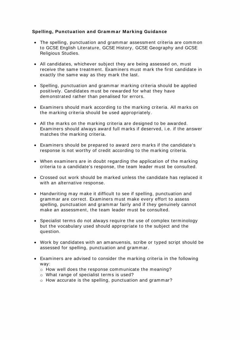
Spelling, Punctuation and Grammar Marking Guidance • The spelling, punctuation and grammar assessment criteria are common
to GCSE English Literature, GCSE History, GCSE Geography and GCSE Religious Studies.
• All candidates, whichever subject they are being assessed on, must
receive the same treatment. Examiners must mark the first candidate in exactly the same way as they mark the last.
• Spelling, punctuation and grammar marking criteria should be applied
positively. Candidates must be rewarded for what they have demonstrated rather than penalised for errors.
• Examiners should mark according to the marking criteria. All marks on
the marking criteria should be used appropriately. • All the marks on the marking criteria are designed to be awarded.
Examiners should always award full marks if deserved, i.e. if the answer matches the marking criteria.
• Examiners should be prepared to award zero marks if the candidate’s
response is not worthy of credit according to the marking criteria. • When examiners are in doubt regarding the application of the marking
criteria to a candidate’s response, the team leader must be consulted. • Crossed out work should be marked unless the candidate has replaced it
with an alternative response. • Handwriting may make it difficult to see if spelling, punctuation and
grammar are correct. Examiners must make every effort to assess spelling, punctuation and grammar fairly and if they genuinely cannot make an assessment, the team leader must be consulted.
• Specialist terms do not always require the use of complex terminology
but the vocabulary used should appropriate to the subject and the question.
• Work by candidates with an amanuensis, scribe or typed script should be
assessed for spelling, punctuation and grammar. • Examiners are advised to consider the marking criteria in the following
way: o How well does the response communicate the meaning? o What range of specialist terms is used? o How accurate is the spelling, punctuation and grammar?
Question Number
Answer Reject Mark
1 (a) 1 mark for suggesting an appropriate impact NB: Impacts could be physical or human Common responses likely to include:
• Lahars • Ash cloud deposition • Debris dam or melt water flood • Lightning storm • Volcanic bombs • Flooding
• Transport links disrupted • Water supply contaminated • Tourism industry affected • Communication problems • Base for environmental refugees
from neighbouring settlements • Health issues (breathing
problems)
Pyroclastic Flows.
(2)
Question Number
Correct Answer Mark
1(b)
1 mark for each appropriate statement. Additional mark(s) awarded for extending statements. Response must link convection currents to plate movements for full marks. e.g. In the mantle (1) the magma circulates in huge convection currents (1). These currents are driven by the heat of the core (1). They tug, push and pull the plates causing them to move (1). e.g. Magma from within the mantle (1) is heated by radioactive decay (1). The hot magma rises (1) and pushes against the plates of the crust causing them to move (1). NB: Answer could be written, diagrammatic or combination of both. NB: No additional marks to be awarded for information repeated in the sketch / written description.
(4)
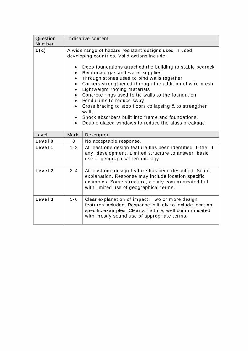
Question Number
Indicative content
1(c)
A wide range of hazard resistant designs used in used developing countries. Valid actions include:
• Deep foundations attached the building to stable bedrock • Reinforced gas and water supplies. • Through stones used to bind walls together • Corners strengthened through the addition of wire-mesh • Lightweight roofing materials • Concrete rings used to tie walls to the foundation • Pendulums to reduce sway. • Cross bracing to stop floors collapsing & to strengthen
walls. • Shock absorbers built into frame and foundations. • Double glazed windows to reduce the glass breakage
Level Mark Descriptor Level 0 0 No acceptable response. Level 1 1-2 At least one design feature has been identified. Little, if
any, development. Limited structure to answer, basic use of geographical terminology.
Level 2 3-4 At least one design feature has been described. Some explanation. Response may include location specific examples. Some structure, clearly communicated but with limited use of geographical terms.
Level 3 5-6 Clear explanation of impact. Two or more design features included. Response is likely to include location specific examples. Clear structure, well communicated with mostly sound use of appropriate terms.

Question Number
Answer Reject Mark
2 (a) 1 mark for each valid statement:
• Between 1000 and 1200 the temperature increased
• Between 1200 and 1350 the temperature fell
• Temperatures throughout the period were above the 20th century average.
• Temperatures peaked at 0.9˚C above the long term average
References to period after 1350. Comments stating that the temperature ‘fluctuates’.
(2)
Question Number
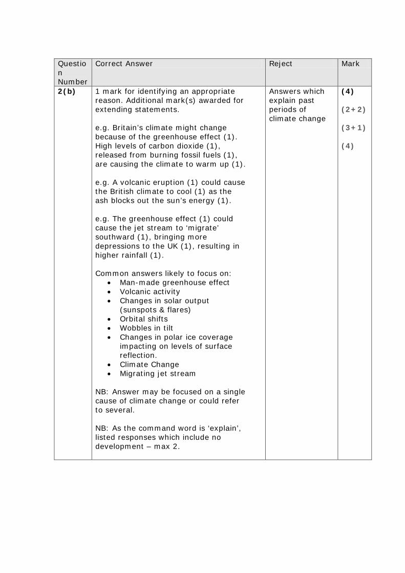
Correct Answer Reject Mark
2(b)
1 mark for identifying an appropriate reason. Additional mark(s) awarded for extending statements. e.g. Britain’s climate might change because of the greenhouse effect (1). High levels of carbon dioxide (1), released from burning fossil fuels (1), are causing the climate to warm up (1). e.g. A volcanic eruption (1) could cause the British climate to cool (1) as the ash blocks out the sun’s energy (1). e.g. The greenhouse effect (1) could cause the jet stream to ‘migrate’ southward (1), bringing more depressions to the UK (1), resulting in higher rainfall (1). Common answers likely to focus on:
• Man-made greenhouse effect • Volcanic activity • Changes in solar output
(sunspots & flares) • Orbital shifts • Wobbles in tilt • Changes in polar ice coverage
impacting on levels of surface reflection.
• Climate Change • Migrating jet stream
NB: Answer may be focused on a single cause of climate change or could refer to several. NB: As the command word is ‘explain’, listed responses which include no development – max 2.
Answers which explain past periods of climate change
(4) (2+2) (3+1) (4)
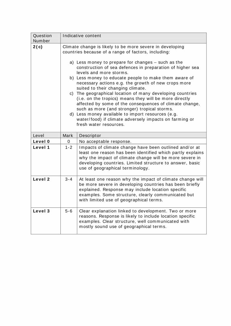
Question Number
Indicative content
2(c)
Climate change is likely to be more severe in developing countries because of a range of factors, including:
a) Less money to prepare for changes – such as the construction of sea defences in preparation of higher sea levels and more storms.
b) Less money to educate people to make them aware of necessary actions e.g. the growth of new crops more suited to their changing climate.
c) The geographical location of many developing countries (i.e. on the tropics) means they will be more directly affected by some of the consequences of climate change, such as more (and stronger) tropical storms.
d) Less money available to import resources (e.g. water/food) if climate adversely impacts on farming or fresh water resources.
Level Mark Descriptor Level 0 0 No acceptable response. Level 1 1-2 Impacts of climate change have been outlined and/or at
least one reason has been identified which partly explains why the impact of climate change will be more severe in developing countries. Limited structure to answer, basic use of geographical terminology.
Level 2 3-4 At least one reason why the impact of climate change will be more severe in developing countries has been briefly explained. Response may include location specific examples. Some structure, clearly communicated but with limited use of geographical terms.
Level 3 5-6 Clear explanation linked to development. Two or more reasons. Response is likely to include location specific examples. Clear structure, well communicated with mostly sound use of geographical terms.
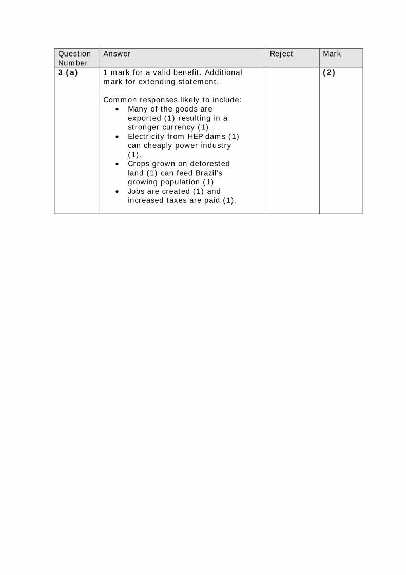
Question Number
Answer Reject Mark
3 (a) 1 mark for a valid benefit. Additional mark for extending statement. Common responses likely to include:
• Many of the goods are exported (1) resulting in a stronger currency (1).
• Electricity from HEP dams (1) can cheaply power industry (1).
• Crops grown on deforested land (1) can feed Brazil’s growing population (1)
• Jobs are created (1) and increased taxes are paid (1).
(2)
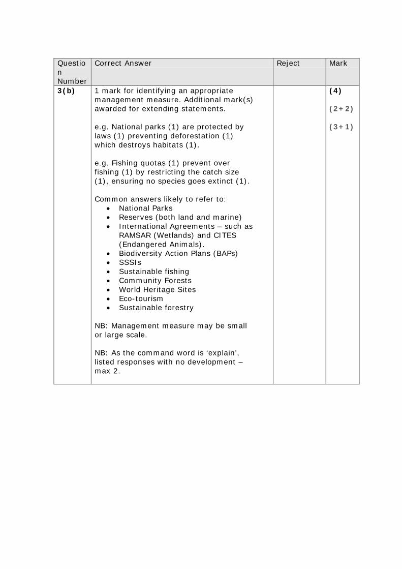
Question Number
Correct Answer Reject Mark
3(b)
1 mark for identifying an appropriate management measure. Additional mark(s) awarded for extending statements. e.g. National parks (1) are protected by laws (1) preventing deforestation (1) which destroys habitats (1). e.g. Fishing quotas (1) prevent over fishing (1) by restricting the catch size (1), ensuring no species goes extinct (1). Common answers likely to refer to:
• National Parks • Reserves (both land and marine) • International Agreements – such as
RAMSAR (Wetlands) and CITES (Endangered Animals).
• Biodiversity Action Plans (BAPs) • SSSIs • Sustainable fishing • Community Forests • World Heritage Sites • Eco-tourism • Sustainable forestry
NB: Management measure may be small or large scale. NB: As the command word is ‘explain’, listed responses with no development – max 2.
(4) (2+2) (3+1)
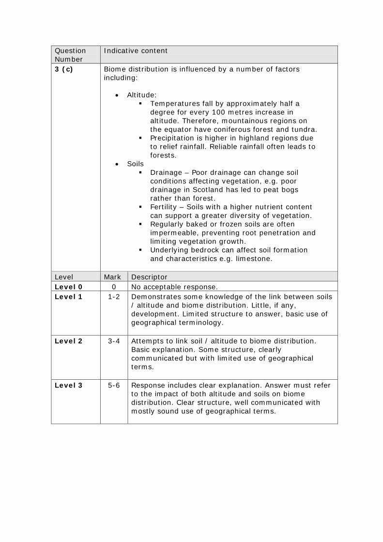
Question Number
Indicative content
3 (c)
Biome distribution is influenced by a number of factors including:
• Altitude: Temperatures fall by approximately half a
degree for every 100 metres increase in altitude. Therefore, mountainous regions on the equator have coniferous forest and tundra.
Precipitation is higher in highland regions due to relief rainfall. Reliable rainfall often leads to forests.
• Soils Drainage – Poor drainage can change soil
conditions affecting vegetation, e.g. poor drainage in Scotland has led to peat bogs rather than forest.
Fertility – Soils with a higher nutrient content can support a greater diversity of vegetation.
Regularly baked or frozen soils are often impermeable, preventing root penetration and limiting vegetation growth.
Underlying bedrock can affect soil formation and characteristics e.g. limestone.
Level Mark Descriptor Level 0 0 No acceptable response. Level 1 1-2 Demonstrates some knowledge of the link between soils
/ altitude and biome distribution. Little, if any, development. Limited structure to answer, basic use of geographical terminology.
Level 2 3-4 Attempts to link soil / altitude to biome distribution. Basic explanation. Some structure, clearly communicated but with limited use of geographical terms.
Level 3 5-6 Response includes clear explanation. Answer must refer to the impact of both altitude and soils on biome distribution. Clear structure, well communicated with mostly sound use of geographical terms.
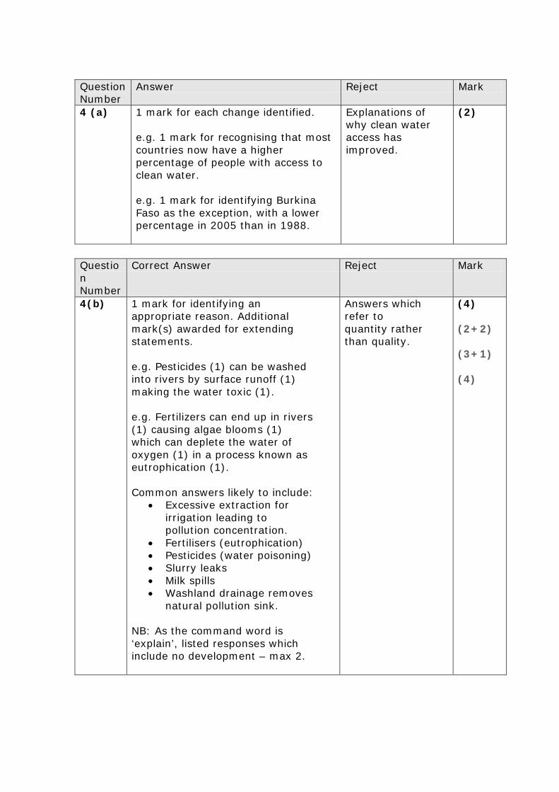
Question Number
Answer Reject Mark
4 (a) 1 mark for each change identified. e.g. 1 mark for recognising that most countries now have a higher percentage of people with access to clean water. e.g. 1 mark for identifying Burkina Faso as the exception, with a lower percentage in 2005 than in 1988.
Explanations of why clean water access has improved.
(2)
Question Number
Correct Answer Reject Mark
4(b)
1 mark for identifying an appropriate reason. Additional mark(s) awarded for extending statements. e.g. Pesticides (1) can be washed into rivers by surface runoff (1) making the water toxic (1). e.g. Fertilizers can end up in rivers (1) causing algae blooms (1) which can deplete the water of oxygen (1) in a process known as eutrophication (1). Common answers likely to include:
• Excessive extraction for irrigation leading to pollution concentration.
• Fertilisers (eutrophication) • Pesticides (water poisoning) • Slurry leaks • Milk spills • Washland drainage removes
natural pollution sink. NB: As the command word is ‘explain’, listed responses which include no development – max 2.
Answers which refer to quantity rather than quality.
(4) (2+2) (3+1) (4)
Question Number
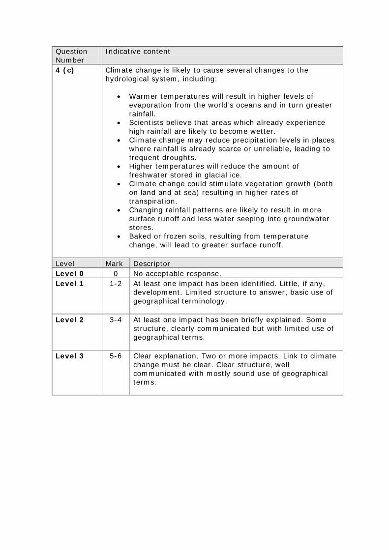
Indicative content
4 (c)
Climate change is likely to cause several changes to the hydrological system, including:
• Warmer temperatures will result in higher levels of
evaporation from the world’s oceans and in turn greater rainfall.
• Scientists believe that areas which already experience high rainfall are likely to become wetter.
• Climate change may reduce precipitation levels in places where rainfall is already scarce or unreliable, leading to frequent droughts.
• Higher temperatures will reduce the amount of freshwater stored in glacial ice.
• Climate change could stimulate vegetation growth (both on land and at sea) resulting in higher rates of transpiration.
• Changing rainfall patterns are likely to result in more surface runoff and less water seeping into groundwater stores.
• Baked or frozen soils, resulting from temperature change, will lead to greater surface runoff.
Level Mark Descriptor Level 0 0 No acceptable response. Level 1 1-2 At least one impact has been identified. Little, if any,
development. Limited structure to answer, basic use of geographical terminology.
Level 2 3-4 At least one impact has been briefly explained. Some structure, clearly communicated but with limited use of geographical terms.
Level 3 5-6 Clear explanation. Two or more impacts. Link to climate change must be clear. Clear structure, well communicated with mostly sound use of geographical terms.
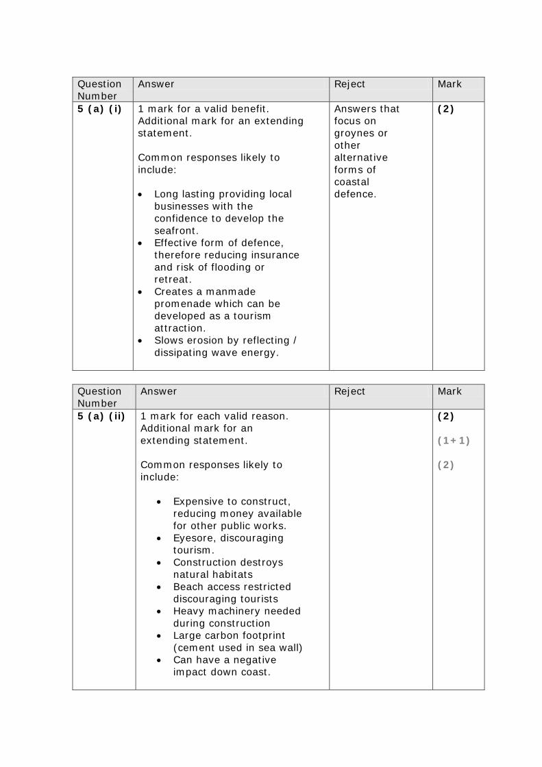
Question Number
Answer Reject Mark
5 (a) (i) 1 mark for a valid benefit. Additional mark for an extending statement. Common responses likely to include: • Long lasting providing local
businesses with the confidence to develop the seafront.
• Effective form of defence, therefore reducing insurance and risk of flooding or retreat.
• Creates a manmade promenade which can be developed as a tourism attraction.
• Slows erosion by reflecting / dissipating wave energy.
Answers that focus on groynes or other alternative forms of coastal defence.
(2)
Question Number
Answer Reject Mark
5 (a) (ii)
1 mark for each valid reason. Additional mark for an extending statement. Common responses likely to include:
• Expensive to construct, reducing money available for other public works.
• Eyesore, discouraging tourism.
• Construction destroys natural habitats
• Beach access restricted discouraging tourists
• Heavy machinery needed during construction
• Large carbon footprint (cement used in sea wall)
• Can have a negative impact down coast.
(2) (1+1) (2)
Question Number
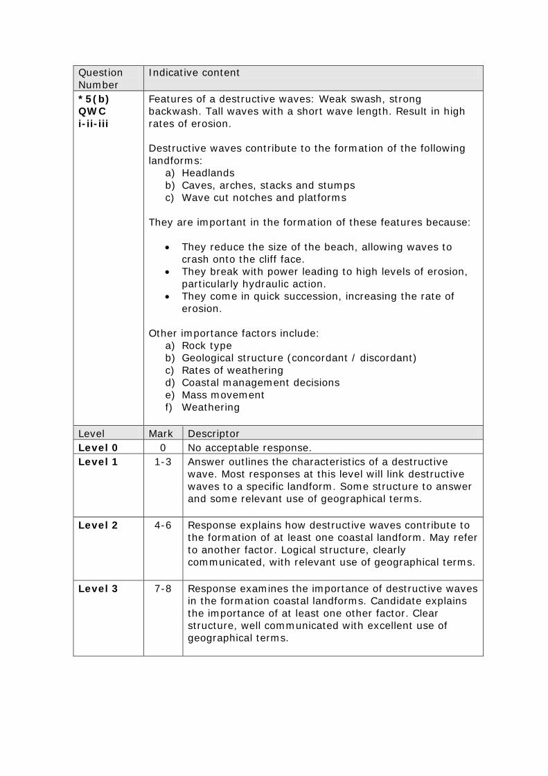
Indicative content
*5(b) QWC i-ii-iii
Features of a destructive waves: Weak swash, strong backwash. Tall waves with a short wave length. Result in high rates of erosion. Destructive waves contribute to the formation of the following landforms:
a) Headlands b) Caves, arches, stacks and stumps c) Wave cut notches and platforms
They are important in the formation of these features because:
• They reduce the size of the beach, allowing waves to crash onto the cliff face.
• They break with power leading to high levels of erosion, particularly hydraulic action.
• They come in quick succession, increasing the rate of erosion.
Other importance factors include:
a) Rock type b) Geological structure (concordant / discordant) c) Rates of weathering d) Coastal management decisions e) Mass movement f) Weathering
Level Mark Descriptor Level 0 0 No acceptable response. Level 1 1-3 Answer outlines the characteristics of a destructive
wave. Most responses at this level will link destructive waves to a specific landform. Some structure to answer and some relevant use of geographical terms.
Level 2 4-6 Response explains how destructive waves contribute to the formation of at least one coastal landform. May refer to another factor. Logical structure, clearly communicated, with relevant use of geographical terms.
Level 3 7-8 Response examines the importance of destructive waves in the formation coastal landforms. Candidate explains the importance of at least one other factor. Clear structure, well communicated with excellent use of geographical terms.
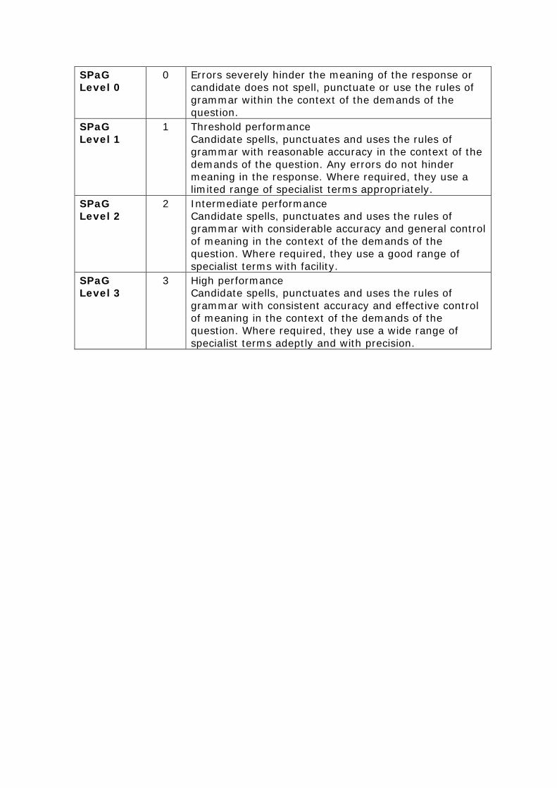
SPaG Level 0
0 Errors severely hinder the meaning of the response or candidate does not spell, punctuate or use the rules of grammar within the context of the demands of the question.
SPaG Level 1
1 Threshold performance Candidate spells, punctuates and uses the rules of grammar with reasonable accuracy in the context of the demands of the question. Any errors do not hinder meaning in the response. Where required, they use a limited range of specialist terms appropriately.
SPaG Level 2
2 Intermediate performance Candidate spells, punctuates and uses the rules of grammar with considerable accuracy and general control of meaning in the context of the demands of the question. Where required, they use a good range of specialist terms with facility.
SPaG Level 3
3 High performance Candidate spells, punctuates and uses the rules of grammar with consistent accuracy and effective control of meaning in the context of the demands of the question. Where required, they use a wide range of specialist terms adeptly and with precision.
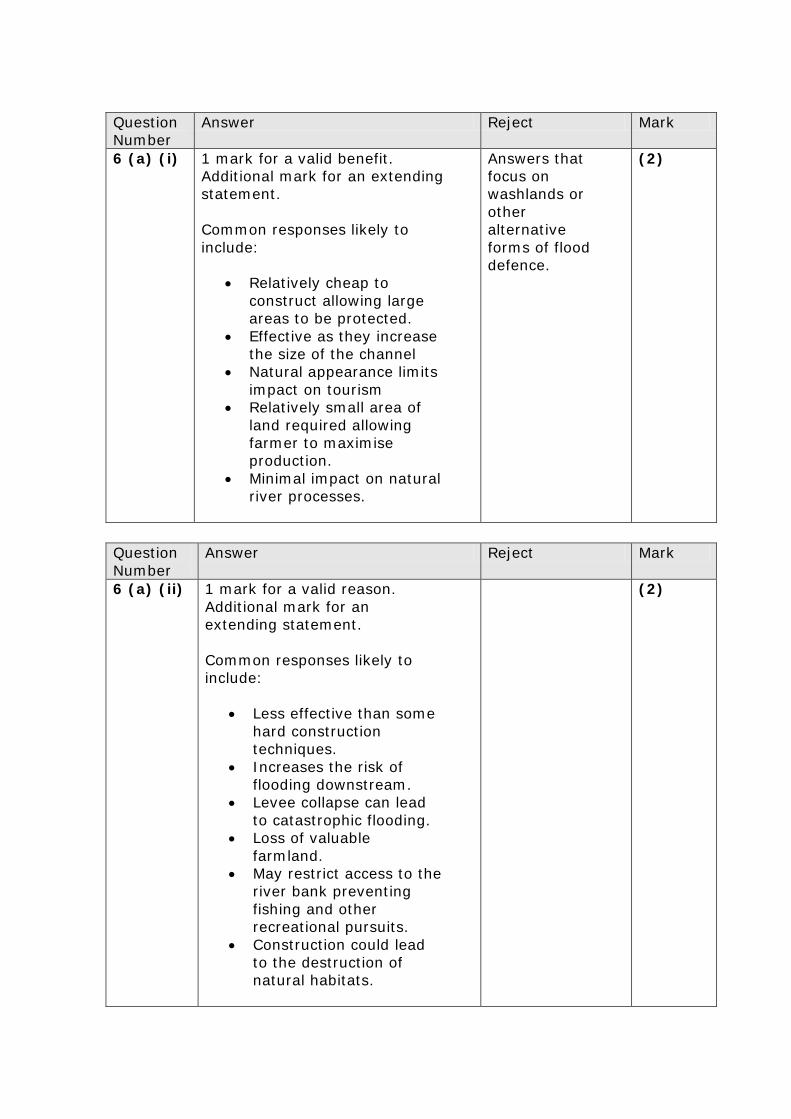
Question Number
Answer Reject Mark
6 (a) (i) 1 mark for a valid benefit. Additional mark for an extending statement. Common responses likely to include:
• Relatively cheap to construct allowing large areas to be protected.
• Effective as they increase the size of the channel
• Natural appearance limits impact on tourism
• Relatively small area of land required allowing farmer to maximise production.
• Minimal impact on natural river processes.
Answers that focus on washlands or other alternative forms of flood defence.
(2)
Question Number
Answer Reject Mark
6 (a) (ii)
1 mark for a valid reason. Additional mark for an extending statement. Common responses likely to include:
• Less effective than some hard construction techniques.
• Increases the risk of flooding downstream.
• Levee collapse can lead to catastrophic flooding.
• Loss of valuable farmland.
• May restrict access to the river bank preventing fishing and other recreational pursuits.
• Construction could lead to the destruction of natural habitats.
(2)
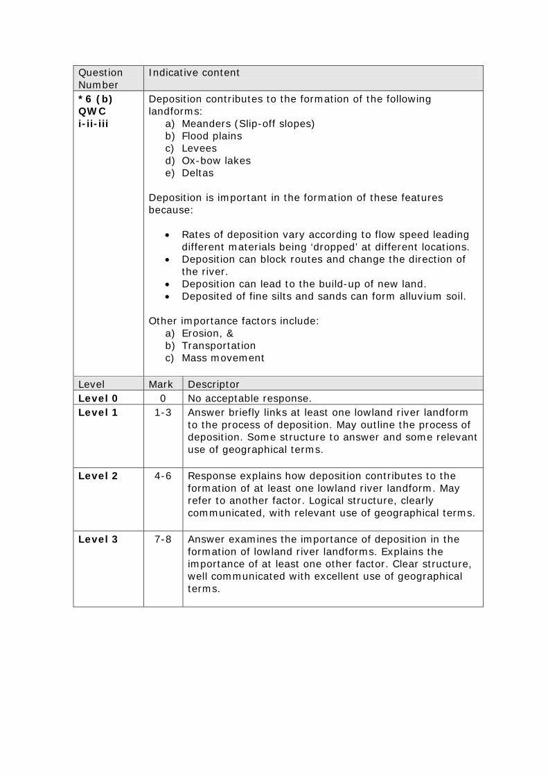
Question Number
Indicative content
*6 (b) QWC i-ii-iii
Deposition contributes to the formation of the following landforms:
a) Meanders (Slip-off slopes) b) Flood plains c) Levees d) Ox-bow lakes e) Deltas
Deposition is important in the formation of these features because:
• Rates of deposition vary according to flow speed leading different materials being ‘dropped’ at different locations.
• Deposition can block routes and change the direction of the river.
• Deposition can lead to the build-up of new land. • Deposited of fine silts and sands can form alluvium soil.
Other importance factors include:
a) Erosion, & b) Transportation c) Mass movement
Level Mark Descriptor Level 0 0 No acceptable response. Level 1 1-3 Answer briefly links at least one lowland river landform
to the process of deposition. May outline the process of deposition. Some structure to answer and some relevant use of geographical terms.
Level 2 4-6 Response explains how deposition contributes to the formation of at least one lowland river landform. May refer to another factor. Logical structure, clearly communicated, with relevant use of geographical terms.
Level 3 7-8 Answer examines the importance of deposition in the formation of lowland river landforms. Explains the importance of at least one other factor. Clear structure, well communicated with excellent use of geographical terms.

SPaG Level 0
0 Errors severely hinder the meaning of the response or candidate does not spell, punctuate or use the rules of grammar within the context of the demands of the question.
SPaG Level 1
1 Threshold performance Candidate spells, punctuates and uses the rules of grammar with reasonable accuracy in the context of the demands of the question. Any errors do not hinder meaning in the response. Where required, they use a limited range of specialist terms appropriately.
SPaG Level 2
2 Intermediate performance Candidate spells, punctuates and uses the rules of grammar with considerable accuracy and general control of meaning in the context of the demands of the question. Where required, they use a good range of specialist terms with facility.
SPaG Level 3
3 High performance Candidate spells, punctuates and uses the rules of grammar with consistent accuracy and effective control of meaning in the context of the demands of the question. Where required, they use a wide range of specialist terms adeptly and with precision.
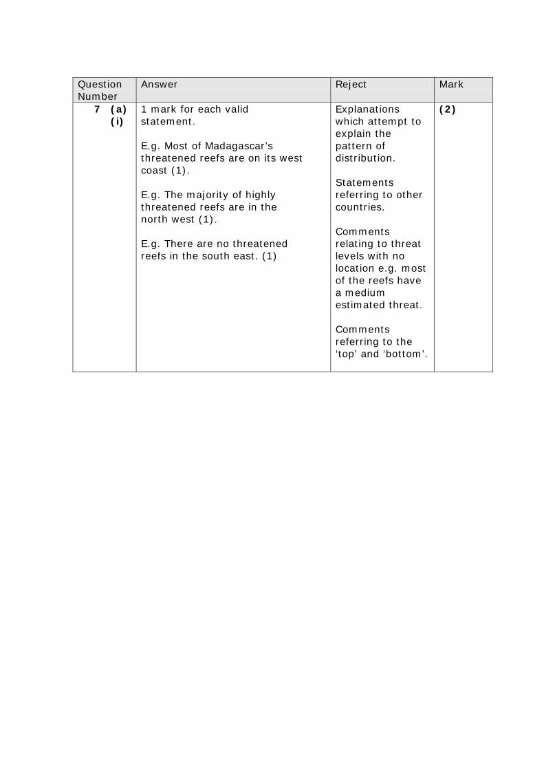
Question Number
Answer Reject Mark
7 (a) (i)
1 mark for each valid statement. E.g. Most of Madagascar’s threatened reefs are on its west coast (1). E.g. The majority of highly threatened reefs are in the north west (1). E.g. There are no threatened reefs in the south east. (1)
Explanations which attempt to explain the pattern of distribution. Statements referring to other countries. Comments relating to threat levels with no location e.g. most of the reefs have a medium estimated threat. Comments referring to the ‘top’ and ‘bottom’.
(2)
Question Number
Answer Mark
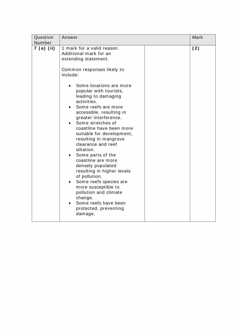
7 (a) (ii)
1 mark for a valid reason. Additional mark for an extending statement. Common responses likely to include:
• Some locations are more popular with tourists, leading to damaging activities.
• Some reefs are more accessible, resulting in greater interference.
• Some stretches of coastline have been more suitable for development, resulting in mangrove clearance and reef siltation.
• Some parts of the coastline are more densely populated resulting in higher levels of pollution.
• Some reefs species are more susceptible to pollution and climate change.
• Some reefs have been protected, preventing damage.
(2)
Question Number
Indicative content
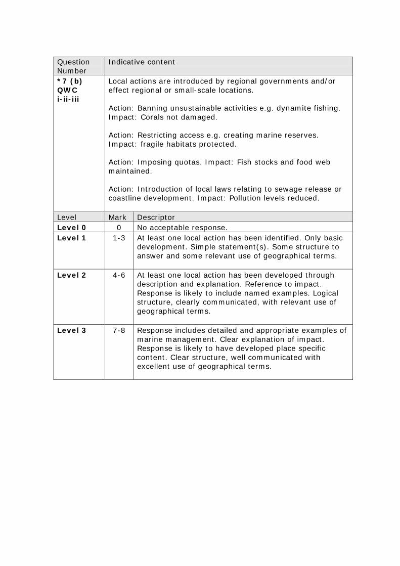
*7 (b) QWC i-ii-iii
Local actions are introduced by regional governments and/or effect regional or small-scale locations. Action: Banning unsustainable activities e.g. dynamite fishing. Impact: Corals not damaged. Action: Restricting access e.g. creating marine reserves. Impact: fragile habitats protected. Action: Imposing quotas. Impact: Fish stocks and food web maintained. Action: Introduction of local laws relating to sewage release or coastline development. Impact: Pollution levels reduced.
Level Mark Descriptor Level 0 0 No acceptable response. Level 1 1-3 At least one local action has been identified. Only basic
development. Simple statement(s). Some structure to answer and some relevant use of geographical terms.
Level 2 4-6 At least one local action has been developed through description and explanation. Reference to impact. Response is likely to include named examples. Logical structure, clearly communicated, with relevant use of geographical terms.
Level 3 7-8 Response includes detailed and appropriate examples of marine management. Clear explanation of impact. Response is likely to have developed place specific content. Clear structure, well communicated with excellent use of geographical terms.

SPaG Level 0
0 Errors severely hinder the meaning of the response or candidate does not spell, punctuate or use the rules of grammar within the context of the demands of the question.
SPaG Level 1
1 Threshold performance Candidate spells, punctuates and uses the rules of grammar with reasonable accuracy in the context of the demands of the question. Any errors do not hinder meaning in the response. Where required, they use a limited range of specialist terms appropriately.
SPaG Level 2
2 Intermediate performance Candidate spells, punctuates and uses the rules of grammar with considerable accuracy and general control of meaning in the context of the demands of the question. Where required, they use a good range of specialist terms with facility.
SPaG Level 3
3 High performance Candidate spells, punctuates and uses the rules of grammar with consistent accuracy and effective control of meaning in the context of the demands of the question. Where required, they use a wide range of specialist terms adeptly and with precision.
Question Number
Answer Reject Mark
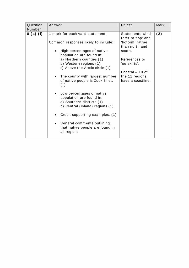
8 (a) (i) 1 mark for each valid statement. Common responses likely to include:
• High percentages of native population are found in: a) Northern counties (1) b) Western regions (1) c) Above the Arctic circle (1)
• The county with largest number
of native people is Cook Inlet. (1)
• Low percentages of native population are found in: a) Southern districts (1) b) Central (inland) regions (1)
• Credit supporting examples. (1)
• General comments outlining that native people are found in all regions.
Statements which refer to ‘top’ and ‘bottom’ rather than north and south. References to ‘outskirts’. Coastal – 10 of the 11 regions have a coastline.
(2)
Question Number
Answer Reject Mark
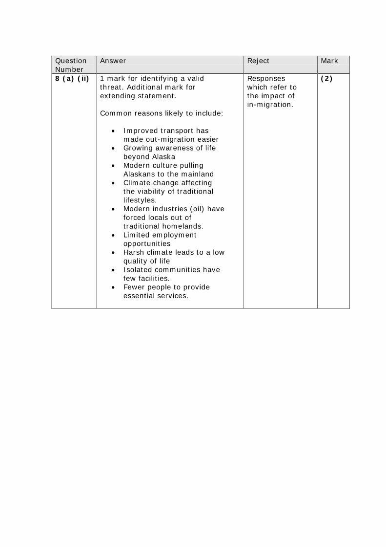
8 (a) (ii)
1 mark for identifying a valid threat. Additional mark for extending statement. Common reasons likely to include:
• Improved transport has made out-migration easier
• Growing awareness of life beyond Alaska
• Modern culture pulling Alaskans to the mainland
• Climate change affecting the viability of traditional lifestyles.
• Modern industries (oil) have forced locals out of traditional homelands.
• Limited employment opportunities
• Harsh climate leads to a low quality of life
• Isolated communities have few facilities.
• Fewer people to provide essential services.
Responses which refer to the impact of in-migration.
(2)
Question Number
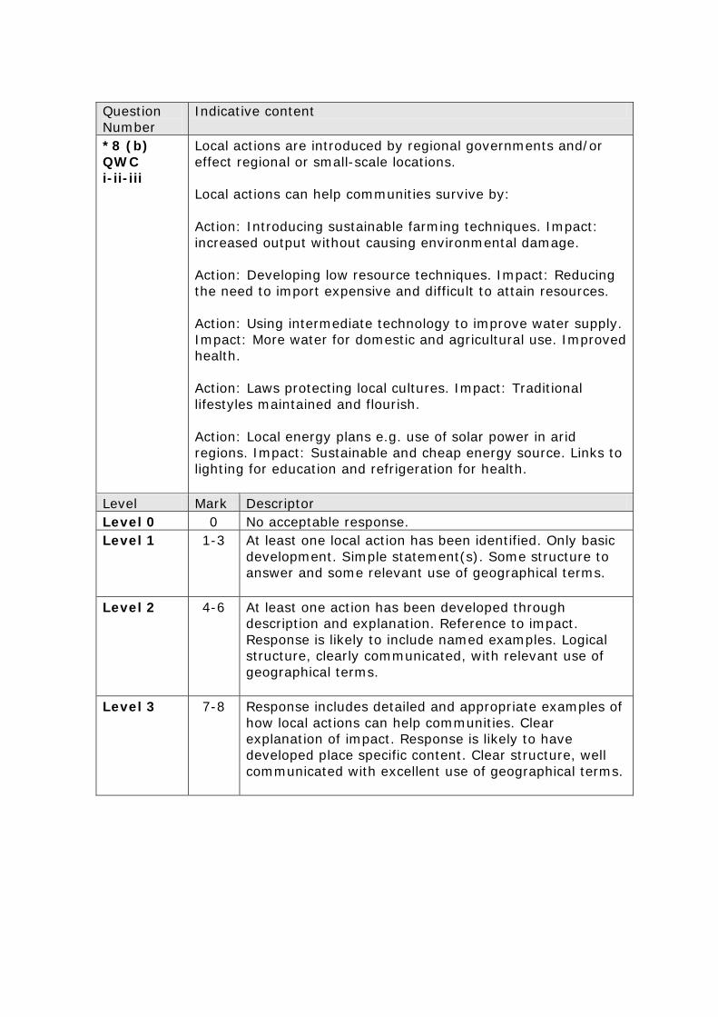
Indicative content
*8 (b) QWC i-ii-iii
Local actions are introduced by regional governments and/or effect regional or small-scale locations. Local actions can help communities survive by: Action: Introducing sustainable farming techniques. Impact: increased output without causing environmental damage. Action: Developing low resource techniques. Impact: Reducing the need to import expensive and difficult to attain resources. Action: Using intermediate technology to improve water supply. Impact: More water for domestic and agricultural use. Improved health. Action: Laws protecting local cultures. Impact: Traditional lifestyles maintained and flourish. Action: Local energy plans e.g. use of solar power in arid regions. Impact: Sustainable and cheap energy source. Links to lighting for education and refrigeration for health.
Level Mark Descriptor Level 0 0 No acceptable response. Level 1 1-3 At least one local action has been identified. Only basic
development. Simple statement(s). Some structure to answer and some relevant use of geographical terms.
Level 2 4-6 At least one action has been developed through description and explanation. Reference to impact. Response is likely to include named examples. Logical structure, clearly communicated, with relevant use of geographical terms.
Level 3 7-8 Response includes detailed and appropriate examples of how local actions can help communities. Clear explanation of impact. Response is likely to have developed place specific content. Clear structure, well communicated with excellent use of geographical terms.

SPaG Level 0
0 Errors severely hinder the meaning of the response or candidate does not spell, punctuate or use the rules of grammar within the context of the demands of the question.
SPaG Level 1
1 Threshold performance Candidate spells, punctuates and uses the rules of grammar with reasonable accuracy in the context of the demands of the question. Any errors do not hinder meaning in the response. Where required, they use a limited range of specialist terms appropriately.
SPaG Level 2
2 Intermediate performance Candidate spells, punctuates and uses the rules of grammar with considerable accuracy and general control of meaning in the context of the demands of the question. Where required, they use a good range of specialist terms with facility.
SPaG Level 3
3 High performance Candidate spells, punctuates and uses the rules of grammar with consistent accuracy and effective control of meaning in the context of the demands of the question. Where required, they use a wide range of specialist terms adeptly and with precision.

Pearson Education Limited. Registered company number 872828 with its registered office at Edinburgh Gate, Harlow, Essex CM20 2JE