Embed Size (px)
Citation preview
1
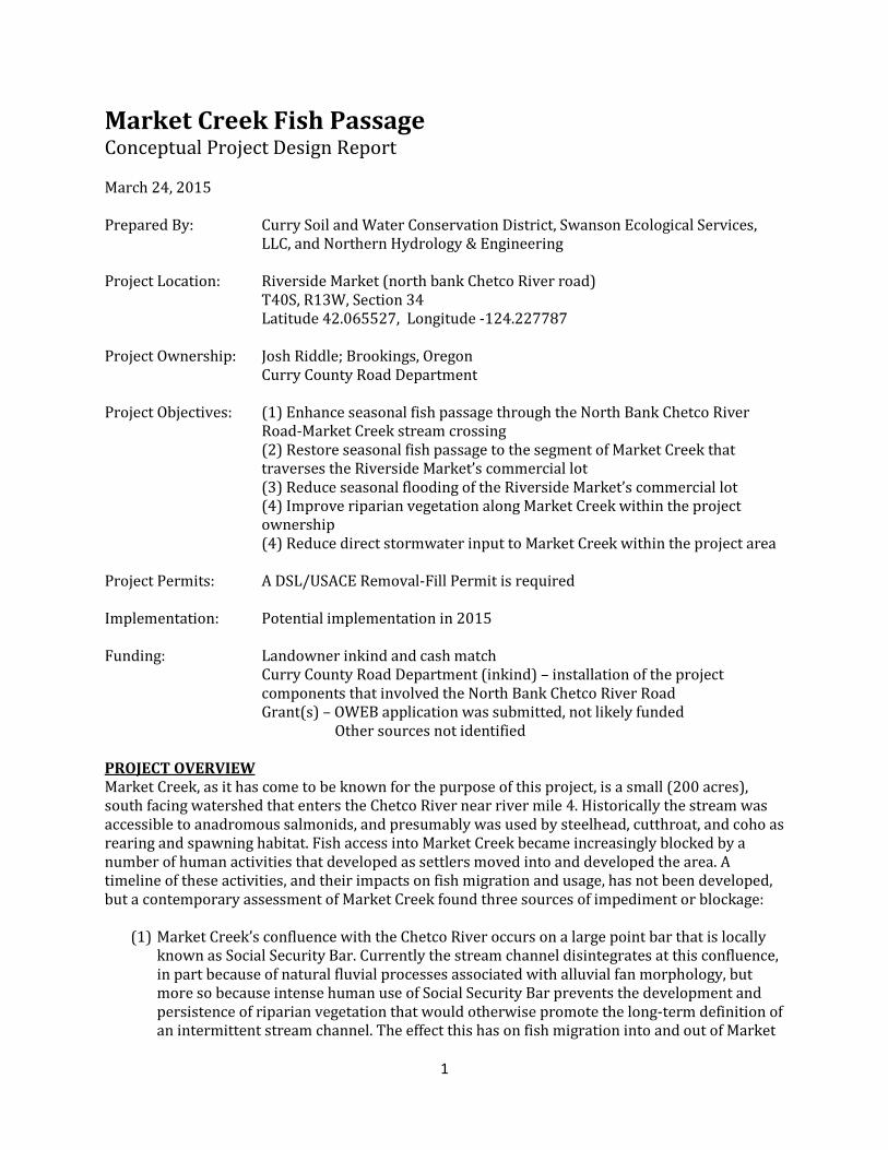
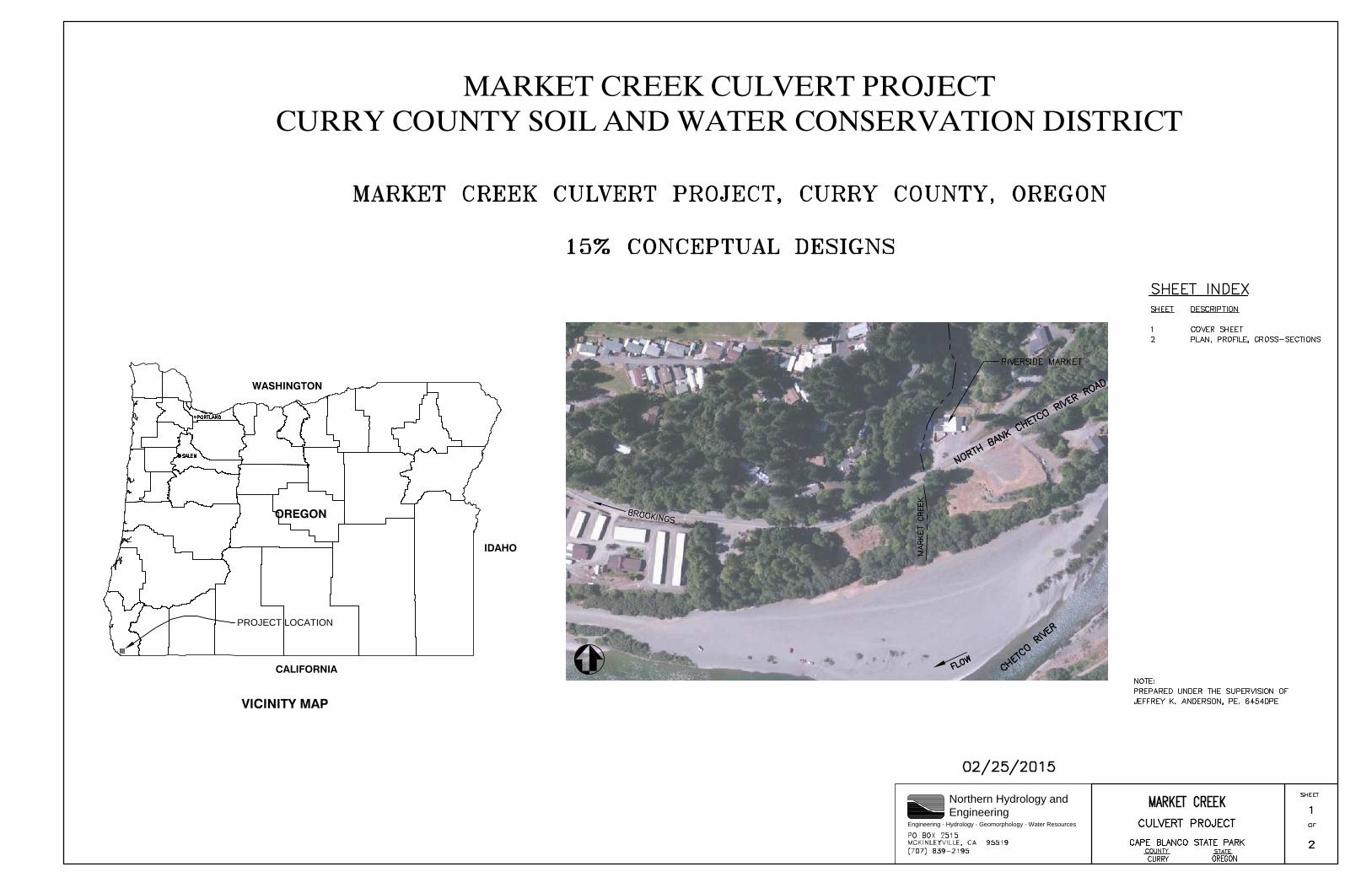
Market Creek Fish Passage Conceptual Project Design Report March 24, 2015 Prepared By: Curry Soil and Water Conservation District, Swanson Ecological Services,
LLC, and Northern Hydrology & Engineering Project Location: Riverside Market (north bank Chetco River road) T40S, R13W, Section 34 Latitude 42.065527, Longitude -124.227787 Project Ownership: Josh Riddle; Brookings, Oregon Curry County Road Department Project Objectives: (1) Enhance seasonal fish passage through the North Bank Chetco River
Road-Market Creek stream crossing (2) Restore seasonal fish passage to the segment of Market Creek that traverses the Riverside Market’s commercial lot (3) Reduce seasonal flooding of the Riverside Market’s commercial lot (4) Improve riparian vegetation along Market Creek within the project ownership (4) Reduce direct stormwater input to Market Creek within the project area
Project Permits: A DSL/USACE Removal-Fill Permit is required Implementation: Potential implementation in 2015 Funding: Landowner inkind and cash match Curry County Road Department (inkind) – installation of the project
components that involved the North Bank Chetco River Road Grant(s) – OWEB application was submitted, not likely funded Other sources not identified PROJECT OVERVIEW Market Creek, as it has come to be known for the purpose of this project, is a small (200 acres), south facing watershed that enters the Chetco River near river mile 4. Historically the stream was accessible to anadromous salmonids, and presumably was used by steelhead, cutthroat, and coho as rearing and spawning habitat. Fish access into Market Creek became increasingly blocked by a number of human activities that developed as settlers moved into and developed the area. A timeline of these activities, and their impacts on fish migration and usage, has not been developed, but a contemporary assessment of Market Creek found three sources of impediment or blockage:
(1) Market Creek’s confluence with the Chetco River occurs on a large point bar that is locally known as Social Security Bar. Currently the stream channel disintegrates at this confluence, in part because of natural fluvial processes associated with alluvial fan morphology, but more so because intense human use of Social Security Bar prevents the development and persistence of riparian vegetation that would otherwise promote the long-term definition of an intermittent stream channel. The effect this has on fish migration into and out of Market
2
Creek is not well understood, but observations suggest that the timing and duration of passage is limited to high water events in the Chetco River that are at, or near, bankfull discharge.
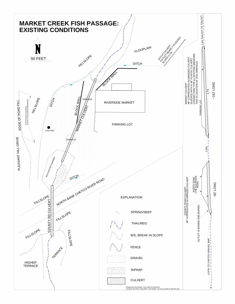
(2) Construction of the North Bank Chetco River Road (county road) most certainly altered the morphologic interface of the Market Creek stream valley and the Chetco River floodplain. The county road, which transects the Market Creek valley at this interface, prevents the stream from migrating throughout what historically must have been a dynamic alluvial fan, and instead forces the stream to follow a single pathway through the road prism. The type and dimensions of the structure(s) that historically was used to route Market Creek through the county road are not know, though we assume that this structure(s) impacted the upstream, and potentially downstream, migration of salmonids. The current structure is a 48 inch diameter corrugated metal culvert that is approximately 92 feet in length, and partially embedded at the downstream end of the crossing. This culvert is undersized relative to the 100-year discharge and to the stream’s active channel width, but because it is backwatered by the Chetco River during flood events, fish appear to successfully migrate through the structure when conditions are favorable.
(3) Construction of the Riverside Market and associated commercial lot further diminished the dynamic character of the Market Creek-Chetco River confluence by filling the Market Creek stream valley and routing Market Creek through an additional ~200 feet of confined stream channel. Until the early 1990’s this channel was “daylighted”, and according to ODFW, steelhead and cutthroat trout were still present in the upstream channel; an indication that migration was feasible, at least under certain hydrologic conditions. Circa the mid-1990’s a previous owner of Riverside Market installed a culvert across the commercial lot that measured 48 inches in diameter and ~162 feet in length; presumably to increase usable space for commercial purposes (i.e. storage, a mushroom buying station, etc.). Installation of this culvert, and a subsequent retrofit that reduced the inlet to 36 inches in diameter, completely blocked upstream fish migration; and it appears that this also led to the extirpation of a resident cutthroat population in the upper watershed. In addition to blocking fish migration, the Riverside Market culvert also reduced the stream’s ability to transport bedload to the downstream channel, which has caused the upstream channel and stream valley to aggrade, and subsequently to evolve geomorphically.
In addition to blocking fish passage, the Riverside Market culvert also causes periodic flooding of the Market’s commercial lot because it is unable to adequately convey bedload, debris, and winter discharge; a scenario that was greatly exacerbated when the inlet was retrofitted with the 36 inch diameter culvert. This flooding poses structural risks to the Riverside Market, significantly adds fine and coarse sediment to the stream channel, and is threatening the stability of the county road where the overland flow reenters Market Creek via the county’s roadside ditch. INVESTIGATIONS (1) Fish Presence-Absence
On January 17, 2014 the Curry SWCD’s Project Manager and ODFW’s Assistant District Fish Biologist conducted a presence-absence fish survey within the project area to further understand and document pre-implementation fish usage in Market Creek. An electro-shocker was used to stun and collect fish, primarily from pools. Three pools were sampled downstream of the county road before flow went subsurface near Social Security Bar; no fish were observed. Between the county road and the Riverside Market culvert one pool was sampled (below the culvert outlet), which contained 11 trout measuring <90 mm. Upstream of the Market’s culvert
3
8 pools were sampled but no fish were observed. Based on this sampling we concluded that juvenile salmonids were able to migrate from the Chetco River to the outlet of the Market’s culvert, but were blocked by that culvert from migrating into the upstream channel; we also concluded that cutthroat no longer persist in Market Creek as a resident population.
(2) Total Station Coordinate Survey On March 17, 2014 the Curry SWCD’s Project Manager and the SWCD’s Data Management Specialist conducted a coordinate survey of the project area using a Total Station survey instrument. The data was used to draft a planview and thalweg profile of the existing conditions, and it was used to develop a conceptual project design that was used to submit an OWEB restoration grant proposal in October 2014.
From this initial assessment of the project area we recognized that the existing conditions presented specific engineering challenges and risks that were beyond the capacity of the SWCD’s staff, so we sought professional engineering assistance from a firm in Northern California that has expertise in fluvial geomorphology and fish passage design. The firm, Northern Hydrology and Engineering (NHE), met on-site with the SWCD’s Project Manager in early September 2014, to review the findings in the SWCD’s conceptual design and to develop a Scope of Work for engineering assistance. In December 2014 the Curry SWCD’s Project Manager and NHE’s Engineering Technician conducted a second Total Station topographic survey of the project area that captured greater detail and covered a significantly larger geographic area than the SWCD’s survey; and the NHE survey was executed at a level of accuracy commensurate to the engineering precision that is required at the site. NHE drafted the survey data and conducted sufficient analysis to evaluate alternative designs and develop a preferred conceptual design. More information on this is provided below.
(3) Land Acquisition and Conversation Easements
Through the development of this project we came to recognize that there are potential land acquisitions and/or conservation easements adjacent to the project area that would further enhance rearing habitat on Market Creek and on the lower Chetco River mainstem. The first area under consideration is the parcel that Market Creek crosses as it flows from the county road downstream to Social Security Bar. This parcel, which is owned by the owner of the Riverside Market, includes approximately 2,600 feet of river frontage. Historically this area was used to stockpile gravel from the river, so there are spoils of river aggregate that could be removed and regraded to restore riparian wetland habitat for high flow refugia, and to enhance instream habitat and improve the morphology of lower Market Creek; including where it connects to the Chetco River. Currently there is a building pad on the parcel that is slated for commercial development, but the landowner has indicated he would rather see the parcel preserved as riparian habitat, and he is open to an acquisition or easement. This is a rare opportunity on the lower Chetco River mainstem that warrants further investigation. The other parcel is located immediately upstream of Riverside Market and includes the remaining valley morphology in the Market Creek subwatershed. Restoration of the valley could create 600-800 feet of complex instream and riparian wetland habitat that would function as winter refugia once fish passage is established below. Road decommissioning, slope stabilization, and forest management could also be implemented on the parcel to reduce fine and coarse grain sediment loading, and there is at least one other culvert that affects fish
4
migration. We haven’t yet asked the landowner whether an acquisition or easement is an option, but the conversation is warranted given the potential gains in rearing habitat.
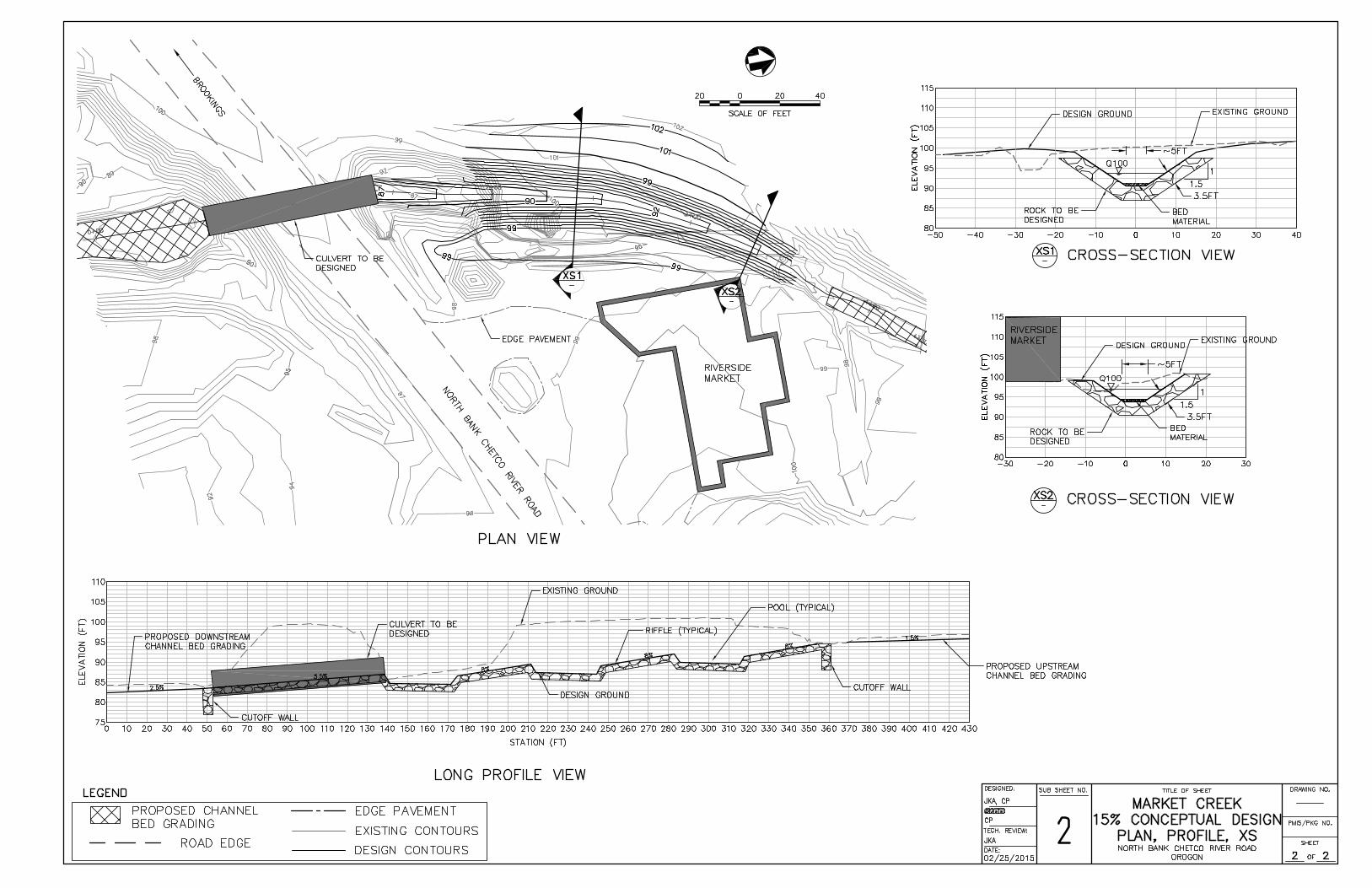
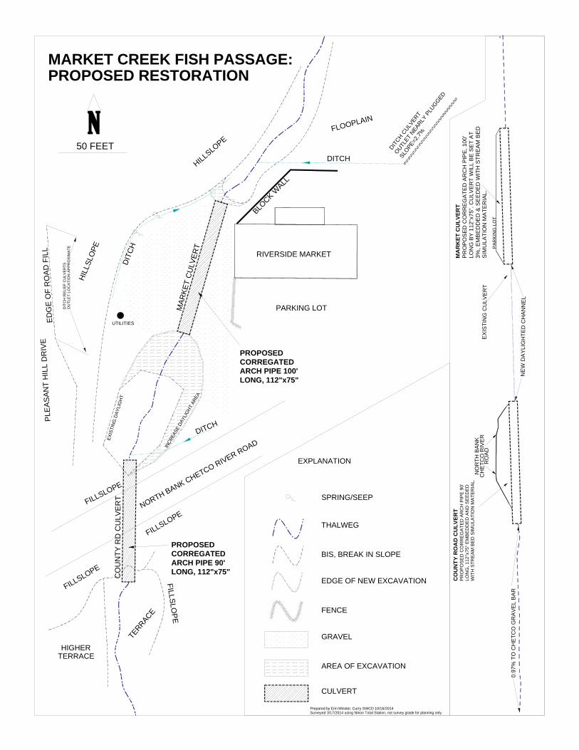
PRELIMINARY DESIGN The SWCD’s conceptual design was developed with two objectives in mind: (1) to provide fish passage that met NOAA’s SLOPES V design criteria, and (2) preserved usable space for the landowner’s commercial interests. To achieve these two objectives the SWCD concluded that the Riverside Market culvert should be replaced with a shortened, embedded arch culvert; that the existing segment of “daylighted” stream channel between the Market’s culvert and the county road should be extended in length and widened to create floodway rearing habitat; and that the county road culvert should be replaced with an embedded arch culvert (see attached SWCD design drawings). NHE’s initial analysis of their topographic survey data led them to conclude that replacing the Riverside Market culvert with an embedded arch culvert might not be feasible within the context of NOAA’s fish passage criteria, so they recommended that the culvert be replaced with an engineered roughened channel (see attached NHE conceptual design). In their conceptual design NHE proposes to build the channel out of large angular rock, and to alternate between overly steep riffles and flat resting pools. This will create a transitional channel that can lift the stream approximately 10 feet in elevation from the county road culvert up to the Market Creek stream valley, while also creating hydraulic conditions that pass juvenile and adult salmonids. Historically this change in elevation would have taken place within alluvial fan morphology at the confluence of the Market Creek stream valley and the Chetco River floodplain; in a channel that was dynamic and constantly in flux. This context no longer exists because of the construction of the county road and the Market’s commercial lot, but the change in elevation still exists, and so there is a need for NHE’s conceptual roughened channel. After further discussion the landowner agreed to forgo the commercial space that was created when the Riverside Market culvert was installed, and is supportive of NHE’s conceptual design; making it a feasible, and the preferred, design for the site. PRE-IMPLEMENTATION There are multiple tasks that must be completed before NHE’s conceptual project design can be implemented.
• The conceptual design should be reviewed by NOAA’s Fish Passage Engineer and ODFW’s Passage Coordinator, so that feedback can be incorporated into the design before further investment is made in the engineering of the roughened channel.
• The upstream landowner must be informed about how the project will affect the upstream channel, and we need to determine whether the landowner will allow project activities to extend upstream onto their property.
• A stormwater management plan will also be required according to NOAA, to address runoff from, and leading into, the project area. Further clarification is needed to determine the geographic extent of the treatment area, and whether retention will be required as part of the plan.
• A planting plan must be developed for the project area that includes, at a minimum, revegetation of the roughened channel, riparian interplanting downstream of the county road crossing, and any vegetative component(s) in the stormwater management plan.
5
• The Curry County Road Department should be updated regarding NHE’s conceptual design, the need for a stormwater management ditch relief culvert on the county road, and the project’s projected timeline; a written agreement is also needed between the Curry SWCD and the County Road Department, that clarifies the roles and responsibilities of each party, and secures the Road Department’s commitment to replace their Market Creek culvert.
• Further investigation is needed to determine if an acquisition or easement is plausible for either of the two candidate parcels; this will include, at a minimum, an inquiry with potential funders, a coarse appraisal of property values, and a discussion with the upstream landowner.
• Implementation funds should be sought as soon as regulatory feedback is incorporated into NHE’s conceptual design, and sufficient engineering has been completed to develop an estimate of the project’s material and construction costs. We estimate that our existing project funds will advance the conceptual design to 60% completion, which means additional funding will be necessary to finalize the design; these costs should be incorporated into the project’s implementation budget and grant proposals.
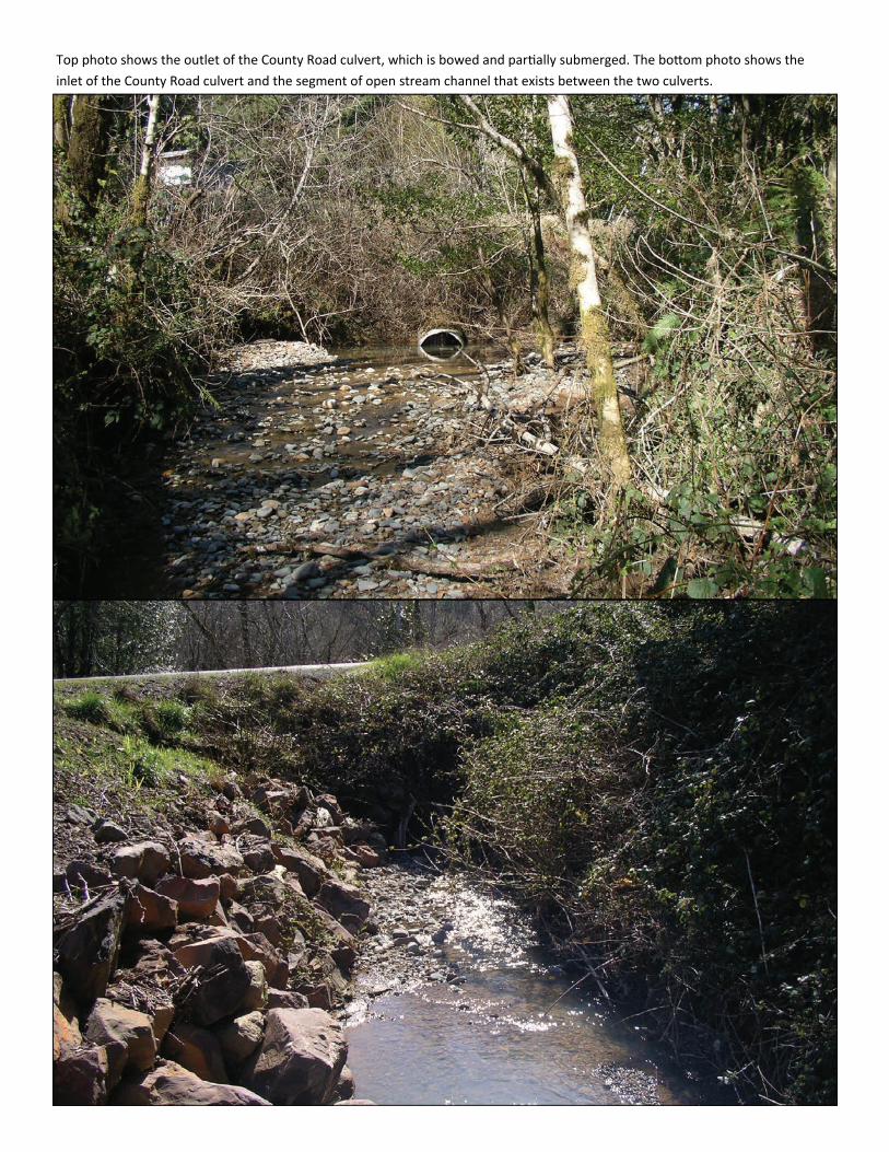
Top photo shows the outlet of the County Road culvert, which is bowed and par ally submerged. The bo om photo shows the
inlet of the County Road culvert and the segment of open stream channel that exists between the two culverts.
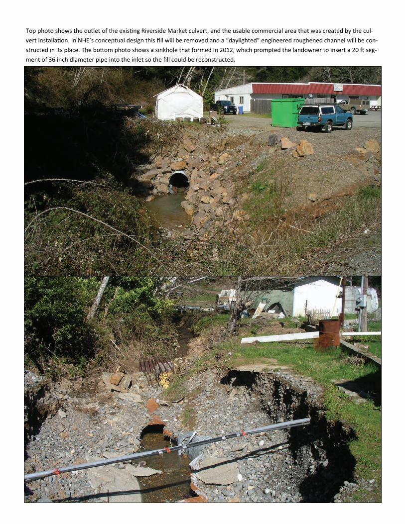
Top photo shows the outlet of the exis ng Riverside Market culvert, and the usable commercial area that was created by the cul‐
vert installa on. In NHE’s conceptual design this fill will be removed and a “daylighted” engineered roughened channel will be con‐
structed in its place. The bo om photo shows a sinkhole that formed in 2012, which prompted the landowner to insert a 20 seg‐
ment of 36 inch diameter pipe into the inlet so the fill could be reconstructed.
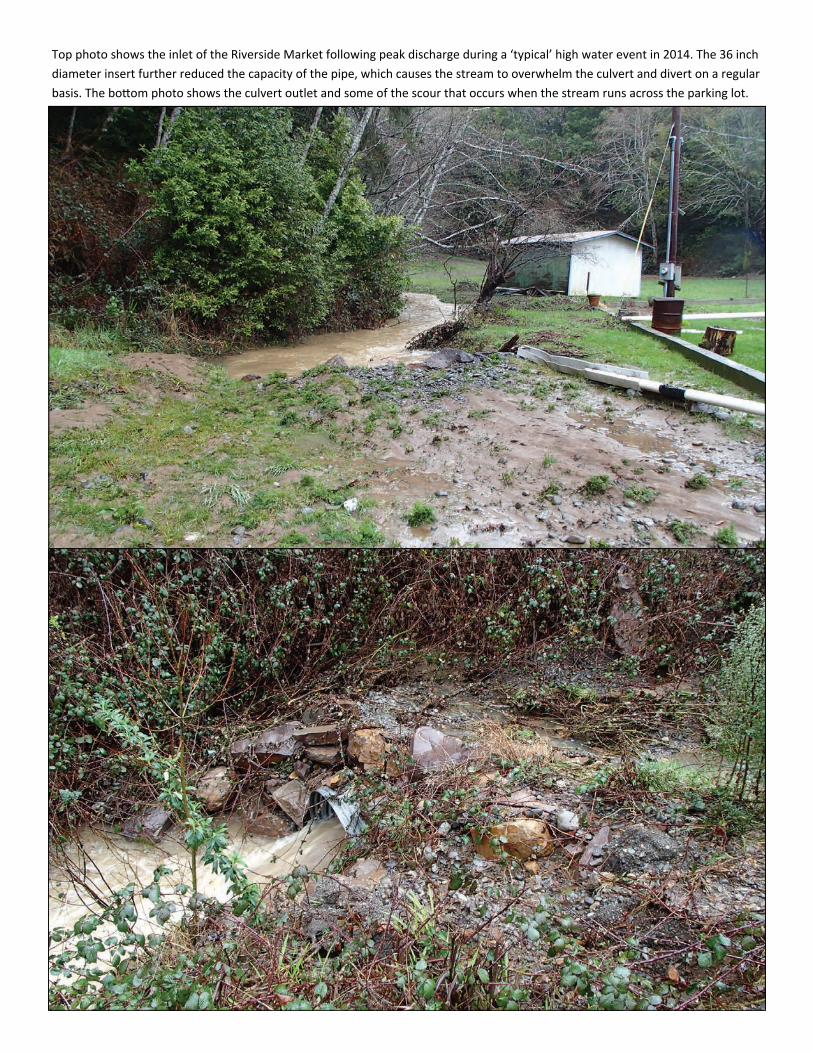
Top photo shows the inlet of the Riverside Market following peak discharge during a ‘typical’ high water event in 2014. The 36 inch
diameter insert further reduced the capacity of the pipe, which causes the stream to overwhelm the culvert and divert on a regular
basis. The bo om photo shows the culvert outlet and some of the scour that occurs when the stream runs across the parking lot.
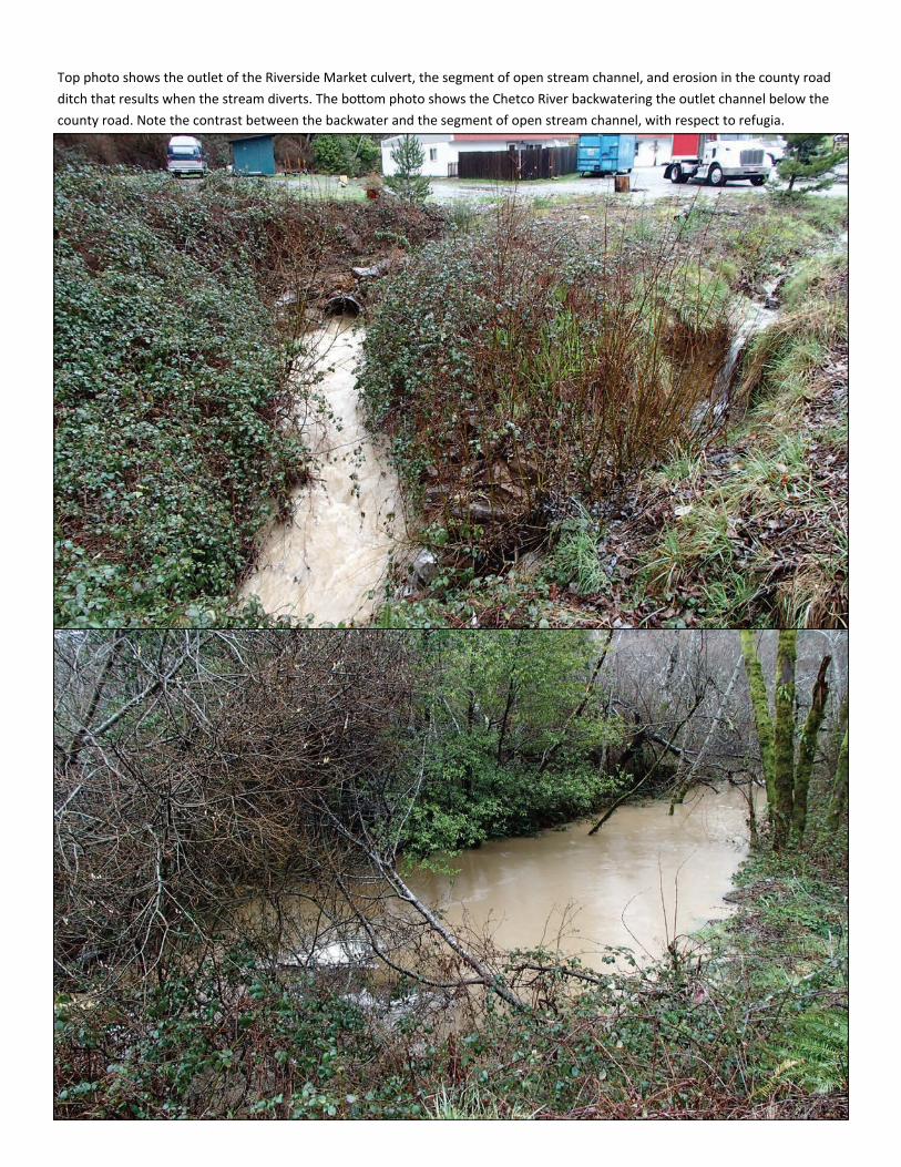
Top photo shows the outlet of the Riverside Market culvert, the segment of open stream channel, and erosion in the county road
ditch that results when the stream diverts. The bo om photo shows the Chetco River backwatering the outlet channel below the
county road. Note the contrast between the backwater and the segment of open stream channel, with respect to refugia.
Northern Hydrology and
Engineering
Engineering - Hydrology - Geomorphology - Water Resources
VICINITY MAP
PROJECT LOCATION
CURRY COUNTY SOIL AND WATER CONSERVATION DISTRICTMARKET CREEK CULVERT PROJECT
CALIFORNIA
WASHINGTON
IDAHO
OREGON
NORTH BANK CHETCO RIVER ROAD
RIVERSIDE MARKET
PLE
ASAN
T H
ILL
DR
IVE
HILL
SLO
PE
ED
GE
OF
RO
AD F
ILL
HILLSLOPE
DITCH
DITCH
SINKHOLE
SINKHOLE
FLOOPLAIN
BLO
CK
WAL
L
BLOCK W
ALL
DITCH C
ULVER
T
OUTLET
NEAR
LY P
LUGGED
SLOPE
=2.7%
NO
RTH
BA
NK
CH
ETC
O R
IVE
RR
OAD
PA
RKI
NG
LO
T
MA
RK
ET
CU
LVE
RT
48" C
OR
RE
GA
TED
ALU
MIN
IZE
D C
ULV
ER
TS
LEE
VE
D W
ITH
A 3
6" P
LAS
TIC
CU
LVE
RT
CO
NN
EC
TIO
N T
YP
E &
LO
CA
TIO
N U
NK
NO
WN
THIS
IS L
OC
ATI
ON
OF
2014
SIN
KH
OLE
4.7%
1.4%
TA
ILO
UT
TO T
AILO
UT
OU
TLE
T IS
BO
WE
D A
ND
BU
RIE
D
0.97
% T
O C
HET
CO
GR
AVEL
BAR
2.6%
FILLSLOPE
FILLSLOPE
FILLSLOPE
FILLSLOPE
TERRACE
TERRACEHIGHER
50 FEET
MARKET CREEK FISH PASSAGE:
THALWEG
BIS, BREAK IN SLOPE
FENCE
GRAVEL
RIPRAP
SPRING/SEEP
EXPLANATION
CULVERT
N
Prepared by Erin Minster, Curry SWCD 10/16/2014Surveyed 3/17/2014 using Nikon Total Station, not survey grade for planning only.
DIT
CH
RE
LIE
F C
ULV
ERTS
OU
TLE
T LO
CA
TIO
N A
PP
RO
XIM
ATE
DIT
CH
PARKING LOT
~162
' LO
NG
~92'
LO
NG
UTILITIES
DAY
LIG
HTE
D C
HAN
NEL
EXISTING CONDITIONS
MAR
KET
CUL
VER
T
CO
UN
TY R
D C
UL V
E RT
48" C
OR
RE
GA
TED
ALU
MIN
I ZED
CU
LVER
TC
OU
NT Y
RO
AD C
ULV
E RT
NORTH BANK CHETCO RIVER ROAD
RIVERSIDE MARKET
PLEA
SAN
T H
ILL
DR
IVE
HILL
SLO
PE
EDG
E O
F R
OAD
FIL
L
HILLSLOPE
DITCH
DITCH
FLOOPLAIN
BLOCK W
ALL
DITCH C
ULVER
T
OUTLET
NEARLY
PLU
GGED
SLOPE
=2.7
%
NO
RTH
BA
NK
CH
ETC
O R
IVE
RR
OA
DPA
RK
ING
LO
T
MA
RK
ET C
ULV
ERT
PR
OP
OS
ED
CO
RR
EG
ATE
D A
RC
H P
IPE
, 100
' LO
NG
BY
112
"x75
". C
ULV
ER
T W
ILL
BE
SE
T A
T 3%
, EM
BE
DD
ED
& S
EE
DE
D W
ITH
STR
EA
M B
ED
S
IMU
LATI
ON
MA
TER
IAL.
0.97
% T
O C
HE
TCO
GR
AV
EL
BA
RFILLSLOPE
FILLSLOPE
FILLSLOPE
FILLSLOPE
TERRACE
TERRACEHIGHER
50 FEET
MARKET CREEK FISH PASSAGE:
THALWEG
BIS, BREAK IN SLOPE
FENCE
GRAVEL
AREA OF EXCAVATION
SPRING/SEEP
EXPLANATION
CULVERT
N
Prepared by Erin Minster, Curry SWCD 10/16/2014Surveyed 3/17/2014 using Nikon Total Station, not survey grade for planning only.
DIT
CH
RE
LIEF
CU
LVER
TSO
UTL
ET
LOC
ATI
ON
APP
RO
XIM
ATE
DIT
CH
PARKING LOT
UTILITIES
EXIS
TIN
G D
AYLI
GH
T
PROPOSED RESTORATION
CO
UN
T Y R
D C
UL V
E RT
INCR
EASE
DAY
LIGH
T AR
EA
CO
UN
TY R
OA
D C
ULV
ERT
PR
OP
OS
ED
CO
RR
EG
ATE
D A
RC
H P
IPE
90'
LO
NG
, 112
"x75
" EM
BE
DD
ED
AN
D S
EE
DE
D
WIT
H S
TRE
AM
BE
D S
IMU
LATI
ON
MAT
ERIA
L.
NE
W D
AY
LIG
HTE
D C
HA
NN
EL
EX
I ST I
NG
CU
LVE
RT
EDGE OF NEW EXCAVATION
PROPOSED CORREGATED ARCH PIPE 100' LONG, 112"x75"
PROPOSED CORREGATED ARCH PIPE 90' LONG, 112"x75"
MAR
KET
CU
LVER
T