Embed Size (px)
Citation preview
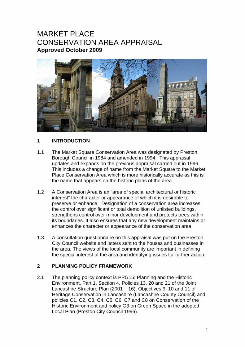
MARKET PLACE CONSERVATION AREA APPRAISAL Approved October 2009
1 INTRODUCTION 1.1 The Market Square Conservation Area was designated by Preston
Borough Council in 1984 and amended in 1994. This appraisal updates and expands on the previous appraisal carried out in 1996. This includes a change of name from the Market Square to the Market Place Conservation Area which is more historically accurate as this is the name that appears on the historic plans of the area.
1.2 A Conservation Area is an “area of special architectural or historic
interest” the character or appearance of which it is desirable to preserve or enhance. Designation of a conservation area increases the control over significant or total demolition of unlisted buildings, strengthens control over minor development and protects trees within its boundaries. It also ensures that any new development maintains or enhances the character or appearance of the conservation area.
1.3 A consultation questionnaire on this appraisal was put on the Preston
City Council website and letters sent to the houses and businesses in the area. The views of the local community are important in defining the special interest of the area and identifying issues for further action.
2 PLANNING POLICY FRAMEWORK 2.1 The planning policy context is PPG15: Planning and the Historic
Environment, Part 1, Section 4, Policies 13, 20 and 21 of the Joint Lancashire Structure Plan (2001 – 16), Objectives 9, 10 and 11 of Heritage Conservation in Lancashire (Lancashire County Council) and policies C1, C2, C3, C4, C5, C6, C7 and C8 on Conservation of the Historic Environment and policy G3 on Green Space in the adopted Local Plan (Preston City Council 1996).
1

3 SUMMARY OF SPECIAL INTEREST
• It marks the location of the historic core of Preston • The site of the major civic buildings of the 19th century and early
20th century – Harris Museum, Sessions House, Town Hall and former Head Post Office
• The largest public open space in Preston city centre which forms the setting for the Cenotaph and restored Market Obelisk
• The location of two of the earliest surviving buildings in Preston 4 ASSESSING SPECIAL INTEREST 4.1 Location and setting 4.1.1 The Market Place Conservation Area is located in the centre of
Preston. It is a roughly rectangular area of land bounded to the north by Lowthian Street/the indoor market, to the east by Lancaster Road, to the south by Fishergate/Church Street and on the west by Cheapside/Friargate. The land slopes from east to west and also from south to north.
Fig 1 Conservation area map as originally designated
2
4.1.2 North Lancashire geologically is clay and shale, with New Red Sandstone and limestone in the Ribble valley.
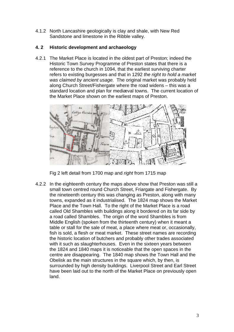
4. 2 Historic development and archaeology 4.2.1 The Market Place is located in the oldest part of Preston; indeed the
Historic Town Survey Programme of Preston states that there is a reference to the church in 1094, that the earliest surviving charter refers to existing burgesses and that in 1292 the right to hold a market was claimed by ancient usage. The original market was probably held along Church Street/Fishergate where the road widens – this was a standard location and plan for mediæval towns. The current location of the Market Place shown on the earliest maps of Preston.
Fig 2 left detail from 1700 map and right from 1715 map 4.2.2 In the eighteenth century the maps above show that Preston was still a
small town centred round Church Street, Friargate and Fishergate. By the nineteenth century this was changing as Preston, along with many towns, expanded as it industrialised. The 1824 map shows the Market Place and the Town Hall. To the right of the Market Place is a road called Old Shambles with buildings along it bordered on its far side by a road called Shambles. The origin of the word Shambles is from Middle English (spoken from the thirteenth century) when it meant a table or stall for the sale of meat, a place where meat or, occasionally, fish is sold, a flesh or meat market. These street names are recording the historic location of butchers and probably other trades associated with it such as slaughterhouses. Even in the sixteen years between the 1824 and 1840 maps it is noticeable that the open spaces in the centre are disappearing. The 1840 map shows the Town Hall and the Obelisk as the main structures in the square which, by then, is surrounded by high density buildings. Liverpool Street and Earl Street have been laid out to the north of the Market Place on previously open land.
3

Fig 3 left detail from 1824 map and right from 1840 map
4.2.3 A painting by Edwin Beattie (below) shows the Market Place in 1844, the view is looking towards Fishergate with Cheapside on the right. The buildings shown on the left were demolished to make way for the Harris Museum. The Obelisk is shown in the foreground and in the centre background is the Georgian Town Hall built in 1760 for the 1762 Guild.
Fig 4 Painting by Edwin Beattie of the Market Place
4

Fig 5 Photograph c. 1862 showing the Fishergate elevation of the Town Hall. On its left is the Guildhall and on its right are the buildings demolished to make way for the Miller Arcade.
4.2.4 In the second half of the nineteenth century a substantial remodelling of the Market Place was carried out. Some buildings were demolished to make way for new ones, the remaining open spaces were developed and roads were widened and altered. As already mentioned the Harris Museum and library (1882–93) was built during this period as was the new Town Hall (1862-7), the covered market (1870-5) and the police station (1857). The Obelisk, shown in Fig 4, was dismantled in 1853 and taken to Hollowforth Hall. It did not return to the Market Place until 1979. Lancaster Road was developed between 1850 and 1860 as were the buildings on the corner with Church Street (Nos 2-4).
4.2.5 The Victorian Town Hall was built between 1862-7 to the designs of Sir George Gilbert Scott (who designed the Albert Memorial and St Pancras Station and hotel amongst others). It was built in the Gothic style, a re-working of mediæval gothic, which was very popular in the second half of the nineteenth century. It caught fire in 1947 and was badly damaged and was finally demolished in 1962. It is recorded in engravings and photographs which show what an outstanding building it was. The site is now occupied by Crystal House.
5

Fig 6 Victorian engraving of the Town Hall which replaced that shown in Fig 5 showing the Market Place elevation. Note Nos. 33 & 34, Cheapside which survive largely unchanged.
Fig 7 The Victorian Town Hall seen from Fishergate – the buildings on the right were demolished for the Miller Arcade so dating the photograph to some time between 1867 and 1899
6

4.2.6 The Harris Museum was built with money left for the purpose by Edmund Harris, a local solicitor, to designs by local architect, James Hibbert, in the Greek revival style. (He also built the West Wing of Preston Royal Infirmary and Fishergate Baptist Church in Preston and Treales CE Primary School.)
Fig 8 View of the Harris Museum from Friargate before the buildings on the left hand side were demolished, compare with Fig 19
4.2.8 The police station was built in 1857 by J H Park (he also designed the old HSBC bank at 39-40, Fishergate) along Earl Street to the corner of Lancaster Road. It was enlarged in 1901 in a similar style and was in use as a magistrate’s court until some 15 years ago when the new court opened.
7

Fig 9 Top engraving from 1914 from the corner of Earl Street and Birley Street showing the rear of the police station on the left-hand side and bottom photo from 1965 showing the police station on the right-hand side (the building on the corner of Earl Street and Lancaster Road was built later in 1901)
4.2.9 The covered market was built in 1870, twice, as it collapsed during construction and had to be built again. The development of market halls is a feature of the large, industrialised towns of the North-West and Midlands and was the result of a desire to clean-up the traditional open air markets which often were the centre of other activities such as bull-baiting, cock-fighting etc. Usually they were located away from the old market place in as central a location as possible and they were enclosed. Preston was one of the few towns to build an open-sided structure – others were at Manchester, Stockport, Warrington and Darlington (some of these are now enclosed).
4.2.10 The buildings to the right of the new town hall on Fishergate were
demolished to make way for the Miller Arcade which has a date stone of 1899 above the south door. Birley Street and Jacson Street were
8

laid out and Lancaster Road finally connected to Church Street. Architects’ drawings dated 1893 for the Arcade show that it was planned to have warehouses, show rooms, the “stokery” for the Turkish Baths and the hotel restaurant and tea room in the basement (there was also a sub-basement for the hotel services; beer and wine cellars, bakehouse, coal store etc), on the ground floor there were shops and the entrances for the hotel and the Turkish Baths – the sign for the baths is still there on the eastern side. On the first floor approximately half was offices and the other half was divided between public rooms of the hotel such as the billiard room and coffee room and the Turkish Baths. The hotel bedrooms occupy half the second floor – just one bathroom and four WCs are shown for twelve bedrooms – and the other half of the building is shown as offices. On the third floor was a kitchen, scullery, larder, pantry and three servants bedrooms almost certainly associated with the hotel and the remaining floor space is marked “to be appropriated” i.e. there was as yet no use allocated. The plans were drawn up by a firm called Essex, Nicol and Goodman who were based in Birmingham and were a leading partnership in the use of terracotta decoration there. There is also a drawing of the Miller Arcade which shows considerable differences with the building as built, compare Fig 10 with Fig 11.
Fig 10 Miller Arcade – drawing showing the Church Street and Birley Road elevations – a fourth floor is shown on both these elevations, turrets are shown on three of the corners, and a raised central block above the entrances on these elevations. It is a matter of speculation as to whether the other two elevations on Lancaster Road and Jacson Street were to have been treated in the same way
9

Fig 11 Photo of the Miller Arcade as built showing the Church Street elevation – note the spire of the Gothic Town Hall on the left
Fig 12 The Miller Arcade today (2008) largely unchanged apart from the removal of the turrets and chimneys.
10

Fig 13 Left detail from 1892 map and right detail from 1911-2 map
Fig 14 Overlay showing the 1892 layout in red and the 1911 layout in
black 4.2.12 This remodelling continued into the early twentieth century when the
buildings to the north of the Market Place were demolished and the northern side of Friargate was remodelled (see Fig 8). The Sessions House was built between 1900 and 1903 to the designs of Henry Littler, County Architect, who also designed the county asylum and chapel at Whittingham amongst others. The demolished buildings on the west of the Market Place were replaced with the Post Office (1901-3) and the Fish Market. The monument shown in front of the Post Office was then the Boer War Memorial which was moved to Avenham Park when it was replaced with the Cenotaph in 1926. This memorial was designed by Sir Giles Gilbert Scott, the grandson of Sir George Gilbert Scott who had designed the Town Hall. At some point between 1912 and 1931 the drinking fountain, shown on the 1892 map (and
11

probably on some of the earlier maps), in the top left hand corner of the Market Place disappeared.
Fig 15 Photo dated 1926 showing the unveiling of the Cenotaph
Fig 16 Detail from 1931-2 map
12

4.2.13 The Town Hall, originally called the Municipal Buildings, was built in 1933-4 to the designs of Sir Arnold Thornley who had also designed the Northern Ireland parliament building at Stormont and the Port of Liverpool building (with Briggs and Wolstenholme).
Fig 17 Photo c. 1931 showing the excavations for the Municipal Buildings, note the Post Office in the background
4.2.14 The final changes were the demolition of the Town Hall in 1962 and its
replacement by Crystal House (1960s) and the return of the Obelisk to the Market Place in 1979. Adjacent to the conservation area major developments were the demolition of the buildings along Liverpool Street and their replacement with the indoor market (1973) which effectively obliterated Liverpool Street, the building of Lowthian House and the building of the Guildhall in 1972.
13

4.3 Spatial analysis In common with most conservation areas the Market Place conservation area has views into, within and out of it. One of the most important views out is the view down Friargate to the spire of St Walburge’s church and one of the most important views in is the view up Friargate towards the Harris Museum. These views are particularly important as they are Preston’s only Grade I buildings within the city centre.
Fig 18 Views out – on the left view out to Church Street and on the right to the Guildhall in Lancaster Road
Fig 19 on the left view out down Friargate with the spire of St Walburge’s in the distance and on the right view in looking up Friargate towards the Harris Museum (compare with Fig 8)
14
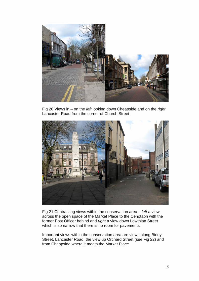
Fig 20 Views in – on the left looking down Cheapside and on the right Lancaster Road from the corner of Church Street
Fig 21 Contrasting views within the conservation area – left a view across the open space of the Market Place to the Cenotaph with the former Post Officer behind and right a view down Lowthian Street which is so narrow that there is no room for pavements Important views within the conservation area are views along Birley Street, Lancaster Road, the view up Orchard Street (see Fig 22) and from Cheapside where it meets the Market Place
15

Fig 22 View of the covered market from the top of Orchard Street
4.4 Character analysis 4.4.1 The character of the conservation area derives from the combination of
prestigious civic buildings, open spaces and small shops, cafés and pubs.
4.4.2 The civic buildings were often designed by nationally or regionally important architects – the exception to this is the Harris Museum which was designed by a local architect James Hibbert. These civic buildings are predominantly built of sandstone ashlar (Amounderness House is brick at the rear).
Fig 23 The pediment of the Harris Museum
16

Fig 24 Lancaster Road showing the front of Amounderness House and the Town Hall It is interesting to note that although the Town Hall, Amounderness House and its extension were built at differing times they have all been built in a similar style and materials so that they form a harmonious whole.
Fig 25 The Sessions House seen from the Market Place
17

All these buildings were built in a loose classical style ranging from the Greek Revival of the Harris to the Edwardian Baroque of the Sessions House. This means that they have common, unifying features such as pediments, concealed roofs, columns and large window openings.
4.4.3 The shops in Lancaster Road were mainly built of brick with sandstone
dressings. Many of them were stuccoed to give the appearance of being built of stone and some had an ashlar facade.
Fig 25 Buildings along Lancaster Road – in the foreground are red brick buildings with some stone and in the centre are Nos. 10 – 24 (mainly ashlar facades)
Fig 26 Stucco on some of the facades of Nos. 50 – 60, Lancaster Road
18

Some of the commercial buildings built late 19th/early 20th century show influences from the Arts and Crafts movement and others make use of terracotta.
Fig 27 Clockwise from top left; the Black Horse seen from the corner of Orchard Street and Friargate, the main entrance, lettering above the door and the porch supported by caryatids
Fig 28 left detail over the window of Fred Riding & Sons in Market Street and right detail above the Farmers Arms Hotel
19

Fig 29 top left the Miller Arcade entrance from Church Street, top right the interior and above detail of some of the terracotta decoration Again, although the commercial buildings were built at varying times the use of similar materials such as brick, sandstone and terracotta, similar scale and horizontal emphasis of the buildings gives a unifying effect.
4.4.4 The Market Place is the largest public open space in the centre of Preston and, as such, is a focus for civic and commemorative events. It is the natural focus for national and local significant events such as the visit of King George VI and Queen Elizabeth in 1938, the visit of
20

Winston Churchill and the Victory Parade in 1945, Preston North End’s promotion to the Championship in 2000 and fairs and guilds.
Fig 30 Market Place seen from the roof of the Miller Arcade
Fig 31 Armistice Day circa 1937
21

4.5 The contribution made to the character of the area by green space and its biodiversity value
4.5.1 As this is a conservation area at the heart of Preston there is no open green space. However, there are many trees mainly around the Market Place but also in Cheapside, Market Street, Harris Street and Lancaster Road. The trees in the between the Harris Museum in the Market Place and Cheapside are plane trees with just one of an unknown species. Around the Cenotaph and the Sessions House they are predominantly plane with some alders. Along Harris Street the trees are all birch and along Market Street there are two planes and one alder. At the top of Cheapside near its junction with Fishergate are six field maples. Trees in streets play a vital part in making urban areas more pleasant places to live. They perform a number of functions; acting as pollution sinks, reducing noise, creating shade and softening the built environment. Current factors affecting street trees are from conflicting pressures for land use, lack of management and pressures to remove trees on the grounds of public liability.
Fig 32 left trees along Market Street and right trees framing the Harris Museum 4.6 The extent of intrusion or damage (negative factors) 4.6.1 Redevelopment of parts of the conservation area during the latter half
of the twentieth century have been particularly damaging as new buildings have often failed to respect their surroundings in terms of height, materials, detailing etc. Much of this occurred in the 1960s and 1970s before the conservation area was designated in 1984. Crystal House, which replaced the Town Hall is a medium-rise building which is much higher than its surroundings and of a mundane design. Although recent works have improved its appearance it is still out of keeping in its location.
22

Fig 33 Crystal House competing with the Harris Museum on the skyline Some of the shops along Cheapside, Friargate and Orchard Street are either modern buildings which do not respect the neighbouring buildings or older buildings with modern shop fronts which neither respect the character of the building nor that of the wider conservation area.
Fig 34 Wilkinson’s building next to the Black Horse Hotel (listed Grade II) is built from different materials and in a different style but is of the same height
23

Fig 35 Clockwise from top left; 20th century shops on the corner of Friargate and Cheapside built using different materials and detailing, 20th century shops on Orchard Street one of which uses different materials and both have a different type of window, and on the bottom row two shops whose shop fronts fail to respect the character of the rest of the building
4.6.2 Developments outside the conservation area have also had an adverse
impact on the character and appearance of the conservation area but again many of these occurred before its designation. The replacement of the traditional buildings along Liverpool Street and, in particular, moving the building line forward has made what was previously a wide roadway between buildings into a narrow, gloomy, enclosed space.
24

Fig 36 On the left the remnants of Liverpool Street and on the right the road before redevelopment. Note how the new buildings are much closer to the Grade II listed covered market and how this has altered the nature of the space between them The indoor market building does not relate to its surroundings in either style or materials and at its lower end sits even closer to the covered market than the buildings at the top next to Lancastria House (see Fig 36). More importantly the steps from the first floor of the indoor market intrude into the internal space of the covered market disrupting both the layout of the stalls and the flow of pedestrians. The landing at first floor level creates a dark, uninviting entrance to the shops and the lower floor of the market. It is also very narrow and combined with the outdoor displays of the shops it is very congested at peak times. At the bottom of the covered market is Market Street; at its junction with Lowthian Street is Lowthian House. The central part of this building is much higher than anything around it and does not relate in materials or detailing either to its surroundings.
25
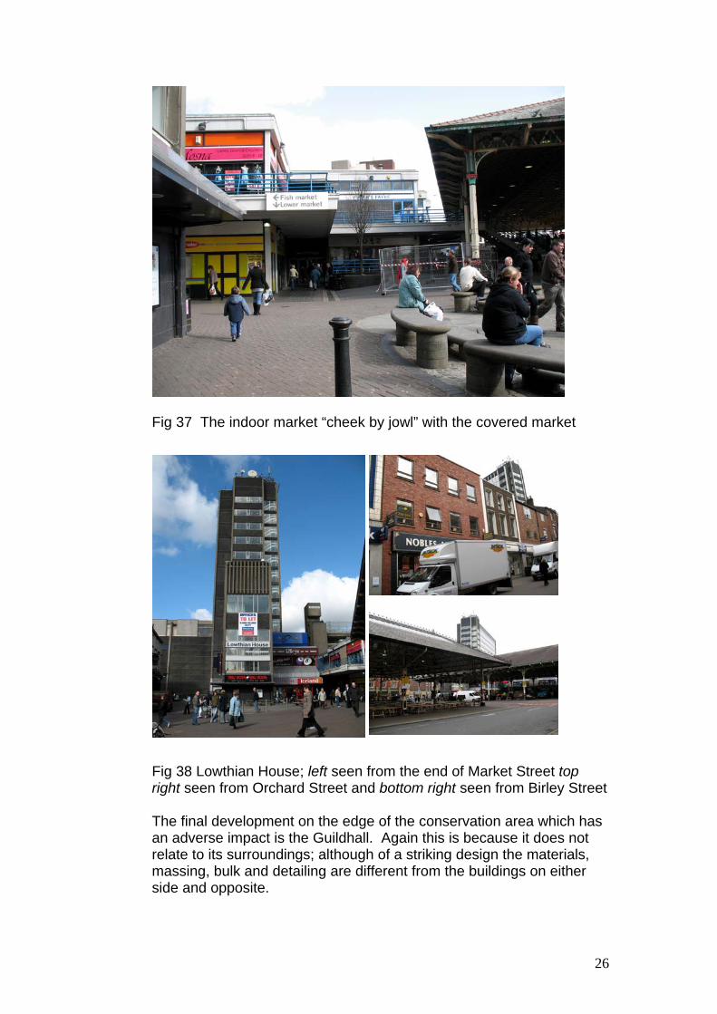
Fig 37 The indoor market “cheek by jowl” with the covered market Fig 38 Lowthian House; left seen from the end of Market Street top right seen from Orchard Street and bottom right seen from Birley Street
The final development on the edge of the conservation area which has an adverse impact is the Guildhall. Again this is because it does not relate to its surroundings; although of a striking design the materials, massing, bulk and detailing are different from the buildings on either side and opposite.
26

Fig 39 The Guildhall in the street scene
All the buildings identified as being negative factors either within or outside the conservation area represent opportunities to enhance the area if the occasion arises i.e. if there are redevelopment proposals.
4.6.3 Traffic along Cheapside cuts if off from the rest of the Market Place – the one-way scheme means that traffic is routed along here. Lancaster Road and Jacson Street are on bus routes and at certain times congestion makes it difficult to cross the road. It also makes it difficult to leave the Miller Arcade from the Jacson Street exit and cross to the Market Place and the Harris Museum.
4.7 Summary 4.7.1 Most of the buildings in the conservation area are in a good condition
overall and make a positive contribution to the character of the conservation area. A plan showing an assessment of the properties and their conribution to the character of the conservation area is attached at Appendix A.
4.7.2 However there are some underlying problems that are affecting a
number of properties. These include: Poor quality shopfronts Vacant upper floors Inappropriate repairs/alterations A lack of regular maintenance
4.7.3 A combination of these factors means that there are a number of key
listed buildings that could be described as being “at risk”. This includes:
Amounderness House, The Golden Cross Hotel, 60 Lancaster Road, Former TSB Bank, 14-15, Church Street The Former Post Office The Miller Arcade
Other groups of buildings are under-used with only the ground floors being used. This group includes many of the buildings on the east side of Lancaster Road and buildings on the west side of Market Street.
27

5 PROBLEMS, PRESSURES AND THE CAPACITY FOR CHANGE 5.1 A number of buildings are vacant or under-used because of the
uncertainty over the redevelopment of the Tithebarn area. 5.2 Capacity for change is limited as the area is densely developed
already. However, if the redevelopment of any of the buildings identified as being negative factors (4.6) is proposed this would be an opportunity to enhance the conservation area.
6 COMMUNITY INVOLVEMENT 6.1 A summary and evaluation of the responses received from the
consulation on this appraisal will be included within the final version of the appraisal. It will also set out how the views of the local community have been incorporated into defining the special interest of the area and the recommendations for its future preservation and enhancement.
7 SUGGESTED BOUNDARY CHANGES 7.1 The conservation area appraisal has identified the need to change the
existing boundary to include both sides of Cheapside and Friargate. This is because any development here inevitably affects the setting of the existing conservation area and also because Nos 33 & 34, Cheapside date to the late 16th/early 17th century.
7.2 The suggested boundary changes are shown in the plan below.
Fig. 40 Proposed New Boundary for Market Place Conservation Area
28

8 SUMMARY OF KEY ISSUES 8.1 Consideration should be given to prohibiting all traffic, apart from
delivery vehicles, from entering Cheapside during the day. 8.2 Consideration should be given to moving the current bus stop from
Jacson Street to enable the Miller Arcade to be fully integrated with Market Place.
8.3 Vacant and under-used buildings should be brought back into use. 8.4 There is a need to ensure that the conservation area is integrated with
the Tithebarn redevelopment. 9 REFERENCES
Published material Kathryn A Morrison, English Shops and Shopping, Paul Mellon Centre for Studies in British Art in association with English Heritage (2003)
10 GLOSSARY OF TERMS
Article 4 Direction - certain types of development can be carried out without the need for planning permission (known as permitted development) and covers a wide range of minor developments by householders, farmers, foresters and statutory undertakers (public bodies, such as gas and electricity providers, water boards etc). However, in some circumstances authorities may wish to prevent people from exercising these rights in order to retain control on the way in which the development is carried out. This is done by means of a direction under Article 4 of the Town and Country Planning (General Permitted Development) Order 1995 Order. Article 4 directions are sometimes made to cover parts of a conservation area where there is a clear and immediate threat to the amenity of the area.
Ashlar – blocks of stone which have smooth surfaces and straight edges and laid in a continuous horizontal line.
Burgesses - The plural for ordinary citizens of a borough (sing. burgess). Only a freeman could be a burgess so dependants, servants etc did not count. Freemen might not be wealthy. Later it came to mean an elected or un-elected official of a municipality, or the representative of a borough in the English House of Commons.
Caryatid – a sculpture of a female figure used instead of a column to support a structure.
29

Dressings – stone which has a worked surface which may be either smooth or moulded to a particular shape and used round a window, doorway, a corner or other feature.
Gothic style – a style of architecture with pointed arches (windows, doors and internal openings), buttresses and vaulted ceilings most often seen in mediæval churches. The style was popular with Victorians and again largely used for churches but also used for civic buildings such as town halls, prisons and also for country houses.
Greek revival style – architecture which is based on the simplest type of construction where vertical uprights such as columns or posts support horizontal beams or lintels. This style came later to Europe than classical Roman architecture and was fashionable in England from about the 1780s to 1830s.
Pediment – the triangular upper part above the columns at the Harris Museum
Stucco – a type of plaster often used as an external render and for architectural features in place of stone.
30

Appendices
31

Appendix A
Plan Showing Contribution of Buildings to Character of Conservation Area
32

Appendix B
Description of Listed Buildings Within Conservation Area
33

SD5329NE FRIARGATE 941-1/9/137 (North side) 31/12/87 No.166 The Black Horse Hotel II Hotel, now public house. 1898, by J.A.Seward of Preston for the Atlas Brewery Company of Manchester. Red brick with sandstone dressings and slate roofs. Corner block with rear wing. Three storeys with 3 windows to Friargate, 3-light canted corner and wide single-bay return to Orchard Street; with stone plinth, sill-bands and head-bands to all floors, cornice and high stepped parapet, all carried round. The Friargate facade has a central elliptical-headed doorway with moulded stone surround, panelled door, 2-light overlight, and very large brackets carrying a balustraded balcony above; the Orchard Street facade has a tripartite central doorway with side windows, square overlights, and prominent cornice with segmental pediment on the centre; the corner oriel has a carved apron wrapped round, the centre with raised lettering "BLACK HORSE HOTEL". All the windows are sashed without glazing bars and those at ground floor have stained glass. Modern painted inn sign bracketed over front door. INTERIOR: almost unaltered from original form and appearance, including a central bar which is partly semi-circular in elaborate tilework, partly panelled with glazed screens above; tiled dado; ribbed plaster ceiling; much original joinery and coloured glass; copper door furniture; and some alterations eg seating of 1929. Good and remarkably unaltered interior of the period, and one of only 2 remaining from Atlas Brewery Company. Listing NGR:
SD5429SW LANCASTER ROAD 941-1/12/169 (East side) 27/09/79 Nos.16 AND 18 GV II Post office, now 2 shops with offices over. 1854; altered. Painted ashlar facade to brick carcase, slate roof. Narrow rectangular plan at right-angles to street. Classical style. A pedimented 3-storey 3-bay facade (plus concealed attic), with modillioned cornice to ground floor, giant Composite pilastrade to upper floors, moulded frieze, emphatic modillioned cornice, and moulded pediment. The ground floor has 2 altered shop fronts with elaborate coupled consoles rising from the fascia to the cornice; the upper floors have a string-course to each bay, windows with altered glazing at 1st floor and 4-pane sashes above. Corniced side-chimneys; skylights. History: post office 1854-70. Forms part of block including Nos 10, 12 and 14 to the right (to which it appears as a wing), and Nos 20 and 22, and No.24 to left (q.v.). Listing NGR: SD5411929414
34

SD5385529512 SD5429SW CHURCH STREET 941-1/12/69 (North side) 27/09/79 No.11 GV II Includes: Nos.2 AND 4 LANCASTER ROAD. Shops with dwellings over. c.1850-60, altered. Red brick in Flemish bond, with sandstone dressings (roof concealed but probably slate). Rectangular plan on corner site. Mostly 3 storeys, but Nos 2 and 4 Lancaster Road 4 storeys to same height; a symmetrical 3-window facade to Church Street, with moulded cornice and parapet carried round. Ground floor occupied by C19 shop front (carried round), with deep fascia carrying simple railings, and scrolled wrought-iron cresting to the corner, a deep band over this; tall 15-pane sashed windows at 1st floor, that in the centre with moulded architrave and cornice, shorter sashes at 2nd floor with glazing bars only in the upper leaves. Hipped roof. Left return to Lancaster Road has 2 similar windows on each floor, also with flat-arched heads; and Nos 2 and 4 Lancaster Road have C20 shops at ground floor, 3 sashed windows at 1st and 2nd floors and 2 smaller sashes at 3rd floor, all with flat-arched heads. INTERIORS not inspected. Forms group with Red Lion and Ellesmere Chambers (q.v.). Listing NGR: SD5413029376
SD5429SW CHURCH STREET 941-1/12/70 (North side) 27/09/79 No.13 Red Lion Hotel and Ellesmere Chambers GV II Hotel and offices. c.1809, remodelled in later C19. Red brick in Flemish bond (now painted white), with sandstone dressings (now painted red) and slate roof. Double-depth front block incorporating a carriage entry to the left, with a long rear wing. Three storeys and 3 bays, the centre breaking forwards slightly; with 1st-floor sill-band carried across, interrupted 2nd-floor sill-band, plain frieze and moulded cornice with parapet including shallow triangular upstand over centre. The ground floor has 3 Ionic pilasters framing the centre and right-hand bays, a pilastered central doorway with panelled door, plain fanlight, and broken pediment above, and similar pediments over a wide rectangular carriage entry to the left and a similar opening to the right with large double doors (to Ellesmere Chambers); above ground floor the centre has 3 tiers of raised panels (vertical, horizontal, and vertical with corniced architrave), the lowest with a red lion rampant on a moulded stage; the outer bays have windows with plain reveals, mostly sashed without glazing bars (and the left at 1st floor altered as a top-hung casement). INTERIOR not inspected. History: in C19, was meeting place of Liberal parties, especially at election times, confronting Tory Bull Hotel opposite. Listing NGR: SD5413229404
35

SD5429SW CHURCH STREET 941-1/12/71 (North side) 27/09/79 Nos.14 AND 15 Trustee Savings Bank GV II Bank. Dated 1905 on plinth; for Preston Savings Bank. Sandstone ashlar on plinth of polished pink granite (roof concealed but probably slate). Long rectangular block with front range parallel to street. Baroque style. Two storeys and 1:4:1 bays, symmetrical; ground floor treated as rustic and 1st floor as piano nobile, with moulded plinth, modillioned cornice and balustraded parapet. The 4-bay centre has channelled rusticated piers and large cross-windows at ground floor, blocked pairs of Ionic columns at 1st floor and large round-headed 2-light casement windows with glazing bars, fanlights with radiating glazing bars, keyed architraves, and small balustraded segmental balconies. The central pier of the ground floor has marks of former attached lettering "PRESTON SAVINGS BANK", and a foundation stone in the plinth with inscription recording that it was laid by W.P.Park, Chairman of the Trustees, in October 1905. The end bays break forwards slightly and have channelled rustication to both floors; each has a round-headed doorway at ground floor with rusticated voussoirs and carved keystone, and a doorcase composed of granite blocked Tuscan columns with sandstone entablature and open-segmental pediment, decorated wrought-iron gates and fanlights (the latter mostly concealed by modern signs), at 1st floor a 12-pane sashed window with triple-keystone, pedimented architrave and small balustraded balcony, and at parapet level a segmental pediment containing a cartouche with swags. INTERIOR: banking hall has richly decorated coffered ceiling with egg-and-dart frieze, foliated modillions, massive beams on foliated consoles, and geometrical-patterned moulded plaster decoration in the panels. Listing NGR: SD5413229404
SD5429SW LANCASTER ROAD 941-1/12/168 (East side) 27/09/79 Nos.10, 12 AND 14 GV II Shops with offices over. c.1854; altered. Painted ashlar facade to brick carcase, slate roof. Rectangular plan. Classical style. Three storeys and attic, 5 bays, with modillioned cornice to ground floor, giant Composite pilastrade to upper floors, moulded frieze, emphatic modillioned cornice and plain parapet. The ground floor has square piers with elaborate coupled consoles to the cornice above, coupled doorways to the left under a keyed segmental arch, a single doorway to the right with a set-in moulded architrave under a lintel with anthemion crest, and an inserted doorway in the centre flanked by altered windows; the upper floors have diminishing sashed windows without glazing bars, those at 1st floor with moulded architraves, all recessed and clasped between small square fillets treated as pilasters with acanthus caps. Attic skylight in roof. INTERIOR: at right-hand end, an open well staircase in C18 style, with open string, scrolled brackets, stout turned balusters and moulded handrail, moulded plaster cornices (acanthus etc); doorway at 1st floor with
36

large open-pedimented architrave, opening into full-width hall. Forms part of block with Nos 16 and 18, Nos 20 and 22, and No.24 to left (q.v.). Listing NGR: SD5412229397
SD5429SW LANCASTER ROAD 941-1/12/170 (East side) 27/09/79 Nos.20 AND 22 (Formerly Listed as:LANCASTER ROAD Nos.20 AND 22, 24 Stanley Arms Public House (no.24)) GV II Commercial building, probably shops with dwellings over. Probably mid 1850s; altered. Painted brick with stucco ornament, slate roof. Rectangular plan incorporating carriage entry at left end. Classical style. Three storeys plus attic, 3 bays, the 1st narrower (over the carriage entry), the centre breaking forwards slightly, with giant coupled pilasters to this and pilaster fillets to the outer bays, moulded frieze, and emphatic modillioned cornice with blocking course. The ground floor has C20 shop fronts; the upper floors have windows with moulded architraves, that in the centre at 1st floor with a pediment on consoles (but altered glazing) and that to the left a 4-pane sash with a plain cornice (that to the right now altered), and those at 2nd floor with shouldered architraves, the centre and left with 4-pane sashes but the other altered. Two glazed dormer windows in roof; corniced chimneys. INTERIOR not inspected. Forms part of block including Nos 10,12 & 14, and Nos 16 and 18 to right, and No.24 (The Stanley Arms) to left. Listing NGR: SD5411329416
SD5429SW LANCASTER ROAD 941-1/12/171 (East side) 27/09/79 No.24 The Stanley Arms Hotel (Formerly Listed as:LANCASTER ROAD Nos.20 AND 22, 24 Stanley Arms Public House) GV II Hotel, now public house. Probably late 1850s; altered. Painted stucco facade to brick carcase, slate roof. Square plan. Classical style. Three storeys over cellar, a pedimented 3-bay symmetrical facade, with rusticated ground floor under prominent cornice, 2 pairs of giant Tuscan pilasters (framing the outer windows) with a short string-course in each pair, a band with raised lettering "STANLEY ARMS HOTEL", triglyph frieze and pediment with guttae and moulded surround. The ground floor has a doorway with panelled surround rising to 2 pairs of consoles to the cornice, and square tripartite windows which have sashed centre lights; the central window at 1st floor has a pediment on consoles, that above has a shouldered architrave, and all these
37

windows are sashed without glazing bars (except that in the centre at 1st floor which has altered glazing). Forms part of group with Nos. 20 and 22 to the right, and Nos. 16 and 18, and Nos. 10-14 further to the right. Listing NGR: SD5411029438
SD5429NW LANCASTER ROAD 941-1/10/172 (East side) 22/01/90 Nos.50-58 (Even) Princes Buildings II Terrace of 5 shops with dwellings over (Nos. 50 and 52 now in one, and No.56 subdivided to make 2 shops). c.1860, altered. Brown brick in stretcher bond, mostly stuccoed, with sandstone dressings and slate roof. Shallow double-depth plan with back extensions. Classical style. Three storeys with cellars and attics; 1+3+1+3+3 bays (in a composition which implies an originally symmetrical design centred on No.56 but not fully executed), with giant pilastrading to the upper floors of the 3-bay units, a deep frieze and prominent dentilled cornice with blocking course which break back slightly over the 1-bay units. At ground floor Nos.50 to 56 have double-fronted shops with recessed doorways flanked by plate-glass windows with shafts which have stiff-leaf caps, and large segmental overlights (those at Nos.50 to 54 now covered externally by modern fascia boarding; and the shop front of No.58 remodelled). At 1st and 2nd floors the 6 bays of Nos.50 and 52 and the 3 bays of No.56, breaking forwards slightly and stuccoed, have giant pilasters, interrupted string courses, and 4-pane sashed windows (these features carried round the right-hand return of No.50); Nos.54 and 58, each of one wide bay, have tripartite sashed windows on both floors, those at 1st floor with pedimented tetrastyle architraves which have large foliated consoles, and those above with shouldered stucco surrounds. Nos 50 and 58 have small gableted dormers, Nos.52 to 56 have low flat-roofed 12-light dormers; all have large multiple-flue chimney stacks with moulded stone cornices. The right-hand return wall of No.50, five bays, the upper floors matching the front, has in the centre of the ground floor a doorway with banded surround, panelled door with small dentilled upstand on the lintel, and square overlight with diagonal glazing bars; to right of this, a cornice with consoles beneath the pilasters of the upper floors (suggesting that front formerly had similar feature). Rear: 2-storey extensions, mostly of shallow lean-to form; apparently unaltered windows, mostly 12-pane sashes with crown glass panes. INTERIOR: No.56 has a dog-legged staircase from ground floor to attic, with stick balusters and wreathed handrail; on the upper floors almost intact domestic accommodation including 1st-floor drawing room (now showroom) which has pilasters with entablature, deep moulded plaster ceiling cornice, and elliptical-arched alcove with moulded surround; room above this with similar alcove containing built-in cupboard, and fireplace with panelled surround; various other original fireplaces. Upper floors of other shops retain
38

similar features in whole or part. With No.60 (Golden Cross Hotel) attached at north end, forms block having strong group value with Town Hall (q.v.) and Amounderness House (q.v.) opposite, and visual similarity to Nos.12 to 24 to the south. Listing NGR: SD5408329520
SD5429NW LANCASTER ROAD 941-1/10/173 (East side) 22/01/90 No.60 Golden Cross Hotel GV II Public house. c.1860; altered. Brown brick, part stuccoed, with sandstone dressings and slate roof. Double-depth plan with rear wing. Classical style. Three storeys with cellars and attic, 3 bays, symmetrical; pilasters and banded rustication at ground floor (which also has a cornice), rusticated quoins to the upper floors, frieze with triglyphs and guttae, prominent cornice with mutules, blocking course. The ground floor has a central doorway, narrow vertical-rectangular windows next to this and wider windows beyond these, all these windows with panelled aprons and all framed by broad pilasters terminating in large foliated consoles which carry a cornice. The 1st floor has 2-light casement windows, those in the outer bays with pedimented architraves and that in the centre with a simple moulded surround and straight cornice; the 2nd floor has sashed windows without glazing bars, all with shouldered surrounds but those in the outer bays with small decorated crests, and a plain band above with raised lettering GOLDEN CROSS HOTEL. Gable chimneys. The left return wall has 2 doorways with raised plain surrounds and small cornices (the further one blocked), 2 sashes between these with arched glazing and stained glass spandrels, two 12-pane sashes on each floor above (that on the left at 1st floor with altered glazing in the lower leaf), and 2 narrow 4-pane sashes at attic level. Short wing continuing to rear has altered windows and mono-pitch roof. Rear: sashed windows with 12 and 4 panes at ground floor, 12 and 12 at 1st floor, 4 and 4 at 2nd floor. INTERIOR altered at ground floor; otherwise not inspected. Item is north end of block otherwise comprised of Nos.50 to 58 (q.v.), having strong group value with Town Hall (q.v.) and Amounderness House (q.v.) opposite, and visual similarity to Nos.12 to 24 to the south (q.v.). Listing NGR: SD5407229558
39

SD5429NW LANCASTER ROAD 941-1/10/174 (West side) 27/09/79 Amounderness House (Formerly Listed as: LANCASTER ROAD (West side) Junior Crown Court) GV II Police station and magistrates' court, now used as courtrooms.1857, enlarged 1901. By J.H.Park. Sandstone ashlar (red brick at rear), slate roofs. U-plan, formed by original block with rear wing to Earl Street, and addition on south side also with rear wing. Classical style. Two storeys (probably over cellars), plus 3-stage tower to the addition. The original range is a symmetrical 5-window composition, with a plinth, channelled rusticated ground floor, rusticated quoins to 1st floor, frieze inscribed "ERECTED BY THE CORPORATION A.D.1857 LAWRENCE SPENCER ESQUIRE MAYOR", prominent modillioned cornice and balustraded parapet with ball finials. The centre has a round-headed doorway with an architrave of coupled engaged Tuscan columns and prominent cornice, above this a window with pairs of panelled pilasters and consoles supporting a pediment with lamb and flag, and a round-headed upstand in the parapet with a shield. All the windows are sashed without glazing bars, those at 1st floor paired under cornices on consoles. The 2-window right-hand return is in matching style. The wing continued to the rear is of heavily rusticated rock-faced masonry, 5 windows, mostly round-headed and those at ground floor barred, but the end bay has a square headed doorway and window above both with cornices; and beyond this is a lower 2-storey 5-window cell-block with small semicircular windows at ground floor and round-headed windows above, all with grilles. The 1901 addition fronting Lancaster Road is in similar style, but longer, articulated 3:2:1:2 windows, the square tower rising one stage higher, with a prominent cornice and balustraded parapet, and openings at ground and 1st floors framed by coupled blocked columns. INTERIOR not inspected. Listing NGR: SD5403629564
40

SD5429SW LANCASTER ROAD 941-1/12/176 (West side) 27/09/79 Sessions House (Formerly Listed as: LANCASTER ROAD (West side)Crown Court and Sessions House) GV II* Court house. 1900-3, by Henry Littler. Large rectangular block on site bounded by Harris Street to the south and Lancaster Road and Birley Street to east and west respectively. Sandstone ashlars (roof concealed). Edwardian Baroque style. Three high storeys over basement, symmetrical on all 3 sides, the principal facade to Harris Street 1:5:1:5:1 windows, the centre and end bays breaking forwards, with a plinth, the ground floor treated as a rustic, coupled giant Ionic columns to the centre and the outer bays, moulded frieze, modillioned cornice, pediments to the outer bays and an open-segmental pediment to the centre, a balustraded parapet as high as the pediments, and a tower over the centre. The centre has a porch with blocked columns, a round-headed concave doorway with convex balcony over; above this a round-headed window with elaborate including figures on the pediment, then an oculus framed by swags; an embellished shield in the pediment; and a tall Baroque tower of 4 diminishing and successively set back stages, the 3 upper stages with free-standing Ionic columns and much enrichment. The rustic ground floor has wide semi-circular headed tripartite sashes, with blocked surrounds and voussoirs; the 1st floor and 2nd floors have 24- and 12-pane sashes respectively, all with moulded architraves and those at 1st floor with cornices; and the outer bays have convex balconies to tall round-headed windows with enriched open pediments, and segmental-headed windows above. Hipped roof with enriched chimney stacks. The east and west facades, 1:3:1 windows, have centres recessed above the rustic, with 4 Ionic semi-columns and windows like those at the front, and outer bays with pedimented architraves to the windows; the east side has 2 round-headed doorways in the rustic, and the west side has a segmental-headed archway to the left. INTERIOR: rich decoration including 2 principal courtrooms with pilastered panelling, panelled library with swags etc., panelled former dining room with fine architraves to doors, and magistrates' cloakroom furnished in Purbeck marble. Listing NGR: SD5404529476
41

SD5429NW LANCASTER ROAD 941-1/10/177 (West side) Town Hall GV II Municipal office building, now town hall. 1933-34, by Sir Arnold Thornely. Sandstone ashlar, roof concealed but probably slate. Long irregular plan on rectangular site between Lancaster Road to east and Birley Street to west (with inner courtyard and light-wells), with identical facades to both streets. Restrained neo-classical style. Four storeys over basement, 3:5:3 windows, with a plinth and rusticated ground floor with band over, and central doorway with pedimented architrave enriched with acroteria. The 5-bay centre rises above the ends and has a pierced parapet over the ground floor, low-relief statues between the top-floor windows, a frieze ornamented with swags and urns, and a cornice and parapet with acroteria; the 3-bay outer portions break forwards slightly up to 3rd-floor level, and have banded obelisk fillets in the angles, with urn finials. The windows have small-paned metal cross-window glazing, those at 1st floor in the centre of each portion with pierced balconies, enriched architraves and crested cornices. INTERIOR: open-well stone staircase at east end; panelled council chamber. Forms centre of group with Sessions House adjoining to south and Amounderness House to north; and Princes Buildings opposite. Listing NGR: SD5401729508
SD5329SE MARKET STREET 941-1/11/202 (East side) 04/03/88 Group of nine Telephone Kiosks outside Head Post Office GV II Telephone kiosks; 8 standing in pairs near south end of post office and one detached at north end. Type K6. Designed by Sir Giles Gilbert Scott. Made by various contractors. Cast iron, painted red. Square kiosks with domed roofs. Unperforated crowns to top panels, and margin panes to windows and doors. Listing NGR: SD5396229489
42

SD5329NE MARKET STREET 941-1/9/203 (East side) 27/09/79 The Covered Market GV II Covered market. 1870-75, designed by Garlick, Park & Sykes; constructed first by Joseph Clayton of Preston, then by P.D.Bennett & Co of West Bromwich, and finally by William Allsup. Cast-iron columns, wrought-iron girders and principals with tension bars, hipped slate roof with red ridge tiles. Rectangular plan on east-west axis. A tall open-sided structure, following a downward slope from east to west, 13x3 bays. The columns have square pedestals with dog-toothed panels, 3 marked "J.CLAYTON PRESTON" and 31 with "W.ALLSUP" superimposed, clustered shafts with foliated caps, and large open-work brackets carrying trellis girders with applied ornamentation; attached at right-angles to the girders are prominent curved open-work brackets to oversailing eaves. Roof of close-set principals with wrought-iron tension bars. History: collapsed while under construction, August 1870; completion delayed by disputes between designer and contractors, and by appeal to Sir William Fairbairn. Forms group with Fish Market (q.v.) and Amounderness House (q.v.). Listing NGR: SD5398429579
SD5329NE MARKET STREET 941-1/9/204 (East side) 10/03/80 The Fish Market GV II Covered open-air market building. Early C20. Cast-iron and steel, slate roof with glazed panels. Square plan under 3-span hipped roof ridged on north-south axis. Open sided, essentially a floating canopy carried on 4 columns at each end and one in the centre of each side. Square columns with panelled sides decorated with attached anthemions and rosettes, and heavily foliated caps, carrying very deep trellis girders with ornamental bosses, and long slender arch-braces to very deep oversailing eaves. Long glazed panels on 3 slopes of roof; wrought-iron cresting to all ridges. Forms group with Covered Market. Listing NGR: SD5396329534
43

SD5429SW MARKET PLACE 941-1/12/198 (East side) 12/06/50 Harris Public Library, Museum and Art Gallery GV I Museum, Art Gallery and Library. 1882-93, by James Hibbert of Preston, with sculptures by E. Roscoe Mullins, acroteria (etc) by Rowland Rhodes; slightly altered internally. Sandstone ashlar (roof concealed by parapet). Large rectangular plan including a podium to the front. Monumental Greek Revival style. Three storeys over a basement, the ground floor treated as a plinth and the upper floors as giant Orders. (The Buildings of England: Pevsner N: North Lancashire: P.196). Listing NGR: SD5406029420
SD5429SW CHURCH STREET 941-1/12/84 (North side) 27/09/79 Miller Arcade [shop Nos.1 to 24 (consec)] GV II Shopping arcade with offices over. Dated 1899 over south entry. Altered and restored. Large rectangular block on island site, containing cruciform arcades. Red brick with elaborate buff terracotta dressings, composition tile roofs with glazed vaulting to the arcades. Eclectic style with some Moorish elements. Three storeys over cellars, plus attic storey to south front and turrets over north and south entries; with cornices to the ground and 2nd floors, and brick parapets. The ground floor is a continuous arcade of alternately wide and narrow openings with rounded corners, broken in the centre of each side by 2-storey shouldered entries which have convex corners, those to the north and south breaking forwards slightly and rising to turrets, and with deeply recessed doorways which have windows over, and those to east and west wider and with a massive moulded corbel to a 2nd-floor oriel. The south front has (inter alia) canted 2-storey oriels with elaborate moulded terracotta dressings and panels, and arcades of round-headed windows to the attic; the other facades have coupled windows with similarly decorated 2-storey surrounds, and the north portion of the east side has an enriched doorway under a lintel with raised lettering "TURKISH BATHS"; and the rounded corners have curved 2-light windows, with corbelled balconies to 1st floor. INTERIOR: arcades have mostly original shop-fronts with slender turned shafts and overlights with coloured glass; elaborately decorated windows to upper floors, including groups of 3 and 4 oval oculi over the entries, with canopies over. Listing NGR: SD5413229404
44

SD5429SW CHURCH STREET 941-1/12/83 (North side) 27/09/79 Two sets of railings, lamps and bollards in front of Miller Arcade (Formerly Listed as:CHURCH STREET (North side) Railings.....(etc.) in front of Miller Arcade) GV II Two sets of railings, and 2 lamp standards and bollards formerly mounted on island in centre of street (next to public conveniences); removed and re-mounted in different order, closer to Miller Arcade. Late C19, relocated. Cast-iron with some wrought-iron. Two rectangular enclosures, with bar railings, turned standards, dog-bars, curly spear-heads, with semicircular overthrows over the end entries, decorated with elaborate scrolled wrought-iron cresting; between them (but formerly at the outer ends) 2 tall cast-iron lamp-standards with composite caps. 2 bollards nearby. Included for group value. Listing NGR: SD5408329343
SD5329SE MARKET PLACE 941-1/11/68 (West side) 16/11/88 Nos.33 AND 34 GV II Two shops, originally a house (probably with shops towards Market Place). Late C16/early C17, later C17 rear wing to No.34, substantially altered in C19 and C20. Timber-framed, rendered and part weather-boarded, with Welsh slate roofs. Hall and crosswing plan on very small scale, No.33 to left being the crosswing. One and a half storeys, 2 bays. No.33 is gabled, with barge-boarded projected verges, and has a C19 shop front with recessed doorway to left and 2-tier window to right, the upper half with slender turned shafts and delicate arched glazing bars and scrolls, the whole crossed by a fascia board; and, above this, a window of 3 small square lights with coloured leaded glazing. The facade of No.34 is late C20. INTERIOR: No.33 (the wing) has 2 full bays of framing and part of a 3rd survive: one roof truss with ovolo-moulded tie-beam and principals morticed and pegged at the apex, front wall framing with principals and yoke, and side walls with mortices in the wall-plate for studs and braces. No.34 has a king-post roof truss with a large cambered tie-beam, queen struts, and square-set ridge piece (the upper parts of this visible from No.33); another ovolo-moulded beam; and a rear wing with parts of a large principal-rafter roof truss and purlins of large scantling. Listing NGR: SD5396829414
45

SD5429SW MARKET PLACE 941-1/12/199 (South side) Obelisk GV II Market obelisk. 1782, dismantled and removed 1853, restored and re-erected 1979. Sandstone ashlar. A clustered shaft with moulded base and collar, stiff-leaf decoration to the cap, and a square cornice, mounted on 3 new steps and a square renewed pedestal. Inscribed plaque on south side of pedestal, commemorating the occasion of its unveiling by Her Majesty the Queen in 1979. Listing NGR: SD5400829394
SD5329SE MARKET PLACE 941-1/11/200 (North side) 27/09/79 Post Office and attached railings GV II Post office. 1901-03, altered. Sandstone ashlar, slate roofs. Large rectangular plan. Mixed Renaissance and Jacobean style. Three storeys with basement and attic, 1:5:1 windows, symmetrical, the outer bays breaking forwards slightly and finished with tall shaped gables; with impost band and cornice to ground floor, string course over 1st floor, dentilled cornice and blind-arcaded parapet. The ground floor has a central doorway protected by a porch with banded pilasters and segmental pediment with carving, and large round-headed windows with keyed moulded heads; the 1st floor has 5 cross-windows in the centre with pilastered and pedimented architraves, and mullion-and-transom 6-light windows at the ends, with raised pilastered architraves (linked with those of similar windows above) and the friezes with panels lettered "ER"; the 2nd floor has similar transomed windows throughout; the shaped gables, elaborately ornamented, have Diocletian windows, and the steeply-pitched roof has 5 dormers with semicircular pediments. The gable walls are in similar style, and the long 9-window ranges continued beyond have round-headed windows at ground floor and transomed 6-light windows above, the east side regular but the west side more elaborately articulated and with an open-segmental pediment over the centre, with a shield of arms, and a basement protected by attached wrought-iron railings. Rear covered by attached former Fish Market (q.v.). Listing NGR: SD5398029484
46

47
SD5329SE MARKET STREET 941-1/11/202 (East side) 04/03/88 Group of nine Telephone Kiosks outside Head Post Office GV II Telephone kiosks; 8 standing in pairs near south end of post office and one detached at north end. Type K6. Designed by Sir Giles Gilbert Scott. Made by various contractors. Cast iron, painted red. Square kiosks with domed roofs. Unperforated crowns to top panels, and margin panes to windows and doors. Listing NGR: SD5396229489
SD5329SE MARKET PLACE 941-1/11/201 (North side) War Memorial Cenotaph GV II War memorial cenotaph. 1926, by Sir Giles Gilbert Scott. Portland stone, with some bronze furnishing. Set in a wide raised paved garden with bowed ends and steps to front and rear, on a stepped cruciform plinth with a flagmast at each end, and with a lettered plinth: a tall slightly-tapered obelisk (70 feet high) with an Ionic aedicule to the front, containing a draped female figure with bowed head holding 2 wreaths aloft. Inscription on plinth: "BE EVER MINDFUL OF THE MEN OF PRESTON / WHO FELL IN THE GREAT WARS / 1914-1918 1939-1945 / THIS LAND INVIOLATE YOUR MONUMENT". (The names of very large numbers of fallen are listed on large wall plaques to the staircases of the Harris Museum and Art Gallery, q.v.).Unveiled by Lord Jellicoe, June 1926; replaced Boer War memorial, which was removed to Avenham Park (q.v.). Listing NGR: SD5398929457