Embed Size (px)
Citation preview

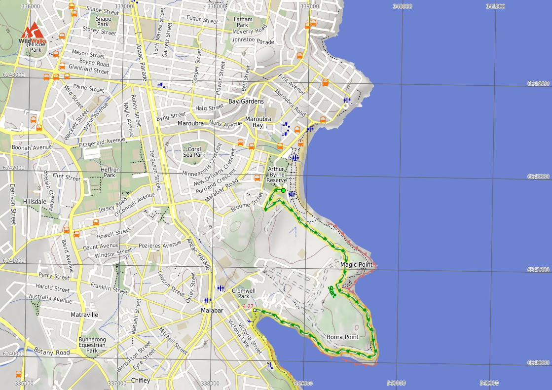
Maroubra to La Perouse
5 hrs
13.4 km One way
Hard track
406m4
<font color=red>CLOSED</font> <b>This walk isclosed at the northern end as there is no safe accessto Malabar Head, updates to come intime.</b>Following the coastline of Botany Bay'snorth side, this walk traverses the cliff line withspectacular views across the South Pacific Ocean. The walk will take you through bushland, pastbeaches and around two golf courses. With good sidetrips out to Bare Island and down to Brown's Rock,this walk explores all the environments that the northside of Botany Bay has to offer.
2m 50mBotany Bay National Park
Maps, text & images are copyright wildwalks.com | Thanks to OSM, NASA and others for data used to generate some map layers.
Coast Hospital CemeteryThe Coast Hospital Cemetery on the northern side of Botany Bay,was first established in the early 1880’s and now houses as many as2000 graves. It serviced the Coast (Prince Henry) Hospital,originally a smallpox hospital, as people who died of smallpox wererequired to be buried at the hospital grounds. The hospital was builtfar enough from the city to provide quarantine, and for this reason,the hospital in time became an infectious deseases hospital, alsotreating patients with influenza, bubonic plague, typhoid fever andleprosy. Unfortunately, the cemetery has now fallen into disrepairand many of the grave sites are in poor condition .
World War Two BunkerThis World War Two bunker is at the southern end of Pistol Rd andacross from the Westpac Helicopter Shed. This bunker consists ofsheltered concrete ammunition storage rooms below and a circulargun base above, with surrounding coastal views.
Cape BanksCape Banks on the northern side of the entrance to Botany Bay,offers possibly the best view in Botany Bay National Park. From theunfenced cliff top, you can watch the power of the ocean as wavescrash into the sandstone rock face below, or watch boats of allshapes and sizes, sail peacefully across the sheltered waters of thebay. If you are lucky, you can enjoy the spectacle of migratingHumpback and Southern Right whales reasonably close to shore,spouting and sometimes breaching as they make their way northwardand southward in pods of three or four. The shipwreck of the SSMinmi can be seen at low tide, lying on rocks on the western side ofCape Banks. There are concrete foundations of buildings remainingon Cape Banks, from when World War Two servicemen werestationed there. More info.
Henry HeadThe Henry Head Battery is located on the northern side of theentrance to Botany Bay at Henry Head. The battery was constructedon an unfenced headland between 1892 and 1895 and operated until1910 when it was closed down. The battery and observation postswas re-utilised during World War Two to defend against approachesto Botany Bay. The battery consisted of two disappearing guns,ammunition storage and observation posts. The underground bunkerand tunnel complex consisted of vaulted ammunition storage roomswith double walls and ceilings. The doubling-up of walls andceilings was a preventative measure meant to stop the walls fromcollapsing in the event of a direct hit. The battery is currently not inuse. The white tower on the battery is the Endeavour Tower, not alighthouse as such, but a red marker light nonetheless. More info.
Before You walkBushwalking is fun and a wonderful way to enjoy our natural places.Sometimes things go bad, with a bit of planning you can increaseyour chance of having an ejoyable and safer walk.Before setting off on your walk check
1) Weather Forecast (BOM Metropolitan District)2) Fire Dangers (Greater Sydney Region, unknown)3) Park Alerts (Botany Bay National Park)4) Research the walk to check your party has the skills, fitness andequipment required5) Agree to stay as a group and not leave anyone to walk solo
Think before you TREKThe 'Think before you TREK' program developed by NSW Police &NPWS promotes the benefits of planning ahead for yourbushwalking trip by using an easy to remember acronym:
Take adequate supplies of food, water, navigation and firstaid equipment.Register your planned route and tell friends and family whenyou expect to return.Emergency beacon (PLB's) should be carried on walks withsignificant gaps in mobile coverage (check terrain profile).Keep to your planned route and follow the map and walkingtrails.
TREK
Topo MapsThe maps provided on wildwalks are helpful, but there are timeswhere you may need maps covering a broader area. Maps that coverthis walk include;1:25 000 Map Series:91303S BOTANY BAY, 91302S BONDI,91294N PORT HACKING1:100 000 Map Series:9130 SYDNEY, 9129 PORT HACKING
GradeThis walk has been graded using the AS 2156.1-2001. The overallgrade of the walk is dertermined by the highest classification alongthe whole track.
Grade 4/6Hard track4
Length 13.4 km One way
Time 5 hrs
Quality oftrack
Rough track, where fallen trees and otherobstacles are likely (4/6)
Signs Minimal directional signs (4/6)
ExperienceRequired
Moderate level of bushwalkingexperience recommended (4/6)
Weather Storms may impact on navigation andsafety (3/6)
Infrastructure Limited facilities (such as cliffs notfenced, significant creeks not bridged)(4/6)
Are you ready to have fun?Please ensure you and your group are well prepared and equipped for allpossible hazards and delays. Check park closures, weather information andFire Danger Rating before setting out. Optional side trips and alternate routesnoted are not included in this walks overall grade, length or time estimate.Please allow extra time for resting and exploring areas of interest. Theauthors, staff and owners of wildwalks take care in preparing this informationbut will not accept responsibility for any inconvenience, loss or injury youmay experience. Please take care, have fun - Happy Walking.Getting there You can get to South Maroubra SLSC (gps: -33.9516,151.255) by car or bus. Car: There is free parking available.You can get back from Southern end of Cann Park (gps: -33.9886, 151.2337)by car or bus. Car: There is free parking available.
Find up to date and more information inlcuding; travel directions, weather,park closures and walker feedback at http://wild.tl/mtlp
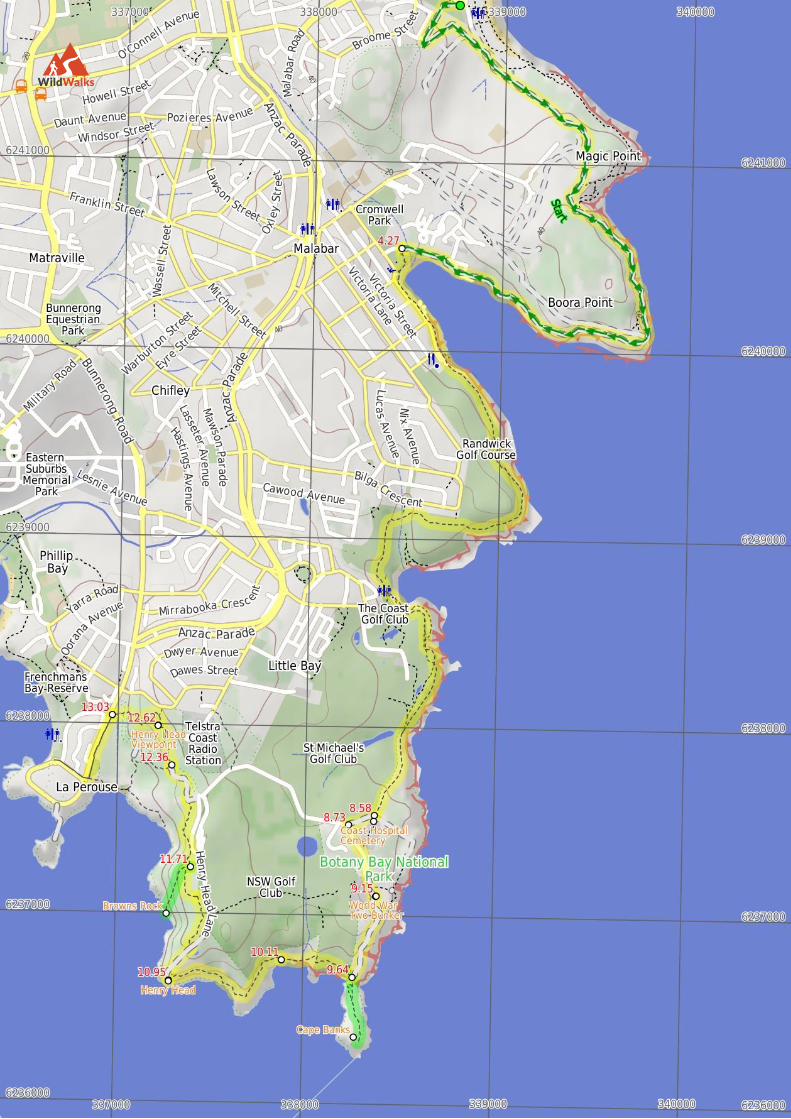
0 | South Maroubra SLSC (4.3 km 1 hr 25 mins) From South Maroubra SLSC carpark, this walk headup the footpath, away from the ocean. Soon, the path comes to some houses,and passes through the gap in the fencing to head behind the houses (keepingthe houses to the right). At the last of the buildings, the walk turns leftsharply, coming onto a sandy management trail through the low shrubs. Thetrack emerges into a large clearing, at the Anzac Rifle Range, which is sharedwith Sydney Model Aero Club. Here, the walk leaves the trails behind andcontinues onto the grassy field, staying left. At the southern end of the fields,a track breaks off to the left (east) and travels through the low scrub again,passing numerous side tracks on the right. The walk comes to a grassyclearing, with a gap in the cliffs on the left (in a small rocky bay) - crossingto the south-eastern corner of this, there is a narrow but distinct track headingup into the scrub. This track continues around the edge of the magnificentMalabar headland. (Note: there are many side tracks exploring MalabarHeadland, with numerous World War II defence structures, and more than280 endemic plant species as well as over 200 bird species). Keeping to thetracks nearest the coast, this walk eventually comes to another grassyclearing, at the bottom of which is a car park. This walk continues alongFishermans Rd, coming to another car park, at Cromwell Park (the children'splayground and Long Bay beach are visible).
4.27 | Cromwell Park (4.3 km 1 hr 21 mins) Turn left: From the car park on Fishermans Road, thiswalk heads into Cromwell Reserve along the footpath. The walk passes thechildren's playground and continues out of the park and along Bay Pde,keeping the water to the left. This walk follows the footpath past the boatlaunch area and Malabar Rock Pool, coming to Randwick Golf Club.Continuing from the car park, the walk travels alongside the golf course, andwithout fanfare, crosses onto The Coast Golf Course. (Note: The golf clubshas given permission for non-members to be on the course, however this ison the condition that it is at one's own risk.) The walk then navigates alongthe golf course's paths, staying near the coast as possible, and coming to apath on the left, leading to stairs that go down to Little Bay Beach. This walkcrosses to the southern end of the beach, then continues back up onto theCoast Golf Course. Continuing south, this walk crosses the fairway of the 5thhole, then passes onto St Michaels Golf Course. Soon, this walk veers leftonto a management trail through the low shrubs, and comes to the CoastHospital Cemetery.
8.58 | Coast Hospital Cemetery The Coast Hospital Cemetery on the northern side of Botany Bay, was firstestablished in the early 1880’s and now houses as many as 2000 graves. Itserviced the Coast (Prince Henry) Hospital, originally a smallpox hospital, as
people who died of smallpox were required to be buried at the hospitalgrounds. The hospital was built far enough from the city to providequarantine, and for this reason, the hospital in time became an infectiousdeseases hospital, also treating patients with influenza, bubonic plague,typhoid fever and leprosy. Unfortunately, the cemetery has now fallen intodisrepair and many of the grave sites are in poor condition .
8.58 | Coast Hospital Cemetery (150 m 2 mins) Veer right: From the intersection at the Coastal Cemetery,this walk follows the level management trail (passing the cemeteryinformation sign on the left) for about 150m, until coming to a locked gateand unsealed car park next to Pistol Club Rd.
8.73 | Int of Pistol Club Rd AND Coastal Cemetery Managem (320 m 5 mins) Turn left : From the intersection (which is found about 1kmpast the 'helicopter sign' off Henry Head Rd), this walk follows the roadgently uphill for about 140m, to come to views of the coastal cemetery (onthe left). Then this walk continues to follow the road gently downhill forabout 200m, until coming to a locked gate and 'Botany Bay National Park'sign.
9.05 | Southern End of Pistol Club Rd (100 m 2 mins) Continue straight: From the southern end of Pistol Club Rd,this walk follows a management trail, passing around a locked gate beforecoming to a 'Botany Bay National Park' sign after about 10m. Then this walkcontinues to follow the trail, with a metal ring fence and the 'WestpacHelicopter' sign and shed (on the right) for about 90m, until coming to aWorld War Two Bunker (on the left).
9.15 | World War Two Bunker This World War Two bunker is at the southern end of Pistol Rd and acrossfrom the Westpac Helicopter Shed. This bunker consists of sheltered concreteammunition storage rooms below and a circular gun base above, withsurrounding coastal views.
9.15 | World War Two Bunker (490 m 10 mins) Turn right: From the World War Two Bunker, this walkfollows a management trail away from the 'Westpac Helicopter' sign andshed, keeping the metal ring fence to the right. The walk follows the trail forabout 20m, then turns left at a three-way intersection to head up a gentle hill.After about 35m, the trail starts to descend steeply to a three-way intersection(and views of the water).Veer right: From this intersection, this walk follows the trail gently downhillwith the water on the left. Then this walk continues to follow the trail forabout 400m to find the southern end of the Coastal Cemetery managementtrail. The walk then follows a grassy track downhill for about 15m to the'Cape Banks Aquatic Reserve' sign and bridge beyond.
9.64 | Optional sidetrip to Cape Banks (360 m 6 mins) Veer left: From the 'Cape Banks Aquatic Reserve' sign, thiswalk follows the track for about 20m to cross a metal foot bridge. Then thiswalk continues to follow the rocky track (passing a golf tee-off green on theright) for about 240m to the exposed Cape Banks headland. At the end of thisside trip, retrace your steps back to the main walk then Veer left.
9.64 | Cape Banks Cape Banks on the northern side of the entrance to Botany Bay, offerspossibly the best view in Botany Bay National Park. From the unfenced clifftop, you can watch the power of the ocean as waves crash into the sandstonerock face below, or watch boats of all shapes and sizes, sail peacefully acrossthe sheltered waters of the bay. If you are lucky, you can enjoy the spectacle
of migrating Humpback and Southern Right whales reasonably close to shore,spouting and sometimes breaching as they make their way northward andsouthward in pods of three or four. The shipwreck of the SS Minmi can beseen at low tide, lying on rocks on the western side of Cape Banks. There areconcrete foundations of buildings remaining on Cape Banks, from whenWorld War Two servicemen were stationed there. More info.
9.64 | North end of Cape Banks Bridge (470 m 10 mins) Turn right: From the Cape Banks bridge and the 'CapeBanks Aquatic Reserve' sign, this walk follows a level footpath west, throughthe golf course, keeping the water on the left. After about 250m, this walkleaves the golf course on a grassy track that leads down a moderately steephill, then follows rock shelves to the west, with the water on the left. About90m along the rock shelves, the walk continues along the beach for about35m, until coming to an indistinct intersection roughly where the rock shelfcomes nearest to the scrub - the track heads moderately steeply uphill, awayfrom the water.
10.11 | Cruwee Cove (840 m 20 mins) Turn right: From the Shelly Beach at Cruwee Cove, thiswalk follow the narrow sandy track away from the beach, to the west,keeping the water on the left. Then this walk continues to follow the track,gently undulating through coastal forest for about 600m to find exposed rockplatforms (with a view ahead to Henry Head). This walk continues up rocksteps, and a rocky track through coastal heath for about 130m. This walkcontinues over rock slabs, with the ocean on the left for another 130m or so,until coming to a white round tower and Henry Head.
10.95 | Henry Head The Henry Head Battery is located on the northern side of the entrance toBotany Bay at Henry Head. The battery was constructed on an unfencedheadland between 1892 and 1895 and operated until 1910 when it was closeddown. The battery and observation posts was re-utilised during World WarTwo to defend against approaches to Botany Bay. The battery consisted oftwo disappearing guns, ammunition storage and observation posts. Theunderground bunker and tunnel complex consisted of vaulted ammunitionstorage rooms with double walls and ceilings. The doubling-up of walls andceilings was a preventative measure meant to stop the walls from collapsingin the event of a direct hit. The battery is currently not in use. The whitetower on the battery is the Endeavour Tower, not a lighthouse as such, but ared marker light nonetheless. More info.
10.95 | Henry Head (760 m 14 mins) Turn sharp right: From the white round tower, this walkfollows the wide management trail (passing two timber seats on the left).Then this walk continues to follow the trail gently uphill for about 220m,until coming to a three-way intersection, with a track and timber posts(on theleft).Turn left: From the intersection, this walk follows a wide sandy track(passing between timber posts), heading up a moderately steep hill throughdense forest. After about 100m, the walk comes to views of Bare Island (onthe left). approximately 130m further along the track, the walk finds a WorldWar One fort (on the left). This walk continues to follow the level wide trackfor another 70m, until coming to a three-way intersection, with a track andbench seat on the left.Turn left: From the intersection, this walk follows the wide track down themoderately steep hill, passing a bench seat on your left. The track headsthrough low coastal forest, with views of Bare Island on the left after about140m. The walk continues gently downhill for another 70m, until coming tofour-way intersection with a 'Browns Rock' signed track (on the left), amoderately steeply downhill track ahead and a gently uphill track (on the
right).
11.71 | Optional sidetrip to Browns Rock (310 m 7 mins) Turn sharp left: From the intersection, this walk follows thetrack gently downhill, following the 'Browns Rock 280m' sign. About 110mdown the track, the walk continues down a moderately steep hill with timbersteps for a further 180m, until coming to a square concrete platform on thewater and Browns Rock. At the end of this side trip, retrace your steps backto the main walk then Turn sharp left.
11.71 | Browns Rock Browns Rock is a popular fishing spot at La Perouse, with an unfenced shelfof rock and concrete from which to cast fishing rods. Unfortunately, this areasuffers from littering - Please help by carrying out your own rubbish and afew extra bits where safe (the rangers do a great job, but it is hard to keepup). More info.
11.71 | Int of Henry Head and Browns Rock Tracks (630 m 12 mins) Turn left: From the intersection, this walk follows the trackdown the moderately steep hill with occasional steps, keeping the chainedgreen bin on the left. Then this walk continues to follow the track for about260m, coming to a metal ring fence (on the left). This walk then continues tofollow the track gently downhill through moist forest for about 120m, untilcoming to a three-way intersection, with a narrow management trail and largegreen shed (on the right).Continue straight: From the intersection, this walk follows the wide trackgently downhill, initially keeping the large green shed on the right. Then, thiswalk continues to follow the forested track for about 170m, until coming to athree-way intersection, with a 'Henry Head' and 'Congwong Beach' sign (onthe left) and track (on the right).
12.34 | Int of Henry Head Track & Henry Head Lane Track (20 m ) Veer right: From the intersection, this walk follows the track northand away from the face of the 'Henry Head/Congwong Beach' sign for about15m, until passing between timber poles and coming to Henry Head Lane.
12.36 | Int of Henry Head Lane AND Henry Head Track (260 m 5 mins) Continue straight: From the intersection, this walk follows thetrack gently uphill (passing between timber posts) through coastal forest.After about 180m, the walk comes to an exposed rock platform and theHenry Head view point.
12.62 | Henry Head Viewpoint The Henry Head view point is located above Henry Head Lane and offersgood views on the surrounding coastline. From the unfenced sandstoneplatform, good views are available to the west, south and east, including BareIsland, the Barracks Tower and Henry Head.
12.62 | Henry Head Viewpoint (400 m 8 mins) Turn right: From the Henry Head view point, this walkfollows the level rocky track north and directly away from the viewpoint(ignoring sidetracks). After about 15m, the track starts to head gentlydownhill, and then after about 100m, the sandy track becomes steeper withtimber steps. After a further 170m, the walk finds a four-way intersection,with timber posts and a sealed road (Henry Head Lane). This walk crossesthe road and continues along the unmarked track gently downhill and across atimber bridge over a creek. Then the walk continues moderately steeplyuphill, until coming to 'The Happy Valley' sign and Anzac Parade.
13.03 | Int of Anzac Parade AND Henry Head Track (370 m 6 mins) Turn left: From the car park and grassed park, this walk
follows the footpath south, with Anzac Parade on your right. Approximately300m along footpath (the footpath briefly separates from the road and thenreturns), the walk finds the northern end of Cann Park and 'Cann Park' sign.This walk then follows the footpath towards the coast (and past the snake pit)for about 100m, until coming to the southern end of Cann Park and'Congwong Beach Walk' sign .
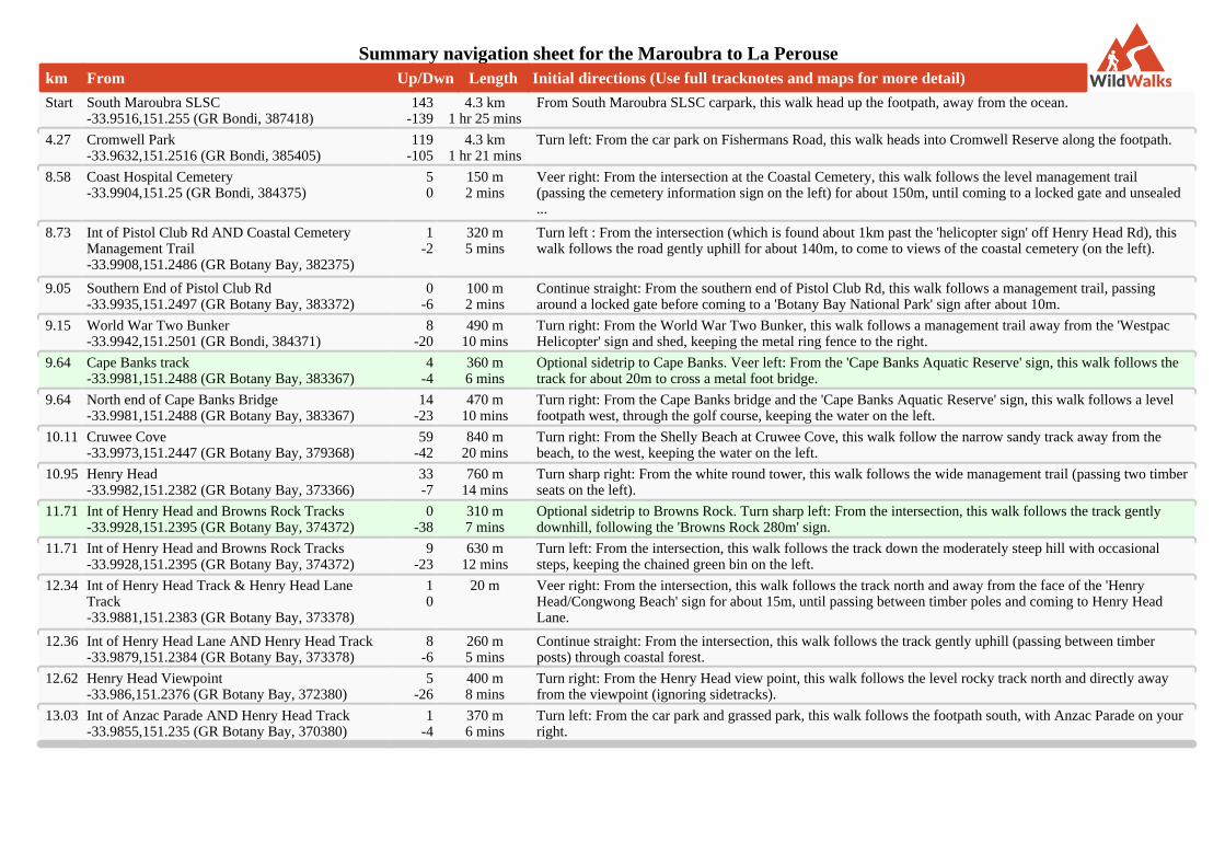
Summary navigation sheet for the Maroubra to La Perousekm From Up/Dwn Length Initial directions (Use full tracknotes and maps for more detail)
Start South Maroubra SLSC-33.9516,151.255 (GR Bondi, 387418)
143-139
4.3 km1 hr 25 mins
From South Maroubra SLSC carpark, this walk head up the footpath, away from the ocean.
4.27 Cromwell Park-33.9632,151.2516 (GR Bondi, 385405)
119-105
4.3 km1 hr 21 mins
Turn left: From the car park on Fishermans Road, this walk heads into Cromwell Reserve along the footpath.
8.58 Coast Hospital Cemetery-33.9904,151.25 (GR Bondi, 384375)
50
150 m2 mins
Veer right: From the intersection at the Coastal Cemetery, this walk follows the level management trail(passing the cemetery information sign on the left) for about 150m, until coming to a locked gate and unsealed...
8.73 Int of Pistol Club Rd AND Coastal CemeteryManagement Trail-33.9908,151.2486 (GR Botany Bay, 382375)
1-2
320 m5 mins
Turn left : From the intersection (which is found about 1km past the 'helicopter sign' off Henry Head Rd), thiswalk follows the road gently uphill for about 140m, to come to views of the coastal cemetery (on the left).
9.05 Southern End of Pistol Club Rd-33.9935,151.2497 (GR Botany Bay, 383372)
0-6
100 m2 mins
Continue straight: From the southern end of Pistol Club Rd, this walk follows a management trail, passingaround a locked gate before coming to a 'Botany Bay National Park' sign after about 10m.
9.15 World War Two Bunker-33.9942,151.2501 (GR Bondi, 384371)
8-20
490 m10 mins
Turn right: From the World War Two Bunker, this walk follows a management trail away from the 'WestpacHelicopter' sign and shed, keeping the metal ring fence to the right.
9.64 Cape Banks track-33.9981,151.2488 (GR Botany Bay, 383367)
4-4
360 m6 mins
Optional sidetrip to Cape Banks. Veer left: From the 'Cape Banks Aquatic Reserve' sign, this walk follows thetrack for about 20m to cross a metal foot bridge.
9.64 North end of Cape Banks Bridge-33.9981,151.2488 (GR Botany Bay, 383367)
14-23
470 m10 mins
Turn right: From the Cape Banks bridge and the 'Cape Banks Aquatic Reserve' sign, this walk follows a levelfootpath west, through the golf course, keeping the water on the left.
10.11 Cruwee Cove-33.9973,151.2447 (GR Botany Bay, 379368)
59-42
840 m20 mins
Turn right: From the Shelly Beach at Cruwee Cove, this walk follow the narrow sandy track away from thebeach, to the west, keeping the water on the left.
10.95 Henry Head-33.9982,151.2382 (GR Botany Bay, 373366)
33-7
760 m14 mins
Turn sharp right: From the white round tower, this walk follows the wide management trail (passing two timberseats on the left).
11.71 Int of Henry Head and Browns Rock Tracks-33.9928,151.2395 (GR Botany Bay, 374372)
0-38
310 m7 mins
Optional sidetrip to Browns Rock. Turn sharp left: From the intersection, this walk follows the track gentlydownhill, following the 'Browns Rock 280m' sign.
11.71 Int of Henry Head and Browns Rock Tracks-33.9928,151.2395 (GR Botany Bay, 374372)
9-23
630 m12 mins
Turn left: From the intersection, this walk follows the track down the moderately steep hill with occasionalsteps, keeping the chained green bin on the left.
12.34 Int of Henry Head Track & Henry Head LaneTrack-33.9881,151.2383 (GR Botany Bay, 373378)
10
20 m Veer right: From the intersection, this walk follows the track north and away from the face of the 'HenryHead/Congwong Beach' sign for about 15m, until passing between timber poles and coming to Henry HeadLane.
12.36 Int of Henry Head Lane AND Henry Head Track-33.9879,151.2384 (GR Botany Bay, 373378)
8-6
260 m5 mins
Continue straight: From the intersection, this walk follows the track gently uphill (passing between timberposts) through coastal forest.
12.62 Henry Head Viewpoint-33.986,151.2376 (GR Botany Bay, 372380)
5-26
400 m8 mins
Turn right: From the Henry Head view point, this walk follows the level rocky track north and directly awayfrom the viewpoint (ignoring sidetracks).
13.03 Int of Anzac Parade AND Henry Head Track-33.9855,151.235 (GR Botany Bay, 370380)
1-4
370 m6 mins
Turn left: From the car park and grassed park, this walk follows the footpath south, with Anzac Parade on yourright.
Powered by TCPDF (www.tcpdf.org)