Embed Size (px)
Citation preview
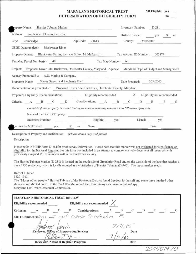
MARYLAND HISTORICAL TRUST NR Eligible: yes DETERMINATION OF ELIGIBILITY FORM no
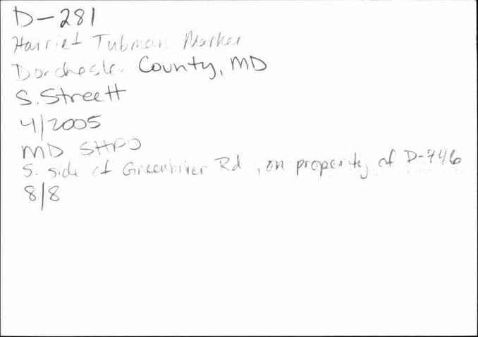
sopertyName: Harriet Tubman Marker Inventory Number: D-281
Address: South side of Greenbrier Road Historic district: yes X no
City: Cambridge Zip Code: 21613 County: Dorchester
USGS Quadrangle(s): Blackwater River
Property Owner: Blackwater Farms, Inc., c/o Milton M. Malkus, Jr. Tax Account ID Number: 003874
Tax Map Parcel Number(s): 40 Tax Map Number: 63
Project: Proposed Tower Site: Bucktown, Dorchester County, Maryland Agency: Maryland Dept. of Budget and Management
Agency Prepared By: A.D. Marble & Company
Preparer's Name: Stacey Streett and Stephanie Foell Date Prepared: 6/24/2005
Documentation is presented in: Proposed Tower Site: Bucktown, Dorchester County, Maryland
Preparer's Eligibility Recommendation: Eligibility recommended X Eligibility not recommended
Criteria: _ A _ B _ C _ D Considerations: _ A _ B _ C _ D _ E _ F _ G
Complete if the property is a contributing or non-contributing resource to a NR district/property:
Name of the District/Property:
Inventory Number: Eligible: yes Listed: yes
|te visit by MHT Staff yes X no Name: Date:
Description of Property and Justification: (Please attach map and photo)
Description:
Please refer to MIHP Form D-281 for prior survey information. Please note that this marker was not evaluated for significance or eligibility for the National Register, but this form was included in an attempt to comprehensively document all resources with previously assigned MIHP numbers within the Bucktown vicinity.
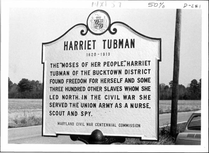
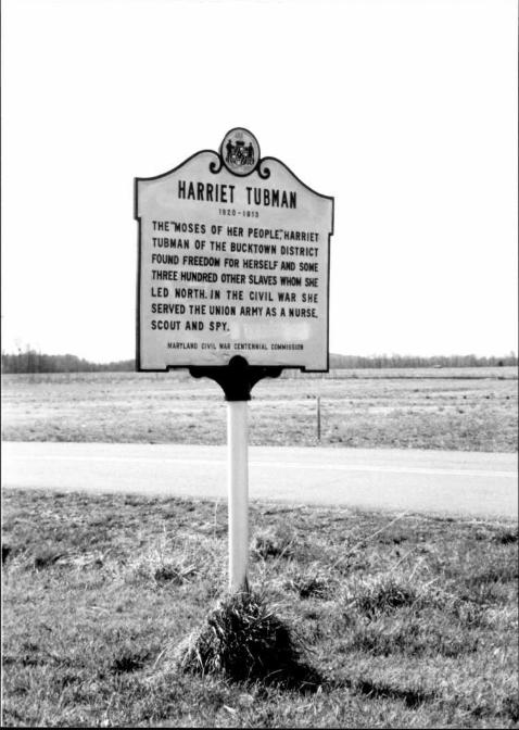
The Harriet Tubman Marker (D-281) is located on the south side of Greenbrier Road and on the west side of the lane that reaches a circa 1935 residence, which is locally reputed as the birthplace of Harriet Tubman (D-746). The metal marker reads:
Harriet Tubman 1820-1913 The "Moses of her people," Harriet Tubman of the Bucktown District found freedom for herself and some three hundred other slaves whom she led north. In the Civil War she served the Union Army as a nurse, scout and spy. Maryland Civil War Centennial Commission
MARYLAND HISTORICAL TRUST REVIEW
Eligibility recommended Eligibility not recommended x
Criteria: _ A _ B _ C _ D Considerations: _ A _ B _ C _ D _ E _ F _ G
MHT Comments: Does not meet Criteria Consideration F.
Reviewer, National Register Program Date
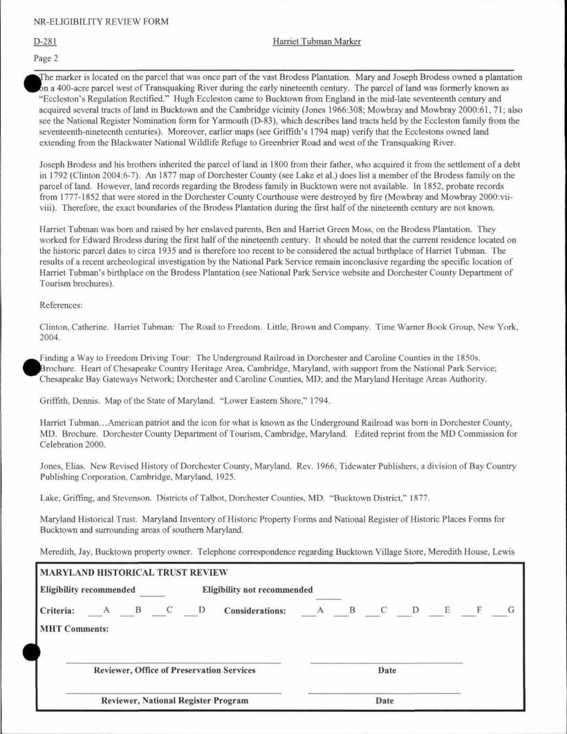
NR-ELIGIBILITY REVIEW FORM
D-281 Harriet Tubman Marker
Page 2
The marker is located on the parcel that was once part of the vast Brodess Plantation. Mary and Joseph Brodess owned a plantation on a 400-acre parcel west of Transquaking River during the early nineteenth century. The parcel of land was formerly known as "Eccleston's Regulation Rectified." Hugh Eccleston came to Bucktown from England in the mid-late seventeenth century and acquired several tracts of land in Bucktown and the Cambridge vicinity (Jones 1966:308; Mowbray and Mowbray 2000:61, 71; also see the National Register Nomination form for Yarmouth (D-83), which describes land tracts held by the Eccleston family from the seventeenth-nineteenth centuries). Moreover, earlier maps (see Griffith's 1794 map) verify that the Ecclestons owned land extending from the Blackwater National Wildlife Refuge to Greenbrier Road and west of the Transquaking River.
Joseph Brodess and his brothers inherited the parcel of land in 1800 from their father, who acquired it from the settlement of a debt in 1792 (Clinton 2004:6-7). An 1877 map of Dorchester County (see Lake et al.) does list a member of the Brodess family on the parcel of land. However, land records regarding the Brodess family in Bucktown were not available. In 1852, probate records from 1777-1852 that were stored in the Dorchester County Courthouse were destroyed by fire (Mowbray and Mowbray 2000:vii-viii). Therefore, the exact boundaries of the Brodess Plantation during the first half of the nineteenth century are not known.
Harriet Tubman was born and raised by her enslaved parents, Ben and Harriet Green Moss, on the Brodess Plantation. They worked for Edward Brodess during the first half of the nineteenth century. It should be noted that the current residence located on the historic parcel dates to circa 1935 and is therefore too recent to be considered the actual birthplace of Harriet Tubman. The results of a recent archeological investigation by the National Park Service remain inconclusive regarding the specific location of Harriet Tubman's birthplace on the Brodess Plantation (see National Park Service website and Dorchester County Department of Tourism brochures).
References:
Clinton, Catherine. Harriet Tubman: The Road to Freedom. Little, Brown and Company. Time Warner Book Group, New York, 2004.
Finding a Way to Freedom Driving Tour: The Underground Railroad in Dorchester and Caroline Counties in the 1850s. (Brochure. Heart of Chesapeake Country Heritage Area, Cambridge, Maryland, with support from the National Park Service; Chesapeake Bay Gateways Network; Dorchester and Caroline Counties, MD; and the Maryland Heritage Areas Authority.
Griffith, Dennis. Map of the State of Maryland. "Lower Eastern Shore," 1794.
Harriet Tubman... American patriot and the icon for what is known as the Underground Railroad was born in Dorchester County, MD. Brochure. Dorchester County Department of Tourism, Cambridge, Maryland. Edited reprint from the MD Commission for Celebration 2000.
Jones, Elias. New Revised History of Dorchester County, Maryland. Rev. 1966, Tidewater Publishers, a division of Bay Country Publishing Corporation, Cambridge, Maryland, 1925.
Lake, Griffing, and Stevenson. Districts of Talbot, Dorchester Counties, MD. "Bucktown District," 1877.
Maryland Historical Trust. Maryland Inventory of Historic Property Forms and National Register of Historic Places Forms for Bucktown and surrounding areas of southern Maryland.
Meredith, Jay, Bucktown property owner. Telephone correspondence regarding Bucktown Village Store, Meredith House, Lewis
MARYLAND HISTORICAL TRUST REVIEW
Eligibility recommended Eligibility not recommended
Criteria: _ A _ B C D Considerations: _ A _ B _ C _ D _ E _ F _ G
MHT Comments:
Reviewer, Office of Preservation Services Date
Reviewer, National Register Program Date
NR-ELIGIBILITY REVIEW FORM
D-281 Harriet Tubman Marker
Page 3
House, and Brodess Plantation, April 2005.
Mowbray, CalvinW., and Mary I. Mowbray. The Early Settlers of Dorchester County and their Lands. 2 vols. Reprinted 2000, Willow Bend Books, Westminster, Maryland, 1981, 1992 by Calvin W. Mowbray.
National Park Service website: http://www.harriettubmanstudy.org/places.htm, accessed March 2005.
MARYLAND HISTORICAL TRUST REVIEW
Eligibility recommended Eligibility not recommended
Criteria: _ A _ B _ C _ D Considerations: A _ B _ C _ D _ E _ F _ G
MHT Comments:
Reviewer, Office of Preservation Services Date
Reviewer, National Register Program Date
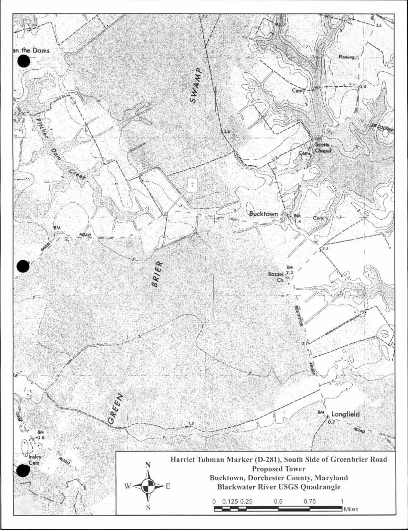
Harriet Tubman Marker (D-281), South Side of Greenbrier Road Proposed Tower
Bucktown, Dorchester County, Maryland Blackwater River USGS Quadrangle
D-281
Form 10-300 UNITED STATES DEPARTMENT OF THE INTERIOR (Dec. 1968) NATIONAL PARK SERVICE
NATIONAL REGISTER OF HISTORIC PLACES INVENTORY - NOMINATION FORM
(Type all entries — complete applicable sections)
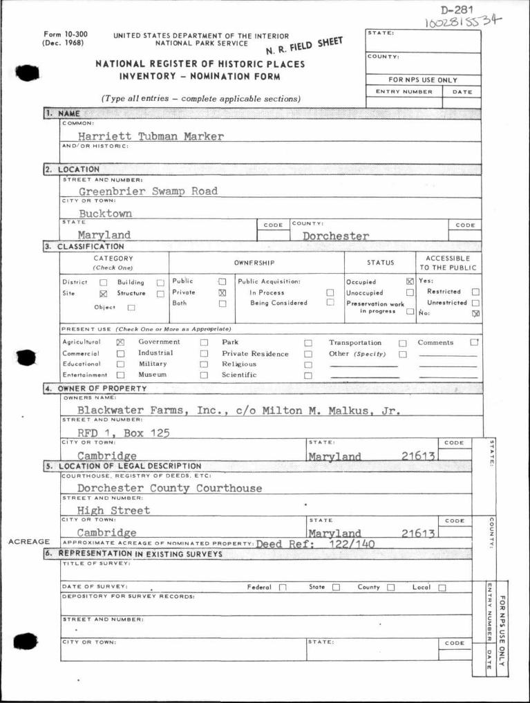
[ 1 . NAME
FOR NPS USE ONLY
E N T R Y NUMBER
COMMON:
H a r r i e t t Tubman Marker A N D / O R H I S T O R I C :
| 2 . L O C A T I O N
S T R E E T A N D N U M B E R :
Greenbr ie r Swamp Road C I T Y OR TOWN:
Bucktown
Maryland C O U N T Y :
Dorches te r 3. C L A S S I F I C A T I O N
CATEGORY (Check One)
District • Building
Site J3 Structure
Object
OWNFRSHIP
Public
Private
Both
Public Acquisit ion:
In Process
Being Considered
STATUS
Occupied
Unoccupied
Preservation work in progress
ACCESSIBLE TO THE PUBLIC
Yes:
Restricted
Unrestricted
No:
P R E S E N T USE (Check One or More as Appropriate)
Agricultural [ g Government
Commercial • I ndus t r i a l
Educational • M i l i t a ry
Entertainment • M u s e u m
Park
Private Residence
Religious
Scientific
Transportation Q Comments Other (Specify) •
n
4. OWNER OF P R O P E R T Y OWNERS NAME:
Blackwater Farms, I n c . , c /o Mil ton M. Malkus. J r . S T R E E T AND NUMBER:
RFD 1. Box 125 C I T Y OR TOWN:
Cambridge [S , L O C A T I O N OF L E G A L DESCRIPT ION
Maryland 21613 C O U R T H O U S E , REGISTRY OF D E E D S . E T C :
Dorches te r County Courthouse S T R E E T AND N U M B E R :
High S t r e e t C I T Y OR TOWN:
Cambridge I Maryland A C R r l A G E A P P R O X I M A T E A C R E A G E O F N O M I N A T E D P R O P E R T Y : D e e d R e f t 1 2 2 / 1 A O
21613
I , R E P R E S E N T A T I O N fN E X I S T I N G SURVEYS T I T L E OF S U R V E Y :
D A T E OF S U R V E Y : Federal f l s , a , e • County • Local • D E P O S I T O R Y FOR SURVEY RECORDS:
S T R E E T AND N U M B E R :
C ITY OR TOWN:

N. R. FIELD SHEET D-281 . DESCRIPTION
CONDITION (Check One)
Excellent • Good Q Foir • Deteriorated Q Ruins • Unexposed Q
INTEGRITY fC/ieck One;
Altered • Unaltered •
(Check One)
Moved • Original Site Q
DESCRIBE THE PRESENT AND ORIGINAL (it known.) PHYSICAL APPEARANCE
Marker Reads:
HARRIETT TUBMAN
1820 - 1913
The "Moses of her people," Harriet Tubman of the Bucktown District found freedom for herself and some three hundred other slaves whom she led north. In the Civil War she served the Union Army as a murse, scout and spy.
Maryland Civil War Centennial Commission
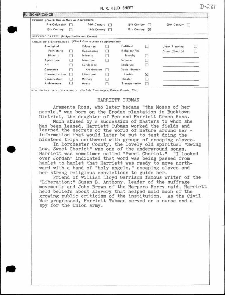
N. R. FIELD SHEET D-281 SIGNIFICANCE
PERIOD (Check One or More as Appropriate)
Pre-Columbion • 16th Century • 18th Century • 20th Century Q
15th Century • 17th Century • 19th Century \g\
SPECIFIC DATE(S) (It Applicable and Known)
AREAS OF SIGNIFICANCE (Check One or More as Appropriate)
Aboriginal Education • Political • Urban Planning •
Prehistoric • Engineering • Religion/Phi- Other (Specify) •
Historic Industry losophy
Agriculture Invention Science
Art Landscape Sculpture
Commerce Architecture [ Social/Human-
Communications | Literature itarian §3
Conservation Military Theater
Architecture LJ Music Transportation Q
STATEMENT OF SIGNIFICANCE (Include Personages, Dates, Events, Etc-)
HARRIETT TUBMAN
Aramenta Ross, who later became "the Moses of her people," was born on the Brodas plantation in Bucktown District, the daughter of Ben and Harriett Green Ross.
Much abused by a succession of masters to whom she has been leased, Harriett Tubman worked the fields and learned the secrets of the world of nature around her -information that would later be put to test doing the nineteen trips northward with groups of escaping slaves.
In Dorchester County, the lovely old spiritual "Swing Low, Sweet Chariot" was one of the underground songs. Harriett was sometimes called "Sweet Chariot." "I looked over Jordan" indicated that word was being passed from hamlet to hamlet that Harriett was ready to move northward with a band of "holy angels," escaping slaves and her strong religious convictions to guide her.
Friend of William Lloyd Garrison famous writer of the "Liberation;" Susan B. Anthony, leader of the suffrage movement; and John Brown of the Harpers Ferry raid, Harriett held beliefs about slavery that helped mold much of the growing public criticism of the institution. As the Civil War progressed, Harriett Tubman served as a nurse and a spy for the Union Army.
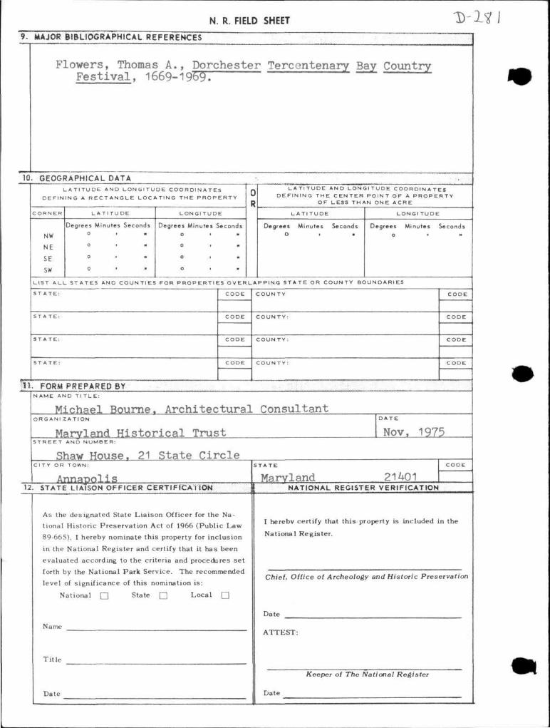
N. R. FIELD SHEET D-281 9. MAJOR BIBLIOGRAPHICAL REFERENCES
Flowers, Thomas A., Dorchester Tercentenary Bay Country Fes t i va l , 1669-1969.
10. GEOGRAPHICAL DATA L A T I T U D E AND L O N G I T U D E C O O R D I N A T E S
D E F I N I N G A R E C T A N G L E L O C A T I N G T H E P R O P E R T Y
CORNER
NW
NE
SE
sw
L A T I T U DE
Degrees Minutes Seconds
LONGI T U D E
Degrees Minutes Seconds
L A T I T U D E A N D L O N G I T U D E C O O R D I N A T E S D E F I N I N G T H E C E N T E R P O I N T OF A P R O P E R T Y
O F LESS T H A N ONE A C R E
L A T I T U D E
Degrees Minutes Seconds O > •
LONGI T U D E
Degrees Minutes Seconds
L I S T A L L S T A T E S AND C O U N T I E S FOR P R O P E R T I E S O V E R L A P P I N G S T A T E OR C O U N T Y B O U N D A R I E S
CODE COUNTY
COUNTY:
1L FORM PREPARED BY NAME AND Tl T L E :
Michael Bourne. Archi tec tura l Consultant ORG ANI Z A T I O N
Maryland His to r i ca l Trust D A T E
Nov. 1975 S T R E E T AND N U M B E R :
Shaw House. 21 State Circle C I T Y OR TOWN:
Annapolis Maryland 21401 12. STATE LIAISON OFFICER CERTIFICATION
As the designated State Liaison Officer for the Na
tional Historic Preservat ion Act of 1966 (Public Law
89-665), I hereby nominate this property for inclusion
in the National Register and certify that it has been
evaluated according to the criteria and procedures set
forth by the National Park Service. The recommended
level of significance of this nomination i s :
National • State • Local •
Name
Ti t le
Date
NATIONAL REGISTER VERIFICATION
I hereby certify that this property is included in the
National Register .
Chief, Office of Archeology and Historic Preservation
Date
ATTEST:
Keeper of The National Register
Date
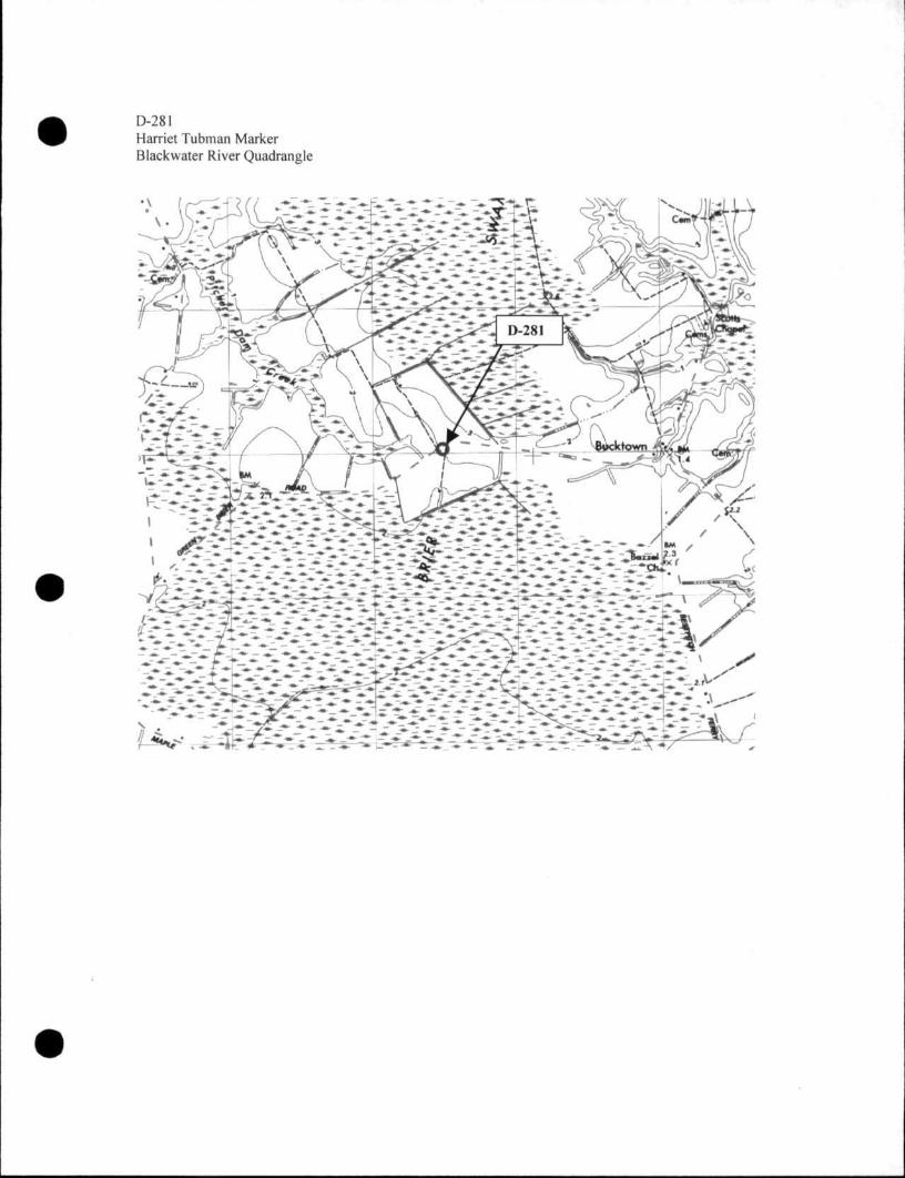
D-281 Harriet Tubman Marker Blackwater River Quadrangle